#ColoradoRiver Basin Forecast Center May 1, 2019 Water Supply Forecast Discussion #COriver #aridification

Click here to read the discussion. Here’s an excerpt:

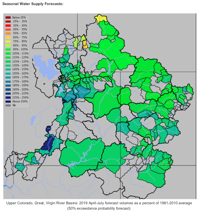
Water Supply Forecast Summary:

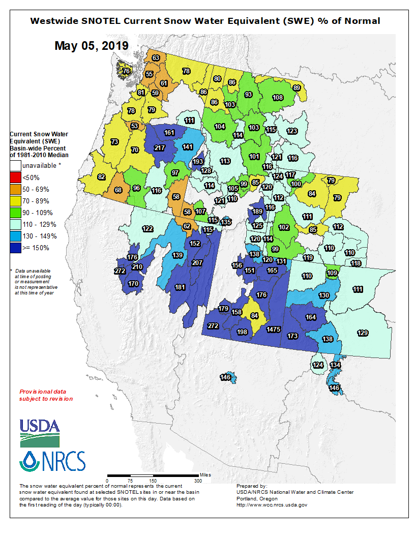
The majority of the Upper Colorado River and Great Basin April-July water supply forecasts increased between April and May. The forecasts at locations that did not increase had minimal changes from early April.

Widespread significant precipitation occurred over the Green River Basin in Wyoming, the Great Basin and the Sevier and San Rafael River basins during the first half of April. The remainder of the Upper Colorado River Basin was mostly dry and received minimal precipitation the first half of the month. However, river basins in Colorado benefited from a significant precipitation event the last four days of the month. Specifically, the Gunnison River basin and Upper Colorado River basin headwaters received up to or more than the average monthly total precipitation during this time period.

The largest increases in water supply forecasts between April 1st and May 1st occurred in the Green River basin in Wyoming, and the San Juan, Gunnison, and Dolores River Basins. Significant increases also occurred throughout the Great Basin, Duchesne, San Rafael and Sevier River Basins in Utah. Forecasts in the Upper Colorado River headwaters and Yampa River basins had slight increases or remained similar to the April 1st forecasts. April-July runoff volume forecasts now range from near 115 to 200 percent of average. Currently only a few northern headwater basins of the Green River Basin in Wyoming and the Great Basin (Bear River Basin) have forecasts below average for the 2019 season.

Very dry soil moisture conditions were widespread entering the winter season. These may have some impact on the overall yield of runoff that ends up in the streams depending on how the snow melt plays out. In areas with significant snowpack or where snowmelt is delayed the impacts of dry soils may be lessened.

April-July unregulated inflow forecasts for some of the major reservoirs in the Upper Colorado River Basin include Fontenelle Reservoir 740 KAF (102% average), Flaming Gorge 1050 KAF (108% of average), Blue Mesa Reservoir 970 KAF (144% of average), McPhee Reservoir 420 KAF (142% of average), and Navajo Reservoir 930 KAF (127% of average). The Lake Powell inflow forecast is 9.20 MAF (128% of average).

April Weather Synopsis-Precipitation-Temperature:

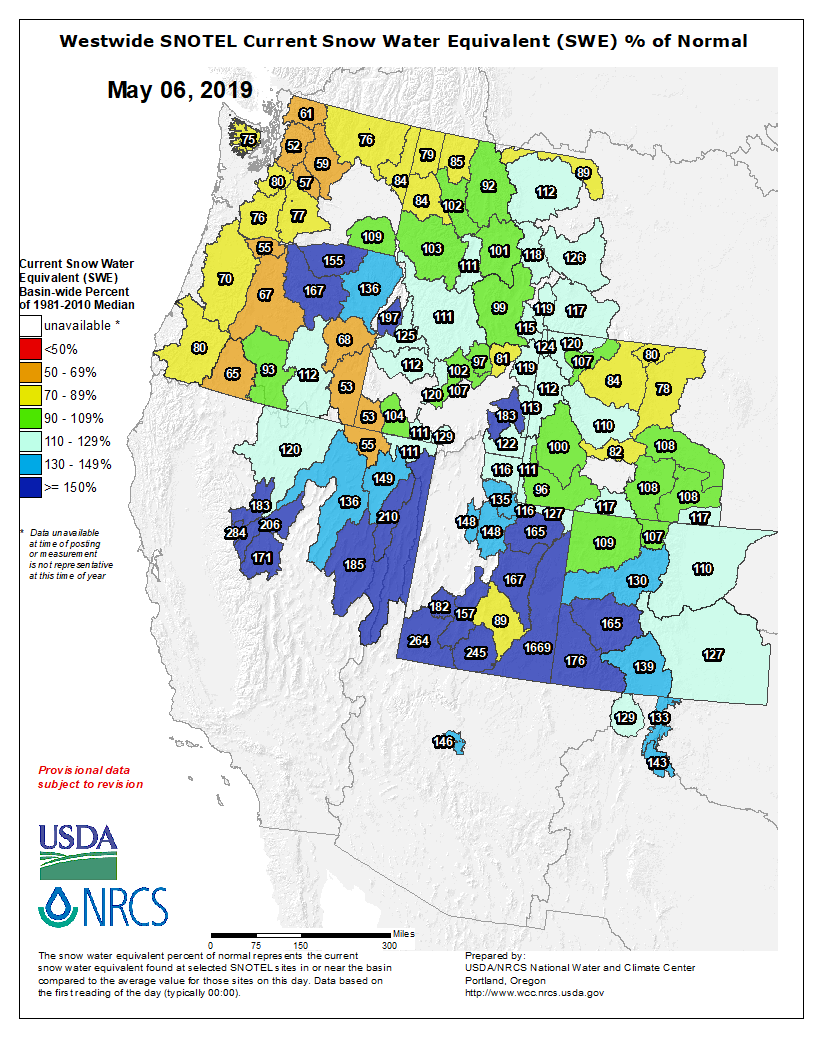
Storm systems favored central/northern Utah and southwest Wyoming for the first half of April. Areas including the Great Basin, Sevier River Basin and the Green River Basin received above average precipitation for the first two weeks of April. River basins in Colorado did not benefit from the storm track early in the month. However, areas in Colorado benefited from a significant precipitation event the last four days of the month which continued into the first few days of May. Specifically, the Gunnison River basin and Upper Colorado River basin headwaters received up to or more than the average monthly total precipitation during this time period.

By the end of the month, the highest wet anomalies (in percent of normal terms) were across the Green River basin in Wyoming, the Duchesne River Basin, parts of central Utah and the Great Basin including the Bear, Weber, Six Creeks, Provo, and Sevier River basins where precipitation was 120-140% of average. Other basins including the Upper Colorado Headwaters, Gunnison River Basin and the Yampa River Basin ended the month with precipitation near 100-105% of average. These areas would have ended the month with below average precipitation and a resulting decrease in water supply forecasts had it not been for the storm at the end of the month. The San Juan River Basin, Dolores River Basin and the Lower Colorado River Basin in Arizona all received below average precipitation for April…

Soil Moisture:

Soil moisture conditions in the higher elevation headwater areas are important entering the winter, prior to snowfall, as it can influence the efficiency of the snowmelt runoff the following spring. The effects are most pronounced when soil moisture conditions and snowpack conditions are both much above or much below average. In areas where the soil moisture was below average entering the winter and the current snowpack is also much below median, spring runoff may be further reduced.

Modeled soil moisture conditions as of November 15th were below average over most of the Upper Colorado River Basin and Great Basin. In the Upper Colorado River Mainstem River Basin, soil moisture conditions were below average in headwater basins along the Continental Divide, and closer to average downstream. Soil moisture conditions in the Gunnison, Dolores, and San Juan basins were much below average.

#Snowpack news: Nice bump from last week’s storminess

Click on a thumbnail graphic below to view a gallery of snowpack data from the NRCS.

And, here’s the Westwide SNOTEL basin-filled map for May 6, 2019.

Westwide SNOTEL basin-filled map May 6, 2019 via the NRCS.

Arkansas River Basin Water Forum recap #ActOnClimate

Statewide temperature 1895 through 2018 via the Colorado Climate Center.

From The Pueblo Chieftain (Peter Roper) via The La Junta Tribune-Democrat:

The message came in three different voices: Climate change and global warming are here, and they will shrink Colorado’s rivers and water supply.

ā€œWe are causing this and we can fix it,ā€ said Brad Udall, a senior research scientist at the Colorado Water Institute and Colorado State University.

He was speaking to several hundred officials from regional water districts who were in Pueblo Wednesday for the 25th Arkansas River Basin Water Forum.

Udall’s message was also underlined by Nolan Doesken, former state climatologist, and Taryn Finnessey, of the Colorado Water Conservation Board.

ā€œWe thought we’d outgrown dust storms,ā€ Doesken said, showing a slide of a dust-filled sky over Southern Colorado a few summers ago. ā€œBut, lo and behold, we find that if you string together multiple years of drought. …ā€

Finnessey, who oversees the state’s drought response plan for the Department of Natural Resources, said the long-term forecast shows a future where the Arkansas River wouldn’t be able to meet the demand to use it.

The three water experts were looking at the impact of climate change on Colorado’s rivers. They gave different perspectives of a trend showing that temperatures are warming — and that would affect how much water is available in the future.

Udall showed temperature models that indicate the average daytime temperature could be 6 degrees hotter by the next century. That trend is already displaying itself in hot, dry summers and longer fire seasons, he said.

ā€œLook at the Paradise Fire in California,ā€ he said. ā€œIt burned 20,000 structures. California now has a fire season that is year-round.ā€

Doesken showed temperature records for Southern Colorado that evidence a slow, creeping trend line upward since the 1890s. And there were many wild swings from wet years to dry years, hot years to colder years. But stretched over time, the average crept upward.

ā€œWe are warming — but Southern Colorado seems to be warming a little more slowly,ā€ he said.

Udall said warmer temperatures are likely to reduce flow in the state’s rivers as much as 20 percent by 2050.

ā€œWater conservation has to be part of every discussion as we go forward,ā€ he said.

Doesken said the state couldn’t begin to cope with its drought struggle without the large man-made lakes, dams and other storage projects. More are probably needed, he said.

ā€œThe question to me is: Do we have the courage to go forward?ā€ he said.

Larimer County is still waiting for $20 million from FEMA for repairs after 2013 floods

Damage to US 34 along the Big Thompson River September 2013. Photo credit: CDOT

From The Fort Collins Coloradoan (Jacy Marmaduke):

Nearly six years after the Big Thompson River flood wrecked U.S. Highway 34, stranded Estes Park and wiped out bridges and homes, the U.S. government has yet to fund $20 million of repairs in Larimer County.

The county hasn’t started construction on County Road 47 (Big Elk Meadows) and County Road 44H (Buckhorn) because of the lack of funding. The county finished work on Big Thompson River bridges destroyed and rebuilt after the flood but hasn’t been reimbursed by the Federal Emergency Management Agency for the project.

The delay in FEMA funding for Larimer County’s last three flood recovery projects has county officials in a bind: As another construction season looms without federal money, so does a crucial state deadline.

Colorado’s general fund has paid for about 13% of Larimer County’s flood restoration work since 2013. Come September 2020, state funding for the projects will dry up.

ā€œWe will not be able to meet that deadline with the delays we’ve had because of this issue,ā€ said Lori Hodges, Larimer County emergency management director. ā€œOur biggest projects are at risk because we haven’t gotten the guidance we need.ā€

The holdup is essentially a bureaucratic issue. Congress passed a law in October 2018 changing the way FEMA awards money for disaster recovery work.

FEMA used to deny funding for all projects that didn’t meet a strict set of code compliance guidelines. The guidelines had little wiggle room for projects on roads and bridges in complex terrain — like the ones destroyed by the flood in the Big Thompson canyon. For example, a road repair in a narrow, rocky canyon probably couldn’t meet FEMA’s requirement for shoulder width.

The Disaster Recovery Reform Act of 2018 instructed FEMA to award money for projects that don’t meet the strict guidelines as long as a local engineer signs off on the work and agrees a waiver is necessary. Congress gave FEMA 60 days to give its regional offices guidance on how to award funding under the new law.

But FEMA hasn’t done that yet, so regional officials won’t fund the implicated Larimer County projects, Hodges said. FEMA Region 8 spokesperson Lynn Kimbrough told the Coloradoan the office paused a Larimer County funding appeal as it waits for policy guidance from headquarters…

CR 47, partially destroyed by the flood, branches off U.S. Highway 36 between Lyons and Estes Park. The road is accessible but unpaved. An 11-mile stretch of CR 44H, located in Buckhorn Canyon and the Roosevelt National Forest, was heavily damaged in the flood and the High Park Fire in 2012.

May 1 San Juan #snowpack update — Jonathan Thompson (@JonnyPeace) #runoff

Westwide SNOTEL May 5, 2019 via the NRCS.

From RiverOfLostSouls.com (Jonathan Thompson):

Snow levels have presumably peaked in the San Juan Mountains and, as expected, they look pretty darned healthy. That said, it’s not quite the biggest snow year on the books. How 2019 ranks depends on which SNOTEL station you’re looking at.

…as of May 1, this year’s snow levels were the second highest at Red Mountain Pass and Columbus Basin, fourth highest at the lower elevation Cascade station, and fifth at Molas Lake (which seems off to me).

But whether it was a record year or not, it’s clear that it has been — and continues to be — a good year for water supplies and river flows in the whole region. At every station the snowpack remains far above average, and three to four times what it was at this time last year. Also, one only needs to look at all the snow slide debris in the high country to determine that it was a historic avalanche cycle…

But that was past. What about the near future? How high will the Animas River get this year?

It’s already hit 3,000 cubic feet per second in Durango, which is plenty of flow for some good kayaking and rafting (albeit a bit chilly). And it’s fair to bet that it will top 5,000 cfs before the runoff is over. But whether it will shoot up past 8,000 cfs as it did in 2005 (which saw a smaller snowpack at most stations in the watershed) or not is anyone’s guess.

Just because the snowpack is bigger than 2005 doesn’t mean the runoff will hit a bigger peak. A cool spring will result in a slower melt, and that will mean a higher average flow and a longer rafting season, but not necessarily a bigger peak.

Either way, the reservoirs are likely to get a bit of a boost, and the smaller ones will likely get topped off. As for Lake Powell rising back up to its former glory? Don’t get your hopes up.

Animas River at Durango March 1 through May 6. 2019 via USGS