From the Water Education Foundation (Gary Pitzer):
Western water in-depth: talks are about to begin on a potentially sweeping agreement that could reimagine how the Colorado River is managed
Lake Mead, behind Hoover Dam, shows the effects of nearly two decades of drought. (Image: Bureau of Reclamation)
Even as stakeholders in the Colorado River Basin celebrate the recent completion of an unprecedented drought plan intended to stave off a crashing Lake Mead, there is little time to rest. An even larger hurdle lies ahead as they prepare to hammer out the next set of rules that could vastly reshape the river’s future.
Set to expire in 2026, the current guidelines for water deliveries and shortage sharing, launched in 2007 amid a multiyear drought, were designed to prevent disputes that could provoke conflict.
Those guidelines have been successful so far and the drought plan — signed March 19 — is expected to help. But as the time for crafting a new set of rules draws near, some river veterans suggest the result will be nothing less than a dramatic re-imagining of how the overworked Colorado River is managed to ensure its very survival as a source of water for 40 million people from Wyoming to Mexico.
Negotiators will face some daunting challenges: Under the 1922 Colorado River Compact that divided its waters among the states, more water has been promised to users than the river carries in an average year. A two-decade drought has amplified the shortfall, particularly in the main reservoirs serving the three Lower Basin states of Arizona, Nevada and California and the country of Mexico. Scientists believe climate change is likely to make things worse.
There are other issues. The Upper Basin states of Wyoming, Utah, Colorado and New Mexico, which have never used their full apportionment of the river’s waters, have their own ambitions for growth. The Lower Basin states are drawing on Lake Mead faster than it can be replenished — creating a so-called structural deficit. Native American tribes throughout the Basin, many of whom have priority rights to the river’s flow, are increasingly expected to assert those rights. And in southeastern California, there’s general agreement the ailing Salton Sea will need to be addressed.
Addressing the Structural Deficit
Resetting how the river is managed is critical because of the fear surrounding the once-unthinkable scenario of Lake Mead, the nation’s largest reservoir that sits near Las Vegas, falling too low to function as a water supply reservoir and hydropower producer.
Pat Mulroy, a senior fellow at the University of Nevada, Las Vegas’ Boyd School of Law and the former longtime general manager of the Southern Nevada Water Authority, is an advocate for extensively rethinking how the Colorado River is managed. (Image: University of Nevada, Las Vegas’ Boyd School of Law)
“There are some real serious issues that the next seven years have to address or there won’t be a continuation of the next chapter of the 2007 agreement,” Pat Mulroy, the former longtime general manager of the Southern Nevada Water Authority, said in late March at the Lincoln Institute of Land Policy’s Future of Water conference in Phoenix. “The structural deficit has to be addressed. Period. End of conversation.”
Solving the structural deficit could require some unconventional and controversial aspects, such as allocating water evaporation in Lake Mead (about 600,000 acre-feet annually) among the Lower Basin states.
“Those are the things that we need to look at now because we have the opportunity and space to do that creative thinking,” Anne Castle, former assistant secretary for water and science at the Department of the Interior, said at the Phoenix conference.
The evaporation allocation could be justified because the Upper Basin bears its own evaporation from Lake Powell (about 386,000 acre-feet annually), meaning that in order to deliver the requisite 8.23 million acre-feet annually to the Lower Basin, more than that has to be stored in Lake Powell to account for evaporation.
Mulroy, now a senior fellow at the University of Nevada, Las Vegas’ Boyd School of Law, said all options must be on the table during upcoming talks. The 2007 guidelines and Drought Contingency Plan, she said, are “Band-Aid” approaches that do not provide a foundational structure for resilience.
“We can’t go on the way we are,” she said. “Are we willing to sit here and say we are going to work from the premise that our Upper Basin neighbors are never going to develop their supply? It’s not a safe assumption, it’s not logical and we can’t continue to work from that.”
She stopped short, however, of advocating a reopening of the 1922 Colorado River Compact that divided its waters, calling such an effort a “a fool’s mission.”
Indeed, water supply development in the Upper Basin is happening through efforts such as Utah’s proposed pipeline from Lake Powell to St. George in the southwest corner of the state. The 139-mile pipeline would pump about 86,000 acre-feet of water annually from Lake Powell to Washington and Kane counties. The Upper Colorado River Commission estimates that Upper Basin use, currently about 4.5 million acre-feet, will reach about 5.4 million acre-feet by 2060.
“The Upper Basin has the prerogative to develop its allocation and we are starting to see that, and when that occurs it’s going to make that whole issue of the structural deficit even more complicated,” Amy Haas, executive director of the Upper Colorado River Commission, said in an interview. She is especially concerned because while the Upper Basin has been providing more than its share of water to the Lower Basin, the elevation at Lake Mead continues to fall.
Jim Lochhead, longtime chief of Denver Water, said in an interview that demand for water in the Upper Basin has actually been relatively flat the past 30 years. But the combination of the structural deficit and warming conditions means the system “isn’t adequate to meet today’s demands.”
Meanwhile, there is an increasing body of scientific evidence pointing to a warmer and drier basin on a scale previously unseen. In 2018, a report authored by climate scientists Brad Udall, Mu Xiao and Dennis Lettenmaier reported that between 1916 and 2014, streamflow in the Upper Colorado River Basin declined by 16 percent and that “pervasive warming” has reduced snowpack and contributed to the long‐term decline of runoff.
The structural deficit refers to the consumption by Lower Basin states of more water than enters Lake Mead each year. The deficit, which includes losses from evaporation, is estimated at 1.2 million acre-feet a year. (Image: Central Arizona Project)
The gravity of the situation – drought and an overallocated, drying basin – pushes people to confront the reality of what’s before them.
“I think folks need to have a real unvarnished conversation about what the shared vision of the basin looks like,” Chuck Cullom, Colorado River Program Manager with the Central Arizona Project, said in an interview. “That conversation … has to include the aspirations of all the water users as well as a recognition that it’s a shared system that benefits all the water users from Mexico to the headwaters in Wyoming and Colorado.”
‘Focus on Risk and Vulnerability’
Analysis of tree ring data shows that drought has frequently occurred in the Colorado River Basin. A 60-year period during the mid-1100s was marked by a 25-year stretch when river flow averaged 15 percent below normal, according to the University of Arizona.
More recently, the system has been shaken by a chronic two-decade drought that saw Lake Mead drop to its lowest level ever in July of 2016. According to Reclamation, the combined storage of Lake Powell and Lake Mead is at its lowest point, 39 percent of capacity, since Powell began filling in the 1960s. A wet winter this year has helped, but there is no guarantee that the reservoirs will ever be full again.
Cullom said that Lake Mead’s precipitous decline will provide those working on the 2026 guidelines with the “visceral experience” and “emotional clarity” of knowing the possible extremes that are lurking.
“The drought has caused everyone to focus on risk and vulnerability in a way that we didn’t in the 2007 guidelines,” he said.
While water managers and policymakers crave certainty, precision and specificity don’t exist when the climate change variable is added to an already volatile Colorado River Basin. That doesn’t mean, however, that plans can’t be made.
“We cannot tell water managers what the future will look like, but we do understand the trends,” Kathy Jacobs, director of the University of Arizona’s Center for Climate Adaptation Science and Solutions, said in Phoenix. “If water managers understand the trends, they can make decisions.”
‘Tethered to the Salton Sea’
An unavoidable part of the conversation is the fate of the Salton Sea, California’s largest lake and a haven for waterfowl on the Pacific Flyway that is receding, exposing a playa that generates swirling dust storms that pose a public health risk. Created more than a century ago by flooding from the Colorado River, the sea in southeastern California is in crisis as it slowly dries up, due in part to water transfers to San Diego. Officials for years have sought a Salton Sea solution that preserves it as a habitat for birds and fish while minimizing its negative impact to air quality.
The Imperial Irrigation District’s insistence that the Drought Contingency Plan include $200 million for the Salton Sea (which was not authorized) ultimately resulted in the district’s exclusion from the drought plan as other stakeholders pushed to get it signed.
“The challenge we see on the river is, we’ve got everybody hooked into a smaller but sustainable Salton Sea. But evidently everybody outside of California is focused on a smaller sea, not the sustainable part,” Tina Shields, Imperial’s water manager, said in an interview.
Imperial in April filed suit to halt the Drought Contingency Plan, asking for a thorough analysis under the California Environmental Quality Act of the plan’s impact on the Salton Sea. The episode reflected Mulroy’s view that deciding what to do about the Salton Sea has to be a part of the future discussions.
“Nothing can happen on the river, whether it’s exchanges, whether it’s conservation, that doesn’t inevitably affect the Salton Sea,” she said. “We are all tethered to the Salton Sea.”
Seeking Lasting Solutions
Complicated, multi-stakeholder agreements regarding Colorado River water use are tough enough in the best of circumstances. Add in more extreme drought, tribal access to long-held water rights and the uncertainty of the river’s sustainability and it’s clear finding a long-lasting solution will not be easy.
Terry Fulp, director of the Bureau of Reclamation’s Lower Colorado Region, reminded the audience in Phoenix that measures such as voluntary reduction agreements and new operating guidelines are intense and complicated processes that require deliberation and patience.
“It took us 2,090 days to set up the [drought plan],” he said. “These are really hard things.”
Lochhead, the Denver Water CEO, echoed that view, noting how difficult it was to reach agreement on the Drought Contingency Plan. Renegotiating the 2007 guidelines by 2026, he added, is going to be far more challenging — “maybe a circus isn’t quite the right word, but not far from it.”
Despite this winter’s snowpack, experienced people know that hard times can be right around the corner. Near-crashing conditions in the early 2000s served as the catalyst for interstate discussions that resulted in the 2007 Interim Guidelines.
That agreement was a significant achievement because it encouraged users to leave water in Lake Mead to shore up its surface level.
“Despite 12 years of dry conditions since the guidelines were put in place, there have been no shortages on the Colorado River because of the incentives to store water in Lake Mead,” said Bill Hasencamp, manager of Colorado River resources with the Metropolitan Water District of Southern California, which provides water for more than 19 million people. “Additionally, those guidelines have provided Metropolitan flexibility to fill its Colorado River Aqueduct during California’s record drought, which has been critically important to our region.”
There is general agreement that what happened in 2007 was but a step in the continuing evolution of river management.
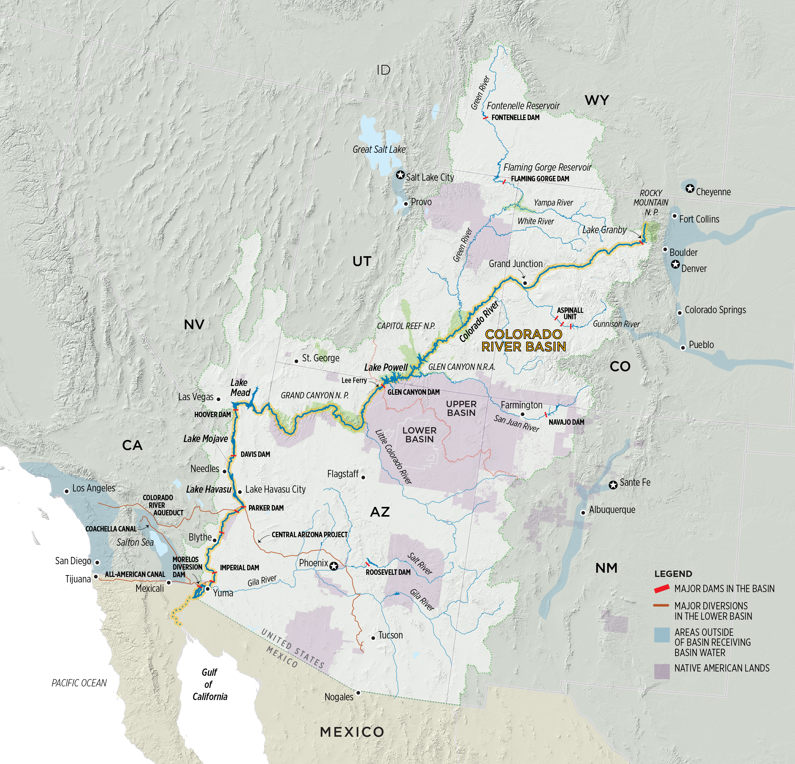
Colorado River Basin. Graphic credit: Water Education Colorado
“The 2007 guidelines were put in place for a certain amount of time and that’s because we had to learn about the system,” Reclamation Commissioner Brenda Burman said in Phoenix March 19 at the signing of the Drought Contingency Plan. “What we learned was that it wasn’t enough. The risk we expected in 2007 increased four times between then and now.”
While the 2007 agreement provided a framework for getting water users through tough conditions, more action is needed beyond conservation, Mulroy said.
“Conservation is foundational. That’s a given,” she said. “But at what point is conservation no longer able to answer the entire question? Simply solving the structural deficit does not in any way, shape or form address the hydrologic impacts [from climate change] that we are going to see on top of the structural deficit.”
What’s Ahead For Negotiators
Under the 2007 Interim Guidelines, talks on a new agreement must begin by 2020, although most expect them to begin this fall. There is a small army of people dedicated to the task, including representatives of the federal government and each of the seven basin states, water users, Native American tribes, nongovernmental organizations and Mexico. Furthermore, the U.S. continues to work with Mexico to implement Minute 323 of the 1944 U.S.-Mexico Water Treaty. Signed in 2017, Minute 323 specified reductions in water deliveries to Mexico during a shortage and allows Mexico to store water in Lake Mead. It expires in 2026.
The negotiations must forego the idea of winners and losers and must ensure that Mexico and Native American tribes are part of the conversation, Mulroy said, adding that a discussion about augmentation has to be on the table.
“We can’t get through this next seven years simply by taking away,” she said. “Trades, exchanges, reuse and stormwater capture and all of those smaller, urban regional discussions absolutely are part of the equation. The idea is to use every flexibility the Compact offers while respecting its four corners.”
Stephen Lewis, governor of the Gila River Indian Community near Phoenix, said that the Drought Contingency Plan could not have been done without the support of tribes. Those same tribes, he said at the Phoenix conference, “need to be at the table” discussing the parameters of the next agreement.
The Imperial Irrigation District, the single largest rights-holder of Colorado River water at 3.1 million-acre feet, will keep fighting to protect the Salton Sea and the viability of the district’s water supply.
“Anytime you talk about less supplies and potential impacts … IID always feels like everybody’s looking at us with that target on our backs since we are the largest user. But they tend to forget we are already conserving and transferring more than 15 percent of that entitlement to benefit other urban water agencies,” Shields, the district’s water manager, said.
There is also the question of the extent of outreach and transparency. Castle, the former Interior official, said it’s essential to leave room in the process for small, closed-door meetings among the state representatives and Interior because “there are things that need to get done that elected and appointed officials can’t get done in public and that’s just the fact.”
Promoting grandiose, “silver bullet” solutions distracts people from the results that can be achieved through multiple “nickel-sized” projects, said Jennifer Pitt, National Audubon Society’s Colorado River Program Director.
“We are going to use less water one way or another, so the question is how do we do it?” she said. “The thought that we are going to get there one way or another because that’s what the water supply is, is a reality that may help drive some of the policy discussions going forward.”
Cullom said the upcoming talks will demonstrate that neither an extension of the 2007 guidelines nor the recently negotiated drought plan will be enough to carry the shared vision of the river’s future. “The drought plan gives us space to develop the next set of operating rules without doing that in a crisis mode,” he said, “so we can take our time and have a rational, thoughtful discussion instead of doing it before a collapse of the system.”
Fulp, the Bureau of Reclamation official who has been through four presidential administrations, said the Colorado River is “essentially apolitical and it’s extremely important that we keep it that way.” He also pointed to the track record of success of the 2007 Interim Guidelines and the Drought Contingency Plan as proof that people can work together.
“We know how to do this,” he said. And he remains optimistic that as new people come to the negotiating table, they will continue that legacy. “We have to make sure we are bringing up the right people behind us because we need the same momentum to get there.”
Reach Gary Pitzer: gpitzer@watereducation.org, Twitter: @gary_wef
Know someone else who wants to stay connected with water in the West? Encourage them to sign up for Western Water, and follow us on Facebook and Twitter.
Let’s take a minute to daydream. Close your eyes and envision beautiful mountain scenery and cold, clean water drifting through the valley floor, bugs flitting through the clear, blue sky, and the possibility of sighting wildlife around every bend. Listen to the birds chirping and the sound of water running over the backs of logs and rocks. Now picture over 100 miles of this river stacked with browns and rainbows. This is not a dream. This is the Arkansas River in central Colorado.
At one point in history, not too long ago, this was not the Arkansas we now know. It was severely contaminated from hardrock mining to the degree of needing a Superfund designation to clean it up. But clean it up they did. After years of remediation work, the Arkansas has rebounded better than imagined, becoming the Gold Medal river we know today.
Chaffee County Commissioner Greg Felt said, “When I first began fishing the Arkansas in 1985, one could catch a lot of fish, but they were small and in poor condition due to water quality issues. With the successful effort to improve that, we began to see fish live much longer and healthier lives, and the diversity of our aquatic entomology really flourished. While a Superfund project is not a quick nor easy process, the payoff for the fishery, and for anglers, local businesses, residents, and visitors has been phenomenal.”
This is also the hope for the Animas River just a few hundred miles to the southwest. Named a Superfund cleanup site in 2016, the Animas headwaters have a similar storied past of hardrock mining. Since the mining boom of the 1880s, the Upper Animas has seen massive heavy metal loads flowing through a wilderness section and into the town of Durango. Luckily, the metals dissolve significantly to leave the lower reaches valuable for anglers with its four miles of Gold Medal designation through Durango. But just imagine what could happen with the remainder of the river after the Superfund cleanup is complete.
We’ve already seen glimpses of rehabilitation on the Animas River. During a brief period when a wastewater treatment plant was in place at the headwaters, trout numbers in the upper reaches were about 400 fish per mile. Once that treatment plant was removed in 2004, numbers dropped to 100 fish per mile in 2010 and a dismal 73 fish per mile last year. The same is true for macroinvertebrates. The celebrated pale morning dun was once a character of the river landscape, but since the closure of the plant, they have been nonexistent. Clearly, remediation of any level is beneficial to trout and trout food.
If the Animas River Valley, its citizens and businesses, anglers and recreationists can learn anything from the Arkansas River success story, it’s this: hope is not lost. It will take time, but the Animas River will return to a healthy habitat for our beloved trout.
On April 7, 2016, the Environmental Protection Agency proposed adding the “Bonita Peak Mining District” to the National Priorities List, making it eligible for Superfund. Forty-eight mine portals and tailings piles are “under consideration” to be included. The Gold King Mine will almost certainly be on the final list, as will the nearby American Tunnel. The Mayflower Mill #4 tailings repository, just outside Silverton, is another likely candidate, given that it appears to be leaching large quantities of metals into the Animas River. What Superfund will entail for the area beyond that, and when the actual cleanup will begin, remains unclear. Eric Baker
From the Environmental Working Group (Monica Amarelo):
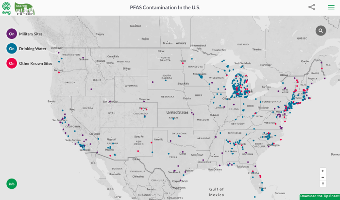
The known extent of contamination of American communities with the toxic fluorinated compounds known as PFAS continues to grow at an alarming rate, with no end in sight. As of March 2019, at least 610 locations in 43 states are known to be contaminated, including drinking water systems serving an estimated 19 million people.
The latest update of an interactive map by EWG and the Social Science Environmental Health Research Institute, at Northeastern University, documents publicly known pollution from PFAS chemicals nationwide, including public water systems, military bases, military and civilian airports, industrial plants, dumps and firefighter training sites. The map is the most comprehensive resource available to track PFAS pollution in the U.S.
The last time the map was updated, in July 2018, there were 172 contaminated sites in 40 states. This update draws from new data sources, so it is not directly comparable with the previous edition. But clearly, the crisis is spreading, and the new data may represent just the tip of a toxic iceberg.
PFAS chemicals, used in hundreds of consumer products, have been linked to weakened childhood immunity, thyroid disease, cancer and other health problems. PFOA, formerly used to make DuPont’s Teflon, and PFOS, formerly in 3M’s Scotchgard, have been phased out in the U.S., but manufacturers have replaced them with chemically similar, largely untested compounds that may be no safer. According to the Centers for Disease Control and Prevention, PFAS chemicals contaminate the blood of virtually all Americans.
“The Environmental Protection Agency has utterly failed to address PFAS with the seriousness this crisis demands, leaving local communities and states to grapple with a complex problem rooted in the failure of the federal chemical regulatory system,” said Ken Cook, president of EWG, which has studied these compounds for almost two decades. “EPA must move swiftly to set a truly health-protective legal limit for all PFAS chemicals, requiring utilities to clean up contaminated water supplies.”
“The updated map shows that PFAS contamination is truly a nationwide problem, impacting millions of Americans in hundreds of communities,” said Phil Brown, a professor of sociology and health sciences at Northeastern University and director of the Social Science Environmental Health Research Institute. “Leaders in many communities and states are doing great work to raise awareness about PFAS and push for cleanup, but this is a national crisis demanding national action. The EPA should act more quickly to evaluate all PFAS chemicals and restrict their use, and polluting industries should be held responsible.”
Michigan has 192 sites on the map, reflecting a testing program more comprehensive than anywhere else. It reinforces the fact that PFAS chemicals are everywhere – when you look for them, you find them. California has 47 known contamination sites and New Jersey has 43.
The map also shows contamination of 117 military sites, including 77 military airports, a legacy of the Pentagon’s 50-year history of using PFAS-based firefighting foam.
There are no legally enforceable limits for PFAS chemicals under the federal Safe Drinking Water Act. The EPA’s non-binding health advisory level for drinking water is 70 parts per trillion, or ppt, for PFOA and PFOS, separately or in combination.
Last year the federal Agency for Toxic Substances Disease Registry proposed safe levels that roughly translate to 7 ppt for PFOS and 11 ppt for PFOA. Based on the best available science and emerging evidence of harm from the entire class of these chemicals, EWG is today proposing drinking water and cleanup standards for all PFAS chemicals as a group at 1 ppt. This is a health-based level that will fully protect public health for the most vulnerable populations, and does not depend on economic or political considerations.
The May 1st forecast for the April – July unregulated inflow volume to Blue Mesa Reservoir is 970,000 acre-feet. This is 144% of the 30 year average. Snowpack in the Upper Gunnison Basin peaked at 143% of average. Blue Mesa Reservoir current content is 384,000 acre-feet which is 46% of full. Current elevation is 7462 ft. Maximum content at Blue Mesa Reservoir is 829,500 acre-feet at an elevation of 7519.4 ft.
Based on the May 1st forecast, the Black Canyon Water Right and Aspinall Unit ROD peak flow targets are listed below:
Black Canyon Water Right
The peak flow target is equal to 7,158 cfs for a duration of 24 hours.
The shoulder flow target is 966 cfs, for the period between May 1 and July 25.
Aspinall Unit Operations ROD
The year type is currently classified as Moderately Wet.
The peak flow target will be 14,350 cfs and the duration target at this flow will be 10 days.
The half bankfull target will be 8,070 cfs and the duration target at this flow will be 20 days.
(The criteria have been met for the drought rule that allows half-bankfull flows to be reduced from 40 days to 20 days.)
Projected Spring Operations
During spring operations, releases from the Aspinall Unit will be made in an attempt to match the peak flow of the North Fork of the Gunnison River to maximize the potential of meeting the desired peak at the Whitewater gage, while simultaneously meeting the Black Canyon Water Right peak flow amount. The magnitude of release necessary to meet the desired peak at the Whitewater gage will be dependent on the flow contribution from the North Fork of the Gunnison River and other tributaries downstream from the Aspinall Unit. Current projections for spring peak operations show that flows in the Gunnison River through the Black Canyon could be over 8,000 cfs for 10 days in order to achieve the desired peak flow and duration at Whitewater. With this runoff forecast and corresponding downstream targets, Blue Mesa Reservoir is currently projected to fill to an elevation of around 7515.5 feet with an approximate peak content of 795,000 acre-feet.
Here’s the article from the Center for Snow and Avalanche Studies. Click through and read the whole article and check out the photo galleries from each site. Here’s a excerpt:
Our CODOS tour around Colorado began Monday and finished Friday afternoon. To see a map of our sample sites throughout the state http://www.codos.org/#maps. Dust from the April 9/10 storm event (D3) was observed at all CODOS sites across the entire state. From Monday thru Thursday (April 30 – May 2) most of the Colorado Mountains received a productive storm and general unsettled weather meant 7 days of precipitation at SASP resulting in 3” of precipitation in the form of wet snow. After this productive storm(s) a number of higher elevation SNOTEL stations (see SNOTEL plots below) appear to now be near peak SWE (Berthoud, Grizzly, Hoosier, Red Mountain, Willow, Fremont), although the peak may still be a week away depending on what melt occurs now until Wednesday when a storm system is expected to arrive, and how much precipitation this storm brings and where.
For CODOS sites that were visited before snow accumulation began the dust was observed at the surface. For sites that we visited during or after snow accumulation the dust was under the new snow. So essentially, the dust was on the surface prior to the storm and will be back on the surface once this new snow consolidates and melts. Dust severity is enough that it has and will effect albedo. Below are pictures and observations for each CODOS site detailing location of dust layers, new snow accumulation on the dust, and general sense of severity of dust.
After the overcast and stormy conditions we experienced Monday thru Thursday slowing snowmelt and resulting in reduced streamflows statewide, the heat will be on thru Monday picking things up a bit. The next tap on the snowmelt brakes starts Tuesday with increased chances of precipitation Wednesday-Friday. The snow level will start high, above 9,000’, but lower towards the end of the week. Models are coming into agreement with this system expecting to produce over 1” of water in some areas.
This is a low frequency dust season (only two notable dust events to date) but may be a high consequence snowmelt season. The two dust events we have received are at the top of the snowpack…..a very big snowpack. How it all plays out depends on spring weather going forth. The snowpack at all CODOS sites are isothermal, wet and at certain depths very wet. As storm systems exit the state and warm/sunny conditions return the snowpack will not waste anytime going back into melt mode. Much more so once the dust layer(s) are exposed at the snow surface. So far this spring we have received well timed storm systems slowing down snowmelt, adding even more precipitation to the snowpack, and covering exposed dust. This keeps streamflow peaks from occurring early and all at once. Ideally inclement weather will allow the snow to melt gradually well into the summer, but if we get a stretch of warm and sunny weather we will see rapid melt in basins that are 110%-172% of median snowpack and very high streamflows as a result.
Another item to consider, we mentioned in previous CODOS reports our SBSP site at elevation 12,200’ is currently in the top three years, being up there with WY2005 and WY2011 for the most SWE in our period of record (going back to WY2004). SBSP is the only source of high elevation operational snowpack data in Colorado. The highest SNOTEL station in Colorado is at 11,600’. So not only are we seeing a lot of snow at higher elevations at SBB and visually elsewhere, but our longtime CSAS field assistant has noted that this is the most snow he has seen on all aspects for this time of year, notably southerly aspects. This winter we did not see any winter “droughts” where a long period, usually in January or February, of sustained warm and dry weather render southerly aspects partially or completely devoid of snow. Unlike typical years where the snow would be melted out by now, the southerly aspects most notably still have ample snow.
Snowpack in every part of Colorado’s high country is sporting layers of dust, according to a new statewide survey of the state’s winter accumulation.
“This is a low frequency dust season,” wrote Jeff Derry, head of the Colorado Dust on Snow Program, in a post about the survey results. “But may be a high consequence snowmelt season.”
Dust is darker than snow. Just like a black T-shirt on a sunny day, it absorbs more sunlight, causing what’s underneath it to heat up more rapidly.
“It’s like holding a magnifying glass up to the snowpack,” Derry said.
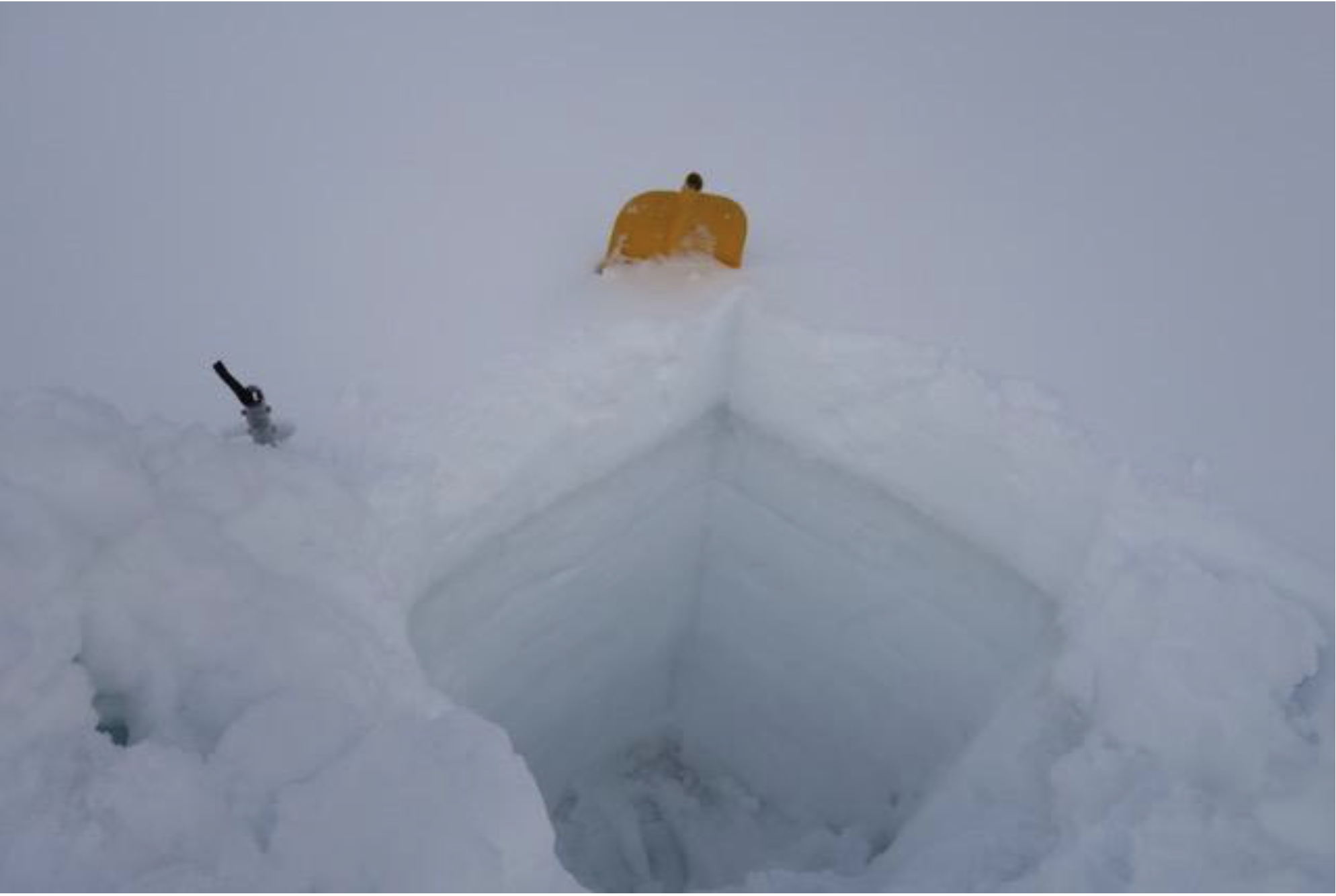
A snow pit on Loveland Pass shows a narrow stripe of dust near the surface. When it’s exposed, the dust can speed up melt off by a couple weeks. Photo credit: Center for Snow and Avalanche Studies via KUNC
Each year Derry and his colleagues from Silverton’s Center for Snow and Avalanche Studies dig snow pits throughout the state to check on the layers of dust. This winter he found two distinct stripes, close to the surface. A dust storm in early March left one of those layers. Another storm in the first week of April blanketed dust on snowpack throughout the state’s high country.
At each of the 11 sites Derry visited, dust was present somewhere in the snowpack.
Snow melts from the top down. The layers closest to the surface melt through the snowpack, exposing those underneath.
Once dust layers are exposed, they have the potential to speed up snow melt. Depending on the severity of the dust deposition and where the layers lie within the snowpack, dust can shorten the runoff season by a couple weeks to a month. In a heavy snow year, like the winter of 2019, that could mean rapid melt in watersheds across the state, making water management much more difficult.
Here’s a report from Barbara McLachlan that’s running in the The Durango Herald. Click through and read the whole article. Here’s an excerpt:
HB19-1113 – Protect Water Quality Adverse Mining Impacts
We all remember the 2015 Gold King Mine spill, so I led a bill to help prevent water pollution from future hardrock mining operations in Colorado. This is good for our environment and precious water, while keeping a thriving mining industry moving forward. Taxpayers will no longer have to pay when a mine files for bankruptcy.
HB19-1006 – Wildfire Mitigation Wildland-Urban Interface Areas
Wildfire season is fast approaching. This bill won bipartisan approval in the Legislature and adds funding to the already existing Wildfire Risk Mitigation Grant Program to address the needs of mitigation in the Wildland-Urban Interface Areas. The funding will help homeowners prepare their property for fire suppression. The Colorado Forest Service says these areas are the most likely to burn during the next fire season; helping them now will help all of Colorado later.
Created by Imgur user Fejetlenfej , a geographer and GIS analyst with a ‘lifelong passion for beautiful maps,’ it highlights the massive expanse of river basins across the country – in particular, those which feed the Mississippi River, in pink.
More rain has fallen in the lower 48 states over the last 12 months than during any similar period in over 120 years of record-keeping. More than 36 inches has fallen on average. According to the Washington Post the record precipitation is an increasing trend, which is expected as climate warming intensifies rainfall.
While most of the country is drought-free, much of the Midwest and south central areas of the country are full of water. The upper Midwest has been inundated by rapid snowmelt and continuing rains. The Mississippi River has risen to one of its highest levels since 1993. The Coast Guard shut down a five-mile stretch in St. Louis to barge traffic which is hard on farmers who are being hit not only with rains and flooding, but also tariffs.
Farther south in Louisiana, Governor John Bel Edwards declared a state of emergency due to severe weather. The U.S. Army Corps of Engineers opened the Bonnet Carre spillway for the second time this year to protect New Orleans by diverting water into Lake Pontchartrain. The same storm system affected Houston, where thousands and businesses lost power and heavy flooding forced evacuations. Parts of the city received five inches of rain in 90 minutes on Thursday.
In the north, water levels on the Great Lakes are expected to reach record highs this year. Lake Superior rose two inches more than normal in April. About six years ago Lakes Huron and Michigan fell to their lowest points during a 15-year slump that dried up wetlands and forced cargo vessels to lighten loads. Now a spokesperson for the Army Corps told the Detroit Free Press they are at the other extreme, and experts say the prolonged drop-off followed by the recent rise in levels is a result, at least in part, of a warming climate.