Once a symbol of American ingenuity, PFAS were originally conceived as wonder chemicals that could resist stains, repel water, extinguish horrific oil-based fires, and keep eggs from sticking to the pan. Today, we know them as a Frankenstein-like invention, zombie chemicals that will not die.
Chemists created thousands of such compounds by bonding carbon to fluorine in chemical chains, forging one of the strongest bonds ever discovered. Now they have been found across the planet—even in the blood of arctic foxes and polar bears. Public health studies found PFAS in the blood of about 95 percent of Americans. While the health impact of low levels of exposure is less clear, the chemicals are linked to liver, thyroid, and immune effects, cancer, and low birth weight. It will take billions of dollars—and yet more engineering prowess—to remove PFAS from drinking water and the environment. The task seems bleak, even as the US Department of Defense prepares to spend more than $2 billion on cleaning up PFAS on its bases. Firefighting training sites, airports, and industrial sites are also big contributors.
On Friday, the US House of Representatives passed the PFAS Action Act, which would require the EPA to set drinking water limits for two PFAS (PFOA and PFOS) and to designate PFAS chemicals as hazardous substances under the Superfund cleanup program. Its path forward is uncertain. Even if the Senate passes the measure, the Trump administration has called its provisions “problematic and unreasonable” and threatened a veto.
But here’s a shred of optimism: Some new technologies show promise in breaking those ultra-strong carbon-fluorine bonds, which means the compounds known as “forever” chemicals could be removed from at least some groundwater. “I have actually started to feel a little bit of hope,” says Chris Higgins, an environmental engineer at the Colorado School of Mines and a PFAS expert. “We’re getting some technologies that seem to be working.”
The most promising approach involves an electrical reaction that looks like lightning striking water. Contaminated water goes through a plasma reactor, where argon gas pushes the PFAS compounds to the surface. Electrodes above and below the surface generate plasma—a highly reactive gas made up of positive ions and free electrons—that interacts with the PFAS and breaks the carbon-fluorine bonds.
“Our goal is to completely destroy the compound and not just transfer it from one phase to another,” says Michelle Crimi, an environmental engineer at Clarkson University in Potsdam, New York, who works on emerging technology to remediate PFAS. The plasma reactor technique was developed by her colleagues Selma Mededovic, a chemical engineer, and Tom Holsen, an environmental engineer.
Crimi is also using ultrasound waves to create cavities—essentially holes—in the water. When they collapse, they instigate physical and chemical reactions that break apart the PFAS chains. Other researchers are working on electrochemical techniques and even soil bacteria that may metabolize PFAS.
Click on a thumbnail graphic below to view a gallery of drought data from the US Drought Monitor.
US Drought Monitor January 14, 2020.
West Drought Monitor January 14, 2020.
Colorado Drought Monitor January 14, 2020.
Click here to go to the US Drought Monitor website. Here’s an excerpt:
This Week’s Drought Summary
Warmer than normal temperatures were common this week over the eastern half of the continental U.S., while temperatures were primarily near normal over the western half, with a few exceptions. Moderate to heavy precipitation was common this week along and east of the Interstate 35 corridor, excepting parts of the Northeast and the Florida Peninsula. In the West, moderate to heavy precipitation also fell in some of the higher elevation areas. For more details on the geographic distribution of precipitation and temperature anomalies, please see the regional paragraphs below. The only exceptional drought occurring in the United States, on Maui, was removed this week after a major precipitation event in Hawaii, where other improvements were also made. Heavy rainfall in northern and eastern Puerto Rico also ended the moderate drought there. In the central and eastern continental U.S., drought conditions generally improved in areas that received heavier precipitation, while some degradation occurred in locations in Texas and Oklahoma that remained drier. The depiction of moderate drought and abnormal dryness also changed in Idaho, Washington, and Oregon, where recent precipitation (or lack thereof) affected mountain snowpack and short-term precipitation deficits. For more details on changes made to the drought depiction, please see the regional paragraphs…
Across the High Plains region, primarily dry and near normal or cooler than normal conditions occurred, with the exceptions of south-central and eastern Kansas, where warmer than normal temperatures occurred and over a half inch of precipitation fell. Temperatures mostly ranged from 5 to 10 degrees cooler than normal in South Dakota and North Dakota this week. Moderate and severe drought continued in south-central and southwest Kansas, respectively, and no changes were made to the drought or dryness depiction in the region…
Temperatures varied across the West region over the past week. Eastern Utah and north-central Montana had temperatures 5 to 15 degrees cooler than normal, while western Utah was 5 to 10 degrees warmer than normal. Warmer temperatures continued in the eastern and southeastern plains of New Mexico, and abnormally dry conditions were expanded where high evaporative demand combined with lower recent precipitation amounts. Heavy mountain snow occurred in the Cascades, where abnormal dryness and moderate drought slightly improved as short-term precipitation deficits slightly lessened and snowpack grew. High elevation areas of Colorado, Wyoming, Idaho, Montana, northern Utah, and northern California received precipitation this week, while lower elevation locations generally stayed dry. Moderate drought and abnormally dry conditions shifted in Idaho in response to changing snowpack and precipitation deficits over the past week…
Most of the South had warmer than normal temperatures this week, though widespread rainfall led to reduction in drought conditions in parts of the region. Temperatures ranged from 10 to 15 degrees warmer than normal in Mississippi and Tennessee to generally 5 to 10 degrees above normal in Oklahoma and Texas. Excluding south Texas, moderate to heavy rain fell across the portion of the region to the east of the Interstate 35 corridor. The highest rain amounts, with some locations exceeding 3 inches, fell upon north-central Texas, southeast Oklahoma, Arkansas, far northeast Louisiana, and northern Mississippi. The heavy rain in east Texas and adjacent portions of Louisiana, Arkansas, and southeast Oklahoma led to improvement in drought and abnormally dry conditions in these areas, where short-term precipitation shortages were lessened, and streamflow improved. In areas west of the more widespread precipitation in Texas and Oklahoma, some of the drought and abnormally dry areas were expanded where short-term precipitation deficits grew…
Looking Ahead
Another winter storm system is forecast to traverse the Central Plains, Midwest, and eastern continental U.S. from Thursday, January 16 into the weekend of Saturday the 18th, delivering widespread rain, snow, and a mix of winter precipitation types. For January 16-21, the National Weather Service Weather Prediction Center is forecasting over three-quarters of an inch of precipitation in a widespread area from coastal central and northern California northward through the high elevation areas of western Washington and Oregon. Precipitation is also forecast in the central and northern Sierra Nevada, and in some of the high elevation regions of the Rocky Mountain Front Ranges and Intermountain West. Widespread precipitation is forecast from West Texas northeastward along and north of the Interstates 44 and 70 corridors and in the Ohio Valley and Northeast, where amounts may exceed an inch in some areas. Temperatures will vary in the High Plains and West during this period, while generally warmer than normal conditions over the eastern continental U.S during the first half of the weekend are forecast to be replaced by colder than normal weather afterward. For January 21-25, the National Weather Service Climate Prediction Center is forecasting mainly warmer than normal temperatures from the High Plains westward, and below-normal temperatures in the South, Southeast, and Northeast. Below-normal precipitation is favored during this period in the Northeast, Great Lakes and Ohio Valley, while above-normal precipitation is favored in the Pacific Northwest, the Central and Southern Great Plains, and areas in between.
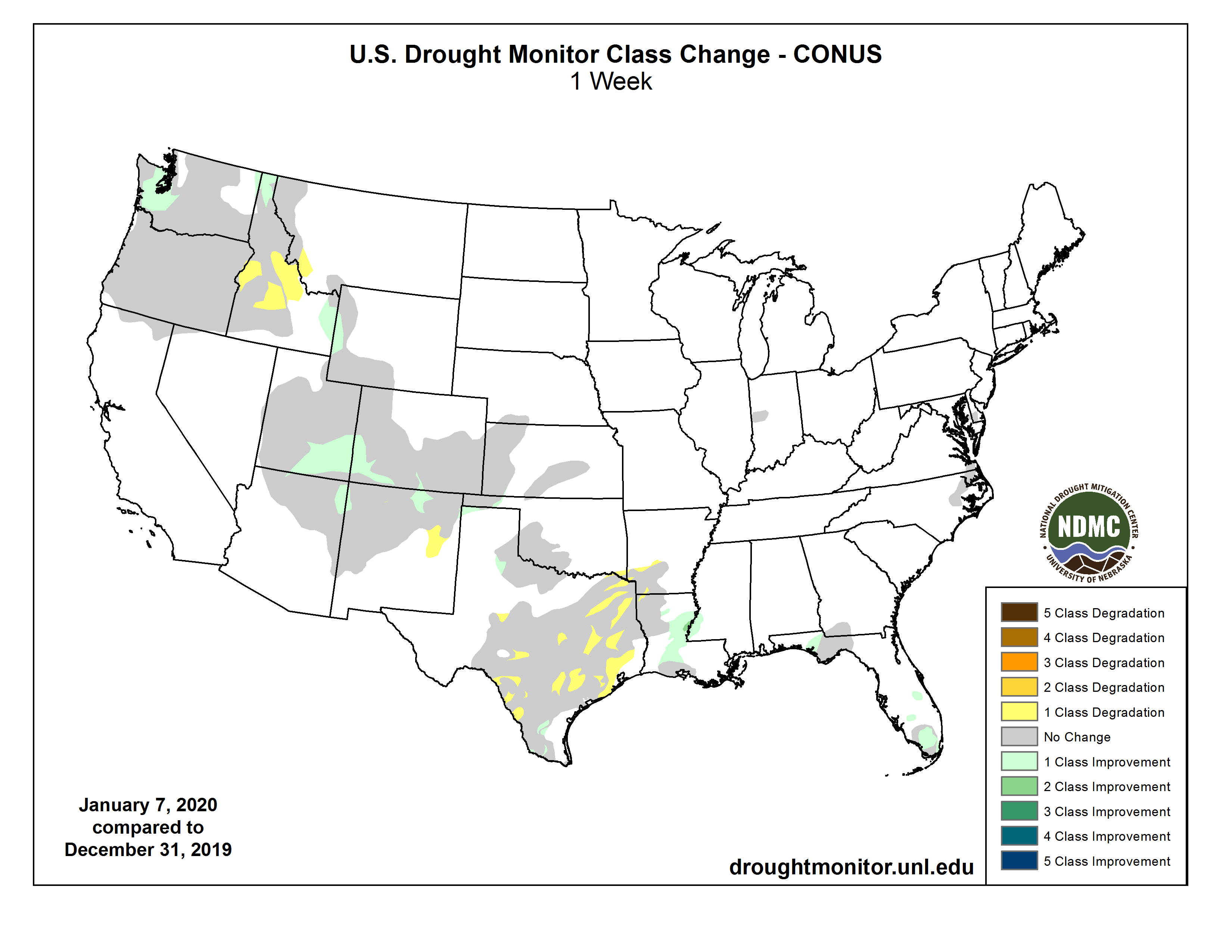
US Drought Monitor one week change map ending January 14, 2020.
[San Juan River Basin] Snow water equivalency (SWE) is 16.4 inches this week. Last week it was 15.5 inches.
SWE median increased from 16 inches to 16.3 inches this week.
This week, SWE data is 110.6 per- cent of median. Last week, it was 96.9 percent of median.
Precipitation data has slightly increased from last week, going from 16.5 inches to 16.6 inches.
The precipitation average has increased 1.5 inches from last week, going from 17.6 inches to 18.9 inches this week.
Precipitation data is 87.8 percent of median this week, a drop from last week when it was 93.8 percent of median.
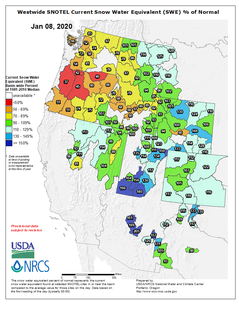
Westwide SNOTEL basin-filled map January 16, 2020 via the NRCS.
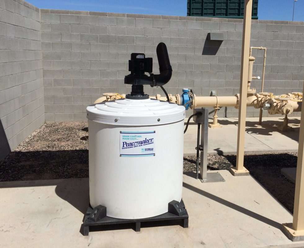
Oxidizing/Polishing Dry Air Scrubber provide a two stage chemistry for the control of odors from hydrogen sulfide (H2S), mercaptans, ammonia, amines and other odors generated in wastewater collection and treatment systems. They are easy to use, effective and economic. Photo credit: Syneco Systems
At its Jan. 7 meeting, the board of the Pagosa Springs Sanitation Gen- eral Improvement District (PSSGID) again worked to deal with a stinky issue that’s plagued the district and some Archuleta County residents — odor control near the town’s two pump stations in the Timber Ridge area.
The odor issues in the area began when the town started using a force main to move its collected waste- water to the Pagosa Area Water and Sanitation District campus for treat- ment. Construction of the pipeline was completed in 2016.
“The odor results from naturally high sulfur in the area, in waste, and the long detention times in the wet well and the force main,” an agenda brief prepared by Public Works Di- rector Martin Schmidt explains.
The PSSGID previously piloted an odor control project with little success, with Schmidt’s document stating, “it did not get close to the levels of H2S [hydrogen sulfide] that were stipulated in the contract.”
PSSGID staff, with engineering support, then brought back information on several options for the board to consider on Jan. 7, along with a recommendation to pair two of the technologies to best control odor and eliminate corrosion.
The four options brought to the board were an oxygen injection system, an aeration system with added ozone (the same technology as the pilot project), chemical dosing, an air scrubber system and an air-injector system that builds dissolved oxygen in the water to eliminate anaerobic bacteria.
Schmidt and Utilities Supervisor Gene Tautges recommended that the board combine the final two options.
The air scrubber system, manufactured by Syneco Systems Inc., has a small blower that creates a negative pressure in the wet well, the agenda brief explains.
“The removed air is scrubbed of H2S by a proprietary media that converts 100% of the H2S into a non-toxic polymer,” the document explains.
Schmidt noted the blower is not much larger than a bathroom fan, with Schmidt and Tautges indicat- ing it operates at a low decibel level, around 55 decibels.
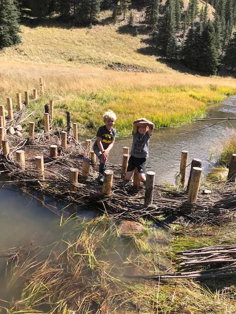
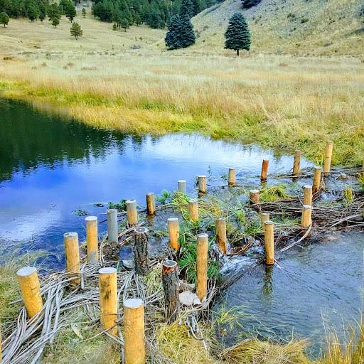
From the Rio Grande Headwaters Restoration Project (Emma Reesor) via The Alamosa News:
The reach of the Rio Grande running through North Park has seen a lot of change in the last two months. Workers and machinery from Robins Construction have braved the elements as part of a plan to improve access to one of Del Norte’s most valuable natural resources.
North Park is one of the few public parks in Del Norte, situated on the Rio Grande just west of Highway 112. While featuring a fishing dock and riverside trail, the community thought more could be done to better connect residents to the river.
From this need arose the Del Norte Riverfront Project a community-led effort to improve access, create recreation infrastructure, and enhance wildlife habitat on the Rio Grande adjacent to North Park. Project partners, including the Rio Grande Headwaters Restoration Project,
Town of Del Norte, Del Norte Trails Organization, Riverbend Engineering and Trout Unlimited have worked with the public over the past five years to plan and fundraise for the DNRFP.
Phase 1 of the DNRFP was completed during the winter of 2018 and included a new boat ramp and parking area located on the north side of the river.
In March of 2019, the DNRFP was selected to receive funding from Great Outdoors Colorado’s Local Parks and Outdoor Recreation grant program.
It was one of 22 projects chosen to receive funding in a highly competitive pool of projects.
This grant, along with support from the Colorado Water Conservation Board, Gates Family Foundation, SLV Conservation and Connection Initiative, Del Norte Bank, Rio Grande County, and community donors, helped realize Phase 2 of the project, which includes the in-stream construction of a boating Play Wave, fish habitat improvements and passage, and river access points.
Work on these structures began in November 2019 and will be complete in early 2020.
Still yet to come this spring is an ADA accessible picnic area, as well as other park amenities. All these improvements will help promote a deeper connection to the river for residents and visitors alike.
Emma Reesor, Executive Director of the RGHRP, has been integral in the planning and fundraising for the project, and is excited to see construction in full swing. “It’s been a joy to work with the community of Del Norte to make this vision a reality” Reesor said, “Improving connectivity between people and rivers will have a positive effect on the community as a whole”.
Marty Asplin with the Del Norte Trails Organization has been a part of the DNRFP from the very beginning and worked hard to bring partners together to benefit Del Norte. “The addition of access to the Rio Grande was part of the Del Norte Trails Master Plan which was adopted by the Town of Del Norte and Rio Grande County in 2007,” said Marty Asplin, “accomplishing this is a large piece of the plan.”
If you’d like to check out the progress of the project, the fishing dock is a great place to view the construction.
Intake towers for power generation at Hoover Dam December 13, 2019.
FromThe Boulder City Review (Celia Shortt Goodyear):
The water at Lake Mead is projected to be at its highest level in years, but the drought is still not over, according to the Bureau of Reclamation.
Lake Mead’s elevation is around 1,092 feet, which is the highest it has been since May 2014, but it is still only 42% full, said Patti Aaron, public affairs officer for the bureau’s Lower Colorado Basin Region.
“Drought isn’t determined by the amount of water in Lake Mead,” Aaron said. “We would need to see at least two to three back-to-back years of above-average hydrology, hopefully more, to say we are out of the drought. There isn’t a set definition of when drought ends.”
There have not been two back-to-back good years since the late 1990s.
Aaron said the higher water levels are due to a wet November and December, causing an above-average inflow into the lake.
“Regarding the rising lake levels, this is part of the normal seasonal trend in which cooler weather reduces water orders from Lake Mead,” she said.
She added that the water level will decline by nearly 20 feet in the spring and summer because water orders will increase before the elevation rebounds later in the year.
The higher water levels are also due to conservation by the lower basin states and Mexico. The Lower Basin Drought Contingency Plan, which took effect on Jan. 1, requires water savings contributions by the United States and Mexico.
Aaron said voluntary conservation activities added about 9 feet to Lake Mead’s elevation last year.
State officials last month designated a new, and popular, stretch of Boulder Creek from the mouth of Boulder Canyon through the park as “impaired” due to elevated levels of E. coli.
But tubers, swimmers, fishermen and women will still likely be able to take a dip this summer if they wish.
The new designation by the state for the creek’s west Boulder stretch adds to the existing impairment of the waterway from 13th Street east to its confluence with South Boulder Creek, according to Colorado Water Quality Control Division spokesperson Ian Dickson…
The determination was made based on a “robust” data set of measurements for the E. coli bacteria, Dickson said.
“Every two years, the (state health) department works with the (Water Quality Control) Commission to examine water quality data and identify impaired waters,” Dickson said. “… The department thanks city of Boulder for this information, and we encourage communities to continue to send data so we can work together to protect the environment.”
Boulder spokesperson Meghan Wilson said the city is working on a communication strategy for informing residents and potential creek users of the newly designated impaired stretch of creek. But unlike a swimming beach at a reservoir or other body of water, local officials have little ability to restrict human access to a stream like Boulder Creek, Wilson said…
…earlier in the week, Dickson did offer a response to Boulder Waterkeeper data the advocacy group used to assert there is a that there is a “human waste footprint” to the detected E. coli.
E. coli is a bacterial marker for fecal pollution, which lives in the intestines of humans, wildlife, cattle and dogs, but is not always harmful to humans. However, one strand, known as 0157:H7, can cause abdominal cramps, diarrhea, vomiting and even life-threatening conditions…
“The one sample taken does not provide conclusive evidence that human source bacteria were present. The strain of bacteria the lab tested for could also come from other animals, such as raccoons and geese. Again, the lab indicated more data is needed to determine whether the strain is from humans versus other animals. At this time, even with these E.coli and human fecal bacterial levels, there is no indicator of an illicit discharge or other noncompliance with the university’s permit.”
After the 2013 floods devastated communities and took several lives, the state of Colorado is remapping the regulatory floodplain of the most affected waterways in Colorado.
“It’s important to provide public and local land use managers with the most accurate flood risk information so they can make better decisions,’ explained Thuy Patton, Flood Mapping Program Manager for the Colorado Water Conservation Board.
In some counties, there are areas that now have higher flood risk and other areas that now have lower flood risk, which changes which homes are in the flood plain. NOTE: these numbers are approximate, based on public information, and are subject to change.
In Boulder County, with this update, 420 new structures are in flood risk area and approx. 400 structures are now not in special flood hazard area, Patton explained.
In Jefferson County, 53 structures were added.
In Larimer County, 601 structures were added and 1,571 were removed.
In Weld County, 453 structures were added and 1,994 were removed.
In Sedgwick County, 85 structures were added and two were removed.
In Washington County, 26 structures were added and 31 were removed.
In Morgan County, 38 structures were added and four were removed.
And in Logan County, 222 structures were added, while 59 were removed.
FEMA uses Flood Insurance Rate Maps (FIRMs) to set flood insurance premiums. The Preliminary FIRMs will become FEMA’s final effective FIRMs in 2021, pending any appeals received by FEMA.
Boulder County is starting a series of public meetings about the changes. Representatives from FEMA, the mapping team, and Boulder County will be present at each session. Each open house will focus on specific reaches, but residents are invited to discuss any stream at each meeting:
Lower Boulder Creek, New Dry Creek, Coal Creek, and Rock Creek – Tuesday, Jan. 14 | 5 to 6:30 p.m. (presentation at 5:15 p.m.) Boulder County Recycling Center – 1901 63rd Street in Boulder County
Saint Vrain Creek, Lower Left Hand Creek, Dry Creek #2, and Little Thompson River – Thursday, Jan. 16 | 5 to 6:30 p.m. (presentation at 5:15 p.m.) Boulder County Parks and Open Space Ron Stewart Building – 5201 St. Vrain Drive in Longmont
North, Middle, and South Saint Vrain creeks and Cabin Creek – Tuesday, Jan. 21 | 5 to 6:30 p.m. (presentation at 5:15 p.m.) Highlands Presbyterian Church – 1306 Business Highway 7 in Allenspark
Little James Creek, James Creek, Upper Left Hand Creek, and Geer Canyon – Tuesday, Jan. 28 | 5 to 6:30 p.m. (presentation at 5:15 p.m.) Jamestown Town Hall – 118 Main St. in Jamestown. This is a joint meeting between Boulder County and the Town of Jamestown
Fourmile Canyon Creek, Two Mile Canyon Creek, Gold Run, Fourmile Creek, Boulder Creek and North, Middle, and South Boulder creeks – Thursday, Jan. 30 | 5 to 6:30 p.m. (presentation at 5:15 p.m.). Boulder Public Library Main Branch, Boulder Creek Room – 1001 Arapahoe Ave. in Boulder
Here’s the release from The Nature Conservancy (Eric Bontrager):
The Trump administration today proposed several changes in the regulation governing how the federal government fulfills its obligations under the National Environmental Policy Act (NEPA).
The law, enacted in 1970, requires the federal government to assess the environmental and other impacts of federal actions like permitting infrastructure projects prior to making final decisions. The changes proposed by the White House Council on Environmental Quality include cutting down review times, limiting consideration of factors like climate change from NEPA analysis, allowing some developers to do their own reviews and expanding the use of categorical exclusions that eliminate further impact analysis for certain-sized projects.
The following is a statement by Lynn Scarlett, chief external affairs officer at The Nature Conservancy:
“The National Environmental Policy Act is one of the United States’ foundational environmental laws, responsible for helping improve the quality of our air, water and ecosystems while giving members of the public a greater voice in the health and future of their communities. The best way to achieve more efficient and effective project decisions is to work collaboratively to identify environmental issues early in the design process. Setting arbitrary, time-certain deadlines for completion of project reviews and simply limiting the scope of projects and impacts that must be considered will not improve the quality of NEPA analysis, will do little to increase efficiency and does not address underlying issues of agency cooperation and stakeholder engagement.
“With climate change impacts bringing severe consequences to many communities across the nation, NEPA provides a tool for assessing how actions affect greenhouse gas emissions and the impacts of climate change to people, their livelihoods and the environment. We recognize the challenges and complexity of such assessments, particularly for indirect impacts, but those challenges are not a reason to neglect or avoid such analysis, as these changes propose.
“The Nature Conservancy continues to support efforts to improve the NEPA process on the ground. However, several of the changes proposed today would reduce the law’s safeguards, transparency and inclusiveness. To deliver on the basic purpose of NEPA – ensuring federal agencies consider the environmental consequences of their actions and inform the public about them – we need to retain strong scientific standards, support thorough analysis and continue robust public engagement. We urge the administration to reconsider proposed changes that will not improve the process but instead will move NEPA away from its intended purpose.
“When the administration first set out to reassess how it should enforce NEPA, we provided a number of detailed recommendations to achieve many of the goals articulated through better implementation and enforcement of existing regulations rather than a broad overhaul. As we analyze the administration’s proposal, we encourage the administration to reexamine those recommendations and the tools already at its disposal rather than inventing new ones to reform NEPA.”
The Nature Conservancy is a global conservation organization dedicated to conserving the lands and waters on which all life depends. Guided by science, we create innovative, on-the-ground solutions to our world’s toughest challenges so that nature and people can thrive together. We are tackling climate change, conserving lands, waters and oceans at an unprecedented scale, providing food and water sustainably and helping make cities more sustainable. Working in 79 countries and territories, we use a collaborative approach that engages local communities, governments, the private sector, and other partners. To learn more, visit http://www.nature.org or follow @nature_press on Twitter.
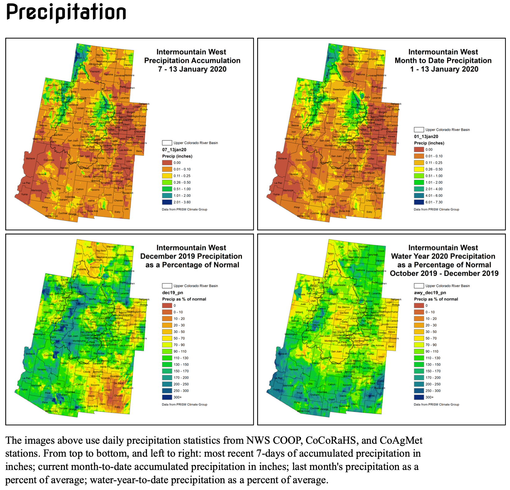
Click here to read the current assessment. Click here to go to the NIDIS website hosted by the Colorado Climate Center. Here’s the summary:
Summary: January 14, 2020
It was a quiet week in the Intermountain West, with most of the region seeing little to no precipitation. The Tetons in northwest Wyoming and the Wasatch range in Utah saw the best precipitation totals with 0.50 – 2.00″. The northern mountains in Colorado saw between 0.5 to 1.00″. Less than 0.10″ through the rest of the region.
January to date has seen the same pattern we saw last week with dryness through most of the region with some precipitation in the Tetons and the northern mountains in Colorado. Precipitation that has fallen this month has been a bit below normal. This is showing up on the short-term SPI with below normal numbers for much of our region.
Snowpack is still above normal for the region and thanks to near to below normal temperatures, the snowpack is sticking around as it should this time of year, even with lower precipitation amounts the first two weeks of 2020.
Temperatures in eastern Colorado have been above normal and with the dry conditions, producers are starting to get nervous about their winter wheat. This is an area we will keep a close eye on over the coming weeks and months. The 7-day outlook does not give much hope for eastern Colorado, with less than 0.10″ expected, however, the 8-14 day forecast is calling for chances of above normal precipitation. Fingers crossed the outlook is right.
The 7-day outlook for the rest of the IMW region shows a typical January pattern, with precipitation expected in the mountains and little to [none] expected in the lower elevations.
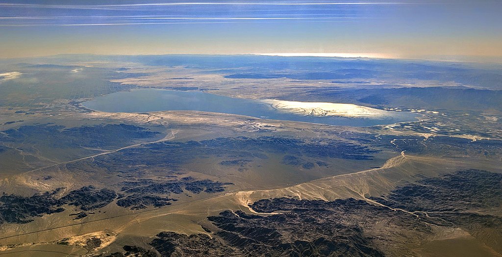
Aerial view of the Salton Sea from the north-northeast (from over Joshua Tree National Park), looking into the early afternoon sun. Photo credit: Dicklyon via Wikimedia Commons
Here’s an in-depth report from Lindsay Fendt that’s running on the Food & Environment Reporting Network website. Click through and read the whole article. Here’s an excerpt:
Now the Salton Sea has another problem: Climate change is making this dry region even drier. And a growing demand for water in the booming cities and suburbs of Southern California has reduced the amount of Colorado River water diverted to nearby farms. In the coming years these two factors are expected to dramatically increase the pace at which the lake shrinks, exposing more lake bed and the agricultural toxins trapped in the mud.
The desert winds lift dust from the lakebed, and scientists fear that eventually the toxic residue of more than a century of agricultural runoff will be blown into the air — and into the lungs of residents. The area surrounding the Salton Sea already has some of the worst air quality in the country, caused by particulate matter swept up from farms and the desert. Local residents have some of the highest rates of asthma and other respiratory problems in the state, and public health officials say the heavy metals and chemicals in the lake bed pose an even greater threat…
It seems unnatural, the shimmering water surrounded by chalky sand and cactus. But water has found its way into this desert basin repeatedly throughout history. Before dams and other diversion structures fixed the Colorado River on its current path, the river used to periodically migrate across the floodplain, changing course to circumvent sediment that had built up in previous seasons. Sometimes it emptied here in the Salton Sink. During one such period, the river sustained an even larger lake, Lake Cahuilla, that stretched from the Coachella Valley, up by Palm Springs, all the way to northern Mexico.
We fly near the Chocolate Mountains that rise up south of the Salton Sea, and Ruiz points to a discolored line high on one of the ridges where a thousand years ago lake water once reached.
“If you talk to anyone from the Cahuilla tribe, the people who have been in this basin forever, they say water has always been here,” Ruiz said. “So this isn’t just about saving some artificial lake.”
Lake Cahuilla dried up sometime in the 16th century after the river again shifted course, this time to the Gulf of California. Dams have tamed the river’s meandering, and it’s unlikely the Colorado will ever find its way into the Salton Sink again. Yet the river’s water is still coming, diverted into the desert via the 80-mile-long All-American Canal.
Plans for Glade Reservoir, the main storage component of the Northern Integrated Supply Project, are coming into sharper focus as the project approaches a series of landmark county hearings. Larimer County commissioners will review Northern Water’s 1041 permit application this spring. The permit covers the construction of Glade Reservoir and water pipelines for NISP, which would take water from the Poudre River to shore up supplies for 15 Northern Colorado municipalities and water districts…
Larimer County’s upcoming review of a project decades in the making is just one reason 2020 is expected to be a game-changing year for NISP — for the project’s leader, Northern Water, and for the sizable camp of people trying to stop it…
You can now count some neighbors of the Glade site in the latter. Residents of the Bonner Peak Ranch, Cherokee Meadows and County Road 29 areas have banded together to form a new opposition group called Save Rural NoCo…
Members of Save Rural NoCo, as well as NISP nemesis Save the Poudre, plan to make their position clear during public comment at the 1041 hearings. The hearings haven’t been scheduled yet because Northern Water hasn’t submitted its 1041 application, but it likely will do so in the coming weeks, spokesman Jeff Stahla said.
The submission will trigger a 90-day deadline for Larimer County to hold planning commission and board of commissioners hearings…
NISP’s main proposed pipeline would carry water from Glade Reservoir about 40 miles southeast toward the project’s participants. The other pipeline would carry water from the Poudre River in Fort Collins about 5 miles east to meet up with the larger pipeline at the county line. The nonfinalized pipeline map is posted on nisptalk.com. A portion of the proposed route is similar to that of the rejected Thornton pipeline.
While Thornton’s 1041 proposal drew commissioners’ ire for a perceived lack of benefit to Larimer County, Northern Water might have an easier time selling NISP as an asset.
Most of the project’s 15 participants are outside of Larimer County, but about 16% of NISP’s water yield is projected to go to Fort Collins-Loveland Water District and Windsor. FCLWD is mostly in Larimer County, and Windsor traverses Larimer and Weld counties.
And Northern Water’s conceptual recreation plan for Glade Reservoir describes the reservoir as an opportunity to alleviate pressure on Larimer County’s highly trafficked reservoirs and support population growth. The Larimer County Reservoir Parks Master Plan identifies Glade Reservoir as a “future park strategy.”
If Glade is built, Larimer County will likely manage recreation at the site. Early concept plans for the reservoir and its surrounding acreage include a visitor center, 170-acre recreation area, boat ramp, three parking lots, unpaved hiking trails east of the reservoir and five campgrounds totaling more than 60 camping sites. Northern Water plans to pay Colorado Parks and Wildlife to stock the reservoir with walleye, saugeye, black crappie, bluegill, yellow perch and rainbow trout. Among an expansive list of other potential recreation opportunities are mountain biking, cross country skiing, rock climbing, horseback riding, kayaking, stand-up paddle boarding, power boating and jet skiing.
Northern Water predicts recreation at the reservoir will generate $13 million to $30 million annually in tourism, economic opportunities for area businesses and sales tax revenue.
On the other hand, NISP would significantly decrease flows in the Poudre River during peak season, diverting more than 40,000 acre-feet annually from a river that is already heavily used. Northern Water plans to send some water down the Poudre through downtown Fort Collins to reduce the impacts here, and the project is projected to slightly increase flows during off-peak season. Northern Water has also committed to spend millions on stream channel and riparian vegetation improvements, among other mitigation efforts.
But the Poudre relies on high springtime flows to flush out sediment and preserve wildlife habitat along the river corridor, and NISP opponents like Save the Poudre argue that no amount of mitigation spending can negate the detriment of taking so much water out of the river…
The 1041 process is technically supposed to be focused purely on the siting of Glade Reservoir and the NISP pipelines, but debate about NISP often blurs the line between nuts-and-bolts infrastructure issues and the project’s larger significance for the Poudre River.
The most significant review of NISP’s necessity and environmental impacts is being carried out by the U.S. Army Corps of Engineers, which is expected to issue a record of decision on NISP in 2020. The Colorado Department of Public Health and Environment is expected to issue a decision on the project’s water quality permit by the end of the month.
“When this was first contemplated, I don’t think anyone predicted it would all come together in the first quarter of 2020,” Stahla said. “What it means is that (NISP) is going to be top-of-mind for the next several months for folks here in Larimer County.”
Glade Reservoir construction could begin as soon as 2023, with the first water storage taking place in 2028…
Save Rural NoCo’s opposition to NISP might have begun with the predicted nuisance of living near Glade Reservoir, but residents interviewed by the Coloradoan said it’s grown into a wider-ranging objection to the project’s impacts on the Poudre River and wildlife…
Jan Rothe, who lives off County Road 29C, feels the project’s benefits are being outsourced to the 15 participants’ fast-growing communities, most of which are spread across Boulder, Weld and Morgan counties…
Northern Water will work with the county to mitigate noise and traffic impacts near Glade, Stahla said, and commissioners can impose conditions on recreation for the 1041 permit. For example, he said, motorized boating could be restricted to the east side of the reservoir so residents aren’t bothered by the noise.
He added that the area is already home to a shooting range and a quarry, though, so the reservoir wouldn’t exactly be the only source of noise.
Stahla said about 50 comment cards collected at the last open house showed a mix of opinions. Most of the commenters were concerned about the recreation plan fitting in with the neighborhood rather than objecting to the reservoir itself, he said…
And Stahla took issue with the idea that NISP serves no benefit for Larimer County. NISP’s largest participant, Fort Collins-Loveland Water District, has a service area covering about 45,000 residents primarily in Larimer County. Windsor is located partially in Larimer County and has about 31,000 residents. The other communities are home to thousands of people who live in one place and commute to work in places like Fort Collins and Loveland, he said.
Fort Collins itself gets about half its water from the Poudre River, and Horsetooth is filled with a mix of water from the Poudre and the Colorado Big-Thompson Project.
“To look at your kid’s teacher who has to drive in from Eaton every day and say, ‘Well, that’s just a Weld County benefit” — I think it misses some of the larger points about where Northern Colorado is as a region,” Stahla said. “As the region has grown and become a mecca for economic and job growth, not everyone’s been able to fit within the area of Fort Collins Utilities. And therefore, the people outside of it need to have secure water supplies as well.”
Northern Integrated Supply Project (NISP) map July 27, 2016 via Northern Water.
Click here to read the newsletter from the Fountain Creek Watershed & Flood Control District. Here’s an excerpt:
UCCS Values Relationship with Fountain Creek District
Contributed by: Kimberly Reeves, UCCS
More than 100 volunteers from the University of Colorado – Colorado Springs (UCCS) participated in Colorado Springs’ sixth annual Creek Week, working to clear the Templeton Gap Floodway of 40 bags of trash, one and a half grocery carts, and a bicycle wheel.
The District’s Creek Week events raise awareness about the Fountain Creek watershed, by educating volunteers about Colorado’s waterways while clearing litter and debris from the 75-mile long Fountain Creek and 927 square-mile watershed that drains into the Arkansas River. UCCS’ Office of Sustainability has championed efforts to promote events on and around campus since the inaugural event in 2014.
This collaborative effort of private companies, city and county organizations, and non-profits has broadened the reach for our campus community by using resources from all partners to ensure we are communicating the same message to our circles of influence. The connection for students to volunteer through opportunities that support our surrounding community allows them to strengthen their civic engagement and development as world citizens. Creek Week provides a platform to talk about the bigger picture of community members across our watershed from Palmer Lake to Pueblo, which is all supporting healthy waterways through volunteerism.
The past two years, Creek Week has increased its efforts from volunteer clean-up events to involve citizen scientist opportunities, which engaged faculty from UCCS to incorporate these opportunities into their courses. This ability to use the surrounding ecosystem as a place to conduct research benefits our students in not only experiential learning, but also the City of Colorado Springs because our students are investing their time to strengthen our community.
The UCCS community asks for Creek Week dates year-round. It has become a positive expectation that our universities invest in our broader community and provides opportunities to make an impact one clean-up at a time.
The Fountain Creek Watershed is located along the central front range of Colorado. It is a 927-square mile watershed that drains south into the Arkansas River at Pueblo. The watershed is bordered by the Palmer Divide to the north, Pikes Peak to the west, and a minor divide 20 miles east of Colorado Springs. Map via the Fountain Creek Watershed Flood Control and Greenway District.
(Left) The smoke plume from California’s Kincade Fire, as seen from the NOAA-20 satellite on October 27, 2019. (Right) Hurricane Dorian spinning near the Bahamas, as seen by the GOES-16 satellite on September 1, 2019. Dorian, and the wildfires in California and Alaska combined, were two of 14 disasters in the U.S. in 2019 that each exceeded $1 billion in damages.
It was another year of record-making weather and climate for the U.S. in 2019, which was the second wettest behind 1973.
Warmer-than-average temperatures were felt by much of the country including Alaska, which logged its hottest year on record.
Alaska also experienced destructive wildfires that, when combined with those in California, caused damages in excess of $1 billion. Thirteen other billion-dollar disasters that struck the U.S. last year included Hurricane Dorian, historic flooding and severe storms.
Here’s a recap of the climate and extreme weather events across the U.S.in 2019:
Climate by the numbers 2019 | January through December
Precipitation across the contiguous U.S. totaled 34.78 inches (4.48 inches above the long-term average), ranking 2019 as the second-wettest year on record after 1973, according to scientists from NOAA’s National Centers for Environmental Information.
By year’s end, 11 percent of the contiguous U.S. was in drought. In April, drought conditions had reached a low of 2.3 percent, the smallest drought footprint in the 20-year history of the U.S. Drought Monitor.
The average temperature measured across the contiguous U.S. in 2019 was 52.7 degrees F (0.7 of a degree above the 20th-century average), placing 2019 in the warmest third of the 125-year period. Despite the warmth, it was still the coolest year across the Lower 48 states since 2014.
There were some standouts in 2019, including Alaska, which had its hottest year ever recorded — 6.2 degrees F warmer than the long-term average. Georgia and North Carolina also saw their hottest year on record, while Michigan, Minnesota, North Dakota, South Dakota and Wisconsin each had their wettest year ever recorded.
This U.S. map shows the locations of all 14 billion-dollar disasters that happened across the country in 2019.
Billion-dollar disasters in 2019
Last year, the U.S. experienced 14 weather and climate disasters with losses exceeding $1 billion each and totaling approximately $45 billion. At least 44 people died and many more were injured during the course of these disasters that included:
1 wildfire event (affecting multiple areas in Alaska and California);
2 tropical cyclones (Dorian and Imelda);
3 inland floods (affecting the Missouri, Arkansas and Mississippi Rivers); and
8 severe storms.
The extreme weather with the most widespread impact was the historically persistent and destructive U.S. flooding across more than 15 states. The combined cost of just the Missouri, Arkansas and Mississippi River basin flooding ($20 billion) was almost half of the U.S. cost total in 2019.
Billion-dollar disasters: The historical perspective
During the 2010s, the nation saw a trend of an increasing number of billion-dollar inland flooding events. Even after adjusting for inflation, the U.S. experienced more than twice the number of billion-dollar weather and climate disasters during the 2010s (119) as compared with the 2000s (59).
The billion-dollar disaster damage costs over the last decade (2010-2019) for the U.S. were also historically large — costs exceeded $800 billion from 119 separate billion-dollar events.
Since 1980, the U.S. has sustained 258 billion-dollar disasters overall that have exceeded $1.75 trillion in total damages.
Synopsis: ENSO-neutral is favored through Northern Hemisphere spring 2020 (~60% chance), continuing through summer 2020 (~50% chance).
During December 2019, near-to-above-average sea surface temperatures (SSTs) were evident over the equatorial Pacific Ocean. Most SST indices increased in the past week, with the eastern Niño-1+2 and Niño-3 regions remaining near average (+0.1°C to +0.3°C), while the Niño-4 and Niño-3.4 regions were warmer at +1.2°C and +0.7°C, respectively. The recent increase in SST anomalies was partially driven by a combination of low-level westerly wind anomalies and the growth in positive equatorial subsurface temperature anomalies (averaged across 180°-100°W;. The latter indicates a downwelling Kelvin wave, which was evident in the above-average temperatures in the central and east-central Pacific Ocean. Over the month, westerly wind anomalies persisted over small regions of the western and eastern equatorial Pacific Ocean, while upper-level winds were near average over most of the equator. Tropical convection remained suppressed over Indonesia and east of the Date Line, and was enhanced to the west of the Date Line. The overall oceanic and atmospheric system was consistent with ENSO-neutral, though recent observations reflected a trend toward warmer conditions that will be monitored.
The majority of models in the IRI/CPC plume continue to mostly favor ENSO-neutral (Niño-3.4 index between -0.5°C and +0.5°C) through the Northern Hemisphere summer. For the December 2019-February 2020 season, the Niño-3.4 index is predicted to be near +0.5°C, which is consistent with the latest observations. The forecasters also favor above-average ocean temperatures to continue in the next month or two, but, in alignment with most model guidance, do not foresee a continuation over several consecutive seasons or shifts in the atmospheric circulation that would indicate El Niño. In summary, ENSO-neutral is favored through Northern Hemisphere spring 2020 (~60% chance), continuing through summer 2020 (~50% chance; click CPC/IRI consensus forecast for the chance of each outcome for each 3-month period).
The team responsible for the development of the enhanced contact electrical discharge plasma reactor, a novel method for degrading poly- and perfluoroalkyl substances (PFASs). Professors Selma Mededovic Thagard and Thomas Holsen with Nicholas Multari and Chase Nau-Hix (shaved head), pose in the CAMP lab, October 6, 2017.
Colorado officials will continue to reach out to drinking water districts to encourage testing for synthetic chemicals known as Per- and Polyfluoroalkyl Substances — otherwise known to the public under the PFAS acronym umbrella.
The sign-up rate, however, has been minimal.
About one week into the Colorado Department of Public Health and Environment’s campaign, officials said about 8 percent of Colorado’s roughly 790 drinking water districts have signed up for tests…
That’s not to say that officials aren’t pleased with the sign-up rate so far. They plan to send email notifications to drinking water districts to remind them of the available funds over the coming weeks…
While the [EPA’s] current advisory limits are voluntary, they are determining whether to formally regulate two of the chemicals, PFOA and PFOS. A decision is expected later in 2020.
International artist combines math, snowshoes and nature to create snow art. The post Snowy Crop Circles at Dillon Reservoir appeared first on News on TAP.
The High Plains Aquifer provides 30 percent of the water used in the nation’s irrigated agriculture. The aquifer runs under South Dakota, Wyoming, Nebraska, Colorado, Kansas, Oklahoma, New Mexico and Texas.
Click here for all the inside skinny from Kansas State University.
Click here to read the newsletter. Here’s an excerpt:
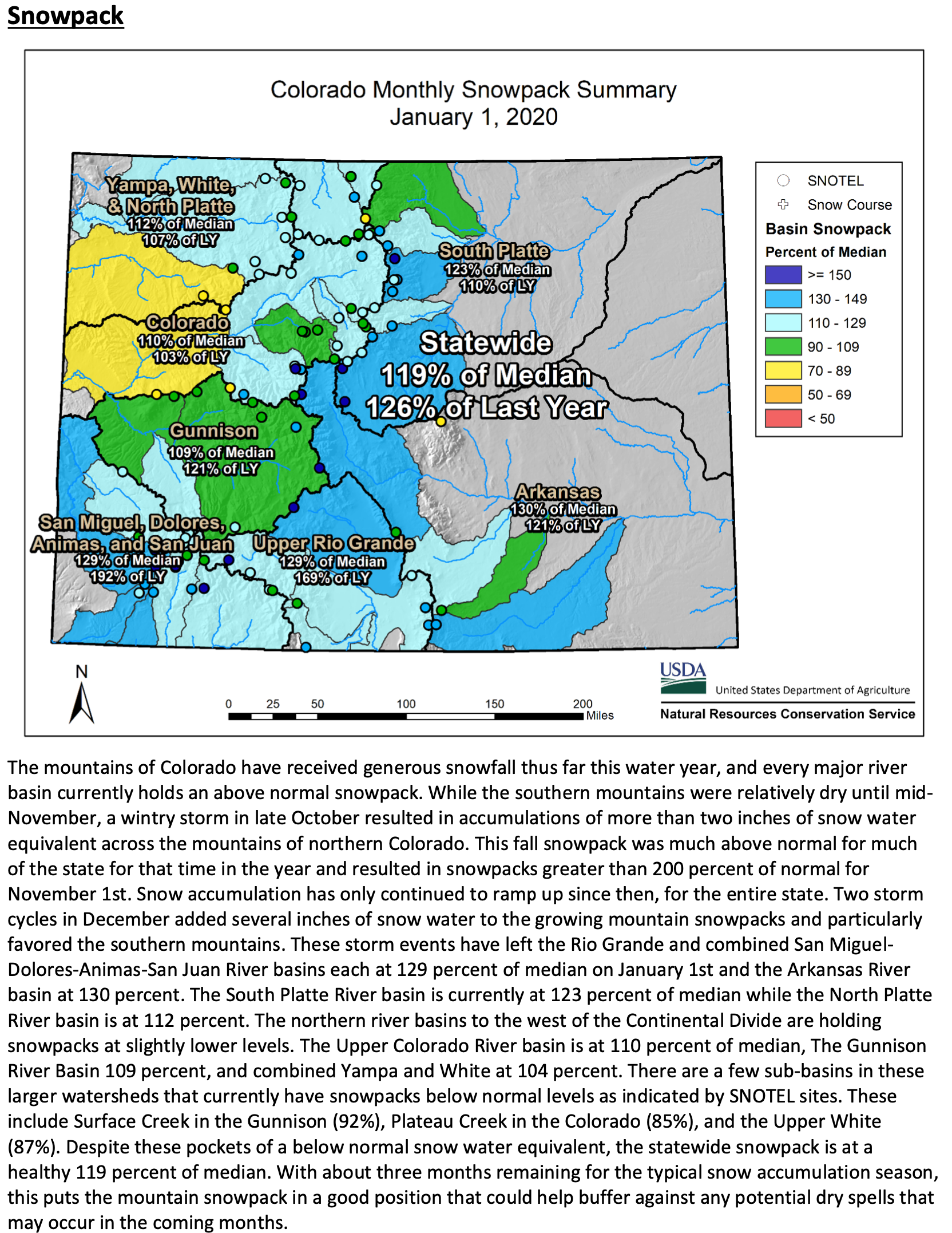
SNOWPACK ABOVE RUNOFF FORECAST
Official forecasts for spring runoff into Upper Colorado Basin reservoirs are below average, despite an above-average snowpack. This is due to low soil moisture resulting from a dry summer and fall. Details are in this forecast discussion from the Colorado Basin River Forecasting Center.
The Colorado River had a great 2019, with Lake Mead rising the most in a decade due to heavy flows into the river stemming from last year’s primo snowpack.
But 2020 isn’t shaping up as well, with a dry monsoon season and fall in 2019 paving the way for expected below-average spring summer runoff this year.
Right now, the April-July runoff is supposed to be 82% of average. That compares to 145 % of average in 2019, the second-best runoff season in the past 20 years, says the federal Colorado Basin River Forecast Center.
Despite last year’s excellent river flows, most experts also say the Colorado still faces long-term supply issues because of a prolonged pattern of below normal runoff that has existed since 2000 due to drought and climate change…
Last year’s high river flows, fueled by heavy late winter and spring snows, caused Lake Mead to rise 9 feet to a little more than 1,090 feet in elevation. That’s its highest year-end elevation since 2013, although it’s well below the lake’s 1,213 foot elevation at the end of 1999…
Part of the reason was that the federal government released an above-average amount of water last year from Lake Powell to Mead, of 9 million acre feet. The river’s tributaries between the two lakes also got a lot more water than usual.
Arizona and the other Lower Basin states also took a lot less water from the river than they normally do — the lowest amount in 33 years.
But that doesn’t mean the area’s long-term structural deficit is fixed, said John Fleck, director of the University of New Mexico’s Water Resources Research Center, who posted last year’s favorable results on his “Inkstain” blog this week.
“Without bonus water released from Powell and extra-big inflows through the Grand Canyon, Mead would still be dropping,” he said.
The runoff forecast for 2020 is below average right now in part because total precipitation has been near to below average in the majority of the Upper Colorado River Basin, said the forecast center.
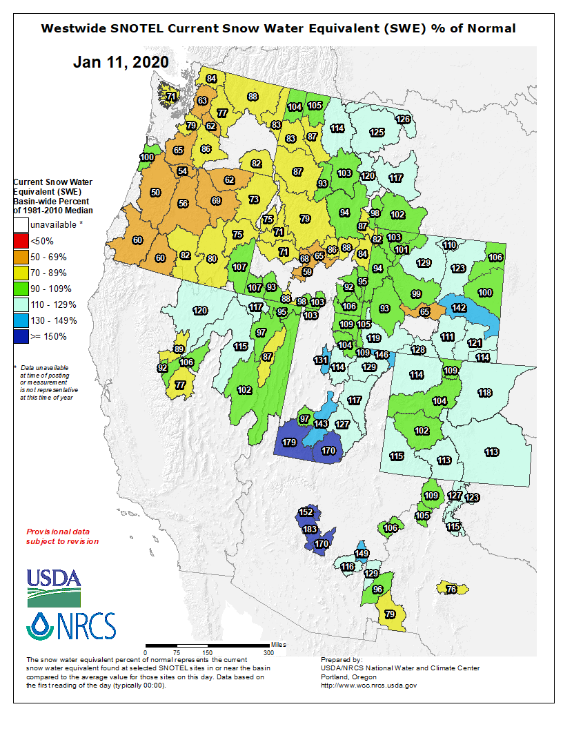
Upper Colorado River Basin snowpack, which feeds the river that supplies Lake Powell, was at 90% of normal [January 10, 2020], U.S. Department of Agriculture statistics show.
The basic explanation for why CO2 and other greenhouse gases warm the planet is so simple and has been known science for more than a century. Our atmosphere is transparent to visible light — the rainbow of colors from red to violet that make up natural sunlight. When the sun shines, its light passes right through the atmosphere to warm the Earth. The warm Earth then radiates some of its energy back upward in the form of infrared radiation — the “color” of light that lies just beyond red that our eyes can’t see (unless we’re wearing infrared-sensitive night-vision goggles). If all of that infrared radiation escaped back into space, the Earth would be frozen solid. However, naturally occurring greenhouse gas molecules, including not just CO2 but also methane and water vapor, intercept some of it — re-emitting the infrared radiation in all directions, including back to Earth. That keeps us warm. When we add extra greenhouse gases to the atmosphere, though, we increase the atmosphere’s heat-trapping capacity. Less heat escapes to space, more returns to Earth, and the planet warms.
DOJ attorneys describe working with industry lawyers as a ‘team,’ raising questions about whether government was representing the American people.
In early 2018, a few months after the cities of Oakland and San Francisco sued several major oil companies over climate change, attorneys with the U.S. Department of Justice began a series of email exchanges and meetings with lawyers for the oil companies targeted in the litigation.
At one point, Eric Grant, a deputy assistant attorney general in the Justice Department’s Environment and Natural Resources Division, sent an email to Indiana’s solicitor general saying that his “boss” had asked him to set up a meeting to go over a plan for the government to intercede in the cases on the companies’ behalf.
The cities were arguing that oil companies should be held liable for catastrophic flooding, sea-level rise and other harmful consequences caused by climate change. The DOJ was preparing an amicus brief in support of the industry, and the Indiana solicitor general was leading the charge by Republican attorneys general from 15 states to also file a court brief supporting the industry.
In another email, an assistant U.S. attorney general referred to the DOJ attorneys and industry lawyers—many of them former DOJ environmental lawyers—as a “team.”
The messages were among 178 pages of emails exchanged by government and industry from February through May 2018 as they worked together to oppose the cities’ lawsuits. They were obtained by the Natural Resources Defense Council (NRDC) under a federal Freedom of Information Act request and shared with InsideClimate News.
Although the emails do not reveal the substance of discussions that took place during the meetings, they bespeak the unapologetically close relationship between the Trump administration and the oil industry. They also provide a window into the closely coordinated efforts to block the climate lawsuits between industry and the Justice Department’s environmental division, which touts itself as “the nation’s environmental lawyer, and the largest environmental law firm in the country.”
Legal experts say the conversations raise questions about the federal government’s objectivity and whether the Department of Justice, in these cases, was acting in the best interest of the country’s people.
The “boss” to whom Grant, the deputy assistant attorney general, referred in his email at the time was Jeff Wood, the Trump-appointed acting assistant attorney general leading the Environment and Natural Resources Division. Wood had landed at the DOJ after serving on the Trump-Pence campaign and after an earlier stint as staff environmental counsel to then-Sen. Jeff Sessions, who would become Trump’s attorney general.
Wood declined to comment, though he cited a footnote in the order by U.S. District Court Judge William Alsup dismissing the cases that the federal government’s amicus brief supporting the oil industry had been submitted “at the Court’s invitation.” The dismissal is now being appealed.
Neither Grant nor his colleagues involved in the meetings with the industry responded to a request for comment. The Justice Department and industry lawyers also did not respond.
The climate lawsuits that grabbed Wood’s attention argue that the companies created a public nuisance—climate change—by producing fossil fuels that become the principal cause of global warming when burned.
“The rapidly rising sea level along the Pacific coast and in San Francisco Bay, moreover, poses an imminent threat of catastrophic storm surge flooding because any storm would be superimposed on a higher sea level,” the lawsuit filed by Oakland officials states. “This threat to human safety and to public and private-property is becoming more dire every day as global warming reaches ever more dangerous levels and sea level rise accelerates.”
The emails cover a period beginning in February 2018, six months after climate cases were filed, and ending in May, a few weeks after the Justice Department filed the amicus brief on behalf of the five oil giants named in the lawsuits.
At one time or another, six attorneys—one-quarter of the attorneys assigned to division’s Law and Policy Section—were brought into the loop with industry.
Justice Department attorneys had multiple conference calls with attorneys for BP and Chevron and hosted at least one in-person meeting at DOJ headquarters in Washington, prompting an attorney for BP to write at one point “thanks again for the helpful discussion last week,” according to the emails. The string of electronic notes shows the extensive effort DOJ attorneys made in coordinating various meetings with their oil industry counterparts.
One of the Justice Department lawyers the emails identified as participating in the strategy sessions with the industry has notified the appeals court considering the case that she will be appearing during the time allotted for the industry to present its arguments next month.
Just Raised Eyebrows or Red Flags?
Because the emails do not reflect the substance of the meetings, Justin Levitt , a law professor at Loyola Law School in Los Angeles, said it is difficult to assess whether ethical lines were crossed.
“If these meetings discussed the logistics of a DOJ amicus filing but not the substance of what the DOJ would file, it may be reason to raise an eyebrow but not a red flag,” he said.
It would be unusual and trigger questions if the meetings delved into the issues raised in the lawsuits, said Smith, a former deputy assistant attorney general in DOJ’s Civil Rights Division.
“It wouldn’t pass the sniff test if the DOJ was trying to address substantive issues,” he said. “If the meetings were about the logistics, there’s nothing improper.”
In its amicus brief, signed by Wood, the government argues the lawsuits violate the constitutional principle of separation of powers between the federal and state governments.
“Balancing the nation’s energy needs and economic interests against the risks posed by climate change should be left to the political branches of the federal government in the first instance,” Wood wrote in the brief.
“The United States has strong economic and national security interests in promoting the development of fossil fuels, among other energy resources,” he wrote.
Wood, who has since left the justice department to become a partner in a Washington D.C. law firm representing clients in federal enforcement actions, also cites a 2017 executive order issued by President Donald Trump saying: “It is in the national interest to promote clean and safe development of our Nation’s vast energy resources.”
No Similar Conversations with the Cities
Pete Huffman, a staff attorney for NRDC, acknowledged the emails offer just a glimpse into the behind-the-scenes action, but says they are enough to raise serious questions.
“We would expect them to be working in what they think are the best interests of the United States,” he said. “We don’t think that working with the industry against climate action in most of these places is in the best interests of the United States.”
Especially worrisome is the apparent one-sided coordination with the industry, said Huffman, who signed an amicus brief filed by NRDC on behalf of the cities.
“We don’t know all the facts from these documents, but it starts to look less like trying to get to the best interests of the United States and more like coordinating in the best interests of the industry,” he said.
The conclusion of favoritism cannot be discounted because the emails do not reflect an attempt by DOJ to contact either the cities of Oakland or San Francisco, Huffman said.
“I can tell you for sure that DOJ never reached out to us,” said Alex Katz, chief of staff for Oakland City Attorney Barbara J. Parker. The same for the San Francisco city attorney’s office, said spokesman John Cote.
A spokesman for the law firm now handling the two cases declined to comment.
Acting in Whose Best Interest?
Pat Parenteau, a professor of environmental law at the Vermont Law School, calls the apparent collaboration “troubling.”
While it’s within the realm of DOJ to express its view on the legal foundation of any case, the department should remain as objective as possible without the appearance of taking sides, he said. The government, he said, should have no contact with either side and simply express an opinion on the legal issues and allow the court to decide.
“From just the appearance standpoint here, it’s troubling to see any coordination,” Parenteau said.
That’s an especially disconcerting line to cross in the climate cases where the public has been put in jeopardy by the industry’s role in climate change, he said.
“The DOJ is supposed to represent the best interest of the people,” he said. “In these cases there is an existential threat to the public. So clearly the government is defending against the best interest of the public by cozying up to the industry.”
In a March 20 email, for example, Assistant U.S. Attorney Christine Ennis wrote to Ethan Shenkman, an attorney representing BP, inviting a conversation regarding the California cases.
“Jim Kilbourne, (an assistant U.S. attorney) who is copied here, told us that you would be interested in discussing the nuisance lawsuits filed against BP,” Ennis wrote. “Justin Smith and I would be happy to speak with you.”
The BP lawyer responds two days later: “Christine – many thanks for reaching out.”
A few weeks earlier, an attorney for one of the oil companies sent a note reminding a Justice Department lawyer that a judge in California had set a filing deadline for DOJ’s brief supporting the industry.
“Thank you for forwarding this,” Assistant U.S. Attorney Justin Heminger responded. “Best regards.”
The Oakland and San Francisco cases—as well as the dozen other climate lawsuits—remain gridlocked in various legal proceedings from California to New York.
In the city of Lakewood, the Bear Creek Greenbelt is the place to be for residents who love the outdoors. Each year, the park, located at 2800 S. Estes St., attracts thousands of cyclists, hikers and others who get the opportunity to enjoy a scenic route to Denver, Bear Creek Lake Park or other places.
With a grant secured from the Great Outdoors Colorado (GOCO) Board, the Colorado Youth Corps Association, a statewide coalition of eight corps that train children, young adults and veterans to work on conservation projects, will work with Lakewood to make the Bear Creek Greenbelt an even better place.
At the beginning of last month, the GOCO Board awarded the city of Lakewood a $34,000 grant to help remove Russian olive trees. The removal will be done through a partnership with Lakewood and Mile High Youth Corps, one of the corps that is part of the Colorado Youth Corps Association.
Russian Olive
Russian olive trees usually reach 12 to 45 feet tall, according to Utah State University Extension. They’re typically found along floodplains, riverbanks, stream courses, marshes and irrigation ditches in the western area of the country and can displace native riparian vegetation, according to the university. The tree can also choke irrigation ditches and damage tires.
“Really, the big benefit is to protect and restore wildlife habitat. It’s part of a larger restoration effort that is going to have an impact on people and the landscape,” said Madison Brannigan, program officer at GOCO. The organization uses proceeds from the Colorado Lottery to preserve, protect and enhance the state’s wildlife, parks, rivers, trails and open spaces.
The other part of the restoration effort at the Bear Creek Greenbelt will involve planting native trees and shrubs, removing weeds, seeding native grass, installing fencing, planting wetland vegetation and improving water quality, according to a release…
Outside of training, members of the Colorado Youth Corps Association earn a payment and education award to use toward college or payment for student loans…
In total, the GOCO Board awarded $61,000 worth of grants in Jefferson County to fund Colorado Youth Corps Association projects. Outside of Lakewood, the Foothills Park and Recreation District received a $27,000 grant to remove invasive species and to support habitat restoration.
Eagle River Watershed Council’s Water Quality Monitoring and Assessment Program provides the foundation for this [Water Quality Report Card]. This collaborative effort collects data at nine fixed sites along the Eagle River and its tributaries. WQMAP allows our community to see threats as they emerge, monitor changes to river health and make guided decisions on priority areas to protect and preserve.
Collected data is compared to state standards set by the Colorado Department of Public Health and Environment and the Water Quality Control Commission. This allows for an understanding of current river health and highlights areas of success as well as areas of needed improvement.
Bill Hoblitzell with Lotic Hydrologic, which coordinates WQMAP for the Watershed Council, shared the findings and explained the importance of this program for the community. It is critical that decisions regarding our watershed are backed by science…
The 2019 Water Quality Report Card has outlined three major challenges to the watershed: Urban runoff and degradation of aquatic life, highway impacts to Black Gore Creek from traction sand, and water chemistry impacts from the Eagle Mine Superfund Site.
Land development poses a threat due to increased impervious surfaces, such as roads and roofs, that water cannot pass through. We might think of our community as a small and rural place, but Hoblitzell points out that “development densities and impervious surfaces in near-stream areas of Vail, Avon, and Edwards currently resemble much larger cities.” These developed surfaces allow contaminated water to rush into the river during rainstorms or spring snowmelt. Polluted water flowing into streams impacts sensitive insects that fish depend on for food.
Traction sand is a necessary part of winter, as it helps keep us safe and in control when traveling over Vail Pass. However, there are negative effects felt in Black Gore Creek due to the buildup of this sediment. It reaches the channel by way of runoff or snow thrown from plows.
Eagle Mine
A constant challenge to the Eagle River is the Eagle Mine Superfund Site. While the river has experienced improvement since cleanup efforts began, metal concentrations regularly increase during spring runoff and impact fish. Local stakeholders continue to work with the Environmental Protection Agency and the state on this cleanup effort.
None of these issues are new or unknown, but their identification as key challenges in the 2019 Report Card supports continued efforts to address them…
James Dilzell is the Education & Outreach Coordinator for Eagle River Watershed Council. The Watershed Council has a mission to advocate for the health and conservation of the Upper Colorado and Eagle River basins through research, education, and projects. Contact the Watershed Council at (970) 827-5406 or visit http://erwc.org.
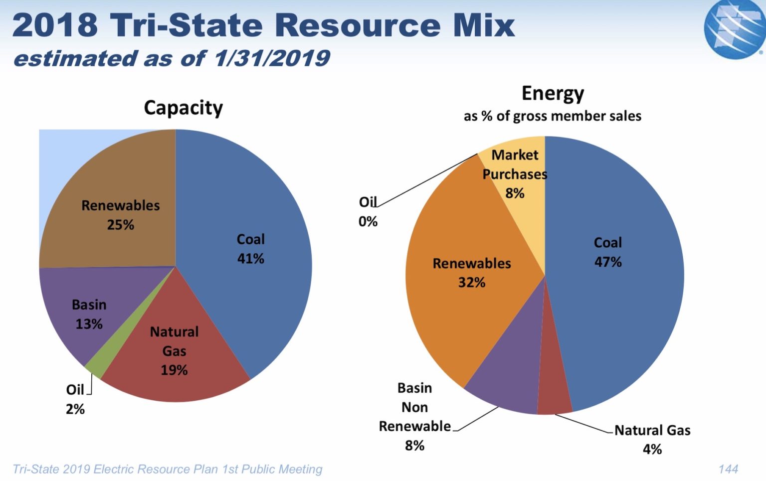
Tri-State Generation continues to make changes that are hitting the Yampa Valley hard.
On Thursday, Tri-State Generation and Transmission Association announced it will close all of its coal-fired power plants and mines in New Mexico and Colorado by 2030. The power provider serves nearly 20 rural electric cooperatives.
Tri-State announced the closure of its Escalante Power Plant in Prewitt, New Mexico, by the end of 2020. It plans to close Craig Station Units 2 and 3, and the Colowyo Mine in Northwest Colorado by 2030.
The announcement from the Westminster-based power provider comes on the heels of pressure by two of its rural electric co-op members, including Brighton-based United Power and Durango-based La Plata Electric Association, in hopes of making a faster transition to renewable energy in recent years. The pair have sought to break up with Tri-State as a result of the power wholesaler’s reluctance to use more renewables and in seeking more say over their power sources, according to previous Craig Press reporting.
The power provider officially announced the following information on the closures during a teleconference Thursday:
Closures will result in 100% reduction of coal emissions in Colorado and New Mexico while increasing Tri-State’s competitiveness with cleaner portfolio and stable rates.
Major changes in generation portfolio include closure of Escalante Station near Prewitt, N.M., by end of 2020, and closure of Craig Station and Colowyo Mine in Northwest Colorado by 2030.
Tri-State is working with state and local leaders to support affected employees and communities, and will seek legislation in Colorado to provide certainty on state greenhouse gas reduction rules.
In total, the closure of the power plants and mine impacts roughly 600 power plant and mine employees, who have been key to Tri-State’s and its predecessor generation and transmission cooperatives’ ability to supply reliable and affordable power to cooperatives for decades…
Tri-State will work with state and local officials to support affected employees and their communities during the transition…
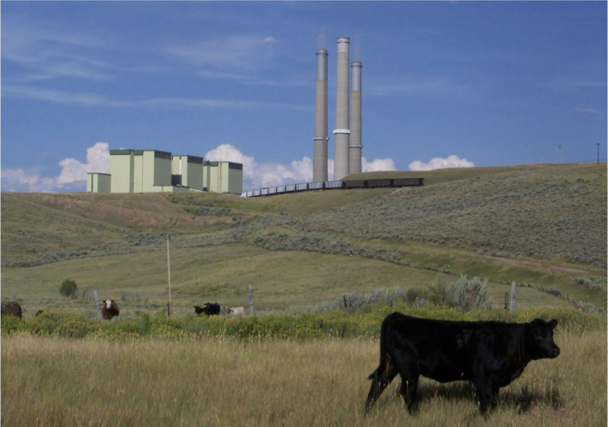
The coal-fired Tri-State Generation and Transmission plant in Craig provides much of the power used in Western Colorado, including in Aspen and Pitkin County. Will Toor, executive director of the Colorado Energy Office has a plan to move the state’s electric grid to 100 percent renewable energy by 2040. Photo credit: Brent Gardner-Smith/Aspen Journalism
Craig Station and Colowyo Mine in Colorado retiring by 2030
Craig Station, a 1,285-megawatt, three-unit power plant in Moffat County, will close by 2030, based on Thursday’s Tri-State announcement. The power plant’s units were constructed by Colorado Ute Electric Association and began operations between 1979 and 1984.
Tri-State acquired Craig Station and other assets from Colorado Ute in 1992. The power plant currently employs 253 people.
Tri-State previously announced that the 427-megawatt Unit 1 will close by the end of 2025. Despite Thursday’s announcement for Units 2 and 3, the closing date for Unit 1 remains unchanged.
The 410-megawatt Unit 2 and the 448-megawatt Unit 3 will close by 2030, according to Highley. Tri-State operates Craig Station and owns 24% of Units 1 and 2. Tri-State owns 100% of Unit 3. Tri-State is working with the other plant owners to determine the specific details for the retirement of Unit 2.
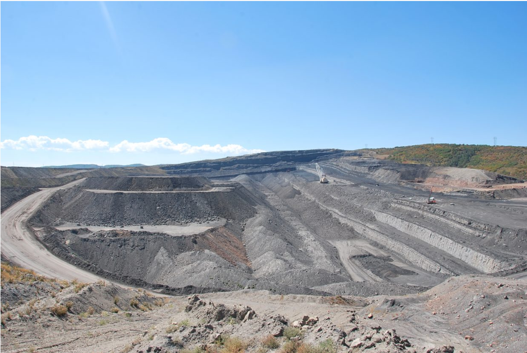
The South Taylor pit is one of Colowyo Mine’s current active coal mining site. Photo by David Tan via CoalZoom.com
Colowyo Mine, located in Moffat and Rio Blanco counties, produces coal used at Craig Station and will cease production by 2030, at which time operations will turn entirely to reclamation. Tri-State purchased Colowyo Mine from Rio Tinto in 2011. The mine currently employs 219 people.
Tri-State is working with the Governor and legislative leaders on proactive legislation that ensures the closures meet greenhouse gas compliance obligations in Colorado, while also maintaining stable rates and reliable power for Tri-State members. This legislation would give Tri-State the ability to transition resources in a timely and financially responsible manner while providing certainty.
Tri-State previously retired its coal capacity at Nucla Station in Western Colorado in 2019.
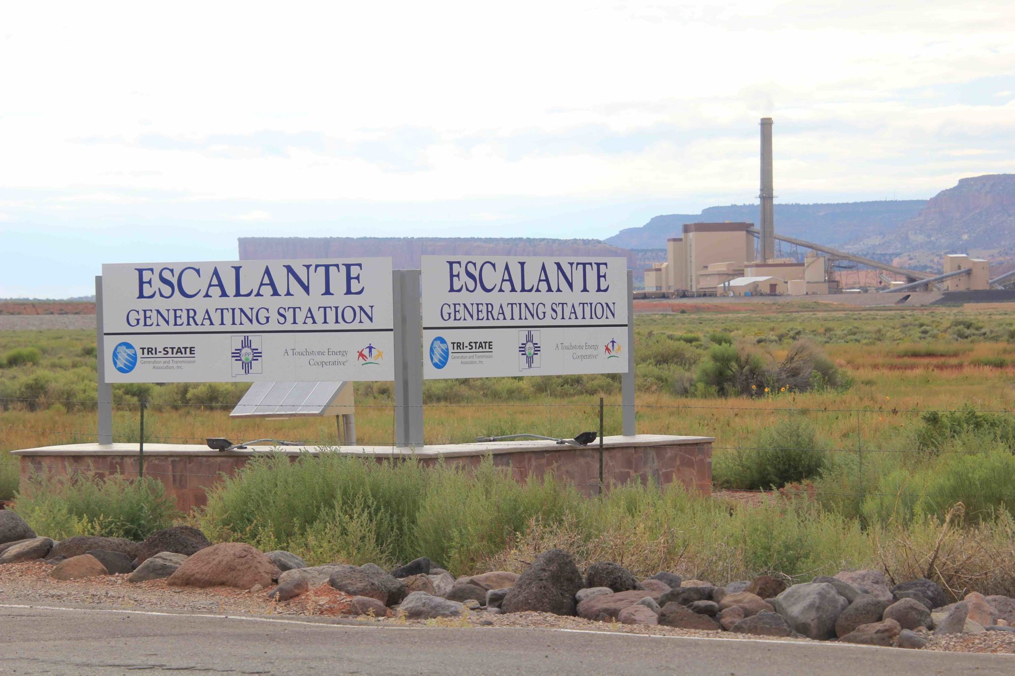
Tri-State plans to close the Escalante Generating Station in 2020. Photo/Allen Best
Escalante Station in New Mexico retiring by the end of 2020
Escalante Station, a 253-megawatt coal power plant near Prewitt, N.M., will close by the end of 2020. The power plant was constructed by Plains Electric Generation and Transmission Cooperative and began operations in 1984. Plains Electric merged with Tri-State in 2000. The closure of the power plant will impact 107 employees.
“The timeline to retire Escalante Station by the end of 2020 is driven by the economics of operating the power plant in a competitive power market, and by Tri-State’s addition of low-cost renewable resources,” said Highley. “Our Escalante Station employees work safely and tirelessly to serve our cooperative’s members, and we’re committed to support them through this difficult transition.”
Escalante Station employees will receive a generous severance package, the opportunity to apply for vacancies at other Tri-State facilities, assistance with education and financial planning, and supplemental funding for health benefits.
Tri-State will also provide $5 million in local community support, and is working with the New Mexico Governor’s Office, legislative leaders and local communities in Cibola and McKinley counties to address the impacts of the transition, including workforce retraining and other economic development efforts. Tri-State will also address issues related to the McKinley Paper Company, which purchases steam and water from Escalante Station.
Tri-State previously retired its coal ownership capacity in Unit 3 of San Juan Generation Station in New Mexico in 2017.
On Thursday, following the State of the State address in Denver, Speaker KC Becker (D-Boulder) reacted to an announcement from the Tri-State Generation and Transmission Association outlining the retirement of all coal generation in Colorado and New Mexico.
“I applaud Tri-State’s commitment to Colorado’s clean energy future and am impressed by the bold carbon emissions reduction target they set. Meeting our state’s targets requires immediate collective action, and I’m happy to see Tri-State take their role seriously,” Speaker Becker said. “As our state transitions toward a clean, renewable energy future, we must always keep in mind that this change will bring difficult transitions for Colorado’s energy workers, their families and communities.
A commitment to a clean energy future also requires a commitment to a fair and just transition for Colorado’s workers. Protecting and supporting workers and communities through these shifting economic tides remains a top priority for the legislature. I look forward to continuing to work with a broad array of stakeholders to find ways to support and protect working families affected by a changing energy economy. The Just Transition Office created by the legislature last year will continue to work with impacted communities and worker representatives across the state on a plan to support those impacted by the transition away from coal.”
Craig Station in northwest Colorado is a coal-fired power plant operated by Tri-State Generation & Transmission. Photo credit: Allen Best
Tri-State has been pressured by its rural electric co-op members — including Brighton-based United Power and Durango-based La Plata Electric Association — to make a faster transition to renewable energy in recent years. The pair have sought to break up with Tri-State as a result of the power wholesaler’s reluctance to use more renewables and in seeking more say over their power sources.
Two co-ops have already negotiated exits from Tri-State. They are the Delta-Montrose Electric Association and the Kit Carson Electric Cooperative in Taos, N.M.
Tri-State, a Westminster-based, nonprofit power provider, retired its Nucla Station coal-fired power plant in September. The utility says the closures won’t cause electric rates to rapidly rise.
“Serving our members’ clean energy and affordability needs, supporting state requirements and goals, and leading the fundamental changes in our industry require the retirement of our coal facilities in Colorado and New Mexico,” Rick Gordon, chairman of the board of Tri-State and a director of Mountain View Electric Association in eastern Colorado, said in a written statement. “As we make this difficult decision, we do so with a deep appreciation for the contributions of our employees who have dedicated their talents and energy to help us deliver on our mission to our members.”
Solar panels, such these at the Garfield County Airport near Rifle, Colo., need virtually no water, once they are manufactured. Photo/Allen Best
“That Tri-State announcement is a good business decision,” reflected Republican State Sen. Bob Rankin who represents the region. “But believe me, there are going to be people crying in Craig, Colorado.”
Yearly Colorado and U.S. national coal production overlapped with presidential terms. Source: U.S. Energy Information Administration, Colorado Division of Reclamation Mining and Safety Credit: Jim Hill / CPR News
While Tri-State hasn’t committed to an economic lump sum payment for Craig yet, early indications suggest that the money could be substantial. A company-owned coal-fired power plant closure announced in Escalante, New Mexico resulted in $5 million of support. Tri-State is encouraging officials to match dollars from public and private sources…
Along with financial support from Tri-State, Barela said Craig can expect help from Colorado’s newly formed Just Transition Office. It’s in the middle of a fact-finding mission guided by Keystone Research Center to discover what job transition programs in coal communities have been successful.
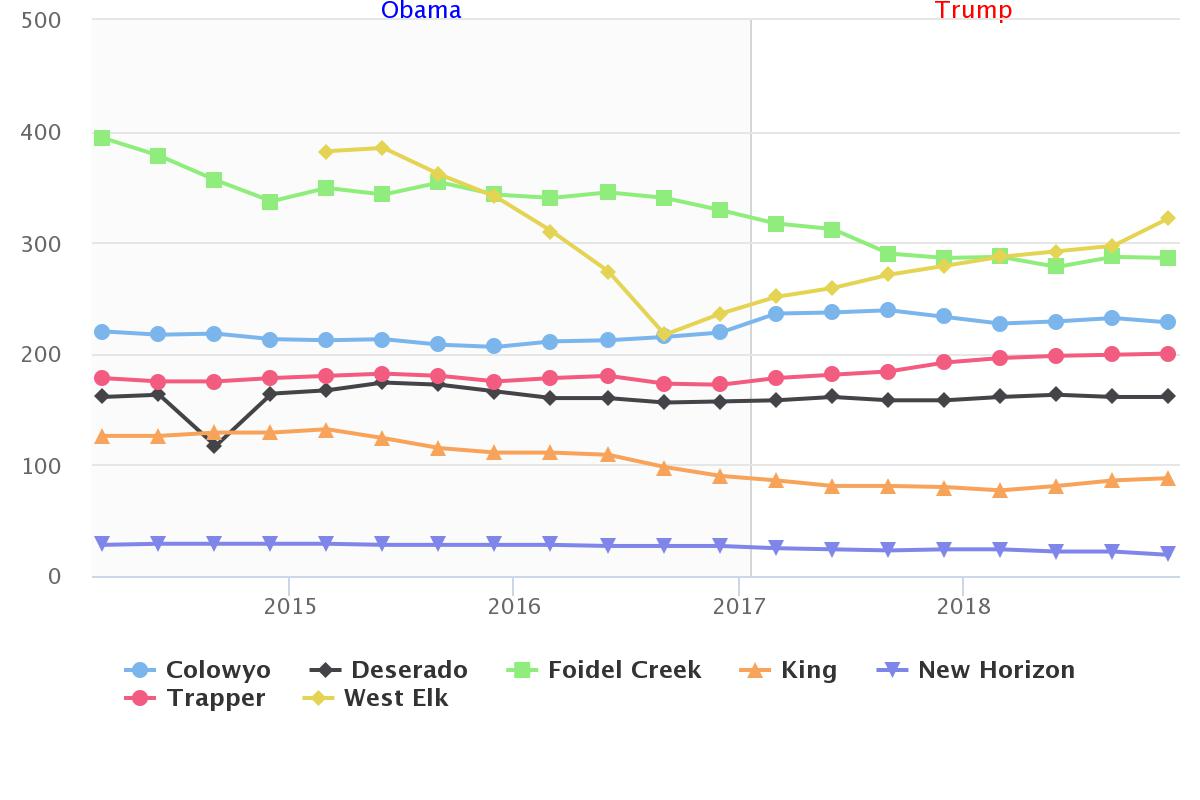
Quarterly average employees at Colorado’s coal mines overlapped with presidential terms. Figures include office employment, not just miners. Production has ceased at New Horizon, which is no longer an active mine. Source: Mine Safety and Health Administration Credit: Grace Hood, Jim Hill / CPR News
Barela, the state of Colorado and Tri-State will continue to work with Craig officials in the coming months. If there’s one silver lining to the Tri-State announcement, it ’s that it comes at a time of tremendous state economic prosperity. Colorado’s unemployment hovers around 2.5 percent.
Tri-State Generation and Transmission Association will shut down its 253 megawatt coal-fired generating station near Grants by the end of 2020 as part of the wholesale electric supplier’s efforts to transition to a clean energy grid over the next decade, according to a Thursday announcement.
The closure will eliminate 107 jobs at the plant, and potentially scores more at a nearby coal mine that supplies fuel for the generating station.
The association has run the Escalante plant in Prewitt since 2000, after it merged with Plains Electric Generation and Transmission Cooperative, which constructed and opened the plant in 1984. Escalante was built to operate through 2045, but Tri-State is closing it 25 years early as part of a broad plan to eliminate all the association’s coal-fired generation in New Mexico and Colorado to meet new regulations in both states that mandate a transition to a carbon-free grid…
“We understand it’s a shock for our employees,” said Tri-State CEO Duane Highley in a conference call with reporters Thursday afternoon. “We will work with them and the local communities where they work to help minimize the negative impacts.”
Tri-State said employees will receive “generous” severance packages, opportunities to apply for vacancies at other Tri-State facilities, supplemental funding for health benefits, and educational and financial planning assistance.
The association will also provide $5 million in local community support in New Mexico, Highley told reporters. The association has been working with Gov. Michelle Lujan Grisham’s office and with state legislators to collaborate on assistance programs and retraining for workers, he said…
Workforce Solutions Cabinet Secretary Bill McCamley said his office will meet with local officials and workers next week to assess needs and ways the state can help…
Energy, Minerals and Natural Resources Department Secretary Sarah Cottrell Propst said the government will work with Tri-State to help locate renewable generation facilities that replace Escalante in the affected communities, if possible, to offset some of the economic impacts there.
Apart from 107 employees at the Escalante plant, it’s unclear how many workers could lose their jobs at the nearby coal mine, which is run by Peabody Coal Co. But Robert Castillo, CEO of Continental Divide Electric Cooperative in Grants, said mine layoffs will likely double the impact…
The impact will be felt throughout the state’s northwestern region, since it comes on top of the partial shutdown of the coal-fired Four Corners Power Plant near Farmington and current efforts to completely close the nearby San Juan Generating Station, Castillo said.
“The problem is much broader, because it’s not just the Grants area,” Castillo said. “We’re talking about the whole northwest quadrant of New Mexico with the Four Corners plant, San Juan, and now Escalante. The whole area is going to be in bad shape.”
Castillo, who is also a board member of the Cibola Communities Economic Development Foundation, said local leaders want to work with state government to recruit more industry to the area. That’s critical for economic development assistance to have an impact, since retraining workers is only effective if alternative jobs are available…
Tri-State said closing Escalante will help the association meet New Mexico’s new Energy Transition Act, which requires state electric cooperatives to derive 50% of their electricity from renewable resources by 2030, and from 100% renewable and carbon-free generation by 2050.
Tri-State expects to meet the 50% renewable milestone by 2024, six years in advance of the 2030 deadline. Currently, about 30% of its electricity comes from renewables.
Rapidly declining prices for solar and wind generation will greatly offset the costs of shutting down coal operations, allowing Tri-State to maintain moderate prices – and possibly even lower its rates – for member cooperatives going forward, Highley said.
“We have new requests for proposals for additional renewable resources and the costs are coming in at such low rates that it allows us to save money even while accelerating the write-off of coal assets,” Highley said.
Tri-State will make announcements about replacement resources next week.
“By year 2030, Tri-State will not operate any coal-based assets,” CEO Duane Highley said during a Thursday conference call with reporters. “These closures will have a huge impact on our employees.”
[…]
Although the Colorado closure is more gradual, giving time to to work with the Legislature for the transition, “the work starts now,” Highley also said.
He said the company is working proactively with the Legislature to make sure it meets greenhouse gas obligations, while also maintaining stable rates, transitioning resources responsibly and providing certainty for members…
Tri-State had three units at Craig. Station 1 was already shutting down, under a settlement agreement related to the state’s regional haze plan. Closure is still online for 2025.
The regional haze settlement also included the shuttering of Nucla Station on Montrose County’s West End, where closure had originally been set for completion in 2022. Tri-State, under the direction of its board, finished closures early by taking it offline in 2019.
Highley said in response to questions asked during the teleconference that Tri-State worked with affected communities and recognizes the need for support.
Craig Unit 2 had been set for closure in 2038 and Unit 3 was set for closure in 2044. The units now will close by 2030 and Colowyo will go into reclamation that year…
Highley during the teleconference said Thursday was “a solemn day,” especially for employees, whose dedication he praised.
“As we make this difficult decision, we do so with a deep appreciation for the contributions of our employees who have dedicated their talents and energy to help us deliver on our mission to our members,” Rick Gordon, chairman of Tri-State’s board of directors said, in an official announcement.
Tri-State provided wholesale power to Delta-Montrose Electric Association, which last year secured a buy-out for its power contract and is departing the Tri-State cooperative.
“That’s a move they should have taken a long time ago,” DMEA board president Bill Patterson said, adding he is not certain where Tri-State will obtain the capital to close the plants. “It really doesn’t impact DMEA that much. We made our deal. We’re working on getting the final details done,” he said.
At a regular meeting on Dec. 12, 2019, the Pagosa Area Water and Sanitation District (PAWSD) Board of Directors approved the district’s 2020 budget…
In an email to The SUN, PAWSD Director of Business Services Aaron Burns noted that the only two changes from the draft budget to the final 2020 budget were an in- crease of $30,000 of unspent super- visory control and data acquisition (SCADA) infrastructure funds from 2019 and an additional $15,000 was added to each water plant; this accounts for increased regulatory monitoring requirements, accord- ing to Burns.
Within the final 2020 budget, PAWSD’s General Fund balance is expected to start at $939,542, a 2 percent decrease from last year; PAWSD’s ending balance within the 2020 budget is projected at $871,865, which is a 7 percent decrease from last year’s total of $940,292.
Total revenues for PAWSD are projected to go up 3 percent this year, with the 2020 budget reflect- ing total revenues of $1,115,707 — up from last year’s total revenue of $1,081,087.
PAWSD’s total expenditures are also expected to increase 7 per- cent, going from last year’s total of $1,101,840 to $1,183,384 in 2020.
For its Water Enterprise Fund, PAWSD is expected to see a 7 per- cent increase in its beginning fund balance, with totals going from $5,534,767 to $5,935,717 in 2020 and the ending fund balance total expected to go up 5 percent, from $5,916,044 to $6,215,778.
PAWSD’s Water Enterprise Fund looks to have an 8 percent in- crease in regard to total revenues, with revenues totaling $6,005,467 compared to last year’s total of $5,574,570.
Total expenditures for the Water Enterprise Fund are expected to increase 10 percent, going from $5,193,293 to $5,725,406 in 2020.
PAWSD’s Wastewater Enter- prise Fund will have a 23 percent increase in its beginning fund bal- ance, increasing from $2,552,203 to $3,140,125; the ending fund bal- ance for the wastewater fund is ex- pected to increase from $3,129,565 to $3,252,712, which is an increase of 4 percent.
PAWSD’s total revenues for its wastewater fund are projected to have no change, according to the 2020 budget.
PAWSD’s total expenditures for its wastewater fund are projected to increase 22 percent, going from $2,166,108 to $2,636,374 in 2020.
The U.S. House voted Friday to pass a comprehensive legislative package that would crack down on per- and polyfluoroalkyl substances, a class of chemicals known as PFAS that are said to cause serious health problems.
Used in tape, nonstick pans and other everyday substances, PFAS have been linked to cancer, decreased fertility, developmental delays and other conditions and have been found in high concentrations in sources of public drinking water and other sites around the country.
The PFAS Action Act includes a series of provisions designed to mitigate their harm. It cleared the House with support from 223 Democrats and 24 Republicans. One hundred and fifty seven Republicans voted against it, as did one Democrat and Michigan independent Rep. Justin Amash. Twenty-four lawmakers did not vote.
Colorado’s delegation was split on the vote, with Democratic representatives voting for the bill and Republicans voting against it…
Friday’s vote came after supporters of the legislation suffered a stinging setback last month, when key PFAS provisions were struck from the National Defense Authorization Act (NDAA) before it was signed into law.
Opposition to those provisions from Senate Republicans prompted House Democrats to call the PFAS bill to the floor this month, House Speaker Nancy Pelosi (D-Calif.) said Friday.
“Last year, our members worked relentlessly to pass bold legislation to tackle the PFAS crisis,” Pelosi said on the House floor. “Unfortunately, at the end of the year, the Senate GOP refused to join the House to secure full, robust protections against PFAS chemicals and key provisions were cut from the NDAA.”
The “Senate GOP obstruction,” she said, “is why we are here today.”
The NDAA does take some steps to address PFAS. It includes provisions that require the U.S. military to transition off of PFAS-laden fire-fighting foam by 2024, ban the foam in exercises and training and test PFAS levels in military firefighters’ blood.
But supporters said the PFAS Action Act passed Friday goes much further.
It would require the U.S. Environmental Protection Agency to list certain PFAS chemicals as hazardous substances under the EPA’s Superfund program, which would accelerate cleanup of contaminated sites. That would be a “significant first step while we allow the EPA to study the remaining compounds — which needs to start now,” Dingell said in a press release.
The bill would also create a national drinking standard for certain PFAS chemicals, help people understand water testing results, prevent new PFAS chemicals from being approved and more…
Colorado public health officials acknowledge federal action on creating a legally binding drinking water standard is lagging, forcing the state to address a public health crisis it’s ill-equipped to handle. The state is in the process of adopting new regulations after finding PFAS levels above the federal health advisory limit in groundwater across the Denver metro region, Colorado Springs and Boulder County. In September, lawmakers approved $500,000 so that the Colorado Department of Public Health can begin testing public drinking water supplies for the toxic chemical…
Despite its bipartisan support in the House, the bill faces an uphill battle.
First, it must pass the GOP-controlled Senate, where hundreds of House-passed bills are languishing on the desk of Majority Leader Mitch McConnell (R-Ky.). Senate Environment and Public Works Committee Chairman John Barrasso (R-Wyo.) told Bloomberg News that the legislation had “no prospects in the Senate.”
If it passes the Senate, then it would move to the White House, which issued a veto threat on Tuesday…
The EPA is already “taking extensive efforts” to address PFAS across the nation, it added — an assertion underscored by the EPA in a statement released on the same day as the White House veto threat.
But critics say the EPA’s “action plan” doesn’t go far enough to contain and clean up PFAS and are skeptical the agency will put public health over corporate profits.
Gold was panned throughout 1870 until winter arrived. The following spring a new rush of prospectors came into the area, but poor yields discouraged most, and by the end of the summer, they left the area.
[J.L. Wightman] plus two others remained and took their gold dust to Denver, receiving $170.
They did not give up and when the source of the gold was discovered, it led to the establishment of Summitville and underground mining.
A post office opened in 1876, and the town grew to become the largest gold producing camp in Colorado. The town’s population fluctuated from 300 to 600, enough to support 14 saloons and the publication of the Summitville Nugget…
Summitville was reborn when large-scale mining to remove low-grade ore resumed in 1934. The post office reopened, and 70 new homes were constructed of milled lumber along with a bathhouse, bunkhouses and large dining hall. Summitville also got its own school and its population swelled to an estimated 1,500.
The mine continued to operate, but due to the harsh weather and deterioration of its buildings, Summitville was again abandoned. Miners and mill workers were brought in by bus from Del Norte…
Mining ended in 1992 after a cease and desist order by the Environmental Protection Agency.
Part of the problem was overflow from the heap leach ponds combined with leaks in the liner allowing potassium cyanide to flow into the nearby stream.
A much bigger problem, however, was the toxic contents of the water coming from the open pit mine and old abandoned tunnels. The water in this area is naturally acidic and for that reason, it dissolves the metals found in the ground and in waste rock. The combination rendered the Wightman Fork of the Alamosa River void of aquatic life for many miles.
The mine owner, Canadian Galactic Resources, soon filed for bankruptcy.
The Environmental Protection Agency was left holding the bag for the cleanup to the tune of around $255 million including $18 million for a water treatment plant.
Galactic Resources paid around $30 million in a settlement. Colorado has now taken over the operation of the plant costing taxpayers about $2 million per year potentially forever.
A visitor to Summitville will see about two dozen abandoned buildings sitting in a meadow and with a beautiful backdrop of high mountains. The ramshackle cabins are split into two groups: one by the road and the other on the hillside.
The U.S. Rafting Team has enlisted three veteran Grand Canyon guides in a mission to set a new speed record for descending the Colorado River’s 277 miles through the canyon. The team tested a new raft design last month on the Ruby Horsethief and Westwater canyons, rowing from Loma to Utah’s Dewey Bridge in about nine hours. (Robbie Prechtl, special to The Colorado Sun)
As the river dipped to 10,000 cubic feet per second (cfs) and the crew outraced a pulse of water released from the Glen Canyon Dam upstream, the record slipped away…
The team of eight arrived at Phantom Ranch, at mile 88, at 11 a.m. on Friday, about 11 hours after they pushed into the Colorado River from Lees Ferry. That was only four minutes off their pace to reach the Pearce Ferry takeout around 10:20 a.m. Saturday. But that was also the peak of the surge released from Glen Canyon Dam. Holding close to a 5 mph rowing speed, the water slowed down with each mile. By midnight, the river had dropped from a daily high of close to 14,500 cfs to around 10,500 cfs…
Speed records have a long history in the Grand Canyon, dating back to 14-day descents in the late 1800s on log rafts captained by adventurers who likely weren’t racing but simply rowing. In 1951 Grand Junction brothers Bob and Jim Rigg set out to purposely set the speed record. They pushed their wooden row boat into the river at Lees Ferry when the river was roaring at 43,100 cfs and finished in 52 hours and 41 minutes. That record stood until 1983, when Kenton Grua, Rudi Petschek and Steve Reynolds caught another flood-stage flow and rowed their wooden dory, the “Emerald Mile,” down the canyon in 36 hours, 38 minutes.
In January 2016, Orkin, an accountant in Aurora, paddled his carbon-fiber race kayak solo down the canyon, finishing in 34 hours and 2 minutes. That record was even more remarkable considering he flipped in Lava Falls and swam from his kayak, alone and at night.
The team this weekend had a clean run with zero mishaps.
Lava Falls: “This, I was told, is the biggest drop on the river in the GC. It’s 35 feet from top to bottom of the falls,” John Fowler. The photo was taken from the Toroweap overlook, 7 June 2010, via Wikimedia.
“We got our revenge on Lava. The boat was fantastic. Everything and everyone held up perfectly. We ran the lines we wanted,” Seelig said. “The water just wasn’t there for us.”
Orkin was paddling a narrow, sleek craft that sliced through water. The Emerald Mile was a wooden dory meant to cut through the river. The raft carrying eight — even with a pair of narrow pontoons beneath a lightweight frame — pushes water out of its way. It might not be possible for a raft to set a speed record in the Grand Canyon…
“OK, if someone was like ‘Hey, I have a permit on this date and it’s going to be this flow’ and we have a crew that is training — that’s a lot of variables — maybe who knows,” Seelig said. “But right now, I’m like ‘No way. Never again.’”
Denver Water and partners pull down big award for pioneering regionwide reuse project. The post National recognition for WISE water practices appeared first on News on TAP.
In the Colorado River Basin — Eagle County and the surrounding region — the snowpack is 110% of normal.
Statewide, snowpacks range between 104% and 129% of normal, according to NRCS data. The statewide snowpack is 119% of normal…
The water year begins in October, so things started dry and got wetter as winter set in. That means the water year’s actual precipitation is a little low, but winter storms are piling up the snowpack, according to the data…
Similar to the 2019 water year, which started in Oct. 2018, precipitation patterns and month-to-month snow accumulations have varied widely.
The 2020 water year started in October 2019 amid a late summer dry spell in southern Colorado. The northern basins — Eagle County and the surrounding region — were blessed with above-normal precipitation beginning in October and running through December with several snowstorms.
That means in our region, streamflows are also healthy so far this winter, with water supplies at or near average. Weather and precipitation patterns vary from region to region across Colorado, the NRCS report states.
In the Arkansas Basin, the water supply is forecast at 104% of normal. On the low end, the Gunnison and combined San Miguel, Dolores, Animas, and San Juan Basins are facing a water supply forecast at 88% of normal…
Across Colorado, 90% of the state’s water supply is forecast to hit between 85% and 115% percent of their average volumes, Wetlaufer said. Statewide reservoir storage is 106% of average, Wetlaufer said.
The U.S. Department of Agriculture Natural Resources Conservation Service reported early-season snow accumulations are encouraging for an ample water supply in the current water year in the Jan. 1 Colorado Water Supply Outlook Report.
Generous snowfall in October, November and December brought every major river basin above normal snowpack.
The Arkansas River Basin stands at 130 percent of median following two December storm cycles that added several inches of snow water to mountain snowpacks.
Statewide, the snowpack stands at 119 percent of median for the current water year, which began Oct. 1…
Reservoir storage varies across the state, but as a whole sits at about 106 percent of average.
Currently the Arkansas River Basin storage is below average at 98 percent.
The Upper Rio Grande Basin is also below average at 86 percent.
Storage in the other major basins ranges from 104-124 percent of average…
The average of forecasts in the Arkansas Basin is 104 percent of normal volumes, which is on the high end of basin forecasts.
Current Situation and Impacts in the West January 9, 2020
The large scale spatial pattern of snow water equivalent (SWE) anomalies in the Lower 48 has not changed much since our last update in early December: the Pacific Northwest generally remains below normal with a gradient to above normal as you move southeast into the Four Corners. However, the magnitude of these anomalies has changed significantly due a series of storms bringing above normal precipitation (for the past three weeks) to the Washington Cascades and a drying trend to the Sierra Nevada and Intermountain West. The core of the worst snow drought conditions has now shifted from the Washington Cascades to the central and northern Oregon Cascades. For HUC-6 Basins the Willamette Basin in Oregon currently has the lowest snowpack at 37% of median SWE while Washington Basins has improved to 55-75% of median. As of January 6 there are now no stations reporting record low SWE and only four stations in the Pacific Northwest reporting 2nd lowest SWE on record with one in Oregon, two in Wasington, and one in Montana.
Despite large improvements in precipitation deficits in the Washington Cascades, SWE gains were limited at lower elevations due to warm temperatures and rain instead of snow for much of December. Alpine Meadows SNOTEL, on the west slope of the Washington Cascades at 3500’ elevation, recorded 34.1” of precipitation between December 9 and January with only 11.5” of SWE gains. The most recent storms over the past week have brought colder temperatures and more snow accumulation at lower elevations compared to mid-December storms.
The poleward shift in the storm track has led to a drying trend south of the Cascades. Major storms in the Sierra Nevada have been absent since mid-December and many locations have fallen to near-to-slightly below normal SWE for this time of year. Small SWE losses have even occurred at some locations in the past week. At the Central Sierra Snow Lab, near Donner Pass California, SWE has declined from 13” on December to 12” on January 7 with 87% of median SWE. Overall, the Sierra is still in good shape with the Walker River Basin being the only HUC-6 below normal at 90% of median SWE.
Snowpack in south-central Alaska remain below normal with Kenai Peninsula and Prince William Sound HUC-6 basins at 56% and 50% of median SWE, respectively. In southeast Alaska there is only one station with long enough records to computes normals: Long Lake currently sits at 91% of median SWE. The few stations in the interior of Alaska currently reporting data all indicate above normal snowpack.
USDA Natural Resources Conservation Service (NRCS) percent of 1981-2010 median snow water equivalent (SWE) over the western U.S.USDA Natural Resources Conservation Service (NRCS) percent of 1981-2010 average precipitation over the western U.S. for the period December 16, 2019-January 5, 2020. Only stations with at least 20-years of data are included in the station averages. For an interactive version of this map please visit NRCSUniversity of Idaho’s gridded meteorological data (gridMET) mean temperature difference from the 1981-2010 average for the period December 13, 2019-January 3, 2020. For an interactive version of this map please visit Climate Engine.
LEICESTER, ENGLAND – 21st JUNE: Drummer Neil Peart of Canadian progressive rock band Rush at his kit during a soundcheck at the De Montfort Hall, Leicester, 21st June 1980. (Photo by Fin Costello/Redferns)
His drumming was at once intricate and explosive, expanding Rush’s power-trio dynamics. His lyrics transformed the band’s songs into elaborate suites.
Neil Peart, the pyrotechnical drummer and high-concept lyricist for the Canadian progressive-rock trio Rush, died on Tuesday in Santa Monica, Calif. He was 67.
The cause was brain cancer, according to a statement by the band’s spokesman, Elliot Mintz.
Rush was formed in 1968 but found its long-term identity — as the trio of Geddy Lee on vocals, keyboards and bass, Alex Lifeson on guitars and Mr. Peart on drums — after Mr. Peart replaced the band’s founding drummer, John Rutsey, in 1974.
Mr. Peart’s lyrics transformed the band’s songs into multi-section suites exploring science fiction, magic and philosophy, often with the individualist and libertarian sentiments that informed songs like “Tom Sawyer” and “Freewill.” And Mr. Peart’s drumming was at once intricate and explosive, pinpointing odd meters and expanding the band’s power-trio dynamics; countless drummers admired his technical prowess.
In a recording career that continued into the 2010s, Rush headlined arenas and had more than a dozen platinum albums. Mr. Peart was also an author, writing books about his travels and his memoirs. After a Rush tour in 2015, he retired from performing, citing its physical toll. According to the band’s statement, he had been suffering from brain cancer for three and a half years…
Neil Peart was born on Sept. 12, 1952, in Hamilton, Ontario, where his parents, Glen and Betty Peart, had a dairy farm. In 1980 he told Modern Drummer magazine that as a child he would “pick up chopsticks and play on my sister’s playpen.”
[…]
In 1974, an audition got him into Rush. He became the band’s lyricist, he said in 1980, “just because the other two guys didn’t want to write lyrics.” He added that he considered the band’s lyrics “secondary” to the music…
Mr. Peart grew up as a fan of loud, flashy drummers like Keith Moon, Gene Krupa, John Bonham and Ginger Baker, and he was known for hitting his drum kit hard. But as his playing developed, he quickly earned a reputation for precisely conceived, meticulously executed drum parts.
He expanded the standard drum kit with double bass drums and a wide array of cymbals, wood blocks, bells and timpani, and he eventually added electronic percussion to his arsenal when it suited the music.
His recording career with Rush began with the band’s second album, “Fly by Night,” in 1975. His approach immediately transformed the music from blues-based hard rock to compositions that were more demanding, ambitious and changeable. Rush’s 1976 album, “2112,” began with a 20-minute, seven-part title track…
Rolling Stone placed Mr. Peart at No. 4 in its 2016 list of “100 Greatest Drummers of All Time.” Mr. Peart paid tribute to one of his influences when he produced a two-volume compilation, “Burning for Buddy,” pairing the Buddy Rich Big Band with jazz and rock drummers including Mr. Peart, Max Roach, Bill Bruford, Steve Gadd and Omar Hakim…
Although Rush’s music was proudly untrendy, it drew fiercely loyal fans who embraced lyrics like those Mr. Peart wrote for “The Spirit of Radio”:
All this machinery making modern music
Can still be open-hearted
Not so coldly charted
It’s really just a question of your honesty.
Video is from the Snakes & Arrows Tour, recorded at the Ahoy Arena in Rotterdam, Netherlands on October 16 and 17, 2007.
FromThe Climate Law Blog (Jessica Wentz and Michael Burger):
On [January 9, 2020] the Council on Environmental Quality (CEQ) published a proposal to dramatically overhaul the federal regulations governing environmental reviews under the National Environmental Policy Act (NEPA). The proposal represents a significant departure from CEQ’s prior interpretation of NEPA as well as decades of agency practice, case law, and guidance consistent with that interpretation. Rather than promoting transparency, public engagement, and informed decision-making consistent with the policy set forth in NEPA, the proposal aims to curtail environmental analyses, limit disclosures to the public, and expedite federal approvals for major projects, including fossil fuel supply infrastructure.
Although the proposed regulations do not explicitly mention “climate change” there are many provisions that would potentially limit or even eliminate analysis of climate change-related issues for fossil fuel extraction leases and infrastructure, such as natural gas pipelines. Here are five key points about the proposal and its implications for fossil fuel projects and analysis of climate change-related issues:
1. The proposal would eliminate requirements to evaluate “cumulative” effects, and possibly “indirect effects,” as well.
The existing NEPA regulations require agencies to evaluate three types of effects in environmental reviews: (i) direct effects, which are “caused by the action and occur at the same time and place;” (ii) indirect effects, which are “caused by the action and are later in time or farther removed in distance, but are still reasonably foreseeable;” and (iii) cumulative effects, which result from “the incremental impact of the action when added to other past, present, and reasonably foreseeable future actions regardless of what agency (federal or non-federal) or person undertakes such other actions.”
The indirect and cumulative effect requirements have played a major role in recent litigation involving federal agency obligations to account for climate change when reviewing the impact of fossil fuel extraction leases and approvals for infrastructure such as pipelines. As we have detailed in recent articles (2017/2019), there are many court decisions requiring agencies to evaluate downstream greenhouse gas (GHG) emissions (e.g., from the combustion of fossil fuels) as indirect or cumulative effects of such approvals, as well as several decisions requiring consideration of upstream emissions (e.g., from fossil fuel production) in the context of transport projects such as coal railways. In some cases, the cumulative effects requirement has also been interpreted as requiring agencies to consider the effects of multiple fossil fuel leasing decisions under their control. These decisions have played an important role in prompting more thorough analysis of the potential effect of such projects on fossil fuel use and the corresponding impact on GHG emissions and global climate change.
CEQ is now proposing to collapse the distinction between indirect and direct effects and to explicitly eliminate the requirement to evaluate cumulative effects (as well as the related requirement to evaluate effects from cumulative actions). CEQ is also soliciting comment on whether it should affirmatively state that consideration of indirect effects is not required under NEPA. CEQ claims this modification is justified because “the terms ‘indirect’ and ‘cumulative’ have been interpreted expansively resulting in excessive documentation about speculative effects and leading to frequent litigation.
CEQ may face an uphill battle justifying such a modification in light of decades of agency practice, case law, and guidance affirming CEQ’s prior interpretation that indirect and cumulative effects properly qualify as “effects” which must be considered under NEPA. In some cases, courts have directly tied the obligation to evaluate indirect and/or cumulative effects to the statutory provisions rather than regulations. For example, in Kleppe v. Sierra Club(1974), the Supreme Court stated that consideration of cumulative effects/actions is necessary to comply with NEPA’s mandate that agencies use “all practicable means” to achieve the policy of environmental protection set forth in NEPA and to comply with NEPA’s procedural requirements.
2. The proposal would limit analysis to effects which are “reasonably foreseeable” and have a “reasonably close causal relationship” to the proposal.
The proposal would replace the old definition of “effects” – which recognized the distinction between direct, indirect, and cumulative effects – with the following definition:
“Effects or impacts means effects of the proposed action or alternatives that are reasonably foreseeable and have a reasonably close causal relationship to the proposed action or alternatives. Effects include reasonably foreseeable effects that occur at the same time and place and may include reasonably foreseeable effects that are later in time or farther removed in distance.”
The proposal defines “reasonably foreseeable” as “sufficiently likely to occur such that a person of ordinary prudence would take it into account in reaching a decision,” but it does not define what constitutes a “reasonably close causal relationship.”
The provision limiting analysis to “reasonably foreseeable” effects is generally consistent with past agency practice and case law – courts have long held that NEPA only requires consideration of “reasonably foreseeable effects.” In cases involving fossil fuel extraction and transportation infrastructure, courts have also repeatedly found that indirect and cumulative GHG emissions (e.g., from the end-use of the fuels) are a reasonably foreseeable outcome of the production and transportation of the fuels.
However, the requirement that there be a “reasonably close causal relationship” appears aimed at limiting analysis and disclosure of certain indirect impacts, such as: (i) upstream and downstream emissions from fossil fuel projects, and (ii) any on-the-ground effects of climate change. In addition, the permissive language specifying that the effects which must be analyzed mayinclude effects that are later in time or farther removed in distance signals to agencies that evaluation of indirect effects is optional rather than mandatory. As a result, both provisions could be used to justify the omission of GHG emissions and climate-relate considerations from NEPA reviews for a broad range of projects.
3. The proposal redefines “significance” and limits consideration of indirect effects in significance determinations.
NEPA requires agencies to take a hard look at “significant” environmental impacts, and only requires preparation of a comprehensive environmental impact statement (EIS) for proposals that may significantly affect the environment. The existing regulations define “significantly” as requiring consideration of both context and intensity. They also provide some guidance on what this means. For example, the regulations outline ten criteria that should be considered in evaluating intensity which include the degree to which the possible effects are highly uncertain or involve unique or unknown risks, the degree to which the effects are likely to be highly controversial, and the degree to which the action may establish a precedent for future actions with significant effects. Even with this regulatory guidance, agencies have a significant amount of discretion in determining whether an impact is “significant” – so much so that it is already very difficult to challenge an agency’s significance determination in court.
The proposed rule would give agencies even more discretion in this context by eliminating the existing definition of “significantly” and replacing it with this provision: “In considering whether the effects of the proposed action are significant, agencies shall analyze the potentially affected environment and degree of the effects of the action.” This language is so vague that it does not provide meaningful guidance to agencies let alone a benchmark that courts could use to evaluate the reasonableness of significance determinations.
If enacted, this change would make it easier for agencies to dismiss the significance of impacts arising from fossil fuel extraction and transportation infrastructure. As we discuss in a forthcoming article, there has been a long-standing debate about the threshold at which GHG emissions qualify as a “significant impact.” Remarkably, we are not aware of any federal reviews for fossil fuel extraction or transportation infrastructure in which the reviewing agency has found a significant GHG impact (despite the fact that these projects would generate millions of tons of CO2e individually and hundreds of millions of tons of CO2e in the aggregate). But plaintiffs have recently begun to challenge this practice in court, relying on the existing regulatory criteria for evaluating intensity as grounds for arguing that GHG impacts from extraction projects qualify as significant impacts under NEPA. Courts have only just begun to grapple with such claims, and the proposed regulations, if upheld, could seriously undermine efforts to hold agencies accountable in this context.
In addition, the proposal would specify that even reasonably foreseeable effects “should not be considered significant if they are remote in time, geographically remote, or the result of a lengthy casual chain.” This provision could certainly be used to justify the exclusion of downstream and upstream GHG emissions from significance determinations for fossil fuel projects. It could also be used to justify the wholesale exclusion of GHG emissions and climate change impacts from all federal reviews, since the impacts of climate change (e.g., sea level rise) are geographically and temporally attenuated from the emission of GHGs. Further supporting this interpretation, the proposed regulations state that “in the case of a site-specific action, significance would usually depend on the effects in the locale rather than in the Nation as a whole.”
CEQ cites the Supreme Court’s decision in Department of Transportation v. Public Citizenas support for this new restriction on significance determinations. But this is a misinterpretation of that case, which held that an agency is not required to consider effects in its NEPA analysis when it has “no ability” to prevent or otherwise influence those effects. Reviewing courts have held thatPublic Citizen is not applicable to federal approvals for fossil fuel production and transportation infrastructure because the reviewing agencies do have the power to act on information about downstream emissions from fossil fuel use when deciding whether to authorize such proposals. See, e.g., Sierra Club v. FERC, 867 F.3d 1357 (D.C. Cir. 2017).
Again, it will be difficult for CEQ to justify such a dramatic revision of the requirements for significance determination due to the long history of agency practice, case law, and guidance supporting its prior interpretation.
4. CEQ has signaled that it will move forward with its proposed GHG guidance, and is inviting comments on whether it should codify any aspects of that guidance in the regulations.
As noted above, the proposed regulations do not include any reference to “climate change.” Rather, in the preamble, CEQ clarifies that it intends to address specific issues related to climate change and NEPA implementation through forthcoming guidance on consideration of greenhouse gas emissions(which it intends to revise to be consistent with the new regulations). However, CEQ is also inviting comment on whether it should codify any aspects of the proposed GHG guidance in this rulemaking.
We discussed the draft guidance and its implications in a previous blog post. One conclusion was that that the guidance, if finalized, was unlikely to significantly affect agency practice or judicial interpretations of NEPA obligation because: (i) the guidance does not carry the same legal force as the statute or implementing regulations, (ii) the guidance does not represent a major departure from current agency practice, and (iii) many of the statements contained therein are too vague to contain meaningful instruction.
However, the situation may change with the finalization of these new NEPA regulations and CEQ’s subsequent revisions to the GHG guidance. If the provisions discussed above are upheld by the courts, then this may open the doors to the promulgation of guidance which could significantly curtail agency analysis of GHG emissions.
5. The proposal would undermine the environmental policy set forth in NEPA.
If the proposal is adopted and upheld in court, it would potentially allow agencies to approve fossil fuel infrastructure and other major projects without adequate consideration or disclosure of GHG emissions and climate change impacts. It would also disrupt agency practices, create considerable uncertainty about NEPA requirements, and make it more difficult for the public to obtain information about and challenge approvals of potentially harmful projects such as coal, oil, and gas extraction leases. It may also enable the Trump administration – if it remains in power – to accelerate its efforts to expand fossil fuel leasing on federal lands and build out fossil fuel supply infrastructure.
This is utterly inconsistent with the environmental policy set forth in NEPA, which states that the federal government will “use all practicable means and measures… to foster and promote the general welfare, to create and maintain conditions under which man and nature can exist in productive harmony, and fulfill the social, economic, and other requirements of present and future generations of Americans.”
Most of the environmental challenges we face today are in fact cumulative and interconnected. Climate change is a prime example. To ignore this reality is not only irrational – it is also detrimental to the public interest and a flagrant violation of NEPA’s policy. Any future changes to the NEPA regulations should be aimed at improving consideration of indirect and cumulative effects rather than curtailing it. The proposed revisions represent a major step in the wrong direction. [ed. emphasis mine]
A statewide anti-fracking group looked to Aurora when crafting more efforts to keep fossil fuel drilling away from homes and schools — and now, Superfund sites.
Activist group Colorado Rising submitted six possible ballot initiatives to the Secretary of State’s office earlier this week. Voters could decide in November on one these six proposals. All are variations of Colorado Rising’s earlier ballot initiative to increase drilling setbacks in 2018, Proposition 112, which voters turned down by a wide margin.
The next year, however, Senate Bill 181 was passed into law, ceding regulation to local governments, now able to increase setback distances and more…
Currently, the statewide setback between drilling and homes is 500 feet, but local governments, such as Aurora and other counties or municipalities, have the power to increase that distance.
Now, Colorado Rising wants to protect Superfund sites from drilling — a move partially inspired by drilling around the Lowry Landfill Superfund site in Aurora, said spokeswoman Anne Lee Foster.
The 507-acre Superfund site contained about 138 million gallons of toxic waste dumped there for decades, although some has leaked out in what scientists call a “plume.” Activists fear more drilling could disrupt the area geology and release waste.
Aurora Councilwoman Nicole Johnston, who represents the region near the Lowry Landfill, said she supports the decision to include Superfund sites in the list of possible ballot initiatives. Of the six proposed initiatives, four would create a 2,500-foot buffer zone between well pads and Superfund sites.
A Sentinel review did not find active oil and gas wells within the proposed buffer zone from the Lowry Landfill border.
The closet oil and gas well is about 2 miles away from the site boundary, according to Colorado Oil and Gas Conservation Commission data. However, the buffer zone proposals would still allow for horizontal drilling underneath the Lowry Landfill surface and toxic waste if the well was drilled outside the buffer.
FromThe New Mexico Political Report (Kendra Chamberlain):
NMED announced late Thursday that the department issued an administrative compliance order to the Air Force for unlawfully discharging wastewater without a groundwater permit at Cannon Air Force Base since April 1, 2019…
“The Air Force continues to ignore New Mexico’s environmental laws,” said NMED Sec. James Kenney in a statement. “Rather than address PFAS contamination, the Department of Defense shows no interest in helping afflicted communities and impacted natural resources.”
Cannon Air Force Base is one of two military installations in the state where PFAS chemicals have contaminated groundwater. The base’s groundwater discharge permit expired at the end of March 2019 and has not been renewed.
In January 2019, the Air Force sued NMED after the department issued a notice of violation for PFAS contamination of groundwater at Cannon. In March 2019, NMED and the New Mexico Office of the Attorney General filed a complaint in federal district court, asking a judge to compel the Air Force to cleanup PFAS contamination at both Cannon and Holloman Air Force Base. The Air Force did not renew its groundwater discharge permit after entering into litigation with NMED.
NMED is now asking the Air Force to pay $1,699,872.60 in civil penalties and submit a discharge permit application within 30 days. The department said it may assess penalties of up to $25,000 per day for “continued noncompliance.”
Fred Stone hasn’t been able sell his milk since November 2016 because his longtime buyer said it was too contaminated with so-called forever chemicals.
But to the federal government, it isn’t contaminated enough to qualify him for a disaster aid program that’s supposed to pay farmers whose milk is polluted through no fault of their own.
And now, Stone says, he can’t afford to keep testing his milk, at $600 a pop, to show it’s either sufficiently contaminated for federal aid, or cleaned up enough to get back the Maine state dairy license he lost last year…
Art Schaap, owner of Highland Dairy in Clovis, N.M., also can’t sell any milk because his cow’s water is contaminated with PFAS from uses at the nearby Cannon Air Force Base. He’s gotten aid from the indemnity program and is grateful for it.
But he’s angry that both he and Stone have had their livelihoods taken from them. Industries and the military that released these chemicals into the environment need to be held accountable, Schaap said.
Federal agencies are “not doing their jobs. They’re kicking the can down the road like this problem is going to go away,” he said. “This stuff just doesn’t go away.”
“The milk industry does not want this in their milk, period,” Schaap said.
Why Tri-State will shelve coal in Colorado and New Mexico and the big challenges that remain: Will Tri-State ‘family’ stay intact?
Tri-State Generation and Transmission announced [January 9, 2020] that it will close its Escalante Station coal-burning units in New Mexico in 2020 and all of its coal-burning units at the Craig Station in Colorado by 2030. One and probably two coal mines near the Craig units will be closed.
Sharply widened price disparities between aging coal plants and new renewable resources play a prominent role in the closures. So do the growing pressures of member cooperatives to decarbonize and take advantage of lower-cost and more distributed renewable resources. Yet another factor was the pressure exerted by advocacy groups, including the Sierra Club, with its extensive grassroots-organizing efforts.
New laws setting decarbonization goals in both Colorado and New Mexico figure into the closures. Legislatures in both states adopted laws last year calling for economy wide decarbonization, in Colorado’s case a 50% reduction in greenhouse gas emissions by 2030 and 95% by 2050. New Mexico’s law requires 80% electrical generation be renewable by 2040 and 100% carbon free by 2045.
Colorado Gov. Jared Polis, in his State-of-the-State address Thursday morning, said Tri-State’s plans within Colorado will reduce the utility’s greenhouse gas emissions 90% by 2030.
Tri-State resource mix via The Mountain Town News/Allen Best.
As of 2018, renewables—including hydropower—constituted 32% of Tri-States sales to members, while coal represented at least 47% and possibly more, depending upon the source of electricity purchased from other sources. Tri-State expects to be at 50% by 2024 and higher yet by 2030, said Duane Highley, the chief executive of Tri-State, at a Thursday tele-press conference.
The closures were not particularly surprising. Highley, who took the reins at Tri-State last April, told Colorado Public Utilities Commissioners in October to “watch our feet” while promising decarbonization by 2030.
But major questions remain for Tri-State, including perceptions of its long-term financial viability. S&P Global Ratings in November lowered ratings for Tri-State and for Moffat County, where Craig Station is located, from A to A-. Reading the news, some were reminded of another Colorado wholesale supplier, Colorado Ute. Overbuilt in coal generation, it went into a death spiral and then bankruptcy in 1991. Tri-State got the Craig units from that bankruptcy
Most prominent of Tri-State’s challenges will be to hang onto its existing members in what in the past has been described as a family. The family has been squabbling, particularly among Colorado’s 18 member cooperatives. One will soon leave, two more are negotiating to leave, and a fourth has informally asked for a buy-out number. Together, they represent 33% of Tri-State’s electrical demand.
Next Wednesday, Tri-State will announce details of what it calls its aggressive and transformative Responsible Energy Plan. The plan results from a process convened in July 2019 and overseen by former Colorado Gov. Bill Ritter’s Center for the New Energy Economy. The task force included multiple environmental groups as well as Tri-State.
The extent and location of new local resources in Tri-State’s generating portfolio may not be answered immediately, says Erin Overturf, deputy director Western Resource Advocates’ clean energy program. The group was among those who participated in development of the Responsible Energy Plan.
Some of those not at the table remain unhappy that they were not.
“From our perspective, we want Tri-State to clean up their carbon footprint, but we would like to be part of this,” said Jessica Matlock, the chief executive of Durango-based La Plata Electric, one of two co-ops that have formally asked the price of breaking their current all-requirements contracts. “We haven’t been involved in any of the discussions, the formulation of strategies. We would actually like to develop a large amount of renewable energy in the Four Corners and supply that to Tri-State. We don’t think they should just develop large-scale resources on the Eastern Slope. They should diversify their resources and look to the co-ops to be partners.”
While the Four Corners has what Matlock describes as “phenomenal” solar potential, land in the United Power service territory north and east of Denver has become too valuable for 200-megawatts solar farms, says John Parker, chief executive of the 93,000-member cooperative. He’s more interested in seeing whether Tri-State can execute its energy pivot without raising rates.
Rates of Tri-State going forward matter entirely to United, says Parker, whose co-operative now is responsible for 19% of Tri-State’s total electrical demand. He said United charges 20% more for residential electricity than does Xcel Energy, a neighboring and sometimes competing utility. United has somewhat higher costs for distribution of electricity to customers owing to the more rural nature of its service territory But Tri-State’s wholesale cost to United provides the larger explanation. “Tri-State is 75% of our cost of doing business,” says Parker.
But will new transmission be needed to access new renewable supplies, as Tri-State representatives have indicated previously? If so, that could cause rates to rise further, Parker fears.
“I think the biggest question that we have as far as this announcement is how are they going to pay for it,” says Kathleen Staks, director of external affairs for Guzman Energy.
Highley, in the teleconference, repeatedly said that rates will remain stable and might even decline even as Tri-State accelerates deprecation on its plants in the two states. Asked specifically if his guarantees of stable rates also applies to the cost of new generation, he replied that yes, it does. The costs of renewable generation are just that good.
Guzman Energy financed the exit of Kit Carson Electric Cooperative in 2016 from its all-requirements contract, which had been set to expire in 2040. It was the first Tri-State member to leave, a dispute that began in 2005 when Tri-State first asked members for contract extensions in order to build another coal plant, this one in Kansas. Guzman has since helped the cooperative based in Taos N.M., to build its solar potential. Luis Reyes, Kit Carson’s chief executive, says that Kit Carson will to be able to meet its peak day-time demand from locally generated solar resources by 2021. Kit Carson, says Matlock, provides La Plata the blueprint for what it hopes to achieve.
In closing the plants early, Tri-State will accelerate their financial depreciation. Value of the two generating stations at Craig at $400 million. Their original end-of-life dates were 2038 and 2044. The depreciation of those units is being accelerated to 2030. Highley suggested that retirement of one of those units, Craig Unit 2, which is co-owned with four other utility partners, could happen earlier.
Tri-State owns the 253-megawatt Escalante Generating Station without partners and values it at $270 million. Its original end of life had been put at 2045.
Still standing will be the two major generating stations in which it has a minority interest. It has 464 megawatts of the total 1,710 megawatts of capacity at Laramie River Station near Wheatland, Wyo., and 419 megawatts of the 1,629 megawatts at Springerville, in eastern Arizona. As for the future of those plants, said Highley, look at what happens legislatively in Arizona and Wyoming.
Evidence had been mounting that Tri-State, despite several relatively small additions of renewable, was being bypassed by the energy transition. The first evidence came in late 2017, after Xcel Energy had announced plans to retire Comanche 1 and 2, two aging coal-burning units at Pueblo, Colo. The bids it had received by that December for wind, solar and even storage shocked most energy analysts, drawing national attention. Conveniently, most of that new generation approved by the Colorado PUC will be located relatively close to existing transmission.
Then, in August 2018, the Rocky Mountain Institute released a report, “A Low-Cost Energy Future for Western Cooperatives,” which examined the Tri-State fleet in terms of risks, including a carbon price and load defection. That analysis concluded only the Laramie River Station in Wyoming made sense economically going forward. Key to the lower-cost of the Wyoming plant is the relative proximity to the Powder River Basin, lowering transportation costs, and a low-price contract continuing into the 2030s.
Since that 2018 study, says Mark Dyson, a co-author, prices of renewables have continued to dive. He cites one example of a project approved late last year that will deliver solar plus storage at a price of around $25 a megawatt. In some cases, he said, that’s lower the cost of coal itself delivered to a plant. And solar itself now is commonly in the lower $20s per megawatt-hour, a price unheard of even two years ago.
Tri-State in 2019 rebuffed an offer from Guzman to buy three Tri-State units (two at Craig, one at Escalante) and shut them down, replacing the 800 megawatts of lost generating capacity with wind, solar and natural gas generation.
Tri-State plans to close the Escalante Generating Station in 2020. Photo/Allen Best
“We would finance the early shutdown of these coal plants, giving Tri-State a substantial cash infusion, in the vicinity of a half-billion dollars, and we would replace the portfolio (that would be lost) with in excess of 70% renewables,” said Chris Riley, president of Guzman Energy, in an interview for Energy News Network. The offer included purchase of the Colowyo Mine.
Guzman said it would also cover the costs of dismantling the three units as well as remediation costs, which are expected to be substantial. The remediation, however, would be subject to negotiation, Riley said. In addition, Guzman offers to assist communities that would be affected by early retirement of the coal units. At least part of Guzman’s sources of funding were foundations.
In its announcement, Tri-State pledged $5 million in local community support in New Mexico to the affected communities, including Grants and Gallup.
It made no similar offer for the Craig community. And, some observers have noted, Tri-State has made little outreach to the affected communities under Highley. However, he said he planned to meet with community members next week. The Craig Daly Press reports that the news hit the Yampa Valley hard.
Highley also promised to continue work Gov. Jared Polis and legislative leaders in terms of the transition but did not say exactly what Tri-State is seeking with legislators. Colorado legislators last session created a Just Transition office, but the agency still lacks an executive director and also funding. Meetings of the advisory committee, which consists of state officials and legislators and local representatives, were held in October and December.
Ultimately 600 Tri-State employees directly involved in the extraction or burning of coal will be directly impacted along with 100 employees who are not directly involved in mining or combustion. It will, said Highley, “result in a significant downsizing of our company.”
However, Tri-State now expects to expand markets to accommodate the application of energy to other uses, including transportation and home heating, a concept called beneficial electrification. Just what it has in mind there will become more clear next week.
This expansion could partially offset loss of members. Delta-Montrose Electric, which represents 4% of Tri-State’s load, will leave Tri-State in May and will instead be supplied by Guzman Energy. Poudre Valley REA, the second-largest member cooperative in terms of demand, at 8%, informally asked for a buy-out number in 2018 but, unlike United and La Plata, has taken no additional action. Directors adopted a goal of 80% carbon-free electricity by 2030.
Both United and La Plata are skirmishing legally with Tri-State at both the Colorado Public Utilities Commission and at the Federal Energy Regulatory Commission. They have asked the Colorado PUC to determine a fair and just exit fee.
Tri-State’s response to the complaints is an offer to provide a partial-requirements contract, one that allows greater ability of local co-ops to generate their own resources. At the press conference, Highley said he is confident that the committee tasked with the details will deliver an acceptable product by April. But patience is publicly wearing thin at United Power. “We’ve spent 18 months trying to change this contract, and all that we have gotten from Tri-State is delays, evasions and excuses,” Parker said in press release issued last week.
The great coal/electricity decoupling, illustrated. Graph by Jonathan P. Thompson, data from the Energy Information Administration.
Click on a thumbnail graphic to view a gallery of drought data from the US Drought Monitor.
US Drought Monitor January 7, 2020.
West Drought Monitor January 7, 2020.
Colorado Drought Monitor January 7, 2020.
Click here to go to the US Drought Monitor website. Here’s an excerpt:
This Week’s Drought Summary
Over the past week, primarily light to moderate precipitation fell from east Texas northeast through New England. Heavier precipitation amounts of 2 to 6 inches were embedded within the larger precipitation swath, affecting areas from southwest Louisiana to the southern Appalachian Mountains. Heavy precipitation amounts, including mountain snow, fell in the Pacific Northwest and in the central and northern Rocky Mountains. Warmer than normal temperatures also covered most of the continental U.S., with the warmest conditions (compared to normal) taking place in the northern states. In the West, many areas that received significant mountain snow in the past few weeks saw an improvement in drought conditions, while areas that missed out on the snow or still had significant precipitation deficits did not see improvements to their drought depiction. Improvements or degradations in conditions east of the Rocky Mountains were primarily in response to significant precipitation occurring, or lack thereof, over the past several weeks. Degradations made in parts of central and southern Texas also occurred due to high evaporative demand and the associated negative impacts on soil moisture. For more details on changes to this week’s U.S. Drought Monitor depiction, please see the regional paragraphs below…
Moderate and severe short-term drought continued across the southern portion of the Colorado high plains and adjacent southwest Kansas, and moderate short-term drought also continued in south-central Kansas, after a mostly warm and dry week across the High Plains region. Temperatures ranged from 5 to 10 degrees warmer than normal in Kansas to as much as 20 degrees above normal in North Dakota and eastern Montana…
Heavy precipitation, including mountain show, fell in many of the higher elevation portions of the West this week, with the exception of the Sierra Nevada and mountainous regions of Arizona and New Mexico. Cooler than normal temperatures prevailed in southwest Colorado and eastern Utah and adjacent parts of Arizona and New Mexico, while near or above normal temperatures were commonplace elsewhere in the West. In the Four Corners region, recent precipitation in higher elevation areas improved conditions, such that severe drought lessened to moderate drought around the Chuska Mountains. Lower elevation areas, however, are still suffering from severe precipitation deficits due to the paltry rainfall from the 2019 North American monsoon, and severe drought conditions remained in some of the lower elevation portions of the Four Corners region. Moderate to large snow packs in the San Juan and Sangre de Cristo Ranges in northern New Mexico and southern Colorado led to improvement from severe to moderate drought in the high country, though the San Luis Valley and other lower elevation areas in southern and western Colorado and northern New Mexico remained in severe drought. In the Pacific Northwest, large precipitation amounts, including mountain snow, improved conditions in some of western Washington, leading to the removal of moderate drought around Puget Sound and in southwest Washington. Farther east, mountain snows also occurred in northern Idaho and western Montana, as well as eastern Idaho and the Wyoming, Teton, and Wind River ranges of western Wyoming. Conditions improved as a result of this precipitation in eastern Idaho and western Wyoming. Moderate drought coverage also lessened in the Idaho Panhandle as a result of this heavy precipitation. Meanwhile, short-term moderate drought expanded in coverage in central Idaho, where recent precipitation was not enough to curtail short-term precipitation shortages and snow pack deficits…
Over the past week, moderate to heavy precipitation occurred in southeast Texas and Louisiana, and from central and southeast Arkansas eastward. The heaviest rain fell from southwest Louisiana to central Mississippi, where amounts ranged from 2 to 6 inches. With warmer than normal temperatures occurring across the region, drought expansion occurred in the parts of northeast Texas, southwest Arkansas, and northwest Louisiana that were missed by the heavier rains. Widespread drought expansion was made from northeast Texas to central and south-central Texas and the Edwards Plateau, as low precipitation this week continued short-term precipitation deficits in these regions. In south Texas, some improvement to drought conditions occurred in areas that received precipitation recently, thus making short-term precipitation deficits less severe or removing them altogether. Moderate drought was removed from the northwest Texas Panhandle, where short-term precipitation deficits had lessened. Moderate and severe drought continued in the Red River Valley in southwest Oklahoma and western north Texas…
Looking Ahead
A strong storm system is forecast to move across the central and eastern continental U.S. over the next week, delivering 1-3 inches of precipitation, with locally higher amounts, from the south-central U.S. to the Lower Great Lakes region between January 8 and 13. High elevation areas in the West (generally north of the Colorado/New Mexico state line) are forecast to receive precipitation this week as well, with amounts in excess of 3 inches possible in the Cascades and Olympic Range and along the Pacific Coast from northern California into Washington. Primarily warmer than normal temperatures are forecast in the eastern continental U.S. through Tuesday, January 14, while below-normal temperatures will be more common in the West. Temperature swings will occur in the central and southern Great Plains as a series of storm systems and cold fronts progress across the continental U.S., while temperatures in the northern Great Plains will be primarily colder than normal. From Monday, January 13 to Friday, January 17, the National Weather Service Climate Prediction Center is forecasting high probability for warmer than normal temperatures in the southeast half of the continental U.S., and high probability for colder than normal temperatures in the northwest half of the continental U.S. Excepting parts of the southern High Plains and southwest Texas, as well as the Florida Peninsula, the forecast is in favor of above-normal precipitation. In Alaska, above-normal precipitation is forecast from January 13-17, except for southern coastal areas. During this time period, warmer than normal temperatures are forecast for the northern half of Alaska, and colder than normal temperatures are forecast for the southern half of Alaska.
US Drought Monitor one week change map ending January 7, 2020.
Similar to what was observed throughout the 2019 water year, 2020 has so far displayed widely varying patterns of precipitation and snow accumulation month-to-month and across the mountain basins of Colorado. October exhibited the continued dry spell of the late summer and early fall in southern Colorado, while the northern basins received above normal precipitation. Precipitation was more evenly distributed in November. December brought above normal precipitation to all basins except the combined Yampa, White, and North Platte in northwest Colorado. This ample December accumulation was mostly received as snow across the state. “Increased accumulation as snow in December compared to the drier previous months has led to above normal snowpack and below normal water year precipitation. As of January 1st, water year-to-date precipitation was 92 percent of normal and snowpack was 119 percent” explains NRCS Hydrologist Karl Wetlaufer. All individual major basins in the state are currently holding above normal snowpack as well, ranging from 104 to 129 percent of normal.
The contributing factors of snowpack and precipitation have led streamflow forecasts to be relatively consistent across the state. “While it is common to see notable geographic trends in forecasts across the state, current water supply forecasts are generally for near to slightly below average volumes in all major basins of Colorado. Ninety percent of water supply forecasts in Colorado currently lie between 85-115 percent of their average volumes.” Wetlaufer notes. On the high end, the average of forecasts in the Arkansas Basin are for 104 percent of normal volumes. On the low end, the Gunnison and combined San Miguel, Dolores, Animas, and San Juan Basins have an average forecast value of 88 percent of normal.
Statewide reservoir storage has remained above average only dropping a few percentage points over the last few months to where it resides at 106 percent of average. Only the Arkansas and Upper Rio Grande Basins are holding below average storage at 98 and 86 percent of average, respectively. All other basins in the state are carrying between 104 and 129 percent of their average reservoir storage for this time of year.
Overall things are off to a good start with respect to prospective water supply with ample reservoir storage and above normal snowpack. We have just surpassed the accumulation of 50 percent of what the normal snowpack peak is, which generally occurs in April. That said, there are still several months until the primary snowmelt runoff season and a lot can change so it is always worth keeping an eye on current conditions as time progresses.
Snow is not just for family skiing trips or the winter Olympics every four years. Mountain snow provides water for billions around the world and is a key part of annual water cycles. About 75% of water supplies in the western U.S comes from snowmelt, according to the U.S. Geological Survey. But scientists say global warming is causing snow to finish melting earlier in the springtime than historically has been the case – and in smaller quantities – putting western water resources at still more risk.
What is snowmelt? Snowmelt is water runoff that flows into rivers, streams, and lakes, replenishing ground and surface water reserves for agriculture and consumer uses. In western U.S. water supply systems, mountains act as natural water reservoirs, filling up large bodies of surface water to be distributed for a variety of uses – growing crops, drinking, bathing – essentially everything humans do. Eastern parts of the U.S generally receive sufficient precipitation throughout the year in the form of rainfall, but still benefit from water from snowmelt through recharging of groundwater, rather than surface water, supplies.
The amount of snowfall varies based on current climate conditions each year, whether it is influenced by the natural environment or humans. Some years are high snow years, others low snow years. Water managers use April 1 as a standard date to begin estimating how much water will be available once it melts based on the level of snowfall. Mountain landscapes across the world vary on when their snow melts. At higher elevations, snow doesn’t start melting until much later in the year, while at lower elevations it melts far sooner. In the U.S., snowmelt period typically begins in the springtime and extends throughout the duration of the summer.
‘Waters of the world’ provide timely needed resources
But the warming of the atmosphere is causing snow to melt earlier in the spring than usual. As a result, there isn’t enough water to extend throughout the summer in some cases. But what is causing such a large-scale change? The answer lies in the human activities that produce carbon emissions – in particular the burning of coal and other fossil fuels – causing global temperatures to rise. As long as carbon emissions and greenhouse gases continue to be emitted and atmospheric concentrations continue to increase, snow will melt earlier and earlier in the year, and that trajectory has troubling consequences for water resources.
Mountains are often referred to as “water towers of the world.” They provide major water resources for humans thousands of miles away, not just for nearby communities. Rainfall is another key source of water for regions that have no mountains, but most global regions are dependent on mountains as their primary source of water. In the U.S, cities nowhere near mountain regions, like Los Angeles, benefit from snowmelt in the distant Colorado Rockies. More than 40 million people between the seven states the Colorado River passes through – Arizona, California, Colorado, Nevada, New Mexico, Utah, and Wyoming – rely on snowmelt that runs off into that river.
Water managers, ranchers, farmers face timing uncertainties
In Colorado, snow is melting as much as a month earlier than the historical norm, and the change is affecting when water will be available in reservoirs for down-stream urban communities. The acceleration of snowmelt timing resulting from higher global temperatures is causing a myriad of issues for water managers, increasingly challenged, given the uncertainties, to predict how much water will be available with snowmelt.
“What climate change is doing is it’s making it warmer and more humid,” said Paul Brooks, professor of hydrology at the University of Utah. “With climate change, a larger fraction of the snow and snowmelt sublimates and evaporates, so there is just less snow overall.”
Farmers and ranchers are affected by earlier snowmelt, mainly because agricultural production relies heavily on an influx of water to arrive on time for growing season. With snowmelt happening a month earlier than expected, irrigation systems receive too much water too early, and human-designed irrigation systems are ill-suited for holding large amounts of water for long periods of time. Farmers accordingly are facing major water deficits, leading to water supply shortages in parts of the growing season.
Disadvantaged communities living in poorer regions of the U.S. are at the highest risk of being adversely affected. Several small towns in the western U.S. states, including Arizona, California, and New Mexico, are facing significant strains on their water supplies that will only intensify as global temperatures continue to rise. California, one of the driest states in the country, has seen major cut-backs to the state’s water availability in recent years.
Western water managers stress the importance of saving water. With snowmelt becoming so unpredictable, water is being allocated to the last drop.
“[In California] the impacts are very significant,” said Ryan Jacobsen, executive director and president of the Fresno Irrigation District. “The way that the snowpack comes off is literally what we live and die by on an annual basis.”
AUTHOR
Erin Chessin is a journalism master’s candidate at the University of California, Berkeley.
Westwide SNOTEL basin-filled map December 8, 2020 via the NRCS.
Here’s the release from Colorado Parks and Wildlife (Mike Porras):
Eyewitness account plus scavenged elk carcass indicates likely presence of multiple wolves in northwest Colorado
Colorado Parks and Wildlife officials say an eyewitness report of six large canids traveling together in the far northwest corner of the state last October, in conjunction with last week’s discovery of a thoroughly scavenged elk carcass near Irish Canyon – a few miles from the location of the sighting – strongly suggests a pack of gray wolves may now be residing in Colorado.
According to the eyewitness, he and his hunting party observed the wolves near the Wyoming and Utah borders. One of the party caught two of the six animals on video.
“The sighting marks the first time in recent history CPW has received a report of multiple wolves traveling together,” said CPW Northwest Regional Manager JT Romatzke. “In addition, in the days prior, the eyewitness says he heard distinct howls coming from different animals. In my opinion, this is a very credible report.”
After learning about the scavenged elk carcass, CPW initiated an investigation which is still ongoing. At the site, the officers observed several large canid tracks from multiple animals surrounding the carcass. According to CPW wildlife managers, the tracks are consistent with those made by wolves. In addition, the condition of the carcass is consistent with known wolf predation. (Photos below)
“The latest sightings add to other credible reports of wolf activity in Colorado over the past several years,” said Romatzke. “In addition to tracks, howls, photos and videos, the presence of one wolf was confirmed by DNA testing a few years ago, and in a recent case, we have photos and continue to track a wolf with a collar from Wyoming’s Snake River pack.
Romatzke says from the evidence, there is only one logical conclusion CPW officials can make.
“It is inevitable, based on known wolf behavior, that they would travel here from states where their populations are well-established,” he said. “We have no doubt that they are here, and the most recent sighting of what appears to be wolves traveling together in what can be best described as a pack is further evidence of the presence of wolves in Colorado.”
Romatzke adds CPW will continue to operate under the agency’s current management direction.
“We will not take direct action and we want to remind the public that wolves are federally endangered species and fall under the jurisdiction of the US Fish and Wildlife Service. As wolves move into the state on their own, we will work with our federal partners to manage the species,” he said.
The public is urged to contact CPW immediately if they see or hear wolves or find evidence of any wolf activity. The Wolf Sighting Form can be found on the CPW website.
For more information about wolves, visit the CPW website.
The city of Durango plans to get back into the Animas River this winter to fix human-made rapids at the Whitewater Park that drew criticism for posing too great a risk to boaters during high water last summer.
Tweaks have been made to the Whitewater Park, which flows along Santa Rita Park, as early as the 1980s. But a full-scale $2.6 million project to enhance the park and build a series of rapids began in 2014 and was finished in 2018.
The most recent issue, which requires the city to get back in the river in the coming months, started three years ago and is considered separate from the Whitewater Park, which was led by the Parks and Recreation Department.
In summer 2016, the city’s Utilities Department spent $1 million to build several new features in the river, just above the Whitewater Park, for the sole purpose of diverting more water into the city’s water intake for municipal use on the east side of the river.
Since then, some members of the boating community have said the new features, which span the entire width of the river, function like low-head dams, one of the most dangerous hazards on a river because of the strong, recirculating water that can flip and trap boats, as well as people.
And if people fall out at the new drops, they have a long, cold swim through the actual Whitewater Park, which includes several major rapids and water temperatures in the low- to mid-40s…
This past summer, [Shane] Sigle said the only way to permanently fix the rapids would be to use grout to cement boulders in the river to ensure a safely designed flow. The U.S. Army Corps of Engineers (which issues permits for work in any waterways) and Colorado Parks and Wildlife, however, oppose using grout on river bottoms because it can adversely affect aquatic life.
City officials have said it’s unrealistic, and costly, to get back into the river every year to move boulders and rocks. But without being able to use grout, options are limited.
As a result, while long-term solutions are sought, it appears smaller maintenance projects are the city’s only way to make the river safer.
Jarrod Biggs, assistant utilities director, said the plan is to get in the Animas River as early as February to start the project, which could cost around $140,000 to $160,000.
Without grouting, though, the river will eventually move the boulders and nullify the improvements the city plans to make this year.
I love beavers. Ever since I was a kid and watched them slap their tails defiantly, and loudly, to warn their clan of the threatening presence of large animals, I’ve thought beavers were worthy of my admiration. Then I realized they build dams too! As an aspiring dam builder myself, I figured beavers had more than a few things to teach me.
In fact, when the question of what is my favorite spirit animal arises, my response is almost always: beavers. They bring joy and gusto to their daily work and are quite content in mud and water. What’s not to admire?
So, when the opportunity came up in late September to be a beaver for a day with WildEarth Guardians’ restoration crew, I jumped at it—especially since I could bring along my energetic, six-year-old twin boys.
But what it exactly means to be a beaver for a day I did not know. I could only imagine that flowing water, willows, and mud had to be essential ingredients.
What I did know was that we were supposed to convene on the banks of San Antonio Creek—a meandering stream that sits at the bottom of a cleft in the volcanic uplift that is the Jemez Mountains. So, it was there that Wiley, Finn, and I found ourselves on a recent Saturday morning with another thirty souls who, I sensed, were likewise wondering whether they, too, could be adequate beavers for a day.
There, WildEarth Guardians’ restoration director, Reid Whittlesey, laid out our task. Standing next to a large pile of willows and rocks, he explained that our goal was to weave willow, and place rocks and mud. If we did it well, as our dam rose so, too, would the water.
The job of building these beaver dam analogues, or BDAs as they are known, was made easier by the placement of two dozen wooden posts that had been driven into the ground in a cross-crossed pattern across the stream. These posts, placed days earlier by Reid and his crew, provided the necessary foundation for each dam to rise.
And so a beaver clan, a crew of five or six people, was deployed to each of the six dam sites. For my boys—as it seemed for everyone—the excitement of the reality of dam-building overrode the hesitation that often comes with trying something new. In partnership with the other adults, the boys wove the willow back and forth between the poles and watched as others did the same.
Without it really being emphasized we had already embodied one of the critical qualities of beavers: collaboration amongst a family unit to accomplish a grand task.
And steadily each of the dams rose. Not on the scale of a New York City skyscraper, but rather like a humble, sod hut that once housed pioneers on the Great Plains. First one foot, then two feet and, in some cases, three or even four feet of willow, mud, sedge, and stone. Each dam was a unique creation and an imperfectly perfect monument—not to our ability to mimic the wisdom of beavers, but rather to our deep human yearning to heal damaged lands.
Of course, every story of healing and restoring the land and its grace, its beauty, and its dignity is also a story of trauma. For healing would not be necessary if there were no trauma. And this piece of the Santa Fe National Forest, this creek, has been deeply and repeatedly traumatized. Not by some massive and obvious threat, but rather by the insidious and ubiquitous presence of cattle grazing in otherwise arid landscapes.
Absent cows, there would be willows along the stream. And almost everywhere there are willows, beavers thrive. And where beavers thrive there is ecological dynamism, and the land sings, with the literal songs of flycatchers and frogs and with the slithering of snakes and the pattering of shrews and mice. And in the stream itself, native trout grow fatter and more abundant in the cooler, deeper waters that beaver dams create.
Here in New Mexico, there is a long list of endangered species that have been imperiled in the absence of beavers and that would benefit from their return. The New Mexico meadow jumping mouse, the Rio Grande cutthroat trout, the Southwest willow flycatcher are just a few.
Sadly, the need for BDAs and the return of beavers is not limited to San Antonio Creek. In 2016 ecologists found that beaver occupied fewer than 1% of potential stream habitats in New Mexico. They found the problem even worse on national forests in northern New Mexico, concluding “beaver dams were exceptionally rare on public lands managed for cattle grazing.” (Small et. al 2016, Livestock grazing limits beaver restoration in northern New Mexico, Restoration Ecology.)
But this story of the beaver apocalypse is not unique to New Mexico, nor even to the American West. Beavers have been extirpated from literally tens of thousands of miles of streams and small rivers—the victims of both trapping and habitat degradation. Those ecosystems suffer greatly in their absence.
Our hope, of course, is that beavers will return to San Antonio Creek and make these dams their own. But when and if they do there is yet another challenge they will face: the harsh, deadly reality of a body-crushing trap. On nearly all of New Mexico public lands, trapping is allowed. So as soon as beavers return to the San Antonio Creek, a weekend trapper could eliminate every last one in the entire watershed.
All of these unfortunate realities for beavers reflect antiquated policy dictated by outdated beliefs—that beavers are pests and nuisance animals that should be eliminated any time someone complains. Incredibly, the last time the state of New Mexico wildlife agency did a beaver inventory was in 1956, the year before the television show “Leave it to Beaver” debuted.
Sadly, we can’t just leave it to beavers anymore. And the work of building beaver dam analogues reflects that reality. If we are to heal our streams and make our water supplies more resilient in the face of an ever-warming planet, we need to get busy. We must create and pass new state and federal policies and practices that restore beavers and beaver habitat to every single mile of streams and rivers on national forests, national parks, and all our public lands.
All the beaver clichés aside, we are losing time, losing species, and losing our precious water supplies every day of our collective inaction. I feel urgency not only for the creatures, large and small, whose intrinsic right to exist is being trampled on, but also for my boys and their deep yearnings to see frogs, snakes, and jumping mice animate the wild places they grow up in.
Toward the end of our time as beavers, my boys and I retreated to our nearby campsite where we shared stories of our days’ feats around the fire. That night, we drifted off to sleep to the hooting calls of a pair of Mexican spotted owls nested in the remnant ancient fir and pine forest that cover the valley walls.
The next morning after packing up, we were about to get in the car when my boys proclaimed that we could not leave without one more inspection of “our” beaver dam. Much to their satisfaction, not only was the dam still intact, but the water level had risen noticeably since the previous afternoon. As their energy lingered, the boys hummed, gently sang, and chattered to themselves and to each other in contemplative satisfaction with their work. One walked back and forth across the dam while the other waded in and out of the now waist-deep water. Without further words, we headed back up stream and up the hill to our car. But before moving on, one of my boys said, “Dad, we need to come back and build more beaver dams!”
“Yes, we do,” I said. “Yes, we do.”
For additional photos from Guardians’ Restoration Director, Reid Whittlesey, click here and scroll down.
New Mexico Lakes, Rivers and Water Resources via Geology.com.
…volunteers with the National Audubon Society’s annual bird count, which has been ongoing since 1949, say they are starting to see the impact the new body of water is having on different species of birds around Durango in winter months.
“Lake Nighthorse has created a different habitat,” said John Bregar, a member of the Durango Bird Club. “It’s attracting water fowl and fish-eating birds we didn’t use to get so much of before. It’s pretty cool to be monitoring that.”
[…]
A group of about nine eared grebe, a water bird, which is a rare sight on the Christmas count, were spotted on Lake Nighthorse last year. Double-crested cormorant, a seabird, used to leave Southwest Colorado for warmer pastures but have taken up at the reservoir during the winter.
And two horned grebes, another water bird, which Bregar said were never recorded on a Christmas count and are not common in Southwest Colorado in general, are now wintering on Lake Nighthorse…
Bregar said aside from the rare finds, all kinds of birds take advantage of the waters and fish of Lake Nighthorse, such as bald eagles, loons and mergansers.
“It’s a deep body of water with a lot of fish,” he said, “so fish-eating birds are quite prevalent.”
In all, 31 volunteers counted 6,279 individual birds and 82 different species Dec. 15.
For reference, 2017 was seen as a good year for the bird count, with volunteers finding 85 species and 7,452 individual birds.
And in 2018, the count, which was conducted Dec. 16, found a strong number of diverse species – 82 – but the number of individual birds was down to 6,732…
Some interesting observations from the count include:
Bird counters noted a near record high number of northern harriers, a raptor, at 19. In a previous year, 20 were spotted
The bird count broke the record for white-winged doves. Only twice before has the count recorded that species, and each time, it was just one dove. “This year we recorded six white-winged doves, five near the upper Animas River and one along Florida Road,” Bregar said. “Durango has had a small population of white-winged doves hanging out in the northern portions of our city for years, but they seldom stray far enough south to get counted in our Christmas bird count.”
A flock of 21 snow geese was spotted flying above the skies in Durango. The birds usually are not seen in Southwest Colorado.
The most abundant bird spotted was the Canada goose at almost 1,200. Second place goes to juncos, a medium-sized sparrow, at around 1,000.
Lake Nighthorse and Durango March 2016 photo via Greg Hobbs.
Platte River Recomery Implemtation Program area map.
Here’s the release from the Colorado Water Conservation Board:
A victory for wildlife and Colorado water, Secretary of the Interior David Bernhardt, Colorado Governor Jared Polis, and the Governors of Nebraska and Wyoming signed a Cooperative Agreement to extend the Platte River Recovery Implementation Program (Program) with $156 million.
The Colorado Water Conservation Board has played a major role in this Program’s creation and ongoing efforts, including policy and financial support.
“This collaborative program supports the recovery of four threatened and endangered species by improving and maintaining habitat in the Platte River in Nebraska while allowing for continued water use in Colorado,” said Colorado Water Conservation Board Director Rebecca Mitchell. “We look forward to continuing our role in the upcoming years of the Platte River Recovery Implementation Program.”
“The commitment by the states and the U.S. Department of the Interior to continue the program’s innovative approach to species recovery and Endangered Species Act compliance is a win-win for the future of Colorado’s citizens and the environment,” said Governor Polis.
The Program was set to expire at the end of 2019. However, with support from the Colorado Water Conservation Board; Colorado Parks and Wildlife; the Department of Natural Resources; and other state, federal, and non-governmental partners; a bill supported by the entire Congressional delegation from Colorado, Nebraska, and Wyoming was passed and signed by the President before the New Year.
Together with its water users, the Colorado Water Conservation Board is celebrating the Program’s more than a decade record of success. As the Program enters into its next 13 years, it has momentum to continue to recover threatened and endangered species, which provides assurance for future water use in Colorado.
Sandhill crane migration, Platte River via the Colorado Water Conservation Board.
Colorado is leading the Mountain West’s clean energy economy.
With nearly 60,000 clean energy workers now, the state’s potential reached new heights in 2018 with strong employment growth across cleantech sectors (4.8%)—far outpacing overall national (1.5%) and statewide (2.4%) job growth.
According to Clean Jobs Colorado 2019 (downloadable PDF) report, Colorado’s is now among the top 10 states for jobs in three sectors: wind energy (3rd), bioenergy (9th), and overall renewable energy (6th). The state fell just outside the Top 10 in solar energy (11th). However, the majority of Colorado’s clean energy job growth came from energy efficiency and clean vehicles, which grew 7.2% and 22.5%respectively.
Analyzing the state geographically,the employment analysis found that while Denver and Boulder accounted for nearly one out of every three clean jobs in the state, about 20 percent (29,000) are in areas outside the Denver, Boulder, Colorado Springs, and Fort Collins metro areas. Additionally, all 64 counties in the state are home to clean energy workers, with 11 counties supporting at least 1,100. Denver led all counties with more than 13,200 jobs, followed by Arapahoe (7,600) and Jefferson (5,800) counties. By density, Jackson, Denver, and Boulder counties led the state in clean jobs per 1,000 employable residents. All 64 counties in Colorado are home to clean energy workers, with 11 counties supporting over 1,000 jobs.
Smart policies such as the Zero-Emission Vehicle standards adopted by Colorado’s Air Quality Control Commission in August and Gov. Polis’ roadmap to 100% renewable energy will help ensure that Colorado’s clean energy economy keeps growing. And businesses have noticed, with Colorado clean energy employers predicting they’ll add jobs more than twice as fast in 2019 (10.3%) as 2018.
Colorado Job Sector Toplines
Energy Efficiency – 34,342 jobs
Renewable Energy – 17,073 jobs
Solar Energy – 7,775 jobs
Wind Energy – 7,318 jobs
Clean Vehicles – 3,323 jobs
Biofuels – 2,045 jobs
Energy Storage – 1,692 jobs
Grid Modernization – 1,272 jobs
ALL Clean Energy Sectors – 59,666 jobs
Other Highlights from 2018
Clean energy jobs also now employ 26,000 more workers than the state’s entire fossil fuel industry (10,022)
8,100 workers Coloradans located in rural areas work in clean energy
64% of clean energy workers are employed by businesses with fewer than 20 total employees
Colorado clean energy employers are projecting 10.3% employment growth for 2019.
Construction (37.6%) and professional services (40.7%) make up the majority of clean energy jobs.
9.6% of Coloradans employed in clean energy are veterans
Denver led all counties in Colorado with 13,200 jobs, followed by Arapahoe (7,600) and Jefferson (5,868) counties
Ethan Bates and Cody Sauve adjust the wiring box on a solar array outside their Delta High School classroom. Bates’ father was a coal mine foreman. Luna Anna Archey/High Country News
Boulder County Solar Contractor Residential Commerical. Photo credit: Flatiron Solar
Releases from the Aspinall Unit were decreased to 1100 cfs on Thursday, January 2nd. Blue Mesa Reservoir elevation ended the year within a foot of the icing target. Releases will be maintained at this level for the near future with possible adjustments made when new runoff forecast information becomes available. Flows in the lower Gunnison River are currently above the baseflow target of 1050 cfs. River flows are expected to stay above the baseflow target for the foreseeable future.
Pursuant to the Aspinall Unit Operations Record of Decision (ROD), the baseflow target in the lower Gunnison River, as measured at the Whitewater gage, is 1050 cfs for January through March.
Currently, there are no diversions into the Gunnison Tunnel and flows in the Gunnison River through the Black Canyon are around 1100 cfs. Current flow information is obtained from provisional data that may undergo revision subsequent to review.
Click here to read the newsletter. Here’s an excerpt:
Cloud Seeding Discussion with Colorado River District
A big thank you to our presenters, Dave Kanzer with the Colorado River District and Eric Hjermstad with Western Weather Consultants for a great community discussion. We had about 50 folks join us at Loaded Joe’s to learn about the weather modification tool being implemented locally.
Missed it? You can watch a recorded version here thanks to High Five Access Media and the underwriting of Eagle River Water & Sanitation District!
Snowfall in Aspen is pacing well ahead of average this ski season thanks to a big opening blast in October and above-averages dumps in December.
The Aspen Water Treatment Plant recorded 84.70 inches of snowfall for October through December, according to the monthly weather reports. That is 28.45 inches or 51% above the average of 56.25 inches, according to the water department’s records.
Each month has been well above average at the plant, which is situated at 8,161 feet, slightly above downtown Aspen’s elevation. The cold-weather months started with a bang when 26.70 inches of snow fell in October. The average is 9.20 inches.
November was closer to typical conditions when 23.50 inches fell, the water department reported. The average snowfall for the month is 21.90 inches.
December kept the trend going with 34.50 inches of snowfall, well above the average of 25.15 inches.
None of the months came close to breaking a record for snowfall. The December record, for example, is 72 inches in 1983.
More snowfall than usual at the 8,100-foot level hasn’t translated into a significantly higher snowpack than average at higher elevations. The snowpack at the headwaters of the Roaring Fork River east of Aspen is at 107% of median as of Friday, according to the Natural Resources Conservation Service, a federal agency that has automated snow telemetry sites scattered around the Roaring Fork watershed.
The snowpack at the Independence Pass site was at 7.7 inches of snow water equivalent — the amount of water produced when the snow is melted. Last year on the same date it was 7 inches.
The snowpack at the headwaters of the Crystal River Valley was 97% at Schofield Pass and 97% at McClure Pass as of Friday.
The snowpack at the headwaters of the Fryingpan River Valley was 147% at Ivanhoe Lake and 131% at Kiln, according to the snow telemetry sites.
Westwide SNOTEL basin-filled map January 7, 2019 via the NRCS.
The Wyoming State Engineer’s Office recently heard a proposal to drill eight high-capacity water wells in Laramie County, and now 17 ranchers and farmers in the area are protesting.
The wells would use a total of 1.5 billion acre feet of water from the Ogallala Aquifer that many states in the Western U.S. rely on for water. Fifth generation Wyoming rancher and attorney Reba Epler said if the state engineer approves these wells, stock wells on her family ranch would likely dry up.
“One of the ways we’d be impacted immediately is that we’d have shallower stock wells that we’ve used for about 50 years,” Epler said. “We’d have to drill much deeper, and the cost of drilling deeper is getting significantly more expensive.”
Epler said all eight wells were applied for by three members of the Lerwick family. She said it’s possible the family wants to sell the water to use in the fracking process since a lot of oil and gas development is happening in the area.
“If you really want to know, I think it’s a classic resource grab,” Epler said. “And anyone who controls 4,642 acre feet of water has a tremendous amount of power and they will have it a long time and many generations of people will have that kind of power.”
Epler said it doesn’t make sense to give anyone that much water when the Ogalalla Aquifer is already drawing down so much nationwide.
“The aquifer in parts of Texas has gone dry, it’s gone dry in parts of New Mexico. Oklahoma, Kansas are having a really difficult time because their pivots are drying up. Colorado, eastern Colorado is having a heck of a time.”
Epler said she remembers when Lodgepole Creek near her ranch ran year round.
Ogallala Aquifer. This map shows changes in Ogallala water levels from the period before the aquifer was tapped to 2015. Declining levels appear in red and orange, and rising levels appear in shades of blue. The darker the color, the greater the change. Gray indicates no significant change. Although water levels have actually risen in some areas, especially Nebraska, water levels are mostly in decline, namely from Kansas southward. Image credit: National Climate Assessment 2018