Coyotes figured out how to survive in the city. Can urban Coloradans learn to coexist? — The #Colorado Sun

Coyote Yosemite National Park. Yathin S Krishnappa [CC BY-SA 3.0 (https://creativecommons.org/licenses/by-sa/3.0)]

Here’s a report Kevin Simpson that’s running in The Colorado Sun. Click through and read the whole thing, here’s an excerpt:

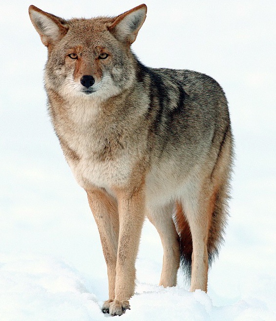
A recent rash of attacks on dogs in the Parker area reignited a long-running conversation about one of the most resilient predators in North America

Wildlife experts say the situation reflects a recurring phenomenon, a cycle of coyote activity that ebbs and flows throughout the so-called urban-wildland interface — and now, well into the urban core — literally from Los Angeles to New York.

“It does seem periodic,” says Kristin Cannon, an area wildlife manager with Colorado Parks and Wildlife. “We’ll go several years where there’s no issues, or very minor ones. Coyotes are pretty ubiquitous anymore, but as far as conflicts with people, and with pets, that seems to flare up every few years one place or another. Because conflicts are so common, it’s hard to quantify.”

Many communities along the Front Range have an official coyote management plan, which largely defines levels of interaction with the animals and prescribes at what point, and how, action may be taken to mitigate problems.

Attacks on humans tend to be the tipping point. And while lethal removal looms as an available tool, the emphasis remains on education and adapting human behavior. That strategy reflects the reality that coyotes, despite historical campaigns to eradicate them, have been a fixture on the continent for upwards of five million years.

And they’re not going away. As longtime coyote researcher Dan Flores, author of “Coyote America,” succinctly puts it: “Resistance is futile.”

[…]

In many Native American cultures, the coyote appears as an avatar for humans. Tales handed down through generations employ it as a four-legged metaphor, precisely for the way it holds a mirror to human behavior. Native to North America, the coyote’s howl, Flores contends, is “our original national anthem.”

By the 1920s, even Scientific American inserted the coyote as the shifty trickster-villain in a contemporary political allegory in which it argued that good Americans, if they spy one, should shoot it on sight for patriotic reasons — because the coyote is “the original Bolshevik.”

Much disdain for coyotes originated within the livestock industry, whose assets run afoul of predatory animals. And that, Flores says, led to an agency of the federal government, then called the Bureau of Biological Survey, seizing on the opportunity to brand itself, in the early 20th century, as the antidote to predation. It proved an effective strategy to guarantee congressional funding.

Colorado played a pivotal role in the extermination efforts that followed. The Eradication Methods Laboratory, which designed and manufactured the means to kill massive numbers of mostly wolves and coyotes, began producing strychnine in Albuquerque. But in 1921 it moved operations to Denver — where, Flores writes in “Coyote America,” “it would go on to perfect an amazing witch’s brew of ever more efficient, ever deadlier pesticides.”

Even the eradication campaign came with what Flores calls a “concerted PR effort” to demonize coyotes. Powered by a series of pre-packaged stories from the Biological Survey, he says, major publications all across the country ran fictionalized accounts that cast certain nuisance animals, including the coyote, as Al Capone-style gangsters. Those who would destroy them were cast as heroic G-men.

Wolves were essentially wiped out in the U.S. by 1925. But coyotes, despite lacking a public relations campaign of their own, more than survived attempts to snuff them. They flourished. So what did they have that wolves didn’t?

In simple terms, coyotes can live in groups, when it’s advantageous. But when it’s not, they can disperse into pairs or even solitary individuals and scatter across the landscape, making them difficult to locate and eliminate.

“Wolves are pure pack animals, and hunters discovered if you can track one of the animals in a pack, you can use its scent to prepare bait and get every one in the pack,” Flores says. “But coyotes don’t have the same pack adhesion. That’s the single advantage over wolves that allowed them to survive.”

So the eradication strategy backfired. Not only did the campaign not wipe them out, but it triggered colonization. When coyotes sense their numbers dwindling, the number of pups in their litters grows larger — a phenomenon called “compensatory breeding.”

Coyotes migrated all over the country and grew comfortable in urban areas, where they face no natural predators, no hunters shooting at them from helicopters, no leg traps or poisons. Plus, urban areas attract plenty of smaller animals, like rabbits, squirrels, rats and mice, that provide a ready food source…

For all the talk of how human development has encroached on animals’ natural habitat, the coyote has turned the tables. A recent story in National Geographic reported that coyotes actually have increased their range by 40% since the 1950s, can be found in every state except Hawaii, have become established in Central America and are expected to appear soon in South America…

Stewart Breck, a researcher with the U.S. Department of Agriculture’s National Wildlife Research Center based in Fort Collins, also specializes in urban coyotes. He has a good idea what’s going on. In fact, he sees two things.

First, urban coyotes tend to be bolder and “more explorative,” he notes. Breck drew this conclusion from research comparing coyotes in Denver to those that inhabit rural areas, which confirmed the behavior pattern. Similar studies have been repeated in many areas around the country.

Second, researchers have identified certain “problem individuals” that appear periodically in urban environments. These bad actors tend to be responsible for most of the unusual conflicts with people.

@USDA Invites Input on Agricultural #Conservation Easement Program Rule

Pond on the Garcia Ranch via Rio Grande Headwaters Land Trust

Here’s the release from the NRCS:

USDA’s Natural Resources Conservation Service (NRCS) seeks public comments on its interim rule for the Agricultural Conservation Easement Program (ACEP). ACEP is USDA’s premier conservation easement program, helping landowners protect working agricultural lands and wetlands. The rule – now available on the Federal Register – takes effect on publication and includes changes to the program prescribed by the 2018 Farm Bill.

“Through easements, agricultural landowners are protecting agricultural lands from development, restoring grazing lands and returning wetlands to their natural conditions,” NRCS Chief Matthew Lohr said. “The new changes to ACEP under the 2018 Farm Bill make it stronger and more effective and will result in even better protection of our nation’s farmlands, grasslands and wetlands.”

NRCS is investing more than $300 million in conservation easements for fiscal 2020. NRCS state offices will announce signup periods for ACEP in the coming weeks.

Changes to ACEP for agricultural land easements include:

  • Authorizing assistance to partners who pursue “Buy-Protect-Sell” transactions.
  • Requiring a conservation plan for highly erodible land that will be protected by an agricultural land easement.
  • Increasing flexibility for partners to meet cost-share matching requirements.
  • Changes to ACEP for wetland reserve easements include:

  • Identifying water quality as a program purpose for enrollment of wetland reserve easements.
  • Expanding wetland types eligible for restoration and management under wetland reserve easements
  • “Conservation easements have a tremendous footprint in the U.S. with nearly 5 million acres already enrolled. That’s 58,000 square miles,” Lohr said. “This is a great testament to NRCS’s and landowner’s commitment to conservation.”

    Submitting Comments

    NRCS invites comments on this interim rule through March 6 on the Federal Register offsite link image . Electronic comments must be submitted through regulations.gov under Docket ID NRCS-2019-0006. All written comments received will be publicly available on regulations.gov, too.

    NRCS will evaluate public comments to determine whether additional changes are needed. The agency plans on publishing a final rule following public comment review.

    Applying for ACEP

    ACEP aids landowners and eligible entities with conserving, restoring and protecting wetlands, productive agricultural lands and grasslands. NRCS accepts ACEP applications year-round, but applications are ranked and funded by enrollment periods that are set locally.

    For more information on how to sign up for ACEP, visit your state website at nrcs.usda.gov or contact your local NRCS field office.

    #Snowpack news: #Colorado has the #blues, mostly

    Click on a thumbnail graphic to view a gallery of snowpack data from the NRCS.

    And, here’s the Westwide SNOTEL basin-filled map for January 6, 2020 from the NRCS.

    Westwide SNOTEL basin-filled map January 6, 2020 via the NRCS.

    Albert King & Stevie Ray Vaughan – Blues Jam Session

    Scientists Devise Cheaper Method to Capture #Hydrogen for Fuel — @H2OTracker #ActOnClimate #KeepItInTheGround

    Electrolysis is a promising option for hydrogen production from renewable resources. Electrolysis is the process of using electricity to split water into hydrogen and oxygen. This reaction takes place in a unit called an electrolyzer. Electrolyzers can range in size from small, appliance-size equipment that is well-suited for small-scale distributed hydrogen production to large-scale, central production facilities that could be tied directly to renewable or other non-greenhouse-gas-emitting forms of electricity production. Credit: US Department of Energy

    From H2ORadio:

    There are great hopes that hydrogen will become a main energy source as common as gasoline. Hydrogen is plentiful and when it is burned it releases no pollutants. But one of the problems is to produce it in a cheap and sustainable manner. In the past, hydrogen has been captured by using expensive metals like platinum to cause a chemical splitting of the element from oxygen in water molecules.

    Now scientists from the University of New South Wales, say that they can produce hydrogen by using low-cost and abundant metals like iron and nickel in a process that uses much less energy. Despite the growing market for electric vehicles, refueling a hydrogen car could be done in minutes as opposed to the hours it takes to recharge a lithium battery in an electric car.

    Forbes reports that the first zero emission hydrogen rail project in the U.S. is being planned for San Bernardino County in Southern California. The local transportation authority will operate a commuter train on a 9-mile stretch that will run on fuel cells. There’s already a commuter rail line running on hydrogen fuel in Germany with more planned in France. China saw the first fuel cell tram go into operation in 2015.

    In rural #Colorado, the kids of #coal miners learn to install #solar panels — @HighCountryNews #ActOnClimate #KeepItInTheGround

    Ethan Bates and Cody Sauve adjust the wiring box on a solar array outside their Delta High School classroom. Bates’ father was a coal mine foreman. Luna Anna Archey/High Country News

    From The High Country News (Nick Bowlin):

    At a picnic table in a dry grass field, a group of elementary school students watched as high school senior Xavier Baty, a broad-shouldered 18-year-old in a camouflage ball cap and scuffed work boots, attached a hand-sized solar panel cell to a small motor connected to a fan. He held the panel to face the setting Colorado sun, adjusting its angle to vary the fan speed.

    “Want to hear a secret?” he asked the kids around him. “This is the only science class I ever got an A in.”

    As he readily acknowledges, Baty hasn’t been the most enthusiastic science student at Delta High School. This class, however, is different. Along with a group of other seniors and a few juniors, Baty is enrolled in “Solar Energy Training.” The class not only provides a science credit needed for graduation; it also trains students for careers in solar energy or the electrical trades. It allows Baty to work with his hands, something he enjoys, while positioning him for employment in a fast-growing industry.

    In Colorado’s North Fork Valley, solar energy — along with a strong organic farm economy and recreation dollars — is helping to fill the economic hole left by the dying coal industry, which sustained the area for more than 120 years. When the mines still ran, graduating seniors could step immediately into good-paying jobs. But in the past five years, two of Delta County’s three mines have closed. Approximately 900 local mining jobs have been lost in the past decade. Ethan Bates, for example, another senior in the solar energy training class, is the son of a mine foreman who lost his job when the Bowie Mine outside Paonia closed in 2016. Now, he’ll graduate as a certified solar panel installer.

    National environmental and climate groups often discuss “just transitions” for fossil-fuel dependent communities like Delta, or Wyoming’s Powder River Basin. Mining companies are going bankrupt, while every year, solar and other renewables get cheaper. Such economic shifts are complex, but one thing is clear: If the transition to renewables is to truly account for the communities and economies it undercuts, it will include programs like Delta High School’s solar training. The class positions young people for success in a coal-free future, and does so from the ground up, attentive to the needs and cares of the local community.

    National environmental and climate groups often discuss “just transitions” for fossil-fuel dependent communities like Delta, or Wyoming’s Powder River Basin. Mining companies are going bankrupt, while every year, solar and other renewables get cheaper. Such economic shifts are complex, but one thing is clear: If the transition to renewables is to truly account for the communities and economies it undercuts, it will include programs like Delta High School’s solar training. The class positions young people for success in a coal-free future, and does so from the ground up, attentive to the needs and cares of the local community.

    SCIENCE TEACHER BEN GRAVES started the class four years ago. Described by a student as “cool” but with a “mad-scientist vibe,” Graves has a salt-and-pepper beard and dresses casually in trail-running shoes and hardwearing khaki pants. In class, he is affable but authoritative.

    As a teacher, Graves sees his main duty as educating young people and creating good citizens. But to do right by his students, he needs to set them up for success under the current economic realities. And that requires classes like solar training. “I think we have to be doing some sort of trades education,” he said. “For a kid with a high school diploma, working service is really all you can do without more training.”

    Many students in the solar class, like Baty, weren’t particularly successful in traditional science classes. They’re kids who haven’t “played the school game,” as Graves put it, of college admission and standardized tests. For these students, training in electrical trades has now joined ranks with welding and agriculture programs offered by the high school.

    In the past four years, the class has helped install two solar arrays behind Delta High School. Students have done much of the work designing the structures and digging the trenches to lay conduit cables. This year for their final project, they will take apart and fully re-install one of the solar arrays. According to Graves, teachers at other local schools are keen to integrate solar training into their classes. Solar Energy International, a local nonprofit and a major catalyst behind the Delta class, is working to integrate solar training into science curriculum across the region.

    These projects are a boon to public school budgets, which lost a tax base when the mines closed. On a school day, the projects can supply about 10% of Delta High School’s energy demand — up to 30% on weekends. Thanks to a municipal cap, Graves said, the school has reached the limit on how much solar it can install, but even the current amount makes a difference.

    “The facilities folks at first waved it away as a class project,” Graves said with a laugh. “Now, maintenance sees it as a real way to reduce demand charges. It went from us pushing some of this stuff on the administration to them saying, ‘Wait a second, we actually want this.’”

    The economics of renewables are changing Delta at the county level, too. The area’s electric cooperative, Delta-Montrose Electric Association (DMEA) is ending its contract with its wholesale power supplier, Tri-State Generation and Transmission Association. Tri-State long required that buyers like DMEA purchase 95% of their electricity from the utility, limiting the amount of solar and other renewables local co-ops could produce. The company is notorious for its continued reliance on coal-fired power plants.

    For many Delta residents, solar offers a certain self-sufficiency and local independence they find appealing, as evidenced by DMEA’s defection from corporate control. It’s also cheaper: DMEA can cut customer costs by increasing its share of renewable power. As a rural electric co-op, DMEA’s members call the shots, and in October 2018, they voted to raise money and sell stocks in order to buy out their Tri-State contract. Politically, Delta County might not be an obvious leader in renewable energy; it voted for President Trump by about 70%. But solar panels on homes and businesses are increasingly common, with demand sometimes outstripping the capacity of local solar firms.

    In the school district where Graves works, DMEA has encouraged the adoption of solar by funding solar arrays at every high school in its service area. Through SEI, the co-op has administered grants for Graves’ class, and it funds solar trainings for teachers across the area.

    FROM AN EDUCATIONAL VIEW, the solar class’ value rests in its capacity to combine technical training and scientific learning outside the traditional grade structure. This dynamic was on full display on a bright fall day in October. The class was participating in an energy reduction contest against other Delta County high schools. Sponsored by the Colorado Energy Office, the Renew Our Schools program promotes student-run energy efficiency projects. At the end of the five-week competition, the winning school would receive $12,000.

    The contest transformed the kids from students to energy auditors. Graves sent them out to prowl the hallways, counting light bulbs and measuring the energy used by the tech lab’s computers. In the hallways, every other light fixture is dark, the bulbs removed by solar students. At a separate table, another group used the data to calculate savings if the building’s sodium vapor bulbs were replaced by LED lights. Lights, the kids found, account for about half of the school’s peak power demand.

    All this activity halted when tragedy struck in early November. Gannon Hines, a senior who hoped to use his solar skills upon graduating, died in a car accident. Three other students were in the car, and one remains badly hurt. Graves did not try to teach in the dark days of mourning that followed; instead, he simply let the students talk and remember their friend. He contemplated calling off the competition, but Hines had been one of the class’ more enthusiastic members.

    “We talked about whether to stop or to keep going with the competition, and we decided to keep going for Gannon,” said Allora McClellan, another senior.

    On the final day of the competition, just before Thanksgiving, it was clear Delta was going to lose, and some of the students were frustrated. They had redoubled their efforts after the heartbreak but came up short. It’s easier for smaller schools to show large energy-use cuts, and Delta is the largest school in the district. Students grumbled about an unfair contest. (In December, the school was awarded $2,000 by the state for their efforts. The funds will help replace fluorescent bulbs with LEDs.)

    As the hour wound down toward lunch, Graves watched a group of students finish some final kilowatt calculations. A few were already drifting toward the door.

    “Hey,” he said, “let’s finish our work.”

    This story was originally published at High Country News on December 13, 2019.

    One coal mine remains open in the North Fork Valley. Photo/Allen Best

    Decision on RMR quarry expansion near Glenwood Springs could take years — The Aspen Times

    The proposed expansion of the Mid-Contintent Limestone Quarry above Glenwood Springs by the politically connected Rocky Mountain Resources has spurred the city to create a taxpayer funded campaign against the plan. The mine’s existing footprint of roughly 16 acres is in yellow and the proposed expansion is in red. Photo credit: City of Glenwood Springs via The Colorado Sun

    From The Aspen Times (Thomas Phippen):

    …if history is a guide, the process to a decision about whether to approve or deny RMR’s expansion proposal could take years.

    The time line of the environmental review of the project, which would expand the limestone quarry from about 23 acres to 321 acres and remove millions of tons of rock per year, is anything but certain.

    “The (Bureau of Land Management)’s current estimate for starting the formal (environmental impact statement) is summer 2020, although that could change to be earlier or later depending on the status of the studies and as BLM gathers more information,” according to a BLM fact sheet on the quarry proposal.

    The agency has a number of baseline studies to complete before the environmental review process can begin in earnest, so the schedule is up in the air, according to BLM spokesman David Boyd.

    “We just don’t know. It’s not like we have a schedule and I’m not saying what it is, we just have to wait and see where all the parts are,” Boyd said.

    One part of the baseline studies is a hydrological analysis.

    The study required several test wells and monitoring of the groundwater for a year. RMR planned to begin drilling the monitoring wells in the fall.

    Due to the intense interest in all things related to the quarry, however, the BLM asked for public comments on issuing a categorical exclusion to approve the test wells.

    After receiving 250 comments, and a last-minute letter from Rep. Scott Tipton, R-Colo., urging more environmental review, the BLM decided to conduct an environmental assessment with “a detailed analysis of potential impacts of drilling the wells.”

    That analysis has begun, Boyd said, and should be complete in the next few months.

    Because of the scoping period in late 2019, the assessment will not need additional public comment, Boyd said.

    The hydrological study needs a year’s worth of data from all four seasons, but there’s a chance that the BLM could begin public comment, scoping and other parts of the environmental impact statement before all the hydrological data is in, Boyd said.

    Still, the process “certainly (won’t start) before summer, and likely at this point later than that,” Boyd said.

    In addition to the hydrologic study, the BLM is conducting a cave and karst study to research underground features on the proposed quarry site, an ethnographic study and an anthropologic and cultural study.

    Many of those studies have begun, Boyd said…

    The average amount of time it takes for the BLM to complete an environmental impact statement is nearly four and a half years, according to a 2017 analysis of the process by the White House.

    The process will officially begin when the BLM posts notice of intent to complete an environmental impact statement.

    Then there will be periods of scoping and public comment, which will likely include public meetings.

    When the BLM completes a draft of the statement, it will be made available for additional public comment. The average time from formal notice to draft EIS is nearly two and a half years at the BLM. From the draft to a final statement is another year and a half, on average, and then it usually takes another six months before the final decision is announced.

    Many environmental reviews take less time; a few take a decade or more.

    Backlog of toxic #Superfund cleanups grows under @POTUS — the Associated Press

    Bonita Mine acid mine drainage. Photo via the Animas River Stakeholders Group.

    From the Associated Press (Ellen Nickmeyer, Matthew Brown, and Ed White) via The Aurora Sentinel:

    The Trump administration has built up the biggest backlog of unfunded toxic Superfund cleanup projects in at least 15 years, nearly triple the number that were stalled for lack of money in the Obama era, according to 2019 figures quietly released by the Environmental Protection Agency over the winter holidays.

    The accumulation of Superfund projects that are ready to go except for money comes as the Trump administration routinely proposes funding cuts for Superfund and for the EPA in general. The four-decade-old Superfund program is meant to tackle some of the most heavily contaminated sites in the U.S. and Trump has declared it a priority even while seeking to shrink its budget…

    The unfunded projects are in 17 states and Puerto Rico. They range from abandoned mines that discharged heavy metals and arsenic in the West to an old wood pulp site in Mississippi and a defunct dry cleaner that released toxic solvents in North Carolina…

    two former EPA officials whose work dealt with Superfund oversight said the growing backlog of stalled Superfund projects under the Trump administration, and steady or ebbing numbers of cleanup construction projects completed, point to a different picture.

    “They’re misleading Congress and the public about the funds that are needed to really protect the public from exposure to the toxic chemicals,” said Elizabeth Southerland, who worked for 30 years at EPA, including as director of science and technology in the water office, before retiring in 2017. ”It’s detrimental.”

    This is a “regulatory failure,” said Judith Enck, who served as the EPA’s regional northeastern U.S. administrator under President Barack Obama…

    Asked what the EPA spent money on instead, and why the agency didn’t ask Congress for more to deal with the growing backlog, EPA spokeswoman Maggie Sauerhage offered few specifics Thursday.

    The EPA’s Superfund program “will continue to prioritize new construction projects based on which sites present the greatest risk to human health and the environment,” Sauerhage said in an email. “Further, the agency maintains the authority to respond to and fund emergencies at these sites if there is an imminent threat to human health and the environment.”

    She pointed to some areas where Trump’s Superfund effort was more on par with that of his predecessors. Long-term remedial efforts to make sure contamination didn’t rebound at existing Superfund sites, for example, averaged 64 a year under Trump. That compares with an average of 60 a year in Obama’s last five years.

    But overall, the backlog of 34 unfunded projects is up from only 12 in 2016, Obama’s last year , and the most at least since 2004.

    At the site of another of 2019’s unfunded Superfund projects, Montana’s Upper Tenmile mining region, which includes the community of Rimini and a subdivision downstream, the EPA has been providing bottled water to residents for the past decade in response to water supplies polluted by about 150 abandoned gold, lead and copper mines.

    Pollution still flows from the mines and into Upper Tenmile Creek more than 20 years after the area was added to the Superfund list.

    About 6 miles from Rimini in the rural Landmark subdivision is a huge pile of contaminated soil that was removed from residential yards. It was supposed to be hauled away but now has weeds growing over it after sitting untouched for several years, said Patrick Keim, who lives nearby…

    EPA has been one of the main focuses of Trump’s efforts to cut federal regulations and oversight that he sees as burdening businesses. Trump each year has asked Congress for nearly one-third cuts in EPA’s budget, and has sought much smaller cuts for Superfund.

    Congress has kept both levels of funding roughly even.

    Colorado River District working to protect West Slope water users — The Grand Junction Daily Sentinel

    A large irrigation canal in the Grand Valley, which relies on water from the Colorado River to irrigate fields. The state is exploring how a voluntary, temporary and compensated water-use reduction plan, known as demand management, might work. Photo credit: Brent Gardner-Smith/Aspen Journalism

    Here’s a guest column from Andy Mueller that’s running in The Grand Junction Daily Sentinel:

    At the Colorado River District, we are working to ensure that whatever the future holds, there’s water on the West Slope to support our way of life.

    Whether you grow food, rely on clean water from your kitchen tap, or recreate on our rivers, the River District is working to develop every tool possible to ensure that West Slope water users are represented and protected.

    In fact, the District recently received a $315,000 “WaterSMART” grant, which we will use to analyze many of the risks that we face on the West Slope in an uncertain water future.

    Despite the optimism from recent snowfall, Colorado is still amid a prolonged decline of flows in the Colorado River — and facing more variable weather conditions and snowpack with each passing year. When you combine that with growing population in the Colorado River basin, both in Colorado and downstream, we’re looking at an uncertain water supply.

    Under the Colorado River Compact, Colorado and other states in the Upper Colorado River Basin are required to keep a certain amount of water flowing to states in the Lower Basin. But declining flows have signaled a risk to that obligation. And continued drought could mean water users in the Centennial State might have to reduce water use in the future without compensation in order to meet this compact commitment.

    As part of a multi-state plan to avoid that, Colorado is exploring the feasibility of a program called demand management, which would pay farmers, industry and cities to voluntarily and temporarily reduce water use in order to bank it in reservoirs for use in preventing an uncompensated call. At the Colorado River District, we have concerns about whether such a program is advisable or necessary, but even as we seek answers to those concerns, others are looking at how such a program will be structured.

    Right now, there are a lot of questions. As Colorado decides if and how demand management would be implemented, we want to advocate for rules that are the best possible for West Slope water users. We are studying the hypotheticals and talking to a broad set of water users to understand what might work in western Colorado.

    The Colorado River District received its $315,000 WaterSMART grant from the U.S. Bureau of Reclamation as part of a federal water planning program. We will be working with the Southwestern Water Conservation District, Tri-State Generation and Transmission Association, The Nature Conservancy, Basin Roundtables, the state of Colorado and others to study risks to our water supply. Leveraging these federal funds and partnerships allows us to do more to protect West Slope water users.

    Agricultural producers play a critical role in our local economies, whether it’s equipment repairs at a local mechanic or a ranch hand buying a burger at the local diner. Our main street businesses could see changes if farmers, even temporarily, aren’t farming.

    To understand how our local economies might be affected by demand management, the River District is sponsoring a study of the potential secondary economic impacts that such a program could have on the businesses and communities that West Slope agriculture supports.

    The grant will also fund the next phase of a multi-year study to understand the risk to Colorado’s water users if a call under the Colorado River Compact requires that we use less water. This study is designed to give us all an idea of what water rights might be curtailed by a compact call, giving water users across the West Slope a better idea of what could happen to their water.

    Finally, the WaterSMART grant will help us bring West Slope water users together to understand how to create a program that makes sense for them. While we can’t get the thousands of water users in the Colorado River District in a room to decide what demand management should look like, we’ll be working with a broad cross-section of water users from different industries and communities in the district to do just that. We want to be sure that if demand management is implemented, it works for ranchers, towns, and rivers in western Colorado.

    All these studies and conversations will give West Slope water users the information and tools they need to decide if they should take part in demand management. They will also better allow the Colorado River District to advocate for those users and protect water on the West Slope in an uncertain future.

    Brad Udall: “…latest version of my 4-Panel plot thru Water Year (Oct-Sep) of 2019 of the #coriver big reservoirs, natural flows, precipitation, and temperature. Data goes back or 1906 (or 1935 for reservoirs.) This updates previous work with
    @GreatLakesPeck

    Busy #cowater month in the San Luis Valley

    From The Valley Courier:

    January will be a busy month for the San Luis Valley Water Community.

    The Rio Grande Water Conservation District’s Board of managers for Special Improvement District number 5 meeting will take place on Jan. 7 at 5 p.m. at the Saguache County Road and Bridge Dept. at 305 3rd St. in Saguache.

    Thursday Jan. 9 — Mosca-Hooper Soil & Water Conservation District will host a workshop with consensus process professional, Jeff Goebel called “Exploratory consensus process on groundwater conflict” from 8:30 a.m. to 5 p.m., lunch provided. There is no cost to participate, please RSVP by Jan. 3 to moscahoopercd1@gmail.com.

    The Rio Grande Basin Roundtable will meet on Jan. 14 from 2 p.m. to 4 p.m. at the San Luis Valley Water Conservancy District Office at 623 E. 4th St. in Alamosa.

    The Board of Directors for the Rio Grande Water Conservation District will hold their quarterly meeting on Jan. 21 at the RGWCD office.

    On Jan. 22, the Board of Managers for Special Improvement District number 2 will hold their annual meeting.

    Many representatives of the Valleys’ water entities along with fellow water users from across the state will also travel to the Colorado Water Congress Annual Convention on Jan. 29-31 in Westminster.

    With the Renewable Water Resources export proposal and numerous other issues still at large, it is highly likely that 2020 will be an eventful year on the San Luis Valley water scene.

    Saguache Creek

    Biologists: Feds’ target numbers too low for Gunnison sage-grouse recovery — @AspenJournalism

    Biologists say federal target numbers are too low to ensure recovery of the Gunnison sage-grouse, which is listed as threatened under the Endangered Species Act. The bird’s largest population is in the Gunnison basin. Photo credit: Colorado Parks and Wildlife.

    From Aspen Journalism (Heather Sackett):

    In the late 1980s, conservation biologist Jessica Young was an undergraduate researching the sage grouse in the Sierra Nevada when one of her professors handed her a cassette tape. He said there was a guy out in Gunnison, Colo., who claimed that the grouse there sounded different. Young listened to the recording of grouse calls and decided she had to see the birds for herself.

    Young began working with Clait Braun, a researcher at Colorado Parks and Wildlife (then called the Department of Wildlife) who had discovered as early as 1977 that the Gunnison sage-grouse was different from its cousin, the wider-ranging greater sage-grouse.

    The work of Young, Braun and other scientists eventually helped prove that the Gunnison sage-grouse was a separate species of ground-nesting bird, one that was officially declared a new species in 2000.

    But there was a problem.

    Researchers quickly realized that not only was this grouse a new species, it was also in serious trouble. By the time they discovered that this bird — which is perfectly adapted to western Colorado’s high-desert sagebrush ecosystem and famous for its elaborate spring mating dance — was a distinctive, smaller species, the bird was already on the verge of vanishing.

    “It was clear to me by the mid-1990s that this was about much more than the Gunnison sage-grouse,” Young said. “I remember thinking that it was probably going to be the 21st-century test of how my nation valued both biodiversity and the economic well-being of communities across the West. I believe that is what the Gunnison sage-grouse really represents.”

    Target numbers too low?

    After years of conservation efforts in the Gunnison basin and elsewhere, the bird’s numbers are still declining. In 2014, in a controversial move that sparked lawsuits from the state of Colorado, Gunnison County and the Gunnison County Stockgrowers Association, the U.S. Fish and Wildlife Service listed the bird as “threatened” under the Endangered Species Act. Five years later, it remains unclear what effect the listing has had on the bird.

    This past fall, the FWS released its draft recovery plan for the species, which is open for public comment through Tuesday. The plan lays out target-population numbers that must be met for seven out of nine years before the species could be considered on the road to recovery and potentially delisted. The plan also charts conservation projects and actions for the next 50 years, at an estimated cost of more than $560 million. The final recovery plan is scheduled to be completed by Nov. 1.

    But environmental groups — along with Braun and Young, two scientists who have dedicated much of their careers to studying the bird — say these population targets are too low to ensure recovery of the species. The target number for the Gunnison basin is 748; in 2019, researchers counted nearly 400 fewer than this.

    The largest population of the Gunnison sage-grouse — about 85 percent of the species — lives in the Gunnison basin, with smaller satellite populations scattered throughout western Colorado. Biologists estimate the bird is now found on less than 10 percent of its historic range. Credit: USFWS

    Declining populations

    Gunnison sage-grouse numbers have indeed declined — some say alarmingly so — in recent years.

    Over the past several years, the three-year average high male count — the highest number of male birds that the researchers spot — has dropped across all populations. In the Gunnison basin, the 2019 number was 583, down from 772 in 2018, 886 in 2017 and 905 in 2016.

    2019 posted the lowest bird numbers since the count methodology was standardized in 1996. The high male count for the Dove Creek population in western Dolores County dipped to zero, while high male counts at Cerro Summit and Poncha Pass in Colorado and the area near Monticello, hovered from just three to seven birds.

    “You don’t want to see declines like this when you have seven birds,” said Kathy Griffin, grouse conservation coordinator for CPW. “To say we are not concerned would not be true. … We have seen these kinds of declines before, but we are getting to the lowest we’ve ever been.”

    According to a paper by Braun, Young and others, the Gunnison sage-grouse once roamed throughout most of southwestern Colorado. It disappeared from Pitkin County in the 1960s. In the 1990s, it was extirpated in Eagle and Garfield counties.

    The largest populations of the Gunnison sage-grouse — and around 85 percent of the bird’s remaining total population — live in the Gunnison basin. Smaller populations of the species, referred to as satellite populations, are scattered throughout western Colorado (Cerro Summit, Crawford, Dove Creek, Pinon Mesa, Poncha Pass and western San Miguel County) and eastern Utah (Monticello).

    The 2014 “threatened” listing was based mostly on these shrinking satellite populations, which scientists think need to remain robust as an insurance policy should some kind of environmental-related disaster or disease befall the main population of birds in the Gunnison basin.

    Those who opposed federal involvement, including Gunnison County, still feel the sting of the 2014 listing as an affront to the collaborative conservation work of local groups, including the county-led Gunnison Sage-Grouse Strategic Committee. Committee Chair and Gunnison County Commissioner Jonathan Houck said the recovery plan, much like the listing itself, still focuses too much on the satellite populations. The Gunnison basin, Houck said, is doing its part to help the bird.

    “The draft recovery plan correctly recognizes the high resiliency of the Gunnison sage-grouse population in the Gunnison basin and also recognizes correctly the strength of the habitat protection in the Gunnison basin,” Houck said. “The irony to me is this is the entire argument we made before the listing.”

    A Gunnison sage-grouse hen leads her chicks in the Gunnison basin during the summer of 2019. Some private landowners have undertaken habitat restoration projects on placed conservation easements on their property in an effort to protect the bird. Photo credit: Greg Petersen via Aspen Journalism

    Bird counts

    CPW uses something called “High Male Count” to track bird numbers year over year. Each spring, biologists watch from the sidelines as regal-looking male Gunnison sage-grouse perform their courtship ritual — strutting and bobbing, fanning their banded tail feathers and popping their air sacs in an effort to attract a female — on leks, which are open areas ringed by sagebrush that the birds return to year after year.

    Researchers count each male they see on several trips to the leks they make each season, meaning the same bird can be counted more than once. These numbers are then averaged over three years to smooth out the seven-to-12-year fluctuations associated with grouse population and used to estimate the total population size.

    The one-two punch of 2018’s extreme drought, which may have resulted in bird deaths, and 2019’s deep snow may have contributed to this year’s low counts. Counting is a logistical challenge because of the precise method used. CPW biologists were not able to access all of the leks last spring because of lingering deep snow, and in other areas, counters heard the birds’ signature popping noise but didn’t catch sight of them.

    “We had a horrible year of counting,” Griffin said. “Because we could never see them, we had to put down a zero even though we knew there were birds there.”

    Whatever the reason for the low counts, bird populations will need to increase in order for the FWS to consider the species recovered and to potentially delist it. The recovery plan sets a target three-year average high male count in the Gunnison basin of 748 for seven out of nine years for the population to be considered stable.

    Western Colorado’s sagebrush sea is the favorite habitat of the Gunnison Sage-grouse. But much of it, like this area near Carbondale, is bisected by trails and encroached upon by piñon and juniper trees. Photo credit: Aspen Journalism

    The sagebrush sea

    Braun and others, including environmental group Rocky Mountain Wild, also say the draft recovery plan lacks specificity when it comes to how to conserve the bird’s habitat — the silvery-green expanse known as the sagebrush sea.

    Western Colorado’s sagebrush sea is naturally fragmented by canyons and mountains. But in recent decades, prime habitat has also been bisected by roads and trails, interrupted by residential developments, affected by cattle grazing, and encroached upon by pinon and juniper trees. The Bureau of Land Management manages about 42 percent of Gunnison sage-grouse habitat.

    “I think the really key thing is that there needs to be habitat that is set aside from development and other threats on public land, and that isn’t really the case right now,” said Megan Mueller, a senior conservation biologist at Rocky Mountain Wild.

    Although some private landowners in the Gunnison basin have participated in habitat restoration projects such as restoring wet meadows and putting conservation easements on their property to protect it from future development, Braun says those measures are not enough. He thinks a more drastic action is needed: stopping livestock from grazing on public land in Gunnison sage-grouse habitat until populations of the bird increase.

    “Grazing is a key factor in why sage-grouse populations are down in the Gunnison basin,” Braun said. “Until we get a handle on the livestock grazing, nothing is going to really improve.”

    Braun recognizes that his idea to temporarily outlaw grazing on public land in Gunnison sage-grouse habitat is an idea many will find unpalatable, even radical. Ranching is an important part of the culture of rural western Colorado.

    “We want to keep ranching active in the Gunnison Valley,” Houck said. “It’s the thing that’s defined this place.”

    One challenge to habitat conservation, Young said, is that the sagebrush sea has long been an undervalued ecosystem. It has traditionally been a place with few regulations, where mountain biking and hiking trails snake through the landscape; where people put dumps and mine tailings; where driving off-road was — and sometimes still is — common; and where overgrazing damaged the landscape.

    Saving the Gunnison sage-grouse, Young said, will require reexamining the economic, social and ecological values that people hold about this landscape. Although the federal involvement may have polarized some groups, the little ground-nesting bird also has the potential to bring together disparate factions to work toward the same goal: species conservation.

    “I think, in the 2000s, the Gunnison sage-grouse are asking us again to consider what our values are for both biodiversity and community success during a time of climate change,” Young said. “They are going to be an indication of how we come together and demonstrate our values and resilience.”

    Aspen Journalism collaborates with The Aspen Times and Aspen Public Radio on coverage of water and environmental issues. This story was published online by The Aspen Times on Dec. 31 and a conversation about this reporting aired on APR on Dec. 31.

    Four States Irrigation Council annual meeting, January 8-10, 2020, set to take place in Fort Collins — The Greeley Tribune

    Irrigation sprinklers run over a farm in Longmont in the South Platte River basin. Photo credit: Lindsay Fendt/Aspen Journalism

    From The Greeley Tribune (Cuyler Meade):

    The Colorado River Compact and water infrastructure projects will be among the items discussed at the annual Four States Irrigation Council meeting held Wednesday through Friday in Fort Collins.

    the Four States Irrigation Council is a group of irrigators, irrigation and water districts, ditch companies and others looking to discuss water-delivery and irrigation-related issues affecting the Four States region, which encompasses Colorado, Kansas, Nebraska and Wyoming.

    Exhibitors at the event will showcase some of the latest innovations and provide attendees with up-to-date information on new products and services. Awards will also be presented.

    Membership in the Four States Irrigation Council is open to anyone and free of dues or fees. Someone can become a member by attending the annual meeting or visiting 4-states-irrigation.org and requesting to be added to mailing list.

    More information about the meeting is also available on the website.

    From high in the Rockies to the South Platte, here’s where #Denver gets its water — Denverite #ColoradoRiver #COriver

    From Denverite (Lindsay Fendt):

    Denver’s water supply today
    The city of Denver has gotten its water from the utility Denver Water since 1918. Today, the utility’s coverage area is larger than the city limits of Denver, covering surrounding suburbs like Lakewood and Littleton. This includes about 1.4 million people who use an average of 65 billion gallons of treated water per year…

    Most of this water goes to Denver homes and apartment buildings, and a whopping 40 percent of it winds up being used outdoors on lawns and other landscaping.

    Denver Water’s collection system via the USACE EIS

    Denver water map
    The map shows the system Denver Water uses today to collect water and transfer it to homes in the metro area. In any given year, about 52 percent of the water that finds its way into Denver’s taps comes from the South Platte River. The Fraser River and Williams Fork River together make up 20 percent of the water supply and the final 28 percent comes from the Blue River.

    These last three rivers are all part of the Colorado River system, and that water needs to be transferred to Denver under the Continental Divide. Water geeks call this type of water conveyance trans-mountain diversions. There are 24 main tunnels that bring about 400,000 acre-feet of water from the West Slope to the Front Range and provide water for both the growing cities and the robust agricultural industry on the Front Range.

    Colorado transmountain diversions via the State Engineer’s office

    While these diversions have been common over the last century, they’ve become controversial in the last few decades of drought on the Colorado River. There is debate as to whether the Colorado River system can sustain many more large diversions.

    On the map, you can see Denver has two major trans-mountain conveyance systems.

    Workers pose for a photo in the Moffat Water Tunnel in this 1930 photo.

    Moffat Tunnel: This old railroad tunnel was the first trans-mountain diversion to feed the city of Denver. The tunnel transfers water directly from the Fraser River under the divide and into South Boulder Creek where it eventually ends up in Gross Reservoir in Boulder County. From there, the water is diverted through a canal to Ralston Reservoir, which provides water to the Moffat Water Treatment Plant.

    The Williams Fork River also puts water into the Moffat Tunnel, but its journey is even more complicated. Before any Williams Fork water even reaches the Moffat Tunnel, it is first diverted into the Gumlick Tunnel, under Jones Pass then back over the divide again through the Vasquez Tunnel. The Vasquez Tunnel empties near Winter Park where the Moffat Tunnel is. By the time this water reaches Denver, it has passed under the Continental Divide three times.

    Harold D. Roberts Tunnel: The Roberts Tunnel was built in 1952 to bring water to Denver from Dillon Reservoir, which sits at the confluence of the Blue River, Snake River and Ten Mile Creek. This large reservoir is Denver Water’s largest, representing 37.1 of the utility’s total storage capacity.

    The tunnel diverts water directly from the reservoir and pipes it under the divide. The 23-mile-long tunnel sits 4,000 feet underground at some points. The pipe itself is ten feet in diameter. This water empties into the North Fork of the South Platte River and runs down the main stem of the river.

    Cheesman Dam spilling June 2014 via Tim O’Hara

    South Platte River Water: Most of Denver’s water supply is drawn straight out of the South Platte River. There are three stems to the river (South, Middle and North), which all converge just south of Denver. Along the river are a number of reservoirs. When the river is running high, the reservoir’s dams hold back some of the water so it can be used later on by the city. These storage reservoirs, which can be found all over the state, let water managers capture the high levels of spring runoff and distribute it well into the summer.

    Water from the South Platte is eventually diverted through a series of pipelines to the Marston Reservoir, which is treated at the Marston Water Treatment Plant and sent to city customers.

    Ducks patrol the South Platte River as construction workers shore up bank. Oct. 8, 2019. Credit: Jerd Smith

    Bird migration timing skewed by #climate, new research finds — @ColoradoStateU #ActOnClimate

    A long-billed curlew in flight. Photo: Nick Saunders via Colorado State University

    Here’s the release from Colorado State University (Mary Guiden):

    Life cycles for birds, insects and trees are shifting in this current era of a rapidly changing climate. How migration patterns, in particular, are changing and whether birds can track climate change is an open question.

    Kyle Horton, assistant professor at Colorado State University, led a new study analyzing nocturnal bird migration that he hopes will lead to more answers about shifting migration patterns. He and the research team used 24 years of radar data from NOAA, the National Oceanic and Atmospheric Administration, for the study.

    The research team – including scientists from the Cornell Lab of Ornithology and the University of Massachusetts – found that spring migrants were likely to pass certain stops earlier now than they would have 20 years ago. Temperature and migration timing were closely aligned, with the greatest changes in migration timing occurring in regions warming most rapidly. During fall, shifts in migration timing were less apparent.

    The study, one of the first to examine the impacts of climate change on migration timing at a continental scale, is published December 16 in Nature Climate Change.

    Analysis using cloud computing revealed patterns of millions of birds

    Horton described the breadth of the research as “critically important,” with the team observing the nocturnal migratory behaviors of hundreds of species representing billions of birds.

    “To see changes in timing at continental scales is truly impressive, especially considering the diversity of behaviors and strategies used by the many species the radars capture,” he said. Yet while the team saw these shifts, Horton noted that this doesn’t necessarily mean that migrants are keeping pace with climate change.

    Migratory birds serve an important role in ecosystems. They eat and take insects off the land, disperse seeds and serve other significant functions, including measuring health in these ecosystems.

    Andrew Farnsworth, the study’s senior author and a research associate at Cornell Lab of Ornithology, said the team’s research answered, for the first time, key questions on birds and climate change.

    “Bird migration evolved largely as a response to changing climate,” he said. “It’s a global phenomenon involving billions of birds annually. And it’s not a surprise that birds’ movements track changing climates. But how assemblages of bird populations respond in an era of such rapid and extreme changes in climate has been a black box. Capturing scales and magnitudes of migration in space and time has been impossible until recently.”

    Researchers accessed NOAA datasets through Amazon Web Services as part of the agency’s Big Data Project, designed to provide access to data in a more efficient way.

    Horton said that this access to the data and cloud computing greatly enhanced the team’s ability to synthesize the findings.

    “To process all of these data, without cloud computing, it would have taken over a year of continuous computing,” he said. Instead, the team crunched the numbers in about 48 hours.

    While Amazon Web Services provided access to the data, new algorithms designed by scientists at the University of Massachusetts revealed the potential of these radar data for biologists. Specifically, the scientists designed new computer vision techniques to remove weather data, a problem that had challenged biologists from decades.

    “Historically, a person had to look at each radar image to determine whether it contained rain or birds,” said Dan Sheldon, associate professor of computer science at the University of Massachusetts Amherst. “We developed ‘MistNet,’ an artificial intelligence system to detect patterns in radar images and remove rain automatically.”

    Fall migration tends to be ‘messier’

    Horton, who works in the Department of Fish, Wildlife and Conservation Biology at CSU, said that the lack of change in fall migration patterns was a little surprising, though migration also tends to be a “little bit messier” during those months.

    “In the spring, we see bursts of migrants, moving at a fairly rapid pace, ultimately to reach the breeding grounds,” he explained. “However, during the fall, there’s not as much pressure to reach the wintering grounds, and migration tends to move at a slower, more punctuated pace.”

    During the fall, birds are not competing for mates, and the path to reach their destination is more relaxed. There’s also a wider age range of birds migrating, as the young eventually realize they need to migrate, too. The combination of these factors makes fall migration more challenging to study.

    Horton said the findings have implications for understanding future patterns of bird migration, since the birds rely on food and other resources as they travel. Under climate change, the timing of blooming vegetation or emergence of insects may be out of sync with the passage of migratory birds. This seemingly subtle shift could have negative consequences for the health of migratory birds.

    Researchers plan to expand their data analysis to include Alaska, where climate change is having more serious impacts than in the lower 48 states in the U.S.

    #Drought news: 180-day #precipitation deficits remain the largest (more than 6 inches) across southwest #Colorado

    Click on a thumbnail graphic to view a gallery of drought data from the US Drought Monitor.

    Click here to go to the US Drought Monitor Website hosted by the Colorado Climate Center. Here’s an excerpt:

    This Week’s Drought Summary

    An area of upper-level low pressure entered southern California by December 26 and then progressed east across the Four Corners region. This upper-level low resulted in heavy rain and high-elevation snow from southern California east to southwest Colorado and New Mexico. A surface low developed across the south-central Great Plains on December 28 with a subsequent track northeast to the upper Mississippi Valley and Great Lakes. Heavy snow fell to the northwest of this low pressure system, while moderate to heavy rainfall accompanied the cold front as it shifted east from the Great Plains to the East Coast. Following the heavy precipitation across the Pacific Northwest during mid to late December, precipitation average below normal during the final week of December. Enhanced onshore flow resulted in periods of heavy precipitation along the Alaska Panhandle, but longer-term precipitation deficits persist. A low pressure system and trailing front brought locally heavy rain and damaging winds to parts of the Hawaiian Islands this past week…

    High Plains

    A low pressure system developed across the southern Great Plains on Dec 28 and then tracked northeast to Iowa and Minnesota. Along and northwest of the surface low track, beneficial precipitation (0.5 to 1.5 inches) fell from the western half of Kansas north to southern and eastern Nebraska. This recent precipitation prompted a 1 to 2-category improvements to the short-term drought areas in Kansas. A 2-category improvement was justified where more than 1 inch of precipitation occurred and 90-day precipitation is either at or above normal. However, severe drought (D2) continues west of Garden City and Liberal, Kansas. In contrast to the improving conditions for Kansas, abnormal dryness (D0) was extended north across western Wyoming where 90-day precipitation deficits are 2 to 6 inches. Drought impacts were modified to long-term only in southwest Colorado due to recent snowfall. Snow water content is running 125 to 135 percent of normal as of December 29, but 6-month SPI values support the severe drought (D2) category in southwest Colorado…

    West

    A vigorous upper-level trough crossed southern California and the desert Southwest from December 25 to 27. Widespread moderate to heavy rain and high-elevation snow (0.5 to 2 inches, liquid equivalent) accompanied this upper-level trough. Snowfall amounts exceeded two feet in the mountains of southern California, while 4 to 12 inches was recorded in the higher elevations of Arizona. This recent precipitation along with support from longer-term SPI values resulted in a 1-category improvement to Dx levels in parts of Arizona and southwest Utah. 180-day precipitation deficits remain the largest (more than 6 inches) across southwest Colorado.

    Drier weather returned to the Pacific Northwest during the final week of December. Following the period of heavy precipitation during mid to late December, no changes were made to the ongoing abnormal dryness (D0) and short-term moderate drought (D1) areas. Water year to date (since October 1) precipitation deficits of more than 12 inches, 28-day stream flows in the lowest 10th percentile, and basin average snow water content less than 50 percent support the short-term moderate drought (D1) across parts of Oregon and Washington…

    South

    As an upper-level trough ejected from the desert Southwest, a surface low developed over the southern Great Plains. Beneficial rainfall (more than 1 inch) resulted in improving conditions across the eastern Oklahoma Panhandle and northwest Oklahoma. Moderate (D1) to severe (D2) drought continues across southwest Oklahoma and adjacent areas of the Texas Panhandle and northwest Texas which received lighter rainfall amounts (0.75 inches of less). Changes to the drought depiction across the remainder of Texas included a slight reduction in D0/D1 in central and southwest parts of the state, based on recent rainfall and lack of short-term dryness. Although it was a dry week across deep southern Texas, a reassessment of indicators supported a slight reduction of severe (D2) drought. A small area of severe (D2) drought was added to Burleson County, based on 120-day indicators. On December 29, a cold front crossed the lower Mississippi Valley where 0.5 to 2 inches of rainfall occurred. The heaviest rain fell to the north and east of the ongoing D0 to D2 areas…

    Looking Ahead

    During the next 5 days (January 2 to 6), another surface low is forecast to develop across the southern Great Plain on January 2. This surface low and trailing cold are likely to bring heavy rainfall (1 to 3 inches) to the lower Mississippi Valley and Tennessee Valley with more modest amounts (1 inch or less) along the East Coast. A low pressure system with onshore flow is expected to bring rain and high-elevation snow to the Pacific Northwest, beginning of January 4. Although rainfall of around an inch is forecast along the Texas Gulf Coast during the next week, dry weather is likely across the remainder of Texas. Mild temperatures are forecast to prevail across the continental U.S. during the first week of January 2020, while bitterly cold temperatures persist throughout Alaska.

    The CPC 6-10 day extended range outlook (January 6 to 10, 2020) indicates a slight tilt in the odds for above normal precipitation across much of the central and northeastern U.S. Below normal precipitation is favored for the Southeast along with California and the Southwest. The highest confidence in the temperature outlook exists across Alaska where below normal temperatures are likely to persist into the second week of January. Below normal temperatures are favored for the Great Basin and Rockies, while a warming trend is anticipated across the south-central and eastern U.S.

    US Drought Monitor one week change map ending December 31, 2019.

    Just for grins here’s a gallery of early January Drought Monitor national maps for the past few years.

    @ColoradoClimate: Weekly #Climate, #Water and #Drought Assessment of the Intermountain West

    Click here to read the current assessment. Click here to go to the NIDIS website hosted by the Colorado Climate Center. Here’s the summary:

    Summary: December 31, 2019

    The last week over the Intermountain West has been a fairly quiet one, with little precipitation falling throughout the region with the exception of the four corners area. Northern Wyoming, northern Utah, and eastern Colorado were dry while SE Utah and SW Colorado received 2.01-4.20” of precipitation over the last week. Temperatures across the Upper Colorado River Basin were near to slightly warmer than average. The warmer areas included NE Wyoming and eastern Colorado. Colorado foothills did see below average temperatures, Park county experiencing temperatures of 9 to 12 degrees cooler than average. Month-to-date, the higher elevations of the IMW have received between 2 and 6 inches of precipitation, with the lower elevations mostly getting at least an inch. This is a pretty normal pattern for this time of year, although some areas are a bit drier than average for the month. Despite that, 30 and 60 day SPIs look pretty good for the entire region, with some drier 30 and 60-day SPIs creeping into northwest Wyoming.

    SNOTEL snowpack for the Intermountain West is off to a good start, with basin-wide averages ranging from slightly below average in western WY to over 200% of average in southern Utah. Individual SNOTEL sites in western WY are struggling a bit with areas in Teton county showing 5-23rd Percentile, but Utah and Colorado snowpack are in good condition with much of the region snow covered right now. Snow cover is helpful for croplands to protect them from extreme cold and wind. We are entering a dry and windy time of year, which can be harsh on the lands. Anytime there is snow cover, it is helpful. Unfortunately there really isn’t any snow cover in southeast Colorado.

    EDDI product for 1 week shows high evaporative demand. While we don’t typically rely on this product in the winter, it is telling us a few things, it’s drier, windy, and warmer. While there isn’t much to evaporate right now from the croplands, these types of conditions are tougher on the dormant vegetation.

    Most of the stream flow gauges are ice affected right now with only 72 stations reporting conditions. However, the majority of those that are reporting are reporting conditions in the normal range.

    Over the next week, the higher elevations of northern Utah, western Wyoming, and western Colorado are forecasted to receive more precipitation. Northwest Wyoming is forecast to receive 0.50-3.00” of precipitation, this could be beneficial to those low SNOTEL sites mentioned above. Central Utah and western Colorado are forecast to get between 0.5 and 1.5 inches over the next week. Eastern Colorado, Arizona and New Mexico are looking to miss out on the bigger accumulations, which is typical for this time of year. Cool temperatures will dominate the region through the next couple of weeks as the Climate Prediction Center is forecasting a higher possibility of the cooler than average temperatures continuing.

    Community Agriculture Alliance: NRCS and #conservation on private lands — Steamboat Today

    Bear River at CR7 near Yampa / 3:30 PM, May 16, 2019 / Flow Rate = 0.52 CFS. Photo credit: Scott Hummer

    Here’s a guest column from Clinton Whitten (NRCS) that’s running on Steamboat Today:

    The Natural Resources Conservation Service is an agency within the U.S. Department of Agriculture that provides free technical assistance, or advice, to land owners and managers regarding resource concerns on their property. The main mission of the NRCS is to help address natural resource issues on private lands through voluntary conservation activities.

    We can help landowners conserve and restore water, air, forests, rangelands and other natural resources. The services we provide range from providing a simple soils report of your property to developing a full conservation plan for an agricultural operation. These services are free, private and voluntary.

    Every county in the U.S. has resource concerns that are unique to the climate and land uses of the area. The following is a list of the common resource concerns in Routt County that NRCS currently encounters. This list is not comprehensive, but it covers the issues that we address the most.

  • Irrigation improvements help increase water use efficiency. In Routt County, this primarily involves improving infrastructure to increase control of flood irrigation water.
  • Grazing management plans help ensure the sustainability of livestock operations and the ecosystems they are utilizing. This can include assistance with infrastructure that would help to facilitate a grazing plan, such as cross fences and watering facilities.
  • Wildlife habitat management plans help improve the habitat of a variety of species on private lands.
  • Forest management plans help improve the health of private lands forest ecosystems. Implementation of management practices, such as thinning, planting, mastication, etc., have the goal of creating a more sustainable forest.
  • Seeding recommendations for the restoration of rangeland, pastureland and disturbed areas to reestablish native grasses which benefits soils and overall ecosystem health.
    Stream and riparian restoration improve both water quality and fish and wildlife habitat.
  • Many of these resource concerns are best addressed using the expertise of a range of organizations and agencies. That is why the NRCS works to develop partnerships with many different local groups.

    We are currently working with the Upper Yampa Water Conservancy District to develop a grant program that will better assist local irrigators to upgrade their head gates and install measuring devices. Forest management plans and projects are developed in coordination with the Colorado State Forest Service.

    The Steamboat NRCS office currently has two partner biologists from Trout Unlimited and Bird Conservancy of the Rockies who assist with the development of conservation plans. By partnering with different entities the NRCS is able to leverage more funds and provide better technical expertise to the private land owners and managers of Routt County.

    If you think you have a resource issue on your property and would like technical assistance, contact the NRCS office at 970-879-3225.

    Clinton Whitten is the resource team lead with the National Resource Conservation Service.

    Happy New Year (and decade)! #happynewyear2020 #ActOnClimate #KeepItInTheGround

    The new decade is pivotal for the environment. Please resolve to work every day to solve the climate crisis and remove the anti-environment politicians from all levels government.

    Happy New Year

    Here’s a look back at the big weather events from the 2010s from the NWS Colorado offices.

    @Interior Extends #PlatteRiver Recovery Implementation Program to Protect Endangered Species

    Platte River Recomery Implemtation Program area map.

    Here’s the release from the Department of Interior (Brock Merrill):

    Secretary of the Interior, along with Governors of Colorado, Nebraska and Wyoming, commit an additional $156 million for recovering threatened and endangered species in the Platte River Basin

    U.S. Secretary of the Interior David Bernhardt signed an amendment to the Platte River Recovery Implementation Program Cooperative Agreement, along with the governors of Colorado, Nebraska and Wyoming, committing resources to extend the program through Dec. 31, 2032. The Platte River Recovery Implementation Program utilizes federal- and state-provided financial resources, water and scientific monitoring and research to support and protect four threatened and endangered species that inhabit areas of the Central and Lower Platte rivers in Nebraska while allowing for continued water and hydropower project operations in the Platte River basin.

    “This program is truly an important partnership that has been successful because of the broad collaboration between federal and state representatives, water and power users and conservation groups,” said Secretary Bernhardt. “All of these stakeholders working together to help recover imperiled species is critical as new water and power projects are continued and developed in the Platte River Basin.”

    The program provides compliance for four species under the Endangered Species Act (ESA) for new and existing water-related projects in the Platte River Basin. Examples of existing water related projects include the Bureau of Reclamation’s Colorado Big-Thompson Project on the South Platte River in Colorado and the North Platte Project in Wyoming and Nebraska.

    “Programs like the Platte River Recovery Implementation Program are critical to ensuring that Reclamation is able to deliver water and power in an environmentally and economically sound manner,” said Bureau of Reclamation Commissioner Brenda Burman “This program is a true success story of how stakeholders and government from across state lines can work together for the common good.”

    The program began in 2007 and is managed by a governance committee comprised of representatives from Colorado, Nebraska and Wyoming, water users, environmental groups and the Department of the Interior’s Bureau of Reclamation and U.S. Fish & Wildlife Service.

    “The Platte River Recovery Implementation Program has brought together three states, environmental groups, water users, and two federal agencies to forge a common goal of balancing existing use with an eye towards recovery for four threatened and endangered species,” said Wyoming Governor Mark Gordon. “This program has ensured that Wyoming continues existing water uses in the South and North Platte River Basins while making measurable contributions to species recovery.”

    “The signing of the Platte River Recovery Implementation Program Cooperative Agreement Amendment marks the celebration of more than a decade of success,” said Colorado Governor Jared Polis. “The commitment by the states and the U.S. Department of the Interior to continue the program’s innovative approach to species recovery and Endangered Species Act compliance is a win-win for the future of Colorado’s citizens and the environment. We look forward to the next 13 years working with our partners to lead in this national model of collaboration.”

    “Agriculture is Nebraska’s number one industry. Extending the Platte River Recovery Implementation Program gives Nebraska’s ag producers certainty around water and land use in the coming years,” said Nebraska Governor Pete Ricketts. “We appreciate the collaboration we enjoy with the other states who are party to this agreement, and we look forward to working with them in the coming years.”

    The estimated total value of federal and state contributions to the program during the first extension is $156 million. The U.S. Department of the Interior will provide one half of the funding necessary for the extension, which will be matched by states through contributions of non-federal funding and water from state-sponsored projects that is provided for the benefit of target threatened and endangered species.

    To learn more please visit the Platte River Recovery Implementation Program.

    Platte River Recovery Implementation Program target species (L to R), Piping plover, Least tern, Whooping crane, Pallid sturgeon

    Nestlé water public hearing re-set for April 26, 2020 — The Ark Valley Voice

    Location map for Nestlé operations near Nathrop via The Denver Post.

    From The Ark Valley Voice (Jan Wondra):

    In a sign that perhaps Nestlé Water might not find its Chaffee County 1041 permit renewal quite as easy as it had hoped, the Chaffee Board of County Commissioners has again changed the date of the public hearing, returning it to the April 26 date that they had initially expected would be honored…

    During a Dec. BoCC session, commissioners were not altogether pleased to learn that Nestlé had asked for the required public hearing to be moved forward to Jan. 2020. They appeared “surprised” that county staff appeared to have acquiesced to the company’s request for an earlier date.

    Public comments made in response to an earlier Ark Valley Voice article about the topic indicate that there are some who are not pleased with what they consider to be a rubber stamp approval of the state permit that allows Nestlé to continue to draw water from Chaffee County. During the Oct. BoCC session, county staff had indicated that Nestlé had met all the terms of the expiring ten-year contract.

    “They have met all the requirements and they been a good neighbor,” said Chaffee Planning Manager Jon Roorda.

    It would appear that commissioners are aware that renewal of the permit issued in 2009 for Nestlé Water to take water from Chaffee County for its branded, bottled water product might be more contentious than it was ten years ago. In 2009, the country was in the grips of the Great Recession, identified as the most serious economic downturn since the 1930s, and Chaffee County had experienced that economic impact. In addition, current public sensibilities to water shortages, heightening wildfire danger and the need to protect our natural environments was not as high then as they are a decade later.

    Take a walk back in time to read about Nestlé here and here.

    Southwest #Colorado remains in severe #drought — The Cortez Journal

    West Drought Monitor December 24, 2019.

    From The Cortez Journal (Jim Mimiaga):

    Much of Southwest Colorado remains listed in a severe drought although it has accumulated 130% of average snowpack.

    According the U.S. Drought Monitor as of Dec. 24, all of Montezuma County and all but the northern edge of La Plata County and the eastern edge of Archuleta County remain listed in severe drought. Virtually all of Dolores, Montrose and Ouray counties were designated in a severe drought.

    As of Dec. 30, the severe drought designation remained despite an above-average snowpack for Southwest Colorado.

    San Miguel, Dolores, Animas, and San Juan Basin High/Low graph December 30, 2019 via the NRCS.

    A SNOTEL map showed 130% of the 30-year average snowpack for the San Juan, Animas, Dolores and San Miguel river basins as of Dec. 30.

    The reason the region remains in the drought category is because the drought monitor tracks precipitation over many previous months, said Ken Curtis, general manager of the Dolores Water Conservancy District that manages McPhee Reservoir.

    July through October was very dry, with below-average moisture. It will take continued average, to above-average moisture to knock the area out of drought, he said…

    A large part of Colorado’s Western Slope remains in severe or moderate drought.

    In fact, only the northeast section of the state, including the Denver metro area and the northern mountains around Steamboat Springs, are not under some kind of drought listing.

    In all, nearly 70% of Colorado is abnormally dry or in moderate or severe drought, according to the U.S. Drought Monitor. A year ago, roughly 85% of the state had some kind of drought status, including 11% that was listed as being in exceptional drought.

    Despite the continued dry conditions, forecasters said things are better than they were last year at this time when exceptional and extreme drought – the worst categories – had set in. Over the last three months, parts of southern Arizona and New Mexico recovered but portions of Utah and Colorado dried out…

    Purgatory Resort was reporting a 54-inch base depth Monday, Telluride Ski Area was reporting a 43-inch base, and Wolf Creek Ski Area was reporting an 81-inch midway base depth.

    Colorado Statewide Snowpack basin-filled map December 30, 2019 via the NRCS.

    #MonteVista Crane Festival tickets available January 2, 2020 #mvcranefest

    Click here tomorrow to purchase your tickets.

    From the Monte Vista Crane Festival via The Mineral County Miner:

    Mark your calendars for the 37th Monte Vista Crane Festival, scheduled for March 6 – 8, 2020. Ticket sales for the tours, speakers, movies and other events will go live Jan. 2 at http://mvcranefest.org.

    The annual festival celebrates the remarkable journey of some 25,000 Sandhill Cranes through the San Luis Valley each spring—a migration that begins in southern New Mexico’s Bosque del Apache National Wildlife Refuge and ends at the nesting grounds in the greater Yellowstone area of Wyoming and Idaho. While passing through the Valley, the tall, elegant birds gather by the thousands in and around the Monte Vista National Wildlife Refuge. Refuge staff manage the on-site wetlands and barley fields specifically to attract cranes and other wildlife. “The wetlands offer nighttime roosting sites,” said refuge manager Suzanne Beauchaine. “We mow the barley fields just before the festival, which provides a virtual smorgasbord.”

    The cranes feed on the fallen grain as well as small animals attracted to the food. “If you watch closely, you may see a crane spear a vole or mouse with its long beak and toss it to its partner,” Beauchaine said. “You’ll also see cranes hop and dance in courtship and hear collective sound of their calls, which is breathtaking, especially with the majestic Sangre de Cristo Mountains in the background.”

    This year’s festival includes crane- and hawk-viewing tours as well as expert-led excursions to Elephant Rocks, Blanca Wetlands, the Scott Miller Archaeological Site and a private conservation site protected under the Rio Grande Headwaters Land Trust. Local ornithologist John Rawinski will return to lead bird walks around the Home Lake State Wildlife Area (the bird walks sold out quickly in 2019). The wildly popular craft and nature fair will once again be held in the Monte Vista’s Ski Hi Building, with live birds on display from Hawks Aloft, a raptor rescue and rehabilitator out of New Mexico.

    This year’s keynote speaker is Colorado-based historian and Theodore Roosevelt re-enactor Kurt Skinner, who whisks audiences of all ages back to a time when the former president imprinted on Americans a love of the natural world. Other speakers include Cleave Simpson and Max Ciaglo. Simpson is general manager of the Rio Grande Water Conservation District in Alamosa, Colorado. His talk, “Dealing with Water Scarcity,” will spotlight water issues facing the Rio Grande Basin and San Luis Valley. Ciaglo, a biologist and intern with Colorado Open Lands, will present on the “Grains for Cranes” project—a unique partnership between federal agencies, local businesses and private barley growers to manage barley as a vital food for cranes.

    This year’s featured movies include “Rango” and “Bird of Prey.” “Rango” is a good, old-fashioned (animated) western about a less-than-courageous chameleon who unwittingly ends up in the town of Dirt, a lawless outpost populated by desert creatures. Rango becomes sheriff—as well as the town’s last hope from a greedy developer’s water grab. Winners of the fourth Annual Kid’s Crane Coloring Contest will be announced before the movie. “Bird of Prey” weaves together stunning footage of the critically endangered Great Philippine Eagle with the remarkable story of wildlife cinematographer Neil Rettig and a small group of conservationists from the Philippine Eagle Foundation—who work tirelessly to save the bird from extinction.

    Please note that except for the Friday night movie this year all tours, speakers and movies will require a ticket for admittance. For schedule and ticket information, visit mvcranefest.org.

    The crane festival is organized every year by a dedicated group of volunteers who depend on sponsorship dollars to support the event. Without sponsorship, the crane festival would not happen. Folks interested in supporting this important community event can email mvcranefest@gmail.com or call 720-940-7561, or donate directly at http://mvcranefest.org.

    A look back at Navajo Tribe environmental issues in the “teens” — The Navajo Times #ColoradoRiver #COriver #aridification #ClimateChange #ActOnClimate

    From The Navajo Times (Cindy Yurth):

    The other big story of the decade was the environment. As the drought steadily worsened in the early teens, President Ben Shelly found himself between a rock and a hard place. A proposed settlement of the water rights on the Little Colorado River, which would have included the Nation sacrificing a portion of its water rights in exchange for infrastructure, proved so wildly unpopular that he was forced to back down, leaving the Nation to take its chances in court.

    A plan to round up Dinétah’s feral horses, which ranchers accused of drinking up and fouling the ever-scarcer watering holes, stirred an international uproar from humane organizations and even actor Robert Redford. It was eventually abandoned and the animals remain a problem, now numbering in the tens of thousands with few natural predators.

    Water issues continued in 2015 as an estimated several hundred Navajos — including President Jonathan Nez and Vice President Myron Lizer — joined the Standing Rock Sioux Tribe in protesting the construction of an oil pipeline beneath the tribe’s main water source, braving sub-zero temperatures, tear gas and rubber bullets.

    The orange plume flows through the Animas across the Colorado/New Mexico state line the afternoon of Aug. 7, 2015. (Photo by Melissa May, San Juan Soil and Conservation District)

    In the summer of that year, the Diné had their own water issue to contend with, watching in amazement as the Animas River ran orange with dissolved metal compounds from an abandoned gold mine near Silverton, Colorado — the result of a botched containment effort by the US. Environmental Protection Agency.

    The Navajo Nation joined the states of New Mexico and Utah in suing the agency and its contractor. As of this writing the litigation is still pending.

    Then there was Bears Ears National Monument, created by President Barack Obama on Dec. 28, 2016, and reduced by 85 percent by President Donald Trump less than a year later. That’s also slogging through the courts.

    But by far the biggest environmental story was the rapid dethronement of King Coal, which for decades had propped up state, local, and tribal economies in the Four Corners.

    As prices for natural gas and renewable energy declined, power plant owners beat a hasty retreat from the dirty fossil fuel that had sustained generations of Navajo miners and a good chunk of the Navajo and Hopi tribes’ budgets.

    In 2013, the Navajo Nation managed to stave off the closure of BHP Billiton’s Navajo Mine by creating a company to buy it, but there was no stopping the demise of the Navajo Generating Station and the two mines on Black Mesa that fed it.

    Environmentalists had for years been pressuring the tribal government to create a plan to replace the revenue that would be lost when the plant closed, preferably by converting it to a sustainable energy producer, but as the last coal shovelful of coal was turned this past November, the only plan was to dig into the Permanent Trust Fund former President Peterson Zah had created in 1985 for just this eventuality.

    Meanwhile the Navajo Transitional Energy Company, the tribal enterprise created to buy the Navajo Mine and then lead the Nation into a more sustainable energy future, purchased three more coal mines in Wyoming and Montana — a move that shocked not only environmentalists but the president and Council.

    Navajo Generating Station and the cloud of smog with which it blankets the region. Photo credit: Jonathan Thompson via The High Country News

    The San Juan Generating Station in Waterflow, New Mexico, is next on the chopping block, slated to close in 2022 unless the state’s Public Regulation Commission approves a plan to convert it to a carbon capture facility.

    We’re reporters of the news, not prognosticators. But it’s not too risky to predict that all these environmental issues will extend into 2020 and most likely beyond, joined by ones no one has even thought of yet as irreversible climate change takes hold.