Click here to read the report from the Energy and Policy Institute (Joe Smyth). Here’s the executive summary:
Burning coal to generate electricity consumes large quantities of water, which exposes the electric utilities that operate coal plants to water supply risks. Large coal plants consume millions of gallons of water each day, which can also lead to legal disputes and conflicts with other water users, increased costs when water supplies are disrupted, and other challenges. Those water conflicts and risks are magnified in the American West, where water supplies are already scarce and increasingly threatened by persistent drought and hotter temperatures driven by climate change.
Several utilities have recently announced plans to close coal plants that they operate in order to reduce costs and meet the expectations of their customers, regulators, and investors for a cleaner power supply. Those closures will free up large quantities of water, creating potential economic and environmental benefits while also raising questions among communities, utilities, and regulators over the fate of that newly available water.
Still, many coal plants in the Western U.S. do not yet have clear closure plans, and the utilities that operate them will continue to face water supply risks and conflicts.
Recent reports by Moody’s Investors Service and BlackRock have highlighted the growing risks of climate change impacts to electric utilities and the power plants they operate, including water supply risks and drought. Major electric utilities also acknowledge those risks; in filings with the Securities and Exchange Commission, the largest electric utilities and coal plant operators in the Western United States – including Xcel Energy, PNM, Arizona Public Service Company, Pacificorp, Talen Energy, and Tri-State Generation and Transmission Association – reported that drought in the region could disrupt water supplies consumed by their coal plants. Utilities that don’t disclose risks in SEC filings, like Basin Electric and Arizona G&T Cooperatives, have nevertheless faced water supply challenges at their coal plants.
Some parties propose keeping coal plants online by installing infrastructure to capture their carbon emissions. Carbon capture infrastructure nearly doubles the water consumption of a coal plant, significantly increasing the water supply risks for companies that pursue carbon capture instead of closing coal plants.
This report explores the water supply risks facing coal plants in the American West, and the conflicts and legal disputes over water that have already arisen between communities and the utilities that operate coal plants. We show how much water each coal plant in the Western U.S. consumed in recent years, and estimate how much more water each will consume until its closure. And we discuss key water supply risks facing particular coal plants in the American West, based on documents filed with the SEC and state utility regulators, annual reports, local news articles, and correspondence with utilities in the region. Those include legal disputes over water rights between Native American communities and utilities, increased water needs of a carbon capture proposal in New Mexico, groundwater consumption by coal plants in Arizona, the impacts of drought on coal plants in Colorado, Montana, and Wyoming, and more.
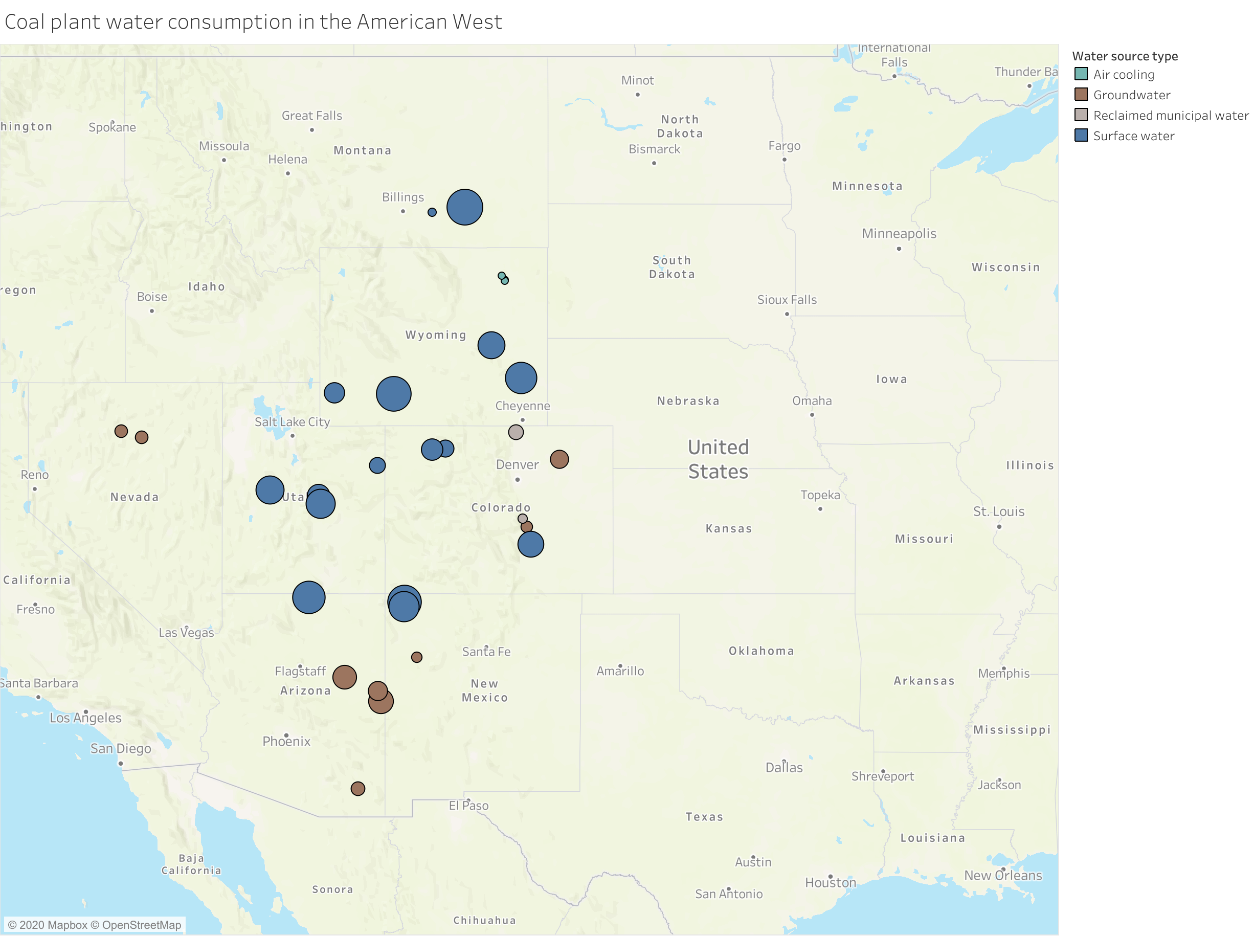
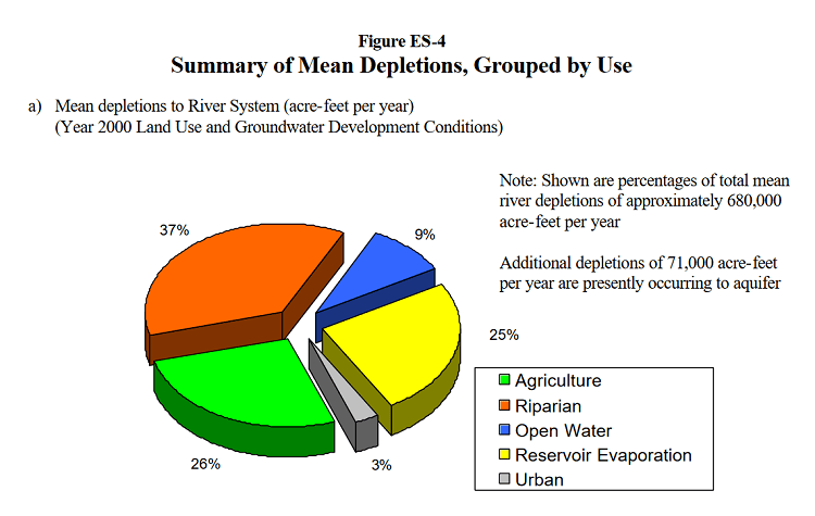
Cumulatively, 30 coal plants in Arizona, New Mexico, Colorado, Utah, Nevada, Montana, and Wyoming consumed 370,555,000,000 gallons [ed. 1,137,190 acre-feet] of water between 2014 and 2018, according to data published by the Energy Information Agency (EIA). On average, that amounts to more than 76 billion gallons of water each year, or 208 million gallons [ed. 638 acre-feet] each day. Coal capacity owned by Pacificorp consumed over 102 billion gallons of water between 2014 and 2018, 27% of the total and the most of any utility in the region.
Combining coal unit water consumption data with coal unit closure dates (announced as of July 2020) shows that coal plants in the Western U.S. could consume 886 billion gallons of water between 2020 and 2040. That figure could be reduced as more utilities announce additional coal plant closures, close coal units before their scheduled retirement dates, and operate coal plants less often.
Most coal plants in the Western U.S. consume surface water, including from the Colorado River, Yellowstone River, Green River, San Juan River, Laramie River, North Platte River, Arkansas River, Yampa River, San Miguel River, Cottonwood Creek, Sevier River, Huntington Creek, Hams Fork River, and the Bighorn River.
Nine coal plants consume groundwater, including in Arizona, Colorado, New Mexico, and Nevada, a practice that is rare outside of the Southwest. Two coal plants in Colorado consume reclaimed municipal water, which reduces but does not eliminate water supply risks. Three coal plants in Wyoming use dry cooling systems instead of water-cooled systems, which reduces water consumption but increases costs and air pollution.
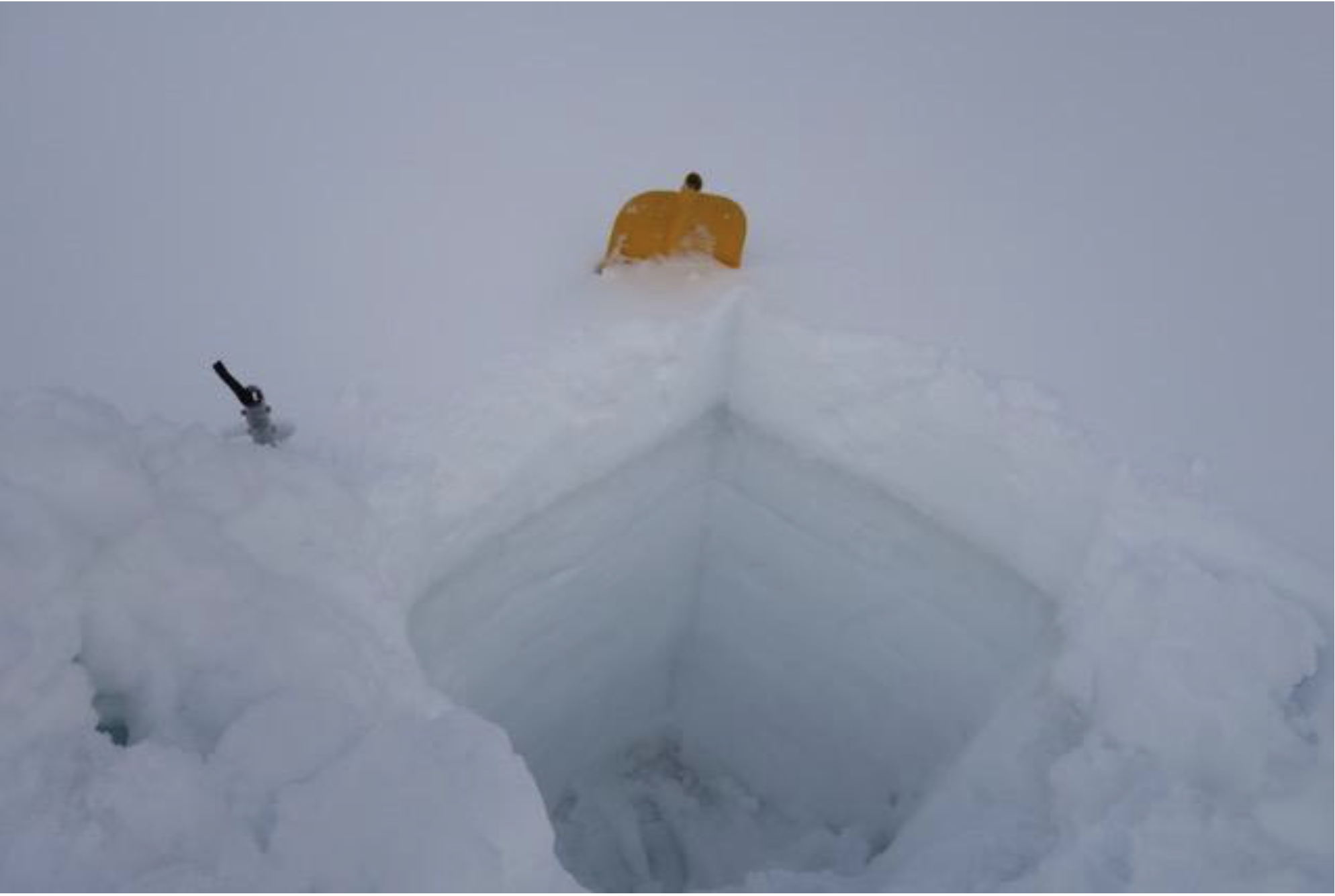
Coal plant water consumption in the American West. Graphic credit: The Energy Policy Institute
Here’s the release from the Bureau of Reclamation (Peter Soeth):
The Bureau of Reclamation is launching a new prize competition that is seeking crowdsourced ideas that will lead to innovative sediment removal solutions for water infrastructure. The “Guardians of the Reservoir” challenge seeks ideas to remove or transport the amount of sediment building up in the reservoirs, replacing available space for water storage, that provide critical water supplies for the country. There will be up to a total of $550,000 in cash prizes available for the three-phase the competition.
“Reclamation is the largest water wholesaler in the country, reliably delivering water and power in an environmentally and economically sustainable manner,” Reclamation Commissioner Brenda Burman said. “We are excited for this prize competition and the new ideas that it will bring as we seek to better manage sedimentation at our facilities.”
This competition delivers on the Department of the Interior and Reclamation’s commitment to address challenges shared by Reclamation and its water customers and stakeholders for many years – how to extend the service life of our reservoirs in the face of accumulating reservoir sediments.
Sedimentation in reservoirs occurs when faster moving rivers transport sediment into slower moving water in reservoirs where it falls out and begins to fill the reservoir. Sedimentation reduces the amount of storage available in a reservoir, impacting the ability of reservoir owners to store water or reduce the risk of floods.
Reclamation conducts prize competitions to spur innovation by engaging a non-traditional, problem solver community. Through prize competitions, Reclamation complements traditional design research to target the most persistent science and technology challenges. It has awarded more than $1,000,000 in prizes through 22 competitions in the past 6 years. Please visit Reclamation’s Water Prize Competition Center to learn more.
Graphic credit: Gregory Morris/National Reservoir Sedimentation and Sustainability Team via H20 Radio
I was working for a software company 30 years ago when this storm swept across the Denver Metro area from Boulder to my office near County Line Road and I-25. The storm just missed my house in North Denver (all of my neighbors got new roofs) and then travelled out to Douglas County and bashed my car into a golf ball looking mess. I remember one of my colleagues’ wife coming into the office quite upset. She had gotten caught on the road as it bashed out the back window of their SUV. From9News.com (Cory Reppenhagen):
On July 11, 1990, a thunderstorm gave Colorado a new definition of how bad a hailstorm could be.
The storm took a very unusual path, coming from the north and clinging to the west of Interstate-25 all the way to El Paso County. It hit peak intensity over the west Denver metro area.
Golf ball to baseball size hail slammed a large portion of the Denver area. Boulder, Arvada, Wheat Ridge, Golden and Lakewood took the heaviest damage.
At the time, the $625 million in damage far surpassed a June 1984 storm, which was also in the Denver metro area, as Colorado’s most damaging hailstorm.
When adjusted to 2020 dollars, the damage from the July 1990 storm stands at $1.23 billion, according to the Rocky Mountain Insurance Information Association. That benchmark that would stand atop the list of Colorado’s most damaging hailstorms until May 8, 2017, when a even more destructive storm caused $2.4 billion (adjusted for 2020) in damage…
July has been historically a bad hail month for Colorado, but then again, what month hasn’t?
The now most destructive storm happened in May. Four of the top 10 worst hailstorms in the state happened in June. The record largest hailstone ever recorded in our state fell in August last year. We typically say that a hailstorm like the one in July 1990, can happen any day between May 1, and the end of September, but there was even a rouge hailstorm on October 1, 1994 that still stands as the Colorado’s 10th most destructive hailstorm.
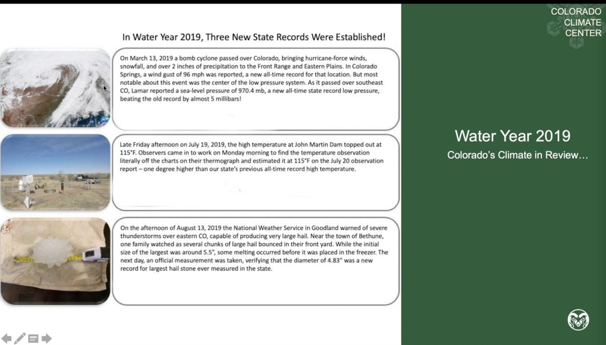
New Colorado records in 2019. Credit: Becky Bollinger/Colorado Climate Center
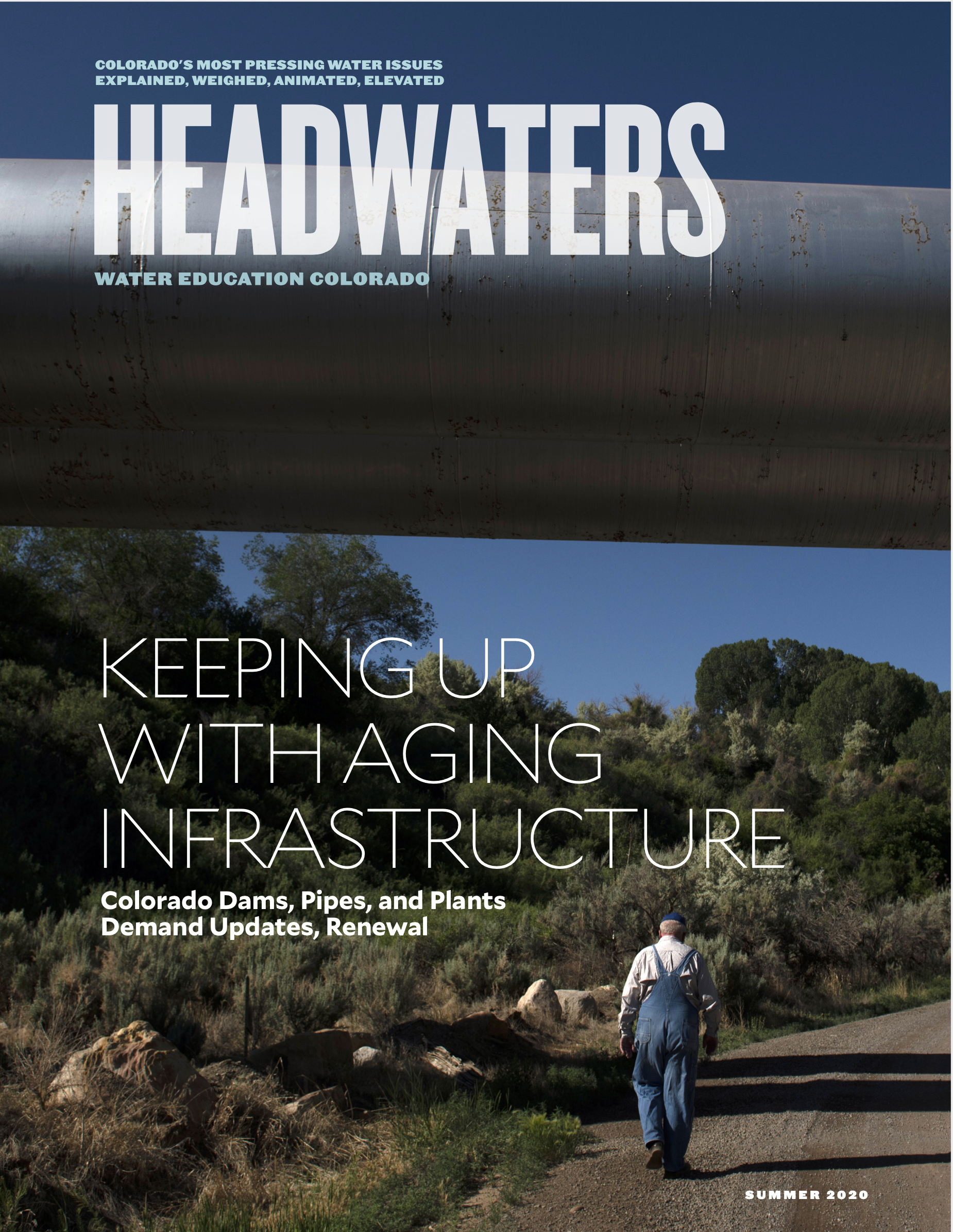
Colorado has grown and changed around the water infrastructure installed decades to more than a century ago, leaving today’s water users and managers to grapple with the prospect of failing pipes, dams and ditches—the result of age and a lack of routine maintenance. Now, though the challenges and costs to rebuild and repair are significant, Coloradans have new opportunities to do so thoughtfully. View or download a flipbook of the magazine.
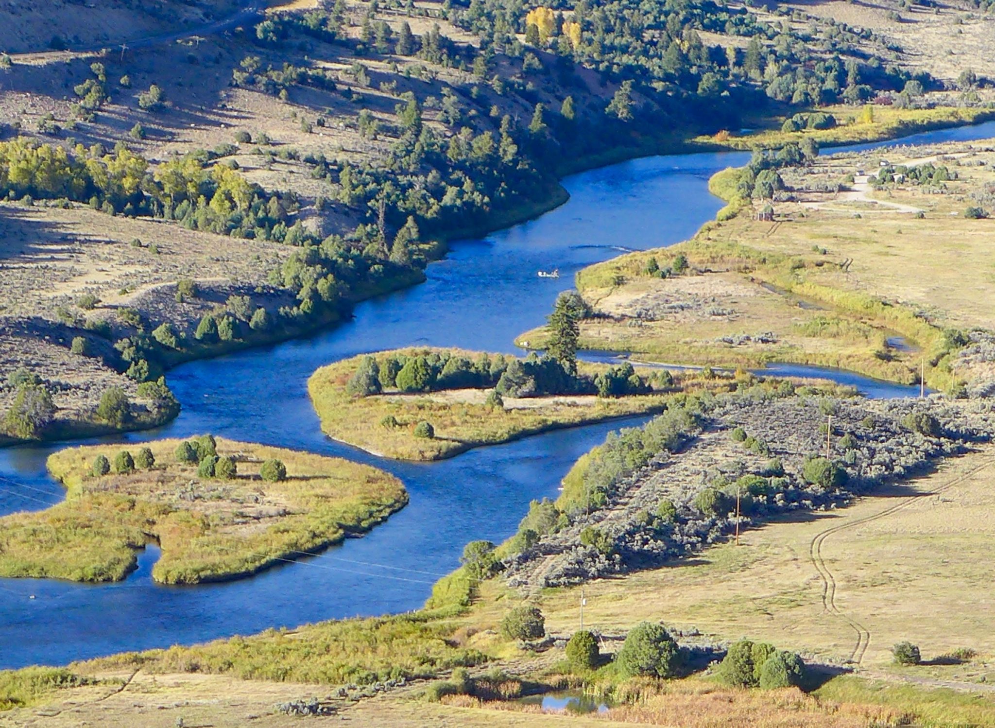
A view of the popular Pumphouse campground, boat put-in and the upper Colorado River. The BLM and Forest Service recently approved an alternative management plan that acts as a workaround to a federal Wild & Scenic designation. Photo credit: Brent Gardner-Smith/Aspen Journalism
Participants in a 12-year process to establish protections for a stretch of the upper Colorado River are calling the finished product — which amounts to a workaround of a Wild and Scenic River designation — a success.
Last month, the Bureau of Land Management and the U.S. Forest Service formally approved the “Amended and Restated Upper Colorado River Wild and Scenic Stakeholder Group Management Plan.” The plan lays out a blueprint for protecting the “outstandingly remarkable values,” or ORVs, of the Colorado River from Kremmling to Glenwood Springs, with an emphasis on recreational floatboating and fishing.
The ORVs must either be a unique, rare or exemplary feature located on the river or shoreline; contribute to the functioning of the river ecosystem; or owe their existence to the presence of the river. The plan seeks to balance these ORVs with water development and use by Front Range water providers and Western Slope water users.
To ensure protection of the ORVs, the plan includes voluntary cooperative measures that the participants could take, such as the strategic timing of reservoir releases, enhancing spring peak flows and agreements with water users to acquire water rights, which would be used to preserve the natural environment.
The plan includes a provision that addresses two big uncertainties that would lead to more transmountain diversions from the Colorado River: Denver Water’s Moffat Collection System Project and the Northern Colorado Water Conservancy District’s Windy Gap Firming Project. The “poison pill” provision would allow any stakeholder to withdraw support for the plan if those projects — which are still in the permitting phase and mired in litigation, and which would provide a combined 48,000 acre-feet of water for the Front Range — negatively impact streamflows, especially for boating.
Six interest groups — conservation/environment/fishing; local government; recreational floatboating; state interests; Front Range water users; and Western Slope water users — have been working on crafting the plan since 2008. The Eagle River Watershed Council has been involved as a stakeholder since 2013, said executive director Holly Loff.
“It’s really exciting, and what a huge collaborative effort this has been, and I can’t really think of other situations that have been larger in scope and larger in the number of collaborators and all with very diverse interests — and we found a way to make it work,” Loff said. “It’s an amazing feat, really.”
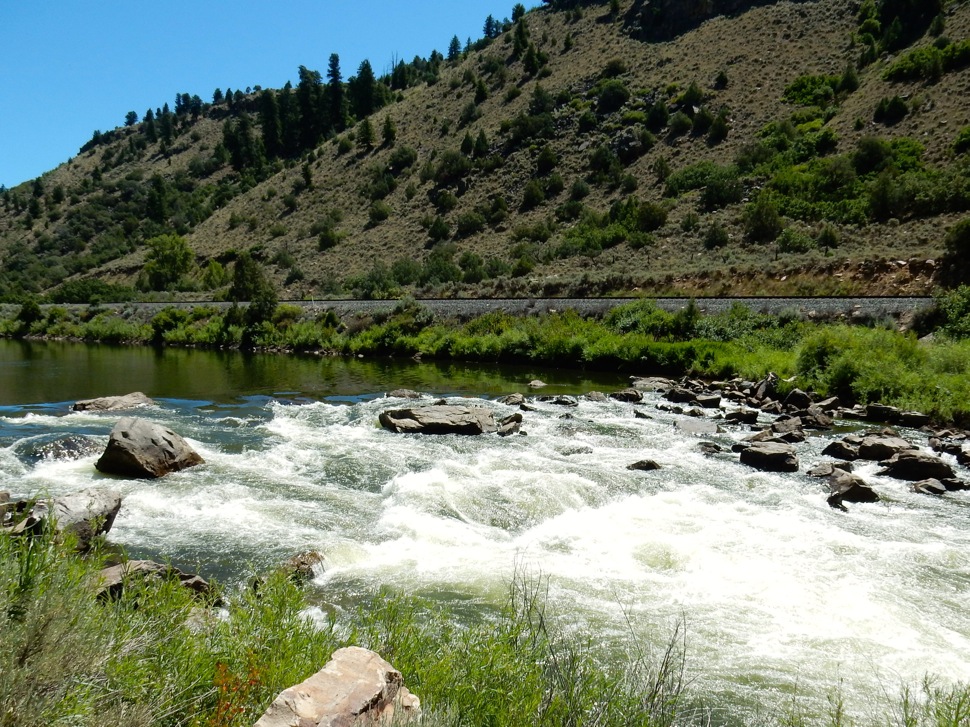
The scenic, and sometimes wild, Rodeo Rapid, one of the few rapids on the upper Colorado River between Pumphouse and Dotsero. Photo credit: Brent Gardner-Smith/Aspen Journalism
Opposition to W&S
The alternative management planning process came about after the BLM in 2007 found that 54 miles of the upper Colorado River from Gore Canyon to just east of No Name Creek in Glenwood Canyon possessed enough ORVs that they were eligible for a federal Wild & Scenic River designation. Created by an act of Congress in 1968, the National Wild and Scenic Rivers System seeks to preserve rivers with outstandingly remarkable scenic, recreational, geologic, fish and wildlife, historic and cultural values in a free-flowing condition.
There are two ways that a river can be designated as Wild & Scenic: The secretary of the Interior can designate a river if a state governor requests it or Congress can designate a river, usually after a land-use agency conducts a study to see whether it’s eligible.
Designation as Wild & Scenic brings protection from development. For example, new dams cannot be constructed on the designated stretch and federal water-development projects that might negatively affect the river are not allowed.
But the possibility of federal government involvement and potential restrictions on water development on the upper Colorado doesn’t sit well with some groups. Municipal water providers such as Denver Water and Northern Water divert water from the Colorado’s headwaters to Front Range cities.
“A lot of members of the water community find the idea of a Wild & Scenic designation kind of frightening and prohibitive,” said Colorado Water Conservation Board Stream and Lake Protection Section Chief Linda Bassi. “It would prevent potentially new reservoirs along a Wild & Scenic river (and) certain types of structures, and that is why the water community has typically been a little leery of Wild & Scenic designation.”
In 2009, the Colorado General Assembly established the Wild and Scenic Rivers Fund. Despite what its name suggests, the fund is not dedicated to establishing Wild & Scenic designations of rivers, but to avoiding the federal designation through “work with stakeholders within the state of Colorado to develop protection of river-dependent resources as an alternative to wild and scenic river designation.”
The Upper Colorado River Wild and Scenic Stakeholder Group has been the recipient of money from the state fund, which is allocated up to $400,000 a year and administered by the Colorado Water Conservation Board. According to a CWCB memo from May, when staff reviews requests for these funds, they evaluate whether projects will promote collaboration among traditional consumptive water interests, including irrigation, and non-consumptive interests, including recreation and the environment, and whether the project will still enable Colorado to fully use water it is allocated.
“If we tried to go through designation, we don’t know if it would have ever made it past the state of Colorado,” said Kay Hopkins, outdoor recreation planner for the White River National Forest. “The state would have had to be supportive of our determination.”
Despite its renowned river rafting, fishing and scenic beauty, which contribute to the recreation-based economy of many Western Slope communities, Colorado has just 76 miles of one river — the Cache La Poudre — designated as Wild & Scenic. That’s less than one-tenth of 1% of the state’s 107,403 river miles.
Instead of a federal designation, the CWCB considers its instream-flow program to be a primary tool in the effort to protect ORVs. Instream flows are in-channel water rights aimed at preserving the natural environment to a reasonable degree. As a part of the alternative management plan process, the CWCB secured three instream-flow rights that date to 2011 on the upper Colorado River — from the confluence of the Blue River to Piney River; from Piney River to Cabin Creek; and from Cabin Creek to the confluence with the Eagle River.
Bassi, who runs the state’s instream-flow program, has participated in the state interests group since planning began in 2008.
“Those flow rates are designed primarily to meet the needs of fish,” Bassi said. “But they will help to maintain flows that provide for some levels of boating experiences.”
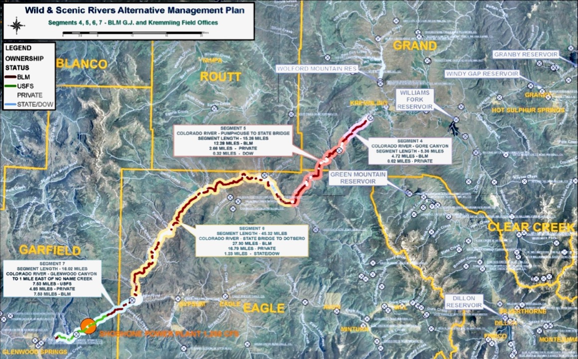
This map shows a stretch of the upper Colorado River, between Kremmling and Glenwood Springs, that is subject to a new framework designed to protect ecological and recreational values, in balance with the needs of water users on the Western Slope and Front Range. Graphic credit: Upper Colorado River Wild and Scenic Stakeholder Group
Pragmatic Discussions
The Forest Service and BLM approval of the alternative management plan means that the stretch of the upper Colorado River has been deferred from Wild & Scenic eligibility. But if the plan fails or any of the stakeholders enact the “poison pill” provision, the river could revert to being considered for eligibility, meaning it would once again be up for federal scrutiny, something some stakeholders want to avoid.
“That is the hammer behind the long-term commitments,” said Rob Buirgy, coordinator for the stakeholder group.
Eagle County Commissioner and Colorado River Water Conservation District Board member Kathy Chandler-Henry believes the strength of the alternative management plan is the input of its many participants.
“My first thought was the alternative management plan must be a lesser system of protection, but in my mind, it has not turned out to be that way because there are so many players at the table,” she said. “It doesn’t seem like a lesser process. It seems like a more publicly engaged process.”
Loff was more pragmatic.
“I don’t think (the alternative management plan) is better, but I don’t know that this group ever would have agreed to a standard Wild & Scenic designation. I don’t think that would have happened at all,” she said. “I think it’s better that we have this.”
Aspen Journalism is collaborating with the Aspen Times and other Swift Communications newspapers on coverage of water and rivers. This story was published online and printed in the Aspen Times on July 11, 2020.
A federal appeals court ruled Friday that an emissions-heavy section of northern Weld County that’s currently excluded from limits on air pollution imposed on the Denver metro area should be counted, potentially ratcheting up pressure on the oil and gas industry to operate more cleanly or cut output.
The U.S. Court of Appeals for the District of Columbia Circuit determined that the Environmental Protection Agency incorrectly left a swath of Weld County abutting the Wyoming state line out of the nine-county “nonattainment” area that centers on Denver, meaning emissions from hundreds of oil and gas wells in that part of the county could soon be added to the metro area for air pollution measurement purposes.
Robert Ukeiley, senior attorney for the Center for Biological Diversity, said the ruling effectively means that Weld County energy operations near the Wyoming border will have to “comply with the more protective standard” that the metro area is under in terms of their emissions output.
“Oil and gas, including in northern Weld County, is responsible for our smog problem, and the court told the EPA enough is enough,” Ukeiley said. “You have to get (the industry) to reduce their pollution.”
The ruling from the appeals court sends the matter back to the EPA for further consideration. The lawsuit against the EPA was brought by the Center for Biological Diversity, the Sierra Club, the National Parks Conservation Association and the Boulder County Board of Commissioners.
Heat and sunlight bake pollutants, including some of the chemicals emitted by oil and gas operations, to form ozone, or smog. For more than 15 years, Colorado has flunked federal air quality health standards with ozone air pollution exceeding a decade-old federal limit of 75 parts per billion, which was tightened to 70 parts per billion under President Barack Obama.
The World Health Organization recommends no more than 50 parts per billion to protect human health.
The U.S. threshold has placed much of the metro area and areas immediately around it in “nonattainment” status when it comes to meeting the requirements of the Clean Air Act. The EPA in December reclassified Colorado as a “serious” violator of federal air quality laws, forcing stricter state efforts to reduce air pollution…
Friday’s ruling revolved around two primary issues: Weld County’s outsized role in oil and gas production in Colorado — the county has nearly half of the state’s more than 50,000 active wells — and a finding that EPA had erroneously cited a topographical feature, Cheyenne Ridge, as a reason for excluding the northern section of the county from the nonattainment area.
EPA, the court wrote, claimed that the ridge effectively acted as a blockade to emissions emanating from the northern reaches of Weld County. The problem is, Cheyenne Ridge is on the Colorado/Wyoming border, the court said, not further south, as EPA asserted.
“EPA literally moved mountains to try and cut oil and gas a break from having to reduce pollution,” Ukeiley said Friday.
The court also faulted EPA’s reasoning for excluding the northern portion of Weld County based on the federal agency’s conclusion that that section of the county only contributed a quarter of the nitrogen oxide and 18% of the volatile organic compounds that the county overall emits.
“Given that Weld County sources generate exceptionally high amounts of VOCs and NOx — mostly from oil and gas operations — the fact that northern Weld contributed only a quarter of those emissions does not support EPA’s decision not to consider them,” the court ruled.
The court determined that according to 2011 data, Weld County produced approximately six times as many VOCs as the next-highest county included in the Denver nonattainment area. And compared to the lowest-emitting county, Weld County produced about 60 times as many VOCs and 20 times more nitrogen oxide.
Avoiding a nightmare spike in COVID-19 cases is exactly what cities like Golden, Lakewood and Westminster are trying to prevent by cutting off or delaying access to creeks and swim beaches.
Their decision is understandable. It’s also frustrating for people who planned on hitting the water to beat the heat and get away from crowds…
…Clear Creek through Golden is now shut down due to overcrowding and coronavirus health concerns, and so are several metro-area reservoirs including Bear Creek Reservoir, Cherry Creek Reservoir, Big Soda Lake and Standley Lake…
…last Friday, the City of Westminster announced it would be delaying the opening of Standley Lake.
Chatfield Reservoir can hold more than 350,000 acre-feet of flood water in emergency situations, but its current capacity is only 27,000 acre-feet of water, the equivalent of 8.8 billion gallons.
All water-based recreation activities such as paddle boarding, swimming, and kayaking will be off-limits at Bear Creek Lake Park until further notice. The temporary closure applies to two popular swim beaches located within the Jefferson County park including Big Soda Lake and Bear Creek Reservoir…
Other swim beaches in the metro area including Chatfield State Park and Aurora Reservoir have reopened with restrictions and limited capacities.
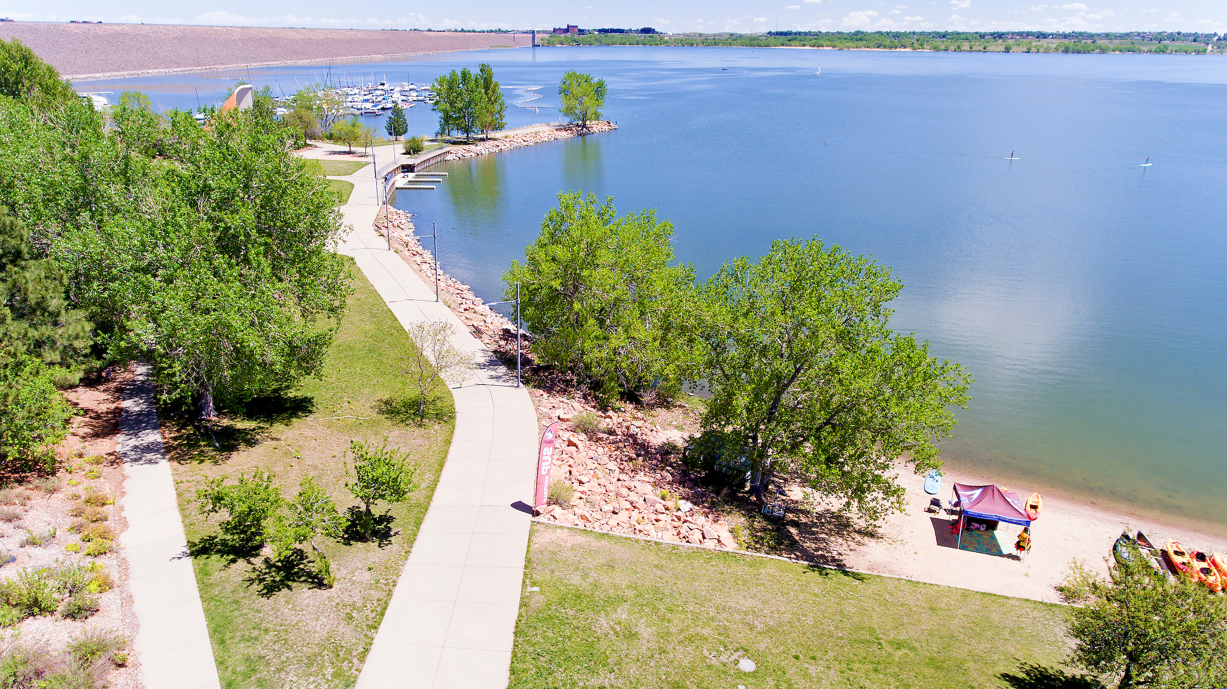
Meanwhile, Cherry Creek State Park has recently closed their swim area due to harmful levels of blue-green algae. Prospect Lake in Colorado Springs was also closed for the same reason.
The return of afternoon monsoons to the Roaring Fork Valley cannot come quick enough for outdoor enthusiasts hitting dusty trails, gardeners coaxing plants along or especially fire chiefs fearing wildfires.
The monsoons typically appear in late June and continue into September, bringing frequent afternoon showers. They have been slow to appear this summer, but that might be about to change.
The National Weather Service expects a 20% to 40% chance of showers and thunderstorms starting later this week and continuing each day for at least the next week in the Colorado mountains, according to Jeff Colton, a warning coordination meteorologist with the NWS office in Grand Junction. He cautioned against expecting copious amounts of moisture…
Pitkin, Eagle and Garfield counties as well as the U.S. Forest Service and Bureau of Land Management in the region are currently in stage one restrictions. That prohibits campfires outside of developed recreation areas. All fireworks are banned…
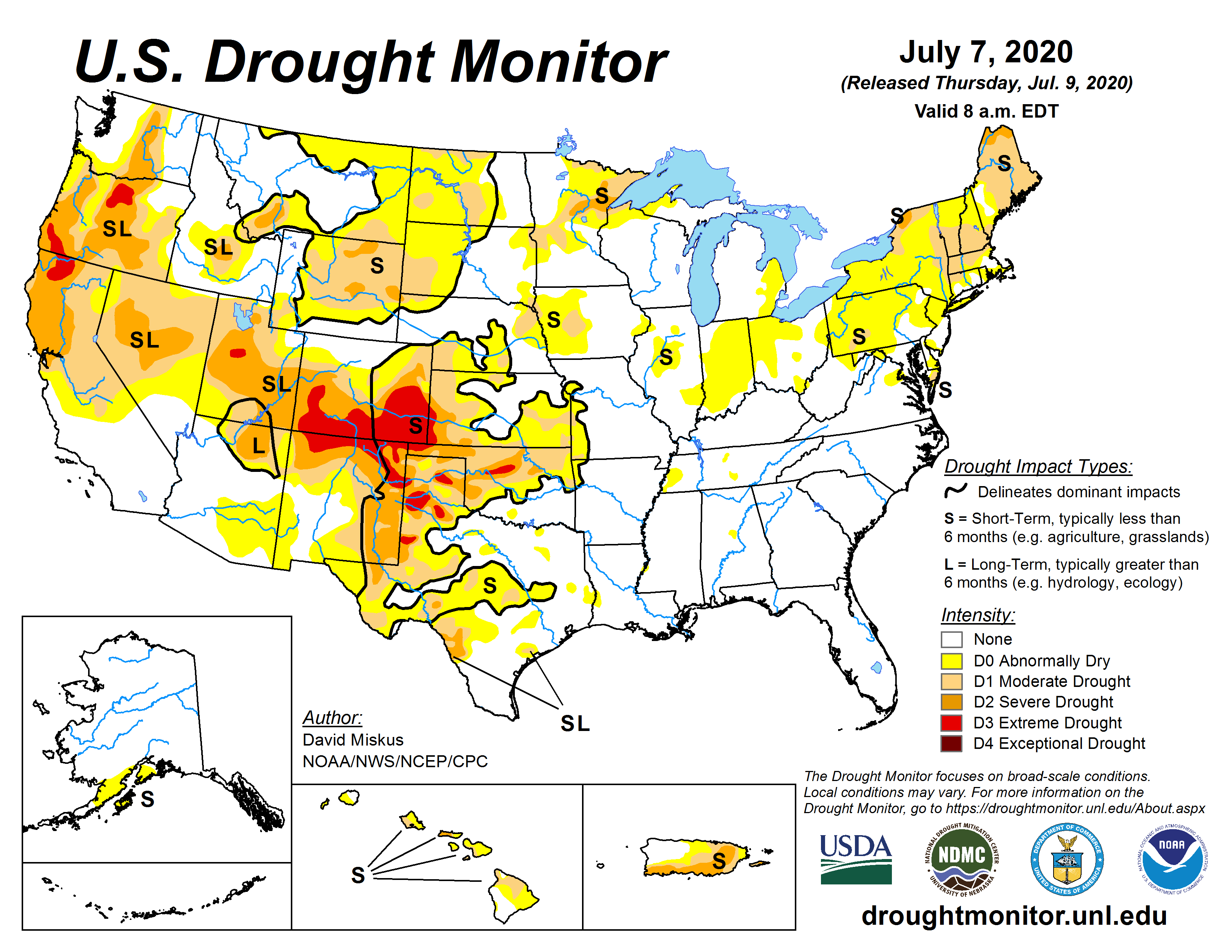
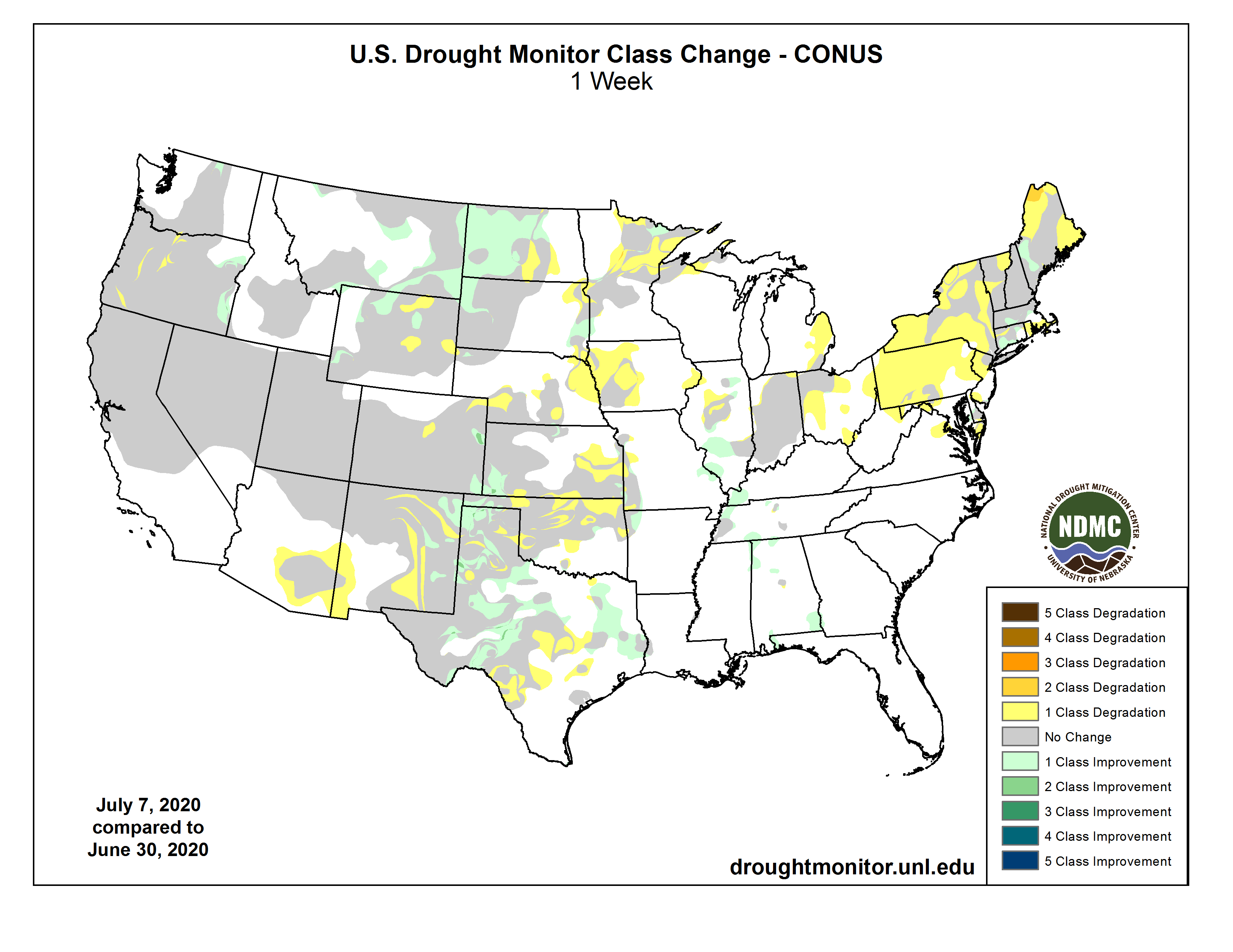
West Drought Monitor July 7, 2020.
Colton said the rain that is forecast isn’t likely to break the grip of a drought affecting all of Colorado. The U.S. Drought Monitor issued by federal weather agencies July 9 shows all of Pitkin County in moderate drought and the extreme western side of the county in severe drought.
The Drought Monitor stressed that the classification is based on broad-scale conditions and that local conditions may vary.
Aspen has managed to stay close to the annual average for precipitation through June, according to records kept at the Aspen Water Department’s plant in Maroon Creek Valley. May was below average but June was slightly above average, thanks in large part to nearly 5 inches of snow June 9 (see related fact box)…
Meteorologist Colton said the snowpack last winter was close to normal, but a lack of snowfall in late winter and an extended period of dry winds starting in May quickly ate up the snowpack. The same low pressure in the Pacific Northwest that has prevented monsoonal moisture to form for Colorado also is responsible for the drying winds, he said.
The dry winds, quickly disappearing snowpack and spotty rainfall have sapped the moisture from the ground. Richmond Ridge Road, which typically harbors massive mud puddles at this time of year, was bone dry Saturday. Trails throughout the valley have been pulverized to dust.
Aspen Global Change Institute has installed 10 field stations around the Roaring Fork Valley that measure ground moisture at various depths as well as precipitation and air temperature.
Sky Mountain Park in the hills above the intersection of Brush Creek Road and Highway 82 is showing soil moisture at the 8-inch depth at about 17% compared to about 14% at this time in 2018.
However, farther downvalley, the soil moisture is drier in some spots than in 2018. The soil moisture at Spring Valley near the Colorado Mountain College campus is at about 12% compared to 17% in 2018.
At Glenwood Springs, the average daily soil moisture at eight-inch depth is about 14 percent, the same as in 2018.
There are few areas of Colorado where drought conditions do not exist and fewer that are at average or above precipitation.
Drought experts say ranchers and farmers in Southern Colorado will not likely see relief this year.
Assistant State Climatologist Becky Bolinger used graphs from data during a recent webinar to explain the conditions for southern and southeast Colorado
Bolinger:“Currently we are at an almost 7 inch deficit or 36% of average there.”
And taking historic data from the months July, August, and September as a possibility for this year:
Bolinger:“And what it really shows is that there’s no situation where we could take historical precipitation and get back to our long term average. If we get average precipitation for the rest of the water year we would end at 60% of average.”
And for southwest Colorado :
Bolinger: “We’re at about a 6.5% deficit. 51% of average. Long term average; they end at about 18.5 inches. They’re not going to get even close to that. Most likely they’re going to end between that 10 and 12 inch range and possibly worse if there’s no showing of the monsoon.”
There is some good news for the Boulder area. Precipitation has been tracking above average for almost all of the water year. Bolinger says even of that changes, Boulder is very likely to remain at or above the yearly average.
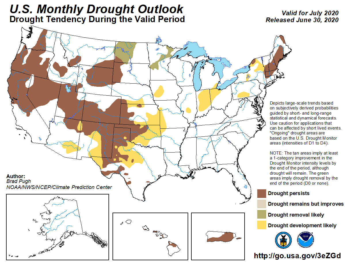
July 2020 drought outlook from the Climate Prediction Center
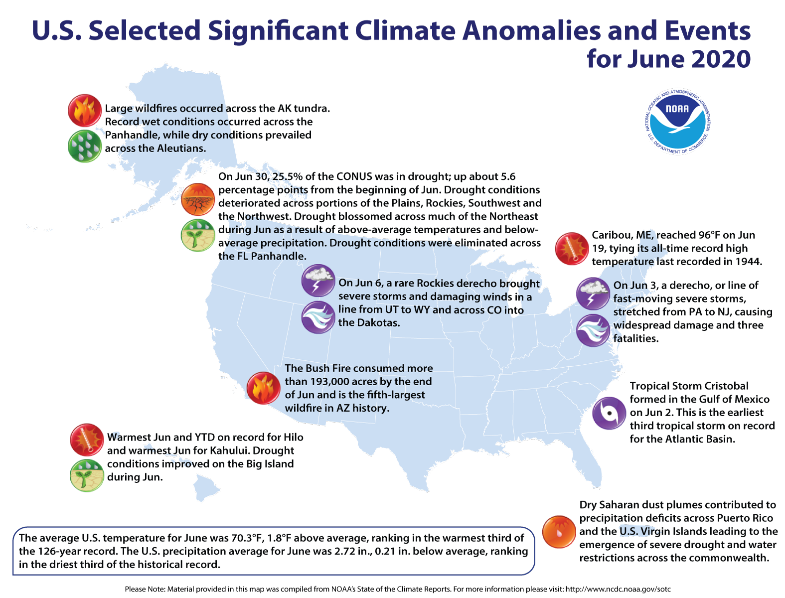
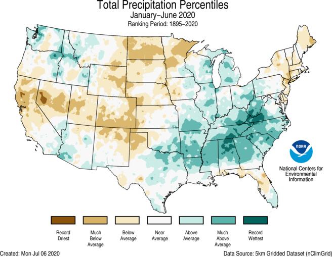
Contiguous U.S. experienced a warm, dry June, and Alaska ranked seventh wettest for the month
The June contiguous U.S. temperature was 70.3°F, 1.8°F above the 20th-century average, ranking in the warmest third of the 126-year record. The year-to-date average temperature for the contiguous U.S. was 50.0°F, 2.4°F above the 20th-century average, and ranked eighth warmest in the January-June record.
The June precipitation total for the contiguous U.S. was 2.72 inches, 0.21 inch below average, and ranked in the driest third of the 126-year period of record. Despite the dry conditions during June, the precipitation total for January-June was 16.32 inches, 1.01 inches above average, and ranked in the wettest third of the 126-year record.
There were 10 billion-dollar weather and climate disasters identified during January-June, which makes 2020 the sixth consecutive calendar year where 10 or more separate events were identified — a new record. All 10 disasters were due to severe storms with impacts from tornadoes, hail and high wind damage across more than 30 states.
This monthly summary from NOAA National Centers for Environmental Information is part of the suite of climate services NOAA provides to government, business, academia and the public to support informed decision-making.
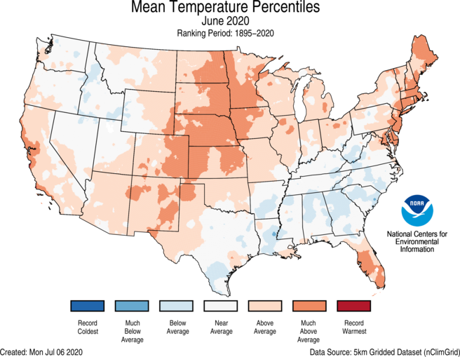
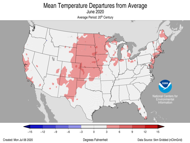
June Temperature
The primary circulation pattern during June was a ridge over the Great Plains with troughs along the East and West coasts. This brought above-average heat to the central U.S. and kept parts of the West and Southeast cooler than average.
Above-average June temperatures were observed across portions of the West and Gulf coasts as well as from the Southwest to the northern Plains and from the Great Lakes into New England. Rhode Island, Delaware, Minnesota and Kansas ranked eighth warmest for the month.
Below-average June temperatures were scattered across portions of the Deep South, Southeast and northern Rockies. However, only South Carolina ranked in the coolest third of its historical distribution for the month.
The Alaska average June temperature was 50.5°F, 1.3°F above the long-term mean and ranked in the warmest third of the historical record for the state. Overall, western Alaska was warmer than average while the southeastern part of the state was near or below average for the month.
Sea ice melt in the Chukchi Sea was slower than average for this time of year. June sea ice extent was 92% of average, which is the highest amount for June observed since 2017 and much higher than the record low extent observed during June 2019.
June Precipitation
Above-average precipitation was observed across portions of the Pacific Northwest, northern and central Rockies, Great Lakes, Deep South and the Mid-Atlantic regions. Idaho ranked 13th wettest while an additional 10 states ranked in the wettest third of their historical distribution for June.
Below-average precipitation occurred across portions of the Southwest, Great Plains, Ohio Valley, Southeast and much of the Northeast. Maine ranked 13th driest while 16 additional states ranked in the driest third of their record for June.
Alaska received 3.24 inches of precipitation during June, which is 0.90 inch above average and ranked seventh wettest on record. Both Juneau and Ketchikan in the Panhandle had their wettest June on record. Across the Interior, Northway, Delta Junction and Fairbanks had a top-five wettest June, while Denali National Park ranked sixth wettest.
According to the June 30 U.S. Drought Monitor report, approximately 25.5 percent of the contiguous U.S. was in drought, up from nearly 20 percent at the beginning of June. Drought conditions expanded or intensified across portions of the Plains, Rockies, Southwest, Northwest and Puerto Rico. Drought blossomed across much of the Northeast during June as a result of above-average temperatures and below-average precipitation. Drought conditions improved across parts of Hawaii and were eliminated across the Florida Panhandle.
Year-to-date (January-June) Temperature
Above-average to record-warm January-June temperatures were observed across the vast majority of the Lower 48 states. Florida ranked warmest on record for this six-month period while New Jersey ranked third warmest and Rhode Island and Massachusetts ranked fourth warmest.
The Alaska statewide average temperature for the year-to-date period was 21.4°F, 0.1°F below average, and ranked in the middle third of the record. Above-average temperatures were located across the Aleutians, part of the West Coast region and portions of the eastern North Slope. Below-average temperatures were concentrated across much of the Southeast Interior, Cook Inlet and southern Northeast Interior regions.
Year-to-date (January-June) Precipitation
Above-average precipitation occurred across portions of the Northwest and Southwest and from Texas to the Great Lakes and into the Southeast. Tennessee ranked wettest on record, North Carolina ranked fourth wettest and West Virginia and Alabama ranked fifth wettest for this year-to-date period.
Below-average precipitation was observed from the West Coast into parts of the central and southern Rockies and from the southern High Plains to the Northern Tier. Below-average conditions were also present across the Northeast and parts of Florida. North Dakota had the sixth driest and Colorado eighth driest January-June on record.
Through the end of June, 10 weather and climate disaster events have been identified, with losses exceeding $1 billion each across the U.S. during 2020. All 10 events were due to severe storms, which occurred across more than 30 states from the Great Lakes to the Gulf Coast.
In addition to significant economic impacts, these events resulted in 80 fatalities.
This is a record sixth consecutive year with at least 10 separate billion-dollar disasters and is at near-record pace for billion-dollar disasters during the first half of the year — 2020 is tied with 2011 and 2016, but trailing 2017 by one event.
Since these records began in 1980, the U.S. has sustained 273 separate weather and climate disasters where overall damages/costs reached or exceeded $1 billion (based on the CPI adjustment to 2020) per event. The total cost of these 273 events exceeds $1.75 trillion.
Photo credit from report “A Preliminary Evaluation of Seasonal Water Levels Necessary to Sustain Mount Emmons Fen: Grand Mesa, Uncompahgre and Gunnison National Forests,” David J. Cooper, Ph.D, December 2003.
The Trump administration’s adoption of narrower protections for wetlands and waterways can take effect almost everywhere in the nation, except Colorado, while courts review whether the move was legal.
A federal Judge in California on Friday rejected a request for a nationwide injunction of the rule. Hours later, a federal Judge in Colorado agreed to freeze the federal rule within that state.
The California court’s decision is a major blow to environmentalists and states that had hoped to block the Navigable Waters Protection Rule across the country before it takes effect Monday. Colorado, meanwhile, is celebrating its success in blocking the rule in the Centennial State.
A coalition of liberal states and cities challenged the joint rule from the Environmental Protection Agency and Army Corps of Engineers, saying the agencies violated multiple federal laws. The U.S. District Court for the Northern District of California heard a marathon session of arguments June 18…
Colorado had filed its own legal challenge in the U.S. District Court for the District of Colorado.
Judge William J. Martinez said some of the state’s arguments were “unusual and partly self-contradictory,” but concluded that the state met the bar for a preliminary injunction, which will put the regulation on hold in that state while the litigation plays out.
Other lawsuits attacking the regulation are pending in district courts across the country, where litigants are pursuing similar efforts to block the measure.
The Trump rule defines which types of wetlands and waterways are subject to federal regulations under the Clean Water Act. The interpretation replaces the Obama-era Clean Water Rule and a set of Reagan-era regulations.
Click here to read the newsletter. Here’s an excerpt:
NARROW WOTUS ON HOLD IN CO
The adoption of narrower Clean Water Act protections for streams and wetlands is currently blocked in Colorado, as a result of a court ruling on the state’s challenge to the new federal rule. Details are in this Bloomberg Law report.
These wetlands, located on a 150-acre parcel in the Homestake Creek valley that Homestake Partners bought in 2018, would be inundated if Whitney Reservoir is constructed. The Forest Service received more than 500 comments, the majority in opposition to, test drilling associated with the project and the reservoir project itself. Photo credit: Heather Sackett/Aspen Journalism
Bemoaning uneven individual and state compliance with public health recommendations, top U.S. COVID-19 adviser Anthony Fauci recently blamed the country’s ineffective pandemic response on an American “anti-science bias.” He called this bias “inconceivable,” because “science is truth.” Fauci compared those discounting the importance of masks and social distancing to “anti-vaxxers” in their “amazing” refusal to listen to science.
It is Fauci’s profession of amazement that amazes me. As well-versed as he is in the science of the coronavirus, he’s overlooking the well-established science of “anti-science bias,” or science denial.
Americans increasingly exist in highly polarized, informationally insulated ideological communities occupying their own information universes.
In theory, resolving factual disputes should be relatively easy: Just present strong evidence, or evidence of a strong expert consensus. This approach succeeds most of the time, when the issue is, say, the atomic weight of hydrogen.
But things don’t work that way when scientific advice presents a picture that threatens someone’s perceived interests or ideological worldview. In practice, it turns out that one’s political, religious or ethnic identity quite effectively predicts one’s willingness to accept expertise on any given politicized issue.
“Motivated reasoning” is what social scientists call the process of deciding what evidence to accept based on the conclusion one prefers. As I explain in my book, “The Truth About Denial,” this very human tendency applies to all kinds of facts about the physical world, economic history and current events.
The same facts will sound different to people depending on what they already believe. AP Photo/John Raoux
Denial doesn’t stem from ignorance
The interdisciplinary study of this phenomenon has made one thing clear: The failure of various groups to acknowledge the truth about, say, climate change, is not explained by a lack of information about the scientific consensus on the subject.
Instead, what strongly predicts denial of expertise on many controversial topics is simply one’s political persuasion.
A 2015 metastudy showed that ideological polarization over the reality of climate change actually increases with respondents’ knowledge of politics, science and/or energy policy. The chances that a conservative is a climate science denier is significantly higher if he or she is college educated. Conservatives scoring highest on tests for cognitive sophistication or quantitative reasoning skills are most susceptible to motivated reasoning about climate science.
Denialism is not just a problem for conservatives. Studies have found liberals are less likely to accept a hypothetical expert consensus on the possibility of safe storage of nuclear waste, or on the effects of concealed-carry gun laws.
Denial is natural
The human talent for rationalization is a product of many hundreds of thousands of years of adaptation. Our ancestors evolved in small groups, where cooperation and persuasion had at least as much to do with reproductive success as holding accurate factual beliefs about the world. Assimilation into one’s tribe required assimilation into the group’s ideological belief system – regardless of whether it was grounded in science or superstition. An instinctive bias in favor of one’s “in-group” and its worldview is deeply ingrained in human psychology.
A human being’s very sense of self is intimately tied up with his or her identity group’s status and beliefs. Unsurprisingly, then, people respond automatically and defensively to information that threatens the worldview of groups with which they identify. We respond with rationalization and selective assessment of evidence – that is, we engage in “confirmation bias,” giving credit to expert testimony we like while finding reasons to reject the rest.
Unwelcome information can also threaten in other ways. “System justification” theorists like psychologist John Jost have shown how situations that represent a perceived threat to established systems trigger inflexible thinking. For example, populations experiencing economic distress or an external threat have often turned to authoritarian leaders who promise security and stability.
In ideologically charged situations, one’s prejudices end up affecting one’s factual beliefs. Insofar as you define yourself in terms of your cultural affiliations, your attachment to the social or economic status quo, or a combination, information that threatens your belief system – say, about the negative effects of industrial production on the environment – can threaten your sense of identity itself. If trusted political leaders or partisan media are telling you that the COVID-19 crisis is overblown, factual information about a scientific consensus to the contrary can feel like a personal attack.
This kind of affect-laden, motivated thinking explains a wide range of examples of an extreme, evidence-resistant rejection of historical fact and scientific consensus.
Have tax cuts been shown to pay for themselves in terms of economic growth? Do communities with high numbers of immigrants have higher rates of violent crime? Did Russia interfere in the 2016 U.S. presidential election? Predictably, expert opinion regarding such matters is treated by partisan media as though evidence is itself inherently partisan.
Denialist phenomena are many and varied, but the story behind them is, ultimately, quite simple. Human cognition is inseparable from the unconscious emotional responses that go with it. Under the right conditions, universal human traits like in-group favoritism, existential anxiety and a desire for stability and control combine into a toxic, system-justifying identity politics.
Science denial is notoriously resistant to facts because it isn’t about facts in the first place. Science denial is an expression of identity – usually in the face of perceived threats to the social and economic status quo – and it typically manifests in response to elite messaging.
I’d be very surprised if Anthony Fauci is, in fact, actually unaware of the significant impact of politics on COVID-19 attitudes, or of what signals are being sent by Republican state government officials’ statements, partisan mask refusal in Congress, or the recent Trump rally in Tulsa. Effective science communication is critically important because of the profound effects partisan messaging can have on public attitudes. Vaccination, resource depletion, climate and COVID-19 are life-and-death matters. To successfully tackle them, we must not ignore what the science tells us about science denial.
Click here to read the newsletter. Here’s an excerpt:
Basin Implementation Plan Update
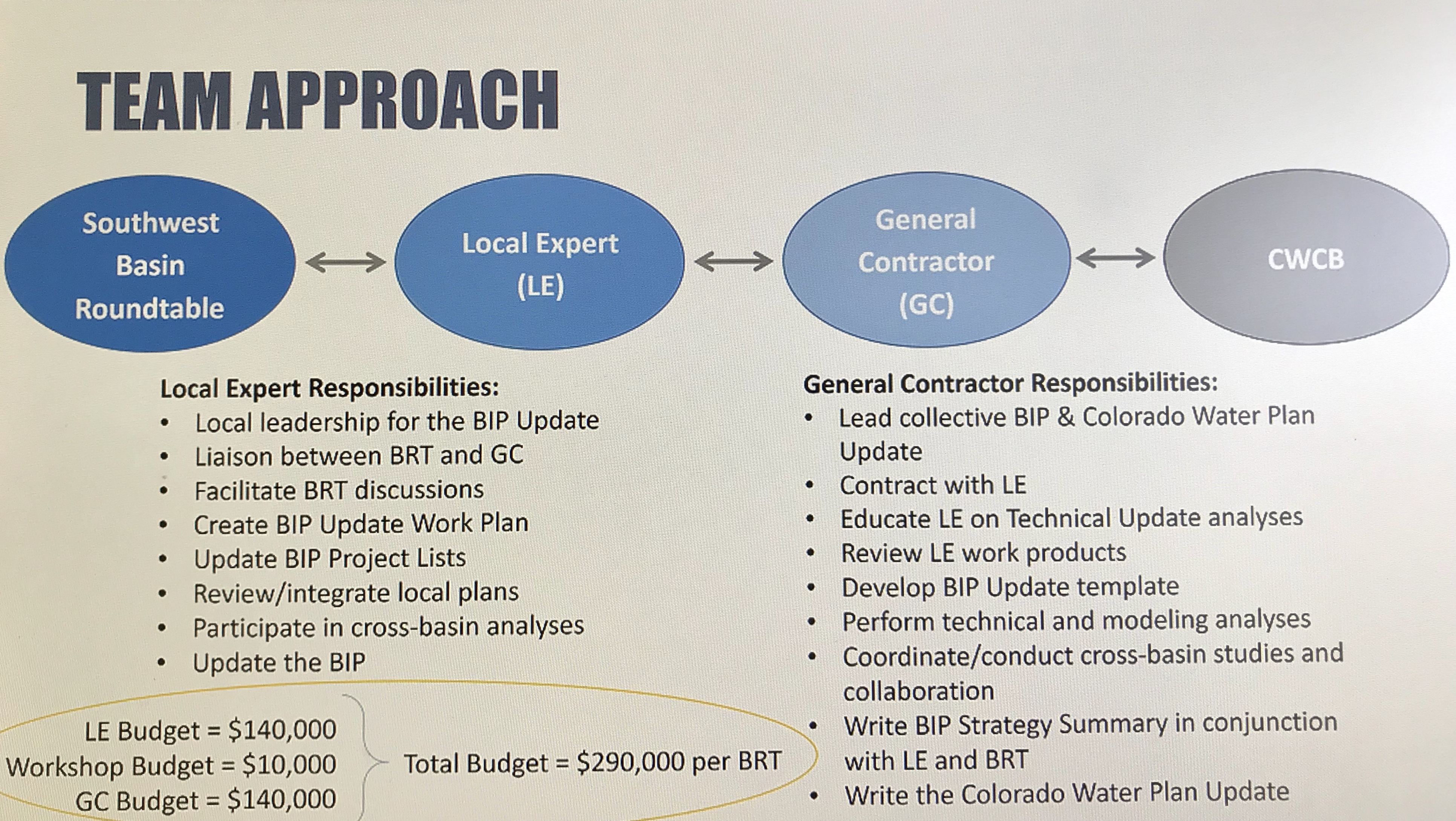
Ed Tolen, SW Basin 1st Vice Chair, explained that in January a sub-committee was set up to select a local expert to work with the SW Basin Roundtable on updating the Basin Implementation Plan (BIP). From the proposals received the committee chose Harris Water Engineers to be local expert. Steve Harris (Harris Water Engineering) will no longer participate on the Interbasin Compact Committee (IBCC) or the SW Basin Roundtable, and Carrie Padgett, P.E. of Harris Water will also step down from the SW Basin Roundtable. Roundtable elections will take place in October, Officer elections will take place in July.
There will be a team approach to working on the BIP update that will include the SW Basin Roundtable, the Local Experts (Harris Water Engineers), who work with the General Contractor (Brown and Caldwell) and the CWCB.
Matt Lindberg with Brown/Caldwell, the General Contractor, gave a presentation on next steps regarding the BIP review process. The purpose of the review and update is to improve project data, unpack technical update, revisit goals and objectives and invest in process efficiency.
The timeline for the BIP update is as follows:
March – August 2020 – Local Expert Workshops, Work Plans and Project lists.
September – December 2020 – Basin Analysis/Study
January – December 2021 – Update the Basin Implementation Plan
December to March 2022 – Incorporate Updated BIP’s into the Water Plan Update
To view the full Technical Update to the Colorado Water Plan go here.
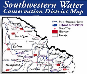
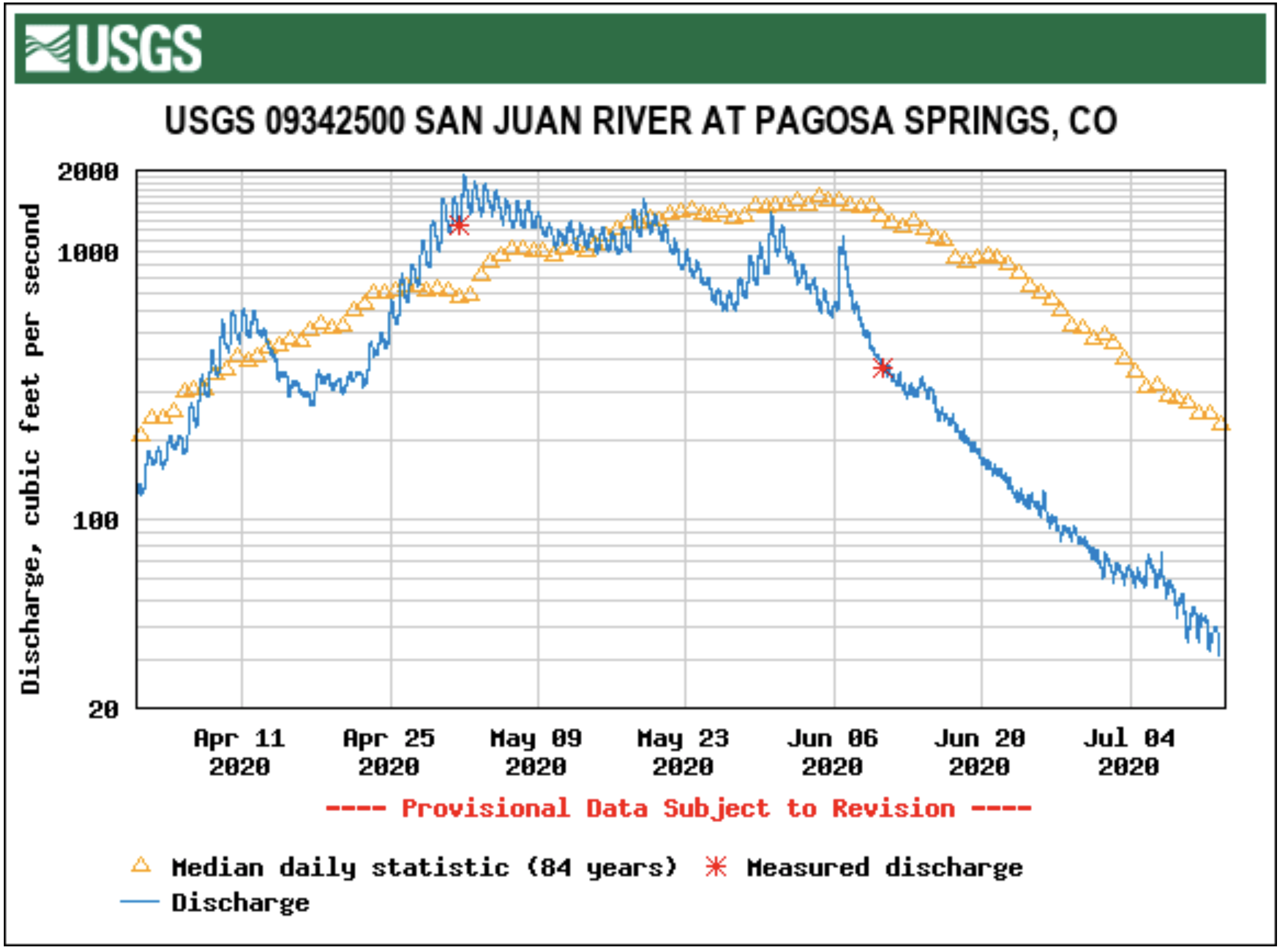
As of Wednesday, the San Juan River had a flow of 51.5 cfs. This total is well below the average for July 8, which is 466 cfs, according to the U.S. Geological Survey.
The highest reported flow total for the San Juan River came in 1995 when the river had a reported flow of 2,200 cfs.
The lowest flow total for the San Juan River came in 2002 when the river had a reported flow of just 18.6 cfs.
In his own operation, [Jim] Faulstich has used drought to improve genetics and clean up problem animals. He keeps two herds of cattle. The second group of cows are ones with problems like big bags, bad eyes or a not so perfect disposition. He keeps these cows with his heifers and breeds them for a short season. “If I need to pull the trigger because it’s dry and we don’t have enough forage, I can easily disperse those,” he said. “It’s nice to have that option.”
Haigh reminds producers how important it is to maximize the health and flexibility of an operation before drought. “Monitor the health of resources and precipitation, as well as soil moisture and the plant, itself,” she said. “Maximizing the health of resources can be through the grazing system or adjusting the stocking rate and resource base. Maximizing the hydrologic base and plant diversity in the rangeland system are also important.”
Faulstich sees drought as an opportunity to improve infrastructure and natural resources on the ranch. “During a drought, the government will usually step forward with emergency cost-share programs,” he said. “I take advantage of that by putting in waterlines and new water sources. On our operation, we have made natural resources a priority. As a result, we have an increase in wildlife, which is a good indicator of how healthy our land is.”
Drought has also shown Faulstich the importance of wetlands, and how they can be used to survive a drought. “Wetlands have saved us a number of times when it is dry,” he said. “We have windrowed cattails, chopped them up and poured molasses on them. One winter, we fed them to the cows along with some ear corn I was able to buy.”
“While we can’t control whether or not it rains, we can control what we do before, during and after drought,” Haigh said. “Recovery can really change the impact drought can have. The more we can do to minimize the impact, the better off we are.”
DISASTER PLAN
A drought plan could be more accurately called a disaster plan, Faulstich said, because it should also cover other disasters like fire, storms and insect damage. “Every operation is different, so there is no drought plan that will be the exact same as someone else. It applies to large operations as well as small ones,” he said “Profitability, sustainability, and resilience are all important to the ranching business, and they require working with nature, diversity, flexibility and soil health.”
In a drought situation, Faulstich said the decisions made are the result of basic business plans he learned the hard way. He points out a photo from his own operation where a piece of land looks grazed to the ground. “It was actually one of the nicest pieces we ever had. It was 18 inches to 2 feet tall, and then we got snow and 3 inches of rain on it. It formed a layer of ice and was just like concrete. There was no grazing left. It was our winter pasture, and if we wouldn’t have had a drought plan, we wouldn’t have been prepared for it,” he said. “It is situations like this that bring us that much closer to be ready for a drought.”
Another year, they left one acre plots of corn in the field, harvesting strips in-between those one acre plots. “We moved those cows every day, but it was the cheapest we had ever wintered cows. We grazed 320 cows per acre per day,” he said. “A lot of it was poor quality corn where some didn’t tassel or make ears. It was a way to utilize that.”
Faulstich also paid for three hay sheds in three years many years ago by selling hay to a dairy farmer in another state suffering from drought. “We keep those three hay sheds full. Our goal is to never use any of that hay, but of course we do. Some of it in one of the buildings is pretty old, and will need some supplement fed with it, but another shed has some top quality alfalfa” he said.
Between harvested feed, grazing grass and standing crops, Faulstich keeps a year’s supply of forage available at all times. He has also used planning to establish flexibility in his operation. A custom grazing program was added to the operation that allows him to graze yearlings on a piece of invasive bromegrass in the spring, without having to invest in the cattle or worry about rain. “It is built into the contract that they have two weeks to remove the cattle if we are running out of grazing,” he said. “It provides us some flexibility from a drought standpoint, while giving us some enterprise opportunity.”
— Clark is a freelance livestock journalist from western Nebraska. She can be reached by email at tclarklivenews@gmail.com.
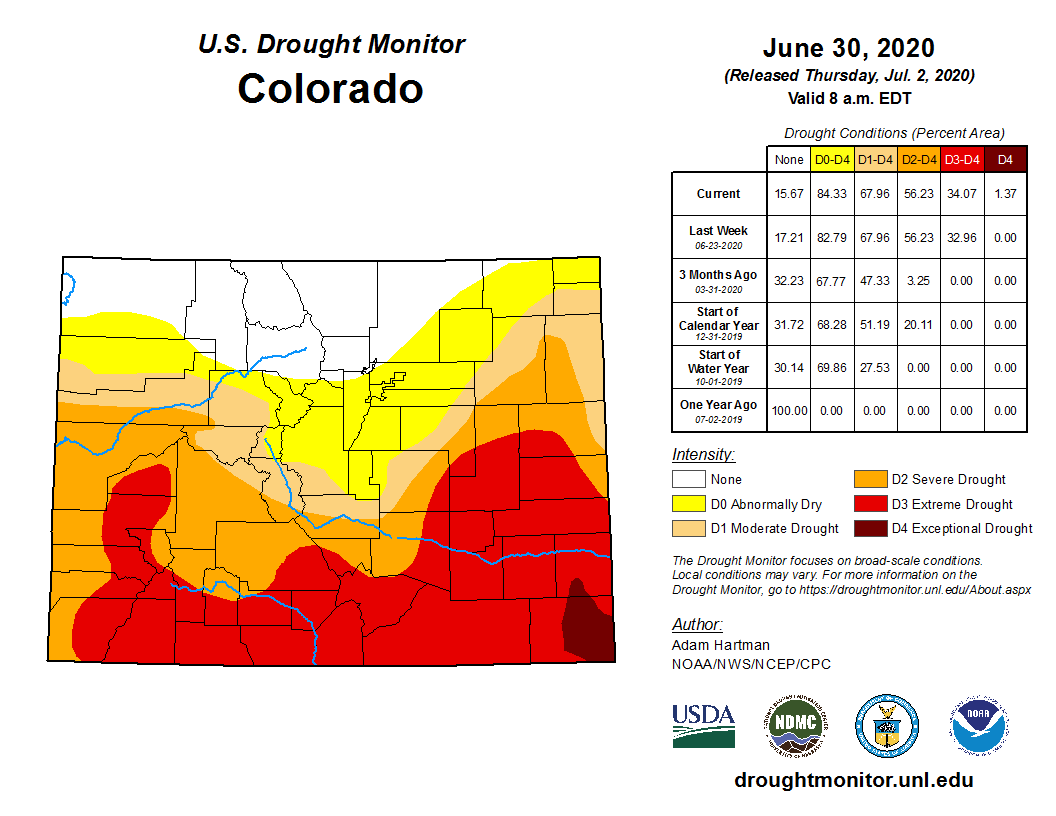
Parts of southeast and east central Colorado saw drought improvements this week, while moderate conditions increased in the northeast and Denver metro area according to the latest update from the National Drought Mitigation Center.
Exceptional drought – the worst category – entered Baca and Prowers counties last week, only to be removed this week after 0.5-2.5 inches of rain fell in the area.
Colorado Drought Monitor July 7, 2020.
Eastern Kit Carson County saw heavy rain last week, allowing areas of moderate and severe drought to be replaced by a bubble of abnormally dry conditions.
Moderate conditions moved into Sedgwick County, and expanded in eastern Logan County. Moderate drought also appeared in southern Jefferson, western Douglas and Arapahoe, and much of Denver County.
Monthly Drought Outlook for July 2020 via the Climate Predication Center.
The U.S. Monthly Drought Outlook from the Climate Prediction Center calls for drought to persist through July. Through September, drought is expected to expand further in northwest and central Colorado.
Overall, 16 percent of Colorado is drought-free, unchanged from the previous week. Abnormally dry conditions decreased one percent to 15, while moderate drought increased from 12 to 14 percent. Severe drought improved from 22 to 21 percent, while exceptional conditions increased one percent to 34.
These wetlands, located on a 150-acre parcel in the Homestake Creek valley that Homestake Partners bought in 2018, would be inundated if Whitney Reservoir is constructed. The Forest Service received more than 500 comments, the majority in opposition to, test drilling associated with the project and the reservoir project itself. Photo credit: Heather Sackett/Aspen Journalism
The U.S. Forest Service has been inundated with more than 500 online comments — the vast majority in opposition — to a geophysical study and drilling by the cities of Aurora and Colorado Springs to determine the feasibility of a second reservoir in the Homestake Creek drainage, including objections from nearby towns and a local state senator.
The geophysical study and the drilling are the next step in the lengthy process of developing a reservoir on lower Homestake Creek.
The mayors of Red Cliff and Minturn signed and submitted separate but identical letters questioning the legality of drilling 10 boreholes on Forest Service land near the Holy Cross Wilderness Area, which is six miles southwest of Red Cliff, to see whether soil and bedrock can support a dam for what would be known as Whitney Reservoir. Avon’s attorney has asked for a public comment extension to Aug. 4 so that it can hold a hearing.
“A Whitney Reservoir would irreparably change and harm our community,” Minturn Mayor John Widerman and Red Cliff Mayor Duke Gerber wrote in their letters, submitted June 30. “We are paying close attention to these proposals, other moves by Homestake Partners and the public controversy. This categorical exclusion is rushed, harmful and unlawful.”
Operating together as Homestake Partners, the cities of Aurora and Colorado Springs own water rights dating to the 1950s that, under the 1998 Eagle River Memorandum of Understanding (MOU), give them the basis to pursue developing 20,000 acre-feet of water a year from the Western Slope. They’ve been studying four potential dam sites in the Homestake Valley several miles below the cities’ existing Homestake Reservoir, which holds 43,600 acre-feet of water.
The smallest configuration of Whitney Reservoir, if deemed feasible and ultimately approved, would be 6,850 acre-feet, and the largest would be up to 20,000 acre-feet. The reservoir, on lower Homestake Creek, would pump water up to Homestake Reservoir, about five miles upstream, then through a tunnel under the Continental Divide to Turquoise Reservoir near Leadville.
In 2018, Homestake Partners paid $4.1 million for 150 acres of private land, which it leases back to the former owner for a nominal fee. That land, which would be inundated to accommodate a large portion of Whitney Reservoir’s surface area, is braided with streams and waterfalls and is lush with fens and other wetlands. It’s also home to a cabin once used as an officers quarters for the famed 10th Mountain Division of the U.S. Army. The site is not far from Camp Hale, between Red Cliff and Leadville, where soldiers trained for mountain warfare during World War II.
This cabin, once used by the 10th Mountain Division of the U.S. Army, sits on a 150-acre parcel owned by Homestake Partners. The site of the proposed Whitney Reservoir is near Camp Hale, between Red Cliff and Leadville. Photo credit: David O. Williams/Aspen Journalism
Eagle River MOU
The Eagle River MOU is an agreement between Aurora and Colorado Springs and a bevy of Western Slope water interests. The Colorado River Water Conservation District, Eagle River Water & Sanitation District, Upper Eagle Regional Water Authority, and Vail Resorts are collectively defined in the MOU as the Reservoir Company. None of those entities submitted comments to the Forest Service on the drilling proposal. And according to Diane Johnson, communications and public affairs manager for the ERWSD and UERWA, none are helping to pay for the feasibility study and none are involved in the reservoir project, except to the degree that it is tied to the MOU.
The MOU provides for 20,000 acre-feet of average annual yield for the cities. “Yield” refers to a reliable supply of water. In some cases, yield equates to storage in a reservoir, but yield can also be created by other methods, such as pumping water uphill from a smaller, refilled reservoir, which is an option being studied by the cities on lower Homestake Creek. The MOU also provides for 10,000 acre-feet of “firm dry year yield” for the Western Slope entities in the Reservoir Company, and firm dry year yield means a reliable supply even in a very dry year. Those entities have developed about 2,000 acre-feet of that allocated firm yield in Eagle Park Reservoir, and it’s not yet clear whether the Whitney Reservoir project would help them realize any additional yield.
“The short answer is we support (Homestake Partners’) right to pursue an application for their yield,” Johnson said. “We trust the permitting process to bring all impacts and benefits to light for the community to consider and weigh in total.” .
Jim Pokrandt, director of community affairs for the River District, declined to comment on the investigatory test work, saying only, “Yes, we have signed the MOU. That said, … we are not participating in the Whitney Creek effort.”
Besides Homestake Partners and the Reservoir Company, the MOU was signed by the Climax Molybdenum Company. The two private companies signed onto the MOU — Vail Resorts and Freeport-McMoRan (Climax) — also declined to comment on either the drilling study or Whitney Reservoir.
Under the MOU, various parties can pursue projects on their own, and the other parties are bound to support those efforts, but only to the degree that a proposed project meets the objectives of the MOU, including whether a project “minimizes environmental impacts.”
Many of the 520 online comments as of the June 30 deadline objected to testing for the possibility of a dam, expressing concern for the complex wetlands in the area, but most of the comments also strongly condemn the overall project: a potential future Whitney Reservoir.
The cities are trying to keep the focus on the test drilling.
“This is simply a fatal-flaw reservoir siting study that includes subsurface exploration, and it’s basically just to evaluate feasibility of a dam construction on lower Homestake Creek,” said Maria Pastore, Colorado Springs Utilities’ senior project manager for water resource planning. “It’s simple exploratory work to determine if we can even go ahead with permitting and design.”
Marcia Gilles, acting ranger for the Eagle-Holy Cross District, said her office will continue accepting comments at any time during the ongoing analysis of the geophysical study despite the June 30 deadline. She added that if the Forest Service concludes there are no “extraordinary circumstances,” she can render a decision using what is known as a categorical exclusion and then issue a special-use permit as soon as August. A categorical exclusion requires less environmental scrutiny than other forms of analysis.
“At this time, the proposed action appears to be categorically excluded from requiring further analysis and documentation in an environmental assessment (EA) or environmental impact statement (EIS),” Gilles said. “Should the environmental analysis find extraordinary circumstances, the Forest Service would proceed to analyzing the project in an EA or EIS.”
State Sen. Kerry Donovan, a Vail Democrat, disagrees. She wrote to the Forest Service on June 30: “I … strongly urge you not to categorically exclude this project from (National Environmental Policy Act) analysis. I cannot express how sternly the citizens of my district oppose water diversion projects to Front Range communities.” Her district encompasses seven Western Slope counties, including Eagle, where the dam would be located.
Donovan called the proposed investigation — which would require temporary roads, heavy drilling equipment, continuous high-decibel noise, driving through Homestake Creek and use of its water in the drilling process — an affront to the “Keep It Public” movement, which advocates for effective federal management on public lands.
These wetlands in the Homestake Creek valley are near the site of the proposed Whitney Reservoir. The Forest Service is considering whether to issue a permit for drilling and a geotechnical study to test whether the site would support a dam. Photo credit: Heather Sackett/Aspen Journalism
Drilling impacts
If approved by the Forest Service for a special-use permit, Homestake Partners would send in crews on foot to collect seismic and other geophysical data later this summer or fall. Crews with heavy equipment would then drill 10 boreholes up to 150 feet deep in three possible dam locations on Forest Service land. The drilling would take place on Forest Service land but not in a wilderness area.
Crews would use a standard pickup truck, a heavy-duty pickup pulling a flatbed trailer, and a semi-truck and trailer that would remain on designated roads and parking areas, with some lane closures of Homestake Road and dispersed campsites possible.
For off-road boring operations, crews would use a rubber-tracked drill rig, a utility vehicle pulling a small trailer, and a track-mounted skid steer. The drill rigs are up to 8 feet wide, 22 feet long and 8 feet high, and can extend up to 30 feet high during drilling, possibly requiring tree removal in some areas. The rigs would also have to cross Homestake Creek and some wetland areas, although crews would use temporary ramps or wood mats to mitigate impacts.
According to a technical report filed by Homestake Partners, the subsurface work is expected to take up to five days per drilling location, or at least 50 days of daytime work only. However, continuous daytime noise from the drilling could approach 100 decibels, which is equivalent to either an outboard motor, garbage truck, jackhammer or jet flyover at 1,000 feet. If work is not done by winter, crews have up to a year to complete the project and could return in 2021.
The drilling process would use several thousand gallons of Homestake Creek water per day that engineers say “would have negligible impacts on streamflow or aquatic habitat. Water pumped from Homestake Creek during drilling would amount to less than 0.01 (cubic feet per second), a small fraction of average flows,” according to a technical report included with application materials.
Homestake Partners would avoid wetlands as much as possible during drilling, but “where temporary wetland or waters disturbance is unavoidable, applicable 404 permitting would be secured from the U.S. Army Corps of Engineers.” Crossing of Homestake Creek would occur in late summer or fall when streamflows are low, and no drilling would occur in wetlands.
While no permanent roads would be built for the drilling, temporary access routes would be necessary and reclaimed as much as possible.
“Access routes would be selected to reduce surface disturbance and vegetation removal, and to avoid identified or potential unexploded ordnances (UXOs) discovered during field surveys,” according to the technical report. The 10th Mountain Division used the area for winter warfare training during WWII.
Another concern cited in the report is the potential impact to Canada lynx. Listed as threatened under the Endangered Species Act, “only Canada lynx has potential habitat in the vicinity of the project area,” according to the report. “No impacts on lynx are anticipated from the proposed work because much of the activity would occur near Homestake Road, a well-traveled recreation access road. Work would be conducted over a short period (approximately five to six weeks) and impacts on potential habitat would be negligible.”
The vast majority of comments from a variety of environmental groups and concerned citizens focused on potential impacts to the area’s renowned wetlands and peat-forming fens, which the project proponents say they will avoid as much as possible. So far, Gilles said she is not aware of any legal challenges to the project.
Two prominent local conservation groups — Eagle Valley Land Trust and Eagle River Watershed Council — submitted comments to the Forest Service expressing serious reservations about both the drilling and the possibility of a dam.
“Geophysical exploration has an obvious significant nexus and direct relation to additional future actions, i.e., dam construction, which may in time massively impact the Eagle River watershed — regardless of whether the future actions are yet ripe for decisions,” ERWC officials wrote.
This map shows the location of test holes Homestake Partners plans to drill as part of its geotechnical investigation into the feasibility of a dam site in the Homestake Creek valley. The Forest Service has received more than 500 comments, most of them in opposition to, the drilling and the overall reservoir project. Credit: USFS via Aspen Journalism
Wilderness boundary
Even if the test drilling returns favorable results for a reservoir project, there is another obstacle that Homestake Partners will have to clear if they want to move forward with two iterations of the project: a wilderness-boundary change, which would require an act of Congress and the president’s signature.
The Whitney Reservoir alternatives range from 6,850 to 20,000 acre-feet and in some configurations would require federal legislation, which the cities are working to draft, requesting a boundary adjustment for the nearby Holy Cross Wilderness Area. The largest Whitney proposal would require an 80-acre adjustment, while an alternative location, lower down Homestake Creek, would require a 497-acre adjustment.
White River National Forest Supervisor Scott Fitzwilliams discounts the notion that his agency should reject outright the test-drilling application, as some environmental groups have suggested, until the wilderness-boundary issue is determined. Although some local and state lawmakers have said they are against shifting a wilderness boundary, Fitzwilliams said it’s still too soon for him to take up the wilderness issue.
“These are test holes,” Fitzwilliams said of the drilling, which is intended to see whether the substrata are solid enough for a dam and reservoir. “Going to get a (wilderness) boundary change is not a small deal for them, so why would you do it if you find fatal flaws? That’s a red herring.
“I understand it; nobody wants to see a dam in the Homestake drainage. I get that. But it just seems prudent to do (the drilling) to see if there’s any reason to go further.”
Aspen Journalism is collaborating with the Vail Daily and other Swift Communications newspapers on coverage of water and rivers. This story was published online by Vail Daily on July 9, 2020 and in its print edition on July 10. The early online version of the story was edited to clarify aspects of the Eagle River MOU.
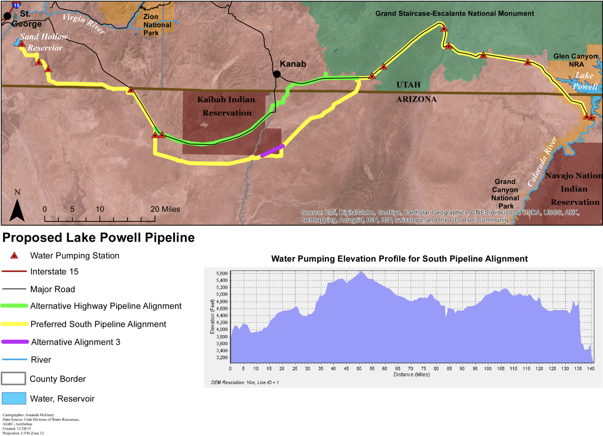
Draft plans for the Lake Powell Pipeline have the project running through sacred and culturally significant lands to the Kaibab Band of Paiute Indians.
The pipeline, which is currently under public review, has two proposed routes — one that runs through the Kaibab Indian Reservation and one that runs along its southern border. The Kaibab Tribe opposes both of these routes, according to a document from the tribe in the project’s draft environmental impact statement.
Proponents of the pipeline prefer the southern route, which bypasses the reservation.
Chairwoman of the tribal council, Ona Segundo, said that doesn’t mean the tribe’s lands wouldn’t be disturbed. The tribe opposes the project as a whole, she said, but would prefer the highway route that follows Arizona State Route 389…
“Yes, the people in Washington County and that area are in need of that water, however, they also need to realize that the Kaibab Paiute Tribe are here,” [Ona Segundo] said. “We’ve been here for millenia and we will continue to be here. We feel it is our duty to protect this area.”
This $2+ billion project would pump 28 billion gallons of water 2,000 feet uphill across 140 miles of desert to provide just 160,000 residents in Southwest Utah with more water. Graphic credit: Utah Rivers Council
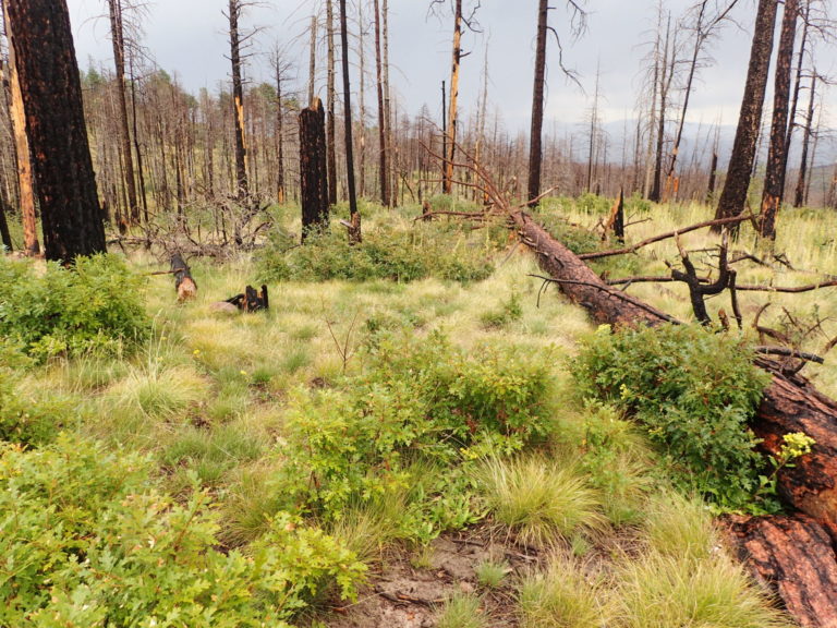
The West Fork fire complex of 2013 was composed of three fires that burned more than 109,000 acres on mostly public lands managed by the Rio Grande and San Juan National Forests. Photo: Jonathan Coop, Western Colorado University via Colorado State University
One of Jonathan Coop’s first vivid memories as a child was watching the flames of the 1977 La Mesa Fire in north-central New Mexico. The human-caused fire burned more than 15,000 acres of pine forests in the Bandelier National Monument and areas surrounding the Los Alamos National Laboratory.
Now a forest ecologist and professor at Western Colorado University, Coop studies the ecological effects of fire on forests in the Southwest United States. He’s also the lead author of a new scientific synthesis about how wildfires drive changes in forest vegetation across the United States. Sean Parks — research ecologist with the USDA Forest Service, Rocky Mountain Research Station — and Camille Stevens-Rumann, assistant professor in the Department of Forest and Rangeland Stewardship at Colorado State University, are co-authors of the synthesis.
The new paper, with contributions from more than 20 researchers, uncovers common themes that scientists are reporting, including increasing impacts of wildfires amid climate change from the borderlands of Mexico and Arizona to the boreal forests of Canada.
Following high-severity fire, scientists have found forest recovery may increasingly be compromised by lack of tree seed sources, warmer and drier post-fire climate and more frequent reburning. [ed. my emphasis]
“In an era of climate change and increasing wildfire activity, we really can’t count on forests to come back the way they were before the fire,” said Coop. “Under normal circumstances, forest systems have built-in resilience to disturbance – they can take a hit and bounce back. But circumstances aren’t normal anymore.”
The loss of resilience means that fire can catalyze major, lasting changes. As examples, boreal conifer forests can be converted to deciduous species, and ponderosa pine forests in the southwest may give way to oak scrub. These changes, in turn, lead to consequences for wildlife, watersheds and local economies.
‘Assisted migration’ an option in some cases, places
Researchers said that in places where the most apparent vegetation changes are occurring, such as the Southwest U.S. and in Colorado, land managers are already exploring ways to help forests adapt by planting tree species that are better suited to the emerging climatic conditions following severe fire.
A forest after the Las Conchas fire in northern New Mexico. Photo: Jonathan Coop, Western Colorado University via Colorado State University
“In places where changes are not quite so visible, including Montana and Idaho, those conversations are still happening,” said Stevens-Rumann. “In these large landscapes where trees are not coming back, you have to start getting creative.”
Parks, who often uses data collected in protected areas to study wildfire patterns, causes and consequences, said some fires can be good, creating openings for wildlife, helping forests rejuvenate and reducing fuel loads.
“However, some fires can result in major changes to the types of vegetation,” he said, adding that this is particularly true for high-severity wildfires when combined with the changing climate. “Giving managers information about where and how climate change and wildfires are most likely to affect forest resilience will help them develop adaptation strategies to maintain healthy ecosystems.”
Stevens-Rumann said that land managers have largely continued to operate in the way they’ve done in the past, replacing fire-killed trees with the same species. “Given the effects of climate change, we need to start being much more creative,” she said. “Let’s try something different and come up with solutions that allow natural processes to happen and interact with landscapes in different ways.”
Coop said that ecologists and managers are beginning to develop a suite of approaches to increase forest resilience in an era of accelerating change.
One approach that he said he’s partial to is allowing fires to burn under benign or moderate fire weather conditions – similar to what happens in a prescribed burn – which results in forests that are less prone to high-severity fire because of reduced fuel loads and patchy landscapes. This is also known as managing wildfire for resource objectives, an approach that researchers said is cost-efficient, allowing managers to treat more acres.
“Increasingly, we’re realizing you either have the fires you want and can influence or you’re stuck with these giant fires where, like hurricanes, there’s no shaping their path,” said Coop.
Loss of forests is personal
For many of the researchers involved in this synthesis, the issues being analyzed are personal.
Before becoming a scientist, Stevens-Rumann spent three years on a USDA Forest Service “Hotshot” crew, specializing in fighting fires in hard-to-access and dangerous terrain. Parks grew up in Colorado and California and acknowledges seeing changes in the forests and landscapes he grew up with.
Coop said he’s seen an incredible amount of forest lost in the Jemez Mountains where he grew up. The La Mesa fire was only the first in a series of increasingly large and severe fires, culminating with the 140,000-acre Las Conchas fire in 2011. Within the footprint of Las Conchas, less than a quarter of the landscape is still forested.
“Seeing these things unfold over my lifetime, I don’t know if I ever really could have imagined it,” he said. “I’ve borne witness to these very dramatic changes unfolding in the one place that I really know best on Earth.”
Click through to read, what Julia Steinberger describes ad, “…less of a blog post, and more of a howl.” Here’s an excerpt:
“_” : this is our unit of time, and it’s 1000 years long.
_ is 10 long human lifespans, 40 generations, the time separating us from the first millennium and the Middle Ages in European history, when Canute of Denmark ruled Britain, before Marco Polo traveled the Silk Road. It’s a long time by any human account: twice the duration of the Roman Empire.
_____ is 5’000 years. It’s the age of the oldest known living tree, Methuselah, in the Californian White Mountains.
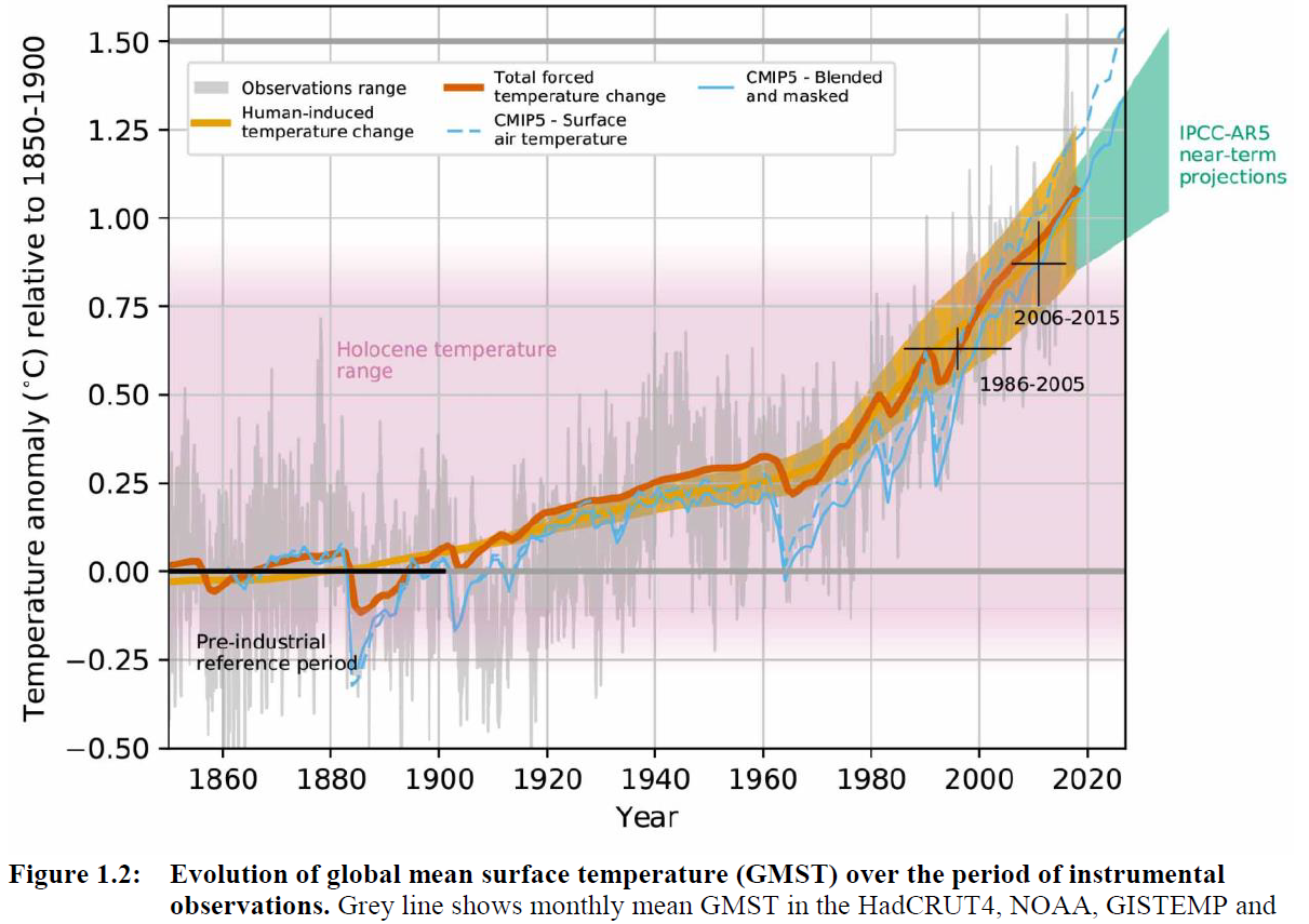
____________ is 12’000 years. It’s the time span separating us from the last ice age. This time is the time during which humans slowly selected plants, developed agriculture, cities, writing: anything we would call civilization. It is the time when humans thrived, cultures multiplied, our population grew. This clement and stable climate interval, which sheltered us and the plants we depend upon to live so well, is known as the Holocene. Gaze upon that interval fondly, for it is already in our past…
Figure 1.2 from the IPCC’s Special Report on 1.5 degrees, showing that we have already left the temperature range of the Holocene.
If CO2 is so correlated with climate, why are we not already experiencing the temperatures and sea levels of the Pliocene, and witnessed by faraway Homo Habilis, with their almost-human eyes? Professor Gavin Foster, co-author of the Nature study, puts it this way: “The reason we don’t see Pliocene-like temperatures and sea-levels yet today is because it takes a while for Earth’s climate to fully equilibrate (catch up) to higher CO2 levels and, because of human emissions, CO2 levels are still climbing. Our results give us an idea of what is likely in store once the system has reached equilibrium.”
Time lags for equilibration vary between Earth systems: climate temperatures will catch up with the Pliocene with in a few decades, sea levels within a few centuries. But it gets worse. Because not only have we left the agriculture-sheltering Holocene. Not only have we zoomed through Pliocene the span than 1 human lifetime (reminder: we have no evidence that the large scale agriculture we depend upon, in our billions, for survival, is possible in this new climate. Cheers.). We are still going. We are accelerating, in fact, with concentrations of CO2 increasing faster and faster every year.
Cherry Creek State Park. Vic Schendel Spring Summer 2017 via Colorado Parks & Wildlife
Here’s the release from Colorado Parks & Wildlife (Jason Clay):
Cherry Creek State Park is experiencing natural algal blooms that may be harmful to dogs and humans as a result of a number of things including warmer temperatures, stagnant waters, and nutrient loading from fertilized lawns.
The park has closed the swim area due to elevated levels of cyanobacteria (blue-green algae) growth. The swim area will remain closed until tests provide acceptable conditions to re-open. Blue-green algae has been detected in other areas of the park and caution signs have been placed in visible areas throughout the lake. The Colorado Department of Public Health and Environment (CDPHE) recommends the following:
Keep kids out
No pets in water
Do not drink water
Avoid contact with algae
For more information on blue-green algae, please click here.
The Dog-Off-Leash-Area stream has been tested and no visible signs of the algae have been observed.
For more information on conditions at Cherry Creek State Park, please click here.
Here at 12,000 feet on the Continental Divide, only vestiges of the winter snowpack remain, scattered white patches that have yet to melt and feed the upper Colorado River, 50 miles away.
That’s normal for mid-June in the Rockies. What’s unusual this year is the speed at which the snow went. And with it went hopes for a drought-free year in the Southwest.
“We had a really warm spring,” said Graham Sexstone, a hydrologist with the United States Geological Survey. “Everything this year has melted really fast.”
The Southwest has been mired in drought for most of the past two decades. The heat and dryness, made worse by climate change, have been so persistent that some researchers say the region is now caught up in a megadrought, like those that scientists who study past climate say occurred here occasionally over the past 1,200 years and lasted 40 years or longer…
Normally, Dr. Sexstone said, measurements of stream flow at gauges in the region would slowly climb to a peak and then drop off gradually as the season progressed.
“This year it seemed like it peaked and then plummeted,” he said.
Becky Bolinger, a drought specialist at Colorado State University and the assistant state climatologist, said the lack of new snow in late spring affected the rate of melting. As snow is exposed to the sun it warms and nears the melting point. If new snow falls, that lowers the temperature, stalling the process. But without any new snow, the melting continues unimpeded…
Early, rapid melting of snowpack has been common recently in the Rio Grande basin, said Shaleene B. Chavarria, a hydrologist with the United States Geological Survey in New Mexico. Being farther south, it is hotter and more arid than much of the Colorado basin…
It’s not just the basins west of the Continental Divide that have experienced severe drought made worse by warming. A study published in May about the country’s largest river basin, the Upper Missouri, where snowmelt on the eastern side of the divide at Loveland Pass eventually ends up, showed that warming has affected runoff over the last few decades and increased the severity of droughts, including one from 2000 to 2010…
US Drought Monitor July 7, 2020.
In [the U.S. Drought Monitor’s] latest analysis, the monitoring group reported that the southern half of Colorado, northern and eastern New Mexico, Northern Arizona and nearly all of Utah were in moderate to extreme drought, with varying degrees of water shortages and crop and pasture damage. And the National Oceanic and Atmospheric Administration, in its most recent climate forecast, said the drought would likely persist through the summer.
Park Williams, a bioclimatologist at Lamont-Doherty Earth Observatory, was the lead researcher on a study published in April that found that conditions in the Southwest from 2000 to 2018 were comparable to several megadroughts since A.D. 800. It said global warming caused by human emissions of greenhouse gases was a major contributor, turning what would have been a moderate drought into an “emerging megadrought.”
At the time the study was published, Dr. Williams said, there was a possibility that a wet May would “bail 2020 out” and perhaps be the beginning of the end for the drought.
Drought can be complex, a function not only of high temperatures and lack of precipitation but also of factors like humidity, wind and cloud cover. Soil moisture and evaporation of water from the ground surface and from the leaves of vegetation, a process called transpiration, are important.
Dust that settles on snow can have an impact, by absorbing sunlight and warming, which speeds melting. And sublimation, by which a solid (snow) directly becomes a gas (water vapor), bypassing the liquid phase (water), plays a role as well.
But scientists are still learning how these various factors interact, and the relative importance of each. In some cases there is little data to analyze, and much of the research relies on computer models.
There are relatively few direct measurements of soil moisture, for example, even though it can greatly affect runoff as it likely did this year in the Southwest.
Soils were already very dry last fall, Dr. Bolinger said, because the annual late-summer rains in Arizona, New Mexico and Southern Colorado largely failed to materialize.
As winter set in, the soil froze, remaining dry while the snow built up on it. Then, once the snow began to melt, the soil had to be replenished first, Dr. Bolinger said.
Dr. Sexstone’s work to better understand snowpack is part of a broader effort within the geological survey to more accurately quantify and forecast runoff, given increasing uncertainty about water supplies in a warming and more drought-prone world.
A snow pit on Loveland Pass shows a narrow stripe of dust near the surface. When it’s exposed, the dust can speed up melt off by a couple weeks. Photo credit: Center for Snow and Avalanche Studies via KUNC
At Loveland Pass, with a light dusting of snow falling around him, he demonstrated a basic technique used to study snowpack. Pulling a shovel from his backpack, he dug a pit in a patch of snow down to solid ground. In this case the pit was only 3 feet deep, but in midwinter in the mountains they can reach up to 15.
Dr. Sexstone then inserted thermometers at various levels in the side of the pit, and, using a scoop and a scale, took samples of the snow at each level. By weighing each sample he could determine its density and how much water would result when it melted.
Last winter, Dr. Sexstone was digging snow pits as part of development work on a project, the Next Generation Water Observing System, to better measure snowpack and stream flows at sites around the Upper Colorado Basin and, through modeling, improve basin-wide assessments of runoff.
“We’re looking at more intensive monitoring within the basin,” said Suzanne Paschke, who manages the project at the geological survey’s Colorado Water Science Center. Installation of advanced sensors to measure snow and other characteristics like soil moisture is expected to begin next year.
Most current snow measurements come from a network called Snotel, first established in the 1960s. It now includes hundreds of sites around the West.
While the Snotel network provides invaluable data about snow depth and how much water it holds, Dr. Sexstone said, the sites are all below the tree line and the system was developed when much less was known about what affects snowpack.
“When they were developing this network, they wanted to find sites that weren’t influenced by all these other factors like wind,” Dr. Sexstone said. Scientists have since realized that snowpack and runoff are a lot more complicated.
“Now we’re starting to say, OK, how do we account for all this other stuff?” he said.
Such a short time ago, 80% emissions reduction seemed such a bold goal. A new report says far more is possible.
It seems like many years ago since Ben Fowke, chief executive of Xcel Energy, standing on a podium at the Denver Museum of Nature and Science, announced that his company was confident it could decarbonize the electrical generation across its six-state operating area 80% by 2030 as compared to 2005 levels. This, he said, could be done using existing technology.
That declaration in December 2018 was national news. So was the company’s disclosure in December 2017 of the bids for renewables to replace the two coal-fired units it intended to retire at Pueblo, Colo. They came in shockingly low.
Now, 80% plans by 2030 are becoming almost commonplace. Consider the trajectory of Colorado Springs. The city council there, acting as a utility board, in June accepted the recommendation of city utility planners to shut down the city’s two coal plants, the first in 2023 and the second in 2030.
That was the easy decision. But the Colorado Springs City Council, in a 7-2 vote, also accepted the recommendation to bypass new natural gas capacity. Xcel is adding natural gas capacity to its portfolio in Colorado, although the plant already exists.
Colorado Springs is now on track to get to 80% reduction by 2030.
As a municipal utility, Colorado Springs was not required by Colorado to reduce its emissions 80% by 2030. That applies to those utilities regulated by the state, and municipalities are exempt. It is subject to broader economy wide goals of 50% by 2030 and 90% by 2050.
A city utility planner says he believes the city can achieve 90% reduction by 2050.
“I do believe personally that in the next 10 years we will see some major advancements in the technology that will allow those technologies to go down and be more competitive,” says Michael Avanzi, manager of energy planning and innovation at Colorado Springs Utilities.
This, the study notes, can be done even while electricity costs decline. This finding contrasts sharply with studies completed more than 5 years ago, which found deep penetration of renewables would elevate costs. These lower costs are being reported across the country, the study found, even in those areas considered resource-poor for renewable energy generation. Colorado is the converse: It has excellent renewables, among the best mix in the nation.
The study is important and rich with detail. Among the seven members of a technical review committee was Steve Beuning, of Glenwood Springs-based Holy Cross Energy.
Hal Harvey. Photo via The Mountain Town News
The findings, though, are best understood in terms of the policy assumptions, which are found in a separate study conducted by Energy Innovation, a San Francisco-based consultancy. Colorado gets several mentions, and it’s important to note that the chief executive is Hal Harvey, who grew up in Aspen. (Harvey has connections in high places; he inspired a column in late June by Thomas Friedman of the New York Times: “This Should Be Biden’s Bumper Sticker.”)
The conclusions describe an optimal set of policies to get the United States to 90% by 2035, including:
federal clean energy standards and, especially in the absence of that, extension of federal tax credits for wind and solar.
strengthening of federal authority to improve regional transmission planning by the Federal Energy Regulatory Authority.
reform wholesale markets to reward flexibility.
Researchers in California did not specifically examine the case of Colorado Springs but more broadly found that U.S. electrical utilities can tap existing gas-fired plants infrequently along with storage, hydropower, and nuclear power to meet demands even during times of extraordinarily low renewable energy generation or exceptionally high electricity demand. All told, natural gas can contribute 10% of electrical generation in 2035. That would be 70% less than the natural gas generation in 2019.
How did the California researchers decide how much natural gas would be needed to firm supplies? As the saying goes, the sun doesn’t always shine, the wind doesn’t always blow. And when would these times of low renewables intersect those of high demand? The researchers studied weather records for seven years, 60,000 hours altogether, and in 134 regional zones within the United States, from earlier in this century. That worst-case time, during the seven years examined, was on the evening of Aug. 1, 2007, a time when solar generation had declined to less than 10% of installed solar capacity, and wind generation was 18% below installed capacity
Based on this, they found a maximum need for 360 gigawatts of natural gas capacity. In other words, no new natural gas generation was needed. We have enough already.
Peak demand in Colorado Springs usually occurs late on hot summer afternoons. The all-time record demand of 965 megawatts occurred on July 19, 2019. As Colorado Springs grows during the next three decades, it will possibly become Colorado’s largest city, with demand projected to push 1,200 megawatts (1.2 gigawatts) at mid-century.
For Avanzi and other utility planners charged with creating portfolios for consideration by elected officials, closing coal plants was an easy case to make. Coal has become expensive, severely undercut by renewables.
Also considered were 100% emission-free portfolios by 2030, 2040, and 2050. But they were seen as too risky and too costly, at least at this time.
Portfolio 17, the one ultimately adopted by the city council on June 25, calls for the Martin Drake plant to be closed in 2023 and the Ray Nixon plant in 2030.
Seven portable gas generators are to be installed at the Drake plant for use from 2023 to 2030, a need dictated by the existing transmission and not the inadequacy of renewables. Colorado Springs already has a gas plant, but the city council members accepted the recommendation of utility planners that no new plant will be needed. That vote was 7-2.
A natural gas plant located northeast of Denver operated by Tri-State Generation and Transmission. Photo/Allen Best
Writing in PV Magazine, Jean Haggerty pointed out that Colorado Springs was part of a trend among utilities to avoid building new natural gas bridges to renewable energy. Tucson Electric Power also plans to skip the gas bridge. And, on the East Coast, Florida Power & Light and Jacksonville’s municipal utility reached agreement to rely on existing natural gas and new solar generation when they retire their jointly owned coal plant, the largest in the United States.
In creating the portfolios, Avanzi says he relied upon mostly publicly available reports, especially the National Renewable Energy Laboratory’s annual technology baseline and U.S. Energy Information Administration documents. For battery storage, he relied upon a study by energy consultant Lazard.
Colorado Springs’ plan calls for 400 megawatts of battery storage by 2030. Previously plans for a 25-megawatt battery of storage are expected to come on line in 2024.
All types of storage were examined. The single largest storage device in Colorado currently is near Georgetown, where water from two reservoirs can be released to generate up to 324 megawatts of electricity as needed to meet peak demands. The water then can be pumped uphill 2,500 feet to the reservoirs when electricity is readily available.
Colorado Springs studied that option. It has reservoirs in the mountains above the city. It found the regulatory landscape too risky.
The most proven, least risky, technology is lithium-ion batteries that have four-hour capacity and flow batteries with six hours capacity. They can meet the peak demand of those hot, windless summer evenings after the sun has started lessening in intensity.
Dozens of in-person and remote speakers aired their concerns about the proposed $1.1 billion water storage and delivery project, which would include building Glade Reservoir northwest of Fort Collins.
Issues raised about the massive project proposed by Northern Water included the ecological impacts of drawing water from an already heavily used Poudre River to store in the reservoir, the routing of pipelines that would carry water to participating communities, and the effects construction of the reservoir and pipelines would have on nearby communities…
A decision of record on the Environmental Impact Statement for NISP is expected to be released this year by the U.S. Army Corps of Engineers. The project has received water quality certification from state regulators…
The Planning Commission is considering an application from Northern Water for a 1041 permit — named for the state law that grants local governments permitting authority over certain infrastructure projects — for the siting of the reservoir and associated recreational facilities, including a visitor center, boat ramps and campgrounds. The permit also covers the routes of four pipelines needed to convey water from Glade.
Commission members heard presentations on the reservoir and pipelines from county staff members and Northern Water on June 24. Wednesday’s four-hour hearing was dedicated to taking public comment.
Of the approximately 40 people who spoke individually or as the representative of a group, only one spoke in favor of NISP. The county has received several hundred emails from residents opposing the project…
Northern Water has said the dam site is safe and structures will be designed to withstand seismic activity and soil shifts.
Residents of the Eagle Lakes subdivision blasted the proposed routing of a pipeline from Glade through their neighborhood that would connect with another pipeline near the county line and carry water south.
Northern Water would likely have to use its eminent domain power to get the 100-foot easement it wants for constructing the pipeline, said Eagle Lake resident Mark Heiden…
He said alternative routes through open land are available if Northern Water were willing to pay the additional cost, which he estimated at $3 million.
Area homeowners complained they would have to endure many weeks of disruption from construction activity and loss of use of their property because of the easements.
Northern Water has said it would pay property owners fair market value for easements and restore disturbed land to pre-construction condition or better.
Several speakers compared the proposed pipeline to the city of Thornton’s plan to run a massive pipeline along Douglas Road. The proposal was fought by No Pipe Dream and others.
The county commissioners rejected Thornton’s proposed route last year. Thornton has sued the county in District Court over the decision…
The Planning Commission continued its hearing to July 15, when members will hear additional information from staff and Northern Water before deliberating on its recommendation on a permit to the county commissioners, who will decide whether to grant the permit.
The commissioners have scheduled multiple hearings on the permit application for NISP in August.
After the public comment was completed, planning commissioners listed several questions they want addressed by county staff or Northern Water at the next meeting. The questions reflected issues brought up during public comment, including whether Northern Water has sufficient water rights to fill the reservoir and provide recreational opportunities.
Northern Water has said boating would be possible on the reservoir 90% of the time.
Commission member Nancy Wallace said she wants to hear more about how plans for the project address climate change and other “big picture” issues…
What’s next
The Larimer County Planning Commission is scheduled to have its final meeting on NISP beginning at 6 p.m. July 15 at the County Courthouse Offices Building, 200 W. Oak St. in Fort Collins.
Attendance will be limited to 50 people because of COVID-19 restrictions on gatherings.
The planning commission will make a recommendation on a permit for NISP to the Board of County Commissioners, which will decide on the application.
Hearings by the commissioners are scheduled:
6 p.m., Aug. 17 – Presentations only; no public testimony.
2 p.m. Aug. 24 (break from 5:30 p.m. to 6:30 p.m.)
3 p.m. Aug. 31 (break from 5:30 p.m. to 6:30 p.m.)
6:30 p.m. Sept. 2 – Questions, final deliberation and decision
Speakers will be limited to 2 minutes each. Borrowing, lending or grouping time will not be allowed.
The number of new COVID-19 cases in the U.S. has jumped to around 50,000 a day, and the virus has killed more than 130,000 Americans. Yet, I still hear myths about the infection that has created the worst public health crisis in America in a century.
The purveyors of these myths, including politicians who have been soft peddling the impact of the coronavirus, aren’t doing the country any favors.
Here are five myths I hear as director of health policy at the University of Southern California’s Schaeffer Center that I would like to put to rest.
Myth: COVID-19 is not much worse than the flu
President Donald Trump and plenty of pundits predicted early on that COVID-19 would prove no more lethal than a bad flu. Some used that claim to argue that stay-at-home orders and government-imposed lockdowns were un-American and a gross overreaction that would cost more lives than they saved.
Myth: Cases are increasing because testing is increasing
At one point, the idea that COVID-19 case numbers were high because of an increase in testing made intuitive sense, especially in the early stages of the pandemic when people showing up for tests were overwhelmingly showing symptoms of possible infection. More testing meant health officials were aware of more illnesses that would have otherwise gone under the radar. And testing predominately sick and symptomatic people can result in an overestimate of its virulence.
Now, with millions of tests conducted and fewer than 10% coming back positive, the U.S. knows what it is facing. Testing today is essential to finding the people who are infected and getting them isolated.
Unfortunately, Trump has been a leading purveyor of the myth that we test too much. Fortunately, his medical advisers disagree.
Myth: Lockdowns were unnecessary
Given the current spike in infections after reopening the economy, more people are arguing that the lockdowns were unsuccessful in crushing the virus and shouldn’t have been implemented at all. But what would the country look like today if state governments had tried to build herd immunity by letting the disease spread rather than promoting social distancing, prohibiting large gatherings and telling the elderly to stay home?
Most epidemiologists who study pandemics believe that reaching herd immunity could only be achieved at enormous cost in terms of illness and death. About 60% or 70% of Americans would have to become infected before the spread of the virus diminished. Thatwould result in 1 to 2 million U.S. deaths and 5 to 10 million hospitalizations.
These are horrific, yet conservative estimates, given that mortality rates would surely rise if that many people were infected and hospitals were overrun.
Myth: The epidemiological models are always wrong
It is not surprising that many people are confused by the proliferation of predictions about the course of the virus. How many people become infected depends on how individuals, governments and institutions respond, which is hard to predict.
Faced with the warning early in the pandemic that 1 to 2 million Americans could die if the U.S. simply let the coronavirus run its course, federal and state governments imposed restrictions to constrain the spread of the virus. Then, they relaxed those restrictions as new cases ebbed and pressure mounted to reopen the economy.
Now, they must consider reimposing some of those restrictions as infection rates rise in a majority of states, including Texas, Arizona, Florida and California. The models were based on data and assumptions at that time, and likely influenced responses which in turn changed underlying conditions. For example, new cases of COVID-19 are rising in the U.S., while fatalities are falling. This reflects a shift in infection rates toward younger populations, as well as improved treatment as providers learn more about the virus.
Just like an investment disclaimer that past returns do not guarantee future performance, modeling a pandemic should be seen as suggestive of what might happen given current information and not a law of nature.
The U.S. recorded a record number of new cases during the first week of July, exceeding 50,000 per day for four straight days. The rising number of cases led several states to halt or roll back their reopening plans in hopes of stemming the spread of the virus.
Meanwhile, most consumers are reticent to return to “normal” economic activity: Fewer than one-third of adults surveyed by Morning Consult in early July were comfortable going to a shopping mall. Only 35% were comfortable going out to eat, and 18% were comfortable going to the gym. For almost half of the population, an effective treatment or vaccine may be the only way they will feel comfortable returning to “normal” economic activity.
COVID-19 is an immediate threat that requires a unified, science-based response from governments and citizens to be successful. But it is also an opportunity to rethink how we prepare for future pandemics. Some misinformation is inevitable as a new virus emerges, but perpetuating myths for political or other reasons ultimately costs lives.
Humpback chub are one of four federally endangered fish species that rely on habitat in the 15-Mile Reach of the Colorado River. Humpback chub photo credit US Fish and Wildlife Service.
Charismatic is hardly the best word to describe the humpback chub, a fish with a frowny eel face jammed onto a sportfish body in a way that suggests evolution has a sense of humor. Nor did tastiness build a fan base for this “trash fish” across its natural habitat throughout the Colorado River Basin. But, in 1973, the humpback chub became famous by winning federal protection under the Endangered Species Act.
Researchers in the Grand Canyon now spend weeks at a time, several times a year, monitoring humpback chub, which has become central to an ecosystem science program with implications for millions of westerners who rely on Colorado River water…
…the humpback chub’s experience is surprisingly meaningful now, as its river habitat deep in the iconic, redrock canyon becomes the subject of new scrutiny. New negotiations about the Colorado’s future begin later this year in a world that has fundamentally changed since foundational water agreements were drawn up, back when the river was flush and the entire basin was treated like a giant network of irrigation ditches.
Now, nearly a century after the original Colorado River Compact was forged, river stakeholders also find themselves in alien terrain as they try to reconcile an old management scheme with new realities, such as tribal rights, environmental protection and, especially, climate change.
‘The Pie is Getting Smaller.’
About 40 million people in seven states and Mexico rely on the Colorado for irrigation, drinking and even hydropower. Most of the water is used in agriculture to irrigate more than 5.5 million acres.
Meanwhile, the Colorado is shrinking. Average river flows have dropped 19 percent over the last century. About half of the decline is blamed on global warming, and scientists project that unchecked climate change could nearly triple flow reductions by the century’s end. Meanwhile, basin tribes want to tap into allocations they haven’t been able to use because they lack means to store and pipe the water.
NPS and USFWS use a seine net to trap humpback chubs in the Little Colorado River. Photo credit Mike Pillow via the Arizona Daily Sun.
And thanks to research mandated by the 1992 Grand Canyon Protection Act, the fate of the chub and the canyon ecology are factors that will also need to be considered in the yet-to-be-scheduled negotiations. Ultimately, everyone’s worried about losing their share of the Colorado River, of going home with partly empty buckets because there’s just not enough water to go around…
Water Rights: A Dramatic Struggle
The U.S. Interior Department must begin updating plans for managing the river, and convene all the states that rely on it, by the end of the year under the Colorado River Interim Guidelines, one of the agreements that determine how much water is allocated for each stakeholder to use or develop.
Like everything about Colorado River management, it’s legally complex and controlled by a deeply entrenched power structure involving the seven basin states, the federal Bureau of Reclamation and established users in agriculture and municipalities that have assigned positions in the line to the spigot—spots known as “water rights.”
[…]
But even the guidelines, which were implemented in 2007, have fallen short in the new, drier West. Last year, Congress approved a pair of Drought Contingency Plans, requiring varying levels of conservation to be implemented, state-by-state, whenever water levels sank too low at Lake Powell or Lake Mead, the ginormous storage reservoirs for Colorado River water. Both lakes dropped to emergency levels within months.
The original compact guarantees certain water volumes to the lower basin states—Arizona, Nevada and California. The upper basin states—Wyoming, Utah, Colorado and New Mexico—historically haven’t used all of their allocations but plan to develop theirs, too. For example, Utah is pressing forward with a multibillion-dollar project to pipe 86,000 acre feet halfway across the state to the fast-growing southwestern part of the state. A diversion of water from the Utah-Wyoming border to Colorado’s populous Front Range—killed and resurrected so many times it’s called the “zombie pipeline”—would use 55,000 acre feet.
Still, Schmidt said: “I am actually very hopeful. I believe that climate change and the real need to renegotiate agreements have brought us together.”
The role of global warming as a motivator for revisiting the water allocations probably can’t be overstated. The average temperature in the Southwest has already risen twice as fast as the global average and future temperatures are projected to increase as much as 9.5 degrees Fahrenheit by 2100.
Climate change is just one reason Daryl Vigil, water director for the Jicarilla Apache Nation and interim director of the Ten Tribes Partnership, is determined to see tribes at the table in the next round of negotiations. He says the 29 basin tribes have priority rights to about 20 percent of the Colorado River’s water but were snubbed by current users from past Colorado River talks.
Native American lands where tribes have water rights or potential water rights to Colorado River water. Graphic via Ten Tribes Partnership via Colorado Water Users Association website.
“The system is going to protect itself, to perpetuate what it already does because it benefits those who already are doing okay,” he said. “Familiar story, right?”
The exclusion, which amounts to environmental racism, means tens of thousands of indigenous people have not been able to access their water and tap into the associated economic opportunities, such as selling their water rights and using the water for energy projects, he said. Instead, other stakeholders are using tribal water without paying for it.
Another reason the tribes should be part of the decision making, he said, is because of their experience—thousands of years of dealing with water scarcity in the region—and their cultural views about the environment belong in any critical conversations about the Colorado. Otherwise the future looks “pretty catastrophic to us,” Vigil told High Country News this spring.
“When we start talking about climate change,” he said, “absolutely pushing to make sure that we’re thinking about a mindset of how we fit into Nature, rather than Nature fitting into us.”
[…]
[John] Fleck said the people deciding the basin’s fate need information about the tradeoffs. And data from Grand Canyon research will help them understand not only how to preserve a “sacred space” in American culture but also how to continue relying on a resource essential to the West.
A map prepared by Aurora Water that shows a potential 500-acre adjustment to the Holy Cross Wilderness boundary near the potential Whitney Reservoir on lower Homestake Creek. The map as current as of July 16, 2019.
Forty years after the Holy Cross Wilderness Area was created, an early effort to explore tapping its water supplies has generated more than 500 comments to the U.S. Forest Service.
Aurora and Colorado Springs, which own and operate the only reservoir in the area, Homestake I, hope to demonstrate that they can divert more water and build another reservoir to serve Front Range and West Slope interests without damaging the delicate wetlands and streams in the mountain forests there.
But first, they are asking the Forest Service for a special use permit to survey the area and to bore several test holes to determine soil conditions and areas best suited to build the proposed Whitney Reservoir. The public comment period closed June 30, although the Forest Service said it will continue to accept comments.
If a reservoir were to be built, it would also require that the 122,000-acre-plus wilderness area shrink by 500 acres, an action that will require congressional approval.
Significant opposition to the permit request is already building, with the Holy Cross Wilderness Defense Fund threatening legal action to stop the surveying and drilling of test holes into soils, according to comments submitted to the Forest Service.
Also opposing the process, among others, is Colorado state Sen. Kerry Donovan, who represents several West Slope counties. “Our wilderness areas are afforded the highest levels of protection and to begin action that disturbs them today begins a process of destroying them forever,” she said. [Editor’s note: Donovan is on the Board of Trustees of Water Education Colorado, which sponsors Fresh Water News].
In addition, she wrote, “With drought conditions becoming the new normal…it is imperative we protect high altitude water resources and keep each drop in the basin it was born in.”
The Eagle River is a tributary to the drought-stressed Colorado River, whose flows have already begun a serious decline.
Eagle River Basin
Jerry Mallet is president of Colorado Headwaters, an environmental advocacy group. The fight to stop the proposal, he said, “will be as big as the Two Forks fight was several years ago,” referring to the successful effort to stop Two Forks Reservoir from being built on the South Platte River in 1990.
Aurora and Colorado Springs point to their legal obligations to develop a project that serves multiple interests, and which also protects the environment, while ensuring their citizens have access to water in the future.
“The studies…will provide the factual data necessary to identify and evaluate feasible reservoir alternatives to provide critical water supplies for human and environmental purposes,” said Colorado Springs spokesperson Natalie Eckhart. “We recognize the necessity to partner with other agencies throughout this process and are committed to working collaboratively with other communities and agencies to best manage our shared water resources.”
The proposal comes under a 1998 agreement known as the Eagle River Memorandum of Understanding, which allows the reservoir proponents to develop enough water to serve environmental, municipal and industrial interests. Aurora and Colorado Springs hope to develop 33,000 acre-feet of water, an amount roughly equal to that used annually by 66,000 homes.
Under the proposal, Aurora and Colorado Springs would receive 20,000 acre-feet, West Slope interests would receive 10,000 acre-feet, and 3,000 acre-feet would be set aside for the Climax Molybdenum Company.
Parties to the 1998 agreement include Aurora, Colorado Springs, the Colorado River District, the Eagle River Water and Sanitation District, the Upper Eagle River Water and Sanitation District, as well as Vail Associates.
Diane Johnson, spokesperson for the two Eagle River districts, said the agencies haven’t yet taken a position on the proposal, citing the need for the analysis required for the special use permit as well as any actual construction of a reservoir to be completed.
Located west of Vail between Minturn and Leadville, the Holy Cross Wilderness Area was the subject of a significant battle in the 1980s when Aurora and Colorado Springs sought to build a second major reservoir there known as Homestake II.
After opponents successfully took their case all the way to the U.S. Supreme Court, Homestake II was defeated in 1994.
In exchange, however, the cities were granted permission to develop a smaller amount of water in the future in partnership with Western Slope interests, resulting in the project that is now being proposed to the Forest Service.
To submit your comments or to get more information about the survey and drilling proposal, visit this U.S. Forest Service’s web page.
Jerd Smith is editor of Fresh Water News. She can be reached at 720-398-6474, via email at jerd@wateredco.org or @jerd_smith.
A wetland area along Homestake Creek in an area that would be flooded by a potential Whitney Reservoir. The cities of Aurora and Colorado Springs are looking to develop additional water in Eagle County and divert it to the Front Range. Photo credit: Brent Gardner-Smith/Aspen Journalism
Click on a thumbnail graphic below to view a gallery of drought data from the US Drought Monitor.
US Drought Monitor July 7, 2020.
West Drought Monitor July 7, 2020.
Colorado Drought Monitor July 7, 2020.
Click here to go to the US Drought Monitor website. Here’s an excerpt:
This Week’s Drought Summary
A trough of low pressure over the West kept much of the Northwest and Southwest unseasonably cool for early July, while high pressure, high humidity, and stalled or slow-moving fronts were the focus for scattered showers and thunderstorms across most of the Plains, middle and lower Mississippi and Tennessee River Valleys, the Southeast, and along eastern sections of the mid-Atlantic and New England. The greatest weekly totals (more than 2 inches) fell on the Dakotas, western parts of Illinois, Kentucky, and Tennessee, the lower Mississippi Valley, and along the eastern two-thirds of the Gulf and the southern Atlantic Coasts (including Florida). Light to moderate amounts (0.5-2 inches) were reported from western Washington eastward to western Minnesota, throughout most of the Plains and Southeast, and in eastern sections of the Northeast. Little or no precipitation fell on most of the Far West, Southwest, southern Texas, the Corn Belt, and western portions of the mid-Atlantic and New England. Temperatures averaged above normal east of the Rockies, especially in the Northern Great Plains, upper Midwest, and Great Lakes region that saw weekly departures of +4 to 10 degrees F. Temperatures averaged close to normal in the Southeast and lower Mississippi River Valley where frequent bouts of rain and clouds kept readings down. In Hawaii, windward shower activity increased later in the period, but was not enough to make any major improvements. Subnormal rainfall continued across Puerto Rico except in northwestern sections of the island, deteriorating conditions across eastern areas. In Alaska, light precipitation was measured at most stations, but a dry June around the Kenai Peninsula area warranted some D0 in southwestern Alaska…
A second week with widespread and abundant rains across much of the Dakotas and Montana, along with field reports on the rains impacts, justified large-scale 1-category improvements in western North Dakota (D1 to D0), northwest South Dakota (D1 to D0), southeastern Montana (D1 to D0), southwestern South Dakota (D0 to none), and parts of Montana (D0 to none). Field crops have responded, with both Dakotas reporting mainly fair to good conditions for corn, soybeans, barley, oats, winter and spring wheat, along with pasture and range conditions. Montana’s wheat and barley were also doing well. Farther south, scattered showers brought some relief to hard-hit sections of southwestern Kansas (D3 and D2) and southeastern Colorado, the latter area where the D4 area was eliminated after 0.5-2.5” of rain. In eastern Colorado, Kit Carson County received heavy rain, necessitating a D0 bubble on the map. However, where the rains were not as plentiful or were missed, dryness and drought expanded. This included D0 and D1 expansion in south-central North Dakota, northeastern and southeastern South Dakota, northeastern, south-central, and southwestern Nebraska, and southeastern Kansas. In Wyoming, a reassessment of conditions from field reports and indices included some reduction of D0 and D1 in western sections where it has been wet the past 30-days, but the addition of 3 small D2 areas in central and southeastern sections. The former lone D2 area in Wyoming was removed as indices did not support it…
Seasonably dry but unseasonably cool weather prevailed over much of the West, with mostly light precipitation (less than 1 inch) limited to the northern Cascades, northern Rockies, and eastern New Mexico. With precipitation normal generally low during July (except for the southwest monsoon which should be ramping up soon) and temperatures below-normal, most areas were status-quo except for the following exceptions. In north-central Washington, field conditions had improved enough to warrant a slight improvement of D2 to D1 in Okanogan County. The winter and spring wheat crops in southeastern Washington, northeastern Oregon, and west-central Idaho, known as the Palouse, should be excellent with cool temperatures and adequate rains for a longer time than normal. In Oregon, some slight deterioration was made in the southwestern and north-central areas (D2 and D3 expansion), but continued wetness in the east called for some slight improvement of D1 and D0 areas. The slow and warm start to the southwest monsoon season in southeastern Arizona and southwestern New Mexico was depicted with an expansion of D0 there. In eastern New Mexico, although spotty light to moderate (0.5-2 inches) showers fell, most areas remained status-quo as longer-term conditions will need much more moisture for significant improvement. Only small areas in eastern New Mexico where the totals exceeded 2 inches were improved by 1-category. However, in central areas where the rains missed, D1 and D2 were expanded westward to reflect the continuing deterioration of ground and vegetation conditions…
Scattered showers and thunderstorms also dotted the South just like the Southeast, although some areas completely missed out on the rains. This included central and southern Texas, central Oklahoma, northern Louisiana, central and northeastern Arkansas, and western Tennessee. The rains were welcome in northern Texas and western Oklahoma Panhandles, but the spotty nature of the thunderstorms made for an interesting drought depiction. Overall, some 1-category improvements were made to both areas, but large swatches of D2-D3 remained. Removal of the D0 areas in western Tennessee, Mississippi, and northeastern Texas were made if enough precipitation fell (generally more than 1.5 inches), but kept if weekly amounts were less, or 2-3 month deficits were still too large. Where little or no precipitation fell, degradation occurred when 30-, 60-, or 90-day deficits were large enough. This included parts of south-central Texas and central and northeastern Oklahoma. Tulsa, OK, measured only 0.11” of rain in June, its driest June since local records began in 1893. Southern Texas was left status-quo as 2-3 month surpluses were large enough to stave off this week’s dryness and heat, but rain will be needed soon. According to the USDA/NASS, crop conditions are a mixed bag depending on which state and which part of that state the crop is grown. Soybean and/or corn conditions were rated fair to good in Texas, Tennessee, Louisiana, Arkansas, and Mississippi, cotton and winter wheat rated 36% and 28% poor or very poor in Texas, respectively. In contrast, Oklahoma only had 7% winter wheat in poor or very poor condition, but much of Texas and Oklahoma’s winter wheat crop was already harvested. Topsoil moisture as of July 5 was 64% short or very short in both Oklahoma and Texas, with much lower values in Southern states to the east…
Looking Ahead
During the next 5 days (July 9-13), WPC’s QPF keeps much of the western half of the U.S. bone dry, with relatively light amounts (less than an inch) forecast for the eastern half of the Nation. Exceptions to this are moderate totals (1-2 inches) in the central Great Plains, upper Midwest, and along the Eastern Seaboard from Florida northward into Maine, with eastern sections of North Carolina and New England receiving the greatest amounts. Above-normal 5-day temperatures are expected in the Southwest and Northeast, with near to slight above-normal readings forecast for the remainder of the lower 48 States except for subnormal values across extreme northern Rockies and Plains.
The Climate Prediction Center’s 6-10 day outlook (July 14-18) favors above-normal precipitation across the northern tier of the U.S., from Washington to Michigan, in south Florida, and northern Alaska. Odds for subnormal precipitation are likely in the Southwest and southern halves of the Rockies and Plains, then eastward to the Carolinas and mid-Atlantic, and northward into New England. Above-normal temperatures are favored (more than 70%) from New Mexico northeastward into the Great Lakes region and Northeast, with the rest of the eastern half of the Nation and southwestern Alaska expecting above-normal readings. In contrast, below-normal temperatures are probable in the Northwest, Intermountain West, and northern half of Alaska.
US Drought Monitor one week change map ending July 7, 2020.
And, just for grins, here’s a gallery of early July US Drought Monitor maps for the past few years. The drought in the SW U.S. really stands out.
The public on Tuesday had its first opportunity to pepper officials with questions about the Lake Powell Pipeline’s recently-released draft environmental impact statement, a 313-page document from the Bureau of Reclamation examining how the controversial project could impact a myriad of resources in several scenarios.
That draft statement, which will be made final later this year after a period of public comment, looks at two proposed alignments of the approximately 140-mile pipeline that roughly straddles the Utah and Arizona borders.
It also weighs one option where no pipeline is built, and another where water in the Virgin River Basin — Washington County’s only source of water — is managed and stretched to support substantial population growth over the next several decades, possibly to the detriment of the river itself…
Among the questions posed by the approximately 130 participants who logged onto the meeting, held entirely online due to the COVID-19 pandemic, many centered on issues of climate change, the project’s impact on the already heavily-taxed Colorado River and how the pipeline would impact sensitive cultural and ecological sites along its 140-mile corridor…
One person asked Rick Baxter, Program Manager with the U.S. Bureau of Reclamation, if the agency considered “discouraging” the projected population growth driving the need for the pipeline.
Baxter, whose agency is impartial to whether the project gets approved or not, deferred that question to local and state policymakers.
Out of the two alignments of the pipeline being weighed, one, deemed the “Southern Alignment,” is favored by the bureau.
That alignment would begin near the Glen Canyon Dam on the west side of Lake Powell, cross in and out of Utah and Arizona, skirt around the southern edge of the Kaibab Paiute Indian Reservation and terminate at Sand Hollow Reservoir.
This $2+ billion project would pump 28 billion gallons of water 2,000 feet uphill across 140 miles of desert to provide just 160,000 residents in Southwest Utah with more water. Graphic credit: Utah Rivers Council
Its detour around the reservation means the Southern Alignment also has to pass through the Kanab Creek Area of Critical Environmental Concern, a unique and fragile habitat for the Southwestern Willow Flycatcher.
The Bureau of Land Management’s resource management plan for Kanab Creek currently does not allow for the pipeline to pass through there, so officials would need to amend that plan.
The other alignment roughly follows the Southern Alignment, but passes through the Kaibab Paiute Reservation and avoids the Kanab Creek protected area.
Baxter said the pros and cons of the two alignments are comparable; one doesn’t clearly stand above the other. But the reason the Southern Alignment is favored is because the project’s proponents haven’t been able to reach an agreement with the tribe.
Baxter was also pressed on why a “conservation alternative,” which would implement an aggressive conservation plan and develop local water resources, wasn’t considered.
The biggest reason a plan like that was passed over is it didn’t tap into a second water source outside the Virgin River Basin, which is one of the primary goals of the pipeline project — an effort to protect the water supply in the event something were to happen to one of the sources, Baxter explained.
“You can conserve your way to a certain point,” he said. “And even if you were to try to conserve your way to a certain point, at some point, if anything ever happened to that one source water managers would look for multiple different ways to protect the folks they’re providing water for.”
Tomorrow evening, I’m moderating a conversation about climate change between Republican former Ohio Governor John Kasich and 18-year-old climate justice organizer Jamie Margolin. We’ll be talking about the gaps between young and old, progressive and non-progressive when it comes to climate change—and whether it’s possible to bridge them.
I intend for this conversation to be frank, honest, and challenging—but also respectful. I’d love for you to tune in. It will be streamed on World War Zero’s Facebook Live tomorrow, July 9, at 6pm EST/3pm PST.
First-of-its-kind report shows the global economy is better off with more nature protected
In the most comprehensive report to date on the economic implications of protecting nature, over 100 economists and scientists find that the global economy would benefit from the establishment of far more protected areas on land and at sea than exist today. The report considers various scenarios of protecting at least 30% of the world’s land and ocean to find that the benefits outweigh the costs by a ratio of at least 5-to-1. The report offers new evidence that the nature conservation sector drives economic growth, delivers key non-monetary benefits and is a net contributor to a resilient global economy.
The findings follow growing scientific evidence that at least 30% of the planet’s land and ocean must be protected to address the alarming collapse of the natural world, which now threatens up to one million species with extinction. With such clear economic and scientific data, momentum continues to build for a landmark global agreement that would include the 30% protection target. The United Nations Convention on Biological Diversity has included this 30% protected area goal in its draft 10-year strategy, which is expected to be finalized and approved by the Convention’s 196 parties next year in Kunming, China.
This new independent report, “Protecting 30% of the planet for nature: costs, benefits and economic implications,” is the first ever analysis of protected area impacts across multiple economic sectors, including agriculture, fisheries, and forestry in addition to the nature conservation sector. The report measures the financial impacts of protected areas on the global economy and non-monetary benefits like ecosystem services, including climate change mitigation, flood protection, clean water provision and soil conservation. Across all measures, the experts find that the benefits are greater when more nature is protected as opposed to maintaining the status quo.
The nature conservation sector has been one of the fastest growing sectors in recent years and, according to the report, is projected to grow 4-6% per year compared to less than 1% for agriculture, fisheries, and forestry, after the world recovers from the COVID-19 pandemic. Protecting natural areas also provides significant mental and physical health benefits and reduces the risk of new zoonotic disease outbreaks such as COVID-19, a value that has not yet been quantified despite the extraordinarily high economic costs of the pandemic. A recent study estimated the economic value of protected areas based on the improved mental health of visitors to be $6 trillion annually.
“Our report shows that protection in today’s economy brings in more revenue than the alternatives and likely adds revenue to agriculture and forestry, while helping prevent climate change, water crises, biodiversity loss and disease. Increasing nature protection is sound policy for governments juggling multiple interests. You cannot put a price tag on nature — but the economic numbers point to its protection,” said Anthony Waldron, the lead author of the report and researcher focused on conservation finance, global species loss and sustainable agriculture.
The report’s authors find that obtaining the substantial benefits of protecting 30% of the planet’s land and ocean, requires an average annual investment of roughly $140 billion by 2030. The world currently invests just over $24 billion per year in protected areas.
“This investment pales in comparison to the economic benefits that additional protected areas would deliver and to the far larger financial support currently given to other sectors,” said Enric Sala, co-author of this report, explorer-in-residence at the National Geographic Society and the author of the forthcoming book The Nature of Nature: Why We Need the Wild (August 2020). “Investing to protect nature would represent less than one-third of the amount that governments spend on subsidies to activities that destroy nature. It would represent 0.16% of global GDP and require less investment than the world spends on video games every year.”
The Campaign for Nature (CFN), which commissioned this report, is working with a growing coalition of over 100 conservation organizations, and scientists around the world in support of the 30%+ target, and increased financial support for conservation. CFN is also working with Indigenous leaders to ensure full respect for Indigenous rights and free, prior, and informed consent. CFN recommends that funding comes from all sources, including official development assistance, governments’ domestic budgets, climate financing directed to nature-based solutions, philanthropies, corporations, and new sources of revenue or savings through regulatory and subsidy changes. As 70-90% of the cost would be focused on low and middle income countries because of the location of the world’s most threatened biodiversity, these countries will require financial assistance from multiple sources.
FromThe New York Times (Hiroko Tabuchi and Brad Plumer):
They are among the nation’s most significant infrastructure projects: More than 9,000 miles of oil and gas pipelines in the United States are currently being built or expanded, and another 12,500 miles have been approved or announced — together, almost enough to circle the Earth.
Now, however, pipeline projects like these are being challenged as never before as protests spread, economics shift, environmentalists mount increasingly sophisticated legal attacks and more states seek to reduce their use of fossil fuels to address climate change.
On Monday, a federal judge ruled that the Dakota Access Pipeline, an oil route from North Dakota to Illinois that has triggered intense protests from Native American groups, must shut down pending a new environmental review. That same day, the Supreme Court rejected a request by the Trump administration to allow construction of the long-delayed Keystone XL oil pipeline, which would carry crude from Canada to Nebraska and has faced challenges by environmentalists for nearly a decade.
The day before, two of the nation’s largest utilities announced they had canceled the Atlantic Coast Pipeline, which would have transported natural gas across the Appalachian Trail and into Virginia and North Carolina, after environmental lawsuits and delays had increased the estimated price tag of the project to $8 billion from $5 billion. And earlier this year, New York State, which is aiming to drastically reduce its greenhouse gas emissions, blocked two different proposed natural gas lines into the state by withholding water permits.
The roughly 3,000 miles of affected pipelines represent just a fraction of the planned build-out nationwide. Still, the setbacks underscore the increasing obstacles that pipeline construction faces, particularly in regions like the Northeast where local governments have pushed for a quicker transition to renewable energy. Many of the biggest remaining pipeline projects are in fossil-fuel-friendly states along the Gulf Coast, and even a few there — like the Permian Highway Pipeline in Texas — are now facing backlash.
“You cannot build anything big in energy infrastructure in the United States outside of specific areas like Texas and Louisiana, and you’re not even safe in those jurisdictions,” said Brandon Barnes, a senior litigation analyst with Bloomberg Intelligence…
In recent years…environmental groups have grown increasingly sophisticated at mounting legal challenges to the federal and state permits that these pipelines need for approval, raising objections over a wide variety of issues, such as the pipelines’ effects on waterways or on the endangered species that live in their path…
Strong grass roots coalitions, including many Indigenous groups, that understand both the legal landscape and the intricacies of the pipeline projects have led the pushback. And the Trump administration has moved some of the projects forward on shaky legal ground, making challenging them slightly easier, said Jared M. Margolis, a staff attorney for the Center for Biological Diversity.
For the Dakota and Keystone XL pipelines in particular, Mr. Margolis said, the federal government approved projects and permits without the complete analyses required under environmental laws. “The lack of compliance from this administration is just so stark, and the violations so clear cut, that courts have no choice but to rule in favor of opponents,” he said…
Between 2009 and 2018, the average amount of time it took for a gas pipeline crossing interstate lines to receive federal approval to begin construction went up sharply, from around 386 days at the beginning of the period to 587 days toward the end. And lengthy delays, Mr. Barnes said, can add hundreds of millions of dollars to the cost of such projects…
A slump in American exports of liquefied natural gas — natural gas cooled to a liquid state for easier transport — has also weighed heavily on pipeline projects. L.N.G. exports from the United States had boomed in recent years, more than doubling in 2019 and fast making the country the third largest exporter of the fuel in the world, trailing only Qatar and Australia. But the coronavirus health crisis and collapse in demand has cut L.N.G. exports by as much as half, according to data by IHS Markit, a data firm.
Erin M. Blanton, who leads natural gas research at Columbia University’s Center on Global Energy Policy, said the slump would have a long-term effect on investment in export infrastructure. The trade war with China, one of the largest growth markets for L.N.G. exports, has also sapped demand, she said…
Last year in Virginia, a coalition of technology companies including Microsoft and Apple wrote a letter to Dominion, one of the utilities backing the Atlantic Coast pipeline, questioning its plans to build new natural gas power plants in the state, arguing that sources like solar power and battery storage were becoming a viable alternative as their prices fell. And earlier this year, Virginia’s legislature passed a law requiring Dominion to significantly expand its investments in renewable energy.
“As states are pushing to get greener, they’re starting to question whether they really need all this pipeline infrastructure,” said Christine Tezak, managing director at ClearView Energy Partners…
Climate will also play a larger role in future legal challenges, environmental groups said. “The era of multibillion dollar investment in fossil fuel infrastructure is over,” said Jan Hasselman, an attorney at the environmental group Earthjustice. “Again and again, we see these projects failing to pass muster legally and economically in light of local opposition.”
Here’s the release from the City of Boulder (Bill Skerpan, Shelby Condit):
Boulder is one of 16 cities across the nation and the first in Colorado recognized this year for well-managed, data-driven local government by achieving What Works Cities silver level certification.
This certification evaluates how effectively cities are managed by measuring the extent to which city leaders incorporate data and evidence in their decision-making against a national standard of excellence.
“I am proud to be part of such an incredible organization,” said City Manager Jane Brautigam. “The What Works Cities certification is yet another testament to the dedication of city staff in ensuring our community receives the best service possible. We will continue to work together to develop evidence-based solutions as we respond to and recover from the public health crisis caused by the coronavirus.”
To gain this certification out of hundreds of other city applicants, Boulder has proven it has the right people, processes, and policies in place to put data and evidence at the center of decision-making. Over the past year, the city has demonstrated measurable progress on foundational data practices, representing its commitment to advancing how data is used to better serve community members.
“We set the goal of achieving WWC certification in 2020, and in less than two years we’ve done it,” said Bill Skerpan, the city’s innovation and analytics manager. “It’s an important milestone for the city, achieved through dedication from departments across the city. But we still have more work to do on this innovation path and are excited to create more effective, efficient, and equitable services for the Boulder community.”
Some examples of Boulder’s use of data that helped the city achieve certification include:
The city has a goal to reduce its organizational emissions 80% below 2008 levels by 2030, and as of 2019 has achieved a 38% reduction through energy efficiency, renewables and other efforts.
The city’s wastewater treatment team optimized a machine learning model for processing city water that will save costs and minimize environmental impacts. The team’s efforts have already reduced energy consumption by an estimated 500,000 kWh, valued around $15,000.
Boulder Fire-Rescue developed a live dashboard using 911 call data to give firefighters real-time insights into emergency trends around the city, among other data-driven efforts to support improved service delivery.
During COVID-19 response and recovery, the city has incorporated new data practices to evaluate whether efforts were reducing racial inequities, reviewing demographic data alongside COVID-19 infection and hospitalization rates, employment, basic needs assistance programs, evictions and foreclosures, and more.
The city’s Open Data Catalog has expanded to include 110 datasets, many updated daily and coming from city departments. This also led to innovative community partnerships such as the 2018-2019 Art of Data exhibit in the Boulder Main Library.
Nearly 200 U.S. cities have completed a What Works Cities Assessment to date, while only 24 cities have now met the national standard in achieving certification.
About What Works Cities
What Work Cities, launched by Bloomberg Philanthropies in April 2015, is a national initiative that helps cities use data and evidence more effectively to tackle their most pressing challenges and improve residents’ lives. Through the initiative’s expert partners, cities around the country are receiving technical assistance, guidance and resources to succeed in making more informed decisions, tackling local challenges, and delivering more effective services and programs for their residents. Cities in the What Works Cities network also gain access to a collaborative network of peers in cities across the country. For more information, visit http://whatworkscities.org.
The silence you are hearing is no one being surprised.
The limits of the phrase “waters of the United States” within the Clean Water Act (CWA) have been the subject of conflicting, confusing, and often divergent case law for decades, and the efforts of the United States Environmental Protection Agency (EPA) and the United States Army Corps of Engineers (USACE) to issue new rulemakings beginning in the Obama administration have only led to a deeper legal quagmire. The most recent effort to redefine the term, the Navigable Waters Protection Rule (2020 WOTUS Rule) is already subject to conflicting court decisions, and split implementation.
The contrary decisions were both handed down on June 19, 2020 in the United States District Court for the District of Colorado and in the United States District Court for the Northern District of California. The Colorado decision granted the state’s request for a preliminary injunction preventing the implementation of the 2020 WOTUS Rule in Colorado. The California decision considered and rejected a similar request for nationwide injunction by seventeen states.
Colorado’s decision turned on an analysis of the U.S. Supreme Court Decision in Rapanos v. United States, 547 U.S. 715 (2006). Noting that is difficult to ascertain what the 4-1-4 Rapanos decision actually stands for, the Colorado district court looked at what it stands against. Five justices in Rapanos were expressly opposed to the categorical exclusion of intermittent and ephemeral streams from Clean Water Act protection that was proposed by the plurality opinion of Justice Scalia. Because the 2020 WOTUS Rule attempts to codify what the Supreme Court has already rejected as “inconsistent with the [CWA’s] text, structure, and purpose” (see Rapanos at 776), the judge concluded that Colorado is likely to succeed on the merits, and granted the requested injunction.
The California decision came to the opposite conclusion, relying heavily on the inherent ambiguity of the term “navigable waters” within the CWA. Citing Chevron U.S.A. v. NRDC, Inc. 467 U.S. 837 (1984), the court believed deference was due to the agencies when implementing ambiguous terms in a statute. The district court also noted that under National Cable & Telecommunications Association v. Brand X Internet Services, 545 U.S. 967 (2005), an agency reversing itself regarding the interpretation of an ambiguous term is not automatically cause for denying Chevron deference. Moreover, the district court noted that a “court’s prior judicial construction of a statute [read: Rapanos] trumps an agency construction otherwise entitled to Chevron deference only if the prior court decision holds that its construction follows from the unambiguous terms of the statute and thus leaves no room for agency discretion.” Brand X at 982. The court could not construe any proposition from the fractured Rapanos opinions as following unambiguously from the terms of the CWA, and thus concluded that the plaintiffs had not carried their burden of showing a likelihood of success on the merits. The broader injunction requested by the plaintiffs was denied.
The High Plains Aquifer provides 30 percent of the water used in the nation’s irrigated agriculture. The aquifer runs under South Dakota, Wyoming, Nebraska, Colorado, Kansas, Oklahoma, New Mexico and Texas.
Stretching 174,000 square miles across the High Plains, bringing life to fields of corn, cotton and wheat, lies the vast geologic resource known as the Ogallala Aquifer.
The largest freshwater aquifer in the world, the Ogallala has been an entire generation’s primary source for agricultural and public groundwater in eastern Colorado and six Great Plains states. Ninety percent of its pumped water is used for irrigation, making a fifth of the annual U.S. agricultural harvest possible, and helping support 30% of livestock produced in the nation.
Over the past eight decades, intensive reliance on this precious natural resource to support irrigated agriculture has led to crisis levels of water scarcity and water quality declines in many parts, threatening the very future of U.S. agriculture and the livelihoods of thousands of crop producers. Farmers, ranchers, scientists, community organizations and policymakers must work together to guide and implement strategies that will extend the life of the aquifer.
Since 2016, a Colorado State University-led consortium of eight western universities and the USDA-Agricultural Research Service have worked tirelessly to address these very challenges. The team of close to 100 experts, students and partners was formed through a $10 million grant from the USDA’s National Institute of Food and Agriculture Water for Agriculture Challenge program, under the leadership of two CSU faculty members: Meagan Schipanski, associate professor in the Department of Soil and Crop Sciences, and Reagan Waskom, professor in the same department and director of the Colorado Water Center.
The Ogallala Water Coordinated Agriculture Project includes CSU, University of Nebraska-Lincoln, Kansas State University, Oklahoma State University, New Mexico State University, Texas Tech University, West Texas A&M University, Texas A&M AgriLife Extension, and the USDA-Agricultural Research Service. Through the past several years, the project has integrated research, extension and thoughtful evaluation of social policies and economic strategies to make science-based recommendations for extending the life of the Ogallala Aquifer for generations to come and preparing for transitions away from irrigation when and where the aquifer depletes.
Most importantly, the USDA-funded work was intended to foster engagement with the people most affected by the declining water supply – the farmers and producers who rely on it and who, above all others, are dedicated to saving it.
“Over these past four years, we have focused not just on the science, but on the impact of that science, and on the network our project has helped foster,” said Schipanski, who recently led the procurement of a no-cost, fifth-year extension of the grant to continue the work into 2021. “We’ve become a trusted actor in this multi-state space, to lead these conversations.”
Expanding knowledge
Supported by the USDA grant, the team has developed a large body of research on critical topics related to the Ogallala Aquifer. These include optimizing water use through advanced cropping and irrigation management in both dryland and irrigated production systems; investigating socioeconomic factors that influence water use and decision-making; assessing potential impacts of policy and farm-level practices on regional outcomes; and developing data-based support tools and technologies that are both effective and user-friendly.
As an example of new scientific insight that could inform management practices, a recent paper co-authored by researchers from Stanford University, CSU, Kansas State University, West Texas A&M University and others, outlines the scale of threatened areas in the aquifer projected through 2100. While studies often assume that irrigated farming will transition to dryland farming once portions of the aquifer dry up, the researchers found that 13% of the land projected for irrigation losses is not suitable for such a transition and will likely go to pasture or other uses.
Others on the team have uncovered critical connections between soil health and water conservation in the Ogallala region, with a focus on soil organic matter accrual and the state of the soil microbiome. The expected transition to more dryland production will even further increase crops’ reliance on soil health, the researchers say.
Still, others have provided technical insights into deficit irrigation management of corn crops from across the Ogallala Aquifer region. Deficit irrigation is a watering strategy in which less water than a crop might fully use is applied, and water volume is timed to match the crop’s peak needs.
Center pivot sprinklers in the Arikaree River basin to irrigate corn. Each sprinkler is supplied by deep wells drilled into the High Plains (Ogallala) aquifer.
Economic tradeoffs, incentives
A large focus area for the team has centered on the economic, social and behavioral ramifications of different management strategies and policies for the region. Particularly important has been a deep assessment of the attitudes and motivations of the farmers in the region, and how those might differ across ages and generations.
Jordan Suter, CSU associate professor in the Department of Agricultural and Resource Economics, has been among those working in the area of understanding the decision-making of agricultural producers. His work — in collaboration with others in his department as well as researchers in the Department of Civil and Environmental Engineering — has undertaken the complex endeavor of combining spatial, hydrologic and economic models to support new insights into the delicate tradeoffs of different water policies.
Recently, Suter co-authored research on longstanding water conservation programs like the Conservation Reserve Enhancement Program, a federally funded collaboration with state and local water districts that incentivizes agricultural producers to retire groundwater wells in the interest of preserving the aquifer. In their recent analysis, Suter and colleagues found that the program, which pays farmers to take their wells offline, attracts participation primarily from wells that irrigate lower-quality land, in areas of the aquifer where less water is available. In other words, the program might not be as effective as hoped and could benefit from some restructuring of the incentives offered.
Among the most prominent themes of Suter and colleagues’ work is the need to balance short- and long-run outcomes of different management strategies. “I think most people are prepared to make sacrifices to provide for the long run, but how much and what is the best course of action is ultimately in their hands to decide,” he said. “Hopefully we can help provide empirical evidence to allow for informed decisions.”
Taking action now
Equally as important to answering research questions has been the strengthening of extension activities and programs to help water users take action now, whether that means changing how they approach irrigation or vetting technologies to help them manage water more sustainably.
An example of such work has been the growth and success of the Master Irrigator Program, which originated in the North Plains Groundwater Conservation District in Texas in 2016, was recently adapted and launched earlier this year in Colorado, and is now moving into Oklahoma.
The expansion of Master Irrigator programs was catalyzed by the Ogallala project’s help in coordinating an eight-state Ogallala Summit in 2018 with the Kansas Water Office that identified actionable, replicable activities for the benefit of the region. Colorado’s Master Irrigator program is a four-day, intensive educational course available for Republican River Basin irrigators and farm managers, offering training in advanced conservation- and efficiency-orientated irrigation practices.
Participants in the inaugural Colorado Master Irrigator Program, which took place in February and March, manage more than 20,000 acres within all eight Republican River Basin counties in northeastern Colorado.
Attendees at the first Ogallala Aquifer Summit, April 9 and 10, 2018, Garden City, Kansas, were broken into diversified focus groups by the organizers to better hash out issues that affect all eight states that sit above the aquifer. (Journal photo by Jennifer M. Latzke.)
With support from the Ogallala team, the locally run Colorado Master Irrigator program has secured funding from the Colorado Water Conservation Board to continue for at least another two years, said Amy Kremen, the Ogallala grant program’s project manager. In addition to supporting development and delivery of the program, the funding makes possible participation stipends of up to $2,000 to course graduates who agree to share how they’ve used the information they’ve learned.
Community engagement and the satisfaction of participants in year one of the Colorado Master Irrigator program was very robust, Kremen said. “By laying out a smorgasbord of technologies and strategies for water management and providing a forum for practical discussion on potential benefits as well as costs and limitations, it puts farmers in the driver’s seat,” she said.
In keeping with the theme of advancing technologies, the Ogallala project has also supported the growth of a Nebraska-based program called TAPS, or Testing Ag Performance Solutions. In 2017, Ogallala team collaborators based at the University of Nebraska-Lincoln launched a series of farm-management competitions that provide a no-risk environment for farmers to try out agricultural technologies to produce a crop. As a result of the team’s connections, a new TAPS program was launched in 2019 in cooperation with Oklahoma State University in the Oklahoma Panhandle. Over the next three years, a grant from the USDA Natural Resource Conservation Service will support further development of TAPS programs and explore possibilities for expansion in Colorado and Kansas.
“The TAPS program has been this incredible, impactful integration of industry, research and extension,” Schipanski said.
Ogallala Aquifer Summit
This and other successes from the Ogallala Water Coordinated Agriculture Project are set to be shared with over 200 partners at the Ogallala Aquifer Summit, to take place in early 2021 in Amarillo, Texas. The biennial event, postponed from earlier this spring due to the COVID-19 pandemic, is themed “Tackling Tough Questions.”
The Ogallala aquifer, also referred to as the High Plains aquifer. Source: National Oceanic and Atmospheric Adminstration
Meteorologists say a sweltering summer heatwave is going to grip some 84 percent of the U.S. population – some 270 million people will see highs in the high 90s, and at one time or another, some 150 million will sweat through heat indexes of more than 100 degrees.
The heat dome over the U.S. will begin over the Upper Midwest, the Ohio Valley, and the Mid-Atlantic. By mid-week, the western edge of the heatwave will fall over the lower plain states and the Mississippi Valley south to Texas, Arkansas, Missouri, and Louisiana. Heat records across the United States are expected to be shattered.
While our high altitude will protect the central Colorado Rockies from some of the worst of the heat, the drought conditions that pre-exist with this latest heatwave are profound.
A study published late last week in Science showed that since 1950, “heat waves globally are getting significantly more frequent, lasting longer and producing more cumulative heat – making populations more vulnerable to heat stress.”
The records show that across the globe, the amount of heat on a given heatwave day (a day in which the temperature exceeds the heatwave threshold) generally has increased by around 2+ degrees Celsius (4 degrees Fahrenheit) in both the mid and high latitudes of the globe, from the Arctic Ocean to Siberia and points south, everywhere but the central plains of the U.S.
Scientists can’t say exactly why temperature indexes in that one spot in the world don’t appear to be rising past historical levels like the rest of the world. But they do point out that the heat experienced on the central plains during the 1930s Dust Bowl years was so extreme (which occurred partly due to damaging land use activity) that those same horrible conditions have yet to be eclipsed.
While the current heatwave constitutes “weather” — not “climate” – the scientists do say that with the current climate trends mirroring the severe heat waves that helped power the Dust Bowl and intensified by human activity, heat waves are more than twice as likely than in the past.
The lack of significant rainfall in the plains, and the continued lack of moisture in the southwest – less than half the normal amount – mean that some areas have moved from “extreme” drought to “exceptional” drought. Researchers say rising temperatures due to human-caused climate change are responsible for about half the pace and severity of the current drought.
Arizona has three massive fires burning. The southern and southwestern portions of Colorado, are considered to be in “extreme – exceptional” drought conditions, making wildfire danger extremely high.
This summer’s weather is part of something much more ominous in the southwest; a 20-year long-mega-drought that began in 2000. That recent study indicates this might be the worst drought in our area in 1,200 years. That drought cycle was devastating to the region’s indigenous people.
Concentric rings of various widths mark the annual growth of trees. Photo by Peter Brown, Rocky Mountain Tree-Ring Research. Photo credit: NOAA
While tree rings and other evidence points to the historical and natural megadrought cycle, this time might be different. In the past 20 years, there have been rare wet years – 2019 was one of them – scientists say this has become the exception, not the rule.
The situation is causing extreme stress on water resources, even as the region is gaining population. This may make it much harder to deal with or recover from megadrought cycles.
The research included nine U.S. states from Oregon and Montana down through California, through New Mexico, and parts of northern Mexico. Using tree-ring data, the researchers documented dozens of droughts beginning in 800 A.D.
Four of them were megadroughts; the 800s, the 1100s, 1200s, and the late 1500s. They matched that record to the last 20-years’ soil moisture records. The southwestern U.S. has already passed three of the past megadroughts and is on par to exceed the fourth megadrought which lasted from 1575 to 1603.
Here’s the fluke: The 20th century was the wettest century in the entire past 1,200-year record. That jewel of a time that we think of as “normal” — might have been a blip in the real climate situation.
“We’re on the same trajectory as the worst prehistoric droughts,” said lead research author Park Williams, a research professor in the Lamont-Doherty Earth Observatory at Columbia University. He adds that what separates this drought from past megadroughts is that the natural dry cycle is magnified by a warming climate – which is also widening the affected area.
“The 20th century gave us an overly optimistic view of how much water is potentially available,” said research co-author Benjamin Cook. But Cook said there’s one other thing he’s more worried about than water for urban areas. “I think the biggest impact is the West-wide increase in very large and intense wildfires, which will get even worse in a warmer future and perhaps unimaginable during a future megadrought.”
Average global temperatures have risen more than 2.2 degrees Fahrenheit in the past 20 years. Warmer air holds more moisture, extra moisture is increasingly being drawn from the ground, which is speeding up the drying out of soils.
Earth’s global surface temperature in 2019 was the second warmest since modern record-keeping began in 1880 and 1.8 degrees Fahrenheit (0.98 degrees Celsius) warmer than the 1951 to 1980 mean, according to an analysis by NASA.
The vast majority of scientists don’t just agree that climate change is occurring, they say that about half the pace and severity of the current drought is human-caused and as droughts lengthen and gain in severity, the regional temperatures in the West will keep rising.
Denver Water crews marvel at water lines from the 1880s as they are replaced to handle new demands. The post Pipelines into the past appeared first on News on TAP.
A new report from the First Street Foundation provides a national analysis of flood risk in states and cities across the United States, including in Colorado.
The nonprofit, dedicated to the research and development of flood prevention, released a model that allows users to assess flood risk in the past, present and future at the individual property level by location. The risk assessment takes into account sea-level rise, rainfall and flooding along smaller bodies of water.
The new in-depth report estimates that 14.6 million properties across the United States are at substantial risk of flooding, which is a staggering 5.9 million more properties than the Federal Emergency Management Agency (FEMA) shows on federal government flood maps…
When looking at all levels of flooding risk in our state, the data shows 200,400 properties at any type of risk over the next 30 years. Of these, 16,900 are categorized as facing almost certain risk.
Here are the cities and towns in Colorado that have the highest number of properties at risk of flooding.
Colorado Springs: 15,440 properties in 2020
Denver: 10,136 properties in 2020
Fort Collins: 4,559 properties in 2020
Aurora: 4,058 properties in 2020
Longmont: 4,023 properties in 2020
Boulder: 3,237 properties in 2020
Arvada: 2,730 properties in 2020
Loveland: 2,169 properties in 2020
Lakewood: 2,069 properties in 2020
Greeley: 1,885 properties in 2020
Denver will see the most significant increase in flood risk over the next 30 years, according to the data.
You can use the nonprofit’s new Flood Factor tool to check the flood risk of your exact address.
Here’s the release from the Colorado Department of Public Health and Environment:
The state announced the results of a project that tested water statewide for PFAS, pervasive chemicals that originate from toxic firefighting foam and other sources. The state found that none of the treated drinking water tested was above the EPA’s health advisory level, but the state did find higher levels of the chemicals in some groundwater sources.
The results are posted online in a data dashboard. With $500,000 awarded from the state legislature, the department facilitated the sampling of 400 water systems and 15 firefighting districts– as well as 152 groundwater sources and 71 surface water sources like rivers and streams. The sampling included about half of the drinking water systems in the state serving around three-quarters of the population.
“The current results show that no drinking water tested above the EPA health advisory for two chemicals,” said Kristy Richardson, state toxicologist at the Department of Public Health and Environment. “At the same time, we know science is evolving, and we are committed to using the most current and best available information to provide health-based guidance on exposure to the chemicals. As new studies become available, our understanding of health effects in humans — and our recommendations — will continue to be refined.”
Key findings:
Four entities that tested source water had sample results that exceeded the EPA health advisory. Three of the four entities already tested for the chemicals in previous years and have notified the public of those results– Stratmoor Hills Water and Sanitation District and Security Water and Sanitation District located in El Paso County and Sugarloaf fire district located in Boulder County. The entities are either not using that source water or treating the water to remove the chemicals before using it as drinking water. The additional entity is Fourmile Fire District.
Fourmile Fire District, located in Teller County, had not previously tested for the chemicals and found high levels in a well at one of their stations, but the state was informed the firefighters do not drink this well water. The fire district, local public health agency, and state are examining the geographical area to see if any residents living nearby may be impacted. Residents that live near the Four Mile station will be notified of the results and what steps they can take if they are concerned.
The state also sampled rivers and streams. All of the samples collected had some detectable level of the chemicals. The sample collected at the mouth of Sand Creek in Commerce City was above the EPA drinking water health advisory, but the state isn’t aware of anyone directly drinking this affected water. Nonetheless, high levels of the chemicals in streams can impact downstream drinking water supplies since they don’t break down.
The data indicate that industrial entities that have permits to discharge wastewater into rivers and streams may play a large role in the buildup of the chemicals. Sand Creek was sampled twice– one upstream of Commerce City on the east end of Aurora and one downstream before it flows into the South Platte. A number of industries treat and discharge wastewater in that area. The upstream sample result was 13 ppt, and the chemical amount increased downstream to a combined level of 77 ppt for the chemicals, a level above EPA’s drinking water health advisory.
The state recently released a survey that state dischargers are required to fill out providing information about the use and storage of certain products containing the chemicals. This will help the state better understand the risk of the chemicals entering state waters.
The state is also using its hazardous waste authority to require various sites along the Front Range to evaluate potential impacts to groundwater. State inspectors have evaluated three oil and gas facilities in the area of Sand Creek, and found that one facility has significantly impacted groundwater next to Sand Creek. The state will use the groundwater data and the surface water data from Sand Creek to determine if additional measures are needed to protect the creek.
“This is an essential step in filling in the gaps in our understanding of where the chemicals are in the state,” said John Putnam, director of environmental programs at the Colorado Department of Public Health and Environment. “But, our work is not complete — we will continue to work to assess conditions for the other systems not sampled, private wells near areas of contamination, and Colorado’s waters. And, we’ll work to find solutions where the chemicals are found at high levels and to safely dispose of materials before they get to our waters.”
As part of its action plan to address the chemicals, the state will propose a water quality policy to the Water Quality Control Commission in mid-July to enhance its ability to get more data on discharges of the chemicals to state waters and provide guidance on the need for filtration or other treatment. The policy will also help the state set limits on the chemicals from entering our waters.
Additionally, in spite of the shortened session, the legislature passed two important laws regarding the chemicals. There are now restrictions on the use of firefighting foam that contains the chemicals and a fee structure so the state can have the necessary resources to provide guidance on the health impacts and investigate and support communities that may be impacted. The fees will provide critical resources to (1) support additional sampling and health assessment for systems; (2) implement a takeback program to take back and dispose of materials with the chemicals; and (3) assist systems that have found the material in their source water.
From email from the Colorado Water Conservation Board (Rob Viehl):
The CWCB staff is working on revisions to the Rules Concerning Colorado’s Instream Flow and Natural Lake Level Program (“ISF Rules”). The revisions to the ISF Rules will: (1) address the rulemaking requirements of HB20-1157; (2) update a reference to the CWCB’s website; and (3) update references to Colorado Parks and Wildlife.
Staff will hold a virtual stakeholder meeting on Monday, August 3, 2020 from 1:00 p.m. – 4:00 p.m. to discuss the draft ISF Rules revisions.
A draft of the revised ISF Rules and information on how to access the meeting will be sent out prior to the meeting. If you have questions, contact Linda Bassi at linda.bassi@state.co.us or (303) 917-5916.
Fishing the Big Thompson River. Photo credit: Larimer County
Construction of the Arkansas Valley Conduit is expected to begin in the near future following the state’s approval of a $100 million financing package for it.
The Colorado General Assembly has approved the annual Colorado Water Conservation project bill that contains the funding, and Gov. Jared Polis signed that bill into law earlier this week…
The Arkansas Valley Conduit is estimated to cost between $564 and $610 million to complete over a 15-year period, according to Chris Woodka of the Southeastern Colorado Water Conservancy District.
The $100 million in state funding would include $90 million in loans and $10 million in grants over the life of the project. When complete, the conduit will provide clean drinking water to 50,000 people in 40 communities.
The conduit had received funding since 2010 to prepare for construction of the 130-mile pipeline which will deliver a safe drinking water supply to the Lower Arkansas Valley.
In February, the Bureau of Reclamation announced that $28 million of fiscal year 2020 funding was being directed to the conduit in an effort to move from planning and design into construction. An additional $8 million has been requested for fiscal year 2021 and is under consideration by Congress, Woodka said.
Arkansas Valley Conduit “A Path Forward” November 22, 2019 via Southeastern.
From the City of Westminster via The Northglenn-Thornton Sentinel:
Westminster councilors made a plan official that keeps the city’s water and sewer rates in 2021 the same as this year.
Councilors voted 7-0 June 22 to hold off on a planned increase due to impacts from COVID-19.
The city had been considering a 6% increase in water and sewer rates for 2021 and 2022. That would have increased water rates by about $3.31 month and sewer rates by $3.36 per month. Much of the increase was earmarked for capital work on the city’s pipes and water and sewer infrastructure.
Instead, the city was able to use savings from refinancing some city debt and claiming lower interest rates to cover the costs of the utilities. The city refunded $17.9 million in bonds it sold in 2010, reducing the overall amount owed by $3.6 million over the same term. That savings should allow the city to fund necessary operations and projects in 2021 without a rate increase.
The city will also tap into a $2 million rate stabilization fund and cut $500,000 from the money the utility pays into the general fund to pay water and sewer expenses for the next year.
Westminster offers several programs to help interested customers use less water and manage their bill.
A water bill assistance program offers income-qualified customers — including customers financially impacted by COVID-19 — a $15 per month credit toward their utility bill.
The city also offers several water conservation programs to help residents use less water outdoors including an irrigation consultation program that saves participating customers an average of $150 on their water bill.
The city has also formed an internal task force to identify innovative solutions to maintaining the city’s infrastructure while reducing costs.
Exceptional drought – the worst category – reentered Colorado for the first time since February of last year according to the latest report from the National Drought Mitigation Center.
About half of Baca County, long with a portion of southwest Prowers County, are now in exceptional drought conditions. Above average temperatures and low humidity, along with wind and minimal rain contributed to the ongoing degradation in the southeast portion of the state.
Colorado Drought Monitor June 30, 2020.
Extreme conditions expanded in southwest Colorado, taking in western Ouray County, central Montrose County, and an increased part of eastern San Miguel County.
Southern and eastern Weld County, along with the remainder of northeast Morgan County, moved into abnormally dry conditions.
July 2020 drought outlook from the Climate Prediction Center
The U.S. Monthly Drought Outlook from the Climate Prediction Center calls for drought to persist through July. Through September, drought is expected to expand further in northwest and central Colorado.
Overall, one percent of the state is now in exceptional drought, while extreme conditions held steady at 33 percent. Severe drought dropped one point to 22 percent versus the prior week. Moderate drought was unchanged at 12 percent while abnormally dry conditions were up one percent to 16. The drought-free area of Colorado fell one percent to 16.
More than two-thirds of the state is experiencing moderate drought or worse. One year ago, Colorado was free from abnormally dry conditions and all levels of drought for the first time since tracking began in 2000.
The Rio Grande near Albuquerque in 2012. Photo credit: City of Albuquerque CC by 2.0 via The New Mexico Political Report
FromThe New Mexico Political Report (Kendra Chamberlain):
For the first time in decades, Albuquerque is facing a dry Rio Grande. Despite a nearly-normal snowpack over the winter, that water never made it down into the river this year. Instead, water managers had to release stored water from reservoirs to keep the Rio Grande flowing. Those stores are running out, and some 28 miles of the river south of Albuquerque has already gone dry.
“We’re going to have a flat sandy dry riverbed with a little ribbon of water meandering through the sand very soon,” Fleck said.
It’s not unusual for stretches of the river, especially south of Albuquerque, to go dry in summer months. But as temperatures rise due to climate change, and the region’s climate becomes more arid, it’s likely that we’ll see more and more dry years for the river, even if snowpacks remain at near normal levels.
The Rio Grande is a highly managed river. The water that flows into and is diverted out of it is governed by the Rio Grande Compact of 1938, which dictates how water is managed and distributed between various communities across Colorado, New Mexico, Texas and Mexico.
In New Mexico, every drop of water that flows through the river is owed to someone. And while the Compact itself is designed to accommodate wetter and drier years, the state has very little wiggle room in how it manages that water in the face of a large, system-scale shift in climate, like we’re beginning to experience now.
Some say now’s the perfect time to rethink water management on the Rio Grande.
“This is not going to work, going forward,” said Jen Pelz, a biologist, attorney and Wild Rivers Program Director at WildEarth Guardians. “Communities, as well as the river itself, are going to be in great danger if we keep operating on a year-to-year basis, praying for rain and hoping we’re going to have another 1980. That’s not going to happen under the new climate regime.”
New Mexico is already using more water than it has access to
The Rio Grande Compact is a complex interstate legal agreement between governments and districts that rely on the Rio Grande to supply drinking water and irrigation water to their respective communities. Under the pact, Colorado delivers each year a certain amount of water to New Mexico, and New Mexico, in turn, is required to deliver a certain amount of water to the Elephant Butte Reservoir. That water is then distributed to irrigators in New Mexico and Texas south of the reservoir.
The delivery obligations are based on the amount of precipitation received each year. In dry years, New Mexico has lower delivery obligations to the reservoir, and in wet years, the state has higher delivery obligations. Mike Hamman, CEO and chief engineer of the Middle Rio Grande Conservancy District, said the Compact was designed with an eye towards the boom and bust water cycle of the Rio Grande.
“The states that are in the Rio Grande Compact have designed and developed whole operating procedures around wide swings in water supply,” Hamman told NM Political Report. “The Compact is scaled to try to encompass that as best as it can, it functions reasonably well since its inception.”
This chart, taken from the Interstate Stream Commission’s June 16 2020 meeting packet, shows New Mexico’s compliance with the Rio Grande Compact from 1940-2019. Source: New Mexico Interstate Stream Commission.
New Mexico is already out of step with its water supply as determined by the Compact. A 2004 study commissioned by the Interstate Stream Commission (ISC) and the U.S. Army Corps of Engineers offered a first thorough look at the state’s water budget since the 1930s. The study found that, given average water flows and average water depletions, New Mexico is short 40,000 acre feet of water each year, on average.
“If you add everything up, according to this study, our uses of the river, plus natural uses that we’re responsible for under the Compact accounting, exceed the average supply by 40,000 acre feet per year,” said Norm Gaume, a retired licensed professional water engineer who formerly served as director of the ISC. Gaume commissioned the study in the 1990s, though it was published after his tenure at the ISC.
“Our uses of water, on average, exceed our average supply. Not in the future, because of climate change, but [in 2004],” he said.
The study has never been updated, but there’s some hope that the state’s water use has actually decreased in the interim — even if just slightly — thanks to the water conservation efforts in the cities of Santa Fe and Albuquerque, the Rio Grande’s two largest municipal water users.
“They’ve been very, very successful in their water conservation programs, so their per-capita use is going way down,” said Fleck. He added that the acreage of irrigated land in the Middle Rio Grande is also declining, which may translate into some smaller water savings.
Pelz commended water conservation progress, but noted that even in wet years, the water budget shortfall can be seen in some stretches of the river in southern New Mexico
“Last year, when the river was flush with water because it was an above-average water year, the river still went dry in the San Acacia reach, below the San Acacia diversion dam,” Pelz said. “That’s because we’ve over-allocated our system, and we’re not doing anything to protect the right of the river to have any water.”
Responding to climate change
Meanwhile, climate change is shifting how the region experiences precipitation. And that, water managers say, will likely impact New Mexico’s water future and its ability to meet its delivery obligations year to year.
“We’re entering a period now where there’s a shift in temperatures and precipitation as a result of the climatic changes going on. That can definitely be a compounding factor,” Hamman said. “It creates higher demand for existing crops and vegetation, as well as changes the way snowmelt accumulates and runs off. It’s not only affecting the volumes, it’s affecting the timing. That’s a little different than what we have historically experienced.”
Hamman said the Middle Rio Grande Conservancy District began implementing what he called adaptation strategies since the mid-1990s. Those include minimizing diversions, maximizing storage and optimizing what water is in the river.
“There’s a bunch of different pieces to that puzzle that we’re working on already,” Hamman said.
But a significant amount of the state’s water budget cannot be controlled by water management. Looking back to the 2004 study, Gaume pointed out that nearly half of Rio Grande water depletion is caused by evaporation and other natural mechanisms, not human activity.
“The natural depletions are not very controllable, and they keep going, even if we don’t have much flow going in,” he said.
This chart, from the 2004 Middle Rio Grande Water Supply Study, shows how much water is lost to natural depletions (to things like evaporation and riparian habitats) and human-caused activities such as agricultural.
Climate change and aridification will likely cause these natural depletions to increase, the effects of which will ripple throughout the communities that rely on water from the Rio Grande.
“What happens when temperatures go up? Evaporation goes up even faster — much faster than temperature, it’s not a linear function at all,” Gaume said. “So reservoir evaporation is going to go way up, evaporation from the bosque and the river is going to go up. We’re not sure what’s going to happen to our supply, but what we do know is that our net supplies are going to go down, because evaporation losses are going to go up.”
What kind of future for the Rio Grande do we want?
Water experts agree there are big conversations to be had around what kind of future New Mexico residents want for the Rio Grande. But experts also agree those conversations haven’t happened yet.
“This is a values question. What does the community value?,” Fleck said. “We do not have in the Middle Rio Grande Valley a management framework where we can even have those conversations about what our community values are. What do we want that river to look like?”
Pelz and WildEarth Guardians have a few ideas. Pelz authored a 2017 report that looked at what she called out-of-the-box thinking about water management on the Rio Grande. It proposes exploring whole-basin approaches to managing the river, rather than the piecemeal management structure that currently exists.
“We’ve been advocating for a long time to have the National Academy of Sciences study this idea — have [people] who don’t have an interest in the basin, who are scientists, look at all the different reservoir authorizations, and the Compact, to see if there are better ways we could operate reservoirs that would help make sure farmers got delivered water, also make sure that there’s water in the river when the environment and species need the water, communities could ensure they have water when they need it. That’s more of a long-term solution,” she said. “These three states have three different laws around allocating water. If the whole basin were managed together, it’d probably be a different story.”
Altering the state’s Rio Grande water management would require renegotiating parts of the Rio Grande Compact, which is something that all three states would need to agree to do. At present, there doesn’t seem to be much support for considering renegotiating any parts of the Compact among the parties.
In an email to NM Political Report, Office of the State Engineer spokesperson Kristina Eckhart said New Mexico isn’t interested in opening up negotiations, given the current litigation between the state and Texas over water.
“Texas mediated a 2008 agreement in the Lower Rio Grande that takes water apportioned to New Mexico by the Compact away from New Mexico, and then in 2013 sued New Mexico in the U.S. Supreme Court claiming Texas is being harmed. Given those actions, New Mexico sees no reason to renegotiate the Compact at this time,” Eckhart said. She added that there’s currently no drought contingency planning occurring, either.
The U.S. Bureau of Reclamation has just begun work on a Rio Grande River Basin study in New Mexico, which will include “projections and water supply and demand within the basin and analysis of how existing water and power infrastructure and operations will perform in the face of changing water realities,” said Mary Carlson, a spokesperson for the Bureau.
The Bureau partnered with the Middle Rio Grande Conservancy District, the ABCWUA, the New Mexico Interstate Stream Commission, as well as tribes, environmental organizations, educational institutions, and community organizations for that study.
The Bureau is also working with the ISC “on the development of forecasting tools to help better project delivery requirements under the Compact, to improve decision-making related to how much water to store upstream, and how much to send down to Elephant Butte for Compact delivery,” she said.
Could the basin study open up an opportunity for the three states to consider coming back to the negotiating table to deal with climate change in the future?
“Potentially,” Hamman said, adding that there are some other aspects of the Compact that need consideration, too.
“There are some definite reservoir regulation issues that need to be looked at, and maybe a whole different idea of net precipitation, if it’s moving towards more of a monsoon-driven system, then a snow melt system, a lot of those kinds of things need to be looked at,” he said. “Once those options are developed, then I think the interest of the other Compact states would increase.”
In the meantime, New Mexicans will have to make do with a sandy Rio Grande this year.
Here’s a guest column from Jim Ling that’s running in the Fort Collins Coloradoan:
From where I stand, the South Fort Collins Sanitation District (SFCSD) is proud to announce it is nearing the completion of its approximately $35 million wastewater reclamation expansion, which includes improvements to its facility.
These much-needed improvements, slated for completion by the end of the year, allows us to meet new, more strict requirements from the U.S.Environmental Protection Agency (EPA) and Colorado Department of Public Health and Environment (CDPHE), in addition to providing additional capacity for future growth.
With this expansion, SFCSD can delay the implementation of future regulations by up to a decade, providing more time to budget for future requirements. Building now proves more economical than waiting, allowing SFCSD to do more with less.
We work hard to protect our customers and the environment by trying to stay ahead of the game and prepare as economically as possible.
The SFCSD serves an area encompassing approximately 60 square miles, including residents in Fort Collins, Loveland, Timnath, Windsor and Larimer County. These valued customers may rest assured that we will continue to provide excellent service and treatment 24/7, 365 days a year.
Performing these types of improvement projects proactively helps control costs, further protecting our customers from unnecessary fee increases. Best of all, we continue to offer very high levels of service at reasonable costs for our customers.
Thanks to careful planning, we expect the project to finish on time according to plans, and under budget.
Capacity increases are paid by growth through the sale of taps and impact fees collected during development. Costs associated with enhanced treatment needs are funded through monthly wastewater charges to our customers.
Our staff and board work hard to be good stewards of our constituents’ money. As of now, the district has not had to borrow to finance these important and necessary projects, thus saving money by avoiding interest payments.
More than 400 miles of collection lines bring wastewater to the water reclamation facility 24-hours per day, 7 days per week, 365 days a year. The current treatment process at the facility is capable of treating 4.5 million gallons of water per day.
As EPA and CDPHE requirements for water reclamation become more stringent, we must adapt and add processes to continuously improve the quality of water discharged from our plant.
By sending cleaner water to the Poudre River, we improve the river’s health. Not only will these facility enhancements continue to provide excellent service and treatment, but they will also allow us to handle the population growth that many communities in Northern Colorado are experiencing.
Water is a finite resource and it needs our protection. We continue to do everything we can to ensure that clean and healthy water is available to future generations.
From the editor of the Wyoming Livestock Roundup (Averi Reynolds):
The Environmental Protection Agency (EPA) along with the Department of the Army Corps of Engineers published a final rule defining the Waters of the United States (WOTUS), which may be federally regulated under the Clean Water Act (CWA), under the Navigable Waters Protection Rule (NWPR) effective June 22.
The NWPR, which repeals and replaces the rule published on Oct. 22, 2019 provides four categories of jurisdictional waters and clearly outlines exclusions for many water systems that traditionally were not regulated, as well as defines terms that have never been defined before.
Overreach overturned
Parrish notes litigation thus far has been about federal overreach. National Cattlemen’s Beef Association (NCBA) Chief Environmental Counsel Scott Yager says the NWPR, “Restricted federal jurisdiction over the CWA by virtue of pulling out unnecessary waters and pulling back the overreach and providing some additional exclusions for farmers and ranchers.”
The NWPR is in our backyard according to Yager, except for Colorado residents where a judge stayed the rule from taking effect in the state. The 1987 WOTUS definition remains in effect in Colorado as the 2015 rule was appealed with the publication of the NWPR.
“This is a really good development for farmers and ranchers,” says Parrish on the NWPR going into effect in the remaining 49 states.
Clear definitions
Parrish says the new NWPR provides farmers and ranchers the clarity they need in defining navigable waters and waters under federal control.
One of the major points of the new definition includes the exclusion of ephemeral waters under federal control, Yager notes. Ephemeral waters are water from precipitation events that do not consistently run, such as runoff from a rain or snowmelt event.
Ephemeral features are no longer under federal control with the passage of NWPR, which was a concern of farmers and ranchers under the previous WOTUS.
Yager declares this, “A huge win under this new rule for farmers and ranchers.”
New rule implementation
Although the new ruling has been passed, Parrish shares that there is more work to do on behalf of agricultural producers. He also says implementation is going to be a major factor for the success of the new rule.
“We are going to have to partner with this administration to ensure the transparency and the clarity the agencies wanted when they developed this rule is realized,” he says.
While the NWPR is an effective law, it is currently being challenged by a multitude of environmental groups and blue states, according to Yager.
He adds, “We are defending the Trump administration’s rule in various courts throughout the United States.”
Yager says producers should enjoy the new water rule.
Parrish adds, “This rule is going to be protective of water quality. It’s going to be protective of the environment. But yet, provide the clarity farmers, ranchers and landowners deserve.”
Averi Reynolds is the editor for the Wyoming Livestock Roundup. Send comments on this article to roundup@wylr.net.