Conservation Organizations Emphasize Need to Protect Environmental Priorities in #ColoradoRiver Basin — Audubon #COriver #aridification

Great Blue Heron. Photo: Patricia Kappmeyer/Audubon Photography Awards

Click the link to read the release on the Audubon website:

Several conservation organizations today [February 2, 2023] urge Colorado River Basin decision-makers to protect critical environmental priorities as they wrestle with Basin management decisions being made over the next several months. The groups warn that ignoring these priorities risks further damage to the Basin’s environment and natural heritage, the foundation of the iconic Colorado River system. 

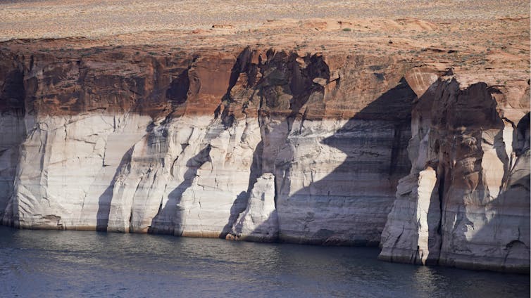
The U.S. Bureau of Reclamation is pursuing a supplemental Environmental Impact Statement (SEIS) process to evaluate the need to partially modify operating criteria for primary Colorado River reservoirs given extreme drought conditions and historically low reservoir levels at Lake Powell and Lake Mead.

While the groups are encouraged to see six of the Basin states put forward a “consensus based modeling alternative” for Reclamation to consider in the SEIS process, the groups seek to ensure that critical environmental concerns are considered in any operational actions that Reclamation models and evaluates.

As the Colorado River community considers operational changes, seven conservation organizations identify five (5) environmental priorities that are most directly linked to or implicated by the SEIS process, which is expected to be completed in the summer of 2023:

  • Investing federal funds in watershed health, long term resilience, and agricultural innovation in the Upper Basin tributaries with high fish and wildlife and recreational value;
  • Preserving the Endangered Fish Recovery Programs in the Upper Basin and the Lower Colorado River Multi-Species Conservation Program;
  • Safeguarding the integrity of the Grand Canyon ecosystem and recreational values;
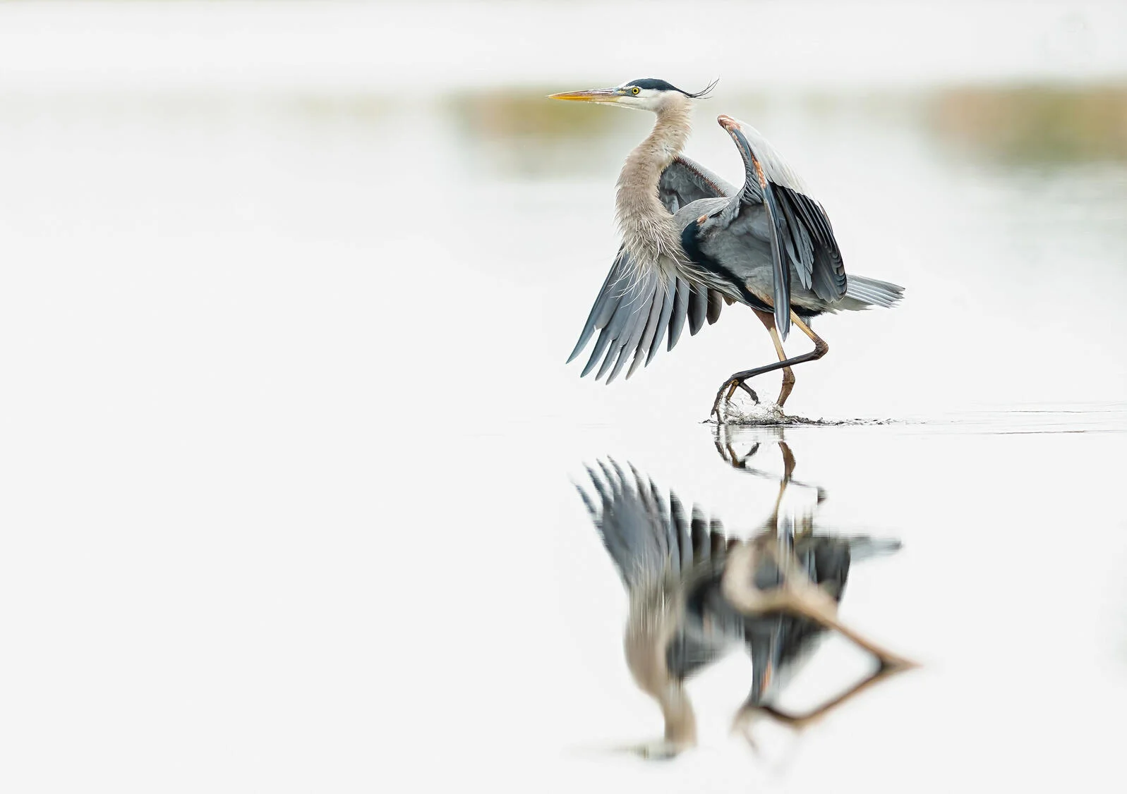
  • Restoring wetlands at the Salton Sea to minimize toxic dust and benefit bird habitat along the Pacific Flyway;
  • Forestalling the loss and continuing restoration of the Colorado River Delta.

“We highlight these particular priorities because, for the Colorado River community, they are closely tied to the continued integrity of the Colorado River Basin and are potentially most affected by the current SEIS process,” said Jennifer Pitt, Colorado River Program Director for National Audubon Society. “In the face of a hotter, drier climate, the Colorado River—and all of the living things depending on it—require that we stay focused on these priorities.”

“Whatever options Reclamation ultimately considers as part of the SEIS process, these environmental priorities cannot be lost in the mix or sacrificed in the name of a crisis, or we risk making the entire situation worse,” said Christy Plumer, chief conservation officer for Theodore Roosevelt Conservation Partnership.

“These and related priorities are essential to the continued sustainability of the Colorado River system.  Failing to consider them when making basin management decisions would undermine the ecological health of the Colorado River Basin, adding more potential for controversy in a Basin that needs to move forward—urgently—with consensus efforts to reduce water demand and restore the health of the watershed,” said Sara Porterfield, western water policy advisor for Trout Unlimited. 

“Our groups have worked hard over the last decade to find environmental solutions that also benefit water users. We want to ensure those hard-won solutions and benefits aren’t sacrificed because of interstate disputes over water allocations,” said Taylor Hawes, director of the Colorado River Program at The Nature Conservancy. “We know the Basin’s stakeholders are facing difficult decisions with dropping reservoir levels, drier soils, hotter temperatures, and that adjustments are needed now to deal with those issues in both the Upper and Lower Basins. Nevertheless, we don’t want to lose sight of the risks to the extraordinary natural heritage of the Colorado River,” Hawes added.

“We stand ready to work with Basin states, Tribes, water users, and the federal government to ensure that the SEIS process is sufficiently transparent, efficient, and comprehensive,” said Kevin Moran, associate vice president of regional affairs for Environmental Defense Fund.

As #ClimateChange and overuse shrink #LakePowell, the emergent landscape is coming back to life – and posing new challenges #ColoradoRiver #COriver #aridification

The white ‘bathtub ring’ around Lake Powell, which is roughly 110 feet high, shows the former high water mark. AP Photo/Rick Bowmer

Daniel Craig McCool, University of Utah

As Western states haggle over reducing water use because of declining flows in the Colorado River Basin, a more hopeful drama is playing out in Glen Canyon.

Lake Powell, the second-largest U.S. reservoir, extends from northern Arizona into southern Utah. A critical water source for seven Colorado River Basin states, it has shrunk dramatically over the past 40 years.

An ongoing 22-year megadrought has lowered the water level to just 22.6% of “full pool,” and that trend is expected to continue. Federal officials assert that there are no plans to drain Lake Powell, but overuse and climate change are draining it anyway.

As the water drops, Glen Canyon – one of the most scenic areas in the U.S. West – is reappearing.

This landscape, which includes the Colorado River’s main channel and about 100 side canyons, was flooded starting in the mid-1960s with the completion of Glen Canyon Dam in northern Arizona. The area’s stunning beauty and unique features have led observers to call it “America’s lost national park.”

Lake Powell’s decline offers an unprecedented opportunity to recover the unique landscape at Glen Canyon. But managing this emergent landscape also presents serious political and environmental challenges. In my view, government agencies should start planning for them now.

A tarnished jewel

Glen Canyon Dam, which towers 710 feet high, was designed to create a water “bank account” for the Colorado River Basin. The U.S. Bureau of Reclamation touted Lake Powell as the “Jewel of the Colorado” and promised that it would be a motorboater’s paradise and an endless source of water and hydropower.

Lake Powell was so big that it took 17 years to fill to capacity. At full pool, it contained 27 million acre-feet of water – enough to cover 27 million acres of land to a depth of one foot – and Glen Canyon Dam’s turbines could generate 1,300 megawatts of power when the reservoir was high.

Soon the reservoir was drawing millions of boaters and water skiers every year. But starting in the late 1980s, its volume declined sharply as states drew more water from the Colorado River while climate change-induced drought reduced the river’s flow. Today the reservoir’s average volume is less than 6 million acre-feet.

Nearly every boat ramp is closed, and many of them sit far from the retreating reservoir. Hydropower production may cease as early as 2024 if the lake falls to “minimum power pool,” the lowest point at which the turbines can draw water. And water supplies to 40 million people are gravely endangered under current management scenarios.

These water supply issues have created a serious crisis in the basin, but there is also an opportunity to recover an amazing landscape. Over 100,000 acres of formerly flooded land have emerged, including world-class scenery that rivals some of the crown jewels of the U.S. national park system. https://www.youtube.com/embed/y7jm08U38c0?wmode=transparent&start=0 As Lake Powell recedes, it is uncovering formerly flooded land and things that past visitors left behind.

Bargained away

Glen Canyon made a deep impression on explorer John Wesley Powell when he surveyed the Colorado River starting in 1867. When Powell’s expedition floated through Glen Canyon in 1869, he wrote:

“On the walls, and back many miles into the country, numbers of monument-shaped buttes are observed. So we have a curious ensemble of wonderful features – carved walls, royal arches, glens, alcove gulches, mounds, and monuments … past these towering monuments, past these oak-set glens, past these fern-decked alcoves, past these mural curves, we glide hour after hour.”

A red rock cliff towers above trees and a small pool of water.
This side canyon emerged in recent years as Lake Powell shrank. The white ‘bathtub ring’ on the rock wall shows past water levels. Daniel Craig McCool, CC BY-ND

Glen Canyon remained relatively unknown until the late 1940s, when the Bureau of Reclamation proposed several large dams on the upper Colorado River for irrigation and hydropower. Environmentalists fiercely objected to one at Echo Park in Dinosaur National Monument on the Colorado-Utah border, alarmed by the prospect of building a dam in a national monument. Their campaign to block it succeeded – but in return they accepted a dam in Glen Canyon, a decision that former Sierra Club President David Brower later called his greatest regret.

New challenges

The first goal of managing the emergent landscape in Glen Canyon should be the inclusion of tribes in a co-management role. The Colorado River and its tributaries are managed through a complex maze of laws, court cases and regulations known as the “Law of the River.” In an act of stupendous injustice, the Law of the River ignored the water rights of Native Americans until courts stepped in and required western water users to consider their rights.

Tribes received no water allocation in the 1922 Colorado River Compact and were ignored or trivialized in subsequent legislation. Even though modern concepts of water management emphasize including all major stakeholders, tribes were excluded from the policymaking process.

There are 30 tribes in the Colorado River Basin, at least 19 of which have an association with Glen Canyon. They have rights to a substantial portion of the river’s flow, and there are thousands of Indigenous cultural sites in the canyon.

Another management challenge is the massive amounts of sediment that have accumulated in the canyon. “Colorado” means “colored red” in Spanish, a recognition of the silt-laden water. This silt used to build beaches in the Grand Canyon, just downstream, and created the Colorado River delta in Mexico.

But for the past 63 years, it has been accumulating in Lake Powell, where it now clogs some sections of the main channel and will eventually accumulate below the dam. Some of it is laced with toxic materials from mining decades ago. As more of the canyon is exposed, it may become necessary to create an active sediment management plan, including possible mechanical removal of some materials to protect public health.

The creation of Lake Powell also resulted in biological invasives, including nonnative fish and quagga mussels. Some of these problems will abate as the reservoir declines and a free-flowing river replaces stagnant still water.

On a more positive note, native plants are recolonizing side canyons as they become exposed, creating verdant canyon bottoms. Restoring natural ecosystems in the canyon will require innovative biological management strategies as the habitat changes back to a more natural landscape.

Finally, as the emergent landscape expands and side canyons recover their natural scenery, Glen Canyon will become a unique tourist magnet. As the main channel reverts to a flowing river, users will no longer need an expensive boat; anyone with a kayak, canoe or raft will be able to enjoy the beauty of the canyons.

Glen Canyon National Recreation Area, which includes over 1.25 million acres around Lake Powell, was created to cater to people in motorized boats on a flat-water surface. Its staff will need to develop new capabilities and an active visitor management plan to protect the canyon and prevent the kind of crowding that is overrunning other popular national parks.

Other landscapes are likely to emerge across the West as climate change reshapes the region and numerous reservoirs decline. With proper planning, Glen Canyon can provide a lesson in how to manage them.

Daniel Craig McCool, Professor Emeritus of Political Science, University of Utah

This article is republished from The Conversation under a Creative Commons license. Read the original article.

Department of Interior funds 5 tribal #water rights settlements in #Arizona — The Arizona Mirror

From the 2018 Tribal Water Study, this graphic shows the location of the 29 federally-recognized tribes in the Colorado River Basin. Map credit: USBR

by Shondiin Silversmith, Arizona Mirror
February 10, 2023

Several tribal nations will start seeing some funding as part of their water rights settlements, as the U.S. Department of the Interior has allocated nearly $580 million to start fulfilling Indian water rights claims. 

“Water is a sacred resource, and water rights are crucial to ensuring the health, safety, and empowerment of Tribal communities,” Secretary Deb Haaland said. “Through this funding, the Interior Department will continue to uphold our trust responsibilities and ensure that Tribal communities receive the water resources they have long been promised.”

Five tribes in Arizona will receive more than $306 million in funding from the settlement: the Ak-Chin Indian Community, Gila River Indian Community, Navajo Nation, San Carlos Apache Tribe and Tohono O’odham Nation.

The money will help each tribe develop infrastructure projects that will fulfill the terms of their water rights settlements.

“I am grateful that Tribes, some of whom have been waiting for this funding for decades, are finally getting the resources they are owed with the help of this crucial funding from President Biden’s Bipartisan Infrastructure Law,” Haaland said.

Part of the funding comes from the Bipartisan Infrastructure Law’s Indian Water Rights Settlement Completion Fund, where nearly $460 million will be applied to settlements enacted before Nov. 15, 2021. 

An additional $120 million has been allocated from the Reclamation Water Settlement Fund, a fund created by Congress in 2009 that receives $120 million in mandatory funding annually from 2020 through 2029. 

Together, both funds allocated nearly $580 million to fulfill 14 tribal water settlement claims from 12 tribal nations.

“The federal government’s trust responsibility to Native communities includes providing Tribes with access to clean, reliable water,” said U.S. Sen. Brian Schatz, D-Hawaii, the chairman of the United States Senate Committee on Indian Affairs. 

Schatz said the Department of Interior’s funding announcement shows leaders following through on the work legislatures did to” pass and fund Indian water rights settlements to ensure water security for Tribes and surrounding communities.”

There are 34 congressionally enacted Indian Water Rights settlements as of Nov. 15, 2021, when the Bipartisan Infrastructure Law was signed, which included $2.5 billion to implement the Indian Water Rights Settlement Completion Fund. 

The Department of Interior stated that it will help deliver long-promised water resources to Tribes, certainty to all their non-Native neighbors, and a solid foundation for future economic development for entire communities dependent on common water resources.

“As a champion of the Bipartisan Infrastructure Law in the House, I’m excited to see this significant investment in Arizona’s Tribal communities,” U.S. Rep. Ruban Gallego said in a statement.

Gallego, a Phoenix Democrat, said that Arizona is experiencing the devastating impacts of a 1,200-year drought, but the funding will go a long way to help secure Arizona’s water which ensures a sustainable water future and follows through on tribal water settlements.

Indian reserved water rights are vested property rights for which the United States has a trust responsibility, according to the department. The federal policy supports the resolution of disputes regarding Indian water rights through negotiated settlements. 

For Arizona, this funding supports five specific settlements:

  • $22,000,000: Ak-Chin Indian Water Rights Settlement Operations, Maintenance & Replacement
  • $18,225,000: AZ Water Settlements Act Implementation – San Carlos Irrigation Project Rehabilitation
  • $79,000,000: Gila River Indian Community – Pima Maricopa Irrigation Project
  • $1,500,000: San Carlos Apache Tribe Distribution System
  • $8,000,000: So. Arizona Water Rights Settlement – Farm Extension

The Navajo Nation is included in these settlements, and their funding will support projects they have established in the New Mexico and Utah portions of their tribal land. The settlements include:

  • $2,000,000: Navajo-Gallup Water Supply Operations, Maintenance & Replacement   
  • $137,000,000: Navajo-Gallup Water Supply Project 
  • $39,114,000: Navajo-Utah Water Settlement