#LakePowell: What is it good for? — @Land_Desk #ColoradoRiver #COriver #aridification #snowpack (February 2, 2023)

Click the link to read the article on The Land Desk website (Jonathan P. Thompson):

Absolutely nothing? 

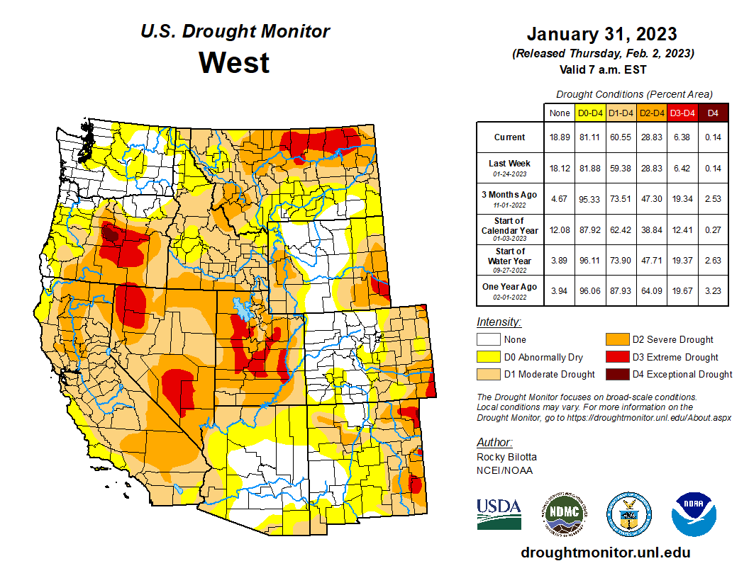
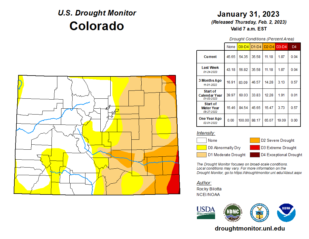
Sometimes it seems that way, doesn’t it? Unlike other dams, Glen Canyon does not provide any meaningful flood control (except for in the Grand Canyon). It doesn’t regulate streamflow to stretch out the irrigation season (because there are virtually no fields to irrigate between Glen Canyon Dam and the upper end of Lake Mead). And it isn’t so great at storing excess water since, well, there is no excess water. At best it serves as an overflow basin for when Lake Mead fills up. But with both Lake Powell and Lake Mead holding only about 25% of their total capacity, the upper reservoir has become redundant — at least from a water storage standpoint.

Paddling Powell. Photo by Jonathan P. Thompson.

It is from this redundancy that the Fill Mead First philosophy has emerged. Wouldn’t it make more sense, adherents of this school ask, to drain Lake Powell and put what water remains there into Lake Mead, so that you’d have one half-full reservoir rather than two quarter-full ones? So that you’d have billions of gallons of water evaporating off just one reservoir rather than two? 

It’s a great question. And it brings up another one: Why Lake Powell? As in, what purpose does Glen Canyon Dam still serve in a climate-changed, diminished Colorado River world? 

Let me start by saying that I believe the construction of Glen Canyon Dam was a crime against Nature. It inundated countless cultural sites, killed 186 miles of the mainstem of the Colorado River along with hundreds of additional miles of side canyons and tributaries, and deprived everyone born after 1963 of the opportunity to experience one of our nation’s natural marvels. It radically altered the ecology of the Grand Canyon and further endangered already imperiled native fish.

Delph Carpenter’s original map showing a reservoir at Glen Canyon and one at Black Canyon via Greg Hobbs

For what was this sacrifice made? Primarily it was to enable the Upper Colorado River Basin states to comply with the Colorado River Compact

The Compact did two big things: First, it divided the assumed average annual flows of the river between the Upper Basin states (Colorado, Wyoming, Utah, and New Mexico) and the Lower Basin states (California, Arizona, Nevada). The Lower Basin got 8.5 million acre-feet per year; the Upper Basin got 7.5 million acre-feet per year. Mexico was added later, getting 1.5 million acre-feet. 

But there was something else: To ensure the Lower Basin would get its share, the Compact mandates that the Upper Basin “not cause the flow of the river at Lee Ferry to be depleted below an aggregate of 75 million acre-feet” for any 10-year period. In other words, the Upper Basin couldn’t merely take out its 7.5 MAF share each year and let whatever remained run down to their downstream compatriots. It had to deliver an annual average of 7.5 MAF. 

That’s no problem during big water years, but during years when less than 15 MAF is in the river, the Upper Basin would have had to reduce its take accordingly, while the Lower folks would still get their share. During some dry years, the total flow of the river has been lower than 7.5 MAF, meaning the Upper Basin States would be left high and dry.

September 21, 1923, 9:00 a.m. — Colorado River at Lees Ferry. From right bank on line with Klohr’s house and gage house. Old “Dugway” or inclined gage shows to left of gage house. Gage height 11.05′, discharge 27,000 cfs. Lens 16, time =1/25, camera supported. Photo by G.C. Stevens of the USGS. Source: 1921-1937 Surface Water Records File, Colorado R. @ Lees Ferry, Laguna Niguel Federal Records Center, Accession No. 57-78-0006, Box 2 of 2 , Location No. MB053635.

Unless they had a savings account. Or, in this case, a dam and reservoir above Lee Ferry capable of storing enough water during wet years to be able to release the Lower Basin’s 7.5 MAF during even the driest years, i.e. Glen Canyon Dam and Lake Powell. If not for Lake Powell, the Upper Basin States would have been in deep doo doo over the last couple of decades, because they would have had to substantially cut consumption or go to war with California for failing to deliver the required water to the Lower Basin. 

So you could say that the Colorado River Compact’s downstream delivery mandate is the main reason we now are cursed or blessed with Lake Powell. It’s also perhaps the biggest hurdle for Fill Mead First folks to clear: You can’t really get rid of Glen Canyon Dam without scrapping the Compact, for better or worse. 

The mandate and the reservoir have another consequence: It forces the Upper Basin States to count evaporation losses against its consumptive use of the River (because it has to deliver the 7.5 MAF after evaporation occurs). Meanwhile, the Lower Basin States can simply take their allotted share out of the river, regardless of evaporation: Another inequity baked into the system. 

Glen Canyon Dam serves other purposes, too, such as:

  • Silt Control: Well, control may not be the right word, since no one has control over the clay and mud and sand (and other less savory sediments) that are carried down the Colorado and San Juan Rivers. But Lake Powell does a good job of catching the silt and keeping it from continuing downstream to clog up Lake Mead. Silt was piling up in Mead at a rate of up to 137,000 acre-feet per year before Glen Canyon. Now it’s down to less than 10,000 acre-feet annually, thanks to that big silt-catcher upstream. 
  • Hydropower Production: We’ve written about this one a lot. The short version: If you did away with Glen Canyon Dam, you’d be depriving the grid of enough electricity annually to power about a quarter of a million homes in the Southwest. It would also drain between $100 million and $200 million annually from dam electricity sales, which helps fund endangered fish recovery programs. That said, by putting that water in Lake Mead, you’d offset some of that loss by increasing the generating capacity of Hoover Dam’s hydroelectric plant. 
  • Recreation: I will confess that when the Blue Ribbon Coalition announced its “Fill Lake Powell: The path to 3,588” initiative last year, I laughed. After all, the motorized recreation lobbying group was calling for massive consumption cuts by all of the Colorado River’s users not to save the River or keep the system from collapsing, but to keep Lake Powell boatable. That just seemed like some slightly lopsided prioritizing. But then a friend and Lake Powell lover called me out on it, and I do have to admit that I’ve done some recreating on Powell, myself, and loved it.

The first time I saw Lake Powell was in the mid-1970s when the reservoir was still filling up. My parents’ friends had rented a houseboat and we spent a week or so with them exploring side canyons, camping, swimming — which for me was floating around in my life jacket — in the warm waters, and hiking to out-of-the-way places that the reservoir and boat had made easily accessible. 

There’s something surreal, even shocking about this vast body of water within an arid sea of stone. It’s easy to imagine someone heading off from their houseboat for a hike, getting lost, running out of water, and dying of thirst on a precipice hanging out over a 300-foot vertical drop to a trillion gallons of water. It’s otherworldly in that it seems horribly out of place on this world, which maybe is why it played the part of a post-apocalyptic planet in the opening scene of Planet of the Apes.

But the otherworldliness is part of the appeal, I suppose. Over the years I would return to Lake Powell with friends to camp out on the sandstone shores, sometimes getting there with boats, other times taking creaky old cars on sandy backroads to sections of shoreline that are now miles from the water. We spent a Summer Solstice or two on the reservoir and it was so damned hot and the days so long that early each morning I’d peel myself out of my sun-cooked and sweat-soaked sleeping bag and head straight for the tepid water.

It was usually a lot of fun: A luxurious change from the death march backpacking trips I tended to go on and a sort of novelty to be able to go on a big swim behind the Slickrock Curtain. Well, besides that time that some friends and I encountered a half-submerged cow carcass in the murky water near shore, its legs jutting skyward out of a horribly bloated body, Coors Light cans floating nearby like offerings to a bovine God. But hey.

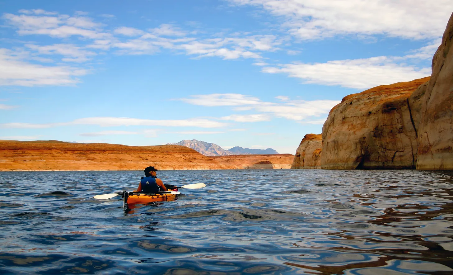
Back in 2006 or 2007 my wife Wendy headed to Powell for a different sort of trip, setting out from Halls Crossing Marina in sea kayaks for a three-day tour. There’s something eerie about being right down in the glassy, dark water like that. When out in the main channel I tried not to think about how those waters went down below me for hundreds of feet. I tried not to think about the story my cousins used to tell about how divers searching for one of the reservoir’s many victims didn’t find the body but did encounter 12-foot-long catfish in the depths. I tried not to think of what would happen if one of those monster houseboats crashed into me in my skinny little skiff. But all in all it was a marvelous trip and a great way to see that part of the world. I’ve been plotting a longer journey ever since, one in which maybe we hitch a ride with a motor boat up the Escalante or something.

My experiences notwithstanding, recreation at Lake Powell is not only big business, but has also become critical to the economies of the communities that have sprouted near its shores. A National Park Service study found nearly 3 million visitors to Glen Canyon National Recreation Area spent $332 million in and around the park in 2021 (down from $420 million in 2019 when reservoir levels were higher). 

Page, Arizona, was established to house the workers who constructed Glen Canyon Dam, and later became the park’s main gateway community, housing its employees, boats, and businesses that cater to park visitors. When the Navajo Generating Station coal plant shut down in 2019, a lot of folks worried that Page would collapse, economically. But it’s stayed afloat — pardon the pun — thanks in part to Lake Powell tourism. 

If you drained Lake Powell would tourism to the area dry up, too? I doubt it. Plenty of folks — myself included — would flock to the place to see what the actual canyon looks like, even if it is half silted over. Others, I’m sure, would want to witness the carnage of climate change wrought collapse. Hell, I’d pay good money to be on a house boat as the reservoir drained just to see the place revealed in real time. 

I suspect Powell will be drained or drain itself in the next few decades, but I doubt it will happen in the next few years. The Bureau of Reclamation is clearly intent on keeping reservoir levels viable for as long as possible, even if it means bringing the hammer down on the states and forcing cuts in consumption. Combine those efforts with a few good snow years and, who knows, the reservoir might just rebound somewhat.

The Land Desk is a reader-supported publication, which means we’ve got no advertisers, corporate sponsors or product placement deals. All we’ve got is you. So, if you’d like to support the Land Desk, sign up for a paid subscription.

West snowpack basin-filled map February 1, 2023 via the NRCS.

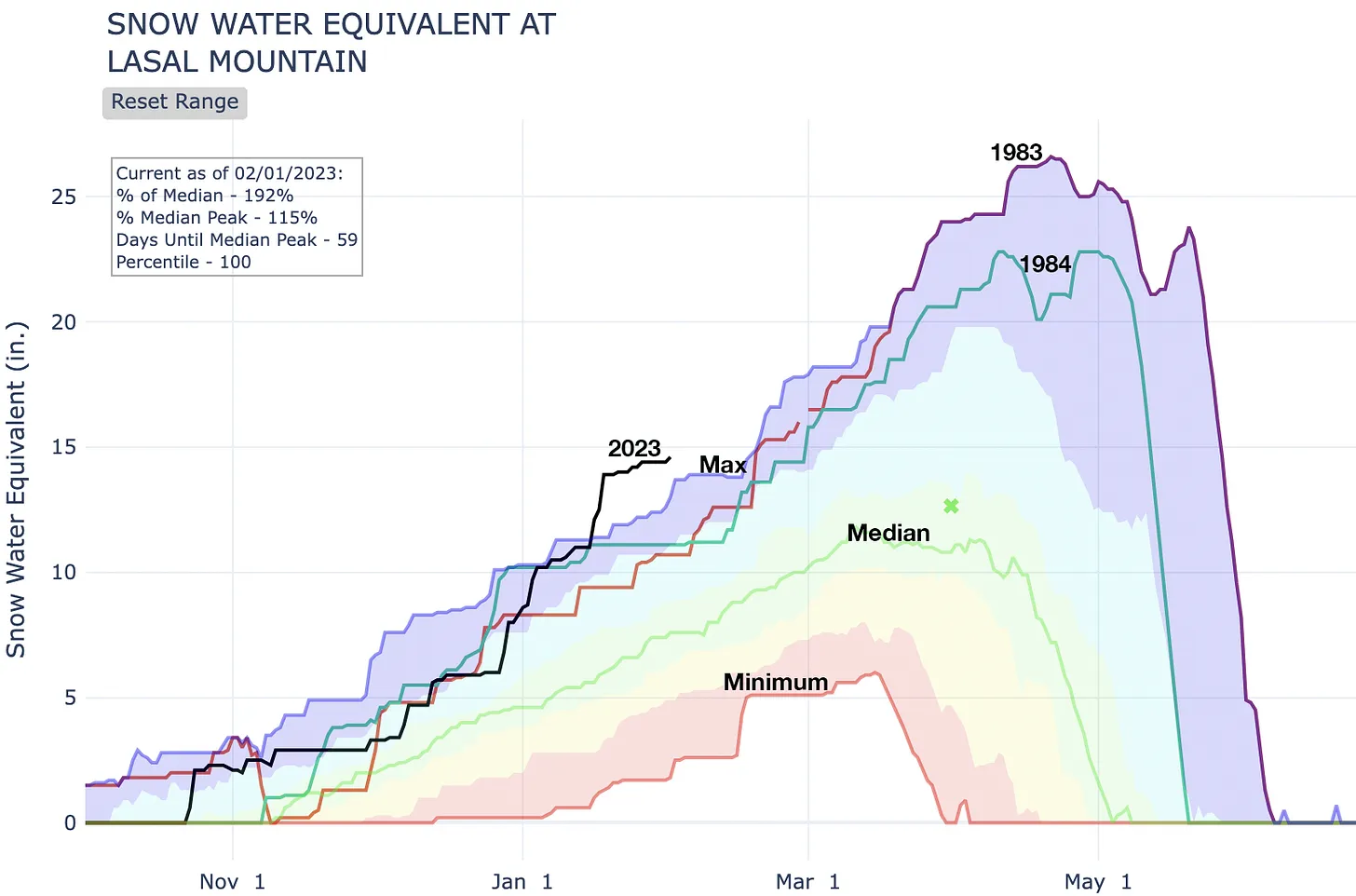
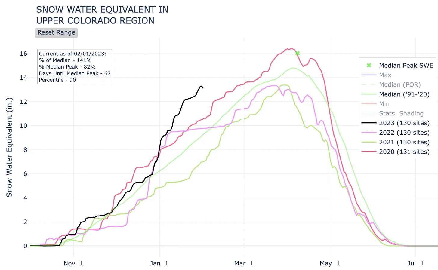
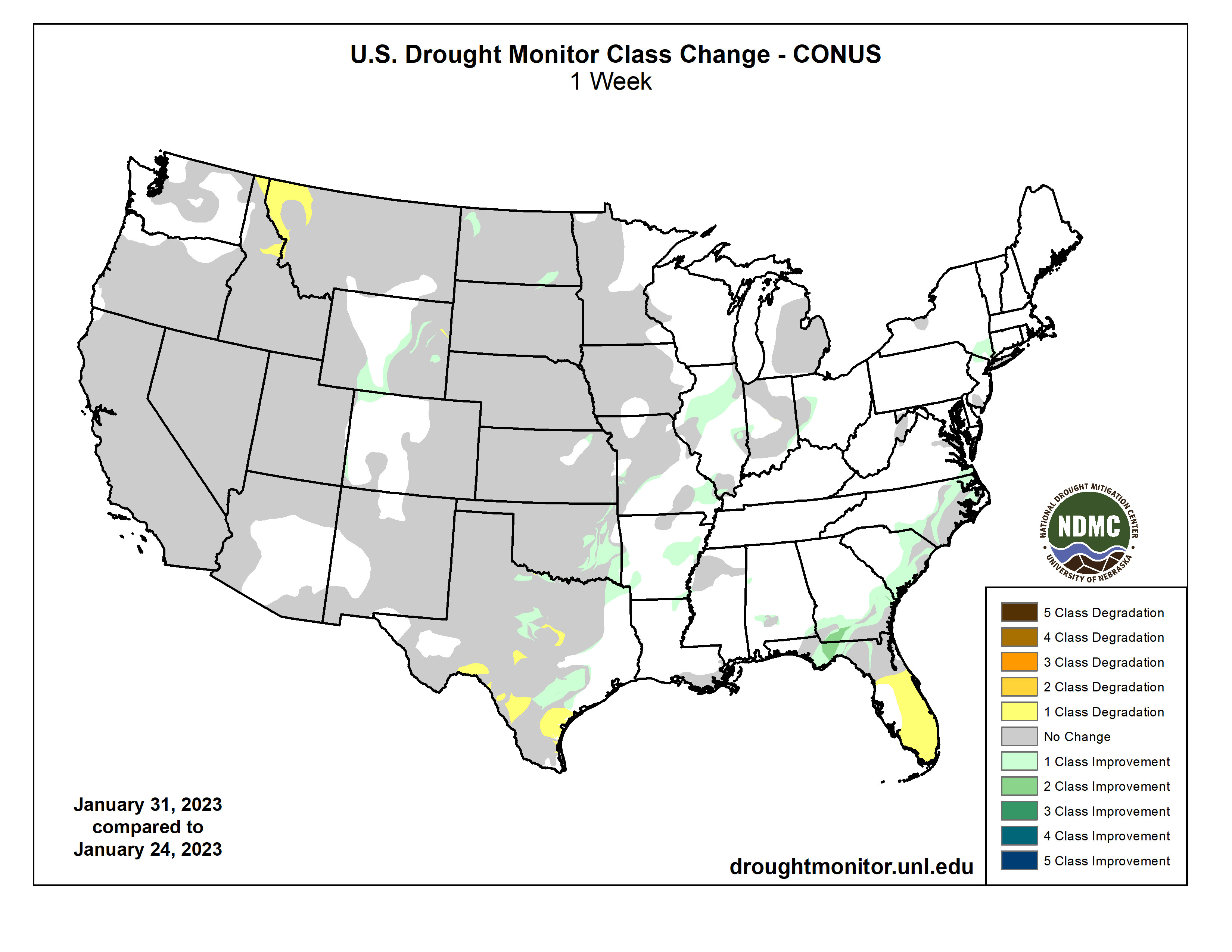
I don’t want to jinx it, but maybe, just maybe, this is going to be one of those good spring runoff years of yore. The snow is piling up at above average rates, but it is still early: We may be two-thirds of the way through meteorological winter (Dec-Feb), but not even halfway through the big snow season, which can stretch into May. There’s still time for the snow-deluge to turn to drought. 

Oh, and then there are the party poopers who are saying a good snow year is actually bad because it will cause people to let their guards down and ease up on efforts to conserve. 

But what the hell, I’m gonna celebrate. Because you know what? There’s a s%$t-ton of snow out there, which is great for the ski areas and the rivers, sure, but best of all it means even lowlanders can go nordic skiing at the golf course, just like in the good ol’ days. Here’s some of the graphs that really stood out for me:

Wait, what?! Not only is the snowpack in Southeastern Utah’s La Sal Mountains nearly double what it normally is this time of year, but it’s 15% above the median peak level for the entire year. More remarkable, it’s higher than ever for this date — there’s even more liquid than in the monster years of 1983 and 1984 (when Glen Canyon Dam had a little spillover problem).
The Dolores River Basin has suffered from a string of drought years which has left irrigators a bit high and dry and the Dolores River downstream from McPhee Dam even drier. So, it’s good to see things looking a bit better this year, albeit not quite as snowy as the La Sals (which also feed the lower Lower Dolores). If snowfall trends continue, it might mean McPhee will fill up enough that dam operators will release enough water to make a river downstream. Who knows, maybe there will be enough flow for a few days for boating? Cross your fingers.
And, finally, we have the Colorado River Basin above Lake Powell. It’s well above median levels, and far surpasses 2021. The question now is whether the black line for 2023 will keep climbing, or plateau like it did around this time last year. In any event, it should probably keep the reservoir from sinking below critical minimum power pool levels this summer.

Deadpool Diaries: The numbers in the states’ two proposals — John Fleck @jfleck #ColoradoRiver #COriver #aridification

States’ proposal for Colorado River cuts. Lake Mead elevation along the x axis, millions of acre feet of cuts along the y axis. Credit: John Fleck

Click the link to read the article on the InkStain website (John Fleck):

Getting ready for an interview this morning with Mark Brodie at KJZZ (waving at my Phoenix friends!) I put together a table to make it easier to compare the six-state proposal submitted Monday to reduce Lower Colorado River Basin water use, and the California proposal submitted yesterday (Tues. 1/31/23).

Perhaps worth sharing here? “Elevation” is Lake Mead elevation, the numbers are million acre feet of total cuts.

Two keys to note.

First, despite big disagreements about how to approach this, we have unanimity among all seven states that very deep cuts in Lower Basin water use are needed. At the lowest Lake Mead elevations, the numbers are similar.

The difference is in timing. California’s cuts don’t kick in until later – essentially a gamble on good hydrology once again helping us avoid conflict by letting us use more water in the short term.

The six-state proposal says “go big” any time Mead drops below 1,050. The California proposal doesn’t start “going big” until 1,025.

The six-state proposal yanks the bandaid off now.

Under the current “most probable forecast” for the coming year, we’d end up in 2024 with:

  • Six state proposal: 3,168 million acre feet in cuts
  • California proposal: 2,188 million acre feet in cuts
TierElevation6-stateCalifornia
Tier 010901,7841,241
Tier 110752,1561,613
Tier 2a1,0502,9181,721
Tier 2b10452,9182,013
Tier 2c10402,9182,071
Tier 2d10352,9182,129
Tier 2e10303,1682,188
Tier 3a10253,1682,525
Tier 3b10203,3682,675
Tier 3c10153,3682,875
1,0103,3683,125
1,0053,3683,325

There are other differences too – huge disagreements on how to approach the allocation of the cuts! No time for that this morning, I’ve a book to write, but I hope to get back to that in the next few days, stay tuned.

Opinion: The 2023 session will determine #Colorado’s #water future — Abby Burk and Jessica Gelay #COleg #COWaterPlan

Colorado River February 2020. Photo: Abby Burk via Audubon Rockies.

“Water is the conversation. It will be the centerpiece of our agenda this year,” said newly elected Speaker of the House Julie McCluskie, setting the tone and elevating water issues for Colorado’s 2023 General Assembly.

It’s no secret Colorado’s rivers and streams are suffering and our state’s challenges are a good example of water crises gripping the American West. Parched rivers; stressed farms, livestock and fish; and more frequent floods and wildfires are all symptoms of the disruption wrought as climate change impacts our region and already strained water supply.

Abby Burk brings a lifetime love of rivers, particularly of the Colorado River and its tributaries. As the western rivers regional program manager for Audubon Rockies. Photo credit: Audubon Rockies

Colorado’s lawmakers and other leaders have a responsibility to ensure Coloradans have the tools we need to proactively respond to drought and its impacts — on the legislature’s opening day, Senate President Steve Fenberg made it clear water will be among the high priority items the General Assembly takes on. And Speaker McCluskie concurred, saying: “Colorado has to be seen as a leader in this space.” Gov. Jared Polis’s proposed 2023 budget has already highlighted support for addressing our state’s water challenges. Last year the federal government injected a once-in-a- generation allocation of public funds to support water needs in the West. Now action is needed within the Colorado legislature to increase funding and capacity to establish both immediate and long-term drought security and to protect clean drinking water alongside river and watershed health.

We’re excited to see the Governor’s budget request for a historic $25.2 million to advance implementation of the state’s water plan, providing capacity to meet increasing demands, to combat the effects of climate change, and to support the health of our rivers. It’s important to note: these state funds are vital for unlocking matching federal dollars, dollars that are expected to be leveraged for approximately $100 million worth of water project grants across the state — a 4-to-1 return on investment. By engaging local communities, investing federal funds in needed infrastructure projects, and empowering millions of people to take action to conserve water, Colorado will make significant progress toward responding to long-term climate trends.

Flows in the Colorado River have decreased by more than 20% in just the past 20 years, which is why improving the struggling Colorado River system has been, and remains, the top priority for Water for Colorado. A healthy and vibrant river system serves as habitat for wildlife, increases resilience to floods and wildfires, enhances the quality and availability of water and forage for livestock, bolsters critical rural recreation economies and provides numerous ecological services that protect our sources of clean drinking water. With increasing threats of extreme weather events, healthy and functioning streams are critical to ensuring resilient communities, and a thriving state. This is why we are supporting efforts by the state’s Department of Natural Resources to pass legislation clarifying stream restoration projects can proceed without unnecessary red tape; and also why we support Governor Polis’s budget request to increase Colorado’s ability to leverage federal funds and assist with the crisis we are facing on the Colorado River.

Water policy is no longer a niche issue. Water conversations are happening at every level of state leadership — from the Governor’s office, to the General Assembly, to the Attorney General’s office — and across issue areas this session, making national headlines week after week. For example, as Governor Polis and the General Assembly seek to address land-use patterns and the affordable housing crisis, they are inserting water use into the conversation as a vital element. Integrating land use, development planning and more flexible water management can be another area on which our state leads.

Jessica Gelay Colorado Government Affairs Manager. Photo credit: Western Resource Advocates

The focus on water needs to be wide-ranging, but it also must be consistent. The time is now for Colorado to implement innovative policies that keep rivers flowing and proactively respond to drought conditions. In doing so, we will be a leader, showing other states how to do more with less, supporting the health of our river systems, and securing our state’s long-term vitality in the face of a hotter, drier future.

As Speaker McCluskie told us, the work ahead on water may be “the most challenging work the state has ever done.” While this is likely true, it may also be the most

rewarding — we can tell our children and grandchildren they live in a more resilient state because of the work conducted this session.

In his 2023 State of the State, Governor Polis reminded us “water is life in Colorado and the (W)est, it’s as simple as that.” The consequences of inaction this session are too great to consider. Failing to protect our water resources is not an option. Luckily, Colorado has the opportunity to not only protect our water resources in the near-term, but lead the charge toward longer-term drought resilience and climate resilience. It’s incumbent upon our lawmakers to secure Colorado’s water future. We look forward to working together to do so.

Abby Burk is Western Rivers Regional Program Manager for Audubon Rockies. Jessica Gelay is the Colorado Government Affairs Manager for Western Resource Advocates. Audubon Rockies and Western Resource Advocates are both members of the Water for Colorado Coalition.

#Drought news February 2, 2023: Improvements to moderate to severe (D1-D3) drought and abnormal dryness (D0) in eastern #Wyoming and improvements to abnormal dryness W. #Colorado

Click on a thumbnail graphic to view a gallery of data from the US Drought Monitor website.

Click the link to go to the US Drought Monitor website. Here’s an excerpt:

This Week’s Drought Summary

Winter storms brought heavy rain and snow much of the eastern U.S. and from the Pacific Northwest to the central Rockies this week with above-normal precipitation observed from the southern Plains to the Southeast and along the East Coast. Precipitation led to abnormal dryness and drought improvements in the central Plains, Midwest, Southeast and Northeast. Conversely, conditions worsened over dryer areas including Idaho/Montana, southern Texas and the Florida Panhandle. In the eastern United States, temperatures have been above-normal resulting in rain falling over many areas instead of snow. Many cities including New York, Baltimore, Philadelphia and Washington D.C. remain snowless for the season. New York City recently set a new latest first measurable snowfall previously set on Jan 29, 1973. In California, a series of atmospheric rivers brought significant amounts of rain which gave reservoirs a much-needed boost, but California lacks infrastructure to make use of such a massive rainfall. Despite the deluge, the winter storms may not have eased the state’s drought. In Hawaii, a strong low pressure system aloft combined with a low pressure trough at the surface to produce conditions favorable for heavy rainfall and flash flooding over portions of the main islands…

High Plains

A half an inch or more of precipitation fell across parts of Colorado and Wyoming, mainly in the higher elevations, resulting in improvements to moderate to severe (D1-D3) drought and abnormal dryness (D0) in eastern Wyoming and improvements to abnormal dryness western Colorado. Much of the High Plains remains in a holding pattern as areas that received abundant snowfall over the Water Year are slow to make improvements due to the long-term nature of drought in the region…

Colorado Drought Monitor one week change map ending January 31, 2023.

West

Precipitation was below-normal across the region, especially along the West Coast. Due to weeks of heavy precipitation, from a series of atmospheric rivers, halted most degradations or improvements this week despite the deluge, placing much of the region on a holding pattern. The rain did give reservoirs a much-needed boost, but California’s infrastructure is not set up to make use of such a massive rainfall. Because of California’s system of dams and levees, which try to control surface water flow, underground aquifers are not always able to recharge their overpumped supplies during heavy rain events. When rivers are restricted, less water comes into contact with soil surfaces and less water is therefore able to seep down into aquifers. In the drier areas of the West, moderate (D1) drought expanded into parts of northern Idaho and northwestern Montana due to continued degrading conditions that can be observed in soil moisture, streamflow, and precipitation deficits (up to five inches) for this area. In Utah, much of the state has above normal snowpack but no improvements were made this week based on the current issues with groundwater and depleted reservoirs…

South

A half an inch or more of precipitation fell across much of the South with the heaviest amounts falling across the eastern part of the region. Two inches of more of rainfall fell across parts of eastern Texas, Arkansas, Louisiana and Mississippi, which resulted in moderate to exceptional (D1-D4) drought and abnormal dryness (D0) improvements in Oklahoma; moderate to extreme (D1-D3) and abnormal dryness improvements in eastern Texas; and abnormal dryness improvements in Arkansas, Louisiana and Mississippi. Conversely, drought and abnormal dryness was expanded in western Texas due to lack of rain, precipitation deficits, drying soils and degrading streamflow in the area…

Looking Ahead

The National Weather Service Weather Prediction Center has forecasted a significant ice storm (valid January 30 – February 2) is forecasted to bring freezing rain, sleet, and ice accumulations over portions of the Southern Plains and Mid-South. The storm is expected to bring prolonged power outages and cause treacherous travel conditions. Moving into next week (valid February 4 – February 8), very chilly conditions are expected across the Northeast as cold air and gusty winds settle in under upper-level troughing. Dangerous wind chills and possibly new daily temperature records are in store for much of the Northeast region. Temperatures could stay below zero all day in parts of Maine and in the single digits in much of northern New England. This cold airmass is expected to sink further south along the Eastern Seaboard leading to temperatures 10-20F below normal. Temperatures are expected to rebound across the East as warmer temperatures over the central U.S. migrate eastward after the weekend. The West however could stay around 5-10F below average especially in terms of highs underneath upper troughing. A frontal system could spread some light snow to the Midwest/Great Lakes regions and Northeast this weekend, and amounts could be enhanced downwind of the Great Lakes. Light precipitation is possible along the Eastern Seaboard while the West could expect generally light to moderate precipitation in the form of lower elevation rain and higher elevation snow. At 8 – 14 days, the Climate Prediction Center Outlook (valid February 9 – February 15) calls for below-normal temperatures across much of the West, from the Pacific Northwest to the Southwest, and much of Alaska. Near-normal temperatures are expected in parts of the Northwest, northern and central Rockies and southern Plains, including southwest and eastern Alaska, while the eastern half of the contiguous U.S. and the Alaska Panhandle have the greatest probability of warmer-than-normal temperatures. Most of the U.S. can expect above-normal precipitation with the probability of near-normal precipitation occurring in much of the Northwest, the Florida Peninsula and northern Alaska and in parts of southern Texas.

US Drought Monitor one week change map ending January 31, 2023.

#Colorado joins five other #ColoradoRiver Basin states in #conservation plan — Sky-Hi News #COriver #aridification

Map credit: AGU

Click the link to read the article on the Sky-Hi News website (Kyle McCabe). Here’s an excerpt:

Six of the seven Colorado River Basin states agreed to a plan Monday, Jan. 30, to conserve water in the river and manage lakes Powell and Mead, a day before a federal deadline for the states to agree on voluntary water cuts passed. Politicians including Sen. Michael Bennet and Gove. Jared Polis applauded the six states’ collaboration…The six-state plan would not reach the 2 million acre-feet threshold, focusing many of its cuts on lower basin states, despite not having the approval of California, a lower basin state and the river’s largest consumer.

A news release from Bennet’s office quoted him as saying the plan “did exactly what was needed” and expressing his disappointment in California not agreeing to the plan. California instead submitted its own plan to the U.S. Bureau of Reclamation on Tuesday. Polis said in a news release that Colorado will also continue to follow the Upper Colorado River Commission’s 5-Point Plan from July 2022, which was the upper basin’s original response to the Bureau of Reclamation’s calls for conservation in June 2022.

Will basin states’ plans save operations at Glen Canyon, Hoover dams?: Federal government will mull proposals to save ailing #ColoradoRiver — The Deseret News #COriver #aridification

Glen Canyon Dam November 2022. Photo credit: USBR

Click the link to read the article on The Deseret News website (Amy Joi O’Donoghue). Here’s an excerpt:

Politics and threatened litigation are replacing what is left of the water in the Colorado River as the seven basin states that rely on the West’s largest river try to reach an agreement to cut flows so power generation can continue at Glen Canyon and Hoover dams. The directive to find some sort of definitive plan for dam operations by reducing flows was issued by the U.S. Bureau of Reclamation, which is tasked with making decisions to prop up the river that has been decimated by drought and over diversion through the years. The proposals do not change any of the states’ water allocations, for now, or affect any existing water rights. The plans will ultimately become part of a more comprehensive effort being worked on by the federal agency.

The Compact’s Signers. Photo via InkStain

It is more than a heavy lift for a river that was divided up under a compact forged more than 100 years ago in a remote location in New Mexico and subsequently shaped by regulations, court decisions and compacts that all coalesced into what is now known as the “Law of the River.”

[…]

“Instead of bending over backwards to prop up Lake Powell, officials should be making plans to save Lake Mead and utilize Glen Canyon as a backup facility,” said Eric Balken, executive director of Glen Canyon Institute. “There’s just not enough water to save both reservoirs, and Mead is more vital to the basin.”

The institute has long advocated for the draining of Lake Powell, the nation’s second largest reservoir behind Lake Mead.

On Monday, six of the states sharing the Colorado River — California later detailed its own plan — submitted what they described as a Consensus Based Modeling Alternative to the reclamation bureau. While not a formal agreement, they say it provides a step toward helping the federal agency as it crafts an environmental review going forward.

Among other things, the alternative details:

  • Additional combined reductions of 250,000 acre-feet to Arizona, California and Nevada at Lake Mead elevation 1,030 feet and below.
  • Additional combined reductions of 200,000 acre-feet to Arizona, California and Nevada at Lake Mead elevation 1,020 feet and below, as well as additional reductions necessary to protect Lake Mead elevation of 1,000 feet.

Those potential reductions are designed to keep Lake Mead’s Hoover Dam in operation.