
Click on a thumbnail graphic to view a gallery of drought data from the US Drought Monitor website.
Click the link to go to the US Drought Monitor website. Here’s an excerpt:
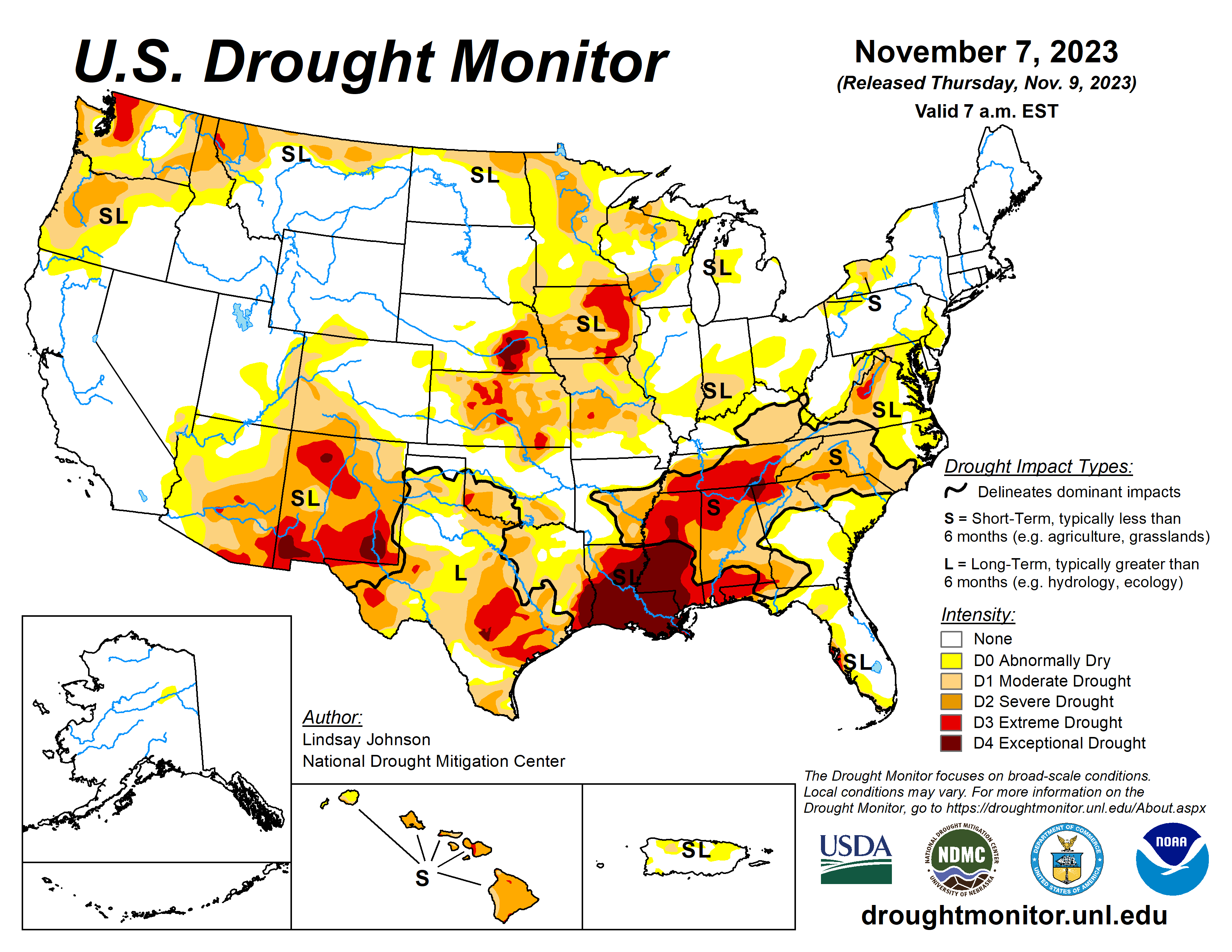
This Week’s Drought Summary
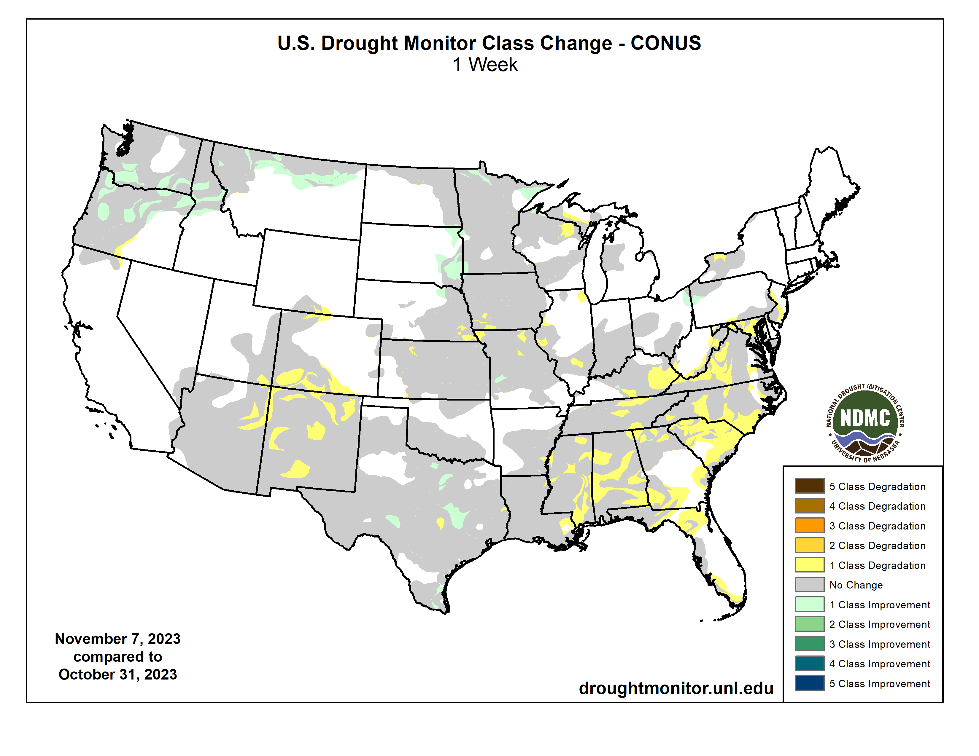
Residual impacts from the prior week’s storm continued to bring some improvements to the Pacific Northwest, northern Plains and upper Midwest. However, in the South and Southeast, conditions continue to rapidly deteriorate, leading to flash drought and widespread expansion of drought conditions.,,
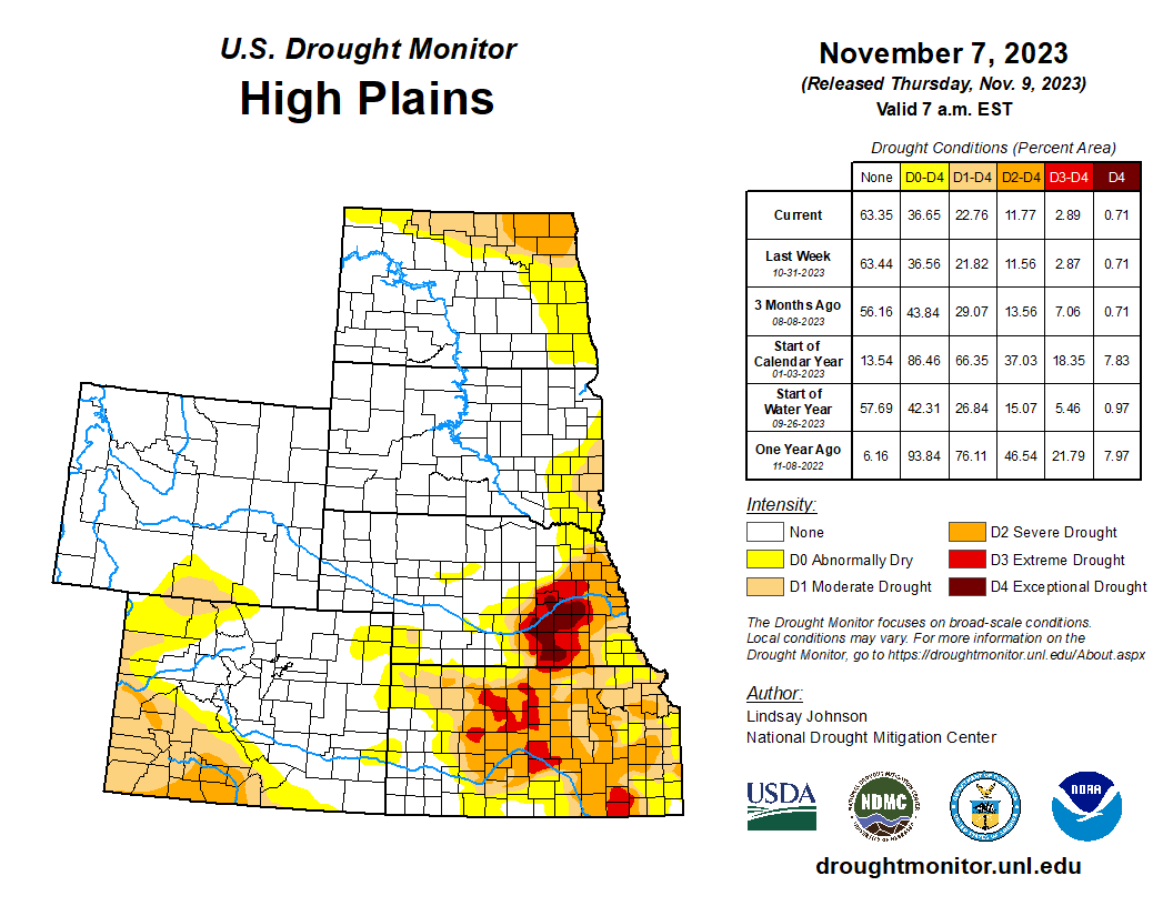
High Plains
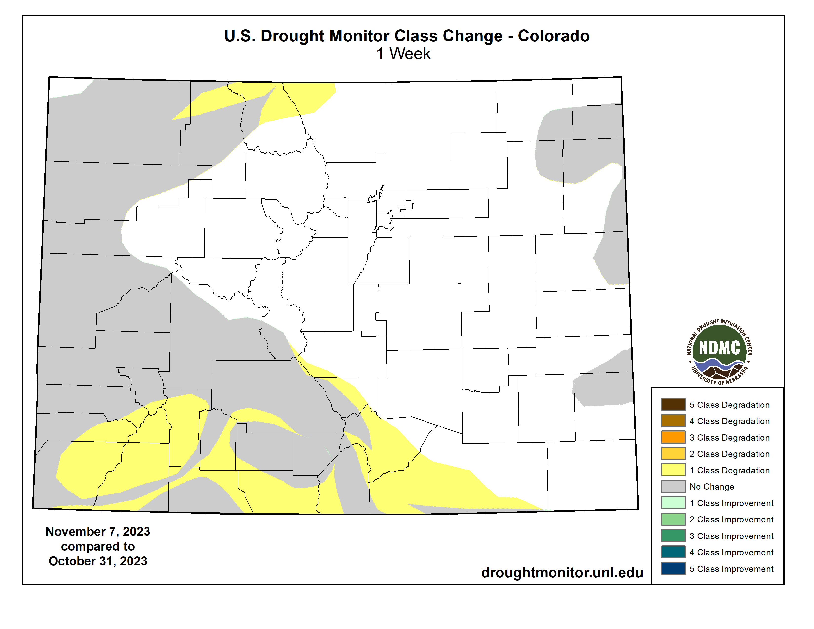
Dry conditions persisted across the High Plains where temperatures are above normal, with Wyoming and Colorado seeing temperatures of 3-8 degrees above normal. The eastern boundary experienced near- or slightly-above-normal temperatures, except for North Dakota where temperatures were 3 or more degrees below normal. South Dakota and northeastern Nebraska continued to see improvements as remnants of the past week’s precipitation aid in dry conditions. There were 1-category improvements along the eastern South Dakota and northeastern Nebraska borders. Areas in South Dakota are so wet that producers have reported issues with planting winter crops…
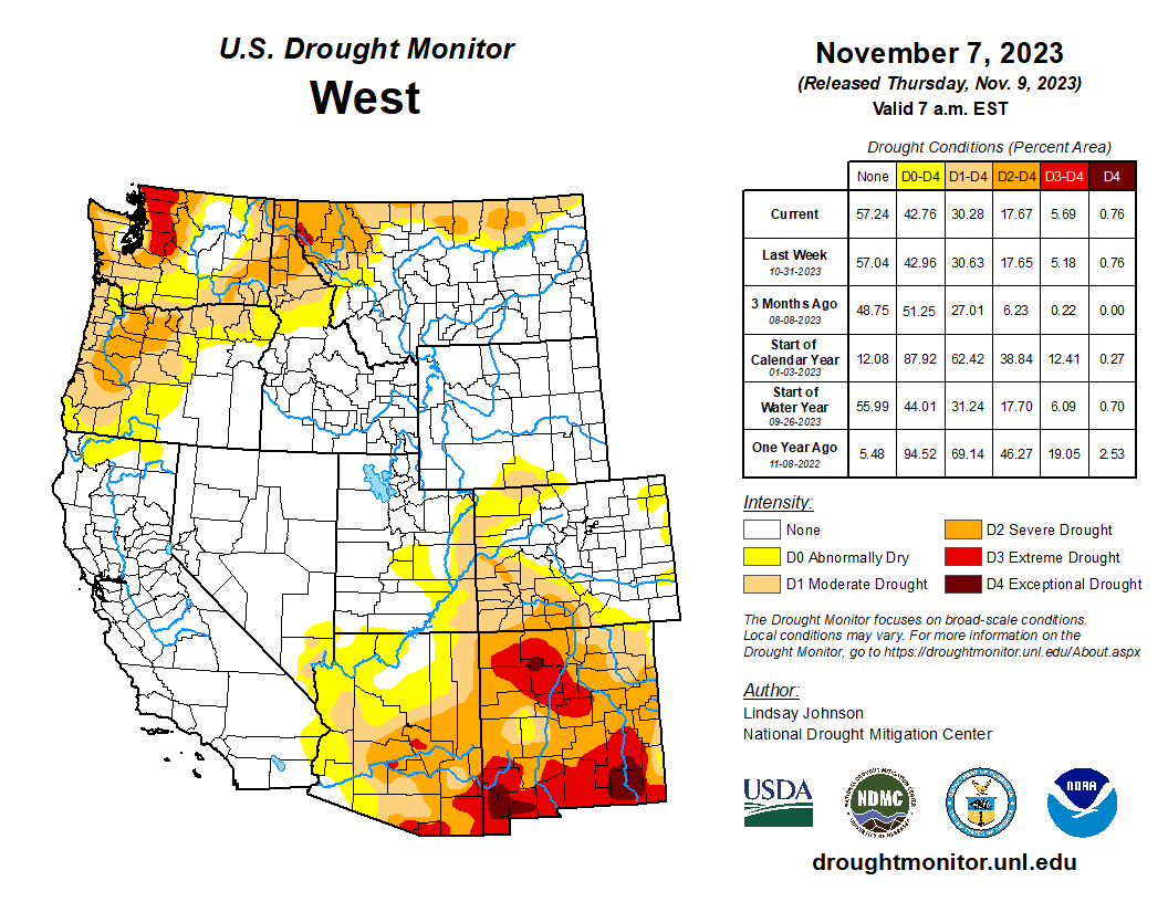
West
An atmospheric river cascaded over parts of the Pacific Northwest, bringing several inches of new rain and snow accumulation along with last week’s precipitation. With this continued influx of precipitation, modest 1-category improvements were made across the northwest, particularly on the windward side of the Cascade Range. Further improvements were seen in northern Idaho and Montana, which received up to 4 inches of precipitation in some areas. Despite the deluge of precipitation over the last one to two weeks, temperatures have been 1-3 degrees above normal, and south-central Montana even had temperatures of 6-9 degrees above normal. The remaining states in the West remained status quo…
South
Dry conditions continued across the South, with the entire region at or below 25% of normal precipitation. Despite this lack of precipitation, there was some relief in terms of temperatures, which were 2-4 degrees below normal. Areas of Louisiana and Mississippi were up to 8 degrees below normal. Louisiana and Mississippi did not see any drought relief, with 1-category degradations across the two states. In Louisiana, over 50% of the state is in Exceptional Drought, and in Mississippi rapid deterioration spilling eastward from Louisiana resulted in 1-category degradations. Tennessee is also in Extreme Drought, and Exceptional Drought was introduced along the tri-state border, along with Alabama and Georgia. Extreme and Severe drought also migrated northward. Texas and Oklahoma remained largely unchanged, with some improvements in central Texas and status quo conditions for Oklahoma…
Looking Ahead
Over the next five to seven days, much of the western and central Gulf Coast region will likely see 2-5 inches of precipitation as an unformed tropical depression makes its way north from Cuba into the western Gulf of Mexico. Some of this moisture will continue across the Southeast. The Casacade Mountian range and surrounding areas are likely to continue to receive more moisture. Temperatures are expected to be slightly below normal in Texas, the south Atlantic region and the Northeast. The High Plans and parts of the northern West and Midwest are likely to see maximum temperatures of 8-12 degrees above normal.
The six- to 10-day outlook shows a strong chance of above-normal temperatures centered over the eastern High Plains and western Midwest. Much of the rest of the county is also projected to experience above-normal temperatures. Below-normal precipitatation is forecasted across much of the northern regions from eastern Montana to Maryland and Maine. The West is projected to have above-normal precipitation, particularly in central and southern California as well as Alaska and Hawaii.
Just for grins here’s a slideshow of early November US Drought Monitor maps for the past several years.

US Drought Monitor map November 7, 2023. 
US Drought Monitor map November 1, 2022. 
US Drought Monitor map November 2, 2021. 
US Drought Monitor November 3, 2020. 
US Drought Monitor November 5, 2019. 
US Drought Monitor November 6, 2018. 
US Drought Monitor November 7, 2017. 
US Drought Monitor November 1, 2016. 
US Drought Monitor November 3, 2015 
US Drought Monitor November 4, 2014 
US Drought Monitor November 5, 2013 
US Drought Monitor November 5, 2012 
US Drought Monitor November 1, 2011 
US Drought Monitor November 2, 2010