

Click the link to read the article on the VoiceofSanDiego.org website (MacKenzie Elmer):
A trade deal is brewing between major southern California water agencies to help restock a major reservoir on the drought-stricken Colorado River and meet federal demands to cut back use.
San Diego, Los Angeles and Imperial Valley are the major players trying something that’s never been done before using a water trading agreement inked 20 years ago as a guiding light. Under the proposal, San Diego is going to give up some of its Colorado River water it fought so hard to secure so more can be saved in the larger river system. But instead, it would lean on supplies from northern California, a source that was virtually unavailable to the region due to drought just last year.
Here’s how it would play out: San Diego would forgo buying a portion of its Colorado River water supplies from Imperial Valley. The federal government would pay Imperial Valley not to take that water out of the river at all, then Imperial Valley would reimburse San Diego. Then San Diego would instead buy that same amount of water from California’s other (and cheaper) supply source – the Sierra Nevada mountain snowpack – via the Metropolitan Water District of Southern California.
The board of the Metropolitan Water District of Southern California or Met, based in Los Angeles, will be the first to consider the deal at its Nov. 13 meeting. The savings San Diego generates from switching supplies – potentially tens of millions of dollars — could help smooth future water rates in San Diego, said the San Diego County Water Authority General Manager Dan Denham.
“This is bringing more flexibility to water management in southern California,” Denham said. “If we’re able to pull this off then it speaks volumes for these water agencies and the federal government and show we’re able to work together.”
This is part of a larger plan to help the Imperial Irrigation District or IID – the Colorado River’s single largest user and from which San Diego buys much of its Colorado River water – meet its promise to the feds to cut its use by 115,000 acre feet this year – about four percent of its supply. (That’s enough to quench 230,000 California households’ indoor and outdoor water use in one year.)
The feds are paying IID to reduce its water use by that much. The price hasn’t been made public yet, but IID customers already pay some of the cheapest rates for Colorado River water around: about $20 an acre foot. San Diego buys its water from IID at a premium, about $710 an acre foot. It’s likely that the final reimbursement price from the feds will fall on the more expensive side of that range.
What’s interesting about this deal is San Diego and Met have historically been at each other’s throats over prices of imported water. So much so that the two are still involved in a lawsuit over how much San Diego should pay Met to get Colorado River water down south. It’s partly why San Diego cut a deal 20 years ago to buy most of its water from Imperial Valley instead.

But now, San Diego is turning back to Met for about 15 percent of its supply.
“We’re taking advantage of the wet year and putting water in Lake Mead to benefit the whole (Colorado River) system,” said Adel Hagekhalil, general manager at Met. The State Water Project refers to water from the Sierra Nevada mountains.
Even though it’s been a wet year, especially for California which drew most of the state out of drought, large swaths of the Colorado River basin are still dangerously dry, according to the U.S. Drought Monitor. The feds have told the seven U.S. states using the river they’ll need to figure out a way to use much less as climate change intensifies drought in the West. But last winter’s record-breaking rain and snow delivered a window for southern California water suppliers to spread that wealth of water around – for now.
There’s so much water flowing from that mountain range’s melted snowpack, Met is able to use that source instead of the Colorado River for much of its customer day – about 19 million people. Because Met has two water sources, the Colorado River and the California mountains, it can lean on its California supply when water is plentiful and then, like a savings account, store water in the river’s largest reservoir (Lake Mead behind Hoover Dam) to use on a less-rainy day.
Met has so much water it plans on maxing-out its savings account by banking 450,000 acre feet of water in Lake Mead, Hagekhalil said. And it will make a little extra money by selling more water to San Diego.
“What you end up with is a win-win for everybody,” Hagekhalil said.
The proposed deal would be temporary or in place just for 2023, according to a Met board document.

Click the link to read the article on the Pagosa Springs Sun website (Josh Pike). Here’s an excerpt:
The Archuleta County Board of County Commissioners (BoCC) heard a proposal from Planning Manager Owen O’Dell and Water Quality Manager Kevin Torrez for the county Water Quality Department to take over plan reviews from San Juan Basin Public Health (SJBPH) at its Oct. 24 work session…[Kevin Torrez] explained that the Water Quality Department would oversee licensing of local septic system installers…Development Director Pamela Flowers stated that the cost for licensing would be approximately $50, which would cover administering a test created by the state and providing a certification document. [Torrez] highlighted that the Archuleta County Board of Health would ap- prove OWTS variances and that OWTS inspections would also occur upon transfer of title for a property with an OWTS…
Torrez briefly covered inspection and maintenance of high-level treatment systems before moving on to discussing lagoons, noting that lagoons are allowed if they were permitted before 1967. He indicated that there is an after- the-fact permitting system for unpermitted lagoons, but new lagoons are not allowed…Torrez explained that the Water Quality Department would inspect these lagoons and determine if they are functional and can receive a permit or if they need to be abandoned…
In response to a request for legal advice from [Verionica] Medina, [Todd] Weaver stated that this would be possible, noting that the laws governing the dissolution of health districts are limited. He added that he did not foresee a legal challenge to this change.
Click the link to access the article on the Science Advance website (Wu, Et al.) Here’s the abstract:
Abstract
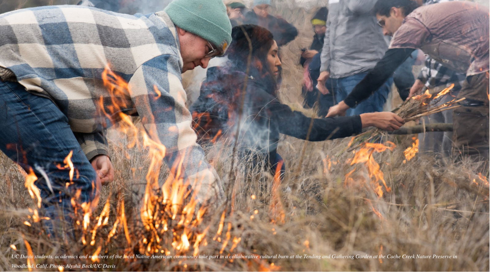
The increasing frequency of severe wildfires demands a shift in landscape management to mitigate their consequences. The role of managed, low-intensity fire as a driver of beneficial fuel treatment in fire-adapted ecosystems has drawn interest in both scientific and policy venues. Using a synthetic control approach to analyze 20 years of satellite-based fire activity data across 124,186 square kilometers of forests in California, we provide evidence that low-intensity fires substantially reduce the risk of future high-intensity fires. In conifer forests, the risk of high-intensity fire is reduced by 64.0% [95% confidence interval (CI): 41.2 to 77.9%] in areas recently burned at low intensity relative to comparable unburned areas, and protective effects last for at least 6 years (lower bound of one-sided 95% CI: 6 years). These findings support a policy transition from fire suppression to restoration, through increased use of prescribed fire, cultural burning, and managed wildfire, of a presuppression and precolonial fire regime in California.


Click the link to read the article on the Aspen Journalism website (Heather Sackett):
In Colorado, there are several ways to protect rivers, which vary depending on the goals.
To maintain water quality, the Colorado Department of Public Health and Environment offers an Outstanding Waters designation. If boosting the flows for boating is the goal, municipalities can get a Recreational In-Channel Diversion (RICD) water right. And to protect the environment, the state water board acquires instream-flow water rights, designed to maintain minimum flows.
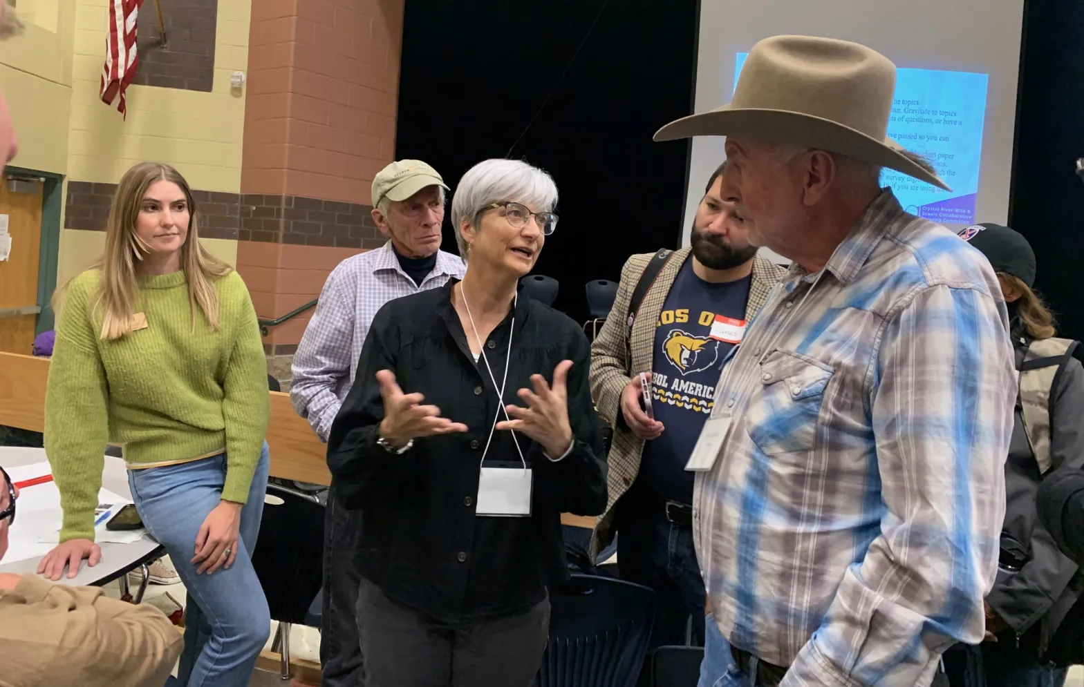
But if the goal is preventing dams and transbasin diversions, and guaranteeing a free-flowing river, experts say a federal Wild & Scenic designation is the gold standard. That was the message from some presenters at a community summit on the Crystal River on Thursday at Roaring Fork High School in Carbondale.
“It’s the strongest, most robust form of river protection,” said Jennifer Back, a retired employee of the National Park Service and former member of the Interagency Wild & Scenic Rivers Coordinating Council. “If you like what’s out there right now, Wild & Scenic River designation does a really good job of protecting what’s there.”
Back was one of eight presenters at Thursday’s [October 26, 2023] open house, organized by a steering committee that is exploring the feasibility of Wild & Scenic designation and other management and protection alternatives. The committee is chaired by representatives from the town of Marble, Gunnison County, Pitkin County and the Colorado River Water Conservation District.
The meeting, which drew about 130 people, was the second community summit of a public stakeholder process aimed at evaluating local interest in pursuing protections for the Crystal River, which flows about 40 miles from its headwaters, in the Maroon Bells-Snowmass Wilderness, and through the towns of Marble, Redstone and Carbondale before its confluence with the Roaring Fork River.
Some residents of the Crystal Valley, along with Pitkin County, have long been proponents of a Wild & Scenic designation. But others, wary of any federal involvement, have balked at the idea.
Manette Anderson, one of just a handful of residents of Crystal, a tiny historic hamlet named for the river, is a member of the steering committee. She said she’s still learning and that it’s too early in the process for her to yet be in favor of, or dismiss, any of the options.
“Going into all this, I thought Wild & Scenic would probably not be an option I would be interested in, generally speaking, because of anecdotal concerns that other people in other areas of the country have had with Wild & Scenic experiences,” she said. “But I’m open to learning about it.”
The U.S. Forest Service determined in the 1980s that portions of the Crystal River were eligible for designation under the Wild & Scenic River Act, which seeks to preserve in a free-flowing condition, rivers with outstandingly remarkable scenic, recreational, geologic, fish and wildlife, historic and cultural values.
There are three categories under a designation: wild, which describes sections inaccessible except by trail, with shorelines that are primitive; scenic, which describes shorelines largely undeveloped but accessible by roads in some places; and recreational, which describe places readily accessible by road or railroad and that have development along the shoreline.
The initial Forest Service proposal for the Crystal included all three designations: wild in the upper reaches of the river’s wilderness headwaters; scenic in the middle stretches; and recreational from Marble to the Sweet Jessup canal headgate. Each river with a Wild & Scenic designation has unique legislation written for it that can be customized to address local stakeholders’ values and concerns.
Any designation would take place upstream from the big agricultural diversions on the lower portion of the river near Carbondale.
According to Back, the management framework for a Wild & Scenic River can be as unique as the river itself, and involve cooperative agreements between federal, state and local agencies. The “teeth” of the designation, she said, comes from an outright prohibition on federal funding or licensing of any new Federal Energy Regulatory Commission (FERC)-permitted dam. A designation would also require review of federally assisted water resource projects.
“What we mean by that is a project that basically is in the waterway below the ordinary high-water mark,” she said. “It could be a bridge; it could be a road; it could be power lines. It’s not an outright prohibition, but they do have to be reviewed before the project goes forward.”
Back said there are 228 rivers in the country with a Wild & Scenic designation. Many of them are in Alaska and the Pacific Northwest. But with water managers historically unwilling to tie up potential future water development, Colorado has just 76 miles of one river — the Cache la Poudre — designated as Wild & Scenic.
Protection options
In addition to Outstanding Waters, instream-flow water rights and RICDs, other potential river protections detailed at Thursday’s meeting include creating a National Conservation Area or Special Management Area (environmentalists are pursuing this on the Dolores River after determining that Wild & Scenic isn’t politically feasible there); 1041 regulations, which allow counties to maintain control over certain development; and local options such as riparian restoration projects and leasing agreements where water users can loan some of their water for the benefit of the environment.
Another option would be to create a management plan that doesn’t carry the same restrictions as Wild & Scenic but is still aimed at protecting ORVs, much like a stakeholder group on the upper Colorado River completed in 2020. This alternative management plan took more than 12 years to come to fruition, and participation of the stakeholders is voluntary.
Pitkin County Commissioner Kelly McNicholas-Kury, a member of the steering committee, said she continues to think that a Wild & Scenic designation is the best option for river protection that meets the criteria laid out by the stakeholder process: prevention of dams and out-of-basin diversions; sustainable recreation and tourism; support of local agriculture, water rights and property rights; limiting future development; and maintaining a healthy river corridor.
After Thursday’s presentations, attendees were asked to fill out a survey that ranked how well each option met these criteria.
A Wild & Scenic designation would not preclude any of the other protection options; multiple approaches could take place at the same time.
“Wild & Scenic would never get in the way of (Outstanding Waters), but Outstanding Waters is not going to give us what a Wild & Scenic River designation might,” McNicholas-Kury said.
According to McNicholas-Kury, the steering committee is striving for consensus among its members before it makes a recommendation to the public about a path forward for Crystal River protections. But if consensus cannot be reached, they can go to a super-majority vote that would require agreement of at least 75% of committee members.
“Folks have really come in with a desire to learn and a desire to keep an open mind,” she said. “I think there is a ton of consensus around wanting to protect the river, so I’m hopeful that we’ll get there.”

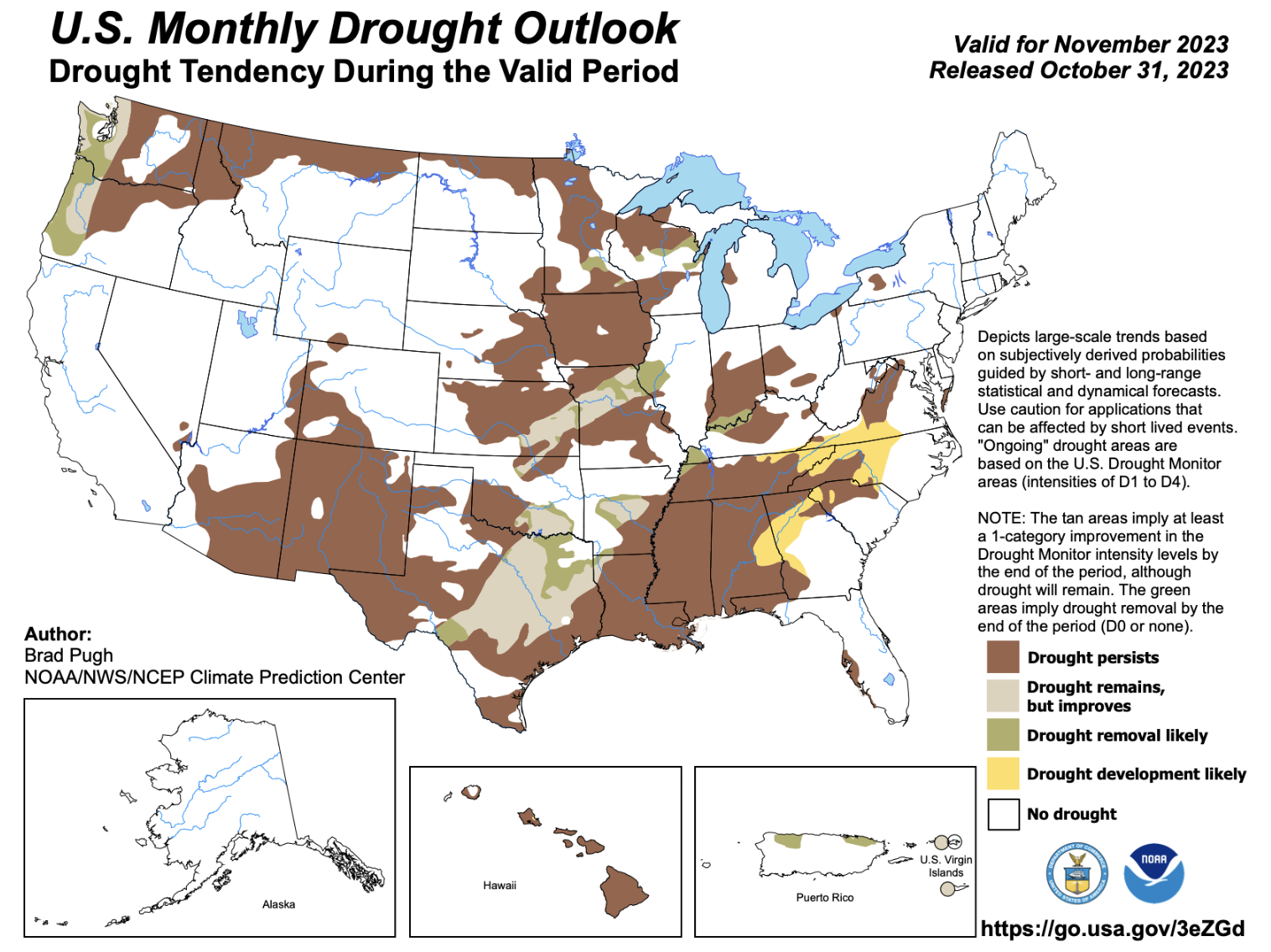
Click on a thumbnail graphic to view a gallery of drought data from the US Drought Monitor website.
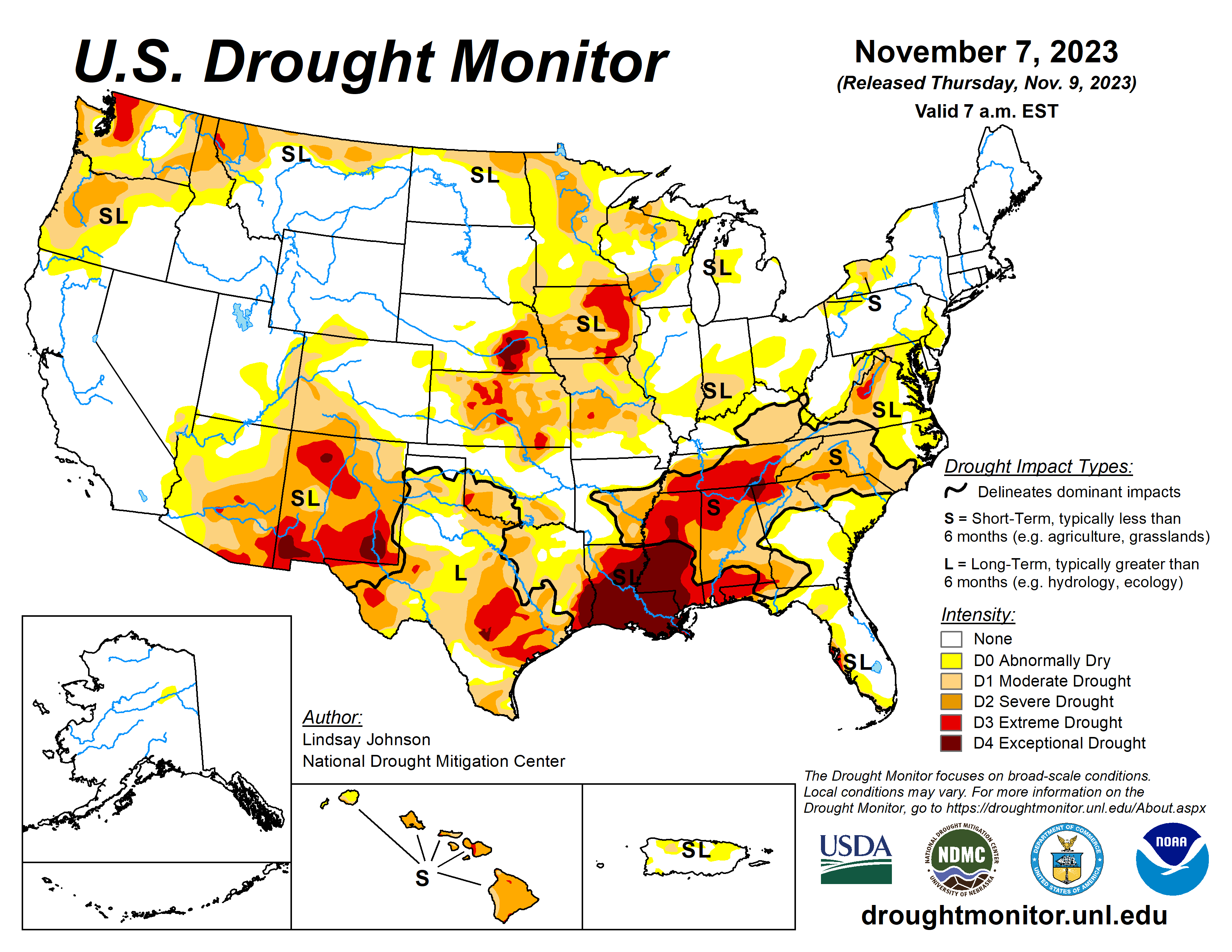
Click the link to go to the US Drought Monitor website. Here’s an excerpt:
This Week’s Drought Summary
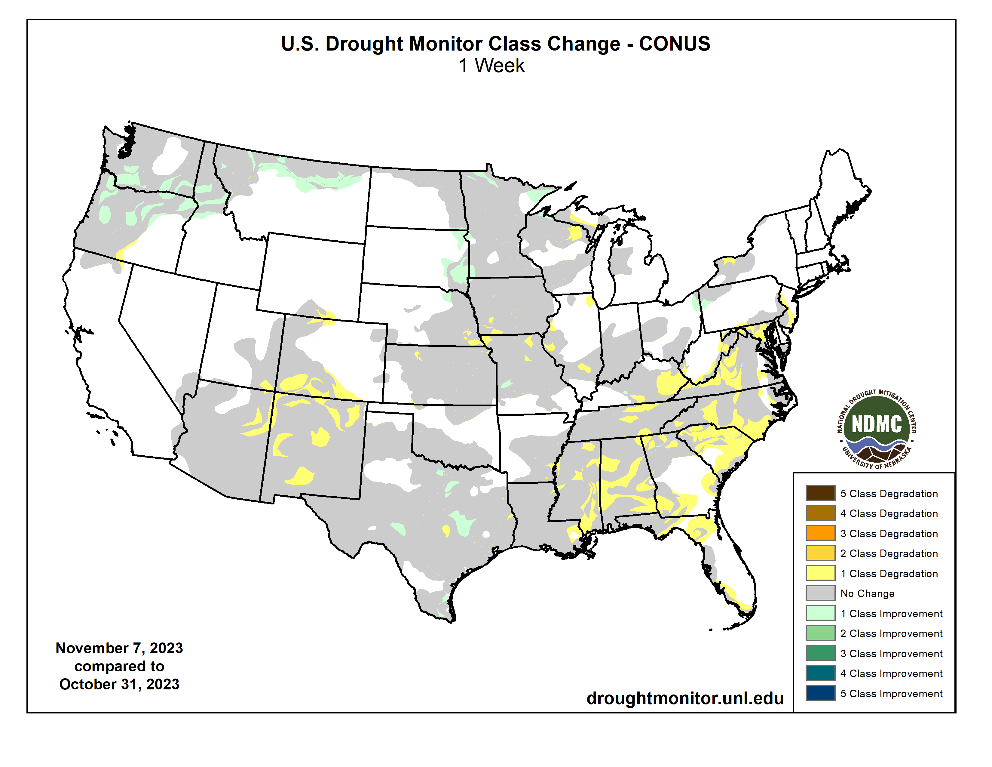
Residual impacts from the prior week’s storm continued to bring some improvements to the Pacific Northwest, northern Plains and upper Midwest. However, in the South and Southeast, conditions continue to rapidly deteriorate, leading to flash drought and widespread expansion of drought conditions.,,
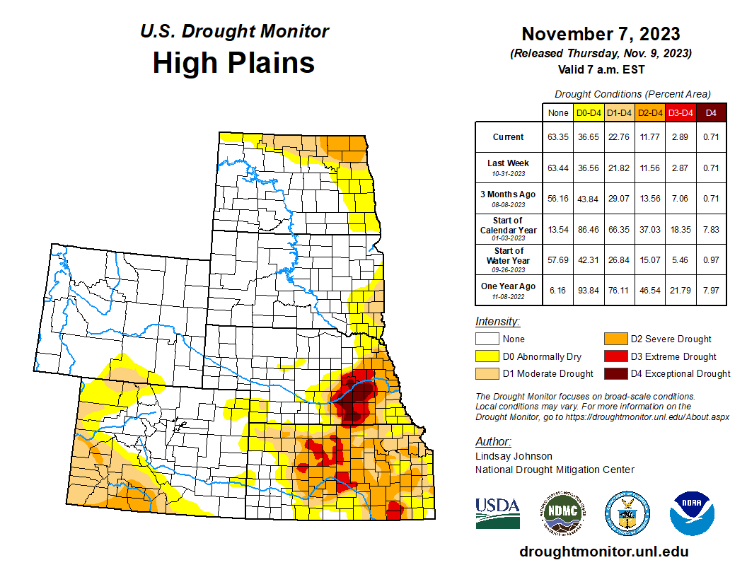
High Plains
Dry conditions persisted across the High Plains where temperatures are above normal, with Wyoming and Colorado seeing temperatures of 3-8 degrees above normal. The eastern boundary experienced near- or slightly-above-normal temperatures, except for North Dakota where temperatures were 3 or more degrees below normal. South Dakota and northeastern Nebraska continued to see improvements as remnants of the past week’s precipitation aid in dry conditions. There were 1-category improvements along the eastern South Dakota and northeastern Nebraska borders. Areas in South Dakota are so wet that producers have reported issues with planting winter crops…
West
An atmospheric river cascaded over parts of the Pacific Northwest, bringing several inches of new rain and snow accumulation along with last week’s precipitation. With this continued influx of precipitation, modest 1-category improvements were made across the northwest, particularly on the windward side of the Cascade Range. Further improvements were seen in northern Idaho and Montana, which received up to 4 inches of precipitation in some areas. Despite the deluge of precipitation over the last one to two weeks, temperatures have been 1-3 degrees above normal, and south-central Montana even had temperatures of 6-9 degrees above normal. The remaining states in the West remained status quo…
South
Dry conditions continued across the South, with the entire region at or below 25% of normal precipitation. Despite this lack of precipitation, there was some relief in terms of temperatures, which were 2-4 degrees below normal. Areas of Louisiana and Mississippi were up to 8 degrees below normal. Louisiana and Mississippi did not see any drought relief, with 1-category degradations across the two states. In Louisiana, over 50% of the state is in Exceptional Drought, and in Mississippi rapid deterioration spilling eastward from Louisiana resulted in 1-category degradations. Tennessee is also in Extreme Drought, and Exceptional Drought was introduced along the tri-state border, along with Alabama and Georgia. Extreme and Severe drought also migrated northward. Texas and Oklahoma remained largely unchanged, with some improvements in central Texas and status quo conditions for Oklahoma…
Looking Ahead
Over the next five to seven days, much of the western and central Gulf Coast region will likely see 2-5 inches of precipitation as an unformed tropical depression makes its way north from Cuba into the western Gulf of Mexico. Some of this moisture will continue across the Southeast. The Casacade Mountian range and surrounding areas are likely to continue to receive more moisture. Temperatures are expected to be slightly below normal in Texas, the south Atlantic region and the Northeast. The High Plans and parts of the northern West and Midwest are likely to see maximum temperatures of 8-12 degrees above normal.
The six- to 10-day outlook shows a strong chance of above-normal temperatures centered over the eastern High Plains and western Midwest. Much of the rest of the county is also projected to experience above-normal temperatures. Below-normal precipitatation is forecasted across much of the northern regions from eastern Montana to Maryland and Maine. The West is projected to have above-normal precipitation, particularly in central and southern California as well as Alaska and Hawaii.
Just for grins here’s a slideshow of early November US Drought Monitor maps for the past several years.


Click the link to read the article on the Aspen Journalism website (Heather Sackett):
The results of water quality testing on Lincoln Creek show that the waterway is toxic to fish and that metals concentrations have been increasing in recent years. But because the main source of the contamination is a nearby tributary — and not a mine — it is unclear who should take responsibility for cleaning it up.
A report released this week by the Environmental Protection Agency shows that Lincoln Creek in the four miles between the Ruby Mine and Grizzly Reservoir exceeds state water quality standards for aquatic life for aluminum, cadmium, copper, iron, lead, manganese and zinc. Aluminum and copper concentrations were higher than standards set by the Colorado Department of Public Health and Environment in multiple locations: in Lincoln Creek downstream of Ruby Mine, in Grizzly Reservoir and in Lincoln Creek downstream of the reservoir.
“The high concentrations of these metals are toxic to aquatic life and make Lincoln Creek uninhabitable for fish,” the report says.
The report is based on water quality sampling data from 2022.
Karin Teague, executive director of the Independence Pass Foundation, said she is glad the report is finally out so that the community can talk about what to do about the contamination. The foundation’s mission is to restore and protect the ecological integrity of the pass corridor.
“We have a dead creek on our hands,” Teague said. “It’s a hard thing to see, and it’s a disaster for the living things that used to call the creek home. It’s bad for the wildlife and has human health implications.”
But those human health implications remain unclear.
In addition to exceeding standards for aquatic life, the report says cadmium, copper, iron and nickel were present in concentrations exceeding the state standards for domestic water supply.
Lincoln Creek feeds into the Twin Lakes Reservoir and Canal Company’s transmountain diversion system, in which Grizzly Reservoir is used as a collection pond before sending water through the Twin Lakes Tunnel to the Front Range, where it is used primarily in Front Range cities, including for drinking water. Colorado Springs Utilities owns the majority of the water in the Twin Lakes system.
The report says there is a slight potential that the metals are contaminating drinking water, but the substantial mixing, the distance that the water travels and the filtration limit these impacts. Lincoln Creek is a tributary of the Roaring Fork River, but Aspen’s domestic water supply is not affected; the city’s drinking water comes primarily from Castle Creek.
Colorado Parks and Wildlife stocks Grizzly Reservoir with fish each year, making it a popular and scenic spot for summer alpine fishing and camping. There have been fish die-offs in the reservoir in recent years, including 2021. But CPW aquatic biologist Kendall Bakich said that since Grizzly Reservoir is diluted with water from several surrounding cleaner drainages, fish can still survive there and CPW plans to continue stocking.
CPW stocks the reservoir with “catchable trout,” meaning anglers can take them out and eat them. Since the trout have been raised in hatcheries with clean water and food, and have probably lived in the reservoir for only a short time (most trout that aren’t caught by anglers during the summer don’t survive the harsh winter in Grizzly), Bakich said they are not likely to pose a risk to human health. But CPW tested the tissue anyway of some of the few fish that made it through the winter since they would have the most exposure to the toxic metals.
“We haven’t gotten the results back on those tissue samples,” Bakich said. “At this point, what we know about copper and how it resides in a fish’s body, it resides in the organs and people don’t eat the organs. If you are harvesting fish in the summer, they have just been put in there.”
Natural source of contamination
The report points to natural sources as the culprit for creek contamination, referring to a “mineralized tributary.” The mineralized tributary in question is a drainage in a steep slope above Ruby Mine, which flows into Lincoln Creek just below the discharge from the Ruby Mine portal. Prospectors dug for gold, silver, lead and copper at now-defunct Ruby Mine in the early 1900s.
The report says that the mine discharge and the mineralized tributary have very different water chemistry and that the contamination has been traced back to the tributary, not the mine. The report estimates that the mineralized tributary contributes 98.5% of the copper contamination to Lincoln Creek.
“While historical mining does appear to play a role in some of the impacts to Lincoln Creek, all of the data and observations point to natural sources as the major component of metals loading into Lincoln Creek,” the report reads. “Therefore, cleanup or removal activities associated with Ruby Mine would have minimal benefits to improve the overall quality of Lincoln Creek.”
The EPA is authorized to address elevated metals concentrations only from human-caused sources, not contamination from natural sources.

Climate change a cause?
Water quality issues on Lincoln Creek have been a concern for years, with the creek above the reservoir often running a yellowish color, and Grizzly Reservoir often a bright turquoise. In September 2022, Lincoln Creek below the reservoir turned a milky-green color, and white and yellow sediment settled on the streambed, prompting water quality testing in the fall of 2022 and the EPA report. These conditions in 2022 could be seen downstream at the confluence with the Roaring Fork River, sparking concern for local residents and organizations.
Although water quality issues on Lincoln Creek are not new, according to the report, the metals concentrations — especially copper — have increased over the past 20 years. And climate change may be to blame.
“While the exact cause for observed trends is not known, it is suspected that climate change may be altering hydrologic cycles and thawing once-frozen rock deep in the mountain,” the report reads. “These processes could expose more metals-bearing rock to oxygen, thereby increasing potential to generate acidic drainage and dissolution of metals.”
Now that the findings have been released, the next step is figuring out what to do about the contamination and which agencies should be involved. Pitkin County Environmental Health Manager Kurt Dahl said a meeting has been scheduled for Thursday with representatives from Pitkin County, CDPHE, the U.S. Forest Service, CPW, the Roaring Fork Conservancy, EPA, and the Colorado Division of Reclamation, Mining and Safety.
“Being a natural source, (EPA) is not going to deal with it,” Dahl said. “Is there another agency that will deal with it? The question of what are the next steps is one of the more important pieces to answer.”
Teague hopes to learn more about the potential health risks of the contamination and that the community can figure out a solution to clean it up.
“This is a community that cares a lot about its backyard, the health of its wild places,” she said. “If we can talk about building $50 million trails, maybe we can talk about millions of dollars to bring a creek back to life.”
Aspen Journalism is a nonprofit, investigative news organization covering water, environment, social justice and more. Visit http://aspenjournalism.org.
Pitkin County supports Aspen Journalism with a grant from the Healthy Community Fund. Aspen Journalism is solely responsible for its editorial content.

Click the link to read the article on the Big Pivots website (Allen Best):
Study finds that existing technology can get Colorado to near-zero electricity without need for breakthroughs in geothermal, nuclear or other realms. It will require a bit of natural gas.
Colorado can decarbonize its electricity very deeply by 2040 without busting the bank. But there’s a catch.
To hit this 98.5% decarbonization level will require accepting natural gas as 1% of the mix along with a small percentage of carbon-based electricity imported into Colorado. And getting there will not require still-costly emerging technologies.
That’s the take-away from a modeling study commissioned by the Colorado Energy Office.
How about 100% emissions-free electricity? That can be achieved, and in several different ways — all of them at a higher price, according to the modeling conducted by Ascend Analytics, a Boulder-based company.
The company modeled two other scenarios deploying deep levels of geothermal, hydrogen, and advanced nuclear reactors as well as other emerging technologies. Still another scenario examined the cost of using simply wind, solar, and existing battery technology. And one scenario emphasized local generation.
These five other scenarios came in at prices of $47.1 billion to $56.2 billion in net-present value — all substantially higher than the $37.5 billion of the less-than-perfect scenario using some natural gas.
Burning natural gas on an as-needed basis to ensure reliability will produce 565,000 metric tons of emissions in 2040. That compares with 40 million tons in 2005, according to the modeling study. This scenario also envisions a higher share of electricity , about 17%, being imported into Colorado.
All the scenarios in the modeling assume substantial amounts of improved energy efficiency, in effect partially eliminating the need for new generation. All models also assume that Colorado utilities will, as required by a state law, be participating in some sort of regional market for electricity by 2030.
Will Toor, director of the Colorado Energy Office, called the study results “huge.”
“The biggest takeaway of the study is understanding that we can get very deep emissions reductions, nearly zero emissions by 2040 while minimizing costs to utility customers. That is not something that we understood going into this study,” he said in an interview.
“As we look at developing the policy framework for 2040, it will be very much informed by that understanding,” he added.
The modeling study will likely deliver the justification for a bill in the legislative session beginning in January that would propose a new emissions-reduction target for Colorado’s electrical utilities. Laws adopted in 2019 and in subsequent years tasked those utilities with reducing emissions 80% by 2030. Most and perhaps all seem to be on track to get there with relative ease.
Some moving higher more quickly
Some utilities expect to get far higher—and soon. Notable is Holy Cross Energy, the electrical cooperative based in Glenwood Springs. It expects to achieve 92% emissions-free electricity by early in 2024 and has a goal of 100% by 2030.
Bryan Hannegan, chief executive of Holy Cross, has long said that the path to 90% was reasonably clear. The hard part, with answers still unknown, he has said, will be that final 10%. And unlike the path to 90%, that final leg will likely be more expensive.
The modeling has any number of assumptions. Some likely are further out on the limb than others.
All the scenarios assume a 40% increase in electrical demand across Colorado during the next 17 years. Population growth will drive some of this new demand. Increased demand will also result from electricity replacing fossil fuels in both transportation and building and water heating.
To satisfy this increased demand will require new generation. Just how much new generation will depend upon the type. Wind and solar exclusively from generators within Colorado coupled with battery storage would require 74,492 megawatts of installed capacity. Having natural gas available will require far less, 44,474 megawatts.
On a more micro level and with a concrete challenge, Platte River Power Authority — the supplier to Fort Collins, Loveland, Estes Park and Longmont — is putting together its resource plan looking out to 2030. Directors in 2018 identified a goal of 100% renewables by 2030 but also attached a handful of conditions to that goal. Five years later, Platte River’s planners don’t see a way to 100% by 2030, at least not without risking reliability or absorbing considerable costs. One scenario calls for 85% renewables. The plan, however, is not scheduled to be completed until June.
For an explanation of the reasoning for a unanimous resolution by Platte River’s board of directors, see a blog by Fort Collins Mayor Jeni Arndt, her city’s board representative.

Transmission, seen by many as critical to deep levels of emissions reductions, gets relatively little mention in the modeling report. Arguably, an entire scenario could be built around potential for transmission upgrades, such as greater ease of moving electricity between the Western Interconnection grid, of which Colorado is a part, and the Eastern Interconnection, which starts at Kansas and Nebraska.
Ascend Analytics had conducted similar modeling about deep, deep decarbonization of electricity for Los Angeles Water and Power. The question in that study was what would it take for Los Angeles to achieve zero-emissions electricity?
Twenty years ago Colorado and its electrical utilities almost entirely embraced coal generation as the cheapest energy source far into the future. By 15 years ago, that resolve had weakened. Voters had adopted the state’s first renewable energy mandate and legislators had upped it. Wind prices were swooping down. Not least utilities had become confident of keeping lights on while deploying wind and solar.
A watershed year was 2017. Xcel Energy, Colorado’s largest utility, which supplies roughly half of the electricity in the state, sought bids for new electrical generation. The low prices for wind and solar dramatically undercut those of fossil fuels. Proponents of renewables were elated. A year later, Xcel Energy announced its plans for 80% decarbonization by 2030. The paradigm had shifted.
Most of those wind, solar, and storage projects bid in 2017 have now or soon will go on line. Statistics for 2023 are not yet available. However, as of 2022, renewable energy accounted for 37% of the state’s electrical generation, with wind power accounting for four-fifths of that renewable generation, according to the U.S. Energy Information Administration.
Two coal plants have closed since 2017 and now eight more will be laid down before the end of 2031. One, Pawnee, located at Brush, is to be converted to natural gas.
Toor said his agency began having discussions in 2022 about the next steps beyond 2030. The questions guided creation of the modeling study. The state called in utilities, environmental groups, industrial sectors, and others for conversations about how to frame the study.
What some said
Ean Tafoya, the Colorado director for GreenLatinos, a national advocacy group, said he remembers the first meeting occurring in May. Based on the number of those interested in environmental justice invited to participate as stakeholders, he suspects dozens of stakeholders were involved.
The results of the modeling Tafoya described as “very promising.”
“It shows me that the emerging technologies that my community has been very concerned about, that we don’t need them,” he said, referring to hydrogen, carbon capture and sequestration and direct-air capture as well as deep-well geothermal. “And if we can do this by 2040 without change of policy, that is very exciting.”
If Colorado can find ways to leverage capital through green infrastructure banking and address workforce training, Colorado “can truly be a leader nationally and globally,” he added.
Xcel Energy issued a statement that said the company was “encouraged by the Colorado Energy Office’s findings.”
“We agree there is a need for new 24/7 carbon-free technology to achieve deep carbon reductions. The state’s policies will enable us to reduce carbon emissions greater than 80% by 2030 and will inform our future investments into the local infrastructure necessary to move clean energy reliably into our customers’ homes – while keeping bills low.”
Do Colorado’s modeling results suggest a template for other states or regions of the United States, even other countries? Toor thinks so.
“It is saying that you can get to near-zero greenhouse gas emissions and pollution from electricity generation within the next 20 years —with no incremental cost to customers. That’s true with other states, and it doesn’t matter whether you’re a red state or blue state. “Regulators and utilities should be excited about the ability to minimize costs to customers while nearly entirely eliminating emissions. I think that is a really important conclusion.”
That said, added Toor, other states are starting at different places. “We have already had substantial progress.”
Colorado also is blessed with renewable resources. It has wind – not the best, but among the best. It also has strong solar. Again, not the best, but very good.
“I want to be careful about claiming insight into other states, but I do think it is a very striking result that you can achieve such deep pollution reductions simply by developing the lowest-cost resources,” said Toor.
In creating the documents, Ascent based its projected costs of various technologies on projections by the National Renewable Energy Laboratory but also Ascend’s Market Intelligence Team.
How fast will technology move?
Even with those presumably careful calculations based on strong information, how good are they? After all, 20 years ago, the cost numbers argued for coal. Incredibly, some people still try to make that argument.
Also 20 years ago, many smart people projected the imminent arrival of both peak oil and, by extension, peak natural gas. Those projections, based on rear-view mirror data, failed to anticipate the rapid incremental advances in hydrofracturing, horizontal drilling and other extraction technology. From $14.50 per million Btu in 2008, natural gas prices plummeted to $2.50 with the recession – but never returned to the stratospheric levels that justified poking very deep holes across the Piceance Basin southwest of Craig. Meantime, the U.S. became a net exporter of oil.
Of course, we have had similar cost curves with wind, then solar, and now storage prices.
Might the same thing occur with geothermal, using underground heat to produce electricity, as is already done in California and some other places? Sarah Jewett, vice president for strategy at Fervo Energy, suggested cause for similar optimism in her industry during her remarks at the Colorado Rural Electric Association conference on Monday. The cost curve in recent projects in Utah and Nevada has been bending downward, she said.
Earlier that same day, a panel of experts about nuclear energy reported cause for optimism about nuclear, while yet another panel predicted reason to believe hydrogen will play an important role in the future.
Toor acknowledged the unexpected cost declines for many technologies. “It’s quite possible that hydrogen and other technologies will be lower cost than now projected,” he said.
Regardless, he added, these near-zero or zero-emissions pathways should become the baseline.
“I think it would be important that utilities are looking at new technologies and that utility regulators are able to look at getting to even deeper reductions based on what the actual cost trajectories turn out to be,” he said.
Colorado’s energy regulation framework is well suited to achieving those deep reductions —even deeper than the low-cost 98.5% emissions-free that this modeling suggests will be possible.
A final report, after review by stakeholders, is expected in December.
Following are what the modeling study cites as its key findings. The language is verbatim from the report:
- The Economic Deployment scenario, which relies on current state and federal policies and is projected to meet demand at the lowest cost, is projected to reliably meet electricity needs in 2040 while achieving 98.5% reduction in greenhouse gas emissions in 2040 from a 2005 level while also achieving near zero emissions reduction in nitrous oxide and sulfur oxide.
- Wind and solar will be the main source of electricity in Colorado in 2040. In the Economic Deployment scenario, 76% of electricity comes from in-state wind and solar; 16% comes from out-of-state imports of near zero-emissions electricity (mostly wind from a wholesale electricity market); and 10% from energy efficiency, with the rest coming from other sources. Across all other scenarios, in-state wind and solar account for more than 90% of electricity.
- In the Economic Deployment scenario, gas-fired electricity generation meets only about 1% of total need for electricity.
- Under current cost assumptions, the Optimized 100 scenario, which achieves zero emissions by 2040 using a technology-neutral, least-cost approach, selects a substantial amount of hydrogen and a modest amount of geothermal to complement wind, solar, and batteries. It is 25% more expensive than the economic deployment scenario.
- The Wind, Solar and Battery scenario is 20% more expensive than the Optimized 100 scenario and 50% more expensive than the least cost Economic Deployment scenario. The Accelerate Geothermal scenario is 11% more expensive than the Optimized 100.
- The Optimized 100 scenario retires all gas-fired generation by 2040. It replaces retiring gas capacity primarily with clean hydrogen starting in 2032. By 2040, this scenario has 5,061 MW of clean hydrogen and 125 MW of geothermal generation.
- The model does not select gas with carbon capture or advanced modular reactors in any scenario because of the cost.
- The Accelerated Geothermal scenario adds a requirement to have 10% of demand met with geothermal in 2040, which results in 1,989 MW of installed capacity (compared to 125 MW in the Optimized 100 scenario).

Click the link to read the release on the City of Greeley website (Keri Fishlock):
A $250,000 grant from the Colorado Water Quality Control Division will help Greeley Water identify and inventory water service lines that contain lead.
As it works to help customers reduce their risk of lead exposure, Greeley Water must create a mapped inventory of water service line materials by October 2024 to meet federal and state regulations. This process helps the city identify and replace any remaining customer-owned lead service lines at no cost to the homeowner.
Greeley Water plans to use grant funding for the following:
- Water service line inventory
- Lead or galvanized service line confirmations
- Geographic Information Systems (GIS) mapping and analysis
“This grant is great news for the City of Greeley. It helps speed up our inventory process. It directs more of our available funds toward replacing service lines that contain lead,” said Keri Fishlock, an engineer with Greeley’s Water and Sewer Department.
In recent years, there has been greater national awareness of the potential health risks of lead in drinking water. Water testing confirms that water leaving Greeley’s treatment facilities is treated to a high standard and is lead-free. Yet, lead may be present in older homes’ plumbing, faucets or service lines. Greeley Water is working with customers to identify and reduce those risks.
Go to www.greeleygov.com/leadsurvey to complete a short survey about your water service line. Participants can win one of three $100 gift cards awarded monthly.
Contact Greeley Water if you need help at leadprotection@greeleygov.com or 970-336-4273.

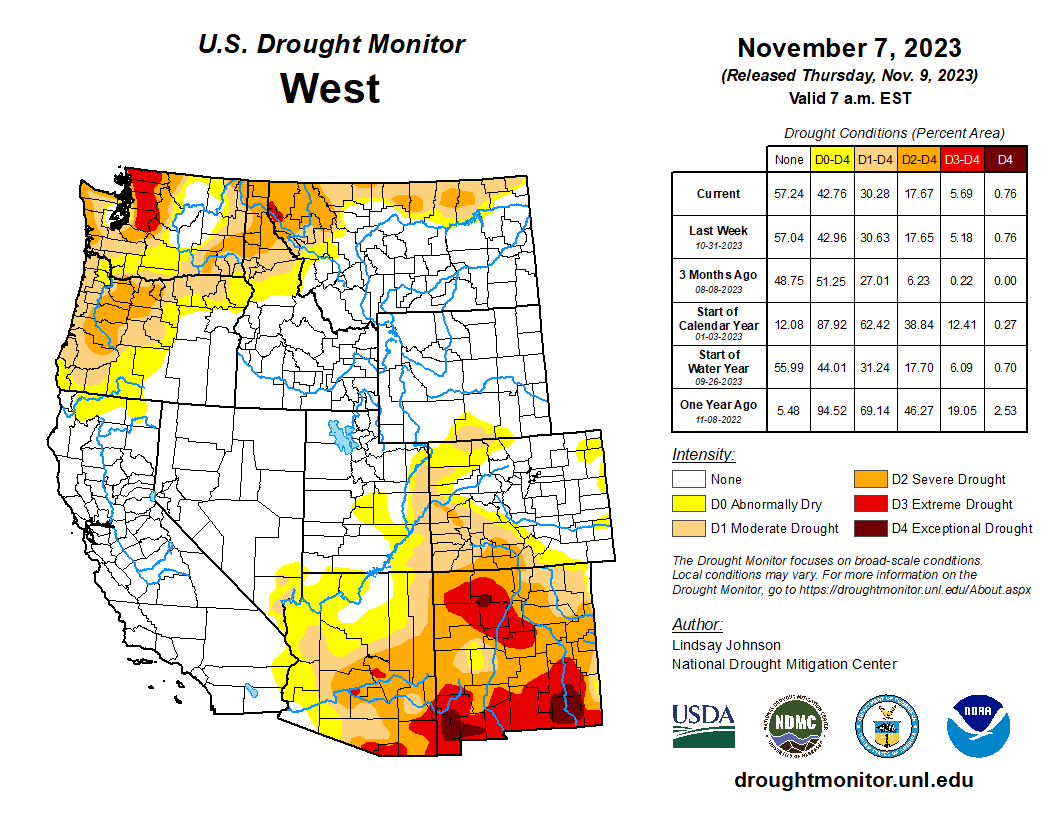
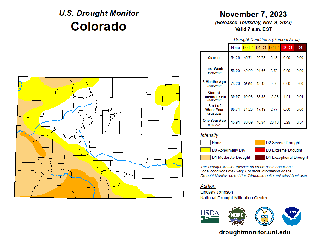
Click the link to read the story map on the NDMC website (Curtis Riganti):
Drought Overview

During October, drought coverage across the U.S. decreased slightly, with regional variation. Drought expanded and worsened from southwest Virginia and North Carolina, to southwest Arkansas and adjacent Alabama, to northern Georgia and Mississippi. In Tennessee and adjacent northern Georgia, several locations experienced four-category degradations, and much of the region saw multiple-category degradations. Degradations also occurred in Hawaii, parts of the Utah-Colorado border, Arizona, New Mexico and other scattered locations.
Improvements were widespread in Oklahoma and Texas, especially in the eastern and southern portions of those states, respectively. Some improvements also occurred in the Midwest, with multiple-category improvements in Wisconsin, Minnesota and northern Nebraska. Single- or multiple-category improvements also occurred in northern North Dakota, northern Montana and portions of Oregon and Washington.
Overall, moderate or worse drought coverage dropped from 32.1% to 30.68%. Severe or worse drought coverage decreased from 18.79% to 17.65%. Extreme or worse drought coverage declined from 8.48% to 6.62%, and exceptional drought coverage dipped from 2.35% to 1.82%.
Drought Forecast
During November, some improvement to ongoing drought conditions is forecast in western Washington and Oregon, according to the National Weather Service Climate Prediction Center. Isolated improvement or removal of drought is forecast in parts of central and northeast Wisconsin, and near the Twin Cities in Minnesota.
Drought improvement or removal is forecast for a narrow strip extending from Wichita, Kansas, through Kansas City to west-central Illinois, and along parts of the lower Ohio River in western Kentucky and southern Indiana. Parts of central and northeast Texas, as well as adjacent southeast Oklahoma, are forecast to experience more widespread drought improvement or removal. Drought improvement or removal is also forecast on St. Thomas and St. Croix in the U.S. Virgin Islands and in northern Puerto Rico.
Drought development is forecast to occur in parts of southwest Virginia, northwest and central North Carolina, and parts of northern and western Georgia and east-central Alabama.
Temperature

Despite a chilly end to October, temperatures across the northern Great Plains and Northwest ended the month mostly within 3 degrees of normal. A few spots experienced temperatures 3 to 6 degrees warmer than normal. Parts of central and eastern Montana, and adjacent northern Wyoming and western South Dakota, finished October near normal or a few degrees colder than normal.
October in New England was warmer than normal, with widespread temperatures from 3 to 9 degrees above normal. The last two weeks of October were especially warm in the Northeast, with much of New England checking in at 6 to 10 degrees above normal. Much of the Midwest, south-central, and Great Plains regions finished October somewhere between near normal to 6 degrees warmer than normal for October.
Most of the Southeast saw near- or slightly below-normal temperatures for October. Temperature variations in Hawaii, while widely varying, were mostly within 3 degrees of normal. Temperatures along the Arctic Coast and in southeast Alaska were mostly 1 to 3 degrees warmer than normal, while temperatures in central Alaska were mostly 1 to 3 degrees colder than normal.
Precipitation

Drier-than-normal weather enveloped a swath of the eastern U.S. stretching from Louisiana, Mississippi and northern Alabama to the Mid-Atlantic. Below-normal precipitation also occurred in most of New Mexico, and in parts of western Montana, northern Idaho and Washington. Wetter-than-normal weather occurred in parts of eastern Montana and western North Dakota, as well as parts of central and east-central Wyoming. A swath of above-normal precipitation also occurred along the Nebraska-South Dakota border to northwest Iowa, southern Minnesota and central Wisconsin. Above-normal precipitation also occurred in north-central Texas and in the region surrounding Lubbock, Texas. In Hawaii, Oahu and the windward side of the Big Island were drier than normal during October. South-central and southwest Alaska were drier than normal during October, while the rest of the state was mostly near normal or wetter than normal…
High Plains
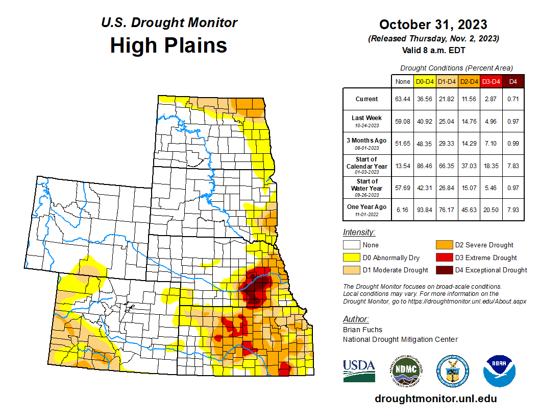
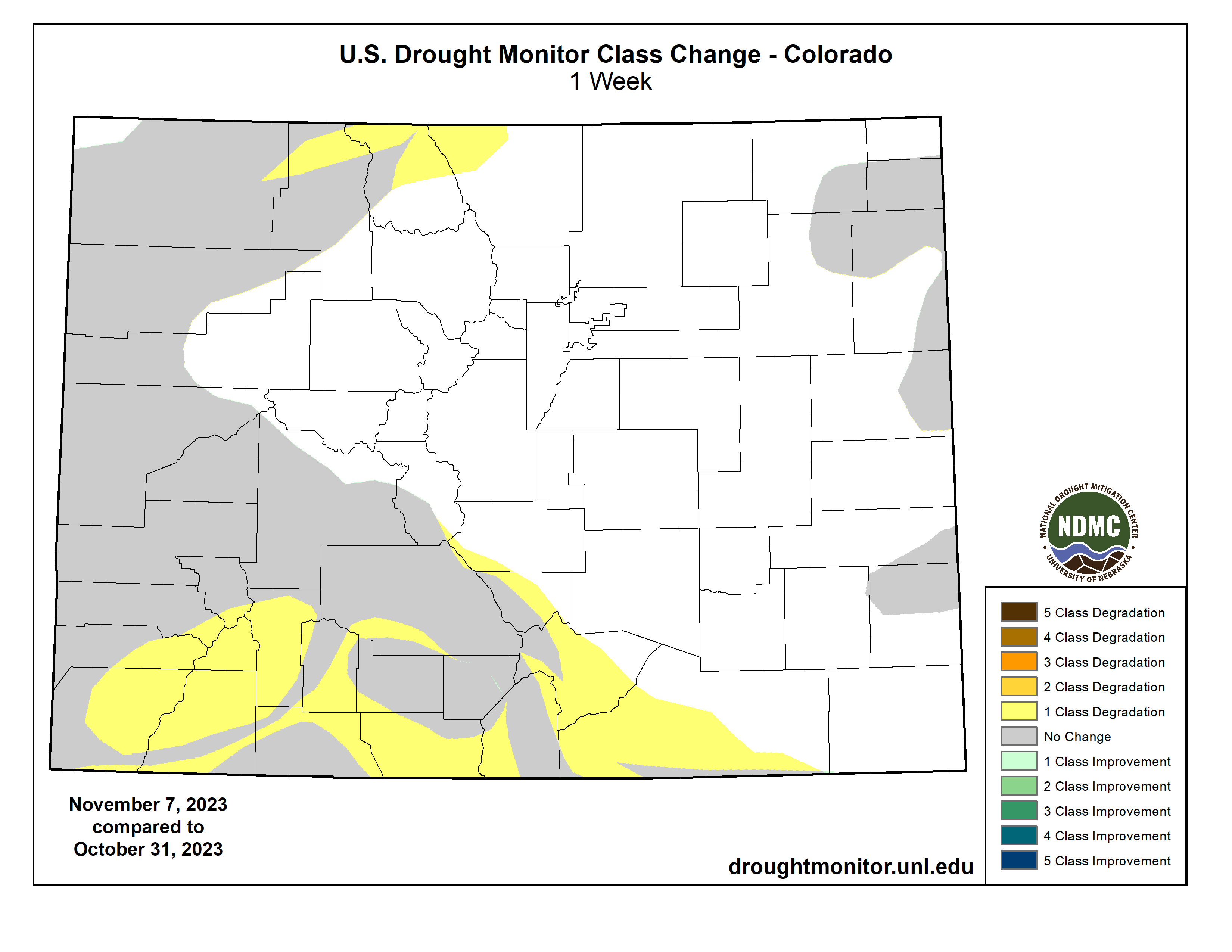
Above-normal precipitation occurred in several parts of the High Plains during October. An area spanning the Nebraska-South Dakota border to central and northern Wyoming saw wetter-than-normal weather for the month, with some areas receiving at least twice their normal October precipitation. Above-normal precipitation also occurred in parts of the Rocky Mountains in central Colorado. The southern tier of the state did not fare as well, with many spots there seeing less than half of their normal October precipitation. Localized, much drier conditions also occurred in the central portion of the North Dakota-South Dakota border, where some places reported less than half of their normal October precipitation.
Overall, drought conditions decreased across the region in October. Moderate or worse drought coverage dropped from 26.84% to 21.82%. Severe or worse drought coverage dipped from 15.07% to 11.56%. Extreme or worse drought coverage decreased from 5.46% to 2.87%, and exceptional drought coverage dropped from 0.97% to 0.71%.
West
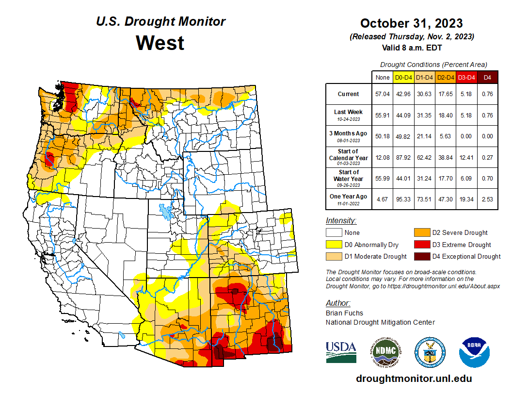
The West experienced several areas of drier-than-normal weather during October. Parts of western Washington, northern Idaho and Montana were much drier than normal — receiving half or less of their normal October precipitation. Central and eastern Montana were generally wetter than normal, as were localized spots in Utah, southeast Idaho and northeast Oregon. Central and eastern Montana were generally a few degrees colder than normal, while the rest of the region generally ranged from near normal to 6 degrees above normal.
Drought coverage did not change substantially across the West during October. Moderate or worse drought coverage dropped from 31.24% to 30.63%. Severe or worse drought coverage dipped from 17.7% to 17.65%. Extreme or worse drought coverage decreased from 6.09% to 5.18%, and exceptional drought coverage increased from 0.7% to 0.76%.

Click the link to read the article on the USDA website:
WASHINGTON,October 18, 2023 –
Today, the Biden-Harris Administration announced the U.S. Department of Agriculture’s Forest Service is making nearly $50 million in grant funding available for proposals that support crucial links between resilient, healthy forests, strong rural economies and jobs in the forestry sector. Made possible by President Biden’s Investing in America agenda, a key pillar of Bidenomics, this funding will spark innovation, create new markets for wood products and renewable wood energy, expand processing capacity, and help tackle the climate crisis.
“A strong forest products economy contributes to healthier forests, vibrant communities and jobs in rural areas,” said Agriculture Secretary Tom Vilsack. “Thanks to President Biden’s Investing in America agenda, we are investing in rural economies by growing markets for forest products through sustainable forest management while reducing wildfire risk, fighting climate change, and accelerating economic development.”
This announcement is part of President Biden’s Investing in America agenda to generate economic opportunity and build a clean energy economy nationwide. The grants are made possible by President Biden’s Inflation Reduction Act, the largest climate investment in history and a core pillar of Bidenomics, as well as President Biden’s Bipartisan Infrastructure Law, an historic investment to rebuild America’s aging infrastructure.
The open funding opportunity comes through the Forest Service’s three key grant programs to support the forest products economy: Wood Innovations Grant, Community Wood Grant, and Wood Products Infrastructure Assistance Grant Programs. The agency is seeking proposals that support innovative uses of wood in the construction of low carbon buildings, as a renewable energy source, and in manufacturing and processing products. These programs also provide direct support to expand and retrofit wood energy systems and wood products manufacturing facilities nationwide.
The Forest Service is requesting proposals from eligible entities in the private, non-profit, and government sectors including Tribes, local and state governments, businesses and for-profit entities, institutions of higher education, as well as public utility, fire, conservation, and school districts, among others.
These investments will support forest management projects to improve forest health and reduce wildfire risk across all land ownerships. Byproducts of these activities, like small diameter timber and woody biomass, have historically been of little market value. Thanks in part to these Forest Service grant programs, funding is available to support the use of this often-unused material in many types of wood products.
Businesses that are engaged in or support the forest products economy are eligible to apply for funding to expand manufacturing capacity. These businesses are vital employers in local communities, especially in tribal or rural communities.
The investments will also support the Forest Service’s 10-year strategy to address the wildfire crisis in the places where it poses the most immediate threats to communities. The agency is investing in projects that source wood from activities that reduce risks to communities, like prescribed fire and mechanical thinning to reduce the vegetation that fuels wildfires.
Visit the Forest Service webpage for more information on funding for the Wood Innovations, Community Wood and Wood Products Infrastructure Assistance Grant Programs.

Click the link to read the article on the Water Education Colorado website (Jerd Smith):
The chair of a special task force set up in Colorado to help protect in-state interests on the Colorado River told lawmakers Tuesday that it would deliver its final report to them Dec. 15.
Lawmakers created the Colorado River Drought Task Force when they approved Senate Bill 23-295 last spring. It includes representatives of environmental and agricultural groups, urban and rural water users, and the Southern Ute and Ute Mountain Ute tribes, among others. It is charged with developing policy recommendations and new tools to help save water, and ensuring neither water users nor the environment are adversely affected by any new Colorado River programs and agreements.
The 17-member task force has drawn fire from some, who worry that its public discussions of in-state Colorado River water issues could weaken Colorado’s position as it negotiates with the other states in the basin on how to rescue the drought-strapped river system.
“Last year we put a lot of money into our Colorado River negotiating team,” said Sen. Jeff Bridges, D-Arapahoe County. “And what I have heard from them is that this work is not necessarily helpful. I hope you are taking this into account.”
Bridges’ comments came at a meeting of the Colorado Legislature’s Water Resources and Agriculture Review Committee on Oct. 31 in Denver. Bridges is a member of the committee.
Task force chair Kathy Chandler-Henry said the group was aware of those concerns but did not share them. “As a task force, we have talked about how we can best support our negotiators … Our plan is to do no harm, protect Colorado, and tell the Lower Basin to clean up its act,” she said. Chandler-Henry is also an Eagle County Commissioner and president of the board for the Colorado River District, which protects local water interests within the 15 counties on Colorado’s Western Slope within its boundaries.
The broader Colorado River system includes seven states, with Colorado, New Mexico, Utah and Wyoming comprising the Upper Basin, and Arizona, California and Nevada making up the Lower Basin. Chandler-Henry was referring to years of overuse in the Lower Basin, which most experts believe contributed to the current crisis on the river.

The Colorado River system has its headwaters within Colorado’s Rocky Mountain National Park. As it flows west, Colorado’s massive mountain snowpack generates roughly two-thirds of the water that eventually serves cities from Denver to Los Angeles and millions of acres of productive farmland from Colorado to California.
But a 22-plus-year drought, widely believed to be the worst in more than 1,200 years, as well as a sharp decline in flows due to climate change nearly drained the river’s two major reservoirs, lakes Powell and Mead, last year. The crisis prompted the federal government to order the states to dramatically cut back their water use.
This year, negotiations among the states and the federal government have begun on how to stabilize the river. Suggestions include reducing water use in the Lower Basin, finding new ways to grow food using less water, and improving water delivery systems so that less water is lost to leakage and evaporation.
Interest remains high within Colorado on how to protect water users’ interests in the river here at home as well as how to protect its ecology as climate change continues to sap its flows.
Sen. Dylan Roberts, D-Avon, current chair of the Water Resources and Agriculture Review Committee, who was also a co-sponsor of the bipartisan bill that created the drought task force, said he believed the group’s report would prove useful and that it would be important to be prepared for what may lie ahead on the river.
“We are having conversations now so that tools are in place when we need them,” Roberts said.
Task force staffer Kelsea Macllroy said the group will have its draft report ready for public review Dec. 1 through Dec. 7 and that public comments could be submitted during that time via its website. Once the final report is completed, lawmakers will evaluate the recommendations and determine how to proceed prior to the start of the 2024 General Assembly Jan. 9.
Fresh Water News is an independent, nonpartisan news initiative of Water Education Colorado. WEco is funded by multiple donors. Our editorial policy and donor list can be viewed at wateredco.org.
Jerd Smith is editor of Fresh Water News. She can be reached at 720-398-6474, via email at jerd@wateredco.org or @jerd_smith.

Click the link to read the release on the University of Maryland website (Emily Nunez):
The influx of salt in streams and rivers is an ‘existential threat,’ according to a research team led by a UMD geologist.
The planet’s demand for salt comes at a cost to the environment and human health, according to a new scientific review led by University of Maryland Geology Professor Sujay Kaushal. Published in the journal Nature Reviews Earth & Environment, the paper revealed that human activities are making Earth’s air, soil and freshwater saltier, which could pose an “existential threat” if current trends continue.
Geologic and hydrologic processes bring salts to Earth’s surface over time, but human activities such as mining and land development are rapidly accelerating this natural “salt cycle.” Agriculture, construction, water and road treatment, and other industrial activities can also intensify salinization, which harms biodiversity and makes drinking water unsafe in extreme cases.

“If you think of the planet as a living organism, when you accumulate so much salt it could affect the functioning of vital organs or ecosystems,” said Kaushal, who holds a joint appointment in UMD’s Earth System Science Interdisciplinary Center. “Removing salt from water is energy intensive and expensive, and the brine byproduct you end up with is saltier than ocean water and can’t be easily disposed of.”
Kaushal and his co-authors described these disturbances as an “anthropogenic salt cycle,” establishing for the first time that humans affect the concentration and cycling of salt on a global, interconnected scale.
“Twenty years ago, all we had were case studies. We could say surface waters were salty here in New York or in Baltimore’s drinking water supply,” said study co-author Gene Likens, an ecologist at the University of Connecticut and the Cary Institute of Ecosystem Studies. “We now show that it’s a cycle—from the deep Earth to the atmosphere—that’s been significantly perturbed by human activities.”
The new study considered a variety of salt ions that are found underground and in surface water. Salts are compounds with positively charged cations and negatively charged anions, with some of the most abundant ones being calcium, magnesium, potassium and sulfate ions.
“When people think of salt, they tend to think of sodium chloride, but our work over the years has shown that we’ve disturbed other types of salts, including ones related to limestone, gypsum and calcium sulfate,” Kaushal said.
When dislodged in higher doses, these ions can cause environmental problems. Kaushal and his co-authors showed that human-caused salinization affected approximately 2.5 billion acres of soil around the world—an area about the size of the United States. Salt ions also increased in streams and rivers over the last 50 years, coinciding with an increase in the global use and production of salts.

Salt has even infiltrated the air. In some regions, lakes are drying up and sending plumes of saline dust into the atmosphere. In areas that experience snow, road salts can become aerosolized, creating sodium and chloride particulate matter.
Salinization is also associated with “cascading” effects. For example, saline dust can accelerate the melting of snow and harm communities—particularly in the western United States—that rely on snow for their water supply. Because of their structure, salt ions can bind to contaminants in soils and sediments, forming “chemical cocktails” that circulate in the environment and have detrimental effects.
“Salt has a small ionic radius and can wedge itself between soil particles very easily,” Kaushal said. “In fact, that’s how road salts prevent ice crystals from forming.”
Road salts have an outsized impact in the U.S., which churns out 44 billion pounds of the deicing agent each year. Road salts represented 44% of U.S. salt consumption between 2013 and 2017, and they account for 13.9% of the total dissolved solids that enter streams. This can cause a “substantial” concentration of salt in watersheds, according to Kaushal and his co-authors.

To prevent U.S. waterways from being inundated with salt in the coming years, Kaushal recommended policies that limit road salts or encourage alternatives. Washington, D.C., and several other U.S. cities have started treating frigid roads with beet juice, which has the same effect but contains significantly less salt.
Kaushal said it is becoming increasingly important to weigh the short- and long-term risks of road salts, which play an important role in public safety but can also diminish water quality.
“There’s the short-term risk of injury, which is serious and something we certainly need to think about, but there’s also the long-term risk of health issues associated with too much salt in our water,” Kaushal said. “It’s about finding the right balance.”
The study’s authors also called for the creation of a “planetary boundary for safe and sustainable salt use” in much the same way that carbon dioxide levels are associated with a planetary boundary to limit climate change. Kaushal said that while it’s theoretically possible to regulate and control salt levels, it comes with unique challenges.
“This is a very complex issue because salt is not considered a primary drinking water contaminant in the U.S., so to regulate it would be a big undertaking,” Kaushal said. “But do I think it’s a substance that is increasing in the environment to harmful levels? Yes.”
###
In addition to Kaushal, other UMD-affiliated co-authors included Carly Maas (M.S. ’22, geology), geology master’s student Joseph Malin, Jenna Reimer (B.S. ’19, geology), Ruth Shatkay (B.S. ’19 architecture; M.S. ’21, environmental science and technology), geology Ph.D. student Sydney Shelton, and Alexis Yaculak (B.S. ’21, geology).
Their paper, “The Anthropogenic Salt Cycle,” was published in Nature Reviews Earth & Environment.
This research was supported by the National Science Foundation (Award Nos. GCR 2021089 and 2021015), Maryland Sea Grant (Award No. SA75281870W) and the Washington Metropolitan Council of Governments (Contract No. 21-001). This article does not necessarily reflect the views of these organizations.

Click the link to read the article on The Land Desk website (Jonathan P. Thompson):
Maybe by now you’ve heard that the collective users of the Colorado River have come together in harmony and agreed to cut water consumption significantly to avoid further depletion of Lakes Powell and Mead. Well it’s true! And the feds even seem ready to sign onto the plan. Maybe you’ve also heard this means the crisis is over and we can all relax and go home now.
I don’t think so.
A refresher: The 1922 Colorado River Compact divvied up the river between the Upper and Lower Basin states (Mexico was added later). They assumed at least 16.5 million acre-feet ran down the river each year, when in fact it was more like 14 million acre-feet. This discrepancy became clear over the last two decades as the water users’ giant savings accounts — Lakes Mead and Powell — were depleted to critically low levels.
That prompted federal water officials to call on the states to cut consumption by 2 million to 4 million acre-feet per year, or else they would implement the cuts themselves. After a lot of wrangling, the Lower Basin states (Arizona, California, and Nevada) finally relented and proposed 3 million acre-feet of cuts. Perfect, right?
Wrong. Their cuts would be spread out over three years, meaning their reductions only amounted to 1 million acre-feet per year, which is far less than needed. The deal seemed to many of us like a non-starter — or at least like very faulty math.

But it so happens that the proposal came on the heels of an extraordinarily wet winter in the Colorado River Basin, giving a bit of a boost not only to the reservoirs, but also to forecasters’ optimism regarding river flows over the next few years. Also, water users have responded to mandated cuts and done some voluntary cuts of their own, and the wet year meant they had to irrigate less, bringing Lower Basin water consumption to its lowest point in decades.
All of that was enough to prompt the feds to include the proposed Lower Basin cuts in an updated environmental impact statement and to make it the preferred alternative. They seem to think it will be enough to fend off the crisis, for now. And maybe it will be. But here are some numbers to consider:
- Lake Powell currently holds about 8.7 million acre-feet of water, which is higher than the last two years, but 2.2 million AF less than on this date in 2020.
- Lake Mead currently holds about 8.8 million acre-feet, which is less even than in 2021.
- Lake Powell, alone, lost 136,550 acre-feet — or about 44.5 billion gallons — to evaporation between July 1 and Nov. 1 of this year.
- The combined storage of Lake Meads and Powell is currently at about 17.5 million acre feet, which is less than a third of the total capacity. In other words, the reservoirs are still two-thirds empty — even after the big winter.
Crisis averted? Probably, at least for now. And with an El Niño pattern likely in coming months, we might get another big winter. Still, it seems somewhat imprudent to relax efforts to cut consumption — and to discount more drastic plans for dealing with the diminishing Colorado River.
Click the link to read the article on the Pagosa Springs Sun website (Josh Pike). Here’s an excerpt:
Discussion of the budget opened with PAWSD Business Manager Aaron Burns stating that the budget presentation was planned to include explanations of debt service coverage and projections — that PAWSD would have approximately $2,622,985 in excess debt service coverage in 2024 — a budget summary, a detailed examination of budget line items and discussion of 2024 capital projects. Burns noted that PAWSD’s actual expenses in a year are often lower than the budgeted expenses, which he partially attributed to difficulties in finding contractors or employees to complete the projects…
The board and District Engineer/ Manager Justin Ramsey then discussed the decision by the board at the September meeting to move forward with constructing workforce housing on a parcel adjacent to Running Iron Ranch. Ramsey noted that the funding in the budget would support initial work on creating such housing. PAWSD board member Glenn Walsh suggested that the board had not decided on the exact format for this housing, but that he believed the board was committed to “doing something really smart that helps our employees.”
[…]
Burns then reviewed the operating budget considerations, noting that the district is budgeting for 38 full- time equivalents — up one from last year — and the budget includes a 6 percent “across-the-board” wage increase. He stated that the workers’ compensation experience modification for the district decreased from 1.42 to 0.78 in 2024 and that the health insurance expenses are projected to increase by 5 percent, which he noted is less than expected…
Burns explained that the district’s annual debt service coverage ratio in the water fund dipped to a low of 0.86 in 2023 due to payments on loans for the Snowball plant expansion unex- pectedly beginning in 2023, but that the district would correct the coverage ratios in 2024 due to the ongoing rate study for the district.

Click the link to read the release on the Department of Interior website:
PHOENIX, Ariz. — The Biden-Harris administration today announced $63.4 million in new investments as part of President Biden’s Investing in America agenda for water conservation, water efficiency, and protection of critical environmental resources in the Colorado River System. The investments, which will improve and protect the stability and sustainability of the Colorado River System now and into the future, are administered through the Lower Colorado River Basin System Conservation and Efficiency Program and funded by the Inflation Reduction Act, the largest climate investment in history.
Bureau of Reclamation Commissioner Camille Calimlim Touton joined federal, Tribal and state leaders in Phoenix today to announce the execution of seven new system conservation agreements in Arizona, which will conserve up to 162,710-acre feet of water in Lake Mead through 2026. The conservation agreements will help finance voluntary system conservation to protect Colorado River reservoir storage volumes amid persistent drought conditions driven by climate change.
The new conservation agreements build on the Biden-Harris Administration’s announcement of a historic consensus-based proposal to conserve at least 3 million-acre feet of Colorado River System water through the end of 2026, when the current operating guidelines are set to expire.
“Thanks to President Biden’s Investing in America agenda, the Lower Colorado River Basin System Conservation and Efficiency Program is helping address, improve and protect the long-term stability of the Colorado River System,” said Secretary Deb Haaland. “The Biden-Harris administration is using every tool and resource at our disposal to continue our sustained, collaborative progress in increasing water conservation across the West.”
“Addressing the drought crisis requires an all-hands-on-deck moment, and close collaboration among federal, state, Tribal and local communities. We are excited to see so many Arizona entities committing to system conservation and partnership,” said Commissioner Touton. “Together, we can come together to find solutions to meet the challenges of these unprecedented drought conditions.”
New Conservation Agreements
The System Conservation Implementation Agreements announced today will commit water entities in Arizona to conserving water in the Colorado River System. Water entities entering into these agreements include:

Historic Funding from Investing in America Agenda
President Biden’s Investing in America agenda is integral to these efforts to increase near-term water conservation, build long term system efficiency, and prevent the Colorado River System’s reservoirs from falling to critically low elevations that would threaten water deliveries and power production. Because of this funding, conservation efforts have already benefited the system this year.
The seven new agreements announced today join eleven previously announced contracts in Arizona. In total, the 18 agreements executed in Arizona will commit water entities across the state to conserve up to 348,680-acre feet of water in Lake Mead in 2023, and up to 984,429-acre feet through 2026. Reclamation is working with its partners to finalize additional agreements. These agreements are part of the 3 million acre-feet of system conservation commitments made by the Lower Basin states, 2.3 million acre-feet of which will be compensated through funding from the Inflation Reduction Act, which invests a total of $4.6 billion to address the historic drought across the West.
Through the Bipartisan Infrastructure Law, Reclamation is also investing another $8.3 billion over five years for water infrastructure projects, including water purification and reuse, water storage and conveyance, desalination and dam safety.
To date, the Interior Department has announced the following investments for Colorado River Basin states, which will yield hundreds of thousands of acre-feet of water savings each year once funded projects are complete:
- $281 million for 21 water recycling projects that are expected to increase annual water capacity by 127,000 acre-feet annually;
- Up to $233 million in water conservation funding for the Gila River Indian Community, including $83 million for a water pipeline project and an additional $50 million from the Inflation Reduction Act through the Lower Colorado River Basin System Conservation and Efficiency Program, which will also provide similar investments in 2024 and 2025;
- Over $73 million for infrastructure repairs on water delivery systems; $19.3 million in fiscal year 2022and another $54 million announced in April 2023;
- $71 million for 32 drought resiliency projects to expand access to water through groundwater storage, rainwater harvesting, aquifer recharge and water treatment;
- $50 million over the next five years to improve key water infrastructure and enhance drought-related data collection across the Upper Colorado River Basin; and
- $20 million in new small surface and groundwater storage projects.
Click the link to read the article on The Los Angeles Times website (Alex Wigglesworth and Ian James). Here’s an excerpt:
The expanse of Sierra National Forest near Shaver Lake is a relic of the climate before global warming. Scientists believe that the conifers won’t be able to survive the current conditions. Researchers at Stanford University found in a recent study that roughly one-fifth of all conifer forests in the Sierra are mismatched with the warmer climate and have become “zombie forests.”
[…]
The findings indicate that these lower-elevation Sierra conifer forests, which include ponderosa pine, sugar pine and Douglas fir, are no longer able to successfully reproduce. Conditions have become too warm and dry to support conifer saplings, whose shallow roots require plenty of water if they are to survive into adulthood, Hill said. Giant sequoias also grow in lower-elevation areas of the Sierra Nevada, but the researchers didn’t analyze the risks specific to those trees.
When these forests burn in high-severity wildfires — or are wiped out by drought, disease or pests — they will likely be replaced by other types of trees and brush, the scientists said. That could dramatically slash how much carbon the region can store; provide a habitat for invasive species; and displace plants and animals that call the forests home.

Click the link to read the article on the Getches Wilkinson Center website (Andrew Teegarden):
Introduction

The Supreme Court’s decision in the Sackett case earlier this year dramatically altered the regulatory framework for wetlands, ephemeral waters, and intermittent streams in the United States. Now, there is a two-step process in determining whether a water is subject to the Army Corps of Engineers (Corps) jurisdiction. First, find if there is a Water of the United States (WOTUS) that is a “relatively permanent body of water connected to a traditional interstate navigable water”. Second, if a WOTUS is present, then the Corps must analyze whether the wetland at issue has a continuous surface connection to the WOTUS to the extent that they are indistinguishable from one another. This change to how WOTUS is interpreted will leave many wetlands and other waters unprotected from the impacts of dredge and fill operations. Colorado estimates that 54 percent of watershed areas within the state are affected by this ruling.1
States across the country, including Colorado, will now have to step up and fill the regulatory gap created by Sackett. They will have to decide whether and how to protect the watersheds within their borders that no longer fall within the jurisdiction of the Clean Water Act. And while the legal status of those gap waters may have changed because of Sackett, their vital role in ecological protection, agriculture, and recreation has not. This work is urgent. Before we know how to deal with these impacts here in Colorado, we need to understand where the law currently stands and what the state is doing to deal with this regulatory gap.
I. Before Sackett, Colorado’s wetlands were regulated at the federal level.
In Colorado, the Corps issues permits for dredging and filling of Waters of the United States (WOTUS) under section 404 of the Clean Water Act. The process requires individuals to apply to the Corps for a permit, and the Corps then determines if the water or wetland is subject to their jurisdiction, and in turn, if a permit for dredging or filling is required. Before Sackett, this permitting program applied across the state of Colorado to all waters considered to be within the Corps’ jurisdiction under the federal Clean Water Act.
In reviewing applications for permits, the Corps must apply criteria established by the EPA known as the Section 404(b)(1) guidelines.2 The “guidelines” are binding on the Corps and include the following requirements:
- There is no practicable alternative that would have “less adverse impact on the aquatic ecosystem;”
- There is no violation of water quality standards or toxic effluent standards;
- The discharge would not jeopardize a listed species or result in the destruction of adverse modification of critical habitat;
- The discharge would not cause or contribute to significant degradation of the waters of the United States; and
- The project must include “appropriate and practicable steps” that “will minimize potential adverse impacts of the discharge on the aquatic ecosystem.”
The Corps also conducts a public interest review based on a range of factors and only issues a permit after weighing the proposed impacts against the potential benefits of the proposed activity.3 In addition, the Corps must comply with other federal requirements, including environmental review under the National Environmental Policy Act (NEPA), Section 7 consultation under the Endangered Species Act (ESA), identification and consideration of cultural resources under Section 106 of the National Historic Preservation Act (NHPA), as well as consulting with affected Tribes during the permitting process.
Following Sackett, these substantive and procedural protections no longer apply to the “gap waters” that fall outside the jurisdiction of the Corps under Section 404 of the Clean Water Act. The state program that is designed to fill the “gap” should be built upon a robust framework that addresses these key components of the Section 404 program.
II. The current law in Colorado is inadequate to fill the gap left by Sackett.
Currently in Colorado, the Water Quality Control Act (WQCA) provides for the protection of all watersheds by prohibiting the discharge of pollutants into state waters unless operators obtain a water quality permit from the agency.4 Colorado defines state waters as “any and all surface and subsurface waters which are contained in or flow through the state, along with certain enumerated exclusions.”5 Colorado specifically recognizes wetlands and those other waters under the definition of state waters as “those areas that are inundated or saturated by surface or groundwater at a frequency and duration sufficient to support, and that under normal circumstances do support, a prevalence of vegetation typically adapted for life in saturated soil conditions.”6 The prohibition on discharge states, “no person shall discharge any pollutant into any state waters from a point source without first having obtained a permit from the division for such discharge” which makes the dredging and filling of state waters illegal.7
The fundamental problem in Colorado, however, is that there is no state permitting program that applies to the discharge of dredge and fill material into state waters. Thus, a landowner has no way to get a permit that authorizes an activity that is plainly unlawful under the Water Quality Control Act. There is no funding mechanism for a permitting program authorized by the Colorado legislature. There are no substantive standards established under state law to guide the development and implementation of a gap waters permitting program. And there are no provisions for how the public would be involved in a permitting process.
These provisions do not exist under state law, because these kinds of permits have always been issued by the Corps under the federal Clean Water Act, until now. The Supreme Court’s decision in Sackett created a gaping hole in Colorado’s program for protecting and regulating discharge and fill activities, and the current state of the law in Colorado is inadequate to fill the gap.
III. Previous and ongoing efforts to develop a state-run regulatory program
In 2020, the Colorado Department of Public Health and the Environment (CDPHE) began a stakeholder engagement process for designing and implementing a state-run regulatory program. At that time, the Trump Administration was attempting to shrink the scope of federal jurisdiction under the Clean Water Act by amending the regulatory definition of WOTUS (i.e., the Navigable Water Protections Rule). Recognizing that this process could leave a regulatory gap in Colorado, CDPHE convened stakeholder groups and produced two white papers discussing the impact of these developments within Colorado, summarizing the stakeholder engagement process, and identifying other potential issues to be considered in designing a state wetland permitting program.
Although the process started in 2020, it did not result in legislation moving through the Colorado legislature because the Navigable Water Protections Rule was enjoined by a federal court. The federal government therefore continued to implement the 2008 version of WOTUS in Colorado up until the Sackett decision earlier this year.
In response to Sackett, CDPHE issued a policy on “Enforcement of Unpermitted Discharges of Dredged and Fill Material into State Waters” in July of 2023. The enforcement policy states that the division “does not intend to take enforcement action” against unpermitted discharges if owners and operators supply notice of the activity to CDPHE and the impacts do not exceed .1 acres of wetlands or .03 acres of streambed, or if the activity would not have originally required pre-construction notification to Corps regardless of size. Applicants must provide notice to CDPHE of their intent to dredge or fill and so far, the department has only received eight notifications since the policy was implemented.8 There are many other details, and parties should review the policy carefully if they believe their activities may be covered.
This enforcement policy is, at best, a short-term solution that suffers from potential defects or concerns, including the following:
Uncertainty for the regulated community: The enforcement policy does not result in issuance of a permit, authorize the discharge, or otherwise change the status of the activity prohibited by the WQCA. This uncertainty may complicate financing and insurance arrangements and create other uncertainties for owners and operators. The policy also applies only to a subset of relatively small projects and does not clarify how other kinds of activities will be regulated.
Lack of public participation regarding notice, permitting, and enforcement: The enforcement policy does not address how the public will be notified and involved in activities that affect state waters. There are no provisions for public notice of activities, or public involvement in the regulatory or enforcement processes, which are important components of the federal program under the Clean Water Act.
There is no funding mechanism to create additional administrative capacity: The enforcement policy does not address the long-term increase in staffing and other administrative capacity for CDPHE to effectively manage a regulatory program that had previously fallen within the Corps’ purview.
Lack of substantive standards and regulatory tools like mitigation: The enforcement policy does not establish substantive standards that guide review and authorization of proposed activities, nor does it authorize the kinds of regulatory tools like wetland mitigation that the Corps and other agencies have used to ensure a no-net loss policy.9
CDPHE has also submitted a request for funding this year to provide enforcement and compliance of gap waters not currently subject to federal regulation. The money will be used for 1 FTE to perform inspections, supply oversight of the coordinated efforts of the state and federal agencies, and to hire a consultant to formulate options for regulating dredge and fill activities at the state level. While this funding is certainly not a long-term answer, Colorado is hopeful that their non-enforcement policy will provide short-term solutions until a formal regulatory program is set up.
Addressing the permitting gap with our state waters and formalizing a plan that protects them from any further degradation is vital. Part of the plan must include legislation creating a state permitting program in Colorado that ensures robust public participation and includes the procedural and substantive safeguards that provide the foundation for the federal program. If we wait too long, we may jeopardize the ecological, social, and economic values that Colorado’s unique watersheds provide to the people of the state.
[1] Colorado Department of Public Health and Environment, Dredge and Fill White Paper No. 1: Colorado Dredge and Fill Permitting Considerations in Response to the 2020 Navigable Waters Protection Rule (Jan. 29, 2021), at 6, 9-10.
[2] 40 C.F.R. Part 230
[3] 33 C.F.R. § 320.4
[4] Colo. Rev. Stat. §25-8-501(1).
[5] Colo. Rev. Stat. §25-8-103(19).
[6] 5 Colorado Regulations 1002-31.5
[7] Colo. Rev. Stat. § 25-8-501(1),
[8] Telephone Interview with Kelly Morgan, Water Quality Control Division, Colorado Department of Public Health and Environment (October 3, 2023).
[9] No-net loss is a practical management tool requiring the creation of new wetlands in the same or similar size to the impacted area. Mandatory mitigation programs such as the no-net loss mandate are vital because of the important function wetlands provide in the natural environment.
Download a pdf of “Will Colorado Fill the Gaps in the post-Sackett World?”
Click the link to read the article on The Denver Post website (Elise Schmelzer). Here’s an excerpt:
The chances that water levels will fall below critical elevations before 2027 are now 8% at Lake Powell and 4% at Lake Mead, according to the new analysis. Previous estimates, based on September 2022 data and an assumption that nothing would change in the management of the reservoirs, had found a 57% chance of critically low elevations at Lake Powell and 52% at Lake Mead. With the improved forecasts, the federal government appears poised to move forward with a plan by the seven states in the Colorado River Basin to reduce use for the next three years. Earlier this year, federal officials proposed forcibly cutting the amount of water sent downstream to the Lower Basin if the states could not find a compromise on reducing use. On Wednesday, the officials said they had ruled out those forced cuts…
The Bureau of Reclamation now will undertake a more thorough analysis of the states’ plan. The plan, created by the three Lower Basin states — California, Arizona and Nevada — would reduce water use by those states by 3 million acre-feet over the next three years. Most of that reduced use would be achieved through projects paid for by federal money from the Inflation Reduction Act, including conservation projects in Tucson and Phoenix. The four Upper Basin states — Colorado, New Mexico, Wyoming and Utah — signed onto the plan this spring.
Colorado’s top negotiator for the river said in a news release Wednesday that she and her team were reviewing the revised federal analysis and considering whether the analysis can “provide meaningful and enforceable reductions in use to address near-term challenges facing the Colorado River System.”
“If there’s a lesson to be learned from the last few years, it is that we must live within the means of the river if we hope to sustain it,” said Becky Mitchell, the state’s Colorado River commissioner.

Click on a thumbnail graphic to view a gallery of drought data from the US Drought Monitor website.
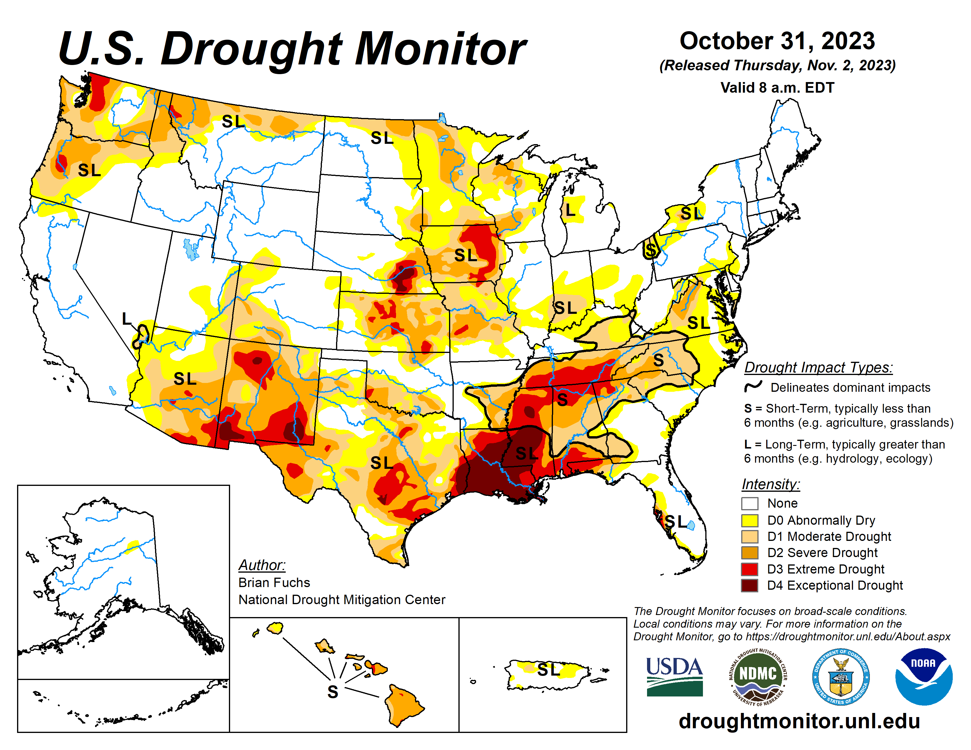
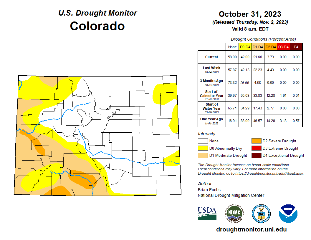
Click the link to go to the US Drought Monitor website. Here’s an excerpt:
This Week’s Drought Summary
One of the first significant storm systems of the season impacted the Plains and into the Midwest. Not only did the region see widespread precipitation, but the first real cold air also dropped in from Canada. Snow was widespread through the northern Plains and significant rain fell across portions of Kansas, Missouri, Oklahoma, Texas and Arkansas as well as in Wisconsin. The Southeast continued to be dry and warmer than normal while cold air dominated portions of Montana into Wyoming during the last week…
High Plains
Significant precipitation was recorded in North Dakota, northeast Nebraska, and central and southeast Kansas. Some of the precipitation in these regions came as snow and it is anticipated that much of the ensuing melt-off will get moisture into the soils. Temperatures were cooler than normal over most of the region with the greatest departures over the western Dakotas where temperatures were 10-15 degrees below normal. A full category improvement to the drought intensities was made over northern North Dakota, central and western Nebraska, and southeast Kansas. Some expansion of abnormally dry conditions took place over eastern Colorado and western Kansas as well as southern Wyoming…
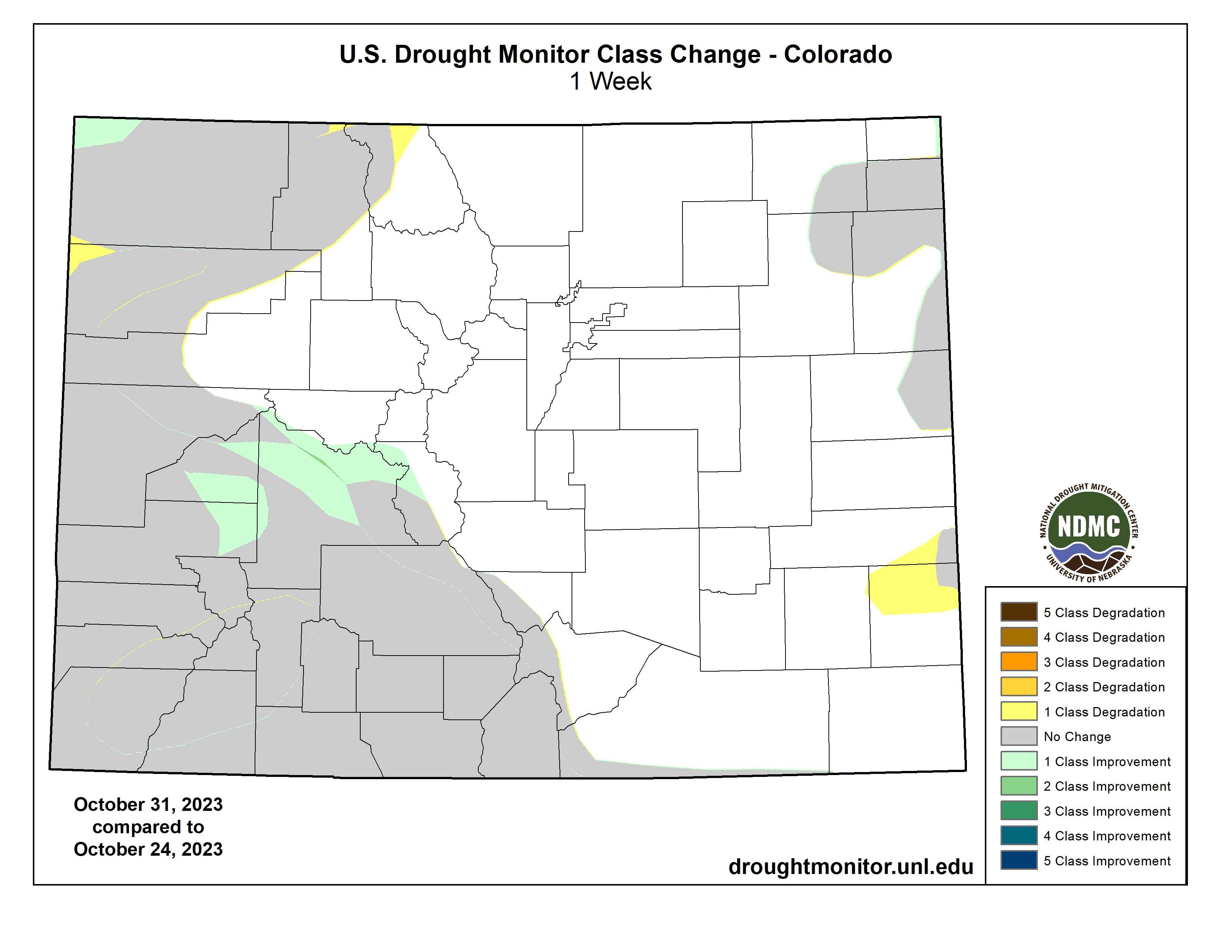
West
Much of Montana and central to western Colorado saw the most significant precipitation for the week, with good amounts of snow in the higher elevations. Great Falls, Montana, recorded over 8 inches of snow for the week and Havre had 5.7 inches. Crested Butte, Colorado, recorded 13 inches of snow for the week while Steamboat Springs had 4.9 inches. Temperatures were below normal for almost all of the region with most areas 5-10 degrees below normal. Areas of Arizona and New Mexico were near normal to up to 5 degrees above normal while Montana and Wyoming received the coldest air and temperatures for the week were 20-25 degrees below normal. The precipitation in Montana allowed for improvement to the drought conditions, mainly in the northern portions of the state. Some improvements were made in western Colorado while there was some slight expansion to the abnormally dry conditions in Utah. Improvements were also made this week in central Washington as the most recent wetter pattern started showing up in the drought indices and indicators, allowing for improvements on the map…
South
Temperatures were mixed for the week as areas impacted by the strong storm system through the region were 1-3 degrees below normal while those further to the west were 9-12 degrees above normal for the week. Significant rain fell over most of Oklahoma and Texas and into northern Arkansas this week, allowing for improved drought conditions. Lake Waco, in north central Texas, gained 112,000 acre-feet over the past week, taking it from its historic low of 54.5% of conservation storage to 114% of conservation storage. Most of these areas had a full category of improvement to their drought status, with some areas of Texas seeing multiple category improvements to the drought intensity. A full category of improvement was made over much of Arkansas this week with a reduction of moderate and severe drought conditions…
Looking Ahead
Over the next 5-7 days, much of the southern half of the U.S. is expected to be dry with little to no precipitation anticipated in areas south of a line from central California to Nebraska and into the Mid-Atlantic. The Pacific Northwest as well as the northern Plains and Midwest are expected to have the most active weather and precipitation. Temperatures are expected to be warmer than normal over the Southwest, southern Plains and Southeast with departures of 8-10 degrees above normal in west Texas and into New Mexico. Cooler-than-normal temperatures are anticipated over northern California, the northern Plains and upper Midwest with departures of 5-8 degrees below normal.
The 6–10 day outlooks show a good chance of a warmer-than-normal pattern over the southern U.S. and the Pacific Northwest. The best chance for below-normal temperatures is over the Great Lakes and New England regions. There is a high likelihood that temperatures over Alaska and Hawaii will also be above normal. The greatest chances of above-normal precipitation will be over northern California and southern Oregon while coastal areas from North Carolina to Maine will also have above-normal chances of recording above-normal precipitation. The best chance of below-normal precipitation is over the southern Plains and into Arizona and New Mexico.
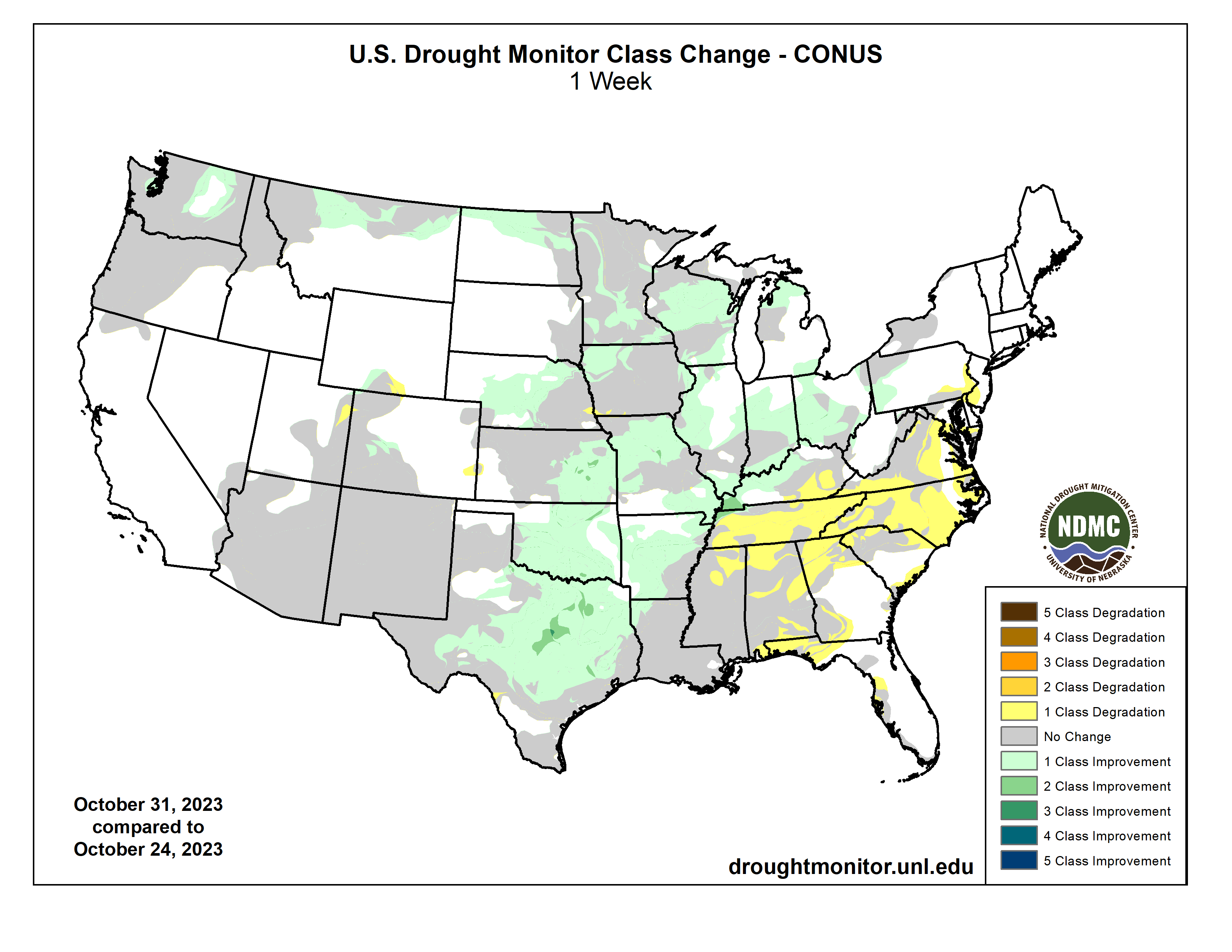
Click the link to read the article on the Colorado Water Trust website (Marsha Daughenbaugh):
Heroes are sometimes hard to find. However, in the world of protecting Colorado’s environment, culture and water resources, Colorado Water Trust is a hero.
I have served on the Board of Directors with Colorado Water Trust (CWT) for five years and am continually amazed with the projects, work ethics and involvement of the staff and fellow board members. The positive, “can-do” attitude is proving to be a model of what can be done to protect and improve our state’s river flows.
I became aware of Colorado Water Trust before joining the Board because of their efforts to maintain sustainable water levels in the Yampa River. As a non-legal, non-engineering individual in the water world, it was amazing to me that a non-profit had the interest and resources to purchase water for a struggling river system. My first thought was “they really care about agriculture” because this extra water meant ranchers along the Yampa River would be able to irrigate hay fields and pastures that were threatened with severe drought conditions. A search of CWT’s website opened my eyes to their mission, and I became intrigued with other projects.
Years later, through a strange set of events, I was asked to become part of their Board. They were looking to expand their representation throughout the state with people involved in day-to-day agricultural water and land use. I became a candidate, was accepted, and was thrilled with the opportunity to become involved.
CWT is striving to find solutions for many of the land use challenges facing agriculture: water equity, adequate water quantity, protection of natural resources, retention of properties for future generations, and respect for people who provide food and fiber to our country and world.
Much has been accomplished and there are many successful CWT stories. We have projects in process and potential proposals are being researched. There is much to do—and Colorado Water Trust is a positive leader in the efforts.
Hero is defined as a person who is admired or idealized for courage, outstanding achievements, or noble qualities. CWT is an organization that embodies that definition, and I am proud to serve on the Board.
Marsha Daughenbaugh
Board Member, Colorado Water Trust
Rancher, Steamboat Springs

by Rachel Mipro, Kansas Reflector
October 31, 2023
TOPEKA — Kansas researchers will turn their focus to wheat, millet and other crops in a federally funded attempt to tackle world hunger.
The U.S. Agency for International Development awarded Kansas State University $22 million to research how best to promote the growth of crops as climate change and global instability continues to derail the agricultural industry.
K-State will lead the Feed the Future Climate Resilient Cereals Innovational Lab, or CRCIL, focusing on sorghum, millet, wheat and rice as major world crops that need to be protected. The university will partner with several other state universities including Cornell University and Louisiana State University, along with international partners in South Asia, Eastern and Western Africa and Latin America.
Jagger Harvey, director of CRCIL and a research professor in the Plant Pathology Department at K-State, said the project will look at ways to make these crops more resilient, including researching seed modification to help double food production and crop durability as climate conditions worsen.
“Kansas farmers and researchers are no strangers to harsh climatic conditions impacting cereal production,” Harvey said. “This makes K-State the perfect home for this new initiative.”
The funding will support collaborative research, along with using plant-breeding technology, such as DNA sequencing and genotyping, crop modeling and quicker growth methods, with the end goal of providing hardier crops to farmers around the world.
Dina Esposito, USAID’s assistant to the administrator for Resilience, Environment, and Food Security, said the initiative would help tackle problems of hunger and poverty.
“Advancing this work is critical to generating a pipeline of climate-adapted crops so we can strengthen the resilience of small-scale farmers and meet their current and future needs,” Esposito said.
Jared Crain, a K-State plant pathology department research assistant professor who will serve as the associate director of the innovation lab, estimated that more than 50% of the world’s caloric intake comes from cereal crops.
“With the exception of maize, CRCIL is dedicated to identifying and using genetic variation to improve farmers’ production and consumers’ acceptance of the top vital cereals,” Crain said.
The $22 million award is the fifth award that K-State has received through Feed the Future, a federal initiative attempting to combat world hunger. USAID has invested nearly $128 million in K-State innovation labs for research into agricultural areas such as post-harvest losses and increasing harvest yields.
Kansas Reflector is part of States Newsroom, a network of news bureaus supported by grants and a coalition of donors as a 501c(3) public charity. Kansas Reflector maintains editorial independence. Contact Editor Sherman Smith for questions: info@kansasreflector.com. Follow Kansas Reflector on Facebook and Twitter.

Click the link to access the report from the Beyond Plastics website:
October 2023 | Beyond Plastics & International Pollutants Elimination Network (IPEN)
Chemical recycling — or what the industry likes to call “advanced recycling” — is increasingly touted as a solution to the plastic waste problem, but a landmark new report from Beyond Plastics and IPEN shows this technology hasn’t worked for decades, it’s still failing, and it threatens the environment, the climate, human health, and environmental justice. This comprehensive report features an investigation of all 11 constructed chemical recycling facilities in the United States, their output, their financial backing, and their contribution to environmental pollution.
The petrochemical and plastics industries have been aggressively working across America to pass state laws that reclassify chemical recycling facilities as manufacturing rather than waste facilities, which reduces regulation of these polluting plants and allows the companies to grab more public subsidies. As of this report’s release, 24 states have passed such laws. Just like mechanical recycling, chemical recycling is an industry marketing tactic to distract from the real solution to the plastic problem: reducing how much plastic is produced in the first place.
Deregulating and incentivizing chemical recycling is a dangerous trend with environmental and human health repercussions, though it’s not surprising when you consider how little information is publicly available about what chemical recycling actually does, how it does it, who it affects, how little plastic it removes from the waste stream, and how little product is actually produced.
This report unmasks chemical recycling’s history of failure, its lack of viability, and its harms so that others, especially lawmakers and regulators, can see this pseudo-solution for what it is: smoke and mirrors.

From email from the National Drought Mitigation Center (Curtis Riganti):
Drought developed and expanded in parts of the Desert Southwest during an unusually hot and dry North American Monsoon. Maricopa County, Arizona, recorded a statewide average of 1.27 inches of rain (the second-lowest county average total in 43 years of data, according to the County’s Flood Control District ).
Widespread extreme and exceptional drought developed from central and east Texas through Louisiana and southern Mississippi, leading to impacts including wildfires in Louisiana. All five long-term climate stations in south-central and southwest Louisiana had their hottest August on record, and three of the five sites had their driest August on record, according to the National Weather Service (NWS) Lake Charles 1 .
Drought also developed or intensified along the U.S.-Canada border from Minnesota to Washington. Hawaii was another area of drought development, with areas of extreme drought on the leeward sides of Maui.
Drought and abnormal dryness from a generally drier-than-normal spring mostly improved in the Northeast.

From email from Reclamation (Erik Knight):
Releases from the Aspinall Unit will be decreased from 1100 cfs to 800 cfs on Thursday, November 2nd. Releases are being decreased in response to a decrease in diversions at the Gunnison Tunnel. Tunnel diversions will be reduced by 300 cfs on November 1st, so there will be a short period of higher flow in the Gunnison River through the Black Canyon before the release change at Crystal Dam.
Flows in the lower Gunnison River are currently above the baseflow target of 1050 cfs. River flows are expected to remain above the baseflow target for the foreseeable future.
Pursuant to the Aspinall Unit Operations Record of Decision (ROD), the baseflow target in the lower Gunnison River, as measured at the Whitewater gage, will be 1050 cfs for November through December.
Currently, Gunnison Tunnel diversions are 800 cfs and flows in the Gunnison River through the Black Canyon are around 320 cfs. After this release change Gunnison Tunnel diversions will be 500 cfs and flows in the Gunnison River through the Black Canyon will still be near 320 cfs. Gunnison Tunnel diversions are expected to stay near 500 cfs for the first 2 weeks of November for late season irrigation of the winter wheat crop. Current flow information is obtained from provisional data that may undergo revision subsequent to review.
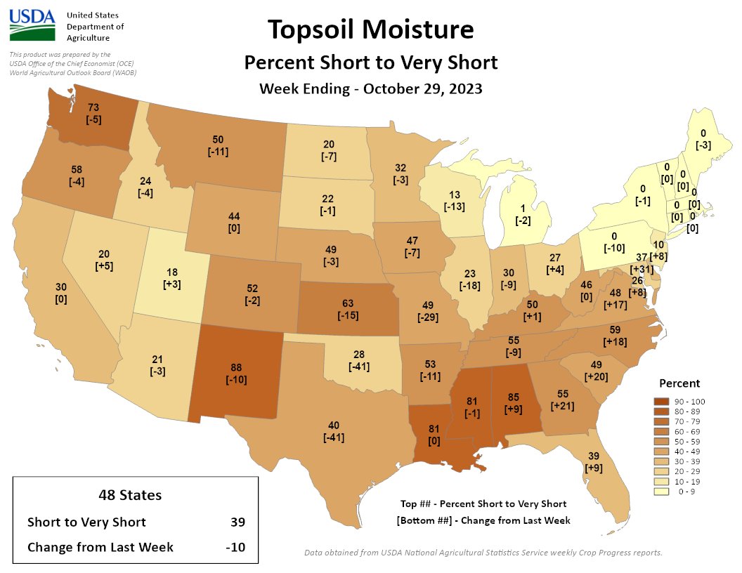
39% of the US is short/very short for the week ending 10/29. Much of the US saw improvement with snow & rainfall last week, but many southeastern states saw rapid drying. WA, NM, LA, MS & AL continue to see the driest topsoil.