How volunteer ‘Streamkeepers’ influence water policy across the West — Water Education Foundation

A volunteer with the South Yuba River Citizens League tests the water quality and temperature of the river in the Sierra foothills northeast of Sacramento. Source: South Yuba River Citizens League

Click the link to read the article on the Water Education Foundation website (Nick Cahill):

February 29, 2024

When residents of the Yuba River watershed northeast of Sacramento saw a stretch of the emerald-green river suddenly turn an alarming reddish-brown on a recent winter day, they knew immediately who to call.

Though water quality concerns are the purview of federal, state and county environmental agencies, they alerted the local South Yuba River Citizens League, confident its volunteers could get to the scene quicker and investigate the discoloration faster than any regulator.

Sure enough, the group found the likely culprit within hours. One of its trained river monitors took samples at the site near the Gold Rush-era town of Nevada City, ran a series of tests, then compared the results with those from samples volunteers had routinely collected for more than 20 years – from the same section of river and the same time of year.

“Our baseline data allows us to look back on how the river has behaved at certain points in time, and lets us quickly identify anomalies,” said Aaron Zettler-Mann, the league’s executive director, who develops stream-sampling tools for volunteers as part of his post-doctorate research in geography. “We worked backward and determined it was probably just a small landslide.”

The league is among dozens of volunteer organizations that monitor the health of their local waterways and native fish populations across California and the West.

As new threats emerge, the community stream stewards bring their data and observations to the attention of environmental enforcement agencies. Colorado takes the relationship a step further by formally partnering with streamkeepers and using their data to inform decision-making. 

Often referred to as “streamkeepers,” the grassroots groups are meticulous chroniclers of river conditions – the Yuba league alone records water temperature, pH, dissolved oxygen and turbidity at 37 sites across 40 river miles – and are often the first to detect problematic trends.

Information from streamkeeper groups has influenced California policymakers in setting minimum stream flow requirements for native fish, establishing water quality standards for treated wastewater disposed in streams and designating stretches of rivers “wild and scenic” to keep them free of dams and diversions.

“These groups get the data from the ground level and make it real,” said Felicia Marcus, former chair of California’s State Water Resources Control Board, which polices water quality. “Their stories can be really important and powerful in the public policy arena.”  

Versatile Volunteers

Andrew Rypel

Some larger groups like Los Angeles Waterkeeper have fundraising and public relations staff and are linked to larger networks while many of the smaller, more grassroots organizations like the Friends of the Shasta River monitor waterways in more remote areas.

Native American tribes are no less active in protecting their watersheds. Several tribes are the driving force behind the ongoing removal of four hydroelectric dams on the Klamath River. At Clear Lake, just north of Napa Valley’s wineries, the Big Valley Band of Pomo Indians and the Elem Indian Colony are taking the lead on spotting toxic algal blooms that harm fish and taint water supplies.

Streamkeeper groups share similar core goals: reduce pollution, monitor stream conditions and gather data that can help officials make informed water policy decisions.

Mostly comprised of trained volunteers, the groups lead river clean-ups, survey locations for habitat restoration, conduct routine water quality testing and educate the public on the importance of healthy watersheds. Retired biologists, ecologists, conservationists and former employees of natural resource agencies are common in the ranks of volunteers as are riverside property owners.

Andrew Rypel, director of the Center for Watershed Sciences at the University of California, Davis and former member of a streamkeeper group in Alabama, cast these volunteers as the “ultimate transdisciplinary water professional.”

“They tend to know something about science, ecology, agriculture, the people who live along the waterbody and the economics of the situation,” he said. “They’re in the middle of everything.”

Punching Above Their Weight

Some California streamkeepers wield their local knowledge to spur regulatory changes.

One of the preeminent streamkeeper success stories comes from Putah Creek, an 85-mile-long stream that winds through parts of Northern California’s wine country before draining into the Sacramento River.

Having a permanent, paid stream keeper has aided the ecological recovery of Utah Creek below Monticello Dam in Northern California’s wine county. Eight miles down a smaller dam divers much of the water south to Solano County cities, farms and industry. Source: UC Davis

In 1990, the volunteer-led Putah Creek Council sued the Solano Irrigation District and Solano County Water Agency to release more water from a dam to sustain chinook salmon and other native fish species downstream. The city of Davis and UC Davis later joined the council as plaintiffs.

After a protracted legal fight, a state judge ordered a new flow schedule for the creek that requires the water agency to provide more water when certain species are spawning or migrating out to the ocean. As part of a settlement over the lawsuit, the water agency agreed to create a permanent streamkeeper position on staff.

Having a dedicated, long-term funding source for the streamkeeper position has been key to the creek’s recovery, said Max Stevenson, who assumed the full-time job in December 2021. He added that some of his most important work is done off-stream, engaging with interest groups.

“Long-term relationship building is the key,” Stevenson said. “All the users – landowners, regulatory agencies, the public and cities – they have to get along.”

The lower Putah Creek, which commonly ran dry during drought and was a haven for illegal dumping, has seen a resurgence in its salmon and steelhead trout populations thanks to consistent flows and habitat restoration, according to UC Davis researchers.

A similar effort is underway in the San Joaquin Valley, where local streamkeeper groups are among those pressing the city of Bakersfield to keep more water in the lower Kern River for fish. A state judge has ordered the parties to come up with a plan that ensures “public trust flows” to benefit fish while the case is pending.

Los Angeles Waterkeeper has routinely filed lawsuits over the past 30 years, forcing the state and local governments to curb sewage spills and reduce the flow of toxic urban runoff into streams and along the Pacific coast.

“While no one likes to go to court, a lawsuit is often the only way to get polluters and regulators to do the right thing,” said Kelly Shannon McNeill, the Los Angeles group’s associate director.

Streamkeepers are also known for rallying against new dams.  

The Yuba league was hatched in the 1980s primarily to fight proposals for more dams on the river. It swayed local politicians to fight against the projects and — after nearly 20 years of lobbying — state lawmakers gave the Yuba wild and scenic status, permanently banning new dams and diversions on nearly 40 river miles. The group now has about 3,500 members.  

A chinook salmon prepares to spawn in the Shasta River below Mount Shasta. Petitions files by Friends of the Shasta River and other groups prompted state water officials to temporarily limit diversion ton the stream. Photo courtesy of Carson Jeffres.

Since then, stretches of several other rivers have been added to the state’s wild and scenic list, most recently a portion of the Mokelumne River in 2018.

Near the California-Oregon border, Friends of the Shasta River has had recent success in protecting salmon and other native species on a key Klamath River tributary.

The group formed in 2019 out of frustration over the lack of streamflow protections for a river that historically produced about 50 percent of the chinook salmon in the Klamath River basin. The group, comprised of local scientists, retired natural resource professionals and riverside property owners, documents water conditions and promotes the river’s values in rural Siskiyou County.

“The Shasta River is tiny, more of a creek running through a desert, but arguably for its size it was probably the most productive salmon-bearing stream on the face of the earth,” said David Webb, a Friends of the Shasta River board member.

The Shasta streamkeepers, the Karuk Tribe and other salmon activists filed petitions that prompted the state water board to temporarily limit water diversions during the last three years on the Shasta and nearby Scott River. Regulators are currently gathering scientific data and considering whether to adopt permanent minimum flow requirements to ensure the rivers don’t run dry during critical periods for native fish.

“We’ve waited long enough; we need permanent instream flows so that public trust resources are protected,” Webb said.

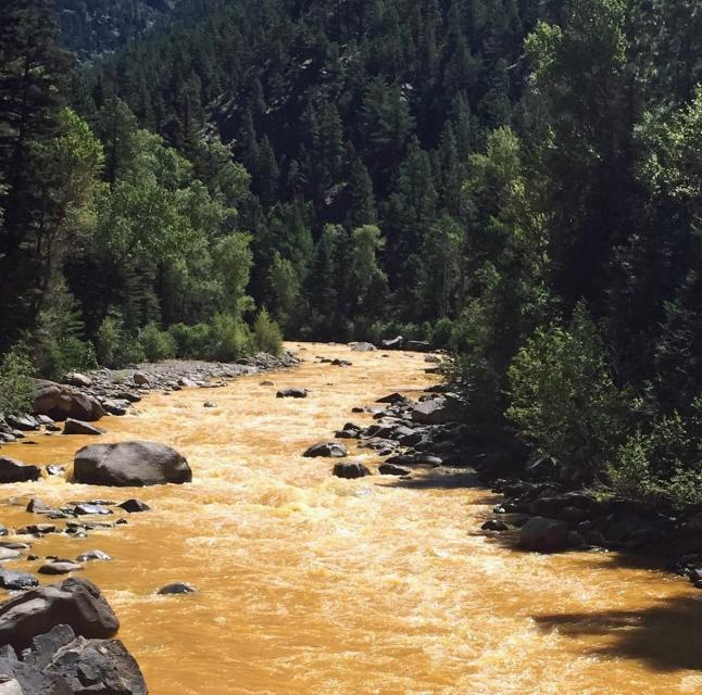
A River Turns Orange

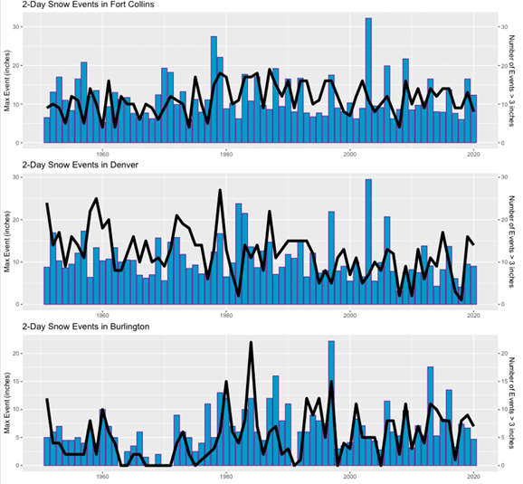
For more than three decades, Colorado has relied on a virtual army of volunteers to track the health of the state’s more than 150 rivers.

Before 1989, conditions on most of the state’s 770,000 miles of river weren’t monitored. Important water decisions were made without reliable data. To better inform decision-makers, the state created a program that enlists streamkeepers, teachers and students to gather water quality data.

A reach of the Animas River in Southwestern Colorado turns orange following a wastewater spill from Gold King Mine in 2015. State officials used volunteers’ baseline data to track progress on the river cleanup. Source: Wikimedia Commons

Today, the River Watch program managed by Colorado Parks and Wildlife and the nonprofit River Science has about 100 volunteer groups that monitor hundreds of streams. Revenue from the state lottery helps pay for the program.

Megan McConville, who manages the program for the state, says the thousands of volunteers serve as eyes and ears for Colorado’s streams, spotting trends unseen by environmental regulators.

“These students, these volunteers, they know their rivers better than I ever will,” McConville said. “What I love about this program is that I can call a volunteer and ask them ‘Hey, could you expand your monitoring to include two more locations? We want to figure out whether a culvert is introducing zinc into a waterway.’”

Streamkeepers came in particularly handy in 2015 when 3 million gallons of orange sludge spilled from an abandoned mine and tainted the Animas River, a Colorado River tributary. The state used the volunteers’ baseline data to track its progress on the river cleanup.

‘They Can Have Your Flank’

While streamkeepers have had legal fights with water suppliers and regulators, partnerships between them are becoming more common in California.

Both the South Yuba River Citizens League and the Yuba Water Agency are working with a broader coalition to restore 275,000 acres of forest in the river’s upper Sierra watershed. They are also cooperating on habitat restoration projects and a proposal to create a channel that will allow threatened green sturgeon to get around a dam on the Yuba.

Willie Whittlesey, Yuba Water Agency general manager, credited the 2008 Yuba Accord for fostering ongoing partnerships on the Yuba. 

“This is a new way of doing things,” Whittlesey said of the series of agreements among the agency, environmental groups, farmers and hydroelectric producers.

Meanwhile, in California’s capital city, streamkeepers are becoming effective advocates. Marcus, the former head of the state water board, said grassroots groups have figured out creative ways to draw attention to problems in ways that regulators can’t.

Joaquin Esquivel

She credited groups, such as those that brought jars of tainted drinking water to public hearings and press conferences, for winning legislative support for more water board staff and resources to regulate rural drinking water systems.

“They can have your flank,” said Marcus, who in 1985 co-founded the grassroots Heal the Bay group to fight pollution in Santa Monica Bay and elsewhere along Southern California’s coast. “Sometimes they highlight a problem and then the agency can get the resources needed to address it.”

Streamkeepers can also aid regulators by carefully reviewing pending orders and rules. During her stint as state water board chair, Marcus said the California Coastkeeper Alliance was particularly adept at articulating the pros and cons of draft documents and then working with the regulator on useful changes. “It makes it easier for you as a regulator,” she said.

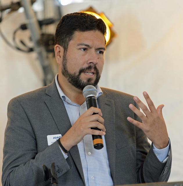
Joaquin Esquivel, the current board chair, said volunteer groups have been submitting critical water quality data to the board’s citizen monitoring program for years. The program helps streamkeepers choose monitoring techniques, perform quality control and find funding sources.

“Their concern is genuine,” Esquivel said. “Collecting and bringing in data helps us see that a watershed or stream is impaired.”

Back on the south Yuba, Zettler-Mann and his group have started monitoring the watershed for signs of emerging threats, including long-lived synthetic compounds known as PFAS and a rubber preservative in tires that federal regulators are examining for potential harm to salmon.

UC Davis’ Rypel, a professor of coldwater fish ecology who advocates “a streamkeeper for every stream,” said having passionate volunteers filling data gaps and looking out for emerging threats to streams like the Yuba and Putah can inspire neighboring watersheds to do the same.

“Of all the different management things I’ve seen tried,” he said, ”the streamkeeper thing might be the one that’s worked best.”

Reach writer Nick Cahill at ncahill@watereducation.org

Know someone who wants to stay connected to water in the West? Encourage them to sign up for Western Water and follow us on TwitterLinkedInFacebook and Instagram.

Winter Precipitation on #Colorado’s Northern Front Range: Is it Changing? — @ColoradoClimate Blog

Click the link to read the post on the Colorado Climate Center blog (Peter Goble):

March 1, 2024

Hello, and welcome to meteorological spring (March-May). The month of February just ended, and frankly, this winter felt different. The northern Front Range of Colorado has just been through a bizarre meteorological winter. For Fort Collins, this was the second warmest and second least snowy meteorological winter since the beginning of the 21st century, and certainly warmer and less snowy than the historical past. At the same time, precipitation (the combined accumulation of rain and melted liquid from snow/ice) has been well above average this winter. The official Fort Collins Weather Station winter precipitation total of 2.42” is the 8th wettest winter on record, and ranks only behind 2007 and 2016 in the last 30 years. Boulder also recorded its 8th wettest winter in over 100 years while remaining only 0.6” above the 1991-2020 average snowfall mark. Our neighbors at the University of Northern Colorado in Greeley recorded their 3rd warmest winter, but with 151% of normal precipitation. On top of this, winter 2024 has also been speckled with rain only events, freezing drizzle, and a very heavy, spring-like rain snow mix. Is this a sign of things to come? Will rainy, drizzly, sloppy winters replace the fine, snowy powder of our past? Let’s dig into the numbers and the literature to find out.

Winter Rain Only Events


Rainfall events during the winter months on the northern Front Range of Colorado are perhaps more common than some realize. Since 1951 there have been 80 rainfall events with no measurable snow for Fort Collins, and 95 for Boulder. That is an average of 1.0-1.5 rain only events/meteorological winter. Fort Collins and Greeley had three such events this year (Boulder only one). There is no statistically significant trend in winter rain events over this time. If somebody says “it never rains in northern Colorado during winter” be skeptical.


One reason we may be inclined to believe winter rain is rare in Colorado is these events generally aren’t memorable. Precipitation accumulations are almost always small. 80-90% of rain-only winter events tally less than one tenth of an inch of precipitation. Fort Collins, Greeley, and Boulder have never seen a rain event greater than half an inch during winter. The largest rain only value occurred in Boulder on January 18th, 1974 (0.43”).

Freezing Rain/Drizzle


We also experienced a freezing drizzle event this winter on February 16th, 2024. This is not the only winter freezing drizzle events in recent years: Northern Colorado also saw freezing drizzle on January 24th, 2017, January 19th, 2022, and March 7th, 2014 (though this last date falls just outside the scope of “meteorological winter”). Anecdotally, it feels as though these events are becoming more frequent. A couple notes on freezing rain and freezing drizzle: 1. While freezing drizzle is obviously possible for northern Colorado, true freezing rain is nearly impossible. 2. Freezing drizzle is not well archived historically. One possible source of freezing drizzle records is the Automated Surface Observing System (ASOS), a network of weather stations designed to aid aviation endeavors. Some ASOS stations do mark the occurrence of freezing drizzle, but not all, and existing records are spotty. All this to say, it is unclear whether or not freezing drizzle is becoming more likely for northern Colorado.

February 3rd, 2024 (A Spring Storm in the Middle of Winter)


February 3rd was a special day on the northern Front Range of Colorado. The official Fort Collins weather station received 1.66” of precipitation between 7:00 PM on the 2nd, and 7:00 PM on the 3rd (7:00 is the official weather station daily observation time). Boulder and Greeley received 1.74” and 0.74” of precipitation respectively. This was a top ten wettest storm for Greeley and a record setter for Boulder. In Fort Collins, 1.66” of precipitation is not only a record amount of moisture for any day in February (135 years of record), it single-handedly made February 2024 the wettest February Fort Collins has ever experienced. Furthermore, Greeley’s all-time wettest February storm also occurred in 2024 just one week later, but as heavy snowfall.

Northern Colorado locals have seen these types of rain/snow events before, but they are more of a calling card of spring. Typically, in February, the air is too cold and dry to support such accumulations. The weather pattern on this day was unique in a couple key ways allowing this event to happen. For one, the storm tapped into a corridor of tropical moisture extending all the way from the central tropical Pacific Ocean to the western United States, greatly increasing the potential for high moisture totals. These events are often called “atmospheric river events,” and are more common in coastal settings like California, Oregon, and Washington. Secondly, we experienced a split polar jet stream pattern with Colorado lying in the middle of the two currents. The southern flank of the split polar jet brought the atmospheric river to our doorstep while a high pressure airmass in the middle of the two flanks deflected the moist air back against the eastern side of the Rocky Mountains, and blocked cold arctic air from sweeping this storm out over the plains (figure 1). Both factors were important for producing such spring-like storm conditions.

Figure 1: Upper air map of Contiguous United States from the morning of February 3rd, 2024 (250 hectopascal pressure level). Wind speeds measured in knots (kts) from National Weather Service Soundings. Wind speeds contoured in 25kt intervals. 1 flag = 50 kts. Long bars = 10 kts. Short bars = 5kts. Green arrow shows position of jet stream. The “H” and “L” mark locations of high and low pressure.

Winter Precipitation and Climate Change


Our office teamed up with Jeff Lukas of Lukas Consulting to synthesize what the academic literature says about how Colorado’s climate may change over the remainder of the 21st century. This resource can be accessed here. If you have not had a chance to scan this document, I highly recommend it. We can use this document to get a glimpse into the future of winter precipitation, snowfall, and winter storms for Colorado.


Colorado has warmed, and continues to warm, significantly in all seasons due to increasing greenhouse gas concentrations in the atmosphere. Atmospheric physics tell us that warmer air can hold more water vapor, meaning there is potential for higher precipitation measurements from each individual storm under a warmer climate. We do see evidence that meteorological winters are getting wetter. Since 1950 we have seen a 3% increase in statewide wintertime precipitation. This trend is actually higher for the northern Front Range +14%, but somewhat offset by marginal decreases in western Colorado. Most climate models do suggest further increases in wintertime precipitation are likely. One experiment from our report shows an average of 6% more winter precipitation across Colorado by mid-Century with nearly 90% of the 36 global climate models used agreeing on the sign of the trend. Further increases are possible by the end of this century, and under high carbon emissions scenarios.


Accurately assessing trends in snowfall is more complicated. Snow measurement protocols have changed over time, muddying the waters of snowfall trend analysis. We do know average high elevation snowpack has decreased over time in Colorado, but 3”+ snowstorms on the Front Range have not. Annual maximum snowfall event totals have not fallen yet either (Figure 2). We also know that extreme cold outbreaks, which often follow winter snowstorms, are likely to continue decreasing in frequency and intensity, but will not disappear.

Figure 2: Maximum 2-day snow event per year in inches (blue bar) and total number of 2-day snow accumulations greater than 3 inches per year (black line) for Fort Collins (top), Denver Central-Park (middle), and Burlington (bottom), 1951-2020. Source: climatechange.colostate.edu

Winter storms are complex, and can be measured in a number of ways. For instance, just in recent years, we have seen the northern Front Range covered with 20-30” of snow (March 2021), a new lowest central pressure record from a winter storm (March 2019), and one of the most intense cold fronts in decades (December 2022). We have high confidence that winter will continue to get warmer on average across Colorado over the coming years and decades, but snow, extreme cold, and wildly varying conditions will not be out of the offing anytime soon.


Based on the evidence we have about climate change in Colorado, it is reasonable to hypothesize that our warming trend made this event more likely. Even so, climate models do not suggest that events like February 3rd, 2024 will become commonplace by the end of the century, even under high emissions scenarios.

A newly published study from the U.S. Geological Survey explains how salinity in the Upper #ColoradoRiver Basin has changed over the past few decades and shows how #climate, irrigation and flow of groundwater contribute to salinity in the watershed #COriver #aridification

Click the link to read the release on the USGS website (Alexandra (Allie) Weill and Olivia Miller):

February 8, 2024

A newly published study from the U.S. Geological Survey explains how salinity in the Upper Colorado River Basin has changed over the past few decades and shows how climate, irrigation and flow of groundwater contribute to salinity in the watershed. The study correlates overall salinity declines in the river basin since the 1980s with a transition from wet to dry conditions.


High salinity can limit water available for agriculture, drinking water, aquatic life and infrastructure, with significant impacts to the economy and human health. Salt occurs naturally in water, but salt loads are influenced by irrigated agriculture, geology, land cover, land-use practices and precipitation. Salinity can exacerbate corrosion of lead pipes and increase lead levels in drinking water and mobilize other metals or pollutants as well. High salinity levels in the Colorado River reduce agricultural yield, damage infrastructure and are estimated to cause $348 million per year in damage to infrastructure and crop production.

Sources/Usage: Public Domain. Salt deposits along the Paria River, UT. (Olivia Miller, USGS)

“This study shows us how irrigation and climate work together to influence salts going into streams,” said USGS hydrologist Olivia Miller, lead author on the study. “Future climate change in the Southwest, combined with changes in irrigation, may affect stream water quality, but we don’t yet understand how these interactions will play out, so our next step is developing a model to test scenarios of future climate change.”

Wet periods have higher salinity loads because increased runoff from rain and melting snow and increased groundwater movement bring more salts into rivers. In contrast, drier periods have lower salinity loads. Irrigation also plays an important role, contributing salts to the river more efficiently than any other source. 

“Salt loading to the Upper Colorado River and tributaries is a significant economic and environmental concern which limits the utility of the Colorado River and creates economic damages to downstream water users,” said Don A. Barnett, Executive Director, Colorado River Basin Salinity Control Forum.

For the new study, USGS scientists created a dynamic model that simulates the flow of water and salts throughout the whole Upper Colorado Basin between 1986 and 2017, allowing them to estimate salinity in the river and identify its sources for every year over that time.

The study confirmed previous findings that salts come primarily from groundwater (66-82%), with smaller portions attributed to runoff and springs. The salts in groundwater may initially come from infiltration of irrigation water, but once dissolved in groundwater, tracing the source is difficult. Groundwater is stored for long periods underground, meaning that there can be a time lag between when the salts enter the groundwater and when they end up in the river. As a result, while salinity management efforts focused on surface runoff processes may produce small results in the short term, larger impacts may take longer to work through the groundwater system.

“The Upper Colorado River Basin States are taking actions to reduce salinity in the Colorado River for the benefit of the 40 million people who use the River’s water,” said Paul Kehmeier, Salinity Program Coordinator, Colorado Department of Agriculture. “This study helps clarify that the sources of salt vary over time and it will help inform managers on strategies to continue improving the quality of water in the Basin.”

The study was published in the journal Environmental Research Letters.

Click here for more science from the USGS Utah Water Science Center.

Sources/Usage: Public Domain. View Media Details The Dolores River, CO. (Olivia Miller, USGS).