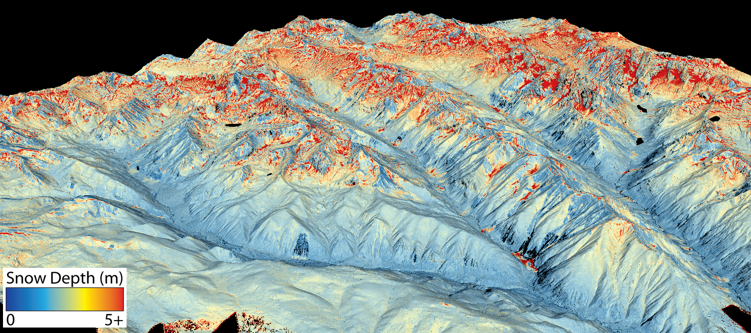
This map shows the snowpack depth of Castle and Maroon valleys in spring 2019. The map was created with information from NASA’s Airborne Snow Observatory, which will help water managers make more accurate streamflow predictions. Jeffrey Deems/ASO, National Snow and Ice Data Center
Click the link to read the release on the USBR website (Chelsea Lair):
March 28, 2024
The Bureau of Reclamation is making a minimum of $3 million available for emerging snow monitoring technologies. Each selected project is eligible to receive between $300,000 – $999,999 and must include the implementation of aerial LiDAR snow surveys.
The funding opportunity is available at www.grants.gov by searching for funding opportunity number R24AS00206. Applications are due on May 6, 2024, at 4 p.m. MDT.
The funding is through Reclamation’s Research and Development Office and funds will be provided by grant.
Eligible applicants include water districts, irrigation districts, water associations, universities, state agencies, private sector entities, City/county or township governments, Tribal Government, nonprofit Organizations, non-governmental organizations, and any combination of the entities listed above.
Applicants can submit projects that meet the following criteria:
Improvements to existing snow monitoring technologies – Demonstrating and/or deploying.
Deploying snow monitoring technologies in poorly monitored areas.
Improve the use of snow monitoring data to enhance water supply forecasts.
The Bureau of Reclamation will host a webinar on April 5, 2024, from 11:30 a.m. to 12:30 p.m. MDT to discuss eligible applicants and project types, program requirements, and the evaluation criteria for the Snow Water Supply Forecasting funding opportunity. Please register to attend the webinar. If you are not able to make it, the webinar recording will be available at the challenge website.
Reclamation’s Snow Water Supply Forecast Program aims to enhance snow monitoring and to advance emerging technologies in snow monitoring and subsequent water supply forecasts. The program activities are working to build climate change resilience by enabling improved water management. To learn more, please visit the program website.
…China’s overwhelming dominance has alarmed officials in the United States and in Europe, who say they are worried that a flood ofcheap Chinese products will undercut their efforts to grow their own renewable energy industries — especially if the Chinese companies have what they consider an unfair advantage. Treasury Secretary Janet L. Yellen, who is expected to soon make her second visit to Beijing in less than a year, said in a speech Wednesdaythat she will press China to address “excess capacity” — including in solar, electric cars and batteries — that “distorts global prices” and “hurts American firms and workers.” Combined, this raises the specter of another trade war, one that activists say could pit protectionism against planet…
China’s metamorphosis into clean tech giant was ordered from the very top. Leader Xi Jinping made supporting “essentially green” industries a priority last month as he tries to stop the world’s second-largest economy from slowing…Clean energy is a bright spot in an otherwise gloomy economic outlook: China’s exports of electric vehicles, lithium-ion batteries and solar products soared 30 percent to $146 billion last year. BYD overtook Tesla in 2023 to become the world’s top-selling electric-car maker. This helped make the renewable energy industry the biggest contributor to the country’s economy, ahead of every other sector, according tothe Center for Research on Energy and Clean Air, a think tank. That shift has come about thanks in no small part to state support. For over a decade, Beijing has used measures including subsidies and tax breaks to create dozens of huge conglomerates that dominate sustainable energy industries. The Tongwei facility, toured by The Washington Post, is 15 percent owned by two of Chengdu city’s state-run investment companies. In the first nine months of last year, the company reported being subsidized with $125 million by the state, a 240 percent rise from 2022.
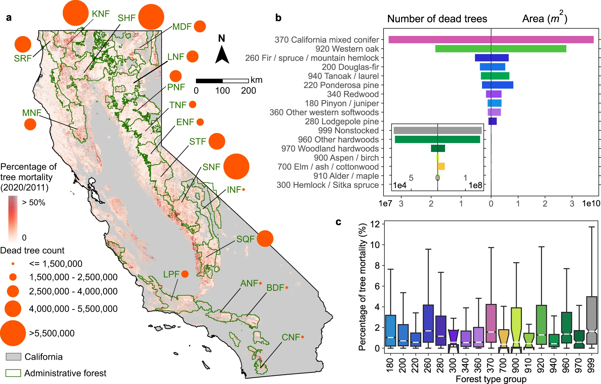
In panel a, the orange circles denote the total count of dead trees in each national forest. Supplementary Table 3 provides the lookup table for national forest abbreviations. The underlying map represents the percentage of tree mortality, which is the count of detected dead trees against the count of all trees in 2011 within 240 × 240 m grids43. Only forests, shrublands, and grasslands that are contained in the National Land Cover Database 201963 and ESA WorldCover 202064 are included in the mapping (Methods). b Total number of dead trees and spatial coverages for 16 main logical ecological groupings of forest types in California44. c Box plots of percentages of tree mortality per ha for each forest-type group. The boxes represent the interquartile range (IQR) which is between the 25th and the 75th percentile of the percentages of tree mortality. The whiskers represent 1.5 times the IQR. The white lines inside the boxes represent the medians. The notches inside boxes represent the 95% confidence intervals for the medians. Random selection of 30% of the pixels per forest-type group was applied to mitigate the spatial auto-correlation. The colour scheme used in panels a, b is consistent with the forest-type group map (Supplementary Fig. 7), representing different forest-type groups.
In recent years, large-scale tree mortality events linked to global change have occurred around the world. Current forest monitoring methods are crucial for identifying mortality hotspots, but systematic assessments of isolated or scattered dead trees over large areas are needed to reduce uncertainty on the actual extent of tree mortality. Here, we mapped individual dead trees in California using sub-meter resolution aerial photographs from 2020 and deep learning-based dead tree detection. We identified 91.4 million dead trees over 27.8 million hectares of vegetated areas (16.7-24.7% underestimation bias when compared to field data). Among these, a total of 19.5 million dead trees appeared isolated, and 60% of all dead trees occurred in small groups ( ≤ 3 dead trees within a 30 × 30 m grid), which is largely undetected by other state-level monitoring methods. The widespread mortality of individual trees impacts the carbon budget and sequestration capacity of California forests and can be considered a threat to forest health and a fuel source for future wildfires.
Click the link to read the report on the USFWS website.
Under the Emergency Wetlands Resources Act of 1986, we are required to submit decadal reports to Congress on wetland status and trends (area and change). These National Wetlands Inventory (NWI) Program reports provide the data necessary to effectively manage wetlands and determine if the goal of “No Net Loss” of wetlands is achieved. This is the 6th report in a series spanning nearly 70 years. Covering the period between 2009 to 2019, the report provides the extent of wetlands in 2019, as well as changes in wetland area and type between 2009 and 2019 for the contiguous United States. It highlights the importance of wetlands in providing ecosystem services, as well as the effects of wetland loss, gain, and type change. The report includes a recommendation and four strategies aimed at achieving no net loss of wetlands, including vegetated wetlands.
The Crystal River flows through the Gunnison County town of Marble, seen here with Beaver Lake. A representative from the Town of Marble is expected to participate in a subcommittee focused on an intergovernmental agreement to protect the river. CREDIT: ECOFLIGHT
After a year’s worth of work and meetings with a facilitator, a group focused on protecting the Crystal River is pursuing three potential ways forward.
The Crystal River Wild & Scenic and Other Alternatives Feasibility Collaborative Steering Committee recommends forming three subcommittees, each focused on continuing to evaluate a different method of river protection.
The first is an intergovernmental subcommittee composed of local governments that would develop an agreement that commits each of them to protecting the mainstem of the river against dams and trans-basin diversions. A “peaking” instream-flow subcommittee would look at protecting river flows during times of peak runoff and against diversions. A third subcommittee would move forward with writing a draft proposal for a federal Wild & Scenic designation that has the flexibility to address local landowner needs and that supporters say is still the strongest option for river protection.
Some Crystal Valley residents, along with Pitkin County, have pushed for a Wild & Scenic designation for years to protect the free-flowing nature of the river. But others, wary of any federal involvement, have balked at the idea, instead proposing different types of protections.
The steering committee was convened last year to explore different options, including Wild & Scenic, for river protections. As part of this work, they also held two community summits, which each drew more than 120 members of the public, as part of a process to get stakeholder input.
Marble resident Wendy Boland will be on the Wild & Scenic subcommittee. She said that the majority of residents are in favor of a federal designation, but that the subcommittee will have to address some people’s lingering concerns about private property and make sure those concerns are respected.
“Wild & Scenic is constantly being called the gold standard of river protection,” Boland said. “And the fact that it can be tailored to meet a local community’s needs and concerns is a big plus. So that’s really the goal of the subcommittee I’m on. We’ve listened to everybody’s concerns; can we draft legislation that would meet all those concerns?”
The Crystal flows from its headwaters in the Maroon Bells-Snowmass Wilderness through the towns of Marble, Redstone and Carbondale before its confluence with the Roaring Fork and is one Colorado’s last undammed major rivers.
The U.S. Forest Service determined in the 1980s that portions of the Crystal River were eligible for designation under the Wild & Scenic River Act, which seeks to preserve, in a free-flowing condition, rivers with outstandingly remarkable scenic, recreational, geologic, fish and wildlife, historic, and cultural values. Wild & Scenic experts say the “teeth” of the designation comes from an outright prohibition on federal funding or licensing of any new Federal Energy Regulatory Commission-permitted dam. A designation would also require review of federally assisted water resource projects.
Any designation would take place upstream from the big agricultural diversions on the lower portion of the river near Carbondale.
Jennifer Back, a retired National Park Service employee and former member of the Interagency Wild and Scenic Rivers Coordinating Council talks with Crystal River valley resident Larry Darien at a community summit on the Crystal River in April 2023. Three subcommittees will move forward with exploring options for protecting the river. CREDIT: HEATHER SACKETT/ASPEN JOURNALISM
‘Peaking’ instream flows
A second subcommittee will look at a tool that could be used to protect peak flows through the Colorado Water Conservation Board’s instream-flow program. The CWCB is the only entity allowed to hold water rights that keep water in rivers and are designed to preserve the natural environment to a reasonable degree. A “peaking” instream-flow water right would keep in the stream all of the water not claimed by someone else (also called “all of the unappropriated flow”) during certain times of the year.
So far, this particular tool is little-used, but there are three recent examples in the Gunnison River basin on Cottonwood Creek, Monitor Creek and Potter Creek. These three water rights were filed for in July and are still making their way through water court. No entities have filed statements of opposition. All three still allow for some amount of future water development.
The way that instream-flow water rights work is that another entity, usually a land use agency such as the U.S. Bureau of Land Management or a wildlife agency such as Colorado Parks and Wildlife will make a recommendation to the CWCB for a particular amount on a particular stream. Roy Smith, a water rights and Wild & Scenic Rivers specialist at the BLM, worked on the recent peaking instream-flow water rights in the Gunnison basin. He said in those cases, a peak instream flow was needed to protect the cottonwood trees because they need high flood waters that slowly recede to germinate seeds.
“Basically, what it means is every drop of water that has not been spoken for by any previously claimed water right is spoken for by this instream flow,” Smith said. “What we decided was let’s propose a water right where when the stream reaches bank full, a water right will be triggered that protects all the flow from that flow rate and above until the flood event is over.”
But the “outstandingly remarkable values” that Wild & Scenic seeks to protect and the special riparian ecosystems that peak instream flows are designed to protect may not align in the case of the Crystal River.
“A lot of the values that the Forest Service identified for potential Wild & Scenic designation are values like recreation and scenic and those are little bit harder to fit into the state’s instream flow program because that focuses on water-dependent ecology like bugs and fish and riparian habitat,” Smith said. “So there’s still a question as to whether those values on the Crystal can fit into this type of approach. The stakeholder group is going to have to figure that out.”
The intergovernmental agreement subcommittee will focus on developing a draft agreement to memorialize a commitment to protecting the Crystal against mainstem dams and trans-basin diversions. It will include representatives from the town of Marble, Gunnison County, Pitkin County and the Colorado River Water Conservation District. The River District is no stranger to water sharing agreements and has helped craft some of the most important ones in Colorado between Front Range and Western Slope water users.
Zane Kessler, the River District director of government relations, was a member of the steering committee and will serve on the intergovernmental agreement subcommittee. He said he was glad the group could find consensus on pursuing the three potential options for river protection.
“I think this should serve as an example of how local, county and regional governments on the Western Slope can work together to represent and protect the water interests of our shared constituents,” he said in a statement. “But the path forward is going to have to include communication and collaboration. It can’t be just one town, or county or district going it alone.”
Each of the three ways forward do not preclude any of the others being considered. The three subcommittees plan to provide monthly updates, and the entire steering committee will continue to meet every six months for the foreseeable future.
“Everybody loves the river, and they want to protect it,” Boland said. “The question is: Which ways can we make that best happen?”
Pitkin County supports Aspen Journalism with a grant from the Healthy Community Fund. Aspen Journalism is solely responsible for its editorial content.
From email from the Middle Colorado Watershed Council:
March 29, 2024
In February 2024, the final piece of funding needed for the construction of the Roan Creek Fish Barrier and Infrastructure Project was secured through Partnership Funding from the Colorado River District. The $41,000 award followed the announcement last November of a Bureau of Reclamation WaterSMART award for $746,412. Early funding was secured from CPW for construction materials, and a match was supplied through Colorado Basin Roundtables Water Supply Reserve Funds.
The project works with partners to provide native fish protection while upgrading irrigation infrastructure. Natural barriers like waterfalls or artificial constructed barriers protect unique and important populations of native fish species. The upper portion of Roan Creek contains a unique native fish assemblage comprised of Colorado cutthroat trout, bluehead sucker, Paiute sculpin, and speckled dace.
A fish barrier will effectively eliminates the upstream movement of non-native fish to protect these species. During the barrier construction, irrigation infrastructure upgrades and ditch lining will allow efficient delivery of water for agriculture purposes.
The project was developed through collaborative efforts of the Bureau of Land Management (BLM), Colorado Parks & Wildlife (CPW), MCWC, Garfield County, the land owner, and the water rights holder. Wright Water Engineers and GEI Consultantswere hired to complete the 90% design needed to pursue funding for construction.