#Colorado mountain #snowpack: “We’re sitting pretty right now” (March 19, 2024) — The #Denver Post

Click the link to read the article on The Denver Post website (Bruce Finley). Here’s an excerpt:

Colorado’s mountain snowpack measured 109% of the 30-year norm on Monday after lagging earlier this winter, setting up potentially healthy water supplies. March snowstorms bolstered the snowpack, which typically peaks in mid-April before melting intensifies.

“We’re sitting pretty right now,” National Weather Service meteorologist Caitlyn Mensch said. “We’re above 100% everywhere, which is positive to see as we head into spring.”

[…]

On Monday, those federal measurements of “snow water equivalent” – the amount of water held in the snow – showed snowpack at 108% of the norm in the closely-watched Upper Colorado River Basin.

The snowpack in the South Platte River Basin, which supplies metro Denver and the farms and ranches across northeastern Colorado, has reached 114% of the norm, data shows. Before last week’s heavy snow along the Front Range, that basin was at 96% of the norm.

In the Arkansas River Basin that supplies farms on the southeastern Colorado plains, the snowpack measured 111%…

The Upper Rio Grande River in southern Colorado had a snow-water equivalent of 101%, data shows.

Southwestern Colorado mountains had a combined snow-water level of 103% of the norm in the San Miguel, Dolores, Animas, and San Juan river basins.

The Gunnison River Basin was at 103%; the Yampa and White river basins at 113%…

… and, the Laramie and North Platte basin at 106%.

Click the link to read “These Colorado areas got the most snow in last week’s storm” on the Fort Collins Coloradoan website (Ignacio Calderon). Here’s an excerpt:

Top 10 snowfall reports in Colorado

  1. Aspen Springs in Gilpin County: 61.5 inches
  2. Evergreen (5.4 miles northwest) in Clear Creek County: 61.0 inches
  3. Aspen Springs (1 mile west) in Gilpin County: 57.0 inches
  4. Rollinsville (1.1 miles south-southwest) in Gilpin County: 54.4 inches
  5. Idaho Springs (4.7 miles south-southeast) in Clear Creek County: 53.7 inches
  6. Nederland (4 miles east-northeast) in Boulder County: 53.0 inches
  7. Rollinsville (0.1 miles west-northwest) in Gilpin County: 50.7 inches
  8. Pinecliffe (4 miles south-southeast) in Jefferson County: 50.7 inches
  9. Pinecliffe (2.5 miles west-northwest) in Boulder County: 48.1 inches
  10. Nederland (4.3 miles east-northeast) in Boulder County: 47.5 inches

Feds publish “unprecedented” #BearsEars plan: Preferred alternative centers Indigenous knowledge, includes tribal co-management — Jonathan P. Thompson (@Land_Desk)

Fresh snow on Bears Ears. Photo credit: Jonathan P. Thompson/The Land Desk

Click the link to read the article on The Land Desk website (Jonathan P. Thompson):

March 12, 2024

The Bureau of Land Management and National Forest Service released the draft Bears Ears National Monument management plan last week and I don’t think I exaggerate when I say it is potentially history-making. That’s because the agencies’ preferred alternative “maximizes the consideration and use of Tribal perspectives on managing the landscape” of the national monument, and is intended to “emphasize resource protection and the use of Traditional Indigenous Knowledge and perspectives.” 

When it was established by President Obama in 2016, Bears Ears became the first national monument to be conceived of, proposed, and pushed to realization by Indigenous tribal nations. Now it is set to become the first to have a management plan centered around Indigenous knowledge. The Bears Ears Commission, made up of representatives from each of the five tribal nations that made up the inter-tribal coalition, will have an active managing role under the preferred alternative. 

National monument proclamations typically are overarching documents that set the general framework for what kind of protections they will offer the resources within their boundaries. The management plan, however, is where the rubber meets the road, as they say, and lays out more detailed regulations on recreation, grazing, off-road use, camping, and other activities. 

Creating a plan that covers 1.36 million acres of wildly varying landscapes is never going to be easy. But the Bears Ears process has been especially fraught. Before the agencies could even begin fashioning a framework for the Obama-era boundaries, the Trump administration eviscerated the national monument, dividing it into two separate units and shrinking the acreage substantially. A 2020 management plan functioned more like an anti-management plan, hardly bothering to protect what remained and replacing a tribal commission with a slate of vocal anti-national monument picks.

So, after President Biden restored the national monument in 2021, the agencies and the tribal commission had to start from scratch. The two-volume draft plan, covering about 1,200 pages, is the fruit of that labor. The agencies will accept public input for 90 days, after which they will finalize the plan. 

What the preferred alternative does — and doesn’t do

In February, Utah lawmakers nixed a proposed land exchange that would have swapped state lands within the national monument for more valuable federal lands outside the monument. Their stated reason: They had received “signals” that the Bears Ears management plan would be unduly restrictive. 

It appears that they were tuned into the wrong channel. 

In the draft plan, the agencies considered five alternatives, ranging from taking “no action,” or keeping the status quo, to Alternative D, the most restrictive, which would shut down grazing on about one-third of the monument, ban wood harvesting on another third, and close nearly 1 million acres to OHV use. And even that option doesn’t go nearly as far as many environmentalists would like. 

The agencies’ preferred plan, or Alternative E, is decidedly less restrictive than Alternative D in most respects. Here are some of the details:

  • It would manage recreation based on four zones: Front Country, Passage, Outback, and Remote.
    • Front Country, consisting of about 19,000 acres, would be the “focal point for visitation and located close to communities and along major paved roads.” Visitor infrastructure development — restrooms, trails, campgrounds, interpretive signs — would be allowed there.
    • The 7,500 acres of Passage Zone would be along secondary travel routes such as maintained gravel roads. New facilities would be allowed here, but designed to be less obtrusive. 
    • The Outback Zone (265,299 acres) would “provide a natural, undeveloped, and self-directed visitor experience.” New facilities or campgrounds would not be allowed. 
    • The 1.07 million acres in the Remote Zone would emphasize “landscape-level protections” and would include wilderness areas and other wilderness quality lands. No new sites, facilities, or trails would be developed here. 
  • Recreational shooting would be banned throughout the national monument. This may seem somewhat arbitrary. But based on my observations, shooting is the number one form of vandalism to rock art panels. Yes, some people actually use ancient paintings and etchings for target practice. Whether they do it out of depravity or because they have an IQ of a fence post, I do not know. (Apologies to fence posts.) 
  • Livestock grazing would be allowed on 1.2 million acres and will be banned on just under 170,000 acres. Ranchers’ fears that a national monument would destroy their livelihood are clearly unfounded, as the preferred alternative represents very little change. Most of the non-grazing acreage under this plan was already off-limits to cattle prior to the monument designation. Livestock was banned in Arch Canyon, Fish Creek, and Mule Creek years ago, for example, after grazing cattle wrecked riparian areas and damaged cultural sites. And it’s not allowed in Grand Gulch, Dark and Slickhorn Canyons and other areas, either. Those prohibitions will remain in place.
  • Two new areas of critical environmental concern — including the John’s Canyon Paleontological ACEC — would be added under this alternative. 
  • Forest and wood product harvest would be allowed to continue through an authorization system in designated areas. The managing agencies and the Bears Ears Commission would establish harvesting areas where cultural resources could be avoided, and where harvest could protect and restore vegetation, wildlife, and ecosystems. Certain areas might be closed permanently or seasonally if monitoring by the agencies and Bears Ears Commission determines they need a rest. 
  • Vegetation and fire management would emphasize traditional indigenous knowledge and fuels treatments would give precedence to protecting culturally significant sites.
  • Motorized aircraft takeoffs and landings would be limited to the Bluff Airport and Fry Canyon Airstrip. Drones (aka UASs) would generally be banned (with exceptions for formally permitted operations). 
  • About 570,000 acres would be managed as OHV closed areas and 794,181 acres as OHV-limited areas (where OHVs would be limited to designated routes, as is currently the case). This represents very little change from the status quo since nearly all of the new “closed” areas would be in areas that don’t have any designated routes now, meaning they are already effectively closed to motorized travel. The one significant exception is Arch Canyon, which would be closed — at last! — to OHVs under the preferred alternative
  • Dispersed camping would continue to be allowed in most of the monument, but would be prohibited within one-fourth of a mile from surface water, except in existing or designated campsites. Camping would also be prohibited in cultural sites. Managers would be allowed to close additional areas to dispersed camping if it is found to be having an adverse effect on water bodies. Campfires would be limited to fire pans or restricted to metal fire rings when available. 
  • Swimming or bathing in “in-canyon stream/pool habitat” will be prohibited
  • Climbing will be allowed to continue on existing routes, but would not be permitted near cultural sites, to access cultural sites, or where it may interfere with raptor nests. 
The dark gray areas would be off-limits to grazing under the preferred alternative (E). Nearly all of these areas are already no-grazing zones. Alternative D, not shown, would nearly triple the acreage of no-grazing zones. Via Jonathan P. Thompson/The Land Desk
Motorized vehicle limited and closed zones under the preferred alternative. It marks a fairly minor shift from the status quo, but significantly closes Arch Canyon to OHVs. Note the squares scattered about: They are sections of state land that would be traded out in a land exchange. Right now it is on hold, however, thanks to Utah lawmakers. Via Jonathan P. Thompson/The Land Desk

This is merely a sampling of a few of the details of the preferred alternative, which is not necessarily the final choice. There are four other alternatives, as well, with varying levels of restrictions and different provisions, and they may be blended or borrowed from for the final plan. While plowing through the entire two volumes may not be your cup of tea, if you’re interested in this kind of thing I would recommend skimming through and checking out the tables comparing the alternatives in volume 1. And then check out the maps in volume 2 which also compare alternatives cartographically. You have until early June to comment. 

Interested parties may check out the plan and related documents and submit comments through the “Participate Now” function on the BLM National NEPA Register or mail input to ATTN: Monument Planning, BLM Monticello Field Office, 365 North Main, Monticello, UT 84535.


⛏️ Mining Monitor ⛏️

Remember how we wrote about a potential lithium extraction boom coming to Utah and how water protectors and advocates were concerned about its impacts? It turns out they were right — to be concerned, that is. Last week one of A1/Anson/Blackstone’s exploratory drilling rigs encountered a subterranean pocket of carbon dioxide, leading to a bit of a blowout. Now water is apparently spewing from the drill hole and could wind up in the Green River. 

I learned about this incident from a new news outlet, the The Green River Observer, which comes in a print form and as a Substack e-mail newsletter. I’ve long thought the Substack platform would be a good one for hyperlocal coverage in so-called news deserts, and now Kenny Fallon’s doing just that with the Observer. So far it has covered uranium and lithium mining, proposed water projects, housing, a local branding campaign, and more. Plus, it alerted readers to the blowout, complete with pictures and videos. Check it out!

Becoming Beavers, a Story About Low Tech Process Based Restoration — Fresh Water News

Click the link to read the article on the Water Education Colorado website (Alex Handloff):

March 18, 2024

When confronted with a challenge, whether it be in the natural world or even in a virtual one, we at Mountain Studies Institute (MSI) like to ask, “What would nature do?” This is not asking what we want nature to do, but rather what it already does, what it is perfectly suited to do. A good example is leap year which occurred this year. As humans, we count our journey around the sun in days so imperfectly that we have to add a day every four years. You may think that that’s pretty darn good, pretty darn accurate. However, does the moon not tell time perfectly? Or the seasons? Or the equinoxes? They never need to catch up with an extra day.

The reason I bring this up is that environmental challenges often arise from this misalignment, from doing things that aren’t in harmony with the way the natural world works. It shouldn’t come as a surprise that streams degrade, for example, when we extirpate beavers, channelize the stream, and divert water for irrigation. Too often, though, it does seem to hit us as a surprise, and our response is to collect information so that we can make adjustments. But we need to dig deeper than that and ask ourselves what the root problem is instead of constantly making leap year-like adjustments ad infinitum. We need to do what nature does.

That is the elusive idea of sustainability when it comes to stream restoration which asks us to make changes to ourselves, not to change the world around us.

We often don’t know the consequences of our actions or inactions on the more-than-human world until a critical piece of nature no longer functions, and we have to restore it, not replace it. Such is the case for a degraded stream that is no longer connected to the floodplain, cannot support wildlife habitat, whose streambanks erode, and often runs dry. If we want that restoration to last — and I mean last in a harmonious way, not in a concrete immovable way — it must align with the way nature already works. Nature is not a machine with replaceable parts, but rather an ecosystem of emergence, of dynamic balance. Sometimes that restoration means embodying the missing pieces themselves, where people must become beavers.

Want to know how healthy a stream is? Ask the beavers! If they aren’t there, ask the fish! If they aren’t there, ask the bugs! If they aren’t there, ask the plants! If they aren’t there, well you’ve got a pretty good answer about the stream’s health — not good. A healthy stream has all those features and more. Restoring it isn’t as simple as plopping fish in a stream, planting willows on the streambanks, and parachuting in some beavers — though those can certainly help.

There are quantitative ways to measure stream health, and those measurable pieces need to be paired with unmeasurable but equally important pieces. As we look at the presence or lack of things, the condition of things that exist, and the amount conditions that need to change to have a particular thing come back, we must look at the context in which those measurements are being made, the connections that are subtle and nuanced, and the system as a whole.

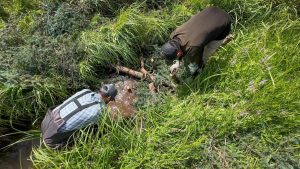
At Mountain Studies Institute, we explore a myriad of strategies, monitoring their effectiveness, and exploring questions and interventions that address our environmental challenges. In the case of stream restoration, we’ve adopted a strategy based on nature itself and its beautiful complexity, something called low tech process based restoration (Utah State University has exceptional resources on the subject). That includes beaver dam analogues (BDAs) and post assisted log structures (PALS) which create pools, eddies, riffles, log jams and turns. Those features help promote conditions that help plants establish, reduce erosion, raise water tables, provide wildfire refugia, and establish wildlife habitat.

We at MSI are intimately involved in several stream restoration projects across the San Juan Mountains of Colorado and in northern New Mexico in partnership with incredible organizations and collaboratives, an example of which has already been highlighted by Water Education Colorado in Headwaters Magazine article, Busy as a Beaver, discussing stream restoration on the Mancos River. Mancos River restoration is a long-term project at multiple sites for MSI and collaborative partners, including Ute Mountain Ute Tribe, Mancos Conservation District, Mesa Verde National Park, and private landowners along the river.

Claire Caldwell of Mountain Studies Institute stands atop a finished post assisted log structure in the Mancos River. Photo credit: Mountain Studies Institute

Additionally, MSI helps coordinate the 2 Watersheds – 3 Rivers – 2 States Cohesive Strategy Partnership, which works across 5 million acres in southern Colorado and northern New Mexico to make forests, watersheds, and communities more resilient. We went to the site of a project on the Rito Penas Negras to tell the story of restoration, beavers, and our relationship with nature.

Overhead view of 2-3-2 Partnership volunteers constructing a beaver dam analog in the Rito Penas Negras. Photo credit: Mountain Studies Institute

We encourage you to listen to that story — the story of stream restoration — in our podcast, The Dirt and Dust, in an episode entitled, Becoming Beavers, which explores the idea of imitating nature to help restore a stream system all in the hopes that beavers come back and do the work themselves, that the dynamism and complexity of the natural system is restored.

I don’t think we’ll be changing leap year anytime soon, but we can change the way we think about the natural world and the role we play as humans. We can strive to work alongside nature, not against it, and hope that someday waterways like the Rito Penas Negras and Mancos River have fish, bugs, plants and beavers.