Click the link to read the article on the Aspen Journalism website (Heather Sackett):
March 6, 2024
In two separate proposals for how the nation’s two largest reservoirs should be managed, the upper and lower Colorado River basin states agree on a couple things, but can’t find common ground on whether the upper basin should take cuts when reservoir levels fall.
Proposals submitted to the U.S. Bureau of Reclamation by the upper basin states (Colorado, Utah, Wyoming and New Mexico) and the lower basin states (California, Arizona and Nevada) each say that the current guidelines’ method of basing operations on 24-month forecasts and setting shortages based on critical elevations of Lake Powell and Lake Mead should be tossed out in favor of using real-time water storage levels to determine releases and who takes how much in cuts. Both proposals say that the lower basin must cut its use by 1.5 million acre-feet in most years.
But the similarities stop there. Lower basin water managers say all seven states that use the Colorado River must share cuts broadly under the most critical system conditions, while upper basin officials maintain they do not have to cut their water use because they have never used the entire 7.5 million acre-foot apportionment given to them under the Colorado River Compact.
The separate proposals came after the seven basin state representatives could not reach a consensus after months of negotiations on how to operate the reservoirs after 2026. In recent months, water managers have focused on figuring out a new plan for reservoir management because the current guidelines from 2007 were only intended to last 20 years. In the context of a historic drought and climate change, the 2007 guidelines, along with the emergency Band-Aid that was 2019’s Drought Contingency Plan, have not been enough to keep reservoir levels from plummeting and bringing the system to the brink of collapse.

In its proposal, the lower basin has committed to doing something that the upper basin has long called for: owning the amount of water lost to evaporation and transit. A recent Reclamation study put evaporation and transit losses in the lower basin — which are currently unaccounted for on any balance sheets of supply and demand — at about 1.3 million acre-feet per year.
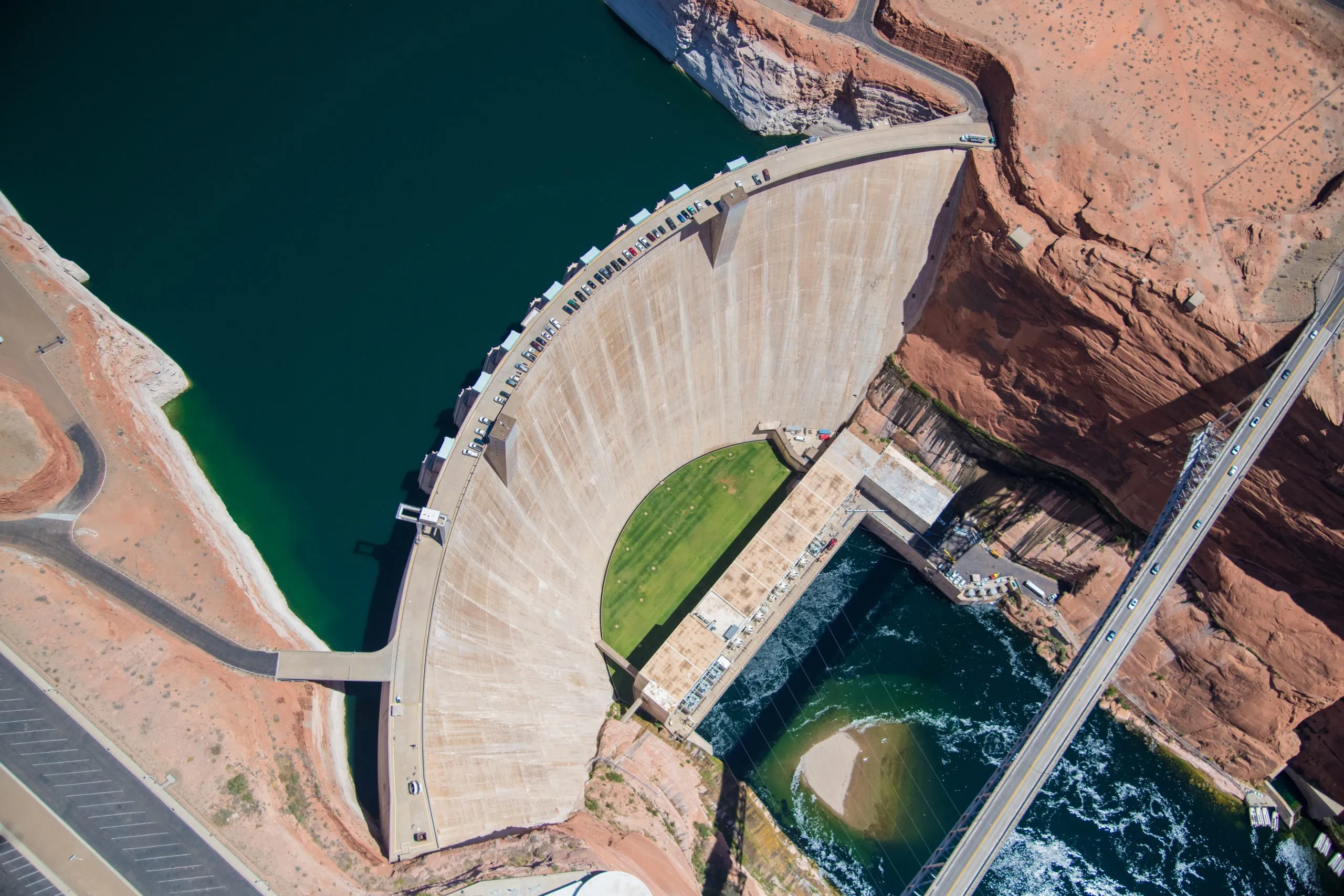
The lower basin’s proposal says it will cut its use by 1.5 million acre-feet when total system storage is between 38% and 69%. But if reservoir levels dip lower than 38% full, the lower basin wants additional cuts to be split evenly between the upper and lower basins, up to 3.9 million acre-feet. As of Tuesday, Lake Powell was nearly 34% full and Lake Mead was about 37% full.
“The Lower Basin Alternative creates resiliency and proposes climate change is a shared responsibility of all those that depend on the Colorado River,” JB Hamby, the Colorado River commissioner representing California, said in a prepared statement. “Each basin, state and sector must contribute to solving the challenges ahead. No one who benefits from the river can opt out of saving it.”
Upper basin water managers disagree, saying their water users are already being squeezed by climate change and are forced to take shortages in dry years because the water simply isn’t there. Upper basin officials have long maintained that most of the blame for the system crashing should be placed on lower basin overuse.
“I want to be very clear that the upper division states have always been in full compliance with the 1922 Colorado River Compact and, again, are currently using 3 [million] to 4 million acre-feet less than our compact apportionment,” Amy Ostdiek, Colorado Water Conservation Board section chief for interstate, federal and water information, said at a press conference explaining the upper division alternative. “There’s no mechanism to make mandatory water cuts in the upper basin beyond those that already occur each year.” [ed. emphasis mine]

Conservation promises
The upper basin’s proposal, however, says the four states will pursue “parallel activities”that include voluntary, temporary and compensated reductions in use, although the upper basin states do not offer a specific amount of water that they will conserve. This would be separate from the post-2026 guidelines process.
The upper basin has dabbled in recent years with two such conservation programs: demand management and system conservation. In 2019, the state of Colorado embarked on a multiyear feasibility study of a voluntary and temporary program — known as demand management — that would pay water users to cut back and bank the conserved water in Lake Powell. That program is currently shelved without having been implemented.
In 2023, the Upper Colorado River Commission restarted the System Conservation Program, which pays water users — nearly all of them in agriculture — to cut back. With this program, there is no guarantee the conserved water makes it to Lake Powell. The program saved about 38,000 acre-feet in 2023, at a cost of nearly $16 million. System Conservation will take place again this year.
The upper basin proposal, which officials say mitigates the risk of either reservoir reaching dead pool, bases both cuts to lower basin use and releases from Lake Powell on how full the reservoirs are on Oct. 1 of each year.
“We’re also looking to operate Lake Powell and Lake Mead based on observed conditions instead of unreliable forecasts,” Ostdiek said.
Under the upper basin’s proposal, if the two reservoirs combined are more than 90% full, no lower basin reductions will occur; if they are 70% to 90% full, lower basin cuts increase up to 1.5 million acre-feet; at 20% to 70% full, lower basin cuts remain static; and if the reservoirs are less than 20% full, lower basin cuts increase up to 2.4 million acre-feet a year, on top of the initial 1.5 million-acre-foot cuts. Under the upper basin proposal, those four states do not take any cuts, even as reservoir levels fall.
That is in contrast with the lower basin’s proposal which would require cuts beyond 1.5 million acre-feet to be split evenly between the upper and lower basins.
If Lake Powell is 81% to 100% full on Oct. 1, then releases would be between 8.1 million and 9 million acre-feet; at 20% to 80% full, releases would be between 6 million and 8.1 million acre-feet; and if the reservoir is less than 20% full, just 6 million acre-feet would be released.
The lower basin proposal for releases from Lake Powell is based on the total amount of water in the upper basin Colorado River Storage Project Act reservoirs: Flaming Gorge, Blue Mesa, Navajo and Lake Powell. If these upper basin reservoirs are more than 80% full, releases from Lake Powell would be between 8.5 and 11 million acre-feet; if reservoirs are between 30% and 80% full, releases would be between 7 and 8.5 million acre-feet; if reservoirs are between 20% and 30% full, releases would be between 6 and 7 million acre-feet and if storage is less than 20% full, 6 million acre-feet would be released.
Current reservoir operations are based on Reclamation’s “24-month Study,” a monthly forecast that predicts a range of probabilities for reservoir storage levels and “balancing tiers,” which lay out who takes what shortages if reservoirs fall below certain elevations.
The two proposals will be reviewed by Reclamation, the federal agency that manages many of the West’s dams and reservoirs, as part of the National Environmental Policy Act process for creating the new post-2026 guidelines for reservoir operations.
Although the upper and lower basins did not reach consensus before the March 11 deadline and instead submitted two different proposals, both sides say they are still open to continuing negotiations.
“Although our proposal can stand on its own, it was also designed to promote the development of a seven-state consensus alternative, which is a goal we all still seek to achieve,” Wyoming Commissioner Brandon Gebhart said in a prepared statement.
This story ran in the March 8 edition of The Aspen Times, the Vail Daily.