

Click the link to read the article on the Aspen Journalism website (Heather Sackett):
March 10, 2024
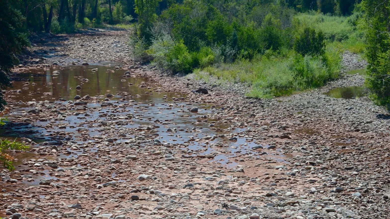
In 2012, one of the driest years in Colorado in recent memory, the Crystal River practically dried up.
Ken Neubecker, a now-retired Colorado projects director at environmental group American Rivers and former member of the Pitkin County Healthy Rivers board, recalls the stream conditions.
“I took a photo on the Thompson Road bridge, and it was running about 1 cubic foot per second, if that,” he said. “It was mostly dry rocks with some puddles in between.” (One cfs, which is equivalent to the amount of water to fill one basketball, is a common way to measure the flow of water.)
These extremely low-water conditions returned in the drought years of 2018, 2020 and 2021, with river flows near the fish hatchery just south of Carbondale hovering around 8 to 10 cfs — not enough to support aquatic life and nowhere near the 100 cfs that the state of Colorado says is the minimum needed to maintain a healthy stream.

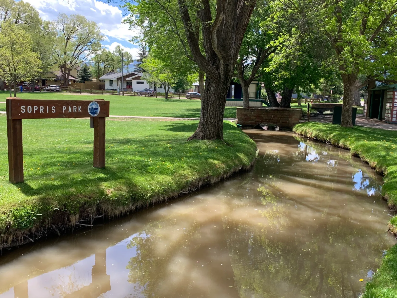
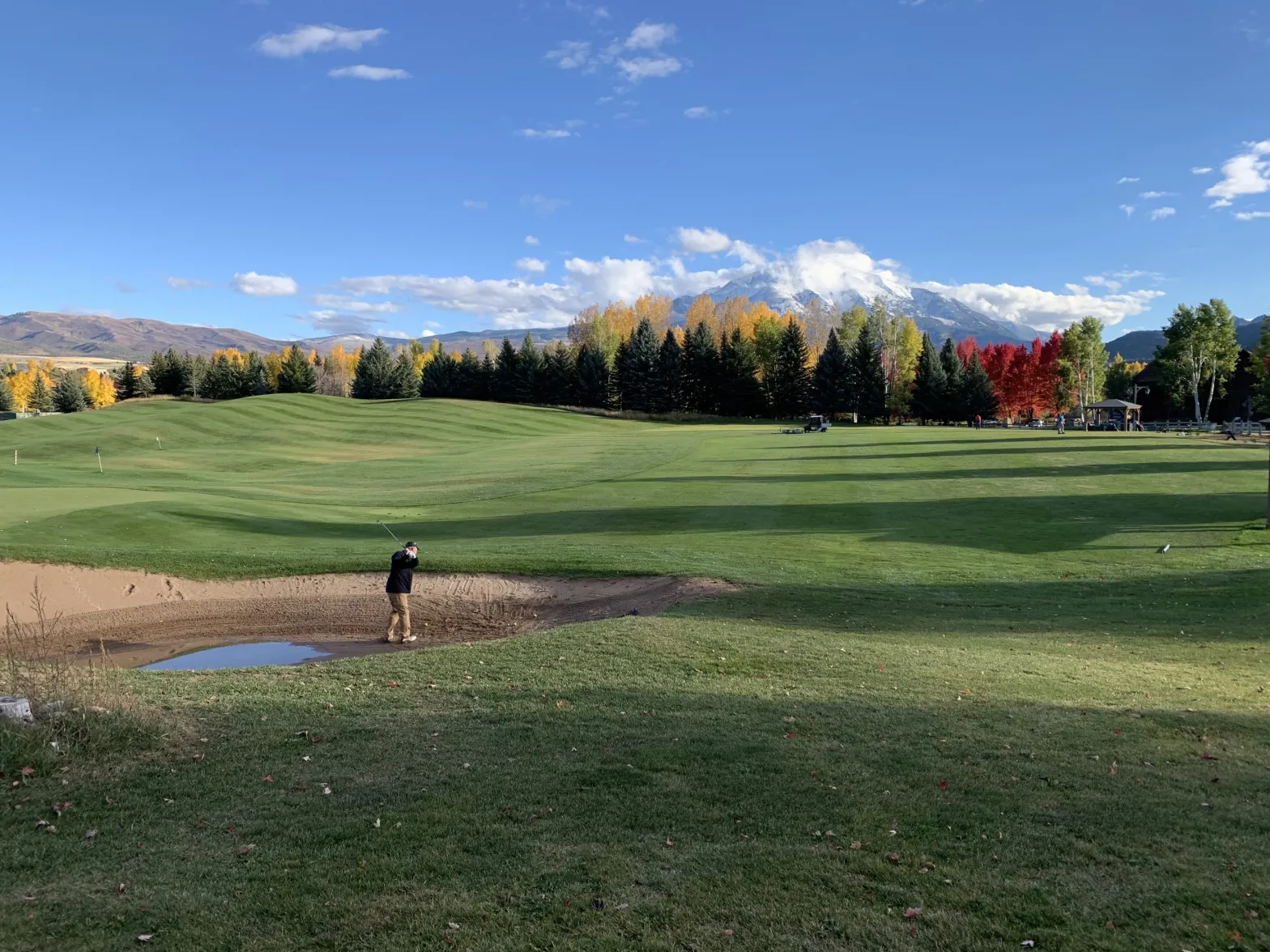
Beginning high in the Elk Mountains, the Crystal River flows 40 miles through a canyon under the flanks of Mount Sopris and winds past the towns of Marble, Redstone and Carbondale before joining with the Roaring Fork River, a major tributary to the Colorado River. Along the way, its waters turn mesa hayfields, acres of alfalfa, and town parks and lawns a verdant green.
A historic drought driven by climate change and temperatures that creep ever higher are partly to blame. But the factors that lead to a dry river bed are many and include unique geology, ill-defined legal concepts, misunderstandings about the value of water, inefficient irrigation systems and vague state guidelines regarding waste that seem to be enforced only under specific circumstances.
These barriers to conservation are widespread across western Colorado. The Crystal River is one place where these complex issues converge, resulting in a chronic dry-up of stream sections in late summer most years. To Neubecker, the cause is water users taking more than they need and not leaving enough for downstream users — especially when the “user” is the river ecosystem itself.
“It just dries up a stretch of river and disconnects the upper part of the river from the lower part,” he said. “You have to be a good neighbor, and that concept has been totally thrown by the wayside.”
The Crystal is not unique. Rivers throughout the West face increasing pressure from chronic overuse, warming temperatures and prolonged dry spells. Persistent dry-ups that span weeks or months are a familiar feature of many so-called “working rivers” that supply water to the West’s sprawling farmlands and growing cities.
As scarcity has gripped the states that make up the headwaters of the Colorado River, a new level of scrutiny has fallen on water uses once considered insignificant, even small hayfields or grassy front yards. Communities throughout the West are now under pressure to justify their use of any amount, and make a case for continuing to do things the way they’ve always been done.
To better understand these issues plaguing the Crystal, Aspen Journalism examined the river’s biggest users to create the most complete picture possible of how water is used, why dry conditions persist and what can be done about it. We created a detailed analysis using publicly available information; state-of-the-art, satellite-based measurements; interviews with experts; and, where possible, site visits and ditch tours.
Understanding exactly how the West’s water is used — and perhaps where opportunities for efficiency improvements exist — will only become more crucial in a hotter, drier future with increasing scarcity across the Colorado River basin.

Low ditch efficiencies
According to Aspen Journalism’s analysis, some of the Crystal’s biggest diverters have very low ditch efficiencies, meaning that the crops they grow are using just a small fraction of what they take from the river.
The low efficiencies pose the question: Does the small amount of water that is actually used by the crops justify the large amounts diverted from the Crystal, to the detriment of its ecosystem?
Of the 42 active ditches on the Crystal according to the Colorado Division of Water Resources (DWR) database, Aspen Journalism examined the top eight: those with the biggest and oldest water rights, the majority of which date to the 1880s. The analysis compared how much they were taking out of the stream based on diversion records maintained by DWR and how much water was absorbed by crops. Known as evapotranspiration, this is tracked by satellites through a publicly available platform called OpenET. Evapotranspiration is a measure of the amount of water used by crops, also called consumptive use.
Aspen Journalism’s analysis shows that Crystal River ditches that irrigate primarily agricultural land — the East Mesa, Lowline and Ella — have an average efficiency of between about 12% and 14%. That means the crops that are irrigated by these ditches use 12% to 14% of the water the ditch diverts. An outlier is the Sweet Jessup Canal, which irrigates Crystal River Ranch and whose crops use nearly 30% of the water it diverts, according to our analysis. Much of this ditch is lined or piped, making it more efficient.
For ditches that are used primarily for outdoor watering of residential lawns, gardens, ballfields and parks — ditches such as the Carbondale Ditch, the Weaver & Leonhardy, Bowles & Holland, and the Rockford, the latter of which also irrigates some agricultural land — our analysis showed lower efficiencies, ranging from less than 1% to about 9%. However, that analysis likely represents an undercount of the amount of water consumed on smaller parcels.
OpenET is becoming a widely used tool by water managers, including by the Upper Colorado River Commission, to calculate the water savings on individual fields that participate in its 2023 and 2024 System Conservation Program. Still, this technology has limitations. For example, the satellites work best on parcels that are at least .22 acres, so consumptive use tied to many residential lawns and gardens that are irrigated with water from these ditches is probably not included in these calculations. There is also no way to account for the amount of water a crop uses that comes from precipitation. Including that figure would result in lower ditch-efficiency percentages. For a complete explanation of how Aspen Journalism got these numbers, including all the caveats and limitations of the data, see our methodology breakdown.
The two ditches owned and operated by the town of Carbondale — the Carbondale Ditch and the Weaver Ditch — appear to be using a particularly small percentage of the overall water they take from the river. These ditches weave through the front yards, parks and alleyways of Carbondale, contributing to the charming, small-town feel and adding a riparian ribbon of green to an arid landscape. In general, these ditches that are used by residents to water their lawns and gardens have less-consumptive use than ditches that are all or nearly all agricultural use. However, since the OpenET does not pick up small lawns and gardens, it’s hard to know exactly how much water is being consumed from these ditches.
Kevin Schorzman, public works director for the town of Carbondale, said the town does not track ditch efficiencies, consumptive use or the number of homes that use ditch water for their lawns. He said the town has undertaken several projects over the past few years that should lead to improved efficiency in the ditch system, including lining portions of the Carbondale and Weaver ditches with concrete as well as piping sections of both ditches.
Officials have pointed to a river restoration project, which includes headgate modernization and automation on the Weaver Ditch as having benefits for the environment. But Schorzman said the project may or may not impact diversions from the river.

Inefficiencies widespread
James Heath, DWR engineer for Division 5, agreed that Aspen Journalism’s ditch-efficiency numbers, while low, looked pretty reasonable. Additionally, a 2015 consumptive-use analysis of the Colorado River basin by Wilson Water Group put the overall system efficiency for the area that includes the Crystal’s watershed at 10%, which is in line with Aspen Journalism’s findings.
Very low ditch efficiencies seem to be common throughout Division 5, which contains the headwaters of the Colorado River. The 2015 Wilson Water Group study showed efficiencies in sub-basins ranged from 10% to 31%. Two other mountainous headwaters — the Blue River and Eagle River basins — had efficiencies of 14% and 16%, respectively.
Eric Kuhn, a Colorado River expert, author and former general manager of the Glenwood Springs-based Colorado River Water Conservation District, said the Crystal’s ditch efficiencies are in line with other places in western Colorado. He said irrigators in some basins are diverting 10 to 12 acre-feet for every acre-foot that their crops end up using.
“Those are the numbers we kind of got used to when people looked into them in detail,” Kuhn said.
It is common knowledge that ditches must take more water than only what is needed by crops, as pointed out by Joe White, director of finance at Colorado Rocky Mountain School. The private boarding school is the largest shareholder on the Rockford Ditch, which diverts from the Crystal.
“I don’t think that should surprise anyone,” White said. “Diversions are never going to equal consumptive use. Everyone knows it takes more diversion than consumptive use to deliver water to where it needs to be applied.”
White said Aspen Journalism’s numbers sound too low, but he did not provide his own consumptive-use numbers for the Rockford Ditch. White added that the Rockford needs to be kept full so that the lawn-watering irrigation pumps in the nearby neighborhood of Satank function properly.
“It’s challenging to regulate it as efficiently as we would like to,” he said.
Because the Crystal is not the only overtaxed stream in Colorado dealing with these issues, cities across the state are attempting to deal with water scarcity. That can be through strict conservation measures and, in particular, wringing water from nonfunctional, ornamental grass by banning its planting and incentivizing its removal.
But so far, widespread mandatory conservation measures — cracking down on waste and implementing efficiency standards — have not been aimed at agriculture, which is by far the biggest water-use sector and potentially has some of the lowest-hanging fruit to find water savings through irrigation improvements.

Reasons for low efficiencies
There could be several reasons why ditch efficiencies on the Crystal are low. The most basic is that flood irrigation is less efficient than sprinklers. About 58% of agricultural lands on the top eight ditches are flood irrigated, according to data from the state DWR. Many ditches were also built in the late 19th century and are not lined or piped, meaning that some of the diverted water is lost to leakage.
Some of the diverted water is lost to thin, rocky soils that water percolates through quickly. Irrigators often need to divert extra water, known as “push water,” to ensure that there’s enough pressure to get the water all the way to land at the end of the ditch, which is sometimes miles from the point of diversion. These transit losses are not considered part of consumptive use and are not measured by OpenET.
There is some evidence that soils in the area are especially rocky — the Crystal River was originally named Rock Creek — which may be contributing to low efficiency, allowing water to seep through the bottom and sides of ditches before reaching a farm field.
Heath, the division engineer, also found evidence of this from drill logs for water wells in the area.
“They are running into some pretty coarse materials at shallow depths that would cause a lot more ditch loss, a lot more deep percolation, which would increase the losses and cause the overall system efficiencies to go down,” Heath said. “So, I think it’s pretty reasonable, the numbers you’re coming up with.”
Much of the diverted water that the crops don’t use eventually seeps back to the river over days, weeks or months, a phenomenon known as “return flows.” If the Crystal River Valley’s geology really is as porous as evidence suggests, return flows probably make it back to the river quickly, without much being stored for late-season returns.
The problem with return flows is that they do not go back into the river at the same spot they are taken out and have a delayed return, contributing to seasonal dry-ups. And after percolating through the soil, return flows can be warm and laden with salt and other contaminants, impacting the river’s overall quality and the fish that depend on cold, clean water.
Is water being wasted?
Carbondale’s Schorzman said the town is adhering to state guidelines on waste and operating the ditch systems in a manner that is reasonably efficient. But pinpointing who might be wasting water in Colorado is difficult.
According to state guidelines on waste from 2017, which recently retired Colorado state engineer Kevin Rein said are still in effect, “a person shall not run through his or her ditch any greater quantity of water than is absolutely necessary for irrigation, domestic, and stock purposes to prevent the wasting and useless discharge and running away of water.”
The guidelines define waste as “diverting water when not needed for beneficial use, or running more water than is reasonably needed for application to beneficial use.” Beneficial use is defined as “the use of that amount of water that is reasonable and appropriate under reasonably efficient practices to accomplish without waste the purpose for which the appropriation is lawfully made.”
But “reasonably efficient” is not clearly defined. And how much more water ditches should take than what’s needed by crops is also unclear. Determining whether an irrigation practice is reasonable or wasteful is subjective.
Much like the famous Supreme Court test for obscenity, Rein said water commissioners have a good idea of what waste is when they see it. DWR has not done an efficiency analysis on the Crystal ditches, and Rein said he cannot identify a threshold for “reasonable” because every system is different.
“I don’t know whether it was intentional or not, but it’s important to our administration that it allows for judgment and for evaluation of myriad factors,” Rein said, referring to the subjective nature of the criteria.

Divert it or lose it?
Another potential explanation for the low use numbers could be that some irrigators are overdiverting based on a misunderstanding of Colorado water law. The true value of a water right is tied to its historical consumptive use, which is how much water the crops use. However, there is an entrenched, incorrect belief that by maximizing the amount of water taken from a stream, one can increase the future value of a water right or protect it from abandonment. Many interpret Colorado’s famous “use it or lose it” doctrine as “divert it or lose it.”
“The reality of that is sometimes it can feel like you have something on paper and giving up something you have on paper feels like you’re losing something,” said Assistant Pitkin County Attorney Laura Makar.
According to a 2016 special report by DWR officials and experts at the Colorado Water Center at Colorado State University, “use it or lose it” is commonly seen as a barrier to implementing water-conservation measures and efficiency improvements.
Users are told to divert their whole amount, “in order to preserve the water right; that is, protect it from abandonment and/or lead to the maximum value of the water right in a water right change proceeding,” the report reads. “This conclusion is based on a misapplication of the law.”
In reality, there are two requirements for abandonment: A water right must sit dormant and unused for 10 years, and the owner must intend to abandon it. For the past 20 years, DWR has had a policy of not placing water rights that date to before the 1922 Colorado River Compact on the abandonment list, which is compiled every 10 years. This means pre-compact water rights (like many of those in the Crystal analysis) have an additional layer of protection from abandonment, even if they meet the two requirements.
Neubecker said taking more water than you can use violates one of the most sacred concepts at the heart of Colorado water law: the duty of water. The duty of water is the amount needed to grow a crop — not the maximum allowed by a decree — and varies depending on crop type and location.
“Technically, it is against the law to take more water than you actually need regardless of what your decree says,” Neubecker said. “It’s just that neither the lawyers nor the state engineer’s office are going to enforce it.”
Low efficiencies not a problem for state officials
DWR officials don’t have a problem with inefficient ditches as long as irrigators are not wasting water. Rein said that low efficiency doesn’t mean irrigation is being done improperly.
“I’m not aware that we have evidence of waste occurring on those systems,” Rein said.
There was, however, at least one documented instance of alleged water waste that occurred on the Crystal in recent years. In 2018, former water Commissioner Jake DeWolfe restricted how much water was flowing into the Lowine Ditch for taking more than it could put to beneficial use. Attorneys for one ditch user, Tom Bailey, complained in a letter to DWR, saying that the commissioner’s determination of waste was “ambiguous and erroneous,” and that the guidelines for waste are unlawful, claims that reflect the subjective nature of defining waste. DeWolfe declined to speak with Aspen Journalism for this story.
One of the ways water commissioners determine if waste is occurring is by looking at what is known as the “tail water,” which is where, after irrigating land, the ditch returns the water to the river. In 2018, DeWolfe said the large amount of tail water from the Lowline was an indication of waste.The situation on the Crystal in 2018 is indicative of how state officials manage the river. The system is complaint-driven, meaning water commissioners will usually focus their efforts on streams where a water user has placed a call or where they have heard complaints of waste from water users. If a river is not on call, if no one is reporting their neighbors for taking too much or if there are no obvious indicators such as flooding, water commissioners probably won’t scrutinize ditches for waste. In most cases, tail water is not measured.
According to Heath, since 2018, no complaints about waste in the Crystal River basin have been received and waste has not been observed by water commissioners. Therefore, curtailment of structures within the Crystal River basin for waste issues has not occurred since 2018.
Heath said that as long as irrigators aren’t taking extra water to expand their historical irrigated acreage, his office doesn’t have an issue with low ditch efficiencies.
“As long as they continue to operate as they have historically operated, I don’t see that there is a problem with the diversions they are making,” he said. “They are operating their ditches and irrigating as they always have, and it just yields a low system efficiency.”
When the river is harmed
In Colorado, inefficient or wasteful practices are only considered such if they deprive another senior user of water.
But what if the other water user being harmed is the river ecosystem itself? There are few ways to ensure that enough water stays in the river for the fish, plants and animals that depend on it.
The stretch of the Crystal River just south of Carbondale near the Colorado Parks and Wildlife fish hatchery has a tendency to dry up during the late irrigation season. The problem is worse in dry years, and the tool meant to address it is limited in what it can accomplish.
The Colorado Water Conservation Board holds instream flow water rights on the Crystal River, which are intended to preserve the natural environment to a reasonable degree. They date to 1975 and are some of the oldest instream flow rights in the state. Although the Crystal River was here long before any humans inhabited the valley, under the cornerstone of Colorado water law known as prior appropriation — where the oldest rights, which almost always belong to agriculture and cities, get first use of the river — the instream flow rights that protect the river itself might as well have been born yesterday.
The instream flow right is 100 cfs on the stretch of river between Avalanche Creek and its confluence with the Roaring Fork, but it is rarely met from August to October. The reason?
“It’s the senior uses in the area,” said Rob Viehl, chief of the Colorado Water Conservation Board’s stream and lake protection section. “There are a lot of large senior irrigation ditches right above the fish hatchery gauge that divert a lot of water. They are in priority, and they are legally senior to the instream flow.”
The dry stretch is immediately downstream from the diversion for the Carbondale Ditch, which can pull 42 cfs from the river.
“Carbondale definitely needs to do some ditch-efficiency work,” Neubecker said. “The town of Carbondale is the single-biggest water rights holder on the Crystal.”

Possible solutions
Much of western Colorado’s irrigation infrastructure is stuck in the 19th century. Upgrading ditches and headgates — and, in turn, making them more efficient — can be costly.
Matt Rice, southwest regional director for environmental group American Rivers, said Aspen Journalism’s analysis points to the need to upgrade that infrastructure. And with billions of dollars in federal funding available, now is a good time for these types of projects, he said.
“If you need that much nonconsumptive push water to get your 11 or 7 or 9%, my sense is that there is a lot of opportunity to do things better,” Rice said. “It seems to me that infrastructure modernization on the Crystal could be a key thing to investigate.”
Colorado River environmental groups — including American Rivers, Trout Unlimited, The Nature Conservancy, Pitkin County Healthy Rivers — have funded and worked on agricultural infrastructure improvement projects that claim to have multiple benefits for agriculture, the environment and recreation. The idea is that if a project makes an irrigation system more efficient, less water will need to be diverted from a river.
But although they may improve riparian habitat or create safer passage for boats, there’s no evidence these projects result in more water left in rivers. Of all the experts Aspen Journalism interviewed for this story, none could point to a ditch infrastructure improvement project that resulted in a measurable decrease in diversions, as reflected in diversion records maintained by DWR. Simply quantifying flow needs specifically for recreation and the environment through stream-management plans has been thwartedin recent years by agricultural interests.
The town of Carbondale and other groups have recently completed a headgate modernization project on the Weaver Ditch, which supporters say will benefit the environment. But Schorzman, Carbondale’s public works director, said in an email that the project “may or may not impact diversion amounts.”
Environmental groups say they must work with — and not against — agriculture since they are the biggest water-user sector and that building relationships is important. In that spirit, Pitkin County Healthy Rivers has earmarked tens of thousands of dollars (the exact amount the project will cost is still unclear) to fund a piping project for the East Mesa Ditch, which had a blowout from sinkholes in September. Healthy Rivers has not secured a commitment from ditch owners that there will be any benefit to river flows from the piping project, even though part of its mission is to maintain and improve the quantity of water in local streams.
“The question is: How can we stay true to our charter of maintaining streamflow while helping somebody divert water from the river?,” Pitkin County Attorney John Ely said at a September Healthy Rivers meeting. “You simply can’t preserve water in the river at all without someone you can work with and someone who holds a relatively senior water right. … You can’t solve the riddle of how to protect streamflow without working with agriculture.”
An often-heard refrain from water users is that if they leave the water in the river, it will just get picked up by the next downstream user, so they may as well divert it. That is true to a degree. But if all the water users on a system were to become more efficient, they might be able to each take less.
And a new state law allows water users to get paid to temporarily lease water to the state’s instream flow program for five out of 10 years. The loaned water is tracked by DWR officials so that it stays in the river through the stretch where it’s needed. So far, the program is little-used — just nine projects so far statewide — and no water users on the Crystal are currently doing this type of instream flow loan.

Carbondale ranchers Bill Fales and Marj Perry are participating in a slightly different program, a non-diversion agreement with the Colorado Water Trust designed to leave more water in the river. When river flows dwindle to less than 40 cfs, Fales will get paid to reduce his diversions from the Helms Ditch, which could result in an additional 6 cfs in the Crystal.
“Obviously we are like everybody else — we hate to see the river dry,” Fales told Aspen Journalism in 2022.
Colorado’s entrenched water law system protects those European American settlers who first put the water to beneficial use, growing crops and building cities. One hundred and forty years later, that system still reflects the values of the time that the concept of prior appropriation was invented and largely excludes water for the environment, recreation or tribal communities. But as water supplies continue to be squeezed across the Colorado River basin, that may one day change.
“Change is hard,” Makar said. “If we have a system that has been in place and working one way for a long time, it requires new education, new materials. … I think it’s worth it, and I think that the system is eventually going to require it. But that doesn’t mean it’s easy.”
This story was produced in partnership with The Water Desk, an independent initiative of the University of Colorado Boulder’s Center for Environmental Journalism.
Click the link to read the article on the NOAA website:
March 8, 2024
A very mild February wrapped up a record-warm winter for the U.S., according to experts from NOAA’s National Centers for Environmental Information (NCEI).
Below are highlights from NOAA’s U.S. climate report for February 2024:
Climate by the numbers
February 2024
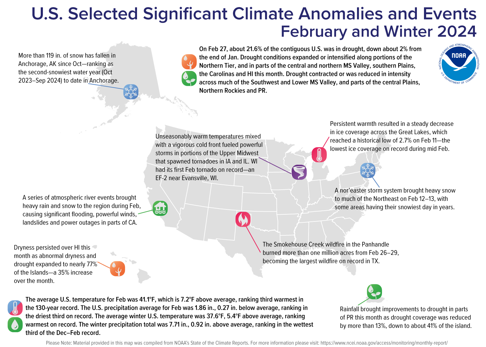
The average temperature across the contiguous U.S. last month was 41.1 degrees F, 7.2 degrees F above the 20th-century average and ranking as the third-warmest February in NOAA’s 130-year climate record. Iowa, Minnesota, Missouri and Wisconsin each had their warmest February on record. An additional 20 states saw their top-10 warmest February on record.
Persistent winter warmth resulted in a steady decrease in ice coverage across the Great Lakes, which reached a historic low of 2.7% on February 11 — the lowest amount of ice coverage on record during mid-February.
February precipitation for the contiguous U.S. was 1.86 inches, 0.27 of an inch below average, ranking in the driest third of the climate record. Illinois, Maine, New Hampshire, New York and Vermont each saw their second-driest February on record.
Meteorological winter (December 2023 – February 2024) | Year-to-date
Meteorological winter was the warmest winter on record for the contiguous U.S., with an average temperature of 37.6 degrees F — 5.4 degrees above average. Iowa, Michigan, Minnesota, New Hampshire, New York, North Dakota, Vermont and Wisconsin each had their warmest winter on record. Twenty-six additional states saw their top-10 warmest winters on record.
Total winter precipitation was 7.71 inches, 0.92 of an inch above average, ranking in the wettest third of the December–February record. Connecticut and Delaware both had their third-wettest winter season on record.
The year-to-date (January – February 2024, YTD) average temperature for the contiguous U.S. was 36.5 degrees F — 4.5 degrees F above average —ranking as the ninth warmest such YTD on record. The YTD precipitation was 5.12 inches — 0.67 of an inch above average — ranking in the wettest third of the historical record.
Billion-dollar disasters
During the first two months of 2024, NCEI confirmed one weather disaster in the nation with a loss exceeding $1 billion. From January 8-10, a southern tornado outbreak and East Coast storm impacted more than a dozen states, damaging many homes, businesses, vehicles and other infrastructure.
Since 1980, the U.S. has sustained 377 separate weather and climate disasters where overall damages/costs reached or exceeded $1 billion (including Consumer Price Index adjustment to 2024). The total cost of these 377 events exceeds $2.670 trillion.
Other notable climate events
Atmospheric rivers drench the West: A series of atmospheric rivers brought heavy rain and snow to the Western U.S. during February, causing significant flooding, powerful winds, landslides and power outages in parts of California. The city of Los Angeles received more than 12 inches of rain during February, approximately three times the February average, resulting in the wettest February in decades for the city.
A record February tornado: Unseasonably warm temperatures mixed with a vigorous cold front fueled powerful thunderstorms that spawned tornadoes in portions of the Upper Midwest. Wisconsin had its first February tornado on record — an EF-2 near Evansville, Wisconsin.
A wildfire scorched Texas and Oklahoma: The Smokehouse Creek wildfire burned more than a million acres in the Texas Panhandle and western Oklahoma in February 2024. The wildfire, which began on February 26, became the largest wildfire in Texas history.
More > Access NOAA’s latest climate report and download the images.
Click the link to read the article on the NOAA website:
March 8, 2024
Key Points:
- The 2023–24 winter season ranked warmest on record for the contiguous U.S. with eight states across the Upper Midwest, Great Lakes and Northeast each observing their warmest winter on record.
- The Smokehouse Creek wildfire burned more than a million acres in the Texas Panhandle and western Oklahoma. The wildfire began on February 26 and has become the largest wildfire in Texas history.
- February 2024 was the third-warmest February on record for the nation and precipitation ranked in the driest third of the historical record for the month.
Other Highlights:
Temperature

The average temperature of the contiguous U.S. in February was 41.1°F, 7.2°F above average, ranking third warmest in the 130-year record. February temperatures were above average across most of the contiguous U.S., while record-warm temperatures were observed across much of the Mississippi Valley and in parts of the Great Lakes and southern Plains. Minnesota, Wisconsin, Iowa and Missouri each had their warmest February on record.
The Alaska statewide February temperature was 10.3°F, 5.5°F above the long-term average, ranking in the warmest third of the 100-year period of record for the state. Above-normal temperatures were observed across much of the state with near-normal temperatures observed in parts of southeast Alaska and Panhandle.
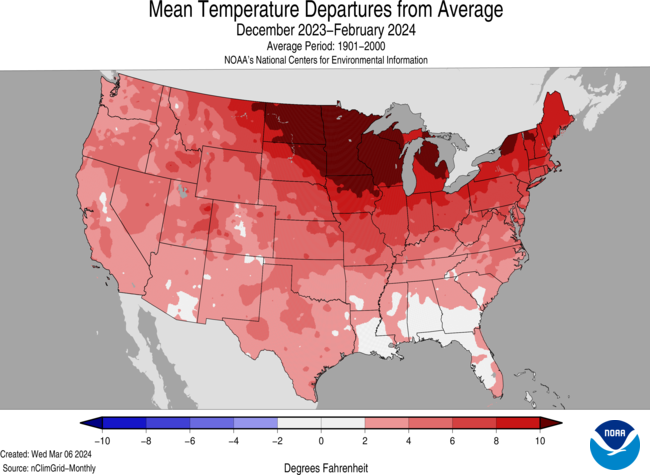
The meteorological winter (December–February) average temperature for the Lower 48 was 37.6°F, 5.4°F above average, ranking as the warmest winter on record. Temperatures were above average across a vast majority of the contiguous U.S. and near average along parts of the Gulf of Mexico. North Dakota, Minnesota, Iowa, Wisconsin, Michigan, New York, Vermont and New Hampshire each had their warmest winter on record.
The Alaska winter temperature was 6.4°F, 2.8°F above the long-term average, ranking in the middle third of the historical record for the state. Temperatures were above average across parts of the North Slope, West Coast, Southwest and Panhandle, while much of the Interior and south-central Alaska were near average for the season.
Precipitation
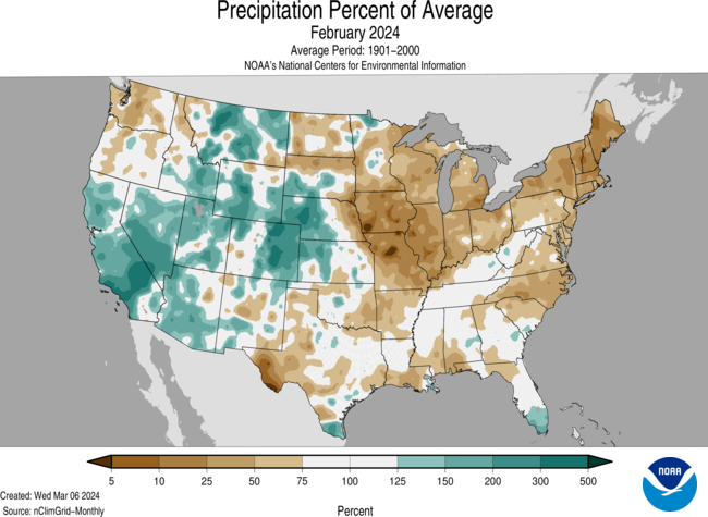
February precipitation for the contiguous U.S. was 1.86 inches, 0.27 inch below average, ranking in the driest third of the historical record. Precipitation was above average across much of the western U.S. and in parts of the central Appalachians, Southeast, and western High Plains. Conversely, precipitation was below normal across much of the eastern half of the U.S. and in parts of the Northwest, northern Plains and Southwest. Maine, New Hampshire, Vermont, New York and Illinois each had their second-driest February on record.
Alaska’s average monthly precipitation ranked in the middle third of the historical record. Precipitation was above average in parts of the North Slope, West Coast and in parts of the south-central Gulf of Alaska coast, while below-normal precipitation was observed in parts of the northeast Interior and Panhandle during the month.
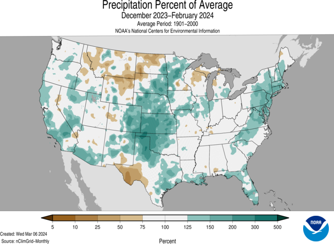
The U.S. winter precipitation total was 7.71 inches, 0.92 inch above average, ranking in the wettest third of the December–February record. Precipitation was above average across much of the contiguous U.S., while below-normal precipitation was observed along the Northern Tier and in parts of the Great Lakes and Southwest, and in small pockets of the Mississippi Valley and Maine. Connecticut and Delaware both had their third-wettest winter season on record.
For the winter season, precipitation ranked in the wettest third of the historical record for Alaska. Wetter-than-average conditions were observed across much of the state, while near-normal precipitation was observed in portions of the central Interior, south-central Interior and in parts of the Aleutians. Parts of the northeast Interior observed below-normal precipitation during this period.
Billion-Dollar Disasters
One new billion-dollar weather and climate disaster was confirmed in February 2024, as a January 8–10 southern tornado outbreak and east coast storm impacted more than a dozen states.
The U.S. has sustained 377 separate weather and climate disasters since 1980 where overall damages/costs reached or exceeded $1 billion (including CPI adjustment to 2024). The total cost of these 377 events exceeds $2.67 trillion.
Other Notable Events
A series of atmospheric river events brought heavy rain and snow to parts of the West during February, causing significant flooding, powerful winds, landslides and power outages in parts of California. The city of Los Angeles received more than 12 inches of rain during February, approximately three times the February average, becoming the wettest February in decades for the city.
Persistent warmth, with monthly temperature nearly 20°F above normal for the month, resulted in a steady decrease in ice coverage across the Great Lakes, which reached a historical low of 2.7% on February 11—the lowest ice coverage on record during mid February.
Unseasonably warm temperatures mixed with a vigorous cold front to fuel powerful storms in portions of the Upper Midwest that spawned tornadoes in Iowa and Illinois. Wisconsin had its first February tornado on record—an EF-2 near Evansville, Wisconsin.
Drought
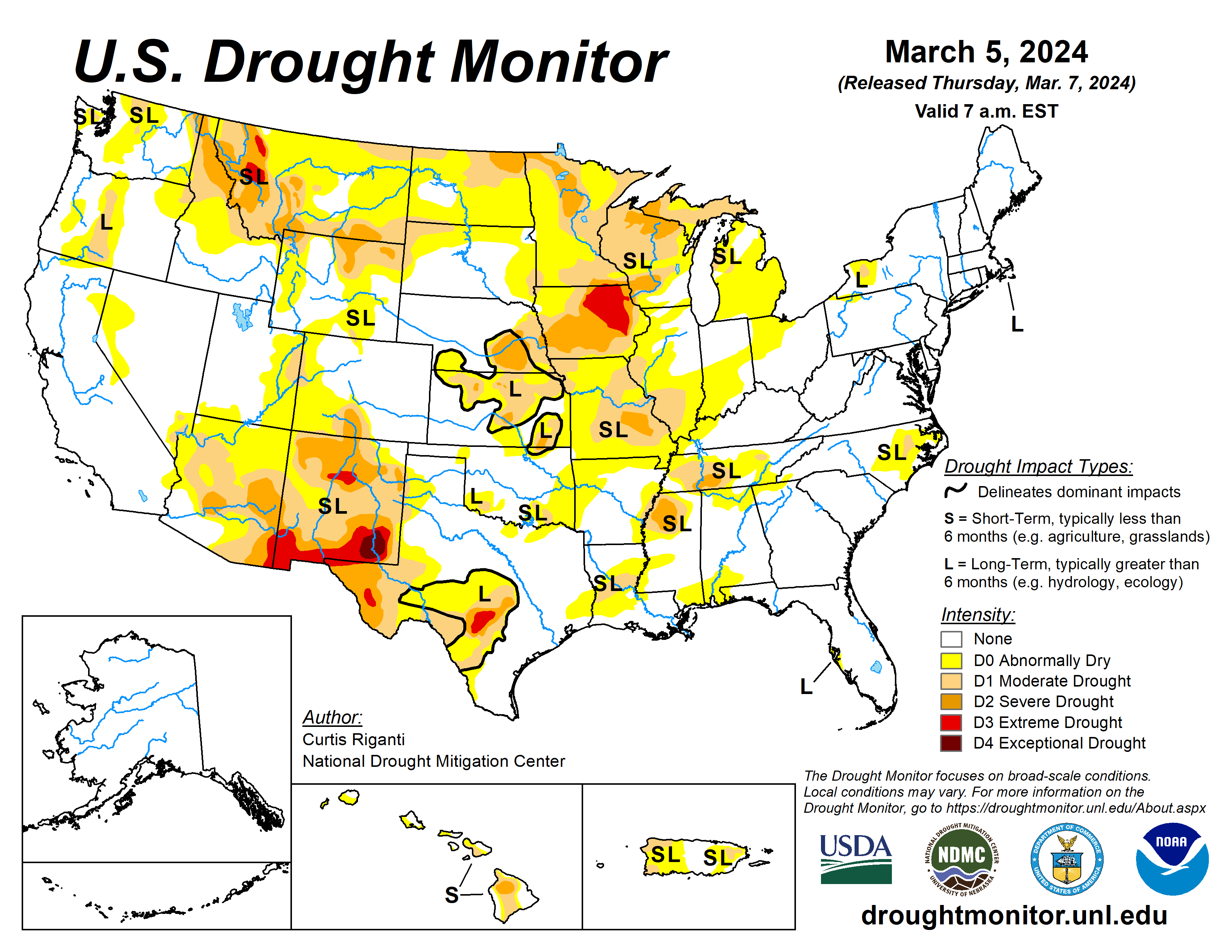
According to the February 27 U.S. Drought Monitor report, about 21.6% of the contiguous U.S. was in drought, down about 2% from the end of January. Drought conditions expanded or intensified along portions of the Northern Tier, and in parts of the central and northern Mississippi Valley, southern Plains, the Carolinas and Hawaii this month. Drought contracted or was reduced in intensity across much of the Southwest and Lower Mississippi Valley, and parts of the central Plains, northern Rockies and Puerto Rico.
Monthly Outlook
Above-average temperatures are favored to impact much of the eastern U.S. in March while precipitation is likely from the central Plains to the West Coast and from the Gulf of Mexico to southern portions of New England. Drought is likely to persist along portions of the Northern Tier, Southwest, Hawaii and Puerto Rico. Visit the Climate Prediction Center’s Official 30-Day Forecasts and U.S. Monthly Drought Outlook website for more details.
Significant wildland fire potential for March is above normal across much of the Upper Midwest and in parts of the central and southern Plains. For additional information on wildland fire potential, visit the National Interagency Fire Center’s One-Month Wildland Fire Outlook.

Click the link to read the report on the USGS website (Rebecca J. Frus, Cameron L. Aldridge, Michael L. Casazza, Collin A. Eagles-Smith, Garth Herring, Scott A. Hynek, Daniel K. Jones, Susan K Kemp, Thomas M. Marston, Christopher M. Morris, Ramon C. Naranjo, Cee S. Nell, David R. O’Leary, Cory T. Overton, Bryce A. Pulver, Brian E. Reichert, Christine A. Rumsey, Rudy Schuster, and Cassandra D. Smith). Here’s the executive summary:
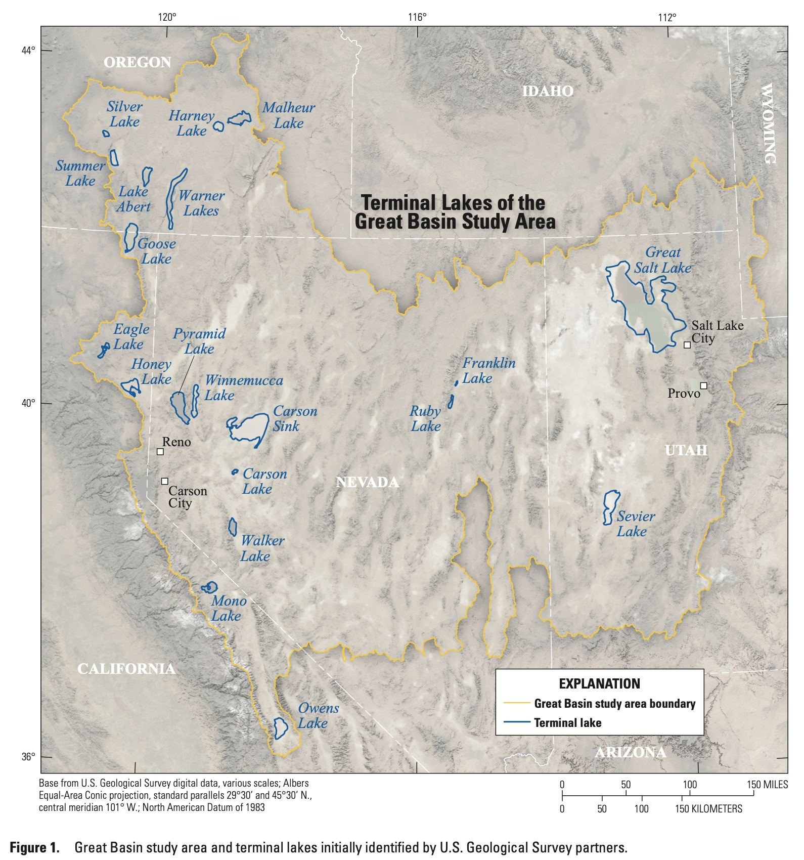
In 2022, the U.S. Geological Survey (USGS) established the Saline Lake Ecosystems Integrated Water Availability Assessment (IWAAs) to monitor and assess the hydrology of terminal lakes in the Great Basin and the migratory birds and other wildlife dependent on those habitats. Scientists from across the USGS (with specialties in water quantity, water quality, limnology, avian biology, data science, landscape ecology, and science communication) formed the Saline Lake Ecosystems IWAAs Team. The team has developed this regional strategic science plan to guide data collection and assessment activities at terminal lakes in the Great Basin.
The U.S. Congress requested the USGS to establish the Saline Lake Ecosystems IWAAs in response to historically low water levels at terminal lakes and associated wetlands across the Great Basin. Not all Great Basin terminal lakes have high salinity; however, all terminal lakes occur in endorheic, closed, basins with no surface-water outflow. Low lake levels across the Great Basin are the result of increased water use for agriculture and municipalities, drought conditions, and a warming climate. Great Basin terminal lake water extents have decreased by as much as 90 percent over the last 150 years, and terminal lake wetlands have decreased in area by as much as 47 percent since 1984. Lake elevations and wetland areas are primarily supported by freshwater inputs from snowmelt feeding upgradient rivers, streams, and springs. These freshwater inputs have been severely reduced because of continued and increased surface-water diversions and surface-water capture through groundwater pumping for agriculture, mining, and public supply as well as unprecedented drought conditions and warming temperatures related to climate change.
Water quality, specifically salinity, is highly variable for terminal lakes of the Great Basin, and this variability is a result of the balance between freshwater inflow and evaporation. Variability of salinity at each of the terminal lakes can be affected by lake morphology, hydrogeologic features of the basin, annual variability in weather patterns, and changes in upgradient water use. Hypersaline terminal lakes provide abundant food resources such as brine shrimp and brine flies that support nesting and migrating birds. The density and composition of invertebrates are closely tied to lake salinity. Increased salinity can exceed the tolerance of invertebrates, severely limiting their biomass. In contrast, decreased salinity can lead to altered invertebrate community composition, reducing the abundance of optimal avian prey resources.
Great Basin terminal lake ecosystems, including open-water and adjacent aquatic and terrestrial environments, provide resources necessary to sustain many animal populations throughout the year. Although a variety of taxa use terminal lakes, these ecosystems are of acute importance for the millions of migratory waterbirds (for example, shorebirds, wading birds, and waterfowl) dependent on the network of terminal lakes and their associated wetlands. Migratory birds transiting the Pacific and Central Flyways use Great Basin terminal lake ecosystems throughout the year to feed, nest, and transit between wintering and breeding ranges. As such, successful conservation of birds and their habitats requires coordinated management of water and habitats across the Great Basin network of terminal lakes and wetlands.
The linkages between water availability and ecosystem vulnerability of terminal lakes in the Great Basin are not well understood. The vulnerability of terminal lakes is related to the factors driving change and adaptive capacity of the lake ecosystem. Saline lake ecosystems are vulnerable when changes in water quantity affect ecosystem function. Water quantity affects salinity, which affects food webs and habitat; these linkages can be investigated with water-quality and food web monitoring. Water quantity also affects inundated habitat, which can be quantified through remote sensing. It is necessary to quantify hydroclimatic and water use controls on water availability to terminal lakes to assess the response of the ecosystems. Remotely sensed data can provide a broad-scale and long-term synoptic view of terminal lake hydrologic characteristics, but ground observations are required to interpret changes in water quality and ecological functions. Some terminal lake basins have ongoing monitoring and modeling efforts within the Great Basin (for example, Great Salt Lake, Carson River Basin), yet most monitoring locations are hydrologically upgradient and too far away from lake inflows to provide an accurate assessment of hydrological trends for the lake ecosystems. Other terminal lakes have no long-term hydrological monitoring in their respective watersheds (for example, Lake Abert).
Ecological data collection in the Great Basin is also insufficient to understand how many birds exist on the landscape, how birds use the mosaic of terminal-lake habitats as an interconnected system, and how Great Basin terminal lakes are linked to the larger continental system of the Pacific and Central Flyways. Across agencies and organizations, tracking bird movement, abundance, and diversity is inconsistent, with some lakes having once- or twice-a-year bird survey efforts and a few locations having more intensive ecological data-gathering efforts (for example, Great Salt Lake, Lake Abert). Bridging hydrological and ecological information gaps will improve understanding of the trends in water supply and water quality, habitat availability and usage, and impacts on vulnerable waterbird species, all of which would be used by managers in coordinated conservation of this unique network of terminal-lake habitats.
The terminal lakes of the Great Basin are part of the Basin and Range physiographic province that extends from the Colorado Plateau on the east to the Sierra Nevada on the west, and from the Snake River Plain on the north to the Garlock fault and the Mojave block on the south. The Great Basin is larger than 650,000 square kilometers and encompasses most of the State of Nevada but also extends to western Utah, eastern California, southeastern Idaho, southwestern Wyoming, and southeastern Oregon. The climate is arid to semiarid with a hydrologic regime that is snowmelt dominated, providing as much as 75 percent of total annual runoff for the region. Terminal lakes of the Great Basin occupy the lowest areas of closed (endorheic) drainage basins, such that lake levels and water quality respond rapidly to surface-water inflow. Terminal lakes provide local and regional economic value to the States in the Great Basin, including mineral extraction, aquaculture, public works, and recreational uses. As an example, assessments of Great Salt Lake’s ecological health and economic impact find hemispheric importance for the former and regional importance for the latter. Great Salt Lake creates about 7,000 jobs and $2 billion of economic output per year, most of which would be lost with further declines in lake level.
The objectives of this Science Strategy are threefold: (1) to identify how changing water availability affects the quality, diversity, and abundance of habitats supporting continental waterbird populations; (2) to highlight the scientific monitoring and assessment needs of Great Basin terminal lakes; and (3) to support coordinated management and conservation actions to benefit those ecosystems, migratory birds, and other wildlife. There are long-term hydrological, ecological, and societal challenges associated with terminal lakes ecosystems in the Great Basin. This Science Strategy benefits partners by providing a conceptual model, nested at different spatial extents, that identifies key scientific information needs to inform coordinated implementation of management and conservation plans within and among hydrologic basins to address these complex challenges.