Click the link to read the article on The Land Desk website (Jonathan P. Thompson):
March 1, 2024
🐐 Things that get my Goat 🐐
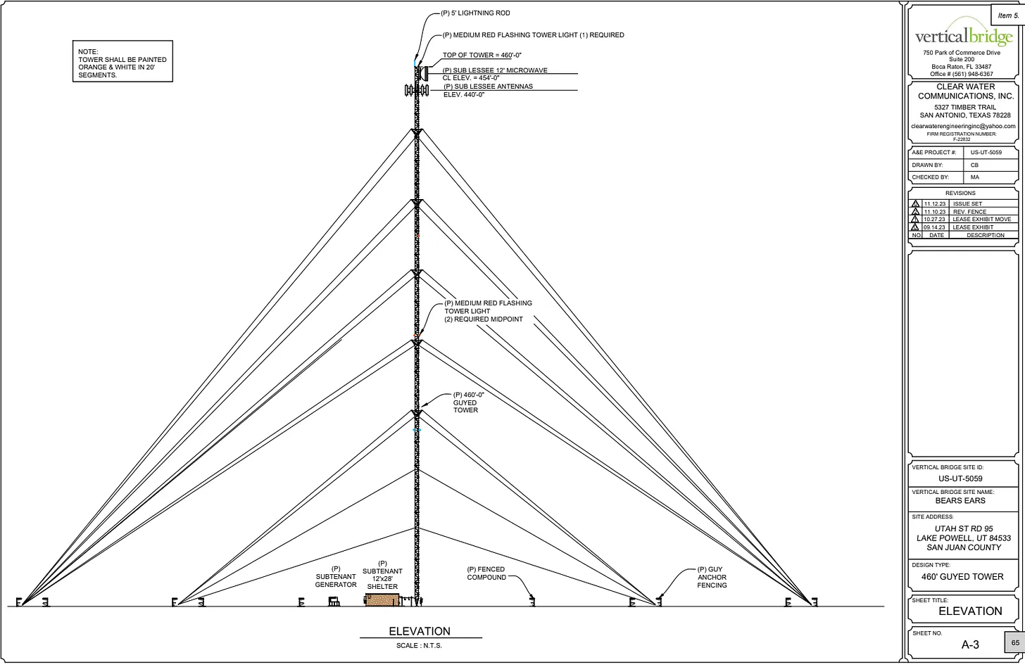
Exhibit One of the consequences of Utah lawmakers nixing the Bears Ears National Monument land exchange: A company is proposing to build a 460-foot telecommunications tower, complete with two sets of blinking red lights, on state trust land just outside Natural Bridges National Monument in the heart of Bears Ears.
Last month, the San Juan County Planning Commission voted 3-2 to approve a conditional use permit for the tower. The county commission is expected to consider whether to grant the developer a variance, since the maximum structure height for the parcel is 35 feet. The Utah Trust Land Administration and Federal Communications Commission would also need to grant permission prior to construction.
Neither the Bureau of Land Management (which manages Bears Ears NM) nor the National Park Service (which manages Natural Bridges NM) have much say in the matter, because the tower is on state land that would have been included in the swap — if it had occurred. And yet, the ginormous tower (460 feet is really big) would be visible throughout much of both national monuments.
Presumably the tower will extend telecommunication signal to the vast cell phone dead zone that, in my experience, begins around Salvation Knoll and stretches westward to the Henry Mountains. It would have obvious public safety implications by allowing folks to call for help if they happen to venture out on an “Impassible When Wet” road just as an April slush storm is rolling in and end up in a ditch — or worse.
I must admit, there have been times when I’ve been out there that I would have liked to have cell signal so I could let my family know I was alive. Or when access to a current weather forecast may have led me to make better decisions (yeah, right!). Or when being able to work online would have allowed me to stay out in the canyons for a few more precious days. This tower would make all of that possible, I guess.
But is it really worth it? The site of the proposed tower and its red lights is one of the nation’s few remaining dark sky regions, where light pollution has yet to dim out the stars and the night. Similarly it’s one of the only refuges from the otherwise omnipresent social media, text messages, emails, and ringing phones — a digitally dark area, if you will. The tower will disrupt both.
(Thanks to the folks at SUWA for alerting me to this issue).
Reminder
I should have put this link in Tuesday’s dispatch, but spaced it. Anyway, it’s just a reminder that mineral withdrawals for national monuments or other purposes don’t affect existing valid mining claims. Valid ≠ Active. In order for a claim to be valid, the claimant must demonstrate the presence of a valuable mineral deposit there. It’s a small distinction, but an important one. In the end, however, the point remains: a national monument designation would not block existing mining operations or potential operations on valid claims.
🎥 What We’re Watching 🎞️
You gotta check out this video that reader Robert Dundas alerted us to (and that was posted to Vimeo by Rig to Flip). It’s footage from southwest river-running pioneer Otis “Doc” Marston’s May 1948 run down the lower Dolores River with his wife Margaret, friends Becky and Preston Walker, and Ditty the dog. It’s fascinating, even though it lacks audio or narration (it helps to put on your own background music).
Filmed in 1948.
It’s a bit long, too, but do watch it all the way through, because a lot of the best stuff is near the end, when they deal with some very big water — i.e. about 11,000 cubic feet per second. If the footage is too slow moving, just put the video on double-speed, which puts it almost on pace with our frenetic modern society. The scenery is, of course, fantastic. And the river-running gear and attire is really something to behold, as is Preston Walker’s method of guiding “Doc” through the rapids by standing on the bow, shirtless and life-preserver-less, pointing the way with a lit cigarette as if it were a conductor’s baton.
Most of the places in the video haven’t changed that much, aside from Marston’s launch point, which is now under McPhee Reservoir. Oh, and the Dewey Bridge, near where they take out, hadn’t burned (it looks shiny and new). There’s some cool shots of the hanging flume, in a more-intact-than-now state.
I was a bit baffled when, about four minutes into the video, I spied a Spanish colonial style church in or near what appears to be the Castle Valley east of Moab. I mean, it ain’t no LDS stake house, that’s for sure. But a closer examination revealed it was part of a movie set. It took a bit of searching and old-Western trailer viewing, but I’m pretty sure that the church was from John Ford’s Rio Grande, starring a youthful John Wayne and Maureen O’Hara. The church shows up at about 1:15 in this trailer:
🥵 Aridification Watch 🐫
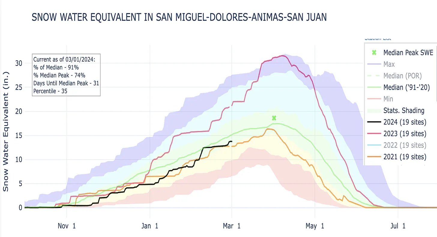
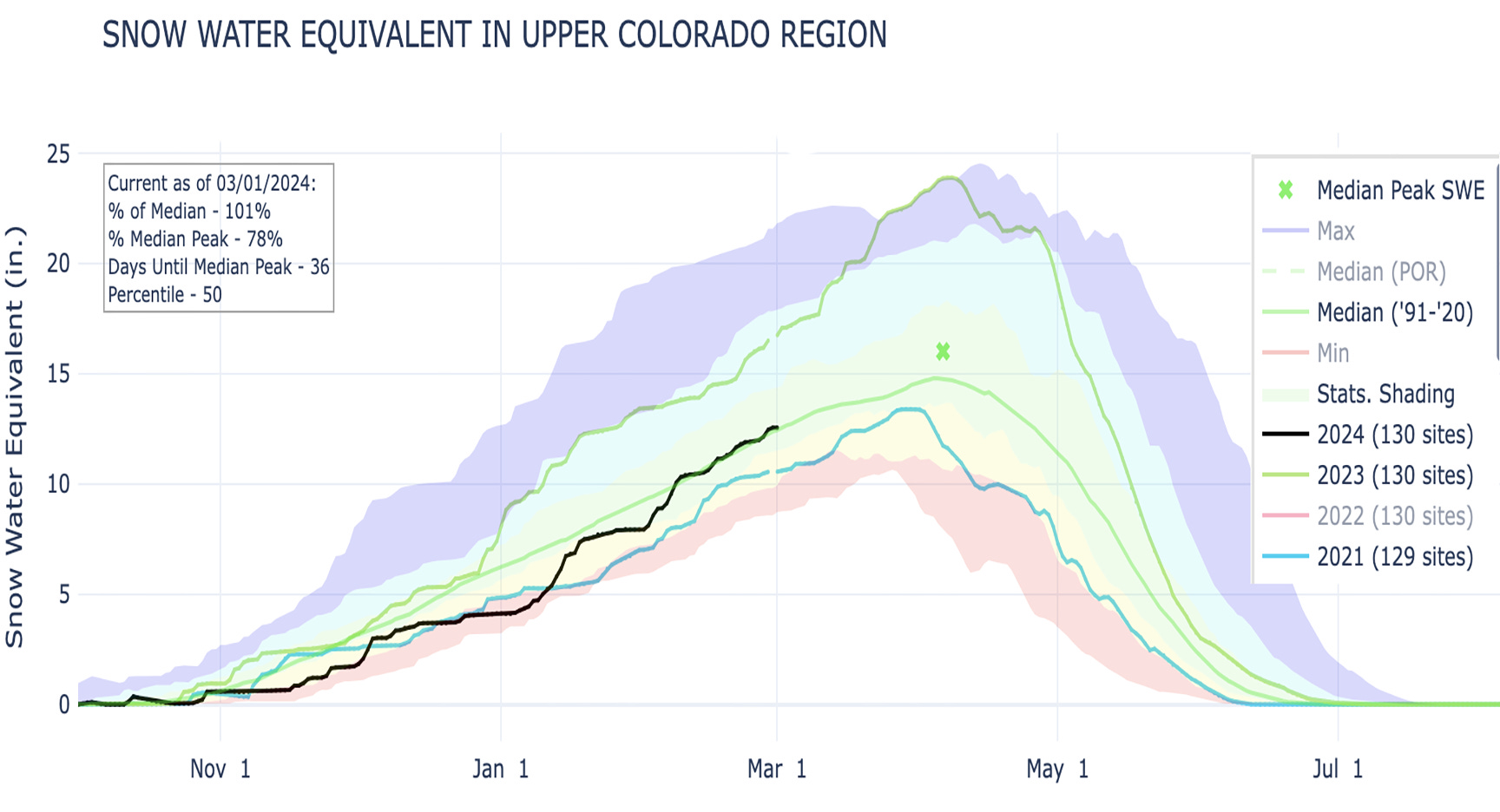
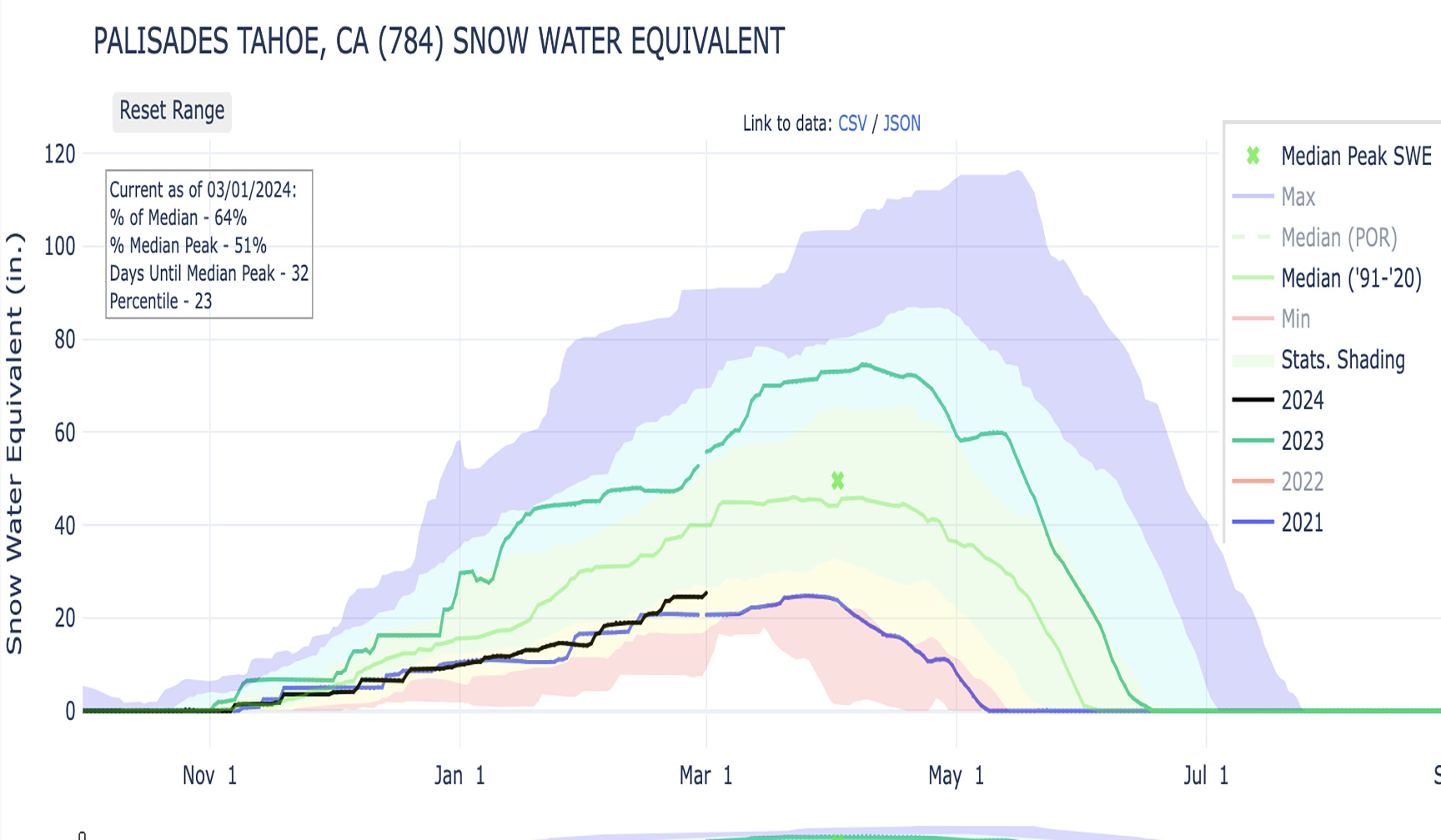
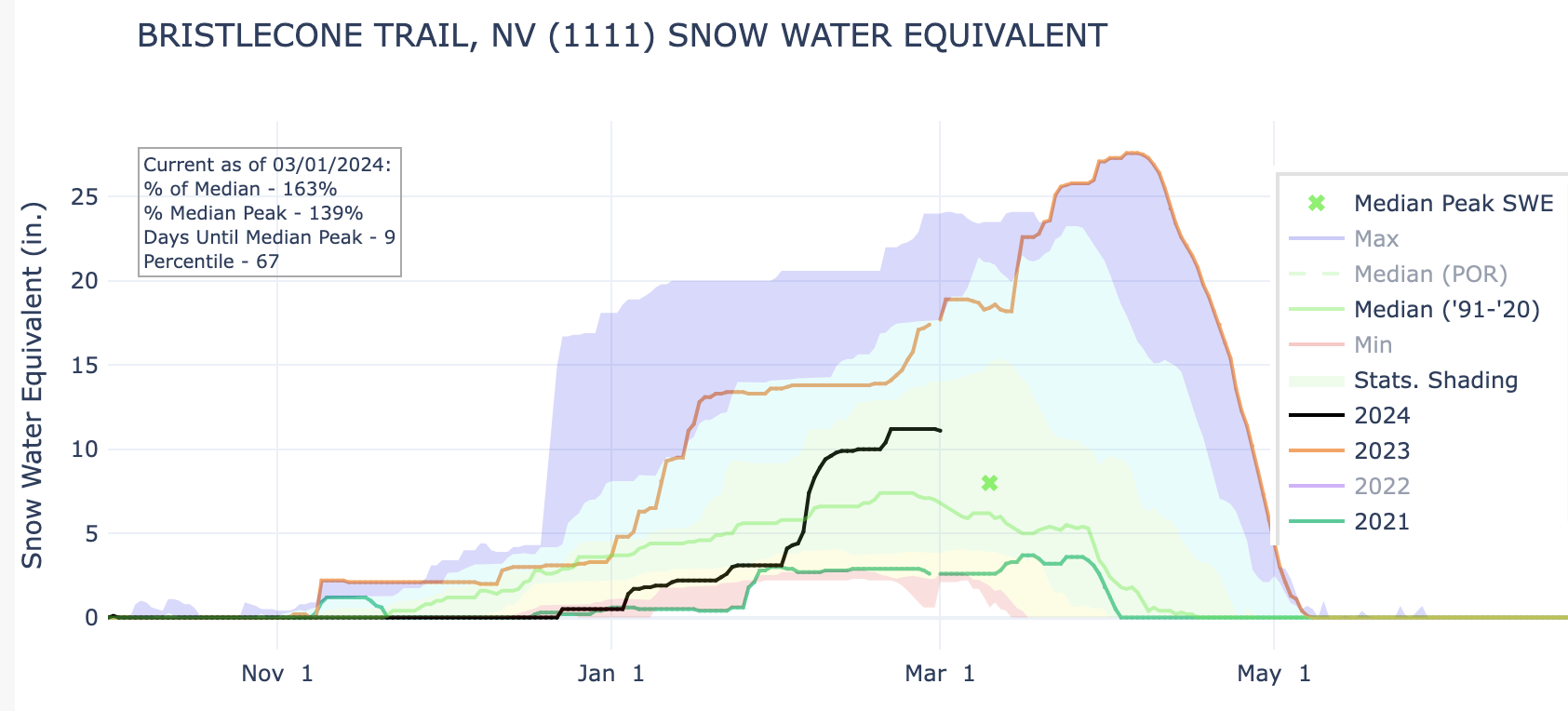
I was looking forward to today, the first day of meteorological spring, because I could finally deliver the good news about the big improvements to the snowpack during February. And things are looking up! Albeit maybe not as much as we’d expect, given the huge dumps some places have received in the last month.
To sum things up, the snowpack across much of the West is right around average. Not great, not anything like 2023, but also far better in most places than this time of year in 2021. Let’s just jump into the graphs: