There’s a lot of anxiety about climate change shrinking Lake Powell, but it also means whitewater rapids upstream have re-emerged. Thrillseekers can now run them for the first time since the 1960s.
ARI SHAPIRO, HOST:
At the bottom of a deep, red rock canyon in the desert southwest, the Colorado River is restoring itself, or at least a part of itself, even as climate change shrinks its volume. And that has river enthusiasts celebrating. Long-forgotten whitewater rapids are reemerging upstream. Reporter Luke Runyon set out to find more.
LUKE RUNYON, BYLINE: Ah. We just docked our boats to scout Gypsum Canyon Rapid. The sky is blue. The sun is out. It’s hot, and you can hear the water roaring.
PETE LEFEBVRE: I’m just going to go down this main wave train and look for this doamer (ph) rock and tuck underneath that.
RUNYON: Professional river guide Pete Lefebvre has been down Cataract Canyon more than 130 times, but he’s never seen Gypsum Rapid. And it looks mean, a churning, roiling mess of water and boulders.
PETE LEFEBVRE: It’s steep. It’s sharp. It’s a must-make move. And I’m nervous (laughter).
RUNYON: Lefebvre has never seen this rapid because for more than 50 years, it’s been buried under mud. Cataract Canyon is a transition zone, where the dammed up waters of Lake Powell start backing up, and sediment buries whatever’s on the bottom. But since 2000, Lake Powell has dropped 100 feet. So here, the river is starting to behave like a river again, carving down and excavating these long-buried boulders. Mike DeHoff is another experienced river-runner.
MIKE DEHOFF: Cataract Canyon, I think, these days is like a friend that was in a car accident or had a terrible sickness that has come home from the hospital.
RUNYON: In 2019, he and Pete Lefebvre started the Returning Rapids Project. DeHoff’s wife, Meg Flynn, a librarian in nearby Moab, keeps its archive. Using old photos from before Lake Powell’s dam was built, they anticipate when and where new rapids might again show themselves.
MEG FLYNN: We see here how flowing water brings life and that the river, if you give it a chance, can recover at a rate that is really astounding to all of us.
Snow is a cornerstone of the American West’s water supply, but just how important is it to the region’s streams, rivers and reservoirs?
In the popular press and academic papers, the sizable share of runoff that originates as snowmelt is often cited as a reason why the West’s snowpack is so crucial to both cities and farms, not to mention the region’s wildlife and very way of life.
But when a team of researchers set out to study the question, they found a wide range of estimates cited in 27 scientific papers. They concluded that “a detailed study of the contribution of snow to the runoff over the western U.S. has not been conducted.”
To clarify the connection between the snowpack and streamflow—and project how climate change is altering the relationship—the scientists used computer simulations and hydrological modeling in a 2017 paper in Geophysical Research Letters to estimate snow’s significance for runoff across the West. Here’s what they found:
53% of total runoff in the West originated as snowmelt, even though only 37% of the precipitation fell as snow.
In mountainous parts of the region, snowmelt was responsible for 70% of runoff. Specifically, it was 74% for the Rockies, 73% for the Sierra Nevada and 78% for the Cascades (see graphic below).
A quarter of the West’s land area, primarily in the high country, produced 90% of total runoff on average.
Climate change will reduce the snowpack’s contribution to runoff, according to the study, as warmer temperatures make it more likely that precipitation will fall as raindrops, rather than snowflakes, leaving downstream water users vulnerable.
“The snowpack is more efficient at producing runoff and streamflow than liquid precipitation,” said co-author Jennifer Adam, a Professor of Civil and Environmental Engineering at Washington State University. “When it’s cold, you have less evaporative demand.”
How much runoff is derived from snowmelt?
Chart: Mitch Tobin/The Water DeskSource: Li, D., et al. (2017). How much runoff originates as snow in the western United States, and how will that change in the future? Geophysical Research Letters, 44(12), 6163–6172. Created with Datawrapper
Climate change threatens snowpack
A diminished snowpack and less snowmelt in rivers “would likely exacerbate the dry-season water scarcity in the future,” according to the study. “In addition, the earlier snowmelt will strain storage capacity of the hydrologic infrastructure and further reduce the water availability in the prolonged dry season.”
Future runoff in the West will be affected by many other factors, including land-use changes, water policies and water efficiency trends. But the researchers caution that “due to the profound reliance on snow as water resources, future declines in snow accumulations in the West will pose a first-order threat directly on the regional water supply, especially in the late summer and fall” when water demand peaks.
Looking ahead, the study used two climate change scenarios—known as Representative Concentration Pathway (RCP) 4.5 and 8.5—to project how the snowpack’s contribution to streamflow will respond to warming temperatures and altered precipitation.
As I noted in a previous post, RCP 8.5’s business-as-usual projections for the carbon output of the global economy now appear too pessimistic, so the more moderate emissions scenario in RCP 4.5 may be more plausible.
Using RCP 4.5, the study projects that by 2100, the fraction of runoff coming from the snowpack will decline from 53% to 39.5%. For streams and rivers draining the region’s major mountain ranges, the figure will drop from 71% to 57%.
The declines are even greater when using the higher-emissions RCP 8.5 scenario: snow-derived runoff in the West falls to 30.4%, and in mountainous areas, it’s down to 45%.
In other words, with enough warming and time, the West’s snowpack will no longer be responsible for the majority of runoff in the region. The change in character and timing of runoff will pose serious challenges, not only for humans who have built elaborate water infrastructure based on snowmelt but also for other species that have come to depend on snow-dominant systems.
Snowmelt-derived runoff projected to fall due to warming
Notes: Moderate Emissions scenario is RCP 4.5 and High Emissions scenario is RCP 8.5
Chart: Mitch Tobin/The Water DeskSource: Li, D., et al. (2017). How much runoff originates as snow in the western United States, and how will that change in the future? Geophysical Research Letters, 44(12), 6163–6172. Created with DataWrapper
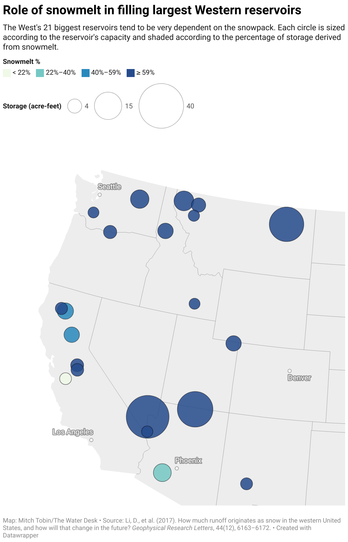
Snowmelt’s contribution to reservoirs
The 2017 study also examined the snowpack’s importance to each of the region’s largest 21 reservoirs, which collectively have more capacity than the 2,300+ other reservoirs in the West combined.
Overall, snowmelt accounts for 67% of storage in these reservoirs. For the largest three in the West—Mead, Powell, and Fort Peck—the figure is 70%. In the map below, the circles are sized according to each reservoir’s storage capacity and shaded by the percentage derived from snowpack (click on circles for more data).
Map: Mitch Tobin/The Water DeskSource: Li, D., et al. (2017). How much runoff originates as snow in the western United States, and how will that change in the future? Geophysical Research Letters, 44(12), 6163–6172. Created with DataWrapper
Reservoirs are collection points for runoff, so to understand why some are more or less dependent on snowmelt, the researchers looked at the watersheds upstream. The map below shows that dependence on snowmelt varies greatly across the vast and topographically diverse region, with the bluest shading representing areas most dependent on snowmelt and the yellow shading showing places least reliant on snow.
Source: Li, D. et al. (2017).
What explains the geographic pattern?
“Winter temperature and then also the fraction of annual precipitation that falls in the winter are the two key pieces,” Adam said.
In some parts of the region, it’s cold enough at high elevations for it to snow and most of the yearly precipitation falls in winter. But at lower elevations and in other parts of the West, there’s more precipitation outside of winter, and even during the colder months rain may fall instead of snow.
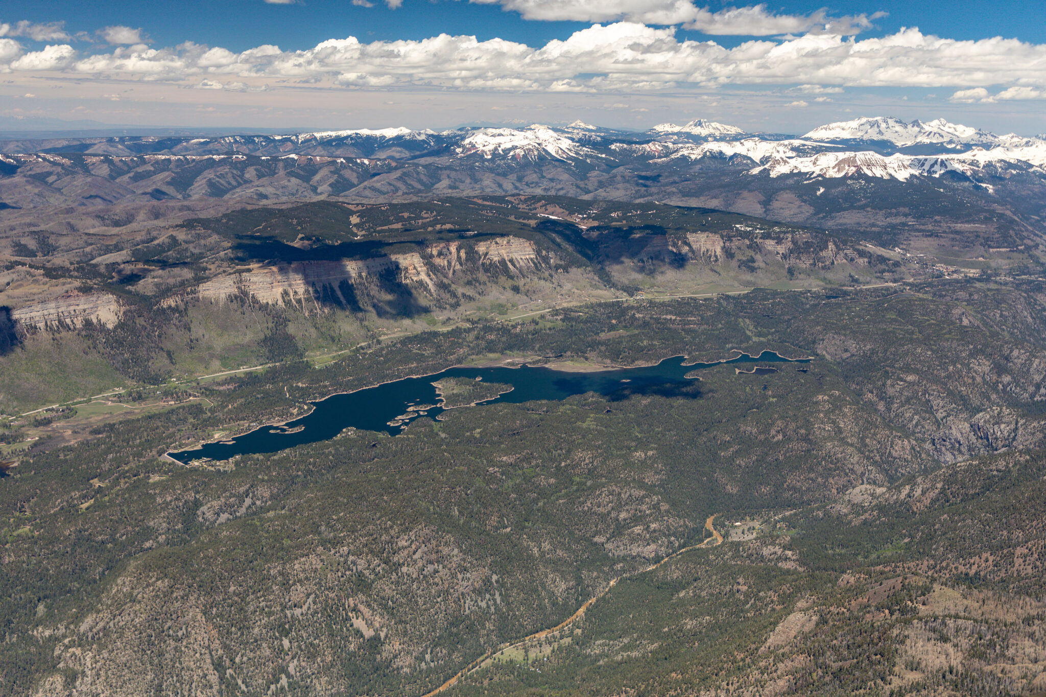
Aerial view of the San Juan Mountains snowpack, Electra Lake and the Animas River, north of Durango, Colorado, on May 26, 2024. Photo by Mitch Tobin, The Water Desk, with aerial support from LightHawk.
Warming reshapes river flows
Climate change will not only alter the snowpack’s contribution to runoff but also profoundly change the timing of those streamflows and the fundamental character of many waterways.
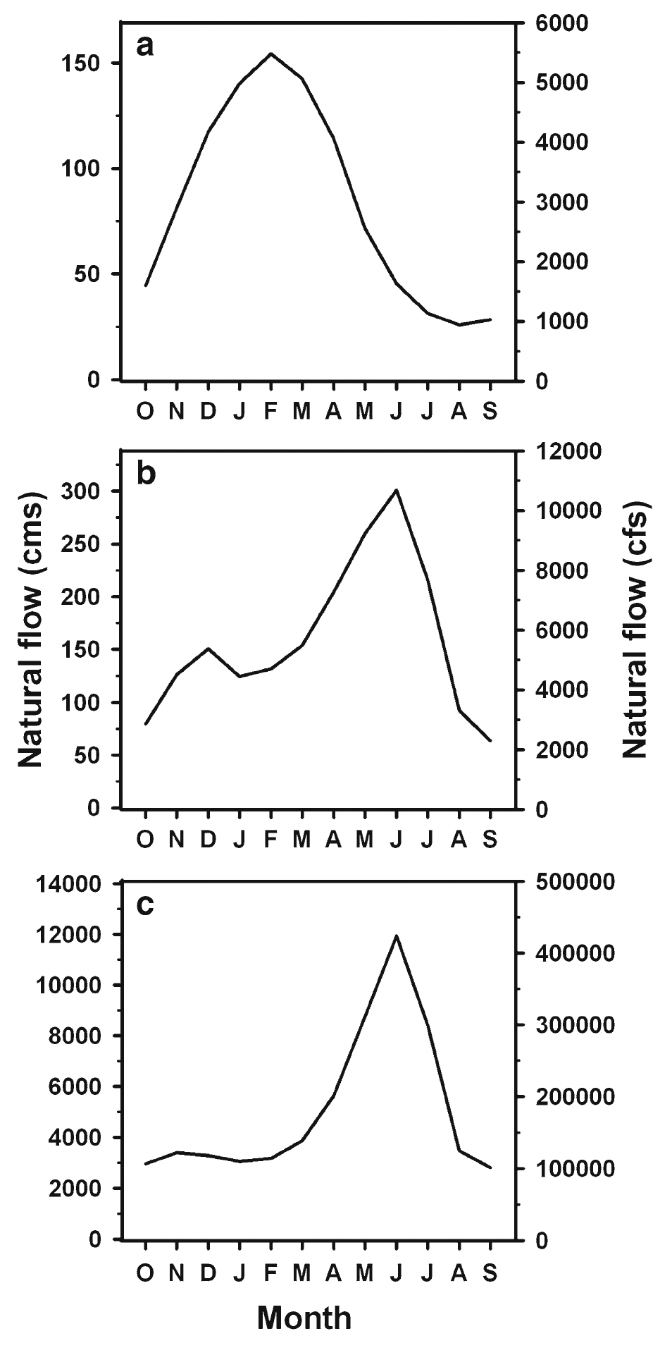
Adam noted that another study, published in 2010 in Climatic Change, classified tributaries into three categories—rain-dominant, transient rain-snow, and snowmelt-dominant—based on their precipitation patterns. The graphics below show that each of these regimes lead to very different hydrographs, which are visualizations of streamflow over time that essentially tell the story of a river’s discharge through the seasons.
Graph “a” shows a rain-dominant system, represented by the Chehalis River, east of Aberdeen, Washington and near the Pacific Coast. This hydrograph peaks early in the winter because rainfall quickly runs to the river. Graph “b” shows the transient rain-snow system, in this case represented by the Yakima River in south-central Washington, where the streamflow exhibits two peaks: a smaller one due to winter rains and a much larger one due to the spring snowmelt from higher elevations. Finally, graph “c” shows a snowmelt-dominant system, in this case the Columbia River at The Dalles, Oregon, where the streamflow remains low throughout the winter but then ramps up in spring and peaks in summer due to the high-country snow melting out.
Source: Elsner M., et al. (2010).
These three hydrographs depict very different rivers in terms of the timing and magnitude of their flows. The hydrographs also lead water agencies to pursue varying management strategies to ensure that customers get enough water, while individual species and entire ecosystems have evolved through the ages to cope with the streamflow regimes. In the 21st century, however, warming temperatures will reshape these curves by making these systems more dependent on rain than snow.
“In those places that are snowmelt dominant historically, you’re going to see a lot of vulnerability to warming temperatures,” Adam said, adding that junior water rights holders are most at risk. “More of our modeling is looking at the water rights and trying to understand where the water restriction is going to be felt.”
Ecologists have long warned that reduced streamflows pose a dire threat to cold-water fisheries, such as trout. Adam said a shift from snowmelt to rain could compound the problem. “One of the problems with the loss of snowpack is that snowmelt cools down the system,” she said. “It’s not just about water volume, but it’s also about cooling the rivers.”
Looking ahead, climate models are crystal clear in projecting warmer temperatures, but the story for precipitation is clouded by uncertainty, making it especially hard to predict runoff at lower elevations.
“We don’t really know what’s going to happen to the rain dominant systems: Are they going to get wetter? Are they going to get drier? We just don’t know,” Adam said. “At least we know with confidence that the snowmelt-dominant systems are going to become more and more stressed.”
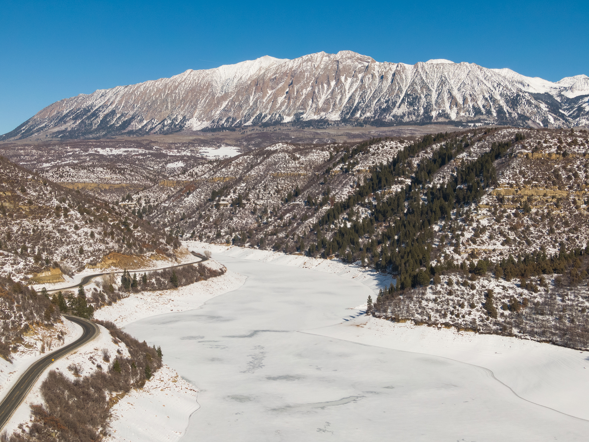
Aerial view of the Blue River, a popular trout fishery near Silverthorne, Colorado, on December 22, 2019. Photo by Mitch Tobin, The Water Desk.
The Water Desk’s mission is to increase the volume, depth and power of journalism connected to Western water issues. We’re an editorially independent initiative of the Center for Environmental Journalism at the University of Colorado Boulder.