#Drought news October 24, 2024: The heaviest rains fell across #Colorado, reporting rainfall totals up to 600% of normal, resulting in improvements of moderate to severe drought and abnormal dryness in western and southern portions of the state this week

Click on a thumbnail graphic to view a gallery of drought data from the US Drought Monitor website.

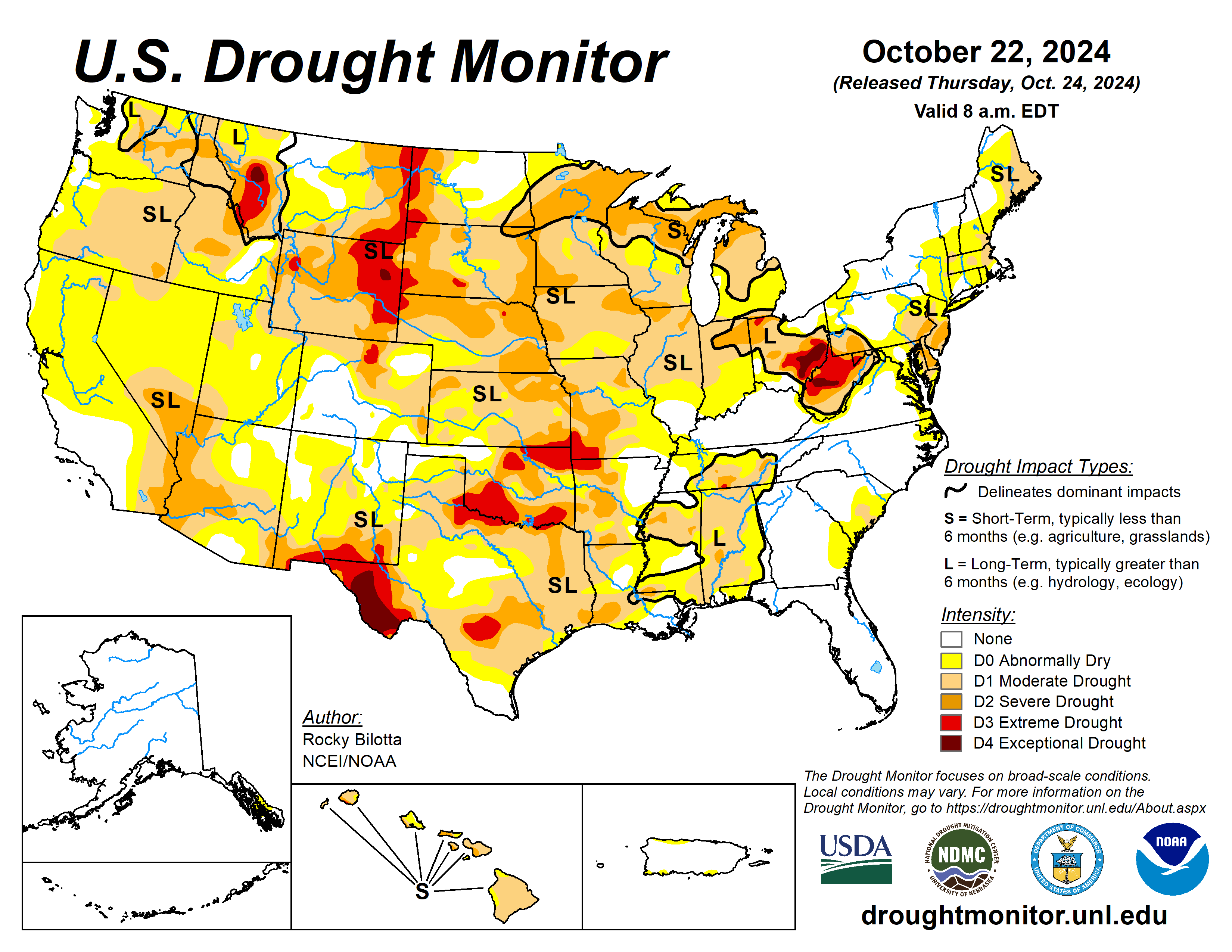
Click the link to go to the US Drought Monitor website. Here’s an excerpt:

This Week’s Drought Summary

Precipitation fell across much of the U.S. over the past week, while heavier amounts were observed over parts of the Pacific Northwest and Southwest. Portions of New Mexico, Utah, Colorado and Washington reported rainfall totals between 3 to 5 inches above normal, while precipitation totals were below normal across much of the eastern U.S. Warmer-than-normal temperatures were observed across much of the U.S. this week. Temperature departures ranging between 6 to 15 degrees F above normal were observed from the northern Rockies to northern portions of the Midwest. Cooler-than-normal temperatures were observed from eastern portions of Texas to the Mid-Atlantic, and in parts of the Great Bains and Southwest. The Southeast observed temperatures between 3 to 9 degrees F below normal this week..

High Plains

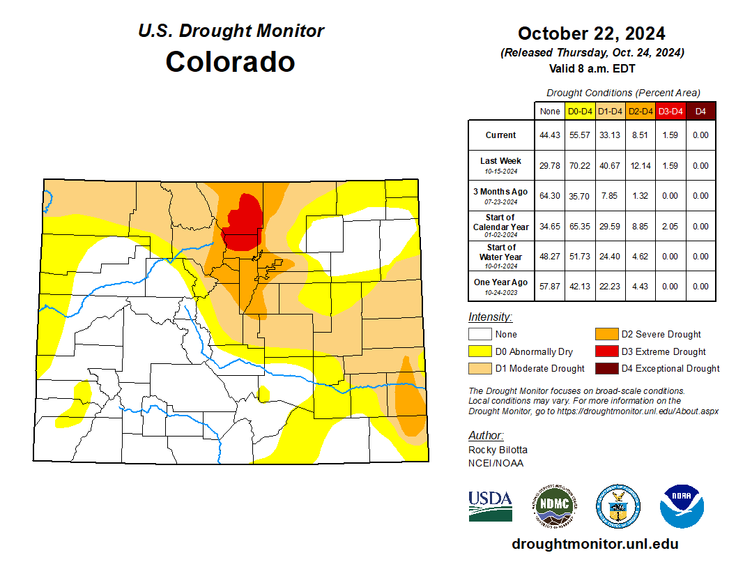
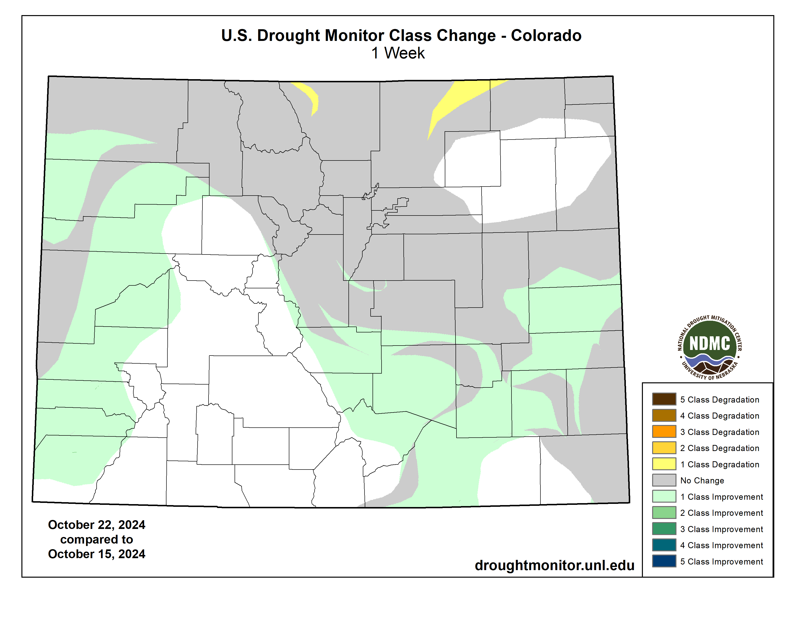
Warm temperature dominated the High Plains this week with departures ranging up to 12 degrees F above normal, especially in the northern portions of the region. Precipitation fell across much of the region this week, but amounts were not large enough to prevent further degradations across much of the region. Extreme drought was introduced in northeast Nebraska, while extreme drought was expanded in western South Dakota, eastern Wyoming, and northwestern Nebraska. Severe and moderate drought were expanded in portions of Kansas, Nebraska, and the Dakotas, while severe drought was expanded in southern Wyoming. Abnormal dryness was expanded in parts of North Dakota. The heaviest rains fell across Colorado, reporting rainfall totals up to 600% of normal, resulting in improvements of moderate to severe drought and abnormal dryness in western and southern portions of the state this week…
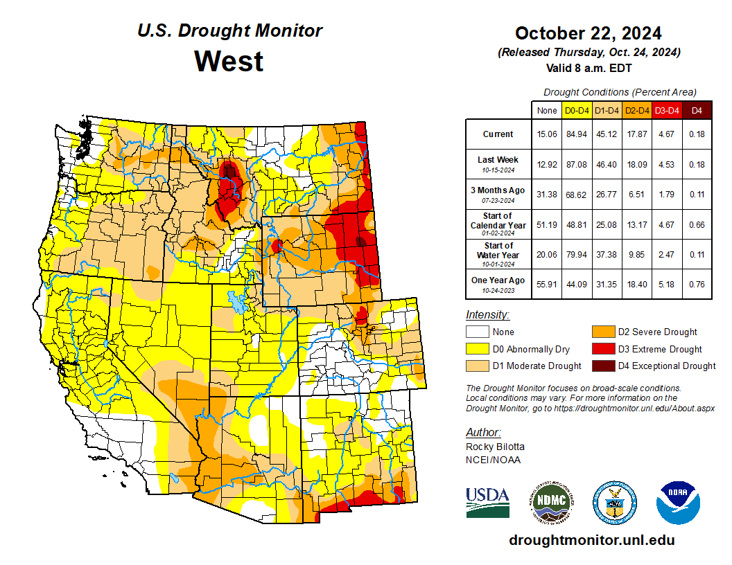
Colorado Drought Monitor one week change map ending October 22, 2024.

West

Average temperatures were mostly above normal across the West this week, while much of the Great Basin, New Mexico and southern California experienced below-normal temperatures, with departures of 1 to 6 degrees F below normal. Conversely, Montana observed temperatures ranging between 3 to 12 degrees F above normal this week. Precipitation fell across much of the region but amounts were mostly normal to below-normal for the region. Heavier rainfall totals, up to 600% above normal, were observed over parts of northwest Washington, Utah and New Mexico. Daily maximum precipitation records were set in parts of Utah and New Mexico. Above-normal precipitation (up to 8 inches above normal), along with cooler temperatures, allowed drought and abnormal dryness improvements in New Mexico, while abnormal dryness was improved in Arizona, Utah, and Washington. Warmer-temperatures and below-normal precipitation resulted in expansion of moderate to extreme drought and abnormal dryness in eastern Montana based on SPI/SPEI data, as well as low soil moisture and streamflow values…

South

Dry conditions continued across much of the South this week, while precipitation fell just along the western borders of Texas, Oklahoma and Kansas. Temperatures were mixed across the region with the eastern areas experiencing below-normal temperatures, with departures of 1 to 9 degrees F below normal, and above-normal temperatures were observed across western portions of the South, with departures of 1 to 6 degrees F above normal. Moderate to severe drought were expanded across portions of Texas, Oklahoma, and northern Arkansas, while moderate to severe drought were expanded in Louisiana and Mississippi. The expansion and intensification of drought categories were based on short-term SPI/SPEI, reservoir levels, streamflow and soil moisture data…

Looking Ahead

During the next five days (October 22–26, 2024), The cold front crossing the Great Lakes and into the Northeast Wednesday into early Thursday will likely have just enough moisture and lift to produce some mainly light to moderate showers, while conditions should continue to remain dry and mostly sunny for areas farther to the south across the Mid-Atlantic and the Southeast U.S. Moisture is forecasted to return to the Pacific Northwest late this week into the weekend, with rain and high elevation northern Cascades snow could commence as early as late Thursday. Temperatures will feel more like September across areas from the central U.S. into the Northeast Tuesday into Wednesday, with highs running 10 to 20 degrees above average for late October and possibly even a little higher over parts of the Upper Midwest/northern Great Lakes on Tuesday. A cold front pushing rapidly eastward from the northern Plains will bring more seasonable conditions after midweek. From late week into the weekend, a building Western U.S. upper ridge that pushes eastward ahead of the Pacific storm system should promote a warming trend first over the Intermountain West and Rockies/western High Plains and then covering much of the central U.S. where many areas should see highs 10 to 20 degrees above normal. The West Coast states should be within a few degrees on either side of normal aside from a brief warmer period over parts of California around midweek.

The Climate Prediction Center’s 6-10 day outlook (valid October 27–31, 2024) favors above-normal precipitation from parts of the Midwest to the West Coast, and across most of Alaska and Hawaii, with below-normal precipitation favored from the Tennessee Valley to the Northeast, as well as parts of the Southwest. Increased probabilities for above-normal temperatures are forecast for Hawaii and much of the contiguous U.S., while below-normal temperatures are likely across the state of Alaska and in the Pacific Northwest.

US Drought Monitor one week change map ending October 22, 2024.

Topsoil Moisture % short/very short — @NOAADrought

68% of the Lower 48 is short/very short, tying the highest value at any time during the last 10 years (68% on 10/23/22) per

@USDA_oce‘s Brad Rippey. Conditions worsened in much of the eastern half of the U.S., particularly in the SE.

Fact check: Debunking weather modification claims, no one creates or steers hurricanes; the technology does not exist — NOAA

Advanced radar technology helps forecasters more accurately track, assess and warn the public of approaching high-impact weather. (Image credit: NOAA)

Click the link to read the article on the NOAA website:

October 23, 2024

As the southeastern United States reels from the impact of two historic hurricanes, a large amount of disinformation about nonexistent weather manipulation technology is spreading across the internet, particularly on social media platforms.  

Below, NOAA identifies some of the inaccurate claims circulating online and provides science-based facts and information in response.


  • CLAIM: The government is creating, strengthening and/or steering hurricanes into specific communities. 
  • FACT:  No technology exists that can create, destroy, modify, strengthen or steer hurricanes in any way, shape or form. All hurricanes, including Helene and Milton, are natural phenomena that form on their own due to aligning conditions of the ocean and atmosphere. 

  • CLAIM: NOAA modifies the weather.
  • FACT: NOAA does not modify the weather, nor does it fund, participate in or oversee cloud seeding or any other weather modification activities. NOAA’s objective is to better understand and predict Earth’s systems, from the bottom of the seafloor to the surface of the sun. We are deepening our understanding and deploying new resources to improve forecasting and give communities earlier and more accurate warnings ahead of extreme weather events. NOAA is required by law* to track weather modification activities by others, including cloud seeding, but has no authority to regulate those activities.

*The Weather Modification Reporting Act of 1972 (15 Code of Federal Regulations § 908) requires anyone who intends to engage in weather modification activities within the United States, including cloud seeding, to provide a report to the Administrator of NOAA at least 10 days prior to undertaking the activity. Those reports are filed via email and may be found on the NOAA Central Library website.


Cloud-seeding graphic via Science Matters
  • CLAIM: The government is engaging in activities like cloud seeding to modify the weather. 
  • FACT: NOAA does not fund or participate in cloud seeding or other weather modification projects. Cloud seeding is the only common weather modification activity currently practiced in the United States — typically by private companies in western mountain basins in winter in order to help generate snow in specific locations, or in the desert southwest to replenish water reservoirs in summer. The method has been used for decades in an effort to increase stored water in snowpack that melts in the spring to maintain adequate water supply.

    Decades ago, between 1962 and 1982, NOAA provided support for research into whether hurricane intensity could be modified, known as Project STORMFURY. The research was not successful in modifying hurricanes and STORMFURY was discontinued. NOAA has not attempted to modify hurricane intensity and participate in cloud seeding since. For more information on this project, visit this NOAA Atlantic Oceanographic & Meteorological Laboratory website.

  • CLAIM: NEXRAD Doppler radars are being used to steer hurricanes and are targeting specific communities.
  • FACT: Radars are tools for observation and are not able to direct the motion or intensity of air masses or storms. NEXRAD Doppler radars detect precipitation and the motion of the precipitation particles. The radar can determine an object’s location, shape, intensity and movement relative to the radar, but cannot alter or move those objects in any way. NEXRAD radars have been an essential weather forecasting tool since the 1990s and weather radars in general have been in use in the United States since the 1950s.

This graph shows the full record of monthly mean carbon dioxide measured at Mauna Loa Observatory, Hawaii. The carbon dioxide data on Mauna Loa constitute the longest record of direct measurements of CO2 in the atmosphere. They were started by C. David Keeling of the Scripps Institution of Oceanography in March of 1958 at the NOAA Weather Station on Mauna Loa volcano. NOAA started its own CO2 measurements in May of 1974, and they have run in parallel with those made by Scripps since. (Image credit: NOAA Global Monitoring Laboratory)
  • CLAIM: Solar geoengineering made hurricanes Helene and Milton worse.
  • FACT: Solar geoengineering, a theoretical practice which would modify the atmosphere to shade Earth’s surface by reflecting sunlight back into space, is not taking place at scale anywhere in the world. Geoengineering did not impact hurricanes Helene and Milton, let alone make them worse.

    The Earth’s warming atmosphere can cause hurricanes to intensify rapidly and carry more moisture, allowing them to dump higher amounts of rain. Record to near-record warm ocean temperatures across the Gulf of Mexico allowed hurricanes Helene and Milton to rapidly intensify. Natural steering currents in the upper atmosphere determine a storm’s path. 

  • CLAIM: NOAA is conducting solar geoengineering.
  • FACT: NOAA is not conducting solar geoengineering. NOAA studies the stratosphere and marine boundary layer with instruments on balloons and aircraft to help fill important gaps in our knowledge and inform decisions about the potential risks and benefits of solar geoengineering.

  • CLAIM: NOAA is involved with projects like HAARP and SCOPEX that modify weather. 
  • FACT:  NOAA is not associated with these projects, neither of which can modify the weather. 

    HAARP is a small National Science Foundation-funded facility in Gakona, Alaska, that conducts research on the ionosphere, 30 to 600 miles above the Earth’s surface. HAARP (High-frequency Active Auroral Research Program) is not capable of influencing local weather at Earth’s surface, let alone tropical cyclones thousands of miles away. The HAARP system is basically a large radio transmitter. 

    SCOPEX, run out of Harvard University, was a scientific research project to study the behavior of small amounts of aerosols in the stratosphere to advance the understanding of solar geoengineering. The proposed scientific research project ended in March 2024 before field experiments were conducted.

Eight #Colorado counties receive funding to improve urban tree canopy — Colorado State Forest Service

Students collect tree measurements on the Colorado State University campus on March 19, 2024. Tree surveys are one of the tasks funded by the Colorado IRA UCF grants. Photo: Field Peterson, CSFS

Click the link to read the release on the Colorado State Forest Service website:

October 23, 2024

The Colorado State Forest Service announced awards for the first round of funding for the Colorado Inflation Reduction Act (IRA) Urban and Community Forestry (UCF) grant program. The CSFS created the new grant program with IRA funding from the U.S. Forest Service, and the money will be used to improve the tree canopy in communities in disadvantaged areas across Colorado. In total, the CSFS will award $1.6 million for 11 projects in 8 counties across Colorado.   

“This infusion of funding for urban forestry into some of our most vulnerable communities is overdue,” said Matt McCombs, state forester and director of the CSFS. “This is a historic investment in trees and one that will transform the canopy in these communities. Healthy trees and a flourishing urban canopy will improve the lives of Coloradans by providing more shade, cleaner air, and more beautiful places to work, live and play.”  

The funded projects include a variety of activities that will improve Colorado’s urban forests: 

  • Planting hundreds of trees 
  • City tree inventories 
  • Community outreach events 
  • Removal of hazard trees and storm-damaged trees 
  • Hiring arborists, interns and tree stewards  

“I’m excited to work closely with these communities as they make long-lasting investments to their urban trees,” said Cori Carpenter, tree equity specialist at the CSFS. “Many of these towns don’t have dedicated forestry staff, so this funding source is really the only way they can make much-needed improvements to their community’s tree canopy.” 

For the first round of Colorado IRA UCF grants, the CSFS received 23 eligible applications requesting more than $4.7 million. Since $1.6 million was available for this round of grants, 12 projects totaling more than $3 million could not be funded. Another $1 million will be available through the grant program each year in 2025 and 2026.  

These counties received Colorado IRA UCF funds during this funding cycle: Adams, Alamosa, Boulder, Chaffee, Las Animas, Mesa, Sedgwick and Yuma. Review a full list of awardees

The CSFS will announce the next round of funding assistance through the Colorado IRA UCF grant program in spring 2025. Learn more about the Colorado IRA UCF grant program.  

Reservoir Drawdown in 2024: Are We on Track to Recover Storage? — Jack Schmidt (Center for #ColoradoRiver Studies) #COriver #aridification

Click the link to read the article on the Center for Colorado River studies website (Jack Schmidt):

October 22, 2024

Unfortunately, water use between now and next April is on track to exceed the inflows of the snowmelt season, resulting in a net loss of reservoir storage. The persistent decrease in runoff is severely challenging the quest to rebuild reservoir storage.

Summary

Reservoir storage in the Colorado River basin is now approximately equal to two year’s average annual consumptive use. In the three months since reservoir storage peaked in July 2024, drawdown of those reservoirs lost more than 80% of the increase accomplished by the 2024 snowmelt inflow season, which had increased basin reservoir storage by only 2.5 million acre feet despite the Upper Basin snowpack having peaked at a snow water equivalent that was 13.5% greater than the long-term average1. If this rate-of-use continues for the next six months, there will be a net loss in basin reservoir storage. Water supply reliability and security for Colorado River water users can only be accomplished if we replenish the amount of water stored in reservoirs and not further deplete the declining supply.

Details

On 15 October 2024, total contents of the reservoirs of the Colorado River Basin upstream from the Gila River were 27.8 million af (acre feet). This amount of reservoir storage would support two years of consumptive use of the Colorado River2, assuming that basin consumptive uses remain approximately 13 million af/yr, the average between 2021 and 2023. Reservoir storage today is comparable to conditions in mid-June 2021 (Fig. 1) when there was increasing concern among the basin’s water managers about the security and reliability of water supplies provided by the Colorado River. Today, we should be just as concerned as we were in 2021.

Figure 1. Graph showing total basin reservoir storage (blue line), and storage in different parts of the Colorado River watershed between 1 January 2021 and 15 October 2024. CRSP reservoirs are those authorized by the Colorado River Storage Project Act. Credit: Jack Schmidt/Center for Colorado River Studies

The only way to increase the security and reliability of the water supply is to increase reservoir storage, and we are not doing a very good job of achieving that goal. There is no doubt that the large reservoir inflows of 2023 benefitted the basin water supply, allowing us to take a step back from the edge of the cliff of crisis. Basin reservoirs in mid-March 2023 were the lowest they had been (21.3 million af) since late May 1965, when the Colorado River Storage Project’s reservoirs were just beginning to fill and other reservoirs had yet to be built. Snowmelt runoff in 2023 recovered 8.4 million af of reservoir storage, nearly a 40% increase from the March 2023 low point (Fig. 2)

Figure 2. Graph showing reservoir storage between 1 January 2023 and 15 October 2024, highlighting the amount of reservoir recovery during each snowmelt season and the amount of reservoir drawdown during intervening periods. Credit: Jack Schmidt/Center for Colorado River Studies

However, little additional progress in reservoir recovery was made in 2024.  We were encouraged that reservoir drawdown during the nine months immediately following the 2023 inflow season was remarkably small, only 2.15 million af and only 26% of the preceding gain in storage. However, snowmelt inflow only resulted in 2.5 million af of gain in reservoir storage in 2024 (Fig. 2).

In contrast to last year, basin uses and losses are much greater this year. In the first three months following the 2024 inflow season that ended in mid-July, reservoir drawdown has been 2.14 million af, more than 80% of the gain of the preceding inflow season (Table 1). Slightly more than half of the drawdown during the last three months has been from the 42 reservoirs upstream from Lake Powell. Those releases supported the needs of mid- and late summer irrigated agriculture, were exported out of the basin, or flowed into Lake Powell. It is likely that the drawdown from these reservoirs will decrease during winter. Slightly more than 30% of the drawdown has been from the combined contents of Lake Mead and Lake Powell. Recent agreements to decrease diversions in the Lower Basin hopefully will reduce drawdown from Mead-Powell combined storage during the next six months. The continued drawdown from Mead-Powell storage will be a robust test of the effectiveness of recent drought management measures.

Table 1. Reservoir drawdown during the first three months following the 2024 snowmelt compared to the total drawdown during the nine months following the 2023 snowmelt season. Credit: Jack Schmidt/Center for Colorado River Studies

Basin water use between now and April 2025 is on track to exceed the inflows of the 2024 snowmelt season, resulting in a net loss of reservoir storage since the bounty of 2023. The persistent decrease in runoff in the 21st century is severely challenging the quest to rebuild reservoir storage.  We desperately need to accomplish that goal to avoid another water supply crisis such as occurred between 2020 and 2022.

The only way to replenish the amount of water stored in reservoirs is to decrease reservoir drawdown to match or exceed each year’s gains that occur during the inflow season. For the next six months, that is our goal.

  1. Based on data from the Natural Resources Conservation Service snow water equivalent for the Upper Colorado Region for 2024 and for 1991-2020. https://nwcc-apps.sc.egov.usda.gov/awdb/basin-plots/POR/WTEQ/assocHUC2/14_Upper_Colorado_Region.html
  2. Also including losses from reservoir evaporation.
  3. Between 6 July and 15 October 2024
  4. Between 13 July 2023 and 17 April 2024.
  5. Includes drawdown of Lake Mohave and Lake Havasu.
ten tribes
Graphic via Holly McClelland/High Country News.

Federal Judge Cites Upper Colorado River Basin’s Compact Call Risk — John Fleck (InkStain.net) #COriver #aridification

Workers from Denver Water and contractor Kiewit Barnard stand in front of Gross Dam in May to mark the start of the dam raise process. Photo credit: Denver Water.

Click the link to read the article on the InkStain website (John Fleck):

October 18, 2024

A federal judge this week criticized the federal government for failing to consider the risk of a Colorado River Compact call in its environmental review of the planning for Denver Water’s expansion of Gross Reservoir in Boulder County.

Wrangling over the risk of a compact call – which the judge said could force water use reductions in the Upper Basin if the Upper Basin states fail to deliver enough water past Lee Ferry to the Lower Basin – has been a key point in current negotiations between the two basins over future Colorado River operations.

The ruling, in a lawsuit against Gross Reservoir expansion by Save the Colorado River and others, allows construction to proceed, but criticizes the project’s planners for not considering the fact that the risk of a compact call means there might not be enough water to fill it. (Here’s Elise Schmelzer’s article about the decision.)

In the decision, federal judge Christine Arguello noted that the Army Corps of Engineers environmental review of the project “rests on the assumption that there will be no compact call…. However, considering the American West’s last few decades of severe aridity, such an assumption warrants considerable scrutiny.”

Here’s the full language from Arguello’s ruling. I’ve bolded the key bits:

Further reading of the judge’s sources:

Map credit: AGU