May 1st #Colorado Water Supply Outlook: Early Melt, Below Normal #Snowpack, Low #Runoff and Mixed Reservoir Conditions — NRCS

El Diente SNOTEL. Photo credit: NRCS

Click the link to read the release on the NRCS website:

May 7, 2025

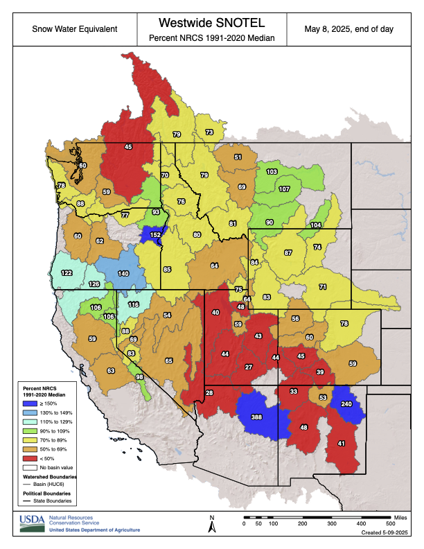
Snowpack across Colorado is well below normal following a warm, dry April. Statewide snowpack has begun its seasonal decline, with SWE at 57% of median. Despite a dry April, early May storms brought helpful precipitation to higher elevations.

As of May 1st, Colorado’s snowpack peaks and begins its seasonal decline. Statewide snow water equivalent (SWE) is at 57% of median, reflecting a sparse and well below average snowpack with drier conditions in central, southwest and southeast basins. In the Gunnison, combined San Miguel-Dolores-Animas-San Juan (SMDASJ), Upper Rio Grande (URG) and Arkansas snowpack is at 34% of median. Northern basins are at 73% of median with higher snowpacks in northeast mountains. 

Statewide peak SWE occurs 11 days earlier than the historical median with 90% of sites observing earlier dates. April brings limited storm activity, making for a less eventful month and resulting in a -28% SWE departure of the 30-year median. That negative departure translates to a decline of 2.6 inches of SWE at 82% of sites over the past 30 days. Looking at the full accumulation season from late October through April, the cumulative SWE departure deepens to 5.5 inches. 

May began with a strong storm system delivering over 3 inches of moisture at some sites in the Sangre de Cristos and San Juans, including the SMDASJ, URG and Arkansas River basins. The Front Range mountains are also benefitting from the early May storm, primarily east of the divide. Southwest basins typically receive around 7% of their annual precipitation in May, much of which falls as snow at higher elevations. During spring, however, this precipitation can fall as rain on snowpack unless temperatures cool significantly. “With this recent storm cooler temperatures prevailed, resulting in observed snowfall in many high elevation sites. While this early May storm did not benefit all regions equally, the widespread drop in temperatures will help reduce melt rates and slow runoff timing across the state,” notes Nagam Bell, NRCS hydrologist. 

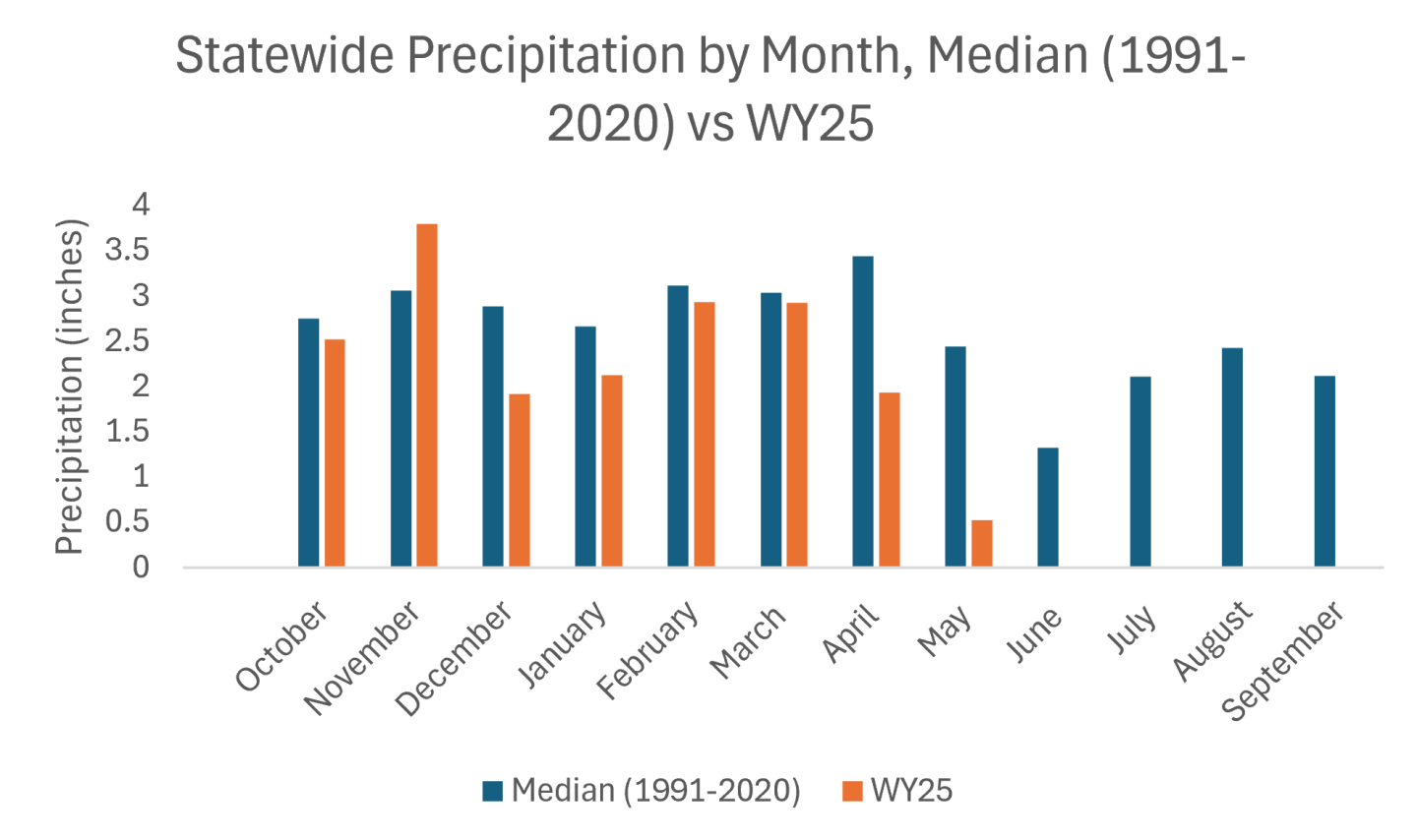
Water year to date (WYTD) precipitation is at 85% of median statewide, with basin values ranging from 74 to 95 percent. Northern basins lead the state with drier conditions found in the URG (74%) and SMDASJ (77%), while the Gunnison and Arkansas measure 82 and 86 percent of median, respectively. April finishes as the driest month for the primary accumulation period with statewide totals at 59% of median. Northern and central basins fall well below average: Yampa-White-Little Snake end at 43%, Colorado Headwaters at 47% and Gunnison at 49%. Southern basins fair slightly better over the last 30 days: SMDASJ reports 75% and the URG 70% for the month. Sixty day precipitation trends show a modest bump in some areas. Laramie-North Platte reaches 84% and the SMDASJ reports 88% of median. 

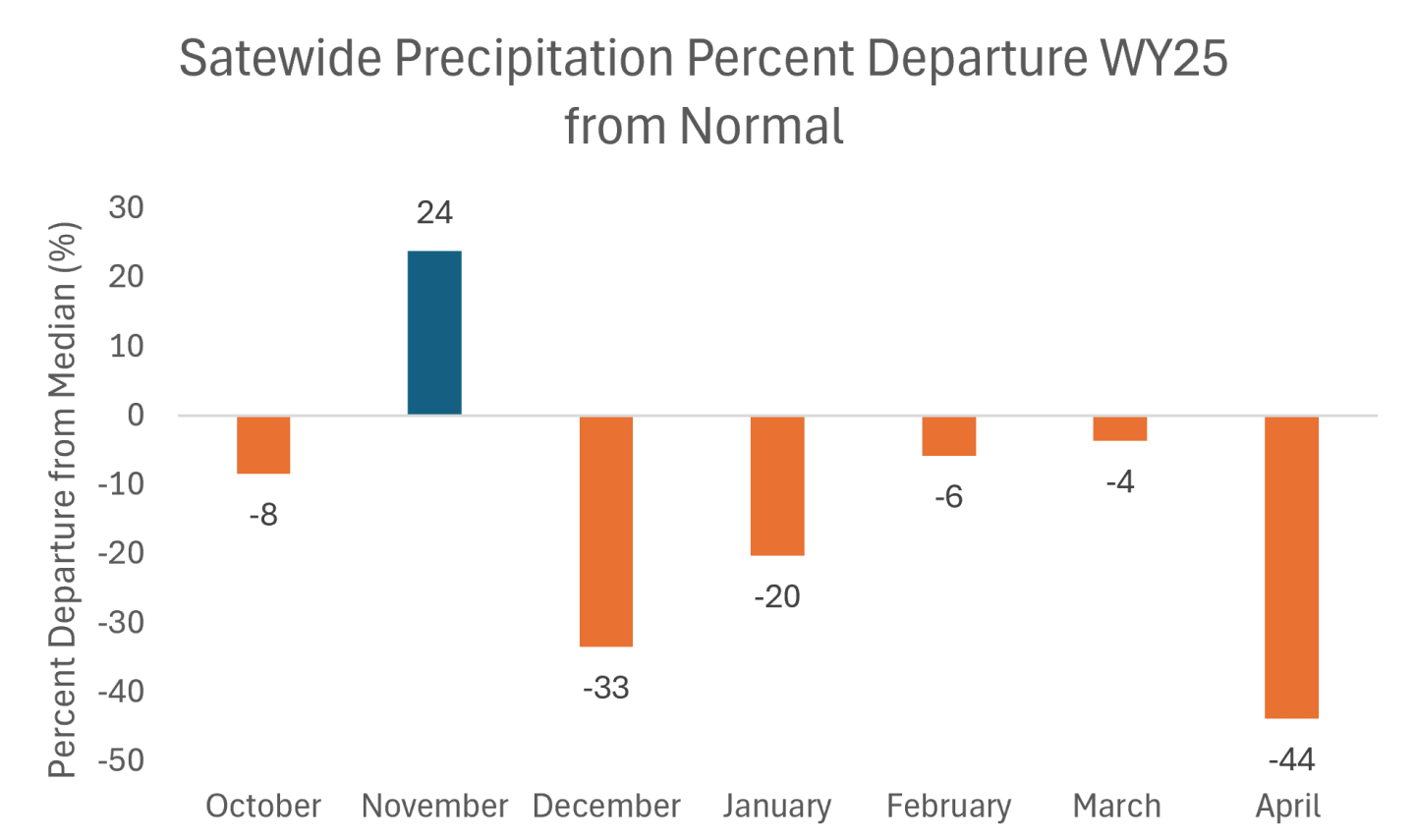
On the lower end, the Arkansas and URG observe 66 and 73 percent, respectively. The 90 day averages highlight increased variation, spanning 64 to 98 percent. Northern basins remain the strongest performers while precipitation values taper farther southeast. The following charts highlight statewide totals (see Figure 1) and departures from median. November remains the only month with a notable surplus, while April records the steepest drop at 44% below normal (see Figure 2).

Figure 1. Statewide monthly precipitation totals comparing the 1991-2020 median with Water Year 2025. May totals reflect values through May 5th and are not yet complete. Credit: NRCS
Figure 2. Percent departure from median precipitation by month for Water Year 2025. November records a surplus and April has the largest negative departure. October, February and March observe closer to normal precipitation. Credit: NRCS

Statewide reservoir storage is at 93% of median and 61% of total capacity as of the end of April. Despite below average snowpack storage levels at most higher capacity reservoirs are holding near or above average volumes and include: Dillon, Lake Granby, Blue Mesa and Pueblo Reservoir. The exceptions are McPhee at 73% of median and 62% capacity and Navajo Reservoir at 74% of median and 61% capacity. 

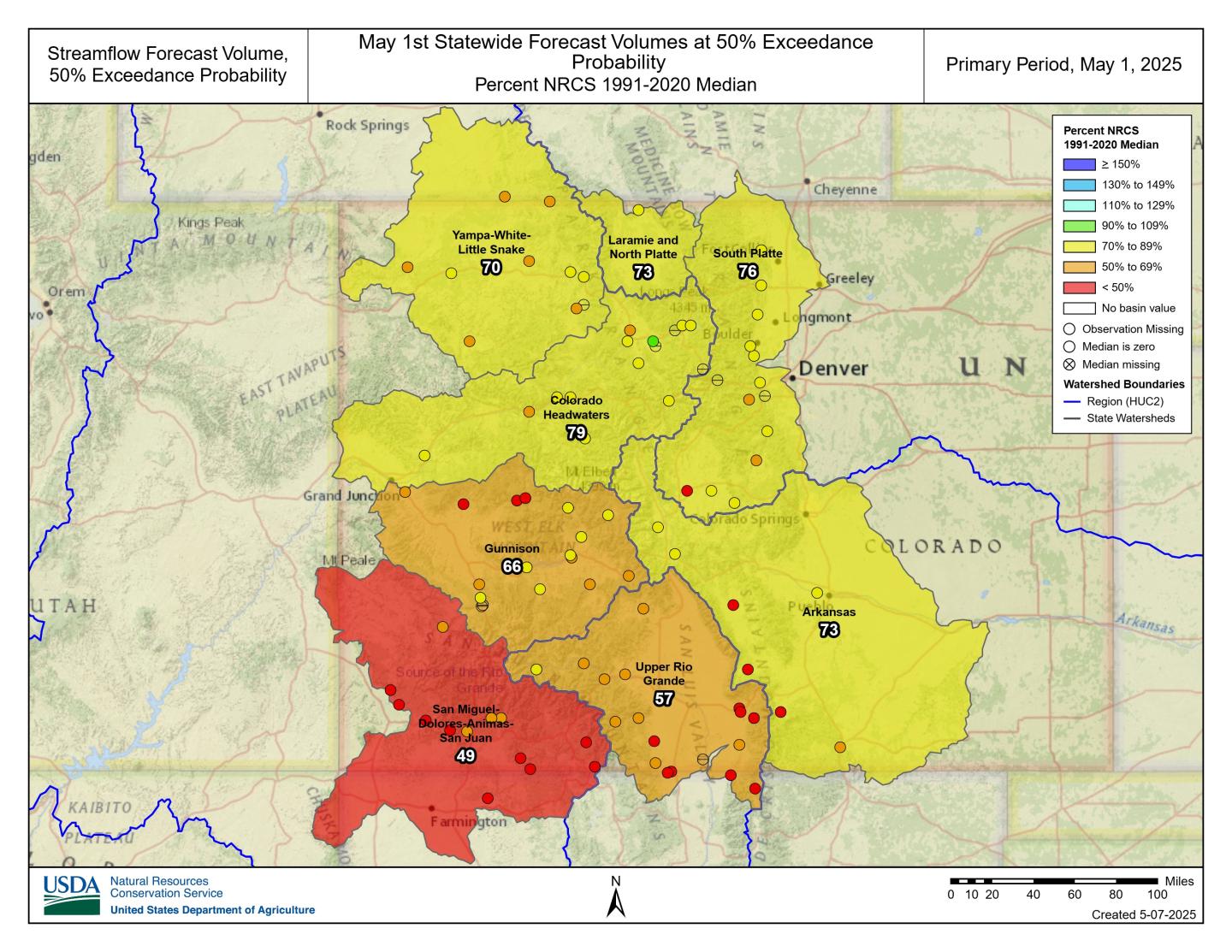
Streamflow forecasts continue to reflect widespread degradation heading into the remaining runoff period. The exception is a handful of points remaining closer to normal that are clustered northwest of the divide in the Colorado Headwaters. The lack of April moisture and precipitation deficits from primary accumulation months compounded by an early and accelerated snowmelt, particularly in southern basins, limits streamflow potential through the remainder of the forecast season based on conditions leading into the May 1 forecast. 

As of early May, 24% of Colorado SNOTEL sites have reached melt out primarily in the southern basins. These sites melted out an average of 16 days earlier, with the median statewide melt out date on May 24th. “Lower snowpack volumes and increased temperatures drive early melt, which translates into earlier and likely lower peak streamflow. The potential result is a compressed runoff window and in many cases a muted response in flows,” notes Bell. Soil moisture data further supports these trends, with snowmelt signals registered throughout soil stacks across most basins. 

Statewide, the 50% exceedance forecasts are at 71% of median with 86 forecast points averaging in the 19th percentile. Basins in the Upper Colorado Region that make up the Colorado western slope are at 72% of median forecasts. All 50% probabilities show a negative departure from median volumes with lowest outlooks in the southwest region ranging from 49% in the SMDASJ, 57% in the URG and 66% in the Gunnison. Streamflow’s in the Arkansas are at 73% of median with higher output points ranging from 71% of median at Pueblo Reservoir inflow to 85% of median at the Arkansas River at Salida. These suppressed forecasts reflect the combined effects of limited April precipitation, early and accelerated snowmelt, and low antecedent water year precipitation.

As the season progresses and fewer forecasts updates remain the range of forecasted outcomes narrows and uncertainty decreases as late season inputs come in. In general, most exceedance values remain low and can be compared for the entire forecast season at each point using the evolution forecast plots. In years like this the drier forecast range, including the 90% exceedance, can be especially informative. If dry conditions persist, these lower projections may prove most reflective of what materializes. It’s essential to consider the full range of forecast probabilities, not just the median, when planning around potential runoff outcomes.

* San Miguel-Dolores-Animas-San Juan River basin*

*For more detailed information about January mountain snowpack refer to the May 1st, 2025 Colorado Water Supply Outlook Report. For the most up to date information about Colorado snowpack and water supply related information, refer to the Colorado Snow Survey website

Designer of #Colorado’s Gross Dam expansion warns of possible flooding if judge halts project — Jerd Smith (Fresh Water News) #ColoradoRiver #SouthPlatteRiver

Denver Water is helping ensure its future water security with the Gross Reservoir Expansion Project. When the project is complete, it will nearly triple the Boulder County reservoir’s capacity to 119,000 acre-feet. CREDIT: HEATHER SACKETT/ASPEN JOURNALISM

Click the link to read the article on the Water Education Colorado website (Jerd Smith):

May 8, 2025

Adam engineer who designed a major expansion of Gross Reservoir Dam in Boulder County told a federal judge Tuesday that the raising of the dam, facing a potential halt due to an April federal court ruling, needs to proceed to protect public safety.

Mike Rogers, the civil engineer who designed the $531 million expansion of the dam,  said bad weather could create flood conditions that would lead to a catastrophic failure similar to what occurred with the Oroville Dam failure in California in 2017.

But Stephen Rigbey, a Canadian dam safety expert testifying for Save The Colorado, said any issues with putting the construction project on hold, even in its partially-complete state, could be addressed, and that the risk of a catastrophic failure was “negligible.”

Workers from Denver Water and contractor Kiewit Barnard stand in front of Gross Dam in May 2024 to mark the start of the dam raise process. Photo credit: Denver Water.

Rogers’ and Rigbey’s testimony Tuesday came during a federal hearing in Denver, after which U.S. District Court Judge Christine Arguello will determine whether to allow construction to move forward on the Denver Water project or whether the construction will be paused until new federal reviews she has ordered are completed and legal questions are answered.

But at the end of Tuesday’s hearing, Arguello said the parties to the case had not provided enough information for her to make a decision and ordered them to submit more data later this month.

The massive construction project has raised fierce opposition in Boulder County and prompted several legal challenges from Save The Colorado, a group that advocates on behalf of rivers. Though its early lawsuits failed, in 2022 the river defenders won an appeal that put the legal battle back in play. Despite months of settlement talks, no agreement was reached.

Denver Water’s entire collection system. Image credit: Denver Water.

Boulder County Commissioner Ashley Stolzmann was unmoved by Rogers’ testimony, saying she hopes the judge halts the work to prevent further environmental damage in Boulder County and to protect the Fraser River, a tributary to the Upper Colorado River. The Fraser has served as the source of water for Gross Reservoir since the 1950s, when it was built.

“It’s incredibly disappointing that Denver has chosen to move forward,” Stolzmann said. “With climate change, it really is a time for different entities to work together to repair the climate. I want to see Denver seek alternative solutions.”

Denver Water first moved to raise Gross Dam more than 20 years ago when the water provider began designing the expansion and seeking the necessary federal and state permits. Denver Water has said raising the dam and expanding the reservoir is necessary to ensure it has enough water throughout its delivery system and to help with future water supplies as climate change continues to reduce streamflows.

The Gross Reservoir Expansion Project involves raising the height of the existing dam by 131 feet. The dam will be built out and will have “steps” made of roller-compacted concrete to reach the new height. Image credit: Denver Water

After years of engineering, environmental studies and federal and state analyses, Denver received a permit from the U.S. Army Corps of Engineers and construction began in 2022. It has involved taking apart a portion of the original dam and raising its height by 131 feet to nearly triple the reservoir’s storage capacity to 119,000 acre-feet from 42,000 acre-feet.

The case took center stage again April 3, when Judge Arguello put a temporary halt to construction of the higher dam, at Save The Colorado’s request.

In that high-profile ruling, Arguello said, in part, that the Army Corps should have considered whether ongoing climate change and drought would leave the Colorado River and Western Slope waterways too depleted to safely allow transfer of Denver Water’s rights into a larger Gross Reservoir for Front Range water users.

At the same time, she ordered a permanent injunction prohibiting enlargement of the reservoir, including tree removal and water diversion, and impacts to wildlife.

Almost immediately, Denver Water filed for temporary relief from the order, saying, in part, that it would be unsafe to stop work as the incomplete concrete walls towered above Gross Reservoir.

Arguello granted that request, too, allowing Denver to continue work on the dam considered necessary for safety.

Denver Water has also filed an appeal with the U.S. 10th Circuit Court of appeals, seeking to permanently protect its right to continue building the dam. The appeals court is expected to wait for the lower court to rule, before considering Denver Water’s request.

More by Jerd Smith

Udall/Overpeck 4-panel Figure Colorado River temperature/precipitation/natural flows with trend. Lake Mead and Lake Powell storage. Updated through Water Year 2024. Credit: Brad Udall

A dry winter on the #ColoradoRiver has big reservoirs on track for trouble — Alex Hager (KUNC) #COriver #aridification

Skiers descend Arapahoe Basin Ski Area in Colorado on May 4, 2025. Snowpack across the mountains that supply the Colorado River is far below normal for this time of year. Forecasts call for 55% of average runoff into Lake Powell, the nation’s second-largest reservoir. Alex Hager/KUNC

Click the link to read the article on the KUNC website (Alex Hager):

May 8, 2025

This story is part of ongoing coverage of the Colorado River, produced by KUNC and supported by the Walton Family Foundation. KUNC is solely responsible for its editorial coverage.

If you took a look at a map of Rocky Mountain snow right now you would see a lot of red.

The mountains that feed the Colorado River with snowmelt are strikingly dry, with many ranges holding less than 50% of their average snow for this time of year. The low totals could spell trouble for the nation’s largest reservoirs, but those dry conditions don’t seem to be ringing alarm bells for Colorado River policymakers.

Inflows to Lake Powell, the nation’s second largest reservoir, are expected to be 55% of average this year, according to federal data released this week. If forecasts hold true, 2025 would see the third-lowest amount of water added to Lake Powell in the past decade.

Westwide SNOTEL basin-filled map May 8, 2025 via the NRCS.

“It’s looking like a pretty poor water supply and spring runoff season,” said Cody Moser, a hydrologist with the Colorado River Basin Forecast Center.

If Lake Powell drops too low, the reservoir would lose the ability to generate hydropower for about five million people across seven states. Much lower, and it could lose the ability to pass enough water downstream, where tens of millions of people depend on it.

Eric Balken, who watches Lake Powell closely as director of the nonprofit Glen Canyon Institute, said this year’s snow data is concerning, but it isn’t driving the same level of concern from policymakers and media outlets that emerged in previous dry years.

Balken said that may be happening for two reasons.

First, it’s because negative outcomes might not be felt immediately. Lake Powell is unlikely to drop low enough to lose hydropower capabilities this summer, but the dry spring is making that more likely to happen in 2026.

Second, it’s because water managers simply have bigger fish to fry.

The federal offices that manage Western water are in disarray amid layoffs and restructuring since Donald Trump returned to the White House. The Bureau of Reclamation, the top federal agency for Colorado River dams and reservoirs, is without a permanent commissioner.

All the while, state and federal policymakers are spending most of their time and attention on drawing up new water-sharing rules. The current rules expire in 2026. Talks between states have reached a standstill, and negotiators say they’re working toward a compromise.

“That chaos within the agencies, the broader negotiations happening on the Colorado River, all of these other factors, I think, are sort of drowning out the severity of the drought situation right now,” said Balken.

Glen Canyon Dam creates water storage on the Colorado River in Lake Powell. Low water levels in Lake Powell could jeopardize the dam’s ability to produce hydropower or pass water downstream. Credit: U.S. Bureau of Reclamation

This year got off to a strong start for mountain snow, but took a dip during a dry spell that lasted from December through February. Snowmelt from Colorado accounts for about two-thirds of the water in Lake Powell. A portion of Western Colorado saw less than 15% of normal precipitation from December through April.

Scientists say these low snow years are the result of climate change, which is causing less snow to fall, and more of it to be soaked up by dry, thirsty soil before it has a chance to reach rivers and reservoirs. That has left the Colorado River in a dry trend going back more than two decades.

Balken said the climate reality is here to stay, and should spur the region’s leaders to rein in demand accordingly.

“Just because we’ve gotten used to it doesn’t mean that it’s not a problem,” he said. “We have to stay laser focused on what’s happening on the Colorado River, because there are some very big problems that need to be addressed.”

The snow in #Colorado’s mountains melted too fast. It could mean worse wildfires this year — Colorado Public Radio #snowpack #runoff

Click the link to read the article on the Colorado Public Radio website (Ishan Thakore). Here’s an excerpt:

May 6, 2025

Layers of snowpack melted rapidly in Colorado in April, which could lead to less water supply in the summer and higher wildfire potential, according to data from the National Integrated Drought Information System.  The federal data, released on May 1, indicate that “substantial and rapid” snowmelt occurred throughout broad swaths of Colorado between April 10-17. Several weather stations maintained by the U.S. Department of Agriculture logged record snowmelt during that week, compared to the same period in prior years. Snow disappeared up to 4 weeks early in parts of Colorado compared to previous years, federal data show…How quickly snow melts, and when it happens, can impact water availability during hot summer months and affect how likely wildfires are to occur in a region. An area that’s seen rapid snowmelt in early spring could have dried-out vegetation by summer, a potential fuel for blazes…

Westwide SNOTEL basin-filled map May 8, 2025 via the NRCS.

Spring heat waves in early April rapidly melted snow across Colorado’s Rocky Mountains, leading to large drops in the state’s median “snow water equivalent,” compared to past levels. Snow water equivalent (SWE) measures how much liquid water is stored in the snow, which will eventually melt and flow into the soil and bodies of water…

The federal data also show that water supply forecasts for the Upper Colorado River Basin – an area that stretches four states including Colorado – declined compared to rosier projections from early April.