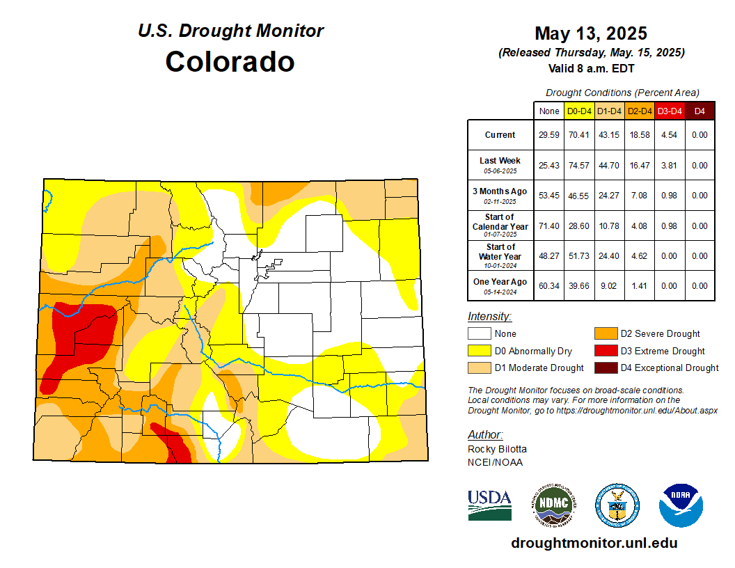
Grand County is home to numerous lakes, reservoirs and rivers. Currently, the county is sitting better than other areas in Colorado in terms of drought. But as a dry, hot summer is forecast, the Grand County Drought Preparedness Committee declared a drought watch. This is the lowest level of the four drought stages. According to the committee, the county has experienced its two driest decades in history. The drought committee includes stakeholders across the county who look at environmental indicators to determine droughts levels and give recommendations for water conservation…In a news release, the committee states the drought watch is spurred by significant snowmelt that’s occurred since early April. The Upper Colorado River Basin’s snowpack levels were at 67% of median on May 8, the release states…
Foulk said that the preparedness committee will reconvene on May 27 to review the county’s drought indicators. Based on precipitation levels and other factors, the county could move up to Stage 1 drought warning, or go back down from the current drought watch. For each drought stage, the preparedness committee recommends specific water reduction actions. Regardless of the current level of drought, residents are encouraged to conserve water as normal practice. Small steps in community members’ homes and yards can have big impact on the waters that flow through Grand County.
Click the link to read the article on the Summit Daily website. Here’s an excerpt:
May 15, 2025
The Colorado River District will hold one of its 11 “State of the River” events in Silverthorne on Thursday, May 22. The event, held in partnership with the Blue River Watershed Group, will be held at the Silverthorne Pavilion from 6 p.m. to 8 p.m., according to the Colorado River District’s website…
Presentations will cover topics including current river conditions and seasonal forecasts, updates on the Colorado River system, local water projects affecting the Blue River in Summit County, updates on the Shoshone River water rights efforts, conservation efforts in the region and updates on recent legislative efforts. Registration is required. To register for the “State of the River” event visit ColoradoRiverDistrict.org/state-of-the-river-meetings-2025
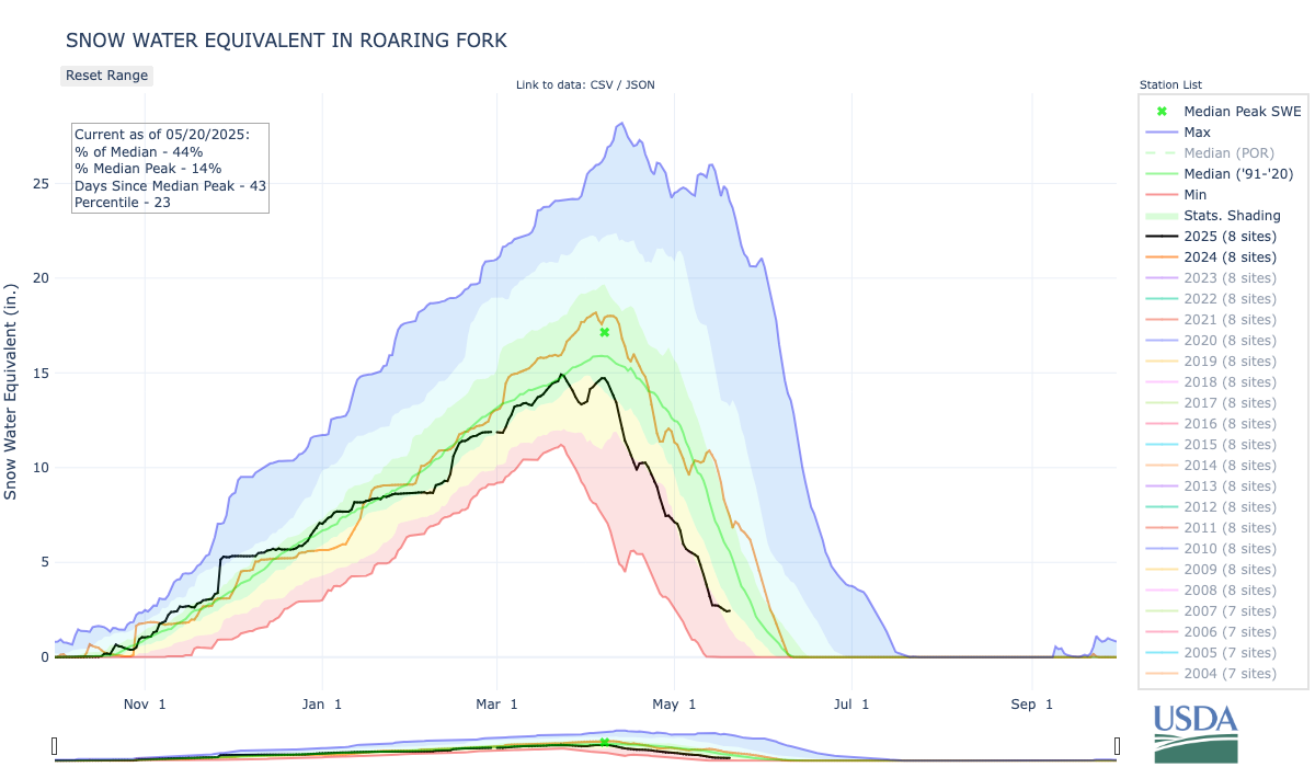
The central mountains of Colorado, including Aspen, are currently experiencing a snowpack that is only 42% of the seasonal average, a dramatic shortfall that is already producing consequences for river flows, drought conditions, and fire risk across the region. Meteorologist Kris Sanders with the National Weather Service in Grand Junction confirmed the snowpack is not only low, but melting rapidly.
“We peaked at pretty close to normal — around 80% — but normally we see the snowpack last a little longer,” he said. “It has been melting quicker.”
The zero snow water equivalent, a measurement of the amount of water contained in snowpack, is projected by the end of May, Sanders said. In other words, there soon won’t be any water content left in the central mountains’ snowpack…Sanders noted that recent precipitation will offer only short-term relief. He said the Roaring Fork Valley received up to less than one inch of rain, and four to eight inches of snow in the higher elevations, with close to a foot at the highest…He added that the central mountains are forecasted to remain abnormally dry, with moderate drought conditions likely persisting through the summer…[Matthew Anderson]pointed to current Roaring Fork River flows at Glenwood Springs, which are around 900 cubic feet per second (cfs) due to recent cold. The Colorado Basin River Forecast Center expects peak flows to reach 2,000 cfs within 10 days, a steep drop from the usual 6,000 cfs typically seen in early June.
The debate over selling off public land has become more serious, and consequential, than ever. While the urge to transfer public land out of the American public’s hands has flared up many times over the last century or so, never has the concept gained so much support among establishment politicians and pundits. Neither James Watt, the notoriously anti-conservationist Interior Secretary under Ronald Reagan, nor the fossil fuel-loving officials of the George W. Bush administration, nor even Trump I’s Interior Secretary, Ryan Zinke, called for wholesale public land transfers.
And yet, now we have not only Interior Secretary Doug Burgum advocating for selling land to states and real estate developers, but also members of Congress and even prominent newspaper columnists and editorial boards doing so. As this extremist threat becomes more real, public land lovers understandably react in extreme ways — including condemning every public land transfer, no matter how small.
I used to bristle at the mention of public land swaps, until the late Paul Beaber, a long-time US Forest Service surveyor, set me straight. He pointed out that not only does the current law allow federal land agencies to “dispose” of some parcels, but that in some cases exchanges and even sales can make sense and be beneficial to public land users. (And just to be clear, the current proposals by Republicans in Congress and the Trump administration do not make sense and will not benefit public land users).
The point was raised by Land Desk reader James Aldrich in response to last week’s piece on the public land sale amendment in Congress’ budget reconciliation bill. He wrote:
I have to take issue with James’ last sentence here: Saying that public land should be sold because it belongs to all of us is a logical fallacy, since once it is sold it will only belong to one of us! So that’s not the best justification for selling the land. However, he brings up some other good points.
First, there are hundreds if not thousands of this sort of parcel scattered around the West, these little squares of BLM islands in a sea of private land. The BLM is usually eager to get rid of those parcels, because they not only create a management headache, but also end up serving as something like exclusive parks for the private owner(s) that surround it. They are technically public, but practically private, since the public can’t access them without trespassing on private land.
And, as Luke Schafer put it in a response to Aldrich, the BLM does have a mechanism for “disposing” of those parcels.
I’ll get more into how that is typically done in a moment. But first, a bit of history to see how we ended up with these isolated squares of public land.
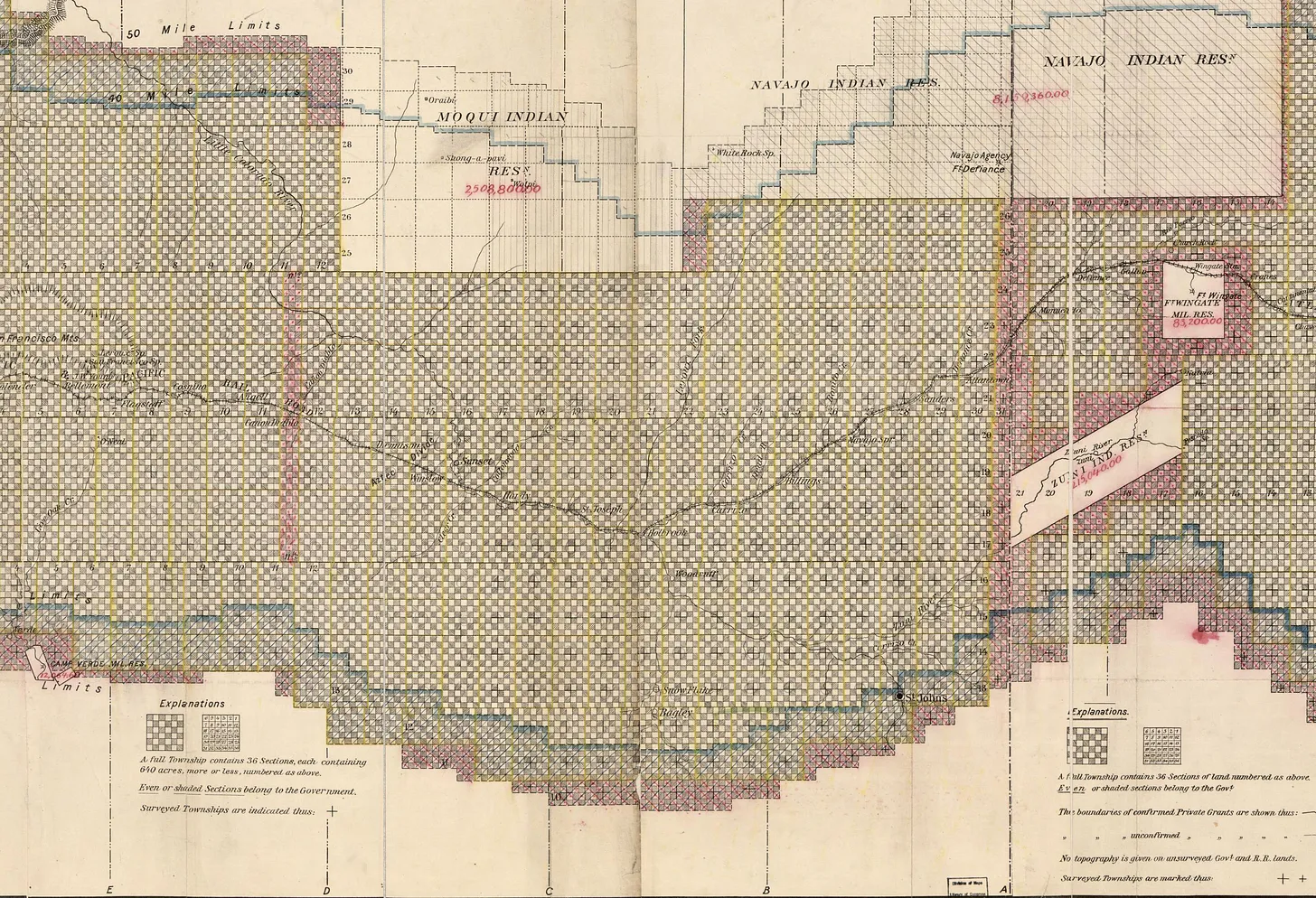
In 1785, the U.S. Congress of the Confederation passed the Land Ordinance, which in turn created the Public Land Survey System to be applied to the public domain west of the Appalachians (which, at the time, didn’t extend very far). The land was cordoned off into thirty-six-square-mile rectangular townships, which were then sliced into 640-acre sections — a big grid made up of thousands of squares — with zero consideration for topography, watersheds, cultural boundaries, eco-zones, or habitat.
This grid that overlays America is artifice, something seen only on maps, based on nothing real. Yet it has profoundly influenced the way Americans relate to the landscape and to one another, and is manifested physically on the American landscape in its state and county lines, its streets and avenues, its county roads and property lines, and in GPS coordinates. “The grid, not the eagle or the Stars and Stripes,” wrote John Brinckerhoff Jackson in his seminal A Sense of Place, A Sense of Time, “is our national symbol. It is imprinted in every child before birth.”
As the U.S. government continued to expand its empire westward, usually by stealing land from the Indigenous inhabitants, it added the land to the public domain and imposed the grid onto the landscape to create a system that allowed the government to dispose of — i.e. sell or give away — public land to settlers, would-be farmers, railroads, and miners in an orderly fashion.
[⚠️ Suspicious Content] The 1862 Homestead Act was created with subsistence farming in mind and allowed a prospective farmer to stake out a 40- to 640-acre claim on the public domain1. But the claim’s boundaries weren’t determined by the topography or richness of the soil, but rather by the PLSS; every homestead was a perfect square that the claimant could work for five years, and then patent it, or take title to the land. The government also gave railways every other square-mile of land in rail corridors to incentivize the rail corporations and to draw more homesteaders, and it allowed mining claimants to patent their claims too.
Every square of the public domain that was not homesteaded, given to the railway, staked with a mining claim and patented, or put into a forest reserve or park remained in the public domain. And land that was homesteaded or otherwise claimed, but not patented, also reverted back to the public domain. The result are numerous, chaotic land-ownership called “checkerboards” due to the square shape of each parcel, or geometrically-correct, jurisdictionally nightmarish hodgepodges of federal, tribal, state, private, and Indian allotment land.
Congress passed the Federal Land Policy Management Act, or FLPMA, in 1976, which ended the mass disposal of public lands. The Homestead Act was repealed, mining claims can still be staked (very easily), but there is a moratorium on new patents, and no one is giving public land to railroads any more — although some folks sure would like to give it to real estate developers. Still, the BLM does leave the door open for some land transfers, mainly to address islands of public land within a sea of private holdings. The BLM’s website describes the process like this:
The agency also works to clean up the checkerboard via land swaps, in which an isolated federal parcel is exchanged for a private one surrounded by public land. While these can be win-win situations, they can also look a bit like blackmail or a hostage situation. In the 1990s and early 2000s, for example, a real estate developer named Tom Chapman made a habit of acquiring private inholdings — often in wilderness areas — and threatening to develop them if the BLM or Forest Service didn’t exchange the inholdings for much more valuable parcels in or near ski resorts and so forth. The agencies usually had little choice but to comply.
But in many cases, the swaps can be beneficial. In the San Juan Mountains, for example, huge mining companies like ASARCO ended up with big blocks of mining claims in the high country, surrounded by public lands. The companies could sell the claims to private individuals, who could then potentially build on them, creating a nightmare for county land-use planners. Or they could turn them over to the feds in exchange for isolated but more developable public parcels elsewhere, allowing the BLM or Forest Service to consolidate its alpine holdings, while also disposing of private-land-locked parcels elsewhere.
Don’t get the wrong idea: The BLM can’t just sell or swap chunks of land at their whim. To sell parcels like those James referred to, the BLM first would have to identify them as “disposable,” if you will, during the Resource Management Planning process for that particular field office. That is a long process that includes extensive environmental reviews and ample opportunity for public input. Large exchanges, meanwhile, are subject to their own environmental analyses and public comment.
By contrast, the ideologues in Congress now pushing for public land transfers are looking to sell off or give away about a half-million acres. A small portion of the parcels could be considered “scattered, isolated tracts” that are hard to manage. But others are quite large and, if transferred, would create private inholdings surrounded by public land. This would not only take valuable public land out of the public’s hands, but also would further complicate management.
So, yes, there are cases in which selling or swapping public land isn’t the end of the world. But the fact is, there are fewer and fewer instances in which that is the case. And selling or swapping public land without public involvement? That’s always wrong.
📸 Parting Shot 🎞️
Barrel cactus blooming in southeastern Utah. Jonathan P. Thompson photo.
1 The Homestead Act allowed for claims of up to 160 acres, which was deemed insufficient for arid lands in the West, so in 1877 the Desert Land Act allowed for claims up to 640 acres, and in 1909 the Enlarged Homestead Act made provisions for 320-acre claims.