Click the link to read the article on the Aspen Journalism website (Heather Sackett):
May 15, 2025
The source of water — and whether there’s enough to go around — is at the heart of concerns about a proposed agritourism development for some local residents and Garfield County officials.
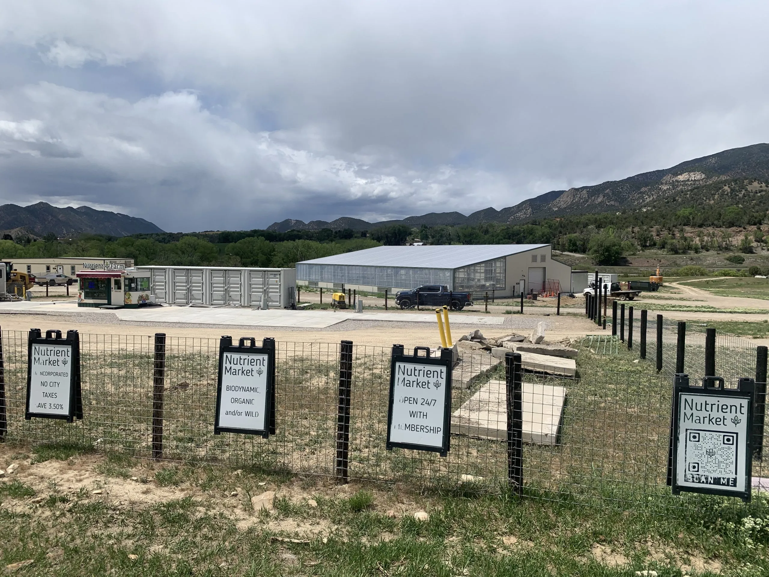
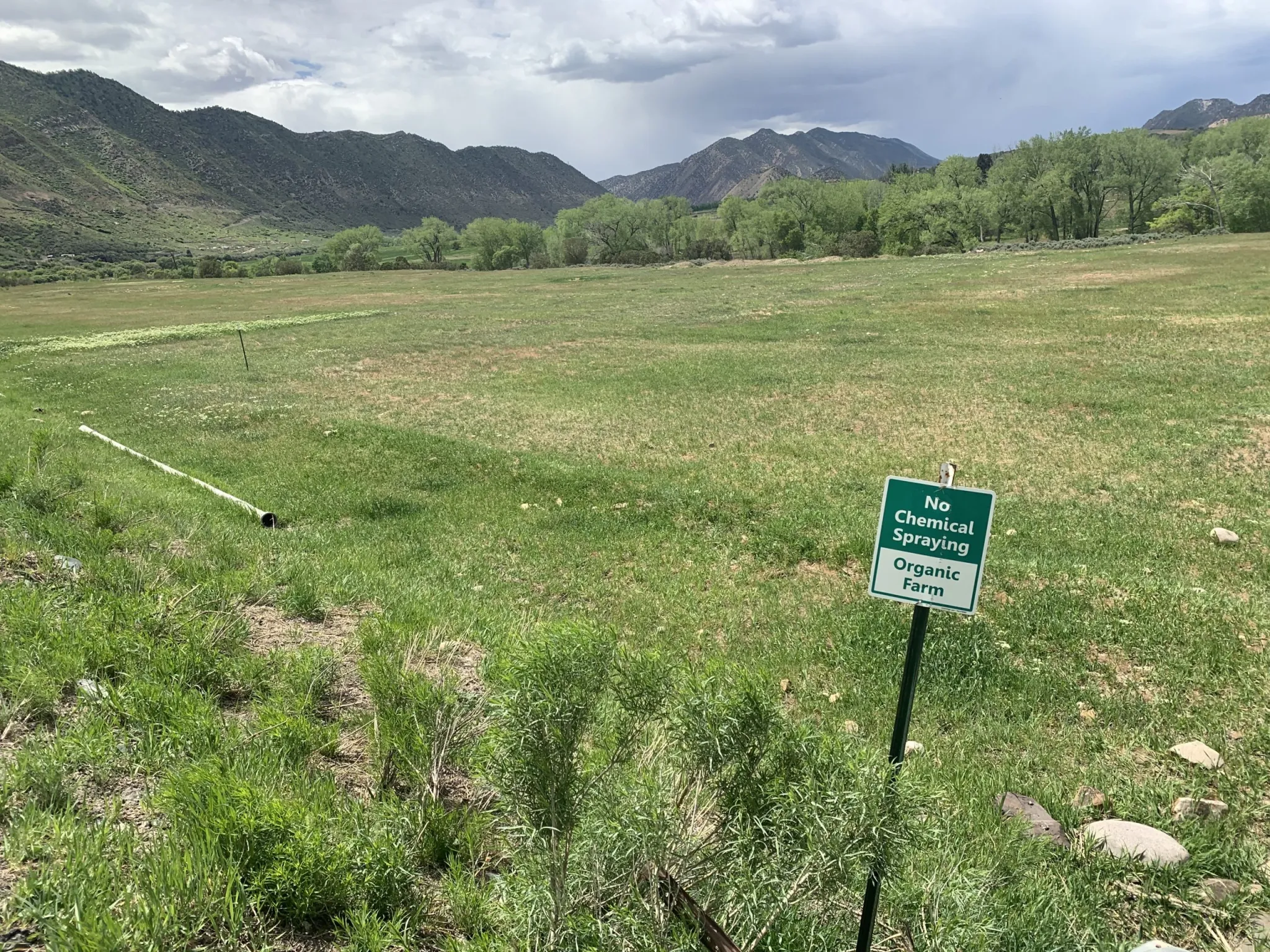
Nutrient Farm, an organic farm and ranch on the south side of the Colorado River between Glenwood Springs and New Castle, is seeking approval from Garfield County for a new planned unit development (PUD), which would include a restaurant, housing, lodging facilities, a music/entertainment area, campground, a health and wellness retreat, and other industrial and agricultural tourism-related operations on its 1,140 acres. Nutrient Farm would need water for its planned expansion of outdoor agricultural production including a “u-pick” orchard, nursery trees, pasture grass, hay, corn, vegetables, lawns and landscaping.

Nutrient Farm is proposing that the main water supply would come from Canyon Creek, a tributary on the north side of the Colorado River. It would be taken out of the creek 1.5 miles upstream from its confluence with the Colorado River and conveyed across the river and Interstate 70 via the Vulcan Ditch.
According to Colorado Division of Water Resources records, the Nutrient Farm property has not used water from Canyon Creek or the Vulcan Ditch in more than two decades.
Water supply studies found that there may not be enough water in Canyon Creek for the Vulcan Ditch to take the full amount to which it is entitled during the late irrigation season in dry years, raising questions about the adequacy of the Canyon Creek water supply and the project’s impacts on the creek.
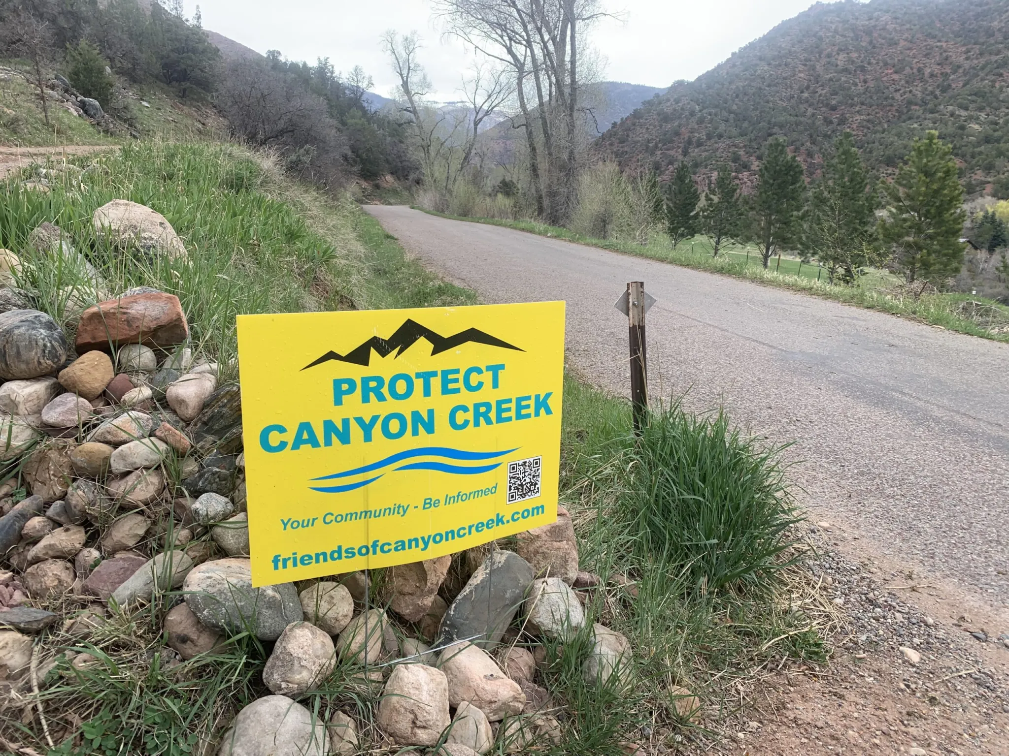
Concerned residents who live on Canyon Creek have formed Friends of Canyon Creek, a group dedicated to maintaining the ecological health of the stream. Six nearby property owners have hired a lawyer to oppose three water court cases related to Nutrient Farm’s water rights.
Sonia Linman lives along the creek and is an outspoken member of Friends of Canyon Creek. She is one of several residents who own property on the creek and don’t want to see the Vulcan Ditch reopened. Linman and others say the draw on the creek that Nutrient Farm is proposing could devastate wetlands, would harm the ecological values of properties that are protected by conservation easements between some landowners and the Aspen Valley Land Trust, and put the wildfire-prone valley at risk if the source of water to fight the frequent blazes is diminished.
“For me, I’d be losing a family member,” Linman said of the creek. “For most of us who believe nature is in an especially tenuous place right now, it would be reflective of a death of hope. We must do what’s right to protect something that is clearly, legally, morally, ethically deserving of that protection.”
Nutrient Farm’s proposal has been contentious, with the overwhelming majority of public comment and letters expressing concern about the project. Many took issue with impacts that the water use could have on Canyon Creek. After being continued twice — in January and March — the PUD application is scheduled to be revisited by the Garfield County Planning Commission on May 28.
AVLT has 12 conservation easements across eight properties in Canyon Creek, with the common goal to preserve and protect the ecological health of the creek and its habitat.
“Not only would [proposed water diversions] have a devastating impact on the ecology of Canyon Creek itself, it would also have extreme, irreversible and likely impermissible
impacts to the conservation values protected by AVLT’s conservation easements,” the letter reads.
But under Colorado water law, drawing a creek down to a trickle is not illegal, as long as the water is being put to beneficial use. And the state has no problem with someone using their water right — especially one that dates to before the 1922 Colorado River Compact — to the fullest extent possible.
Under Colorado’s arcane, century-old system of management, water usually belongs not to those who need it most, nor to the stream itself, but to the legacies of the European American settlers who got there first. Water is treated as both a natural resource that belongs to the public and a potentially valuable private property right. For some observers, Nutrient Farm’s plan highlights the system’s inherent imbalance and demonstrates how few options there are for protecting the health of streams in a warming and drying climate.

Canyon Creek water supply
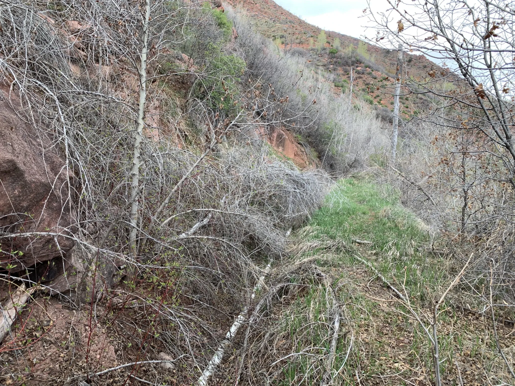
The Vulcan Ditch snakes across the hillside on the west side of Canyon Creek, roughly parallel to County Road 137. It is filled with downed trees, boulders, marmot holes, and an overgrown tangle of bushes and weeds. Nutrient Farm plans to reconstruct and realign the ditch, and install a 24-inch pipe, work that would require at least a 15-foot-wide — in some places, a 30-feet-wide — construction corridor, according to its PUD application. Water would have to be conveyed south across I-70 and the Colorado River to get to the Nutrient Farm property.
Dave Temple is the only other current water user on the ditch, which he maintains just enough in certain places to get his .13 cubic feet per second of water through a narrow, plastic pipe running along the bottom of the ditch to his property, located north of I-70 and the river. He walks parts of the Vulcan Ditch every other day during irrigation season.
“The ditch is a disaster,” Temple said. “I’ve always done it by myself, and it’s always taken me at least two weeks to get everything cleaned up enough to where I could turn the water in. … It’s in bad shape and even though [Nutrient Farm is] going to put it in pipes, it’s still going to devastate the whole hillside here.”
Nutrient Farm holds two water rights on Canyon Creek: a larger right, from 1908, and a smaller right, from 1952. According to a water supply adequacy report from Glenwood Springs-based engineering firm SGM, in dry years in the late irrigation season (August through October), the available streamflow may be limited to the senior 1908 water right.
A revised version of the SGM report, from this past March, clarified that although Nutrient Farm has the legal right to divert its full Vulcan Ditch right of 8.93 cfs, it will not — and cannot — divert continuously, year-round. The amount of water allowed to be used by crops (known as consumptive use) is capped at 393 acre-feet per year, which limits how much can be taken from the stream. At its maximum diversion rate of 8.93 cfs, Nutrient Farm would be able to divert only 34 days a year.
The report says the legal and physical water supply from Canyon Creek is sufficient.
“Whether diverting at higher rate for fewer hours, or diverting at a lower continuous rate, the proposed diversions are limited and are well within the supply available from Canyon Creek even in a dry year,” the report reads.
At the request of Canyon Creek property owners, Wright Water Engineers reviewed the original report from 2020 and submitted a memo to Garfield County. The Wright engineers agreed that there would be limited water available in Canyon Creek at the Vulcan Ditch headgate during the late irrigation season of dry years. Further, they concluded when using 1977, the driest year on record in the Colorado River Basin, as a benchmark, that the streamflow available at the Vulcan Ditch headgate would be below the property’s average demand at that time.
“Therefore, the Canyon Creek physical and legal supply is not sufficient to provide for Nutrient Farm’s demands during the late irrigation season in dry years,” the memo reads.
During late summer and early fall is when many streams in Colorado experience dry-ups as natural seasonal streamflows dwindle but irrigation continues. Many streams in Colorado are overappropriated, meaning there are more water rights on paper than there is water in rivers, depending on the season, and it’s not uncommon for irrigators to experience shortages during these times.
Nutrient Farm is owned by Andy Bruno, who bought the property in 2018. He did not answer a list of specific questions sent by Aspen Journalism, but he provided a statement about the project’s intended use of Canyon Creek.
“There is a long-standing adjudicated right for the entire Nutrient Farm water supply,” Bruno wrote in an email. “There is more than ample water available in the Canyon Creek to address all needs and Nutrient Farm remains subject to Division of Water Resources oversight. Nutrient Farm owns senior water rights, has a water management plan and will use this resource responsibly.”

Water for fish
In a comment letter to the Garfield County Planning Commission, leaders of the Colorado chapter of Trout Unlimited said that if Nutrient Farm’s water right — in full or in part — was diverted during fall and winter low-flow periods, it could be devastating to spawning fish.
In 2021, Trout Unlimited completed a $250,000 project to upgrade the culvert system that conveys Canyon Creek under I-70 to improve access for spawning fish from the Colorado River. Trout Unlimited representatives said Nutrient Farm should permanently use water from the Colorado River, and that Canyon Creek should be protected from additional diversions.
“TU is primarily concerned about the detrimental impacts of additional diversion from Canyon Creek on brown trout spawning and subsequent egg incubation and fry emergence,” the letter reads. “In a drier, hotter climate, aquatic systems like Canyon Creek should be given special consideration.”
But historically, the health of aquatic ecosystems have been given very little consideration in the laws that govern water use in Colorado. And the section of lower Canyon Creek where the Vulcan Ditch headgate is located lacks one of the only protections available to rivers in Colorado: a minimum instream-flow water right.
These rights are held by the Colorado Water Conservation Board and are designed to preserve the natural environment to a reasonable degree. They date to the 1970s or later, and under the Western water management system of prior appropriation, where the oldest rights get first use of the creek, they aren’t always effective at keeping water in streams because they are so much younger than many big irrigation rights.
An upper reach of Canyon Creek between the confluence with Johnson Creek and the headgate of the Baxter Ditch has a series of minimum instream-flow water rights, but lower Canyon Creek lacks this protection.
Several other ditches besides the Vulcan Ditch take water from Canyon Creek, including the Williams Canal, the Mings-Chenoweth, Wolverton and Johnson ditches.
DWR does not have a problem with a water user taking so much water that it dries up the creek as long as they are not taking more than legally allowed or increasing their overall consumptive use to more than what is allowed in their water court decrees.
“That’s called tough luck,” said Aaron Clay, a retired water attorney, water court referee and expert who teaches community courses about the basics of water law across the Western Slope. “That’s the way the law works and DWR has no control over that. … Unfortunately, the prior appropriation system does not recognize environmental concerns on creeks.”
Vulcan Ditch history
According to Nutrient Farm’s project narrative, “the Vulcan Ditch has historically provided irrigation water to the property from Canyon Creek and will continue to do so.” Nutrient Farm plans to use the Canyon Creek water for potable indoor use, irrigating crops, livestock, landscaping, grass fields, open space and recreational ponds.
But although the Vulcan Ditch may have brought water to what is now the Nutrient Farm property decades ago, state diversion records indicate that hasn’t happened in the past 24 years. The year 2000 was the last year that the ditch took a large quantity of water, about 1,500 acre-feet. Records are spotty for the next decade with either a very small amount of water diverted or no diversions at all, until 2010, when diversions resumed, but at a much lower level than in the 20th century. These numbers reflect the diversions of the only other water user on the ditch: Temple, who uses a small pipe to get water from the headgate to his property downstream.
Under Colorado water law, water rights holders must use the water if they want to keep their legal right to it. If they don’t, the water right could be abandoned. Abandonment is the legal term for one of Colorado’s best-known water adages: Use it or lose it. Abandonment means that the right to use the water is canceled. The principle came about to discourage hoarding of water rights that weren’t being used and to make sure that someone who used water long ago — but then stopped — couldn’t suddenly begin diverting water again and disrupt the flows of a river that more current water users have come to depend on.
“We’re afraid that this kind of precedent is dangerous,” Linman said. “When water has not been used and a ditch has not been maintained, to have the power to reopen a clearly abandoned structure puts residents at risk across the entire West.”
The reason that Nutrient Farm’s water rights on the Vulcan Ditch haven’t been formally abandoned, despite the ditch itself not being used in more than two decades, is because the farm has been taking water from the Colorado River using what’s known as an alternate point of diversion.
But those records are spotty. Diversion records indicate that a small amount of water was taken from the Colorado River to the Nutrient Farm property using a pump in five years between 2006 and 2023. Assistant Division Engineer for Division 5 Caleb Foy said his office must evaluate how to best use its resources in pursuing abandonment cases, which are subject to a determination of the court. For a water right to be abandoned, the water user must intend to abandon it in addition to not having used it in the previous 10 years.
“The water court has typically applied a relatively low standard for users to show they did not intend to abandon their rights,” Foy said in an email. “As such, within Division 5, partial abandonment of rights diverted at structures with a record indicating some water use were generally not a priority… .”
There may be another reason the Vulcan Ditch and associated water rights have not ended up on the state abandonment list: For the past 25 years, the state of Colorado has also given an extra layer of protection to pre-Colorado River Compact water rights. The state engineer’s office has had a policy of keeping them off the abandonment list for the past two cycles.
Data gaps
Garfield County planning staff has also expressed its concerns with Nutrient Farm’s water plan, which they outlined in two recommended conditions of approval. The county land-use code requires that applications for land-use change permits have an adequate, reliable, physical, long-term and legal water supply. To ensure this, the county wants Nutrient Farm to use water from the Colorado River instead of Canyon Creek and to complete an additional water supply plan analysis, which includes an assessment of impacts on stream flows in Canyon Creek.
However, counties typically don’t have jurisdiction over water rights issues in Colorado. Normally, that is the responsibility of departments of state government such as the water courts, DWR and the CWCB.
In a written response to the county, Nutrient Farm attorney Danny Teodoru said both these conditions are far outside the proper scope of zoning review in Colorado.
“Nutrient Farm, and frankly any water owner in the state of Colorado or the American West, can in no way agree to tie their legal use of legally decreed water rights to a discretionary zoning review,” Teodoru wrote. “Such a notion is absolutely untenable and again flies in the face of long-established Colorado law on incredibly valuable water rights.”
He added that Nutrient Farm would participate in a collaborative stream study if other Canyon Creek water rights holders do.
A stream management plan for Canyon Creek would go a long way to fill what Kate Collins, executive director of the Middle Colorado Watershed Council, called an area with a lot of data gaps. Canyon Creek was not included in the 2021 Middle Colorado Integrated Water Management Plan and was left out of the 2024 Wildfire Ready Action Plan. In addition to having no minimum instream flow for the lower portion of the creek, stream gauge data has been spotty over the years, without a long, consistent record.
“We believe finding out more science and data to make good decisions is always a good idea when it comes to the watershed,” Collins said.
Few options for protecting streams
The issue of who can use water on Canyon Creek gets at a central tension of Western water law: Is water a public resource or a private property right? The answer is both. There are other options for leaving water in streams during environmentally critical times of year, including nondiversion agreements or water leasing programs. But there’s no way to force it to happen without the willing participation of water users.
“It has to be a negotiated deal because it’s a property right and the property right says: ‘I have the right to dry up the stream,’” Clay said. “If the dispute is beyond the headgate, it’s no longer a water rights issue — it’s a private property issue. Those disputes are between private property owners, not DWR.”
The Friends of Canyon Creek have few options to protect their local stream. Linman said her group shouldn’t be responsible for funding an assessment of impacts when they want to leave the creek the way it is. Within the limited confines of the system, the water court process — which seeks to minimize harm to other water users — is the best opportunity to have a say in how Nutrient Farm uses water. Three cases related to Nutrient Farm’s water rights are still pending. However, none of the cases directly affects the project’s right to use water from the Vulcan Ditch.
“Our intention is to protect the creek and make sure that a new draw wouldn’t be pulled from an already threatened watershed that is significantly responsible for fire mitigation, ecological stability and community well-being,” Linman said.
Linman, Temple and others are frustrated by what they say is a lack of communication between them and Bruno and his representatives. Temple said he learned of Nutrient Farm’s plan to reopen and pipe the ditch when he talked with an employee of SGM who was surveying the Vulcan Ditch.
“I have not had any communication,” Temple said. “They have never ever come over here to talk to me. They should understand you can’t just be secretive; you have to communicate with your neighbors.”
Residents worry they will soon live next to a diminished stream, harming their quality of life and ability to fight wildfires. They are also concerned that the construction needed to clear the ditch of debris, repair the ditch and pipe the ditch will damage their property. They said they would be more likely to support Nutrient Farm’s development plan if it used water from the Colorado River, a much bigger water source than Canyon Creek and better able to handle the diversion.
According to SGM’s report, Canyon Creek should be the preferred source for Nutrient Farm’s water supply because it’s better quality than the notoriously silty Colorado. Last year, Nutrient Farm filed water court applications to renew water rights from 1983 that would allow the farm to take an additional 2 cfs from the Colorado River and for a 2,000 acre-foot reservoir in which to store this water.
Basalt attorney and JVAM partner Ryan Jarvis represents six property owners who are opposers in the three water court cases that Nutrient Farm filed last year related to its water use.
“Besides a decreed instream-flow water right, I don’t know of any other way, per se, to protect the flows in the creek for environmental concerns,” Jarvis said.
But residents are holding out hope that there is another potential way forward. They say Nutrient Farm could choose to be a good neighbor.
“There is an easy and achievable solution,” Jarvis said. “Take your water from the Colorado River and don’t unnecessarily harm Canyon Creek and its community. My clients are still here and willing to have conversations and find solutions.”