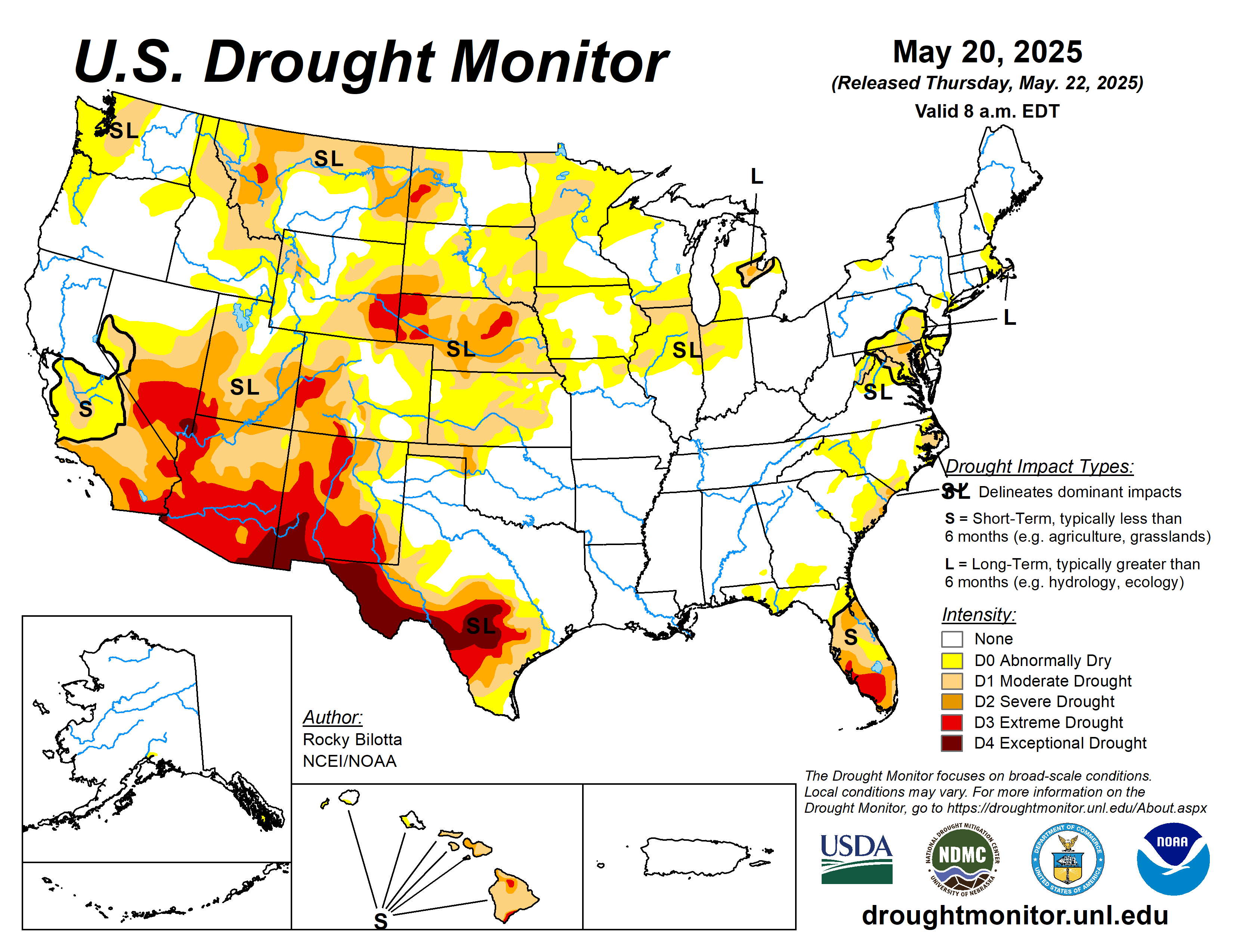
This week, widespread precipitation impacted much of the U.S., with heavier amounts (exceeding 1 inch) observed from the northern Rockies eastward to the East Coast, and in portions of the Pacific Northwest, Hawaii, and southern Alaska. Specifically, much of the High Plains reported 2 to 10 inches of rain, while similar totals (2 to 8 inches) were seen across parts of the South, Midwest, and along the East Coast. This above-normal precipitation supported drought improvements across large portions of the High Plains and Northeast, parts of the Midwest and Southeast, and smaller pockets of the West and South. Conversely, below-normal weekly precipitation occurred in parts of the western U.S., the Midwest, and Southeast, leading to the expansion or intensification of drought and abnormal dryness in western High Plains, eastern West, and parts of the Midwest and Southeast. Temperatures were above normal across much of the U.S. this week. The southern U.S., from Texas to Mississippi, saw temperatures up to 10 degrees F above normal. In contrast, below-normal temperatures, with departures up to 10 degrees F below normal, were observed across much of the West and western High Plains, with the largest departures noted in the Dakotas and interior West…
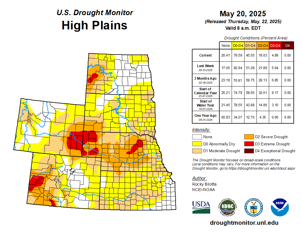
Temperatures varied across the High Plains this week, with departures ranging up to 8 degrees F above normal, while cooler-than-normal temperatures were observed along the western and northern portions of the region. Heavy precipitation fell across much of the region this week, with areas from North Dakota to northern Nebraska reporting weekly precipitation totals between 400% to 600% above normal. These beneficial rains (2 to 8 inches above normal) justified widespread moderate to extreme drought (D1-D3) improvements in the Dakotas and Nebraska. Additionally, improvements of moderate to severe drought (D1-D2) and abnormal dryness (D0) occurred in northern Wyoming and eastern Kansas, where rainfall amounts were up to 3 inches above normal for the week. Conversely, dry conditions resulted in the expansion of extreme drought (D3) in southwest Nebraska and western Wyoming, while severe (D2) and moderate drought (D1) expanded in southern Wyoming and Colorado. Abnormal dryness was also expanded in eastern Colorado this week…
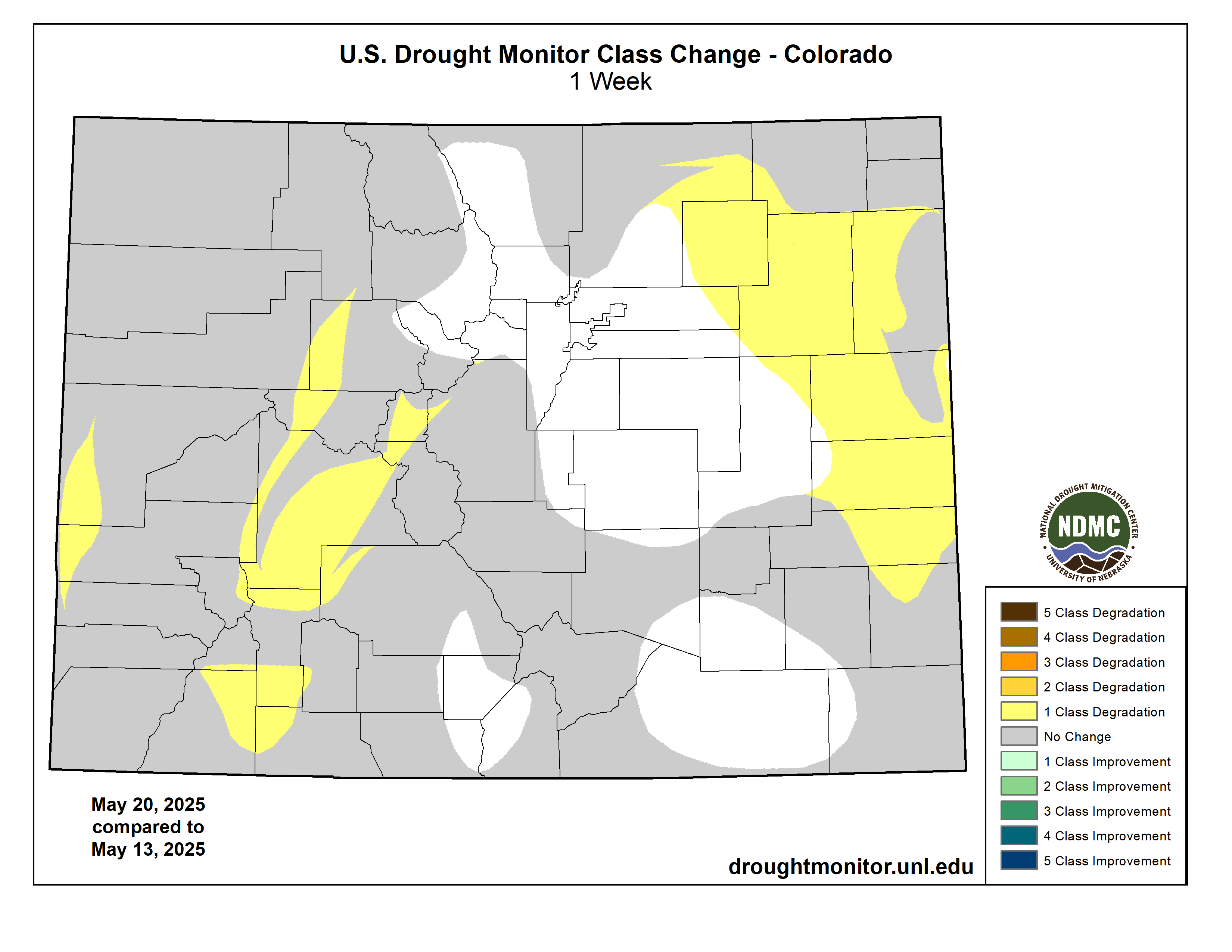
Colorado Drought Monitor one week change map ending May 20, 2025.
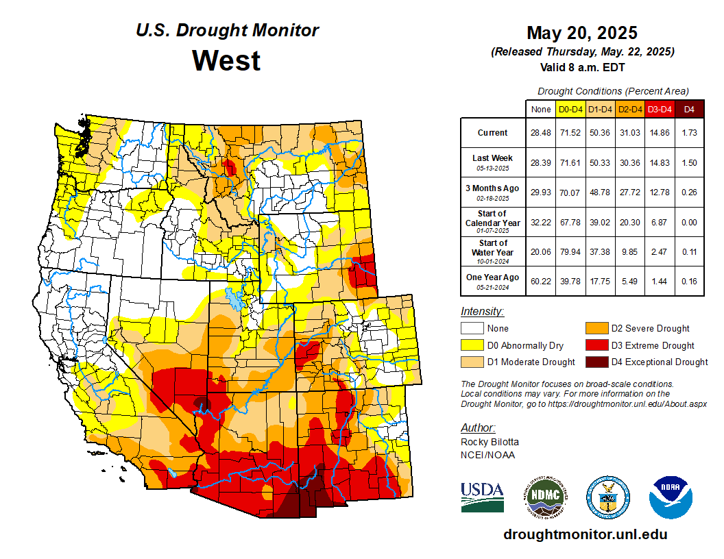
Cooler temperatures dominated the West this week, with departures ranging between 1 to 10 degrees F below normal. Much of the interior West experienced temperatures between 4 to 10 degrees below normal. In contrast, above-normal temperatures were observed across the eastern portions of the Southwest and in parts of Montana, eastern Utah, southern Nevada, and northern California. Precipitation varied across the region this week, with beneficial amounts falling in parts of the Southwest and northeastern Oregon. Moderate to extreme drought (D1-D3) were improved in eastern New Mexico, while moderate to severe drought (D1-D2) were trimmed back in western Utah and abnormal dryness (D0) was improved in Oregon. Conversely, below-normal precipitation resulted in the expansion of exceptional drought (D4) in southwestern New Mexico and moderate drought (D1) in northern Montana this week…
Warmer temperatures dominated the South this week, with departures ranging up to 10 degrees F above normal. However, parts of Texas and Oklahoma observed temperatures near or below normal this week. Precipitation varied across the region this week, with heavier amounts (2 to 8 inches) falling across much of Arkansas, eastern Oklahoma, and in parts of Tennessee, northern Mississippi, and small parts of Texas. Unfortunately, not many improvements were made due to rain falling over areas already free of drought and abnormal dryness, but conditions prevent existing drought from expanding or intensifying. Moderate drought (D1) was removed from eastern Tennessee this week, while abnormal dryness (D0) was removed from Mississippi and improved in eastern Tennessee. Arkansas, Louisiana, and Mississippi are free of drought and abnormal dryness this week…
Looking Ahead
During the next five days (May 20–24, 2025), As the medium range period begins Tuesday, a surface low pressure system over the Mid-Mississippi Valley supported by strong upper-level energy will provide ample lift and instability for rain and thunderstorms in the Mississippi and Ohio Valleys. The low is forecast to track east and spread rain and thunderstorm chances to the Mid-Atlantic in particular on Wednesday, and shifting into the Northeast later week as the low pivots northward. Elsewhere, some weak troughing aloft and frontal systems tracking through the Northwest next week could produce rounds of modest precipitation there. Most precipitation should be rain aside from the highest peaks. Warm to hot temperatures are likely across the southeastern U.S. as the subtropical upper ridge reaches the region. Southern Texas in particular will remain hot into Tuesday, with temperatures well into the 100s. The Florida Peninsula should see warm temperatures in the mid 90s. Both areas could see record or near record warm lows and highs. Meanwhile, a trough will promote below normal temperatures across the northern tier, with highs only reaching the 50s in the north-central Plains on Tuesday. As the trough tracks east, cooler than average temperatures are likely in the eastern third of the U.S. under it, moderating temperatures in the South. But upper ridging poking into the southwestern U.S. will raise temperatures to above normal there, expanding east across the Four Corners states by Thursday and into the southern Plains late next week. Highs will be well into the 100s in the Desert Southwest with temperatures nearing 100 in parts of Texas eventually.
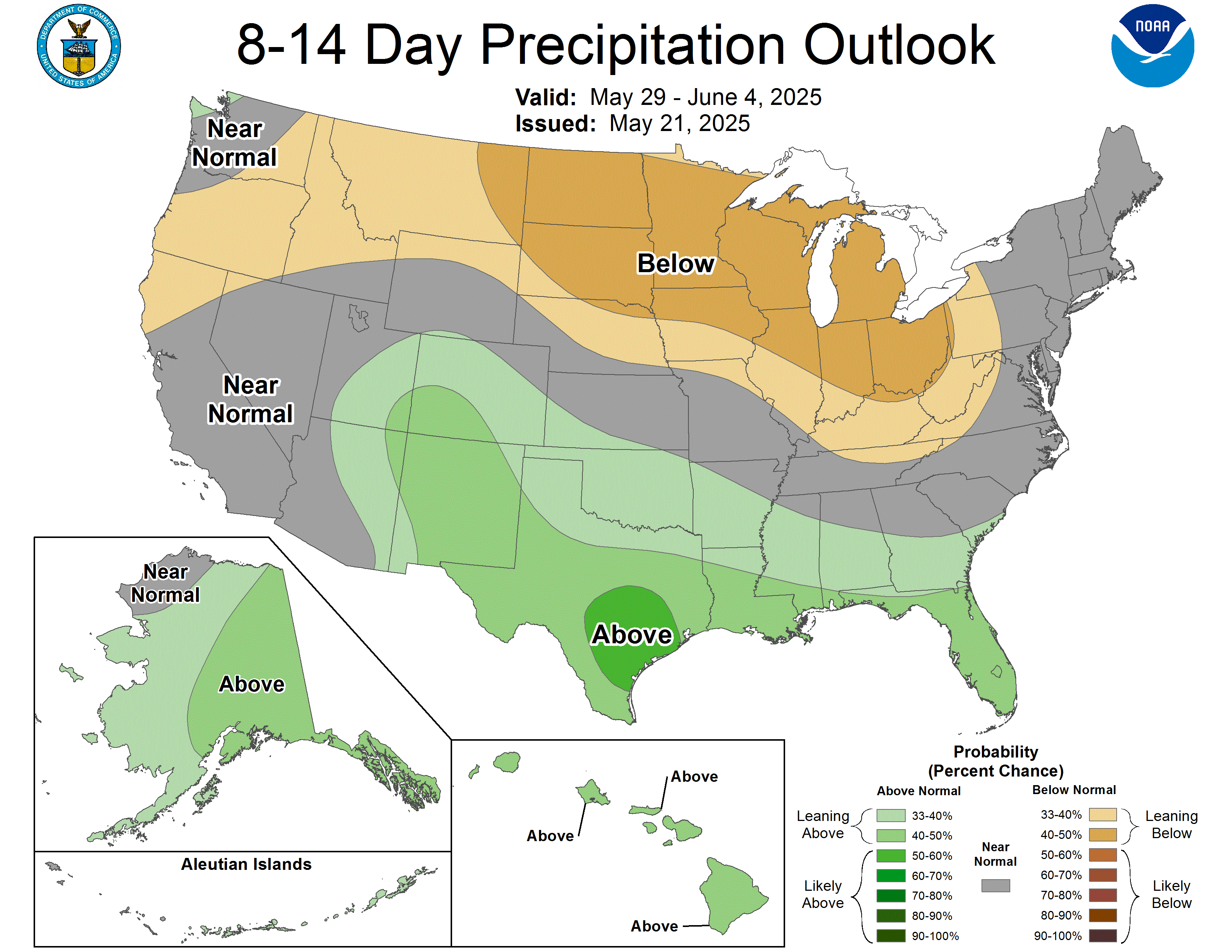
The Climate Prediction Center’s 6-10 day outlook (valid May 25–29, 2025) favors above-normal precipitation across most of the U.S., with near-normal precipitation favored from southern California to Montana, as well as parts of the Midwest, northern New England, and northwest Alaska. Below-normal precipitation favored in portions of the Midwest, from northern Minnesota to northern Michigan. Increased probabilities for above-normal temperatures are forecast for Hawaii, much of the West, and along the Gulf, while below-normal temperatures are favored from the central Plains to the Northeast, and in parts of Alaska.
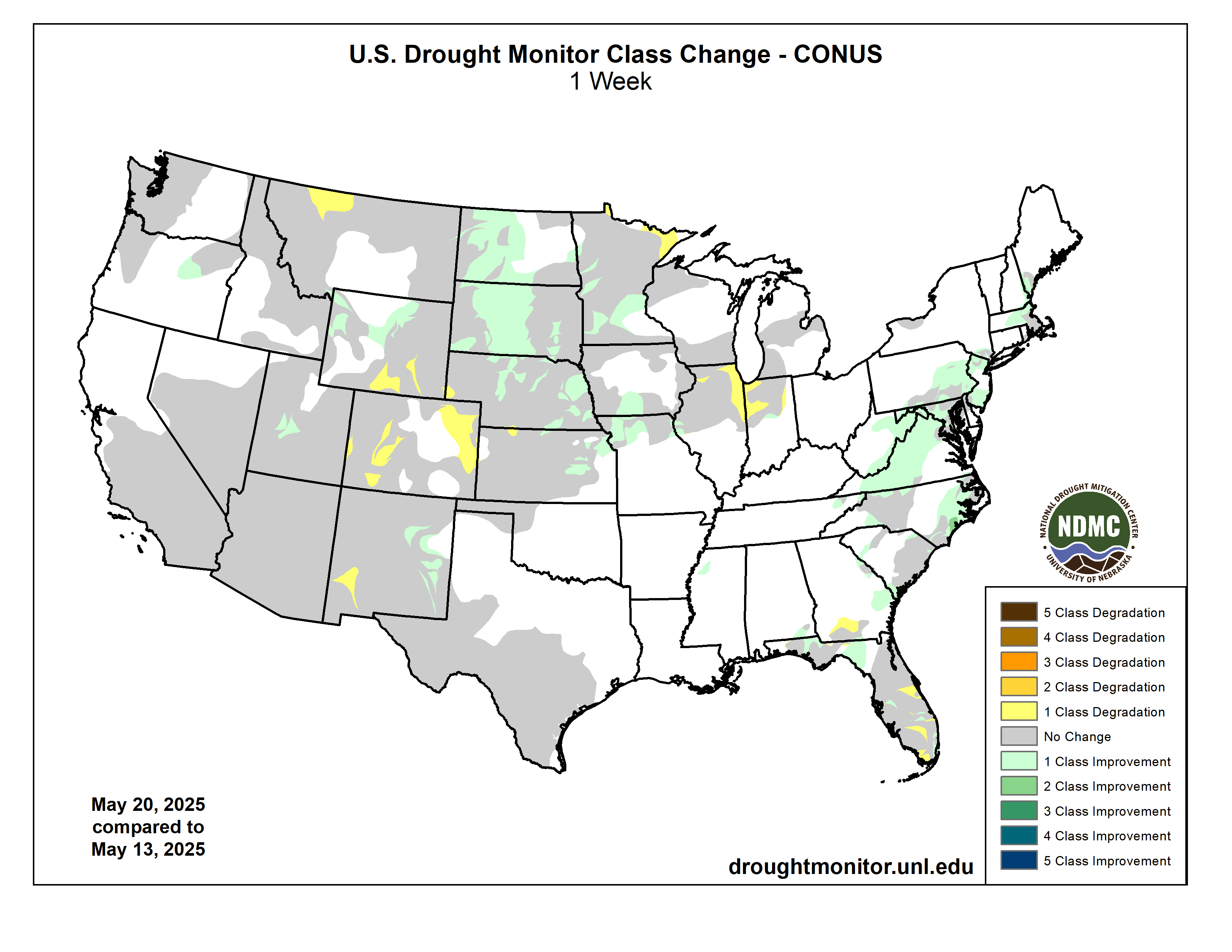
US Drought Monitor one week change map ending May 20, 2025.
Winterized tents house researchers atop the Greenland Ice Sheet at the East Greenland Ice-Core Project. A black geodesic dome and a red mechanic’s garage can be seen in the distance. Photo courtesy of Tyler Jones.
A new study from Chloe Brashear, Tyler Jones and others suggests abrupt warming events were preceded by periods of unusually stable temperatures during the last ice age. The researchers point toward shifting sea ice as a potential driver of the phenomenon.
On July 21, 2019, Chloe Brashear carried another disc of ice through the underground ice cave at the East Greenland Ice-Core project. The cave lay a few meters below the surface of the sprawling Greenland ice sheet, more than 200 miles inland from the coast. Brashear loaded the disc onto a hot aluminum plate and then stepped into the sampling room, where the melt water was pumped through an array of equipment that would filter it, vaporize it and produce a readout of its chemical contents.
Despite the sub-freezing temperatures in the cave, space heaters and an array of whirring instruments kept the sampling room hot. Brashear cast off her parka and got to work.
In most ways, it was a typical day of late-summer field work, but this day was also special. Brashear and her colleagues were analyzing samples extracted from deep within the ice sheet—more than 2,000 meters below the surface. The scientists estimated that the ice was more than 40,000 years old. Later that night, they would celebrate over drinks and grub.
Chloe Brashear poses in the drill trench at the East Greenland Ice-Core Project. Photo courtesy of Chloe Brashear.
New Insights
Five years later, Brashear—now a PhD candidate at Utrecht University in the Netherlands—has teamed up with her former mentor, INSTAAR fellow Tyler Jones, and others to publish new insights from their 2019 expedition. Their new study takes a fresh look at some of the most dramatic climate upheavals in Earth’s history: abrupt warming events that punctuated the last ice age, between 11,000 and 50,000 years ago.
The data revealed something unexpected. On average, the colder periods between warming events displayed variable temperatures—it might be very cold one decade and much warmer the next. But, during the few hundred years before an abrupt warming event, this volatility flattened out. Each rapid warm-up was preceded by centuries of unusually stable temperatures.
“Variability would start to decrease first at decadal and multi-year scales,” Jones said. “Then, a few hundred years later, on average, there would be an abrupt warming event.”
It was as if the climate system was holding its breath before suddenly exhaling in a burst of warmth. But why?
The new paper proposes that shifting sea ice conditions in the North Atlantic may be the missing puzzle piece. If their hypothesis is correct, it could reshape our understanding of Earth’s climate system—especially in times of abrupt change.
Ice age heat
If the phrase “abrupt warming event” makes you think of modern climate change, you’re not wrong. But, the events that Brashear and Jones focused on in their latest paper, known as Dansgaard–Oeschger events, were actually much more intense. Researchers estimate that, in the most extreme version of their projections, temperatures in Greenland may have risen by as much as 29 degrees Fahrenheit in less than a decade.
“As an analogy, imagine you live in Northern Maine when you start college, and by the time you finish college it feels like you’re living in Southern Arizona,” Jones said.
Freshly-drilled ice cores are stored in the ice cave, where they await processing and analysis. Photo courtesy of Tyler Jones.
That changed when Jones and his colleagues, including INSTAAR faculty Bruce Vaughn, Valerie Morris and James White, developed a new methodology for analyzing ice cores: continuous flow analysis. Instead of chopping an ice core into chunks and analyzing each separately, continuous flow analysis melts the core tip to tail, extracting a near-unbroken record of past temperatures. This allows scientists to study changes in climate on a millimeter-by-millimeter scale. In the case of this project, continuous flow analysis allowed Brashear to interpret temperature data for distinct intervals of 7 to 15 years of ancient history.
“If you continuously sample the ice core, you capture all this detail that you are losing with discrete sampling,” she said.
This technique provided the new paper’s biggest insight: the stable temperatures that preceded each of the Dansgaard–Oeschger events. It also provided Brashear with a powerful dataset to compare to sea ice models.
The comparison once again produced an intriguing result. The changes in temperature variability were highly correlated with modeled changes in sea ice variability. In the new paper, Brashear provides a hypothesis: the leading edge of North Atlantic sea ice may have become more stable, which would have decreased its influence on short-term temperature fluctuations in Greenland.
If true, the finding could influence scientists seeking to refine models of Earth’s climate and gain insights into the modern era.
“This result doesn’t directly apply to the modern changes we’re seeing, because they are unprecedented,” Jones said. “But, our hope is that we can shed light on the mechanisms that gave rise to this lead-lag relationship in variability and temperature, and then pass those results on to the modeling community.”
The next chapter
The researchers are cautious to not overstate their results. After all, the sea ice hypothesis is just one of several possible explanations. More evidence is needed.
Some of that evidence may come soon. Jones’ lab has secured funding to reanalyze an ice core extracted in the late 1980s and early 1990s from a site 200 miles south of the East Greenland Ice-Core Project. Using continuous flow analysis, they hope to confirm the patterns Brashear identified and gain further insight into these ancient climate shifts.
“We’re hoping we can replicate the result and push further into modeling,” he said.
The final chapter of Brashear’s research at INSTAAR is now over, but the experience of working in the remote scientific encampment atop the Greenland ice sheet remains vivid. She looks back with fondness on long days in the underground lab, neverending Arctic sun and nights spent celebrating new discoveries with international collaborators.
“It’s awesome to be able to look at a dataset and then have these memories associated with it,” she said. “It helps you stay motivated… I’m still pursuing a career in science, so you could say it had a positive impact.”
A line of national flags waves in the arctic wind. 15 Institutes from 14 different countries participate in research at the East Greenland Ice-Core project. Photo courtesy of Tyler Jones.
The May 1st forecast for the April – July unregulated inflow volume to Blue Mesa Reservoir is 460,000 acre-feet. This is 72% of the 30 year average. Snowpack in the Upper Gunnison Basin peaked at 93% of normal. Blue Mesa Reservoir current content is 527,000 acre-feet which is 64% of full. Current elevation is 7483.4 ft. Maximum content at Blue Mesa Reservoir is 828,00 acre-feet at an elevation of 7519.4 ft.
Based on the May forecasts, the Black Canyon Water Right and Aspinall Unit ROD peak flow targets are listed below:
Black Canyon Water Right
The peak flow target is equal to 2,360 cfs for a duration of 24 hours.
The shoulder flow target is 300 cfs, for the period between May 1 and July 25.
Aspinall Unit Operations ROD
The year type is currently classified as Moderately Dry.
The peak flow target is 4,585 cfs for a duration of 1 day (based on a May 15 forecast of 430 Kaf)
There are no half bankfull duration or peak duration targets.
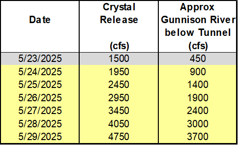
Pursuant to the Aspinall Unit Operations ROD, releases from the Aspinall Unit will be made in an attempt to match the peak flow of the North Fork of the Gunnison River to maximize the potential of meeting the desired peak at the Whitewater gage, while simultaneously meeting the Black Canyon Water Right peak flow amount. The latest forecast for flows on the North Fork of the Gunnison River shows a period of high and near peak flows beginning on May 29th.
Therefore ramp up for the spring peak operation will begin on Saturday, May 24th, with the intent of timing releases with this potential higher flow period on the North Fork of the Gunnison River. Releases from Crystal Dam will be ramped up according to the guidelines specified in the EIS, with 2 release changes per day, until Crystal begins to spill. The release schedule for Crystal Dam is:
Crystal Dam will be at full powerplant and bypass release on May 28th and Crystal Reservoir will likely begin spilling by the next day. The peak release from Crystal Dam should be reached on May 29th and the peak flow on the Gunnison River at Whitewater should be reached on May 30th.
The current projection for spring peak operations shows flows in the Gunnison River through the Black Canyon peaking around 3700 cfs in order to achieve the desired peak flow at Whitewater. Actual flows will be dependent on the downstream contribution of the North Fork of the Gunnison River and other tributaries. Lower tributary flows could lead to higher releases from the Aspinall Unit and vice versa. Once the peak target has been reached, details of the ramp down operation will be released.
Black Canyon July 2020. Photo credit: Cari Bischoff
We are an empire now, and when we act, we create our own reality…. And while you’re studying that reality—judiciously, as you will—we’ll act again, creating other new realities, which you can study too, and that’s how things will sort out.’
That is indeed the way things seem to be sorting out today, in imperial America, under the imperious Trump, breakers of things. ‘The administration’ breaks a law in the process of creating Trump’s still vaguely formulated imperial reality. Citizen groups bring suit against his action, and the action is studied by judges in the context of the Constitutional rule-of-law, part of our existing (recently existing?) triumvirate reality of legislate-execute-evaluate, checks-and-balances, et cetera.
The judges tell Trump that he is exceeding his Constitutional authority, and he must undo most of what he has done. But by then he has distracted us from that by breaking something else in his chainsaw massacre of 250 years of American evolution, another action the judges must study and pass judgment on, thanks to suits brought by groups faithful to Constitutional reality.
But Trump ignores all of their judgments by appealing them, as he continues to commit actions reshaping reality and warranting further judicial study. And the Constituttional reality we’ve taken for granted for 250 years suddenly begins to seem somewhat less real than it was back in good old 2024. When we should have known better – but those damn grocery prices, and Trump promised that on day one…. Well, fool us once, shame on the fool; fool us twice (or fifty or a hundred times), shame on us.
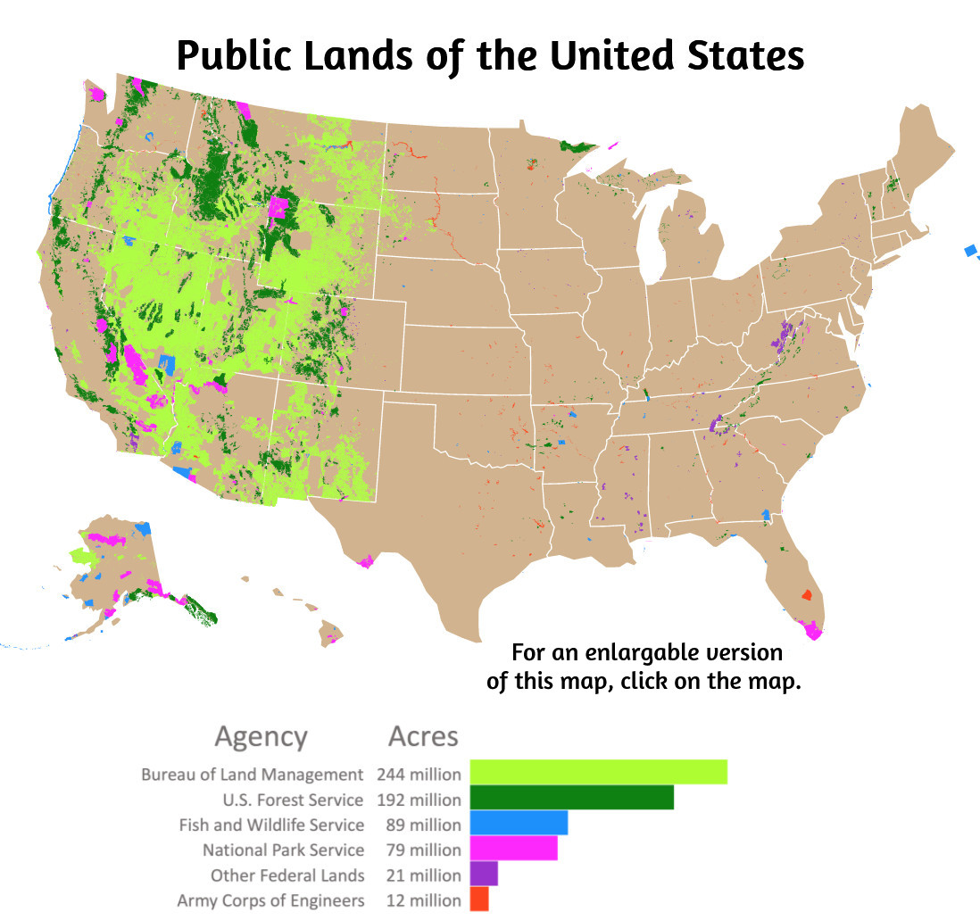
So on to damage control. Today I want to look at the unfolding situation with the nation’s public lands – always a sore spot with many true conservative Republicans from western states as well as Trump’s Repugnicans. The map below shows the situation – more than 630 million acres of public land, most of it by far in the West: small dots and patches of it east of the Great Plains, but vast swaths west of the plains. This land is our land, as the song says, but how the composite ‘we the people’ can or should relate to and live with this land has been an ongoing debate at all levels of governance for more than 250 years.
You’ll quickly note from the map above that public land is almost half of what we call the ‘Intermountain West’ – the region between (and including) the Rocky Mountains on the east and the Sierra-Cascade ranges on the West. The importance of these particular public lands and their resources extends well beyond their actual geography. Most all of the water for the Colorado River, for example, starts on public lands in the green areas (National Forest lands) in the states of Colorado, New Mexico, Utah and Wyoming, and nurtures the entire River Basin and some out-of-basin extensions all the way to southern California. Coal trains continue to rumble eastward from Wyoming, Utah and Colorado carrying low-sulphur coal to the remaining back-east coal-fired power plants – and the Trumpsters want to make coal great again (‘clean, coal’ of course). Trucks roll down from the public’s mountain forests carrying 150-year-old spruce logs like we will not see again for four or five generations, if then, destined for suburban housing – and the Trumptsters want to increase logging from those lands by 25 percent.
But what I want to focus on today is the yellow land on the map, the Bureau of Land Management (BLM) land that makes up around half of the Intermountain West, and a large portion of the Colorado River Basin, mostly below 8,000 feet elevation. The BLM is a bureaucracy in the Interior Department, I’ll remind you, charged with managing all of the public lands that have not yet been designated for more specific uses, like National Forests or National Parks.
This gets the BLM nicknamed the ‘Bureau of Leftover Management,’ but that misses the real picture. The BLM lands do include a lot of brown or just barren land that makes one think nature is still trying to figure out what to do with it. But the BLM lands also include a very diverse and often spectacularly beautiful array of ecological landscapes from which areas are regularly designated (and sometimes undesignated then redesignated) as National Monuments (28 of them now on former BLM land), Wilderness Areas (221), and more than 600 others areas designated as part of the National Conservation Lands, including National Scenic Rivers, National Scenic and Historic Trails, and,refuges for various threatened and endangered species. There are treasures yet to be discovered, and either used or protected from use, in the BLM lands.
Significant segments of this land made the news recently when my congressman, Jeff Hurd of Colorado’s Third District (the West Slope, headwaters of the Colorado River), introduced a bill for a ‘Productive Public Lands Act.’ Rep. Hurd, I will note, occasionally behaves more like a true Republican than a Repugnican. He was one of the few Republican congressmen brave enough to voice disapproval of Trump’s pardon of all the January Sixth rebels. Most recently, he was the only Republican to vote against the suspicious sale of some BLM lands in the vicinity of ‘growth hot spots’ in Nevada and Utah. He has shown some spine in not drinking all of the Trump koolaid.
But the ‘Productive Public Lands Act’ bill, and the language used to sell it, are pure Trumpish bullshit. I will let Congressman Hurd speak first for it: ‘This bill would force the Bureau of Land Management to reissue nine Biden-era Resource Management Plans (RMPs) which locked up access to viable lands throughout Colorado and the West. A reissuance of [the Trump-era] RMPs will put us on a path to energy dominance allowing for a more secure and prosperous United States.’
A colleague in the Western Republican Caucus, California Congressman Doug LaMalfa, chimes in: ‘The Biden Administration was hell-bent on locking up public lands, threatening the prosperity of rural economies across the country…. Fortunately, a new era has dawned, and we have the opportunity to reverse these lockups and reinstate the multiple-use mandate on America’s public lands.’
That’s raw meat to the Trump base, but it’s also disinformation of the sort that sounds good to the uncommitted but under-informed – and most of us are somewhat under-informed on the public lands. ‘Multiple use’ – who can object to that? Especially if Joe Biden was trying to ‘lock up’ the pubic lands and threatening our rural prosperity!
But as usual the barefoot lie has legs and runs off in all directions while the truth is still pulling on its support hose. The nine Resource Management Plans in question were not created by President Biden and his ‘deep state’ cronies in Washington; they were created in accord with the rule of law, in this case, the Federal Land Policy and Management Act. (FLMPA), passed in 1976 in a couple of remarkable decades of what might be called ‘eco-populism’: a nation of people deeply concerned about the growing impacts of a century of unbridled industrial capitalism supercharged by fossil-fuel technology – acid rain killing the forests, industrial pollution killing the rivers, out-of-sight-out-of-mind buried barrels of unidentified stuff killing people drinking from aquifers. The people elected Congresses in the 1960s and 70s that – imagine this! – actually addressed the people’s concerns with legislation that began to change the game; tempering the enthusiastic power to change the planet with a growing sense of responsibility for the changes being wrought, and their consequences.
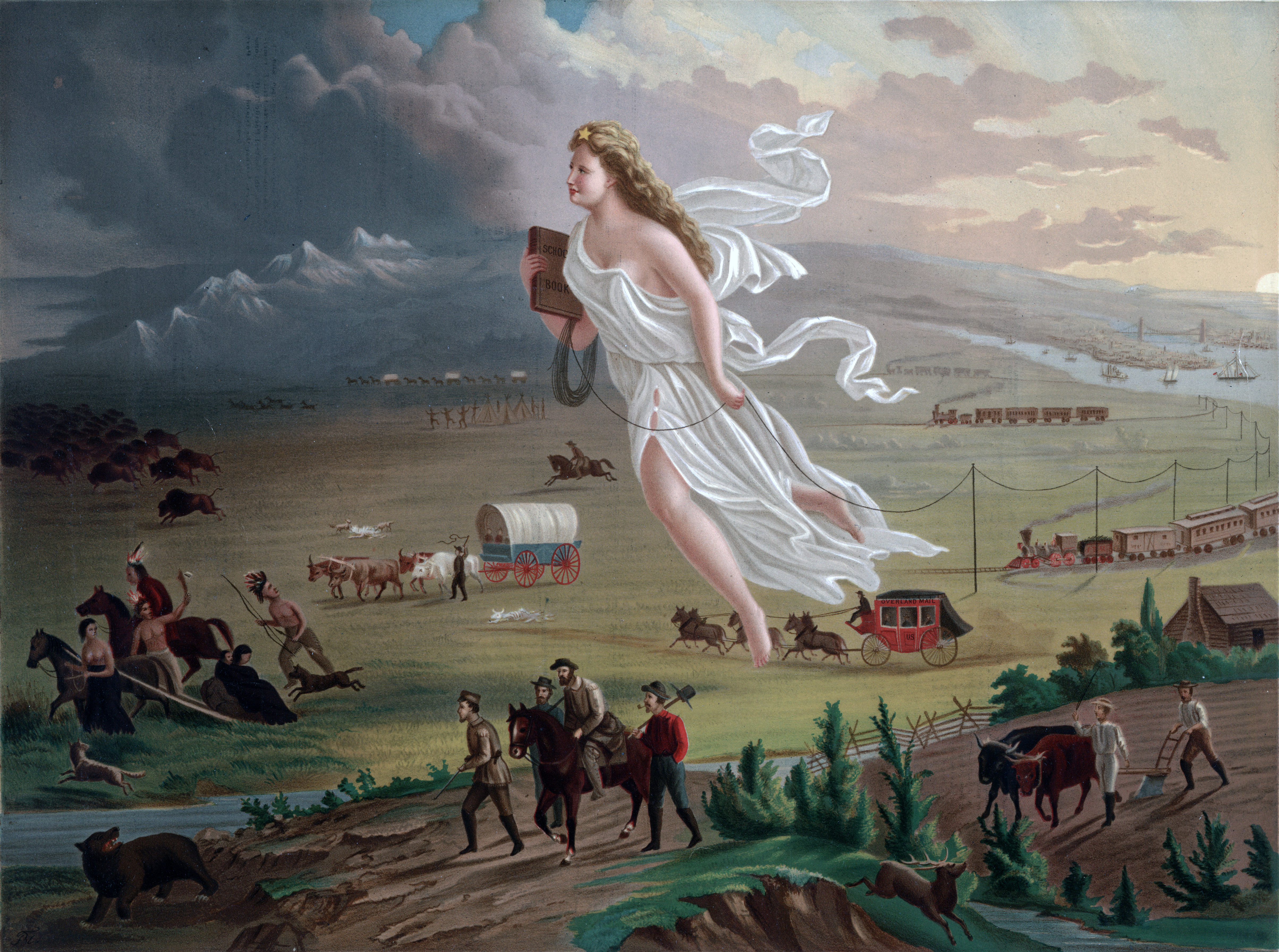
American Progress (1872) by John Gast is an allegorical representation of the modernization of the new west. Columbia, a personification of the United States, is shown leading civilization westward with the American settlers. She is shown bringing light from east to west, stringing telegraph wire, holding a book, and highlighting different stages of economic activity and evolving forms of transportation. By John Gast – This image is available from the United States Library of Congress’s Prints and Photographs division under the digital ID 09855.This tag does not indicate the copyright status of the attached work. A normal copyright tag is still required. See Commons:Licensing for more information., Public Domain, https://commons.wikimedia.org/w/index.php?curid=373152
Passage of the FLMPA in 1976 marked a major step in the evolution of public land management – which did not even exist overall until after World War II. From the 1780s until 1946, all of the new nation’s undesignated lands were under the U.S. General Land Office, which essentially had one purpose: to get as much of that land as possible into private hands as soon as possible, through vehicles like the 1864 Homestead Act, the 1872 General Mining Act, and others going back the 1787 Northwest Ordinance. The American expansionist vision was a land full of rugged American individuals, farming, mining, logging, stockgrowing, all with their own piece of land, and all living in modest decentralized self-sufficient communities that would be the safely dispersed foundation of American democracy.
But by 1900 we were beginning to take ever-larger segments of the public lands out of Land Office control, realizing that cheap land was often getting treated cheaply. Congress began setting aside National Parks and Monuments, beginning with Yellowstone in 1872. In the 1890s presidents began establishing ‘Forest Reserves’ to protect valuable forest land from ‘timber miners’; early in the 20th century these became National Forests, and were moved administratively to the Department of Agriculture, with rangers to protect them and set up grazing fees and timber sales.
Charging for uses on the unclaimed public lands that had basically been used free was not popular (still isn’t), but there was a grudging acknowledgment that management was probably necessary. This was affirmed in the 1930s when a group of Colorado ranchers worked with their congressman Edward Taylor to create the 1934 Taylor Grazing Act, and 80 million acres were withdrawn from General Land Office disposition to be managed by a new Grazing Service – with fees for users.
That paralleled another big cultural change happening in America through the first half of the 20th century: rural Americans were moving to the cities; around 1920 the growing urban population passed the declining rural population, and while the nation still paid lip service to the ‘family farm,’ there were few people going out to homestead on the public lands. Instead, an increasingly well-off and mobile urban ‘middle class,’ with two-week paid vacations, rediscovered the public lands as a resource for recreation, relaxation and renewal; they wanted the public lands to stay forever beautiful, spectacular, adventuresome – and accessible.
These two changes led to the Grazing Service and the General Land Office being quietly combined in 1946 into the Bureau of Land Management – with the Land Office gradually fading into irrelevance: the United States were no longer in the business of selling off national treasures cheap.
What we see in this evolution is a nation of people gradually waking up to the reality of needing to begin taking responsibility for the consequences of a century of enthusiastic exploitation. The final step came 30 years later with the Federal Land Management and Planning Act in 1976 noted earlier – following the foundational National Environmental Policy Act of 1970. NEPA mandated that any project involving federal funding would be preceded by a full environmental impact analysis: we will look before we leap. And if it involved public land, it would have to fit in with developed Resource Management Plans, and some larger projects would have to do their own RMP. This was tedious, difficult, often contentious work – but essential to serious democratic governance. Impatience with this hard work is the first seed of submission to tyranny.
The Resource Management Plans for public lands are all required to have two components. One is planning for multiple uses – all the uses practiced or potentially practiced on the land in question had to be fit into the overall purposes of each plan. The other requirement is public participation at every stage of the process, from all groups with a practical or potential use interest in that land.
‘Multiple use’ does not mean ‘everything going on everywhere’; it means determining how much of every use represented at the table can go on with reasonable accommodation to every other use, and where in the planning area it should happen. There are land and resource uses that are compatible with other uses, and there are uses destined to be the only thing happening in specific places. Mining/drilling, logging, and intensive farming are obviously single uses on any given piece of land, while grazing and hiking and some conservation uses can all go on in the same area, with reasonable accommodations to each other. And the ‘mandated’ public participation means that all would-be users will be heard from in the planning process – participate or shut up.
A Gunnison sage-grouse hen leads her chicks in the Gunnison basin during the summer of 2019. Some private landowners have undertaken habitat restoration projects on placed conservation easements on their property in an effort to protect the bird. Photo credit: Greg Petersen via Aspen Journalism
I can’t speak to all nine of the Resource Management Plans that Hurd and LaMalfa want to repeal, but I am quite familiar with one of them: ‘The Gunnison Sage-Grouse Record of Decision and Approved Resource Management Plan Amendment, dated October 2024.’ This is a RMP to try to save a species of Sage Grouse that has been listed as ‘Threatened’ by the U.S. Fish and Wildlife Service, under the Endangered Species Act. Without going into the multiple decades of detail, this plan was worked out among ranchers, outdoor recreational users (both motorized and unmotorized), fishermen, environmental organizations, scientists, local government representatives, state and federal agencies, industrial reps when relevant, and citizens just interested.
There are places in the basin where some of the single-use land users are indeed ‘locked out’ for restoration needs, but this is not ‘Joe Biden locking them out’; this is the people establishing priorities based on difficult efforts to balance economic and ecological needs, in places at least as dependent on recreational uses as extractive uses. Biden’s only relationship with the whole process was to give the rule of law (FLMPA/NEPA) his blessing, and the time and space it warrants to get it hashed out down on the ground where the problem shapes lives.
To hammer the point home, in case you don’t get it – This is not an absence of ‘multiple use planning’; it is a stellar example of it. The RMP has been worked out over the past two decades by multiple users of landscapes shared with a threatened species who are all willing to try to live with the plan – the kind of local governance that was once celebrated by ‘Main Street Republicans’ (as opposed to ‘Wall Street Republicans’). I expect the other eight plans have somewhat the same rooted authenticity.
So long as we have the legal mandate to do this, and the local patience and will to work it out in our down-on-the-ground reality, we have not yet fully succumbed to the imperial ‘created reality’ that Trump and our local Congressman want to impose on us.
The next logical step here is to ask whether the poor oppressed oil and gas industry, which the Repugnicans want to ‘liberate’ through the Productive Public Lands Bill, really needs liberating – which requires looking at what they can and cannot do now, and whose fault that is or isn’t. But I’ve taken so long here in providing some background for that discussion that it’s time to give you a breather. I’ll be back with the rest of the story in a couple weeks. Stay tuned.
Meanwhile, I’ll leave you with this irrelevant reflection on Trump’s rejection of the low-flow showerhead:
An anti-BLM sticker (referring, presumably, to the federal land agency, not the Black Lives Matter movement) at another Phil Lyman rally against “federal overreach” and motorized travel closures in southeastern Utah back in 2014. Photo credit: Jonathan P. Thompson/The Land Desk