Drought news May 30, 2025: Short-term drought intensified for S. #Utah and N.W. #Colorado during mid to late May, across S.E. Colorado, SPIs at multiple time scales, soil moisture, and VegDri no longer support any D1

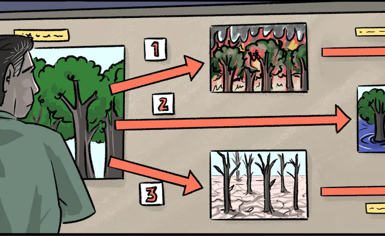
Click on a thumbnail graphic to view a gallery of drought data from the US Drought Monitor website.

Click the link to go to the US Drought Monitor website. Here’s an excerpt>

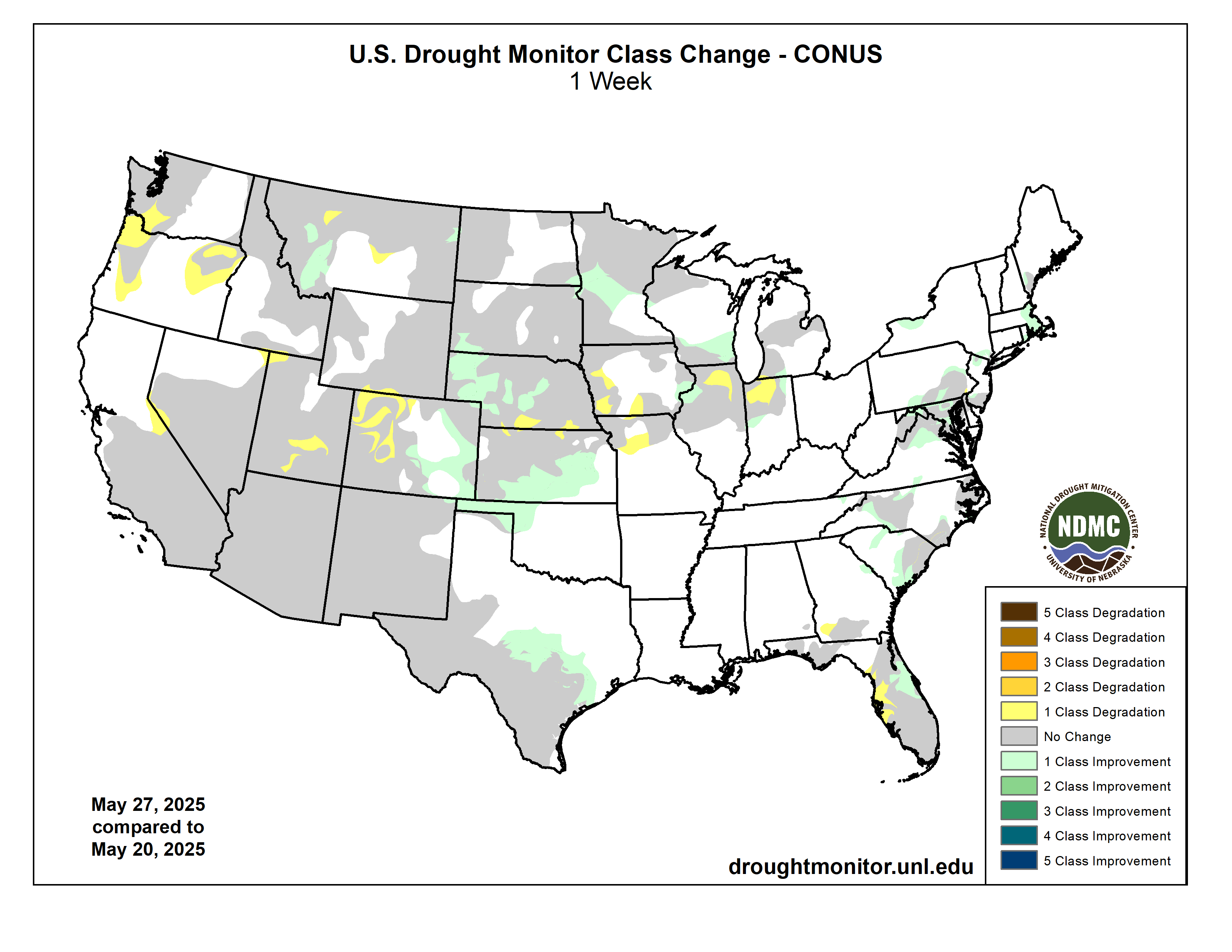
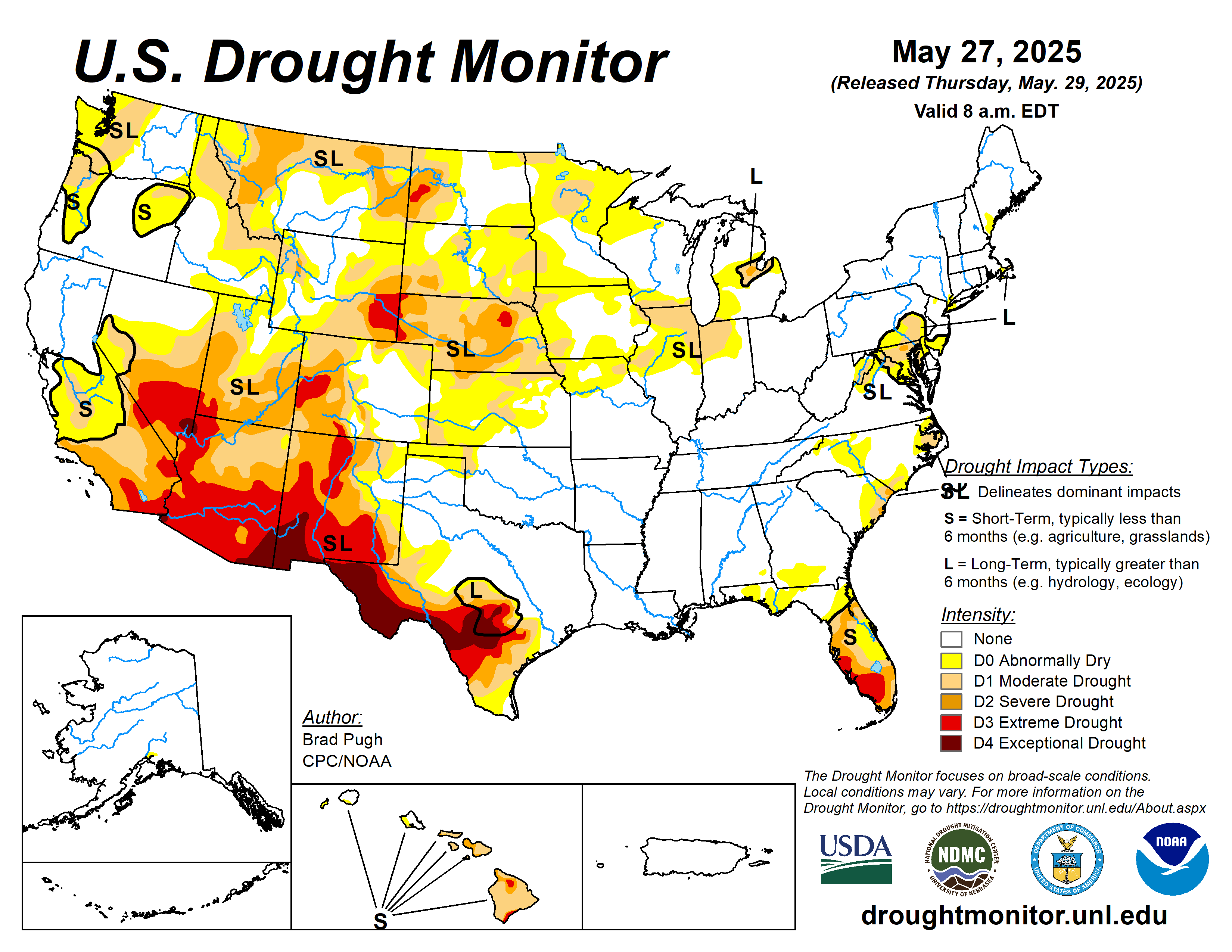
This Week’s Drought Summary

The wet May pattern continued to alleviate or bring an end to drought across the Northeast. Severe to extreme drought persists for central to south Florida although locally heavy showers fell across the east-central Florida Peninsula as the rainy season begins to ramp up. Widespread precipitation (2 inches or more) supported improvements to the Central and Southern Great Plains. During recent weeks, drought developed across portions of southwestern Iowa, northern Illinois, and northwestern Indiana. Short-term drought expanded across the Pacific Northwest and intensified for southern Utah and northwestern Colorado during mid to late May. From May 20-26, above-normal temperatures were limited to the southern tier of the contiguous U.S. 7-day temperatures averaged 4 to 10 degrees F below normal across the Northeast, Corn Belt, and Northern to Central Great Plains. Alaska and Puerto Rico are drought-free, while drought of varying intensity continues for parts of Hawaii…
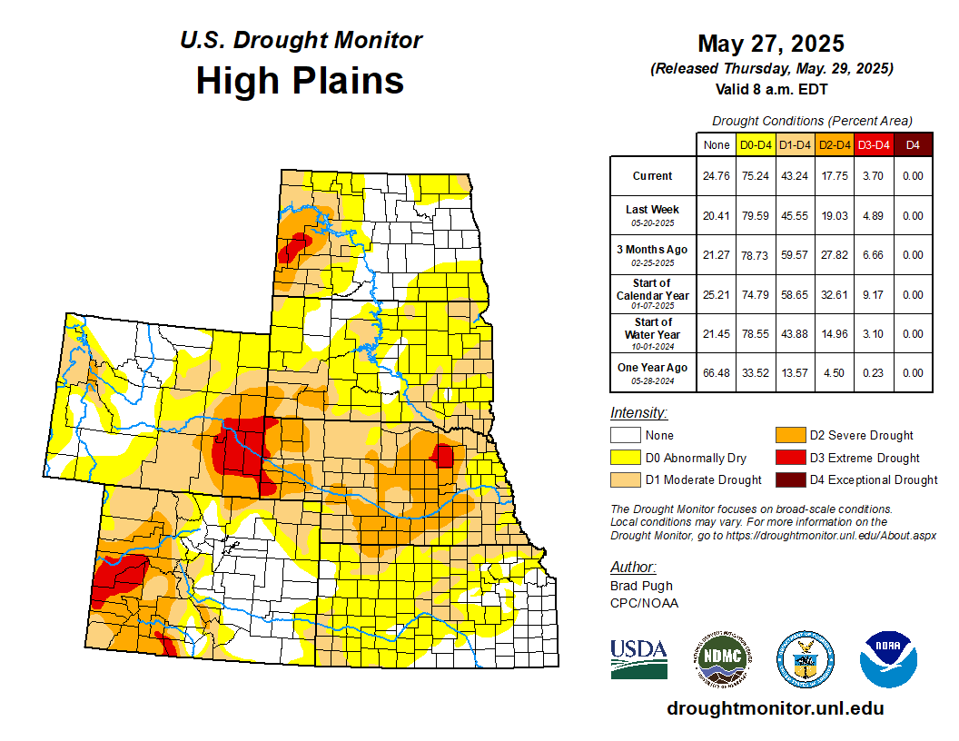
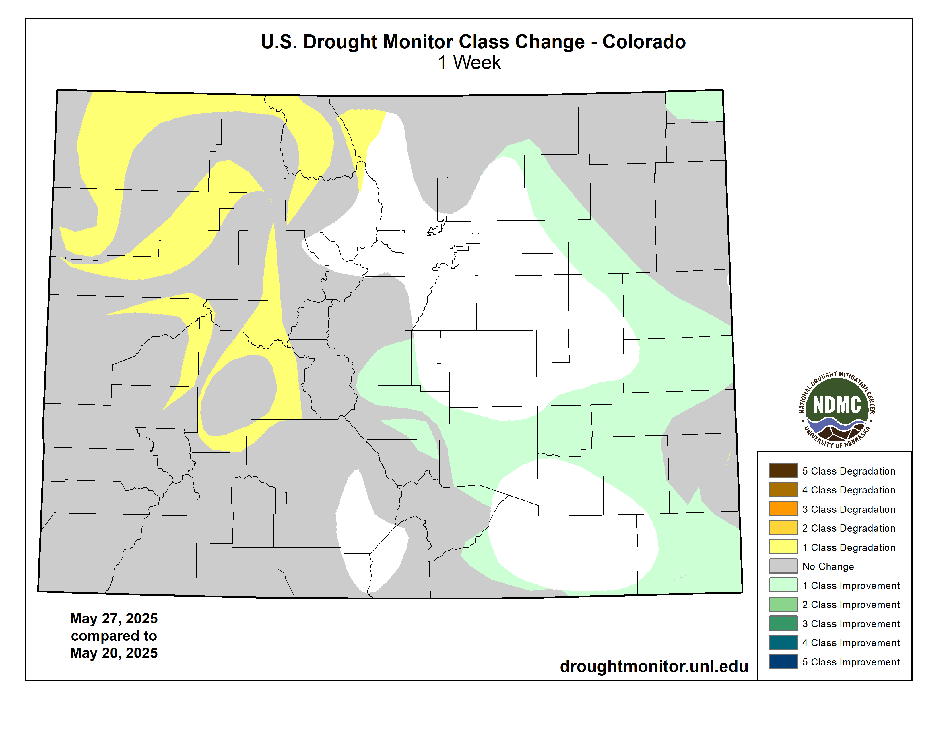
High Plains

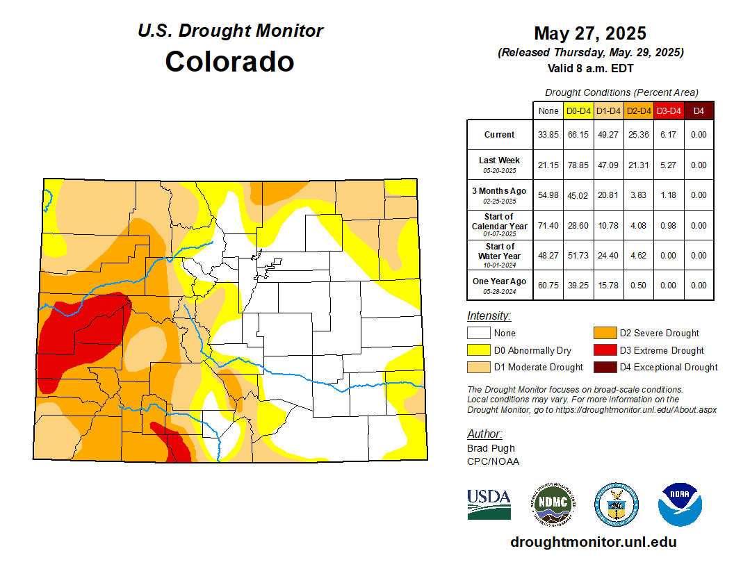
From May 24-26, widespread precipitation (1 to 3 inches, locally more) resulted in a 1-category improvement to portions of southwestern South Dakota, Nebraska, Kansas, and northeastern Colorado. Much cooler temperatures accompanied this widespread precipitation which contributed to topsoil moisture recharge. Based on multiple indicators such as the SPI at various time scales and soil moisture, severe (D2) to extreme (D3) drought was reduced in coverage across central to western Nebraska along with adjacent areas of southwestern South Dakota. Although precipitation was lighter across southeastern Colorado, SPIs at multiple time scales, soil moisture, and VegDri no longer support any D1. Southern Nebraska and northern Kansas missed out on this past week’s precipitation and a couple of small 1-category degradations were made. A 1-category degradation was also warranted for western Colorado based on 90 to 180-day SPI…
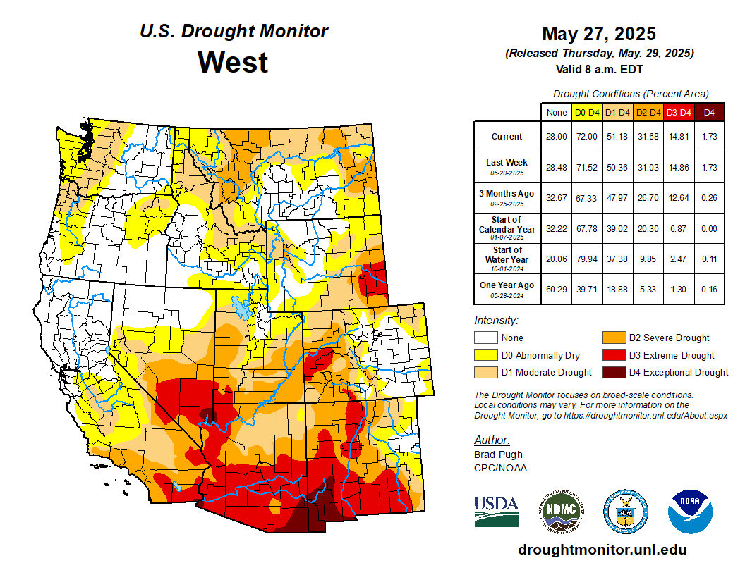
Colorado Drought Monitor one week change map ending May 27, 2025.

West

Based on 6-month SPI, water-year-to-date (October 1, 2024 to May 26, 2025) precipitation deficits, and 28-day average streamflow, moderate drought (D1) was expanded to include more of southwestern Washington. Increasing 30 to 90-day precipitation deficits, low 28-day average streamflows, and declining soil moisture led to the introduction of D1 to parts of northwestern and northeastern Oregon. The 6-month SPI supported the expansion of severe drought (D2) coverage across southwestern Utah. Although precipitation was light this past week, SPIs dating back 120 days along with more favorable soil moisture indicators led to improvements across southwestern and eastern Montana. Conversely, in northwest Montana, D1 was degraded to D2 based on 120-day SPI and declining soil moisture. To the east of the Sierra Nevada Mountains, abnormal dryness (D0) was expanded to the south of Lake Tahoe due to drier-than-normal conditions since April…

South

Heavy rainfall (2 inches or more) prompted a 1-category improvement to ongoing drought areas of south-central and southeastern Texas. Despite this recent heavy rainfall, levels in the long-term monitoring wells of Bexar and Medina Counties remain at all-time lows. In addition, many of the 28-day average USGS streamflows are below the 5th percentile, supporting the D3-D4 depiction. Since the SPIs dating back 6 months are neutral and considering the major impact is hydrological, the drought impact was changed to long-term only. With drought improvement for northwestern Oklahoma this past week, nearly all of Oklahoma and northern to eastern Texas are drought-free. The Lower Mississippi Valley and Tennessee Valley are also drought-free with surplus 30 to 90-day precipitation…

Looking Ahead

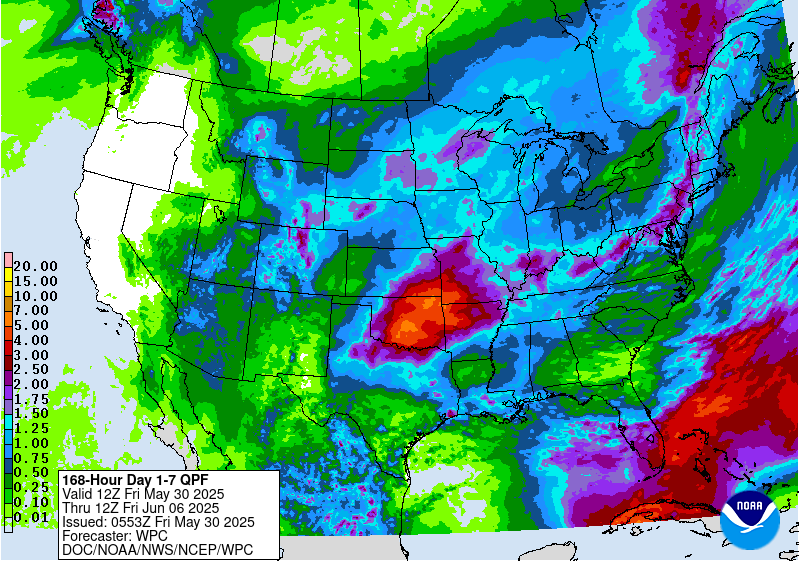
A low pressure system and trailing front are forecast to maintain the wet pattern along the East Coast with the Weather Prediction Center depicting 1 to 2 inches of precipitation from the Mid-Atlantic north to England through June 2. Much-needed precipitation (locally more than 1 inch) is expected for the Florida Peninsula. From May 29 to June 2, mostly dry weather is forecast across the Midwest. By June 2, a low pressure system is forecast to develop and bring another round of precipitation to the Northern and Central High Plains. Much above-normal temperatures and potential record heat are predicted to affect California and the Great Basin to end May.

The Climate Prediction Center’s 6-10 day outlook (valid June 3-7, 2025) favors above-normal precipitation for the Florida Peninsula, Middle to Upper Mississippi Valley, and Great Plains. The precipitation outlook leans towards above-normal precipitation for much of the West. Elevated below-normal precipitation probabilities are forecast across the Mid-Atlantic and Northeast. Alaska and Hawaii are favored to be on the wetter side during the first week of June. Above-normal temperatures are favored from the Mississippi Valley to the East Coast, while below-normal temperatures are more likely throughout the West and Alaska. A slight lean towards above-normal temperatures are forecast for most of Hawaii.

US Drought Monitor one week change map ending May 27, 2025.

Coyote Gulch’s Excellent European Adventure Day 6

Armada Hotel downtown Amsterdam

We’re in Amsterdam. Day 6 was a travel day from Linz to Amsterdam via Vienna in the Danube Valley. Low hills and farms dominated the view. We enjoyed a wonderful dinner at the restaurant Ali Ocakbaşı in Amsterdam.

View from the Armada Hotel, Amsterdam, May 30, 2025.

Managing forests and other ecosystems under rising threats requires thinking across wide-ranging scenarios

Thinking through scenarios allows land managers to prepare for many potential outcomes. Benjamin Slyngstad via USGS

Kyra Clark-Wolf, University of Colorado Boulder; Brian W. Miller, U.S. Geological Survey, and Imtiaz Rangwala, University of Colorado Boulder

In Sequoia and Kings Canyon National Parks in California, trees that have persisted through rain and shine for thousands of years are now facing multiple threats triggered by a changing climate.

Scientists and park managers once thought giant sequoia forests nearly impervious to stressors like wildfire, drought and pests. Yet, even very large trees are proving vulnerable, particularly when those stressors are amplified by rising temperatures and increasing weather extremes.

The rapid pace of climate change – combined with threats like the spread of invasive species and diseases – can affect ecosystems in ways that defy expectations based on past experiences. As a result, Western forests are transitioning to grasslands or shrublands after unprecedented wildfires. Woody plants are expanding into coastal wetlands. Coral reefs are being lost entirely.

A man in a hard hat gestures amid a burned forest with very large trees.
Nate Stephenson, from the U.S. Geological Survey, talks about the fire damage at Redwood Mountain Grove in the Kings Canyon National Park, Calif., in 2021. AP Photo/Gary Kazanjian

To protect these places, which are valued for their natural beauty and the benefits they provide for recreation, clean water and wildlife, forest and land managers increasingly must anticipate risks they have never seen before. And they must prepare for what those risks will mean for stewardship as ecosystems rapidly transform.

As ecologists and a climate scientist, we’re helping them figure out how to do that.

Managing changing ecosystems

Traditional management approaches focus on maintaining or restoring how ecosystems looked and functioned historically.

However, that doesn’t always work when ecosystems are subjected to new and rapidly shifting conditions.

Ecosystems have many moving parts – plants, animals, fungi and microbes; and the soil, air and water in which they live – that interact with one another in complex ways.

When the climate changes, it’s like shifting the ground on which everything rests. The results can undermine the integrity of the system, leading to ecological changes that are hard to predict.

To plan for an uncertain future, natural resource managers need to consider many different ways changes in climate and ecosystems could affect their landscapes. Essentially, what scenarios are possible?

Preparing for multiple possibilities

At Sequoia and Kings Canyon, park managers were aware that climate change posed some big risks to the iconic trees under their care. More than a decade ago, they undertook a major effort to explore different scenarios that could play out in the future.

It’s a good thing they did, because some of the more extreme possibilities they imagined happened sooner than expected.

In 2014, drought in California caused the giant sequoias’ foliage to die back, something never documented before. In 2017, sequoia trees began dying from insect damage. And, in 2020 and 2021, fires burned through sequoia groves, killing thousands of ancient trees.

While these extreme events came as a surprise to many people, thinking through the possibilities ahead of time meant the park managers had already begun to take steps that proved beneficial. One example was prioritizing prescribed burns to remove undergrowth that could fuel hotter, more destructive fires.

Firefighters hold giant sheets of foil-like insulating wrap that surrounded the giant tree. Each person is tiny compared to the width of the tree.
Insulating wraps protected the giant sequoia General Sherman from a fire in 2021. Patrick T. Fallon/AFP via Getty Images

The key to effective planning is a thoughtful consideration of a suite of strategies that are likely to succeed in the face of many different changes in climates and ecosystems. That involves thinking through wide-ranging potential outcomes to see how different strategies might fare under each scenario – including preparing for catastrophic possibilities, even those considered unlikely.

For example, prescribed burning may reduce risks from both catastrophic wildfire and drought by reducing the density of plant growth, whereas suppressing all fires could increase those risks in the long run.

Strategies undertaken today have consequences for decades to come. Managers need to have confidence that they are making good investments when they put limited resources toward actions like forest thinning, invasive species control, buying seeds or replanting trees. Scenarios can help inform those investment choices.

Constructing credible scenarios of ecological change to inform this type of planning requires considering the most important unknowns. Scenarios look not only at how the climate could change, but also how complex ecosystems could react and what surprises might lay beyond the horizon.

A chart shows different ecological changes
Scientists at the North Central Climate Adaptation Science Center are collaborating with managers in the Nebraska Sandhills to develop scenarios of future ecological change under different climate conditions, disturbance events like fires and extreme droughts, and land uses like grazing. Photos: T. Walz, M. Lavin, C. Helzer, O. Richmond, NPS (top to bottom)., CC BY

Key ingredients for crafting ecological scenarios

To provide some guidance to people tasked with managing these landscapes, we brought together a group of experts in ecology, climate science, and natural resource management from across universities and government agencies.

We identified three key ingredients for constructing credible ecological scenarios:

1. Embracing ecological uncertainty: Instead of banking on one ā€œmost likelyā€ outcome for ecosystems in a changing climate, managers can better prepare by mapping out multiple possibilities. In Nebraska’s Sandhills, we are exploring how this mostly intact native prairie could transform, with outcomes as divergent as woodlands and open dunes.

2. Thinking in trajectories: It’s helpful to consider not just the outcomes, but also the potential pathways for getting there. Will ecological changes unfold gradually or all at once? By envisioning different pathways through which ecosystems might respond to climate change and other stressors, natural resource managers can identify critical moments where specific actions, such as removing tree seedlings encroaching into grasslands, can steer ecosystems toward a more desirable future.

3. Preparing for surprises: Planning for rare disasters or sudden species collapses helps managers respond nimbly when the unexpected strikes, such as a severe drought leading to widespread erosion. Being prepared for abrupt changes and having contingency plans can mean the difference between quickly helping an ecosystem recover and losing it entirely.

Over the past decade, access to climate model projections through easy-to-use websites has revolutionized resource managers’ ability to explore different scenarios of how the local climate might change.

What managers are missing today is similar access to ecological model projections and tools that can help them anticipate possible changes in ecosystems. To bridge this gap, we believe the scientific community should prioritize developing ecological projections and decision-support tools that can empower managers to plan for ecological uncertainty with greater confidence and foresight.

Ecological scenarios don’t eliminate uncertainty, but they can help to navigate it more effectively by identifying strategic actions to manage forests and other ecosystems.

Kyra Clark-Wolf, Research Scientist in Ecological Transformation, University of Colorado Boulder; Brian W. Miller, Research Ecologist, U.S. Geological Survey, and Imtiaz Rangwala, Research Scientist in Climate, Cooperative Institute for Research in Environmental Sciences, University of Colorado Boulder

This article is republished from The Conversation under a Creative Commons license. Read the original article.

Sequoias in the Giant Tree Forest August 4, 2022.

Southern Ute tribal member elected to chair the #Colorado Water Conservation Board in historic first — Shannon Mullane (Fresh Water News)

Lorelei Cloud, Vice-chair of the Southern Ute Tribal Council, and Southwest Colorado’s representative of the Colorado Water Conservation Board, which addresses most water issues in Colorado. Photo via Sibley’s Rivers

Click the link to read the article on the Water Education Colorado website (Shannon Mullane):

May 29, 2025

The Colorado Water Conservation Board, Colorado’s top water policy agency, has a new leader: Southern Ute tribal member Lorelei Cloud.

The 15-member board sets water policy within the state, funds water projects statewide and works on issues related to watershed protection, stream restoration, flood mitigation and drought planning. On May 21, board members elected Cloud to serve a one-year term as chair, making her the first Indigenous person to hold the position since the board was formed in 1937.

Cloud said her new role gives Indigenous people a long-sought seat at the table where water decisions are made.

ā€œThis is history,ā€ Cloud said during the meeting. ā€œWhat a moment. What a great moment for the state of Colorado.ā€

In 2023, Gov. Jared Polis appointed Cloud for a three-year term, making her the first known tribal member to hold a seat on the board. Cloud also served as the board’s vice chair for a year starting in May 2024.

Part of the Colorado Water Conservation Board’s purpose is to protect Colorado’s water interests in dealings with other states, like the water sharing agreements among seven states in the Colorado River Basin.

Cloud’s appointment to the board and elevation to board chair come at a time when tensions are high over water in the West.

She represents the San Miguel-Dolores-San Juan basin in southwestern Colorado, which is part of the larger Colorado River Basin, a key water source for about 40 million people across the West.

The Colorado River Basin’s water supply has been strained by over two decades of prolonged drought, rising temperatures and an unyielding demand for water.

The rules that govern how water is stored and released from the basin’s reservoirs are set to expire in 2026, leaving officials with the difficult task of negotiating a new set of management rules that will last for years to come.

The seven basin states have been at odds over how water should be managed in the basin’s driest possible conditions. Tribal officials have been working to ensure their priorities are considered in the high-stakes negotiations.

ā€œThis moment isn’t just about me or about the Indigenous people — it’s about all of the people in this room,ā€ Cloud said, adding that the board is ā€œmaking decisions that aren’t just about today. It’s about our future.ā€

Decision-makers in the Colorado River Basin have a history of excluding tribal nations that dates back to the 1922 Colorado River Compact.

The compact laid the foundation for how water is shared between the Upper Basin — Colorado, New Mexico, Wyoming and Utah — and the Lower Basin — Arizona, California and Nevada. The agreement includes one line about tribal water, and tribal nations were not involved in the negotiations.

Native America in the Colorado River Basin. Credit: USBR

Tribal water is a key issue in the basin: The 30 basin tribes have recognized rights to over 25% of the Colorado River’s average flow.

Cloud said her new role is ā€œpart of the reconciliation that we’ve all been waiting for as Indigenous people.ā€

ā€œHaving an Indigenous person in a position that makes water management decisions — it’s a seat at the table that we’ve been wanting for such a long time, and it’s finally here,ā€ Cloud said. ā€œIt’s a joyous moment.ā€

Cloud has twice served as vice chairman of the Southern Ute Tribal Council. She has also held leadership positions in The Nature Conservancy Colorado, the Indigenous Women’s Leadership Network, the Ten Tribes Partnership, and the Water and Tribes Initiative.

As board chair, Cloud will run the meetings, ensure fair voting and represent the board as spokesperson when needed. She will continue to represent the southwestern basin, which reaches 10 counties and includes cities like Cortez, Durango and Telluride.

The Southern Ute Indian Tribe and the Ute Mountain Ute Tribe — the two federally recognized tribes with reservation land in Colorado — are also located in the southwestern basin.

ā€œI’ve been lucky to witness Chair Cloud’s rise as a leader in the Colorado water community,ā€ said Dan Gibbs, Department of Natural Resources executive director. ā€œNo one is more deserving or better positioned to chair the CWCB in this critical moment.ā€

More by Shannon Mullane

Map of the Colorado River drainage basin, created using USGS data. By Shannon1 – Own work, CC BY-SA 4.0, https://commons.wikimedia.org/w/index.php?curid=65868008