Spring #snowpack: Slightly better than advertised, weak statewide figures obscure more nuanced scenario for Denver Water as we enter runoff season — Todd Hartman (News on Tap)

North Fork Snake River. Melted snow is the primary source of drinking water for the 1.5 million people who rely on Denver Water every day. Photo credit: Denver Water.

Click the link to read the article on the Denver Water website (Todd Hartman):

May 16, 2025

News headlines this spring offered a bleak picture of Colorado’s snowpack heading into the spring runoff season. But, as always with headlines, it is best to also read the story that follows.

Because the story for Denver Water isn’t quite so dour. 

Snowpack woes hit Colorado’s southern half hard. For Denver Water, positioned farther north, the water supply looks better.

First, let’s do the numbers. 

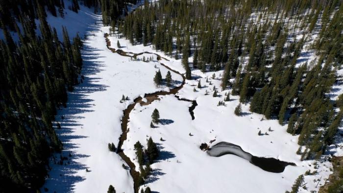
Denver Water had a weak showing in the South Platte River Basin, with peak snowpack hitting just 84% of normal and — most unhelpful of all — peaking on April 6, 19 days earlier than typical.

The news was far better in the Colorado River Basin (north of the South Platte River Basin), which accounts for the other half of Denver Water’s supply. There, peak snowpack clocked in at 109% on April 25, right on the mark for a typical peak date.

“Overall, not great, but not terrible either,” summed up Nathan Elder, water supply manager for the utility. 

The best news for Denver Water: The utility is starting the runoff and reservoir-filling season with existing storage levels about 2% above average. 

That’s a credit to its customers’ efforts to conserve water and translates into a good chance that Denver Water will be able to fill its storage reservoirs that help 1.5 million people get through the summer hot season.

But “fill” doesn’t mean “spill.” That is, there won’t be excess water to spill into rivers in what can make for dramatic visuals and provide an extra boost to river flows. 

“We hope to fill our reservoirs right to the brim, but that’s where it stops,” Elder said.

Denver Water’s planners are concerned about a hot-and-dry trend taking hold in May, and emphasize the need for residents to adhere to the utility’s annual summer watering rules that allow irrigation only in the evening and morning hours (between 6 p.m. and 10 a.m.) and limit irrigation to no more than three days a week — preferably just one or two days when springtime temperatures are lower.

And watch the skies. When we do get a good rainstorm, turn your sprinkler dial to “off” for a few days.

The generally poor snowpack and early runoff in much of the state, including in the South Platte River Basin, also stokes concerns for a rough fire season, as 9News meteorologist Chris Bianchi pointed out in a May 13, 2025, story

“This year’s snowpack levels resemble those recorded in 2018, 2012, 2002 and 1992. All of which were marked by intense wildfire activity. Three out of those four years saw large-scale fires, raising concerns that 2025 could follow a similar trajectory unless weather patterns shift dramatically.”

And, on a too-long-didn’t-read basis, here’s Bianchi’s tweet that summed up the story:

Denver Water’s watershed experts agree that conditions could increase wildfire risk.

“The risk of wildfire is relatively low when there is snow on the ground. When snowpack melts rapidly, vegetation can dry out quickly and become susceptible to wildfire ignitions,” said Madelene McDonald, a watershed scientist and wildfire specialist for Denver Water.

Though McDonald notes that experts anticipate “average” wildfire behavior in Colorado in 2025, that still means thousands of fires that could collectively affect more than 100,000 acres in the state. 

“It’s important to stay vigilant and prepared to experience wildfire under any snowpack conditions or fire outlook scenarios,” she said.

An April pivot

The current outlook is a pivot from what had been looking like a normal year for snowpack as recently as April 1, Elder said.

“For Denver Water, April is typically a month where we build snow,” he said. 

But that didn’t happen this year, and by mid-May the snowpack had shriveled to half its typical percentage.

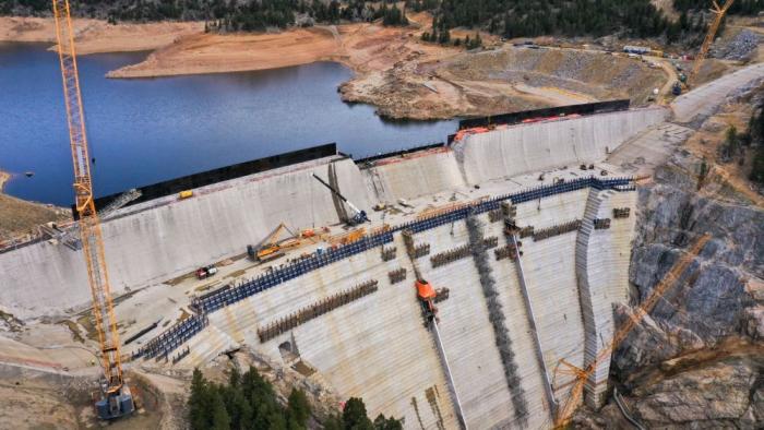
The tepid spring in the South Platte River Basin also highlights the importance of Denver Water’s Gross Reservoir Expansion Project, which recently has been slowed in federal court. (Read Denver Water’s recent statement on a May 6 court hearing.) 

That project will expand the reservoir and add roughly 80,000 acre-feet of water storage capacity in the utility’s north system, which gathers snowmelt from the Upper Colorado River Basin. That additional water storage will provide a buffer to protect the utility’s customers from the effects of years when the snowpack is weaker, like this year, in Denver Water’s separate and unconnected south system.

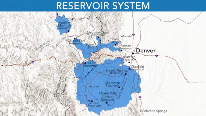
“Our system is robust but suffers from significant imbalance,” Elder said. 

“We rely too heavily on our south system, on the South Platte, which accounts for 90% of our storage,” he said. “Increasing storage to the north will give Denver Water far more flexibility to handle these weaker snowpack years on the South Platte.”

And years marked by a weaker snowpack in the South Platte River Basin have become more common. 

In four of the last five years, the South Platte snowpack above Denver Water’s collection system has peaked below normal. And in that fifth year — last year — it barely cleared the “normal” bar at 101%. All of which amplifies the need for the Gross Reservoir Expansion Project.

Raising Gross Dam, seen here on April 8, 2025, will nearly triple the water storage capacity of the reservoir behind it. The project has been in the permitting and review process for 23 years. Photo credit: Denver Water.

Now, as June approaches, water managers will turn their focus to runoff levels, temperatures and fire potential. And come summer, they will once again — as always — hope for a big dose of monsoonal moisture. 

Those big rainstorms not only deliver a boost to rivers and reservoirs but prompt attentive customers to turn off their irrigation system and let their grass and plants drink up nature’s soaking bounty. 

Remember, the less you pour, the more your water utility can store.

And it’s never a bad time to consider transforming your landscape, or even parts of it. 

Denver Water has a new guide to help: the DIY Landscape Transformation Guide, and it includes ways to eradicate grass in the areas where you want to remodel your landscape with native plants and other changes.

Denver Water relies on a network of reservoirs to collect and store water. The large collection area provides flexibility for collecting water as some areas receive different amounts of precipitation throughout the year. Image credit: Denver Water.

Special Snow #Drought Update: Rapid Snowmelt — NIDIS #snowpack #runoff

Click the link to read the update on the NIDIS website:

May 20, 2025

Record-Breaking Snowpack Melt Out Across the West

Key Points

  • Above-normal temperatures and below-normal precipitation continued to rapidly melt western U.S. snowpack. Nearly all western basins are now in late season snow drought, despite many stations reaching near to above-average peak snow water equivalent (SWE) during the snow accumulation season. Some stations, including some in Nevada, Colorado, Utah, and New Mexico, saw record early melt out.
  • The rapid depletion of snow, coupled with increased evaporative demand (the “thirst” of the atmosphere), can rapidly dry soils and vegetation, which can lead to an early start to the fire season.
  • Snowmelt this time of year is common, but such rapid melt rates are not normal. In some instances, above-normal temperatures such as these can cause snow to sublimate (transition from a solid to a gas) and reduce runoff into streams and reservoirs.
  • Tracking snow drought during the snowmelt season is important, because the rate and disappearance of snow can cause flooding and impact water supply, soil moisture, ecosystems, recreation, and wildfire potential.
  • Water supply forecasts for the Colorado River Basin, Rio Grande Basin, and Columbia River Basin declined compared to April 1 forecasts due to well-below-average April precipitation.
  • The NOAA Climate Prediction Center’s 6-10 day outlook favors above-normal temperatures across most of the West, which could again accelerate snowmelt rates at higher elevations where snow remains. 

Snow Drought Conditions Summary

This update is based on data available as of Thursday, May 15, 2025 at 12:00 a.m. PT. We acknowledge that conditions are evolving.

Current Conditions

Tracking snow drought during the snowmelt season is important because the rate and disappearance of snow can cause flooding and impact water supply, soil moisture, ecosystems, recreation, and wildfire potential. 

Across many basins in the West, late season snow drought (snow water equivalent in the bottom 20% of historical conditions) developed amid above-normal temperatures and a very dry April and early May. Several significant melt out events impacted nearly every major mountain range. Some stations, including some in NevadaColoradoUtah, and New Mexico, saw record early melt out. Snowmelt this time of year is common, but such rapid melt rates are not normal. In some instances, above-normal temperatures such as these can cause snow to sublimate (transition from a solid to a gas) and reduce runoff into streams and reservoirs. 

Median snowpack values are lower in late spring. As a result, even small precipitation events can cause large changes in percent of median values at this time of year without significantly increasing overall seasonal snowpack totals.  

Columbia River Basin

In the Columbia River Basin, May-to-date precipitation has been below 50% of normal across large portions of the state. The Yakima River Basin and some other basins already had long-term precipitation deficits, and multiple years of drought prompted Washington to declare a drought emergency

Earlier-than-normal snowmelt could deplete reservoir systems earlier in the season than is typical across Idaho. These lower reservoirs could lead to minimal water in storage for next year’s demands. Low reservoir levels could deepen Idaho’s reliance on ample snow next winter to meet water supply. The Middle Snake River Basin saw snow water equivalent (SWE) drop from the 70th percentile to the 30th percentile in a two-week period beginning late April. 

Colorado River and Rio Grande Basins

The Colorado River Basin and other portions of the central Rockies in Colorado and Utah that had above-median snowpack at the beginning of April rapidly melted later that month. Snow water equivalent (SWE) in the Colorado Headwaters Hydrologic Unit Code (HUC) 6 Basin dropped from the 30th percentile to the 10th percentile in a 7-day period in mid-April. On April 24, Utah declared a drought emergency in 17 southern Utah counties in response to low streamflow forecasts, increased water demand as temperatures rise, and drought. 

As of May 4, parts of Wolf Creek Pass were snow-free, meaning they melted nearly 3-4 weeks early. The SNOTEL station at Wolf Creek Pass entered near-record low SWE totals for this time of year. The Baldy Mountain SNOTEL site in Arizona (9,210-foot elevation) remained mostly snow-free throughout the winter. 


Looking Ahead

Low Water Supply Forecast 

Water supply forecasts for the Colorado River Basin, Rio Grande Basin, and Columbia River Basin declined compared to April 1 forecasts due to well-below average April precipitation. The northern Rockies in the headwaters of the Missouri River Basin also experienced rapid melt out and early peak snow water equivalent (SWE). With 50% of the Missouri River Basin in drought, persistent dry conditions coupled with early peak SWE have reduced water supply forecasts. 

Warm Temperatures, Near-Normal Precipitation Support Early Snowmelt

The NOAA Climate Prediction Center’s June outlook favors above-normal temperatures and below-normal precipitation across most of the West. California, Nevada, Arizona, and southwest Utah have equal chances of above-, below-, or near-normal precipitation. Conditions are favorable for earlier-than-normal snow meltout. Melt out is common this time of year. However, the rapid depletion of snow at higher elevations, coupled with increased evaporative demand, can rapidly dry soils and vegetation. This can lead to an early start to the fire season. 

Drought Likely to Persist

The seasonal drought outlook from the Climate Prediction Center favors drought development or expansion across the northern Rockies of Idaho and Montana, which includes some areas that received above-average snowpack earlier in the season but melted rapidly. The southern Rockies saw low snowpack throughout most of the season, and drought is expected to persist across these areas, including southern California, Nevada, Utah, and Colorado, along with Arizona, New Mexico, and a portion of Washington. 

Heightened Fire Risk for Parts of the West 

Late season snow drought from rapid snowmelt and early melt out, above-normal temperatures, and below-normal precipitation led to significant wildland fire potential. In Arizona and New Mexico, record low snowpack this winter and substantial long-term deficits favor above-normal wildland fire potential in May

National Interagency Fire Center outlooks for June favor above-normal wildland fire potential in areas with significant snow drought, including Arizona and New Mexico. Increased fire potential extends into the southern portions of Nevada, Utah, and Colorado. June outlooks also favor above-normal fire potential in eastern Washington, northern Idaho, and the Sierra Nevada of California. 

In July and August, significant wildland fire potential is favored across nearly all of Washington, Oregon, Montana, and Idaho. Significant portions of California, northern Nevada, and northeast Wyoming are also predicted to have increased fire potential. 


Late Season Snow Drought Developed Across the West


Spring Heat Wave Rapidly Melts Snow


Rapid Snowmelt Led to Rapid SWE Losses in the Colorado Headwaters Basin


Rapid Snowmelt Led to Rapid SWE Losses in the Middle Snake-Boise Basin


* Quantifying snow drought values is an ongoing research effort. Here we have used the 20th percentile as a starting point based on partner expertise and research. Get more information on the current definition of snow drought. Note that reporting of SWE by Snow Telemetry (SNOTEL) stations may be unavailable or delayed due to technical, weather or other issues, which may affect snow drought depiction in this update. 
 

For More Information, Please Contact:

Daniel McEvoy
Western Regional Climate Center
Daniel.McEvoy@dri.edu

Jason Gerlich
CIRES/NOAA/NIDIS Pacific Northwest and Missouri River Basin Regional Drought Information Coordinator
Jason.Gerlich@noaa.gov

Amanda Sheffield
CIRES/NOAA/NIDIS California-Nevada Regional Drought Information Coordinator
Amanda.Sheffield@noaa.gov