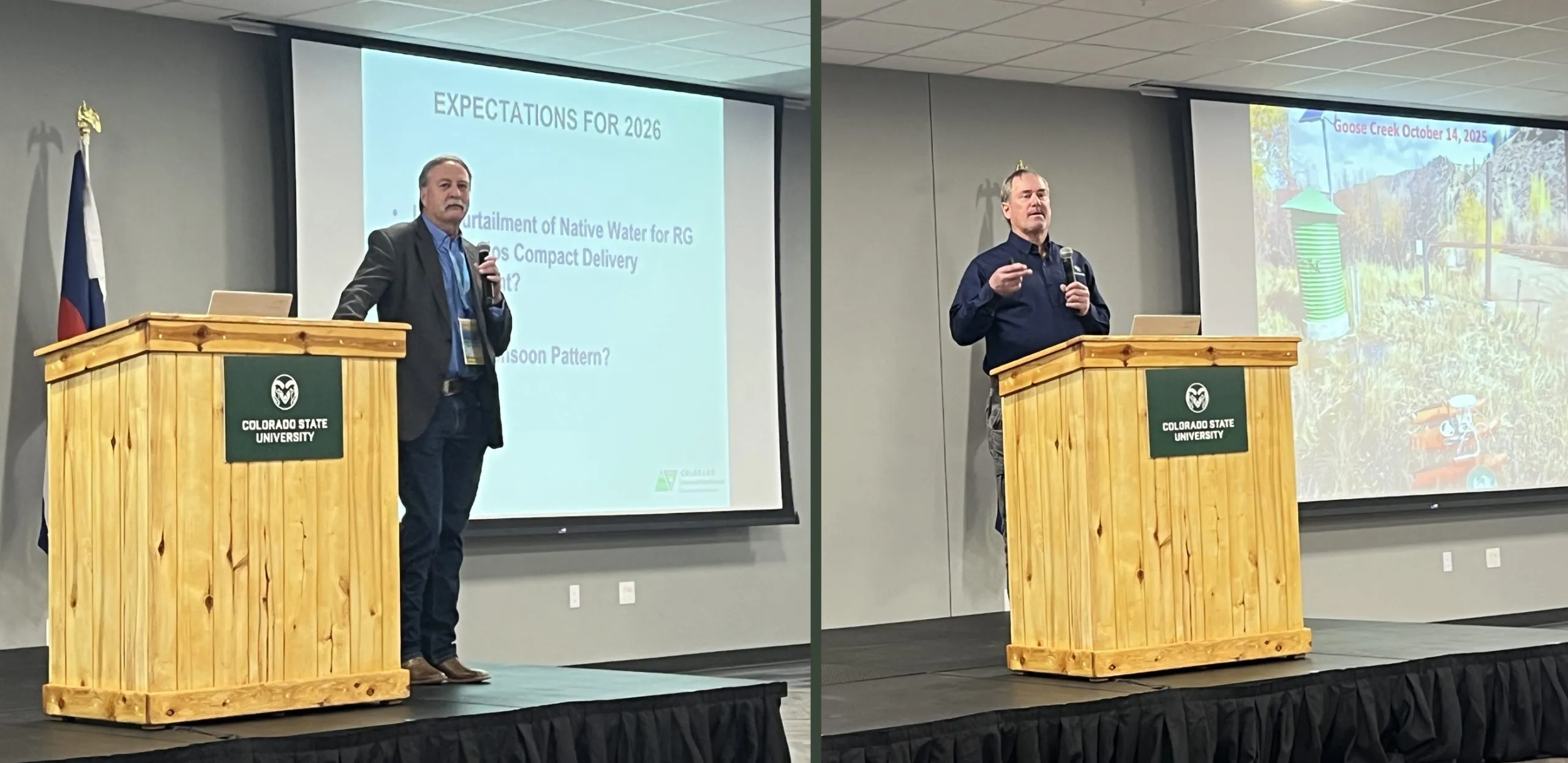
Division engineer Craig Cotten, left, and Pat McDermott of the Colorado Division of Water Resources, deliver the state water resources report on the final day of the 2026 Southern Rocky Mountain Ag Conference. Credit: The Citizen
An unconfined aquifer that is getting “worse and worse,” not better.
Such is the reality of the situation for the Upper Rio Grande Basin and warnings given to the San Luis Valley farming and ranching community on the final day of the 2026 Southern Rocky Mountain Ag Conference.
If you’re a praying sort, it isn’t too early in 2026 to fold your hands together toward the heavens. If not, a good wish or two would be fine as well.
The outlook is that dire. Except for the hope that a changing weather pattern from La Niña to El Niño at some point this year will deliver the goods and avoid even more of a collapse.
“We do anticipate at this moment, at this date that it’s going to be a poor runoff in 2026,” said Pat McDermott of the Colorado Division of Water Resources. It is customary for him and state division engineer Craig Cotten to provide a look back at the recent water year and a look ahead to the next spring runoff.
McDermott typically attempts a positive spin for the large audience that fills the main conference room at the Outcalt Center of the Ski Hi Complex in anticipation of the state water resources report. He did his best by pointing to a rosier outlook in the 2026 Farmer’s Almanac, the last annual edition.
It is the state, after all, that governs groundwater pumping in the San Luis Valley and has metrics Valley farmers are required to meet to stay in business. One is the recovery of the unconfined aquifer through buy-and-dry and reduced groundwater pumping strategies.
“It just kind of gets worse and worse every year that we look at it,” said Cotten in referencing the storage levels of the Upper Rio Grande’s unconfined aquifer and the greater level of recovery efforts crop producers in Subdistrict 1 are facing as a result.
“Unfortunately it’s going in the wrong direction and it has been for quite some time here,” Cotten said in referencing the latest five-year average for storage.
THE NUMBERS
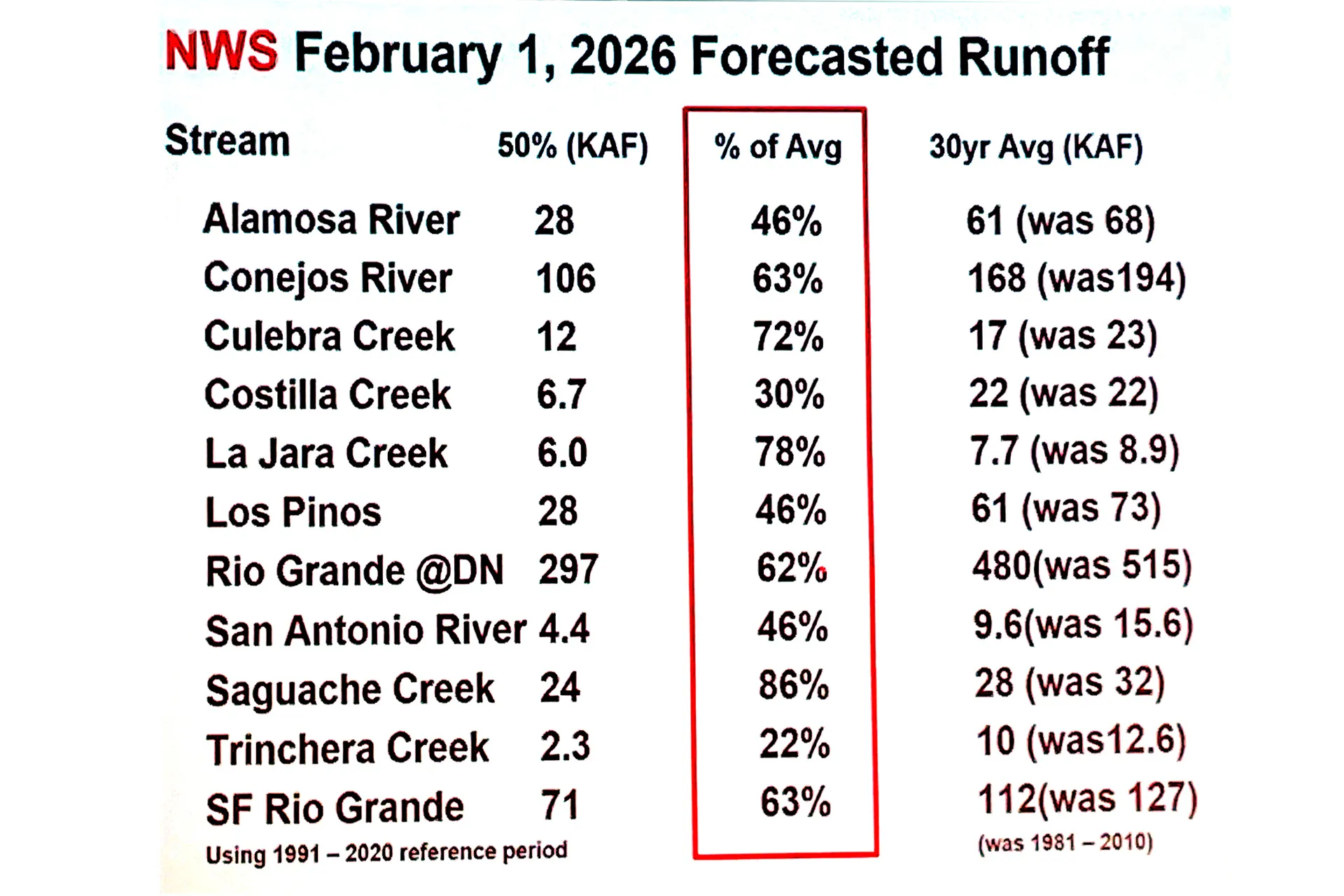
Rio Grande 2025
493,000 acre-feet – Annual index flow or 80 percent of long-term average past 30 years
125,000 acre-feet – Obligation to New Mexico and Texas under Rio Grande Compact
Rio Grande saw an increase of 95,000 acre-feet due to October 2025 rain.
Conejos River 2025
205,000 acre-feet – Annual index flow or 68 percent of the long-term average of 300,000 acre-feet
46,900 acre-feet – Obligation to New Mexico and Texas
Conejos River saw an increase of 15,000 acre-feet due to October 2025 rain.
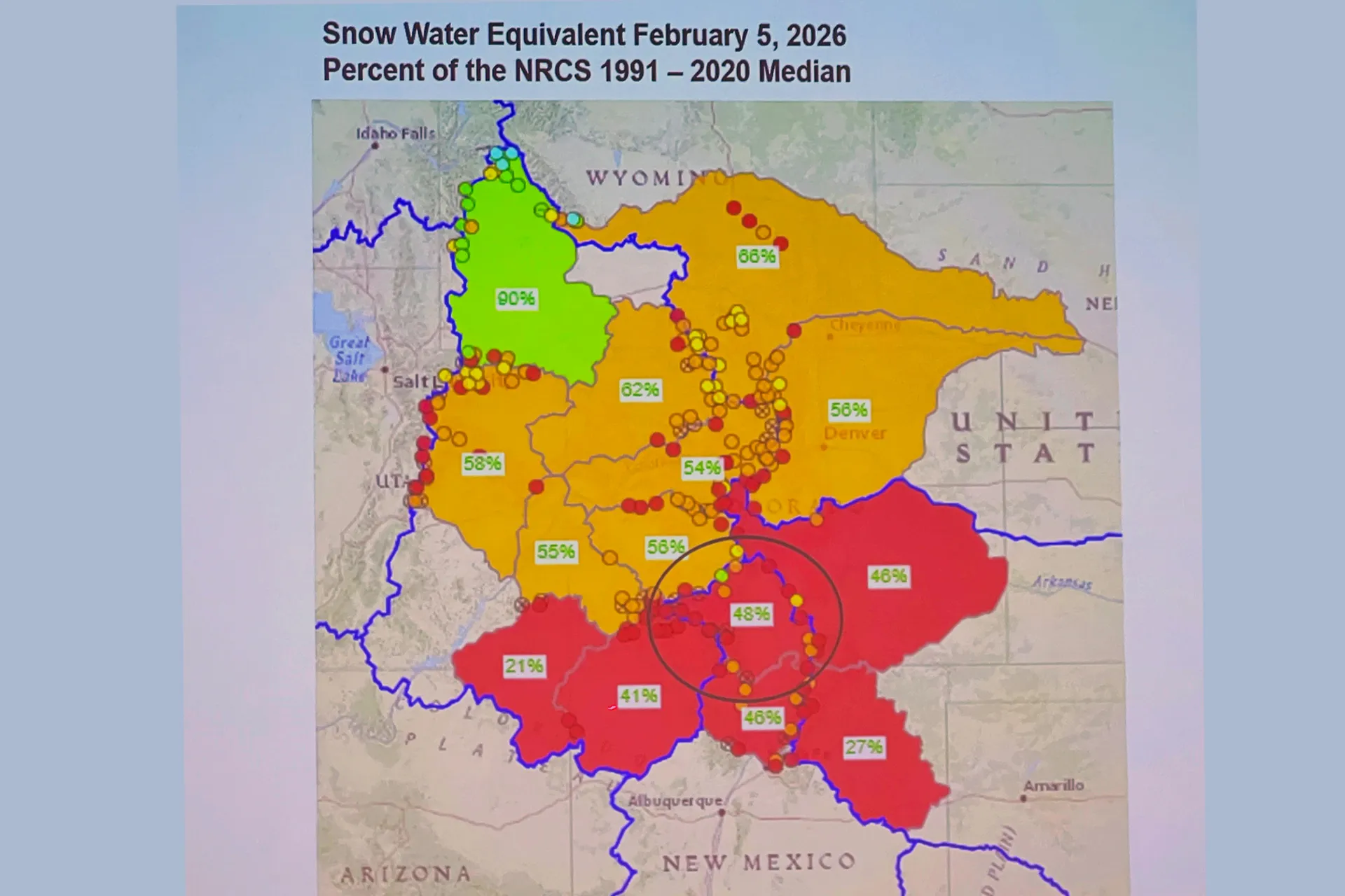
February’s current conditions
Statewide snowpack: 55 percent of median
Upper Rio Grande snowpack: 48 percent of median
Warmest December on record for nine western states based on 131 years of temperature data.
Nathan Coombs and Heather Dutton, both key players in the water conservation world locally and at the state level, gave further explanation on the changing weather patterns that are impacting the basin and the amount of water available for irrigation.
Coombs pointed to the problem of overnight temperatures in the late fall and winter months, and the fact the Valley just isn’t getting the sub-zero temperatures it used to.
Look at December 2025, which saw an average daily low for the month of 11 degrees – double digits overnight – when the normal low for December is 0.8 degrees. January of this year had an average daily low of 4 degrees instead of the -1 that is a normal overnight low temperature for the month. It would have been higher than 4 degrees were it not for sub-zero overnight lows in 5 of the last 7 nights of January.
“We’re not sunburning that much harder, we’re just losing the cold,” Coombs said to his fellow farmers.
The timing of when the moisture comes is off, too. Look at the past two water years – 2024 and 2025 – when heavy rains in October came through and added to the total overall amount of water in the Rio Grande and Conejos River systems.
Too late to help irrigators, but good enough to help the amount of water in the Rio Grande and Conejos River, overall.
“Look at how it’s changing,” Coombs said. “Useful water for irrigation is changing in more ways than just volumes. We’re seeing timing change. So that’s part of what this is. Mother Nature is playing a big role in this. We’ve got to figure that component out a little better. We don’t need to look across the fence at what our neighbors are or aren’t doing. Let’s figure out how we correct to that.”
Rio Grande and Pecos River basins. Map credit: By Kmusser – Own work, Elevation data from SRTM, drainage basin from GTOPO [1], U.S. stream from the National Atlas [2], all other features from Vector Map., CC BY-SA 3.0, https://commons.wikimedia.org/w/index.php?curid=11218868
Sen. Mike Lee, the MAGAt from Utah, appears to be vying to be the most anti-public land politician in history. The Trump sycophant was, of course, behind last year’s congressional bids to sell off public land to real estate developers and various other schemes. His latest assault is the Historic Roadways Protection Act, which passed through a Senate committee yesterday. It would block the Bureau of Land Management from “closing historical roads” and implementing travel management plans across a broad swath of federal lands in Utah until a federal court rules on thousands of county RS-2477 claims.
RS-2477 is an 1866 statute that allowed highways to be constructed across federal lands to access mining claims and homesteads. It was repealed in 1976 when Congress passed the Federal Land Policy Management Act, or FLPMA. But FLPMA grandfathered in existing “highways” that had been constructed under RS-2477. In 2010 and 2011, Utah and its counties filed some 12,000 RS-2477 claims on about 35,000 miles of “highways” on federal lands, many of which are no more than old livestock tracks, in hope of gaining control of the paths so they can grade them, widen them, and even pave them. Settling all of these claims could take decades, meaning Lee’s bill would essentially be banning the BLM from managing travel on these areas forever.
Albert Bacon Fall, the New Mexico Senator and disgraced Interior Secretary under President Warren G. Harding still has my vote for the most anti-public land politician. But maybe that’s because Fall was actually a colorful character. Lee’s most interesting trait is that he holds Jell-O socials in his Capitol office.
One of the things I like about Page, Arizona, are the weird and ubiquitous contrasts that characterize the place. There’s the surreality of a lakeside city in the desert and the striking juxtaposition of golf course greens against stone. But perhaps the most jarring of all is the sensation of wandering Safeway’s aisles in a distinctly American town and hearing fellow patrons speaking languages from all over the world.
The Southwest attracts visitors from across the globe and, as a result, the increasingly dominant tourism and outdoor recreation industries have come to depend on international travelers. After Trump was inaugurated and implemented his America First creed, which tends to manifest as hostility towards every other nation, international travel to the U.S. dropped. That’s in spite of the fact that Trump’s economic policies have also caused the dollar’s value to plummet, making the U.S. a cheap vacation spot for Europeans.
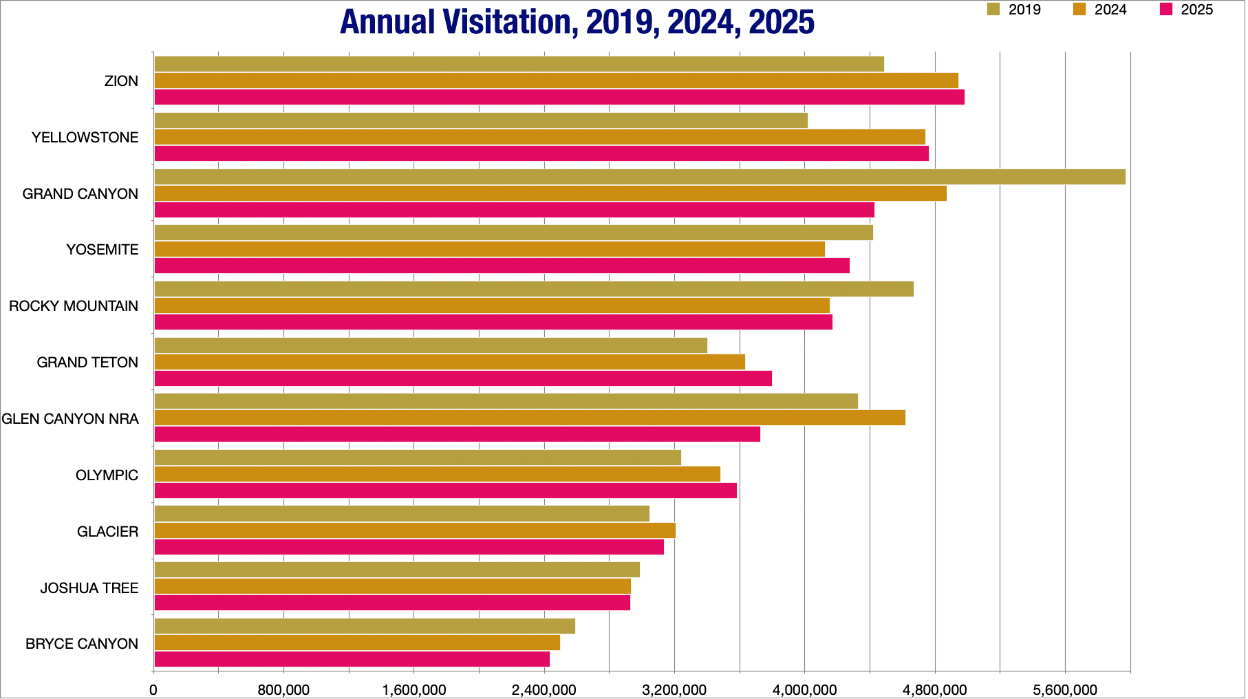
Over the summer of 2025, that appears to have led to a drop in visitation to most national parks in the Southwest. However, visitation tended to rebound in the fall — perhaps due to lower gas prices — bringing the annual numbers back up to close to what they were in 2024.
One exception was Glen Canyon National Recreation Area, which saw a huge drop in visitors last year, probably due to a combination of low reservoir levels at Lake Powell, a massive wildfire on the Grand Canyon’s North Rim, and the drop in international visitation. But if tax revenues are any indication, it hasn’t hurt the overall tourism industry in Page that badly. Sales tax, hotel/motel tax, and online lodging tax revenues for January through September 2025 were up significantly from the previous year, according to the City of Page’s statistics.
Grand Canyon NP and Glen Canyon National Recreation Area saw the biggest drops in year-over-year visitation in 2025, which may be due to a fire on the Grand Canyon’s North Rim and the drop in international travel to the U.S. Visitation continues to grow at Yellowstone, Grand Teton, and Olympic National Parks. Source: NPS.
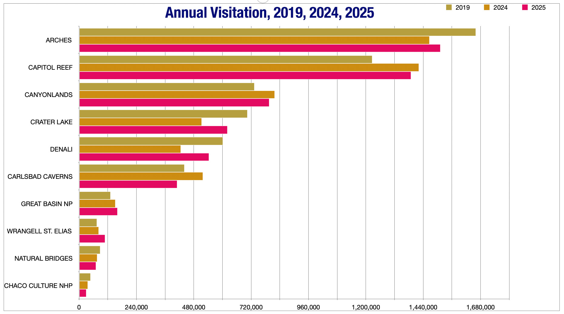
Arches National Park saw a marked decrease in visitation following the implementation of a timed entry system in 2022, but since then it has held steady and increased between 2024 and 2025. Most other Southwest national park units saw a decrease in visitation last year, however.
🏠 Random Real Estate Room 🤑
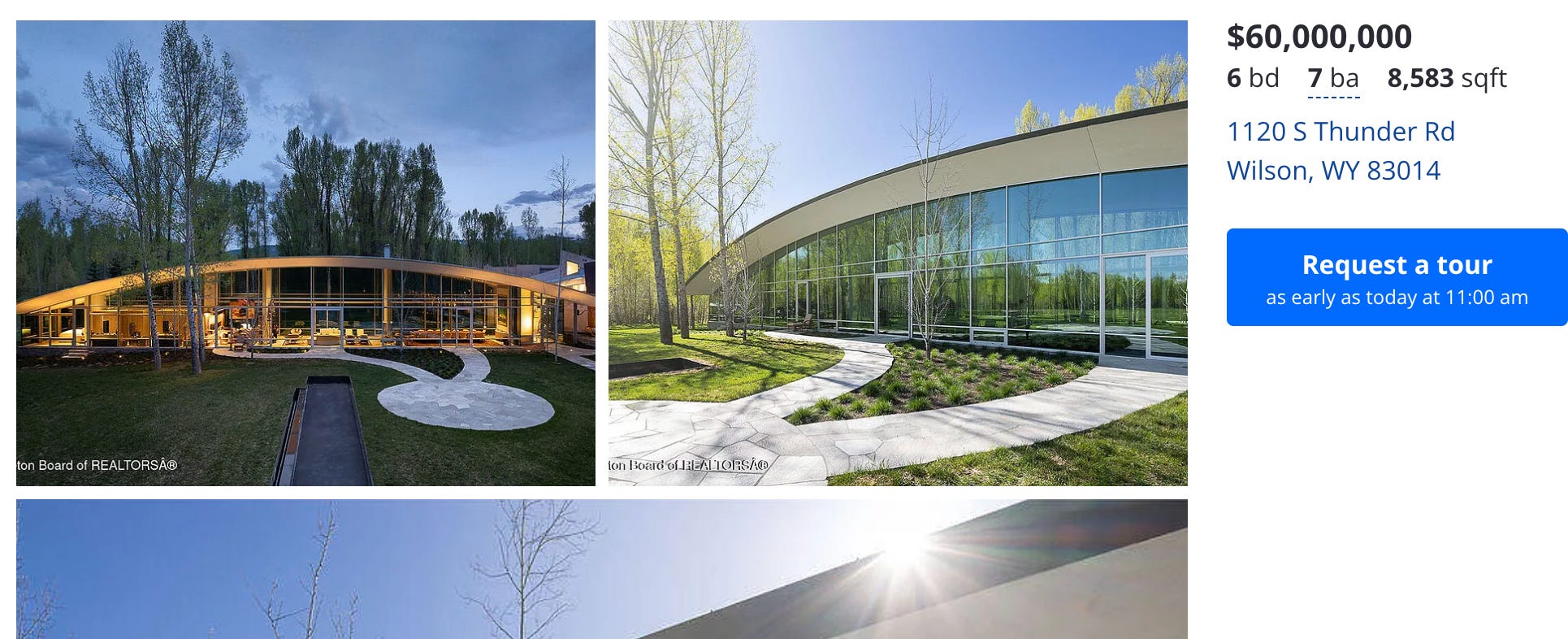
The most expensive home on the market in Jackson Hole currently. Source: Zillow.
You’ll all be thrilled, I’m sure, to learn that the uber-wealthy had a pretty good year in 2025, at least if high-end home and land sales are any indication. Luxury real estate sales in Jackson, Wyoming, reportedly are “surging” and “closed the year with exceptional momentum.” That’s the latest from The Viehman Group’s Jackson Hole Report, something I read when I want that lovely sensation of barfing in the back of my mouth.
Thirty-seven homes sold for over $10 million in the region last year, with 25 of them netting a sale price of over $15 million. The most expensive home sale was the Bar B Bar Ranch 4, with “multiple enhanced spring creeks for fishing,” which went for a modest $43 million.
But don’t worry! Overpriced luxury homes remain for the taking! For instance, you can buy a glorified quonset hut — er, an 8,583-square-foot steel, glass, and stone mansion — for $60 million. I know that seems like a lot, but according to Zillow’s BuyAbility calculator, the monthly payments would be a mere $320,673 after a $12 million down payment.
The median earnings for full-time year-round workers in Teton County are about $70,000 per year, which, according to Zillow’s mortgage calculator, could allow one to afford a $220,000 home with a $10,000 down payment. Meanwhile, the median home sale price in Teton County is about $3.8 million. And the cheapest home on the market is a 1970s, 644 sf condo listed for $695,000 (after a $30k reduction).
So, yeah, the West’s housing affordability crisis is as bad as ever, and the gap between the uber-rich and everyone else continues to grow.
🥵 Aridification Watch 🐫
The Abundance movement has reached the Colorado River, brought by an unexpected flag-bearer. The motorized recreation organization, BlueRibbon Coalition, is proposing the Colorado River Abundance Act. The vision, writes the coalition, is simple: “The American Southwest does not have to settle for managing a dwindling resource. It can choose abundance and start building.”
Building what? You ask. The answer: “A coordinated suite of desalination plants — offshore, onshore, and binational — supported by pipelines, pumping systems, brine-management facilities, and sediment removal programs.” These plants would crank out as much as 7 million acre-feet of water per year and deliver it to the river and/or directly to Lower Basin water users. That would allow more water to stay in Lake Powell and Lake Mead, thereby buoying reservoir levels.
And that would, among other things, improve boating and other recreation on those reservoirs, which is why the BlueRibbon Coalition is pushing the concept. In addition to creating funds for building a massive amount of water desalination and transportation infrastructure, the proposed legislation would also “elevate recreation to a coequal project purpose, establishing Recreation Modernization Plans for key reservoirs,” and pushing major upgrades to marinas, launch ramps, docks, trails, and shoreline facilities, “including a top-priority requirement to rebuild mid-lake services at Lake Powell with fast-track approval.”
That’s referring to the late Dangling Rope Marina, a remote floating boat refueling and restocking station in Dangling Rope Canyon, located about halfway between the down-lake marinas and Halls Crossing in the upper section of the reservoir. But low water levels and a damaged electrical system forced the National Park Service to shutter it in 2021, and it has not been reopened or replaced.
This abundance approach could work, in theory. But consider this: the largest desalination plant in the world, Ras Al Khair in Saudi Arabia, can treat about 306,500 acre-feet of water per year. It reportedly cost about $7 billion to construct, and uses about 3,626 megawatt-hours of electricity each day — that adds up to 1,323 gigawatt-hours annually, or enough to power tens of thousands of homes (or a handful of data centers). You’d need about 20 of those leviathans and a crapload of generation capacity to reach the 7 MAF/yr target of this plan, not to mention the extensive pumping and piping infrastructure to get the water to where it needs to go.
At some point, doesn’t it seem just a little bit easier, and a hell of a lot less expensive, to live within our means?
I will say that the Abundance approach is a step up from a, let’s say Archimedean, proposal to raise Lake Powell’s level by, wait for it, throwing a bunch of car batteries into the reservoir. If you’re wondering if this was a serious idea or not, just consider from where it came: The Sonoran Avalanche Center.
Sonoran Avalanche Center on Instagram: “Our first song about ba…
The Land Desk has been talking a lot about the effects the low snowpack will have on water supplies, Lake Powell, and irrigators. But it’s also hurting the ski industry — Vail Resorts reported a 20% drop in skier visits this winter — and that’s hurting the communities and workers that rely on that industry. The news clip below reports on how a Summit County food bank is being overwhelmed by new demand this winter.
The median home price in Summit County, by the way, is about $995,000.
🗺️ Messing with Maps 🧭
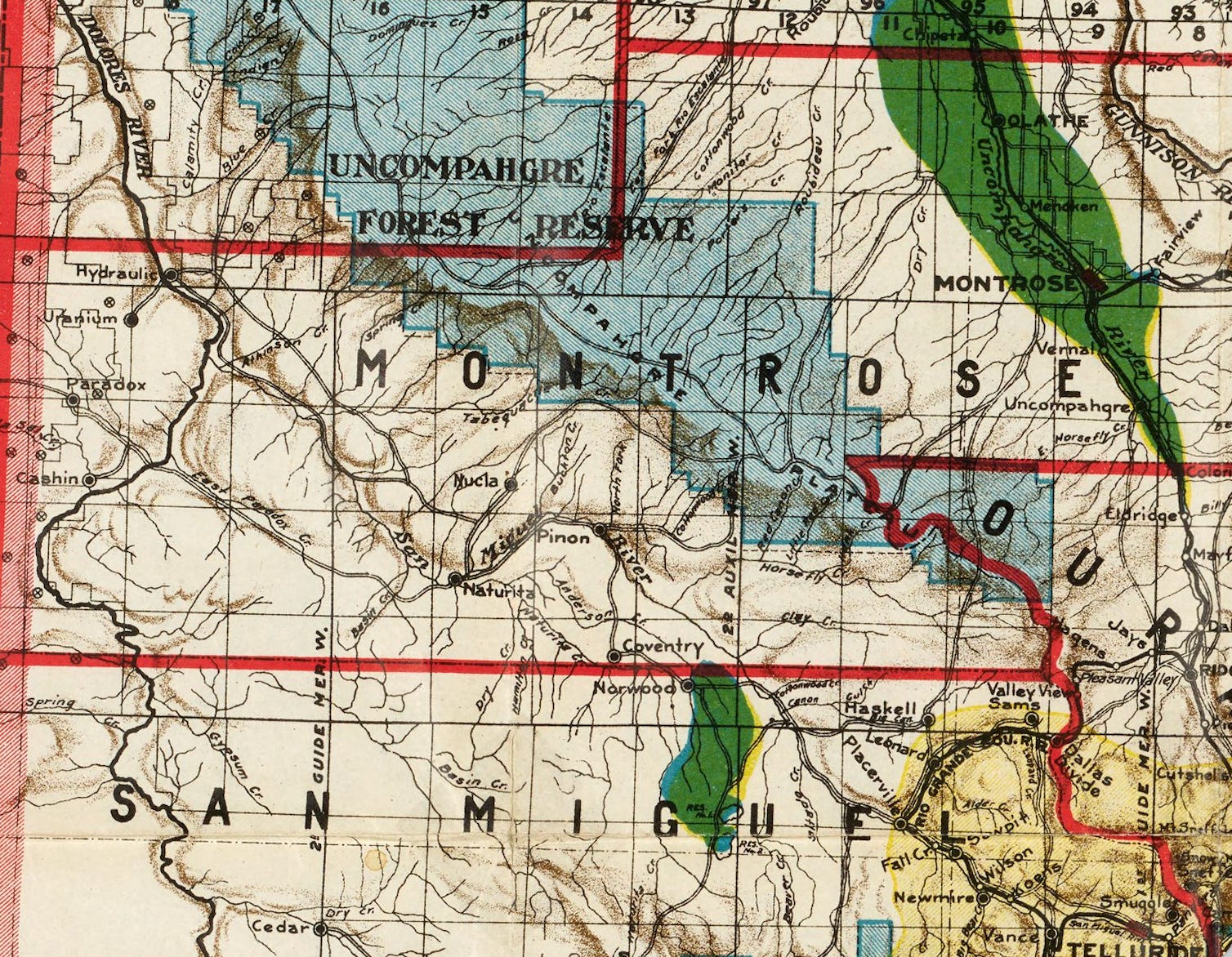
Detail from Clason’s Industrial Map of Colorado, circa 1904. Unfortunately, I only had space for one outtake from this one, so look for more in the future, because it’s cool. Note how back then the road from Naturita to Norwood followed the San Miguel River to Piñon before heading south to Coventry (which is now Redvale, I guess?). Also, the towns of Hydraulic and Uranium on the Dolores River downstream from the confluence with the San Miguel. If anyone can point out those locations on a modern map, I’d be much obliged!