Click on a thumbnail graphic to view a gallery of drought data from the US Drought Monitor website,

Click the link to go to the US Drought Monitor website. Here’s an excerpt:
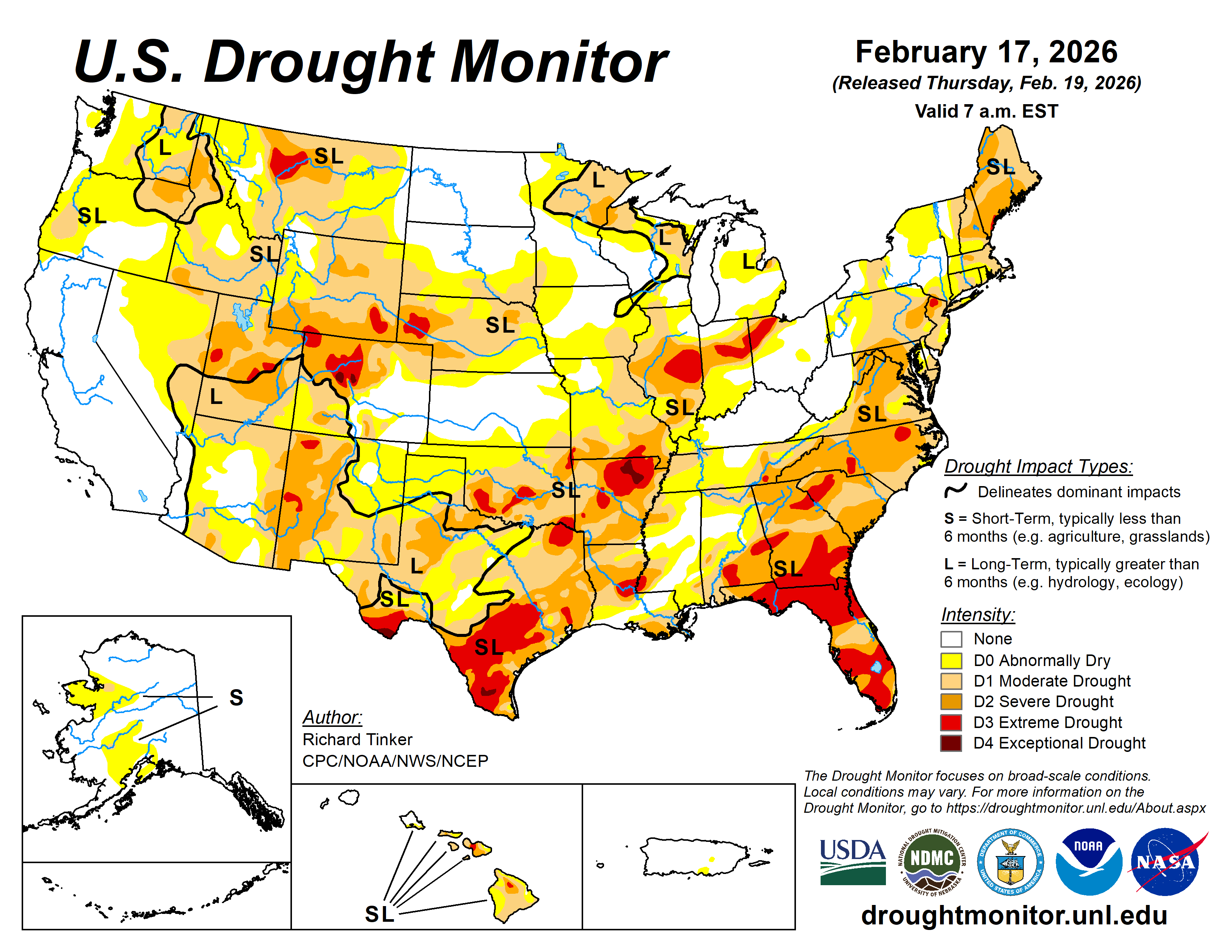
This Week’s Drought Summary
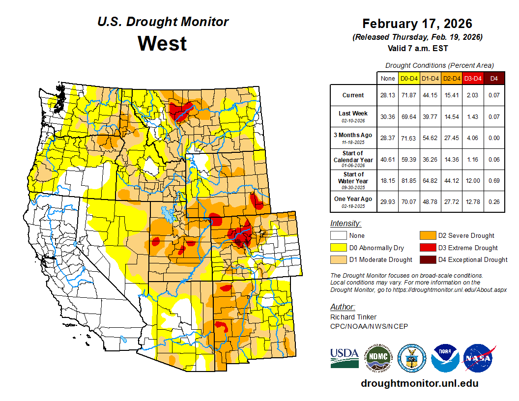
After a few warm and dry weeks, heavy precipitation returned to the West Coast States this past week; however, the heaviest amounts fell on California, which is almost completely free of dryness and drought. At least 1.5 inches fell on a large part of the state including much of the western tier, the higher elevations, and the northern Valleys. Much larger amounts fell on isolated higher-elevation and orographically-favored locations, with a few spots recording amounts approaching 10 inches (liquid-equivalent). Several feet of snow has piled up on a few spots across the Sierra Nevada, but overall the snowpack in this area remains significantly below normal. Other areas from northwestern California northward through the Cascades and points west also recorded significant amounts of precipitation, ranging from 0.5 to locally 3.0 inches. Similar amounts were more scattered across the rest of the interior West, with the largest totals confined to the highest elevations. As of early Tuesday Feb 17, this precipitation has not significantly boosted snowpack in some areas with less than normal amounts, specifically much of the Cascades, south-central Idaho, Scattered locations across western Wyoming, much of west-central and southwestern Colorado, central sections of Utah and Nevada, and the southernmost Rockies.
Farther east, moderate precipitation was fairly widespread over approximately the southeastern quarter of the contiguous states, east of the High Plains and from the central Great Plains, lower Ohio Valley, and mid-Atlantic region southward. Heavier amounts fell on scattered areas across the east-central and southeastern Great Plains, parts of the adjacent lower Mississippi Valley, and a few narrow swaths across the western Florida Panhandle and parts of the northern Peninsula. To the north, scattered light amounts with isolated moderate totals were recorded in upstate New York and parts of New England. Other areas across the High Plains and the northeastern quarter of the contiguous states reported little or no precipitation.
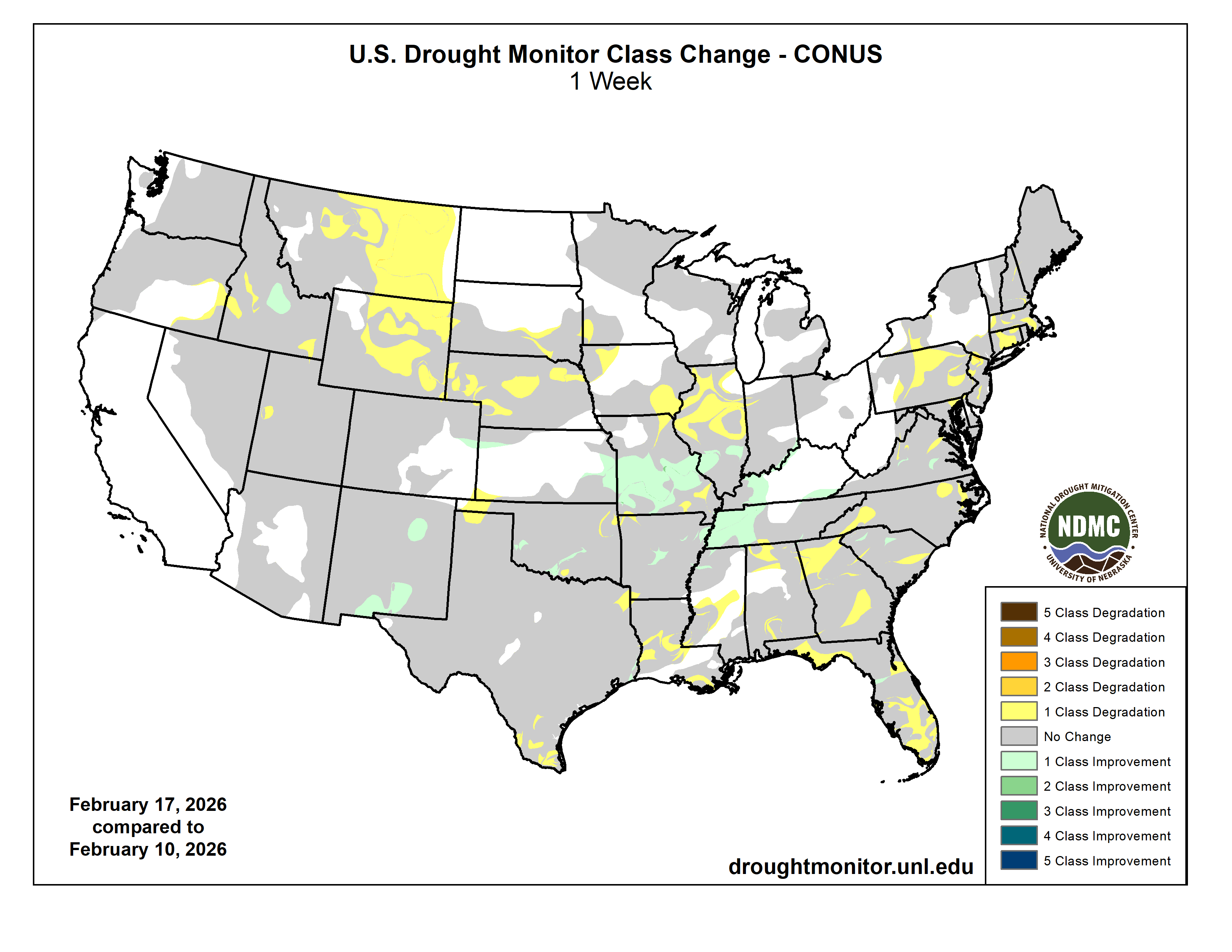
Some areas of improvement were introduced based either on this past week’s precipitation or a re-assessment of the effects from earlier storms. Specifically, improvements were introduced in central Idaho, the southwestern High Plains, and parts of the Tennessee, lower Ohio, and middle Mississippi Valleys. There was more deterioration than improvement overall, however, including areas scattered across the Eastern Seaboard, lower Mississippi Valley, Deep South, Upper Midwest, northern High Plains, and far southern Texas. Hawaii experienced areas of improvement for the second consecutive week while Alaska and most dry areas in Puerto Rico remained unchanged…
High Plains
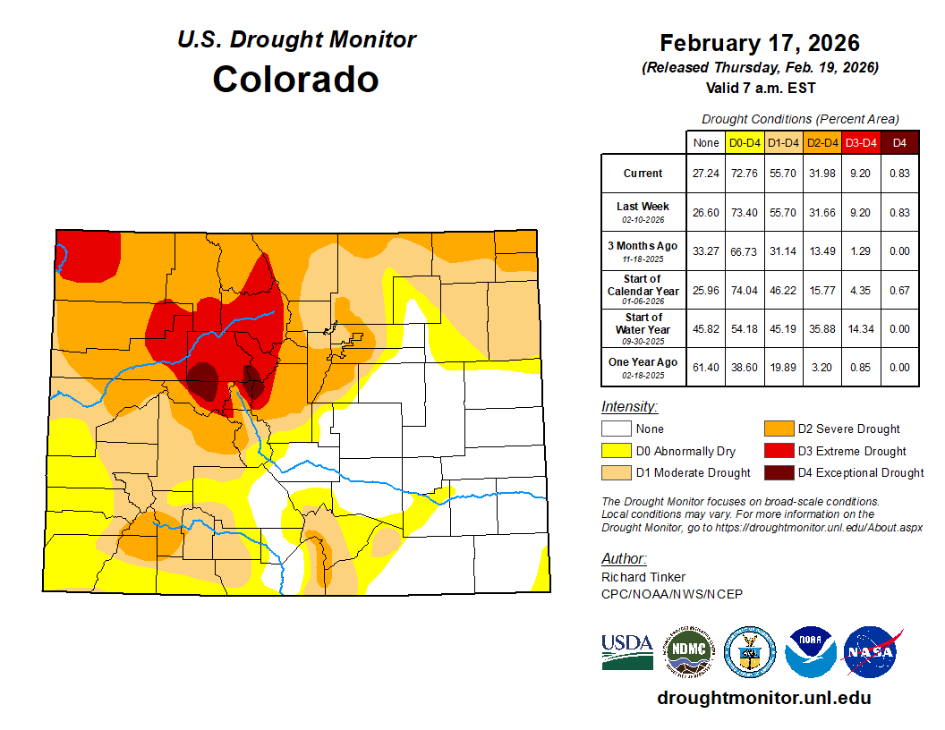
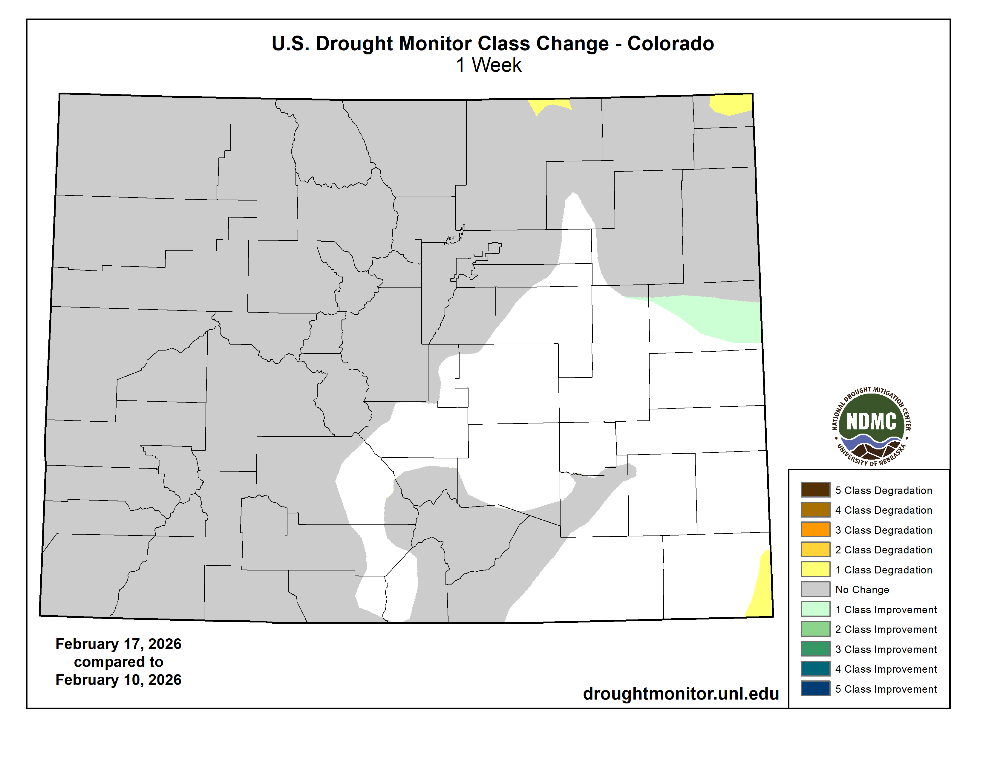
Moderate to locally heavy precipitation fell on part of eastern Kansas, and scattered light to moderate amounts fell on the rest of the southern tier of the Region. Farther north, however, scant precipitation led to large areas of degradation across a large proportion of Wyoming and central through eastern Montana, with more limited deterioration introduced across parts of Nebraska and South Dakota. This resulted in moderate drought or worse covering a swath across most of Nebraska and adjacent areas westward through most of Wyoming and the northern, central, and western sections of Colorado. Severe drought (D2) or worse is widespread from western Nebraska across the southern tier of Wyoming through northern and central parts of Colorado…
West
Heavy precipitation was fairly widespread across California, which is currently almost completely devoid of any degree of dryness or drought. Elsewhere, widespread deterioration was introduced across central and eastern Montana, leaving most of the state entrenched in abnormal dryness to severe drought (D0 to D2), with an area of extreme drought in parts of north-central Montana. Elsewhere, only minor adjustments were made as light to moderate precipitation fell on a large part of the areas of dryness and drought – enough to preclude widespread deterioration, but not sufficient to justify much improvement. Only a few parts of central and south-central New Mexico were improved, primarily from the effects of precipitation prior to last week. Severe to extree drought (D2-D3) now extends across most of the western half of New Mexico, adjacent4 Arizona, central and northern Utah, parts of northern and southwestern Idaho, and parts of Pacific Northwest east of the Cascades…
South
Heavy precipitation (3 to locally 5 inches) dropped on a swath through central Arkansas while 1.5 to locally 3.0 inches were recorded from the lower Red River (south) Valley through the central tier of Arkansas into much of western Tennessee. Moderate to locally heavy amounts were observed over much of the west side of the lower Mississippi Valley and portions of eastern Texas. Amounts of several tenths of an inch to locally around an inch were reported across a large part of central and north-central Texas, most of Oklahoma east of the Panhandle, much of Mississippi and western Alabama, and eastern sections of Tennessee. Little or no precipitation was reported across the Texas and Oklahoma Panhandles, western Texas, and Deep South Texas. This pattern supported improvement across the western half of Tennessee and smaller areas of Arkansas and northwestern Mississippi, along with scattered spots across southern Oklahoma. Deterioration was fairly common in areas that missed most of the week’s precipitation, primarily in the lower Mississippi Valley, the immediate ArkLaTex region, and Deep South Texas. Intensifying dryness in the latter area prompted the introduction of exceptional drought (D4) in parts of Jim Hogg and Brooks Counties. D4 already existed in part of interior northeastern Arkansas and the southernmost reaches of the Texas Big Bend. Meanwhile, extreme drought (D3) expanded to cover most of south-central and Deep South Texas, parts of east-central Louisiana and adjacent Mississippi, portions of southern Oklahoma and northeastern Texas, most of northeastern Arkansas, and a few smaller scattered areas in western Arkansas and northeastern Oklahoma. During the past 90 days, fewer than 2 inches of precipitation have fallen on western Oklahoma, the Texas Panhandle, and the southwestern tier of Texas from the Big Bend into much of Deep South Texas…
Looking Ahead
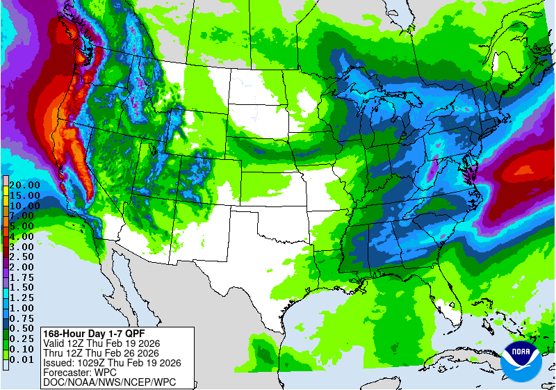
The heaviest precipitation over the next few days is forecast along and near part of the West Coast, with at least 2 inches expected across northwestern California, the southern Cascades, and the central and northern Sierra Nevada. Up to 7 inches may fall in isolated higher elevations, most or all of which would be snow. Meanwhile, moderate to heavy amounts (0.5 to 2.0 inches) are forecast across Washington and Oregon from the Cascades westward. Similar amounts are forecast for the northern Great Lakes, and most locations from the Deep South through central New England, with lesser amounts expected over much of the central and northern Carolinas. There is a lot of uncertainty in this area, depending on the development and track of an East Coast storm system that could affect the mid-Atlantic and lower Northeast over the weekend. Light to moderate totals are anticipated over a large part of the interior West, including the Great Basin, much of the northern Intermountain West, and the higher elevations across the Rockies. Several tenths of an inch are possible across the lower Great Lakes, middle and lower Ohio Valley, and the east side of the lower Mississippi Valley. Little or no precipitation is expected across the northern and southern Plains, southern Florida, and northern Maine. Above-normal temperatures are expected from the Southwest through most of the Plains, with many locations expected to average 5 to 11 deg. F above normal. In contrast, subnormal temperatures are forecast in the northernmost Plains, where daily highs could average as much as 9 deg. F below normal. Meanwhile, 5-day average anomalies are expected to range from -2 to -5 deg. F across northern California as well as the Ohio Valley and many locations farther east.
The 6- to 10-day outlook for February 24-28 depicts increased chances for below-normal precipitation across much of the southern tier of the contiguous U.S., from the extreme southern Rockies through the central Gulf Coast and most of Florida. Chances for abnormal dryness exceed 40 percent across most of Texas and some adjacent areas. Farther north, heavier than normal precipitation is at least nominally favored from the mid-Atlantic, southern Appalachians, central Plains, and Desert Southwest northward to the Canadian border. Chances for unusually unsettled weather exceed 60 percent across central and northern California, and top 50 percent central California northward across western Washington and Oregon, as well as the middle and lower Ohio Valley. In Alaska, drier than normal conditions are favored along western parts of the state while surplus amounts are more likely over eastern areas. Across Hawaii, above-normal amounts are marginally favored statewide. Meanwhile, warmer than normal weather is expected to dominate the contiguous 48 states from the Appalachians to the Intermountain West, with chances for significantly warmer than normal conditions topping 80 percent in western Texas. Areas somewhat favoring below-normal temperatures are restricted to the West Coast west of the Cascades, and over much of the Florida Peninsula. Considerably higher chances for unusually cold weather cover most of Alaska, reaching above 70 percent in southwestern parts of the state. In contrast, warmer than normal conditions are somewhat favored across Hawaii, especially across Kauai, Oahu, and the southern Big Island.