Due to the increasing severity of the ongoing drought, and in an effort to conserve as much water as possible, the Bureau of Reclamation will decrease the release from Navajo Dam to 250 cubic feet per second (cfs) on Monday, March 16, at 8:00 AM.
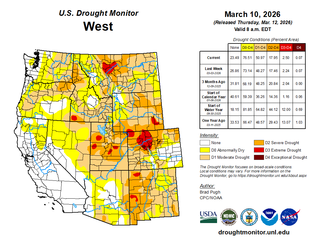
West Drought Monitor map March 10, 2026.
This change provides an opportunity to conserve approximately 1,500 acre-feet of stored water during the remainder of March while downstream targets are being met by side inflows.
Releases from Navajo Dam are made for the authorized purposes of the Navajo Unit and to support base flows through the endangered fish critical habitat reach of the San Juan River (Farmington to Lake Powell). The San Juan River Basin Recovery Implementation Program recommends a target base flow of between 500 cfs and 1,000 cfs through the critical habitat area. The target base flow is calculated as the weekly average of gaged flows throughout the critical habitat reach from Farmington to Lake Powell.
This scheduled release change is subject to adjustment based on river flows and weather conditions.
Map of the San Juan River, a tributary of the Colorado River, in Arizona, Colorado, New Mexico and Utah, USA. Made using USGS National Map data. By Shannon1 – Own work, CC BY-SA 4.0, https://commons.wikimedia.org/w/index.php?curid=47456307
Click the link to read the update on the NIDIS website. Here’s an excerpt:
March 12, 2026
Record Snowpack Deficits Worsen in February; Conditions Expected to Deteriorate Further with Chances for Record Heat
Key Points
Snow drought worsened from February into early March due to record warmth, despite near-normal precipitation across much of the West. Some locations, such as the central and northern Cascades in Washington, were also drier than normal during this period. Every major river basin and state in the West is experiencing a snow drought.
Record-breaking high temperatures are forecasted for large parts of the West. Further, the 6-10 and 8-14 day outlooks from NOAA’s Climate Prediction Center lean toward drier-than-normal conditions for almost all of the West along with a strong probability of warmer-than-normal temperatures through March. Record-breaking snow drought conditions are expected to further deteriorate as snow melt begins much earlier for some.
Every major river basin in the West experienced its first or second warmest winter (December, January, and February) on record. The Great Basin, Rio Grande, Arkansas-White-Red, and Upper and Lower Colorado River Basins experienced their warmest winter on record, while the Missouri and Columbia River Basins recorded their second warmest.
As of March 8, Colorado reported record-low statewide snowpack. Stations in the Cascade Range in Oregon and Washington are reporting the greatest snowpack deficits in the West. Some states, such as California, are already experiencing an early melt out of snow.
The Colorado River Basin reports record-low snow water equivalent (SWE).
Basins like the Deschutes, Humboldt, Yakima, and Rio Grande continue to see snow drought conditions deteriorate.
Snow drought impacts are occurring and are expected to worsen. Municipal and agricultural water supply concerns and restrictions are increasing.
The Bureau of Reclamation’s most probable forecast for Lake Powell shows minimum power pool elevation being reached by December 2026. If the water drops below this point, the Glen Canyon Dam may no longer generate hydroelectricity.
The Bureau of Reclamation’s initial April–September water supply forecast for the Yakima Basin has those with pro-ratable water rights only receiving 44% of their full water allotments.
The North Platte River Basin is under priority administration issued by the Wyoming State Engineer’s Office based on the Modified North Platte Decree.
Snow Drought Conditions Summary
This update is based on data available as of Monday, March 9, 2026 at 12:00 a.m. PT. We acknowledge that conditions are evolving.
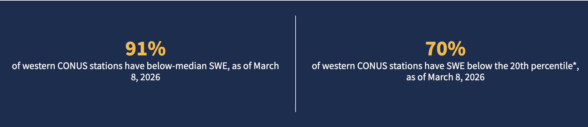
Quantifying snow drought values is an ongoing research effort. Here, we define snow drought as snow water equivalent (SWE) at or below the 20th percentile, which is a baseline guided by partner expertise and research. Note that reporting of SWE by Snow Telemetry (SNOTEL) stations may be unavailable or delayed due to technical, weather or other issues, which may affect snow drought depiction in this update.
Current Conditions
The last three months (December, January, and February) were the warmest or tied the warmest winter on record dating back to 1895 for Arizona, Colorado, Nevada, New Mexico, Oregon, Utah, and Wyoming. Arizona and New Mexico broke their previous records set in 2015 and 1907, respectively, by over 2°F. California, Idaho, and Montana experienced their second warmest winter on record; Washington experienced its fourth warmest.
Coming off of a record-dry January, near-normal precipitation fell over most, but not all, of the West in February and early March. Precipitation deficits are increasing in parts of Colorado, the Washington Cascades, New Mexico, Arizona, and the plains of Wyoming and Montana.
This winter brought record flooding, rain-on-snow events, record-warm temperatures, and record dryness across the West. Because of these conditions, snow melted early in many places and failed to accumulate in middle and lower elevations. Snow fell and is currently present at higher elevations where temperatures were cold enough to produce snow, but high-elevation snow does not offset overall deficits from the absence of middle and low-elevation snowpack. As a result, snowpack remains extremely low across the West. Some minor improvements occurred in some basins over the last month, but there was not enough snow to offset the substantial deficits.
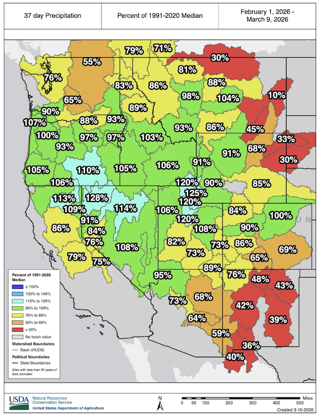
If Precipitation Fell, It Fell as Rain for Many
February 1–March 9, 2026 precipitation for Hydrologic Unit Code (HUC) 6 basins across the West, shown as a percentage of the 1991-2020 median. Red hues indicate basins that received less than 50% of normal precipitation for this period. Only stations with at least 20 years of data are included in the station percentiles. Values are averages of high-elevation precipitation at SNOTEL stations and are not representative of all portions of the HUC, which extend to lower-elevation valleys. For an interactive version of this map, please visit the USDA Natural Resources Conservation Service (NRCS). Source: USDA NRCS.
Winter Concludes as the Record Warmest for Much of the West
December-February mean temperature percentiles based on an 1895-2026 period of record. Red hues indicate temperatures in the top third (warmest) of historical conditions, while blue hues indicate temperatures in the lowest third (coldest) of historical conditions. Graphic is from the Western Regional Climate Center’s Westwide Drought Tracker and the source data are from the PRISM Climate Group.
Winter Ends With More Record-Low Snow
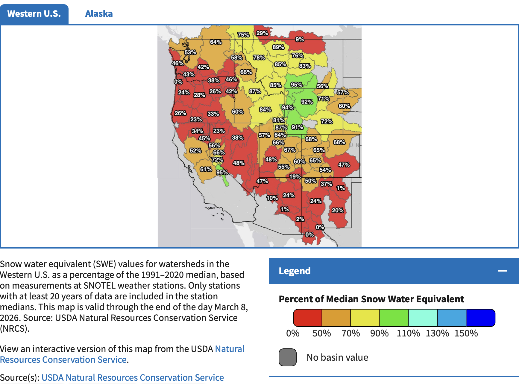
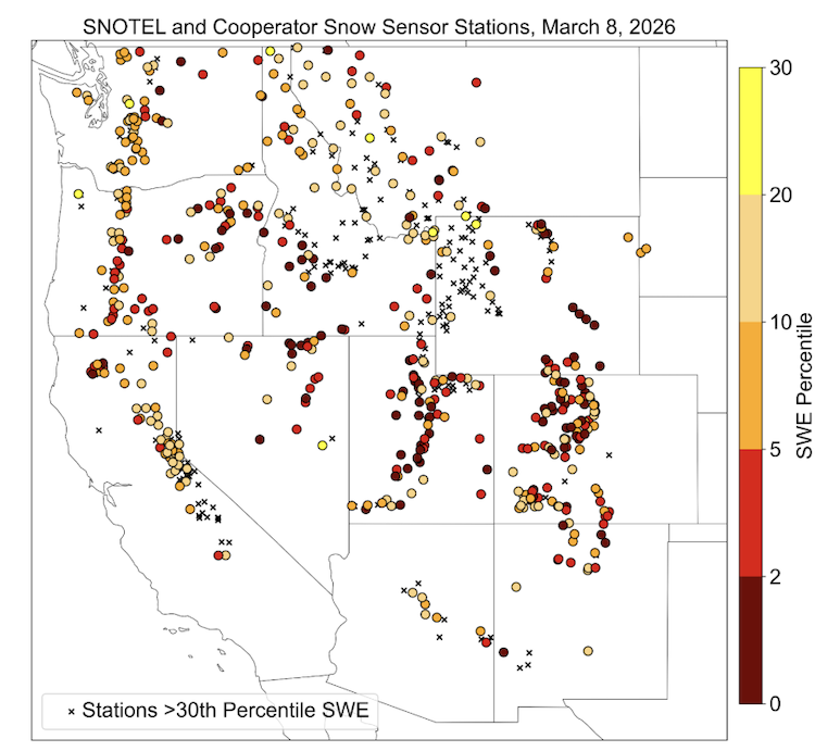
SNOTEL and Cooperator Snow Sensor sites in the Western U.S. with snow water equivalent (SWE) values at or below the 30th percentile as of March 8, 2026. Stations above the 30th percentile are shown with a black “x.” We define snow drought as SWE below the 20th percentile (red, orange, and tan hues). This analysis only used stations with at least 20 years of data. This map does not show stations where the median SWE value for the date is zero. Data source: USDA Natural Resources Conservation Service.
Snow drought conditions continue to be widespread across the region. Lower to mid-elevation and plains snowpack is almost non-existent across Idaho, Montana, and Wyoming. February precipitation was near-to-above normal, except over northern Montana, as well as central and eastern Wyoming, which saw substantial precipitation deficits. Record-breaking warm temperatures in February worsened snow drought as precipitation that fell did so as rain. Snow accumulated mostly at the highest elevations across the Northern Rocky Mountains.
Snow water equivalent (SWE) in Idaho is 58-87% of median, with many SNOTEL stations in southwestern Idaho reporting record-low values. Record-low SWE is occurring at many SNOTEL stations across Wyoming’s Big Horn and Laramie Mountains. In western Montana, SWE is 78-95% of median, with several stations reporting record-low SWE values across the state.
Central Rocky Mountains
74% of stations in Utah are in snow drought
97% of stations in Colorado are in snow drought
Despite snowfall in February, snow drought continued across the Central Rocky Mountains of Colorado and Utah. Colorado experienced its warmest February on record, and Utah its third warmest on record. Though snow water equivalent (SWE) as a percent of median improved over the last month, seasonal deficits are so great that snow drought and record-low SWE persists in much of the region. For example, from February 10-20 several snow storms brought substantial, needed snow across the state of Colorado. However, the snow was not enough to alleviate deficits, and statewide average SWE remained at a record low.
Both the Upper and Lower Colorado River Basin are reporting record-low SWE. USDA Natural Resources Conservation Service’s SWE projections for the Upper Colorado River Basin indicate that the most likely scenario peak SWE is around 10-30% of normal. These values could change depending on how conditions evolve. In Colorado, SWE in 1977 and 1981 was lower than in 2026, according to long-term snow course records with at least 50 years of data. However, this was due to less precipitation. Winter 2026 was much warmer than the winters of 1977 and 1981, while those years were much drier than this year.
Colorado statewide average SWE is at its record low, 63% of median. Utah statewide average SWE is the second lowest on record at 65% of median. All basins in the Central Rocky Mountains are below 70% of median SWE, except small portions of the Green River Basin in northeast Utah.
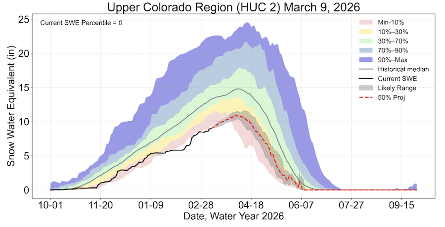
Record-Low Snow Water Equivalent Since Mid-January in the Upper Colorado River Basin
Water year observed (black line) and projected (dashed red line) accumulated snow water equivalent (SWE, in inches) in the Upper Colorado Region HUC 2 watershed. Water Year 2026 conditions are compared to the 1990-2020 median (gray line) and to the bottom 10th percentile of historical conditions (red), 10th-30th percentile (yellow), 30th-70th percentile (green), 70th-90th percentile (light blue), and 90th-100th percentile (dark blue). Valid March 9, 2026. SWE projections are based on historical observations and do not include future forecast data. The 50th percentile SWE projection is indicated by the dashed red line and the likely (30th-70th percentile) range by gray shading. Source: USDA Natural Resources Conservation Service (NRCS).
Looking Ahead
Temperature and Precipitation Outlooks
Record-breaking high temperatures are forecasted for large parts of the West next week. Further, the 6-10 and 8-14 day outlooks from NOAA’s Climate Prediction Center lean toward drier-than-normal conditions for almost all of the West along with a strong probability of warmer-than-normal temperatures through March. Record-breaking snow drought conditions are expected to further deteriorate as snowmelt begins much earlier for some. Additional, early snow loss at middle- and low-elevation stations is likely to occur over the next two weeks. Some basins may melt completely weeks earlier than normal. These forecasted conditions would increase already critical water supply concerns across the West…
Water Supply Forecasts
Many regions are likely to see earlier and lower than usual runoff. Water supply forecasts from the Colorado Basin River Forecast Center are well-below average, with most sites forecasted to see less than 70% of average season runoff. The forecasted unregulated inflow into Lake Powell is only 35% of average, which would be the fifth driest over the historical record. Seasonal water supply forecasted volumes from the California-Nevada River Forecast Center dropped significantly after the late February snowmelt event in the Sierra Nevada, and most locations are forecasted to receive less than 70% of median April–July runoff. In the Northwest, April–September runoff volume forecasts are mostly near to below normal, according to the Northwest River Forecast Center. Forecasts from the Missouri Basin River Forecast Center range around 78% of average for the Missouri Basin above Fort Peck, Montana.
Wildfire
Without the presence of snow across the landscape, soils and plants may begin to dry out earlier than usual. Due to the record-breaking warmth this year, high temperatures can lead to increased and rapid dry down of the landscape, again leading to an early start to the fire season. An extended fire season is a critical concern but does not guarantee large fires, as ignitions would still be required to generate large wildfires.
For More Information, Contact:
Dan McEvoy Desert Research Institute, Western Regional Climate Center daniel.mcevoy@dri.edu
Jason Gerlich University of Colorado Boulder Cooperative Institute for Research in Environmental Sciences / NOAA’s National Integrated Drought Information System jason.gerlich@noaa.gov
Amanda Sheffield University of Colorado Boulder Cooperative Institute for Research in Environmental Sciences / NOAA’s National Integrated Drought Information System amanda.sheffield@noaa.gov
More than a year after a landmark $100 million environmental settlement designed to improve the Poudre River was OK’d, little progress has been made to put the agreement into action.
The settlement, signed last February, came after Save The Poudre sued to stop the $2.7 billion Northern Integrated Supply Project (NISP). The deal was crafted to allow NISP to move forward while paying to improve the Poudre and protect it from any harm the project could cause.
The Northern Integrated Supply Project, currently estimated at $2 billion, would create two new reservoirs and a system of pipelines to capture more drinking water for 15 community water suppliers. An environmental group is now suing the Army Corps of Engineers over a key permit for Northern Water’s proposal. (Save the Poudre lawsuit, from Northern Water project pages)
NISP is designed to serve roughly one dozen fast-growing cities along the Northern Front Range and will include two reservoirs and a pipeline.
The Community Foundation of Northern Colorado is leading the effort to implement the settlement, which includes projects that will make the river healthier for fish and aquatic habitat, improve water flows and water quality, and increase recreational opportunities.
The foundation is overseeing a six-member committee that began meeting last August. The committee will decide how to implement the ambitious environmental projects outlined in the settlement.
“We are taking time to be intentional,” said Jodie Riesenberger, the foundation’s vice president for community impact.
But work has also been slow because key payments from NISP participants to the foundation are tied to benchmarks in building the massive reservoir and pipeline system. The committee received its first $5 million payment last year when the settlement was signed and is supposed to get its next $5 million payment when construction begins, something that could have happened later this year but has since been delayed. The full $100 million is to be paid out over a 20-year period, Riesenberger said.
Since the settlement was approved, though, the project’s largest customer, the Fort Collins-Loveland Water District, has dropped out of NISP. A handful of other cities, including Evans, have also dropped out, citing concerns about soaring design and construction costs, as well as the cost of the environmental settlement.
In response, Northern Water, which is overseeing project construction, temporarily halted design work as it re-examined NISP’s size.
Now, construction isn’t likely to begin until 2027 or later, according to Northern Water spokesman Jeff Stahla.
“We did slow things down,” Stahla said, “but there is still a chance we can start in mid-2027.”
Save The Poudre River President Gary Wockner said the delays aren’t surprising.
The committee has “been moving slow because there is a lot to learn. If you want to fix problems on the river, you have to understand the river and know what the problems are,” he said.
Since the river committee began meeting in August, Riesenberger said work has focused on analyzing what the issues are and trying to figure out how and whether to spend the money they have on hand now.
The delays “don’t impact what we’re doing yet, but it could if it drags on longer. The dream is that these dollars could do transformational things for the river,” Riesenberger said.
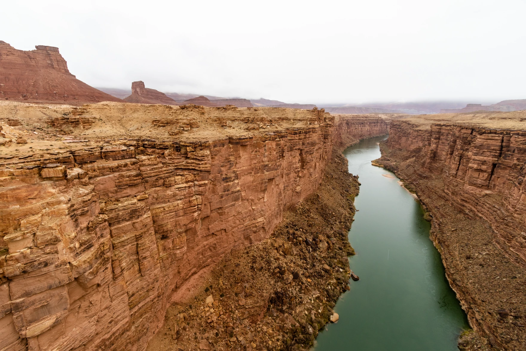
The Colorado River flows beneath Navajo Bridge in Arizona on Dec. 27, 2019. Three tribes in Arizona are pushing for a settlement that would solidify their access to the River’s water and provide billions of dollars for water infrastructure. Photo credit: Mitch Tobin/The Water Desk
Click the link to read the article on the KJZZ website (Alex Hager). Here’s an excerpt:
March 11, 2026
Coverage of tribal natural resources is supported in part by Catena Foundation
Tribal leaders and U.S. senators spoke out in support of a measure that would solidify access to water for three tribes with land in Arizona during a Wednesday [March 11, 2026] hearing at the Senate Indian Affairs Committee. The Northeastern Arizona Indian Water Rights Settlement, or NAIWRSA, would settle claims to water by the Navajo, Hopi and San Juan Southern Paiute tribes, and provide $5 billion to build new water delivery systems and help the tribes access their water. The settlement would need to be authorized by congress to go into effect. At Wednesday’s Senate committee hearing, impassioned pleas to bring water to tribal communities ran up against federal concerns about the cost of a settlement, and talks of hesitation from some states that use the Colorado River.
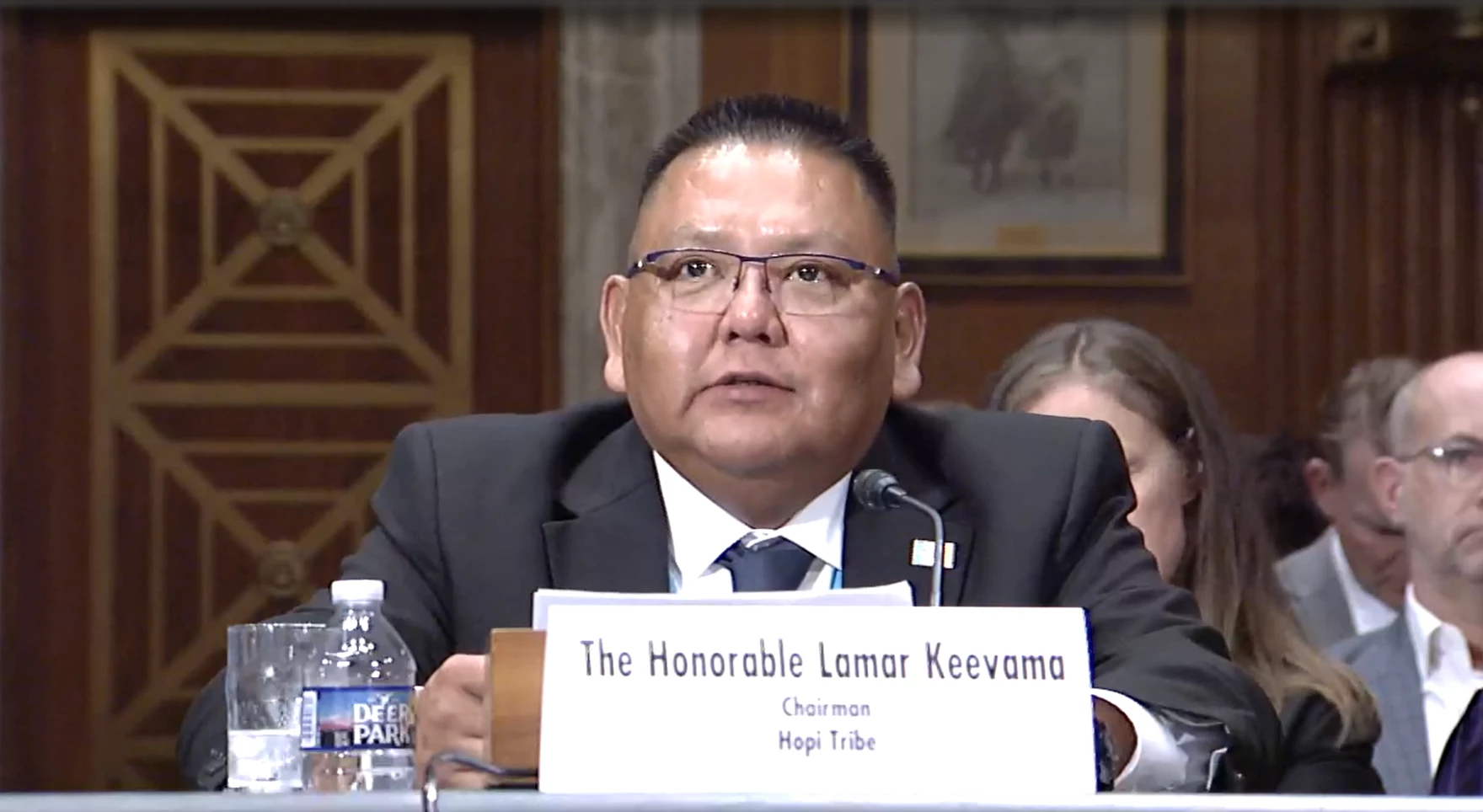
“This settlement is more than a legal agreement,” said Lamar Keevama, chairman of the Hopi Tribe. “It is a path forward. It allows the Hopi tribe to remain and protect our homeland, supports economic development and ensures that our communities have the basic resources necessary to thrive.”
An official with the Interior Department said he was supportive of the settlement’s aims, but was concerned with the cost.
“$5 billion is a lot of money,” said Scott Cameron, Interior’s principal deputy assistant secretary for water and science. “We look forward to working with the committee and with the three tribes and the other interested parties, of which there are quite a few, to see if we can’t creatively come up with some ideas to still satisfy the purposes of the bill at somewhat less cost.”
Lamar Keevama, chairman of the Hopi Tribe, testifies in front of a U.S. Senate Committee on March 11, 2026. “This settlement is more than a legal agreement,” he said. “It is a path forward.” Photo credit: U.S. Senate Committee On Indian Affairs
NAIWRSA has partially been hung up by a unique geographical challenge and longstanding tensions between states that share the Colorado River. The river, which is at the heart of settlement talks, is divided into two regions — the Upper Basin and the Lower Basin. Its water is managed by the seven states that use it, and they have been deeply split about new policies to share water. They generally fall into two camps — the Upper Basin states of Colorado, Utah, Wyoming and New Mexico, and the Lower Basin states of Arizona, California and Nevada. The Navajo Nation straddles both basins, with land in Arizona, New Mexico and Utah. Some of its land falls within a portion of Arizona that is technically part of the Upper Basin. Some Upper Basin states worry that the settlement would allow the Navajo Nation to take water from the Upper Basin and lease it for use in the Lower Basin, creating a precedent that could open the door to more transfers out of the Upper Basin. Buu Nygren, president of the Navajo Nation, pushed back on that suggestion.
“It is hard to imagine that any Upper Basin state would object to my people being able to use water that they have used for decades simply because of the fear of a potential precedent,” he said.
From the 2018 Tribal Water Study, this graphic shows the location of the 29 federally-recognized tribes in the Colorado River Basin. Map credit: USBR
Colorado’s snowpack is at its lowest in over 40 years this winter, raising alarms not only for skiers but for the many communities whose economies depend on outdoor recreation. While the lack of snow is highly visible on ski slopes, its effects stretch far beyond lift lines and even beyond Colorado’s borders.
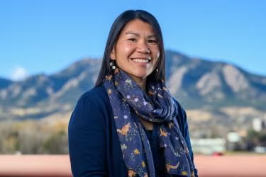
Natalie Ooi. Photo credit: University of Colorado at Boulder
Natalie Ooi, a teaching professor who is the director of the Masters of the Environment (MENV) program and leads the Sustainability in the Outdoor Industry specialization, studies sustainable tourism and recreation economies. CU Boulder Today recently spoke with Ooi about why this season stands out, how towns built around outdoor recreation can adapt, and what longer-term conversations communities across the Mountain West and beyond should be having.
How unusual is this winter’s snowpack, and what makes it significant?
Mountain and recreation-dependent communities are seasonal by nature, so they expect some year-to-year variation and understand that weather influences visitation. But as Russ Schumacher, the state climatologist at Colorado State University, has reported, this winter’s lack of snow is the most severe since SNOTEL data began in the early-mid 1980s. (SNOTEL, which stands for snowpack telemetry, is a network of backcountry weather stations that gather and transmit snowfall data.)
One of the challenges in talking about the outdoor recreation economy is that while we often focus on mountain resort communities, there are recreation-dependent communities across the entire state. What’s unique about this season is that all of Colorado is effectively experiencing drier than normal conditions. Typically, you might see some areas below average, others at or above average. This year, it’s widespread. That scale is worth highlighting.
It’s easy to focus on mountain resorts because snow—or the lack of it—is so visible. But it’s just as important to think about river-based and other recreation-dependent communities and what this will mean for them in the spring.
Beyond skiing, which activities feel the impact of a low-snow winter?
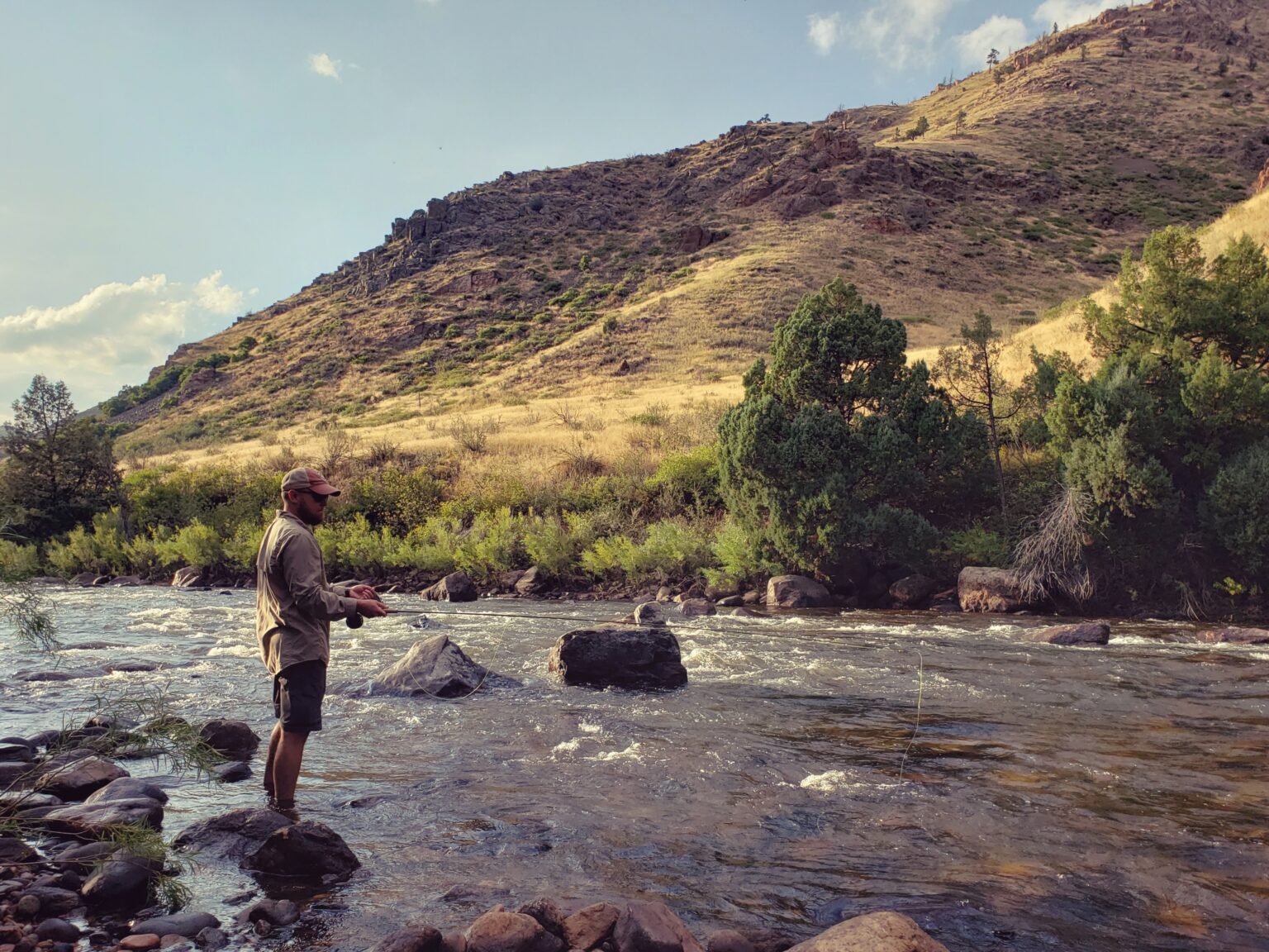
River-dependent activities like rafting, tubing and fly fishing are also affected. At these record low snowpack levels, some rivers may limit recreation from a conservation perspective to protect aquatic species and overall river health if water levels drop too low. That creates a difficult dynamic for communities whose economies depend heavily on outdoor recreation and visitation. This isn’t just about ski towns—businesses tied to camping, backpacking, guiding, gear rental, retail and campground operations also feel the effects when visitation patterns shift.
In mountain resort and ski communities, there’s always season-to-season variation. Many ski industry managers will tell you average snowfall years are actually the best for business. Too much snow can create operational challenges and even deter some visitors. But in an average year, there’s enough snow to keep serious skiers happy while still being manageable for beginners and intermediates.
Why is this season particularly hard for ski resorts?
I think this season is more challenging because you have that double whammy of not just a lack of snowfall, but high temperatures as well. If it’s cold and there’s a lack of snowfall, most ski areas can make enough snow to build a solid base and open a good percentage of terrain that the majority of visitors and residents will use. They can still operate at a capacity where people continue to ski and aren’t canceling vacations.
This year, though, the combination of low snow and high temperatures makes that much harder. It’s just not feasible to make enough snow when it won’t stick around. The energy and water demands required to make snow that quickly melts simply aren’t a sound management decision.
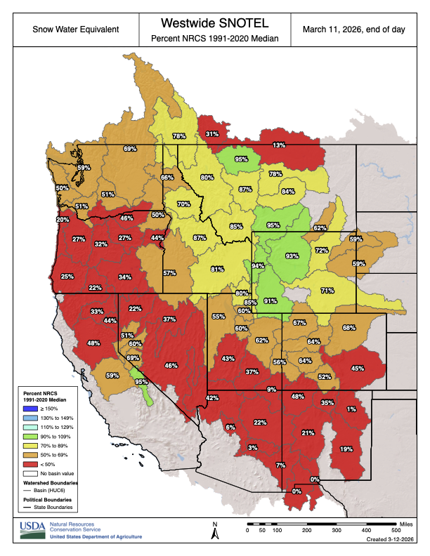
Westwide SNOTEL basin-filled map March 11, 2026.
What does low snowpack mean for spring and summer river economies?
Low snowpack affects not just total water levels but also runoff timing. Shorter, earlier runoff windows can compress rafting and fishing seasons, making it harder for outfitters to plan staffing and reservations.
How does wildfire complicate the picture?
Wildfire is a real challenge for Colorado and the West. One of the biggest issues is how far-reaching the impacts are because of smoke. There are legitimate public health and safety concerns about being outside and inhaling that level of smoke.
Even if Colorado doesn’t have a wildfire in a major tourism region, a fire in Wyoming, Utah or elsewhere can still affect the tourism season. As the climate warms and wildfire risk increases, that disruption could become more common across multiple states.
How do resorts try to adapt in the short and long term?
It’s hard to pivot in the short term. That kind of rapid adaptation is challenging. But over the years, many ski resorts have adopted diversification strategies to reduce their reliance on winter and ski tourism as their sole focus.
If you look at Alterra Mountain Company and Vail Resorts as examples, there’s a reason they own and/or manage resorts across the U.S. and internationally. This season, for instance, the East Coast is having a phenomenal year. That likely means above-average visitation and revenue there, which can help offset declines in places experiencing poor snow conditions. Geographic diversification is one key strategy.
What ripple effects are communities seeing beyond lift ticket sales?
Lift ticket revenue is obviously a key part of a ski resort’s business, but it’s not the only one. This season provides a clear illustration of that dynamic.
For example, Vail Resorts reported that season-to-date skier visits were down 20% compared to the prior year. But lift revenue was down just 1.8%. That gap is largely due to season pass sales, which provide more stable, upfront revenue.
At the same time, other categories saw much steeper declines: Ski school revenue was down nearly 15%, dining revenue down almost 16% and retail and rental revenue down about 6%.
So even when lift revenue appears relatively stable, the broader resort ecosystem is feeling much sharper impacts.
Lower visitation can also affect seasonal employment, reducing hours or shortening contracts for workers who rely on winter tourism income. That hurts resort companies, but it also impacts the supporting businesses—often mom-and-pop shops or other chains—that rely on visitation. When overall visitation drops, all of those businesses feel it. The ripple effect across the entire community is significant.
What conversations should communities be having right now?
Economic diversification is key. Outdoor recreation is a powerful way to bring in visitors and outside dollars, especially in rural places that can’t attract manufacturing or may never become the next tech hub. But communities need to think strategically about broadening their economic base and leveraging their outdoor recreation infrastructure as a quality of life attractor for other industries.
Some places are already doing this. Steamboat Springs, for example, has built out an entrepreneurial ecosystem that is rooted in outdoor recreation and the mountain lifestyle but is separate to the tourism economy. Grand Junction has leaned into mountain biking and its access to public lands, while also seeking to attract outdoor recreation brands to diversify its economy beyond traditional extractive industries. These kinds of investments help communities spread risk across seasons and industries.
It’s also about managing the visitation they do have and maximizing visitor spending. How do you encourage people not just to camp on adjacent BLM (Bureau of Land Management) land and leave, but to come downtown? How do you design trail systems so they start or end downtown, prompting visitors to buy an ice cream, a coffee or a meal?
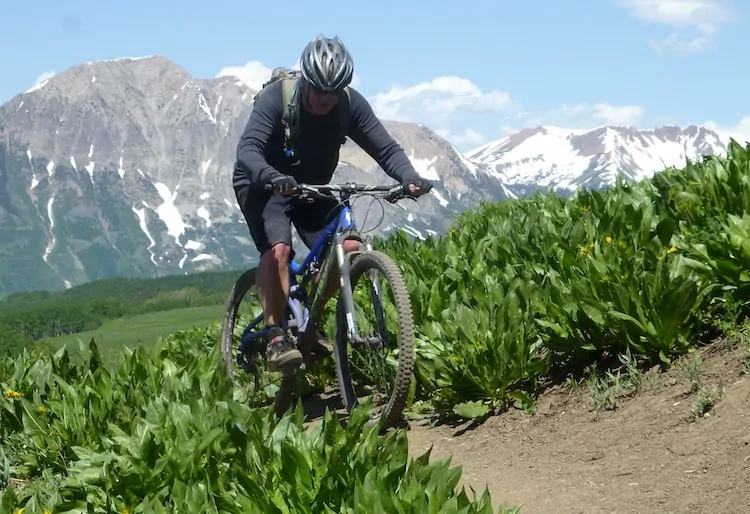
Ian Billick on the favored mode of transportation at Crested Butte.