As of early 2026, many American cities face critical threats to their municipal water supplies due to a combination of overdrawn aquifers, shrinking reservoirs, and aging infrastructure. While historically associated with the Southwest, water stress has increasingly impacted the Northeast and Midwest due to infrastructure failures and shifting climate pattern
Here are twenty American cities most threatened by a potential reduction of municipal water supplies:
Phoenix, AZ: Rapid population growth and heavy reliance on the Colorado River, which is facing record-low supply levels.
Las Vegas, NV: Highly dependent on Lake Mead, which has hovered near “dead pool” levels where water can no longer flow downstream.
Los Angeles, CA: Relies on water imported from hundreds of miles away; recent wildfires have also exposed weaknesses in emergency water-flow capacity.
San Antonio, TX: Its primary source, the Edwards Aquifer, is under intense pressure from drought and high demand.
Miami, FL: Faced with “saltwater intrusion,” where rising sea levels push salt water into the freshwater aquifers used for municipal drinking water.
El Paso, TX: Situated in the Chihuahuan Desert with very few local water sources; it is racing to open a large-scale water purification facility in 2026.
Salt Lake City, UT: Threatened by dwindling snowpack and the shrinking of the Great Salt Lake, which affects regional groundwater recharge.
San Diego, CA: Faces chronic drought and heavy reliance on external sources, leading to massive investments in desalination and recycling.
Atlanta, GA: Struggling with aging, century-old pipes that suffer frequent major breaks, leading to multiple citywide states of emergency.
Lincoln, NE: Highly vulnerable to extreme climate swings and drought that impact its regional water table
Chicago, IL: Despite its proximity to Lake Michigan, the city faces significant water loss due to aging infrastructure and stressed inland aquifers.
New York City, NY: Massive demand and future climate pressure, combined with “subsidence” (sinking land), strain its massive tunnel delivery system.
Denver, CO: Declining snowpack in the Rockies has significantly reduced the flow of the rivers the city depends on.
Jackson, MS: Suffered a near-total system collapse due to decades of underfunding and storm damage, leaving residents without safe water for weeks.
San Jose, CA: Dealing with overdrawn aquifers that have led to significant land sinking and infrastructure damage.
Riverside, CA: High population growth and limited local supply have created a narrow margin of water safety.
Corpus Christi, TX: Its reservoirs have reached dangerously low levels, forcing the city to spend hundreds of millions on new groundwater projects.
Santa Fe, NM: A small city with extremely high vulnerability to prolonged drought due to its limited catchment area.
Philadelphia, PA: Faces increasing risk from saltwater moving up the Delaware River, which can contaminate municipal intakes.
Mathis, TX: A critical example of a small municipality where the only water source, Lake Corpus Christi, reached such low levels that intake valves risked drawing sludge.
Click the link to read the paper on the Getches-Wilkinson Center website (Eric Kuhn, Anne Castle, Carlos de la Parra, John Fleck, Jack Schmidt, Kathryn Sorensen, Katherine Tara). Here’s the abstract:
March 26, 2026
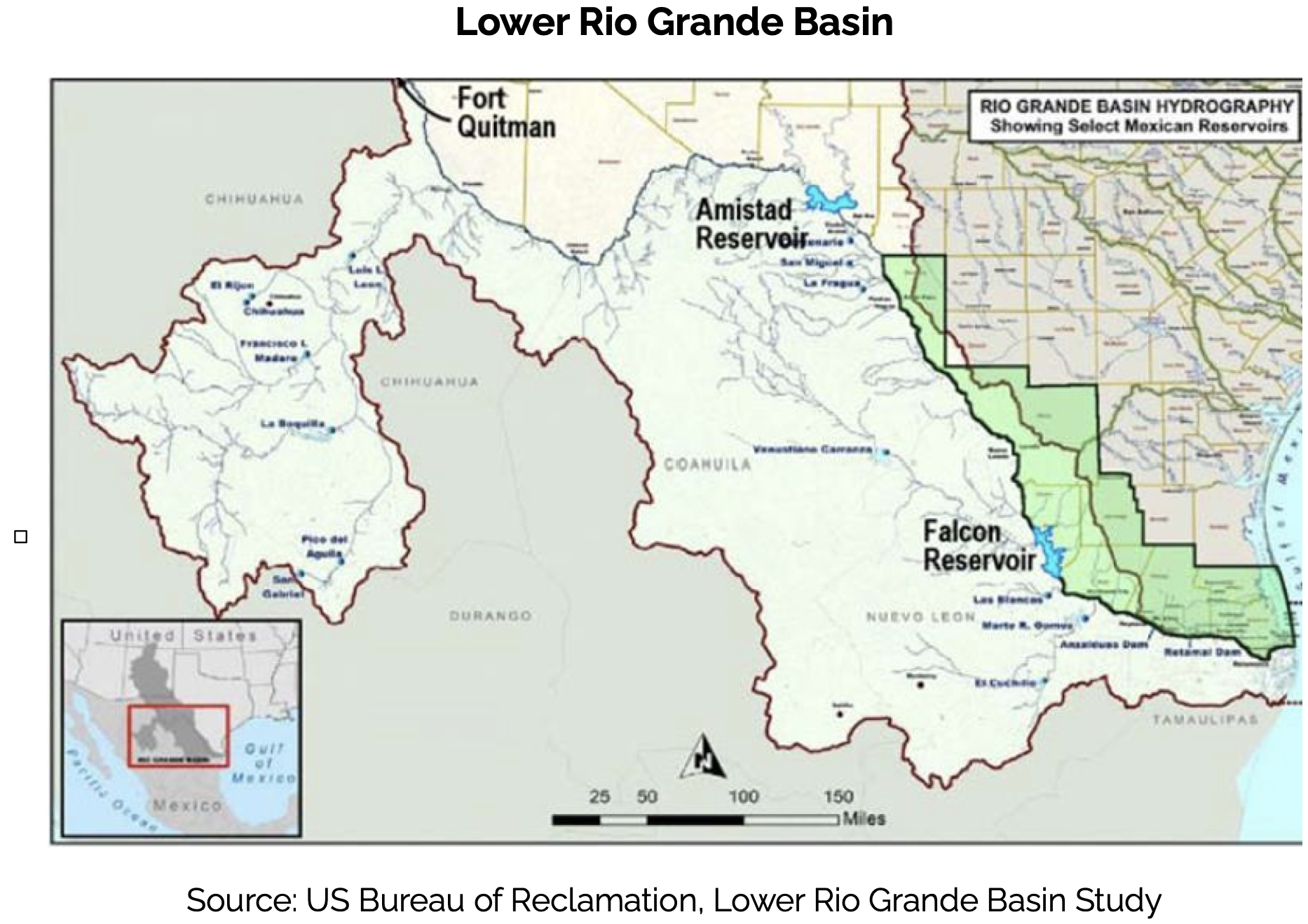
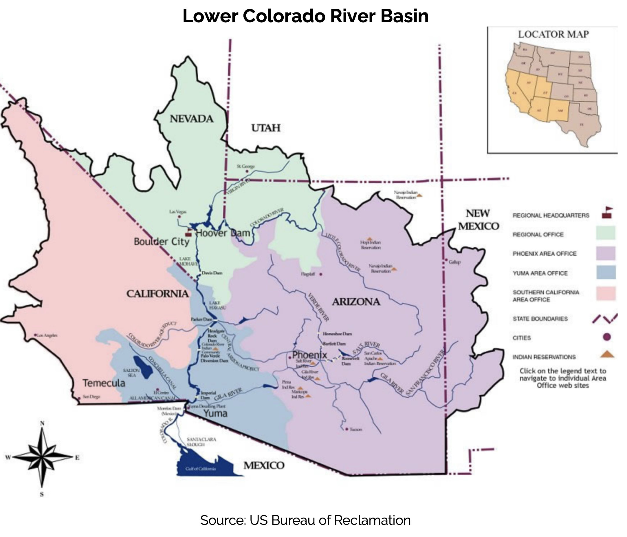
Since 1945, the United States and Mexico have managed common interests on their two largest shared rivers systems, the Colorado and the Rio Bravo/Rio Grande, under the terms of the 1944 international treaty that was designed from the beginning with tools to adapt to changing hydrologic and societal conditions. A recent emergency agreement on the Rio Bravo/Rio Grande illustrates what is possible, and with old river management rules on the Colorado both within the United States and between the United States and Mexico about to expire, we are at a moment of opportunity for meaningful change. The core problem on the Colorado River, which we address in the analysis that follows, arose from decisions made in the first half of the 20th century to allocate fixed volumes of water. As usage patterns and hydrology change in the 21st century, fixed volumes no longer work. [ed. emphasis mine] A shift to a percentage-based split between the United States and Mexico on the Colorado River, based on the river’s actual natural flow, would provide a solid foundation for the two countries’ joint management of the Colorado in the decades to come.
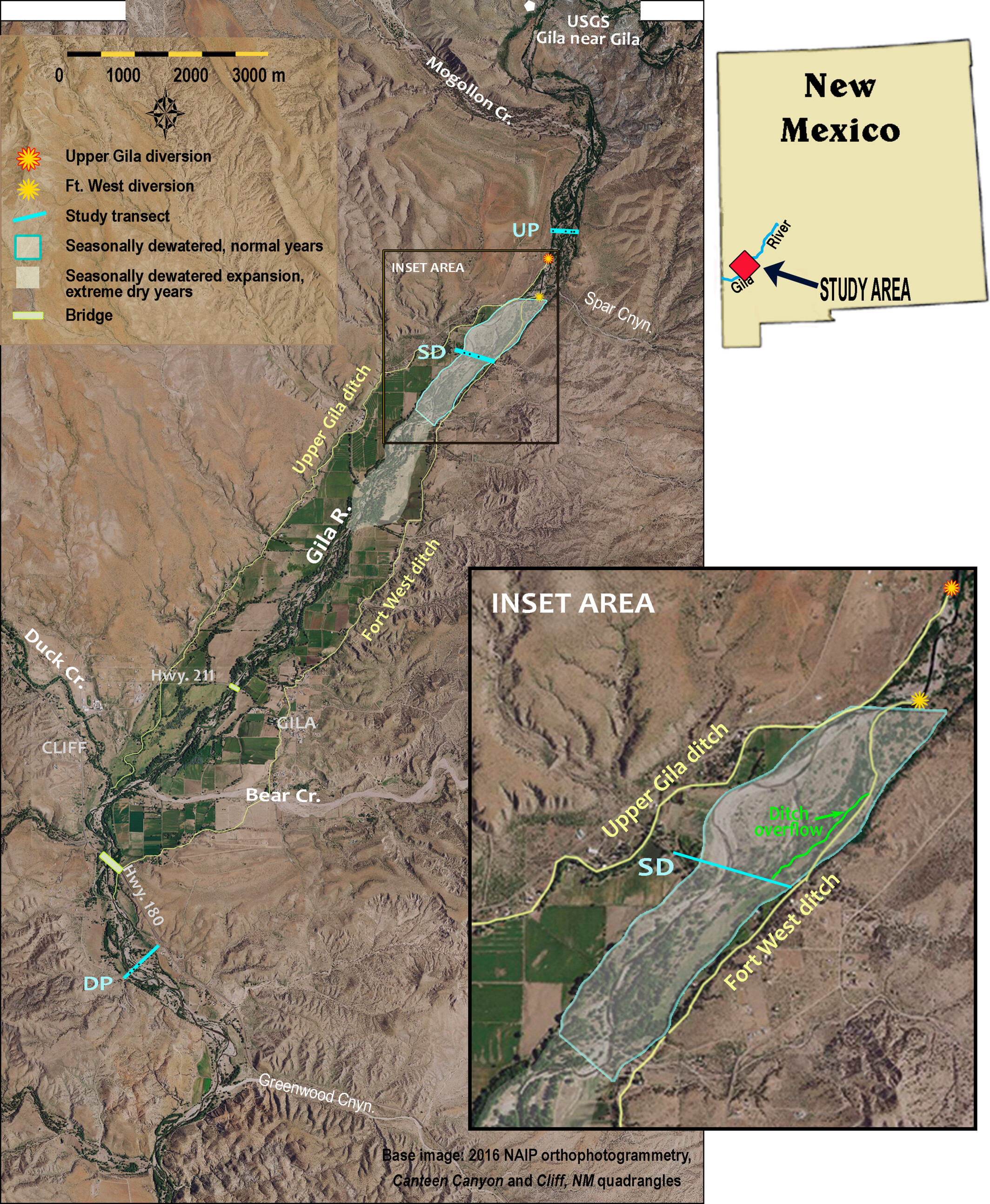
Study reach in the Cliff-Gila Valley, showing the three study transect locations for this work: upstream perennial (UP), seasonally dewatered (SD) and downstream perennial (DP); major irrigation diversion sites and the approximate regions where the channel was seasonally dewatered by diversions in normal and extremely dry years. The dewatered region is magnified in the inset figure to show the position of the Fort West ditch overflow channel. USGS gaging station 09430500 is located at the upstream end of the valley. Gila River flows from north to south.
Click the link to access the research paper on the Wiley Online Library website (Ellen Soles, Martha Cooper, Laurel Saito). Here’s the abstract:
In arid regions with limited water supplies like the Colorado River basin of the southwestern United States, flow regimes and water availability are major controls on native riparian ecosystems resilience, persistence and function. In this paper, we share a case study that uses a long-term dataset of topographic, vegetation and groundwater data collected over water years 2011–2021 to demonstrate how secondary channels formed during high flow events enhance groundwater-dependent riparian ecosystem resilience, favouring native over non-native vegetation. In the Cliff-Gila Valley of southwestern New Mexico, channelization and levee construction between 1940 and 1980 profoundly altered the floodplain and channel of the Gila River, a Colorado River tributary. During subsequent large floods, river anastomosis (branching) left a network of secondary channels across the floodplain. Long-term data show that these channels improve vegetation access to groundwater, facilitating regeneration and expansion of diverse native groundwater-dependent vegetation. Data also show that even the lowest perennial flows (0.4–0.6 m3 s−1) sustain rates of groundwater recession favourable to successful native riparian seedling recruitment in the topographic lows created by secondary channels. Alluvial groundwater recedes more sharply in a reach seasonally dewatered by irrigation diversions, but seepage through diversion structures and unlined ditches maintains shallow groundwater levels. This case study demonstrates that even in arid regions, robust native groundwater-dependent riparian areas can co-exist with human water demands when large floods can move across broad floodplains and create topographic complexity. [ed. emphasis mine] The study also highlights the importance of long-term datasets for documenting ecosystem resilience to floods, drought and ongoing climate change.
Warm and dry conditions in Western Colorado are speeding up runoff from an already below normal snowpack. And it is causing concern among communities. “There are smaller communities that have a single source of drinking water supply that are concerned about what their source is going to be producing as the summer goes on if the snow melts out too quickly,” said [Christina] Medved…Another concern is having enough water for irrigation.
“The green grass lawns, the big parks and fields, they take a lot of water to keep green. And so, we’ve already been hearing from communities that if they have to, they will stop watering those fields,” said Medved.
The dry season we have had also means concern for wildfire season. “If you have an early melt out and you’re able to dry out the landscape by June, June tends to be a drier month. And so that tends to be associated with some higher-than-normal fire danger,” said Goble.
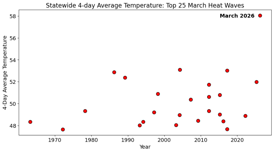
Colorado’s top-25 March heat waves since 1951, defined as 4-day averaged statewide temperatures. Colorado’s warmest heat wave (set last week, March 18-21) eclipsed its previous warmest heat wave (March 23-26, 2004) by nearly 5°F. Data from NCEI nclimgrid via the Colorado Climate Center
Click the link to read the article on the Big Pivots website (Allen Best):
March 30, 2026
It was weird, it was wacky. This string of summer days in Colorado that arrived around the first day of spring was extraordinary. Will it change us in some fundamental way?
It’s not like 9/11, the day we saw people jumping from the skyscrapers in New York City to escape an even more cruel death by fire. We knew instantly that the world was different and in a very big way.
But doesn’t this anomaly deserve more than a shrug of the shoulders? As summer arrived in the last days of winter, I heard several people say, “Well, enjoy this nice weather” as you passed through their doors. A well-intentioned pleasantry but detached from a vital truth. Nice weather for Arizona maybe, but this was Colorado.
Winter had altogether been very, very warm. November was the third warmest November on record across Colorado. December the warmest. February also broke records.
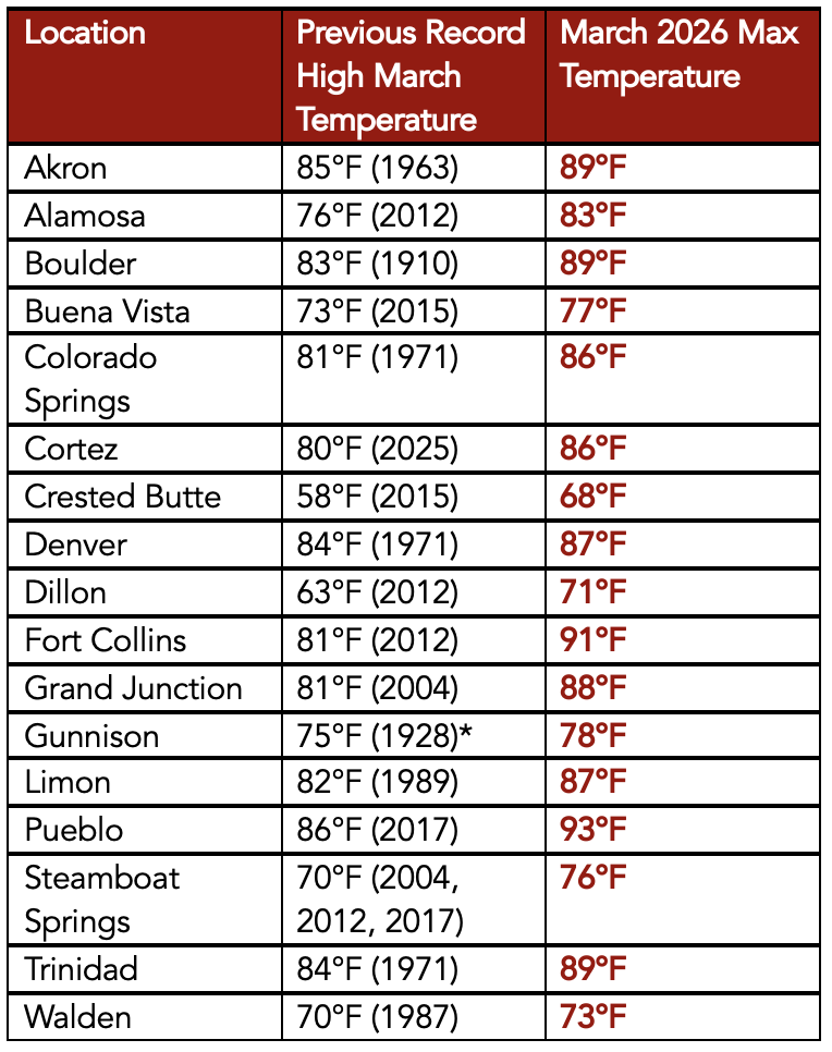
Then came March. Alamosa, a town at 7,543 feet in elevation in Colorado’s San Luis Valley, notched 11 record highs during March going into the last weekend. This included nine in a row from March 18-26. Of special note was the record high of 83 degrees recorded on March 21. It broke the old record by 7 degrees. It also was a higher temperature than has ever been recorded in Alamosa in April.
Crested Butte had a high temperature of 68, a full 10 degrees higher than the old record for that date.
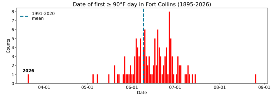
Dates of first 90°F or warmer day in Fort Collins from 1895-present. The blue dashed line shows the 1991-2020 mean 90°F or warmer day, which is June 9. Data from ACIS.
Fort Collins got to 91 degrees, also 10 degrees more than the old record for that date. It was the highest ever mark for March — but also higher than anything ever recorded in April, whose record remains 89 degrees. The average first day for 90 degrees in Fort Collins is June 15.
Allie Mazurek, of the Colorado Climate Center staff, posted a report on Thursday morning that defines in numbers what she calls an event “impossible to ignore.” Included in her presentation is the chart atop this essay that shows how anomalous this four-day streak of heat was compared to others in Colorado during March.
This heat was nearly uniform across Colorado. “There were far more stations in the state that broke all-time monthly high records for March than did not,” wrote Mazurek. “To see monthly records shattered by more than 5 degrees F across numerous stations is truly remarkable. The kind of heat that we saw last week across Colorado is more typical of June or even July.”
Remarkable about theheat in Colorado was not only its intensity but its longevity across four days (March 18-21). “Over that period, several locations set new monthly records every one of those days, with each day being warmer than the last.”
March maximum temperature records at various long-term weather stations throughout Colorado. Data from ACIS.
This heat comes at a particularly bad time. The thin snowpack was already melting. The deepest snowpack in Colorado’s mountains has traditionally occurred in early May, because of accumulations at higher elevations.
That assumes a normal of some sort — although it is questionable whether “normal” has any true meaning given how fast the climate is now changing. So take this for what it’s worth: the statewide snowpack this past week sat at 38% of the 1991-2020 median. And what must be noted here — as with the temperature records that were broken — is that we have had an exceptional increase of heat in Colorado in the last 25 years.
Notable in the lifetimes of baby boomers in Colorado were the winters of 1976-77 and 1980-81. This year’s meager runoff will almost certainly surpass those dry years. New is the heat.
High-pressure heat domes can be predicted but are notoriously challenging to forecast weeks or months in advance. They also remain rare, but the warming atmosphere makes them more likely.
“We do have high pressures every year across the West,” said Mark Wankowski, a meteorologist at the Pueblo office of the National Weather Service. “This one was extremely early.”
Writing from Colorado Springs last weekend in an essay in The Atlantic titled “There’s No Way the West Will Have a Normal Summer,” Rebecca Boyle explained that the heat wave was created by a “a bizarrely strong ridge of high pressure in Earth’s atmosphere.” This ridge suppressed cloud formation and brought in warmer air. “Such atmospheric ridges are more common in the summer, but this one would be unusually intense even for that season.
Kaitlyn Trudeau, a senior researcher at the science nonprofit Climate Central, told Boyle this was the strongest ridge ever observed in March. Climate Central has developed a prediction model that assesses how much a warming trend or record high can be attributed to human-caused climate change. According to this model, the western high temps were five times more likely because of elevated greenhouse gas emissions.
I feel rattled by this heat. You may remember the high-pressure cooker that broiled the Pacific Northwest in June 2021. Temperatures spiked to 116 degrees in Portland. People in apartments that were not air conditioned died from the heat. In Multnomah County, the location of Portland, 72 deaths were attributed to heat. Farther north, in British Columbia, the town of Lytton went up in flames after several days of intense heat, including a temperature that reached 121 degrees Fahrenheit.
After that heat, the Colorado Public Utilities Commission asked Xcel to assess how well it could respond to somewhat similar heat in Colorado. The company concluded it had the resources.
But this week, in the wake of the intense spring heat, the PUC commissioners were clearly worried, part of a growing concern about “resource adequacy.” Will Xcel be able to meet critical electrical needs if another heat dome arrives in Colorado this summer? The commissioners asked Xcel to return with strategies for reducing demand from big industrial customers if demand for cooling spikes.
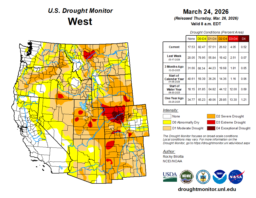
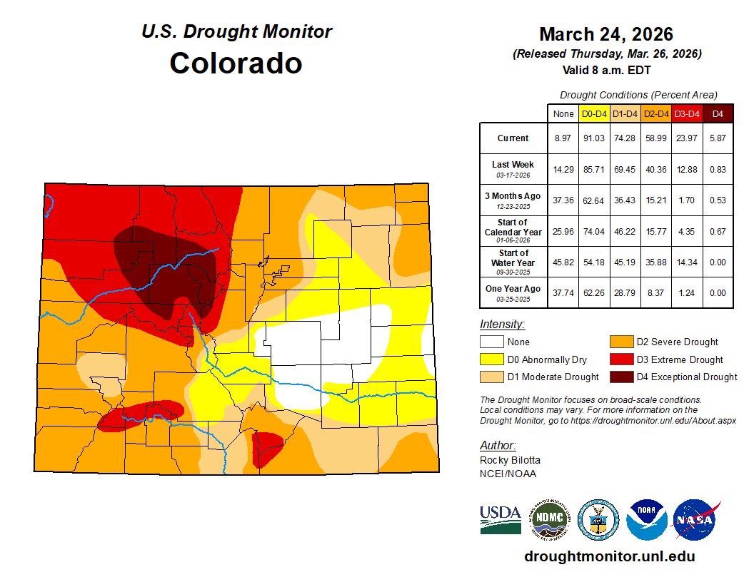
Colorado Drought Monitor map March 24, 2026.
Curious about an on-the-ground perspective from this heat and sparse snow, I called Paul Bonnifield in Yampa. A drought map colors that part of northwest Colorado mahogany, beyond extreme drought and in the realm of “exceptional.” What did exceptional drought look like to him?
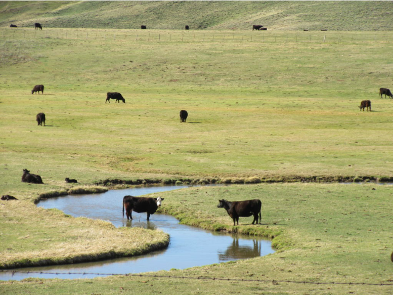
Yampa lies at the headwaters of the Yampa River, between the Gore Range and the Flattops. It has a bucolic setting, a place of hay meadows and grazing cattle. Lying upstream are a couple of reservoirs on the edge of the Flattops.
It’s not uncommon for snow to remain on the ground at Yampa, elevation, 7,900 feet, in late March. Not this year. “The ground is hard, just dry, dry, dry,” said Bonnifield.
Bonnifield grew up a few miles away at Phippsburg, a railroad town, and he worked on the railroad himself in addition to spending time teaching and writing at a college in Oklahoma. He’s now in his late 80s and can put this year’s anomalous heat and drought into perspective.
“We are in serious trouble,” he said. “I’ve never seen it like this before.”
Less water will mean less hay production in Egeria Park, where this photo was taken about eight years ago. Photo/Allen Best
Unless a miracle arrives in the form of spring rain and snow, ranchers in Bonnifield’s area — called Egeria Park — will have to decide what to do with their cattle. There’s not enough water to grow grass. There will be wildfire smoke besotting the sky, dampening tourism. And as for river rafting downstream on the Yampa – not likely. Steamboat Spring has already imposed watering restrictions for lawns.
Denver Water this week adopted lawn-watering restrictions for its customers in Denver as well as those in surrounding jurisdictions. It has 1.5 million customers, directly and indirectly, in the metro area.
Nathan Elder, the utility’s manager of water supply, reported to board members on Wednesday that snowpack levels are at historic lows and melting earlier and more rapidly.
Denver Water diverts water from rivers and creeks on both sides of the Continental Divide. In Grand and Summit counties, at the headwaters of the Colorado River, the snowpack was 53% of normal and the lowest on record for the date, Elder said. The South Platte River has it even worse, just 40% of normal.
“These are really unprecedented snowpack conditions,” he said at the meeting on March 25. During the previous week — the week of the heat dome —Denver had lost 25% of its snowpack in the areas it collects water, he reported.
Denver Water is asking the 1.5 million households and businesses that get water from the utility to refrain from starting to irrigate lawns, including this one in southeast Denver, until mid-May. Photo credit: Allen Best/Big Pivots
Can it get worse? Well, yes, it could. “It’s well documented that, in part, due to climate change, the runoff generated from a given snowpack has declined when compared to the past,” said Elder. “So we can expect even less water from this already low snowpack.”
Might a miracle arrive? After the drought and heat of 2002, metro Denver was stressed. Then, on St. Patrick’s Day 2003, three feet of snow fell. In the San Luis Valley, monster rainfall last fall swelled the Rio Grande, leaving water in the soil that will help even now as farmers begin preparing their fields for early plantings.
NOAA projects continued likelihood of above normal temperatures and below-normal precipitation across Colorado, including Denver’s collection area, during April.
Denver aims to reduce water use 20% by its customers in Denver and in outlying suburbs. It will permit lawn watering two days per week and then after 6 p.m. or before 10 a.m. It is also urging customers to refrain from watering their lawns until mid-May. That’s not an easy ask when it feels like June in March. In April, Denver Water’s board members will be asked to approve “drought pricing.”
Russ Schumacher, the state climatologist in Colorado, is called upon frequently to give programs to water organizations and others. This past week he gave a presentation to the Fort Collins Chapter of the Colorado Renewable Energy Society.
“Wildfire certainly is top of mind,” he said while showing a time-lapse video of a wildfire called High Park Fire that occurred west of Fort Collins in 2012.
Dry and hot temperatures leave Russ Schumacher, the state climatologist, apprehensive about potential wildfires this year. Above photo is from the Longmont area in August 2020, a hot and smoky year when wildfires continued almost into November. Photo/Allen Best
Global warming is a simple proposition, he said.
“If you put a pot of water on your stove you’re not going to be able to predict all those individual bubbles or exactly when it’s going to start boiling,” he explained. “But you know that when you turn that heat on, the water’s going to get warmer and it’s going to continue to warm the more heat that you add. So the physics of climate change is actually rather similar in that regard.”
And, of course, adding greenhouse gases to the atmosphere traps heat, which heats the planet. “When you add heat to something, then it warms.”
Colorado has had outliers of heat before. The Dust Bowl during the mid-1930s was a time of heat and drought. More hot and dry arrived in the 1950s.
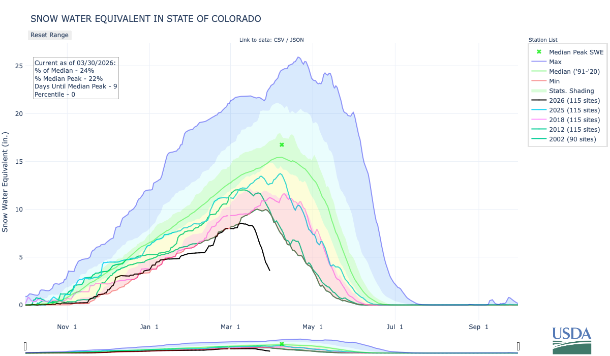
This chart shows snowpack in Colorado. The heat dome caused rapid melting of snow. In the San Luis Valley, heavy rains of last October may allow farmers to survive better than during 2002.
Dry has not changed. The hot has changed. What used to be an extremely hot year in Colorado is now a fairly average year or just slightly-above-average year, said Schumacher.
Citing NOAA data, Schumacher showed a sharp rise of almost 2.5 degrees Fahrenheit since 1980. The heat has been most acute in the summer and fall — although, obviously, recent months spoil that easy narrative.
With a moderate rate of emissions, we can expect another 2.5 to 3 degrees of warming by around 2050. That expectation comes with a disclaimer about uncertainty. It’s a best guess.
Precipitation has been more complicated than temperature in Colorado. As for the future, it remains a puzzle. Could be more, could be less. Either way, it will be impacted by temperatures.
“If it’s warmer, if it‘s windier, it’s less humid, the air is thirstier for water from the soils, crops, forests, reservoirs, wherever.” Schumacher said. “As it gets warmer, that evaporative demand goes up. The air is thirstier for water, and this has big implications for drought and water supply and water resources.”
Might warming occur more slowly? That’s possible, and a possibility tied strongly to whether global emissions of greenhouse gases can be abated. Given the current political climate in the United States, a key player in world politics, this low-emissions scenario looks highly unlikely. More likely are the heat domes.
Like the pot of water on the stove that Schumacher described, we’re certain to see more heat bubbles. Hard to tell where and when they will be, but there will be more of them. That leaves me distinctly uncomfortable. In Colorado I have felt 104 degrees. I cannot fathom the 118 degrees of Portland.
Colorado statewide annual temperature anomaly (°F) with respect to the 1901-2000 average. Graphic credit: Colorado Climate Center
With far less snowpack in the high country this year and an anemic runoff forecast, the Uncompahgre Valley is positioned for a terrible irrigation season. Water users association Manager Steve Pope did not mince words.
“This is the worst year on record so far for snowpack. Looking at the fact that it’s pushing 90 degrees outside in March, we aren’t going to be able to expect much of a runoff,” Pope said on Wednesday, one week before water deliveries begin on April 1, ” … There is no good news.”
The Uncompahgre Valley Water Users Association will only be delivering allocations to shareholders of 50% to start, and, if water models remain consistent, will cut delivery to 40%. No pump contracts can be filled this year, although there will be credits for next year for paid accounts. Shareholders who pump directly from an association canal or lateral must register pumps and install meters and regulating valves for the deliveries. As well, people are being asked to reconsider lawns and large-scale landscaping to conserve every drop possible for agriculture…
Runoff projections within the Uncompahgre Basin are worrying. The Colorado River Basin Forecast Center operates SNOTEL sites that measure snowpack and snow water equivalent, the amount of water the snow holds. Ideally, there would be robust snowpack and SWE, as well as weather conditions conducive to slower melt, leading to prolonged runoff. That isn’t the case this year…2026 is on track to turn out even worse than 2002, the leanest water year this century — but even 2002 was bookended with decent water years before and after…Pope said the Colorado River Basin Forecast Center is projecting a 50% chance of the local watershed seeing about 53,000 acre feet of runoff…The water users association can’t really rely on natural flow from the Uncompahgre River this year, Pope said, but he does anticipate enough to fill Ridgway Reservoir. Beyond that, however, “it’s not very promising.” Overall weather conditions compound the problem of so-so snowfall during the winter: it’s been warmer far up in the high country, too. Pope said that at the 12,200-foot elevation Swamp Angel study site maintained by the Silverton-based Center for Snow and Avalanche Studies, it’s only been getting down to a few degrees below freezing at night. (This site had a measured snow water equivalent of 13.4 inches as of March 15.)
“If it’s not freezing at night, there’s nothing to slow the runoff down. They said the dust isn’t as bad this year. That is somewhat of a silver lining. We haven’t had the wind, so the dust isn’t quite as bad,” said Pope. Dust accelerates snowmelt.