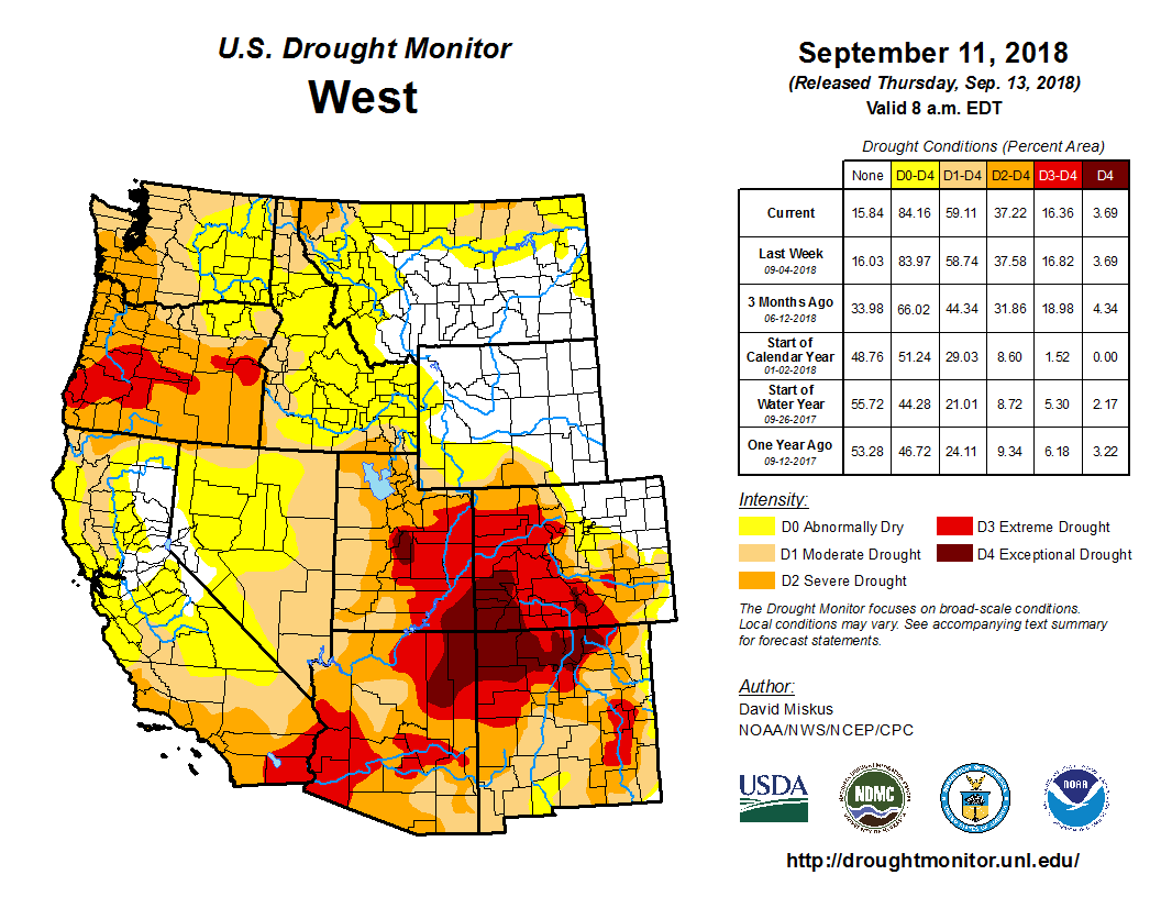
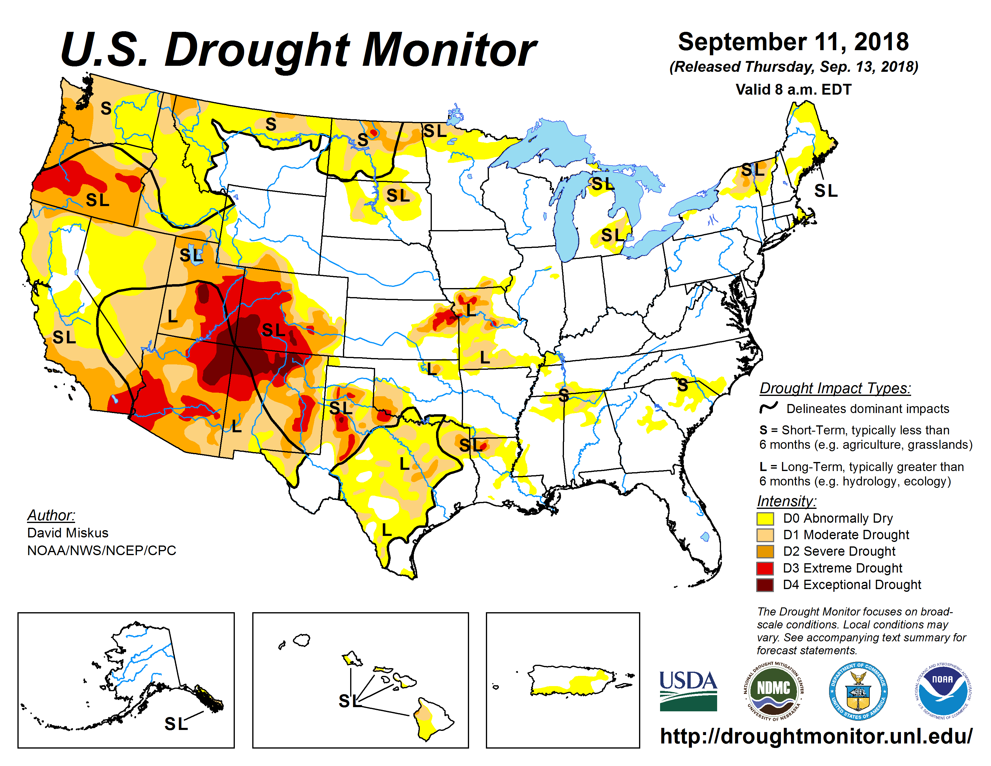
Click here to go to the US Drought Monitor website. Here’s an excerpt:
Summary
The combination of energetics from northern Mexico lifting toward the Southern Rockies/Great Plains and enhanced moisture from the remains of a tropical depression led to heavy precipitation events across the south-central U.S., particularly notable as a frontal zone stalled. Significant rain fell across much of the South, leading to much improved drought conditions in many areas. In fact, several regions across the U.S. received at least double (or more) of their typical precipitation for this time of the year over the past week, including the far Pacific Northwest, eastern Montana to northern Nebraska and Iowa and western Wisconsin, southwestern Arizona into northwestern New Mexico, and a large swath encompassing much of Texas northeastward to southern New Hampshire, part of which was from the remnants of Florence, now classified as the second wettest storm of the past half century to impact the U.S. Parts of the Southeast and most of the West were dry and drought conditions spread or worsened in several regions…
A stalled front brought significant rainfall to much of the South, providing several inches of rain across the region, including drought-stricken areas. The system brought normal conditions back to all of northwestern Tennessee, where 3 or more inches of rain fell over the past week. The system also brought enough rainfall to alleviate much of the abnormal dry (D0) and moderate drought (D1) conditions in southern and central Tennessee where several inches of rain also fell. In Mississippi, D0 continued to shrink across the north central part of the state. Unfortunately, areas along the Mississippi/Alabama border missed out on the most significant precipitation and so D1 expanded here. In Louisiana, significant rain fell right where it was needed across the north to reduce drought impacts while providing a seemingly endless moisture feed from the Gulf, fueling daily convection across the rest of the state. Most of the D1 was eliminated in the northwestern part of the state. A 2-category improvement — from severe drought (D2) to D0 — across southern Bossier and northern Bienville Parishes was warranted, as these areas received widespread totals of 3 to 4 or more inches, which actually resulted in flash flooding. In Arkansas, this week’s wet weather allowed for more trimming of D0 in both the north and south. The areas of D1 remain in the southern part of the state though, due to deficits dating back several months which have yet to be overcome. Southern and eastern Oklahoma into much of Texas also saw widespread improvements across much of the state, including a few areas of 2-category improvement related to the massive downpours that alleviated any dryness and related drought impacts. While 3 inches or more was common, some isolated areas received more than a foot of precipitation. Some areas of southwestern Texas, however, did not receive much rain, and areas of D0 to D2 spread, namely from eastern Hudspeth County to Brewster County along the U.S./Mexican border…
As summer comes to a close and fall begins, many areas across the High Plains continue to experience dry conditions. In eastern Kansas, extreme drought (D3) was extended into the northern half of Osage County as well as southwestward into northeastern Marion County. Extreme drought was also introduced in Eddy County in east central North Dakota, with adjoining extreme (D2) and moderate (D1) drought each extending slightly farther south to southern Foster County. These counties have each received less than 25 percent of their typical precipitation over the past two months. Among some of the local observances: “soybean yields are disappointing. Corn harvest has started, more than a month earlier than normal. Grasshoppers are thick in some areas of the county, damaging some late season crops. Some producers have started feeding their cattle, which typically does not happen until first snowfall. Pastures are bare and water sources have dried up. Producer are having to haul cattle home from pastures”. In northern Wyoming, a small patch of D0 was introduced to northern Campbell County, and a larger swath was introduced just to the south from Johnson County (Wyoming) east to Shannon County (South Dakota). These areas have also seen below-average precipitation over the past two months, with Mt Rushmore the fifth driest in its record for this period…
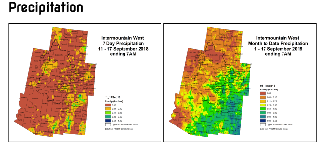
An upper low dropping down from the Gulf of Alaska sparked widespread precipitation across western Washington in the Pacific Northwest, helping lead to improvements along the coastal region to just across the Oregon state line. With high temperatures generally in the mid to upper 60s, up to 4 inches of rain fell over the bullseye of severe drought (D2) in north central Montana along the Canadian border this past week, improving conditions here. In Utah, Idaho, and Nevada, however, little to no precipitation fell and temperatures remained above average. Severe drought expanded across southern Idaho and southward through Elko into White Pine County in northeastern Nevada and the remaining areas of Box Elder, Tooele, Juab, and (most of ) Millard Counties in neighboring Utah. A local report from Tooele County notes a range of poor conditions, from extreme fire danger to low ponds to pulling herd off the rangeland to near-empty reservoirs. This region has received little rain since April and are below-average at the beginning of the fall season, when the region should see a pick up in precipitation. Also in northern Utah, extreme drought (D3) was expanded farther west in Box Elder County. Across Utah, 66 percent of pasture and range land were rated poor or very poor for the period ending September 23, while 68 percent of the topsoil moisture rated poor to very poor for the same period, according to the U.S. Department of Agriculture. Conditions also degraded in other areas. Extreme drought was expanded northward over southeastern Utah, northwestern Colorado, and slightly into Carbon County in southern Wyoming. With only one week left in the water year, the gauge on the San Juan River near Bluff, Utah, is on course to break its 92-year record for lowest accumulated discharge. Severe and moderate (D1) drought also expanded slightly along the Continental Divide. With a lack of precipitation in August and September to date, abnormal dryness (D0) was expanded to the north and east in northeastern Colorado. Exceptional drought (D4) expanded in southwestern Colorado and northern New Mexico due to high temperatures, in addition to the continuing lack of precipitation…
Looking Ahead
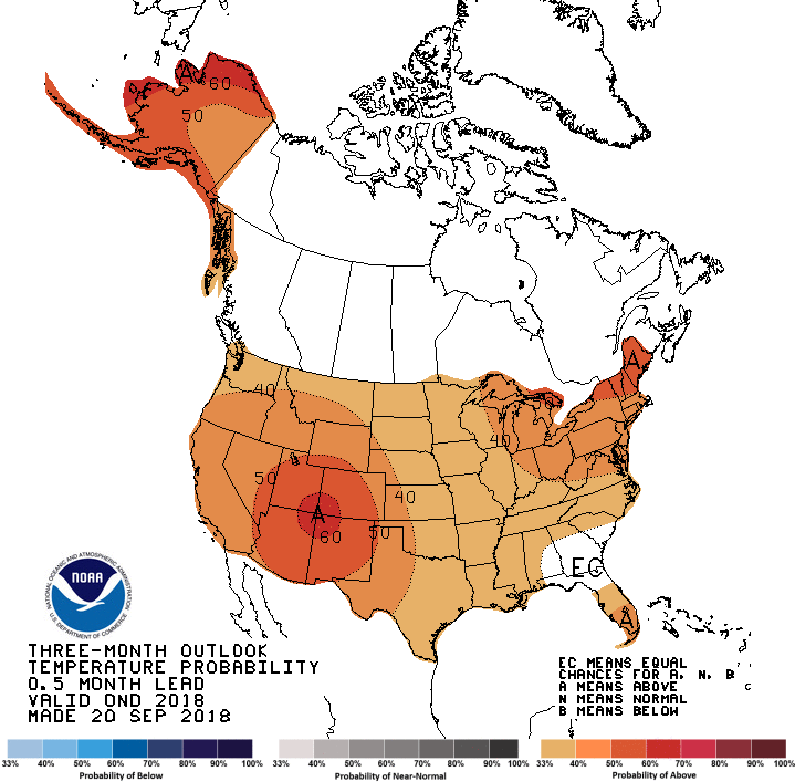
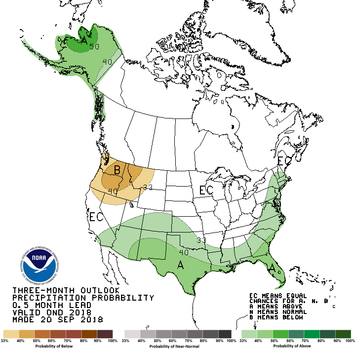
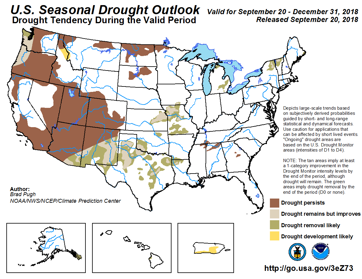
Over the week beginning Tuesday September 25, most of the contiguous U.S. is expected to receive at least some precipitation, with 2 or more inches predicted across east central Wisconsin, parts of New York and Massachusetts, and a swath from south Texas and southern Louisiana into much of eastern Mississippi, central and northern Alabama, central and southeastern Tennessee, northwestern Georgia, and western North Carolina. Areas not expecting any precipitation are all areas currently experiencing some level of drought, including eastern Washington into north central Oregon, southern California, most of Nevada, southern Idaho, and eastern Colorado. Looking further ahead at NOAA’s Climate Prediction Center (CPC) 6-10 day Outlook (September 30 – October 4), above-normal temperatures are favored across all of Alaska, along with most of the southern and eastern contiguous U.S. Below-normal temperatures are favored over central and northern California extending eastward into Wisconsin. A projected deep trough over the Bering Sea indicates the likelihood of above-normal precipitation over western Alaska and the Aleutians, while a projected strong ridge over Alaska favors below-normal precipitation over eastern Alaska into the Alaska panhandle, an area of persistent and worsening drought. There is an increased chance of above-normal precipitation across most of the contiguous U.S. during this period. Looking two weeks out (October 2-8), the forecast is quite similar to the 6-10 period, except that near-normal temperatures are favored over the contiguous U.S. west coast, while near- to below-normal precipitation is forecast over parts of the Pacific Northwest and above-normal precipitation is predicted over the entire eastern U.S.
From the Water Education Foundation (Gary Pitzer):
Western Water Notebook: Commissioner Brenda Burman, in address at foundation’s water summit, also highlights shasta dam plan
The Colorado River Basin is more than likely headed to unprecedented shortage in 2020 that could force supply cuts to some states, but work is “furiously” underway to reduce the risk and avert a crisis, Bureau of Reclamation Commissioner Brenda Burman told an audience of California water industry people.
During a keynote address at the Water Education Foundation’s Sept. 20 Water Summit in Sacramento, Burman said there is opportunity for Colorado River Basin states to control their destiny, but acknowledged that in water, there are no guarantees that agreement can be reached.
“While you can’t control weather, you can’t control climate in many ways, what we do know is that we can look at the risk ahead and we can find ways to address that risk,” she said.
In a talk that touched on Reclamation’s work across the West, Burman also said California needs more water storage to take advantage of exceptional runoff years and pointed to the Bureau’s proposal to raise Shasta Dam as one solution.
The first woman commissioner in Reclamation’s 116-year history, Burman, 51, lauded the “great tradition” of cooperative efforts by stakeholders to maintain the Colorado River’s viability even as people have begun to contemplate the potential impacts of a coming crisis.
“Everybody has come together, and we are working furiously about how do we address that risk, how do we buy it down, how do we control our own destiny,” she said. “We are very close and very hopeful of coming to terms this year with a deal on the Colorado River … where everybody is taking a little bit of a hit, finding more flexibility, but knowing that the future may hold more difficult problems.”
Should dry conditions continue this winter, Reclamation projects a 57 percent chance of a shortage declaration in 2020, which would be the first time that has ever occurred. Under the first tier of a shortage declaration on Lake Mead, Colorado River water deliveries, primarily to Arizona, would be cut. The seven Colorado River Basin states — California, Nevada, Arizona, Colorado, New Mexico, Utah and Wyoming — have responded with pending drought contingency plans that are centered on the idea that all water users, not just those with junior water rights, have a stake in keeping the system whole.
“When you look at the risk that’s being faced on the Colorado River, I commend the senior water users who have stepped up,” Burman said. “Senior users on the Colorado River system have very much stepped up and said, ‘We recognize this risk and we are willing to come to the table to figure this out.’”
The overseer of the Central Valley Project (CVP) and the vast apparatus of the Colorado River Storage Project, Reclamation employs about 5,000 people in maintaining 475 dams and 337 reservoirs across 17 Western and Great Plains states.
Burman assumed her duties amid a whirlwind of water policy activity in California as a new federal administration began to establish its priorities for managing the CVP. The emphasis of that task, which includes the proposed raising of Shasta Dam, was crystallized in August when Interior Secretary Ryan Zinke called for a plan to maximize water supply deliveries from the CVP to farmers in the San Joaquin Valley. Asked about the plan at the Water Summit, Burman said work on it is still underway.
Burman lamented the inability of the current water storage system in California to take advantage of the runoff that comes during exceptionally wet years, such as 2017.
“There is a huge reliability problem on this system,” she said. “There is not enough infrastructure and we don’t have enough places to put water, whether it’s above ground or underground. It is time for us to take a look at what is available and what is affordable for increasing the capacity of this system so that the water supply is more reliable in dry years.”
She called the proposed raising of Shasta Dam, which has been discussed for more than 20 years and is controversial in some corners, “by far the most cost-effective project” for creating a water supply.
“If you raise the dam by 18 feet … you can actually have an incredible effect,” she said. “You can produce over 600,000 acre-feet of new capacity and new space in that system. If we had filled that up in 2017, that would have helped so much this year. It would have helped with meeting our responsibilities to fish and meeting the responsibilities to our contractors.”
CVP contractors south of the Delta support the idea of raising the dam because the extra storage could help with their supply during tight times and provide the necessary water for embattled salmon populations.
Some environmental and fishery organizations and the nearby Winnemem Wintu Tribe oppose raising the dam.
In a March 2018 letter to some congressional leaders, Natural Resources Agency Secretary John Laird wrote that a dam raise “would violate California law due to the adverse impacts that project may have on the McCloud River and its fishery.”
In addition to her time as a deputy commissioner with Reclamation and a deputy assistant secretary at Interior, Burman’s 25-year career has been spent with the Salt River Project in Arizona, Metropolitan Water District of Southern California, The Nature Conservancy and the office of Arizona Senator Jon Kyl.
A graduate of the University of Arizona College of Law, Burman was a judicial clerk for the Wyoming Supreme Court and Coconino County Superior Court in Arizona.
She began her career as a park ranger at Grand Canyon National Park. In her testimony last year to the Senate Committee on Energy and Natural Resources, she talked about the lessons learned from that experience.
“In the canyon, we counted on scarce springs in the backcountry for our water supply, and on the rim we counted on a rickety old pipeline that often broke to bring water from Roaring Springs up to the rim and the tourist area,” she said. “It was a learning experience that taught me the value of water and the hard work it often takes to get it.”
Historical storage Elephant Butte Reservoir as of September 26, 2018 via Water Data for Texas.
From the New Mexico Political Report (Laura Paskus):
The Rio Grande Compact, which divides water among Colorado, New Mexico and Texas was signed in 1938. And New Mexico’s water laws today are still based on codes that the territorial legislature passed in 1907.
But as the climate changes and warmer temperatures affect the state’s rivers, reservoirs and aquifers, the same tactics and strategies that may have helped New Mexicans weather dry times over the past century won’t keep working. And perhaps no place in the state offers such a stark reminder of that fact than the reservoir behind this dam. After a dry winter and hardly any snowmelt this spring, Elephant Butte Reservoir is at three percent capacity, storing 58,906 acre feet of water as of September 24.
Historically, people tend to listen to what they want to hear, rather than what they need to hear: What they need to hear is that our laws do not reflect hydrology and our hydrology is changing for the worse, and if we do not manage it, it will manage itself,” says Phil King, an expert on hydrology and the relationship between surface and ground water in southern New Mexico. “I would much rather correct the system ourselves through management than let nature do it’s cold, hard reality fix,” adds King, a professor of civil engineering at New Mexico State University and a consultant to the Elephant Butte Irrigation District, or EBID.
Stopping the ‘death spiral’
EBID serves about 8,000 farmers in the Rincon and Mesilla valleys in southern New Mexico, from Arrey to the border town of Santa Teresa. If you’ve eaten chile from Hatch or pecans from Mesilla, fed alfalfa to your horses or poured milk from a New Mexico dairy into your coffee, you’ve consumed water that EBID’s farmers divert from the Rio Grande and Elephant Butte or pump from the aquifer.
For roughly a century, EBID farmers have supplemented irrigation water with groundwater. Without it, they would not have survived the drought of the 1950s. But they pumped during the wet years, too, including throughout the 1980s and ‘90s. Then, beginning around 2003, about four years into the Southwest’s current drought period, pumping ramped up even more.
That’s a problem, especially in the Rio Grande Valley, where river water recharges the groundwater, and pumping water from the aquifer makes it even thirstier for river water.
With both the surface water and the groundwater strained, the system suffers a double-whammy, King says. That causes a positive feedback or what King calls a “death spiral.”
Even though scientists, engineers, hydrologists and farmers know the two are intertwined within the same system, in New Mexico, groundwater and surface water are managed separately. King calls that “hydrological folly.”
“We’ve got some major rethinking to do with New Mexico water law: Status quo is not an option,” he says. “I think what people need to understand is we are facing conditions that mankind has not faced here before.”
And the only way to reverse that death spiral is to use less water.
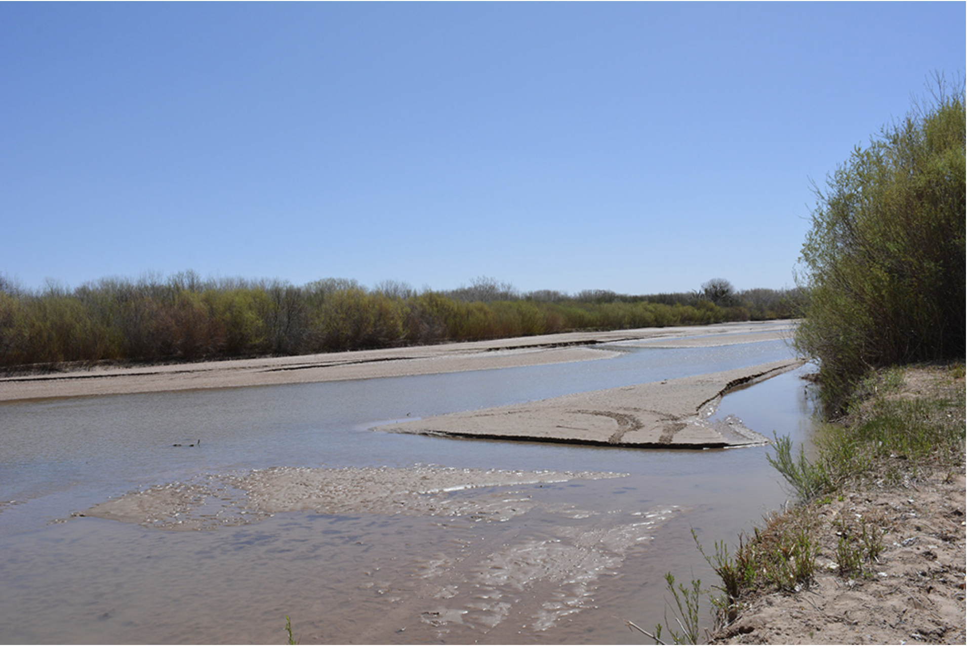
The drying riverbed of the Middle Rio Grande near the Bosque del Apache National Wildlife Refuge on April 4, 2018. Photo credit: USBR
From the Eagle River Watershed Council via The Vail Daily :
The mighty Colorado River is a source of life flowing through seven Western U.S. states and Mexico, providing water to nearly 40 million people; it’s the backbone of agriculture, tourism, recreation, irrigation and hydropower industries in the West.
The river basin has a complex history of governance at the state, federal and local level known as the “Law of the River.” Famously over-allocated at the time of signing, the Colorado River Compact of 1922 is the cornerstone of the Law of the River and dictates the management of the river’s flows between Upper Basin and Lower Basin states.
How do water managers take on an already over-allocated river with growing stressors such as drought, climate change and an ever-growing population? What will happen if water levels continue to drop in Lake Powell and Lake Mead? What is a “compact call” and what will it mean for Western states, as well as Eagle County as a headwaters community?
The Vail Symposium presents The Law of the Colorado River: Conflict and Collaboration on Thursday, Oct. 3, at Hotel Talisa in Vail with experts John McClow, Anne Castle, Pat Mulroy and Eric Kuhn. The panel is intimately involved in the management of the Colorado River Upper and Lower basins and will present answers to these questions as well as the innovative strategies being implemented to combat the growing threats to the river such as the Drought Contingency Plan, System Conservation Pilot Program, Minute 319 & 323 and more.
The program starts at 6 p.m. and costs $25 in advance and $35 at the door. Tickets are available at http://www.vailsymposium.org.
“The Colorado River is a lifeblood in our community both recreationally and in terms of agriculture,” said Kris Sabel, executive director of the Vail Symposium. “We’re pleased to be able to host such a timely and enlightening discussion in partnership with the Eagle River Watershed Council.”
ABOUT THE SPEAKERS
Anne Castle is a senior fellow at the Getches-Wilkinson Center for natural resources, energy and the environment at the University of Colorado, focusing on western water policy issues. From 2009 to 2014, she was assistant secretary for water and science at the U.S. Department of the Interior where she oversaw water and science policy for the department and had responsibility for the U.S. Bureau of Reclamation and the U.S. Geological Survey.
Eric Kuhn was, until earlier this year, the general manager of the Colorado River District, a position he held since 1996. Kuhn started employment with the Colorado River District in 1981 as assistant secretary engineer and has served on the Engineering Advisory Committee of the Upper Colorado River Compact Commission since 1981. From 1994 through 2001, he served on the Colorado Water Conservation Board.
John H. McClow is a graduate of the University of Colorado and Colorado Law. He has practiced law in Colorado since 1973. He has represented the Upper Gunnison River Water Conservancy District since 1991, becoming full-time General Counsel in 2006. He is a member of the Board of Directors and is past president (2014) of the Colorado Water Congress and is vice-chair of its State Affairs Committee. He served as Colorado’s Commissioner on the Upper Colorado River Commission from 2013-14.
Pat Mulroy is a former senior fellow at the Metropolitan Policy Program. In addition, she serves as the senior fellow for climate adaptation and environmental policy at UNLV’s Brookings Mountain West. She is a founding chair of the Western Urban Water Coalition, and she was a founding member of the Water Utility Climate Alliance. She served on the Board of Directors for the National Water Resources Association and with the Association of Metropolitan Water Agencies first as treasurer (2009-2011) and then as president (2011-2013).
Moderator Holly Loff has served as the executive director of Eagle River Watershed Council since 2013. Under her direction, the Watershed Council set and continues to implement a strategic organizational path that focuses on advocating for the health of the watershed, focusing on education, fostering collaboration and securing diversified funding.
The City of Boulder’s Open Space and Mountain Parks Department (OSMP) has begun a major restoration project that will improve native fish habitat in Boulder Creek and restore natural areas surrounding the creek. This ecological project also will repair damage from the 2013 floods by returning Boulder Creek to its pre-flood channel, and will include the planting of more than 11,000 native trees and shrubs. These plantings will help improve the creek’s sustainability and resiliency, and help mitigate damage to private and public property during future floods. These efforts are occurring in two areas east of Boulder. Photo credit the City of Boulder.
From RestoringTheWest.org. (Click through to sign up for the email list for updates):
Overcoming land management and restoration challenges to achieve sustained yield of multiple uses on public lands will be the focus of the 12th Annual Restoring the West Conference on October 16-17, 2018 at Utah State University. By law the U.S. Forest Service, the Bureau of Land Management, and many other governmental agencies must manage their lands for “sustained yield” of “multiple-uses” like outdoor recreation, range, timber, watershed, and wildlife and fish “without … impairment of the productivity of the land”. Demand for these resources on public lands, and for ecosystem services and other previously unanticipated outputs, is increasing greatly. Management has gotten more complicated as uses and users have increased. At this conference researchers and managers will share ideas about and examples of compromise, collaboration, and creativity that can improve management and restoration of public lands for sustained yield of the many resources we value. The conference will include two days of plenary sessions and an evening social including a poster session. We hope you will join us in October – stay tuned for more information, agenda details, etc.
This conference is organized and sponsored by Utah State University including USU Extension Forestry, the Department of Wildland Resources, the Quinney College of Natural Resources, and the Ecology Center. Support also comes from the Western Aspen Alliance.
Homestake Reservoir on Homestake Creek in the Eagle River basin. Completed in 1967, it stores water destined for use Aurora and Colorado Springs. Photo credit: Brent Gardner-Smith/Aspen Journalism
During election years in Colorado, it’s routine for candidates for statewide office to address the summer convention of the politically powerful Colorado Water Congress.
After all, “it’s rare that a bill opposed by our membership is ever signed by a Colorado governor,” the group’s website claims.
And so the ritual was repeated last week as about 350 self-proclaimed “water buffaloes” gathered at the Hotel Talisa in Vail and heard from the Republican and Democratic candidates for the 3rd Congressional District, governor and attorney general.
And what the crowd — water managers and providers, engineers and water attorneys — wants to hear about most from candidates is their position on “storage,” “infrastructure” and “projects,” which are industry euphemism for dams and reservoirs.
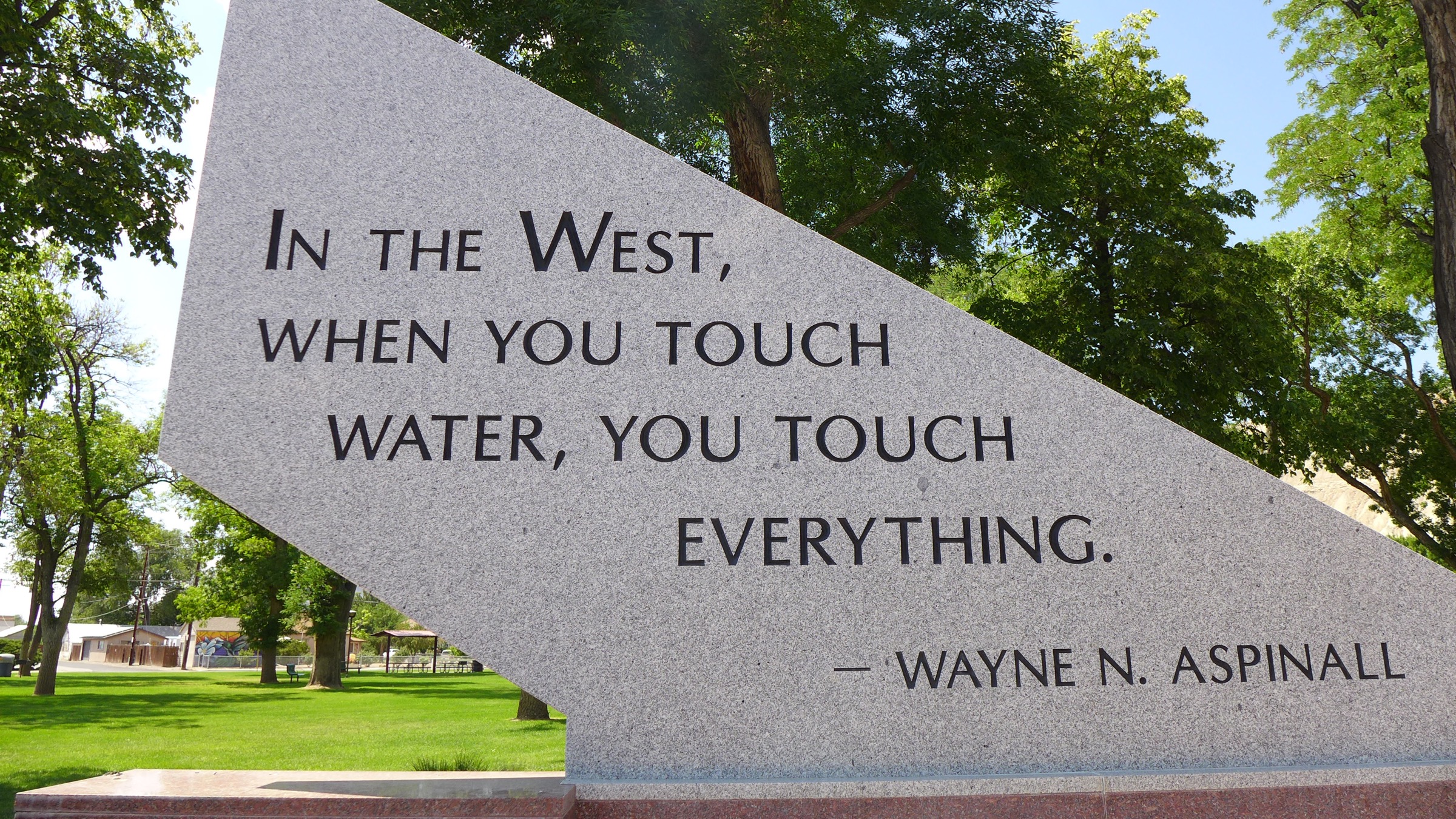
Part of the memorial to Wayne Aspinall in Palisade. Aspinall, a Democrat, is a legend in the water sector, and is the namesake of the annual award given by the Colorado Water Congress. Photo: Brent Gardner-Smith/Aspen Journalism
Storage box checked
“When it comes to water storage, we need to build more. And during my administration, we will build more,” Walker Stapleton, the Republican candidate for governor, told the Water Congress members on Wednesday, Aug. 22, in one of the more straightforward declarations heard last week on the subject.
“Some of this will be larger projects and larger reservoirs, but it will also be dynamic and medium-sized projects that help us store water in innovative ways and balance environmental protection with our needs to build out storage,” Stapleton said. (Read more on Stapleton’s water policies).
Scott Tipton, a Republican who has represented the 3rd Congressional District since 2010, is a familiar figure at Water Congress. Speaking at 8:30 a.m. Thursday morning, Aug. 23, Tipton began by paraphrasing Wayne Aspinall, the late Congressman from Palisade who is nationally recognized for his work on water issues.
Aspinall’s quote, “In the West, when you touch water, you touch everything,” is carved into stone in a park near the Colorado River in Palisade, but Tipton expressed it as “When you touch water in the West, it is really the lifeblood of what we are and who we are in our state.”
Tipton went on to say that Colorado’s population is expected to double by 2050.
“We need to be looking out the windshield in terms of water storage,” Tipton said, adding, “We’re going to have to be able to store more water.” (Read more on Tipton’s water policies).
Jared Polis, the Democratic candidate for governor, briefly mentioned storage in his prepared remarks, but in the context of expanding existing reservoirs and using technology to conserve more water.
The outflow of the Bousted Tunnel just above Turquoise Reservoir near Leadville. The tunnel moves water from tributaries of the Roaring Fork and Fryingpan rivers under the Continental Divide for use by Front Range cities, and Pitkin County officials have concerns that more water will someday be sent through it.
Transmountain diversions
Venturing out on a political limb, Polis shared his views of the prospect of additional transmountain diversions under the Continental Divide.
“To many Coloradans in the high country on the Western Slope — some communities that I represented for a decade in Congress — future transmountain diversions pose an existential threat to the health of our rivers and our agricultural economy,” Polis said.
“So I’ll be very clear: As a matter of principle, I will oppose transmountain diversions that are not developed through the collaborative principles that the interbasin compact committees have agreed on.”
He then doubled-down on his position, saying during a Q&A period that he “would oppose any transmountain diversions that have not been agreed upon by respective areas.”
On Friday, Aug. 24, Diane Mitsch Bush, a Democratic candidate for the 3rd Congressional District, spoke to the water buffaloes.
As a state legislator from Steamboat, she served for four years as a house member on the legislature’s “interim water committee” and chaired the house agricultural committee, where any bill having to do with water is scrutinized.
During a Q&A period, Mitsch Bush was asked flat out, “Will you be an advocate for new storage projects?”
“Small, efficient storage projects are certainly something that we will most likely need,” she replied. “Not on the scale that we’ve seen in the 20th century, (but) I think small and efficient off-channel projects may be very helpful in storing and delivering water.”
She also addressed the potential need for additional transmountain diversions.
“We really need to think of ways to not have new transmountain diversions, for many reasons,” she said. “The key one being that when, not if, when, there is a compact call on the Colorado, some of those transmountain diversions will be among the first called.”
Editor’s note: Aspen Journalism is covering water and rivers in the Colorado River basin in collaboration with the Vail Daily and The Aspen Times. The Vail Daily published this story on Aug. 26, 2018.
A 10th Circuit panel on Monday heard arguments on whether the Army Corps of Engineers incorrectly applied Clean Water Act standards only to mitigating environmental damages rather than to the entirety of a project to expand a Colorado reservoir…
The Audubon Society of Greater Denver sued the Army Corps of Engineers in 2014, claiming the corps failed to choose a less environmentally damaging alternative.
“The record and the state show that the most environmentally damaging plan was chosen,” said attorney Kevin Lynch with the University of Denver Sturm College of Law, representing the Audubon Society during oral arguments at the 10th Circuit on Monday.
In order to meet federal regulations, Lynch said the corps evaluated the full reallocation project under the National Environmental Policy Act (NEPA), and then misapplied the Clean Water Act to assess only alternative plans for environmental mitigation. Lynch said both NEPA and the Clean Water Act need to be applied to the full project.
U.S. Attorney Sommer Eagle confirmed the Clean Water Act was applied only to consider discharge from the mitigation efforts rather than the full project. When U.S. District Judge Philip A. Brimmer issued final judgment in favor of the corps in December 2017, he found no issue with this reading of the law.
On Monday, U.S. Circuit Judge Scott Matheson seemed to address both parties when he asked, “How much of your argument is based on your interpretation of ‘overall project purpose?’”
Matheson said the panel would comb through the law to determine whether “project” under the Clean Water Act means the full construction or can refer to parts of it.
Other project alternatives passed over by the Army Corps of Engineers included expanding other water reserves, increasing groundwater storage, using readily available offsite gravel pits directly adjacent to the park, and a “no-action alternative relying on Penley Reservoir” coupled with increased water conversation efforts.
Chief Circuit Judge Mary Beck Briscoe was not impressed by the suggestion that better water conservation would solve metropolitan Denver’s increasing demand.
“Would that have been something that would have been effective? You hope that this week people do better, but next week maybe they won’t?” Briscoe challenged.
Construction on the Chatfield Storage Reallocation Project is expected to be completed by 2020. Although construction has commenced on the western edge of the lake, activists still hope for a decision that would protect the Plum Creek Nature Area.
U.S. Circuit Judge Carlos Lucero also sat on the panel. The judges did not indicate when they would reach a decision.
As rivers run dry and reservoirs run low, west-central Colorado district studies storage and leasing options
At the head of the Crystal Valley, automated sprinklers trundle across fields that hug Highway 133, scattering precious water over green sprouts. But on Brook Levan’s farm, one of those sprinklers sits idle. Due to low flows in the Crystal River, the irrigation system stopped operating. Levan had to purchase organic hay from out of state to feed his dairy cows.
“Some of that’s Montana water,” said Levan, pointing to a shed filled with bales of yellow hay.
Levan, director of Sustainable Settings, a nonprofit that promotes sustainable farming, said he remembers when there was snow year-round on Mount Sopris. This year, the mountain’s dry and gray. In the valley below, the Crystal River flows at a trickle, meandering through a rocky, dry riverbed as warm winds whip across the fields at either side.
For Coloradans in state Senate District 5, an area larger than New Hampshire stretching from the Vail mountains to the western plains, water is a constant worry. It helps grow fruit for markets and hay for livestock. It sustains recreational economies that rely on visitors who ski, raft and fish.
Some call water the state’s lifeblood, and that’s doubly true in water-dependent Crystal Valley. And as the rivers run dry and reservoirs run out, two candidates vying to represent this district in the Colorado Statehouse are proposing different paths forward for how to manage the state’s water supplies — and the public lands that encompass them more generally.
The incumbent wants farmers to be allowed to lease their water rights without fear of penalty, while her opponent believes building reservoirs to store water is the best answer.
Republican Olen Lund, a 59-year-old alfalfa farmer from Paonia, is running to unseat Democratic Sen. Kerry Donovan, a 39-year-old rancher from Vail. The winner will likely play a role in the contentious debate over water policy, especially as Colorado braces for increasing demands from other states on Colorado River water.
Rancher and former state Rep. Kathleen Curry of Gunnison, a Lund supporter, has long championed Western Slope water rights. “We need a really strong voice” in Denver, she said. “We do not want our water cut back so that Denver and the surrounding area can build another subdivision.”
For Dea Jacobson, a former regional campaign coordinator for the Democratic Party from Cedaredge, the environmental impact of oil and gas drilling is an even larger concern. “The region needs nursing and care,” she said, especially when it comes to proposed drilling in the North Fork Valley. “Putting the oil and gas industry in the same backyard as the water supply needed for organic farming” is dangerous, she said.
Water is paramount in this district. But this race is also about the balance of power under the Gold Dome. Democrats have a seven-seat hold on the House, and, this November, they want to flip three seats blue in the Senate, where Republicans hold a one-seat majority. The GOP views the District 5 seat as a pickup opportunity to bolster its majority, in part because Republicans outnumber Democrats here. In 2014, Donovan won by a relatively narrow 2.3 percent margin.
But midterm elections are considered a referendum on the president’s party — and Donald Trump isn’t that popular in this district; Hillary Clinton bested him in 2016 by 5.5 percentage points.
“It is an important race for us,” said Curry.
Olen Lund outside the Red Rock Diner in Carbondale on Sept. 18, 2018. Photo by John Herrick
Lund, a former Delta County commissioner and president of the Delta County Farm Bureau, is running on the motto that he will be a voice for rural Colorado. “We need a senator that knows our lands aren’t playgrounds for the Denver-Boulder types,” he told Republicans packed in a Denver hotel conference room at the state GOP nominating assembly last April. “This is our home. We will fight for our farms, our families and our values.”
Lund is a founding member of the Gunnison Basin Roundtable, which represents water users in the region. He also served on the Interbasin Compact Committee, a state advisory panel that discusses water compacts with states that share the Colorado River. He is cavalier about the drought in Colorado. He rattled off past dry years: 1935, 1977, 2002. “It’s been dry before,” Lund said during an interview at the Red Rock Diner in Carbondale last week.
Still, he said there is a looming collision between a growing population on the Front Range and demand from the thirsty Lower Basin states of Arizona, Nevada and California. The 1922 Colorado River Compact requires the Upper Basin states — Colorado, Wyoming, New Mexico and Utah — to send at least 7.5 million acre-feet per year to the Lower Basin.
Farmers and ranchers must be efficient with their water, Lund said. One tool, alternative transfer mechanisms, or ATMs, allow farmers to lease their water rights for purposes other than irrigation. Still, he cautioned, there are inherent problems with ATMs and they must be applied on a case-by-case basis.
The “most important tool,” Lund said, is storage. This often requires damming rivers and flooding reservoirs — projects that have historically run into opposition from environmentalists. Lund said the legislature may be able to help “grease the skids.”
As for new taxes to pay for conservation and efficiency projects, he scoffed.
“Increase taxes and increase taxes,” Lund said. “It’s getting more and more difficult for people to exist.”
As he drinks a cup of ice water and eats a hamburger, he recalls growing up helping his neighbors grow vegetables and inheriting his father’s pear orchard before turning it into alfalfa pasture.
“I’m a farmer serving as a politician. It’s not like this is something on my bucket list,” Lund said. “A lot of people asked me to do it.”
Kerry Donovan speaks at a candidate forum in Salida on Sept. 18, 2018. Photo by John Herrick
Across the Continental Divide, the Arkansas River spills into the Chaffee Valley. Intermittent rafting outfits mark the sides of State Highway 24. In Salida, a recreational tourism town which sits on the river, about 50 people gathered inside the A Church recently for a progressive candidate forum.
Sen. Donovan drove down from Vail, where she runs her family ranch raising Highland cattle, chickens, horses and mules. She also grows vegetables. One of the people at the forum asked her what she plans to do about water shortages.
Donovan said some farmers and ranchers fear they have to “use it or lose it,” referencing a Colorado water law clause that says if a farm uses less water than it’s entitled to, the owner’s allocation can be cut. She also said some farmers sell their water rights outright to municipalities, a process known as “buy and dry.” Farmers, she said, need more flexibility. She said she wants to look at new ideas for how farmers and ranchers can lease water rights to the Colorado Water Conservation Board to keep stream flows high for ecological purposes, like fish habitat, and recreational uses.
“How do we give the agricultural community more options with their water rights while not likely losing them? I know the realities on the ground and I know the pressures the West Slope is going to feel,” she said in an interview with The Colorado Independent.
Donovan opposes any new transmountain diversions. And damming more rivers requires more water, which there isn’t much of to begin with, she said. Besides, she said, it may be better to add capacity to existing reservoirs. She added there’s little the state legislature can do around this subject given that most dams require federal permits.
When it comes to passing new taxes to pay for water conservation and efficiency projects, she’s open to ideas.
In addition to water, audience members at the forum brought up the area’s lack of affordable housing. “My favorite barista told me he and his family are leaving because they can’t afford to live here,” said Anne Marie Holen, a resident of Salida.
The lawmaker says she wants to give tax credits to local businesses that invest in housing.
Spotty Internet service was another complaint. Donovan said a new law she co-sponsored will pump tens of millions of dollars into Internet infrastructure in rural Colorado.
People applauded when Donovan said, “It’s not acceptable that a health care bill is more than a mortgage bill,” adding that she wants legislation to increase transparency around drug companies’ supply chains, an effort that was shot down in the Republican-controlled Senate this session.
The Independent asked Lund for his thoughts on affordable housing, broadband and health care policy, but he was unable to respond in time for publication.
Donovan raised more than $163,000 so far this election cycle. Coloradans for Fairness, an independent expenditure committee supporting Democrats in the state Senate, spent more than $30,800 on digital ads supporting her. There are virtually no limits on how much money IECs can accept and spend on candidates.
Lund, by comparison, has raised only $14,000. But he has more generous support from several outside groups buying ads on his behalf, such as the Colorado Economic Leadership Fund, a 501(c)4 that does not have to disclose its donors or how much it’s spending on Lund’s campaign, and Americans for Prosperity, another dark money group backed by the Koch brothers.
Furthermore, the Senate Majority Fund, an IEC that aims to elect Republicans to the state Senate, spent more than $69,000 this year on mailers attacking Donovan on behalf of Lund’s candidacy.
Much of the Senate Majority Fund’s money comes from oil and gas companies. And Lund does not equivocate in his support for the industry.
He supports drilling in his backyard, the North Fork Valley, where the Bureau of Land Management, under the Trump Administration, is proposing to lease land to drillers. Gov. John Hickenlooper opposes the plan, saying it could impact greater sage grouse habitat and affect big game winter range and migration corridors.
Lund, who said he was planning to attend an oil and gas tour in Mesa County this week (a county not included in SD5), brushed off these concerns. He said ranchers provide good habitat for the sage grouse. And as for elk, he said, “They love the drilling sites. It is more of a plus than a minus for the elk.”
Lund said recreation probably has a greater impact on the environment than drilling, citing a recent trip to Eagle where he said there were mountain bike trails were all over the mountainside. “That has got to be an interruption of something,” he said.
Donovan not only sees things differently, she helped make the third Saturday in May “Public Lands Day.” Wilderness, wildlife and water are the reason people live in Colorado, she said.
“They’re the pictures we put up on Instagram. And they fuel the economies of many communities,” Donovan told those attending the candidate forum.
Donovan opposes drilling in the North Fork Valley. She said she sent letters to the BLM opposing the plan.
“Your role as a public servant is to be a voice for the local community. And the local community that will be most impacted by that drilling does not want it,” she said.
That community is Paonia, Lund’s hometown.
For farm residents in rural Senate District 5, there is a concern that lawmakers in distant Denver are not listening.
“We just don’t want them to forget about us,” said Paul Stockwell, executive director of the Delta Area Chamber of Commerce.
But right now, these voters mean everything to the candidates as they tour the state, knocking doors and asking for support. The district’s roughly 35,600 unaffiliated voters, the largest bloc, matter most. Overall, the district’s population has grown since 2010, totaling about 143,000 people as of 2016, according to the U.S. Census.
Donovan said her campaign has contacted over 17,000 people, either by phone or by knocking doors.
Lund said he’s been out campaigning, too.
“It’s a big district,” he said. “We’re on the second set of tires.”
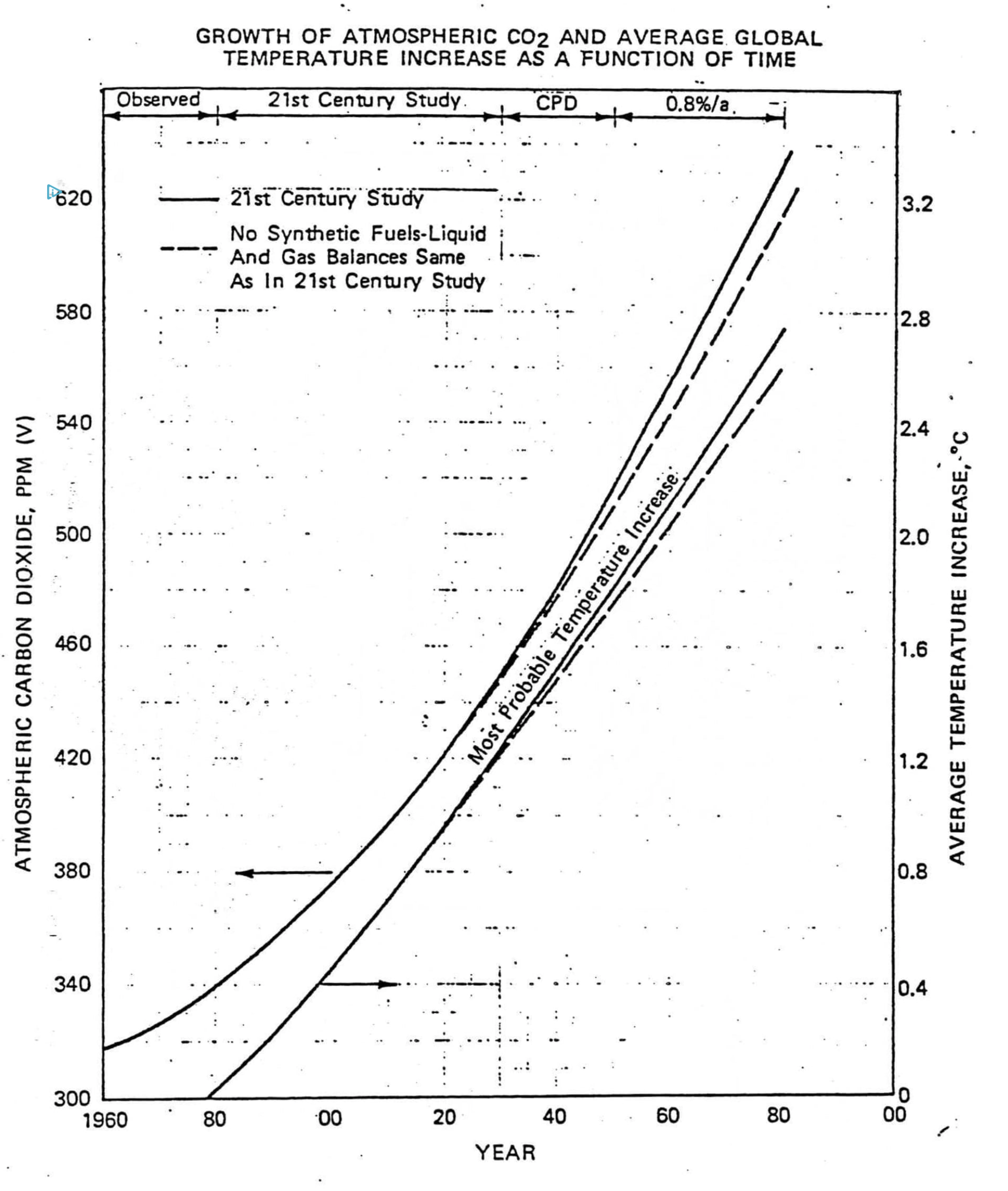
1. The Annual Greenhouse Gas Index (AGGI) is a measure of the capacity of Earth’s atmosphere to trap heat as a result of the presence of long-lived greenhouse gases. The AGGI provides standardized information about how human activity has affected the climate system through greenhouse gas emissions.
2. This indicator demonstrates that the warming influence of greenhouse gases in the atmosphere has increased substantially over the last several decades. In 2017, the AGGI was 1.42, an increase of more than 40% since 1990.
3. The AGGI can inform decisions about mitigation strategies.
Full Summary:
Radiative forcing (shown on the left vertical axis) is the change in the amount of solar radiation, or energy from the sun, that is trapped by the atmosphere and remains near Earth. When radiative forcing is greater than zero, it has a warming effect; when it is less than zero, it has a cooling effect. In this indicator, radiative forcing from long-lived greenhouse gases is shown relative to the year 1750. The AGGI (shown on the right vertical axis) is an index of radiative forcing normalized to the year 1990; it shows how the warming influence of greenhouse gases in the atmosphere has increased since that year.
This indicator demonstrates the change in radiative forcing resulting from changing concentrations of the following greenhouse gases: carbon dioxide (CO₂), methane (CH₄), nitrous oxide (N₂O), chlorofluorocarbons (CFC-11 and CFC-12), and a set of 15 minor, long-lived halogenated gases. The National Oceanic and Atmospheric Administration (NOAA) Global Monitoring Division provides high-precision measurements of the abundance and distribution of long-lived greenhouse gases that are used to calculate global average concentrations. Radiative forcing for each gas is computed from these concentrations, and total radiative forcing for all gases is used to calculate the AGGI.
The AGGI shows that the warming influence of long-lived greenhouse gases in the atmosphere increased by 42% between 1990 and 2017. Carbon dioxide is currently the largest contributor to radiative forcing. Radiative forcing from methane has steadily increased since 2007, after having been nearly constant from 1999 to 2006. Owing to the Montreal Protocol, an international agreement signed in 1987, CFCs have been decreasing since the mid- to late 1990s after a long period of increase. However, CFC replacements (many of the “other halogenated gases” in the graph) have been increasing since the phase-out of CFCs.
Fundamentally, the AGGI is a measure of what human activity has already done to affect the climate system through greenhouse gas emissions. It provides quantitative information in a simplified, standardized format that decision makers can use to inform mitigation strategies.
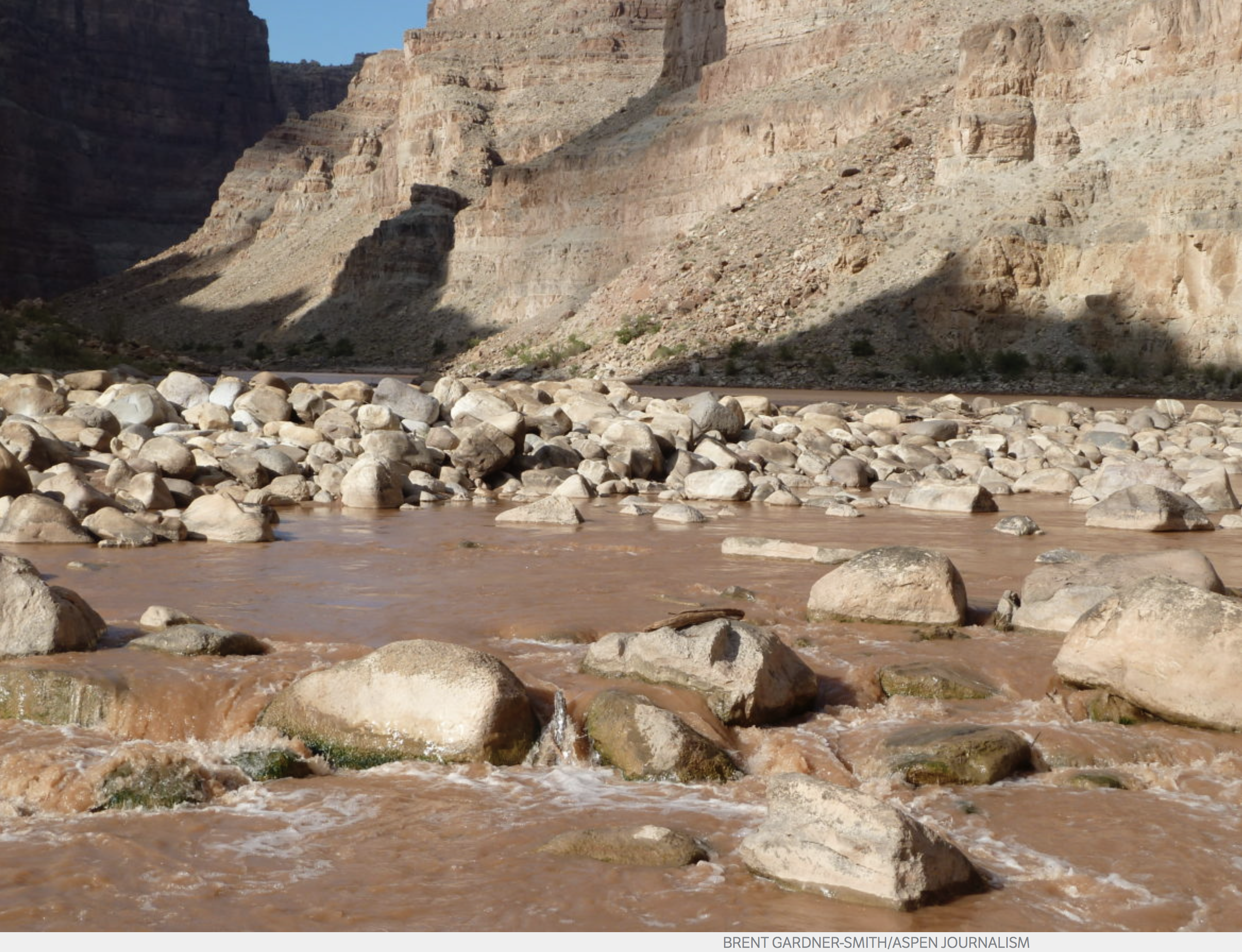
Low flows on the Colorado River in Cataract Canyon. Flows on the Colorado have always risen and fallen seasonally, but water managers in the west now firmly see a future with less water overall to work with.
The phrase “climate change” did not appear on the agenda of a recent three-day meeting of the Colorado Water Congress, but the topic was often front and center at the conference, as it increasingly is at water meetings around the state and the region.
Amy Haas, the new executive director of the Upper Colorado River Commission, told the Water Congress audience of about 300 water managers, irrigators, engineers and lawyers that “hydrology is changing more rapidly than we once thought” and that “it is primarily due to climate change.”
And, Haas said, attitudes among water managers about climate change are changing too.
“I feel that water managers are not only talking about climate change, they are talking about it frequently,” she said. “This is the new reality that we have to contend with. And I’m encouraged to hear the discussion, openly, in all sorts of water management forums.”
Haas also recognized Brad Udall, who was also at Water Congress, in her remarks.
A senior climate researcher and scientist at Colorado State University, Udall continues to get the attention of water managers with studies that tie rising temperatures to declining river levels.
Udall recently published a paper, along with Mu Xiao and Dennis Lettermaier, on the declining flows of the Colorado River.
The paper found that flows in the upper Colorado River basin declined by 16.5 percent from 1916 to 2014, while annual precipitation increased only slightly, by 1.4 percent.
By conducting experiments with a model that uses temperature and precipitation as inputs, the researchers found that “53% of the decreasing runoff trend is associated with unprecedented basin-wide warming, which has reduced snowpack and increased plant water use,” Udall explained. “The remaining 47% of the trend is associated mostly with reduced winter precipitation in four highly productive sub-basins, all located in Colorado.”
Climate Science 101
Udall is also using “aridification” at water meetings to describe what’s happening in the Colorado River basin, and he’s offered up a succinct summary of his research on climate change, on a t-shirt, that says “it’s warming, it’s us, expert agree, it’s bad, (and) we can fix it.”
Andy Mueller, the general manager of the Colorado River District, also makes no bones about climate change.
He told the Water Congress audience that the River District is “planning for a future with less water, and it being a permanent situation.”
And on Sept. 14, at a River District seminar in Grand Junction, Mueller told an audience of over 250 water managers, users and stakeholders that science shows that “climate change is going to reduce the natural flow into Lake Powell by 20 percent by 2035 and by the end of the century, 35 percent.”
Mueller added, “We’ve got to recognize that we have a supply problem in the upper basin.”
Past not relevant
Jim Lochhead, the CEO and manager of Denver Water, said during his remarks at the Colorado Water Congress meeting that the impact of climate change goes even beyond supply issues.
“A warming climate is something we’ve built into our scenario planning process, but it’s not just a water supply concern,” Lochhead said, also citing wildfires and the resulting runoff into reservoirs and rivers, and the increased cost for water treatment from “warmer water” and “emerging contaminates.”
He also said Denver Water no longer thinks that the past is a reliable guide to the future, citing the “over-assumptions of water supply” in interstate compacts like the 1922 Colorado River Compact, the state’s water rights system which is based on “past hydrology,” and state and federal regulations that are based on “past water temperatures and water quality parameters.”
“Those are all geared to the past and not to the future,” Lochhead said.
Denver Water has also “abandoned linear water-supply planning,” where, as he put it, “you look at the past hydrology, look at past population trends, and project those out into the future, look at a water supply gap, and then go out and find water to meet that gap.”
“That no longer can meet the challenges that we face today,” Lochhead said.
And Lochhead said that “firm yield,” the capacity of a given water supply system to meet demands in a dry spell, and the Holy Grail for water providers, was now an outmoded concept.
“We don’t use that term any more, actually, because we know that no yield is firm,” he said.
And if that wasn’t riveting enough for water managers to hear, Lochhead also said that “as we look at the warming climate some of the scenarios in our scenario planning are actually pretty scary, and they will be coming at us more and more quickly.”
From the Associated Press via The Grand Junction Daily Sentinel:
The National Park Service says unsafe levels of a type of algae that can be harmful to humans have been found in the water of a central Colorado reservoir.
Park officials said they detected the presence of toxins that can be produced by algae blooms in water samples taken from Blue Mesa Reservoir.
The agency advised visitors to avoid contact with shallow waters in an area known as the Iola Basin and to avoid mats of algae throughout the reservoir.
The reservoir is part of Curecanti National Recreation Area west of Gunnison, Colorado.
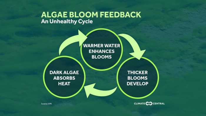
Harmful blue-green algae is natural to the area but can spread quickly in warm, shallow water.
We live in a warming world. And we often characterize that warming through metrics of temperature. But that’s only a sliver of the story. Another sliver, and perhaps a more consequential one, of the story is the connected increase in atmospheric moisture.
Recent months have brought us—yet again—real-world examples of what these increases in moisture can bring.
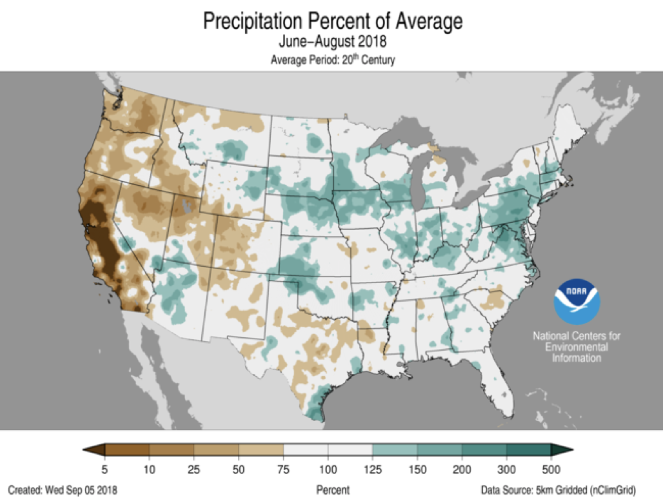
To say it’s been a wet year in the mid-Atlantic is an understatement. Through August, that is to say, before Florence, we were already working on the wettest year on record, or close to it, in much of the region.
January-through-August precipitation ranks for the contiguous United States. The darkest green areas saw record high precipitation for that eight-month period. The medium green indicates places with Jan-Aug precipitation in the top ten percent of history. The lightest green shade indicates areas with precipitation totals in the top one-third of history. The period of record dates back to 1895. From NCEI’s US State of the Climate report for August 2018.
Once Florence’s rains are factored into the end-of-September analyses, we’ll see much more dark green in the Southeast and mid-Atlantic.
What does that have to do with warming? Taken individually, not a lot. But taking the larger history into context, this is a continuation of a signal we’ve seen in recent decades, especially east of the Rockies: it’s getting wetter. 2018’s rank as the wettest year on record (to date) for parts of the East just reinforces this trend.
So, what does that have to do with warming? Again, it’s complicated, because precipitation is the end result of several atmospheric ingredients and processes, but to oversimplify: a warmer atmosphere can hold more water vapor, and an atmosphere with more water vapor can make more precipitation.
But the bigger and more consequential change we’ve seen is how much rain can and does fall in an event. I’m going to call that “Big Rain” as shorthand. What I mean by “event” is something meteorological in scale, lasting a day or two or maybe three.
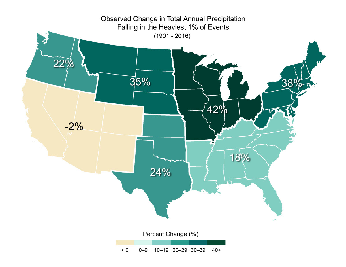
I should stop here, as an aside, and say there are a multitude of ways to define “Big Rain.” One way that the National Climate Assessment has chosen is to define Big Rain as the top 1% of daily totals from the reference period of 1961-90.
This indicator shows the increase or decrease of the amount of annual rainfall that comes in the form of very heavy precipitation. For this indicator, very heavy precipitation refers to events in the top 1% of those occurring during the reference period of 1961-90. From the National Climate Assessment Climate Science Special Report, and the US Global Change Research Program’s Indicator Platform.
By this indicator, most of the country has seen dramatic increases in Big Rain. You can learn more about this indicator here.
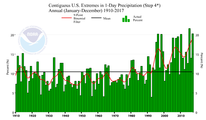
By NCEI’s Climate Extremes Index—another way to diagnose changes in Big Rain—it’s increasing, too. Component 4 of the CEI is dedicated to one-day rainfall totals. That trend is up, with a bullet.
NCEI’s Climate Extremes Index Component 4 shows how much of the US was subject to greater than normal proportion of precipitation derived from extreme 1-day precipitation events. The increase in recent years means that more of the US is subject to increased very heavy one-day precipitation.
How is that tied to warming? The same way: a warmer atmosphere can hold more water vapor and an atmosphere with more water vapor can make more precipitation. And the warmer it gets, the higher the theoretical “Big Rain” events can get. That’s playing out in the data, pretty much any way you look at it.
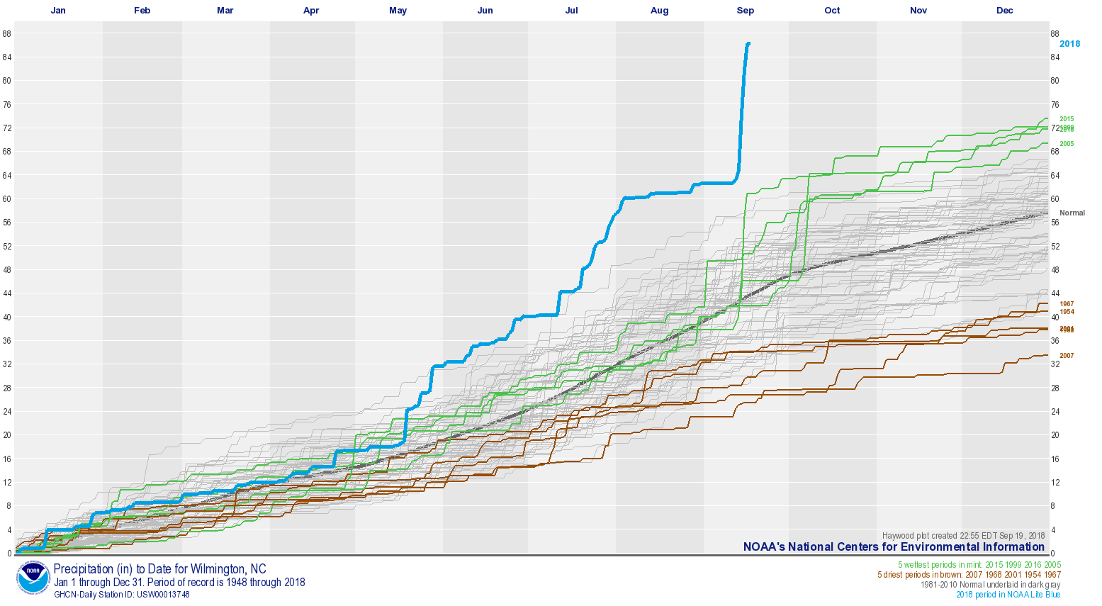
These two trends—wetter conditions overall, and bigger Big Rain—are exemplified in this plot for Wilmington, NC. This plot, often called a “Haywood Plot,” shows the cumulative precipitation for about 70 years at Wilmington. Each line on the graph shows a year’s progression in total precipitation. The driest five years are plotted in brown; the wettest years in mint, with 2018 highlighted in light NOAA blue.
This Haywood plot for precipitation at Wilmington, NC shows how each year’s cumulative precipitation played out. The 2018 precipitation (through September 16) is in the thick, blue line. The other four years that make up the five wettest on record (with 2018) are shown in mint, while the five driest years are shown in brown. The other years are shown as grey. 2018 became the wettest year on record at Wilmington with more than 100 days left in the year. Haywood plots are often included in the supplemental materials associated with NCEI’s monthly US State of the Climate reports.
Look at 2018. Even before Florence, Wilmington was experiencing the wettest year-to-date on record, with the blue line outpacing its “rivals” in the field. Florence’s totals pushed that line into—literally—uncharted territory. Even if no rain were to fall in the next 100 days, 2018 will be the wettest year on record at Wilmington by almost a foot.
But what’s more interesting, looking beyond this year’s data, are the spikes. Each of those five wettest years has a large spike in September or October. And each of those spikes—indicating a huge increase in precipitation over the span of just a day or two or three—came courtesy of a named storm. Specifically, 2005’s Ophelia, 2016’s Matthew, and 1999’s Floyd, which made landfall in the region, and 2015’s Joaquin, whose moisture was entrained into massive rains over the Carolinas.
The other years don’t have these huge spikes. Sure, it’s kind of intuitive that the years with the biggest spikes would have the highest totals, but what’s not so obvious is all five of those years have happened in the last 20 years. The previous 50 years? Not so much.
And that brings us back to hurricanes and tropical storms, or “tropical cyclones” for short. We’ve long known that generally speaking, warmer means more intense storms and more potential rainfall, but the latest piece of knowledge on tropical cyclones is that they appear to be slowing down, for reasons that aren’t entirely clear.
Why does that matter? Slower storms can dump more rain on a place, and when that place is coastal land, it can bring catastrophic flooding. We definitely saw this with Harvey and Florence.
These factors—an atmosphere more laden with water vapor making more rain, and making more rain in larger doses, and the change in forward speed of tropical cyclones—are connected to our very real observations of more precipitation. It’s something we’ll need to build for, warn for, and work on.
Ivanhoe Reservoir, in the headwaters of the Fryingpan RIver basin. Photo: Brent Gardner-Smith/Aspen Journalism
From email from Reclamation (James Bishop):
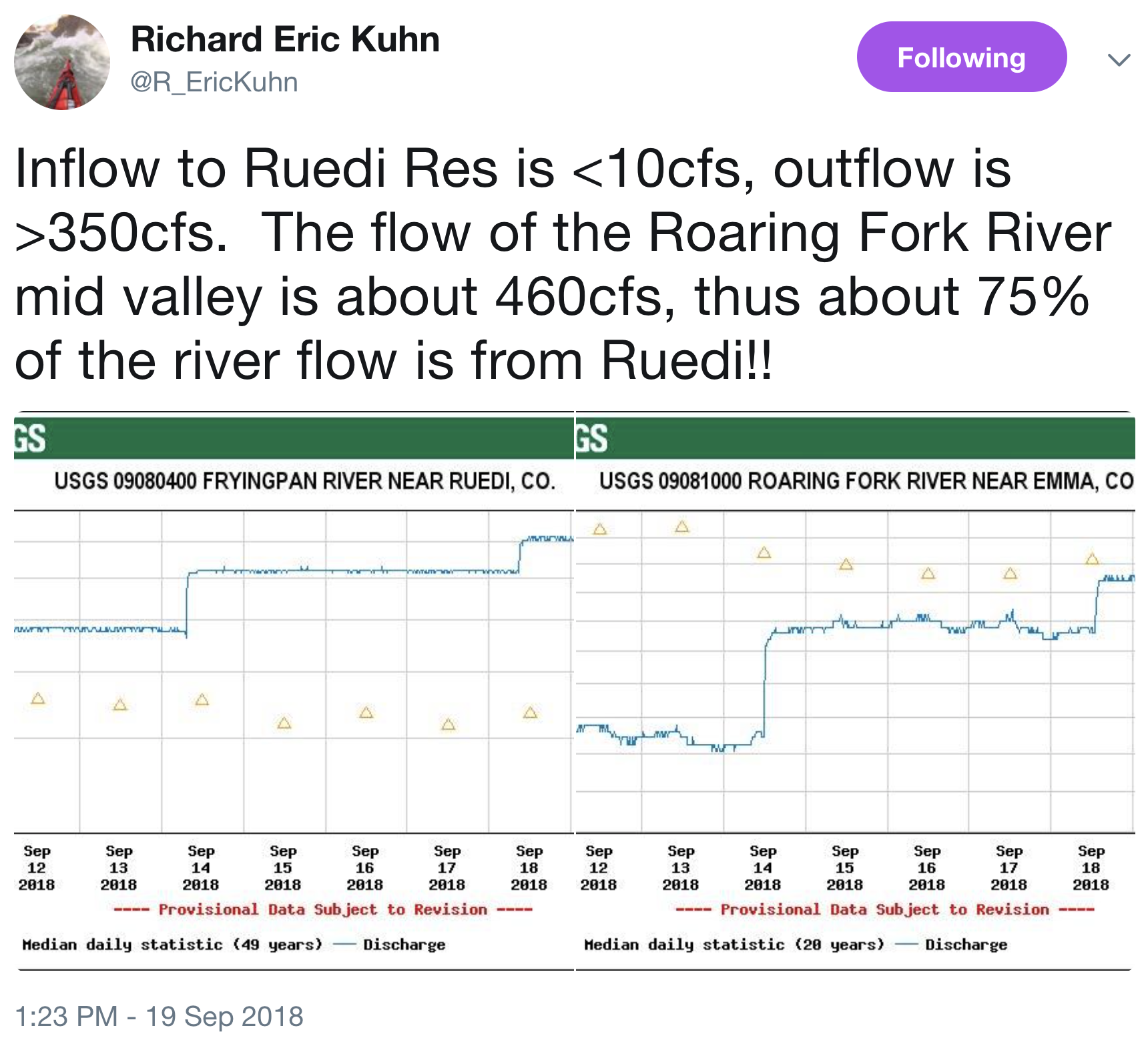
Releases from Ruedi Dam to the Fryingpan River are scheduled to decrease from 350 to 300 cubic feet per second on Monday, September 24 at 8 a.m.
This release rate maintains “fish water” deliveries to the 15-mile Reach for endangered fish species. Routine updates to follow. Feel free to contact me with any questions at jbishop@usbr.gov or by phone at 970-962-4326.
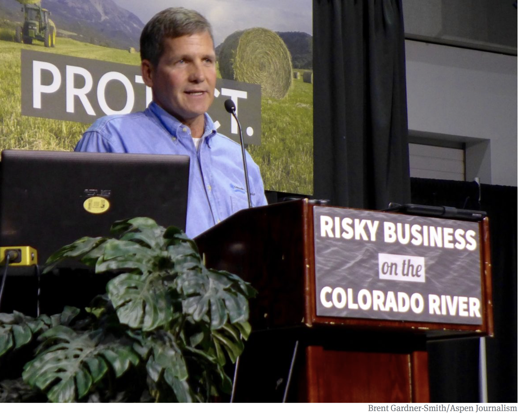
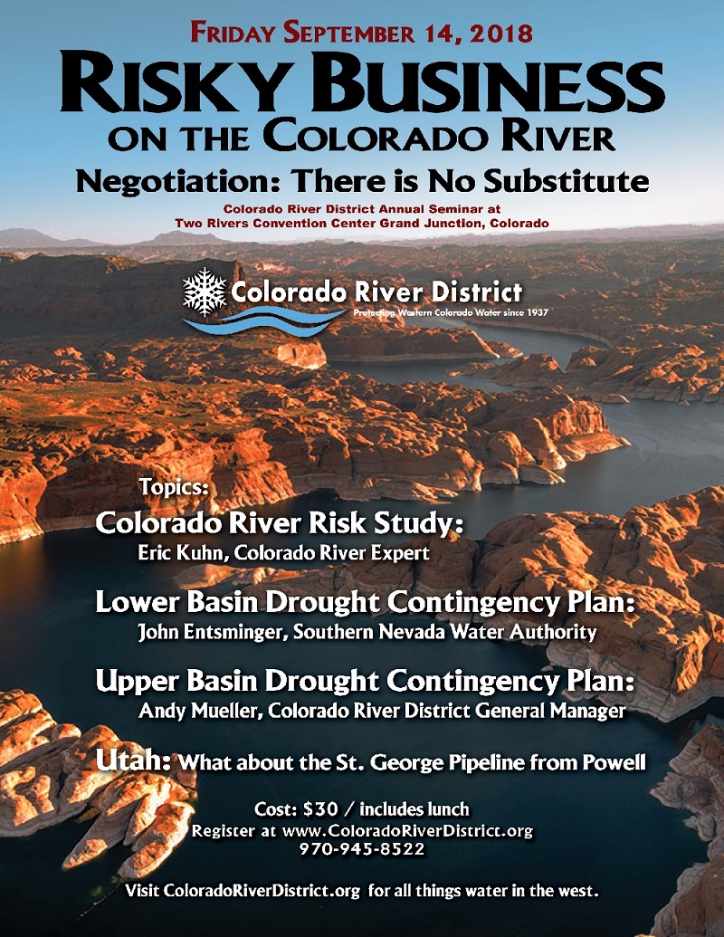
Click here to go to the Colorado River Water Conservation District website:
Our 15th Annual Water Seminar, “Risky Business on the Colorado River” was held on September 14th, 2018 in Grand Junction, Colorado.
We heard from speakers with Southern Nevada Water Authority, the Utah Division of Water Resources, a member of the Board of the Colorado Water Conservation Board, the Colorado River District and others as they discussed current conditions on the river and how water is managed.
The headwaters of the Rio Grande River in Colorado. Photo: Brent Gardner-Smith/Aspen Journalism
From the New Mexico Political Report (Laura Paskus):
Right now, New Mexico’s largest reservoir is at about three percent capacity, with just 62,573 acre feet of water in storage as of September 20.
Elephant Butte Reservoir’s low levels offer a glimpse of the past, as well as insight into the future. Over the past few decades, southwestern states like New Mexico have on average experienced warmer temperatures, earlier springs and less snowpack in the mountains. And it’s a trend that’s predicted to continue.
“There was no spring runoff this year. We started this year at basically the point we left off at last year,” says Mary Carlson, a spokesperson for the U.S. Bureau of Reclamation, which operates Elephant Butte Dam, just north of the town of Truth or Consequences. The federal agency runs the Rio Grande Project, which stores water that legally must be delivered downstream to the Elephant Butte Irrigation District, the state of Texas and Mexico.
Drought has moved around the U.S. Southwest since the late 1990s, and last winter’s dismal snowpack broke records in the headwaters of the Rio Grande. Without runoff this spring, by February reservoir levels around the state—including at Elephant Butte—were as high as they were going to be this year. “We had some help from the monsoons,” Carlson says, “but not as much as we wanted, where we wanted.”
Many spots around New Mexico reveal signs of drought and climate change, whether it’s the puny flows of the Rio Grande, the fire-ravaged forests of the Jemez Mountains or the crispy rangelands of the northeast. But Elephant Butte Reservoir offers perhaps the starkest reminder that keeping up with the changing climate may require questioning long-held ideas of how water is managed and shared, how we think about rivers and reservoirs and even, who we consider our friends or foes.
Farmers ‘dealing with La Nada’
For farmers in southern New Mexico, this year “really stung,” says Gary Esslinger, manager of Elephant Butte Irrigation District, or EBID. This year, he explains, less than 45,000 acre-feet of water flowed via the Rio Grande into Elephant Butte. That’s the lowest recorded inflow since the dam was built in the early 20th century.
“There was virtually no snowpack runoff, and whatever there was didn’t get to Elephant Butte,” he says. “The Middle Rio Grande, that river was drying up way too early.”
Beginning in early April, when the state’s largest river is usually running high with snowmelt, it began to dry south of Socorro and upstream of the reservoir…
Watching the reservoir empty out this year makes farmers feel like they are running out of water, he says. At the same time, they’re uncertain about how long their groundwater supplies will last, even though the district tries to monitor groundwater levels and has hired a full-time groundwater specialist.
“We’re not cratering; it’s not Doomsville yet,” he says. “But we’ve got to find another source.” People can pray for rain and snow, he says, but the challenge is finding a long-term, consistent water source. And western states, including New Mexico, don’t have that.
“Everybody’s thinking, ‘Well, climate change is really happening,’ and I think we need to change the way we’re thinking. We keep looking for improvement in the West,” he says.
With improvement unlikely, Esslinger says he’s started considering more radical solutions—like whether western states could share the cost of a canal that would move water from the East, from someplace like the Mississippi River. “People think I might be crazy, but I think we should start looking at it,” he says. “I don’t think we can continue to keep playing this game of predicting and forecasting: we need to find some water and get it over here to the West.”
Farmers face other challenges, too, including the growing expense of pumping groundwater and an “insurmountable” number of regulations, he says. It’s also hard to find workers to hand-pick crops like chile and onions, thanks to changes in immigration policy.
CNHP Wetland Ecologists Joanna Lemly and Sarah Marshall hold a wetland soil core taken from Todd Gulch Fen at 10,000 feet in the Colorado Rockies. The dark, carbon-rich core is about 3 feet long. Living plants at its top provide thermal insulation, keeping the soil cold enough that decomposition by microbes is very slow. William Moomaw, Tufts University, CC BY-ND
Sand Creek in Aurora.
Map of the Roaring Fork River watershed via the Roaring Fork Conservancy
Here’s the release from the Environmental Protection Agency (Lisa McClain-Vanderpool):
Colorado Natural Heritage Society and Colorado State University-Natural Heritage Program will provide invaluable resources to Roaring Fork and Aurora watershed stakeholders
EPA has awarded $575,333 in wetlands grants to two programs in Colorado to survey, assess, map and provide technological tools such as smart phone applications.
“The data these projects generate are important to understanding, protecting and restoring wetlands in the state of Colorado,” said Darcy O’Connor, Assistant Regional Administrator of the Office of Water Protection. “Supporting decision making with solid scientific data is the wise approach to wetlands protection.”
Colorado Natural Heritage Society was awarded $221,250 to survey and assess critical wetlands in the Roaring Fork watershed in western Colorado. This project proposes to conduct a prioritized survey and assessment for critical wetlands within the Roaring Fork Watershed. The primary goal is to provide stakeholders, including private landowners with scientifically valid data on the condition, rarity, location, acres, and types of wetlands within the watershed.
Colorado State University’s Colorado Natural Heritage Program (CNHP) was awarded $221,250 for the 5th phase of CNHP’s wetlands database including vegetation classification, floristic quality assessment, a wetland restoration database and updates to the Colorado Wetlands Mobile App. The CNHP will revise Colorado’s wetland and riparian vegetation classification and floristic quality assessment, and create a Colorado wetland and stream restoration database.
The CNHP was also awarded $132,833 to assess critical urban wetlands in the city of Aurora, Colorado. CNHP will update the National Wetland Inventory mapping and conduct field-based wetland assessments in the greater Aurora area. Water quality data will also be collected at these sites. The goal is to create useful products for local land managers, land owners and community members.
EPA has awarded over $2.5 million in wetlands grant funding for 11 projects across EPA’s mountains and plains region of the West (Region 8). Healthy wetlands perform important ecological functions, such as feeding downstream waters, trapping floodwaters, recharging groundwater supplies, removing pollution, and providing habitat for fish and wildlife.
Wetlands Program Development Grants assist state, tribal, local government agencies, and interstate/intertribal entities in building programs that protect, manage, and restore wetlands and aquatic resources. States, tribes, and local wetlands programs are encouraged to develop wetlands program plans, which help create a roadmap for building capacity and achieving long-term environmental goals.
In 2018, SWSI is being updated using the latest information and will it serve as the technical mainframe for the revisions of the Colorado Water Plan and the Basin Implementation Plans. SWSI 18 will provide parameters that will help plan revision teams consider a variety of scenarios based on climate variance, existing supply and demands, and population growth. This will help these teams make the revised plans, maps that truly guide Colorado and the basin’s water future.
Want to know more? Visit the Colorado Water Conservation boards website at http://cwcb.state.co.us/Pages/CWCBHome.aspx or join in the Rio Grande Basin Roundtable meetings which are held the second Tuesday of each month at the San Luis Valley Water Conservancy District, 623 Fourth Street in Alamosa. Meetings begin at 2 pm. Also visit http://www.rgbrt.org.
Below is an excerpt from Jonathan Thompson’s beautiful book about the people and the historic economies of the Four Corners area and the resultant water pollution, health problems, and climate effects left over from the extractive industries that flourished there. The book centers around the Gold King Mine spill in August 2015 and that is the context Thompson uses to explain the area’s history. He even introduces you to his grandmother and that’s quite a story in itself. River of Lost Souls is an important book. The reader ends up smarter about dealing with folks that disregard environmental issues in the name of economic gain.
Jonathan’s Note: Among the many things in the path of Florence, the tropical storm that battered North Carolina in September, were coal ash dumps. A lot of folks don’t know what those are, or why they are cause for concern. So I’m running this long excerpt from River of Lost Souls: The Science, Politics, and Greed Behind the Gold King Mine Disaster to shine some light on the issue of coal combustion waste.
To drive west out of Farmington is to travel through the borderland, where the northeastern edge of the Navajo Nation melds with the non-Indian world. It’s a cultural and economic mishmash. Here’s a sex store next to a plumbing supply shop across the highway from a sprawling automobile burial ground not far from a Mennonite church. Justalaundry, Zia Liquors, Family Dollar, and numerous little booths or shacks where Diné sell kneel down bread or tamales or piñon nuts to passersby. And the “quick cash” joints that have sprouted like weeds in Gallup, Farmington, and other reservation border towns, preying on the poor, the desperate, and the “unbanked” with their thousand-percent interest loans. It’s just an update of the exploitative pawn shops of yore. “It’s a border town, and tribes around it constitute economic colonies,” John Redhouse, who grew up in Farmington, told me, adding that things haven’t improved that much since the 1970s.
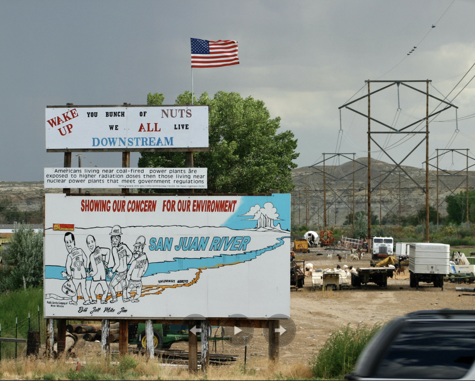
Trailers perched on cinder blocks, tires on a roof. An old man in a recliner, sipping a tumbler of warm whiskey, selling his junk. Down in the lush Jewett Valley a sign pointing to an old metal building reads: “RABBITS GOATS CHICKS AVON AT DOUBLEWIDE.” Just up the road, the Original Sweetmeat Inc., aka “Mutton Lover’s Heaven,” a slaughterhouse and butcher shop, sits alongside the highway and the Shumway Arroyo.
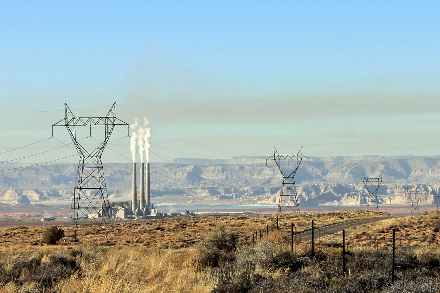
A few miles north looms the San Juan Generating Station, built in 1973 in the arroyo. Eight miles away, on the Navajo side of the river, sits the older, larger Four Corners Power Plant.
The Original Sweetmeats is owned and run by Raymond “Squeak” Hunt, a tall, gruff man prone to muttering inscrutable aphorisms, who deals mostly with mutton, or sheep (as opposed to lamb), and sells to a mostly Diné clientele. “You may think I’m one hard, mean son-of-a-bitch,” Hunt told me when I first met him in 2002, as he unloaded a trailer full of sheep, bound for slaughter. “But it hurts me every time I kill one of these animals.”
I wasn’t there for the sheep, though. I was visiting because Hunt is surely the most stubborn—if unlikely—thorn in the corporate side of Public Service Company of New Mexico, the operators of San Juan Generating Station and the supplier of electricity to the entire state. That doesn’t make him unique; hundreds of activists have agitated against the air pollution from the two coal plants’ smokestacks over the decades. But Hunt was one of the most ferocious fighters against a rarely noticed form of pollution spilling out of the plants: the slag, ash, and dust left over from burning coal, otherwise known as coal combustion waste.
Hunt has lived here, along the banks of the Shumway Arroyo, for much of his life. Prior to 1973 the upper reaches of the Shumway contained water only after rains. Once the arroyo reaches the San Juan River Valley near Hunt’s place, however, irrigation return and groundwater resulted in the arroyo’s transformation to a perennial stream. The stream was a source for both domestic and livestock water for early settlers of the Jewett Valley, including Hunt’s family.
When construction began on the large, mine-mouth, coal-burning power plant a few miles upstream alongside the arroyo, the arroyo changed. Coal power plants require vast amounts of water to function, and when SJGS went on-line in 1973, the plant dumped its wastewater and just about everything else into the Shumway. From that time on, the previously dry arroyo became a perennial stream from the plant to the river. Downstream users in Waterflow, in the meantime, continued to drink out of wells fed by the arroyo’s flows and their livestock kept drinking straight out of the stream.
Like the slightly larger Four Corners Power Plant, which was constructed a decade earlier, San Juan Generating Station’s smokestacks were subject to virtually no regulation. During its first decades of operation, Four Corners became notorious for the black plume of smoke—hundreds of tons of sulfur dioxide and fly ash each day—that it sent into the region’s previously crystal clear skies. One account says that one plant produced more smog than New York City. With the addition of SJGS, the air quality in the region deteriorated, vistas were cut short by smog, and the one thing that remained visible from far away were the plumes emitted by the stacks.
It did not take long for citizen groups from around the region to protest the deterioration in the quality of their air. General citizen pressure and lawsuits forced the 1977 Clean Air Act to include a policy preventing the degradation of air quality. In 1978, San Juan Generating Station installed controls to reduce smokestack emissions and Four Corners followed in 1980. Air pollution from the plants was significantly reduced. Other pollution was not.
When coal is burned the carbon reacts with oxygen to form carbon dioxide. But coal is a lot more than just carbon. It’s got sulfur in it, which becomes sulfur dioxide during combustion, the main cause of acid rain. It contains a host of other elements, most notably arsenic, mercury, and selenium, some of which waft from the stack as smoke and particulates. Most end up as solid waste of one form or another. Each year, power plants in the United States collectively kick out enough of this stuff to fill a train of coal cars stretching from Manhattan to Los Angeles and back three times. It’s stored in lagoons next to power plants, buried in old coal mines, and sometimes piled up in the open. It is the largest waste stream of most power plants, and a study by the Environmental Protection Agency found that people exposed to it had a much higher than average risk of getting cancer.
“Anybody who knows anything about coal ash chemistry knows that when you burn coal, what you have leftover is dramatically different from what you had originally,” Jeff Stant, a geologist with the Clean Air Task Force, told me back in 2002. Coal ash can contain seventeen metals. Some, like mercury or arsenic, are already toxic, others become more so during combustion.
Because every pound of pollution kept out of the air ends up in the solid waste stream, the pollution control methods in the stacks only made the problem on the ground worse. The solid waste consists of fine and dusty fly ash; a gravelly, gray material called bottom ash; and the relatively benign glassy clinkers or boiler slag. The stack scrubbers that pull sulfur dioxide and nitrogen oxide out of the smoke create perhaps the most malignant material, called scrubber sludge. All of that was typically piled up near the plant, where it could blow into the air, or get washed into an arroyo, or leach into the ground. In San Juan Generating Station’s case, the stuff was dumped right into or near Shumway Arroyo—an echo of the hardrock mining tailings that had been similarly dumped for decades one hundred miles upstream.
In the early 1980s, people who lived along the Shumway Arroyo and drank from wells began getting sick. Hunt suffered from muscle spasms, lost sixty pounds, and had a cornucopia of other problems. “I looked like a POW after World War II,” he said. His wife and kids got sick; his neighbors, too.
Though Hunt’s illness was never definitively traced to a specific cause, he and other activists are pretty sure some of the stuff in coal combustion waste made it into his water. Around the time Hunt got sick, researchers found extraordinarily high levels of selenium—which tends to be highly concentrated in coal combustion waste—in the Shumway Arroyo. His symptoms match those of selenium poisoning. His illness may have also come from ingesting too much lead, cadmium, arsenic, mercury, or sulfates, all of which are commonly concentrated in coal combustion waste.
Whatever the poison, it soon became clear that the water was tainted. Those who were sick sued the Public Service Company of New Mexico, which operates the plant; the company never admitted fault, but ultimately settled with the affected families. It also tightened up its waste disposal, becoming one of the first power plants in the nation to go to a zero discharge permit, which means it can’t release any water onto the land. After a lot of legal wrangling, Hunt settled, too.
Hunt, however, remains convinced that the power plant continues to sully the water in the arroyo. He says that water leaks from retention ponds, coal-washing, and dust-control spraying, and even if it’s clean, it picks up and remobilizes contaminants in the sediments of the arroyo, left by the dumping in the 1970s and ’80s. During the late 1990s and early 2000s, 1,400 of Hunt’s sheep, all of which had drunk from the Shumway Arroyo, got sick and died or had to be killed. Hunt blamed Public Service Company of New Mexico, or PNM, the state’s biggest electricity provider. The utility said negligence on Hunt’s part killed the sheep, with the help of minerals occurring naturally in the arroyo and the water. The utility and Hunt have been at loggerheads for years in very public ways. On their way home from work every day, the power plant’s employees have no choice but to see a giant billboard erected by Hunt on his property, bashing both PNM and New Mexico’s environmental regulators. A smaller sign above the big billboard reads: “WAKE UP you bunch of NUTS we ALL live DOWNSTREAM.”
Hunt’s fight isn’t limited to his own situation, though. He’s also worked to shine a light on the coal combustion waste issue in general. Despite the magnitude of the waste stream, and its potentially deleterious effects on human and environmental health, coal combustion waste disposal is regulated much like normal landfills are. The EPA has for decades worked on new rules, implementing some, letting others fall by the wayside.
“I hope you have a cast-iron stomach,” said Hunt as we walked over to the little stand by the road where a Diné couple was selling, along with jewelry, bowls of extremely hot chili and kneel down bread. The lamb sandwiches inside looked good at first, but after a tour of the slaughterhouse and witnessing a sheep get stunned, decapitated, and dressed, I opted for the chili. We sat in a shady spot next to the parking lot and watched a steady stream of customers go into the butcher shop and haul out racks of lamb and mutton, chops, and something a Diné man called b’chee, little strips of meat or fat wrapped up in sheep intestines that Hunt’s wife prepared.
After eating, as the afternoon clouds moved in along with a stiff breeze, we climbed into Hunt’s truck and he drove us to the south side of the river, toward Four Corners Power Plant. We followed a dirt road skirting Morgan Lake, in the shadow of the soot-stained smokestacks of the plant. Each year about nine billion gallons of water are brought up from the San Juan River to form this reservoir, then it’s circulated through the plant to cool the massive generators and for other purposes. The hot water is discharged back into the reservoir, so Lake Morgan is warm and steamy, even in winter, making it a popular, if surreal, windsurfing and fishing spot.
On their way home from work every day, the power plant’s employees have no choice but to see a giant billboard erected by Hunt on his property, bashing both PNM and New Mexico’s environmental regulators. A smaller sign above the big billboard reads: “WAKE UP you bunch of NUTS we ALL live DOWNSTREAM.” Photo credit: Jonathan Thompson
When early provisions of the 1970 Clean Air Act first were being implemented in the early 1970s, the smokestacks looming over Lake Morgan kicked out more than four thousand pounds of mercury each year, along with thousands of pounds of selenium and copper and hundreds more pounds of lead, arsenic, and cadmium, not to mention sulfur dioxide, nitrogen oxides, and other pollutants. Thanks to federal air pollution regulations, and to activists who push the government to enforce those rules, emissions have decreased considerably over the years. Now, with only two of five units still in operation, the plant puts out about 150 pounds of mercury and 520 pounds of selenium each year, along with varying quantities of other toxic metals. Most of these pollutants are then deposited in the surrounding water, on the land, and on homes. For years, rain and snow falling on Mesa Verde National Park—its backside visible from the shores of Morgan Lake—have contained some of the highest levels of mercury in the nation, and elevated levels have even been found on Molas Pass, just south of Silverton. The mercury is then taken up by bacteria in lakes and rivers, which convert it to highly toxic methylmercury, which then enters the food chain. Mercury messes with fishes’ brains, and even at relatively low concentrations can impair bird and fish reproduction and health. It’s not so good for people, either.
We continued out into the desert toward the Chaco River and the Hogback, and as we came over a rise an incongruous scene unfolded before us: a flat-topped, uniformly shaped mesa, its dusty soil gray and smooth, with eerie-looking deep-orange water pools on its surface. Nothing was growing there. I wondered if maybe it was this that I needed a strong stomach for, not the chili.
We were looking at the Four Corners Power Plant’s dump, made up of ash impoundment piles, decant water, and evaporation ponds, containing some forty years’ worth of accumulated coal combustion waste—tens of millions of tons of it—from three of the plant’s five generators. At the time, Four Corners was burning about 8.5 million tons of coal each year, some 3.3 million tons of which were leftover as coal combustion waste, dumped both here and back into the nearby mine. A trio of unlined sludge-disposal ponds sat less than five hundred yards from the Chaco River, which empties into the San Juan River a few miles away. Two miles upstream is the Hogback Outlier, a Chacoan-era pueblo. A crescent-shaped structure known as a herradura—a piece of AWUF associated with Chacoan roads—sits atop the Hogback nearby.
Darker clouds headed our way and the wind kicked up, whipping the fine, gray ash and dust off the top of the piles and into the air, reducing visibility to thirty feet or so. When the dust cleared we saw a sign stuck into the base of one of the piles. It read: “No Trash Dumping. Walk in Beauty.”
For people who worry about coal combustion waste and the way it’s regulated, this place is Exhibit A. “My first thought when I saw this,” Lisa Evans, an attorney for Earthjustice, told me, “was, this can’t be the United States.”
Like the Shumway Arroyo which runs past Hunt’s home, the Chaco River downstream from this complex of ponds and piles has contained extremely high levels of selenium, as does the groundwater beneath the ponds. When ingested, selenium can adversely affect reproduction in fish, birds, and mammals. Fish along this stretch of the San Juan River often contain elevated levels of mercury, lead, selenium, and copper. In 1992 a U.S. Fish and Wildlife biologist surveyed fish downstream on the San Juan River from the Four Corners Power Plant to Mexican Hat and found that a majority of them had lesions, damaged livers, deformities, or other signs of disease. While the culprit appeared to be bacteria, the particular strains need the fish to be otherwise impaired, by contaminants, for example, in order to invade.
When I returned to Hunt’s place in 2007, he gave me the same tour. Nothing had changed, but the spokesman for the plant’s operator, Arizona Public Service, assured me that they were no longer dumping their coal ash in the piles Hunt and I toured, and that the company planned to clean up the nasty piles and ponds and replace them with lined impoundments. Since then, the piles have been covered, and the old ponds removed. Dumping continues here, but under more controlled conditions. Ash is also dumped back into the nearby coal mine, which has been owned by a Navajo Nation-owned company since the end of 2013. This alleviates some of the problems associated with dumping, but doesn’t solve all of them, critics say. Chemicals can still leach into groundwater (though it’s less likely here, where it’s so arid), and unless the ash is covered, it can still blow around in the air, settling on nearby homes.
Arizona Public Service, which is owned by Pinnacle West Capital Corporation, sells electricity to nearly 1.2 million people across Arizona. The corporation raked in over $400 million in profit in 2015. At the same time, it lobbied hard to change state rules on net metering, which determine how much the utility must compensate homeowners for electricity generated by rooftop solar panels. They’ve managed to chip away at the incentives, thus discouraging people from installing their own panels and generating a bit of their own electricity.
As we drove back around the plant, seemingly to provoke the security guards, Hunt treated me to another rhetorical geode. “It’s just like asking Patty Hearst’s mother what happened…all you get is a bunch of excuses,” he said. “These are some nasty sons-a-bitches. It’s all about profit. They don’t care about anything or anyone, they just care about their profits.” As crude as the delivery might have been, it was hard to refute the concept.
When we arrived back at Original Sweetmeats, the after-work rush was on. We hung back by the truck and watched. It was late afternoon. The cottonwoods cast long shadows on the ground. “If I’m lucky, one day I’ll die of a heart attack,” Hunt said.
After a pause, he perked up to tell me about the petroglyphs that are pecked into the sandstone cliff band that runs up and down the San Juan for miles. I looked out at the valley, sliced up by the four-lane highway and the big transmission towers, and wondered why the Pueblo people would leave such a place, and I tried to imagine what the first Diné people, coming from the North, out of the cold mountains and across the parched high desert, thought when they came upon the silty river and the trees and the willows on its banks. It must have felt like home.
Up on the desert on either side of the valley, the plants chugged on, each burning twenty thousand tons of coal per day. They’ve brought jobs and industry to a once-impoverished and undeveloped place and keep the people in faraway cities cool in the unforgiving summer heat. They each send millions of dollars of property taxes and royalties to various governments. They also spew out thousands of tons of toxic waste each year. Power is not free.
An old pickup truck pulled into the parking lot, several cages holding roosters in the back. A large man tumbled out, wearing safety glasses and a dirty jumpsuit, his face spattered with some kind of black soot: a power plant employee, selling his chickens after work.
“Five dollars for the little ones,” he told a man and wife who were inspecting the birds. Then he turned to Hunt and me and told us about how he can no longer smell anything after years at the plant, and about how his friend who lived nearby had to clean his television screen daily to wipe away the buildup of fly ash.
“I won’t make it to sixty, I can guarantee that,” he said, matter-of-factly. His wife sat in the cab of the pickup, smiling and quiet.
The haze seemed to be getting thicker in the west, the sun taking on an orange glow. Under my breath, to no one in particular, I said, “Looks like it will be a nice sunset tonight.”
“(Thompson) combines science, law, metallurgy, water pollution, bar fights and the occasional murder into one of the best books written about the Southwest in years.”
— Andrew Gulliford, historian and writer, in The Gulch magazine.
The Farm Bureau is the public face, the oil and gas industry is the money behind it
Imagine you are a property owner. One day, you decide you want to use your land to develop a sand and gravel operation. You do your research, and you find out that your property is smack in the middle of a floodplain the county has designated. So the local authorities turn down your request for that sand and gravel operation. What do you do? You sue, arguing that the designation is causing you financial harm.
You will lose.
In fact, the Colorado Supreme Court sided with La Plata County in this very case in 2001.
Now, 17 years later, a constitutional amendment that appears on the ballot this November seeks to significantly strengthen a property owner’s rights in the event of a loss based on a government rule or regulation. It would also ease access to financial compensation in such cases. Critics argue that, if passed, the measure would lead to a flood of lawsuits that could bankrupt smaller and less affluent municipalities or have a chilling effect on proposing regulations in the first place.
The proposed amendment, which is backed by the oil and gas industry, is the latest salvo in the ongoing turf war between municipalities seeking local control to protect the safety and health of their communities and powerful industries and individuals alike seeking to benefit from the extraction of resources close to those communities.
Amendment 74, as it will appear on the Colorado ballot this fall, reads as follows: “Shall there be an amendment to the Colorado constitution requiring the government to award just compensation to owners of private property when a government law or regulation reduces the fair market value of the property?”
The Colorado Farm Bureau, a nearly 25,000-member-strong organization that represents the state’s farmers and ranchers as well as a variety of agriculture industry-related players, teamed up with the monetary muscle from the oil and gas sector and brought forward the initiative. The Bureau has also taken on the PR campaign to persuade voters, and it hails the measure as a leveling of the playing field, allowing individuals to seek compensation for what legalese refers to as a “regulatory taking” — the impact of a government action on their property value.
“As farmers, we think of things in acres,” said Marc Arnusch, a family farmer in the southeast corner of Weld County and a member of the Farm Bureau’s board of directors. “And just because I have 10 acres, it shouldn’t have to take a government action to take 9.5 of those acres away from me before a takings claim can be made. This [amendment] gives me as a farmer the right to seek just compensation through the court process and through government negotiation to satisfy me and keep me whole. Because nothing is more important to a farmer than his land. It is his livelihood.”
While the proposed amendment does not specify which kinds of private property would be affected and leaves such interpretations up to the courts, among the examples will most certainly be mineral and water rights as well as oil and gas resources.
“For property rights advocates, this is sort of a dream come true, because they know the upshot is that government will in most cases stop regulating because it is simply too costly to do so,” said Justin Pidot, a law professor specializing in property rights and environmental and natural resources law at the University of Denver’s Sturm College of Law. “They are deeply anti-government, anti-regulatory measures that are very consciously designed to prevent environmental regulations, public health regulations, zoning and the like.”
What does the law say right now?
Before diving deeper into the pros and cons of Amendment 74’s potential effects, a brief overview of existing property rights law — as provided by Pidot, a former deputy solicitor for land resources for the Department of the Interior during the Obama administration — serves as helpful guidance to understand the contradicting arguments swirling around the measure.
Basically, there are a couple of different situations in which property rights law comes into play. First: In what’s called a “physical appropriation of property,” the government simply seizes an individual’s property for public use. In this case, current state law mandates the government to pay the owner based on the property’s fair market value.
But it is the second area of this type of law that cuts to the core of Amendment 74. When lawyers speak of a “regulatory taking,” the government has enacted some sort of rule or regulation that negatively affected someone’s property value. And in these cases, rarely does the owner actually get compensated monetarily.
Pidot explained that the courts developed a standard in which they look at existing research showing that government regulations as a whole have positive and negative impacts on property values and overall creating a healthy balance. Cherry-picking one “bad” regulation would throw the whole system out of balance, Pidot said.
The legal doctrine that has evolved over time would require that a property owner experience a “very high set of losses” before compensation is warranted, he said. “The way the courts have described it is we are looking for a regulation that is the functional equivalent of the government taking title to your property entirely.”
But for farmer Arnusch, talk of a steady tide of regulations lifting all boats doesn’t count. He is staunchly opposed to governments taking away value from land in the first place.
Arnusch illustrated his point with a hypothetical scenario.
“For example, on my farm, if I wanted to put up a grain elevator…” he said. “If I had started down the pathway, defined the facility, it fit the code, I have my blueprints, I have hired a contractor, and then the government comes out and changes the code for my general vicinity, they have impacted me directly, because I was already so far down the track.”
And for that loss, the inability to reap maximum value from his land, Arnusch argued, he should be compensated.
Who’s to blame: zealous bureaucrats or faceless corporations?
Critics of Amendment 74 point out that other states have tried similar laws. Comparable efforts in Florida led municipalities – afraid of a flood of compensation claims – to severely dial back much of their regulatory prowess. Oregon voters in 2004 approved a similar amendment to the state’s constitution. Three years later, after angry property owners filed over 7000 claims totaling nearly $20 billion and local governments had to pay out $4.5 billion, voters amended the state constitution again, effectively retruning the bar for takings’ claims back to where it was before 2004.
And neither of these two states crafted as broad an amendment as the one the Farm Bureau and their allies in the oil and gas sector are now proposing, said Colorado Municipal League Executive Director Sam Mamet, a critic of the measure.
“It is the whole gamut of local government decision making and policy making that could be called into question here,” he said. “There was no care in drafting this, there was no thought to being more narrow, articulating certain exemptions, putting in some ability for the legislature to perhaps implement the measure by statute — and that is of major concern.”
Whether it is a liquor or marijuana license, street improvements or affordable housing, Mamet said local governments could come to a screeching halt because their prime worry would have to be about an individual or industry group depleting city coffers with a regulatory takings claim.
It is Mamet’s latter point that rings the alarm bells for Aurora City Councilwoman Nicole Johnston.
“If this passed, a whole new system of courts resolving property disputes could be required,” she cautioned. “There is no leveling of the playing field for the little guy or the small community, it’s basically those with deep pockets and resources can spend years in litigation to protect their interests. That puts the little guy and the smaller city and any municipality at a disadvantage.”
The elephant in the room: oil and gas fighting drilling setback measure
Councilwoman Johnston has a specific worry: that behind the farmers stands a mighty phalanx of oil and gas industry lawyers, just waiting to take down City Halls across Colorado that dare to wield local control to limit development of resources within their boundaries.
A brief flashback: In 2016, the Colorado Supreme Court ruled that municipalities do not have the power to impose fracking bans — as for example the cities of Fort Collins and Longmont did — but that it is up to the state to regulate such drilling. Various municipalities have continued to try to impose limits since.
Enter Proposition 112. Also on the ballot this fall, this measure asks Coloradans to enforce a 2,500-foot buffer zone between new oil and gas drilling operations and any occupied structure a municipality deems vulnerable.
Eric Sondermann, an independent political analyst in the state, called Amendment 74 “a bit of an insurance policy” for oil and gas and related agricultural groups against Proposition 112.
“The people who have most to risk on a new massive setback of oil and gas development is obviously the industry itself, but it is also the holders of mineral rights,” he said. “And the holders of those mineral rights are often farmers and ranchers.”
It comes as little surprise, then, that campaign finance filings show a multi-million dollar effort spearheaded by an oil and gas interest group called Protect Colorado to support the Farm Bureau. The issue committee invested more than $4 million into the signature-gathering process and has also spent money on pro-industry television ads. The result: The Farm Bureau earlier this year dropped a record 209,000 signatures on the Secretary of State’s desk, more than twice what was needed — which made Amendment 74 only the second such ballot measure since voters in 2016 approved an amendment that placed much stricter laws governing the signature-gathering process. Back then, the oil and gas industry and its allies contributed more than $3 million to proponents of that amendment — known as Raise the Bar — hoping that a higher bar for efforts to change the constitution would shield them from at least some citizen initiatives seeking to reign in drilling in the state.
Despite its substantial monetary support for Amendment 74 this year, Protect Colorado representatives were tight-lipped about the amendment, referring most questions about it to the Farm Bureau, and saying only that it is “a fair measure” for which they helped gather signatures.
Dan Haley, president of the Colorado Oil & Gas Association, in a statement hailed Amendment 74 as a “good government measure that makes sense for all of us.”
The fight over what rights property owners should have not only encompasses the PR arena, though. Court documents show that opponents of the amendment mounted a legal challenge, against it, saying the amendment was overly broad and violated the single subject rule for such measures. But the bid ultimately failed. The lawyer the Farm Bureau hired to defend its position was Jason Dunn, a Republican who works for Denver-based political power player firm Brownstein Hyatt Farber Schreck — and President Donald Trump’s nominee to become the next U.S. attorney for the state of Colorado. Dunn was also involved in finalizing the language of the proposed amendment.
The same court documents name Michelle Smith as a co-respondent beside the Farm Bureau’s executive vice president, Chad Vorthmann. Smith is an oil and gas operative with more than 35 years in the industry under her belt who has worked for organizations including the Colorado Chapter of the National Association of Royalty Owners as well as Denver-based Davis Oil Company and Anderman Oil Company. In 2015, the Denver Business Journal selected her to its “Top Women in Energy” class. Smith is an outspoken property rights advocate and a mineral rights owner herself.
Asked if Amendment 74 was in any way related to the proposed drilling setback measure, she said: “Not related, but property rights are property rights.” Smith then added that it would “only make sense” for a mineral owner to bring forward a case if you took away his or her right to drill.
Newspaper editorial boards across the state are chiming in, with the Grand Junction Daily Sentinel going as far as likening the fight over Amendment 74 to a “nuclear escalation hitting the initiative process.”
Such drastic language didn’t go unnoticed in the Capitol, either. Gov. John Hickenlooper’s office made what one of his advisors, speaking on the condition of anonymity, told The Colorado Independent were “a handful of calls” to see if a truce could be brokered and both measures would be withdrawn. The effort ultimately failed, and the mandated deadline to do so has since passed. The governor’s office declined to publicly comment on the issue.
Democratic gubernatorial candidate Jared Polis is opposed to Amendment 74. His Republican opponent Walker Stapleton’s spokesman has said the candidate supports the concept behind the measure, and his campaign website lauds Colorado’s farmers and ranchers, noting that many “use their property or mineral rights to produce energy” and so are able to benefit from a “diversified revenue stream.”
And so it will be up to Colorado voters this fall to decide the fate of Amendment 74 in this newest edition of property rights v. local control. Given the new Raise the Bar requirement that a constitutional amendment needs to gather at least 55 percent instead of a simple majority of yes votes, the measure still has a steep climb ahead, independent analyst Sondermann said.
But the war for the interpretative prerogative is well under way.
The Farm Bureau’s Vice President of Advocacy, Shawn Martini, cautioned against castigating the amendment in apocalyptical terms when really, he said, there was no reason to believe the courts would severely alter the historically narrow view they have taken when it comes to regulatory takings.
“For our members, this is much more broad than just mineral rights,” he said. “It cuts to the core of what makes agriculture successful, what makes most businesses in this country successful, and that is strong protections for private property. The government per the constitution is allowed to take away private property, but they are also required to provide just compensation for people who are impacted by this policy. And our members would like to see that right strengthened and push the court a little bit more to the center and to take a slightly more broad view of who can be compensated for a regulatory taking.”
DU law professor Pidot is having none of that no-big-deal argument.
“It seems quite odd to me for the proponents of a constitutional amendment to say, well it is not going to do very much,” he said. “The point of amending the constitution is people believe there is a severe problem that needs a severe response. We should take the measure seriously. It’s proponents believe that this will reshape our law in significant ways — and the question for us is, ‘Are those beliefs that we want to be reshaped?’”
The “minibus” appropriations bill is the result of a bipartisan, bicameral deal struck on [September 10, 2018] in a conference committee and is the first spending package to pass ahead of the end of the current fiscal year on September 30. “We are absolutely grateful to every member of Congress who supported this important funding bill,” said Julie Hill-Gabriel, Vice President of Water Conservation at the National Audubon Society. “Audubon and its more than one million members know that healthy water systems are vital to birds and to people. This legislation will help us build on the progress we’ve made in strengthening our water infrastructure.”
The bill advances programs that are important for birds and the places they need, including:
An extension of the System Conservation Pilot Program until the year 2022. As a key tool to address the prolonged drought in the West, this win-win program has provided anyone with Colorado River water rights the opportunity to receive a cash payment in exchange for conserved water that stays in rivers and reservoirs. Additional funding for the Bureau of Reclamation could also be used to increase the number of projects in this program that will reduce the threat of water shortages for the 36 million Americans who rely on Colorado River water.
With participation from ranchers, farmers, golf course owners and water system managers in seven states (WY, UT, CO, NM, AZ, CA, NV), this program allows for more water remaining in the seasonal habitats that birds like the Yellow-billed Cuckoo and Willow Flycatcher need to feed, rest and nest.
Increased funding for the Bureau of Reclamation’s WaterSMART Program, and other funding to address drought conditions in the West. WaterSMART invests in innovative, collaborative, and locally-led projects that conserve water across the West, and helps address the long-standing backlog of western water infrastructure needs. This means that organizations like state and local Audubon groups can continue to partner on projects such as lining canal walls, restoring native vegetation or clearing blocked streams, all of which contribute to the quantity and quality of water that people, birds and other wildlife depend on in an increasingly hot and dry West.
Funding for endangered species recovery and water quality control programs at the Bureau of Reclamation and Fish and Wildlife Service. These programs are critical for the recovery of endangered native fish species like the Colorado pikeminnow, humpback chub and razorback sucker, and for ensuring compliance with the Endangered Species Act for more than 2,500 water projects in the Colorado River Basin, including every Bureau of Reclamation project upstream of Lake Powell. This program helps ensure species that are lynchpins of local ecosystems and food chains are considered when water infrastructure projects are planned.
Important funding for construction of Everglades restoration projects through the U.S. Army Corps of Engineers. These projects will protect and restore wetlands in America’s Everglades, a unique ecosystem that is home to 70 threatened and endangered species and more than 300 native bird species like the Roseate Spoonbill. Completed restoration projects provide new options for managing water that can respond to toxic algae blooms in addition to intermittent flooding and drought. Audubon hopes to see the Army Corp direct some of its discretionary funds from this legislation towards Everglades restoration above and beyond the levels identified in this bill, including needed funding for Operations, Maintenance and Rehabilitation of Everglades projects.
A directive for the Department of Energy to pursue a “moonshot” goal for demonstrating energy storage technologies, critical funding for the Office of Energy Efficiency and Renewable Energy, and robust support for research and development supported by programs like the Advanced Research Projects Agency-Energy (ARPA-E). Each of these programs will help pave the way for important advances in storing and distributing electricity generated by renewable sources like wind and solar. Renewable energy, properly sited and managed for bird safety, is key to mitigating a changing climate, which is the greatest danger that birds face.
Importantly, the bill does not include harmful environmental riders from earlier versions of the legislation.
One excluded provision would have repealed the 2015 Waters of the United States (WOTUS) Rule. Repealing the Rule would reduce protections for wetlands and the one-third of North American bird species – including the Bald Eagle, Wood Stork, American Bittern and Prothonotary Warbler – that rely on wetlands for food, shelter, or breeding.
The bill also does not include a rider that would have banned spending funds to develop or issue regulations based on studies of the social cost of carbon. Climate change is the top threat that birds face, as it is both shrinking and shifting their ranges. Audubon supports research and policy that will reduce greenhouse gases such as carbon that are warming the planet.
A look back in time to the fund raising by Raise the River effort that helped with the pulse flow when the Colorado River reached the ocean for a brief time.
Young girl enjoying the river restored temporarily by the pulse flow March 2014 via National Geographic
Workers place pipeline as part of the Southern Water Supply Project II now under construction in Boulder County. Photo credit: Northern Water
Click here to read the newsletter. Here’s an excerpt:
Construction begins on Southern Water Supply Project II
Crews from Garney Construction have started work on a new pipeline project to bring reliable water supplies to four water providers in Boulder and Larimer counties.
Called the Southern Water Supply Project II, the pipeline will deliver additional Colorado-Big Thompson Project and Windy Gap Project water from Carter Lake to the city of Boulder, town of Berthoud, Left Hand Water District and the Longs Peak Water District.
The $44 million project includes more than 20 miles of steel pipe that will improve water quality and at some portions of the year will act as the primary source of raw water for the project’s participants.
Officials estimate the project will be complete in early 2020.
Click here for more information, including an interactive map of the pipeline route.
CIRES, partners receive NOAA funding to develop global map
As wildfires and dust storms in a changing climate create health challenges for people worldwide, NOAA has announced funding for a University of Colorado Boulder-led project that promises to help improve air quality monitoring and forecasting.
Currently, global observations of aerosols—tiny airborne particles which can cause health problems—are sparse, leading to uncertainties in climate models. The new project aims to produce a better global map of aerosols and improve NOAA’s aerosol monitoring and forecasts.
CIRES AND NOAA RESEARCHER MARIUSZ PAGOWSKI. CREDIT: SUSAN COBB/ CIRES
“Aerosols are also critical to the Earth’s radiative balance and clouds, thus having a major impact on weather and climate,” said Mariusz Pagowski, a CIRES scientist who studies aerosols at NOAA’s Global Systems Division.
Large wildfires blazing in the western United States, storms blowing dust over Europe and Asia, and smog in India and China have people here and around the world talking about air pollution—especially tiny particles or aerosols from fires known as PM2.5, particulate matter less than 2.5 microns in diameter. According to the U.S. EPA, PM2.5, which can become lodged in lungs and exacerbate health problems, is the single most critical factor affecting deaths from air pollution.
The new project is funded through a $495,000 grant from the NOAA Research MAPP Program. Pagowski and his team will use the grant to produce a reliable global map of different aerosol types in the atmosphere. To do this, the researchers will develop novel methods for combining observations with models, a process known as data assimilation. Their goal is to address deficiencies of the current approaches and improve NOAA’s aerosol forecasts.
THIS EXPERIMENTAL MODEL IS FORECASTING WHERE BLACK CARBON (SOOT) WILL BLOCK SUNLIGHT BY ABSORBING AND SCATTERING LIGHT. CREDIT: NOAA GLOBAL SYSTEMS DIVISION
As the changing climate and growing human population are expected to worsen wildfire seasons and pollution in general, improving NOAA’s aerosol monitoring and forecasting will provide information vital for public health and environmental decision-makers.
“This research will benefit scientists involved in aerosol forecasting, as well as the climate, health, and environmental communities,” Pagowski said.
The project’s co-investigators include Georg Grell, a research meteorologist at NOAA’s Global Systems Division of the Earth Systems Research Laboratory; Arlindo da Silva, a research meteorologist at NASA’s Global Modeling and Assimilation Office; and Sarah Lu, a research associate at the State University of New York at Albany.
This project is one of five in the area of data assimilation-based climate monitoring funded by the Modeling, Analysis, Predictions, and Projections (MAPP) program in the NOAA Climate Program Office.
Water experts say that if the ongoing drought persists, Lake Powell could be empty within three years, and call could be placed on the upper basin to curtail water rights. To avoid the chaos such an unprecedented call might bring, state officials are discussing how a more orderly, but still mandatory curtailment of water uses, might need to be implemented. A wall bleached, and stained, in Lake Powell. Photo credit Brent Gardner-Smith @AspenJournalism.
A state-imposed mandatory curtailment of water in the Colorado River Basin within Colorado was discussed as a looming possibility during a meeting of the Colorado Water Conservation Board on September 19 in Steamboat Springs.
Representatives from the Western Slope told the statewide water-planning board that while they favor creating a new legally protected pool of water in Lake Powell and other upstream federal reservoirs to help prevent a compact call on the river, they have significant concerns about the pool being filled outside of a program that is “voluntary, temporary and compensated.”
However, Front Range water users told the board that a voluntary program may not get the job done and that a mandatory curtailment program, based on either the prior appropriation doctrine or some method yet to be articulated, may be necessary to keep Lake Powell and Glen Canyon Dam functioning so Colorado, Utah and Wyoming can deliver enough water to California, Arizona and Nevada to meet the terms of the 1922 Colorado River Compact.
“With the repeat of historic hydrology beginning in the year 2000, Lake Powell will be dry, and when I say dry I mean empty, within about three years,” Jim Lochhead, CEO and manager of Denver Water told the CWCB board.
Lochhead said that while a voluntary demand management program might help bolster water levels in Lake Powell, “it doesn’t necessarily solve the problem.”
“So we may need — I know we don’t want to implement — but we may need other mechanisms to accelerate the creation of water into Lake Powell in the event of an emergency,” Lochhead said. “This is not something that Denver Water wants, or is asking for. What we are asking for is that the contingency plans be put into place. We need to have those plans in place before the system collapses.”
On Wednesday, Brent Newman, the chief of CWCB’s Interstate, Federal, & Water Information Section emphasized that neither they, nor the state attorney general’s office, is at this point “assessing, pursuing or recommending to the CWCB board any type of involuntary or ‘anticipatory’ curtailment scenario.”
And yet, such scenarios are on a lot of people’s minds.
(Please see related memo, slides and audio from the meeting. The audio is via YouTube, as provided by CWCB. The file opens well into the discussion, so click back to the beginning of the file, which opens just after the agenda item began, with brief introductory comments from CWCB Director Becky Mitchell. It’s well worth listening to. Also please see related story from Sept.18.).
The looming possibility of mandatory curtailment of water use has raised concerns among Western Slope water managers, who feel that such cuts could harm Western Slope agricultural, such as this hay filed in the Yampa River basin. However, as water levels continue to drop to record lows in Lake Powell, mandatory curltailments are being discussed as a real possibility, especially by Front Range water managers. Photo credit: Brent Gardner-Smith/Aspen Journalism
At hand
Lochhead said Denver Water wants to see a voluntary, temporary and compensated program created as a “first priority,” but also said “I also don’t think that by not talking about mandatory curtailment we can pretend the problem will go away. We need to be thinking about it, and we need to be thinking about it proactively.”
However, Western Slope water interests as represented by the Colorado River Water Conservation District and the Southwestern Water Conservation District are concerned that if a new storage pool is created in Lake Powell, and a mandatory curtailment program is used to fill it, it could have dire consequences for agriculture on the Western Slope.
NPR panel discussion of The Future of Water at CSU May 24, 2016. L to R: Patty Limerick, Roger Frugua, Melissa Mays, Paolo Bacigalupi, Kathleen Curry, and host Michel Martin.
“This is our livelihood,” Kathleen Curry, a rancher in Gunnison who serves on the Gunnison River Basin Roundtable, told the CWCB. “This water is what we depend on. If we move in the direction of mandatory curtailment, and it isn’t equitable, you are going to have significant impacts to the water users in the state of Colorado, especially on the Western Slope.”
The two regional Western Slope water conservation districts had drafted a resolution they wanted the CWCB to adopt Wednesday, which did not happen, as the CWCB declined to vote on it.
The resolution stated that any mandatory curtailment program would be developed on a “consensus basis” with the two districts at the table, and not just be a directive of the state.
However, Bennett Raley, the general counsel for the Northern Water Conservancy District, which provides water to nearly a million people in northeastern Colorado, said the state, as a sovereign entity, should not be constrained by consensus.
He also said that mandatory curtailment may well be necessary in Colorado.
“If the drought continues, there are two paths,” he told the CWCB board. “If there is an infinite source of money, then voluntary works. Great, we’re all happy. If the drought continues and there is not an infinite source of money, then the state will go to mandatory. The Supreme Court will ensure that, sooner or later, it’s not a question.”
Part of the fear of such a mandatory program is that hardly anyone, outside of perhaps the state engineer, knows what it would look like.
“Ultimately it’s a state decision, it’s a decision of the state engineer as to how water rights would be curtailed to meet the state’s obligations under the Colorado River Compact,” said Lochhead, when asked after the meeting how mandatory curtailment would work. “The short answer is, I don’t know. There are a lot of questions and viewpoints.”
Lochhead did say Denver Water is willing to “work with the state and with the West Slope to ensure that any curtailment doesn’t disproportionally impact any region of the state, whether it’s on the West Slope or the Front Range, and that essentially the same rules apply to everybody.”
Editor’s note: Aspen Journalism is collaborating with The Aspen Times and other newspapers in the Swift Communications group in Colorado on the coverage of rivers and water. The Times published this story on Thursday, September 20, 2018. The Glenwood Springs Post Independent also published it on Sept. 20, as did the Vail Daily.
Meadows were greening up in Colorado’s Egeria Park by early May [2017] even as snow held on in the Flat Tops. Photo/Allen Best
Here’s the release from the University of Nevada Reno (Nicole Sheaer):
Mountain snowpack is a primary source of water for the arid western United States. This region, which includes Arizona, California, Colorado, Idaho, Nevada, New Mexico and Utah, receives precipitation in mountains far from agricultural fields, and during the winter months when crops are not grown. Water allocation institutions are the rules, regulations, rights and management strategies that determine how that water gets distributed among competing uses. Changes in mountain snowpack is altering water availability in ways that are not yet well understood, and it is not clear how well existing water allocation institutions will cope with these changes.
To bring scientific focus to these inevitable changes, the University of Nevada, Reno recently received a $4.97 million grant from the USDA National Institute of Food and Agriculture to lead a major research effort that includes the Desert Research Institute; Colorado State University; Northern Arizona University and Arizona State University.
“Water is our most precious resource and finding solutions for dealing with water scarcity and quality is critical for communities across the U.S. who grow and raise the food we eat,” Acting NIFA Director Tom Shanower said. “By investing in projects that address a critical problem for American agriculture, we aim to find better tools and technologies for water management practices that make a difference for our farmers, ranchers, and foresters.”
Changes in water availability
“Agriculture in the arid West has historically benefitted from natural storage and predictable melt rates of mountain snowpacks; but, existing built water storage and delivery infrastructure no longer represent our snowpacks,” Adrian Harpold, assistant professor in the University of Nevada, Reno College of Agriculture, Biotechnology and Natural Resources, said. “Earlier melting of mountain snowpack alters the timing of runoff, putting additional pressure on reservoirs to meet the needs of agricultural water rights holders.”
Changes in availability and seasonal timing of mountain snowpack runoff mean that everyone, from farmers to municipal managers, is going to have to adapt. Conflicts have already arisen where existing water allocation laws and regulations have failed to allocate water in accordance with all rights holders’ expectations, and water authorities have intervened to limit permitted water rights. According to the researchers on this project, Western water allocation strategies may benefit from changes to adapt to long-term mountain snow-melt patterns.
“This change in runoff timing will require more active management of reservoirs, based on new hydrometeorological forecasts rather than on historical climate norms, to enhance water supply for downstream consumption and to mitigate floods,” Seshadri Rajagopal, assistant research professor in the Division of Hydrologic Science at the Desert Research Institute, said.
During the next five years, the interdisciplinary team that includes hydrologists and economists will evaluate the following:
• How changes in mountain snowpack affect available water;
• Which basins in the arid West are most at risk;
• The effectiveness of existing water allocation laws and regulation in managing these changes, in comparison with proposed modifications;
• How changes in available water, and laws and regulations, affect the economic well-being of various groups in society – including the sustainability of agricultural production in the arid West.
“The impacts of changing mountain snowmelt on water rights holders are profound,” Kim Rollins, University of Nevada, Reno professor and project director for the grant, said. “Increased risk affects private decisions to sell irrigation water rights, potentially causing permanent losses in the capacity for food production in the arid West. Decision-making can be improved with a better understanding of how changes in water flows influence agriculture producer decision-making and how laws and regulations can exacerbate or relieve constraints imposed by these changes.”
Information gathered will aim to inform three sets of decision-makers. The first are the regional, state and federal water policymakers. The second are the local water district managers as they determine, according to the laws and regulations set forth by policy, where and when to divert water flows from the various sources through their systems to end users. The third set of decision-makers are the individual agricultural producers and other water rights holders in deciding how they will use water and how they will respond to changes in their water rights.
“To be of value to decision-makers, empirical information must be provided in a manner that specifically addresses the decision problems at hand,” Loretta Singletary, interdisciplinary outreach liaison, University of Nevada Cooperative Extension and professor, University of Nevada, Reno, said. “This means that timing, format, units of measurement, accessibility and other attributes of empirical information need to be designed to be of practical use to improve decision-making outcomes.”
Research Team:
• Kimberly Rollins, professor, University of Nevada, Reno, College of Business, Department of Economics and Nevada Agricultural Experiment Station, College of Agriculture, Biotechnology and Natural Resources;
• Loretta Singletary, interdisciplinary outreach liaison, University of Nevada Cooperative Extension and professor, University of Nevada, Reno, College of Business, Department of Economics;
• Adrian Harpold, assistant professor in Natural Resources and Environmental Sciences, and Nevada Agricultural Experiment Station at the University of Nevada, Reno, College of Agriculture, Biotechnology and Natural Resources; Global Water Center;
• Michael Taylor, assistant professor, University of Nevada, Reno, College of Business, Department of Economics and state specialist in agricultural and resource, University of Nevada Cooperative Extension;
• Gi-Eu Lee, postdoctoral fellow, University of Nevada, Reno, College of Business, Department of Economics;
• Seshadri Rajagopal, assistant research professor, Desert Research Institute, Division of Hydrologic Sciences;
• Greg Pohll, professor, Desert Research Institute, Division of Hydrologic Sciences;
• Dale Manning, assistant professor, Colorado State University, College of Agricultural Sciences, Agricultural and Resource Economics Department;
• Christopher Goemans, associate professor, Colorado State University, College of Agricultural Sciences, Agricultural and Resource Economics Department;
• Abigail York, associate professor, Arizona State University, School of Human Evolution and Social Change;
• Benjamin Ruddell, associate professor, Northern Arizona University, School of Informatics, Computing and Cyber Systems;
• Bryan Leonard, assistant professor, Arizona State University, School of Sustainability.
Bringing their expertise to the team will be CSU associate professor Christopher Goemans, and assistant professor Dale Manning, both in the Department of Agricultural and Resource Economics in the College of Agricultural Sciences. Together, Goemans and Manning will develop an economic model that identifies how, over the next 30 years, different groups who use water in the West could gain or lose water access, depending on the timing and amounts of water available within seasons.
The CSU researchers’ ultimate goal is to help water managers, farmers and other users plan for the future by modeling various scenarios of water availability and allocation. For example, their model could help inform decisions about water release versus storage on a seasonal basis, or how water rights within existing laws might benefit from change.
“While infrastructure investment can improve the timing of water deliveries, designing allocation rules and regulations that account for the multiple values of water can be equally important to getting the most out of scarce water resources in the face of uncertain supply,” Manning said. “As snowmelt patterns change, both junior and senior water rights holders may be adversely affected. In this context, inflexible laws and regulations could result in rights holders wasting water, or being reluctant to adopt conservation technology to avoid the risk of losing water rights.”
Water management will change
Water policy analysts predict that water management in the western U.S. will undergo extensive changes to adapt to mountain snow melt patterns. The speed and extent to which these changes can occur depend on water allocation rules and regulations. This has caused recent conflicts where existing water allocation laws and regulations have failed to distribute water in accordance with all rights holders’ expectations. Given existing laws and the risk of over-allocating limited supplies, states and regional water authorities have intervened to limit permitted water rights.
“Water rights laws may hinder adaptation to climate change in the arid western U.S.,” Goemans said. “If senior water rights holders – namely food-producing and cash crop agriculture customers – are unable to get the water they need, the economic viability of irrigated agriculture could decline significantly.”
The impacts of changing volume and timing of snow melt on water rights users are profound, according to Kim Rollins, a University of Nevada, Reno economics professor and the grant’s project director. “Increased risk is involved with private decisions to sell irrigation water rights and lands, causing permanent losses in the capacity for food production in the arid West,” Rollins said. “Decision-making can be improved with a better understanding of how changes in water flows influence agricultural producer decision-making and how laws and regulations can exacerbate or relieve constraints from these changes.”
Information gathered will aim to inform three sets of decision-makers. The first are the regional, state and federal water policymakers that create the legal infrastructure for allocating water. The second are the local water district managers as they determine where and when to divert water flows from the various sources through their systems to end users, given existing law. The third set of decision-makers includes the individual agricultural producers and other water rights holders that decide how they will use water and how they will respond to changes in their water rights.
Map of the Colorado-Big Thompson Project via Northern Water
From email from Reclamation (James Bishop):
Due to revised demands, releases from Olympus Dam to the Big Thompson River are scheduled to rise from 83 to 101 cubic feet per second (cfs) tonight at midnight (cusp between Thursday and Friday), 21 September. Earlier this week I announced releases from Olympus Dam were planned to rise to 225 cfs and that figure has since changed significantly.
At this point in our forecast, we do not anticipate releases to the Big Thompson River rising above 150 cfs as we use the river to deliver C-BT Project water. On that subject, use of the Big Thompson to make project water deliveries is slated to run through October 12, and those deliveries vary frequently. I will of course continue to provide updates while keeping in mind the old adage: “Plans are disposable. Planning is indispensable.”
A map of the Fry-Ark system. Aspen, and Hunter Creek, are shown in the lower left. Fryingpan-Arkansas Project western and upper eastern slope facilities.
From email from Reclamation (James Bishop):
Yesterday, I messaged you that we at Reclamation no longer planned to increase releases to 400 cubic feet per second (cfs) from Ruedi Dam to the Fryingpan River but would instead be maintaining releases at 355 cfs. That change holds, but I wanted to further explain this.
Due to the persistence of very low river flow conditions in the Colorado River, the U.S. Fish and Wildlife Service, in coordination with Reclamation engineers and other Program partners, has decided to reduce the rate of release of Endangered Fish Recovery Program water stored in Ruedi Reservoir to allow these releases to be extended further into October. The reduced rate of release will enable a longer duration of “fish water” to be delivered to the 15-Mile Reach over the upcoming weeks, optimizing its benefits to the endangered fish.
Seasonal temperature outlook through December 31, 2018 via CPC.Seasonal precipitation outlook through December 31, 2018 via CPC.Seasonal drought outlook through December 31, 2018 via CPC.
Click here to go to the US Drought Monitor website. Here’s an excerpt:
Summary
Three tropical systems drenched three separate drought areas this past week, with Hurricane Florence affecting the Carolinas with record rainfall, a low pressure system in the western Gulf of Mexico bringing rain to parts of Texas and Louisiana, and Tropical Storm Olivia bringing yet more rain to Hawaii. Drought conditions improved or were alleviated across these regions. Some showers and thunderstorms were seen across the Plains, but not enough to improve drought conditions. Unfortunately, many areas experiencing severe to exceptional drought saw little to no rainfall, with the dryness often accompanied by warmer-than-normal temperatures for this time of year, exacerbating conditions. Notably, eastern Oregon, northern Utah, and western Colorado all saw expansion of extreme or exceptional drought…
Dry conditions continued in northwestern North Dakota, where precipitation over the past two months has been less than 30 percent of normal. Moderate (D1) and severe (D2) drought were expanded westward in this area. In the southwest, D1 was expanded slightly in Hettinger County, where precipitation has been just 20 percent of normal for the same period. However, conditions were better to the east, and normal conditions returned to northern Brant and much of western Morton Counties. In western South Dakota, an area of severe drought was introduced area in Haakon County. Local reports indicate that many crops have been cut for feed due to drought and winter wheat planting is starting out dry. The fields left standing have low expected yields. Moderate drought was expanded where rainfall has been less than 25 percent of normal over the past two months. Additionally, both moderate and severe drought were expanded in north central and northeastern part of the state. Impacts here include early chopping of corn for silage instead of growing for grain harvest, low corn and soybean yields and test weights, and early harvest due to drought. Abnormal dryness and moderate drought were also expanded in central South Dakota. Pierre has received less than 25 percent of its average rainfall over the past two months. With little to no rain and temperatures reaching into the upper 80s, drought conditions deteriorated toward the south/southwest in eastern Kansas. Conversely, the small patch of D0 from west central Kansas farther west into eastern Colorado improved to normal, where rainfall has been average to above average over the past 1 to 3 months. In east central Colorado, D1 was extended into northern Elbert County, where virtually all crops in this county were rated very poor this year. Additionally, D0 was expanded slightly eastward in southern Wyoming and eastern Colorado. Exceptional drought (D4) was added to southeast and central Mesa County, and Delta County in western Colorado. Record low snowpack this winter and near-record high evaporative demand this summer have led to rapidly depleting water supplies. Moderate drought was expanded to central Sweetwater County, Wyoming, where hot, dry conditions have prevailed through much of the warm season and precipitation for the water-year-to-date is below normal. No changes were made this week to the depictions in Nebraska as agricultural conditions in the state are good as the season ends and maturation is ahead of schedule…
According to the most recent USDA statistics released on September 16, the extent of topsoil and subsoil rated short or very short of moisture (poor or very poor conditions) was 93 and 92 percent, respectively, for Oregon. Extreme drought (D3) conditions were extended southward in Malheur and Harney Counties in the eastern part of the state. Streamflow along the Owyhee River in this area is near the historical low. Additionally, the area of moderate drought (D1) was expanded northward over most of eastern Morrow, Umatilla, and Union Counties, and severe drought (D2) northward over most of western Morrow, Gilliam, and Sherman Counties. In the latter area, several wildland fires burned extensive acreage in July and August due to extreme dry and hot conditions. In Utah, D3 was introduced to an area east of the Great Salt Lake, encompassing part of the Wasatch-Cache National Forest. There has been little to no rainfall in this region over the past week with temperatures reaching the upper 80s and 90 degrees. No changes were made this week across the remainder of the west
An area of low pressure over the western Gulf of Mexico brought some heavy rainfall and drought relief across portions of Texas and Louisiana. In Texas widespread 1-category improvements were made across the south and east. The rain did not reach the western and northern part of the state, however, where abnormal dryness (D0) and moderate drought (D1) expanded slightly. In southern Louisiana, the Lake Arthur station in northeastern Cameron Parish measured 11 inches of rain since August 25th. Abnormal dryness was eliminated here and to the north (Evangeline Parish) and northeast (Feliciana Parish). Moderate and severe (D2) drought conditions were reduced across much of northwestern Louisiana. Extreme drought (D3) was eliminated altogether in this region as well. To the east, D0 was reduced across a few counties in the north central part of Mississippi, while D1 expanded slightly in the northeast. In the southwestern corner of the state, D0 was also reduced. Aside from the eastern part of Tennessee, which received some precipitation from Florence, much of the rest of the state was dry and warm this past week. Abnormal dryness was expanded in part of southwestern Tennessee and northward into the central region around Marshall, Williamson, and Rutherford Counties. In Arkansas, D1 was expanded north over much of Miller County. Texarkana Airport has received only 39 percent of its normal rain over the last five weeks, with above-normal temperatures. This dryness was seen in eastern Oklahoma as well, where a large swath of D0 was added in eastern Oklahoma, stretching northward to nearly connect to the dry region in northern Adair County, which was also extended slightly southward…
Looking Ahead
Over the week beginning Tuesday September 18, areas from the Southern Plains to the Upper Midwest. are expected receive the highest precipitation. Up to four inches, or more in localized regions, could fall over Oklahoma, northern Missouri, southern Minnesota, and northern Iowa. Up to two inches of precipitation is also forecast for northwestern Washington state. Wisconsin and Texas may also see some heavy rainfall. Most of Oregon, southern Idaho, California, Nevada, Utah will remain dry. Temperatures are forecast to reach mostly into the 60s and 70s across the northern U.S., with some 50s around Montana. Additionally, some scattered shower activity early in the period may allow the southwest to see highs in the 80s.The heat continues across much of the central U.S. into the Southeast, where upper 80s and 90s will be prevalent. Looking further ahead at NOAA’s Climate Prediction Center (CPC) 6-10 day Outlook (September 23-27), the probability of dry conditions is highest in the Southwest, namely Utah, Colorado, New Mexico, and Arizona, exactly over the area where drought conditions are currently among the worst in the country [ed emphasis mine], while wet conditions are most likely across eastern Texas, an area that has in recent weeks received excess rainfall. Most of the north central and southern U.S., with the exception of most of the states along the Atlantic Seaboard, may also see wetter-than-normal conditions. Much of interior Alaska is also forecast to see above-average precipitation, while the panhandle — the region currently experiencing dry conditions — is projected to stay dry. During this period, below-average temperatures may be seen over central California and the Northwest eastward to northern Minnesota, and central and northern New England. while above-average temperatures are forecast for most of the rest of the contiguous U.S. and all of Alaska Looking two weeks out (September 25 – October 1), the likelihood of above-average temperatures is highest in the Southeast and Alaska The probability of below-average temperatures is highest across Montana. The probability of above-average precipitation is highest over the northern U.S. from Oregon to Michigan and through the Plains into the deep South.
Fryingpan River downstream of Ruedi Reservoir. Photo credit Greg Hobbs
FromAspen Public Radio (Elizabeth Stewart-Severy):
While most local rivers are flowing at levels far below average, the Fryingpan is the exception. Releases from Ruedi Reservoir are supplementing low flows downstream, in the Colorado River.
The Bureau of Reclamation controls the amount of water that flows out of Ruedi dam, and announced this week that flows in the Fryingpan will increase to 400 cubic feet per second (cfs), more than double the average.
The increases will mean more water delivered to irrigators with senior water rights in the Grand Valley. It will also provide water to four endangered fish in an area known as the 15-Mile Reach near Grand Junction.
Flows in the Fryingpan River are expected to remain at 400 cfs through the end of September.
Hoping to avoid the wholesale shut down of agricultural wells in the San Luis Valley that occurred in the South Platte, water users here developed their own plan of action, Rio Grande Water Conservation District General Manager Cleave Simpson explained during “A Tale of Two Rivers” Monday night at Adams State.
Simpson spoke about the Rio Grande Basin’s groundwater journey while CSU Director of the Colorado Water Institute Reagan Waskom spoke about the South Platte Basin.
Attendees at the September 17 talk asked Simpson if local efforts were going to be enough, especially in light of drought and generally warmer conditions in recent years.
He responded that if voluntary efforts to reduce water consumption are not successful, the state will force the issue, because local water users — at least those in the basin’s first water management sub-district — are mandated to bring the aquifer levels back up to a certain level in a specified amount of time.
That clock is ticking, he said.
In its eighth year of operation Sub-District #1, sponsored by the water district Simpson manages, is required by legislation to bring the Rio Grande Basin’s aquifer up to a more sustainable level in 20 years, which means it has 12 years remaining on that mandate, Simpson explained.
The sub-district concept was born as a way to self govern water use in the basin, he said. The various sub-districts throughout the basin focus on “communities of interest,” Simpson said.
The first sub-district, which will soon have several sister sub-districts throughout the basin, covers about 3,000 irrigation wells involving about 300 landowners. They have used many methods to reduce their consumption, repair their wells’ injuries to surface water users and to meet their aquifer sustainability mandate, Simpson said.
He said the first sub-district has invested $8 million in fallowing projects and $6 million in acquiring and drying up parcels irrigated by groundwater…
He said, however, that speaking personally and not as the district manager, he believed a lot more acreage would need to be taken out. He said of the approximately 500,000 irrigated acres currently in the San Luis Valley, he believed 100,000-150,000 irrigated acres could no longer be supported with the dwindling water supply and aquifer sustainability mandate, unless farmers found a crop that used half the consumptive volume of water they are now using.
“There’s social consequences for taking 100,000 acres out of production in the Valley,” Simpson said.
Waskom added that the South Platte Basin is different in that it is not as agriculturally dependent as the Rio Grande Basin. While the Valley’s economy is still largely dependent on agriculture, the South Platte has more diversity such as oil/gas, growth and commercial enterprises. Losing cropland in the South Platte is not as crucial as it is in the San Luis Valley, he said.
“It’s different here. You need to think about that as a community, what your future looks like,” he said…
Simpson said that while groundwater users in the Rio Grande Basin must replace their injurious depletions to surface rights, just as in the South Platte, one major difference in the requirements between the two basins is the obligation in this basin to “create and maintain a sustainable aquifer … unique requirements … Nowhere else in the state are well owners held to that standard.”
That requirement must be met 20 years from the formation of the first sub-district, which is now eight years into that timeline, Simpson said. He added that while there is flexibility on how to get there, “where you have to get to is clearly well defined.”
He pointed to the downward trends in stream flows, specifically on the Rio Grande at the Del Norte gauge where for the first time since flows have been measured at that gauge (1890 forward), the river has gone 10 years without reaching the 700,000 acre-foot annual flow and about 20 years without hitting 800,000 acre feet. The annual flow this year is about 285,000 acre-feet.
Simpson added, “It’s probably not fair to call it a drought anymore. It’s climate. It’s just where we are, natural or man made, it’s just where we are at.”
Simpson also referred to the unconfined aquifer study the district has undertaken since 1976, which is generally the same area covered by the first sub-district. The aquifer remained fairly steady prior to 2002 and in that drought year alone lost 400,000 acre feet volume of water in that study area, Simpson said.
The first sub-district through its varied efforts of fallowing and conservation recovered about 350,000 acre feet, Simpson added. Experiencing three or four years of close to average flows helped. This year has presented more of a challenge, Simpson added, and he expected a decline in the aquifer storage area of about 200,000 acre feet.
[Friday, September 14, 2018], the U.S. Fish and Wildlife Service accepted a 12.82-acre conservation easement donation in Colorado’s San Luis Valley from Western Rivers Conservancy. With the donation, the San Luis Valley Conservation Area becomes the 567th unit of the National Wildlife Refuge System, an unparalleled network of public lands and waters dedicated to the conservation of native wildlife and their habitats.
Western Rivers Conservancy has worked in partnership with the Service, state and local governments, as well as other conservation organizations to connect people and communities to this diverse ecosystem. Their donation of a conservation easement is yet another step in local efforts to conserve important fish and wildlife habitat and increase opportunities for public access. It will ultimately support increased biodiversity and recreational opportunities such as birding and hunting on nearby public and private lands.
“We are very pleased to partner with the Service to help create the San Luis Valley Conservation Area,” said Dieter Erdmann, Western River Conservancy Interior West Program Director. “The Rio Grande and its tributaries are the lifeblood of the San Luis Valley and we are committed to supporting voluntary conservation efforts that will benefit fish, wildlife and people alike.”
“By working collaboratively with our conservation partners and local communities to establish the San Luis Valley Conservation Area, we are helping ensure that the San Luis Valley continues to support some of the state’s most important fish and wildlife resources, as well as the people who live here, for generations to come,” said the Service’s Mountain-Prairie Regional Director Noreen Walsh.
In 2015, the Service approved the San Luis Valley Conservation Area Land Protection Plan, which clarified and guided the Service’s intent to continue working with partners and private landowners to establish voluntary conservation easements in this priority landscape. Easements allow landowners to retain their property rights and continue traditional activities such as livestock grazing and haying within the easement, while prohibiting commercial development. Under the plan, the Service could protect up to 530,000 acres with conservation easements donated or purchased from willing sellers.
The Conservation Area plan is designed to protect wildlife and wetland habitat in southern Colorado and northern New Mexico. Its limit is defined by the headwaters of the legendary Rio Grande, which begins its nearly 1,900-mile journey to the Gulf of Mexico in the San Juan and Sangre de Cristo Mountains that surround the San Luis Valley. Runoff from mountain snowpack creates wetlands and riparian areas in the midst of what otherwise is a high-mountain desert, providing important habitat for plants and migratory birds such as greater sandhill cranes, waterfowl and other sensitive or imperiled species. As the Conservation Area expands over time, the Service intends to protect wildlife habitat and maintain wildlife corridors between protected blocks of habitat on public and private conservation lands.
The new Conservation Area is the fifth unit of the San Luis Valley National Wildlife Refuge Complex and the ninth national wildlife refuge in the state of Colorado.
The Service’s Refuge System now encompasses 567 national wildlife refuges and 38 wetlands management districts across 150 million acres. Refuges are critical to the local communities that surround them, serving as centers for recreation, economic growth, and landscape health and resiliency. Each state and U.S. territory has at least one national wildlife refuge, and there is a refuge within an hour’s drive of most major cities.
Learn more about the National Wildlife Refuge System or the San Luis Valley Conservation Area.
Newly found documents from the 1980s show that fossil fuel companies privately predicted the global damage that would be caused by their products.
In the 1980s, oil companies like Exxon and Shell carried out internal assessments of the carbon dioxide released by fossil fuels, and forecast the planetary consequences of these emissions. In 1982, for example, Exxon predicted that by about 2060, CO2 levels would reach around 560 parts per million – double the preindustrial level – and that this would push the planet’s average temperatures up by about 2°C over then-current levels (and even more compared to pre-industrial levels).
Exxon’s private prediction of the future growth of carbon dioxide levels (left axis) and global temperature relative to 1982 (right axis). Elsewhere in its report, Exxon noted that the most widely accepted science at the time indicated that doubling carbon dioxide levels would cause a global warming of 3°C. Illustration: 1982 Exxon internal briefing document
Later that decade, in 1988, an internal report by Shell projected similar effects but also found that CO2 could double even earlier, by 2030. Privately, these companies did not dispute the links between their products, global warming, and ecological calamity. On the contrary, their research confirmed the connections.
Shell’s assessment foresaw a one-meter sea-level rise, and noted that warming could also fuel disintegration of the West Antarctic Ice Sheet, resulting in a worldwide rise in sea level of “five to six meters.” That would be enough to inundate entire low-lying countries.
Shell’s analysts also warned of the “disappearance of specific ecosystems or habitat destruction,” predicted an increase in “runoff, destructive floods, and inundation of low-lying farmland,” and said that “new sources of freshwater would be required” to compensate for changes in precipitation. Global changes in air temperature would also “drastically change the way people live and work.” All told, Shell concluded, “the changes may be the greatest in recorded history.”
For its part, Exxon warned of “potentially catastrophic events that must be considered.” Like Shell’s experts, Exxon’s scientists predicted devastating sea-level rise, and warned that the American Midwest and other parts of the world could become desert-like. Looking on the bright side, the company expressed its confidence that “this problem is not as significant to mankind as a nuclear holocaust or world famine.”
The documents make for frightening reading. And the effect is all the more chilling in view of the oil giants’ refusal to warn the public about the damage that their own researchers predicted. Shell’s report, marked “confidential,” was first disclosed by a Dutch news organization earlier this year. Exxon’s study was not intended for external distribution, either; it was leaked in 2015.
The river’s Upper Basin – generally north of Lake Powell – has been largely insulated from the 19-year drought afflicting the giant watershed, thanks to the region’s relatively small water demand and heavy snows that bury Colorado’s 14,000ft peaks each winter. But this year, there was no salvation in the snowpack.
Several major Colorado River tributaries – the Dolores, San Juan and Gunnison rivers – saw record-low snowpack this winter. Others, including the Yampa River and the headwaters of the Colorado itself, did not break records but saw snowpack shrink to 70 percent or less of average.
As a result, many reservoirs on the west slope of the Rocky Mountains have shrunk to mud puddles. In August, the resort city of Aspen, Colorado, imposed mandatory watering restrictions on its residents and visitors for the first time in its history. And in another first, the state of Colorado curtailed water rights on the Yampa River – which flows through Steamboat Springs – forcing some water users to stop extracting water to protect higher-priority users and aquatic life in the river.
In the Colorado River’s more arid Lower Basin, the chronic drought has received plenty of attention due to the dramatic shrinkage of Lake Mead and the likelihood of water shortages for Arizona, Nevada and California in 2020. But drought in the Upper Basin has gone relatively unnoticed, and in many ways it will be a much tougher problem to solve.
“This is the first time we’ve had to wake up in the morning and say, ‘Oh my gosh, our lives have changed,’” says Doug Monger, a county commissioner in Routt County, Colorado, home to Steamboat Springs. “It’s scary as hell.”
Mead and Powell are the largest and second-largest reservoirs in the nation, respectively. They’re linked by the Grand Canyon, one of the planet’s most iconic geologic features. Yet while everyone has watched epic drought paint a giant bathtub ring around Lake Mead, Lake Powell has been shrinking, too.
The water elevation at Powell has sunk 94ft since 2000. A big reason is that Lake Powell has been used to keep Lake Mead from sinking to an elevation of 1,075ft, the point at which the federal government must declare a water shortage under a 2007 agreement. This would cause mandatory water delivery cuts to the Lower Basin states, triggering widespread water rationing.
A new report by a team of science and policy experts, known as the Colorado River Research Group, notes that continuing this practice will bring harm to Lake Powell. If the lake shrinks, it could compromise hydropower generation at Glen Canyon Dam and prevent Lake Powell from continuing to backfill Lake Mead.
It could also touch off an ugly dispute between the two basins. To reach agreement on the 1922 Colorado River Compact, Upper Basin states committed to send the Lower Basin states a certain amount of water. As measured at Lee’s Ferry, just below Lake Powell, those water deliveries must achieve a 10-year running average of 75 million acre-feet. If not, the Lower Basin states can declare a “compact call,” triggering negotiations that could subject the Upper Basin states to water rationing.
That prospect, long considered remote, may now be looming.
“The lower Lake Powell gets, the higher the probability that’s going to happen,” says Douglas Kenney, a member of the research group and director of the Western Water Policy Program at University of Colorado Law School. “A compact call would be devastating in the Upper Basin. It would be total chaos.”
That’s because there are no hard and fast rules to govern a compact call. There is no clear trigger for the process, unlike the elevation triggers at Lake Mead. And there is no clear process that follows declaration of a compact call, nor any rules about who should cut their water use.
If the Lower Basin declares a compact call, Kenney says, it would surely be contested by Upper Basin water users.
“Some of that could be Supreme Court-type litigation that could come into play,” he says. “If you get to that point, all you’re doing is saying there’s not going to be enough water for everybody, so let’s decide who’s going to get the short end of the stick. You never solve problems when you get to that situation.”
Powell has continued shrinking not just because of drought in the Upper Basin, but because the Lower Basin has benefited from surplus water passed through Glen Canyon Dam – beyond requirements of the 1922 agreement. Through interim rules adopted in 2007, surplus flows in the Upper Basin have been passed along to Lake Mead to keep the latter from falling into shortage. This water would have otherwise stayed in Lake Powell and avoided the decline in water elevation there.
This has amounted to an 11 million acre-feet bonus for Lake Mead since the surplus water began flowing, Kenney’s group found in the new report. And Lake Powell is likely to go on shrinking as long as these water releases continue.
In addition to the threat of a compact call, Colorado now has its own water shortages to worry about from drought and climate change. A new study, for instance, blames 53 percent of the decline in water flows in the Colorado River on warmer temperatures, not just less precipitation. This is likely to continue as temperatures warm, a worrisome trend since the Upper Basin delivers about 90 percent of all the flow in the Colorado River.
A slide presented by Andy Mueller, general manager of the Colorado River District, on Sept. 14, 2018 at the district’s seminar called ‘Risky business on the Colorado River.’ The slide shows how water from the Colorado River system, within the state of Colorado, is used.
Andy Mueller, the general manager of the Colorado River District, presented six principles last week to guide an emerging federal and state program designed to reduce water use in order to avoid a compact call on the Colorado River.
Mueller spoke at a seminar produced by the River District in Grand Junction that attracted 265 people. The theme of the seminar was “Risky Business on the Colorado River.”
The first two principles Mueller described Friday at the meeting relate to a legal bucket-within-a-bucket that the upper-basin states of Colorado, Utah and Wyoming plan to create through federal legislation in Lake Powell, which would allow the three states to control water that they deliver to the big federal reservoir through a demand management, or water-use reduction program.
The River District’s first principle is that such a storage program in Lake Powell should be “free of charge” and designed “for the benefit of the upper basin to avoid a compact violation.”
The district’s second principle says water stored in Lake Powell from a demand-management program should “not be subject to equalization or balancing releases from Lake Powell.”
That principle stems from a set of interim guidelines approved in 2007 by the upper-basin states and the lower-basin states of California, Arizona and Nevada that seek to use water from Lake Powell, when it is at certain levels, to keep Lake Mead operational.
Mueller and other upper-basin regional water managers think the guidelines, which expire in 2026, now allow the lower basin to take more water than they deserve under the 1922 Colorado River Compact.
Mueller told his audience that the demand-management pool to be created in Lake Powell is “for preventing lower-basin entities from sucking too much water down that river.”
So, the second principle is meant to protect the upper basin from the lower basin.
The other principles are designed to either protect the Western Slope from the state, which is discussing potential mandatory cutbacks in water use in order to avoid a compact call, or from the Front Range, which may support such a measure, according to Mueller.
Andy Mueller, the general manager of the Colorado River District, addressing a crowd of 265 water managers, users and stakeholders in Grand Junction on Friday at a River District seminar called ‘Risky business on the Colorado River.’ Mueller spelled out six principles the River District wants the state to embrace as it develops a ‘demand management’ program designed to get the state’s water users to reduce their water use in order to bolster levels in Lake Powell.
Depletions
The River District’s board members are determined to protect agricultural interests on the Western Slope, which use about 1.4 million acre-feet of water from the Colorado River system every year, mainly for irrigating alfalfa fields and pastures.
By comparison, Front Range cities use about 360,000 acre-feet of water a year from the Colorado River Basin through their transmountain diversion systems, which are junior to the 1922 Colorado River Compact.
And if those cities have that water cut off in the face of a call under the compact, Mueller said they would come buy out willing irrigators on the Western Slope and dry up their fields.
The River District’s third principle is that any use-reduction program in the upper-basin states must be “voluntary, temporary and compensated” and “must reflect proportionate contributions from each upper division state.”
Mueller said the River District supports a “guided market” approach to paying water users to use less water and let it flow instead to Lake Powell.
“What we’re opposed to is some form of mandatory uncompensated curtailment of water rights, whether it is pre- or post-compact,” he said.
The fourth principle is that there must be “no injury to other water rights.”
The fifth principle is that there must be “no disproportionate impacts to any single basin or region with Colorado.”
Mueller said Friday that the demand-management program must “make sure that the pain that comes with the reducing consumption of water is actually equitably distributed and applied to all users, everybody with a straw in the river.”
Mueller explained that the post-1922 water rights in the Colorado River basin are roughly split equally between the transbasin diverters on the Front Range and users on the Western Slope.
“These junior water rights that are diverting significant amounts of water to the Front Range, along with our junior water rights on the West Slope, are the ones that need to be willing to share in this demand-management program, in the intentional reduced use,” Mueller said.
The sixth principle is that a demand-management program must be consistent with what’s known as “the conceptual framework” in Colorado’s 2015 water plan relating to future potential transmountain diversions.
“We’re not going to curtail our uses on the West Slope and send demand-management water down to Lake Powell, only to have another transmountain diversion come in and suck water to the East Slope,” Mueller said. “That’s what the state agreed to when it agreed to the state water plan, and we’re saying that needs to be upheld.”
One of the slides in Andy Mueller’s presentation deck on 9.14.18.
Bar fight?
Mueller’s last slide said “the Colorado Water Conservation Board and the state engineer should agree to abide by these principles and not go beyond them without unanimous agreement among those entities charged with protecting the state.”
He plans to deliver that message to the CWCB when it meets Wednesday in Steamboat Springs.
On Tuesday, the River District also released a series of letters and a draft resolution on the issue, including a letter from the River District and the Southwestern Water Conservation District to the CWCB board, a draft resolution from the River District and Southwestern they want the CWCB to approve, a letter from the Colorado Basin Roundtable to the CWCB, and a letter from the Front Range Water Council to the CWCB.
The letter from the Front Range Water Council, an ad hoc collection of the largest water providers on the Front Range, was dated Sept. 13. It includes a reference to the possibility of a non-voluntary water curtailment program in the upper Colorado River basin states of Colorado, Utah and Wyoming.
“If the quantity of conserved water made available through a voluntary compensated demand management program is not sufficient to ensure compliance with the Colorado River Compact,the state of Colorado and the Upper Colorado River Commission may need to adopt alternative measures to generate water for storage in an Upper Division storage account,” the letter states. “We will work with the state of Colorado to develop an alternative mechanism for generating conserved water for the Upper Division storage account.”
In its letter to the CWCB, the Colorado River District and the Southwestern River District, stressed the need for consensus, and their inclusion, on any sort of mandatory curtailment program.
“We are concerned about recent discussions that a demand management program might morph into a mandatory ‘anticipatory curtailment’ program or something else that has not been publicly vetted,” said the letter. “That is the reason we request that the CWCB adopt of (sic) formal resolution or policy-statement regarding a demand management program, and that the CWCB commit that such a program be consistent in particular with Principle 4 of the Conceptual Framework set forth in the Colorado Water Plan.”
Editor’s note: Aspen Journalism is collaborating with The Aspen Times, the Glenwood Springs Post Independent, the Vail Daily and other Swift Communications outlets on the coverage of rivers and water.
Here’s the release from Reclamation (James Bishop):
The Bureau of Reclamation is forecasting a notable increase in releases from Olympus Dam to the Big Thompson River beginning on September 20, 2018.
As of today, September 18, releases from Olympus Dam into the Big Thompson River are at 26 cubic feet per second (cfs). Between September 20th and October 12, releases are expected to rise to approximately 225 cfs.
This forecast assumes native inflows into Lake Estes as well as irrigation demands will not change significantly from our current projections, but both are subject to unexpected fluctuations.
Ron Rogers biologist with Bio-West Inc., holds a large razorback sucker captured in Lake Mead near the Colorado River inflow area
Here’s the release from the Bureau of Reclamation (Mark McKinstry, Amee Andreason):
The Bureau of Reclamation today awarded a $3.4 million contract to Bio-West Inc., of Logan, Utah, to determine how habitat, flows, water temperatures, trends in other fish species and other variables affect the endangered razorback sucker in the Lake Mead and the Grand Canyon inflow areas.
The razorback sucker is one of four large-bodied river fish native to the Colorado River Basin. Currently listed as endangered under the authority of the Endangered Species Act, the fish was historically abundant throughout the basin and was predominately found in the main stem river and major tributaries of Arizona, California, Nevada, New Mexico, Utah and Wyoming. The current distribution and abundance of razorback sucker is greatly reduced from historic levels. However, populations have persisted, made possible due to aggressive stocking efforts throughout the Colorado Basin.
Grand Canyon and Lake Mead currently have the only self-sustaining and recruiting population of endangered razorback suckers in the Colorado River Basin. Under this contract, researchers will be able to study this population of fish to determine their population numbers, age structure, movement patterns from the river back and forth to Lake Mead, and spawning areas in the lake and river. Understanding this population will help in the recovery of this critically endangered fish throughout its range.
The work accomplished under this contract will include seven 2-week efforts in Grand Canyon from March through September 2019 and will investigate adult razorback sucker spawning and movement patterns in Grand Canyon and Lake Mead. This will help to identify the types of habitat used by these fish in addition to determining a population estimate. These activities will support conservation efforts in the Grand Canyon and Lake Mead and will provide updated information on a U.S. Fish and Wildlife Service proposal to revise the recovery goals for the razorback sucker.
FromThe High Country News (Jonathan Thompson). This article first appeared in The High Country New on Sept. 21, 2017:
Coal. Guns. Freedom.
I saw these three words on a little sticker affixed, discordantly, to the window of a car in a small Colorado town. It struck me as funny at first: Coal and guns being elevated to the status of platonic ideals or, even more loftily, the refrain of a bad country song. All it was missing was Jesus, beer and Wrangler butts. A few days later, though, as I sat on a desert promontory overlooking northwestern New Mexico, the sticker didn’t seem so funny. As the sunrise spilled across sagebrush plains and irrigated cornfields, it also illuminated a narrow band of yellow-brown clouds on the horizon.
The clouds were smog, a soup of sulfur dioxide, particulates, nitrogen oxide and other pollutants emanating from the smokestacks of the coal-burning Four Corners Power Plant and San Juan Generating Station, on either side of the San Juan River Valley. The people of the Four Corners have experienced that cloud in one form or another nearly every day for the past half century. Our skies have been sullied, as have our lungs; mercury wafts from these and other smokestacks and falls with rain on Mesa Verde National Park and in the clear, icy streams of the San Juan Mountains. The plants suck millions of gallons of water from the river each day for steam production and cooling, and they leave behind mountains of ash, clinkers and sludge, tainted with mercury, arsenic, selenium and other toxic material. That’s all in addition to the tens of millions of tons of climate-altering carbon dioxide the stacks release each year.
We’ve been told that this is just the price we pay for power, that this is what it costs to keep the lights on in Phoenix, Las Vegas, Los Angeles, that we have no choice but to live with it. To stop burning coal, or even try to mitigate the harm, we’ve been told, will put thousands of hard-working Americans out of a job, skyrocket electricity costs, and black-out our lights and computers.
Coal. Guns. Freedom.
Now, however, as many of the biggest coal plants near the end of their lives, coal-fired electricity is going the way of the steam locomotive and manual typewriter. It’s becoming clear that King Coal was a big lie, a long-standing myth. For decades, we’ve been hoodwinked by the fetishization of coal, to the detriment of us all.
Navajo Generating Station and the cloud of smog with which it blankets the region. Photo credit: Jonathan Thompson via The High Country News
Coal fueled the white invasion of the West. It stoked smelters, powered locomotives and generated steam, driving mills that processed tons and tons of rock. Newcomers heated their homes and cooked with coal, thousands of them toiling in mines to keep the fires going. The coal industry rose up on those miners’ backs, reaping enormous profits that lined politicians’ pockets. These lawmakers returned the favor by keeping regulations minimal and royalties low on federal mineral reserves, and by sending in troops to murder striking miners. “Coal is the fuel of the present,” crowed the author of a 1906 US Geological Survey report, “and so far as can be seen, will continue to lead … for a long time to come.”
Yet even then, Westerners were slowly shifting away from the expensive, dirty and inconvenient fuel. The electricity that powered the mines and towns was, by and large, generated from falling water. And when the pipelined bounty of the 1920s’ natural gas boom spread from New Mexico and Texas across the West, homeowners switched en masse to gas for cooking and heating, saying goodbye to stokers, clinkers and coal’s pervasive, greasy film.
By 1950, coal provided a mere 10 percent of the West’s electricity. Natural gas generation was eating into that slice, and plans for a network of dams along the Colorado River threatened to flood the grid with even more cheap, coal-displacing hydropower. Steam locomotives went the way of the dinosaurs, driven to extinction by diesel. American coal consumption fell by 20 percent in the 1950s alone; in the West it plummeted by 40 percent.
Facing an existential crisis, the coal industry executives knew they could not compete based on the merits of their fuel. Instead, they set out to imbue it with symbolism and mythology. Coal was not just coal, the lobbyists argued. It was abundant, reliable and deserving of a seat in the pantheon of American culture, alongside cowboys, guns — and, yes, freedom. (They also managed to convince the Sierra Club that coal plants were a green alternative to river-ruining dams.)
Most of all, coal was equated with honest jobs for hard-working miners (and voters) — never mind that mechanization and efficiency had been killing off mining jobs since the early 1900s. The shift from coal to diesel and natural gas was framed not as mere consumer choice between commodities, but as an attack on some ineffable American value.
Coal. Guns. Freedom.
The industry enlisted Sen. Wayne Aspinall, a Democrat from the coal state of Colorado, to its cause, and Congress created the Office of Coal Research in 1960 “to encourage and stimulate the production of coal in the United States through research and development … and maximize the contribution of coal to the overall energy market.” Lawmakers from coal-producing counties and states ganged up on other forms of energy, taxing natural gas, for example, or requiring public institutions to heat with coal, free market be damned.
In 1952, the U.S. Bureau of Reclamation released its “Study of Future Power Transmission for the West.” It revealed the perverse logic that prevailed at the time: Since both the population and per capita electricity use were rapidly increasing, new power plants were needed. The new power supplies would lower electricity prices, thus drawing more people and encouraging more consumption, which would then spur the building of more power plants, and so on. It was a recipe for a slow-building disaster, regardless of what fueled the power plants. Pushing coal as the main ingredient made it that much more catastrophic.
The authors of the report acknowledged that natural gas was relatively cheap and clean, easy to transport and abundant. Nevertheless, they recommended coal to power the massive fleet of new plants, because they worried that natural gas supplies might someday run short. In so doing, they signaled that the federal government, far from being “fuel neutral,” had a strong preference for coal. The mythology around coal became policy.
Starting in the mid-1960s, coal plants were built across the nation at a rapid rate, with more than 10,000 megawatts of coal-generated capacity — the equivalent of about five Four Corners power plants — added annually. Smoke-belching plants rose up from the deserts of Utah, Arizona and New Mexico, including several on or near the Navajo Nation, sending their juice to the air conditioners, televisions and “electrified homes” of Los Angeles, Phoenix and Las Vegas. Monstrous draglines gouged into spare mesas, and smog settled over valleys and obscured mesa and mountain views. Each of the new plants emitted at least 10 million tons of greenhouse gases annually.
The coal frenzy was not dampened by the passage of the Clean Air Act of 1970 — it took years to implement the law, and even longer to enforce it. In 1977, Congress strengthened the act in ways that would give cleaner-burning natural gas a leg up. But that was nullified by another law, the Powerplant and Industrial Fuel Use Act of 1978, which prohibited the use of natural gas as a primary fuel for generating electricity. It was a blatant act of market interference, in which the government chose coal over cleaner-burning natural gas. Lawmakers and lobbyists argued the law would help the U.S. achieve energy independence, but that was yet another myth. All it really did was double down on coal, thus tightening a stranglehold on the nation’s grid that would take decades to loosen.
This April, in a move that harkens back to the 1950s, Energy Secretary Rick Perry launched a review of the electrical grid, clearly looking to kill regulations and otherwise prop up the flagging coal industry. Perry presumed that reliable and “critical baseload resources,” such as coal-power, were being unfairly bullied off the grid by “regulatory burdens” and “the market-distorting effects of federal subsidies that boost one form of energy at the expense of others.” Meanwhile, long before the review was complete, the Trump administration went about killing environmental protections aimed at keeping harmful pollutants out of the air, rescinded an initiative to get corporations to pay their fair share for mining coal owned by U.S. taxpayers, and halted a study of the effects of mountaintop mining — all in the name of reliability, affordability and, of course, jobs.
It must have been a shock, therefore, when Perry’s own experts concluded in August that government interference isn’t killing coal; the free market is. “The biggest contributor to coal and nuclear plant retirements has been the advantaged economics of natural gas-fired generation,” the study’s authors wrote, essentially repeating common knowledge. Furthermore, coal’s phase-out and the increase in renewable energy on the grid have not hurt reliability or, for that matter, caused a net loss in jobs.
The findings were of little surprise to industry watchers. Coal’s foreseeable decline began when Congress repealed the Fuel Use Act in 1987. That opened the way for a huge buildup of natural gas-generated capacity. When the shale drilling revolution glutted the market with natural gas beginning in 2008, an abundance of power plants were already on hand to put it to use. The Great Recession caused electricity demand to plateau at about the same time, and the combination of factors caused wholesale electricity prices to fall. The myth of coal as the most affordable fuel perished, though its greater symbolism has proven more stubborn.
The buildup of wind and solar power further decreased overall electricity prices in relation to coal. Playing a minor role in coal’s misfortune were “a suite of environmental regulations” — from the Clean Power Plan to the Mercury and Air Toxics Standard — that, Perry’s review says, “had varying degrees of effects on the cost of generation.” While these rules do affect coal more than other fuels, they aren’t “unfairly” targeting coal, as the industry and its boosters contend. Rather, they target air pollution, and coal happens to be the most polluting fuel currently in use. Other Obama-era regulations are harder on natural gas — both the Environmental Protection Agency and Bureau of Land Management’s methane rules targeted oil and gas production, leaving methane-venting coal mines alone.
Between 2002 and 2016, some 59,000 megawatts of coal-generated capacity were taken off the grid nationwide due to plant retirements. Salt River Project announced it would shut down its Navajo Generating Station in 2019 because the plant no longer made economic sense. Colstrip in Montana is slated to go dark in 2027, and Intermountain Power Project in Utah will close in 2025. Public Service Company of New Mexico wants to phase coal out altogether over the next 15 years, which includes shutting down San Juan Generating Station in 2022 and divesting from Four Corners Power Plant. It won’t be an easy task, since the utility currently gets 54 percent of its electricity from coal, but PNM analysts insist that more efficiency and a switch to natural gas, nuclear and renewables will cost their ratepayers less in the long-run.
Energy Information Administration
Even the coal plants that continue to run are seeing less use, and different uses, causing coal to lose ground. The Navajo Generating Station put out 30 percent less power in 2015 than it did two years earlier, for example, so if it weren’t scheduled to be shut down, it might just fade away. Two decades ago, coal plants were mainly used as a baseload power source, meaning they’d run at maximum output around the clock in order to supply the minimum demand on the grid. Yet in 2016, according to a Western Interstate Energy Board analysis, only a small handful of plants spent more than half the year in baseload operation.
So when coal plants go dark, the grid won’t lose much in the way of baseload power or the reliability it purportedly provides. “Reliability is adequate today,” Perry’s review concludes, going on to say that the loss of capacity due to retirements has been replaced, and that energy-source diversity is as high as ever. Another piece of the coal myth, smashed.
One of the few things that coal-generation has going for it is “fuel assurance.” That is, coal plants can stockpile fuel on site. Natural gas is more difficult to store, and relies on vulnerable pipeline networks. Solar and wind power are weather dependent. For the centralized coal plants of the Interior West, however, fuel assurance is offset by the fact that the plants rely on long-distance powerlines to deliver the goods, and those not only leak a lot of electricity, they can be taken out by extreme weather, wildfire, saboteurs and even squirrels.
Such practical considerations, however, do not make for powerful myth. Symbolism does. And the coal industry seethes with symbolism.
Coal. Guns. Freedom.
Perry’s grid review found that the coal industry has shed nearly 40,000 jobs over the last 15 years, but attributes those losses not only to the downturn in demand but also “increased mechanization and a shift to western coal” — the massive mines of Wyoming’s Powder River Basin need fewer workers than those in Appalachia to extract each ton of coal. For each job lost due to displacement of coal by natural gas, solar or wind power, another rose to take its place in an electricity generation-related industry. The Energy Department’s 2017 employment report found that coal power plants and mines employed about 160,000 people, while the wind and solar industry provided more than 475,000 jobs. Coal jobs carry far more symbolic and therefore political heft, however, since no one has yet figured out how to romanticize solar-panel installation.
When Obama was castigated for a so-called war on coal, it was not for trying to mitigate a catastrophic global habit, but for attacking miners, a powerful symbol in rural, white, American culture (85 percent of coal miners are white men, according to the Bureau of Labor Statistics). When Trump demonstrates that he “digs coal” by rolling back regulations, he’s banking on rural nostalgia and pushing back against Obama, who for portions of white America became a symbol of urban elitism, progressivism and blackness.
Coal boosters have meanwhile seized upon this mythology for cynical ends. Trump has used it to blot out Obama’s legacy (one of his few discernible policy goals), and to solidify his base of white, male voters. The regulation rollback is good for coal’s bottom line, yet instead of using the savings to hire more workers, companies have poured the extra revenue into executive pay and bonuses. Top executives in the industry make, on average, $200,000 per year, plus millions of dollars in bonuses, while a miner toiling in dangerous conditions gets just $55,000 — if he hasn’t been replaced by a machine. The pay gap has only grown as the industry has faded, as though the folks at the top are grabbing all they can before the industry crumbles.
Meanwhile, neither Trump nor anyone else is helping out the miners themselves, the humans behind the symbolism. The Trump administration has delayed or rolled back a number of rules aimed at miner health and safety and nominated a former coal executive to head up the Mine Safety and Health Administration. Mining-related fatalities are up this year, with 20 deaths overall, 12 of which were in coal mines. And the Republicans in Congress are working hard to lower taxes on the rich — which doesn’t include most coal miners — at the expense of the rest of us, and to dismantle the Affordable Care Act, which although flawed and fragile, remains the best safety net many have.
If anything, the Energy Department’s review of the grid made it clear that rescinding regulations would do nothing to save the coal industry, or the miners who make it run. It offered very few justifications for saving coal plants. But that’s unlikely to stop Trump, Perry and friends from doing what they can to prop up the coal industry. After all, they’ve got the myth behind them. As for the land, the air, the water, and the people who live near and work in the plants and mines, they’ll continue to pay the price for coal, guns, and freedom. And if those ever become the lyrics of a country song, it will be a tragic one indeed.
Jonathan Thompson is a contributing editor at High Country News. He is the author of a book about the Gold King Mine spill. [ed. It is interesting how the fossil fuel industry is using many of the same arguments in 2018 that were used by the extractive industries that Thompson chronicles. I guess they work.] Follow @jonnypeace
On Aug. 25, Republican Sen. John McCain died of brain cancer after representing Arizona in Congress for more than three decades. Responsibility for appointing McCain’s replacement fell to Arizona’s Republican Gov. Doug Ducey, who faced a difficult choice: Should he appoint an establishment Republican in the mold of McCain, or a far-right flamethrower like President Donald Trump? Last Tuesday, Ducey made his move, installing former Arizona Sen. Jon Kyl, R, who retired in 2013, in McCain’s seat.
Ducey’s decision is a stabilizing and pragmatic one, and in an especially turbulent political moment, it seems to transcend pure political expediency. Kyl, who has a history of negotiating important and contentious water deals, returns to the Senate at a critical juncture for Arizona’s future water security, as it struggles to finalize its portion of the so-called “drought contingency plan” for the lower Colorado River.
The two other states in the Lower Colorado River Basin — Nevada and California — have already hammered out how they’ll contribute to the plan, a voluntary water conservation agreement aimed at boosting water levels in Lake Mead. The states hope that by taking less water from Lake Mead now, they can prevent more severe shortages that will be imposed if the shrinking reservoir drops below certain levels. Arizona’s failure to adopt a plan — the result of a self-defeating battle between two water agencies over how much the state should voluntarily conserve — is holding up this critical planning process. And ironically, Arizona has the most to lose from failing to stave off shortages. Because it holds the most junior water rights to the Colorado River, the amount of water it siphons from the river to keep Phoenix, Tucson and hundreds of farms wet would be cut the most during a shortage, which could be declared as soon as 2020.
Kyl’s expertise could be crucial in the final negotiations over the three-state plan, and impacted Ducey’s decision to send him back to the Senate. Kyl, a former water attorney, ushered landmark water-rights settlements through Congress during his previous tenure, resolving decades-long legal disputes between the federal government and Arizona tribes. “His expertise on water and natural resource issues will be very beneficial to our state as we face new challenges in those areas,” Ducey said in his August announcement. “Now is not the time for on-the-job training.”
In Arizona, water has historically been an area of bi-partisan collaboration, but that has shifted in recent years, according to Chuck Coughlin, a longtime Arizona GOP consultant who worked on McCain’s first Senate campaign in 1986. The current drought planning has mostly been stymied by disputes between agencies within Arizona, but Republicans are also caught between conflicts among their constituents — namely, agricultural interests and developers — as water becomes more of a political concern among voters.
And growing partisanship on both the far-left and far-right has made consensus on water issues more difficult to reach. “There’s distrust from both parties that collide over water in Arizona,” Coughlin said. “The right distrusts any deal involving the federal government, and the left holds a lot of distrust about the state being able to confront scarcity over climate change. Kyl certainly has demonstrated the ability to bridge those sentiments in the past.”
Kyl will not play a major role in the drought plan’s details. But the agreement will have to pass the state Legislature, and because it’s part of a multi-state effort, it will require federal legislation to become legally binding. Kyl — if he continues to hold the Senate seat — would be expected to exert pressure on state lawmakers and Congress to finalize a deal. And Ducey hopes that Kyl will play “an active role” at the federal level in more broadly representing Arizona’s interests in the West’s ever-shrinking water supply. Of course, Kyl has only committed to serve through the current session, and it’s possible the drought plan won’t make it to Congress by then.
Ducey’s decision to bring Kyl back also included more partisan calculations. Kyl was sworn in the same day confirmation hearings began for conservative judge Brett Kavanaugh, a nominee for the U.S. Supreme Court. As a lobbyist at Covington & Burling, Kyl has helped shepherd Kavanaugh through the confirmation process, and is sure to vote to put him on the high court, cementing a conservative majority for perhaps decades to come.
Kyl’s selection also illuminates the delicate politics of a changing electorate. As a whole, historically deep-red Arizona is becoming more moderate, and Democrats have a realistic shot this fall of flipping retiring Republican Sen. Jeff Flake’s seat. Yet the Republican base in Arizona remains as conservative as ever. In the GOP primary for Flake’s seat, the anti-immigrant former sheriff, Joe Arpaio — who forced prisoners to wear pink underwear and march in chain gangs — got 20 percent of the vote. Kelli Ward, who campaigned with far-right conspiracy theorist Mike Cernovich and hinted that McCain timed his death to hurt her Senate bid, got 28 percent. Martha McSally, who entered the campaign as a measured McCain-style Republican, then tacked right, won with 53 percent.
In choosing ultra-conservative Kyl, Ducey, who is also up for election this November, won’t anger his base and is also unlikely to alienate moderate voters because of Kyl’s reputation for getting things done. The GOP establishment hopes that Kyl’s presence in the Senate, even if it’s brief, will bridge some of the partisanship with his “get real” presence. “(Kyl’s) governing capabilities shouldn’t be overlooked,” said Paul Carrese, a political research and director of Arizona State University’s School of Civic and Economic Thought and Leadership. The Senate is far more partisan than it was even six years ago. “But Kyl has demonstrated that he knows the place and has experience.”
Paige Blankenbuehler is an assistant editor for High Country News.
Parties in Arizona must keep pushing to leave more water in Lake Mead.
The new Lake Mead forecast is out… and it isn’t pretty. The Bureau of Reclamation (USBR) now predicts a 57% likelihood that Lake Mead will drop below 1,075 feet in 2020. The risk has grown an additional 5% since the last update.
This means there is nearly a 3 in 5 chance there will be mandatory reductions in Colorado River water for farmers in Central Arizona, and less water for the Central Arizona Groundwater Replenishment District (CAGRD), which uses “excess” water, when available, to offset groundwater pumping for specific housing developments. Stated a different way, this could affect Arizona’s economy. Elsewhere in the Lower Colorado River Basin, specifically in Mexico, other water users will have less water to use as well. But because of deals and compromises that Arizona negotiated in the past, water users in California and Nevada won’t feel the impact of the shortages to the same degree.
As the Steering Committee charged with securing Arizona’s commitment a new statewide deal to reduce Colorado River water use slogs on despite imminent shortage, Arizona faces incredible risk. Under current rules Arizona is exposed to bearing the brunt of Colorado River shortages, which could be catastrophic. In the event of extended drought, central Arizona could lose its entire Colorado River water supply in the next 5 years.
The solution on the table, the Lower Basin Drought Contingency Plan (DCP), would engage California and Nevada to share the pain of reducing water use along with Arizona, and would trigger an agreement already in place with Mexico to conserve even more. (It’s important to remember that the U.S. – Mexico agreement adopted in 2017 that commits Mexico to more water conservation also commits the two countries to habitat restoration in the Colorado River Delta.) Moreover, under the DCP’s rules water users would conserve water more frequently, but in smaller volumes. The DCP is effectively an insurance policy that engages many to make relatively small cuts in water use so it’s less likely anyone (read: Arizona) is hit with catastrophic cuts.
We understand these can sound like fighting words to water users asked to sign on to a new deal for something that may not appear, on the surface, to bring immediate relief from water shortages. Indeed, the DCP cannot create new water. But it does establish a broader base to share in reducing water use. And by starting water conservation requirements earlier than is currently required, it reduces the probability of Lake Mead sinking so low that no water can be released at all. If Arizona stakeholders can rally themselves to agreement, the DCP will buy the state some time and engage Mexico, California, and Nevada in their commitments to leave more water in Lake Mead. We need them.
It is up to Arizona’s Colorado River water stakeholders—tribes, cities, farmers, homebuilders, businesses, non-governmental organizations, and residents—to keep pushing each other towards consensus on the deals within Arizona that make using less Colorado River palatable (we didn’t say enjoyable) to water users.
That means:
Reasonable mitigation for Central Arizona Project agriculture in return for their commitment to use less Colorado River water
Permission for Arizona’s tribes to leave more water in Lake Mead on a voluntary basis
Recognition of the limits of Colorado River water supplies to support future growth in Central Arizona
Coordination among parties to sustainably manage Arizona’s Colorado River supplies
Maintaining Arizona’s legacy of groundwater management statewide, ensuring the reliability of regulations already in place
The problem is clear, and one significant step toward a solution, the DCP, is teed up for Arizona to embrace. People, birds, and Arizona’s sustainability depend on it.
Central’s Board places GMS bond measure on November 2018 ballot
The Board of Directors of the Central Colorado Water Conservancy District placed a bond question for the Groundwater Management Subdistrict on to the 2018 ballot. Central’s board and management stated this measure is important to start planning the next steps to secure water rights and build storage for the region. The projects in the bond include:
Construction of 5,000 acre-feet of additional reservoir storage—which will increase Central’s holdings by 25 percent—in the Fort Lupton and Greeley/Kersey areas.
Construction of the Robert W. Walker Recharge Project, a large project at the Weld and Morgan county lines that will divert water from the South Platte River and send those flows to groundwater recharge basins as far as 5 miles from the river. This will increase drought resiliency for water users in the District. Central was awarded $1.5 million in state and federal grants for the estimated $15 million project.
Purchase of several senior water rights that are becoming available for the District’s portfolio, including the purchase of water currently being leased by Central, which will ensure this water stays in the community to be used by local farms and businesses.
To review the ballot language, click here. Please contact Central’s office if you have any questions.
Randy Ray said every local water manager remembers years like 2002 and 2012.
“That’s one thing water managers don’t forget: the dry years. We always forget about the wet ones, except for the catastrophic floods,” said Ray, executive director of the Central Colorado Water Conservancy District. “How did their water supplies react to the dry years?”
Water officials try to answer when they look toward the future of their systems. That’s why the Central Colorado Water Conservancy District will place a $48.7 million bond question on the ballot this November in an effort to address priorities that, officials said, would help the district plan for droughts such as the ones that ravaged this part of the state in 2002 and 2012. Another drought currently bakes portions of the state this year, as well.
Central’s boundaries stretch through parts of Weld, Adams and Morgan counties and serve about 550 farmers who operate about 1,000 irrigation wells…
The recharge project, the biggest of the three, would claim an estimated $15 million of the funding in an effort to divert water from the South Platte River and send flows to groundwater basins about 5 miles away from the river. Officials said that would create storage to increase drought resiliency for the district’s water users.
For Ray, the recharge project is a solution to problems years in the making.
“It’s complicated, but then again, it’s simple,” he said. “If you want to pump groundwater, you’ve got to replace it. We’re just simply putting water in the aquifer to offset pumping and generate additional supplies that we can count on.”
Recharge projects, which have been in use for decades, exploded in the late 1990s, as strict regulations for well pumping required water users to replace the groundwater they pumped. They work by diverting water to a pond and allowing it to seep into the ground, and eventually, back to the river.
At the Walker Recharge Project, which is named after a former district president, officials plan to divert the water from the South Platte River when it’s flowing at a high level to ponds along a plateau as far as 5 miles away.
The district purchased the land for the project in 2015 after it became clear to Central officials that the district can’t rely on leasing reusable water from Thornton, Aurora, Longmont and Westminster sewer discharge plants the way it has in the past.
Because the population in those cities is growing, Ray said, city officials are more reluctant to give their extra water supplies away. Water managers in those cities remember dry years such as 2002 too.
Plus, Ray said, the district views the projects as better financial investments.
“It’s like renting a house,” Ray said. “The landowner is getting the equity, and you’re just basically paying their mortgage.”
Ray said the other main projects outlined in the ballot question — the reservoir storage and additional senior water rights — also will play a role in helping the district rely less on water leases from cities. The gravel pit reservoir storage, he said, would help the district divert water from the river quickly when water levels are high for additional storage.
But Ray said the biggest selling point for the bond issue is agriculture.
“That’s our big campaign, our big message to our constituents, preserving irrigated agriculture in the county,” Ray said.
By purchasing additional senior water rights, he said, the district could help slow a trend called “buy-and-dry,” in which cities buy water rights from farms.
“So, when one of those cities purchases those water rights, they retire the land, and it’s got to go back to a dry land setting, which has a lot of negative associations with that,” Ray said. “The economy dries up and the tax bases go away.”
If Central takes over that water right, Ray argued, farmers would still have access to groundwater to irrigate a portion of the farmland.
“If you’re 80 years old, 70 years old, that farm and its water rights are your 401(k),” Ray said. “We want to be an alternative to these beautiful senior water rights in Weld County being transferred to Denver, Arapahoe, Douglas counties and reside here under the management of the water conservancy district.”
Here’s the release from Colorado Springs Utilities:
Board extends offer for CEO
In an open session on Sept. 17, the Utilities Board unanimously voted to extend an offer to Aram Benyamin to be the next Chief Executive Officer (CEO) of Colorado Springs Utilities.
Nearly 130 candidates from across the United States submitted their resumes for consideration. In June, the Utilities Board reviewed the top candidates and determined which candidates should complete advanced screening. In July, the Board reviewed the information and selected seven candidates to proceed as semifinalists.
Over the last few weeks, the full Utilities Board conducted seven semi-finalist interviews with internal and external candidates. Deliberations on who would be moving on as finalists were concluded prior to the Aug. 22 Board meeting.
As part of the process, there were opportunities for employees and the public to meet the CEO finalists and provide feedback to the Board. The Utilities Board incorporated the feedback they received from employees and the public and considered the information as they interviewed the candidates.
Aram Benyamin, P.E.
General Manager of Energy Supply
Colorado Springs Utilities
Aram Benyamin currently serves as the General Manager of the Energy Supply Department at Colorado Springs Utilities.
Prior to Colorado Springs Utilities, Mr. Benyamin was the Senior Assistant General Manager, head of the Los Angeles Department of Water and Power’s (LADWP) power system, the nation’s largest municipal utility.
At LADWP, Mr. Benyamin was responsible for 4,000 employees with an annual budget of $3.9 billion, serving more than four million residents of Los Angeles.
LADWP’s power system spans over four states. It includes 7,327 megawatts of generation capacity, 3,507 miles of high-voltage 500, 230 and 138 kV AC transmission lines, two 900 miles of 500 kV DC lines and a 465 square mile area of overhead and underground power distribution network.
Mr. Benyamin is a Professional Engineer and has a bachelor’s of science degree in engineering from California State University, Los Angeles. He also has a master’s degree in business administration (MBA) from University of La Verne and a master’s degree in public of administration (MPA) from California State University, Northridge.
He has also earned a Certificate, Senior Executives in State and Local Government, Harvard University, Kennedy School of Government; Certificate, Executive Business Management Program, University of California Los Angeles (UCLA), Anderson School of Management; Certificate, Engineering and Technical Management, UCLA; Certificate, Business Management Program, UCLA; Certificate, Leadership for the 21st Century, UCLA; Certificate, Total Quality Management, UCLA; Certificate, Construction Management, UCLA.
Mr. Benyamin’s current and past board member and trustee affiliations include YMCA Downtown Colorado Springs Board Member, Armenian General Benevolent Union, Worldwide District Committee Board Member, Boys and Girls Scouts commissioner, troop committee member and volunteer, Trustee of Joint Safety and Training Institutes, Southern California Public Power Association board member, Large Public Power Council board member and California Municipal Utilities Association board member.
Monday, Sept. 17, the Colorado Springs Utilities Board voted to offer the energy supply general manager, Aram Benyamin, a contract as the new CEO of the $2 billion enterprise.
Benyamin would replace Jerry Forte, who retired in May after more than 12 years as CEO.
He came to Utilities in 2015 from Los Angeles Department of Water and Power after he was ousted the previous year due to his close association with the electrical workers union, according to media reports. He also had supported the challenger of Eric Garcetti, who was elected as mayor.
Benyamin tells the Independent that he will accept the offer, although details are being worked out, including the salary. Forte was paid $447,175 a year.
Benyamin will take his cues on major policy issues from the Utilities Board but does have thoughts on power supply, water rights and other issues involving the four services offered by Utilities: water, wastewater, electricity and gas.
He says he hopes to see more options emerge for Drake Power Plant, a downtown coal-fired plant that’s been targeted for retirement in 2035. That’s way too late, according to some residents who have pushed for an earlier decommissioning date…
Utilities has been slower than some to embrace solar and wind, because of the price point, but Benyamin says prices are going down. “Every time we put out an RFP [request for proposals] the prices are less,” he says, adding that renewables will play a key role in replacing Drake’s generation capacity, which at present provides a quarter to a third of the city’s power.
While sources are studied, he says the city is moving ahead with “rewiring the system” to prepare for shutting down the plant. But he predicted a new source of generation will be necessary.
Though he acknowledged he’s not fully versed in Utilities’ water issues, he says it’s his goal to “serve the city first.”
“Any resources we have we need to prioritize them to the need of the city today and the future growth and then decide what level of support we can give to anybody else,” he says.
The Utilities Policy Advisory Committee earlier this year called for lowering the cost of water and wastewater service for outsiders — notably bedroom communities outside the city limits which are running lower on water or face water contamination issues.
Benyamin also says he’s open to further studying reuse of water. “Any chance we have to recycle water or use gray water for irrigation or any other use that would take pressure off our supplies, that’s always a great idea to look into,” he says.
“My short-term vision is to take a look at the organization and kind of recalibrate the vision of what a public utility should be and how a public utility should fit into the vision of the city itself,” Benyamin said.
Long-term goals include identifying what fuel changes Utilities will face and examining the water supply and transmission, he said.
Benyamin said he wants to insert leadership that will boost revenues while maintaining competitive rates. He also foresees increasing renewable energy production and energy storage.
“Renewables and storage are the trend of the future,” he said. “That’s where we’re going.”
Technology for storage and renewable energy, such as wind and solar, are becoming more efficient and affordable, Benyamin said. Combining those two factors with improved distribution of electricity will enable Utilities to be more versatile, he said.
The coal-fired Martin Drake Power Plant downtown is to be closed no later than 2035, but Benyamin said that date could be moved up significantly with more technology, storage and transmission options.
Colorado Springs with the Front Range in background. Photo credit Wikipedia.
This evening, 17 September, 2018, we at Reclamation adjusted releases from Green Mountain Reservoir to the Blue River from 525 to 475 cubic feet per second (cfs). Releases will remain at 475 cfs until further notice.
Feel free to contact me with any questions at jbishop@usbr.gov or by phone at 970-962-4326.
From Colorado Parks and Wildlife via The Pagosa Sun:
Colorado Parks and Wild- life (CPW) is continuing its work to make southwest Colorado a center for native cutthroat trout restoration. The agency will start a recla- mation project near the top of Wolf Creek Pass Sept. 11-13 to bring the native cold-water fish back to part of its native habitat.
Native cutthroat trout were nearly eliminated from Colorado during the pioneer days when water quality in many rivers and streams became polluted due to run off from timber and mining operations.
Also at that time, non-native trout — rainbows, browns and brook — were introduced to Colorado waters and muscled out the native trout. Fortunately, for more than 30 years CPW biologists searched for these indigenous fish and found sev- eral isolated populations in remote streams in the San Juan Basin.
“We’ve been working on cutthroat trout projects in this part of the state for more than 30 years and we’ve made great progress in restor- ing these fish to their native waters,” said Jim White, aquatic biologist in Durango.
Native cutthroat are only found and stocked in Colorado’s headwaters areas.
To re-establish native fish, CPW treats streams with an EPA-approved chemical to eliminate any non-native fish. In September, biologists will treat 1.5 miles of the south fork of Wolf Creek. The chemical, rotenone, has been used safely for years around the world for aquatic management projects. Used properly, it poses no threat to human health. On all stream projects, CPW adds another chemical to the water at the terminus of the treatment area to neutralize the effects of the rotenone. The treatment will be done on Sept. 12 and CPW staff will stay through the next day to monitor the water.
This tributary of Wolf Creek was selected for the project because it provides excellent trout habitat and it is separated by large natural barriers from the main stem of Wolf Creek. The barriers prevent non-native fish from moving upstream into the treated area.
This year is an ideal time for the treatment because the water level in the stream is low and easy to treat. The treated area will be void of fish until next summer. After the spring run-off in 2019, CPW biologists will check the stream to assure non-native fish have been eliminated. If none are found, the native cutthroats will be stocked next summer.
This and other native trout restoration projects are done in coop- eration with the San Juan National Forest.
Native cutthroat trout are restored in headwater streams where the water is pristine, free of whirl- ing disease and non-native fish. Pure native cutthroat trout are not stocked in major rivers because they cannot compete with established non-native rainbow and brown trout populations.
“Colorado Parks and Wildlife is dedicated to maintaining our state’s native species,” said John Alves, senior aquatic biologist for CPW’s Southwest Region. “Restoration work is done to assure that native trout remain a sustainable and important part of Colorado’s natural environment.”
North of Durango, CPW is in the final step of reintroducing native cutthroats into nearly 30 miles of stream in the Hermosa Creek area. The final section will be restocked next summer.
To learn more about CPW’s work to restore native cutthroat trout throughout the state, go to http:// cpw.state.co.us/learn/Pages/Re-searchCutthroatTrout.aspx.
The Palmer Lake Board of Trustees last week unanimously passed the ordinance, which requires that developers drill wells to serve properties outside the service area, Town Administrator Cathy Green said.
However, developers may still build within the service area and connect to existing water mains, Green said.
The town provides water to nearly 1,000 households and businesses. An engineering services company has found the municipal water supply can support about 80 more taps.
In late July, the town implemented Stage 2 water restrictions — preventing residents from watering their lawns and washing their cars — due to a broken pump on one of its wells and abnormally low reservoir levels.
But the town is finishing the installation of a new pump on the well, so the emergency restrictions will be lifted soon, Green said.
Normal year-round restrictions, which require Palmer Lake residents to water their lawns only on certain days of the week, will remain in place, she said.
…this shift since the start of the century toward greater aridity also is forcing, out of public view in government meetings and science labs, an unprecedented scramble to determine how much climbing temperatures — compared with Colorado’s near-record low rain and mountain snowpack — are driving that change.
Quantifying the impact of rising heat is crucial to anticipate future water supplies, state planners and utility officials say. And it may help resolve an intensifying conflict in which some water users embrace reservoirs as necessary, though destructive, to enable more population growth and irrigation agriculture — even as water conservation makes huge gains in Colorado.
Environmental groups reject the idea of creating new reservoirs and are fighting multiple Front Range projects. Colorado already has more than 2,000 reservoirs. And, they note, draining rivers kills already-stressed Western ecosystems.
“The reservoirs really pay off,” state water czar John Stulp said last week after the latest multi-agency Water Availability Task Force meeting. Yet rather than expand storage beyond current projects, Stulp and Gov. John Hickenlooper continue to emphasize a conservation approach of using existing supplies more efficiently…
As usual around the end of summer, Colorado farmers, ranchers, industries and city dwellers last week were drawing down the state’s existing reservoirs, such as Denver Water’s Lake Dillon, where siphoning through a 23-mile mountain tunnel to slake city thirsts and controlled releases to meet legal obligations downriver dropped the water level to 85 percent full, compared with the 91 percent norm in September.
The reservoir drawdowns are bigger in other parts of western Colorado, with the massive Blue Mesa Reservoir west of Gunnison only 39 percent full, reflecting the low stream flows and demands of 40 million people across the Colorado River Basin. The latest data show combined water storage in Colorado River reservoirs at 47 percent of capacity.
However, other major reservoirs in Colorado remain relatively full with surpluses from last spring and in-flow of water offsetting withdrawals. Northern Water officials said their reservoirs supplying high-growth Front Range cities and farming measured 111 percent of normal for this time of year. Similarly, the John Martin Reservoir in southeastern Colorado was at 140 percent and Pueblo Reservoir was at 125 percent of the norm. Recent rain on the Eastern Plains has enabled late planting of wheat.
Statewide, federal data show reservoir storage at 82 percent of normal for September, which is about half full. Few have gone dry.
But as reservoirs serve their purpose of minimizing suffering during dry times before refilling in spring, the low flows in rivers are changing the environment — and causing more damage in some places than the toxic drainage from metal mines. Southwestern Colorado’s Animas River, for example, has dwindled to a record-low trickle before it disappears in New Mexico. Tens of thousands of fish have died…
Rising temperatures
Conservation gains in recent years enabled population growth with more people and producers surviving on less water despite hotter, drier conditions.
But Colorado officials are trying to make sure a growth and development boom can continue. Taryn Finnessey, the state’s senior climate change specialist, oversees more-or-less continual monitoring of precipitation, stream flows and reservoirs…
The average temperature in Colorado has increased by about 2 degrees Fahrenheit over the past century. National Weather Service meteorologists also have measured a trend toward more days where highs reach 90 degrees or hotter. (In metro Denver, temperatures hit 90 or higher on 56 days so far this year, and four of the five years with the highest average temperature on record were after 2006.)
A widening body of research focuses on how much this increased heat, compared with precipitation, affects water levels in rivers — due to increased evaporation and transpiration from plants. A study released last month found that higher temperatures caused 53 percent of the overall 16 percent reduction of water over the past century in the Colorado River — three times more than previously believed.
“You have a greater atmospheric thirst because the air is warming. And plants use more water because it is warmer. And the plants have a longer growing season,” said study author Brad Udall, senior scientist at Colorado State University’s Colorado Water Institute.
“What is a surprise is the magnitude of the loss,” Udall said.
“We’re seeing, even in systems where we get average snowpack, less water flows because of the high temperatures. More evaporation is occurring,” said Ted Kowalski, director of the Walton Family Foundation’s Colorado River Initiative. “Even where we see average snowpack, we’re getting less water.”
Climate scientists anticipate continued increasing temperatures due to the unprecedented, rising global concentrations of heat-trapping greenhouse gases from burning fossil fuels, which has led to carbon dioxide levels topping 410 parts per million.
Build more reservoirs?
The low flows in waterways raise questions about the viability of new reservoirs, even if there was a consensus to build them.
“Reservoirs are very handy when you have big swings between wet years and dry years. They no doubt are useful. The question is: Can building more reservoirs translate to having more water available year after year? In a lot of places, we don’t have the water flows to fill reservoirs. I’m skeptical,” said Douglas Kenney, director of the University of Colorado’s Western Water Policy Program and chairman of the Colorado River Research Group.
“You can build more reservoirs. But if you don’t have the water to put in, then it does no good. … There is certainly some logic to the argument that we need to be able to capture water in the really wet years so that we can get through the dry years,” Kenney said. “The reality is the West is just becoming drier.”
Hotter, drier conditions in the South Platte River Basin that Denver Water relies on have led to increased siphoning from Lake Dillon through the 10-foot diameter Roberts Tunnel under the Continental Divide. Recreational boating marina crews, noting that they have seen worse drawdowns, adapted by reconfiguring their docks. Denver Water officials said most of the drawdown is due to releasing water from the reservoir to senior water rights holders downriver.
Denver Water manager Jim Lochhead has encouraged conservation and efficiency but also favors significantly increased storage capacity strategically spread across mountain basins.
A current imbalance in where Denver draws water “underscores the need and importance of the Gross Reservoir Expansion Project (in western Boulder County), which is in the final stages of approval after nearly 15 years of permitting,” Lochhead said. “When it is completed, Denver Water will have more flexibility throughout our system to react to year-to-year changes in snowpack levels, extreme weather swings and unbalanced conditions across the state.”
“A rough, dry summer”
Agriculture accounts for more than 85 percent of the water used in Colorado. Livestock producers have adapted to low flows by reducing or liquidating herds. Farmers lacking sufficient water have planted fewer crops and improvised to fulfill contracts…
Environmental advocacy groups raise concerns that too much alarm could whip up sentiments for building more reservoirs.
From The Pagosa Sun (J. Williams):
[ed. I could not find a deep link for the article]
Successive years of extreme drought conditions, combined with ongoing economic growth, have sent up red flags for Colorado River District (CRD) officials to alert residents that our water sup- ply is definitely in danger.
“It will continue to be a slow-moving train wreck if we do nothing,” said the CRD’s general manag- er, Andy Mueller, during last week’s statewide webinar for journalists and community leaders.
Statistics presented during the webinar show that reservoirs in the Colorado River Basin are drastically below normal levels, with no im- mediate relief in sight.
The CRD is comprised of 15 Western Slope counties cover- ing about 29,000 square miles of Colorado.
Although the CRD does not directly include Archuleta County and the southernmost part of the basin that encompasses the San Juan River and its tributaries, officials noted that anything involving 28 percent of Colorado’s agriculture and industry will definitely impact everyone in the western United States.
For example, the Colorado River directly feeds Arizona’s Lake Powell, the largest reservoir in America’s southwest. Due to extreme conditions, Lake Powell is now at levels less than 50 percent of where it was in the year 2000.
“We’re talking about a dwindling water supply that will affect millions of Americans,” said Mueller.
To that end, the CRD is working closely with the U.S. Department of the Interior to explore a number of contingency options in case water usage continues to rise while supply continues to decline.
Mueller said that the CRD is insistent, however, that, “We know we have risks ahead, but we do not want to sacrifice economic growth. And, we do not want to simply put the burden of water conservation on Western Slope agriculture [which accounts for over 65 percent of Colorado’s water usage]. Our job is to find creative and cooperative ways to grow without increased water usage beyond what we can safely sustain.”
Among ways the CRD has sug- gested improving Colorado’s agricultural water usage are numerous suggestions to improve irrigation systems to make our state’s farms and ranches more “water efficient.”
Some of the proposed ideas will require additional capital investment in state-of-the-art irrigation equipment. However, officials are quick to note that other suggestions will simply require a few adaptations to improve upon “the old ways” of doing things, such as better irrigation schedules and planting strains of crops that are better adapted to Colorado’s climate to require lower water needs.
It isn’t just the agricultural use that is concerning. Municipal water use taps in to about 25 percent of the state’s water supply and CRD officials point at several “commonsense practices” that munici- palities and consumers can use to stretch water resources.
Chris Treese, the CRD’s external affairs manager, said, “It is critically important that we all work to save water in our homes and in our day-to-day lives, especially since half of the water we use is typically in discretionary activities such as watering gardens and lawns, filling swimming pools and washing the car.”
Treese said he hopes that “Water can be conserved by just making some simple adjustments such as using automatic shut-off faucets when washing the car or implementing irrigation timers when wa- tering the lawn. And, just simply re-thinking what type of landscaping we really want around our homes that would give us all the beauty we want with Colorado-adapted plants instead of wall-to-wall Kentucky bluegrass that requires so much more water.”
Further conversation on the subject will continue at the CDR’s annual seminar titled “Risky Busi- ness on the Colorado River” on Friday, Sept. 14, in Grand Junc- tion. David Bernhardt, deputy secretary of the U.S. Department of the Interior, will be the featured speaker. Registration information is available on the CDR website at: http://ColoradoRiverDistrict.org.
Meanwhile, here are just a few examples from the CDR on the many ways we use water and how much is used in our everyday life where just some minor lifestyle modifications could make a big difference:
• Brush your teeth? — 2 to 5 gallons.
• Wash the car? — 50 gallons.
• Use the dishwasher? — 8 to 15 gallons.
• Flush the toilet? — 1.5 to 4 gal- lons (each flush).
• Take a shower or bath? — 17 to 24 gallons.
• Run the washing machine? — 35 to 50 gallons (each load).
From The Pagosa Sun (Chris Mannara):
Slowly but surely, cumulative lake levels are dropping, but Pagosa Area Water and Sanitation District (PAWSD) customers have still not seen any stage 1 mandatory drought restrictions.
According to a Tuesday press release by PAWSD District Man- ager Justin Ramsey, cumulative lake levels currently sit at 70.6 percent.
This is down from the 72.5 percent total from last week.
When the cumulative lake level percentage hits 70 percent, stage 1 mandatory drought restrictions will “limit outdoor irrigation to the hours between 9 pm and 9 am and trigger a Drought Surcharge of $7.68 per Equivalent Unit (an Equivalent Unit is a single family home),” according to Ramsey’s press release.
Ramsey noted in an interview with The SUN that PAWSD customers are close to those stage 1 mandatory drought restrictions.
“It’s inevitable, though,” Ramsey said.
Lake levels
Ramsey’s report notes that Hatcher Lake is 62 inches from full and Stevens Lake is 127 inches from full.
Lake Pagosa is 24 inches from full, while Village Lake is 8 inches from full and Lake Forest is 15 inches from full.
Diversion flows and water production
Currently, according to Ramsey’s press release, the West Fork has a diversion flow of 3 cubic feet per second (cfs).
The San Juan River has a diversion flow of 1.5 cfs, while Four Mile remains at zero cfs.
Last year, in the time frame of Aug. 24 through Aug. 30, the cumulative water production by PAWSD customers was 15.69 mil- lion gallons.
This year, in that same time frame, water production sits at 17.15 million gallons.
In that time frame last year, Hatcher Lake produced the most with 11.16 million gallons.
This year, Hatcher still produced the most out of the Snowball plant and San Juan River plant, but the total is only at 6.26 million gallons in this time frame.
Additionally, this year in that time period, the San Juan River has produced 5.84 million gallons of water.
Last year in that same time period, the San Juan River plant was not producing any water.
Even after the necessary triggers were met to enter stage 1 drought restrictions, the Pagosa Area Water and Sanitation District (PAWSD) board decided during a special meeting Tuesday to not enact stage 1 drought restrictions yet.
According to a press release sent to The SUN on Sept. 10 by PAWSD District Manager Justin Ramsey, cumulative available lake water for treatment and delivery sits at 69.7 percent.
The trigger for stage 1 mandatory drought restrictions is for the cumulative lake water levels dropping at or below 70 percent, according to the district’s drought management plan.
Stage 1 mandatory drought restrictions would “limit outdoor irrigation to the hours between 9 pm and 9 am and trigger a Drought Surcharge of $7.68 per Equivalent Unit (an Equivalent Unit is a single family home),” according to the release.
During the meeting, Ramsey explained that when the cumulative lake water levels hit, he met with Colorado Division of Water Resources Lead Commissioner Joe Crabb.
The call that had been placed on the Four Mile diversion had been anticipated being removed the middle of this month, Ramsey noted, but according to Crabb, one of the “unintended consequences” of the Colorado Water Conservation Board’s (CWCB) call on the San Juan River was that the ranchers were scared by the call and now the Four Mile call is anticipated to be on until November.
“The concern is that when the CWCB did the call on there it just put the fear in them that their water is going to be pulled from them. So, they’re keeping the water and they’re just super saturating all their fields for the winter,” Ramsey said, noting this was just Crabb’s theory and it was not “set in stone.”
Usually by Oct. 1 the call is removed, Ramsey noted, stating, “this has never happened before.”
“And the scary thing about that is that’s about the time we start seeing freezing and so we lose that water,” Ramsey explained.
Board member Gordon McIver moved to enter stage 1 restrictions; however, board member Glenn Walsh, participating in the meeting by phone, raised some concerns.
“I’m not spooked by the 70 percent in the middle of September. I’d be much more spooked by, say, 85 percent on April 1,” Walsh said.
Walsh noted that he probably would not vote for PAWSD to enter into restrictions because he doesn’t see PAWSD saving any water.
This could look to PAWSD customers like PAWSD is just looking to make money rather than save water, Walsh noted.
PAWSD could stay in voluntary drought restrictions and keep a “close eye” on snow water equivalent and if it is a terrible season like 2002, PAWSD could potentially enter next year in stage 1 or stage 2 drought restrictions, Walsh suggested.
“If we go into drought restrictions every year, we’re just going to be making the case for a reser- voir,” Walsh said.
However, if PAWSD decides to implement the maximum amount of pumping to keep the highest levels it can at the reservoirs, Walsh explained that he wanted to make sure that PAWSD can cover those costs.
Late May is usually when PAWSD is cut off from Four Mile. This year, PAWSD was cut off April 12, which is the earliest PAWSD has ever been cut off, Ramsey noted.
Ramsey noted he hoped to turn the San Juan plant off this month be- cause of how expensive it is to run it.
Ramsey noted that PAWSD had paid $50,000 and $40,000 for electri- cal and chemical costs for the San Juan plant.
PAWSD Chairman Jim Smith noted that he had people ask him what PAWSD is going to do about the drought.
“I am still a little spooked simply because they’re going to wait so long to turn that on,” Ramsey said in reference to being able to use water from the Four Mile diversion.
Waiting until November scares Ramsey more than the lake levels being at 70 percent, he noted.
Board member Paul Hansen, also participating by phone, noted that he agreed with Walsh, suggesting a “wait-and-see policy.”
“I don’t think we should pull the trigger on it right away because it’s so late in the season,” Hansen noted.
Board member Blake Brueckner noted that he felt like it was a little too late in the season to go into drought restrictions.
The restrictions also help offsetting costs of the drought, Ramsey noted, adding that the $7.68 sur- charge could bring PAWSD $50,000 a month.
The Snowball plant costs about $600 for 1 million gallons of water, while the San Juan plant costs $6,000 for that same amount of water, Ramsey stated.
“Yeah, we might need extra money to cover that, but it shouldn’t go with the drought. Because if you start doing drought then people will go back to, ‘Oh well, we need more water storage then, if we’re going into drought,’” Brueckner said.
Ramsey noted that he hopes this situation is not the “new norm.”
“I’m patient. I don’t mind waiting a month,” Brueckner stated.
However, PAWSD Comptroller Aaron Burns pointed out that PAWSD had not budgeted for running the San Juan plant much longer than it already has been.
“I just don’t want to ignore the reality for, you know, of operating this thing,” McIver said.
The motion to enter into stage 1 restrictions failed via a 3-2 vote.
Smith and McIver voted for the motion, while Brueckner, Hansen and Walsh voted against it.
The item will be discussed again at the board’s Sept. 20 meeting.
After the formal vote, community member Al Pfister spoke.
“As a ratepayer, I would’ve appreciated that you actually implemented the stage 1,” Pfister said. Keeping PAWSD more economically balanced and educational purposes were reasons cited by Pfister for going into restrictions. “Regretfully, the only way you can talk to people is through their wallet,” Pfister said.
Walsh later suggested that the surcharge could be smaller or a lump sum to meet additional pumping requirements
.
“I’m not a punish-the-customer type of board member,” Walsh said. “I don’t think any of us are. I think our record shows that,” McIver responded.
Lake levels
Ramsey’s press release notes that Lake Hatcher is 67 inches from full while Stevens Lake is 129 inches from full. Last week, Hatcher was 62 inches from full while Stevens was 127 inches from full.
Lake Pagosa is 24 inches from full ,while Village Lake is 8 inches from full and Lake Forest is 15 inches from full. The totals for those three lakes remain unchanged from last week.
“And the reason for that is we’re pumping water into Forest Lake, so everything we’re pulling out of there at the San Juan Plant we’re basically replacing from the San Juan diversion,” Ramsey explained in an interview.
Lake Pagosa and Village Lake are being fed from Stevens Lake, Ramsey noted.
Water production
Last year, from Aug. 31 through Sept. 6, between the Snowball plant, Hatcher Lake and the San Juan River plant, water production was 15.69 million gallons. In that time period last year, Hatcher Lake contributed 84 percent of the water production with 13.24 million gallons. Snowball produced the other 4.76 million gal- lons last year.
This year, in that same time frame, water production is 17.15 million gallons.
Water production is much more spread out this year, with Snowball producing 5.39 million gallons, Hatcher producing 4.39 million gallons and the San Juan plant producing 6.87 million gallons.
Ramsey noted that the numbers were surprising because water production usually goes up in July and back down in August, but not this year.
“Our August numbers were actually 200,000 gallons less this August than last year, where last year our drop, I think their drop was like 3 million gallons,” Ramsey said.
Ramsey attributed these numbers to the lack of monsoon moisture.
After completing its final PFAS Community Engagement event in Leavenworth, Kansas, on Sept. 5, the EPA plans to prepare its PFAS management plan and release it by the end of the year.
The first community engagement event was in Exeter in June, with follow-ups in Horsham, Pennsylvania, Colorado Springs, Colorado, Fayetteville, North Carolina and an event for tribal representatives in Spokane, Washington.
The EPA said, “The Community Engagement events and the input the agency has received from the docket for public comments have been incredibly informative and will be used, along with perspectives from the National Leadership Summit to develop a PFAS management plan for release later this year.”
[…]
While the EPA says one of its actions will be to evaluate the need for a MCL for PFAS that may change its current level of 70 parts per trillion that is a health advisory…
Many environmental groups are calling for lower levels that have already been established by other states.
FromWestern Slope Now (John Madden). Click through for the TV footage:
Since there is no substitute for water, many gathered at the Two Rivers Convention Center to discuss current conditions of the river, and plans by western states on what to do to protect our water supplies.
The Colorado River District held their 2018 Water Seminar focused on the Colorado River.
They discussed handling the growing demand for water, how other states like Utah use the river, plans to combat drought, and climate change conditions.
The seminar went over several studies including one that looked at how Lake Powell could be drained if the current drought continues and how that would impact Colorado.
FromThe Grand Junction Daily Sentinel (Dennis Webb):
The general manager of the Colorado River District on Friday voiced strong criticism over what he fears is a lack of transparency when it comes to discussions over how to manage water in response to drought.
Andy Mueller raised his concerns during a district water seminar in Grand Junction that focused on contingency planning measures aimed at responding to the potential of a continuation of a long-term drought within the river basin.
Mueller specifically cited the district’s understanding that Colorado and other states may execute a series of documents as soon as the end of the month, including a demand-management plan for states in the Upper Colorado River Basin.
“We have a very serious concern that we haven’t seen the demand-management document. We haven’t seen what it is our Upper Colorado River commissioner is potentially going to sign within the next month,” Mueller said.
He worries that the result could be an agreement that is harmful to western Colorado water users, particularly in the agricultural sector.
“We haven’t seen those documents that are about to be executed. We’ve been told that we don’t need to see them. We’re not OK with that. We don’t think it’s acceptable. We think those documents need to be shared with us and frankly the impact of those documents needs to be shared with the water users of the Western Slope and the state of Colorado,” he said.
Colorado’s representative on the Upper Colorado River Commission is James Eklund, an attorney with family ties to the Collbran area and a former director of the Colorado Water Conservation Board.
Reached for comment Friday, Eklund expressed surprise about Mueller’s concerns, and said the river district and other interested parties will have plenty of opportunity to provide input before things are finalized.
“We are not in any way rushing to get something inked that he and the (river) district and the other advisers in the state on Colorado River issues don’t get a full chance to evaluate and look at and analyze,” he said.
He also provided a different timeline than Mueller did, saying the goal is to get documents ready for review by interested parties by the end of this month, allowing for subsequent consultation with them, with a goal of wrapping up agreements by the end of the year.
He said those parties have been involved all along the process, and that will continue to be the case…
Mueller’s concerns arise over drought contingency planning to respond to falling water levels in Lake Powell. That reservoir is used by Upper Basin states to meet water-delivery obligations to Lower Basin states under a 1922 compact. The river district and other entities are looking at demand management as one means of trying to shore up water storage in Powell to avoid a compact call on Upper Basin holders of post-1922 water rights to meet downstream obligations.
The river district supports the idea of a demand-management program, which could involve measures such as temporary fallowing of lands by agricultural producers, as long as the measures are voluntary and compensated, and the burdens of reducing demand are shared proportionally among all users.
One concern for the river district is that while Colorado Water Conservation Board staff have expressed similar thoughts on the matter, a memo the staff prepared for the board for its meeting next Wednesday says that key issues to be considered include whether a demand-management program should be limited to temporary, voluntary and compensated activities “or be expanded to include something more.”
“What is that expansion? Who is it that’s calling for the expansion? It’s not the West Slope, I can tell you that,” Mueller said. “We don’t think it should be expanded to an involuntary uncompensated mechanism of reducing water use.”
Also of concern to the river district is the memo’s raising the question of whether the program would be used to help assure continued compliance with the river compact “or something more.”
Mueller thinks some Front Range operators of transmountain diversions want to set up individual accounts within the pool of water created through demand-management efforts so that after a compact call occurs they can protect their own diversions while West Slope users get shut off.
He’s likewise concerned about a reference in the memo to the issue of trying to understand “the extent to which the state would engage and work in tandem with stakeholders on rules for compact administration before considering a pivot from temporary, voluntary, and compensated demand management to something more akin to mandatory curtailment.”
Mueller said the idea of mandatory curtailment of use has never been discussed by water roundtables around the state.
“It’s one that needs to see the light of day and we need to understand it before the state signs those demand-management documents,” he said.
Eklund sees such matters as intrastate issues to be resolved within the state of Colorado. His focus at the interstate level when it comes to the demand-management program is to reach an agreement under which conserved water can be stored in Powell in a separate account rather than just being subject to downstream release under existing agreements.
Without such an agreement about where to put the water, he views the discussion about what constraints and sideboards such a program should have in Colorado as being meaningless.
“I think our focus at the interstate level, my focus on behalf of the state of Colorado at that level, is on making sure that we have the table set for the discussion, so that it’s not just an academic, theoretical discussion,” he said.
Mueller said the river district’s concern is that creating a place to put water for a demand-management program ahead of creating the program’s sideboards and rules could lead to wealthy, Front Range water interests using the pool “for very different purposes” than just avoiding a compact call.
Click here to view the Twitter hash tag #crdseminar for all the real-time coverage from the seminar.
Using dynamic forecasting models, climate scientists like Andreas Prein are looking at how intense rainstorms are changing over the coming decades.
Prein, a climate modeling scientist at the National Center for Atmospheric Research in Boulder, said warmer climates are leading to more frequent heavy rainfalls. Since 1950, the number of three-inch rainfalls in a day has increased about 25 percent across the U.S., according to Chad Gimmestad, senior forecaster for the National Weather Service Office in Boulder. Prein explained that the warmer air holds more moisture, so when rain falls more water is dumped than normal in cooler conditions.
“We have stronger evaporation over the ocean because it’s warmer, and then this moisture is transported over the continent,” Prein said. “It is basically exactly what happened in 2013 during the Colorado flood.”
Looking at the regional trends, Gimmestad said the heaviest two rainfalls expected in a year have increased about 10 to 20 percent in the western U.S. In Colorado, where there were once a two-and-a-quarter inch rainfalls, forecasters see two-and-a-half inch rainfalls, he said. While that increase isn’t as large as it is in the eastern U.S., where the heaviest rainfalls in a year have increased from 30 to 60 percent, it still has a significant effect.
“That’s when your flood occurs, so you just made your flood 10 percent bigger,” Gimmestad said..
Prein said the Front Range’s major flood events are often related to a stream of moisture from the Gulf of Mexico from the south traveling north along the mountains and turning west to create upslope flows. As the mountains push the moist air upwards, the heavy rainfalls are practically anchored by the mountains. Gimmestad, who commuted from Greeley to Boulder during the floods, said forecasters knew something big could happen from the weather patterns in 2013, but seeing it was something else. Gimmestad drove to Boulder on the night of Sept. 12, the second night of the heaviest rain during the flood. After about three hours of driving around, he found the one bridge still above the water over Boulder Creek. By the time he drove back to Greeley the morning of Sept. 13, he had to go out to Kersey because everything upstream on the Platte had flooded…
Laura Read, a water resources engineer at the National Center for Atmospheric Research, said the heavy rainfalls led to sustained flooding because of the Front Range’s relatively flat topography next to the steep gradient of the foothills. Residents in areas like Milliken didn’t see the flooding go down for as long as two weeks because the flood brought the groundwater table up, she explained. As the water came up from the ground from the 2013 flood, it caused additional damages to structures…
Brad Udall, senior water and climate research scientist at Colorado State University’s Colorado Water Institute, said scientists of just a few years ago were asking the wrong question about climate change’s effect on extreme weather events. Where scientists before framed the conversation about whether or not climate change caused extreme weather, they’re now looking at how it impacts these cyclical events.
“Climate change may not have caused them, but they add to their intensity. It adds to their frequency. It can add to their duration,” Udall said.
Scientists are still hashing out the degree to which climate change impacted the 2013 flood, Udall said. Heavier rainfalls, drier soils and growing risk for wildfires — which leads to more erosion, Read explained — are expected with the warming climates, experts said. Though there’s not yet enough data to definitively say whether these conditions will lead to more events like the 2013 flood, Udall said climate change is creating unprecedented weather events.
“We’re now in an era, because of climate change, where all the sudden our predictability has gone away,” he said. “We need to be prepared for really bad outcomes.”
Flood damage Big Thompson Canyon September 2013 — photo via Northern Water
The fast-moving water as a result of a storm system stalled over the Front Range inundated parts of Loveland, Lyons, Greeley and Boulder. Fort Collins saw little damage, though the flood temporarily impacted the ability to get in and out of the city.
Nine deaths were attributed to the flooding — two in Larimer County — and an estimated 2,000 homes were damaged or destroyed statewide, according to a Coloradoan report at the one-year anniversary of the flood. Parts of U.S. Highway 34 and other roadways were washed away.
The September 2013 flood ranks among the worst natural disasters in Colorado history, according to reporting during that time. The flood changed the landscape of Northern Colorado and led to years of rebuilding, including projects that just wrapped up this year.
Here’s a photo gallery from The Fort Collins Coloradoan.
Bear tracks in the mud near Big Thompson River west of Loveland via Craig Young
The evidence can be seen in a new network of water gauges, a bolstered mass-notification system, and in the memories of residents five years after the 2013 flood rushed into Loveland. The wisdom will be useful if — more likely, when — another flood takes place in Larimer County.
“Floods are part of life here,” said Loveland Fire Rescue Authority Capt. Pat Mialy as she sat down with a 3-inch-thick binder titled “Flood Master Plan.” “Loveland is built at the bottom of a canyon; some things we can do nothing about, but we can help people become more prepared.”
Mialy, who is also Loveland’s emergency manager, said the city has an integral part in the Flood Master Plan, which encompasses the Big Thompson’s entire path through Larimer County, not just the flow at the mouth of the canyon.
Watching water
Mialy said zooming out and viewing Loveland as a part of other communities marks one of the key differences between the 2013 flood and the next inevitable flood. After all, storms don’t care about ZIP codes.
“We’re listening to Estes Park, we’re listening to Glen Haven,” Mialy said, alluding to a network between agencies that have strengthened ties since 2013. “All our flood systems were integrated; they all speak to each other.”
A network of gauges and number crunchers watches over Loveland and other Larimer communities. The county’s floodplain administrator, Eric Tracy, said if there’s heavy water upstream, he knows about it.
Tracy told the Reporter-Herald that in the 2013 flood, waters washed away the only U.S. Geological Survey water level gauge monitoring flow through the Big Thompson Canyon, and with it, any doubts that the county needed better ways to watch the water.
“It was a very reactive approach before 2013,” Tracy said, motioning toward a pole-mounted camera at the U.S. 34 bridge near Sleepy Hollow Camp. He said the Colorado Department of Transportation uses it to get video footage of the bridge, but that means almost no upstream warning when a flood might overtake the road or worse, wash it away.
Tracy said that, ironically, he and many other flood plain administrators were in Steamboat Springs for a convention the day the 2013 flood ripped through Larimer County. He rushed back as fast as he could to handle the damage…
“The next six months were a nightmare,” Tracy said, noting that his cellphone was a nonstop stream of emergency notifications at that time.
Now, his cellphone still gives him notifications as water moves around the canyon, but he gets them hours before a flood event, when preventative measures can be ordered. Different monitoring locations are programmed with low-, medium- and high-priority warnings that all reach Tracy’s phone, as well as many other devices.
That’s because today, the bridge over Sleepy Hollow, among other locations, has some new gadgets.
“It’s a tipping cup,” Tracy said, now pointing to the top of a metal pole in the ground. He explained that the cup acts as a rain gauge: when it fills up to a certain amount, it tips over. It then counts the number of tips over time and transmits that data back to the county.
Also new is a water pressure transducer, which measures the depth of the water based on the pressure.
Another gadget, mounted on the side of the bridge, bounces sonar off the surface of the river to measure real-time water levels, Tracy said. Best of all, that sonar detector won’t wash away unless the bridge does.
The measurements mean numbers, and those numbers — in the hands of civil engineers such as Tracy — mean real-world information. Combining the data with a geomorphic map of the flood plain, and the county can figure out when and where flooding will occur.
Now, new rain and water flow gauges have been placed at several places in upstream Larimer. According to Tracy, water gauges exist at Sleepy Hollow Camp, Olympus Dam, Mary’s Lake Road, Fall River, Devil’s Gulch, Glen Haven and Drake, among others in rural water flow areas.
“The data will help the National Weather Service ground truth on what they see on their radar systems and will assist in the accurate execution of weather alerts for the Big Thompson basin,” Tracy said. ” The data will also be used in real time in the Emergency Operations Center for large flood events to assist emergency personnel and road and bridge crews in the field.”
Mialy said Loveland authorities are privy to the same information, and they can view it on a dashboard with other agencies.
Lori Hodges, director of Larimer County’s Office of Emergency Management, said the 2013 flood marked a large shift in the county’s emergency preparedness — it also marked a change in her career.
“What’s new since 2013?” Hodges reflected, “Well, my office didn’t exist in 2013. … I was hired because of the flood.”
Hodges said that day one on the job, she updated the county flood plan to reflect the Larimer County Sheriff’s Office’s request for a broader plans, both geographically and socially.
“Before it was a response-based program,” Hodges told the Reporter-Herald. “They needed to look more broadly at mitigation.”
Part of that mitigation means preparing the public for an emergency flood and keeping them away from danger areas.
Sometimes, preparedness is as simple as knowing your neighbors, Hodges said. In the wake of both the 2013 flood and the 2012 High Park Wildfire, both of which called for federal emergency aid, Larimer County created Larimer Connects, a program designed to bridge gaps between county residents.
According to the program’s website, Larimer County has had the most federally declared disasters in Colorado; the website goes on to say that with a track record like that, it’s necessary for Coloradans to expect the worst, especially in unincorporated areas such as Glen Haven and Red Feather Lakes, both of which have created emergency plans since previous disasters.
Larimer Connects offers assistance in creating community hubs such as the North 40 Mountain Alliance, a self-sustaining nonprofit group surrounding Red Feather Lakes.
“The one thing we really did learn from the flood is that when communities are more connected, the better they do when there was a flood,” Hodges said. “It’s social capital; that will cause people to recover faster and better.”
Larimer Connects intends to build resilience within communities by connecting them to resources and each other.
Hodges said that ironically, densely populated areas such as Loveland and Fort Collins have less social capital; neighbors aren’t as tight or reliant on one another, meaning disasters can cause even more disruption.
Everbridge over troubled waters
Mialy said agencies within the county have no problem notifying one another of impending floods — thanks to the new data network — but that’s not enough: Residents must also be aware.
Since the 2013 flood, Loveland has urged residents to sign up for the Larimer Emergency Telephone Authority LETA911 emergency notification system that alerts residents of oncoming or current dangers.
Mialy said the system works almost exactly like an Amber Alert, which automatically notifies all cellphones in a given area of an abduction or other threat.
The problem is, Larimer County doesn’t have the authority to push notifications unless residents sign up.
When signed up, the system uses Everbridge, a mass-notification system to show road closures, evacuation notices and other warnings to all registered devices.
Loveland Fire Rescue Authority emergency management specialist Lenny Layman said through that system, authorities can type a message and draw a polygon on a digital map. When they say “go,” that message is delivered to any and all devices set up within that polygon.
With this system, law enforcement or emergency responders notify the public of an incident before residents feel the need to call dispatch.
He said this could prove especially useful in the event of a flood, when authorities can figure out exactly which neighborhoods could end up underwater.
Users can set up for notifications at multiple addresses. For instance, parents can add their child’s school to the list so they can receive notifications even if they aren’t near an affected area.
Moreover, LETA911 can ping a multitude of channels, including email, landlines, pagers and cellphones using both calls and texts.
“The more information we can send, faster, the more lives saved,” Leyman said. “But you have to opt into Everbridge.”
Mialy said that in her eyes, Loveland has only become stronger since 2013, despite the fact that the city remains in disaster recovery mode.
“We can’t prevent natural disasters,” Mialy said. “But we can identify all our weaknesses.”
Evans Colorado September 2013 via TheDenverChannel.com
In the weeks leading up to September 2013, the Weld County Sheriff’s Office was in the midst of emergency preparedness training.
In a sense, they were ready when a slow-moving cold front stalled over Colorado on Sept. 9, dropping several inches of rain. By the 15th, there was widespread flooding across a 200-mile stretch of the Front Range, including as far south as Colorado Springs and as far north as Fort Collins. A state of emergency was declared in 14 counties, including Weld.
Although deputies were fresh off emergency preparedness training, Weld County Sheriff Steve Reams said the floods identified critical deficiencies in the county’s infrastructure, namely communications.
“That’s something you don’t see everyday,” Reams said. “You don’t think about potential communications problems when you’re working a normal day in law enforcement.”
Colorado’s shared statewide communications system for emergency responders, pushed for in the wake of the 1999 Columbine High School shooting and again following 9/11, was the first to go, Reams said. It became overloaded and essentially worthless as flooding affected Boulder County, then all of Larimer County and finally all of Weld County.
When deputies abandoned the statewide system, they moved to cell phones, their secondary mode of communication, Reams said. But callers from throughout the country trying to check in on loved ones clogged the towers. As a last resort, the sheriff’s office orchestrated a lot of its moves by text message.
“Obviously that’s not the best way to conduct business,” Reams said. “The county has since created its own radio infrastructure that allows us to operate on our own platform. The bandwidth in the county has never been better.”
In addition to coordinating emergency response, Reams said the department had issues connecting with off-duty deputies to get them to come into work. Each deputy now has their own county-issued cell phone, so they can be reached in a timely manner in the event of an emergency. The department has also established better employee tracking to know who is available, even officers who are off-duty.
“Everything came down to an ability to communicate,” Reams said. “Once one mode went down, we had to find another mode of communication. Then that went down.
“You can fix almost any problem as long as you have the ability to communicate about it.”
If communications issues weren’t enough, the 2013 floods also illustrated the sheriff’s office error in keeping almost all of its emergency equipment centralized in Greeley. As the South Platte River breached its banks, it damaged 122 bridges and more than 650 lane-miles of road.
“Every major north-south road with a river crossing was completely wiped out,” Reams said. “Balancing equipment needs was a huge challenge as trying to get equipment from the north part of the county to the south was impossible.”
The Sheriff’s Office has since made changes to where it stages emergency equipment throughout the county.
In the city things weren’t quite as chaotic, said Pete Morgan, current Greeley Fire Marshal and the city’s emergency manager at the time of the flood. Fortunately, Greeley had beefed up its public safety communications prior to the flood, including working with cellphone providers to establish priority access to its networks in the event of an emergency. The city has since increased the number of employees across a variety of departments who have priority access to those networks.
But Morgan said the floods did show the fire department’s Water Rescue Team, trained in underwater rescue operations, was not prepared for swift water rescue needs as a result of the flooding.
The department has since gone from zero swift water rescue technicians to 15, with another five set to get their certification in the next year. Every Greeley fire employee with a response job at least has their swift water operations certificate, which is one rung below a swift water rescue technician, Morgan said. The department also has two swift water rescue instructors to perform in-house certification training.
Every fire truck and ladder now carries equipment specific to swift water rescue.
“The benefit with the additional equipment and certifications is when a swift water call comes in, we don’t have to wait for the Water Rescue Team to gear up and come out to the scene,” Morgan said. “We can respond directly with any of our trucks and ladders to begin rescue measures.”
The city also created an Incident Response Team composed of Greeley’s police, fire, public works, water & sewer, public information, risk management, and information technology departments, among others. Representatives from each department meet and train regularly about how to coordinate response efforts.
Click here to read the update and to check out their graphics:
In response to persistent and prolonged drought conditions throughout the southern half of the state and along the western border, the Governor activated the Colorado Drought Mitigation and Response Plan for the agricultural sector on May 2, 2018, additional counties in northwest Colorado were added this month; information can be found HERE.
With only three weeks left in the 2018 water year, October through August of this year has been the third warmest and the fourth driest October through August period in the 123 year record. Warm and dry conditions continued to persist in Western Colorado in August and early September.
SNOTEL water year to-date precipitation statewide is 68 percent of average, but ranges from 49 percent of average in the Southwest basins to 86 percent of average in the South Platte River Basin. The Rio Grande is at 54 percent of average; while the Gunnison is at 58 percent. The Arkansas is faring slightly better at 63 percent, while the northern basins of the Colorado and Yampa- White are at 76 and 75 percent of average, respectively.
High temperatures, and below average precipitation have led to increasing water demand across much of the state. Reservoir storage, statewide is at 82 percent of normal, with the Arkansas, Colorado, Yampa- White, and South Platte all above 90% of average for the end of August, despite recent declines. Storage in the Upper Rio Grande basin is 88% of normal. The Southwest basins of the San Miguel, Dolores, Animas & San Juan, and Gunnison have seen significant decreases in reservoir storage and are now at 48 and 59 percent of normal, respectively.
Agriculture has been heavily impacted this growing season by both high temperatures, drought, and hail. Hay prices are higher than in the last few years and producers are concerned about finding enough feed for cattle resulting in continued sell off. The Governor is likely to issue an executive order relaxing restrictions on trucks carrying hay into Colorado.
Long term forecasts indicate an increased likelihood of above average temperatures for September through November. Southwestern Colorado is forecast to continue to benefit from additional monsoon moisture and has an increased likelihood of above average precipitation into Fall.
ENSO-neutral conditions are likely to continue through September with El Niño conditions likely to develop in the fall. El Niño could bring an increased chance of wet extremes for southeastern Colorado this winter.
Reservoir storage remains strong, 82% of average for the end of August statewide. Water users with access to storage, especially municipal water suppliers, have been able to avoid major restrictions on water use operations by relying on storage.
Western Colorado has seen above normal and record warm temperatures for the water year to date.
4th driest in 123-year record (behind WY 2002, WY 1934, WY 2012), -4.55” below the 16.67” average.