More than a million people are fleeing the Carolina coast ahead of Hurricane Florence’s impending landfall. When they return, the region they call home will likely be forever changed.
Hurricane Florence is an almost impossibly rare threat. A storm this powerful is exceedingly rare this far north on the East Coast. Never before has a hurricane threatened the East Coast with nearly four feet of rainfall. In just two cases since our records began in 1851 — Hazel in 1954 and Hugo in 1989 — has a Carolina hurricane provoked an 18-foot rise in the ocean tide.
In my two decades as a meteorologist, I can’t recall a single storm that threatened new all-time records in all three of these, simultaneously, anywhere in the world. Despite what some of my more hesitant colleagues might say, you can connect individual weather events to climate change in this day and age. Quite simply, Hurricane Florence is a storm made worse by climate change.
A warmer atmosphere can hold more water vapor — producing heavier downpours and providing more energy to hurricanes, boosting their destructive potential. We already have evidence of these trends from around the world. This is no longer just a theory.
The Carolinas are likely to join Texas, Florida, Puerto Rico, California and countless other places worldwide that have experienced such deadly weather over the past 12 months. On Tuesday, the U.S. Geological Survey issued a statement predicting that Florence could erode away protective dunes from three-quarters of North Carolina’s beaches. Like the otherworldly wildfire smoke that dimmed the British Columbia sun last month or the clear-day floods that routinely hit the Marshall Islands, this week’s potentially coastline-erasing landfall is a glimpse into a haunting world that has arrived too soon.
Since modern tracking began, no hurricane with its origins in the hundreds-of-miles-wide patch of the central Atlantic where Florence traveled has ever made landfall on the East Coast, or even come close. Thanks to unusually warm ocean waters, Florence has intensified at one of the fastest rates in recorded history for a hurricane so far north. Thanks in part to unusually warm ocean waters between New England and Greenland, the atmosphere has formed a near-record-strength blocking pattern — not unlike the one that steered Sandy into New York Harbor in 2012 — that is propelling Florence toward the Southeast coastline. Another blocking pattern, expected to emerge later this week over the Great Lakes, could lock Florence in place for days — which would result in an abject freshwater flood that could extend hundreds of miles inland.
For decades, hurricane scientists fretted about when the effects of climate change would become apparent. Tropical meteorology is tricky, and in the past the models have given conflicting results. But on the East Coast, the trends are more clear: Stronger hurricanes are happening more often, and farther north. They are bringing more rain, and — as the seas rise, their coastal floods are literally changing the shape of the coastline.
Photo of Lake Powell in extreme drought conditions by Andy Pernick, Bureau of Reclamation, via Flickr creative commons
FromThe Colorado Sun (John Ingold). Click through to read the whole Q&A, here’s an excerpt:
A Q&A with former Colorado Supreme Court Justice Gregory Hobbs, one of the state’s top water experts
Colorado’s system governing water use predates the state itself — the oldest water rights in Colorado date to the 1850s. And it is so closely linked to the state that, even when it is used elsewhere, it is often called the “Colorado Doctrine.”
But can it survive perhaps the greatest challenge in its history — a double-whammy of drought and population growth?
To answer that question, The Colorado Sun sat down with retired state Supreme Court Justice Gregory Hobbs, one of Colorado’s foremost minds on water law. Hobbs has 45 years of experience practicing water law in Colorado, and he continues to serve as a senior water judge and mediator.
First, some background: This spring, an influential water think tank, the Colorado River Research Group, released a report calling on water wonks to stop using the term “drought” to describe what is happening in the West. Drought implies something temporary, the report argued. But these changes show no sign of being temporary.
Greg and Bobbie Hobbs
“For that, perhaps the best available term is aridification, which describes a period of transition to an increasingly water scarce environment,” the group stated in its report.
Meanwhile, the Colorado State Demography Office projects that Colorado will add 3 million people by 2050, bringing the population above 8 million.
This is a worrying prospect for water in Colorado — party to nine interstate water compacts and home to thousands of individual water rights, each meticulously ordered in priority from oldest to youngest. And the strain may already be starting to show.
The fiscal year that ended in June 2017 — the most recent for which data is available — had the most claims and filings in state water court since the similarly parched year of 2012, according to a Colorado Sun analysis. Thornton and [Larimer County] are currently locked in a testy battle over how to move water that Thornton has the rights to out of the Poudre River, lifeblood of Fort Collins. And, according to reporting by Water Education Colorado, a New York hedge fund has spent millions buying up senior water rights on Colorado’s Western Slope — apparently betting on future shortages.
Does Hobbs think the Colorado Doctrine is built to withstand this kind of stress? The following Q&A has been condensed and edited for clarity, readability and brevity. At one point, Rob McCallum, a spokesman for the Colorado Judicial Branch who helped arrange the interview and sat in on it, also chimes in.
Hobbs talks about complicated water compacts and delivery systems as casually as discussing high school memories with an old friend, and it can be hard to keep up. So there are a few Colorado Water 101 explainers sprinkled in to help out.
Gregory Hobbs: The (Colorado River) Compact has really been tested in recent years with sustained drought. But it’s working.
Colorado Sun: At what point does it break?
GH: It doesn’t.
CS: It can’t?
GH: No. Not unless one of the states convinces the other six to renegotiate the compact; it’s perpetual. … Congress could try to override it. But I just don’t see it happening because Congress agreed to the compact.
So this is the essence of state-federal sovereignty, these nine interstate compacts that Colorado is a part of. The alternative is litigating in the U.S. Supreme Court for an allocation. It’s an amazing thing that in this 16-year drought, the target release of 8.25 (million acre-feet per year) out of (Lake) Powell has been met or exceeded.
Click here to read the diagnostic discussion from the CPC:
ENSO Alert System Status: El Niño Watch
Synopsis: There is a 50-55% chance of El Niño onset during the Northern Hemisphere fall 2018 (September-November), increasing to 65-70% during winter 2018-19.
ENSO-neutral continued during August, as indicated by a blend of slightly above- and below- average sea surface temperatures (SSTs) across the equatorial Pacific Ocean. Over the last month, the westernmost Niño-4 region was the warmest (latest weekly value was +0.5C), while the Niño-3 and Niño-3.4 regions were weakly positive, with Niño1+2 remaining negative. Subsurface temperature anomalies (averaged across 180°-100°W) were positive, with an increase in above- average subsurface temperatures in the central Pacific and slight expansion of negative anomalies in the eastern Pacific . Convection returned to near average over the Date Line, and was slightly enhanced over Indonesia . Low-level westerly wind anomalies re-developed across the east-central and western Pacific, although they were only slightly evident in the monthly average. Upper-level wind anomalies were westerly over the eastern Pacific. Overall, the oceanic and atmospheric conditions reflected ENSO-neutral.
The majority of models in the IRI/CPC plume continue to predict the onset of El Niño sometime during the Northern Hemisphere fall and continuing through the winter. The forecasters also favor El Niño formation during the fall, and are leaning toward the more conservative model guidance that indicates a weak El Niño event. The persistence of above-average subsurface temperatures and continuing flare-ups of westerly wind anomalies also support the eventual development of El Niño. In summary, there is a 50-55% chance of El Niño onset during the Northern Hemisphere fall 2018 (September-November), increasing to 65-70% during winter 2018-19 (click CPC/IRI consensus forecast for the chance of each outcome for each 3-month period).
I’m heading to Grand Junction for the Colorado River Districts annual seminar. Follow along using Twitter hash tag #crdseminar. I think the seminar is going to be a hoot with all the Colorado River news of late.
Outline of the watershed above Seaman Reservoir via CoCoRaHS and the Colorado Climate Center. The Seaman Fire is pinned near the S. side.
Noah from the Colorado Climate Center sent along this information about the Seaman Fire near Seaman Reservoir. I asked if the fire was in the Seaman Reservoir watershed which is Greeley’s water supply. It is. If it gets over the hill Fort Collins’ and other municipal supplies can be affected from burn scar runoff:
Yes, but just over the hill puts it into another watershed of the main branch of the Poudre. Check out the CoCoRaHS watershed map to see how Seaman is in the HUC [watershed] for Rabbit Creek –North Fork Cache La Poudre and just south of the reservoir – up the hillside – is the Gordon Creek-Cache La Poudre River.
Click here to go to the US Drought Monitor website. Here’s an excerpt:
Summary
A stalled cold front draped across the southern Plains, middle Mississippi and Ohio Valleys, and mid-Atlantic, plus ample Gulf moisture from Tropical Storm Gordon, was the focal point for moderate to heavy showers and thunderstorms. Widespread amounts of 2-4 inches, with locally 6-12 inches, were common in the southern and central Great Plains, along the Gulf Coast (Gordon), in the lower and middle Mississippi, Tennessee, and Ohio Valleys, western Great Lakes region, and the mid-Atlantic. Similar to last week, additional improvements were made in the Midwest, but this week, major modifications (improvements) were also done in the southern Plains (especially Texas) and lower Mississippi Valley. Elsewhere, little or no precipitation fell across the western third of the Nation, although some light showers finally dampened western Washington. In addition, the northern Plains, parts of the Southeast (Georgia and Carolinas), and extreme northern New England saw little or no rain. Temperatures averaged below-normal across the middle third of the Nation and in New England, and above-normal in most of the West, Southeast, and mid-Atlantic…
Generally little or no precipitation fell across the western High Plains while light rains (0.5-1 inch) fell on parts of North Dakota, southeastern South Dakota, eastern Nebraska, most of Kansas, and central Colorado. Scattered locations in extreme southeastern SD, northeastern NE, and eastern KS received more (1.5-3 inches, locally to 7 inches in southeastern KS), but most of this rain fell on non-drought areas. An exception to this was north-central and southeastern Kansas where a 1-cat improvement was made, but unfortunately missed most of the core D2-D4 area in northeastern Kansas (again). Kansas pastures and ranges have also improved, with a NASS/USDA Aug. 12 value of 35% poor or very poor versus a Sep. 9 value of 20%. Subnormal weekly temperatures (anomalies of -2 to -6 degF) in the central Plains also eased evaporative demands. In contrast, drier and warmer weather in the Dakotas have steadily lowered moisture and growing conditions. Under half of normal 30- and 60-day precipitation has fallen on parts of North and South Dakota, and field reports are indicating declining farming, ranching (no forages to graze), and hydrologic (shallow wells and small ponds drying up) conditions. The NASS/USDA poor and very poor pasture conditions for ND and SD have slowly climbed from 7 and 10%, respectively, on July 29, to both at 25% on Sep. 9. Accordingly, D0-D2 was expanded into the driest areas, and a D3 was added in McHenry County, ND, where the field reports and drought tools lined up…
Warmer weather returned to the Northwest after two consecutive weeks of near or subnormal temperatures. Deteriorations in this week’s dry areas were limited to an expansion of D1 into central Washington’s Chelan and Kittitas Counties (2, 3, and 4-month SPEIs -1 to -1.5); a slight increase in D3 in Oregon’s northern Harney and Malheur Counties (soil moisture models, EDDI > 6 weeks, Vegetation Health, VegDRI, low stream flows); reassessment of northern California (D0-D2 shifted eastward into Siskiyou and Modoc Counties); D2 expanded into southern Idaho (Oneida County) with similar conditions in bordering northern Utah (Box Elder County); D3 expanded in southeastern CA due to the weak to non-existent summer monsoon rains. In contrast, improvements were made in central Arizona (courtesy of the Flagstaff WFO) that noted the past 8 weeks have seen well above-normal monsoon rains (in some areas 40-70% of average ANNUAL rainfall) in central Yavapai County and the Mogollon Rim region; and in eastern New Mexico that received significant rains (but less than neighboring west Texas) – with some improvements to Colfax and Mora Counties [D3 to D2], San Miguel and Guadalupe Counties [D2 to D1], DeBaca and Chavez Counties [D3 to D2], and Roosevelt County [D1 to D0]. Conversely, some D2 was added into eastern Otero County, NM, and northeastern Hudspeth County, TX, after a reassessment of conditions. The rest of the West was left untouched as the Pacific Northwest awaits the start of its wet (Fall) season…
Looking Ahead
For the ensuing 5 days (September 13-17), the focus will be on Hurricane Florence’s landfall and where it tracks thereafter. As of Wednesday afternoon, the most likely scenario is landfall near the NC-SC border, with the hurricane slowing down and dropping catastrophic amounts of rain (over 20 inches near landfall), with possible devastating floods in parts of the Southeast and mid-Atlantic. The 5-day QPF targets the Carolinas and Virginia with 4-10 inches, with heavy rains moving northward into the Northeast during Days 6-7. Elsewhere, a tropical disturbance is expected to move into the western Gulf from the Caribbean, dumping more heavy rain (2-6 inches) on the southern half of Texas. Pacific systems traversing along the US-Canada border may drop light to moderate amounts from Washington to Minnesota. Little or no precipitation is expected elsewhere. Temperatures should average below-normal in the Far West, northern Rockies, and Texas, and above-normal from the Southwest northeastward into New England.
For the CPC 6-10 day extended range outlook (Sep. 18-22), the odds favor above-normal precipitation in the northern half of the Plains, in the eastern quarter of the country (from Florence), and northwestern Alaska. Chances are good for subnormal precipitation in most of the West, south-central Plains, lower and middle Mississippi Valleys, and southern Alaska. Above-normal temperatures are likely in the southern and eastern sections of the U.S. and most of Alaska, with subnormal readings limited to the Northwest and northern Rockies and Plains.
Click here for all the inside skinny and to apply:
Scholarship Details
With the assistance of our sponsors, the Arkansas River Basin Water Forum offers scholarships each year offers scholarships each year to students and working professionals in support of their education and research in water resources, watershed studies, hydrology, natural resources management, and others. We offer scholarships in the amount of $2,000 and $1,000, plus free admission to the 2019 Arkansas River Basin Water Forum.
The requirements of the scholarship are as follows:
The Arkansas River Basin Water Forum (ARBWF) preference to award students scholarships who are from the Arkansas Basin and whose work the ARBWF Board expects will provide a benefit to Colorado’s Arkansas River Basin.
Straight line diagram of the Lower Arkansas Valley ditches via Headwaters
Confluence of the Cimmaron and Gunnison rivers. Photo: Brent Gardner-Smith/Aspen Journalism
Click here to read the newsletter. Here’s an excerpt:
The Lower Gunnison Project (LGP)
The LGP is making progress and construction bids have come in for one of four projects (Needle Rock Head gate Improvement) slated to go to construction this fall. Initial permitting and planning has been completed with the publication of the Environmental Assessment (EA). This detailed EA can be reviewed here. Information on the next steps is being uploaded to the LGP page. This will include news for both on- and off-farm activities.
Installing pipe along the Navajo-Gallup Water Supply Project. Photo credit: USBR
Here’s the release from the Bureau of Reclamation (Justyn Liff, Ernie Rheaume):
The Bureau of Reclamation has awarded a $1.375 million contract to Logan Simpson of Tempe, Arizona, for five years of management support of the cultural resources program associated with the Navajo-Gallup Water Supply Project
This contract will ensure Tribal organizations claiming affiliation of lands and traditional cultural properties in the project area will have the opportunity to comment and consult on the effect of the project. Implementation of the National Historic Preservation Act Section 106 Programmatic Agreement for the project requires Reclamation to utilize independent project management to provide objective and non-partisan communication and coordination with signatories, concurring parties, and other consulting Indian Tribes.
Reclamation is currently constructing the Navajo-Gallup Water Supply Project, located in northwest New Mexico. When completed, it will provide a reliable potable water supply for communities in the eastern portion of the Navajo Nation, the southwest portion of the Jicarilla Apache Nation, and the City of Gallup, New Mexico.
Many Indian reservations are located in or near contentious river basins where demand for water outstrips supply. Map courtesy of the Bureau of Reclamation.
The case that begins Tuesday in Maricopa County Superior Court involves the tribe’s past and present uses of water in the Little Colorado River Basin.
“The court is required to study the tribe, understand its history (and) culture, and make a determination what water is necessary for the tribe to have a permanent and livable homeland,” said Colin Campbell, an attorney representing the tribe.
A trial to look at future water uses will start in December 2019. A third trial examining ranch lands to the south of the Hopi Reservation will start in 2020 at the earliest.
The Hopi reservation is spread across three mesas in northeastern Arizona and circled by the much larger Navajo Nation.
On a parallel track are possible settlement talks between the Hopi Tribe, the Navajo Nation and the federal government. Negotiations have started and stopped over the years. Campbell said that in the last month, the federal Indian Water Rights Office started exploring a new attempt at a settlement.
He said that having Jon Kyl back in the U.S. Senate may help, because any settlement would require federal legislative action. Kyl worked on Native American water rights settlements during his previous stint in the Senate…
FromColoradoPolitics.com (Marianne Goodland) via The Cortez Journal:
The Colorado water year, which ends Oct. 31, looks to be the fourth driest on record since the state began tracking water supplies 123 years ago.
Southwest Colorado is expected to set a record for the lowest precipitation and driest water year on record, according to water officials who met Tuesday to review the state’s water supplies. Statewide, 2018 looks to be about the fourth driest, behind 1934, 2002 and 2012, with precipitation (rain and snow) about 4.55 inches below the statewide average of 16.67 inches.
The [Water Availability Task Force] meets monthly to review precipitation and water levels at about 80 reservoirs scattered throughout the state. The review covers a water year – Nov. 1 to Oct. 31.
It has not been a good water year for most of Colorado. It started out badly with the warmest November on record, according to Zach Schwalbe of the Colorado Climate Center at Colorado State University. And this water year shapes up to be the third warmest on record, behind 1934 and 2000, at about 3.6 degrees Fahrenheit above the yearly average of 47.1 degrees.
Southwest Colorado has been exceptionally warm – a record, according to Schwalbe, – in addition to being exceptionally dry. Delta and Ouray counties alone were 4 degrees warmer than usual in August, Schwalbe said.
For example, a precipitation station at Mesa Verde National Park has recorded 7 inches of water this year. The average is about 20, he said.
The one bright spot has been northeastern Colorado, which has received above-average precipitation over the past two months, although it came with a fair amount of hail that caused considerable damage to farm crops in the region. One task force member from the area said his rain gauge was dented from baseball-sized hail, something he said has never happened before.
Schwalbe also spoke about hopes for an El Niño year, which would bring above-average moisture through the winter months. Experts predict about a 70 percent chance of a “moderate” El Niño year, but it won’t help all of Colorado. Forecast maps show northeastern and southeastern Colorado likely to see the most benefit.
At the same time, however, Schwalbe said that the National Oceanic and Atmospheric Administration predicts the next three months will be above average in temperatures.
Colorado’s reservoirs have taken major hits during the summer, with higher than normal water demands, according to municipal water officials. Thornton is expected to join the list of Front Range communities with voluntary water restrictions, an action that is expected to be approved this week by the City Council, according to John Orr of Thornton. Those restrictions, which would limit lawn-watering to three days a week, could become mandatory next month, he said.
Colorado Springs already has voluntary water restrictions in place, said Justin Zeisler of Colorado Springs Utilities.
Demand on reservoir storage to cover agricultural, municipal and recreational water needs has drawn down water levels almost everywhere in the state.
Brian Domonkos, a hydrologist with the USDA’s Natural Resources Conservation Service, reported that statewide, Colorado’s reservoir levels are at 82 percent of average and at about 50 percent full. Compare that with 2017 – at this same time last year, levels were at 120 percent of average.
The South Platte River basin, which has 32 of the state’s 80 reservoirs, is at 105 percent of average; 19 reservoirs are above 50 percent full and only one – Elevenmile – is listed at being at capacity, or full.
The Arkansas River basin, which covers southeastern Colorado, is also in good shape, because of above average rainfall in August.
The reservoirs tied to the San Miguel, Dolores, Animas and San Juan rivers are dramatically low.
The same story is repeated in the Gunnison River basin, where Blue Mesa reservoir, the second largest in the state, is at 39 percent of capacity.
Domonkos said the Gunnison basin has seen record low precipitation this year, but received above average rainfall in the first 10 days of September.
If you are so inclined click here to view Coyote Gulch’s Twitter feed hash tag #cwcbwatf from the meeting yesterday.
A trial began Wednesday to determine whether the city of Colorado Springs violated clean water laws by discharging pollutants and large-volume water flows from its storm water into Fountain Creek and other Arkansas River tributaries.
The trial is for a 2016 lawsuit by federal and state.environmental agencies against Colorado Springs. The case is central to long-standing disputes that Pueblo County and the Lower Arkansas River Valley have with the city for defiling the creek and the river.
The environmental agencies contend the city is responsible for creating a threat to public health because the stormwaters increase levels of E. coli, pesticides and other pollutants into the creek.
The agencies also contend discharge of “extraordinary high levels of sediment impairs (the creek’s) ability to sustain aquatic life, damages downstream infrastructure and communities like Pueblo, worsen flood damage (and) impairs farmers’ ability to irrigate and obtain water to which they are legally entitled under Colorado law.”
Senior Judge Richard P. Match of U.S. District Court in Denver is presiding over the trial that is expected to run at least 10 days.
The Pueblo County Board of County Commissioners and the Lower Arkansas Water Conservancy District joined the U.S. Environmental Protection Agency and the Colorado Department of Health and Environment as plaintiffs by intervening in the case.
The district is comprised of Pueblo, Otero, Crowley, Bent and Prowers counties.
The lawsuit alleges that damage to the creek and river is caused because Colorado Springs’ stormwater system is inadequate, and for numerous years has violated clean water laws by exceeding discharge limits set in permits issued by the state for the system…
An attorney for the city, Steven Perfrement, defended the city’s efforts to operate the system, and to control discharges of pollutants and the volume of water flows. “The city has adopted programs and enforces them.”
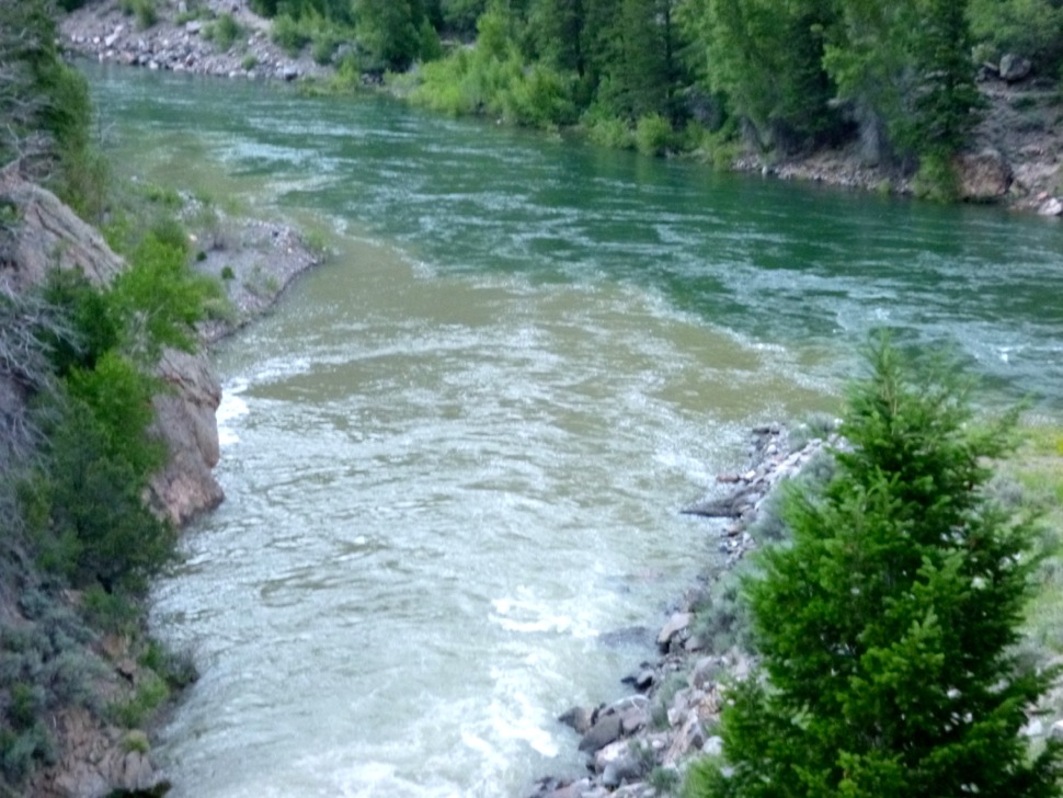
On a still dark December morning in 2015, a red Ford Ranger plastered with stickers and jammed with kayaking gear left the lights of Bozeman, Montana, and headed south on Route 191, paralleling the Gallatin River. It drove through subdivisions and farmland, past a ski resort, and finally toward the border of Yellowstone National Park, where the river’s headwaters rise. There, in one of the most intact, well-protected ecosystems in the United States, Gerrit Egnew, a University of Montana bioengineering student, pulled the truck onto a side road and parked.
The sun had just risen, its rays slanting through frosty spruce trees. The temperature was 10 degrees Fahrenheit. Egnew and his friend Kirra Paulus went through a routine they’d practiced dozens of times: dress in warm layers of wool and synthetic clothing, yank Gore-Tex dry suits over their heads, and shimmy into the neoprene spray skirts that connect them to their plastic boats. Snow crunched underfoot. Although the pair had been here just a few months earlier, the river was nearly unrecognizable in the grip of winter, banks of undercut ice narrowing its channel to less than eight feet across. Not far downstream, the blue-black water disappeared entirely beneath snow and ice.
These aren’t the kinds of conditions whitewater kayakers normally get out of bed for, but Egnew and Paulus hadn’t come for adrenaline. “I’m a middle-class white guy who gets to spend a lot of time outside, and sometimes I feel like the activities I love are selfish,” Egnew told me later. Wanting to put his kayaking skills to more altruistic purposes, he signed up to collect water samples for a Bozeman-based nonprofit called Adventure Scientists. The organization uses kayakers, skiers, climbers and other outdoor enthusiasts to gather environmental data from places too scattered, far-flung or difficult for scientists to regularly reach. One of its biggest projects revolves around a material that Egnew knows well from his years of rafting and kayaking: plastic.
More specifically, Adventure Scientists is interested in microplastics, pieces smaller than 5 millimeters in diameter. Some have broken down from larger items like disintegrating tires, toys or plastic bags. Others are shed from synthetic clothing, or come from personal hygiene products with exfoliating “microbeads.” Some can be seen with the naked eye; others are so small that they’re nearly invisible, and so light they can float on currents of air. And they are everywhere, from Arctic sea ice to city drinking water. By the time Egnew began volunteering on the Gallatin in 2015, Adventure Scientists had already collected water samples from thousands of locations around the world. Ultimately, they found microplastics in 93 percent of them.
But while the ubiquity was startling, the nature of the project meant there was little follow-through at individual sites. And while the threat that microplastics pose to the world’s oceans is well-established, there’s been comparatively little research on their impact to freshwater and inland environments. So Abby Barrows, who heads Adventure Scientists’ microplastic initiatives and is a marine researcher with College of the Atlantic, decided to investigate plastic pollution in a single, unlikely place: Montana’s Gallatin River, which flows into the Missouri and then the Mississippi. If she could identify how microplastics entered the headwaters of one of the country’s biggest watersheds, it could help shed light on how the pollutants spread from streams to rivers to the fish we eat, the water we drink, and the fields where we grow our food.
Which is why Egnew and Paulus were slowly making their way down the last ice-free section of the Gallatin in December, dunking their hands into the frigid water to fill labeled metal water bottles. As Barrows had instructed, they sampled from the left, right and center of the river, always upstream from their kayaks. They took photographs of their gear and clothing so Barrows could later make sure that no plastic bits came from the volunteers themselves. Everything was going well. Then, just before the river disappeared beneath the frozen landscape, a bottle slipped from Egnew’s hand. He pulled his sprayskirt and dove down to rescue it. At the river’s edge, his polyethylene-molded boat scraped ashore.
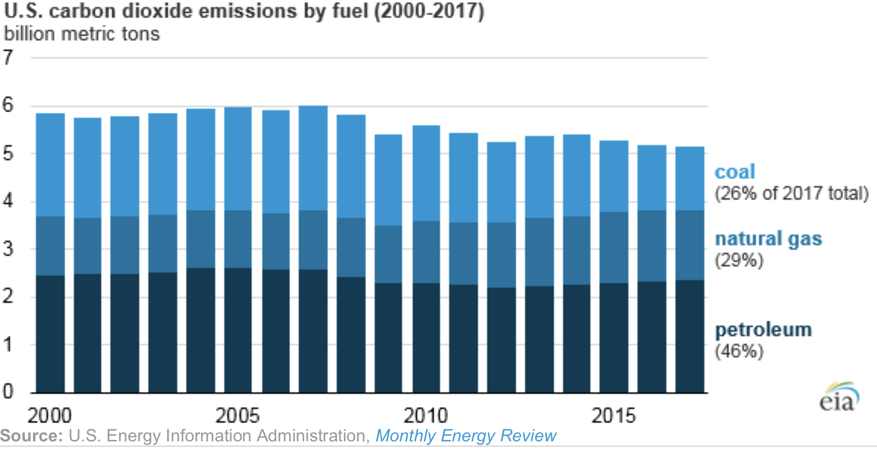
IF FUTURE SCIENTISTS digging through layers of rock and sediment come upon the geologic strata being set down today, they’ll find a colorful stripe of earth atop the plain rock and dirt of the pre-industrial era. Since plastics first became widespread in the mid-20th century, more than 9 billion tons have been manufactured, most of which has been thrown away.
Once they’re buried, scientists have no reason to believe that these Crayola-colored bits and bobs will ever fully biodegrade. Instead of calling our current geologic epoch the Anthropocene, or Age of Humans, scientists who study plastics sometimes refer to it as the Plastocene. Geologists even recognize a type of rock — “plastiglomerate” — that’s made from plastic and sediment that have naturally fused together.
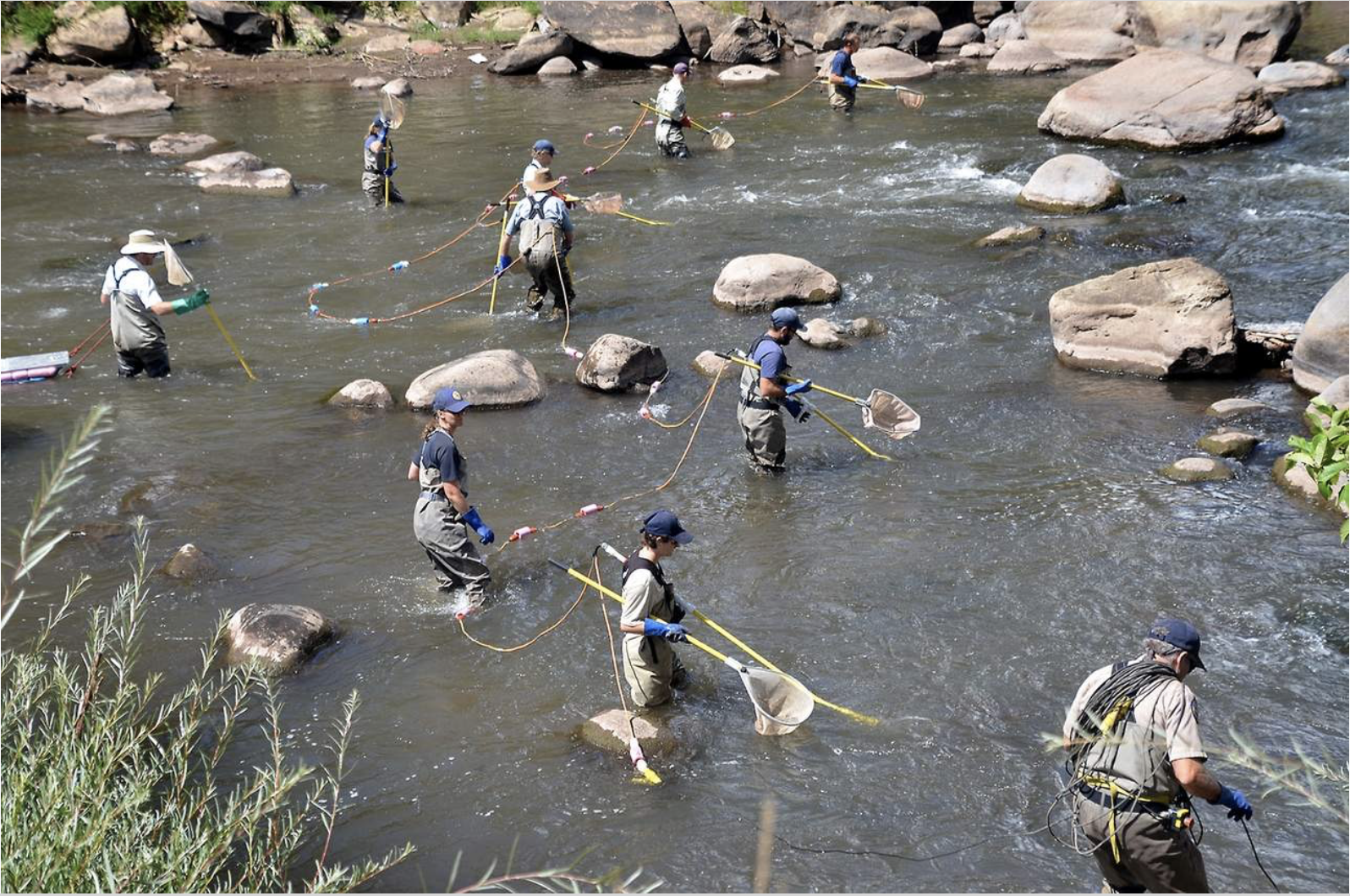
So perhaps it should come as no surprise that when Egnew and Paulus turned in their water bottles, together with more than 700 additional samples collected from 72 sites along the Gallatin over a two-year period, the samples were flush with tiny pieces of plastic. In peer-reviewed research soon to be published, Barrows found that 57 percent of the samples contained microplastics, with an average of 1.2 pieces per liter of water. If that doesn’t sound like much, consider that the Gallatin flows at a rate of 6,000 cubic feet of water per second at its peak, and this seemingly clear mountain river begins to look like a conveyor belt for tiny pieces of trash.
Microplastics have been found in numerous other Western water bodies, from alpine tarns to the giant reservoir of Lake Mead. But the upper Gallatin is one of the most pristine watersheds in the Lower 48 — a playground for fly fishermen, whitewater boaters, mountain bikers and hikers. Much of the river flows through protected public lands. So where’s the plastic coming from?
One source could be the outdoor recreation industry. Mixed in with the organic material floating in the river water, Barrows finds shreds of synthetic rubber like that used in mountain bike tires, the neoprene used in wetsuits, and the PVA used in fishing line. It’s intriguing, she says, “to have the materials from your study directly point to the land uses in a particular area.”
Still, outdoor recreation isn’t wholly to blame. As the Gallatin flows downstream — past Bozeman, into the Missouri River, and through cities, wildlife refuges and Native American reservations — plastics enter the watershed from a panoply of sources, including our own homes.
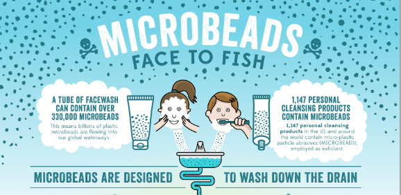
TO THE EXTENT THAT most of us think about microplastics, we’re probably familiar with microbeads, the tiny plastic scrubbers that became common in face washes and toothpastes in the late 1990s. Following a surge in public awareness about the dangers microbeads pose when eaten by fish and other wildlife, Congress voted to ban them in personal care products beginning in 2017. But Danielle Garneau, an associate professor of environmental science at SUNY Plattsburgh who studies microplastics, says that microbeads never made up a large percentage of the microplastics she and her colleagues found in freshwater. A bigger culprit, she says, are plastic fibers. Head to any coffee shop in Bozeman on a wintry Saturday morning, and the problem is in plain sight. Fleece pullovers. Polypropylene leggings. Polyester hats. Globally, production of synthetic fibers — long, thin strands of plastics spun into threads much as wool is spun into yarn — more than doubled from 2000 to 2017. Today, roughly 58 percent of clothing is woven with them, including many technical outdoor fabrics. While these fabrics excel at keeping us warm and dry in the elements, they shed every time they’re washed: up to 250,000 plastic fibers per jacket, per wash cycle.
That means every time one of Bozeman’s 45,000 residents throws their synthetic base layers or fleece jacket in the wash after a sweaty day of skiing or kayaking, they’re releasing microfibers into the city’s sewer system. From there, the plastic-laced water travels to Bozeman’s state-of-the-art wastewater treatment plant, where it passes through a variety of filters and tanks before being discharged into the East Gallatin River. Although Bozeman’s plant meets some of the highest environmental standards in the United States, Garneau says wastewater treatment plants (like freshwater treatment plants) simply aren’t designed to pick up particulates as tiny as microplastics. A 2016 study she co-authored found that municipal wastewater plants release up to 23 billion plastic particles into U.S. waterways every day — a major point source of freshwater plastic pollution.
Even plastics that are captured by treatment plants often end up back in the environment. They settle into the semi-solid residue, or sludge, produced by plants, which is then repurposed as fertilizer and sold or given to farmers. Scientists from the Norwegian Institute for Water Research and the Swedish University of Agricultural Sciences estimate that because of such fertilizers, more plastics wind up in Europe and North America’s agricultural soils each year than currently exist in all the world’s oceans. Inevitably, untreated irrigation runoff sends some of them back into our rivers.
Without additional research on the Gallatin-Missouri watershed, no one can say for sure how microplastic concentrations fluctuate as the rivers flow downstream, or to what extent they’ve contaminated wild and human communities. Still, studies from elsewhere in the country paint the basic picture. Some microplastics are flushed out to sea, where they contribute to marine plastic pollution. Scientists estimate that some 80 percent of plastic in the world’s oceans originates from inland sources.
Other particles sink to the river bottom, where they may be eaten by benthic invertebrates like freshwater mussels. Still others bob along in the water column and are gobbled up by fish or birds. In the Northeast’s Lake Champlain, Garneau has found an average of 22.93 microplastic particles in the guts of each bird she surveyed, 6.49 in fish, and .61 in invertebrates. Off the coast of California, University of Toronto ecotoxicologist Chelsea Rochman found microplastics in 25 percent of fish and 33 percent of shellfish caught locally and sold for human consumption. In both studies, the majority of particles were fibers.
Some of these microplastics are excreted, while others stay embedded in animals’ guts and other organs that Americans rarely eat, except in the case of shellfish. But the chemicals that plastics are made with, including carcinogens like brominated flame retardants, can leach off plastics and be absorbed into muscles and tissues — parts of the fish bound for our dinner plates.
DINING ON CONTAMINATED FISH AND SHELLFISH is just one way humans ingest plastics. Researchers have also found microplastics in craft beer, honey, salt and — in research headed by SUNY Fredonia chemist Sherri Mason — in 81 percent of tap water and 93 percent of bottled water from around the globe, including the United States.
Because the study of microplastics is so nascent, there’s been relatively little research on how eating them impacts human health, and many scientists are wary of being alarmist. “We’re still asking basic questions,” says Timothy Hoellein, an associate professor of biology at Loyola University Chicago who worked on the Gallatin River research. “A big part of microplastics research is still trying to understand where it is, where it’s coming from and where it’s going.”
Laboratory studies, however, are beginning to reveal how eating plastics could affect animal behavior and physiology. The results have been mixed. Some studies show no changes, while others demonstrate repercussions ranging from liver toxicity to tissue scarring to a reduced appetite, which could affect wild creatures’ survival rates. The differing results might be due to the fact that vastly different types of chemical compounds are lumped together as “plastics.”
“Microplastics is a name we use for a lot of different types of contaminants,” Rochman explains. “There are different shapes, different sizes, different suites of chemicals. When we’re talking about pesticides, we never just say, ‘What’s the impact of pesticides?’ We say, ‘What’s the impact of chlorinated pesticides?’ or ‘What’s the impact of DDT?’ But with microplastics, that conversation just isn’t being had yet.”
Students in Rochman’s lab are trying to tease out how, say, eating polyurethane foam impacts wildlife differently from eating polyester fibers. She hopes the results may eventually help regulate the production of hazardous plastics the way similar research helped regulate pesticides. “We’re not going to get rid of plastic,” Rochman says. “It’s a really important material. But we can think about using safer types.” That could mean banning certain chemical compounds from plastic manufacturing, or perhaps engineering more environmentally friendly plant-derived plastics.
Like other plastic scientists I spoke with, Rochman is surprisingly optimistic. Instead of feeling discouraged by the pervasiveness of plastics, they believe the visibility of the problem makes it more likely to be tackled: Unlike climate change, plastic pollution is hard to deny. Environmental campaigns aimed at reducing plastic waste are encouraging some consumers to use steel straws, cloth shopping bags, and washing machine filters that capture microfibers, while the bipartisan cooperation on banning microbeads offers hope that other types of harmful plastics can also one day be regulated. California banned single-use plastic bags in 2016, and Seattle recently banned single-use drinking straws and plastic cutlery from being distributed within city limits.
Other Western states, however, are moving away from regulation. Idaho and Arizona both recently passed legislation banning plastic bag bans, which means cities like Bisbee, Arizona, that independently voted to stop using plastic bags may have to drop their bans or risk losing state funding.
Yet landlocked Western state are hardly immune from the effects of plastic pollution, especially in rural areas where people are more likely to catch and eat wild fish. Keeping plastics out of rivers like the Gallatin could help keep microplastics out of humans’ and animals’ food supplies, both in the intermountain West and further downstream.
The outdoor recreation industry may only be responsible for a fraction of the plastics entering Western watersheds, but as the number of mountain bikers, hikers and anglers toting plastic into wild places grows, enthusiasts like Gerrit Egnew are starting to reckon with the footprint they leave behind. Like nearly everyone else in this country, Egnew depends on plastics. After he dove beneath the icy water of the Gallatin to retrieve his water sample on that December morning, the plastic-derived gaskets and fabrics in his dry suit protected him from hypothermia. That’s why he’s happy to have contributed to research identifying the outdoor recreation’s role in plastic pollution.
“Outdoor industries are often touted as solutions to more extractive types of industry,” Egnew says. “I think that’s probably true. But without knowing the impact of the outdoor industry ecologically, we can’t really compare them.” Quantifying that impact, he adds, is the first step toward mitigating it.
Krista Langlois is a correspondent with High Country News. She writes from Durango, Colorado. Follow @cestmoiLanglois
Warning of the risks of “runaway” global warming, the United Nations secretary general, António Guterres, on Monday called on global leaders to rein in climate change faster.
“If we do not change course by 2020, we risk missing the point where we can avoid runaway climate change,” Mr. Guterres said at United Nations headquarters in New York.
“Climate change is the defining issue of our time, and we are at a defining moment,” he said. “Scientists have been telling us for decades. Over and over again. Far too many leaders have refused to listen.”
His remarks came with countries around the world far short of meeting the goals they set for themselves under the 2015 Paris accord to reduce the emissions that have warmed the planet over the last century. The next round of climate negotiations is scheduled for this year in Poland.
One of the big tests at those talks, which start Dec. 3 in Katowice, will be whether countries, especially industrialized countries that produce a large share of global emissions, will set higher targets for reducing their emissions.
“The time has come for our leaders to show they care about the people whose fate they hold in their hands,” Mr. Guterres said, without taking questions from reporters. “We need to rapidly shift away from our dependence on fossil fuels.”
Mr. Guterres’s speech came days before a high-level climate meeting in San Francisco, spearheaded by Gov. Jerry Brown of California, meant to demonstrate what businesses and local leaders have done to tackle climate change.
The United Nations chief seems to be taking a page from Mr. Brown’s playbook. He, too, is looking beyond national leaders to make a difference. He has invited heads of industry and city government leaders to his September 2019 climate change forum in an apparent effort to increase pressure on national governments.
According to Diane Johnson, communications and public affairs manager for the Eagle River Water & Sanitation District, this year’s late-summer streamflows are currently below those recorded in 2002, the previous record-low year.
In an email, Johnson wrote that September rains in that year boosted streamflows to near-normal levels. Those rains haven’t come this year.
As of Sunday, Sept. 9, Gore Creek in Vail above Red Sandstone Creek was running at just 45 percent of normal. On the same date, the Eagle River at Avon was running at 51 percent of normal.
Those flows are being bolstered somewhat by the district adjusting to increase “in-stream flows” to support aquatic life in the rivers. The state-issued rights for those flows are junior to the ones the district holds.
Releases for in-stream flows have bolstered streamflows elsewhere. For instance, the Colorado River at Dotsero was running at 1,270 cubic feet per second, far above the all-time-low flow of 673 cubic feet per second measured in 2002. That year was before requirements were imposed to maintain in-stream flows…
In July, district officials asked customers for a voluntary 25 percent reduction in outdoor water use. Many customers, including local governments, cut their outdoor water use by 25 percent to 50 percent.
District officials on Monday, Aug. 13, sent letters to hundreds of customers who were using the most water — more than 10,000 gallons per week in some cases.
Johnson wrote that the district’s call for reduced outdoor watering has been well received…
Still, water supplies up and down the valley remain adequate for domestic use…
At the town of Gypsum Public Works Department, water operator Emmanuel Quezada said that town’s supplies are holding solid through the drought. In fact, he said, the town hasn’t imposed watering restrictions this summer.
FromThe Glenwood Springs Post Independent (Kyle Mills):
Drought conditions on the Western Slope have the Colorado, Roaring Fork, Frying Pan and Crystal Rivers at historically low levels…
As of last week, the Roaring Fork River between Basalt and Carbondale was running at 330 cubic feet per second, just 59 percent of average, according to the Roaring Fork Conservancy’s weekly Roaring Fork Watershed report.
The Crystal River is in even more dire straits, running at just 8.1 cfs as of Aug. 9; just 6 percent of average for this time of year…
The earlier-than-usual spring runoff this year fast-forwarded the rivers usual levels by around six weeks. “We didn’t have snow melt for sustainable flows for very long,” [Lani] Kitching said.
A few years ago, El Niño sparked frequent snowstorms in southern Colorado. To be specific, we were under the influence of El Niño between fall of 2014 and summer of 2016. That El Niño period was the strongest on record. People we talked to during that time said the crazy, snowy weather just comes with living in Colorado.
The last two years – 2017 and 2018 – we’ve had two La Niña cycles. That meant we dealt with above-average temperatures, drier weather and lots and lots of wind…not to mention high fire danger.
In the next few months, we have a 60-70 percent chance of El Niño developing.
So what exactly is an El Niño event? When an El Niño pattern develops, the trade winds near the equator slow down and reverse the flow of water across the Pacific. The warm water in the Pacific Ocean moves east toward the coast of South America. This has major implications on the Americas’ weather. An El Nino event brings more precipitation to the southern parts of the U.S., including southern Colorado. Meanwhile, drier conditions and warmer weather are forecasted in the northern portions of the U.S. during the winter. A note: the first part of the winter can be dry in an El Nino pattern with the latter part becoming more active.
Click here for all the inside skinny and to register:
Join us for a celebration fundraiser for the Colorado Healthy Rivers Fund (CHRF). CHRF grants money to on-the-ground projects that contribute to cleaner water, healthier wildlife habitat, improved recreation and vibrant local economies throughout our state. The Colorado Healthy Rivers Fund has granted funding for more than 80 projects statewide. See some of our Past Project Highlights.
Humpback chub are one of four federally endangered fish species that rely on habitat in the 15-Mile Reach of the Colorado River. Humpback chub photo credit US Fish and Wildlife Service.
NPS and USFWS use a seine net to trap humpback chubs in the Little Colorado River. Photo credit Mike Pillow via the Arizona Daily Sun.
November 2012 High Flow Experiment via Protect the Flows
The Colorado River wends its way through southern Utah and, at Glen Canyon, is impounded into Lake Powell. Photo/Allen Best
Macro Invertebrates via Little Pend Oreille Wildlife Refuge Water Quality Research
Glen Canyon Dam construction circa. 1961 via @USBR.
Water means life for all the Grand Canyon’s inhabitants, including the many varieties of insects that are a foundation of the ecosystem’s food web. But hydropower operations upstream on the Colorado River at Glen Canyon Dam, in Northern Arizona near the Utah border, disrupt the natural pace of insect reproduction as the river rises and falls, sometimes dramatically. Eggs deposited at the river’s edge are often left high and dry and their loss directly affects available food for endangered fish such as the humpback chub.
Ted Kennedy, a U.S. Geological Survey aquatic biologist, led a recently concluded experimental flow that is raising optimism that the decline in insects such as midges, blackflies, mayflies and caddisflies can be reversed. Conducted under the long-term, comprehensive plan for Glen Canyon Dam management during the next 20 years, the experimental flow is expected to help determine dam operations and actions that could improve conditions and minimize adverse impacts on natural, recreational and cultural resources downstream.
Western Water spoke with Kennedy about the experiment, what he learned and where it may lead. The transcript has been lightly edited for space and clarity.
Colorado Green, located between Springfield and Lamar, was Colorado’s first, large wind farm. Photo/Allen Best
Wind farm Logan County
Xcel Energy’s Greater Sandhill Solar Farm north of Alamosa, Colo. Colorado’s San Luis Valley has some of the nation’s best solar resource. Photo/Allen Best
It’s a bold move in a state that’s already seeing the devastation that comes with climate change, including heat waves, droughts, wildfires and sea level rise.
California solidified its role as a world leader on climate action as Gov. Jerry Brown signed legislation on Monday to shift the state to 100 percent carbon-free electricity by 2045.
The legislation is one of the crowning environmental achievements of Brown’s administration, which ends in January, and comes on the cusp of a Global Climate Action Summit that he is hosting in San Francisco beginning Sept.12.
In a summer when California has been fighting record wildfires while facing off against the Trump administration’s attempts to rollback climate policies, the state’s Democratic-controlled legislature sought to double down on its commitment to shift away from fossil fuels. Last year’s attempt to pass the legislation fell short. This year, it made it.
“After a grueling year it has finally passed,” state Sen. Kevin de León, the Los Angeles Democrat who sponsored the measure, wrote on Twitter on Aug. 28 after the Assembly voted. De León, who is challenging fellow Democrat Sen. Dianne Feinstein for her U.S. Senate seat in November, was in the Assembly chamber to help round up the final votes.
“Our state will remain a climate change leader,” he said.
…we are excited to share with you some of the topics that will be explored at the conference:
Women in Water
Environmental Justice
Stream Health
Agriculture
Conflict Resolution in the South Platte Basin
5 Year Anniversary – 2013 Flood Recovery Update
& More!
South Platte River Basin via Wikipedia
The upper South Platte River, above the confluence with the North Fork of the South Platte. Photo: Brent Gardner-Smith/Aspen Journalism
The South Platte River runs by a utility plant near I-25 in Denver. The South Platte River runs by an electricity plant near I-25 in Denver. A project proposed by the South Platte Regional Opportunities Water Group would allow Front Range water managers to maximize the reuse of Colorado River water. Photo credit: Lindsay Fendt/Aspen Journalism
Irrigation sprinklers run over a farm in Longmont in the South Platte River basin. Photo credit: Lindsay Fendt/Aspen Journalism
The Platte River is formed in western Nebraska east of the city of North Platte, Nebraska by the confluence of the North Platte and the South Platte Rivers, which both arise from snowmelt in the eastern Rockies east of the Continental Divide. Map via Wikimedia.
The South Platte River typically all but vanishes as it passes through Denver’s industrial neighborhood north of downtown, downstream of the Burlington Ditch diversion, near the Cherokee power plant. Photo/Allen Best
Flooded confluence of Cherry Creek and the South Platte River June 2015 photo via Andy Cross, Getty Images and The Denver Post
South Platte River Basin via the Colorado Geological Survey
Lower South Platte River
South Platte River near Kersey September 13, 2009.
Metropolitan Wastewater Reclamation District Hite plant outfall via South Platte Coalition for Urban River Evaluation
Bicycling the Colorado National Monument, Grand Valley in the distance via Colorado.com
Click here for all the inside skinny and to register:
On October 23, 2018 Grand Valley Water Users Association is providing an opportunity for West Slope agricultural producers and irrigation providers to hear directly from water officials concerning current and upcoming policy issues that will impact the future of water management and agriculture on the western slope. Please see the attached agenda to see the complete list of confirmed influential decision makers who will be joining us. At the top of the list is Amy Haas, the new Director of the Upper Colorado River Commission, who will share an Upper Basin perspective. Ms. Haas will be followed by representatives from the State of Colorado and some of our regional Water Conservation District Managers. Between the two perspectives Eric Kuhn will provide an update on the Basin Risk Study III and the potential implications of the results.
We hope you can join us for this unique opportunity to hear from a very well informed group of water community professionals who have the tough task of hammering out solutions to ever increasing pressures on Colorado River water supplies in Colorado and the Upper Basin. The solutions that are created and implemented will affect us all.
Our focus is on agricultural water users. So Irrigation District, Association, Ditch Company, and agricultural organization managers, staff, boards of directors, members, and stockholders are all welcome. Farmers and ranchers are particularly welcome.
Outdoor watering accounts for more than 50 percent of municipal water use in Colorado on average. Photo by Eric Sonstroem.
FromThe Grand Junction Daily Sentinel (Katie Langford):
Grand Junction residents saved nearly 18.5 million gallons of water since mandatory outdoor water restrictions started in August, according to city officials.
The savings are based on water use estimates for last year, said city Water Services Manager Mark Ritterbush.
An average day of water use in August was 8.1 million gallons in 2017, and that’s decreased by about 14 to 15 percent since water restrictions went into place on Aug. 22, saving approximately 1.2 million gallons a day…
The biggest drop in water use came immediately after the restrictions went into effect, which also happened to be the day that Grand Junction saw a massive rainstorm.
The storm dropped .91 inches of rain on Grand Junction over the span of just a few hours on the evening of Aug. 21, according to the National Weather Service.
City water use dropped from 8.1 million gallons on Aug. 21 to approximately 5.1 million on Aug. 23.
Ritterbush said it’s typical to see a significant drop in water use after a rainstorm.
Grand Junction City Councilor Chris Kennedy said he’s pleased with the savings and has not heard any pushback from residents over the restrictions…
Current restrictions mean city water customers are limited to twice-weekly outdoor watering through September, which drops to once-a-week outdoor watering in October.
The Blue Mesa Reservoir, which feeds into the Colorado River, is at 39 percent capacity, according to the Bureau of Land Reclamation. The last time the reservoir west of Gunnison was at a similar level was in 1987, said Sandra Snell-Dobert, a spokeswoman for the Black Canyon of the Gunnison National Park and Curecanti National Recreation Area.
Soon, water levels are expected to drop to the point where launching and operating boats at most ramps won’t be possible, Snell-Dobert said
Low water levels and rising temperatures also have allowed for blue-green algae blooms. Although no direct environmental impacts have not been observed, some species of this algae can produce toxins that are harmful to dogs.
The Gunnison River Basin varied between 50 percent and 80 percent of its average snowpack this winter, hitting a low of 51.6 percent Dec. 20 and a peak of 79.81 percent April 20.
Other Colorado River reservoirs are facing similar shortages.
Lake Powell and Lake Mead in Arizona dropped to dangerous levels this week because of what scientists are calling the effects of the Colorado River’s worsening “structural deficit,” The Associated Press reported.
Lake Powell and Lake Mead hit 48 percent and 38 percent capacity, respectively.
The Colorado River basin, which feeds lakes Mead and Powell, has been drying out over the last two decades, scientists said. With the demands from farms and cities exceeding the available water supply, the strains on the river and reservoirs are being compounded by growing population, drought and climate change.
The Colorado Division of Water Resources reports the basins were 50 percent full at the end of August, in contrast to last year’s 120 percent average capacity. The average for this time of year is about 82 percent.
The Yampa-White, San Juan-Dolores, Rio Grande, Gunnison and Colorado river basins are classified as being in either “moderate” or “severe drought.”
The Blue Mesa Reservoir near Gunnison on the Curecanti National Recreation Area, is near historic lows — it’s 39 percent full — and has closed almost all its boat ramps. Iola closed Thursday night, the Lake Fork ramp closes Monday. That will leave only the Elk Creek ramp on the reservoir’s north shore along Hwy. 50 open, said recreation area spokeswoman Sandra Snell-Dobert. “Elk Creek, the ramp will remain open as long as we can keep it open.”
The last time water levels were this low on the reservoir was in 1987, Snell-Dobert said. Blue Mesa usually only closes if there’s not enough staff or if the reservoir freezes. The reservoir levels now have also caused some abnormal boating hazards.
“Mostly it’s rocks that are becoming exposed as the water level decreases. There are a lot of rock promontories and islands, and those kinds of things that we haven’t seen in a long time,” she said. But despite the boating restrictions, Snell-Dobert said shoreline fishing, kayaking, canoeing and other hand-launched, non-motorized boating are still allowed at the reservoir.
Here’s the release from the Bureau of Reclamation (Peter Soeth):
The Bureau of Reclamation has launched a new prize competition seeking solutions to provide direct current power of up to 20 watts for electronic instruments on hydropower generating units’ rotating shafts. Power sources for electronics on rotating shafts presently available include batteries and contact solutions. However, existing technologies for these types of power sources are limited with respect to operation, installation, maintenance or other factors. Thus, new solutions are needed to power these instruments, which will be installed permanently on the rotating shaft to collect continuous data of generator operation and performance.
Reclamation is making a total award pool of $250,000 available for this competition. After the competition deadline, Reclamation will select solutions for experimental validation in a laboratory or field-scale demonstration. The solvers selected for this validation will share up to $50,000, with no award smaller than $5,000. Final awards will be granted from the remaining award pool through critical analysis of the demonstration results by Reclamation and its panel of judges.
Solutions for this prize competition can be novel approaches or can build upon existing methods and technologies. The solver should submit a white paper that describes a device for providing direct current power to instruments on rotating shafts as defined in the solution requirements. It should be accompanied by a well-articulated rationale supported by literature and/or patent precedents.
Reclamation is the second largest producer of hydropower in the country, operating 53 power plants. The generating units at these plants are expected to safely and reliably produce the power that is delivered to the western electric grid. Monitoring the generating units is a critical advancement toward keeping these units operational.
Submissions for this competition must be submitted by 11:59 p.m. EST on December 8, 2018.
Reclamation is partnering with the U.S. Army Corps of Engineers and Bonneville Power Administration on this prize competition.
The White House on Friday announced plans to appoint Jayne Harkins, executive director of the Colorado River Commission of Nevada, to head the U.S. side of the cross-border treaty organization.
Harkins said she was recommended for the post by Sens. Catherine Cortez Masto, D-Nev.; Dean Heller, R-Nev.; Cory Gardner, R-Colo.; and John Barrasso, R-Wyo.
The International Boundary and Water Commission regulates such thorny issues as the location of the border and the allocation of water in the Colorado and Rio Grande rivers. The commission also oversees flood control, sanitation and other water quality issues impacting the two nations.
“It’s important. All the work is very important,” Harkins said. “I think I have the background to help with those disputes.”
Harkins has held the top job at the state agency responsible for managing Nevada’s water and power resources from the Colorado River since 2011. During that time, she participated in international talks that led to a series of agreements over Mexico’s use and conservation of water from the Colorado.
Before that, the registered professional engineer spent 27 years with the U.S. Bureau of Reclamation, where she eventually served as deputy director of that agency’s Lower Colorado River Region.
Harkins said her appointment is expected to become official in a few weeks, after which she will report for work at the boundary and water commission’s U.S. headquarters in El Paso, Texas. The Mexican section of the commission is located in the neighboring city of Ciudad Juarez, Chihuahua.
Click here to read the paper. Here’s the abstract:
The Colorado River is the primary surface water resource in the rapidly growing U.S. Southwest. Over the period 1916‐2014, the Upper Colorado River Basin naturalized streamflow declined by 16.5%, despite the fact that annual precipitation in the UCRB over that period increased slightly (+1.4%). In order to examine the causes of the runoff declines, we performed a set of experiments with the Variable Infiltration Capacity (VIC) hydrology model. Our results show that the pervasive warming has reduced snowpacks and enhanced evapotranspiration (ET) over the last 100 years; over half (53%) of the long‐term decreasing runoff trend is associated with the general warming. Negative winter precipitation trends have occurred in the handful of highly productive sub‐basins that account for over half of the streamflow at Lee’s Ferry. We also compared a mid‐century drought with the (ongoing) post‐Millennium Drought, and find that whereas the earlier drought was caused primarily by pervasive low precipitation anomalies across UCRB, higher temperatures have played a large role in the post‐Millennium Drought. The post‐Millennium Drought has also been exacerbated by negative precipitation anomalies in several of the most productive headwater basins. Finally, we evaluate the UCRB April‐July runoff forecast for 2017, which decreased dramatically as the runoff season progressed. We find that while late winter and spring 2017 was anomalously warm, the proximate cause of most of the forecast reduction was anomalous late winter and early spring dryness in UCRB, which followed exceptionally large (positive) early winter precipitation anomalies.
Since 2000, the amount of water flowing in the Colorado River has dropped 19 percent below the average of the past century, a decline that has left the Southwest on the brink of a water shortage.
Now, new research indicates that a large portion of that decline isn’t due to less rain and snow falling from the sky, but to warmer temperatures brought on by climate change.
Scientists from the University of California-Los Angeles and Colorado State University found that about half the trend of decreasing runoff from 2000-2014 in the Upper Colorado River Basin was the result of unprecedented warming across the region.
“A good chunk of the decline we’re seeing right now is temperature-related. And as the Earth continues to warm, we’re going to see less flow in the river,” said Brad Udall, a water and climate scientist at Colorado State University who co-authored the research. “We need to prepare for a river that has significantly less water in it.”
Udall, together with UCLA researchers Mu Xiao and Dennis Lettenmaier, used a hydrologic model to examine the streamflow in the Upper Colorado River Basin from 1916 through 2014. They found the flow declined by 16.5 percent over the past century.
They calculated that 53 percent of the trend was linked to warming, which has shrunk the average snowpack in the mountains, boosted the uptake of water by plants and increased the amount of water that evaporates off the landscape.
“We separated the effect of different factors and determined the influences,” said Xiao, the study’s lead author and a doctoral student in UCLA’s Geography Department. “Aside from warming temperature, the precipitation also contributed to the drought. This was not obvious to us as the precipitation in the Upper Basin doesn’t show a significantly decreasing trend.”
The researchers attributed the remaining 47 percent of the decrease in the river’s flow to shifts in precipitation patterns, with less rain and snow falling in four areas of Colorado that tend to be especially productive in feeding tributaries in the Rocky Mountains.
“The precipitation is falling in different places, places that aren’t nearly as effective in generating runoff,” Udall said. “It’s the heat and it’s also this changing pattern in precipitation from areas that are really productive in generating runoff, like the state of Colorado, to areas that are much less effective, like the deserts of Utah.”
Variable Infiltration Capacity (VIC) Macroscale Hydrologic Model
Colorado State University researcher Brad Udall co-authored the study with UCLA scientists Mu Xiao and Dennis Lettenmaier…
Warming temperatures throughout the Colorado River watershed accounted for more than half the decline in flows, Udall says. Other factors include changes to precipitation patterns and loss of snowpack in high altitudes.
“The impacts of temperature are very large on this river and if you believe temperatures are going to increase — as every reputable scientist now does — you then have to conclude that the future of the river is going to be a future with much less water in it,” Udall says.
The amount of precipitation increased by about one percentage point during the last 100 years, but it didn’t end up in areas that would boost the river’s flow in significant ways.
Udall says most water managers agree that climate change is fundamentally altering how the river functions. Officials in Arizona, California and Nevada are currently negotiating a new plan to voluntarily cut back how much water they take from the river to avoid mandatory reductions. Federal officials have given the states until the end of the year to craft a plan.
The latest study builds on a 2017 study Udall published with University of Michigan researcher Jonathan Overpeck that compared flows in the Colorado River during a period of hot and dry conditions in the basin starting in 2000 to long-term average flows. From 2000 to 2014 flows in the river averaged 19 percent below those recorded the previous 93 years.
He notes too that the current drought conditions in the basin differ from droughts in the recent past. An extended drought from 1953 to 1968 was mostly driven by lack of precipitation, whereas the 21st century drought is being driven by increasing temperatures, a product of climate change.
“It’s disturbing,” Udall says. “I think we’re going to see a very different world as the 21st century unfolds with all these climate change impacts.”
“Those of us here in the Lower Basin are so focused on Lake Mead, but what’s propping up Mead is Lake Powell, and Lake Powell is going down, too,” Flessa said.
A total of about 11 million acre-feet of the extra water has been sent from Powell to Mead since 2000, the report says. That’s more than seven years’ worth of CAP water. Powell has dropped 94 feet since 2000. Had all that water stayed in Powell, that lake wouldn’t have dropped at all since 2000, the report says.
“The math suggests that, without these extra releases, we could today have a full Lake Powell and an empty Lake Mead. We are certainly not saying that would be a ‘better’ outcome; that would be chaos,” said another researcher involved in the report, Douglas Kenney, director of the University of Colorado’s Western Water Policy Program.
“What we are saying is that it’s important to understand that the actions taken to keep Lake Mead out of shortage have had real impacts upstream at Lake Powell, and all users dependent upon Lake Powell now face risks associated with looming Lake Powell shortages.”
The scientists say “the status quo (of reservoir management) is untenable,” and that a crisis on Lake Powell may already be at hand.
“It is impossible to keep a bathtub full while the drain is left open,” the report says.
It’s hard to fill a bathtub when the drain is open; it’s even harder when the tub is shaped like a bowl said Doug Kenney, who led the Colorado River Research Group study.
He said visitors to Lake Mead and Powell who measure the water levels by the bath-tub-like rings on the canyon walls see only part of the problem.
“As the reservoir gets lower and lower, it gets narrower at the bottom,” he explained. “So, what looked like a 10-foot decline one year, might look like a 30-foot decline the year after.”
Lake Mead is currently only 38-percent full, but draws its water from Lake Powell, which was last measured as 48-percent full.
If Lake Mead relied solely on its own winter runoff, Kenney said, “It would be a dry river bed now.”
[Hoover] dam is a proud place, built by thousands of hands and with 5 million barrels of concrete. Its golden elevator doors, Gotham-esque pillars, and stoic guardian angel statues line the lofty walkways atop the structure. A U.S. flag beating patriotically over the desert gets swapped out every few days, and then put out for sale in the visitor center.
Yet, in the 80 years since the great dam’s completion, the 1,450-mile Colorado River – which sustains some 40 million Americans in places like Phoenix, Las Vegas, and Los Angeles — has been gradually growing weaker, and the water level beyond the noble dam has fallen considerably over the last two decades. The writing is easily spotted on the steep rocky walls of the Lake Mead reservoir, where a bathtub-like ring shows where the water once sat during more fruitful times.
Today, however, the water sits 150-feet below that line, and human-caused climate change is a major reason why.
Over the last century, the river’s flow has declined by around 16 percent, even as annual precipitation slightly increased in the Upper Colorado River Basin — a vast region stretching from Wyoming to New Mexico.
New research published in the journal Water Resources Research argues that over half of this decline is due to sustained and rising temperatures in the region, which ultimately means more water is evaporated from the river, diminishing the flow.
But it’s really been in the last twenty years that matters have deteriorated into a major drought, edging the region toward a potential water-rationing crisis.
It’s the worst drought in Colorado River history.
“The river since 2000 has been in an unprecedented decline,” Brad Udall, coauthor of the new study and senior water and climate research scientist at Colorado State University, said in an interview.
“There’s no analog, from when humans started gauging the river, for this drought,” said Udall.
FromThe New Mexico Political Report (Laura Paskus):
a new study shows that even though annual precipitation increased slightly between 1916 and 2014, Colorado River flows declined by 16.5 percent during that same time period. That’s thanks, in large part, to “unprecedented basin-wide warming.” Warming reduces snowpack and increases the amount of water plants demand.
Using experiments and a hydrology model, the trio of authors from the University of California-Los Angeles and Colorado State University, found that 53 percent of the decrease in runoff is attributable to warming; the rest to reduced snowfall within regions that feed into the system.
One of the study’s authors, Bradley Udall, co-authored an earlier paper with Jonathan Overpeck showing a drop in river flows. What’s striking about the new study, Udall explained, is how much of the decline is due to warming relative to precipitation.
“Climate change isn’t in the future: it’s here now, it’s affecting all of us, and it will become increasingly worse as time goes on,” said Udall, senior water and climate research scientist at the Colorado Water Institute at Colorado State University. “Climate change is in our face right now: It’s western fires, it’s drought, it’s river flows.”
He cautioned that the study’s results are based on one model and one data set.
“That said, I think the model is telling us something that’s really valuable,” he said. “The feedback loop—self-reinforcing cycles, where dryness begets heat, which further begets dryness—is probably at the root cause of what’s causing these 50 percent declines.”
In short, he said, the model points toward the further aridification of the region.
The model also shows how sensitive the Colorado River Basin is to shifts in precipitation patterns. Not only does it matter whether precipitation falls as snow or rain, it matters where it falls. Snowfall in Colorado, he explained, contributes more to the river’s flows than if it falls in Utah. Unfortunately, the researchers noted a decline in snowfall within four important sub-basins of the river, all within the state of Colorado.
The paper, he said, is also a reminder that we need respond to climate change right now.
Blue Mesa Reservoir
From email from Reclamation (Erik Knight):
Releases from the Aspinall Unit will be decreased by 75 cfs on Sunday, September 9th. Releases are being decreased in order to bring flows in the lower Gunnison River closer to the baseflow target while conserving storage in Blue Mesa Reservoir. The actual April-July runoff volume for Blue Mesa Reservoir was 237,500 AF of inflow, which is 35% of average.
Flows in the lower Gunnison River are currently above the baseflow target of 890 cfs. River flows are expected to stay above the baseflow target for the foreseeable future.
Pursuant to the Aspinall Unit Operations Record of Decision (ROD), the baseflow target in the lower Gunnison River, as measured at the Whitewater gage, is 890 cfs for September.
Currently, diversions into the Gunnison Tunnel are 1000 cfs and flows in the Gunnison River through the Black Canyon are around 575 cfs. After this release change Gunnison Tunnel diversions will still be 1000 cfs and flows in the Gunnison River through the Black Canyon will be around 500 cfs.
Yesterday afternoon Dr. Katharine Hayhoe gave a presentation about communication as one of CIRES Distiguished Lecturer Series. It was a real treat for me since I had never had the opportunity to see her in person and she is one of my heroes in the climate change world.
She is one of Coyote Gulch’s favorite climate science communicators. Her series with PBS, Global Weirding, takes on the myths and arguments against the reality of climate change in a clear and understandable way.
I’m in the water business and we are very worried about the fact that stationarity is dead. Stationarity can be characterized by the statement, “The past predicts the future,” but when the water cycle is changing due to global warming there is uncertainty about using historical hydrological data to predict future streamflow. We’re seeing the effects of higher temperatures on snowpack and runoff here in the West.
Dr. Hayhoe explained stationarity in one Global Weirding episode in this way [Paraphrasing]:
She lives in west Texas where there is a lot of flat land and open spaces. It’s possible to drive down the highway and steer your car by keeping the road in view by looking in your rear view mirror. Problems arise when the road has a turn in it. You are likely to crash if you haven’t been looking ahead of you.
She detailed some of the experiences that helped shape her approach to climate education, from the very first lecture, full of charts and graphs and detail, when, at the end, she called on a questioner, and he said, “Are you a Democrat?” She learned from subsequent speaking engagements that it was very hard or impossible to connect with a majority of folks by presenting the data. She also showed a series of slides that tracked climate change views by political affiliation which clearly illustrated the divide in the U.S. in 2018.
Dr. Hayhoe is an accomplished speaker telling stories and using humor to make a point.
The first step in communicating, she says, is to create a bond with the audience.
Below is her communication template.
Thanks CIRES and Dr. Hayhoe for a great presentation. Note to Hayhoe: I left feeling inspired.
Tomorrow is Rise for Climate with events all over the world. Acting on climate is essential as is voting for the environment.
Click here to go to the US Drought Monitor website. Here’s an excerpt:
Summary
While subnormal temperatures overspread the Northwest, a strong and persistent Bermuda high over the Atlantic Ocean kept the East unseasonably warm and humid while hindering cold fronts from advancing eastward into the region. As a result, stalled fronts over the Nation’s mid-section became a focal point for widespread heavy showers and thunderstorms, especially from the central Great Plains northeastward into the western Great Lakes region. Parts of Kansas, Nebraska, Missouri, Iowa, Illinois, Wisconsin, and Michigan saw over 5 inches of rain for the week, with locally 10-15 inches of rain in southern Wisconsin. Needless to say, major improvements were made in the Midwest. Tropical showers also occurred along the Gulf Coast, and later in the week Tropical Storm Gordon formed in the eastern Gulf and tracked northwestward toward Mississippi. Scattered showers also fell on parts of the Four Corner Region, the northern Plains, upper Midwest, mid-Atlantic, and western New England. Little or no rain was observed in the West, northern and central Rockies, north-central High Plains, across sections of the interior Southeast, eastern Corn Belt, and coastal New England…
Early in the week, a trough of low pressure brought scattered showers and thunderstorms to the central and western Gulf, dumping 2-6 inches of rain along the coast, with locally over 10 inches. The rains were enough to eliminate short-term deficits and improve the D0-D1 areas in southern Louisiana and western Mississippi by a category. Scattered showers (1-2 inches) also fell on northwestern Louisiana, shrinking some of the D2 and D3 areas near Shreveport. The Gulf rains also provided relief across southeastern Texas, while heavy Day7 rains (3-8 inches) between Laredo and San Antonio fell on a large D2-D3 area, putting a substantial dent into the drought. North-south bands of scattered showers were observed in portions of central and northeastern Texas, slightly decreasing the D2 and D3 areas. In western Texas, a calibration between the radar-based precipitation totals (AHPS) versus gauge-based (ACIS) and other indices showed a wet bias in the radar-based precipitation, thus some additional deterioration was shown in this region, with more areas of D2 and D3 depicted. A spot of D4 was added near Amarillo. In addition, the fifth warmest summer on record for Texas exacerbated the dryness. In Oklahoma, spotty rains (1-2 inches) eased drought in the extreme western Panhandle, and in southwestern and northeastern sections. Similarly, scattered rains in extreme northern and eastern Arkansas erased some D0 there…
Rainfall amounts were either lacking or light across most of the High Plains, except for very heavy rains (2-6 inches, locally higher) in eastern Kansas and southeastern Nebraska (associated with the copious rains in the Midwest), and light to moderate (0.5-2 inches) in parts of the Dakotas and southeastern Colorado. In Kansas and southeastern Nebraska, 2-8 inches of rain caused a 1-2 category drought improvement across southeastern Nebraska and northeastern and southeastern Kansas, while 1-3 inches of rain in far western Kansas was good for a 1-category reduction. Unfortunately, the core D3-D4 drought area in east-central Kansas received much lower totals (less than an inch), and little or no improvements were made there. Farther north, drier weather this week and out to the last 60-days has slowly increased short-term deficits, resulting in some minor deterioration in northeastern Montana, northern North Dakota, central and northeastern South Dakota. While continuing rains eased drought in southeastern Colorado into northeastern New Mexico, worsening conditions in west-central Colorado slightly expanded the D4 there. Monsoonal showers were widely scattered across eastern Arizona and most of New Mexico, but most areas were unchanged…
A drier than normal Water Year during the cold season (October 2017-April 2018) with less mountain snow than normal in the southern two-thirds of the West (used for spring and summer snow melt runoff), combined with a very warm and exceptionally dry summer (May-August 2018), has produced numerous negative impacts. This was most notable in Oregon where the combination of a poor winter snowpack and a hot and dry summer have produced widespread poor pasture and range conditions and very low stream flows and livestock ponds, and required water hauling, supplemental hay, and delayed forest harvesting, along with reduced livestock herds. The 4-month (May-Aug) SPEI, which takes into account temperatures and evapotranspiration with the precipitation, was below -1.5 in western Washington and Oregon by the end of August, and also in parts of eastern Oregon, northern Washington, and northern California. But since the cold season WY (Oct-Apr) was wetter and snowier in Washington and northeastern Oregon, most of the expanded D2 and D3 was added to areas with both a poor 4-month (summer) and 11-month (Oct-Aug) SPEI, namely central Oregon. Based upon the SPEI, D1 was also expanded in northwestern Washington, and D2 increased into southwestern Washington, southeastern Oregon, extreme northern California, northwestern Utah, and extreme northern Idaho where very low stream flows were occurring in the latter area. In contrast, some isolated heavy rains in southeastern Arizona (Graham County) slightly improved D2 to D1 where a short-term surplus existed…
Looking Ahead
For the ensuing 5 days (September 6-10), heavy rain is expected from the southern Plains northeastward into the mid-Atlantic, with the Midwest drought area once again targeted for additional copious rainfall. Most of Texas and Oklahoma should also see substantial totals, as should the Ohio Valley and mid-Atlantic. Moisture from the remnants of Tropical Storm Gordon will contribute to some of these large precipitation amounts. Most of the West, northern Rockies and Plains, parts of the interior Southeast, and coastal New England are forecast to get little or no rain. 5-day temperatures should average below-normal in the Nation’s midsection where the rain is expected, while above-normal readings return to the West.
For the CPC 6-10 day extended range outlook (Sep. 11-15), the odds favor above normal precipitation along the Gulf and Atlantic Coast States, the Pacific Northwest, northern Plains, and upper Midwest. In contrast, subnormal rainfall is likely in the central U.S. and western Great Lakes region which should be welcome after heavy rains that have fallen and are expect to occur in the next 5 days. The southern half of Alaska is favored for subnormal precipitation. Most of the Nation from the Rockies eastward (and Alaska) should see above-normal temperature, with odds for subnormal readings limited to the Northwest, Texas, and eastern Alaska.
Debris flow from 416 Fire. Photo credit: Twitter #416Fire hash tag
FromThe Durango Herald (Jonathan Romeo) via The Cortez Journal:
A fish count in the Animas River on Tuesday found populations have been drastically affected by deadly runoff from the 416 Fire burn scar.
Fish kills because of ash and dirt washing into the river started in mid-July, but a massive rain event around July 17 likely killed most of the fish in the waterway, wildlife officials said at the time.
The dirty runoff lowers the oxygen content in water, suffocating fish, which have been further stressed by abnormally low flows and high water temperatures.
For the first time since the 416 Fire runoff events, wildlife managers with Colorado Parks and Wildlife conducted a fish survey to better understand the extent of the fish kill.
Usually, CPW will use an electrofishing device from a raft to stun fish to survey two 1,000-foot sections of the Animas River: from Durango High School to the Ninth Street Bridge and from Cundiff Park to the High Bridge.
This year, low flows forced wildlife managers to use an electrofishing device from the banks and from in the river.
Jim White, an aquatic biologist for CPW, said in a normal year, a survey will find somewhere around 40 brown trout and 40 rainbow trout in the stretch from Cundiff Park to the High Bridge.
This year, CPW found one brown trout and one rainbow trout in that stretch and no molted sculpin, a small native species of fish that’s a key food source for trout.
In the stretch of river between Durango High School and the Ninth Street Bridge, CPW found four brown trout and two rainbow trout, as well as some molted sculpin, bluehead suckers and speckled dace.
“Normally, we’d catch 10 times that,” White said.
Colorado Parks and Wildlife fish count Animas River August 2018: Photo credit: Joe Lewandnowski
From the U.S. Energy Information Administration (Laura Singer):
U.S. energy-related carbon dioxide (CO2) emissions in 2017 fell to 5.14 billion metric tons, 0.9% lower than their 2016 levels, and coal emissions were the primary driver behind the decline. U.S. energy-related CO2 emissions have declined in 7 of the past 10 years, and they are now 14% lower than in 2005.
Both coal and natural gas consumption in the United States were lower in 2017 than in 2016, and as a result, coal- and natural gas-related CO2 emissions decreased 2.6% and 1.5%, respectively. Natural gas consumption has displaced coal consumption in the electric power sector in recent years, and total U.S. emissions from natural gas first surpassed emissions from coal in 2015. U.S. petroleum consumption increased in 2017, contributing to a 0.5% increase in energy-related CO2 emissions from petroleum, but this increase was offset by the decrease in coal and natural gas emissions.
The electric power sector was the only U.S. sector in which energy-related emissions decreased in 2017, and the 4.6% decline was enough to offset increases in all other sectors. In recent years, the generation mix has shifted away from coal and toward natural gas and renewables. The shift toward natural gas from coal lowers CO2 emissions because natural gas produces fewer emissions per unit of energy consumed than coal and because natural gas generators typically use less energy than coal plants to generate each kilowatthour of electricity. Electricity generation from renewable energy technologies has increased; these technologies do not directly emit CO2 as part of their electricity generation. In EIA’s emissions data series, emissions from biomass combustion are excluded from reported energy-related emissions according to international convention.
In addition to reduced CO2 emissions as a result of utilization of less carbon-intensive generation sources, CO2 emissions were also lower in 2017 because of lower electricity sales, which in 2017 experienced the largest drop since the economic recession in 2009. The decline in CO2 emissions in the residential and commercial sectors was largely attributable to milder weather. Cooler summers reduce electricity consumption for cooling, and warmer winters reduce electricity consumption for heating (and also reduce heating-related consumption of natural gas and petroleum). Electricity sales to the industrial sector were also lower in 2017, despite an overall increase in manufacturing output.
Energy-related CO2 emissions trends are often related to trends in energy consumption and economic growth. Trends in energy consumption and related CO2 emissions relative to economic activity can be measured in several ways. Energy intensity is the amount of energy consumed relative to economic activity, measured in British thermal units per dollar of gross domestic product. Carbon intensity of energy consumed relates CO2 emissions to the amount of energy consumed in a year, measured in metric tons of CO2 per billion British thermal units.
From 2005 to 2017, the U.S. economy grew by 20%, while U.S. energy consumption fell by 2%. Energy-related CO2 emissions also decreased during that time period, and as of 2017, they were 14% lower than their 2005 levels. Compared with the levels in 2005, U.S. economic growth in 2017 was 29% less carbon-intensive, and overall U.S. energy consumption was 12% less carbon-intensive.
The mine spill temporarily closed down recreation in the river and forced farmers to shut off irrigation to their crops. But life in the river? It didn’t change much. The bugs and fish survived and showed no signs of short-term harm. The fish had been living with heavy mineralization of the water for decades.
Crisis averted — until this year…
The Animas began the summer with record low water because of drought and a warm winter. That primed the nearby mountains for a big wildfire. The 416 Fire ended up burning about 55,000 acres around the drainage basin for Hermosa Creek, a tributary of the Animas. Now when it rains over the burn area, a thick sludge washes into the river.
Horn says official surveys haven’t been conducted, but it’s likely the first few ash-laden runoff events killed 100 percent of the fish in a 30 mile stretch of the river.
“You could literally see the fish coming to the banks gasping for air. It physically smothered their gills and their ability to breathe,” Horn says. “So there it was, it didn’t look as bad. It came from a, you could argue, natural source and did way more damage.”
Many western rivers are stressed. They’re pressured by drought, pollution, overuse by cities and farmers and runoff from wildfires. The Animas acts as the perfect poster child.
“It certainly is unlucky,” says Scott Roberts, a researcher with the Mountain Studies Institute, a non profit research group based in nearby Silverton. “It’s unlucky now. And it’s been unlucky for throughout time really.”
The river’s facing problems that show themselves, Roberts says, like a vibrant orange smear or a chocolate brown sludge. Or like earlier this summer when the river’s water all but disappeared within Durango’s city limits, recording its record lowest flow in 107 years of data.
But there are many others that don’t draw intense public attention. Before the Gold King Mine spill, and even now, the river receives acidic water laden with heavy metals from the region’s numerous abandoned mines. Adding insult to injury, in July 2018 a truck carrying waste material from the mine site crashed into Cement Creek, another Animas tributary.
“It’s being stressed by drought, being stressed by warmer temperatures. It’s being stressed by runoff from wildfires, being stressed by elevated metal concentrations, being stressed by bacteria, by nutrients,” he says.
Roberts points to studies that showed samples of the river’s water with high levels of bacteria commonly found in humans, likely leached from underground septic tanks.
“I don’t think that the problems that are plaguing the Animas today are unique to the Animas,” says Trout Unlimited’s Ty Churchwell, based in Durango…
In fact, Churchwell says, all these issues are increasingly common throughout the West. Drought, ash-laden runoff and mine pollution are often the norm in western watersheds. The Animas has just experienced the extremes of all three in a short period of time…
But it could be another five to ten years before the Animas is back to its former self, according to water quality specialist Barb Horn.
Colorado Parks and Wildlife has found cutthroat trout that are unique to the San Juan River Basin in southwest Colorado. The photo below is of a museum specimen found in the Smithsonian via Colorado Parks and Wildlife.
Here’s the release from Colorado Parks and Wildlife (Joe Lewandowski);
Colorado Parks and Wildlife biologists have discovered a unique genetic lineage of the Colorado River cutthroat trout in southwest Colorado that was thought to be extinct. The agency will continue to evaluate the findings and collaborate with agency partners to protect and manage populations of this native trout.
The discovery was officially recognized earlier this year thanks to advanced genetic testing techniques that can look into the basic components of an organism’s DNA, the building blocks of life. This exciting find demonstrates the value of applying state-of-the-art genetic science to decades of native cutthroat conservation management and understanding.
“Anyone who just looked at these fish would have a difficult time telling them apart from any other cutthroat; but this is a significant find,” said Jim White, aquatic biologist for CPW in Durango. “Now we will work to determine if we can propagate these fish in our hatcheries and reintroduce them into the wild in their historic habitat. It’s a great conservation effort and a great conservation story.”
Eight small populations of these trout have been found in streams of the San Juan River Basin within the San Juan National Forest and on private property. The populations are in isolated habitats and sustained through natural reproduction. U.S. Forest Service staff and landowners have been cooperative in CPW’s efforts; they will also be instrumental in further cutthroat conservation efforts.
In August, north of Durango, crews from CPW and the U.S. Forest Service hiked into two small, remote creeks affected by the 416 Fire and removed 58 fish. Ash flows from the fire could have severely impacted these small populations.
Cutthroat trout originated in the Pacific Ocean and are one of the most diverse fish species in North America with 14 different subspecies. Three related subspecies are found in Colorado: Colorado River cutthroat trout found west of the Continental Divide; Greenback cutthroat trout in the South Platte River Basin; and the Rio Grande cutthroat trout in the San Luis Valley. A fourth, the yellowfin cutthroat trout native to the Arkansas River Basin, went extinct in the early 1900s. Cutthroats from each of these areas have specific and distinctive genetic markers. CPW propagates the three remaining subspecies, and actively manages their conservation and recovery throughout the state.
White and other biologists ‒ including Kevin Rogers, a CPW cutthroat researcher based in Steamboat Springs, and Mike Japhet, a retired Durango CPW aquatic biologist ‒ have been surveying remote creeks in southwest Colorado for more than 30 years looking for isolated populations of cutthroat trout. They found some populations in remote locations long before advanced genetic testing was available. The biologists understood that isolated populations might carry unique genetic traits and adaptations, so they made sure to preserve collected samples for genetic testing later. Significant advances in genetic testing technology over the last 10 years were instrumental in finding the distinct genetic markers that identify the San Juan lineage trout as being unique.
In 1874, naturalist Charles E. Aiken collected and preserved samples of fish found in the San Juan River near Pagosa Springs. Two trout were deposited in the Smithsonian National Museum of Natural History in Washington, D.C. These samples were forgotten until 2012 when a team of researchers from the University of Colorado was hired by the Greenback Trout Recovery Team to study old trout specimens housed in the nation’s oldest museums. When the researchers tested tissue from those two specimens they found genetic markers unique to the San Juan River Basin. Armed with the knowledge of these genetic “fingerprints”, CPW researchers and biologists set out to test all the cutthroat trout populations they could find in the basin in search of any relic populations.
“We always ask ourselves, ‘What if we could go back to the days before pioneer settlement and wide-spread non-native fish stocking to see what we had here?’” White said. “Careful work over the years by biologists, finding those old specimens in the museum and the genetic testing gave us the chance, essentially, to go back in time. Now we have the opportunity to conserve this native trout in southwest Colorado.”
Developing a brood stock of these trout so that they can be reintroduced into San Juan River headwaters streams will be a key conservation strategy for increasing their distribution into suitable habitat and help their long-term stability. Protecting the fish from disease, other non-native fish, habitat loss and over-harvest are important factors that will be considered in a conservation plan that will be developed over the next few years. While that might seem like a long time, the discovery of this fish goes back more than 100 years.
Over the decades, CPW has worked with many partners throughout the state to find and conserve distinct cutthroat populations. Many of these efforts were conducted with assistance from the U.S. Forest Service, conservation groups and private property owners. CPW also works on projects with both the Colorado River Cutthroat Trout and Rio Grande Cutthroat Trout conservation teams.
All native cutthroats have been adversely affected by a variety of issues, including reduced stream flows, competition with other trout species, changes in water quality and other riparian-habitat alterations. Consequently, the various types of native cutthroats are only found in isolated headwaters streams. To ensure continued conservation of Colorado’s cutthroats, CPW stocks only the native species in high lakes and headwater streams. That stocking practice started in the mid-1990s.
CPW has also conserved cutthroats in headwaters streams by working with the U.S. Forest Service to build barriers to prevent upstream migration of non-native trout, removing non-native trout and subsequently stocking them with native trout. The conservation group, Trout Unlimited, has provided valuable assistance with many of these projects.
John Alves, Durango-based senior aquatic biologist for CPW’s Southwest Region, said the discovery shows the dedication of CPW aquatic biologists.
“These fish were discovered because of our curiosity and our concern for native species,” Alves said. “We’re driven by scientific inquiry that’s based on hard work and diligence. This is a major discovery for Colorado and it shows the critical importance of continuing our research and conservation work.”
If voters approve the proposed 0.25 percent countywide sales tax at the November general election, a portion of funds would be used to treat forest lands.
The U.S. Forest Service currently treats about 1,200 acres per year. With additional funding, that number would grow to 4,000 acres annually, nearly triple the number of acres that could see mitigation.
The sales tax would generate about $1 million per year and would be used to:
• Strengthen forest health;
• Conserve and support working ranches, farms and rural landscapes; and
• Manage impacts of growth in outdoor recreation.
Cindy Williams, co-lead with County Commissioner Greg Felt of Envision Chaffee County, the entity that is the impetus behind the proposal, said the goal would be to treat 2 percent of forested public lands, about 4,000 acres, in the county each year.
Responsibility for maintaining public lands in the county rests with the Forest Service, Bureau of Land Managment and state of Colorado. But, Felt said, the agencies do not have the budget or the staff to properly maintain lands under their jurisdiction.
An example of how funding would be used is the current project on Monarch Pass. In concert with the U.S. Forest Service, a number of entities have joined forces in an effort to remove beetle-killed dead standing trees to improve forest health, reduce the danger of wildfires and protect water supplies.
Williams said various entities, including the Upper Arkansas Water Conservancy District, Monarch Mountain, Southeastern Colorado Water Conservancy District and Pueblo and Colorado Springs water utilities, are supporting the project.
Monarch Pass is the headwaters of the South Arkansas River, which is a source of water for the city of Salida and dozens of irrigators.
Mitigation work, she said, would protect towns, water supplies, water infrastructure, the recreation economy, wildlife and wildlife habitat.
Felt said Chaffee County has contributed $48,000 from the Conservation Trust Fund to the program.
The idea behind this element of the sales tax, he said, “is to leverage interests of other water-related organizations” who have an interest in water quality and the resource.
If the county puts $500,000 from the proposed conservation tax toward forest mitigation work, Felt said the goal would be to generate an additional $5 million from other sources.
“The goal,” Felt said, “is not to spend a million dollars a year on conservation, but to leverage that into $5 million” to benefit the county.
He said if there is local interest, the county will be able to do more by drawing money from other organizations and agencies…
Williams said the net result of the tax would be to bring additional dollars through grants and participating partners into the county to be used to benefit county resources.
Williams said representatives of agencies and foundations she has talked to about the county conservation project have said they typically do not see communities coming together like this, including governments, businesses and citizens.
The Gates Family Foundation, she said, is monitoring the county as a possible development model with new tools for other Western states.
Felt said Envision has “blown out of the water” representatives of foundations and government agencies who have become aware of the project and now want to play a part in the program as it evolves.</blockquote.
Please join us for this very informative annual Water 101 and 201 Seminar, taking place this year at the First Park Community Center in Nucla, CO. on September 18 & 19, 2018.
Sponsored by the Water Information Program and Tri‑State Generation and Transmission.
Topics include Colorado water law, drought contingency planning, stream management planning, state and local water agency perspectives, water rights, administration, and development. The Water 201 will review more advanced water concepts, issues, and topics. This event is open to everyone.
The Yampa River in northwestern Colorado has closed again. Ongoing drought has drastically reduced water levels.
Colorado Park and Wildlife instituted restrictions on commercial and public activity on the Yampa River this week. An earlier closure ended just 10 days previously.
Commercial tubing companies have been instructed to suspend operations. Officials are requesting that public river users, including tubers, swimmers and anglers, adhere to the “voluntary closure” and stay out of the river.
Chela is a Nairobi based visual artist who specializes in graffiti and fine art. Chela has gained extensive experience experimenting on the streets of Nairobi. Chela has managed to successfully train some young people on how to use art as a tool for social change. Graphic via: RiseForClimate.org From RiseForClimate.org:
Artists from six continents have made artworks that people can use to #RiseforClimate. They included the Rise unifying symbols of an orange Cross for what we need to put a stop to, and a Sun for the solutions we need. You can use images from other continents, showing how truly global the movement is.
People are rising up around the world on September 8th to demand real climate leadership from every level of government. Together, we’ll show that people everywhere are committed to a just transition away from fossil fuels to 100% renewable energy for all.
Storm drain and open channel improvements between the East Rail Line (38th & Blake Station) and the South Platte River (Globeville Landing Outfall), Stormwater detention/conveyance between the East Rail Line (38th & Blake Station) and Colorado Blvd, (Montclair Basin) Stormwater detention/ conveyance immediately east of Colorado Blvd. (Park Hill Basin).
Old Denver pulsed with H2O, water that snaked through the creeks and irrigation canals crisscrossing Colorado’s high prairie before 150 years of urban development buried most of them or forced them into pipes.
New Denver wants those waterways back.
City leaders are ramping up what they describe as a massive, restorative “daylighting” of buried water channels wherever possible — cutting through pavement and re-engineering old streams and canals to create up to 20 miles of naturalistic riparian corridors. Hundreds of millions of dollars have been committed. Eventual costs are expected to top $1 billion over several decades. This work reflects increased interest worldwide in harnessing water and natural processes to make cities more livable.
Starting in 1858 with the discovery of gold in Colorado’s mountains, Denver developers focused on filling in creeks to make way for the construction of railroads, streets, smelters and housing — all laid out across a grid imposed on the natural landscape. The 184-page Green Infrastructure Implementation Strategy that Mayor Michael Hancock’s administration issued this summer reverses that approach with an inventory of high-priority projects aimed at — to the extent that booming growth and development will allow — reopening and revitalizing waterways.
“It is like undoing history,” project manager Patrick Riley said last week along a newly formed 1,000-foot stretch of Montclair Creek — already attracting geese as big trucks beeped and contractors in neon green vests re-contoured the urban terrain.
The Montclair Creek project marks Denver’s most ambitious and controversial daylighting so far, a $298 million revival of a waterway that flows 9 miles from high ground at Fairmount Cemetery (elevation 5,485 feet) under the north half of the city. Work crews are excavating and rerouting water, digging holes for ponds, and planting native grasses and perennials in four areas: the 130-acre City Park Golf Course, the Park Hill Golf Course, a 1.2-mile greenway along 39th Avenue, and a landscaped “outfall” through a 5-acre Globeville Landing park near the South Platte River (elevation 5,274 feet) west of the Denver Coliseum.
City engineers say that, by reconstructing the urban landscape where possible, they’ll slow down water, filter it through vegetation to remove contaminants, control storm runoff and nourish greenery to help residents endure the climate shift toward droughts and rising temperatures…
While a lack of open land and neighborhood resistance can limit daylighting of long-squelched creeks and canals, increasing volumes of storm runoff — the result of the paving of more and more of the city — require action.
The U.S. Army Corps of Engineers has supported daylighting, recognizing that pipes and concrete channels typically can’t handle surges the way natural creeks and floodplains once did before development…
Other projects in the works:
— Re-exposing a southern branch of Montclair Creek that flows under an area extending from City Park across Colorado Boulevard and eastward along Hale Parkway.
— A $77 million removal of concrete and widening of the Weir Gulch that runs through southwestern Denver from South Sheridan Boulevard to the South Platte River.
— A $26 million revitalization of Harvard Gulch in south-central Denver.
— The $249 million enhancement of the South Platte, reshaping and widening river banks between Sixth and 58th avenues, to create an ecosystem healthy enough for trout to reproduce through Denver.
— Converting portions of the 71-mile High Line Canal irrigation system, built in 1883 and owned by Denver Water, into a greenway and refuge.
— Other waterway projects that city officials are discussing involve naturalistic re-engineering of concrete trapezoidal channels in Montbello, flood-prone gullies in Globeville, the southwestern Sanderson Gulch, and buried channels citywide where alluvial sediment indicates creeks once flowed before settlers arrived.
Denver innovations include installing an ultraviolet water-cleaning station at the Montclair Creek outfall to boost natural processes in zapping chemical contaminants, an expanding array from antibiotics to antidepressants, before water reaches the South Platte.
Along Brighton Boulevard north of downtown, city crews also built 56 cement boxes, designed to hold native grasses and flowers in a replaceable soil mix that includes ground-up newspaper, to filter runoff water so that less pollution reaches the South Platte…
Dealing with floods by trying to funnel more and more runoff into culverts and pipelines has become increasingly costly and ineffective, city officials said. A recent city study estimated that dealing with worsening storms by installing more pipelines would cost taxpayers $1.4 billion.
But it’s unclear whether a new approach of embracing waterways will be cheaper in the long run.
As work crews neared completion of the Montclair Creek outfall by the South Platte, project manager Riley said recreational benefits and a need for places “where water could percolate out naturally” — rather than costs — are driving this push that has unified support from city leaders.
“You have to do what is right for the health of rivers. That’s part of the health of the city,” Riley said. “You are going to see a return to natural processes.”
The California Court of Appeal for the Third Appellate District has issued an important decision declaring that California’s powerful public trust doctrine applies to at least some of the state’s overtaxed groundwater resources. The court’s opinion also rejects the argument that California’s Sustainable Groundwater Management Act (SGMA) displaces the public trust doctrine’s applicability to groundwater resources.
The Court of Appeal’s opinion in Environmental Law Foundation v. State Water Resources Control Board decides two key issues of first impression for California water law: first, whether the public trust doctrine applies to California’s groundwater resources; and, second, if it does, if application of that doctrine has been displaced and superseded by the California Legislature’s 2014 enactment of SGMA. A unanimous appellate panel answered the first question in the affirmative, the second in the negative.
The facts of the Environmental Law Foundation are straightforward and undisputed: the Scott River is a tributary of the Klamath River and itself a navigable waterway located in the northwestern corner of California. The Scott River has historically been used by the public for recreational navigation and serves as essential habitat for migrating salmon listed under the Endangered Species Act.
Critically, there are groundwater aquifers adjacent to the Scott River in Siskiyou County that are hydrologically connected to the surface flows of the Scott River. Local farmers and ranchers in recent years have drilled numerous groundwater wells and pumped ever-increasing amounts of groundwater from those aquifers. As a direct result, the surface flows of the Scott River have been reduced, at times dramatically. Indeed, in the summer and early fall months, the Scott River has in some years been completely dewatered due to the nearby groundwater pumping. The adverse effects on both the Scott River’s salmon fishery and recreational use of the river have been devastating.
Environmental groups and the Pacific Coast Federation of Fishermen’s Associations, relying on California’s venerable public trust doctrine, initially responded to this environmental crisis by petitioning Siskiyou County and the State Water Resources Control Board to take administrative action to limit groundwater pumping in the Scott River watershed. Both the Board and the County declined to do so.
Plaintiffs responded by filing suit, arguing that groundwater resources that are interconnected with the surface water flows of the Scott River are subject to and protected by the state’s public trust doctrine. Siskiyou County disputed that claim, arguing that the public trust doctrine is wholly inapplicable to groundwater and that the country has no duty to limit groundwater pumping, even in the face of the resulting environmental damage to the Scott River ecosystem. (The Board, by contrast, eventually reconsidered its position, ultimately adopting plaintiffs’ view that groundwater resources interconnected with surface water flows are indeed subject to the public trust doctrine.)
The trial court concluded that the public trust doctrine does apply to the groundwater resources of the Scott River region. While the litigation was pending there, however, the California Legislature enacted SGMA, which for the first time creates a statewide system of groundwater management in California, administered at the regional level. Siskiyou County seized upon that legislation to argue that even if the public trust doctrine would otherwise apply to the County’s groundwater resources, the doctrine was automatically displaced and made inapplicable to groundwater as a result of SGMA’s allegedly “comprehensive” statutory scheme. The trial court rejected this backstop argument as well, and the County appealed.
The Court of Appeal’s decision today resoundingly affirms the trial court on both issues. On the threshold public trust claim, the justices rely heavily on the California Supreme Court’s landmark public trust decision, National Audubon Society v. Superior Court. In National Audubon, the Supreme Court held that the public trust doctrine, a foundational principle of California natural resources law, fully applies to the state’s complex water rights system. Specifically, National Audubon found that the City of Los Angeles’ diversion of water from the non-navigable, freshwater streams flowing into Mono Lake, which were reducing the lake level and causing environmental damage to the lake ecosystem, could be limited by state water regulators under the public trust doctrine.
The court in the Environmental Law Foundation concluded that the rationale and holding of National Audubon are fully applicable to the facts of the Scott River case. Rejecting the County’s argument that extractions of groundwater should be treated differently from the diversions of surface water that were found in National Audubon to be causing environmental damage to Mono Lake, the Court of Appeal declares:
“The County’s squabble over the distinction between diversion and extraction is…irrelevant. The analysis begins and ends with whether the challenged activity harms a navigable waterway and thereby violates the public trust.”
Accordingly, the Environmental Law Foundation court concludes that the public trust doctrine fully applies to extractions of groundwater that adversely affect navigable waterways such as the Scott River.
The Bureau of Reclamation’s $23 million budget will be transferred to the United States Treasury next fiscal year, impacting the continued health of the Colorado River and the many entities that depend on it.
The funds originally come from the power revenue created by the Glen Canyon Dam, which was then retooled by the bureau to ensure the safety of the water downstream. Without funding, the water, aquatic life and archaeological sites in the Colorado River area will be left unprotected and unmonitored. This change could affect Native American tribes including Havasupai, Hualapai, Hopi and Navajo, seven states of the Colorado River Basin and two states in Mexico — all places that the river runs through.
The Office of Management and Budget initiated the movement of funds from the bureau to the treasury.
In the meantime, the bureau is examining options to support their projects until a permanent solution is found.
“Reclamation is not going to walk away from these programs,” said Marlon Duke, spokesperson for the Bureau’s Upper Basin Region. “We’re working with our stakeholders and our partners to find ways to continue to do the work to find a more permanent solution.”
According to the Bureau, the Grand Canyon Protection Act of 1992 originally diverted the $23 million from the treasury to the Glen Canyon Dam. In diverting the money, the dam was intended to “protect, mitigate adverse impacts to and improve the values for which Grand Canyon National Park and Glen Canyon National Recreation Area were established.”
Staff at Frisco Bay Marina are trying to keep up with water levels that are dropping about one inch per day.
“And so an inch a day going down means the water line is moving 10 feet out every day, so we have to keep chasing it and moving the docks, which is definitely a lot of work,” said Tom Hogeman, the marina’s general manager…
Hogeman said he hasn’t seen the water this low since 2012 and it will only continue to go down as we head into the fall. The marina is typically open for rentals through mid-October but this year the season could end early.
From the City of Grand Junction via The Grand Junction Daily Sentinel:
The perhaps unprecedented mandatory outdoor water use restrictions, announced by the city of Grand Junction in August for all of the city’s domestic water customers, go into effect [Septmeber 1, 2018].
Starting today, Grand Junction residents can only water twice a week. Beginning in October, the restrictions are tightened to just once a week.
City officials have dubbed the water program 3-2-1 to help residents remember to scale back the weekly days of water usage as the year unfolds.
“Don’t forget to re-program your sprinkler timer,” the city advised in a reminder on Friday.
The restrictions on the city’s 9,700 domestic water customers apply only to outdoor watering. Indoor water use is not restricted. Residents can choose which days of the week to water outdoors.
Despite Grand Junction’s decision, other water providers including the Ute Water Conservancy District, the town of Palisade and the Clifton Water District have not followed suit. Officials with those agencies did express their support for Grand Junction’s decision, announced Aug. 21.
Low reservoir water levels, extreme drought and extended hot weather conditions, combined with less monsoonal wet weather usually seen this summer contributed to Grand Junction’s decision to call for mandatory water restrictions, city officials said at the time.
Grand Junction and other Grand Valley water providers called for voluntary water restrictions in early May.
Grand Junction officials cannot enforce mandatory water restrictions, but may intervene in “egregious” situations, officials said.
The city is hoping to avoid drought water pricing, which charges a premium for water use above certain levels.
Grand Junction, like other local water providers except the Clifton Water District, obtains its water from Grand Mesa. Grand Junction receives most of its water from Kannah Creek, which typically runs at 60 cubic feet per second. The creek now is running at just a fraction of that.
The program for the 2018 Upper Colorado River Basin Water Forum: Bridging Science, Policy and Practice, Nov 7-8 at CMU in Grand Junction, continues to fill in. Check it out and register here! Sponsorship opportunities are also available.
The Dolores River, below Slickrock, and above Bedrock. The Dolores River Canyon is included in a proposed National Conservation Area. Photo: Brent Gardner-Smith/Aspen Journalism.
A view of the Dolores River below Slickrock.
August 16, 2017: Colorado ParksWildlife and John Sanderson found imperiled bluehead sucker fry on Dolores River — a hopeful sign.
San Miguel River from CO 141.
Ponderosa Gorge, Dolores River. Boating is popular on the Lower Dolores River, which is being considered as a National Conservation Area. Photo credit RiverSearch.com.
Dolores River Campground September 2016.
The Dolores River shows us what’s at stake in the fight to protect the American West — Conservation Colorado
Photo via the Sheep Mountain Alliance
Dolores River watershed
Dolores River south of Lizard Head Pass
Dolores River near Bedrock
Dolores River
Dolores River above Dolores
Dolores River Canyon near Paradox
FromThe Walton Family Foundation (Peter Skidmore):
In the Colorado River Basin, RiversEdge West leads a coordinated effort to restore critical habitat
Doug King’s family has been ranching the lands around the Dolores River in Southwest Colorado since the 1930’s. “It’s beautiful−I call it John Wayne country,” Doug says, proudly. “I’m the third generation on the land, my son will be the fourth generation, and his son will be the fifth.”
Over the decades, Doug experienced firsthand the steady, relentless creep of invasive plant species like tamarisk and Russian olive and its impact on the land he has cared for his whole life. The damage has been extensive, threatening the larger riparian—or river bank—habitat that in the Colorado River Basin ultimately supports more than 40 million lives across two nations.
As the unwelcome vegetation pressed in on essential farmland and fish and wildlife habitat, Doug and many others in the region understood it was time to lock arms and push back.
Originally conceptualized in 1999 to discuss strategies for addressing invasive plant species along rivers in western Colorado, the then-named Tamarisk Coalition was fueled by a desire to shape a landscape-scale solution. The group had observed that conventional site-by-site eradication simply wasn’t able to move quickly enough.
“People were getting grants to do five acres or half a mile” of tamarisk removal, recalls Tim Carlson, the coalition’s first executive director. “That wasn’t going to solve the problem. We started with a bold approach: If we were going to solve this problem, it’s got to be a regional solution.”
The introduction of the tamarisk is a story of unintended consequences. Long thought to prevent erosion along the banks of western rivers, its presence was so valued in earlier days that Boy Scouts would receive badges for planting it. But the persistent shrub with scale-like leaves took to its adopted habitat like a parasite, displacing native vegetation.
Restoring and sustaining the overall health of the Colorado River Basin has been a primary goal of the Walton Family Foundation’s Environment Program since its inception nearly a decade ago. And, the program’s first grant to the Tamarisk Coalition in 2009 supported its restoration efforts along the San Miguel and Dolores river systems. Gradually, the foundation expanded its support to also include work along the Escalante, Verde and Gila systems.
“We have a great relationship with the foundation where we present innovative ideas, and they help us scale up these efforts. The investment affects a vast landscape, bolsters our work and has helped us promote best practices to other organizations,” says Cara Kukuraitis, outreach and education coordinator for the organization now known as RiversEdge West.
The organization changed its name in 2018 to reflect its broader work in Western riparian areas and the surrounding communities. But it retains its unique and core operating model—to facilitate collaboration and information-sharing across diverse groups and individuals to accomplish riparian restoration at a larger scale than any one partner can attain on its own. As a result, RiversEdge West now supports 20 ambitious multi-stakeholder partnerships encompassing federal, state, and community organizations throughout the American West, teaching best practices to over 300 local public and private restoration organizations and successfully restoring some 11,500 acres—and counting—of riparian habitat.
The state of Colorado is among the group’s core partners.
“Our relationship with RiversEdge West has allowed Colorado Parks and Wildlife to more effectively meet our mission of improving the wildlife habitat within the state,” explains Peter Firmin, manager of the James M. Robb-Colorado River State Park.
“The networking and training opportunities provided by RiversEdge West allow us to leverage intellectual and financial resources to improve habitat along the Colorado River. As a group, we are able to accomplish more than we could as individuals.”
The work of RiversEdge West and its growing network is bolstered by an array of technical tools. For example, a multi-partner geodatabase stores and shares data with land managers, so they can see how their projects connect and positively impact the landscape over time.
“The data helps us establish and measure progress against quantitative goals, so the project can jump from removing tamarisk by just cutting trees to collecting data on the extent of the problem and promoting ways to encourage the ecosystem’s overall health,” says Cara.
It is a testament to the organization’s enduring value that its annual conference attracts upwards of 200 representatives from Colorado, Arizona, Nevada, New Mexico, California, Texas, Kansas, Oklahoma, Utah and Mexico to connect on riparian restoration science.
The organization also is working to convey the broad importance of these efforts through its ongoing “Riverside Stories” web series, which tells the personal stories of people who call this land home and are working to restore this habitat for future generations. Among them is Doug and his family.
“I have a theory that we should leave the land better than how we got it,” Doug notes in sharing his story. “The Colorado River is soon going to be the most important resource in the West. We are just caretakers. You are only going to be here 50-60 years, and then somebody else is going to have this land.
Grand Junction back in the day with the Grand Mesa in background
The new “re-regulating” reservoir in the service area of the Orchard Mesa Irrigation District, which helps the district manage water deliveries more effectively. Photo: Brent Gardner-Smith/Aspen Journalism
Grand Mesa rises in the distance above a street running through Olathe, Colorado. Photo credit: Emily Benson/High Country News
Grand Mesa mudslide May 2014 via The Denver Post
Click here to read the newsletter. Here’s an excerpt:
Student Water Field Conference
Join us September 21-23, 2018 on Grand Mesa in Western Colorado. Spend a September weekend in the aspens on western Colorado’s Grand Mesa learning about water management, snow science and aquatic ecosystems with college students from across the state! A registration fee of $20 covers lodging in cabins at Vega Lodge as well as some meals.
For registration, itinerary, and event details Click Here
The dam that forms Ruedi Reservoir, above Basalt on the Fryingpan River. Photo: Brent Gardner-Smith/Aspen Journalism
From email from Reclamation (Peter Soeth)
The release from Ruedi will be increased Tuesday morning by approximately 45 cfs. After this change, the flow at the Fryingpan River gage below Ruedi Reservoir will increase from 178 cfs to approximately 223 cfs.
This flow increase was requested by the USFWS to support fish recovery efforts in the 15-Mile reach of the Colorado River.
This release rate will continue until further notice.
At their regular meeting Tuesday, the Sterling City Council approved a resolution asking voters to take out a loan of up to $37 million to replace aging infrastructure and address “inflow and infiltration” issues. The interest rate on the bond would not exceed 3.25 percent.
City Manager Don Saling assured the council that the actual debt and interest rates should be less than the city is asking for, but the cost of the project has not been completely nailed down, and interest rates are also fluctuating. Because of that, he said, “limits were set conservatively.”
Repaying the wastewater bond will require city sewer rates to go up, but how much has not been identified. The council has been awaiting the results of a rate study for water and sewer services that looked at infrastructure needs, debt service and operational costs, but an evaluation of the wastewater treatment system done in 2016 by engineering firm Mott MacDonald suggested they go up $23. Since then, the city has implemented flat rate hikes annually, in anticipation of higher rates to pay for the required system upgrades.
The ballot question specifies infrastructure improvements that include changes to the headworks building, which suffered extensive flood damage in 2013; replacing the existing force main and constructing a redundancy in case of failures; modifications to the main plant; lift station replacements and corrective measures for the collection system. One of the problems the system has is leaks from the storm sewer system that can flood the wastewater lines and disrupt the treatment process after heavy rain events.
Failure to make the improvements could result in hefty fines from the Colorado Department of Public Health and Environment, as much as $10,000 from the date of the first violation in November 2017.