The penstocks feeding the Shoshone hydropower plant on the Colorado River in Glenwood Canyon.
From email from the Colorado Division of Water Resources (James Heath):
This is a notification that the Shoshone Power Plant is going down to one unit and their call will be released from the stream. The Shoshone Outage Protocol will not operate due to the target flow of 1250 cfs being insufficient to maintain flows in the Grand Valley to prevent a call from the irrigation water rights. Therefore, the call will be placed tomorrow morning at Cameo under a junior swing or bypass right.
Starting at 8:00 am on Thursday, July 30, 2020 the calling location will be the Grand Valley Canal (WDID 7200645), with the Con-Hoosier Tunnel water right (Admin Number 35927.00000).
The vast Ogallala Aquifer has been on the minds of growers in many states but it certainly has been on the minds of growers in Colorado, Kansas and Nebraska who share the crucial resource with differing regulations. We all share a common bond to try to preserve it for future generations.
Timothy Pautler became involved with water conservation district matters with the settlement of the Arkansas River Compact dispute between Colorado and Kansas. The state of Colorado was in litigation with Kansas and Nebraska on the Republican River Compact. The state decided to approach the defense of this conflict differently than the Arkansas River Compact, so through legislation, Colorado created an entity to assist the state in achieving compact compliance and in August 2004 the Republican River Water Conservation District was formed.
The board members represented, at the time, seven counties, seven Ground Water Management Districts and one member from the Colorado Ground Water Commission. Pautler was appointed by the Kit Carson County Commission.
“My understanding of what was happening to the Ogallala Aquifer in my area of the basin was the driving force behind my desire to participate in the decision to assist the state,” he said. “The economy that was created by the state, in its determination to allow the mining of the Aquifer, and the resulting decline, was a concern.”
In 2019, the boundary for the RRWCD was expanded, to include all the irrigated acres that are actually contributing to the compact issue. This change affected folks in the southeast part of Kit Carson County and the northern part of Cheyenne County and in the East Cheyenne Ground Water Management District. This change created two more board member positions, representing those two new entities. This expansion added approximately 45,000 new irrigated acres to the RRWCD fee assessment.
The RRWCD assists the state in reaching compact compliance on the Republican River Compact that was signed in 1942. In the beginning, the state told growers that if they retired 30,000 acres from irrigation the state would be in compliance. To fund the required budget that was going to be needed, the RRWCD assessed all irrigated acres a fee of $5.50 per irrigated acre. At that point in time, the basin did not have meters on any of the wells, so a per acre charge was really the only option and was easy to do, using county assessors’ records. The RRWCD worked with the Natural Resources Conservation Service and the Farm Service Agency, to create programs that would financially compensate producers for voluntarily retiring some of their irrigated lands.
Over time the district has been actively involved with purchasing surface water rights on the Arikaree and the North and South Forks of the Republican. It was involved with the Pioneer and Laird ditch rights. When they were purchased by the Yuma County Water Authority, the RRWCD leased those rights from the YCWA for $5 million for 20 years. This transaction leaves water in the North Fork of the Republican, and is accounted for at the gauging station located just east of Wray, Colorado
“We are continually working with surface water folks, in order to acquire their rights, this practice is ongoing,” he said. “Because of the way surface water irrigation is accounted for under the compact the retirement of these water rights is very helpful in achieving compliance.
He noted the 15-member board showed tremendous leadership in helping stakeholders understand what was at stake.
“As we moved through time, the collective efforts started to bring results for the basin. We were well on our way to retiring the 30,000 acres of irrigated land. The programs were working rather smoothly, and the process was a success,” Paulter said. “But then our general manager, Stan Murphy, and our engineer, Jim Slattery, started to look at the numbers and realized that the retirement of acres alone, was not going to get us where we needed to be, in order to be in compliance.”
The acreage retirements were coming so far from the three streams—the North Fork, the Arikaree, and the South Fork—to achieve the goal. The retirements were still a good concept and leaving water in the hole is always a positive, the producer and board member said. But the lagged depletion effect that existed in the aquifer was not allowing the impact of acreage retirement to result in immediate stream flow. The lagged depletion, describes the impacts that distant well pumping has on stream flow. As a result of the lag effect, the impact of present day pumping will have negative effects for 30 to 50 years, according to the engineers, even though a well has been retired. The effects that those distant retired wells created, prior to retirement, continued to haunt the long-term goals of the RRWCD.
In 2002, the Republican River settlement had been signed. The final settlement stipulation agreed that Kansas, Nebraska and Colorado would not fight about water use that was in the past, but only work toward achieving future compliance with the compact that allocates how much water each state is entitled to use, he said. As part of the stipulation between the states, the accounting for all three states started at zero, it also allowed that any one of the states could use a pipeline to get additional water to the river in order to get into compliance.
So that became the next challenge for the board. Where do we get enough water to make a difference?
“We started looking at an exhausting list of possibilities, including The Dakota formation below the Ogallala, areas of the basin that were under appropriated, and imports from the South Platte at the time we left no stone unturned. Every idea had issues that came along with it,” Pautler said.
The Dakota was going to be too salty and too costly to bring to the surface and not enough water. The unappropriated area was going to require too many easements and a pipeline of extreme length. The South Platte was too expensive.
“In the end we were able to make a deal with one family. Their water rights were located northeast of Wray. This area of the basin has absolutely the greatest amount of saturated thickness.”
It was far enough away from the North Fork to minimize effect on stream flow, but yet close enough that the pipeline length was a doable deal, approximately 13 miles, he said. About 13,500 acre feet of historical consumptive use, from 62 permits, were acquired.
The Colorado Ground Water Commission then approved the RRWCD application, allowing it to consolidate the 62 existing wells into 15 wells to be used for compact compliance, without any injury to surrounding water rights. Along with the water purchase, the district negotiated easements from the landowners for the pipeline route. The cost of the water and easements was $50 million. The engineers designed a pipeline system that cost $20 million.
Informational meetings were key because a $70 million project was not an easy sell, especially when budgets were compiled. The $5.50 per acre assessment needed to go to $14.50. This created a budget of $7 million. A loan from the Colorado Water Conservation Board for the $60 million, at an interest rate of 2% was secured and the 20-year note will be paid off in 2028. “The public acceptance of the concept, came with a lot of questions,” Pautler said. “As their understanding of the entire compact issue increased, so did their support.”
Not so fast
Even with the pipeline it did not mean going back to old practices, Paulter said. Wells in every county and management district that once pumped 800 to 1,000 gallons per minute had diminished to 200 to 500 gpm.
When the pipeline was completed and functioning, the board started to hear comments like, “now we can pump it till it is dry.”
“The pipeline did give us all a false sense of security that nothing else has to change; the perception was the economies of the communities can now continue as always; the threat of shut downs is taken care of,” he said. “But in reality, our small communities are changing so slow we don’t even see it happening, especially in areas of the basin that never did have sufficient saturate thickness, to expect life to go on as usual, or forever.”
A safe statement would be, “most wells in the basin, do not have the yield they originally had.” Conservation has always been an underlying effort, but the urgency to get into compact compliance was paramount and trumped conservation.
The fee assessment has been a problem for the basin, in terms of conservation. For $14.50 per acre, a producer can pump all he wants, up to his permitted amount. Paulter said a per acre foot charge would have been better formula to achieve conservation. The meters did not come into existence until about 2010. Meters alone will not create conservation, although the irrigators, today, do pay more attention to the amount pumped. They are required to stay within their annual appropriation.
What has worked
Conservation has been attained in the areas where irrigated acres were retired. That unused volume assures more water for domestic and livestock use. That is vital for those areas long term. Travel west of the RRWCD boundary and there are large ranches with very limited water resources. Pipelines have been installed with USDA cost share dollars to move the water for miles. And now, even those pipelines are in jeopardy of not having enough water for livestock numbers to adequately make an economic enterprise work.
When the pipeline was completed, the RRWCD’s Conservation Committee started looking at ways to encourage meaningful conservation. They formed a subcommittee made up of members from all the Ground Water Management Districts.
Different soils
The basin is very different north to south and east to west. Saturated thicknesses vary from having very little left to those areas that still have a 40-year supply left. Soil types very vastly as well.
“We have good heavy soils that will support dry land farming, to sugar sand that without water becomes rangeland. It is a classic case of the ‘haves and the have nots,’ depending on where you are located,” Pautler said. “We are all human, and no one wants to limit their neighbor’s ability to have an economic gain. Admittedly, a tough issue to struggle with.”
Another problem is the fact that the RRWCD has no statutory authority to impose water use restrictions on the basin. That is under the authority of the GWMD. By design, when the RRWCD was given statutory authority to help the state get into compact compliance, GWMDs were very outspoken and insisted that the RRWCD should not be allowed to take over the authority that the management districts already had. These are some of the challenges in trying to achieve meaningful and measureable conservation.
“I would hope that we in the Republican basin can come up with a fair and equitable solution that fits the needs of all water users in the basin. The list of water users has to include discussion with the municipalities, domestic users, commercial interests, and livestock folks. Finding agreement affects everyone, not just the ag irrigators,” he said. “We all have economic interests that are effected by the discussions moving forward. The emotional part of the discussion, kind of stems from the fact that, if we do nothing, ever so slowly, the water passes by our neighbors and we don’t care until it is our turn. A restriction that imposes conservation on all water users happens immediately. The economic impact is immediate.”
This was edited by Dave Bergmeier who can be reached at 620-227-1822 or dbergmeier@hpj.com.
Irrigated pasture at Mantle Ranch along the Yampa River. Ranchers in the Yampa River basin are grappling with the enforcement of state regulations that require them to monitor their water use. Photo credit: Brent Gardner-Smith/Aspen Journalism
Funding is available to Routt County ranchers and farmers to install water-measuring infrastructure to better gauge how much water they are diverting…
The [Upper Yampa Water Conservancy District] has about $200,000 worth of funding to help farmers and ranchers afford the measuring devices thanks to a $100,000 match from the Yampa-White-Green Roundtable, according to Holly Kirkpatrick, communications manager for the conservancy district.
Her office will reimburse 50% of costs associated with the devices, Kirkpatrick said, up to $5,000. The district is taking application through 2021.
“We are seeing a huge uptick in interest for grant funds with people completing their projects,” Kirkpatrick said. “Folks are really interested in how they go about this process and getting projects completed before the end of year.”
For more information on the measuring devices and available funding, contact Kirkpatrick at hkirkpatrick@upperyampawater.com.
Click here for all the inside skinny and to register:
Topic: Yampa Valley State of the River
Description:
Whether it’s for clean water from your kitchen tap, water for hay or livestock or flows to paddle or play on, we all rely on the Yampa River and its tributaries.
Learn about current Yampa Basin water issues, ongoing drought and challenges facing West Slope water users at the virtual Yampa Valley State of the River meeting hosted by the Colorado River District, the Community Agriculture Alliance and the Yampa-White-Green Basin Roundtable.
If you’re busy for the live event, register to receive a recording of the webinar by email to watch later.
Agenda:
• Protecting West Slope Water in Times of Uncertainty – Jim Pokrandt, Director of Community Affairs at the Colorado River District
• Snowpack and Runoff updates in the Yampa River Basin – Upper Yampa Water Conservancy District
• Recreation in the Yampa River Basin – Lindsey Marlow, Program Manager at Friends of the Yampa and Josh Veenstra, owner of Good Vibes River Gear
• How you can participate in Yampa River planning and the Integrated Water Management Plan – Marsha Daughenbaugh, Rocking C Bar Ranch and Nicole Seltzer, Science & Policy Manager at River Network
• Conversation with the Division Engineer – Erin Light, Division 6 Engineer at the Colorado Division of Water Resources and Jackie Brown, Natural Resource Policy Advisor, Tri-State Generation and Transmission
Time: Jul 29, 2020 06:30 PM in Mountain Time (US and Canada)
Here’s a guest column from Kent Holsinger and David Kueter that’s running in The Valley Courier:
Once every ten years a comet is visible in the night sky, the census counts every person living in the United States, and your water rights are at risk of abandonment in Colorado. Water is Colorado’s most precious natural resource. Colorado’s proposed decennial abandonment lists were published online on July 1st. Over four thousand water rights were listed, including over 630 rights in Division 3. This is a marked increase from decades past.
Put another way, the lists prepared by the Division Engineers at the Colorado Division of Water Resources could result in a significant number of water rights being declared abandoned throughout the state. The Rio Grande Basin has been over appropriated since the 1890’s with groundwater resources depleted throughout much of the basin. The Colorado Water Plan projects the basin will need an additional 180,000 acre feet (AF) by 2050. As a result, protecting existing rights is more important than ever. Water right owners should check the lists online at http://water.state.co.us to determine whether their rights are at risk. The lists will also be published in the local papers of record throughout the state in July and August.
While the agency is required to notify the “last known owner or claimant” of a water right included on the list by July 31st, the State’s ownership records are not always up-to-date. In an arid climate like Colorado, water rights are highly coveted and highly valued. Losing a water right to abandonment can be catastrophic. It can also directly impact the bottom line and the market value of your property. Water right owners have multiple opportunities to protest inclusion of a right on the abandonment lists. Under Colorado water laws, abandonment requires both an overt act (typically non-use) and intent. Good record-keeping, personal knowledge and extrinsic evidence like Google Earth imagery can help protect valued water rights. Lands protected by conservation easements may have other good arguments to employ.
Fortunately, the deadline for written objections to be submitted to the appropriate Division Engineer (along with a $10.00 fee for each water right) is July 1, 2021. In the meantime, water right owners would be wise to start collecting records and consulting with legal counsel. By December 31, 2021, after considering any filed objections, the Division Engineers will file the final proposed abandonment lists with the Water Court. Water right owners can then formally protest the inclusion on the list by June 30, 2022, which protests will be heard by the Water Judge beginning in October 2022. This article does not constitute legal advice nor the creation of an attorneyclient relationship. Kent Holsinger and David Kueter are attorneys at Holsinger Law, LLC and can be contacted at: http://www.holsingerlaw.com.
Brad Udall: Here’s the latest version of my 4-Panel plot thru Water Year (Oct-Sep) of 2019 of the #coriver big reservoirs, natural flows, precipitation, and temperature. Data goes back or 1906 (or 1935 for reservoirs.) This updates previous work with @GreatLakesPeck
Click here to read the report. Here’s the Executive Summary:
The Upper Division States of the Colorado River Basin are currently investigating the feasibility of a potential Demand Management program. Demand Management is defined as temporary, voluntary, and compensated reductions in consumptive use. The Demand Management Storage Agreement, one element of the Drought Contingency Plan (DCP) finalized by the Colorado River Basin States in 2019, provides the authorization for the Upper Division States to store water created pursuant to a Demand Management program in Lake Powell. The water would only be used for Compact compliance purposes at the direction of the Upper Colorado River Commission. Whether a program is set up and how such a program would operate are still open questions. Each Upper Division State must make an initial determination that Demand Management is feasible before moving forward with creating a potential program.
The Colorado Water Conservation Board is Colorado’s agency charged with setting the State’s water policy, and is therefore the agency with authority to determine whether Demand Management is feasible for Colorado. Following adoption of the DCP in March 2019, the CWCB Board adopted the 2019 Work Plan to help guide the initial stage of this feasibility investigation, to take place in Fiscal Year 2019-2020. The Work Plan had three primary components: (1) establish workgroups comprised of subject-matter experts and key Colorado River stakeholders, which were directed to meet publicly at least four times in Fiscal Year 2019-20, and to identify key threshold issues for board consideration; (2) regional workshops designed to facilitate the public discussion around Demand Management and provide opportunities for CWCB staff updates on the feasibility investigation; and (3) continued education and outreach. In addition, the Board directed staff to facilitate a literature review, currently underway by consultants hired following a Request for Proposal process.
The purpose of this Report is to provide an update of work done pursuant to the 2019 Work Plan. This report will assist the CWCB Board in considering the key threshold issues associated with a potential Demand Management program. The purpose of the report is not to provide guidance on next steps of the feasibility investigation. However, it may help shape the discussions and decision-making about the next phases of Colorado’s feasibility investigation. While the complete report provides a full summary of workgroup discussions and other work, below is a summary of each workgroup’s main discussion points.
Agricultural Impacts
To encourage agricultural participation, a potential program must be viewed as equitable and proportional while remaining voluntary; furthermore, it must be adequately communicated that the potential program is necessary to achieve the objectives set out in the Upper Basin Drought Contingency Plan and will serve as an insurance policy against mandatory curtailment.
In designing a potential program, care must be given to program design to minimize and mitigate on-farm and off- farm agronomic impacts such as reductions in crop yield and soil erosion, including the provision of technical assistance and information; furthermore, the program should account for secondary economic impacts and evaluate potential benefits.
Non-injury to water right holders and non-participants is critical and can be achieved through the possible consideration of utilizing existing change of water use approval processes and providing additional mitigation expenses to agricultural water providers to account for potential operational impacts.
Structuring the potential program application, review, and the contracting process should consider alignment with the timing of when producers make critical operational decisions and allow for some operational flexibility; furthermore, payments should consider all potential impacts including both agronomic and operational changes.
In considering the design of a potential Demand Management program, current programs in place similar to a potential Demand Management program, such as the Federal Conservation Reserve Program and Colorado Fallow-Leasing Pilot Program should be further analyzed; furthermore, pilot and demonstration projects could be useful in better understanding potential impacts and effects of temporary irrigation reductions and should be explored with an effort to capture the potential diversity of projects.
Economic Impacts and Local Government
Any potential Demand Management program will be voluntary; those who do not wish to participate should not do so.
In designing any potential Demand Management program, the initial goal should be to “do no harm,” meaning to minimize and mitigate any adverse impacts to communities. A number of factors should be considered in analyzing this question, including but not limited to the type of water use, the duration of the Demand Management program, the length of individual project participation, and the geographic location and concentration of projects.
Any potential program should create benefits for individuals, the community, and the economy wherever possible. Potential benefits may include avoidance of Compact administration actions, increased revenue to local economies, environmental benefits, and opportunities to improve long-term management of water and land.
A number of process considerations should be taken into account when considering how to assure no harm is done to communities where possible, or mitigated if there is harm.
In operating a potential Demand Management program, the process should be transparent and collaborative.
Education and Outreach
Workgroup members identified many challenges in helping the State explore threshold questions related to communication, education, and outreach needs around a potential Demand Management program.
In lieu of assisting with a communication plan for the active “investigation” process or a future program, the workgroup focused their expertise around priority considerations should the CWCB elect to continue with feasibility, project pilots, or full program development.
While it is essential to develop a communications plan well before a Demand Management program is enacted, content substance is needed to proceed in which common terms are defined across workgroups and state partners, clear frames are developed to help unite messaging across stakeholder groups, and essential content from FY19- 20 workgroups are considered by CWCB and incorporated into an agreement on a Demand Management program’s general (initial/draft) shape.
At this stage, there is a branding problem, as different stakeholders have different ideas of what a program may look like, how it can be explained, and how often communication is carried to individuals’ direct communities.
This workgroup recommends immediate messaging discussions to identify shared priority framing. Several guiding examples are presented in the workgroup’s final deliverable.
Throughout the investigation, workgroup members identified the need to help stabilize communication chains, the need for extra transparency, and the need to maintain an open line for all users to communicate concerns and ideas to/from CWCB and to/from one another.
Environmental Considerations
A Demand Management program could provide opportunities for projects with net environmental benefits that would not be available under potential Compact administration.
A Demand Management program should not harm the environment, should build in considerations to minimize adverse environmental effects, and should incentivize projects that provide net environmental benefits.
A Demand Management program should use the suggestions in the Environmental Considerations document to evaluate project environmental benefits and impacts without creating an unnecessarily burdensome process for applicants. The suggestions should also be used as part of the criteria to prioritize projects. Potential environmental benefits are location and project specific and would need to be evaluated on a case-by-case basis.
A Demand Management program should identify project impacts and benefits to environmental resources including changes to flow regimes, instream flows, water quality standards, critical habitat, management/planning documents, and conservation needs and strategies if evaluation tools are readily available and applicable (for a more detailed list of potential resources impacted, see Environmental Considerations document).
Research and data gaps exist for evaluating environmental benefits and impacts, such as information on changes to hydrology, return flows, and wetlands. Streamlined approaches and methods are needed to make these assessments.
Funding
The funding workgroup initially identified a number of questions to help frame the conversation around funding a potential Demand Management program, including how much funding would such a program require.
To help quantify potential funding needs, workgroup members discussed factors that could affect a Demand Management program and built scenarios around them.
The factors included: volume of water needed, cost of potential program (i.e. $/acre-foot), percent of water savings expected from a Demand Management program (versus funded investments in infrastructure), acute or chronic need, year by which water is needed, and reservoir storage options.
Workgroup members came up with a preliminary list of funding ideas noting that not one concept, but rather a portfolio (potentially paired with a reverse auction model) would be beneficial: statewide tax (income, sales, property), regional tax, statewide fee, Bureau of Reclamation contribution, hydropower user fee, export user fee (i.e. Front Range water user rate increase).
Even with a diverse portfolio, COIVD-19 fundamentally changed the calculus and workgroup members expect we will likely see transformations in many water use sectors and the larger economies of the Western US if hydrology continues to deteriorate and Compact Administration becomes necessary.
Law and Policy
There are several open legal and policy questions relating to a potential Demand Management program, and the conclusions drawn could impact how a program operates and whether it works within existing law. These key legal and policy issues include, but are not limited to:
Would participation in a potential program be considered a beneficial use under Colorado law? What is the definition of Compact compliance?
How is program eligibility determined?
How is conserved consumptive use defined for purposes of participation in a potential program?
What is the appropriate definition of “temporary” in the context of a potential Demand Management program?
What is the appropriate procedure for project review and approval?
Monitoring and Verification
Quantification, measurement, monitoring, and verification must be honest, accurate, and defensible.
Participation and monitoring and verification must be protective of other water users.
Participation must result in added water to the system.
Participation and monitoring and verification must be as simple, easy, and flexible as possible while still meeting the first three principles.
Water Rights Administration and Accounting
Any potential program should take into consideration the appropriate process for changing the use of a water right from its current use to Demand Management.
The question of whether Demand Management is a beneficial use of water should be considered before a potential program is established.
Changes in administration and accounting for storage should be considered in establishing a potential program.
Appropriate scrutiny for any program should be balanced against the need for ease and flexibility.
Here’s the release from the Colorado Division of Water Resources (Chris Arend):
The Colorado Division of Water Resources (DWR) released the Decennial Abandonment List of water rights [July 1, 2020], an important process of Colorado water law and Colorado’s system of administering our state’s water rights.
Every 10 years the Colorado Division of Water Resources is required by Colorado law to present a list of water rights that each Division Engineer has determined to meet the criteria of abandonment to the water court. “Abandonment” is defined as the termination of an absolute water right in whole or in part as a result of the intent of the owner to permanently discontinue the use of the water under that water right.
“The Decennial Abandonment is an important feature of Colorado water law that is beneficial to water users by providing more certainty,” said Kevin Rein, State Engineer and Director, Colorado Division of Water Resources. “Canceling these rights means that the water users did not use them for a sustained period of time and cannot begin using them again, which provides administrative stability on the stream to the benefit of active water rights.”
The abandonment list is carefully crafted every 10 years by the Division Engineers, who administer water rights in 7 different water basins throughout the state. The list is created by reviewing records of water diversions, conducting site visits, and completing other fact-based research.
After the abandonment list is published, notices are placed in local news outlets and a certified letter is sent to the last-known owner of the water right.
Any person wishing to object to the inclusion of a water right on the initial list may file a statement of objection in writing with the division engineer by July 1, 2021. An objection form is available on DWR’s website.
By December 31, 2021, the Division Engineer will file a revised abandonment list with the water court. Written protests may be submitted to the water court by June 30, 2022. The list of water rights to be abandoned will be finalized by the water court.
Upper Gunnison watershed May 2019. Photo credit: Greg Hobbs
Click here for all the inside skinny and to register:
Gunnison State of the River
Description
Learn about current Gunnison Basin water conditions, drought, and water planning at the virtual Gunnison State of the River meeting hosted by the Colorado River District.
Agenda
•Bob Hurford, Division 4 (Gunnison Basin) engineer with the Colorado Division of Water Resources, will talk about the weak winter snowpack, the dry spring and how these factors are affecting streamflows, reservoir storage and water rights administration.
•Andy Mueller, general manager of the Colorado River District, will address the “Protection of West Slope water as we face an uncertain future.”
• Molly Mugglestone, director of communications and Colorado policy for Business for Water Stewardship, will present on a study that found Colorado’s rivers are major economic drivers producing nearly $19 billion in output annually from people recreating on or near rivers, streams, lakes, reservoirs and waterways.
• Tom Alvey, head of the projects committee for the Gunnison Basin Roundtable, and Jim Pokrandt, community affairs director for the River District, will discuss hot water topics in the basin including drought, fruit freezes, an update of the roundtable’s water plan for the region, how the new crops of hemp and hops are working and the River District’s Lower Gunnison Project.
Time
Jun 24, 2020 06:00 PM in Mountain Time (US and Canada)
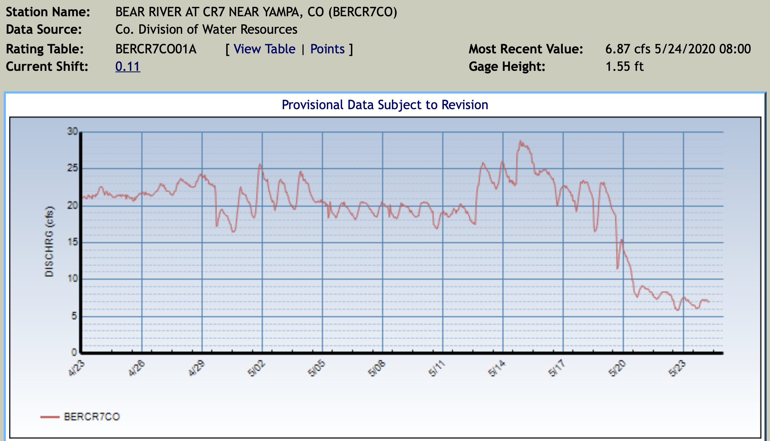
Bear River at Hernage and Kolbe Ditch May 23, 2020. Photo credit: Scott Hummer/DWR
From email from Scott Hummer at the Colorado Division of Water Resources:
Bear River Water Users,
Effective at 9:00 am, tomorrow, May 24, 2020: The Bear River will go on Call and under Administration.
The Swing Right (most junior right partially in priority) will be Yamcolo Reservoir, Admin #41329.00000…the dry up point is the Nickell Ditch.
All current diversions “junior” to Admin #41329.00000…Must be curtailed.
Water will be released from Yamcolo tomorrow morning in order to meet the demand by Senior rights at the bottom end of the system.
There is currently not a need for any water users Senior to Yamcolo Reservoir to place an order for the delivery of contracted/stored water.
The Call situation will be subject to change dependent upon a variety of circumstances, I’ll keep you posted as to any changes in a timely manner.
UYWCD is currently planning to calibrate the new measuring equipment in the Five Pine Ditch on Tuesday the 26th…and there may be some fluctuation in river flows during the task.
Please contact me with any further questions or comments.
From the Colorado Water Conservation Board (Ben Wade):
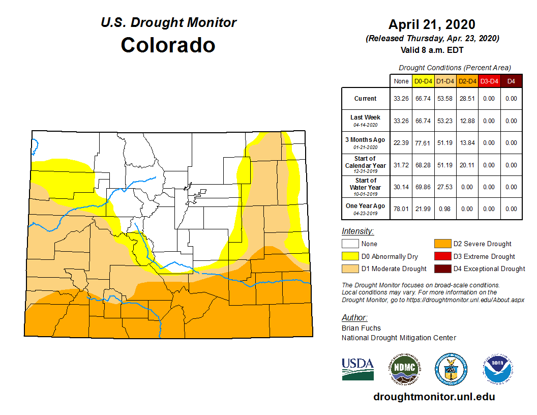
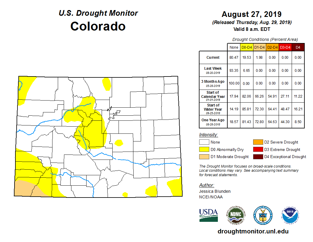
In western drought reporting, an average water year is cause for celebration. While average statewide snowpack and reservoir levels provide many water managers with above-average relief, our dry southern peaks and windy eastern plains are of notable drought concern. Statewide snowpack peaked at 104% of normal on April 8th, yet melt-out rates may be dramatic across the southern basins. North Central Colorado benefited from repeated snow events throughout late March and April, with the Boulder station breaking the 1908-09 snowfall record on April 16th. Drought Task Force members convened remotely on April 23rd for an annual review of roles and procedure should the State’s Drought Plan be activated. The purpose of the Drought Task Force is to direct early implementation of water conservation programs and other drought response measures intended to minimize the state’s vulnerabilities to localized drought impacts.
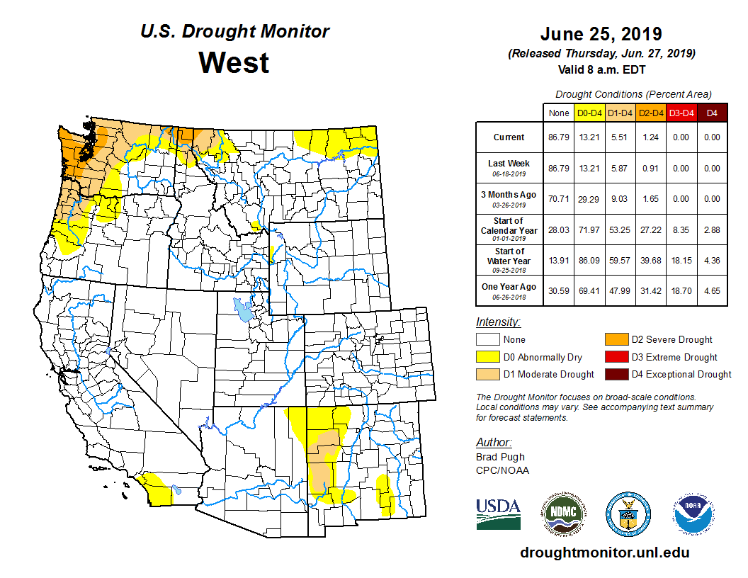
● The 90-day Standardized Precipitation Index (SPI) (from Jan. 1 to Apr. 18) shows below average moisture for the SW and SE and above average for the central and north mountain regions.
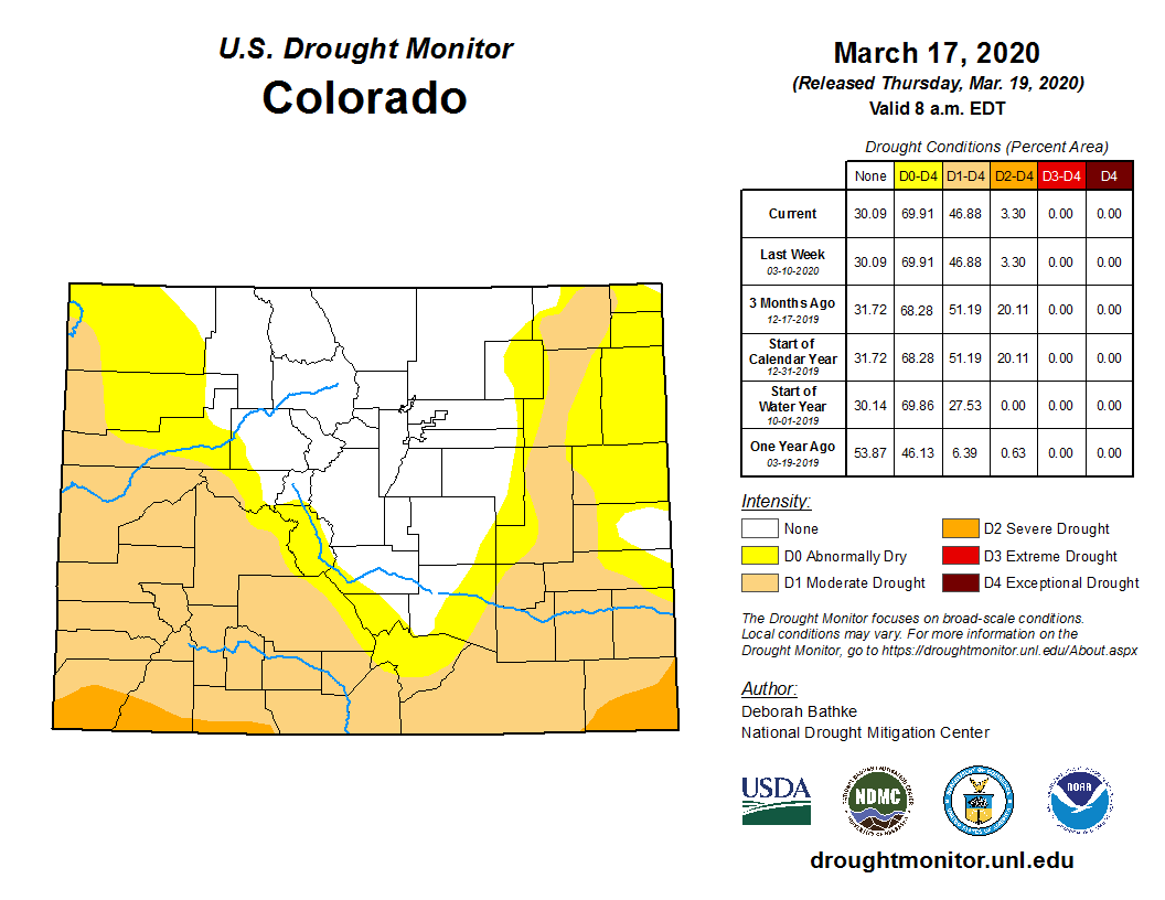
● The U.S. Drought Monitor, released April 23, shows gradual worsening conditions across all of southern CO compared to preceding months. D0 (abnormally dry) conditions cover 13% of the state; D1 (moderate) covers 25%; D2 (severe) drought covers 29% of the southern edge (up from 3% in March); 33% of the state (north-central) remains drought free.
Colorado Drought Monitor April 21. 2020.
● ENSO forecasts are still trending toward neutral conditions for spring and summer 2020, with a few model traces pointed toward La Nina.
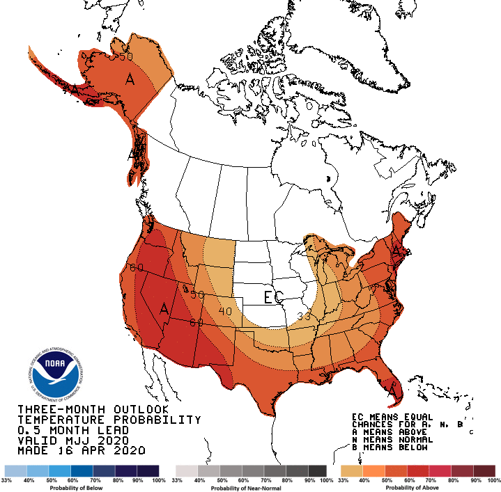
● NOAA’s Climate Prediction Center three month outlook maps show increased probability for warmer than average temperatures May through July for much of the state and favorable, slightly higher than average, precipitation outlooks for the Eastern Plains.
● Reservoir storage remains above average for all major basins except the Rio Grande (83%) and Arkansas (93%). Statewide, reservoirs are at 107% of average and 61% capacity.
● Long-term trends confirm our summers are getting hotter. The current seasonal forecast is a reflection of this.
● Water providers and water users did not report any unusual impacts or concerns at this time.
Yampa River at USGS gage, above Stagecoach Reservoir March 31, 2020. Photo credit: Scott Hummer.
From email from Scott Hummer:
Note the attached, taken yesterday afternoon…
River is beginning to open up, calves are starting to hit the ground and irrigation season will soon be upon s in the high country!
Yampa River Basin via Wikimedia. Ranchers and farmers in the valley have largely ignored Division Engineer Erin Light’s order to install measuring devices as of December, 2019.
A small pool of water along the Walker Ditch is kept free of ice and snow all winter long in order to provide water for cattle on the Monger Ranch near Hayden. A bill recently passed the Colorado legislature that allows ranchers’ historical stock watering rights to stay first in line, ahead of instream flow rights for the environment. Lauren Blair/Aspen Journalism
A bill that cleared the Colorado legislature with bipartisan support March 4 seeks to resolve an eight-year debate over how ranchers and other water users can maintain their historical water use when dry conditions trigger cutbacks to protect streamflows.
HB20-1159 [State Engineer Confirm Existing Use Instream Flow], which passed the House with a unanimous 63-0 vote and the Senate with a 31-1 vote, authorizes state water officials to confirm historical usages, such as water used for livestock, whether or not it’s held in an official water right. This allows ranchers’ uses to stay first in line for water ahead of the stream protections, known as instream-flow rights.
“It’s really a belt-and-suspenders clarification of existing authority,” said Zane Kessler, director of government relations for the Colorado River Water Conservation District, which drafted the language for the bill. “I think it’s a good example of when we sit down and pore over these issues, it’s not hard to come up with a fix that protects West Slope water users and provides the state engineer the authority he needs to continue administering them.”
Instream-flow rights, which are held exclusively by the Colorado Water Conservation Board, exist for the sole purpose of preserving the natural environment of streams and lakes “to a reasonable degree.” Most of these date to the 1970s and are junior to most agricultural-water rights under Colorado’s prior appropriation system of “first in time, first in right.” To date, instream-flow rights protect roughly 9,700 miles of stream in Colorado.
Mud and manure line an access point for cattle to drink from a ditch on Doug Monger’s ranch near Hayden as winter nears its end. A bill recently passed the Colorado legislature that will protect ranchers’ historical uses without requiring them to go to water court. Photo credit: Lauren Blair/Aspen Journlism
Historical uses
The debate over historical uses has turned on whether a water user must go to water court to make their pre-existing use official in a decree.
A 2012 drought brought the question to a head when state officials cut off water users on the Elk River in northwestern Colorado in favor of instream-flow rights. Although many ranchers in the area have water rights for irrigation that are senior to the 1977 instream-flow rights and have historically used that water also for their cattle, the state Division of Water Resources determined that livestock watering wasn’t implicit in irrigation rights.
Those without specific rights for stockwatering were left high and dry once the summer irrigation season was deemed over, even though they had used the water for livestock for generations.
“My grandparents bought this piece of land in 1946,” said Krista Monger, a cattle rancher on the Elk River. “We have the records to show we’ve been using (our water) for livestock.”
Stockwatering and irrigation often go hand in hand. During the irrigation season, if a rancher’s livestock drink from the ditches used to irrigate their fields, the use is considered incidental to irrigation. But once the growing season is over and a rancher keeps the water flowing through the ditch for the exclusive purpose of watering their livestock, the use is not covered under irrigation-water rights.
The amount of water typically used for exclusive stockwatering is a fraction of what is used for irrigating, around 80% to 90% less. Some ranchers also use stock ponds, which require a water-storage right.
More than 90,000 irrigation-water rights are held across the state, of which 29,000 specifically name both irrigation and livestock uses. That means the new law could potentially apply to 61,000 water rights, although not all of these are held by ranchers raising livestock. An additional nearly 32,000 water rights are held exclusively for livestock purposes but not irrigation.
The Monger family holds both irrigation- and livestock-water rights to grow hay and to water their 300 cattle. Her family’s rights and diligent record-keeping meant their ditches kept flowing while their neighbors’ ditches were shut down in 2012, highlighting the need for better record-keeping among the region’s irrigators.
But the incident prompted a statewide debate over the meaning of Colorado statute C.R.S. 37-92-102(3)(b), which states that instream-flow rights are subject to pre-existing uses of water, “whether or not previously confirmed by court order or decree.”
The state Department of Natural Resources, home to both the Division of Water Resources and CWCB, argued that when the instream-flow protections were created, lawmakers intended for water users to make their existing use official in a decree. The Colorado Cattlemen’s Association and the Colorado River Water Conservation District argued that the statute clearly precludes the need for a court decree and sought to protect ranchers’ historical usage without requiring them to go to water court.
“The statute says… prior uses would be honored. But they’re saying the statute doesn’t say what the statute says,” said Mike Hogue, former president of the cattlemen’s group.
After years of negotiations, stakeholders agreed on a simple piece of legislation to clarify the state water engineer’s authority “to confirm a claim of an existing use (if it) has not been previously confirmed by court order or decree,” according to the bill summary. The bill had bipartisan sponsorship from Reps. Marc Catlin, R-Montrose, and Dylan Roberts, D-Avon, and Sens. Don Coram, R-Montrose, and Kerry Donovan, D-Vail.
“I do think this is very helpful legislation,” said State Engineer Kevin Rein, who is with the Division of Water Resources. “We had what I’d call an honest disagreement about what the statute meant. My position is if they change the law and give me a place to hang my hat on, that solves the problem.”
Ditch water trickles back under the cover of snow and ice from a watering hole for cattle on the Monger ranch near Hayden. New legislation prevents ranchers’ water for stock from being shut off by an instream flow right for the environment. Photo credit: Lauren Blair/Aspen Journalism
Wakeup call
However, what the legislation doesn’t resolve — and what is perhaps a bigger Pandora’s box opened by the 2012 incident — is the decision that state water officials made that irrigation rights do not include stockwatering rights. In practice, irrigators around the state, many of whom hold water rights dating to the late 1800s and early 1900s, have used irrigation- or agricultural-water rights not to just irrigate their hayfields, but also to water their livestock.
The new distinction means that ranchers with irrigation rights must apply for livestock water rights if they want to protect their usage into the future. Although the new legislation protects a rancher’s stockwatering use from being shut off specifically by an instream-flow right , their stockwater use could still be cut off if another water user makes a call on the river to fulfill a formal water right.
“We all thought that was part of our ag water rights,” said Doug Monger, a Routt County commissioner and a cattle rancher on the Yampa River in northwest Colorado, and also uncle to Krista Monger. “It’s a wakeup call for all of us.”
Aspen Journalism collaborates with The Craig Daily Press, Steamboat Pilot and Today and other Swift Communications newspapers on coverage of water and rivers. This story ran in the March 16 edition of the Craig Press.
Click here to read the update (Megan Holcomb/Tracy Kosloff):
This year’s spring and summer drought outlook may be tough to predict, but currently the state’s northern mountains and Front Range look strong. There are increasing concerns of dry conditions along the Eastern Plains, in the southwest and San Juans where we are seeing slightly below average snowpacks and reservoir levels. There are reports of extremely dry subsoils on the Eastern Plains. Precipitation averages statewide have slipped from 95 to 90% of average statewide since mid-February. Statewide snowpack has decreased from 110% to 104% since mid-February. Streamflow forecasts are already showing the implications of dry autumn precipitation with forecasts ranging from 54% (Surface Creek near Cedaredge) to 132% (Spinney Reservoir Inflow) of median streamflow values.
● The 90-day Standardized Precipitation Index (SPI) (from Dec 18 to Mar 17) shows below average moisture for the SW and NE and distributed average or slightly above for the central and north mountain regions.
● The U.S. Drought Monitor, released March 19, shows worsening conditions in NE Colorado. D0 (abnormally dry) conditions cover 25% of the state; D1 (moderate) covers 42%; D2 (severe) drought covers 3% of the SE and SW corners; and 30% of the state (north-central) remains drought free.
● ENSO forecasts are still trending toward neutral conditions for spring and summer 2020.
Colorado Drought Monitor March 17, 2020.
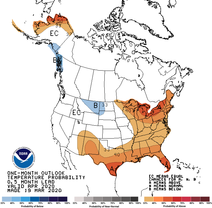
● NOAA’s Climate Prediction Center three month outlook maps show increased probability for warmer than average temperatures March through May for much of the state, and equal chances of near, above, or below average precipitation outlooks.
● Reservoir storage remains near to above normal: 84% to 123% of average in all major basins and 107% of average statewide. Last March 2019, statewide reservoirs were at 83% of average.
● SNOTEL Snow Water Equivalent (SWE) sites show statewide snowpack at 104% of record median (as of Mar 19).
● Water providers and water users did not report any unusual impacts or concerns at this time.
From the Colorado Department of Natural Resources (Megan Holcomb/Tracy Kosloff):
2019 Calendar Year in Review: 2019 followed one of Colorado’s warmest, driest years on record with a severe drought in southwest Colorado. This drought (of 2018) was followed by a cold, wet 2019 spring and 150% of normal snowpack that helped clear the state of drought by June 2019. The 2019 monsoon season, however, was nearly absent and September 2019 was the hottest September on record. The dry 2019 October set much of the state below normal for the 2020 Water Year. These early deficits can still be made up, particularly with snowpack running slightly above normal to date. This, however, does not guarantee an above average runoff given our dry soils.
The 90-day Standardized Precipitation Index (SPI) from October 22 – January 19 shows geographically distributed average and slightly below average precipitation statewide.
According to the U.S. Drought Monitor, released January 15, D0 (abnormally dry), D1 (moderate drought), and D2 (severe drought) collectively cover 53% of Colorado. 35% of the state is under D3 (extreme) and D4 (exceptional) drought.
The long term ENSO forecasts are trending toward neutral conditions remaining for spring and summer 2020, while losing El Niño conditions. This could mean reduced odds of SW Colorado spring moisture.
NOAA’s Climate Prediction Center shows warmer than average temperature outlooks February through April for the SW half of the state, and normal precipitation outlooks for the entirety of the state.
Reservoir storage remains near to above normal (86 to 124% of average) in all major basins and is 109% of average statewide. This time last year reservoirs were 81% of average statewide.
Water providers and water users did not report any unusual impacts or concerns at this time.
The view looking downstream at the proposed site for the reservoir and dam on the White River. Colorado’s top water engineers are looking to oppose the project in water court because of their concerns that it is speculative. Photo credit: Heather Sackett/Aspen Journalism
After years of their questions and concerns not being met, Colorado’s top water engineers are looking to formally oppose the water rights associated with a proposed reservoir project in northwest Colorado.
In November, the Colorado Division of Water Resources filed a motion to intervene in the Rio Blanco Water Conservancy District’s application for a 90,000-acre-foot conditional water-storage right on the White River. The state DWR is now waiting for a judge to determine whether it will be allowed to file a statement of opposition in the case.
For more than 4½ years, state engineers have expressed concerns that the conservancy district has not proven there is a need for the water, which would be stored in the proposed White River reservoir and dam project between Rangely and Meeker. The issue is whether Rio Blanco has shown that it can and will put to beneficial use the water rights it applied for in 2014. It remains unclear whether the town of Rangely needs the water.
“And throughout this case, the Engineers have consistently maintained that RBWCD must demonstrate that its claimed water right is not speculative,” the motion reads. “Although RBWCD has addressed some of the Engineers’ concerns in the past six months, the Engineers maintain that RBWCD has not met its burden.”
State Engineer Kevin Rein said his office had been trying to resolve its concerns with Rio Blanco’s claims to water informally and doesn’t take filing a motion to intervene lightly.
“We are very aware of the influence we can have on the process and costs and delays, so we don’t just frivolously file a statement of opposition every time we have some issue with a case,” Rein said. “We believe there are issues that need to be fixed in this water-court application in order for it to go forward.”
One option for the White River storage project would be an off-channel dam and reservoir at this location. Water would have to be pumped from the White River into the reservoir site. Photo credit: Heather Sackett/Aspen Journalism
Rio Blanco declines comment
The White River storage project, also known as the Wolf Creek project, would store anywhere from 44,000 to 2.92 million acre-feet of water. The water would be stored either in a reservoir formed by a dam across the main stem of the White River — this scale of project proposal is now rare in Colorado — or in an off-channel reservoir at the bottom of Wolf Creek gulch, just north of the river. Water would have to be pumped from the river uphill and into the off-channel reservoir.
Rio Blanco District Manager Alden Vanden Brink declined to comment on the state’s opposition, citing concerns about litigation. Vanden Brink also is chair of the Yampa/White/Green River Basin Roundtable and sits on the board of the Colorado River Water Conservation District.
Rio Blanco is a taxpayer-supported special district that was formed in 1992 to operate and maintain Taylor Draw Dam, which creates Kenney Reservoir, just east of Rangely. The district extends roughly from the Yellow Creek confluence with the White River to the Utah state line.
Rio Blanco says Kenney Reservoir is silting in at a rate of 300 acre-feet per year, threatening the future of Rangely’s water supply and flatwater recreation, and a new off-channel reservoir on the White River could help solve this problem.
Deirdre Macnab, seen here on her 13,000-acre 4M Ranch between Rangely and Meeker, is the current sole opposer in the water court case for the White River storage project. Colorado’s top water engineers are looking to intervene in the case because they say the project applicant has not proven there is a need for the water. Photo credit: Heather Sackett/Aspen Journalism
Opposition
If a water-court judge grants the motion to intervene, the state will become the second opposer in the case. Currently, the only other remaining opposer is 4M Ranch, owned by Deirdre Macnab.
Tucked between rolling hills of arid, sagebrush-covered rangeland, the proposed reservoir and dam site abut her 13,000-acre property along the White River.
Macnab, who bought the beef and hay operation nearly five years ago, is on the board of the conservation group White River Alliance, as well as the Yampa/White/Green River Basin Roundtable. Macnab said the main reason she opposes the reservoir project is because of the state’s concerns.
“If we felt that there was a clear purpose and need that would benefit the public, then we would, in fact, be supportive of this,” Macnab said. “But the fact that the experts are saying there does not appear to be a clear purpose and need means that this would be a real travesty and waste of taxpayer money. It’s something we will continue to oppose until that changes.”
The site of the potential off-channel Wolf Creek Reservoir on the White River. Photo: Brent Gardner-Smith/Aspen Journalism
Additional concerns
State engineers are also concerned about the vagueness of the revised amounts of water for various uses that Rio Blanco says it needs.
In a 2018 report, Division 6 engineer Erin Light questioned Rio Blanco’s claims that it needed water for industrial/oil and natural gas/oil shale and irrigation uses. In response, Rio Blanco dropped those claims but almost doubled the need for municipal and industrial use for the town of Rangely and added a new demand for recreation.
The conservancy district also set the amount of water for environmental needs for threatened and endangered species at between 3,000 and 42,000 acre-feet despite its acknowledgement that the actual amount needed for this use was unknown. Rio Blanco then added a new demand for a sediment pool of 3,000 to 24,000 acre-feet and an insurance pool of up to 3,000 acre-feet but did not describe either of these uses.
“Thus, despite removing its claims for industrial/oil and natural gas/oil shale, which originally accounted for over half the demand for the claimed water right, the total demands for water identified by RBWCD actually increased to 24,000-100,000 acre-feet,” the motion to intervene reads.
Grant money
Since 2013, the Colorado Water Conservation Board has given roughly $850,000 in grant money to Rio Blanco to study the White River storage project, including a $350,000 Colorado Water Plan grant in 2018. According to CWCB communications director Sara Leonard, Rio Blanco has so far spent about 60% of these most recent grant funds.
Leonard said that DWR’s motion to intervene was not a surprise to the CWCB, that the two state agencies with seemingly differing views on the project have met and that the CWCB is aware of the state engineers’ concerns.
“The grants that have been awarded to the applicant to date have all been with the intention of helping the District with the evaluation process,” Leonard wrote in an email. “In other words, the motion has not changed the scope of the ongoing work in the grant.”
The Colorado River Water Conservation District has also given Rio Blanco $50,000 toward investigating the feasibility of the storage project.
“We are not advocates and we are not opposers,” said Jim Pokrandt, director of River District community affairs and chair of the Colorado River Basin Roundtable. “It’s a regional question that our constituents need to figure out.”
Aspen Journalism collaborates with The Craig Daily Press and other Swift Communications newspapers on coverage of water and rivers. This story appeared in the Jan. 17, 2020 edition of The Craig Daily Press.
Irrigated pasture at Mantle Ranch along the Yampa River. Ranchers in the Yampa River basin are grappling with the enforcement of state regulations that require them to monitor their water use. Photo credit: Brent Gardner-Smith/Aspen Journalism
Irrigators in Northwest Colorado are facing a sea change in how they use their water, and many ranchers are greeting such a shift with reluctance and suspicion.
The final frontier of the free river, irrigators in the Yampa River region have long used what they need when the water is flowing with little regulatory oversight. Water commissioners have been encouraging better record keeping in recent years, but a first-ever call on the system during the 2018 drought led state officials to begin enforcing requirements to measure and record water use.
State law requires all irrigators to maintain measuring devices on their canals and ditches. Kevin Rein, state engineer and director of the Colorado Division of Water Resources, said such devices are widely used in other river basins throughout Colorado, where bigger populations and more demand for water have already led to stricter regulation of the resource. The Yampa River Basin is the last region to get into compliance, Rein said.
“The basin went under call for the first time in 2018,” he said. “I would not call that a driving force; I would call that affirmation of why it’s been important … to do this for so many years.”
Nearly 500 Yampa River Basin water users were ordered this fall to install a device by Nov. 30, although irrigators don’t need to comply until spring 2020, when irrigation water begins to run. Those without devices won’t be allowed to use their water and could be fined $500 daily if they do.
The new enforcement is being met begrudgingly by irrigators, many of whom are third- and fourth-generation ranchers and whose families have never measured and recorded water use in more than 100 years.
“Ever since the 1880s, there has never been a call on the Yampa River,” said Craig cattle rancher Dave Seely. “If there wasn’t any water, (ranchers) accepted the fact, so it’s unusual that suddenly we have all this coming down on us now.”
A call on the river occurs when someone with senior water rights isn’t receiving their full allotted amount, and the state places a “call” for users with junior rights to send more water downstream or stop diverting altogether. The move triggers administration of the river by state water commissioners, who make site visits to monitor how much water is flowing through each ditch.
A hayfield in the Elk River Basin, a tributary of the Yampa River. A first-ever call on the Yampa River in 2018 is leading state officials to enforce regulations about measuring water. Photo credit: Brent Gardner-Smith/Aspen Journalism
Government oversight
An air of the Wild West still lingers in this sparsely populated corner of the state, where many ranchers would rather accept a shortfall than invite the government into their affairs by making a call for their water.
“They just took it on the chin and dry farmed,” Seely said.
State officials have seen this resistance to change before and accept it as a matter of course.
“It’s a rough, rocky road at first, but after a while, I think a lot of people will be glad they have a device there,” said Erin Light, Division 6 engineer with the Division of Water Resources.
Light and her colleagues reminded irrigators at the Yampa-White-Green Basin Roundtable meeting in November that keeping accurate records helps protect their water right, since rights are considered abandoned if not used, although the state rarely enforces this.
“Your water right has a value, a value to water your livestock or your crops, but it also has a dollar value for your heirs,” Scott Hummer, a Division 6 water commissioner, said at the meeting. “The only way they have to sell the water or get a price for the water is if the engineers know how much water is consumed by your crop.”
But many irrigators feel mistrustful of state government having more oversight of their water and are worried that outside entities may have designs on the region’s largely unallocated resource. Climate change has led to hotter, drier conditions over the past 20 years, and growing populations have increased the demand for water — both in the Colorado River Basin and along the Front Range.
“It just raises the question of what’s the drive behind it,” said third-generation Yampa cattle rancher Philip Rossi. “It’s hard to have an opinion when you don’t fully understand the long game.
“They’re trying to put a monetary value on water,” Rossi said. “Are they trying to get a better understanding of exactly how much water there is … so they can put a value on it if they want to sell it? Are we helping ourselves, are we hurting ourselves, are we helping them? There’s so many of us that are not interested in selling our water.”
Other ranchers are concerned that increased oversight could mean new restrictions even when water is plentiful. Many are in the habit of using as much water on their fields as they need, regardless of their decreed right.
“When the water’s high, we want to get it across our fields quickly, so we take more water than (our allotted right),” said John Raftopoulos, a third-generation cattle rancher in western Moffat County. “The fear is that, even with high water, they’re going to cut you down to the maximum you can take … that they’ll regulate you to the strict letter of the law.”
An irrigated hayfield along the lower Yampa River. If irrigators don’t install measuring devices on their diversions by the spring irrigation season, they could be fined $500 a day. Photo credit: Brent Gardner-Smith/Aspen Journalism
No waste
Rein said users could continue using more than their allotted right when the river is a free river — in other words, not under a call — as long as they are not wasting it.
“There’s a statutory term called waste; you can’t divert more water than you can beneficially use,” Rein said.
He also said keeping accurate records would only protect the water user as demand increases statewide and across the West.
Measuring devices cost from $800 to $1,500, so installation can get expensive for the many ranchers who have more than one ditch. Rossi has three more devices to install. Raftopoulos has about five others, for a total of 15 on ditches irrigating roughly 2,500 acres of grass hay and alfalfa.
Light estimated 100 irrigation structures had requested extensions — which she is granting in many cases until either July 31 or Oct. 31 — but she won’t have an accurate count on how many ditches are in compliance with the orders until May or June.
“It’s something that was going to happen sooner or later because of water shortages. That’s the system, that’s the law,” Raftopoulos said. “It’s a burden right now, it’s expensive and it’s going to put more government in our ditches. There’s going to be more people watching what comes out.”
Aspen Journalism collaborates with the Steamboat Pilot and Today, the Craig Press and other Swift Communications newspapers on coverage of rivers and water. This story appeared in the Dec. 27 edition of the Steamboat Pilot and Today.
Steamboat Springs: Hundreds of ranchers in the scenic Yampa Valley have ignored a state request to begin measuring the water they use, putting them on a collision course with regulators that will land many of them in court this summer if they don’t relent.
Division Engineer Erin Light, the top water chief in the region, said roughly 70 percent of irrigators in this remote part of northwestern Colorado have not installed measuring devices, meaning that millions of gallons of water are being consumed without oversight, something that is routine on other river systems.
“I sent out a notice in March saying, ‘I’m going to issue an order if you don’t install them now,’” she said. “It was a friendly gesture.”
No one responded.
“We have not been impressed with the response,” Light said.
On Sept. 30, she issued a formal order to 550 ranchers, which, if ignored, could result in fines of up to $500 a day and court action.
Yampa River Basin via Wikimedia. Ranchers and farmers in the valley have largely ignored Division Engineer Erin Light’s order to install measuring devices as of December, 2019.
The deadline to respond this time was Nov. 30. Few did so, Light said.
Under the terms of the order, ranchers who don’t install measuring flumes or other devices to track diversion rates from the river into their irrigation systems will be cut off if they try to irrigate in the spring. They will also likely face prosecution, Light said.
“We’ll be working with the attorney general’s office to begin court proceedings,” she said.
The issue reflects an end to a gentleman’s agreement that dates back to the late 1800s, a consensus that said these tough, resourceful ranchers could manage their own water, that the state did not need to issue a direct order, and that the hay meadows, and cattle and sheep operations, could continue diverting their irrigation water as they always had.
And that’s largely because of the Yampa River’s amazing flows. Unlike almost any other place in Colorado and the West, water here was once so abundant that there was almost always plenty to go around. Measurements weren’t needed, and the state rarely had to step in to resolve disputes among water users, allowing Mother Nature free rein.
But chronic drought, climate change, and population demands have begun eroding the Yampa’s once bountiful supplies. For the first time ever, in the desperately dry summer of 2018, Light was forced to step in, cutting off some irrigators because more senior water rights holders weren’t getting their legal share of water. That sent a shock across the valley but triggered little action.
These days the Yampa River has the distinction of being the only one of Colorado’s eight major river basins that remains largely unmeasured and unregulated.
But Light said the issue has become too critical, and water too scarce, to allow that to continue.
Mike Camblin, whose family has been ranching here for more than 100 years, said he will comply with the order. But he and many of his colleagues feel the state has been too heavy handed in its approach.
“What I don’t like about the order is that it’s forcing people to install those or they are going to get fined $500 a day to run water even if it’s a free river,” he said. The term free river means that there is enough water in the stream to satisfy all water rights, and under normal circumstances people can divert as much of the excess as they want.
Not anymore.
“I’m very disappointed,” said Dave Seely, a long-time rancher who has 11 different irrigation ditches that span Moffat and Routt counties.
Many of his ditches already have measuring devices, but the order means he will have to install at least five new ones at a total cost of more than $10,000, he estimates.
Light is aware of the anger in the ranching community and said she understands the financial burden the order will place on many irrigators.
“I’ve been trying to encourage my water users to understand that there is a value to them in measuring how much water they divert. Water is often a rancher’s most valuable asset. But many don’t want to hear that,” she said.
Seely plans to comply with the order so that he can divert in the spring. But there is a lingering resentment and sense of loss for an era that is ending.
“Historically there was never a call on the river, but now there is,” Seely said. “Now we’re under the jurisdiction of the state engineer forever.”
Hay fields in the upper Yampa River valley, northwest Colorado. Photo credit: Brent Gardner-Smith/Aspen Journalism
A beaver dam on the Gunnison River. Photo: Brent Gardner-Smith/Aspen Journalism
From the Colorado Department of Natural Resources (Megan Holcomb/Tracy Kosloff):
Water Year 2019 was characterized by a near average temperature and was the 34th wettest year in a 125-year period. Multiple state records were established in 2019, such as the March 13th bomb cyclone, the July 19th 115°F record at John Martin Dam, and the August 13th hail storm over eastern Colorado.
The start of Water Year 2020 (WY2020) saw dramatic temperature swings statewide: from the warmest September on record (Sep. 2019) to the 4th coldest October on record (Oct. 2019), marking one of the largest rank jumps on record and one of the state’s biggest changes in monthly average temperature. Grand Junction experienced the coolest Oct. on record while Alamosa and Pueblo experienced the 2nd coolest Oct. on record.
The 90-day Standardized Precipitation Index (SPI) from August 26 – November 23 shows notable precipitation deficits in the western half of the state.
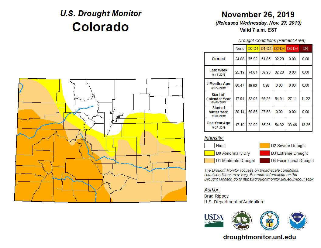
According to the U.S. Drought Monitor, released November 21, D0 (abnormally dry), D1 (moderate drought), and D2 (severe drought) collectively cover 75% of Colorado. Compared to the start of the Water Year 2020 (Oct. 1) the drought monitor shows degregations of 1-2 classes in the southern and western quadrants of the state.
The long term ENSO forecasts are trending toward neutral conditions remaining into the summer (entirety of WY2020). With no El Niño or La Niña forecast to dominate large-scale patterns, the outlook remains a bit more uncertain for the winter.
Colorado Drought Monitor November 26, 2019.
NOAA’s Climate Prediction Center shows warmer than average temperature outlooks December through February, and near-normal precipitation outlooks for the majority of the state. Northern basins may lean toward slightly above average precipitation these next three months.
Reservoir storage remains near to above normal (95 to 126% of average) in all major basins and is 109% of average statewide.
Water providers and water users did not report any unusual impacts or concerns at this time.
Two dozen aging dams in Colorado were in unsatisfactory condition and are located in places where their failure would likely kill at least one person, according to an Associated Press investigation that found at least 1,688 such dams nationwide.
The 24 Colorado dams range in age from 41 to 127 years old and are used for irrigation, recreation and drinking water supply, according to public records obtained by the AP during the more than two year investigation. They are spread among 16 counties, with El Paso having four, Jefferson three and Mesa and Park counties having two each.
Records show the dams are up-to-date with their inspections, and all have emergency action plans in case of a failure. In addition, work is underway or planned for some of the dams, and at least one in El Paso County, South Lake dam, has been repaired, said Bill McCormick, chief of Colorado Dam Safety at the state Division of Water Resources.
Twenty-one of the 24 Colorado dams are privately owned or owned by local governments, and the decision to fix a dam is the owner’s, McCormick said. State regulators can order a reservoir’s water level lowered to a safe level if a dam is in unsatisfactory condition or drain the reservoir if there is no safe level.
“If owners can live with less than full storage, they may not have the incentive to fix their dam,” he said in an email to the AP. “We try to incentivize owners to fix their dams, but the decision is theirs.”
[…]
In September, the Federal Emergency Management Agency awarded Colorado over $260,000 to conduct risk assessments and repair high-hazard dams, the term used to describe a structure whose failure would likely result in at least one death…
Since 1950, there have been six major dam failures in Colorado, according to a 2018 Colorado State Hazard Mitigation Plan. They include the 1982 Lawn Lake Dam failure in Larimer County that killed four people and caused $31 million in property damage.
FromThe Grand Junction Daily Sentinel (Charles Ashby):
The Legislature’s Water Resources Review Committee approved introducing four bills on [October 24, 2019], two of which are aimed at protecting and improving the state’s water supply.
“We have an incredible opportunity to pilot and deploy new technologies that could revolutionize and improve how we manage and consume Colorado’s most essential natural resource,” said Rep. Dylan Roberts, D-Avon, vice chairman of the 10-member committee, which also includes Rep. Marc Catlin, R-Montrose, and Sens. Kerry Donovan, D-Vail, and Don Coram, R-Montrose.
The water speculation measure, which Donovan and Coram are to introduce in the Senate, calls on the Colorado Department of Natural Resources to convene a special work group to study the extent of water speculation in the state, and report back to the committee by 2021…
The new technology measure, which Donovan also is to help introduce, calls on the University of Colorado and the Colorado Water Institute at Colorado State University to conduct feasibility studies on such things as using sensors to monitor surface and groundwater use and quality, and using aerial and satellite technologies to help monitor water supplies.
The other two measures call on the Colorado Water Conservation Board to broaden its public comment rules for its water resources demand management program, and requiring the Colorado Division of Water Resources to hire more well inspectors.
The Water Resources Review Committee advanced Bill 5, which would set a minimum number of six well inspectors during the next fiscal year. The price tag is estimated at $279,000 in the first year, with the original bill tentatively tying funding to whether voters pass Proposition DD in November. The initiative would legalize sports betting, with tax money going to the state’s water plan.
If DD were to fail, the legislature would have to raise well permit fees by 45%. However, the committee approved an amendment to remove the funding alternatives from the legislation until further consideration. The bill would also prioritize high-risk wells for inspection.
Currently, there are two full-time inspectors and a chief inspector who has duties other than inspections…
Earlier this year, the Colorado Office of the State Auditor found that 4,000 wells were constructed in fiscal year 2018. However, only 310 were inspected—and fewer than 10% of the high-risk wells…
Bill 6 would require the executive director of the Department of Natural Resources to recommend changes to the state’s water anti-speculation law. A spokesperson for the House Democrats said that committee members have heard about people purchasing Western Slope water rights, holding them while the price appreciates, and then selling the rights for a profit.
“I don’t think a hedge fund invests in anything without an expectation of making money off of it. Do we know if that’s speculation? We don’t,” said Sen. Kerry Donovan, D-Vail. “Do we have the needed laws in place to prosecute what could be water speculation under the expectation of demand management? That’s some of what we need to look at.”
The committee also advanced Bill 2, which clarifies public comment procedures for any changes to a program for demand management, as well as Bill 3, which directs the University of Colorado and other state agencies to study the feasibility of new water management and monitoring technologies. These include sensors, aerial observation platforms and satellite-based remote sensors.
One day in mid-July [2019], Colorado state engineer Kevin Rein stood before a packed room of farmers and ranchers and admitted that he might be forced to ruin their lives. Rein, a middle-aged man with wavy gray hair, spoke in the measured tones of a technocrat, but his message was dire: If the valley’s residents cannot figure out how to sustainably manage their water use, the state would do it for them. And though he stressed, time and again, his office’s dedication to working with them, and though he praised their efforts, his goodwill fell flat in the hot, poorly ventilated room, where more than 120 people were crammed, worried about their future.
For most of the 20th century, water use in this southern Colorado basin outstripped water supply. The people of the valley came up with an uncommon solution to this not-uncommon problem: an experiment in communal water management. And what they’ve found is that self-governance is hard. Rein not only has the authority, but a legal mandate, to end this experiment if its failure becomes assured. If or when it becomes clear that the San Luis Valley’s water system cannot reach a sustainable level by the year 2031, then, yes, he said, his office would shut off irrigation for a substantial part of the area. That would mean no water for many fields, which could mean foreclosures, bankruptcies and family farms sold.
The stifling room went silent for a full 10 seconds. When the questions resumed, they came without outrage. Rein was not the villain. Most people present must have known that, in the end, they themselves represented both the cause of the problem and its only possible solution.
Cleave Simpson, bottom right, converses with other water users following a Subdistrict 1 budget meeting. Photo credit: Luna Anna Archey/High Country News
THE SAN LUIS VALLEY is a high-mountain desert ringed by the Southern Rockies and blessed with unusual water resources. From its headwaters in the San Juan Mountains, the Rio Grande traces southeast down to the valley floor, beneath which lie two enormous stores of water, one just belowground, the other deeper and enclosed by clay. The river and these aquifers sustain more than 1,500 farms and ranches — and the towns that rely on them — in harsh conditions generally inhospitable to agriculture. Center, a small town with a predictable location relative to the rest of the valley, registers some of Colorado’s coldest temperatures and lowest rainfall. Farming at almost 8,000 feet means long winters and a three-month growing season, accompanied by regular dry spells and occasional July killing frosts. But the sandy soil and near-constant sun are great for potatoes, making the valley the nation’s second-largest producer of “fresh” spuds — as in produce found in a store, not French fries. Other crops include barley, which often goes to the Coors Brewing Company, and alfalfa.
When morning comes to the valley, the Sangre de Cristo (“Blood of Christ”) Mountains earn their name, burning blood-red as the sun summits the sawtooth peaks. On high, snowpack endures for most of the year, watched daily by the farmers below, whose yearly water supply depends on the runoff. A drought that began in 2002 and continues today — recent rainfall notwithstanding — made the valley’s water deficit even more acute. In response to this new aridity, the people of the valley sought authority to regulate their own water use, which the state granted in 2004. In 2012, local governing bodies made up of water users across the valley began to tax commercial irrigation, replace water removed from rivers and streams, and pay farmers to fallow their land.
Western water wonks mostly view this attempt at self-management with hope, as a possible model for other communities facing water crises. But on the ground in the valley, the situation is grim. Last year, the snowpack was low and little rain fell; the Rio Grande’s flow in 2018 was one of the lowest ever recorded. The U.S. Department of Agriculture designated the valley a drought disaster area. With little surface water, farmers had to rely on water pumped from belowground, wiping out years of steady accretion to the shallower, or unconfined, aquifer. Last year’s dry spell put the valley back where it started: about 800,000 acre-feet below the aquifer’s legally mandated recovery level. Seven years gone and no net gains. In December, Rein sent the valley a warning letter. If, he wrote, it is “undeniable that the sustainability goals” will not be met by the 2031 deadline, irrigation shutdowns would follow. Rein would repeat this message in July. This threat now haunts thousands of water users, an ever-present doom on the horizon.
Kyler Brown rides along the Rio Grande River, where headgates divert water into irrigation canals. Coming up with a plan to reduce water use is the easy part, he says. Changing peoples’ behavior is trickier. Photo credit: Luna Anna Archey/High Country News
DROUGHTS BELONG TO THE CHAOTIC FORCES OF CLIMATE, and markets to invisible hands. But the San Luis Valley’s experiment in self-governance means that its agricultural producers control their own fate. Among them is Kyler Brown, who farms barley and potatoes a few miles north of Monte Vista. On a windy, warm day, Brown drove me through his family fields. The farm belongs to his father-in-law; Brown married into the valley. He is 36, tall and sturdy, and sports a black beard and a wide-brimmed hat. Brown laughs often in loud bursts and treats the valley’s struggles to moderate water use with a black humor. To him, the valley is suffering from old habits that die hard.
“It hasn’t led to violence yet,” he said with a grin, as the truck bounced down a two-wheel dirt track. The San Luis Valley is occasionally called “the Kumbaya basin” for its collaborative spirit, but Brown dislikes this description. For decades, the locals lived beyond nature’s limits. Now, water is scarce.
It was late March, and the snow still sat heavy on the surrounding peaks. The irrigation ditch adjoining the fields was overgrown with weeds. Soon, the scrub would be burned clean, the gates connecting Brown’s fields to the Rio Grande Canal open, and his water allotment flowing. Brown steered with one square tanned hand and gestured with the other. If the valley’s farms and ranches, its towns and economies, are to survive, he said, their relationship to water must change, and yet Brown does not think the local governance system, as it stands now, is up to the challenge. “People thought the (water management system) was the miracle, that was the amazing thing,” he said. But implementing the system, forming committees and boards, that’s the easy part, Brown went on. Changing how people act, that’s the real work.
This is especially true when water suddenly appears plentiful, as it did this spring. As if in response to Rein’s letter, southwestern Colorado had one of its snowiest winters in decades. In the mountains above the valley, the season-to-date snowpack average stayed above 300% for most of the spring. The Rio Grande, snow-fed, ran fast and full across the heart of the valley. Grazing meadows flooded in places. Ditches and canals, the vascular system that carries the lifeblood of the valley, filled.
This, then, was the challenge the valley faced, after the disastrous drought and Rein’s letter: 2019’s abundant water, set against 2018’s drought, offered yet another test of the farmers’ habits. Could they use the welcome, unexpected snowpack to refill the aquifers? This is a hard ask: Last year’s drought strained farmers financially. This year, the resource is plentiful.
Brown wants to take on this clash between individual and communal interest. Over the winter, he proposed a “consensus-building” plan to the local water management authority — something that would bring farmers, ranchers and community members together to build agreement on a few key conservation points. As Brown sees it, the people of the valley need to accept that the problem is not principally, or only, water scarcity. People’s water habits, the crops they grow, the decisions they make on the farm: All of these need to be held up and examined under the new arid realities.
“Everyone needs to think every time they turn on a pump,” he said.
Kyler Brown rides along a section of pooled water on the land where he runs his cattle. There hasn’t been so much standing water at summer’s end in years. Photo credit: Luna Anna Archey/High Country News
Brown took me to a small meadow near the Rio Grande, where he runs a few dozen cattle on the cottonwood flats. The river was full to its banks, running dark and cold. Seeing so much water makes scarcity hard to imagine. It’s easy to think that way when the river is full.
Perhaps that’s been the problem all along. The valley’s system of water rights dates back to the 1850s, following the Mexican-American War. The Rio Grande supported the area’s early farms and ranches. Acequias, community water channels, shared the resource at the valley’s southern end. Founded in 1852, the San Luis People’s Ditch in Culebra Creek is the oldest continuously used water right in the state. These waterways created thousands of acres of marshy terrain in the low country, grown over with stands of cottonwood and willow that shaded native wildflowers. By 1900, the entire flow of the Rio Grande was allocated via surface water rights.
The well that Kyler Brown uses for irrigation was drilled in 1978. Photo credit: Luna Anna Archey/High Country News
After World War II, electrification enabled farmers to pump water from wells tapped deep into the aquifers. By the second half of the 20th century, surface-water users had to curb irrigation, thanks to river compacts formed with downstream states. Well users faced no such restrictions. They pumped away, which impacted stream flows, since ground- and surface water interact. For a time, this was not a problem; there was enough water to go around for both surface and groundwater users. (In fact, the water table was so high that valley houses built in the early 20th century don’t have basements.)
The development of center-pivot sprinklers in the 1970s brought big changes, expanding agricultural capacity by allowing more efficient irrigation, no matter what the river was doing. Water use and farm size increased. Before this pumping technology, fields were flooded from the irrigation ditches, and the runoff helped replenish groundwater. But now, the combination of pumps and sprinklers drained the groundwater without replenishing it. Few questioned what this technology allowed. The water table dropped, and the rivers and creeks thinned. The pheasants that once thrived in the thickets and woodlands disappeared.
Center, Colorado, is surrounded by center-pivot-irrigated farms that draw water from shrinking aquifers below the San Luis Valley. Photo credit: Google Earth
TODAY, MORE THAN 14,000 PERMITTED WELLS puncture the valley floor. On a map, they appear as a tightly packed confederation of crop circles, laid out like thousands of green sundials set against the dusty waste of the desert. Many of these wells pump within the valley’s first water management “subdistrict,” which began the experiment in self-governance eight years ago. Two more subdistricts became active this year, on May 1. If all goes according to plan, there will be seven of these, distinguished by differences in geography and hydrology.
The actual work of shared governance takes place through the taxpayer-funded Rio Grande Water Conservation District, which includes the subdistricts. In practice, this involves committee meetings, lots of them. Each subdistrict’s board is made up of water users — farmers and ranchers. (Board members are mostly, but not uniformly, older, white and male. The valley is not — about half the population is Hispanic or Latino.) The meetings take place in a drab, reddish stucco building outside Alamosa. Committee members show up in stiff jeans, flannel shirts and seed caps that are removed for the Pledge of Allegiance, which begins each meeting, revealing pale foreheads above weather-beaten faces. The audience resembles the boards. Most people seem to know each other. Before an April session, I heard a farmer in a hat that proclaimed “compost done right” confide to the man next to him that “we’re going to be doing more quinoa this year, for sure.”
The meetings themselves tend to be dry affairs. In April, Subdistrict 2 board members went page-by-page through the annual water plan, discussed a few water leases, and solemnly approved a $78.22 refund to a ranch for a water fee overcharge. Someone cracked a joke about “counting every penny.” But these sessions, however mundane, are where the water management work gets done, amid a patchwork of interests, values and preoccupations.
Board and community members gather at a Rio Grande Water Conservation District’s Subdistrict 1 budget meeting in August. The subdistrict voted to raise pumping fees from $90 per acre-foot to $150 per acre-foot. They also discussed the fallow field program and ways to make it more accessible for farmers, such as allowing half fields to be fallowed. Photo credit: Luna Anna Archey/High Country News
Cattle ranchers sit next to barley and alfalfa producers. Big operators who own thousands of acres farmed with the newest in GPS-driven tractor technology rub shoulders with smallholders who supplement their agricultural income with a second job in one of the scattered towns. Some have water wells and some have river rights, and many have both. There are disagreements and digressions, punishingly long budget sessions, personal gripes, and episodic displays of resourcefulness and democratic good sense. In the middle of all this is Cleave Simpson, the water district manager, a fourth-generation farmer who tends about 800 acres of hay. Tall, thick-shouldered with sun-narrowed eyes, Simpson has a remarkable ability to explain water policy minutiae in clear, everyday language. People remark on his steady presence and decent conduct in an uncertain time. Even people who disagree with him tell me this.
Simpson believes that the valley can fix its water imbalance, but he admits the difficulty. Cutting water use is unpleasant, he told me, “but we can either wait on Mother Nature — or we can give it a shot ourselves.”
For eight years, the first subdistrict has given it a shot, and the results are uneven. Farmers within its borders must comply with the subdistrict’s water plan or get their own through state water court. Some early resistance aside, most chose the first option. Subdistrict 1 has several tools at hand to curb pumping. The primary one is a fee on pumped water; the current rate is $90 per acre-foot. Those with excess water can sell it to those who want more, via a credit system. There is also a program that pays farmers to take land out of production. About 10,000 acres of farmland have been retired this way, only about a quarter of the expected figure by this point.
Though the system is complicated, the aquifer is not. The aquifer responds to two things: recharge from the surface and reduced pumping. The effects are so obvious that locals sometimes refer to the aquifer as “the bathtub.” The amount of surface recharge each year is limited, so replenishing the aquifer effectively means less groundwater pumping for irrigation. That’s the hard part.
Subdistrict 1 sits atop the unconfined aquifer, so in many ways it is the most important. Many of the largest and most lucrative farms are here, in the heart of the valley. The subdistrict stops just before the Rio Grande to the south and stretches into the valley’s northern reaches, where smaller farms and ranches sit amid the sage and chico brush. Most of the farmers here grow barley, alfalfa or potatoes. Almost all of them rely on wells that pump from the aquifer. When Rein threatened a pumping shut-off, he was referring to Subdistrict 1’s more than 3,000 wells.
Rein’s letter woke people up, said Erin Nissen, who plants potatoes and barley with her father, Lyle, outside the small town of Mosca. At a special meeting after the letter ran in the local paper, several dozen people were expected to show. Hundreds came, filling the room and spilling out the door. “The letter was good,” she told me over the phone. “Scary, but good. There was talk from the beginning: ‘Oh, it’s fine, they won’t come and shut off the wells.’ ”
People are realizing now that the state might, indeed, shut off the wells. Part of the problem, according to Nissen, is an inability to require water-use cutbacks. When the subdistrict system was formed after the 2002 drought — the mention of which still makes valley farmers shiver — the architects thought market mechanisms would be enough, given commodity prices, and the hydraulic and climactic data available.
While sound at the time, this model could not account for the realities of a changing climate, and the subdistrict has proven unable to discourage enough farmers from pumping. “There’s a really sad mindset of, ‘I can pay for it, so it’s my neighbor’s problem,’ ” Nissen said.
Dale Bartee checks the soil in his field of organic flax seed. The plant requires less water than crops like alfalfa and barley. Photo credit: Luna Anna Archey/High Country News
IN PRACTICE, THE SUBDISTRICT’S POLICIES cannot account for the valley’s unequal water distribution. Farmers with good surface water rights take what they need from the river and sell the extra as credits, while wealthier farmers and operations owned by corporations and other outside entities pay the pumping fee and buy up credits. In both cases, there is no behavior change. Hiking the pumping fee will eventually hurt large water users, but it would also devastate small, poorer farms and ranches. It doesn’t take much to break them. For some, the cost is already too high.
That was the case for Dale Bartee’s neighbors, in the northern part of Subdistrict 1 near Center. In the past few years, he said, three locally owned farms nearby sold, in part due to the ever-rising pumping fee, with most of the land going to out-of-state investment firms.
“We used to see all our neighbors on the road, and we’d stop and visit with them,” he said. “Not anymore; now, it’s just haul by and never see them.
“It’s really hurt this area,” he added, sitting at his kitchen table in mid-August. He and his 8-year-old son, Kolby, had been out in the fields, and Bartee made sure Kolby washed his hands and arms before sitting down to talk. A laconic man with a horseshoe mustache, Bartee is the fourth generation of his family to work the farm and hopes to make it five. He runs a cow-calf herd, puts up hay and grows small grains. Kolby and his brother run a herd of 57 sheep. Bartee’s operation has middling surface rights, so he does all he can to limit pumping costs.
Kolby Bartee, age 8, drives as his brother, Tyler, 12, feeds hay to sheep on their farm. The boys run their own sheep herd as part of their family’s fourth-generation farm. Photo credit: Luna Anna Archey/High Country News
All summer, farmers discussed a pumping fee increase as if it were a certainty. They were right. At a budget meeting in late August, Subdistrict 1’s board confirmed a $150-acre-foot rate for next year’s irrigation season. In the public comment period, many argued that the fee would drive farmers from the land. Others said an increase was the only choice, given the aquifer’s level. Several board members spoke about the rate hike as a grim necessity. To Bartee, the new fee means that “the big guys and the ones with the surface credits are just going to get bigger.”
The other subdistricts seem to have learned a few things. LeRoy Salazar, the president of Subdistrict 3 near the Conejos River, which flows wide and shallow down from the San Juan Mountains and east across the valley’s southern end, said that his board can mandate water use restrictions during a dry spell. Simpson agrees, but obtaining this capacity for Subdistrict 1 would require an arduous return to water court. A small farmer himself, Simpson said that a $150-acre-foot fee could make his operation untenable.
Without enforcement authority, Subdistrict 1 has minimal tools besides higher taxes to restrain pumping or manage competition between members. As Brown sees it, this sustains incentive structures that are geared toward use, not conservation and replenishment. “I have a decreed right to that water on paper, and I’m going to pump as much as I can, for as long as I can.”
The instinct is understandable. Most farmers operate on tight financial margins and will pump all they can to bring their crops to market. But when it comes to creating a sustainable system for the valley as a whole, these private instincts run afoul of public considerations.
By April, as snowmelt accelerated on the peaks and farmers prepared to plant potatoes, Brown was already souring on the prospects for his consensus-building plan, proposed to address the public-private push-and-pull. The response, he said at the time, had been pretty quiet. At an April presentation of the proposal by one of Brown’s friends, the skepticism was tangible. Brown said he understands public hesitation. The community has already tightened its belt, but it has not been enough. He likened the water challenge to a family budget.
“Every family has a hard time living within its means,” he said. “Not because there aren’t externalities, like going to the emergency room or no Christmas bonus. But it’s about behavior.”
Farmer Erin Nissen with some of her cattle. Under Subdistrict 1’s fallowed field program, she is still able to utilize the land for grazing. Photo credit: Luna Anna Archey/High Country News
IF THE VALLEY IS TO MEET WATER DEMANDS, inherited habits from wetter times will need to change. Right now, for example, many farmers pump to their legal limit, whether or not the crops need water. In a year like 2018, when the rivers and ditches ran low, heavy well pumping is the only option for many. And in a wet year, the economics of farming and the demands of thirsty crops like alfalfa and wheat prevail. If the water is there, alfalfa will keep drinking. Of the crops that grow in the valley, alfalfa uses the most water per acre. It is also extremely lucrative: The valley exports bales by the truckload to dairies and stockyards all over the West, and in a good year like this one, a farmer can get three cuttings.
In Subdistrict 1, it falls to the ranchers and farmers themselves to break these inherited habits. On the ground, this looks something like what Erin Nissen is up to. Nissen, who is in her late 20s, grew up on her family’s farm. She has a calm demeanor, a direct gaze and innovative ideas on how to manage water use.
Her family operation consists of 11 fields, with each 120-acre section divided into 40-acre plots. Each plot is farmed independently, with crops that rotate each year. They currently grow 240 acres of potatoes and 60 acres of barley. Other fields are planted with cover crops, which are chopped up and turned back into the soil. Also in the rotation are fields of sorghum-sudangrass that are grazed by cattle, fertilizing the fields and thereby reducing the need for chemical inputs. All of this is done with an eye towards building up organic material and promoting healthier, more resilient soil, which acts as a sponge and better retains water. Once rare in the valley, crop rotation has become more common, its benefits for the soil now widely recognized.
Erin Nissen shows the quinoa crop she planted to help decrease water use on her family’s farm. Photo credit: Luna Anna Archey/High Country News
For irrigation, Nissen uses evaporation models to predict the precise amount of water her crops will need. If the afternoon turns cloudy, for instance, she’ll reduce irrigation by a few percent. Even the sprinklers have been modified — anything to shave water use down to the minimum. Newly installed nozzles spray water in droplets, like rain. Older models distribute a mist that is more likely to blow away. Nissen has also reduced the total number of acres she cultivates and voluntarily limits her pumping.
Many farmers use some of these techniques, but few use them all. It can be hard to introduce crop rotations, let alone a full switch to less thirsty crops like quinoa and hemp. Habits are durable things, especially successful ones. Barley and potatoes, planted on the same fields every year — and irrigated in the same ways — have made and sustained many livelihoods in the valley.
I asked Nissen why she has introduced so many changes, and her first answer was: necessity. The family has lower-priority surface water rights, so they depend on taxed water that is pumped from belowground. Cutbacks save money, and healthier soil means higher crop yields. But Nissen also called it an ethical move. Like so many young people who grow up on farms, she went away for college, graduating from Texas Tech University with a degree in agricultural and applied economics. After graduating, she returned, the fourth generation of her family on the farm. It’s not just any future she wants for the valley, but this one, where family farms of moderate size endure, where children work the same land their parents and grandparents tilled. Attaining that future, though, Nissen said, demands that she change her farm’s water habits. “It’s important that farmers cut back for the good of the valley,” she said.
Kyler Brown’s five-year-old son, Elijah, plays at the family breakfast table with a swather that he made. Photo credit: Luna Anna Archey/High Country News
THIS COMMUNAL VIEW was what Brown wanted to encourage with the consensus-building plan, breaking away from the system that brought on the current water crisis. In early June, the Subdistrict 1 board gave the proposal a muted response. For now, the idea has little life.
Like Nissen, Brown’s ultimate hope is for people to face up to the conditions at hand and then consider what sort of future they want for the valley, before it’s too late. For both of them, the point of the subdistrict system, this experiment in self-governance, is not simply to guarantee the valley’s economic future, but, crucially, to sustain a certain sort of life on the land and the communities this life supports. “If we want as many people, as many families, working the land as possible, that’s a value we need to be working towards,” Brown said.
Even while family farms and smaller operations endure in the San Luis Valley, many people describe a trend towards consolidation — larger farms growing at the expense of smaller operations, while outside dollars buy up land as investments or tax write-offs. Department of Agriculture census records show an increase in the number of large, rich farms in recent decades.
The side of a farm building north of Center, Colorado. The farms in the San Luis Valley are known for their fresh potatoes. Photo credit: Luna Anna Archey/High Country News
Some of the valley’s larger operations, such as North Star Farm, which is owned by a California-based trust, and Natural Prairie from Texas, are backed by outside money, as are many of the new hemp operations. Without the strong community ties and commitment to family farms that have inspired Nissen to overhaul her farming practices and conserve water, these deep-pocketed operations have little reason to limit their water use beyond the legal mandate.
The San Luis Valley depends on agriculture. Along any of the valley’s highways, most of the storefronts and signs advertise this dependence, from engine shops and welders, to potato warehouses and irrigation engineers, to the shiny new combines that crouch in waiting along the bar ditch. People, too, rely on agriculture. Farm dollars fund a public school system and several hospitals. Monte Vista has more than a dozen churches. Alamosa boasts a small university, Adams State, which offers an agriculture degree tailored to local students.
There is a divide between the valley’s majority-Hispanic towns and the farms that surround them, according Flora Archuleta, director of the San Luis Valley Immigrant Resource Center. “The people in control are white, the farmers,” she said. “They own the land.” Even so, she went on, Alamosa, Monte Vista and Center would likely not exist without agriculture. The resource center sits on a storefront strip down a gravel side street in Alamosa. Across the street, passenger train cars sit humped and rusting in an old railyard. The office is constantly busy — something different every day. In May, Immigration and Customs Enforcement (ICE) invaded a nearby Mexican restaurant, taking five people. Decades ago, more than 10,000 migrant workers staffed the farms each year. Some farmworkers, mainly Mexican and Guatemalan, still come up through New Mexico and Arizona for planting season, but fewer now, Archuleta said, due to the ever-increasing mechanization of industrial agriculture and tightening immigration policies over the past decade. “The valley is a farming community,” she said, “and that’s what people rely on.”
As Heather Dutton, a fifth-generation valley resident and manager of the San Luis Valley Water Conservancy District, put it, even Alamosa’s mountain-bike stores — in a town of fewer than 10,000 people — exist because there are enough people with enough money to ride on weekends. “There’s this huge chain of people who are all able to live here because of farming in one way or another,” she said, sitting in a craft beer and coffee shop in Alamosa. When we got up to leave, Dutton stopped to say hello to several diners she knew. Like her, all of them rely in some way on the success of those farms for a livelihood.
Alamosa, Colorado, in the San Luis Valley, is heavily dependent on the farm economy. Photo credit: Luna Anna Archey/High Country News
A major downturn in agriculture — whether it happens over time, due to climate change and consolidating market forces, or immediately, should the state order well closures — would hurt Alamosa and the other towns. And the valley is already struggling, despite the presence of so many large, wealthy farms. Commodity prices have not been healthy in more than a decade, and the six counties that constitute the valley are among Colorado’s poorest. Shuttered storefronts dot Alamosa’s main street. A recent casualty is a J.C. Penney, which anchored the block for more than a century. Locals took this closure particularly hard, even petitioning the company to keep the store open. Explaining the closure in a statement, the company said it is shutting locations that do not meet financial targets.
Archuleta’s family has lived in the area since before it was part of the U.S. If farming collapses, she predicts, “the valley would become a ghost town.”
Water from an aquifer that lies below Colorado’s San Luis Valley flows through a center-pivot irrigation system, one of some 14,000 that draw water from below. Photo credit:Luna Anna Archey/High Country News
IN FEBRUARY, MANY PEOPLE SPECULATED that, with a large river and some luck with snowmelt, the valley could regain what was lost last year and maybe substantially more. The first part came to pass: The Rio Grande is projected to have its highest annual flow in more than two decades. The second part did not. As of September, the aquifer had gained about 140,000 acre-feet, less than what had been lost in 2018 and not even the largest yearly recharge since 2002. The water level by summer’s end tends to be the replenishment for the year. It is enough to stay the threat of well shutdowns for now, but next year is as likely to return to drought as it is to resemble 2019. Rein’s warning endures. Did the valley take advantage of this year’s snowpack? As with most things, the result is mixed — not exactly a failure, but not all it could have been.
During a Subdistrict 1 meeting, Cleave Simpson consults with a farmer in the audience. Photo credit: Luna Anna Archey/High Country News
The valley’s people know that the subdistrict system may well fail, yet many continue to act on behalf of a project that asks them to place their trust in each other. Simpson was born here, left for the Colorado School of Mines, and spent more than a decade working as an engineer before coming back and buying a farm with his wife, Cathy, who is also a local. This tracks a pattern in Simpson’s family history; his great-grandfather was the first in the family to arrive in the valley. His grandfather left for a time, then came back, as did his father. His son, Jared, left for college. Now 27, he works the farm with his father. Simpson told me he does the often-thankless task of running the valley’s water governance system for his son. “I love agriculture,” he said. “My son loves agriculture. He has a college degree, he doesn’t have to do this. I do wonder why we keep beating our heads against the wall. But this is home.”
And if it fails, this experiment in self-governance, why should people outside the valley, beyond these homes, care? I put this question to Brown in March. We were driving out along the dirt track through the low country that cradles the river. Snow was visible high above, and spring was coming on. He thought about this for a moment. The valley’s inhabitants produce food, and their livelihood depends upon a thriving agricultural economy, he said. Most of the country does not live this way. And failure to address the water crisis would threaten this way of life, another instance of the decades-long economic abandonment of rural America. But then, after a pause, he added something more. Here in the Colorado mountains, there exists a community, one with a past full of mistakes and a future dark with uncertainty — yet a community all the same. “People who live here aren’t any more special than people anywhere else,” he said, “but they also aren’t any less special than anyone else.”
Kyler Brown carries his three-year-old daughter, Olivia, to the truck to drive her to daycare. Photo credit: Luna Anna Archey/High Country News
Nick Bowlin is an editorial fellow at High Country News. Email him at nickbowlin@hcn.org.
Ralph Parshall squats next to the flume he designed at the Bellevue Hydrology Lab using water from the Cache la Poudre River. 1946. Photo Credit: Water Resource Archive, Colorado State University, via Legacy Water News.
Erin Light is the division engineer for the Yampa, White and North Platte River basins for the Colorado Division of Water Resources, the state agency that manages water rights. Light said she’s sent orders requiring 575 water users to install headgates and measuring devices as required by Colorado law. Most of these orders went to users in the Yampa River basin, though Light estimated about 100 of them went to users in the North Platte River basin in North Park.
In March, water rights holders received notice that they would be required to install headgates and measuring devices. Light estimated fewer than 25% of the users who received notices actually installed the required infrastructure.
Now, those water rights owners have been sent an order to install these devices by Nov. 30. After that date, they’ll be required to either have devices in place or stop using their water.
“If you choose to not divert water and say ‘Fine, I only have a headgate, I’m shutting it. Again, I’m shutting it. I’m not going to put a measuring device in.’ That’s fine, as long as you don’t divert water,” Light said. “But if you have a headgate, no measuring device and choose to divert water contrary to that order after Nov. 30, next spring, May or whenever you turn on (your water), and we see that, we’re going to shut the headgate, and if necessary, we’ll lock the headgate.”
If users break the lock or open the gate, the division could pursue enforcement actions with the Colorado Attorney General’s Office, Light said.
Without a headgate, users and engineers can’t shut off water. For users who divert water without a headgate, Light said the fine for diverting water contrary to the order is $500 each day water is flowing.
Colorado water rights are a “use-it or lose-it” commodity. If a person is not using all of their water right, they can lose part or all of their water right through the abandonment process. Every 10 years, division engineers are required to provide the water court with a list of water rights they believe are abandoned partially or entirely. Light’s office is working through this process now. A preliminary list will be published on July 1, 2020.
“We’re talking to people about the fact that their water right is being considered for abandonment, because we do have an initial list that we’ve developed,” Light said. “Our water commissioners are inspecting structures with water rights on the list and talking to water users, and there’s a lot of frustration (from users) about ‘How could my water right be on the abandonment list?’”
Light said some users don’t realize they can lose part of their water right, but statute says water rights can be abandoned “in whole or in part.”
Keeping accurate records can help. Light encourages water rights owners to track the water they’re using as her office works through the abandonment process. Light said water users should keep note when and at what flow they turn their diversions on or off, any time they adjust flows or anytime water levels in streams and ditches significantly fluctuate.
“Maybe they did divert their water right, but we never got a record of it,” she said. “We observe something less because we weren’t out there at peak flow, and if water users would provide us accurate records of their water use, it’s possible that some of these water rights wouldn’t be included on the list. … It’s really critical that people start taking on that responsibility to protect their water right and keep records. It’s critical in many instances, but one of them is abandonment.”
Here’s the September 2019 Drought Update from the Colorado Water Conservation Board and Colorado Division of Water Resources (Ben Wade, Tracy Kosloff):
August and September to date have both been warm, although the water year as a whole is the coldest since 2010. Above normal temperatures are predicted to continue in October. Recent months have also been dry although for the water year as a whole, precipitation ranges from average to above average statewide. The North American monsoon season was disappointing in Colorado and other parts of the Southwestern U.S. The monsoon season sometimes results in beneficial rainfall for Colorado, particularly in the southern portion of the state.
The map of Snotel precipitation for the last 90 days (June 27- September 24) compared to the average for that time period shows how dry the summer has been in Colorado’s mountain areas.
Colorado Drought Monitor October 1, 2019.
● The weak El Niño has officially ended in favor of neutral conditions. The long term ENSO forecasts are trending toward neutral conditions remaining through the winter.
● Reservoir storage across the state (as of the end of August) is 116% of average and 70% of capacity. At this time last year, statewide reservoir storage was at 82% of average.
● According to the U.S. Drought Monitor, released September 24, D0, abnormally dry, and D1, moderate drought, now cover 66 percent of Colorado.
● Water providers reported their systems are in good shape but water demand was high in August and September and they hope for beneficial moisture over the winter to avoid high demand next spring before runoff has refilled storage supplies.
Dangling money, the developers at Renewable Water Resources — which counts former Gov. Bill Owens as a principal — contend that because the urban Front Range is the richest part of the state, it has the potential to give the most to the poorest.
They envision pumping 22,000 acre-feet per year from 14 wells drilled 2,000 feet deep at the foot of the Sangre de Cristo mountains, building a pipeline costing $250 million to $600 million, and then pumping water at least 40 miles northward over Poncha Pass toward Front Range cities.
“We need between 300,000 acre-feet and 500,000 acre-feet of new water for the Front Range. The question is: Where’s that going to come from?” said Sean Tonner, managing partner of Renewable Water Resources.
“We can take it out of the Colorado River, but we know what the stresses are there. The Poudre River? The Arkansas? The South Platte is already the most over-appropriated river. Folks are looking at moving water from the Mississippi River back to Colorado,” he said. “These are the lengths people are looking to for adding water.”
Exporting San Luis Valley water would be “fairly easy” compared with other options, Tonner said…
The San Luis Valley retort? “There is no win-win,” said Cleave Simpson, manager of the Rio Grande Water Conservation District and a farmer, who has been traveling statewide to make the case against this trans-basin diversion of water…
The intensifying water battle here reflects the rising tensions and inequities across the arid western United States, where water and control over water looms as a primary factor of power. Thirsty Castle Rock, Parker, Castle Pines and other south metro Denver suburbs, where household incomes top $110,000 and development has depleted the groundwater, can marshal assets that dwarf those of farmers in the San Luis Valley, where families’ average income is less than $35,000…
State officials in Denver say they will study Renewable Water Resources’ proposal once the developers file it at the state water court in Alamosa.
“We’ll have to have a perspective of being open to anything,” said Colorado Department of Natural Resources director Dan Gibbs, declining to take a position…
A Renewable Water Resources diagram provided to The Denver Post presented details of a water-siphon project that would begin near Moffat on a company-owned ranch with 14 wells spaced 1 mile apart. A pipeline, 24 inches to 32 inches in diameter, would convey no more than 22,000 acre-feet of water per year northward at least 40 miles over Poncha Pass to Salida, and also to a point west of Fairplay, Tonner said.
San Luis Valley water then could be diverted into the Arkansas River, the Eleven Mile Reservoir used by Colorado Springs and the upper South Platte River that flows into a series of Denver Water reservoirs, he said.
The exported valley water purchased by south Denver suburbs ultimately would be stored in the newly enlarged Chatfield Reservoir southwest of Denver and Parker’s Rueter-Hess Reservoir, still barely half full. Suburban water users would pay the cost of the pipelines, Tonner said, and Renewable Water Resources would use $68 million raised from investors to purchase water rights in the valley — rights to pump 32,000 acre-feet of water for irrigation. But the developers would export no more than 22,000 acre-feet a year. The difference would mean a net gain for the aquifer…
At least 40 farmers have inquired about selling water rights, some of them meeting with former Gov. Owens and other Renewable Water Resources officials. Tonner also declined to identify those farmers…
The ethics of siphoning water away from low-income areas toward the richest parts of the state would have to be considered as part of the state’s water project planning process, said Rebecca Mitchell, director of the Colorado Water Conservation Board.
“That is definitely something that has to be looked at. Is that the way we want to grow as a state? Is that what the value structure is?” Mitchell said. “There are cases where those (trans-basin diversions) can be win-win. But without the buy-in of the local community, there are going to be struggles.”
In recent months, Renewable Water Resources’ principals have been working quietly in the valley, meeting with farmers and proposing the creation of a $50 million “community fund” and possibly other payments. Just the annual interest income from such a fund could exceed Saguache County’s current budget, Tonner said.
By paying farmers for a portion of their water rights, Renewable Water Resources could help them stay on their land, perhaps growing different crops that require less water such as hemp, and infuse the valley with the $50 million and possibly other payments while also retiring wells to ensure a net gain of water in the aquifer.
…scarcity is the mother of invention, and western states are coming up with innovative ways to save water. One was a pilot program which ran from 2015 to 2018 and paid farmers—including [Paul] Kehmeier—about $200 for every acre-foot of water that they had the right to but did not use…
Over the course of four years, the pilot program sponsored 64 projects, conserving an estimated 46,000 acre-feet of water. There was so much interest in some districts that participants had to be selected via a lottery system. Participating farmers closed off some of their irrigation canals, allowing water that would normally go to their fields to flow downstream; at the same time, water administrative agencies and environmental groups like The Nature Conservancy and Trout Unlimited helped monitor flow rates.
The pilot cost about $8.5 million, with funding coming almost entirely from the major municipalities that rely on the Colorado River, including Denver, Las Vegas and Los Angeles. Now the states in the upper Colorado River basin are exploring how to scale it up. Colorado has formed a series of working groups, set to meet for the first time in September, which will tackle questions like who will foot the bill for a large-scale program (which could run in the hundreds of millions of dollars), how to ensure participating farmers are legally allowed to lease out their water rights, and what sort of mechanisms can safeguard conserved water as it makes its way to reservoirs…
Not everyone is thrilled about the possibility of a water market in the upper Colorado River. “Let’s be honest about what it is that we’re doing here: paying farmers not to farm, and drying up land to buy water,” says David Harold, a sweet-corn farmer from Olathe, Colorado, who participated in the pilot program for one year. “This is ‘buy-and-dry’ with another name,” he says, referring to the practice of cities buying land purely for the water rights tied to them, leaving rural communities parched and jobless…
Harold isn’t the only skeptic. “Every single person I interviewed mentioned ‘buy-and-dry,’” says Kelsea MacIlroy, a PhD student at Colorado State University who interviewed 34 irrigators and water experts in western Colorado to understand local perceptions of a demand management program, which is a technical name for a water market where farmers can lease out their water. “People said ‘maybe it’s not exactly the same thing, but we’re afraid that demand management could lead to ‘buy and dry.’’’
[…]
Some, like Harold, see a water market as putting their counties on the road towards becoming another Crowley. But others view a demand management program as a way to avoid the fate of Crowley County. As the pressure mounts along the Colorado River, something’s got to give, and a water market—in which farmers choose to lease their water out for a set period, regaining it again when the program times out—is a more palatable option than selling their water entitlements outright. “Demand management is different than ‘buy and dry’ because it leaves the water in the hands of the farmer,” says Kehmeier…
For a demand management program to significantly reduce water security risks along the Colorado River, it will need to attract a lot of farmers and funding. Policymakers are envisioning a scaled-up version of the pilot that could lease out as much as half a million acre-feet of water by 2026, costing around $100 million. But even that won’t keep the Colorado River from over allocation. That’s why, MacIlroy says, some of the irrigators she spoke with felt demand management “was a Band-Aid and that there’s no point in continuing that conversation unless there are efforts being made to address the larger issues in the Colorado River.”
Click here to read the update (Ben Wade, Tracy Kosloff):
August has been warmer than average across the majority of the state and each basin, except for the Republican basin, has experienced below average precipitation. The North American monsoon season has been disappointing in Colorado and other parts of the Southwestern U.S. The monsoon season sometimes results in beneficial moisture for south central Colorado and the eastern half of the state. Despite not receiving monsoon moisture, statewide precipitation for the Water Year, at mountain SNOTEL sites, is at 114% of average. After being the last state to experience a drought free U.S. Drought Monitor Map, which lasted eight weeks from late May through mid July, D0 has been introduced in various parts of the state (see map below). A portion of southwestern Colorado was downgraded to D1, moderate drought conditions. Reservoir storage across the state continues to be a bright spot at 116% of average.
Colorado Drought Monitor August 27, 2019.
According to the U.S. Drought Monitor, released August 29, D0, abnormally dry has been introduced in the central mountains and has expanded in the southwest part of the state. D0 has shown up in pockets in Las Animas, El Paso & Larimer counties. D1, moderate drought, has been introduced back in La Plata & Montezuma counties.
The weak El Niño has officially ended in favor of neutral conditions. The long term ENSO forecasts are trending toward neutral conditions remaining through the winter.
Statewide monthly precipitation as of August 26 at mountain SNOTEL sites has been 56% of average. For the Water Year, statewide precipitation is 114% of average. The Climate Prediction Center’s one month outlook is predicting above average precipitation and temperature for most of the state for September.
Reservoir storage across the state (as of the end of July) is 116% of average and 78% of capacity. At this time last year, statewide reservoir storage was at 86% of average. The Gunnison basin has seen significant recovery after storage was depleted last year. The South Platte basin reservoirs are in the best shape since the late 1990s.
Water providers in attendance report their systems are in decent shape but water demand has increased due to above average temperatures in the past several weeks.
Some agricultural producers are reporting that corn is behind schedule due to a late start to the season. They are hopeful that frost will not occur before the crops reach maturity.
Please note the attached newspaper article from, the “Yampa Leader”, May 18, 1923…
Kind of ironic…Given the fact, we’re still attempting to deal with the same issues in 2019 as they were on the ground in the Yampa Valley in 1923, and before…
The Platte River is formed in western Nebraska east of the city of North Platte, Nebraska by the confluence of the North Platte and the South Platte Rivers, which both arise from snowmelt in the eastern Rockies east of the Continental Divide. Map via Wikimedia.
Momentum is building in Colorado to create new reservoirs to draw more water from the South Platte River, reducing the flow into Nebraska. Nebraska officials should monitor this situation closely, now and in coming years, to make sure the water volume continues to meet the requirements under a 1923 South Platte River agreement between the two states.
Maintaining a proper flow in the Platte River — formed by the confluence of the South Platte and North Platte Rivers in western Nebraska — is crucial to our state’s agriculture, hydropower and long-term metropolitan water sources for Omaha and Lincoln.
Colorado apparently has considerable room at present to make further diversions and still remain in compliance. “In many years, more water is passing that gauging station at the state line than needs to” under the agreement, Colorado State Engineer Kevin Rein says.
A group called the South Platte Regional Opportunities Working Group, or SPROWG, is proposing to store 175,000 acre-feet of water in a series of reservoirs on the South Platte River, from north of Denver to the Morgan County line. The project also includes a long pipeline to pump water from the river back to the metro area to be cleaned and re-used. Graphic credit: CWCB via Aspen Journalism
The proposed reservoirs, to serve Front Range urban residents, would keep about 150,000 acre-feet of water in Colorado, the Denver Post reports. That’s about half of the estimated amount that Colorado lawmakers claim their state can legally divert on average each year under the 1923 agreement. For comparison: When full, Nebraska’s Lake McConaughy has a capacity of 1.74 million acre-feet.
A 1993 study of Nebraska water history by the University of Nebraska-Lincoln stated, “Some Nebraskans may still bemoan that the state gave away too much water to Colorado in the South Platte Compact of 1923, but it was a voluntary agreement.”
The tremendous metro growth in Colorado’s Front Range is spurring the call for new reservoirs. Urban groundwater levels are declining in the face of dramatically increased demand. Meanwhile, agricultural producers in Colorado’s South Platte River basin support reservoir creation as a way to safeguard their own groundwater from urban diversion. Officials in western Colorado are in favor, saying the South Platte water could reduce the current allocation of western Colorado water to the Front Range via tunnels. Supportive, too, are Colorado water-policy officials, who included the South Platte reservoir concept in their 2015 State Water Plan.
In short, a wide-ranging set of powerful urban and rural interests in Colorado have come together to press for more South Platte water. “We owe it to our state, to our water users and our farmers to capture as much water as we can” out of the South Platte, said Joe Frank, manager of Colorado’s Lower South Platte Water Conservancy District.
Nebraskans can take heart that strong legal protections are in place to safeguard the significant water volume the state receives via the North Platte River, a vital irrigation source. The river supplies Lake McConaughy, for example, with its wide-ranging irrigation and groundwater recharge role for more than half a million acres in the Platte River valley, plus hydropower generation and recreation.
The U.S. Supreme Court issued a decree in 1945 setting out a legal framework for interstate water allocation along the North Platte. In 2001, Nebraska and Wyoming reached a settlement on sharing North Platte water after 15 years of legal wrangling. The agreement essentially froze Wyoming’s water use at the 2001 level and stipulated that groundwater hydrologically connected to the North Platte be included. The settlement created a committee — of federal, Nebraska, Wyoming and Colorado officials — to work out future disagreements.
“In contrast to the meager and seasonal administrative execution of provisions contained in the South Platte Compact,” a 2006 UNL analysis stated, “administrative actions in the North Platte River watershed are extensive and occur year-round.”
Nebraska may have future legal leverage regarding the South Platte if any Colorado diversions raise environmental concerns, such as negative effects on protected animal species. Two examples: sandhill cranes and whooping cranes, which congregate in great numbers annually in central Nebraska.
The proposed South Platte reservoirs are “one of those rare solutions that really is good for both rural Colorado and folks who live in the Denver metro area,” a Colorado state senator stated. Evidently so, but on this side of the border, Nebraskans need to remain watchful and assertive to ensure our state’s rights are recognized and safeguarded to the full extent of applicable law.
Platte River photo credit US Bureau of Reclamation.
Here’s the release from the Colorado Department of Natural Resources (Ben Wade, Tracy Kosloff):
July has seen above average temperatures across the state and below average precipitation. In contrast, the month of June was cool and wet. The North American monsoon season has been slow to start in Colorado, but is anticipated to bring moisture to Colorado in the next one to three weeks. July historically has been a wet month for the eastern half of the state. Reservoir storage across the state has grown considerably through June with well above average streamflows. The U.S. Drought Monitor Map of Colorado shows that a majority of the state is still free of D0-D4, despite below average precipitation and warmer than average temperatures through July 21 but D0, abnormally dry, has been introduced in the southwest corner of the state.
According to the US Drought Monitor, released July 25, Colorado’s 8 week streak of being free of D0-D4 drought ends as D0 has been added in the southwest part of the state.
A weak El Niño remains in effect and is tilted in favor of wetter than normal conditions. The long term ENSO forecasts are trending toward a return to neutral conditions later this year.
Statewide precipitation for July 1 to 21 at mountain SNOTEL sites has been 39% of average. For the Water Year, statewide precipitation is 119% of average. The Climate Prediction Center’s one month outlook is predicting above average precipitation for most of the state for August.
Reservoir storage across the state (as of the end of June) is 105% of average and 76% of capacity. At this time last year,
statewide reservoir storage was at 92% of average.
The western and Southwest basins have seen significant recovery after storage was depleted last year. The Rio Grande basin reservoir storage levels are as high as they have been since 2000.
The corn crop is approximately three weeks behind due to cooler temperatures into late spring. Producers are hoping for
normal temperatures and a late frost to ensure a viable crop.
Water providers in attendance report their systems are in good shape and water demand is down compared to this time last year.
Flooding due to monsoonal moisture in the next 2-3 weeks in post wildfire burn scars remains a concern and is being monitored closely. The daily flood threat bulletin can be accessed May 1 through September 30 HERE.
The U.S. Drought Monitor on Thursday announced in its monthly update that southwestern Colorado is back in low-level drought, or D0.
The folks who keep an eye on drought conditions at the Colorado Water Conservation Board (CWCB) didn’t have anything good to say about it.
“Hi D0. You have not been missed,” the CWCB said in a tweet Thursday.
The news means the state is 97% drought-free rather than 100%, which is where Colorado has been for the past month…
Still, according to a Tuesday presentation for the CWCB’s Water Availability Task Force, Colorado’s snowpack has done the state well this year by every measure, and spring precipitation means many of the state’s reservoirs are full or close to capacity.
The seven reservoirs in southwestern Colorado, tracked by the Natural Resources Conservation Service (NRCS), are at 100% full or nearly so. That’s water from the San Miguel, Dolores, Animas and San Juan rivers.
Reservoirs, however, in southern and southeastern Colorado are still well below capacity, according to the NRCS data. Of the 13 reservoirs served by the Arkansas River in southeastern Colorado, seven are at 50% of capacity or below. For the reservoirs served by the Rio Grande, including those in the San Luis Valley, average capacity of its eight reservoirs is around 50%. Rainfall in the Rio Grande basin was 83% of average in June and doesn’t show much improvement for July, according to NRCS data.
The NRCS data also showed precipitation has remained strong for most of the state. The most moisture has hit northwestern Colorado, home to the Yampa, White and North Platte River basins, with precipitation at 214% of average…
The Colorado, the state’s largest river and supplier to 40 million people in seven states and Mexico, also had precipitation well above average in June, at 151%. The 10 reservoirs served by the Colorado are nearly full, averaging well above 80% of capacity in June.
June ended with above average precipitation statewide, but July has been very dry across the state, the NRCS reported this week.
The Colorado Climate Center reported Tuesday that June’s average temperature was the 42nd coldest for that month on record. The 2018-19 water year, which runs Oct. 1 to Sept. 30, is now the 8th wettest in state history.
Among the standouts: Grand Junction, which is experiencing its wettest year in history, according to the Colorado Climate Center. The state is still in an El Niño weather pattern, meaning above average precipitation for the the next three months for all but the southwestern portion of the state. And summer heat, which held off during June, is now in full force, Climate Center data shows.
From email from the Colorado Division of Water Resources (Tracy Kosloff):
The Colorado Division of Water Resources is proposing a set of regional factors for Rainwater Harvesting Pilot Projects under House Bill 2015-1016 [colorado.gov]. Pilot projects may capture and use a specific amount of rainwater, referred to as historic natural depletion, out of priority without augmentation. The proposed regional factors estimate the historical natural depletion amount. The documentation and proposed accounting spreadsheet are posted for public comment during July 2019 on the Rainwater Collection [water.state.co.us] page of DWR’s website.
A group called the South Platte Regional Opportunities Working Group, or SPROWG, is proposing to store 175,000 acre-feet of water in a series of reservoirs on the South Platte River, from north of Denver to the Morgan County line. The project also includes a long pipeline to pump water from the river back to the metro area to be cleaned and re-used. Graphic credit: CWCB via Aspen Journalism
FromThe Denver Post (Bruce Finley) via The Sterling Journal Advocate:
Colorado officials are planning to build multiple large reservoirs on the prairie northeast of Denver to capture more of the South Platte River’s Nebraska-bound water, then pump it back westward to booming metro suburbs struggling to wean themselves off dwindling underground aquifers.
They’re trying to prevent urban “buy-and-dry” of irrigated farmland and preserve rural communities across the South Platte Basin, which covers Colorado’s northeastern quadrant and ranks among the nation’s productive agricultural regions.
Booming growth along Colorado’s semi-arid Front Range has led to cities buying farms to take control of rights to withdraw scarce water from the river, a relatively feeble source given the magnitude of urban, industrial and agricultural development.
This new push to trap an additional 150,000 acre-feet of water, above what is held in an existing chain of reservoirs built by farmers, surfaced in Denver Post interviews with lawmakers and other officials this month. The effort would cost hundreds of millions of dollars and affect natural habitat for wildlife, including endangered sandhill cranes. It reflects a growing willingness in a nature-oriented state to re-shape river landscapes for meeting human needs.
“If nothing is done, up to 50 percent of the irrigated agriculture in the South Platte River Basin is projected to be dried up by 2050 because there’s no other place for cities to get bigger water supplies other than from irrigated agriculture,” said Joe Frank, manager of the Lower South Platte Water Conservancy District, who is helping to coordinate planning…
The latest state data from well monitoring reveal south metro Denver groundwater tables are falling. While the groundwater depletion since 2008 varies across the suburbs, the data show, decreases around Castle Rock exceeded 16 feet. State officials don’t intervene as long as municipalities determine that the sponge-like aquifers they tap wouldn’t be totally exhausted for 100 years…
Costs of piping water back from new reservoirs are “significant” and would be paid by “participants,” including those suburbs, where the current 350,000 households will increase to 500,000 “at buildout” in 2065, Darling said. Daily water use per person has decreased from utilities’ pre-2002 planning estimate of 165 gallons to 120 gallons, she noted.
Colorado’s new reservoirs would capture water that otherwise flows in the South Platte to Nebraska. A 1923 South Platte River Compact requires Colorado to leave a mean flow of 120 cubic feet per second from April through October.
State lawmakers pointed to gauging-station records showing annual surplus flows from 10,000 acre-feet to 1.9 million acre-feet — an average of 300,000 acre-feet of water each year that Colorado could claim.
State engineer Kevin Rein confirmed that “in many years more water is passing that gauging station at the state line than needs to… Conceptually I agree with what they are saying.”
[…]
Nebraska officials contemplated what this could mean. Nebraska monitors “the potential effects of new water-related activities on the states’ apportionment” and “will look at the proposed projects and communicate directly with Colorado on issues of concern relating to the compact” along with efforts to recover endangered birds, Jeff Fassett, the state’s director of natural resources, said in an emailed response to queries from The Denver Post.
South Platte flows nourish a diversity of species, including the imperiled sandhill cranes in Nebraska. Colorado and other states legally must prevent extinction. The birds need flows that form sandy beach habitat.
Reservoir proponents said impacts would be mitigated. They contend off-channel reservoirs could help cranes because reservoir operators, by trapping high flows during wet years, would be able to release water strategically, simulating nature, just when birds and habitat need more.
But less water and distortion of natural surges would be devastating, and reservoirs themselves would destroy habitat, Audubon Society vice president Brian Rutledge said…
The reservoirs would be built at three or more sites northeast of Denver, near the river but not directly blocking the main stem, and hold up to 70,000 acre-feet of water each, according to a consultant’s report. (An acre-foot equals 325,851 gallons, enough to sustain two families for a year.) That’s about the size of Parker’s Rueter Hess Reservoir, built for $170 million in 2012, one of the largest new reservoirs in the West.
It’s not year clear how many separate reservoirs would be built under this plan.
Sites and pipeline routes haven’t been set. Planners identified more than 20 potential locations for reservoirs but are focusing on areas north and south of Fort Morgan and near Sedgewick. Two or more pipelines, which cost more than $1 million a mile to install, would move captured river water back west to the Front Range, ending near Brighton, Aurora and possibly elsewhere…
Colorado lawmakers strongly supported building new reservoirs and pipelines.
“We should do our best to manage our water, and still meet our compact obligations. If that means less above the compact is going to cross out of our state, we should do that,” said state Sen. Jerry Sonnenberg, R-Sterling, who represents 11 counties across northeastern Colorado and serves on the legislature’s water resources review committee. He and eight other lawmakers, including key committee members, recently toured the South Platte Basin with Water Education Colorado…
Colorado transmountain diversions via the State Engineer’s office
Lawmakers from across the Continental Divide in western Colorado, where rivers are depleted by diversions through tunnels to the Front Range, embraced the push for bigger storage as preferable to siphoning more water out of the Colorado River Basin and to boost resilience amid global warming.
“I would prefer that they find their own water,” said Rep. Dylan Roberts, D-Avon, vice chair of the lawmakers’ water resources review committee.
Sen. Don Coram, R-Montrose, said Coloradans on the Western Slope sense “that a lot of the water we’re sending over isn’t being utilized fully. … We want to keep as much of it as we can.”
And lawmakers representing south Denver suburbs saw increased storage as essential to enable continued Front Range population and economic growth, which they accept as inevitable, without destroying agriculture.
The push for new reservoirs has gained momentum after Colorado’s 2015 State Water Plan enshrined the notion of boosting storage along the South Platte, though the plan doesn’t specify projects.
Colorado Water Conservation Board director Rebecca Mitchell, an architect of that plan, this week indicated a favorable state posture toward what she called the South Platte Regional Opportunities Working Group project.
“The South Platte River Basin is the most populous basin in the state, and in planning for Colorado’s water future… we need to bridge Colorado’s future water supply-demand gap,” Mitchell said in a statement emailed to The Post. “Combined with conservation and a focus on environmental health, project concepts like SPROWG create an opportunity…”
Click here to read the update (Taryn Finnessey/Tracy Kosloff):
For the first time in nineteen years, the U.S. Drought Monitor Map of Colorado has officially been free of D0-D4 for four weeks. The month of May brought cool temperatures across the state and midwest. Not far behind, June has delivered lower than average temperatures and increased precipitation in the form of rain and snow. The last week of June is anticipated to be fairly dry and warm following below average temperatures and above average precipitation. Streamflows are forecast to continue to increase from precipitation and remaining snowpack melt. Current reservoir storage is slightly below normal.
June has been completely free of D0-D4. The smallest amount recorded of D0 last occurred in May 2001, when only 0.13% of our state showed D0.
A weak El Niño is in effect and forecast to remain through the fall. There is an increased chance of cool and wet extremes from July to September.
The Yampa and White River Basins have accumulated 227 percent of average precipitation from the beginning of June to date while the Gunnison Basin has only received 78 percent of average precipitation this month. This is historically a drier time of year in both these basins.
As of June 24th, the precipitation in June is 150 percent of average. The upcoming months of July, August, and September are projected to have an increased chance of above average precipitation as well. July and August are considered critical months of the year, as they are the wettest for the eastern plains.
Current SNOTEL Water Year to-date precipitation is 124 percent of average, with all basins above average. June has been a wet month across the far eastern plains. According to SNOTEL, 12 percent of this year’s remaining snowpack continues to melt. The 2019 peak snowpack ranked 6th at 130 percent median among the last 34 years.
Reservoir storage across the state (as of the end of May) is 90 percent of average. This is slightly lower than last year’s statewide reservoir storage at the same time which was 106 percent of average.
Flooding in post wildfire burn scars remains a concern and is being monitored closely. The daily flood threat bulletin can be accessed May 1 through September 30 HERE.
Learn the history of ground water administration and get up to date on the new rules and regulations for ground water, at a timely presentation by Colorado’s top water official, State Engineer Kevin Rein. “The State’s Role in the Rio Grande Basin: Our Shared Water Future” will be held on Monday, July 15 at 7 pm, in Adams State University’s McDaniel Hall, Room 101. The event is free and open to the public.
Given the ever-increasing pressures on the water supply in the San Luis Valley and across Colorado, the State Engineer will provide background on the role of the State Engineer and the Division of Water Resources in administering the waters of the State. He’ll present an overview of history of ground water administration in Colorado and a hydrogeologic explanation of how wells deplete streams.
Mr. Rein will then address the State’s emerging role in the Rio Grande Basin, with the court approval of groundwater rules and regulations in March. (See: https://rgwcd.org/images/RGWCD/Decree_Case_No_15CW3024.pdf for the full text of the court ruling.) He will also discuss his letter of December 2018 to the Rio Grande Water Conservation District about efforts to restore the Valley’s aquifers and DWR’s obligations to administer the Subdistrict #1’s Plan of Water Management. (See: https://alamosanews.com/article/letter-to-the-editor-state-engineer-issues-warning.) There will be time for questions and answers as well.
The Adams State University Salazar Rio Grande del Norte Center is hosting the presentation as part of its new Water Education Initiative. They aim to bring relevant and useful information to ASU’s students and faculty and the local community about critical issues related to water in the San Luis Valley, its past and current management, and community-based approaches to sustainable water use for the future.
Parking for this free event is available in the parking lot off 1st St. just to the east of McDaniel Hall, open to the public after 5 p.m. For more information, contact Rio de la Vista, Director of the Salazar Rio Grande del Norte Center, at 719-850-2255 or riodelavista@adams.edu.
Aerial view of the San Luis Valley’s irrigated agriculture. Photo by Rio de la Vista.
From email from the Colorado Department of Water Resources:
[Please find below] two documents relating to the investigation of demand management feasibility – both at the Upper Basin level and within Colorado. First, a statement from Director Mitchell on the path forward on demand management feasibility investigations within Colorado. Also, information regarding an upcoming workshop hosted by the Upper Colorado River Commission on the topic of demand management feasibility.
For more information on these topics email demandmanagement@state.co.us.
Demand Management Investigation: The Path Forward
Colorado water users, stakeholders, and interested parties:
Now that the Colorado River Basin Drought Contingency Plan (DCP) is finalized, the Colorado Water Conservation Board (CWCB) is beginning its efforts to investigate the feasibility of a potential demand management program within Colorado.
The strong connection between Coloradans and our water has established a foundation of public input, deliberation, and participation in the decision-making process, which leads to informed and thorough policymaking. This is the model that informed the Colorado Water Plan, and it is this model that the CWCB will utilize to assess demand management: by Colorado, for Colorado.
At the March 2019 meeting, the Board of Directors of the CWCB approved the 2019 Work Plan for Intrastate Demand Management Feasibility Investigations. Below are highlights of the current and upcoming steps that the CWCB staff will be taking to implement the 2019 Work Plan, including opportunities for engagement, processes to inform the Board, and informational events. These elements are designed to ensure that the CWCB and all interested water users and stakeholders are fully informed of demand management concepts and challenges as they are identified. Through this process, the multitude of considerations demand management presents will be fully understood, to promote an informed and fully realized public policy discourse.
General Outreach: Staff will continue to work directly with interested water users and stakeholders to inform them of the process for investigating demand management feasibility within Colorado, and to solicit input on specific elements of potential implementation and solution identification. The direct interaction between staff and the various basin roundtables, policy boards, water users, and stakeholder groups is where the conversations begin. This will then lead to identification of considerations and development of potential solutions, which will be used to inform an evaluation of demand management.
Workgroups: Staff has begun to reach out to subject matter experts on various elements that must be considered for any potential demand management program within Colorado. The purpose of these workgroups is to help CWCB staff identify and frame the complex issues associated with demand management feasibility for public and Board consideration. In this capacity, workgroup members operate like “think tanks” to help CWCB staff prepare to conduct meaningful public discussion of the issues associated with demand management based on useful insight and understanding from experts in the field. Workgroup members have been selected for their subject matter expertise and willingness to work in assisting the State as it implements the public process to evaluate a potential demand management program.
To respect the integrity of the workgroups, members are being asked to participate in a non-disclosure setting. This will allow the participants to brainstorm all sides of an issue, and to have open and frank discussions as they assist CWCB staff in framing demand management considerations for public discussion and evaluation. The decision-making process for consideration of demand management solutions and approaches for potential implementation will be achieved in public meetings and through the comment and input process established in the formulation of the Colorado Water Plan. The workgroups serve as the “think tank” for staff as they begin to develop an understanding of the full complement of considerations, issues, and challenges that demand management presents.
Transparency of Process – Demand management investigations and decision-making by the CWCB will be done through an open dialogue. Once the range and multitude of complex topics associated with demand management are identified and framed, they will be introduced in a process akin to the development of the Water Plan, including workshops, basin roundtable presentations, consideration of public comment, and the like. Additionally, the CWCB will be updated regularly in open session on the progress of the demand management investigation process, and provided with any staff recommendations as appropriate.
Upcoming Demand Management Investigation Events –
CWCB will be hosting an Orientation Webinar for members of the workgroups in July. This Orientation Webinar will be open to the public. The Webinar will provide an overview of the evolution of DCP and demand management, discuss the statewide perspective for analysis of demand management, and outline the timeline and process for the workgroups’ assistance in demand management issue identification. Information about the Webinar will be forthcoming as details are finalized.
The Upper Colorado River Commission will be hosting a Demand Management Stakeholder Workshop in Salt Lake City, Utah on Friday, June 21. The goal of this regional workshop is to provide a baseline understanding of the Colorado River DCP and discuss proposed next steps to examine the feasibility demand management in the Upper Basin. Additionally, Upper Basin State representatives will receive comment and input from interested water users and stakeholders on possible considerations in evaluating the feasibility of a successful demand management program throughout the Upper Basin. When the agenda is finalized, more information regarding the Workshop and registration will be posted on the CWCB website and circulated to interested parties.
CWCB staff will be scheduling public demand management workshops around the state, as outlined in the 2019 Work Plan. These workshops will be in addition to the usual array of roundtables, Interbasin Compact Committee, informational forums, and other water meetings in which staff participate to discuss and receive feedback on demand management. Staff hopes to schedule the first intrastate workshop in alignment with the summer conference of Colorado Water Congress.
The investigation of the feasibility of a potential Demand management program presents a challenge for the CWCB, water users, and stakeholders across Colorado. The Board and staff take this assessment very seriously, and are committed to providing an opportunity for everyone with an interest in Colorado River system sustainability to make their voices heard, while remaining true to the water values identified in the Colorado Water Plan. For more information, to provide comments, or to learn more about the 2019 Work Plan and demand management feasibility process, email demandmanagement@state.co.us or contact CWCB staff.
This year the run-off in Colorado is late. “The native water hasn’t started to flow yet,” said Roy Vaughan with the Bureau of Reclamation. Vaughn is part of the team that helps manage what stored and released from Lake Pueblo Reservoir.
Water released from the dam is currently much less than typical. “We’re releasing about 15 percent of what we normally do this time of year.” The number is a correlation with the amount of run-off flowing into the reservoir. Run-off is late this year. “We see it start and then the weather changes, it cools down and it slows up again. It’s about three weeks late.” For now, spillways are mostly dry.
Click on the graphic for the USGS Water Watch interactive map for Colorado.
Click here to read the update (Tracy Kosloff/Taryn Finnessey):
As a result of consistent fall and winter precipitation, near record breaking snowpack, and near normal reservoir storage levels, the Drought Task Force has made a recommendation to Governor Polis to deactivate the Colorado Drought Mitigation and Response Plan statewide.
While April ended with slightly below average precipitation across the state, May has started off cool and wet and, following a brief warmup, is forecast to end in a similar fashion. May through August is an important period for precipitation accumulation east of the continental divide as much of the annual precipitation falls during this time. Water year to date precipitation remains above average statewide, with some areas still seeing spring snow accumulation. Stream flows have increased reflecting the start of runoff season and reservoir levels are responding.
US Drought Monitor May 16, 2019.
As of May14th, only 11 percent of the State is classified as abnormally dry. This spring has seen the record lowest amount of drought coverage over the contenital United States, according to the US Drought Monitor, which has been tracking conditions since 2000.
El Niño conditions remain, and are likely to continue through summer (70 percent chance) of this year. Historically summer during an El Niño are more likely to be wet than dry, and the NOAA Climate Prediction Center outlooks for the June-July-August period show increased chances of wetter-than-average conditions.
Current SNOTEL Water Year to-date precipitation in 118 percent of average, with all basins above average.
SNOTEL snow water equivalent statewide is 155 percent of median with all basins above normal. These figures can fluctuate greatly during the spring season when snowmelt has begun, but storms can still result in accumulation.
Statewide reservoir storage as of May 1, is 90 percent of average and increasing as the runoff season begins with widespread above average streamflow forecasts. Blue Mesa Reservoir, heavily impacted by the 2018 drought, has increased more than 26 feet in elevation since April 1 and has seen an increase of more than 55,000 acre-feet since May 1.
Flooding in post wildfire burn scars remains a concern and is being monitored closely. The daily flood threat bulletin can be accessed May 1 through September 30 HERE.
Here’s the notice from the the Colorado Division of Water Resources (Scott Hummer):
South Routt County Water Users Meeting
Bear River at CR7 near Yampa / 3:30 PM, May 16, 2019 / Flow Rate = 0.52 CFS. Photo credit: Scott Hummer
Wednesday, May 29, 2019
Soroco High School / Oak Creek, CO
6:30 PM – 8:00 PM
Representatives from the Colorado Division of Water Resources (DWR), Upper Yampa Water Conservancy District (UYWCD), United States Forest Service (USFS), and Natural Resources Conservation Service (NRCS)
The agenda will address the agencies specific roles regarding:
Authority and Responsibilities associated with Administration, Management, and Oversight of water matters in the Morrison Creek, Oak Creek, and all Tributary drainages above Stagecoach Reservoir
All waters users are encouraged to Attend
Special recognition to the Soroco High School, FFA Chapter for helping organize the event!
CSU junior Brad Simms gets to work with his shovel in efforts to restore the area around Left Hand Canyon from the floods. Brad is a member of CSU’s Watershed club. (Jenna Van Lone | Collegian)
The St. Vrain Left Hand Conservancy District, whose mission is to protect water rights and improve management practices in the river basin, is in the first phase of developing a stream management plan for the 300,000-acre watershed. Its goal is to align strategies for maintaining the reliable delivery of water to agricultural users while also satisfying ecological and recreational goals, some of which could require higher flows in the main stretches of streams that feed the St. Vrain, such as Left Hand Creek, as well as the St. Vrain itself, which is a key South Platte River tributary.
“Whether you’re a domestic or agricultural water user, you have an opportunity to really be part of a strategic, balanced approach to meeting competing demands,” said Sean Cronin, the district’s executive director.
But Colorado water law is focused on the use of the state’s most valuable resource, and not on conservation, notes a September survey prepared by a firm hired by the conservancy district for the stream management plan.
“This causes water owners to shy away from change of use, dam modifications or other river improvements, fearing legal or financial challenges and a burden on their time — and farmers do not have time to give away,” the survey states, adding it also will be a challenge to have rights owners “‘open up’ about their decrees or the way they manage, use or store water, and there are sometimes long histories of relationships between agencies or people in how they work together with their water. Overcoming some of these social and political legacies, or positively using these relationships, will be a challenge to the process.”
Seeking balance at what cost?
Diverting water from stream beds through ditch delivery networks has long quenched otherwise dry agricultural lands on the Front Range, but the expansion of the practice over time has led to impacts some are now interested in mitigating.
Boosting the ability for fish and recreational users such as kayakers to pass diversions by altering or replacing infrastructural barriers has consistently been expressed as a priority.
So have improved ability to control timing and quantity of both ditch and stream bed flows, enhancing flood resiliency in the watershed and preventing impacts from municipal development.
“For the most part, this basin wants to work toward finding that balance,” Cronin said. “I won’t say we’re all in agreement of what the balance is, where that pivotal point is to make the balance, and I don’t think we’ll ever get there and that’s fine, as long as folks want to continue sitting at the table.”
While some Longmont-area ditch companies have already designed and implemented more passable diversions or are in talks with local officials about doing so in the near future, a move toward automating the opening and closing of ditch gates that are now moved manually to accommodate water share holders’ calls for supply also could emerge as a consideration for those relying on the watershed.
Being able to remotely open and close gates could help prevent flow heading into ditches when it isn’t needed, possibly allowing higher flows in main stream beds through areas where such water levels could benefit recreation and environmental health.
But doing so could come at a major cost. Terry Plummer, vice president of maintenance and operations for Left Hand Ditch Co., said the company, for reasons unrelated to stream management, next week will install an automated ditch gate that can be operated remotely in one location on its network at a cost of about $30,000.
If an effort to automate water delivery equipment were applied across the broader watershed, though, it would be needed in dozens of locations, and could require the construction of entirely new diversion structures in some areas, which can run cost hundreds of thousands for just one spot, Plummer said.
“We have no intentions of automating at this point in time,” Plummer said. “It’s just too expensive. The assessments (charged to share holders for ditch maintenance) are so high now because of the 2013 flood (damage) that we would have to raise assessments dramatically, and the farming can’t support that.”
He said grant funding would have to become available, with the right terms, to pursue widespread automation.
A method that helped maintain higher wintertime flows in the St. Vrain is likely no longer an option — for about 20 years until 2013, Longmont released water from its Ralph Price Reservoir storage at a rate of 3 cubic feet per second to maintain a winter flow of 5 cfs along the entirety of the river, according to city Water Resources Manager Ken Huson.
But state officials nixed that practice after changing how they account for water.
“It’s not something Longmont can just do on its own anymore like we used to,” Huson said.
Flow not only way to go
Other opportunities for bettering stream management in the St. Vrain watershed might not address flow, however, and still offer environmental and social benefits.
“What we’re going to come up with are management activities,” Cronin said. “Those could address flow, but it could be that an opportunity area doesn’t necessarily have a flow challenge, but a riparian floodplain connectivity challenge.”
Allowing streams to more easily access the floodplain by preventing their banks from becoming overly incised or congested can help avoid rushing waters during flood events via letting the excess flow spread out over flatland, instead of accumulating in steep, deep channels.
Removing the invasive crack willow tree, which has problematically proliferated across dozens of states, from local stream banks could help achieve that, and has already been worked on in some areas of the St. Vrain basin by the Left Hand Watershed Oversight Group.
“That’s really the issue with the current conditions and why there are disconnected floodplains, because we’ve had this encroachment of this invasive tree that has created a super stable bank, and has allowed incision to happen,” said Jessie Olson, the oversight group’s executive director. “We’ve got a number of places like that throughout the watershed that could use some additional connectivity basically by removing the invasive tree and laying back slopes.”
Persistent moisture and near normal temperatures throughout March resulted in significant drought improvements across the region. While April has seen warmer temperatures and decreased precipitation, water year to date precipitation remains above average statewide. This is helping to reduce the threat of large wildfires. We will continue to monitor throughout the snow melt season to determine inflows to reservoirs, streamflow levels. Post wildfire flooding remains a concern and will be closely monitored. The daily flood threat bulletin can be accessed May 1 through September 30 HERE.
Colorado Drought Monitor April 23, 2019.
As of April 23, a mere one percent of the state remains in moderate drought and an additional 22 percent is abnormally dry. This represents a 71 percent reduction in D1-D4 conditions since the start of the water year.
El Niño conditions are now present, and a weak event is likely to continue through summer (65 percent chance) and possibly fall (50-55 percent chance) of this year. Historically spring & summer during an El Niño are more likely to be wet than dry, and the NOAA Climate Prediction Center outlooks for May, and for the May-June-July period show increased chances of wetter-than-average conditions.
SNOTEL snow water equivalent statewide is 120 percent of median with all basins near or above normal. The highest snowpack is in the Southwest basins of the San Miguel, Dolores, Animas & San Juan at 157 percent of median, while the lowest is the Yampa-White at 100 percent of median.
Statewide reservoir storage as of April 1, is 84 percent of normal but is expected to increase as the runoff season begins. The South Platte, Arkansas, Colorado, and Yampa-White, are all above 90 percent of average, while the Upper Rio Grande basin has 79 percent of normal storage. The Southwest basins of the San Miguel, Dolores, Animas & San Juan, and Gunnison remain the lowest in the state at 58 and 67 percent of normal, respectively.
Streamflow forecasts are near to above normal statewide. Snowpack in the southwestern corner of the state is driving streamflow forecasts greater than 150 percent of average in the Dolores, Surface Creek and Saguache-San Luis Basins. Above average streamflows can help to replenish reservoir storage in these regions of the state.
The surface water supply index (SWSI) has improved in recent months with the majority of the state trending to the wetter conditions, this is in part due to strong streamflow forecasts.
The Yampa River had almost no flows at Deerlodge Park, at the entrance to Dinosaur National Park, when this photo was taken in mid-August, 2018. Photo/Erin Light via The Mountain Town News
When the Yampa River went on call for the first time last year, 65% of water users on the river had to cut back or stop using their water because they didn’t have a measuring device or headgate on their diversion.
In light of that, Colorado Division of Water Resources Division 6 Engineer Erin Light sent water users on the Yampa a notice earlier this year, requiring that they install these devices.
Water users must install headgates
“We know we had a problem with measuring devices … but because of this call and this recognition of a problem of having so many structures without measuring devices, I made the decision to send out notices for the installation of headgates and measuring devices,” Light told the audience at the annual State of the River presentation in Steamboat Springs earlier this month.
Light is asking users to install devices by July 31 or ask for more time. If someone does not comply with the notice or receive an extension, they’ll receive an order to install these devices. Not complying with the order can result in a locked headgate, which means a user can’t use any of their water, or a $500 fine per day for every day a user continues to divert water without a headgate.
These structures are required by law, but the Yampa River is still the Wild West when it comes to water use. The Yampa was among the last, if not the last, large rivers in the state to go on call. The area also is among the last in the state to have so many diversions without headgates.
When the river went on call, even water users who had senior water rights and were using less water than they were legally entitled to were not allowed to use their water because their ditches didn’t have measuring devices that count how much water is used.
That’s means about 65% of the devices Light and her staff track in the Yampa River basin — about 850 — were shut off.
A similar notice and order was issued after the Elk River was placed on call in 2010.
Measuring for the future
These devices are important, Light said, because, in the state’s eyes, the value of a water right is based on the record of how much water that crops, livestock and people consume.
Without a way to measure the water, this record is an estimate, with water commissioners — the people charged with monitoring water rights on the ground — taking an educated guess at how much water is flowing based on how quickly a dandelion head floats downstream.
And how the state values a water right is becoming increasingly important as water managers start to plan for the possibility of an interstate call under the Colorado River Compact, which would require Colorado to cut back use as a state in order to send water downstream. Water managers are already working to balance increased demand for water with less available water…
The Upper Yampa Water Conservation District, which includes much of Routt County, offers mini-grants for up to half of the project cost or $500 to assist water users with the cost of installing water control and measuring devices. Each device can earn a grant, so if a producer is installing a headgate and measuring device, they can receive up to $1,000, Upper Yampa General Manager Kevin McBride said.
From the Colorado Water Conservation Board/Colorado Division of Water Resources (Ben Wade):
In response to persistent and prolonged drought conditions throughout the southern half of the state and along the western border, the Colorado Drought Mitigation and Response Plan was activated for the agricultural sector on May 2, 2018, additional counties in northwest Colorado were added in September and activation remains in effect; information can be found HERE.
February and March-to-date have both seen impressive snow accumulation statewide, but especially in the southern half of the state where snowpack is currently above 150 percent of normal for all basins. This persistent moisture and near normal temperatures has resulted in significant drought improvements across the region. We will continue to monitor throughout the snow melt season to determine inflows to reservoirs and streamflow levels. Post wildfire flooding remains a concern and will be closely monitored. The daily flood threat bulletin can be accessed May 1 through September 30 HERE.
As of March 19th, exceptional drought (D4) and extreme drought (D3) have been entirely removed from Colorado. Severe drought covers just 0.63 percent of the state while moderate drought covers an additional six percent. Forty percent of the state is currently experiencing abnormally dry conditions, a significant improvement in recent weeks. Most of the western slope has seen three and even four class improvements in drought conditions since the start of the water year (see image below).
El Niño conditions are now present, and will likely continue through spring (80 percent chance) and even summer (60 percent chance) of this year. Historically spring during an El Niño event trends toward wetter conditions, and the NOAA Climate Prediction Center outlooks for April, and for the April-May-June period show increased chances of wetter-than-average conditions, with less confidence in the temperature outlook.
SNOTEL snow water equivalent statewide is 142 percent of average with all basins well above average. The highest snowpack is in the Southwest basins of the San Miguel, Dolores, Animas & San Juan at 158 percent of median, while the lowest is tied with both the Yampa-White and the North Platte at 128 percent of median (see image below).
Many basins, as well as the state as a whole are near maximum observed snowpack for this time of year and short term forecasts indicate that an active storm pattern is likely to remain.
Reservoir storage, statewide remains at 83 percent of normal but is expected to increase as soon as the runoff season begins. The South Platte, Colorado, and Yampa-White, all above 90 percent of average as of March 1st. Storage in the Arkansas and Upper Rio Grande basins are at 87 and 78 percent of normal, respectively. The Southwest basins of the San Miguel, Dolores, Animas & San Juan, and Gunnison remain the lowest in the state at 58 and 63 percent of normal, respectively.
Streamflow forecasts are near to above normal statewide and have been steadily increasing in recent weeks. As a result the Colorado Basin River Forecast Center has adjusted their April-July unregulated inflow forecasts as follows: Blue Mesa Reservoir 960 KAF (142% of average) a 32 percent of average increase, McPhee Reservoir 480 KAF (163% of average) a 51 percent of average increase. The Lake Powell inflow forecast is 9.50 MAF (133% of average) an increase of 2.2 million acre-feet or 31% of average.
The Drought Visualization Tool is now live; please take a minute to provide feedback on this tool HERE.
Description of Job
Although the Division of Water Resources Office is located in Alamosa, the position’s primary duties are performed within 30 miles of the border of Colorado.
This position assists the Division of Water Resources (DWR) State Engineer in carrying out the statutory duties required of the DWR and any written instruction of the State Engineer within the geographic area of State Division Three; serve as Division Engineer as designated; assure integrity of the Prior Appropriations Doctrine while maximizing beneficial use of water; coordinate the regulation of water within the Division; consult with the Water Court; resolve disputes that exceed the abilities of Water Commissioners; supervise field and office personnel; assist the public through the Water Court process and well permit application process and in the understanding of water law, hydrology and water supply, and other water-related issues; prepare expert witness reports; consult with the Water Court regarding Water Court applications; respond to water user complaints and write reports summarizing the agency’s position; and negotiate or provide expert engineering support / testimony to litigate any conditions necessary to protect existing water rights. Other duties as assigned.
Rio Grande River Basin via the Colorado Geologic Survey
Map of the Rio Grande watershed. Graphic credit: WikiMedia
San Luis Valley. In this perspective, S is on top. Costilla County is along the edge of the southeastern side of the Valley between the Sangre de Cristo sub-range known as the Culebra Mountains (on the E) and the Rio Grande (on the W); upper left quadrant within SLV on this map. Source: http://geogdata.scsun.edu.
Aspen trees in autumn. Photo: Bob West via the Colorado State Forest Service.
From email from the Colorado Department of Natural Resources:
Governor Polis has announced three new board appointments to the Colorado Water Conservation Board.
· Gail Schwartz of Basalt, Colorado, representing the Colorado River basin
· Jackie Brown of Oak Creek, Colorado, representing the Yampa-White River basin
· Jessica Brody of Denver, Colorado, representing the City and County of Denver
In addition, the Governor appointed Russ George as the Director of the Inter-Basin Compact Committee in addition to five gubernatorial appointees.
“I’m excited to work with these appointments,” said Dan Gibbs, Executive Director of the Department of Natural Resources. “Their collective experience is unmatched.”
Gail Schwartz has spent over two decades serving Colorado in both appointed and elected office. Jackie Brown brings a diverse background in natural resources and is a leader in the water community as the current Chair of the Yampa-White-Green basin roundtable. Finally, as General Counsel for Denver Water and formerly with the Denver City Attorney’s Office, Jessica Brody brings both municipal and environmental law experience.
“I’m looking forward to working with the newly appointed board and IBCC members to continue implementing Colorado’s Water Plan. They bring valued expertise and leadership to the water community,” said Rebecca Mitchell, Director of the CWCB. “We sincerely thank the outgoing Board members and IBCC appointments for their service. Their dedication has been instrumental on numerous policy and planning efforts, including bringing a diversity of perspectives to Colorado’s Water Plan.”
Russ George is a fourth generation native of the Rifle, Colorado area and brings a depth of state government and public service. Russ was instrumental in creating the IBCC and basin roundtables.
“As the first champion of the IBCC and roundtable process, there’s no one better equipped to lead the IBCC. We’re embarking on a future of great opportunity in water, and Russ is the perfect choice to navigate the times ahead,” said Gibbs.
Scott Hummer shows off a fish passage at a North Poudre Irrigation Company diversion structure. His agency worked with Fort Collins Natural Areas and Colorado Parks and Wildlife to include a fish passage when the irrigation company replaced a diversion structure on the Poudre River that was destroyed by the 2013 floods. Work was completed [in February 2016]. (Pamela Johnson / Loveland Reporter-Herald)
Scott Hummer was kind enough to forward the materials below in celebration of the 140th anniversary of the creation of Colorado’s water commissioners:
John,
This past Tuesday, February 19, 2019 marked the 140th anniversary of the creation of the position of Water Commissioner by the State Legislature/General Assembly on February 19, 1879…
The concept of Colorado’s system of Prior Appropriation, “the Colorado Doctrine”, was first established in the “gold camps” of the late 1850’s. The concept was first put into practice in the “gold camps” of California and came to Colorado with the “miner’s courts” established by the original “prospectors” in the territory.
And yes, the Water Commissioner position came before the creation of the State Engineers Office as well as the position of “Superintendent of Irrigation”, today’s Division Engineers.
In brief the original legislation created the position as well as the first ten water districts, and as many know…the legislation was in response to the “water war” along the Poudre River in the mid 1870’s…
In 2004, a “celebration” of the 125th anniversary was organized and Water Commissioner were recognized on the floor of the Colorado House of Representatives at the Capital and received an honorary proclamation from then Gov. Owens…
Also in July of 2004, water commissioners were invited to attend and participate in the annual Water Workshop, at then Western State College in Gunnison.
The title of the ‘o4 Water Workshop was “Technology, Science (including the Dismal Science, and Changing Politics of Water”.
So after 15 years, perhaps, it is appropriate to inform and educate the water users and citizens of Colorado as to the public servants that serve them so well.
“He who expects the letter of the law in relation to irrigation to be executed with the precision of clockwork, and that infallible results will be obtained, has a small conception of the tangled web of difficulties in the way, and a meager knowledge of the uncertainties of the element to be manipulated.” — J.P. Maxwell, State Engineer 1890
A standup surfer in the Arkansas River at Salida during Fibark, the river celebration held in late June. Photo/Allen Best
Here’s the report from the CWCB and DWR (Taryn Finnessey and Tracy Kosloff):
In response to persistent and prolonged drought conditions throughout the southern half of the state and along the western border, the Colorado Drought Mitigation and Response Plan was activated for the agricultural sector on May 2, 2018, additional counties in northwest Colorado were added in September and activation remains in effect; information can be found HERE.
Calendar year 2019 has brought with it beneficial moisture that has nearly eliminated all exceptional drought conditions in Colorado and increased snowpack to above normal conditions. As a result, streamflow forecasts have increased in some areas and water providers looking ahead to the 2019 demand season are cautiously optimistic given current conditions. However, much of the snow accumulation season remains and reservoir storage and soil moisture will take time to rebound to pre-drought levels.
■ As of February 19th, exceptional drought, D4, has been almost entirely removed from the state. Only a small sliver remains in Archuleta county, covering about a tenth of a percent of the state. Extreme drought, D3, has also decreased and now covers 10 percent of the state; severe drought 29 percent and 27 percent is classified as moderate drought. An additional quarter of the state is currently experiencing abnormally dry conditions (see image below).
■ El Niño conditions are now present, and may continue through spring (55 percent chance). This is a weak event and given the timing it is unclear the impact that it will have.
■ SNOTEL snow water equivalent statewide is 115 percent of average with all basins above average. The highest snowpack is in the Arkansas basin at 123 percent of median, while the lowest is the Rio Grande at 111 percent of median (see image below).
■ Reservoir storage, statewide is at 83 percent of normal, with the South Platte, Colorado, and Yampa-White, all above 90 percent of average as of February 1st. Storage in the Arkansas and Upper Rio Grande basins are at 89 and 79 percent of normal, respectively. The Southwest basins of the San Miguel, Dolores, Animas & San Juan, and Gunnison remain the lowest in the state at 57 and 61 percent of normal, respectively.
■ Individual reservoir storage levels are highly variable statewide, some reservoirs have strong storage while storage in other reservoirs remain at low levels for this time of year. Historically, reservoirs take a long time to refill following a drought event.
■ March through May is an important period for annual average precipitation in Colorado, many regions receive a large portion of total precipitation during these spring months.
■ Outlooks for the spring season do not show a clear direction. There is a slightly increased chance of above-normal precipitation for the spring across Colorado, and equal chances of above, below, and near-normal temperature.
Statewide snowpack basin-filled map February 21, 2019 via the NRCS.Colorado Drought Monitor February 19, 2019.
The plains around DIA were parched by the scorching 2012 drought, although groundwater pumping along the South Platte River enabled some farms to continue irrigating — photo by Bob Berwyn
Update: From email from Division One (Corey DeAngelis):
Hope all is well with you! We extended our job posting for the Division 1 Assistant Division Engineering position until 02/05/2019 at 5:00 pm.
We have an opening for our DWR Division 1 Assistant Division Engineer position in Greeley, Colorado…The position is open through 01/11/2019, 5:00 pm
Description of Job
This position assists the Division Engineer in performing functions and duties as specified by state statute and to carry out duties and orders of the State Engineer within the geographical area of Water Division One. The position must direct the day to day management of work unit’s involvement in the water court; must guide and direct the allocation and distribution of water; must enforce compliance with decrees, statutes, permits, rules and regulations, and compacts; must resolve disputes concerning water rights and use; must complete and review technical studies related to water resources engineering and water rights administration; and must inform, disseminate information to, and counsel water users, professionals and staff regarding water use, water rights, water allocation and state statutes pertaining to water use. This position will assist the Division Engineer, as assigned, directing and overseeing administration and compliance of Division 1 Ground Water Measurement and Use Rules.
The upper South Platte River, above the confluence with the North Fork of the South Platte. Photo: Brent Gardner-Smith/Aspen Journalism
Click here to apply. From email from DWR (Michael Hein):
This job opportunity is for a vacant Colorado Division of Water Resources Augmentation Plan Auditor & Accounting Operations Specialist Team Lead for Division 1 located in our Greeley, CO office. This position is at the Physical Science Researcher/Scientist IV level (PSRS-IV) and is currently open to the public for application through January 25, 2019 or until 50 applications are received, whichever comes first.
This position provides leadership, guidance and oversight as a work leader to the Division 1 operations group responsible for Augmentation Plan coordination and administration. This group supports water rights administration by developing methodologies to collect and analyze water diversion and delivery data to verify augmentation plans and water diversions are operated in compliance with all applicable court decrees, statutes, rules and regulations. This position identifies and determines applicable professional standards and concepts incorporated into governing water court decrees and provide written protocol and guidance to staff regarding proper analysis of Augmentation Plan operation in accordance with water court decree requirements. This position, when necessary, provides recommendations for new process and procedures to collect, report, analyze and coordinate practices to allow compliance of these plans with the applicable decrees. This position prepares expert reports and expert testimony in Water Court trials not related to enforcement actions. Position is the work leader of three or more full-time positions.
A view of the White River foreground, and the Wolf Creek gulch, across the river. The Rio Blanco Water Conservancy District has been using state funds, and their own, to study two dam options for this area between Meeker and Rangely on the White River. Photo credit: Aspen Journalism/Brent Gardner-Smith
The Colorado Water Conservation Board has given $843,338 to the Rio Blanco Water Conservancy District since 2013 to study a potential dam on the White River, yet officials at the Colorado Division of Water Resources say the project appears “speculative” and Rio Blanco lacks evidence for its claims for municipal, irrigation, energy and environmental uses.
On Nov. 14, the CWCB directors approved the most recent grant application from Rio Blanco for $350,000 to keep studying the proposed White River dam and reservoir project near Rangely.
But while the CWCB is spending more state money to help prepare the White River project for federal approval, another state agency, the Division of Water Resources, is asking hard questions about the project in water court.
“There are concerns whether the district can show that it can and will put the requested water rights to beneficial use within a reasonable period of time and that the requested water rights are not speculative,” wrote Erin Light, the division engineer in Division 6, who oversees the White and Yampa river basins, and Tracy Kosloff, the assistant state engineer in Denver, in a report filed in water court Oct. 4.
In addition to pursuing a series of grants from CWCB, Rio Blanco applied in water court in 2014 for a new water right to store 90,000 acre-feet of water from the White River.
The two engineers in the Division of Water Resources filed their report after consulting with the state attorney general’s office. Review of water rights applications by division engineers is routine, but the report filed by the division engineer and assistant state engineer raised a higher level of concerns than normal.
Also known as the Wolf Creek project, it could store anywhere from 44,000 to 2.92 million acre-feet of water, according to the array of proposals, presentations and applications that have been made public over the project’s ongoing evolution. (Please see: Timeline: tracking the proposed White River dam and reservoir).
The water would be stored either in a reservoir formed by a dam across the main stem of the White River, or in an off-channel reservoir at the bottom of the Wolf Creek gulch.
The latest grant from the CWCB to Rio Blanco was to “finalize the preferred reservoir size and firm-up financial commitments of key project partners so that applications for federal permits can be filed,” according to a CWCB staff memo on the grant.
Asked about the apparent conflict between CWCB and DWR on the White River project, CWCB Director Becky Mitchell said she was aware of the concerns voiced by the division and state engineers and was confident that the next phase of study supported by CWCB would help answer some of the questions raised.
“All of the grants given to Rio Blanco thus far have been all about feasibility, so we are not necessarily in disagreement with DWR, but it needs to trued up,” Mitchell said Tuesday. “There may be concerns with what DWR is stating and the grant will help us evaluate those concerns.”
In another sign of CWCB’s support for the potential project, the agency’s finance section has added a potential $100 million loan to Rio Blanco on a list of potential loans it compiles and publishes as part of the CWCB director’s reports to the agency’s directors.
Brad McCloud of EIS Solutions in Grand Junction is serving as Rio Blanco’s project manager for the White River project.
When asked Tuesday about the contradictory messages sent by the two state agencies, McCloud said, “I think one side is working on one end and the other is doing the other and it’s a good check and balance and the way the system is supposed to work. And there are probably things that will get worked out along the way.”
A view looking downstream of the White River in the approximate location of the potential White River dam and reservoir. The right edge of the dam, looking downstream, would be against the brown hillside to the right of the photo. Photo credit: Aspen Journalism/Brent Gardner-Smith
State questions
In their report filed in water court, the state’s water engineers challenge Rio Blanco oft-stated claim it is seeking the new storage facility at Wolf Creek in order to meet the future water needs of the Town of Rangely, which today takes its water directly from the White River.
“While every case is different and may require evidence tailored to the particular facts of the case, the engineers have not received sufficient evidence to support the district’s claimed water demands for Rangely nor evidence that Rangely intends to rely on water storage in one of the Wolf Creek Reservoirs to meet its demand,” the report from Kosloff and Light says.
The engineers’ report also questions the demand for water in the potential new reservoir from the energy sector.
They said Rio Blanco should, at a minimum, show how much of the 45,800 acre-feet of industrial demand it is claiming is located within the district’s boundaries.
They also say Rio Blanco should make public how much of the demand from the energy sector within the district’s boundaries can be satisfied by the existing water rights of the district.
In addition to challenging Rio Blanco’s claims for municipal and industrial use of water in their 2018 report, Light and Kosloff also question Rio Blanco’s claims for irrigation and environmental uses.
They said a storage report prepared for the project “notes that irrigated acreage and irrigation water demand is projected to decrease in the future” in the area downstream of the reservoir.
And the engineers said they “do not believe that a water right for irrigation use should be awarded in this case.”
And the engineers question Rio Blanco claim that it will release up to 42,000 acre-feet of water from its proposed reservoir to the benefit of endangered fish downstream on the White and Green rivers.
They say an ongoing study has yet to make clear how much water is needed for the endangered fish.
“Long story short, it is still unclear what flows should be used when determining if or how much water needs to be stored to assist with meeting the recommended flows,” the report says. “Until these numbers are known, claiming any quantity of water for these uses is speculative.”
Consultants for the Rio Blanco Water Conservancy presenting a slide earlier this year showing how a dam could be built across the main stem of the White River between Rangely and Meeker. A report from engineers at the Division of Water Resources is questioning the claims made in a water court case in which Rio Blanco is seeking new water rights for the project.
Size in flux
The White River project has a wide range of potential uses, according to Rio Blanco, and it also has a wide range of potential sizes, as various presentations and applications have included potential sizes from 44,000 acre-feet to 90,000 acre-feet to 400,000 acre-feet to 2.92 million acre-feet.
Alden Vanden Brink, the manager of the Rio Blanco district, told the CWCB directors Nov. 14 that his district is not seeking to build a 400,000 acre-foot reservoir, despite the reference in Rio Blanco’s grant application to study a reservoir between 44,000 acre-feet and 400,000 acre-feet.
“The 400,000 is maximum size,” Vanden Brink said. “That is not what the Rio Blanco Water Conservancy District is looking to build. It’s going to take somebody from a way outside source to come to the table for that.”
Vanden Brink said the district was seeking to store “anywhere from 44,000 to about 130,000” acre-feet of water.
However, the grant application from Rio Blanco notes that a 400,000 acre-foot reservoir might have some benefit to the state.
“If the higher end of the storage is implemented, the project has tremendous potential to help the majority of the state of Colorado address Colorado River Compact administration issues,” the grant said.
An earlier study on the dam by W.W. Wheeler and Associates for the Rio Blanco district found it was possible to build a dam on the White River at Wolf Creek that would hold 2.92 million acre-feet of water.
The latest grant application to CWCB from the Rio Blanco district says “the preferred reservoir size will be developed based on the amount of water needed and committed to by key project stakeholders.”
Wade Cox, the president of the Rio Blanco Water Conservancy District, discussed the project in October with the board of the Colorado River District, and referenced the varying potential sizes of the reservoir.
“There is never going to be enough water,” Cox said. “I don’t care how big you build it. Whatever you do, it’s never going to be enough. Somebody somewhere is going to utilize it.”
Editor’s note: Aspen Journalism covers water and rivers in collaboration with The Aspen Times and other Swift Communications newspapers. The Times published the story on Thursday, Nov. 29, 2018.
An irrigation ditch on Orchard Mesa in the Grand Valley, bringing water from the Colorado River to orchards and fields. If Colorado fails to send enough water downstream to meet the terms of the Colorado River Compact, could the use of water in ditches such as this be curtailed?
When uttered in regard to the Colorado River Compact, the phrase “anticipatory mandatory curtailment” of water diversions makes Western Slope irrigators shudder.
And while a policy adopted last week by the state might reduce some of the fear and anxiety among irrigators about being forced to someday soon send water downstream, it’s still a lively subject of discussion.
To set the table, here’s how Andy Mueller of the River District described the situation to his board of directors, in an October 5 memo.
He was describing events at the September meeting of the CWCB, in Steamboat.
“Certain water users are calling for the potential implementation of a demand management program which includes uncompensated anticipatory mandatory curtailment of water rights within the state,” Mueller wrote.
“The Front Range representatives affirmed their position that no Colorado Water Conservation Board action was needed, that a voluntary program was a fine goal but that they believed the state needed to roll out a program which includes rules and requirements for mandatory anticipatory curtailment.
“The presentation from the string of Front Range entities confirmed the River District Staff’s concerns that major water users in the state would like the Upper Basin demand management pool established quickly with the intent that it be filled with water from a program highly or exclusively dependent upon water contributed via uncompensated, anticipatory, mandatory curtailment of water rights in the Colorado River Basin.”
Muller also said in the memo, “ … we recognize that the overuse in the Lower Basin, coupled with the continuation of extremely poor hydrology may, in the future cause us all to support or at least be willing to endure an anticipatory mandatory curtailment.”
That seems to duly raise the question, does the state of Colorado even have the authority to curtail water rights, in an anticipatory fashion, so as not to violate the Colorado River Compact?
A headgate on an irrigation ditch on Maroon Creek, a tributary of the Roaring Fork River.
State have the power?
First, consider this nugget of state law (CRS 37-80-104): “The state engineer shall make and enforce such regulations with respect to deliveries of water as will enable the state of Colorado to meet its compact commitments.”
And then there is the 1938 U.S. Supreme Court decision, Hinderlider v. La Plata and Cherry Creek Ditch Co., which found that the state pretty much has the authority to do what it takes to meet agreements, or compacts, it has made.
There is a worthwhile explanation of the case, and the decision, in “Vranesh’s Colorado Water Law.”
“Interstate compacts, and the equitable apportioning of water among various states, are necessities, especially in times of water shortage. If interstate allocation is subordinated to individual rights, interstate compacts would be valueless,” Vranesh writes.
“Allocation establishes a state’s right to a given amount of water. The right of an individual to use water in a particular state is thus limited by the physical availability of water minus the amount of water allocated to the state.
“The amount allocated to an upper basin state such as Colorado is that amount of water physically available minus that amount which must be delivered at the state line.
“Any regulation by the state engineer within this limitation, with the goal of maximizing beneficial use is a valid exercise of police power, barring other constitutional complications,” Vranesh, a well-respected water attorney, concluded.
The diversion structure for the Maybell Canal on the Yampa River east of Maybell.
Compact commisison
Eric Kuhn, the former general manager of the Colorado River District, was familiar with the Hinderlider case, but said he’s an engineer and not an attorney.
Attorney or not, Kuhn is still an expert on the 1922 Colorado River Compact, and he pointed to the 1948 Upper Colorado River Basin Compact as also being relevant to the discussion.
That compact created the Upper Colorado River Commission and gave it the authority to take steps to avoid violating the 1922 compact, including notifying the individual upper basin states if they are are close to doing so.
“The purpose of the commission is to always be in compliance with the compact,” Kuhn said. “When I read the minutes, they weren’t talking about that you go into a hole and then you do a curtailment to catch back up, they were always saying that you take action ahead of time to make sure you are always in compliance.
“They don’t use the word ‘pre-compact curtailment’ or anything like that in the record of the commission, but it’s pretty clear that the reason the commission exists is that you needed to have somebody that would say ‘we’re making the call that we need to curtail in order to not be in violation of the compact.’ And it’s the commission that makes that call.”
Today, based on the ten-year running average used as a measure of the upper basin’s compliance with the compact, the upper basin looks comfortably in compliance. But Kuhn said the running average is being propped up by the big water year of 2011, and once that falls off the list, things will look different.
And currently, the bigger threat isn’t so much the ten-year average, it’s that if water levels in Lake Powell fall too much further, it will be physically impossible to deliver, through the outlets in the dam, the required amount of water to meet the compact’s obligations.
James Eklund, who is an attorney, and the former director of the Colorado Water Conservation Board and the state’s representative on the Upper Colorado River Commission, was willing to discuss the issues raised by the prospect of mandatory curtailment on Wednesday, during a stopover en route from Denver to his family’s ranch on the lower slopes of the Grand Mesa.
He said that the Hinderlider decision is “one of the most venerable cases in this legal space” and that the common takeaway from the case is that “the Supreme Court said the sovereign state can bind private property owners in its state.”
He noted, however, that how people view the force of the decision, or how to respond to it, sometimes turns on a subtle distinction in Colorado water law that is often overlooked by some water rights owners: a water right is a right to use a set amount of water, not a claim to the water itself.
“The state constitution says the molecules of water are owned by the people of the state of Colorado,” he said. “But the right to use the molecule, that’s a private property right. That’s a use right, not a right to the actual molecule.”
As such, Eklund said ‘you’ve got this body of case law that says that the state is pretty empowered to do what it feels is necessary. The question that you bleed right into, however, is the question of ‘Well, you can, but should you?’ Then it’s a policy question.
“Then you are going to have somebody along each part of the spectrum line up on that. You’ll have the really hardcore hawks say ‘The state has absolute authority, the court has spoken. The state should go do whatever it can to reduce the risk to the state as a whole, to the economy, and to water users generally.’
“And then you’ve got the other end of the spectrum that says ‘No, no, no, the state should always be deferential to a private property right and should not make policy that supersedes that.’ And that the Hinderlider line of cases and philosophy is only meant to be deployed in an emergency, catastrophic, threat-to-public-health-and-human-safety situation.”
Inflows to Lake Powell in 2018 were among the lowest since Glen Canyon dam was built, and giant sandbars are visible in the Green and Colorado rivers above the reservoir.
What about the DCP pools?
Notably, Mueller, the current River District general manager, said the district does not fully share the opinion of others when it comes to the state’s authority to avoid violating the compact by curtailing water use, especially when it comes to new pools of water now being proposed to be legally created in Lake Powell in order to keep Glen Canyon Dam functioning as intended, under “drought contingency planning.”
“We would agree that he has compact compliance authority if we are in violation,” Muller said, referring to the state engineer, during an interview after last week’s CWCB meeting in Goldend. “And where the difference of opinion may lie within our state, still, and frankly, probably will for a long time, is can he curtail water rights in anticipation of a compact violation, and put that water in a pool down in Lake Powell? And we would say, we don’t think that that is a legal right that our state engineer has today. I think there are others who think that the state engineer could curtail water in an anticipatory fashion. We would disagree with that.”
Mueller, during an interview on Nov. 15, also said “there is a difference in administering water rights to keep us in compliance with the compact, where that water is flowing down into a river, not into a (new drought contingency) pool. It’s very different to store it in a pool that may someday keep us in compliance. So there are fine distinctions in there that I think lots of lawyers will argue about one day if we get to that point.”
Mueller was willing to put that debate aside, at least for the moment, and openly consider how the state might eventually go about an anticipatory curtailment if it decided to do so.
“It is probably a rule making,” Mueller said. “But I don’t think they can, through rule making, change some inherent rights associated with water rights. So I think it would require, frankly, a state law change, and some may argue that it may even require a constitutional change. It’s not a small matter.”
Mueller added that if “worst-case-scenario hydrology stays really bad, we’ll all be talking about mandatory. We’ll figure out, I hope, in a very public process, what that looks like. Because there are lots of different ways that mandatory could roll out. Unfortunately, there are probably winners and losers in each way.”
Part of the machinery that controls how much water is diverted out of the Colorado River for use on Orchard Mesa in the Grand Valley. If the state needed to meet its obligations under the Colorado River Compact, it would be up to the state engineer to decide how to curtail water use.
Next question
So, if the dreaded anticipatory, mandatory, curtailment were to happen, how would it happen?
It’s up to the state engineer, who serves as the state’s water referee, to figure that out.
And Kevin Rein, the state engineer, prefers the term “compact administration in the absence of a violation” when discussing the concept.
Will the state engineer use the prior appropriation system, where junior water rights are cut off before senior water rights?
That’s not clear.
Prior appropriation is probably what most people expect the state engineer would use to administer an actual violation of the Colorado compact.
In a water meeting held by the Grand Valley Water Users Association, in Grand Junction on October 23, Rein told about 250 water users that “If I found out today that our agency needs to administer a compact call tomorrow, then that’s where we go, priority of administration. Then we go through that list of priorities. That’s the way we are going to go. And of course, the pre-compact rights would not be impacted.”
So those are the current rules in place, to be deployed by the state engineer if, in fact, Colorado violates the compact, but many wonder if those rules will stay in place because of the now heavy reliance by Front Range cities on junior, post-compact, water rights.
A strict administration of the priority system would cut off almost all of the transmountain diversions to the Front Range from the Colorado River system, and some experts say that could prompt the Front Range interests to buy-and-dry land with pre-compact water rights on the Western Slope, or prompt the Front Range to seek exceptions to the priority system.
As of today there is no specific set of tools, or rules, for the state engineer to use to cut back water rights that technically are not yet in violation of the Colorado River Compact, just because some day they might be, or more precisely, because the state as a whole might be.
“If I’m concerned that in a few years, we might be out of compliance, that’s a personal concern I may have, but I can’t go out and do some administration to build a buffer, to accomplish what they are trying to do through demand management,” Rein, the state engineer said during a short interview after the CWCB had adopted its new policy, in Golden, on Nov. 15.
“Demand management” is a new program the CWCB plans to set up, in order to send water to the new regulatory pools in Lake Powell.
Instead of “anticipatory mandatory curtailment,” or AMC, the demand management program’s mantra is “voluntary, temporary and compensated,” or VTC, and that’s the approach the state says is the best place to start when it comes to sending water down Colorado’s rivers.
“Right now, it’s the drought management plan,” Rein said. “But if somehow the state engineer is tasked with some focus on that (referring to AMC), it would be through outreach, and a well-contemplated approach that complies with the law. But for right now it appears the drought management plan is the best effort to do that.”
Rein declined to speculate on how, exactly, AMC might someday, or somehow, be implemented, other than to re-affirm that it would be a stakeholder-driven process and it would be, again, a “well-contemplated” approach.
Others expect that any future anticipatory mandatory curtailment would be based, but perhaps to varying degrees, on cutting back junior rights over senior rights.
“The question is which one is most consistent with the prior appropriation doctrine, while still being most equitable to folks,” Mueller said, during an interview in Golden, about the available options. “And hopefully designed in a way to cause the least economic damage to not only the state as a whole, but to one segment of the state, or one industry, or one region.”
And Eklund, during Wednesday’s discussion in Glenwood Springs, observed that despite all the unknowns that could come with implementing anticipatory mandatory curtailment, it is likely to be the case that owning pre-compact rights (pre-1922 or 1929) will still be better than owning post-compact rights.
But, as Kuhn said on Wednesday during an interview, “There are not firm guarantees. It’s not your water, it’s the state’s water. And if the state doesn’t have a right to that water under an interstate compact, then your place in line, whether it’s pre or post compact, well, it’s not going away, but there’s just going to be nothing there when you get there. If the state doesn’t have any legal right to the water, you have nothing to divert, whether you have a pre or post compact rights.”
An irrigation ditch off the Crystal River used to irrigate fields. Many such ditches have senior, pre-compact water rights, but it's increasingly unclear how much that may matter in a future with less water, and compact obligations for the state to meet.
Free hand?
So, can the state engineer just cut back on water use however they want to meet the state’s compact obligations?
No. The engineer has the authority to initiate a rule-making process, but he, or she, would have to go through some sort of public process that includes talking to water users.
In regard to other compacts on other rivers in the state, such as the Rio Grande River, the state engineer has used a stakeholder-driven process that includes submitting proposed rules to water court so others can respond to them.
Eklund noted that, as such, Rein was looking at the issue from a “practical standpoint.”
“He’s looking down the long road of what it would take to produce a rule, and go through a rule-making process that would satisfy people and not just get them all riled up and ticked,” Eklund said. “As he stares down that road, there are multiple obstacles that he will hit. He has to go out and do a real-hard listening session, a whole bunch of them, across a number of water divisions. Every basin in the state, with the exception of the N. Platte and the Republican rivers, sees water, in one shape or form, from the Colorado River basin.
“And he would have to adopt a new rule that says, ‘Here is how I’m going to honor the differences and the unique attributes of each of those basins,’ because state law says he has to do that.”
Asked why the state hasn’t already developed such a plan, Eklund said “it’s such a painful process, that you don’t do something like that unless you have to. It’s like going in for elective surgery, ‘I’ll do it when my knee is hurting so bad that I can’t walk anymore, then I’ll go in and do the surgery.’”
Also of note here is how Karen Kwon, first assistant attorney general of Colorado, described how the state might be forced to move from voluntary to mandatory compliance, in her remarks to the CWCB board in Golden on Nov. 15.
“While demand management activities would be intended to try avoid that situation, and provide a proactive mechanism for Colorado to be going forward, there is no guarantee that demand management will work to the level that we need it to to completely avoid curtailment,” Kwon said. “Whether it is because hydrology persists and gets worse immediately and we’re not ready to stand up a demand management program, or that there is not enough money to fund a demand management program, or there is not enough interest in participation, whatever it is, there are lots reasons why we might not have a full operational demand management in the appropriate time.”
Kwon then drew the distinction between actually violating the compact, and working to avoid doing so.
“If we are in compact violation, the Division of Water Resources has to act,” Kwon said. “Outside of a compact violation, there is a situation where people are concerned that the Division of Water Resources is going to act in a vacuum. I have every assurance that is not going to be the case. We would have an open process going forward.”
A map of Colorado showing the urban areas of the state in red.
Divided state?
The ongoing situation, driven by poor hydrology, has, perhaps not surprisingly, opened up a new chasm between water interests on the Western Slope and those on the Front Range.
On Nov. 15, after the CWCB meeting, Mueller of the River District, which is chartered to protect Western Slope water, said “We do talk a lot with the Front Range. This isn’t going to come out of left field. But we want our water users on the West Slope to know that these are the issues that are being talked about. Because it is their water rights that people are talking about.”
And in an interview in September, Jim Lochhead, the CEO of Denver Water and the president of the Front Range Water Council, shared his thoughts on the relationship between a voluntary and a mandatory effort to send water to Lake Powell.
“I think that what we need to do is just proceed step by step,” he said. “The first step is to finalize the drought contingency planning. The next step is to create the demand management pool in Lake Powell, because without that it doesn’t matter what we do. And the third step is to work on a program where, if needed, we can use voluntary, temporary, compensated means to put water in that pool.”
But beyond that, Lochhead said that “Colorado River compact compliance” is a “state responsibility.”
“If we’re in trouble from a compact standpoint, the state is going to have to exercise its authority,” Lochhead said. “I also don’t think that by not talking about mandatory curtailment we can pretend the problem will go away. We need to be thinking about it, and we need to be thinking about it proactively.”
And Bennett Raley, the general counsel for the Northern Water Conservancy District, told the CWCB directors in September that mandatory curtailment may be necessary in Colorado.
“If the drought continues, there are two paths,” he said. “If there is an infinite source of money, then voluntary works. Great, we’re all happy. If the drought continues and there is not an infinite source of money, then the state will go to mandatory. The Supreme Court will ensure that, sooner or later, it’s not a question.”
The Weaver Ditch as it winds through Sopris Park in Carbondale. While the ditch is an a
State policy
Now, let’s go back to where this started and consider a relevant portion of the state’s new policy.
The policy speaks to what the state, via the CWCB, may do someday, if the now still-conceptual demand management program, designed to be voluntary, temporary, and compensated (VTC), does not end up sending enough water downstream.
“If the quantity of conserved water made available through the demand management strategies described in this policy is not sufficient to ensure Colorado’s compliance with the Colorado River Compact, it will be the Board’s policy to encourage and collaborate with the Division of Water Resources to engage in timely and extensive public outreach regarding development of any alternative measures or rules for compact compliance administration to fully inform and seek input from intrastate water rights holders and stakeholders with interests in the Colorado River.
“Such process would be with the goal, but not the requirement, of achieving general consensus within the state, without constraining the Division of Water Resources’ lawful administration of water rights in order to meet Colorado’s compact obligations.”
There are three key clauses of note in there.
The first is, “the Division of Water Resources’ lawful administration of water rights in order to meet Colorado’s compact obligations.”
The second clause is “alternative measures or rules for compact compliance.”
And the third is to “seek input from intrastate water rights holders and stakeholders with interests in the Colorado River.”
Editor’s note: Aspen Journalism is covering water and rivers for The Aspen Times and other Swift Communications publications. The Times published a version of this story on Thursday, Nov. 22, 2018.
From the Colorado Water Conservation Board (Taryn Finnessey/Tracy Kosloff):
In response to persistent and prolonged drought conditions throughout the southern half of the state and along the western border, the Governor activated the Colorado Drought Mitigation and Response Plan for the agricultural sector on May 2, 2018, additional counties in northwest Colorado were added in September; information can be found HERE
The 2018 Water Year (which ended on September 30) was the warmest and second driest in 124 years of records for the state of Colorado. Water Year 2019, which began on October 1st, has seen above normal precipitation and below average temperatures across most of the state. This is the first time in over a year that the statewide average monthly precipitation was above average and monthly temperature was below average. Recent precipitation gains have helped to relieve some drought conditions in Southeastern and Northwestern Colorado; and have led to a good start to the snowpack accumulation season. Cold temperatures and above average precipitation has continued in the first half of November, however, precipitation has not benefited southwestern Colorado as much.
■ As of November 13th, exceptional drought, D4, continues to affect southern Colorado covering 13 percent of the state, extreme drought, D3, covers 21 percent of the state; severe drought 21 percent and 12 percent is classified as moderate drought. An additional 17 percent of the state is currently experiencing abnormally dry conditions.
■ An El Niño watch remains in effect, with a greater than 80 percent chance of an El Niño developing by the end of the calendar year, which could bring an increased chance of wet extremes for southern Colorado.
■ SNOTEL water year to-date precipitation statewide is 124 percent of average, but ranges from 92 percent of average in the Southwest basins to 170 percent of average in the South Platte River Basin. The Arkansas is at 163 percent, while the Colorado is at 134. The Rio Grande and Yampa- White are at 115 and 113 percent of average, respectively; while the Gunnison is at 96 percent.
■ Reservoir storage, statewide is at 81 percent of normal, with the Arkansas, Rio Grande, Yampa-White, and South Platte all above 90% of average for the end of October. Storage in the Colorado River basin is 89% of normal. The Southwest basins of the San Miguel, Dolores, Animas & San Juan, and Gunnison are now at 55 and 53 percent of normal, respectively.
■ Ridgway Reservoir is currently at its lowest point since it was first filled. Recovering from the rapid reservoir declines seen during the summer of 2018 will likely take some time. As of November 1, reservoir storage levels vary widely from near record high to near record low levels, with the Colorado, Gunnison and Southwest basins all below normal.
■ Long term forecasts indicate an increased likelihood of above average temperatures statewide November through January. Southwestern Colorado is forecast to continue to benefit from moisture as a result of the developing El Niño and has an increased likelihood of above average precipitation over the same time period.
■ Water providers are seeing decreased demands consistent with typical winter demands.
■ Fall moisture has helped with winter wheat planting and limited prevented acres were reported.
Widespread precipitation in October helped to alleviate drought conditions in some areas. Many areas of the state saw more precipitation in October than they saw collectively in the first half of Water Year 2018.
Colorado basin-filled snowpack map November 19, 2018 via the NRCS,
Snowpack is off to a good start with most areas of the state seeing above average accumulation in October and the first half of November.
Colorado Drought Monitor November 13, 2018.
Despite recent precipitation, Western Colorado is still dealing with severe, extreme and exceptional drought. Continued above average snow accumulation may help to alleviate these conditions as the winter progress and will be closely monitored.