Learn the history of ground water administration and get up to date on the new rules and regulations for ground water, at a timely presentation by Colorado’s top water official, State Engineer Kevin Rein. “The State’s Role in the Rio Grande Basin: Our Shared Water Future” will be held on Monday, July 15 at 7 pm, in Adams State University’s McDaniel Hall, Room 101. The event is free and open to the public.
Given the ever-increasing pressures on the water supply in the San Luis Valley and across Colorado, the State Engineer will provide background on the role of the State Engineer and the Division of Water Resources in administering the waters of the State. He’ll present an overview of history of ground water administration in Colorado and a hydrogeologic explanation of how wells deplete streams.
Mr. Rein will then address the State’s emerging role in the Rio Grande Basin, with the court approval of groundwater rules and regulations in March. (See: https://rgwcd.org/images/RGWCD/Decree_Case_No_15CW3024.pdf for the full text of the court ruling.) He will also discuss his letter of December 2018 to the Rio Grande Water Conservation District about efforts to restore the Valley’s aquifers and DWR’s obligations to administer the Subdistrict #1’s Plan of Water Management. (See: https://alamosanews.com/article/letter-to-the-editor-state-engineer-issues-warning.) There will be time for questions and answers as well.
The Adams State University Salazar Rio Grande del Norte Center is hosting the presentation as part of its new Water Education Initiative. They aim to bring relevant and useful information to ASU’s students and faculty and the local community about critical issues related to water in the San Luis Valley, its past and current management, and community-based approaches to sustainable water use for the future.
Parking for this free event is available in the parking lot off 1st St. just to the east of McDaniel Hall, open to the public after 5 p.m. For more information, contact Rio de la Vista, Director of the Salazar Rio Grande del Norte Center, at 719-850-2255 or riodelavista@adams.edu.
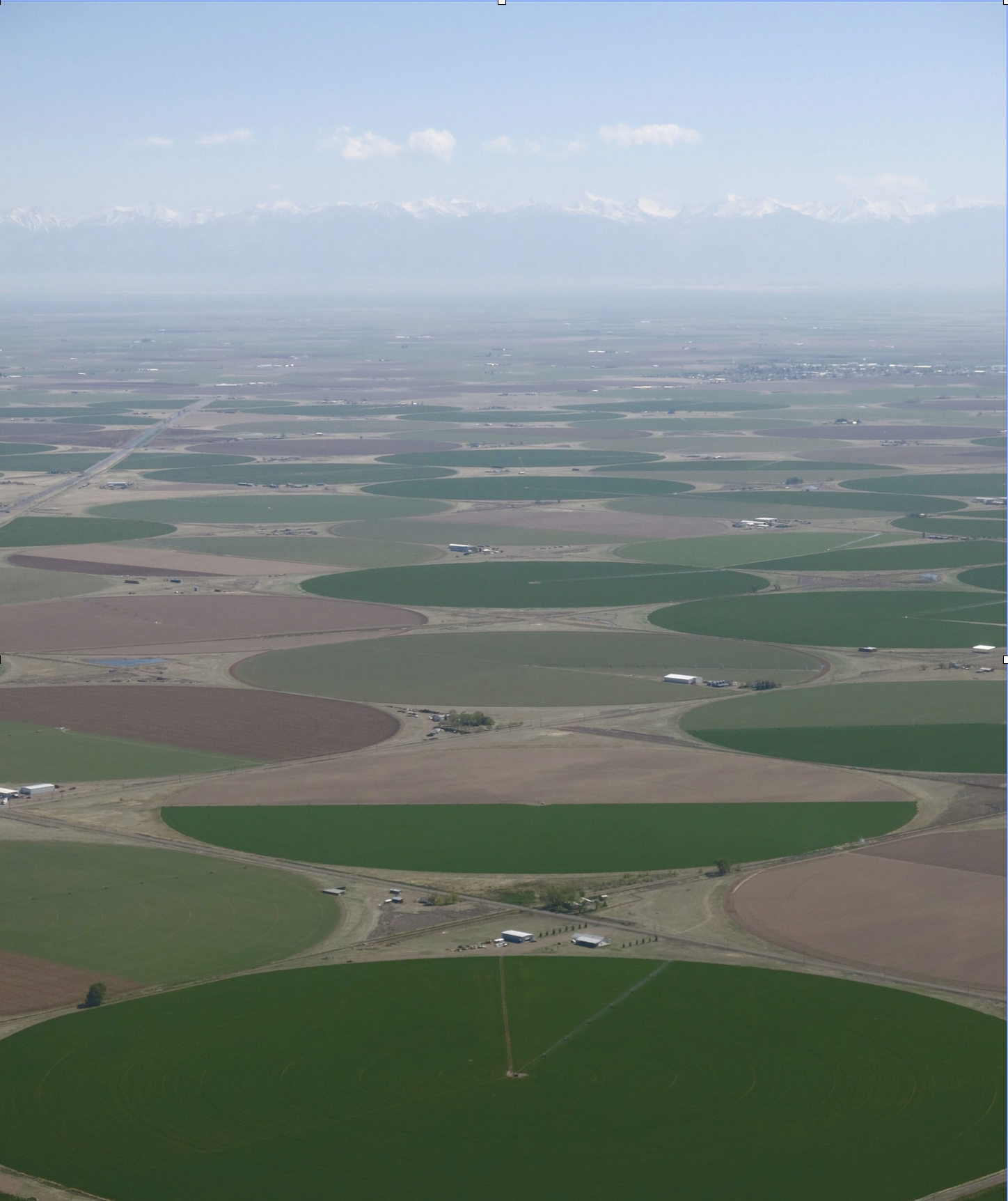
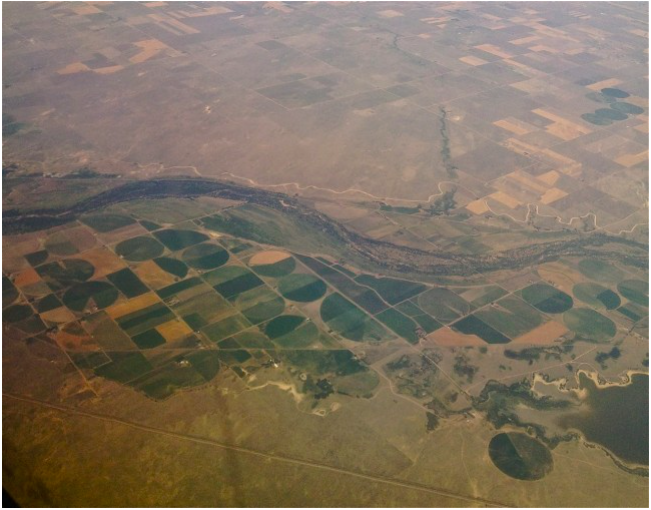
Aerial view of the San Luis Valley’s irrigated agriculture. Photo by Rio de la Vista.
From email from the Colorado Department of Water Resources:
[Please find below] two documents relating to the investigation of demand management feasibility – both at the Upper Basin level and within Colorado. First, a statement from Director Mitchell on the path forward on demand management feasibility investigations within Colorado. Also, information regarding an upcoming workshop hosted by the Upper Colorado River Commission on the topic of demand management feasibility.
For more information on these topics email demandmanagement@state.co.us.
Demand Management Investigation: The Path Forward
Colorado water users, stakeholders, and interested parties:
Now that the Colorado River Basin Drought Contingency Plan (DCP) is finalized, the Colorado Water Conservation Board (CWCB) is beginning its efforts to investigate the feasibility of a potential demand management program within Colorado.
The strong connection between Coloradans and our water has established a foundation of public input, deliberation, and participation in the decision-making process, which leads to informed and thorough policymaking. This is the model that informed the Colorado Water Plan, and it is this model that the CWCB will utilize to assess demand management: by Colorado, for Colorado.
At the March 2019 meeting, the Board of Directors of the CWCB approved the 2019 Work Plan for Intrastate Demand Management Feasibility Investigations. Below are highlights of the current and upcoming steps that the CWCB staff will be taking to implement the 2019 Work Plan, including opportunities for engagement, processes to inform the Board, and informational events. These elements are designed to ensure that the CWCB and all interested water users and stakeholders are fully informed of demand management concepts and challenges as they are identified. Through this process, the multitude of considerations demand management presents will be fully understood, to promote an informed and fully realized public policy discourse.
General Outreach: Staff will continue to work directly with interested water users and stakeholders to inform them of the process for investigating demand management feasibility within Colorado, and to solicit input on specific elements of potential implementation and solution identification. The direct interaction between staff and the various basin roundtables, policy boards, water users, and stakeholder groups is where the conversations begin. This will then lead to identification of considerations and development of potential solutions, which will be used to inform an evaluation of demand management.
Workgroups: Staff has begun to reach out to subject matter experts on various elements that must be considered for any potential demand management program within Colorado. The purpose of these workgroups is to help CWCB staff identify and frame the complex issues associated with demand management feasibility for public and Board consideration. In this capacity, workgroup members operate like “think tanks” to help CWCB staff prepare to conduct meaningful public discussion of the issues associated with demand management based on useful insight and understanding from experts in the field. Workgroup members have been selected for their subject matter expertise and willingness to work in assisting the State as it implements the public process to evaluate a potential demand management program.
To respect the integrity of the workgroups, members are being asked to participate in a non-disclosure setting. This will allow the participants to brainstorm all sides of an issue, and to have open and frank discussions as they assist CWCB staff in framing demand management considerations for public discussion and evaluation. The decision-making process for consideration of demand management solutions and approaches for potential implementation will be achieved in public meetings and through the comment and input process established in the formulation of the Colorado Water Plan. The workgroups serve as the “think tank” for staff as they begin to develop an understanding of the full complement of considerations, issues, and challenges that demand management presents.
Transparency of Process – Demand management investigations and decision-making by the CWCB will be done through an open dialogue. Once the range and multitude of complex topics associated with demand management are identified and framed, they will be introduced in a process akin to the development of the Water Plan, including workshops, basin roundtable presentations, consideration of public comment, and the like. Additionally, the CWCB will be updated regularly in open session on the progress of the demand management investigation process, and provided with any staff recommendations as appropriate.
Upcoming Demand Management Investigation Events –
CWCB will be hosting an Orientation Webinar for members of the workgroups in July. This Orientation Webinar will be open to the public. The Webinar will provide an overview of the evolution of DCP and demand management, discuss the statewide perspective for analysis of demand management, and outline the timeline and process for the workgroups’ assistance in demand management issue identification. Information about the Webinar will be forthcoming as details are finalized.
The Upper Colorado River Commission will be hosting a Demand Management Stakeholder Workshop in Salt Lake City, Utah on Friday, June 21. The goal of this regional workshop is to provide a baseline understanding of the Colorado River DCP and discuss proposed next steps to examine the feasibility demand management in the Upper Basin. Additionally, Upper Basin State representatives will receive comment and input from interested water users and stakeholders on possible considerations in evaluating the feasibility of a successful demand management program throughout the Upper Basin. When the agenda is finalized, more information regarding the Workshop and registration will be posted on the CWCB website and circulated to interested parties.
CWCB staff will be scheduling public demand management workshops around the state, as outlined in the 2019 Work Plan. These workshops will be in addition to the usual array of roundtables, Interbasin Compact Committee, informational forums, and other water meetings in which staff participate to discuss and receive feedback on demand management. Staff hopes to schedule the first intrastate workshop in alignment with the summer conference of Colorado Water Congress.
The investigation of the feasibility of a potential Demand management program presents a challenge for the CWCB, water users, and stakeholders across Colorado. The Board and staff take this assessment very seriously, and are committed to providing an opportunity for everyone with an interest in Colorado River system sustainability to make their voices heard, while remaining true to the water values identified in the Colorado Water Plan. For more information, to provide comments, or to learn more about the 2019 Work Plan and demand management feasibility process, email demandmanagement@state.co.us or contact CWCB staff.
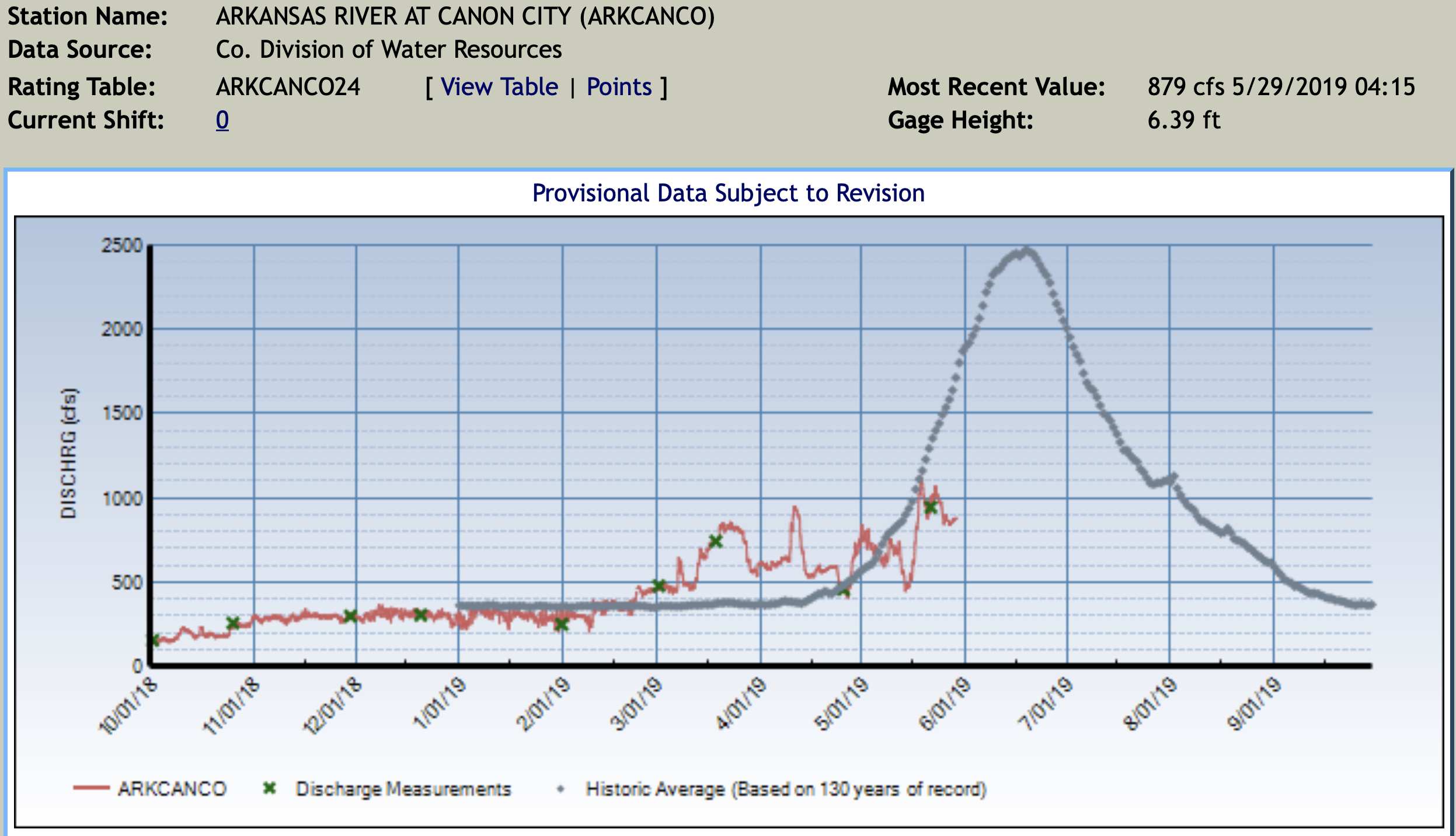
This year the run-off in Colorado is late. “The native water hasn’t started to flow yet,” said Roy Vaughan with the Bureau of Reclamation. Vaughn is part of the team that helps manage what stored and released from Lake Pueblo Reservoir.
Water released from the dam is currently much less than typical. “We’re releasing about 15 percent of what we normally do this time of year.” The number is a correlation with the amount of run-off flowing into the reservoir. Run-off is late this year. “We see it start and then the weather changes, it cools down and it slows up again. It’s about three weeks late.” For now, spillways are mostly dry.
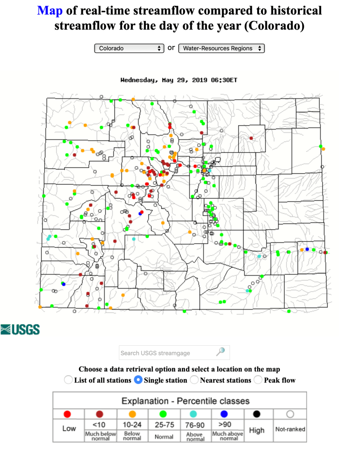
Click on the graphic for the USGS Water Watch interactive map for Colorado.
Click here to read the update (Tracy Kosloff/Taryn Finnessey):
As a result of consistent fall and winter precipitation, near record breaking snowpack, and near normal reservoir storage levels, the Drought Task Force has made a recommendation to Governor Polis to deactivate the Colorado Drought Mitigation and Response Plan statewide.
While April ended with slightly below average precipitation across the state, May has started off cool and wet and, following a brief warmup, is forecast to end in a similar fashion. May through August is an important period for precipitation accumulation east of the continental divide as much of the annual precipitation falls during this time. Water year to date precipitation remains above average statewide, with some areas still seeing spring snow accumulation. Stream flows have increased reflecting the start of runoff season and reservoir levels are responding.
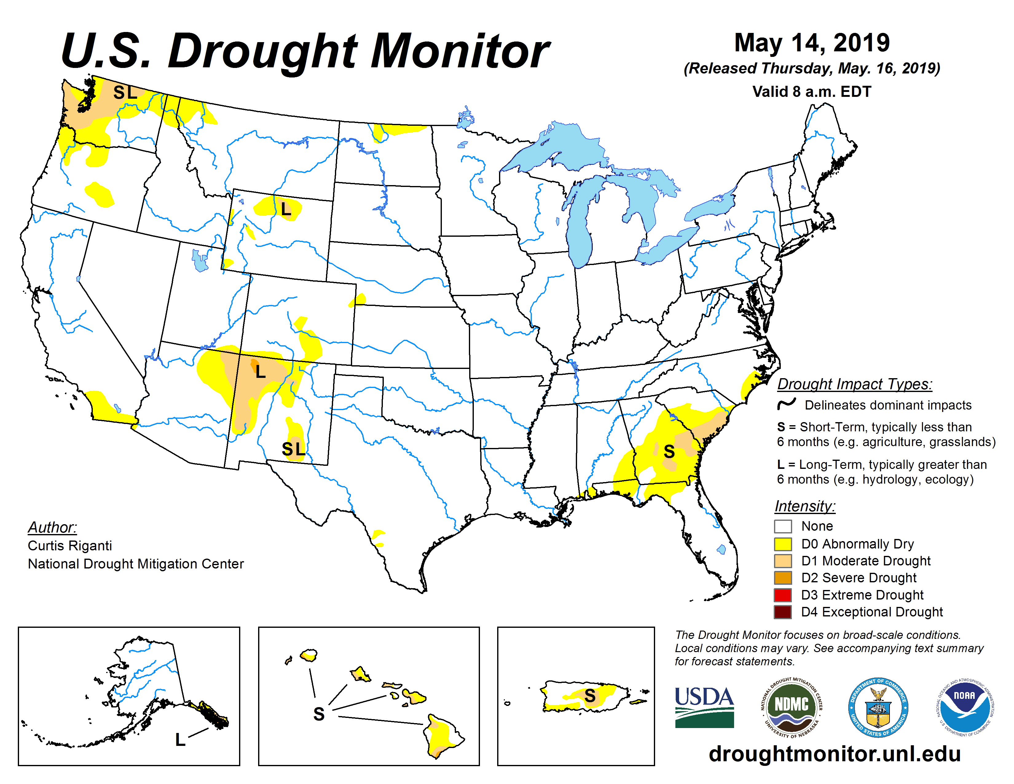
US Drought Monitor May 16, 2019.
As of May14th, only 11 percent of the State is classified as abnormally dry. This spring has seen the record lowest amount of drought coverage over the contenital United States, according to the US Drought Monitor, which has been tracking conditions since 2000.
El Niño conditions remain, and are likely to continue through summer (70 percent chance) of this year. Historically summer during an El Niño are more likely to be wet than dry, and the NOAA Climate Prediction Center outlooks for the June-July-August period show increased chances of wetter-than-average conditions.
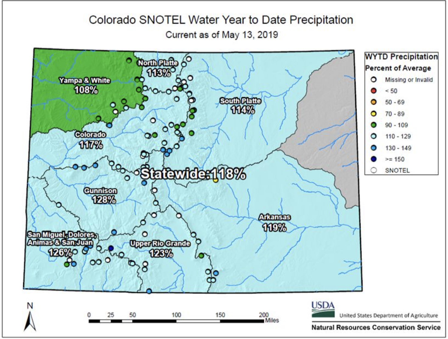
Current SNOTEL Water Year to-date precipitation in 118 percent of average, with all basins above average.
SNOTEL snow water equivalent statewide is 155 percent of median with all basins above normal. These figures can fluctuate greatly during the spring season when snowmelt has begun, but storms can still result in accumulation.
Statewide reservoir storage as of May 1, is 90 percent of average and increasing as the runoff season begins with widespread above average streamflow forecasts. Blue Mesa Reservoir, heavily impacted by the 2018 drought, has increased more than 26 feet in elevation since April 1 and has seen an increase of more than 55,000 acre-feet since May 1.
Flooding in post wildfire burn scars remains a concern and is being monitored closely. The daily flood threat bulletin can be accessed May 1 through September 30 HERE.
Here’s the notice from the the Colorado Division of Water Resources (Scott Hummer):
South Routt County Water Users Meeting
Bear River at CR7 near Yampa / 3:30 PM, May 16, 2019 / Flow Rate = 0.52 CFS. Photo credit: Scott Hummer
Wednesday, May 29, 2019
Soroco High School / Oak Creek, CO
6:30 PM – 8:00 PM
Representatives from the Colorado Division of Water Resources (DWR), Upper Yampa Water Conservancy District (UYWCD), United States Forest Service (USFS), and Natural Resources Conservation Service (NRCS)
The agenda will address the agencies specific roles regarding:
Authority and Responsibilities associated with Administration, Management, and Oversight of water matters in the Morrison Creek, Oak Creek, and all Tributary drainages above Stagecoach Reservoir
All waters users are encouraged to Attend
Special recognition to the Soroco High School, FFA Chapter for helping organize the event!
CSU junior Brad Simms gets to work with his shovel in efforts to restore the area around Left Hand Canyon from the floods. Brad is a member of CSU’s Watershed club. (Jenna Van Lone | Collegian)
The St. Vrain Left Hand Conservancy District, whose mission is to protect water rights and improve management practices in the river basin, is in the first phase of developing a stream management plan for the 300,000-acre watershed. Its goal is to align strategies for maintaining the reliable delivery of water to agricultural users while also satisfying ecological and recreational goals, some of which could require higher flows in the main stretches of streams that feed the St. Vrain, such as Left Hand Creek, as well as the St. Vrain itself, which is a key South Platte River tributary.
“Whether you’re a domestic or agricultural water user, you have an opportunity to really be part of a strategic, balanced approach to meeting competing demands,” said Sean Cronin, the district’s executive director.
But Colorado water law is focused on the use of the state’s most valuable resource, and not on conservation, notes a September survey prepared by a firm hired by the conservancy district for the stream management plan.
“This causes water owners to shy away from change of use, dam modifications or other river improvements, fearing legal or financial challenges and a burden on their time — and farmers do not have time to give away,” the survey states, adding it also will be a challenge to have rights owners “‘open up’ about their decrees or the way they manage, use or store water, and there are sometimes long histories of relationships between agencies or people in how they work together with their water. Overcoming some of these social and political legacies, or positively using these relationships, will be a challenge to the process.”
Seeking balance at what cost?
Diverting water from stream beds through ditch delivery networks has long quenched otherwise dry agricultural lands on the Front Range, but the expansion of the practice over time has led to impacts some are now interested in mitigating.
Boosting the ability for fish and recreational users such as kayakers to pass diversions by altering or replacing infrastructural barriers has consistently been expressed as a priority.
So have improved ability to control timing and quantity of both ditch and stream bed flows, enhancing flood resiliency in the watershed and preventing impacts from municipal development.
“For the most part, this basin wants to work toward finding that balance,” Cronin said. “I won’t say we’re all in agreement of what the balance is, where that pivotal point is to make the balance, and I don’t think we’ll ever get there and that’s fine, as long as folks want to continue sitting at the table.”
While some Longmont-area ditch companies have already designed and implemented more passable diversions or are in talks with local officials about doing so in the near future, a move toward automating the opening and closing of ditch gates that are now moved manually to accommodate water share holders’ calls for supply also could emerge as a consideration for those relying on the watershed.
Being able to remotely open and close gates could help prevent flow heading into ditches when it isn’t needed, possibly allowing higher flows in main stream beds through areas where such water levels could benefit recreation and environmental health.
But doing so could come at a major cost. Terry Plummer, vice president of maintenance and operations for Left Hand Ditch Co., said the company, for reasons unrelated to stream management, next week will install an automated ditch gate that can be operated remotely in one location on its network at a cost of about $30,000.
If an effort to automate water delivery equipment were applied across the broader watershed, though, it would be needed in dozens of locations, and could require the construction of entirely new diversion structures in some areas, which can run cost hundreds of thousands for just one spot, Plummer said.
“We have no intentions of automating at this point in time,” Plummer said. “It’s just too expensive. The assessments (charged to share holders for ditch maintenance) are so high now because of the 2013 flood (damage) that we would have to raise assessments dramatically, and the farming can’t support that.”
He said grant funding would have to become available, with the right terms, to pursue widespread automation.
A method that helped maintain higher wintertime flows in the St. Vrain is likely no longer an option — for about 20 years until 2013, Longmont released water from its Ralph Price Reservoir storage at a rate of 3 cubic feet per second to maintain a winter flow of 5 cfs along the entirety of the river, according to city Water Resources Manager Ken Huson.
But state officials nixed that practice after changing how they account for water.
“It’s not something Longmont can just do on its own anymore like we used to,” Huson said.
Flow not only way to go
Other opportunities for bettering stream management in the St. Vrain watershed might not address flow, however, and still offer environmental and social benefits.
“What we’re going to come up with are management activities,” Cronin said. “Those could address flow, but it could be that an opportunity area doesn’t necessarily have a flow challenge, but a riparian floodplain connectivity challenge.”
Allowing streams to more easily access the floodplain by preventing their banks from becoming overly incised or congested can help avoid rushing waters during flood events via letting the excess flow spread out over flatland, instead of accumulating in steep, deep channels.
Removing the invasive crack willow tree, which has problematically proliferated across dozens of states, from local stream banks could help achieve that, and has already been worked on in some areas of the St. Vrain basin by the Left Hand Watershed Oversight Group.
“That’s really the issue with the current conditions and why there are disconnected floodplains, because we’ve had this encroachment of this invasive tree that has created a super stable bank, and has allowed incision to happen,” said Jessie Olson, the oversight group’s executive director. “We’ve got a number of places like that throughout the watershed that could use some additional connectivity basically by removing the invasive tree and laying back slopes.”
Persistent moisture and near normal temperatures throughout March resulted in significant drought improvements across the region. While April has seen warmer temperatures and decreased precipitation, water year to date precipitation remains above average statewide. This is helping to reduce the threat of large wildfires. We will continue to monitor throughout the snow melt season to determine inflows to reservoirs, streamflow levels. Post wildfire flooding remains a concern and will be closely monitored. The daily flood threat bulletin can be accessed May 1 through September 30 HERE.
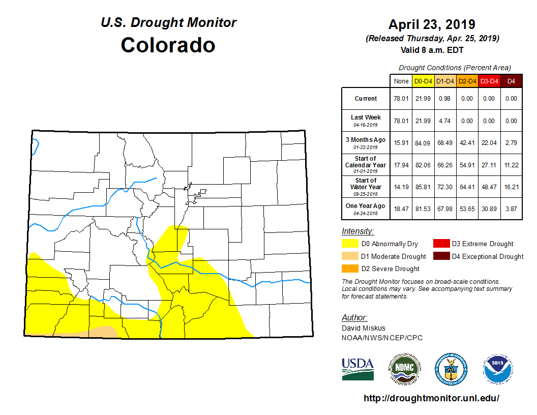
Colorado Drought Monitor April 23, 2019.
As of April 23, a mere one percent of the state remains in moderate drought and an additional 22 percent is abnormally dry. This represents a 71 percent reduction in D1-D4 conditions since the start of the water year.
El Niño conditions are now present, and a weak event is likely to continue through summer (65 percent chance) and possibly fall (50-55 percent chance) of this year. Historically spring & summer during an El Niño are more likely to be wet than dry, and the NOAA Climate Prediction Center outlooks for May, and for the May-June-July period show increased chances of wetter-than-average conditions.
SNOTEL snow water equivalent statewide is 120 percent of median with all basins near or above normal. The highest snowpack is in the Southwest basins of the San Miguel, Dolores, Animas & San Juan at 157 percent of median, while the lowest is the Yampa-White at 100 percent of median.
Statewide reservoir storage as of April 1, is 84 percent of normal but is expected to increase as the runoff season begins. The South Platte, Arkansas, Colorado, and Yampa-White, are all above 90 percent of average, while the Upper Rio Grande basin has 79 percent of normal storage. The Southwest basins of the San Miguel, Dolores, Animas & San Juan, and Gunnison remain the lowest in the state at 58 and 67 percent of normal, respectively.
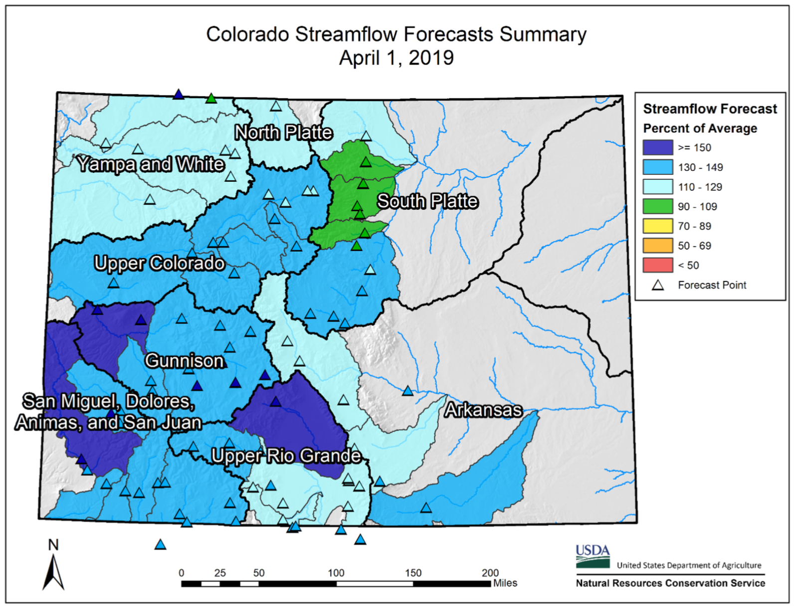
Streamflow forecasts are near to above normal statewide. Snowpack in the southwestern corner of the state is driving streamflow forecasts greater than 150 percent of average in the Dolores, Surface Creek and Saguache-San Luis Basins. Above average streamflows can help to replenish reservoir storage in these regions of the state.
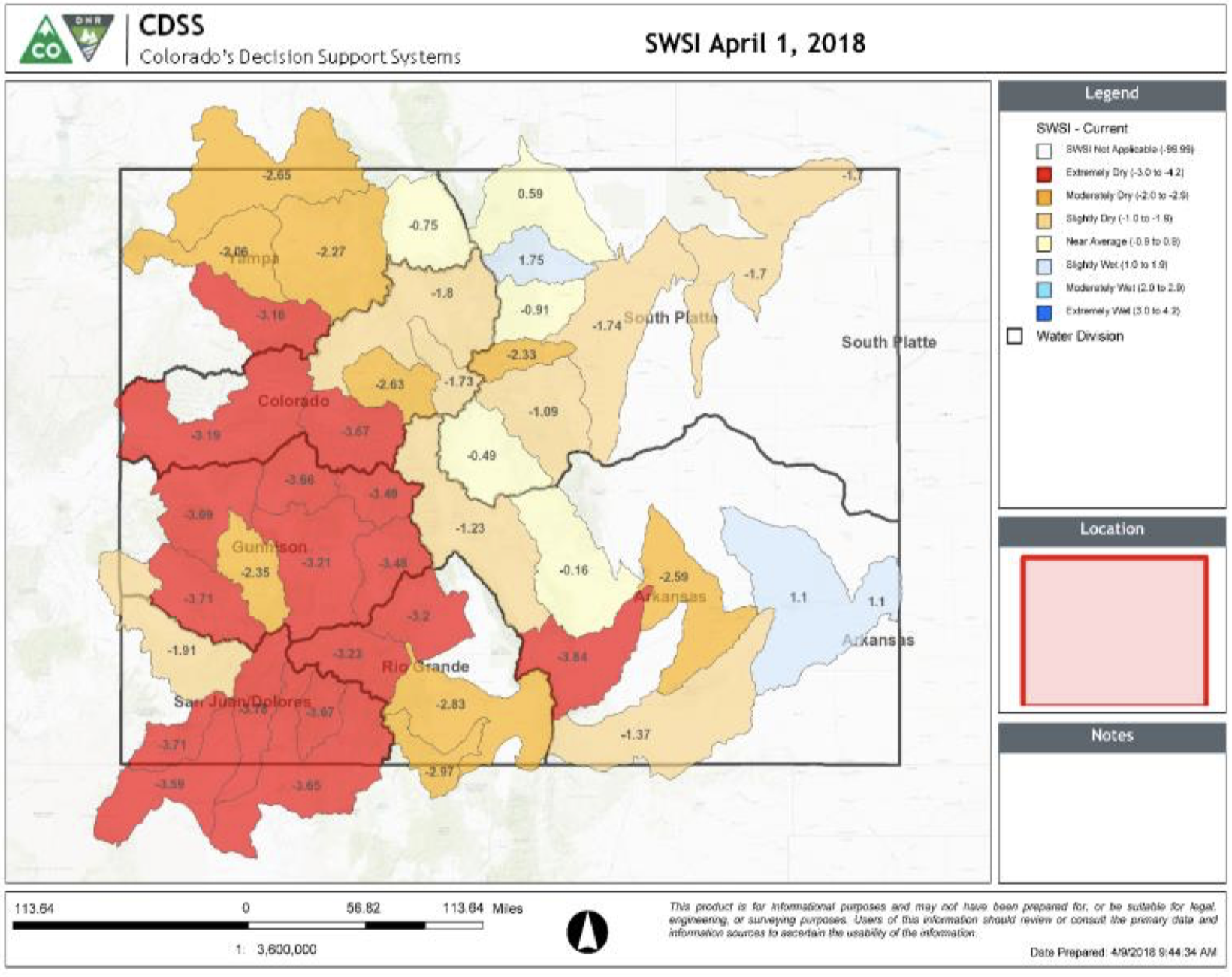
The surface water supply index (SWSI) has improved in recent months with the majority of the state trending to the wetter conditions, this is in part due to strong streamflow forecasts.
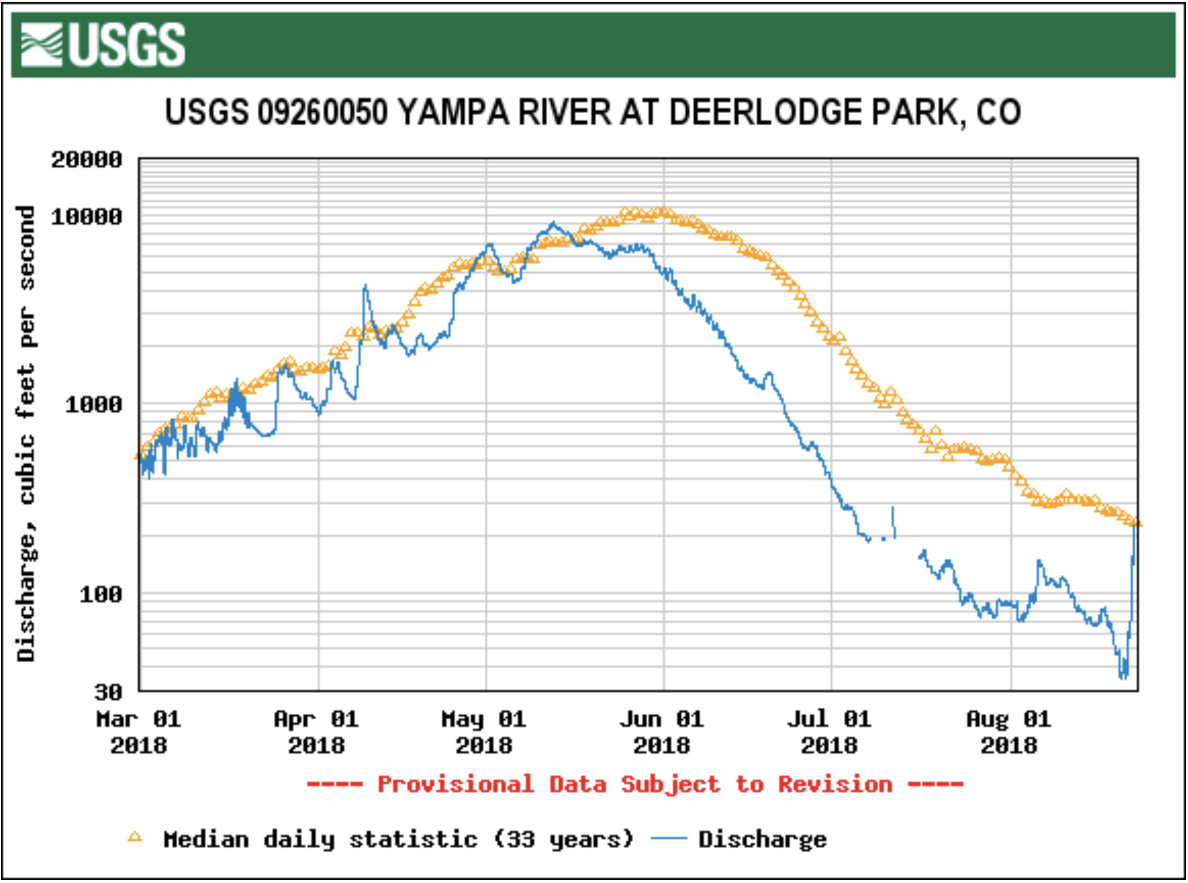
The Yampa River had almost no flows at Deerlodge Park, at the entrance to Dinosaur National Park, when this photo was taken in mid-August, 2018. Photo/Erin Light via The Mountain Town News
When the Yampa River went on call for the first time last year, 65% of water users on the river had to cut back or stop using their water because they didn’t have a measuring device or headgate on their diversion.
In light of that, Colorado Division of Water Resources Division 6 Engineer Erin Light sent water users on the Yampa a notice earlier this year, requiring that they install these devices.
Water users must install headgates
“We know we had a problem with measuring devices … but because of this call and this recognition of a problem of having so many structures without measuring devices, I made the decision to send out notices for the installation of headgates and measuring devices,” Light told the audience at the annual State of the River presentation in Steamboat Springs earlier this month.
Light is asking users to install devices by July 31 or ask for more time. If someone does not comply with the notice or receive an extension, they’ll receive an order to install these devices. Not complying with the order can result in a locked headgate, which means a user can’t use any of their water, or a $500 fine per day for every day a user continues to divert water without a headgate.
These structures are required by law, but the Yampa River is still the Wild West when it comes to water use. The Yampa was among the last, if not the last, large rivers in the state to go on call. The area also is among the last in the state to have so many diversions without headgates.
When the river went on call, even water users who had senior water rights and were using less water than they were legally entitled to were not allowed to use their water because their ditches didn’t have measuring devices that count how much water is used.
That’s means about 65% of the devices Light and her staff track in the Yampa River basin — about 850 — were shut off.
A similar notice and order was issued after the Elk River was placed on call in 2010.
Measuring for the future
These devices are important, Light said, because, in the state’s eyes, the value of a water right is based on the record of how much water that crops, livestock and people consume.
Without a way to measure the water, this record is an estimate, with water commissioners — the people charged with monitoring water rights on the ground — taking an educated guess at how much water is flowing based on how quickly a dandelion head floats downstream.
And how the state values a water right is becoming increasingly important as water managers start to plan for the possibility of an interstate call under the Colorado River Compact, which would require Colorado to cut back use as a state in order to send water downstream. Water managers are already working to balance increased demand for water with less available water…
The Upper Yampa Water Conservation District, which includes much of Routt County, offers mini-grants for up to half of the project cost or $500 to assist water users with the cost of installing water control and measuring devices. Each device can earn a grant, so if a producer is installing a headgate and measuring device, they can receive up to $1,000, Upper Yampa General Manager Kevin McBride said.
From the Colorado Water Conservation Board/Colorado Division of Water Resources (Ben Wade):
In response to persistent and prolonged drought conditions throughout the southern half of the state and along the western border, the Colorado Drought Mitigation and Response Plan was activated for the agricultural sector on May 2, 2018, additional counties in northwest Colorado were added in September and activation remains in effect; information can be found HERE.
February and March-to-date have both seen impressive snow accumulation statewide, but especially in the southern half of the state where snowpack is currently above 150 percent of normal for all basins. This persistent moisture and near normal temperatures has resulted in significant drought improvements across the region. We will continue to monitor throughout the snow melt season to determine inflows to reservoirs and streamflow levels. Post wildfire flooding remains a concern and will be closely monitored. The daily flood threat bulletin can be accessed May 1 through September 30 HERE.
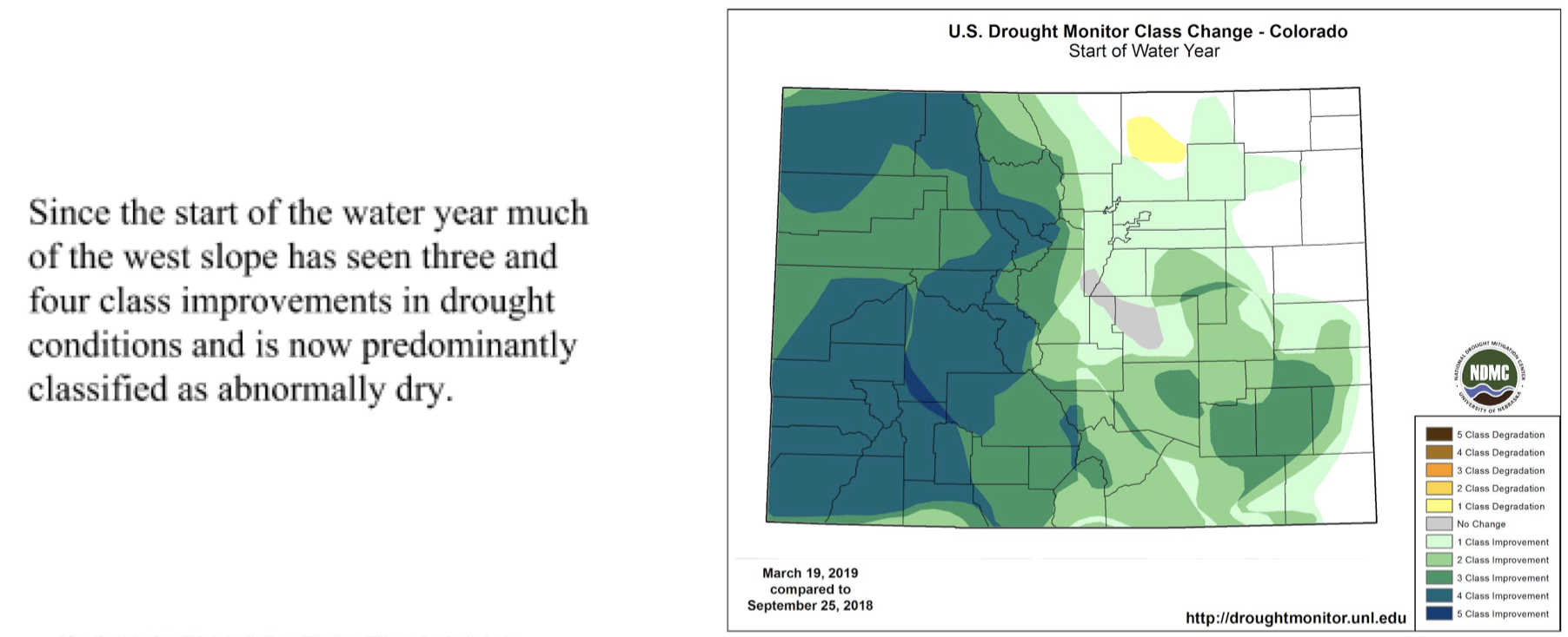
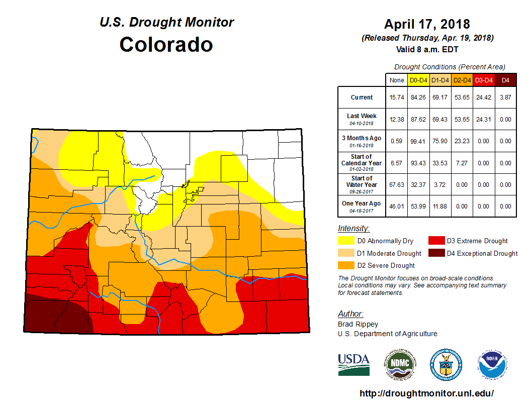
As of March 19th, exceptional drought (D4) and extreme drought (D3) have been entirely removed from Colorado. Severe drought covers just 0.63 percent of the state while moderate drought covers an additional six percent. Forty percent of the state is currently experiencing abnormally dry conditions, a significant improvement in recent weeks. Most of the western slope has seen three and even four class improvements in drought conditions since the start of the water year (see image below).
El Niño conditions are now present, and will likely continue through spring (80 percent chance) and even summer (60 percent chance) of this year. Historically spring during an El Niño event trends toward wetter conditions, and the NOAA Climate Prediction Center outlooks for April, and for the April-May-June period show increased chances of wetter-than-average conditions, with less confidence in the temperature outlook.
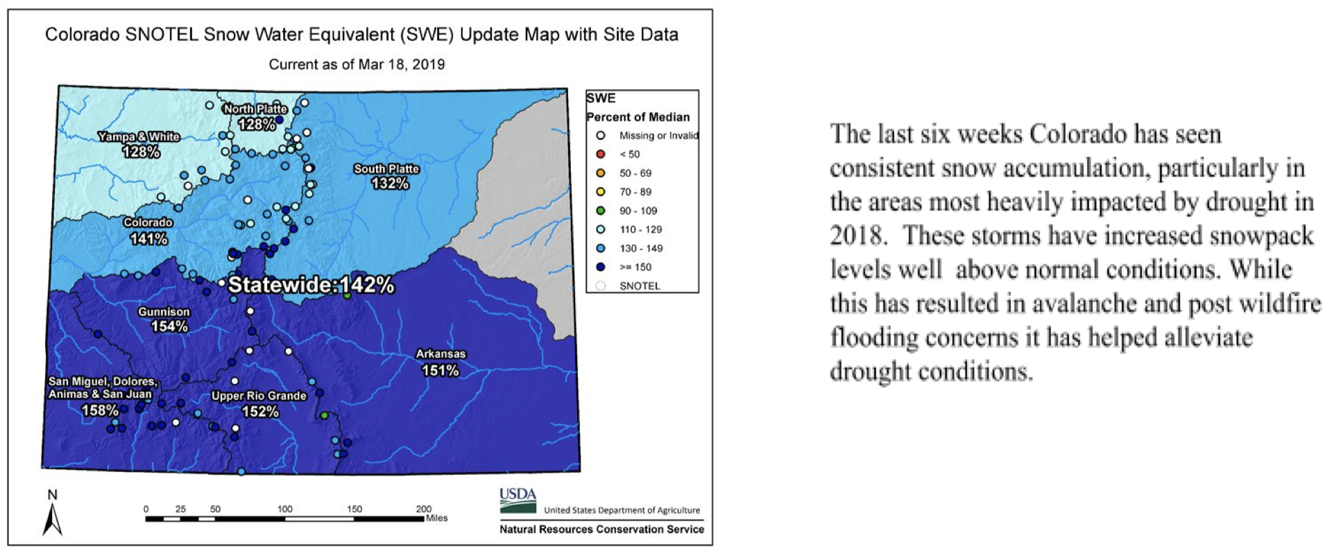
SNOTEL snow water equivalent statewide is 142 percent of average with all basins well above average. The highest snowpack is in the Southwest basins of the San Miguel, Dolores, Animas & San Juan at 158 percent of median, while the lowest is tied with both the Yampa-White and the North Platte at 128 percent of median (see image below).
Many basins, as well as the state as a whole are near maximum observed snowpack for this time of year and short term forecasts indicate that an active storm pattern is likely to remain.
Reservoir storage, statewide remains at 83 percent of normal but is expected to increase as soon as the runoff season begins. The South Platte, Colorado, and Yampa-White, all above 90 percent of average as of March 1st. Storage in the Arkansas and Upper Rio Grande basins are at 87 and 78 percent of normal, respectively. The Southwest basins of the San Miguel, Dolores, Animas & San Juan, and Gunnison remain the lowest in the state at 58 and 63 percent of normal, respectively.
Streamflow forecasts are near to above normal statewide and have been steadily increasing in recent weeks. As a result the Colorado Basin River Forecast Center has adjusted their April-July unregulated inflow forecasts as follows: Blue Mesa Reservoir 960 KAF (142% of average) a 32 percent of average increase, McPhee Reservoir 480 KAF (163% of average) a 51 percent of average increase. The Lake Powell inflow forecast is 9.50 MAF (133% of average) an increase of 2.2 million acre-feet or 31% of average.
The Drought Visualization Tool is now live; please take a minute to provide feedback on this tool HERE.
Description of Job
Although the Division of Water Resources Office is located in Alamosa, the position’s primary duties are performed within 30 miles of the border of Colorado.
This position assists the Division of Water Resources (DWR) State Engineer in carrying out the statutory duties required of the DWR and any written instruction of the State Engineer within the geographic area of State Division Three; serve as Division Engineer as designated; assure integrity of the Prior Appropriations Doctrine while maximizing beneficial use of water; coordinate the regulation of water within the Division; consult with the Water Court; resolve disputes that exceed the abilities of Water Commissioners; supervise field and office personnel; assist the public through the Water Court process and well permit application process and in the understanding of water law, hydrology and water supply, and other water-related issues; prepare expert witness reports; consult with the Water Court regarding Water Court applications; respond to water user complaints and write reports summarizing the agency’s position; and negotiate or provide expert engineering support / testimony to litigate any conditions necessary to protect existing water rights. Other duties as assigned.
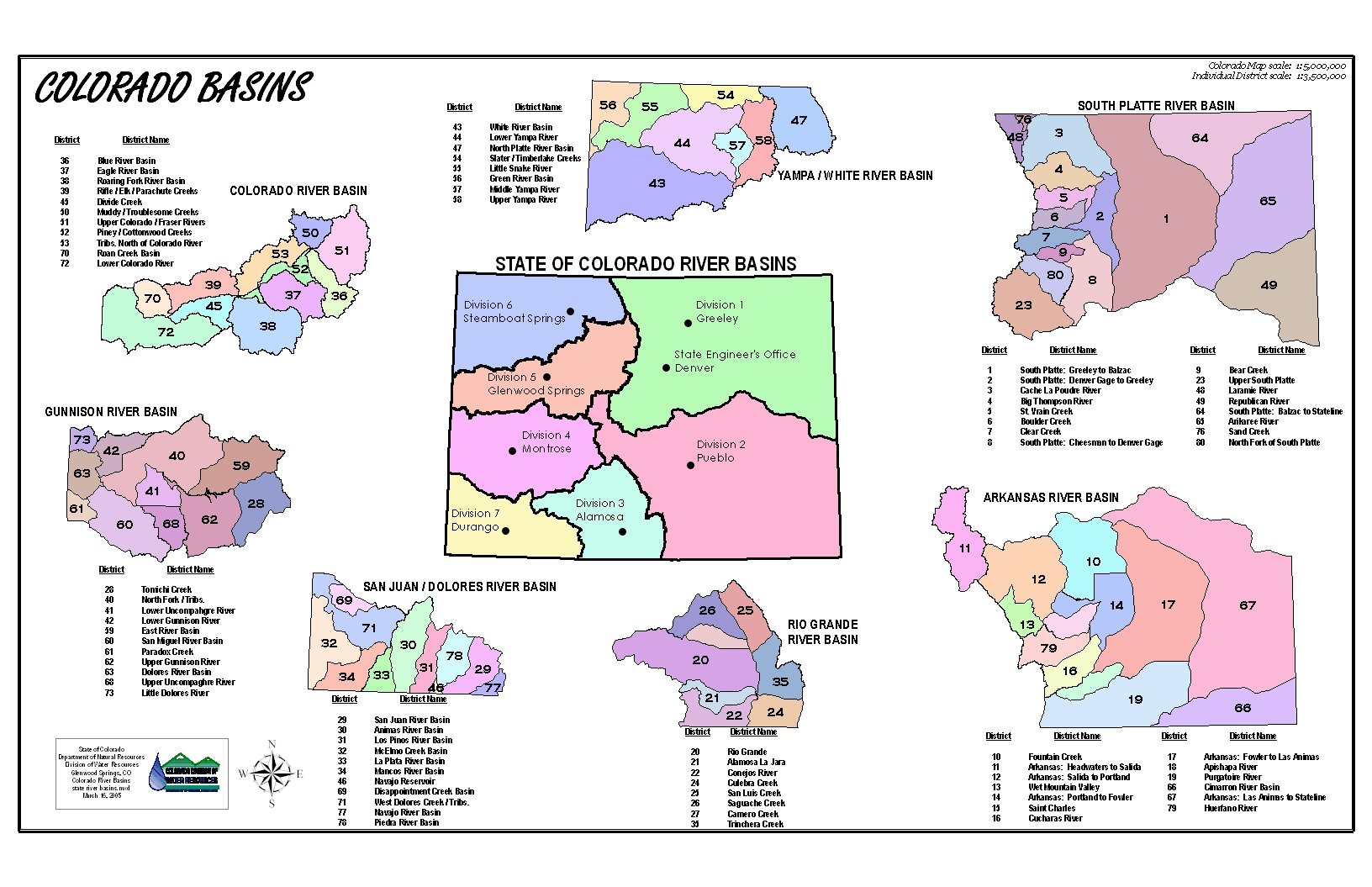
Rio Grande River Basin via the Colorado Geologic Survey
Map of the Rio Grande watershed. Graphic credit: WikiMedia
San Luis Valley. In this perspective, S is on top. Costilla County is along the edge of the southeastern side of the Valley between the Sangre de Cristo sub-range known as the Culebra Mountains (on the E) and the Rio Grande (on the W); upper left quadrant within SLV on this map. Source: http://geogdata.scsun.edu.
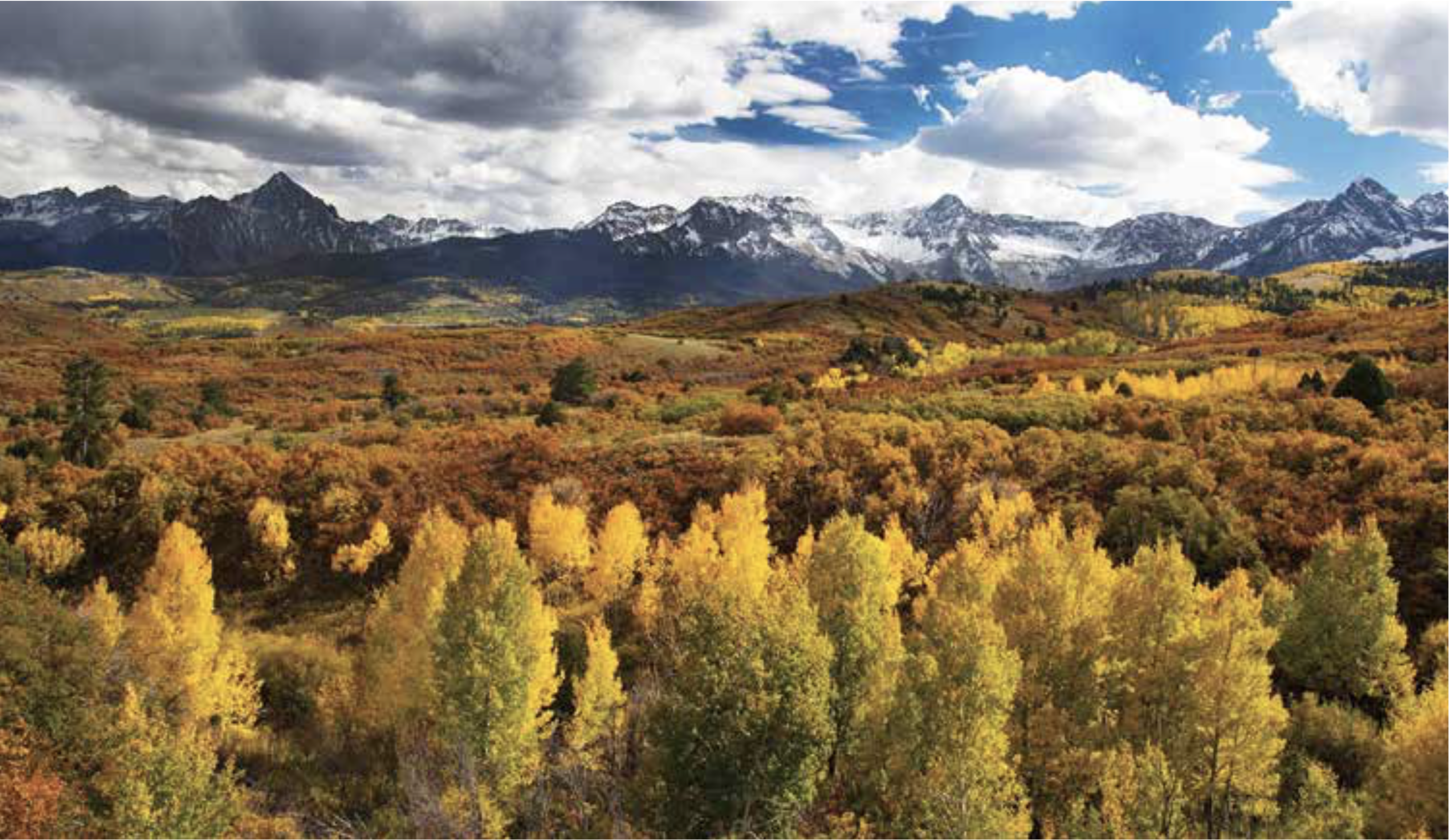
Aspen trees in autumn. Photo: Bob West via the Colorado State Forest Service.
From email from the Colorado Department of Natural Resources:
Governor Polis has announced three new board appointments to the Colorado Water Conservation Board.
· Gail Schwartz of Basalt, Colorado, representing the Colorado River basin
· Jackie Brown of Oak Creek, Colorado, representing the Yampa-White River basin
· Jessica Brody of Denver, Colorado, representing the City and County of Denver
In addition, the Governor appointed Russ George as the Director of the Inter-Basin Compact Committee in addition to five gubernatorial appointees.
“I’m excited to work with these appointments,” said Dan Gibbs, Executive Director of the Department of Natural Resources. “Their collective experience is unmatched.”
Gail Schwartz has spent over two decades serving Colorado in both appointed and elected office. Jackie Brown brings a diverse background in natural resources and is a leader in the water community as the current Chair of the Yampa-White-Green basin roundtable. Finally, as General Counsel for Denver Water and formerly with the Denver City Attorney’s Office, Jessica Brody brings both municipal and environmental law experience.
“I’m looking forward to working with the newly appointed board and IBCC members to continue implementing Colorado’s Water Plan. They bring valued expertise and leadership to the water community,” said Rebecca Mitchell, Director of the CWCB. “We sincerely thank the outgoing Board members and IBCC appointments for their service. Their dedication has been instrumental on numerous policy and planning efforts, including bringing a diversity of perspectives to Colorado’s Water Plan.”
Russ George is a fourth generation native of the Rifle, Colorado area and brings a depth of state government and public service. Russ was instrumental in creating the IBCC and basin roundtables.
“As the first champion of the IBCC and roundtable process, there’s no one better equipped to lead the IBCC. We’re embarking on a future of great opportunity in water, and Russ is the perfect choice to navigate the times ahead,” said Gibbs.
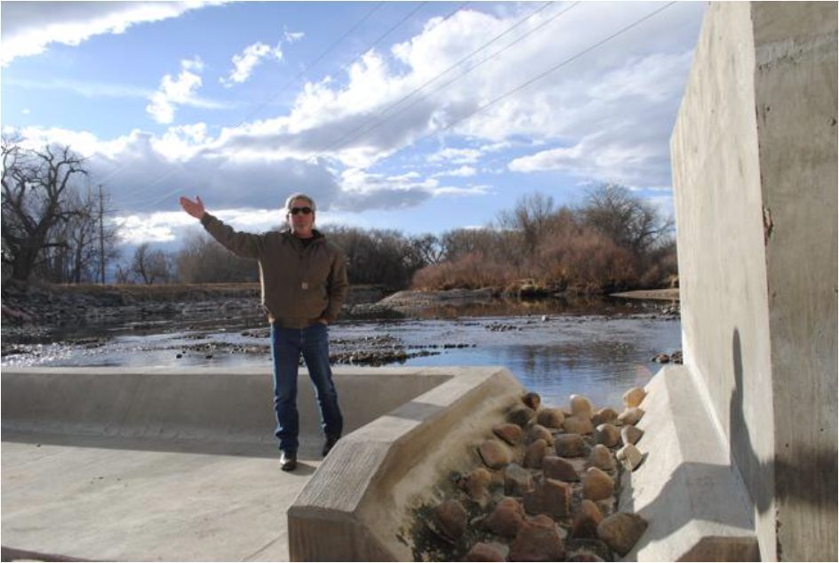
Scott Hummer shows off a fish passage at a North Poudre Irrigation Company diversion structure. His agency worked with Fort Collins Natural Areas and Colorado Parks and Wildlife to include a fish passage when the irrigation company replaced a diversion structure on the Poudre River that was destroyed by the 2013 floods. Work was completed [in February 2016]. (Pamela Johnson / Loveland Reporter-Herald)
Scott Hummer was kind enough to forward the materials below in celebration of the 140th anniversary of the creation of Colorado’s water commissioners:
John,
This past Tuesday, February 19, 2019 marked the 140th anniversary of the creation of the position of Water Commissioner by the State Legislature/General Assembly on February 19, 1879…
The concept of Colorado’s system of Prior Appropriation, “the Colorado Doctrine”, was first established in the “gold camps” of the late 1850’s. The concept was first put into practice in the “gold camps” of California and came to Colorado with the “miner’s courts” established by the original “prospectors” in the territory.
And yes, the Water Commissioner position came before the creation of the State Engineers Office as well as the position of “Superintendent of Irrigation”, today’s Division Engineers.
In brief the original legislation created the position as well as the first ten water districts, and as many know…the legislation was in response to the “water war” along the Poudre River in the mid 1870’s…
In 2004, a “celebration” of the 125th anniversary was organized and Water Commissioner were recognized on the floor of the Colorado House of Representatives at the Capital and received an honorary proclamation from then Gov. Owens…
Also in July of 2004, water commissioners were invited to attend and participate in the annual Water Workshop, at then Western State College in Gunnison.
The title of the ‘o4 Water Workshop was “Technology, Science (including the Dismal Science, and Changing Politics of Water”.
So after 15 years, perhaps, it is appropriate to inform and educate the water users and citizens of Colorado as to the public servants that serve them so well.
“He who expects the letter of the law in relation to irrigation to be executed with the precision of clockwork, and that infallible results will be obtained, has a small conception of the tangled web of difficulties in the way, and a meager knowledge of the uncertainties of the element to be manipulated.” — J.P. Maxwell, State Engineer 1890
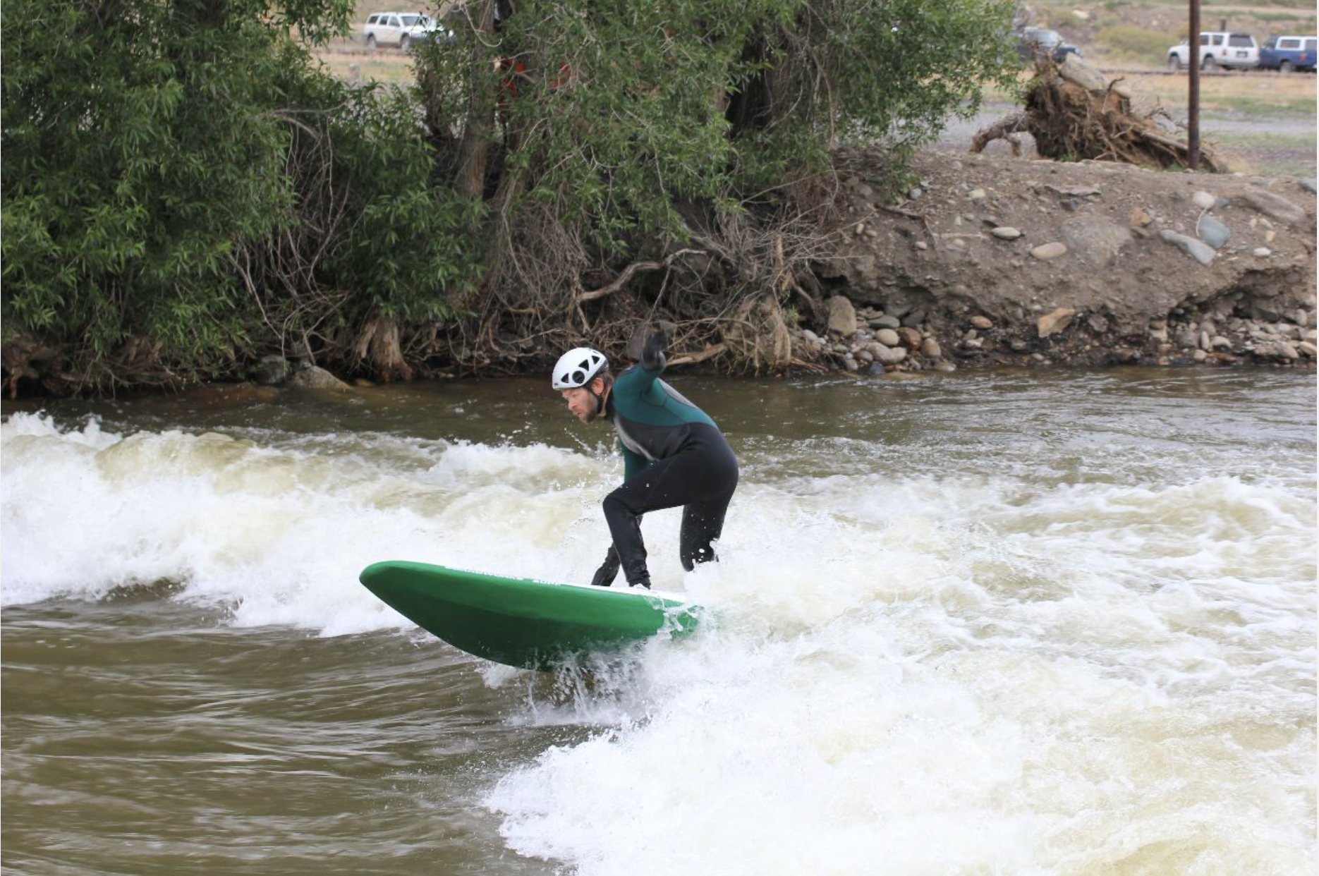
A standup surfer in the Arkansas River at Salida during Fibark, the river celebration held in late June. Photo/Allen Best
Here’s the report from the CWCB and DWR (Taryn Finnessey and Tracy Kosloff):
In response to persistent and prolonged drought conditions throughout the southern half of the state and along the western border, the Colorado Drought Mitigation and Response Plan was activated for the agricultural sector on May 2, 2018, additional counties in northwest Colorado were added in September and activation remains in effect; information can be found HERE.
Calendar year 2019 has brought with it beneficial moisture that has nearly eliminated all exceptional drought conditions in Colorado and increased snowpack to above normal conditions. As a result, streamflow forecasts have increased in some areas and water providers looking ahead to the 2019 demand season are cautiously optimistic given current conditions. However, much of the snow accumulation season remains and reservoir storage and soil moisture will take time to rebound to pre-drought levels.
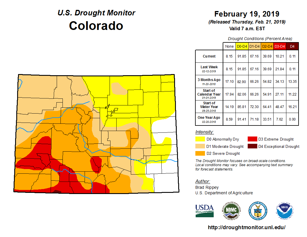
■ As of February 19th, exceptional drought, D4, has been almost entirely removed from the state. Only a small sliver remains in Archuleta county, covering about a tenth of a percent of the state. Extreme drought, D3, has also decreased and now covers 10 percent of the state; severe drought 29 percent and 27 percent is classified as moderate drought. An additional quarter of the state is currently experiencing abnormally dry conditions (see image below).
■ El Niño conditions are now present, and may continue through spring (55 percent chance). This is a weak event and given the timing it is unclear the impact that it will have.
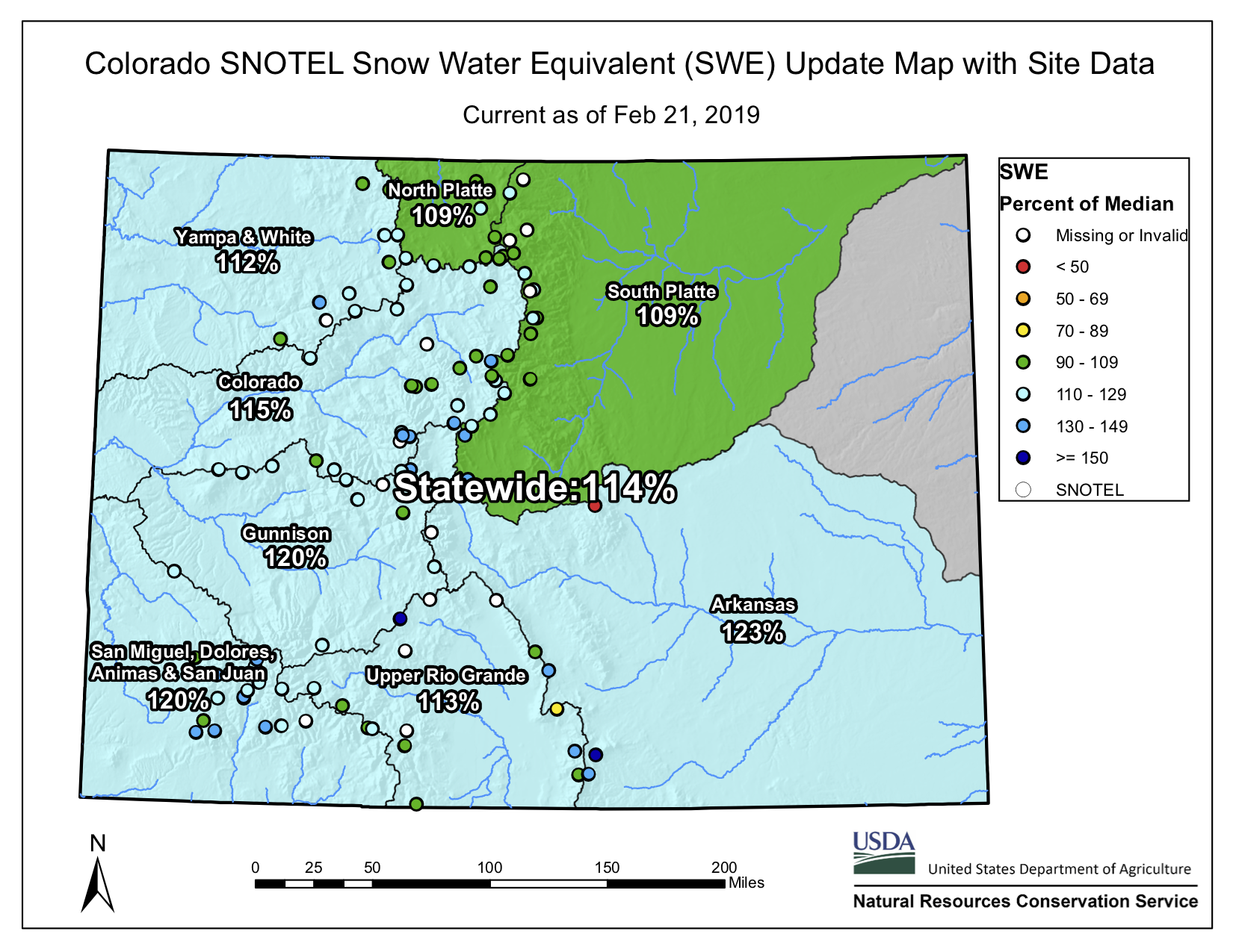
■ SNOTEL snow water equivalent statewide is 115 percent of average with all basins above average. The highest snowpack is in the Arkansas basin at 123 percent of median, while the lowest is the Rio Grande at 111 percent of median (see image below).
■ Reservoir storage, statewide is at 83 percent of normal, with the South Platte, Colorado, and Yampa-White, all above 90 percent of average as of February 1st. Storage in the Arkansas and Upper Rio Grande basins are at 89 and 79 percent of normal, respectively. The Southwest basins of the San Miguel, Dolores, Animas & San Juan, and Gunnison remain the lowest in the state at 57 and 61 percent of normal, respectively.
■ Individual reservoir storage levels are highly variable statewide, some reservoirs have strong storage while storage in other reservoirs remain at low levels for this time of year. Historically, reservoirs take a long time to refill following a drought event.
■ March through May is an important period for annual average precipitation in Colorado, many regions receive a large portion of total precipitation during these spring months.
■ Outlooks for the spring season do not show a clear direction. There is a slightly increased chance of above-normal precipitation for the spring across Colorado, and equal chances of above, below, and near-normal temperature.
Statewide snowpack basin-filled map February 21, 2019 via the NRCS.Colorado Drought Monitor February 19, 2019.
The plains around DIA were parched by the scorching 2012 drought, although groundwater pumping along the South Platte River enabled some farms to continue irrigating — photo by Bob Berwyn
Update: From email from Division One (Corey DeAngelis):
Hope all is well with you! We extended our job posting for the Division 1 Assistant Division Engineering position until 02/05/2019 at 5:00 pm.
We have an opening for our DWR Division 1 Assistant Division Engineer position in Greeley, Colorado…The position is open through 01/11/2019, 5:00 pm
Description of Job
This position assists the Division Engineer in performing functions and duties as specified by state statute and to carry out duties and orders of the State Engineer within the geographical area of Water Division One. The position must direct the day to day management of work unit’s involvement in the water court; must guide and direct the allocation and distribution of water; must enforce compliance with decrees, statutes, permits, rules and regulations, and compacts; must resolve disputes concerning water rights and use; must complete and review technical studies related to water resources engineering and water rights administration; and must inform, disseminate information to, and counsel water users, professionals and staff regarding water use, water rights, water allocation and state statutes pertaining to water use. This position will assist the Division Engineer, as assigned, directing and overseeing administration and compliance of Division 1 Ground Water Measurement and Use Rules.
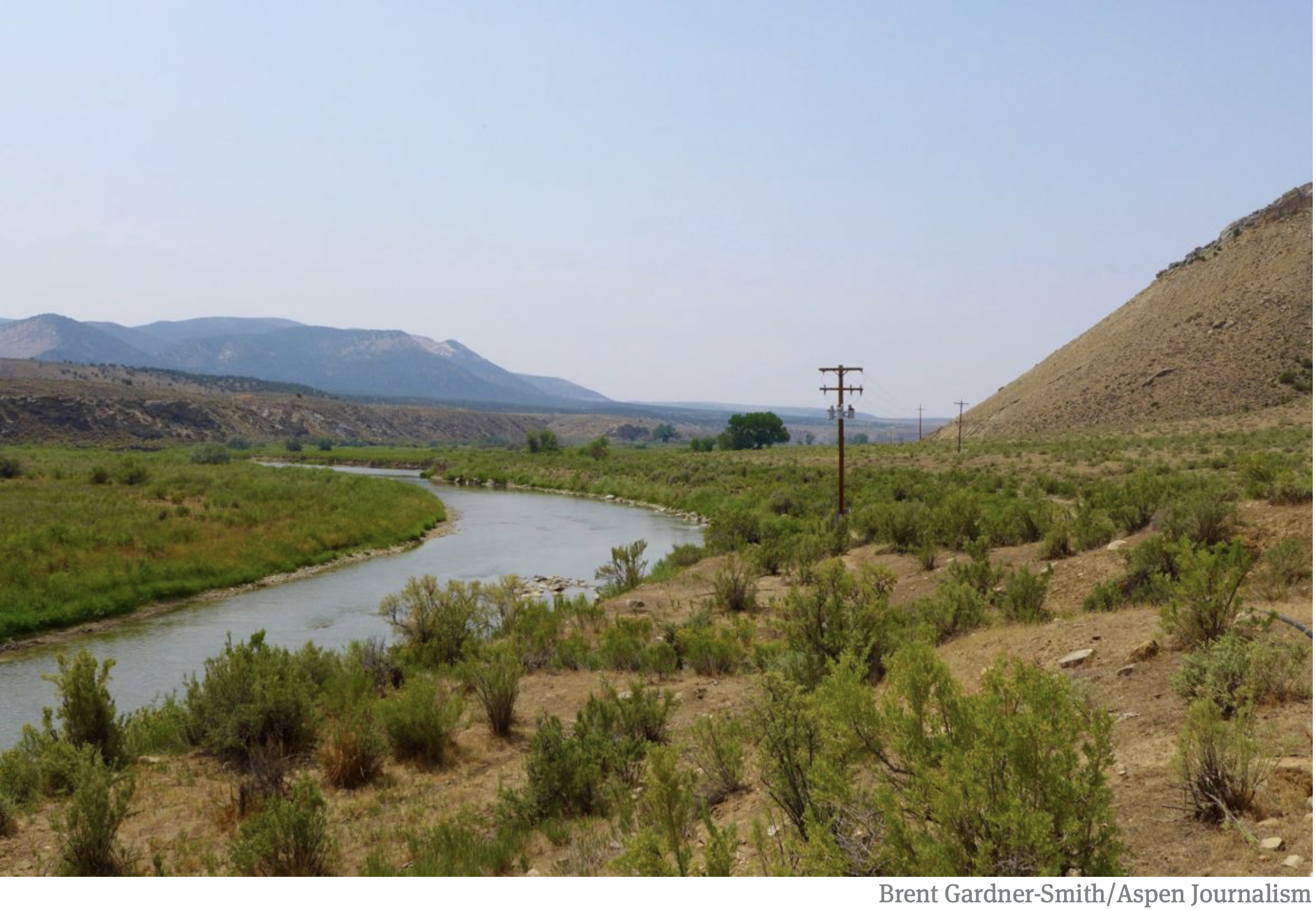
The upper South Platte River, above the confluence with the North Fork of the South Platte. Photo: Brent Gardner-Smith/Aspen Journalism
Click here to apply. From email from DWR (Michael Hein):
This job opportunity is for a vacant Colorado Division of Water Resources Augmentation Plan Auditor & Accounting Operations Specialist Team Lead for Division 1 located in our Greeley, CO office. This position is at the Physical Science Researcher/Scientist IV level (PSRS-IV) and is currently open to the public for application through January 25, 2019 or until 50 applications are received, whichever comes first.
This position provides leadership, guidance and oversight as a work leader to the Division 1 operations group responsible for Augmentation Plan coordination and administration. This group supports water rights administration by developing methodologies to collect and analyze water diversion and delivery data to verify augmentation plans and water diversions are operated in compliance with all applicable court decrees, statutes, rules and regulations. This position identifies and determines applicable professional standards and concepts incorporated into governing water court decrees and provide written protocol and guidance to staff regarding proper analysis of Augmentation Plan operation in accordance with water court decree requirements. This position, when necessary, provides recommendations for new process and procedures to collect, report, analyze and coordinate practices to allow compliance of these plans with the applicable decrees. This position prepares expert reports and expert testimony in Water Court trials not related to enforcement actions. Position is the work leader of three or more full-time positions.
A view of the White River foreground, and the Wolf Creek gulch, across the river. The Rio Blanco Water Conservancy District has been using state funds, and their own, to study two dam options for this area between Meeker and Rangely on the White River. Photo credit: Aspen Journalism/Brent Gardner-Smith
The Colorado Water Conservation Board has given $843,338 to the Rio Blanco Water Conservancy District since 2013 to study a potential dam on the White River, yet officials at the Colorado Division of Water Resources say the project appears “speculative” and Rio Blanco lacks evidence for its claims for municipal, irrigation, energy and environmental uses.
On Nov. 14, the CWCB directors approved the most recent grant application from Rio Blanco for $350,000 to keep studying the proposed White River dam and reservoir project near Rangely.
But while the CWCB is spending more state money to help prepare the White River project for federal approval, another state agency, the Division of Water Resources, is asking hard questions about the project in water court.
“There are concerns whether the district can show that it can and will put the requested water rights to beneficial use within a reasonable period of time and that the requested water rights are not speculative,” wrote Erin Light, the division engineer in Division 6, who oversees the White and Yampa river basins, and Tracy Kosloff, the assistant state engineer in Denver, in a report filed in water court Oct. 4.
In addition to pursuing a series of grants from CWCB, Rio Blanco applied in water court in 2014 for a new water right to store 90,000 acre-feet of water from the White River.
The two engineers in the Division of Water Resources filed their report after consulting with the state attorney general’s office. Review of water rights applications by division engineers is routine, but the report filed by the division engineer and assistant state engineer raised a higher level of concerns than normal.
Also known as the Wolf Creek project, it could store anywhere from 44,000 to 2.92 million acre-feet of water, according to the array of proposals, presentations and applications that have been made public over the project’s ongoing evolution. (Please see: Timeline: tracking the proposed White River dam and reservoir).
The water would be stored either in a reservoir formed by a dam across the main stem of the White River, or in an off-channel reservoir at the bottom of the Wolf Creek gulch.
The latest grant from the CWCB to Rio Blanco was to “finalize the preferred reservoir size and firm-up financial commitments of key project partners so that applications for federal permits can be filed,” according to a CWCB staff memo on the grant.
Asked about the apparent conflict between CWCB and DWR on the White River project, CWCB Director Becky Mitchell said she was aware of the concerns voiced by the division and state engineers and was confident that the next phase of study supported by CWCB would help answer some of the questions raised.
“All of the grants given to Rio Blanco thus far have been all about feasibility, so we are not necessarily in disagreement with DWR, but it needs to trued up,” Mitchell said Tuesday. “There may be concerns with what DWR is stating and the grant will help us evaluate those concerns.”
In another sign of CWCB’s support for the potential project, the agency’s finance section has added a potential $100 million loan to Rio Blanco on a list of potential loans it compiles and publishes as part of the CWCB director’s reports to the agency’s directors.
Brad McCloud of EIS Solutions in Grand Junction is serving as Rio Blanco’s project manager for the White River project.
When asked Tuesday about the contradictory messages sent by the two state agencies, McCloud said, “I think one side is working on one end and the other is doing the other and it’s a good check and balance and the way the system is supposed to work. And there are probably things that will get worked out along the way.”
A view looking downstream of the White River in the approximate location of the potential White River dam and reservoir. The right edge of the dam, looking downstream, would be against the brown hillside to the right of the photo. Photo credit: Aspen Journalism/Brent Gardner-Smith
State questions
In their report filed in water court, the state’s water engineers challenge Rio Blanco oft-stated claim it is seeking the new storage facility at Wolf Creek in order to meet the future water needs of the Town of Rangely, which today takes its water directly from the White River.
“While every case is different and may require evidence tailored to the particular facts of the case, the engineers have not received sufficient evidence to support the district’s claimed water demands for Rangely nor evidence that Rangely intends to rely on water storage in one of the Wolf Creek Reservoirs to meet its demand,” the report from Kosloff and Light says.
The engineers’ report also questions the demand for water in the potential new reservoir from the energy sector.
They said Rio Blanco should, at a minimum, show how much of the 45,800 acre-feet of industrial demand it is claiming is located within the district’s boundaries.
They also say Rio Blanco should make public how much of the demand from the energy sector within the district’s boundaries can be satisfied by the existing water rights of the district.
In addition to challenging Rio Blanco’s claims for municipal and industrial use of water in their 2018 report, Light and Kosloff also question Rio Blanco’s claims for irrigation and environmental uses.
They said a storage report prepared for the project “notes that irrigated acreage and irrigation water demand is projected to decrease in the future” in the area downstream of the reservoir.
And the engineers said they “do not believe that a water right for irrigation use should be awarded in this case.”
And the engineers question Rio Blanco claim that it will release up to 42,000 acre-feet of water from its proposed reservoir to the benefit of endangered fish downstream on the White and Green rivers.
They say an ongoing study has yet to make clear how much water is needed for the endangered fish.
“Long story short, it is still unclear what flows should be used when determining if or how much water needs to be stored to assist with meeting the recommended flows,” the report says. “Until these numbers are known, claiming any quantity of water for these uses is speculative.”
Consultants for the Rio Blanco Water Conservancy presenting a slide earlier this year showing how a dam could be built across the main stem of the White River between Rangely and Meeker. A report from engineers at the Division of Water Resources is questioning the claims made in a water court case in which Rio Blanco is seeking new water rights for the project.
Size in flux
The White River project has a wide range of potential uses, according to Rio Blanco, and it also has a wide range of potential sizes, as various presentations and applications have included potential sizes from 44,000 acre-feet to 90,000 acre-feet to 400,000 acre-feet to 2.92 million acre-feet.
Alden Vanden Brink, the manager of the Rio Blanco district, told the CWCB directors Nov. 14 that his district is not seeking to build a 400,000 acre-foot reservoir, despite the reference in Rio Blanco’s grant application to study a reservoir between 44,000 acre-feet and 400,000 acre-feet.
“The 400,000 is maximum size,” Vanden Brink said. “That is not what the Rio Blanco Water Conservancy District is looking to build. It’s going to take somebody from a way outside source to come to the table for that.”
Vanden Brink said the district was seeking to store “anywhere from 44,000 to about 130,000” acre-feet of water.
However, the grant application from Rio Blanco notes that a 400,000 acre-foot reservoir might have some benefit to the state.
“If the higher end of the storage is implemented, the project has tremendous potential to help the majority of the state of Colorado address Colorado River Compact administration issues,” the grant said.
An earlier study on the dam by W.W. Wheeler and Associates for the Rio Blanco district found it was possible to build a dam on the White River at Wolf Creek that would hold 2.92 million acre-feet of water.
The latest grant application to CWCB from the Rio Blanco district says “the preferred reservoir size will be developed based on the amount of water needed and committed to by key project stakeholders.”
Wade Cox, the president of the Rio Blanco Water Conservancy District, discussed the project in October with the board of the Colorado River District, and referenced the varying potential sizes of the reservoir.
“There is never going to be enough water,” Cox said. “I don’t care how big you build it. Whatever you do, it’s never going to be enough. Somebody somewhere is going to utilize it.”
Editor’s note: Aspen Journalism covers water and rivers in collaboration with The Aspen Times and other Swift Communications newspapers. The Times published the story on Thursday, Nov. 29, 2018.
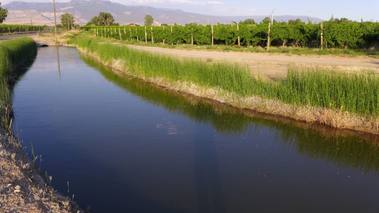
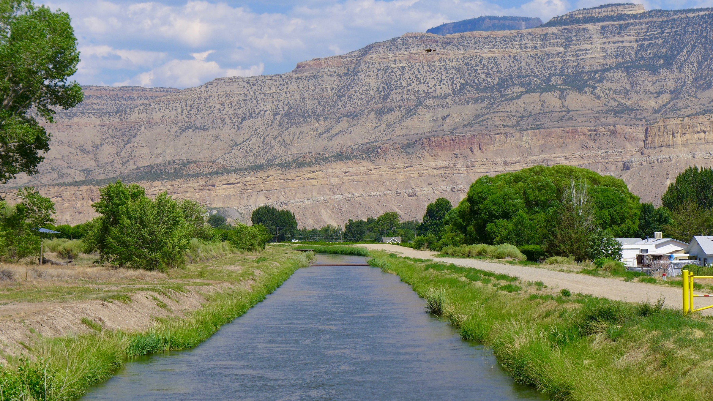
An irrigation ditch on Orchard Mesa in the Grand Valley, bringing water from the Colorado River to orchards and fields. If Colorado fails to send enough water downstream to meet the terms of the Colorado River Compact, could the use of water in ditches such as this be curtailed?
When uttered in regard to the Colorado River Compact, the phrase “anticipatory mandatory curtailment” of water diversions makes Western Slope irrigators shudder.
And while a policy adopted last week by the state might reduce some of the fear and anxiety among irrigators about being forced to someday soon send water downstream, it’s still a lively subject of discussion.
To set the table, here’s how Andy Mueller of the River District described the situation to his board of directors, in an October 5 memo.
He was describing events at the September meeting of the CWCB, in Steamboat.
“Certain water users are calling for the potential implementation of a demand management program which includes uncompensated anticipatory mandatory curtailment of water rights within the state,” Mueller wrote.
“The Front Range representatives affirmed their position that no Colorado Water Conservation Board action was needed, that a voluntary program was a fine goal but that they believed the state needed to roll out a program which includes rules and requirements for mandatory anticipatory curtailment.
“The presentation from the string of Front Range entities confirmed the River District Staff’s concerns that major water users in the state would like the Upper Basin demand management pool established quickly with the intent that it be filled with water from a program highly or exclusively dependent upon water contributed via uncompensated, anticipatory, mandatory curtailment of water rights in the Colorado River Basin.”
Muller also said in the memo, “ … we recognize that the overuse in the Lower Basin, coupled with the continuation of extremely poor hydrology may, in the future cause us all to support or at least be willing to endure an anticipatory mandatory curtailment.”
That seems to duly raise the question, does the state of Colorado even have the authority to curtail water rights, in an anticipatory fashion, so as not to violate the Colorado River Compact?
A headgate on an irrigation ditch on Maroon Creek, a tributary of the Roaring Fork River.
State have the power?
First, consider this nugget of state law (CRS 37-80-104): “The state engineer shall make and enforce such regulations with respect to deliveries of water as will enable the state of Colorado to meet its compact commitments.”
And then there is the 1938 U.S. Supreme Court decision, Hinderlider v. La Plata and Cherry Creek Ditch Co., which found that the state pretty much has the authority to do what it takes to meet agreements, or compacts, it has made.
There is a worthwhile explanation of the case, and the decision, in “Vranesh’s Colorado Water Law.”
“Interstate compacts, and the equitable apportioning of water among various states, are necessities, especially in times of water shortage. If interstate allocation is subordinated to individual rights, interstate compacts would be valueless,” Vranesh writes.
“Allocation establishes a state’s right to a given amount of water. The right of an individual to use water in a particular state is thus limited by the physical availability of water minus the amount of water allocated to the state.
“The amount allocated to an upper basin state such as Colorado is that amount of water physically available minus that amount which must be delivered at the state line.
“Any regulation by the state engineer within this limitation, with the goal of maximizing beneficial use is a valid exercise of police power, barring other constitutional complications,” Vranesh, a well-respected water attorney, concluded.
The diversion structure for the Maybell Canal on the Yampa River east of Maybell.
Compact commisison
Eric Kuhn, the former general manager of the Colorado River District, was familiar with the Hinderlider case, but said he’s an engineer and not an attorney.
Attorney or not, Kuhn is still an expert on the 1922 Colorado River Compact, and he pointed to the 1948 Upper Colorado River Basin Compact as also being relevant to the discussion.
That compact created the Upper Colorado River Commission and gave it the authority to take steps to avoid violating the 1922 compact, including notifying the individual upper basin states if they are are close to doing so.
“The purpose of the commission is to always be in compliance with the compact,” Kuhn said. “When I read the minutes, they weren’t talking about that you go into a hole and then you do a curtailment to catch back up, they were always saying that you take action ahead of time to make sure you are always in compliance.
“They don’t use the word ‘pre-compact curtailment’ or anything like that in the record of the commission, but it’s pretty clear that the reason the commission exists is that you needed to have somebody that would say ‘we’re making the call that we need to curtail in order to not be in violation of the compact.’ And it’s the commission that makes that call.”
Today, based on the ten-year running average used as a measure of the upper basin’s compliance with the compact, the upper basin looks comfortably in compliance. But Kuhn said the running average is being propped up by the big water year of 2011, and once that falls off the list, things will look different.
And currently, the bigger threat isn’t so much the ten-year average, it’s that if water levels in Lake Powell fall too much further, it will be physically impossible to deliver, through the outlets in the dam, the required amount of water to meet the compact’s obligations.
James Eklund, who is an attorney, and the former director of the Colorado Water Conservation Board and the state’s representative on the Upper Colorado River Commission, was willing to discuss the issues raised by the prospect of mandatory curtailment on Wednesday, during a stopover en route from Denver to his family’s ranch on the lower slopes of the Grand Mesa.
He said that the Hinderlider decision is “one of the most venerable cases in this legal space” and that the common takeaway from the case is that “the Supreme Court said the sovereign state can bind private property owners in its state.”
He noted, however, that how people view the force of the decision, or how to respond to it, sometimes turns on a subtle distinction in Colorado water law that is often overlooked by some water rights owners: a water right is a right to use a set amount of water, not a claim to the water itself.
“The state constitution says the molecules of water are owned by the people of the state of Colorado,” he said. “But the right to use the molecule, that’s a private property right. That’s a use right, not a right to the actual molecule.”
As such, Eklund said ‘you’ve got this body of case law that says that the state is pretty empowered to do what it feels is necessary. The question that you bleed right into, however, is the question of ‘Well, you can, but should you?’ Then it’s a policy question.
“Then you are going to have somebody along each part of the spectrum line up on that. You’ll have the really hardcore hawks say ‘The state has absolute authority, the court has spoken. The state should go do whatever it can to reduce the risk to the state as a whole, to the economy, and to water users generally.’
“And then you’ve got the other end of the spectrum that says ‘No, no, no, the state should always be deferential to a private property right and should not make policy that supersedes that.’ And that the Hinderlider line of cases and philosophy is only meant to be deployed in an emergency, catastrophic, threat-to-public-health-and-human-safety situation.”
Inflows to Lake Powell in 2018 were among the lowest since Glen Canyon dam was built, and giant sandbars are visible in the Green and Colorado rivers above the reservoir.
What about the DCP pools?
Notably, Mueller, the current River District general manager, said the district does not fully share the opinion of others when it comes to the state’s authority to avoid violating the compact by curtailing water use, especially when it comes to new pools of water now being proposed to be legally created in Lake Powell in order to keep Glen Canyon Dam functioning as intended, under “drought contingency planning.”
“We would agree that he has compact compliance authority if we are in violation,” Muller said, referring to the state engineer, during an interview after last week’s CWCB meeting in Goldend. “And where the difference of opinion may lie within our state, still, and frankly, probably will for a long time, is can he curtail water rights in anticipation of a compact violation, and put that water in a pool down in Lake Powell? And we would say, we don’t think that that is a legal right that our state engineer has today. I think there are others who think that the state engineer could curtail water in an anticipatory fashion. We would disagree with that.”
Mueller, during an interview on Nov. 15, also said “there is a difference in administering water rights to keep us in compliance with the compact, where that water is flowing down into a river, not into a (new drought contingency) pool. It’s very different to store it in a pool that may someday keep us in compliance. So there are fine distinctions in there that I think lots of lawyers will argue about one day if we get to that point.”
Mueller was willing to put that debate aside, at least for the moment, and openly consider how the state might eventually go about an anticipatory curtailment if it decided to do so.
“It is probably a rule making,” Mueller said. “But I don’t think they can, through rule making, change some inherent rights associated with water rights. So I think it would require, frankly, a state law change, and some may argue that it may even require a constitutional change. It’s not a small matter.”
Mueller added that if “worst-case-scenario hydrology stays really bad, we’ll all be talking about mandatory. We’ll figure out, I hope, in a very public process, what that looks like. Because there are lots of different ways that mandatory could roll out. Unfortunately, there are probably winners and losers in each way.”
Part of the machinery that controls how much water is diverted out of the Colorado River for use on Orchard Mesa in the Grand Valley. If the state needed to meet its obligations under the Colorado River Compact, it would be up to the state engineer to decide how to curtail water use.
Next question
So, if the dreaded anticipatory, mandatory, curtailment were to happen, how would it happen?
It’s up to the state engineer, who serves as the state’s water referee, to figure that out.
And Kevin Rein, the state engineer, prefers the term “compact administration in the absence of a violation” when discussing the concept.
Will the state engineer use the prior appropriation system, where junior water rights are cut off before senior water rights?
That’s not clear.
Prior appropriation is probably what most people expect the state engineer would use to administer an actual violation of the Colorado compact.
In a water meeting held by the Grand Valley Water Users Association, in Grand Junction on October 23, Rein told about 250 water users that “If I found out today that our agency needs to administer a compact call tomorrow, then that’s where we go, priority of administration. Then we go through that list of priorities. That’s the way we are going to go. And of course, the pre-compact rights would not be impacted.”
So those are the current rules in place, to be deployed by the state engineer if, in fact, Colorado violates the compact, but many wonder if those rules will stay in place because of the now heavy reliance by Front Range cities on junior, post-compact, water rights.
A strict administration of the priority system would cut off almost all of the transmountain diversions to the Front Range from the Colorado River system, and some experts say that could prompt the Front Range interests to buy-and-dry land with pre-compact water rights on the Western Slope, or prompt the Front Range to seek exceptions to the priority system.
As of today there is no specific set of tools, or rules, for the state engineer to use to cut back water rights that technically are not yet in violation of the Colorado River Compact, just because some day they might be, or more precisely, because the state as a whole might be.
“If I’m concerned that in a few years, we might be out of compliance, that’s a personal concern I may have, but I can’t go out and do some administration to build a buffer, to accomplish what they are trying to do through demand management,” Rein, the state engineer said during a short interview after the CWCB had adopted its new policy, in Golden, on Nov. 15.
“Demand management” is a new program the CWCB plans to set up, in order to send water to the new regulatory pools in Lake Powell.
Instead of “anticipatory mandatory curtailment,” or AMC, the demand management program’s mantra is “voluntary, temporary and compensated,” or VTC, and that’s the approach the state says is the best place to start when it comes to sending water down Colorado’s rivers.
“Right now, it’s the drought management plan,” Rein said. “But if somehow the state engineer is tasked with some focus on that (referring to AMC), it would be through outreach, and a well-contemplated approach that complies with the law. But for right now it appears the drought management plan is the best effort to do that.”
Rein declined to speculate on how, exactly, AMC might someday, or somehow, be implemented, other than to re-affirm that it would be a stakeholder-driven process and it would be, again, a “well-contemplated” approach.
Others expect that any future anticipatory mandatory curtailment would be based, but perhaps to varying degrees, on cutting back junior rights over senior rights.
“The question is which one is most consistent with the prior appropriation doctrine, while still being most equitable to folks,” Mueller said, during an interview in Golden, about the available options. “And hopefully designed in a way to cause the least economic damage to not only the state as a whole, but to one segment of the state, or one industry, or one region.”
And Eklund, during Wednesday’s discussion in Glenwood Springs, observed that despite all the unknowns that could come with implementing anticipatory mandatory curtailment, it is likely to be the case that owning pre-compact rights (pre-1922 or 1929) will still be better than owning post-compact rights.
But, as Kuhn said on Wednesday during an interview, “There are not firm guarantees. It’s not your water, it’s the state’s water. And if the state doesn’t have a right to that water under an interstate compact, then your place in line, whether it’s pre or post compact, well, it’s not going away, but there’s just going to be nothing there when you get there. If the state doesn’t have any legal right to the water, you have nothing to divert, whether you have a pre or post compact rights.”
An irrigation ditch off the Crystal River used to irrigate fields. Many such ditches have senior, pre-compact water rights, but it's increasingly unclear how much that may matter in a future with less water, and compact obligations for the state to meet.
Free hand?
So, can the state engineer just cut back on water use however they want to meet the state’s compact obligations?
No. The engineer has the authority to initiate a rule-making process, but he, or she, would have to go through some sort of public process that includes talking to water users.
In regard to other compacts on other rivers in the state, such as the Rio Grande River, the state engineer has used a stakeholder-driven process that includes submitting proposed rules to water court so others can respond to them.
Eklund noted that, as such, Rein was looking at the issue from a “practical standpoint.”
“He’s looking down the long road of what it would take to produce a rule, and go through a rule-making process that would satisfy people and not just get them all riled up and ticked,” Eklund said. “As he stares down that road, there are multiple obstacles that he will hit. He has to go out and do a real-hard listening session, a whole bunch of them, across a number of water divisions. Every basin in the state, with the exception of the N. Platte and the Republican rivers, sees water, in one shape or form, from the Colorado River basin.
“And he would have to adopt a new rule that says, ‘Here is how I’m going to honor the differences and the unique attributes of each of those basins,’ because state law says he has to do that.”
Asked why the state hasn’t already developed such a plan, Eklund said “it’s such a painful process, that you don’t do something like that unless you have to. It’s like going in for elective surgery, ‘I’ll do it when my knee is hurting so bad that I can’t walk anymore, then I’ll go in and do the surgery.’”
Also of note here is how Karen Kwon, first assistant attorney general of Colorado, described how the state might be forced to move from voluntary to mandatory compliance, in her remarks to the CWCB board in Golden on Nov. 15.
“While demand management activities would be intended to try avoid that situation, and provide a proactive mechanism for Colorado to be going forward, there is no guarantee that demand management will work to the level that we need it to to completely avoid curtailment,” Kwon said. “Whether it is because hydrology persists and gets worse immediately and we’re not ready to stand up a demand management program, or that there is not enough money to fund a demand management program, or there is not enough interest in participation, whatever it is, there are lots reasons why we might not have a full operational demand management in the appropriate time.”
Kwon then drew the distinction between actually violating the compact, and working to avoid doing so.
“If we are in compact violation, the Division of Water Resources has to act,” Kwon said. “Outside of a compact violation, there is a situation where people are concerned that the Division of Water Resources is going to act in a vacuum. I have every assurance that is not going to be the case. We would have an open process going forward.”
A map of Colorado showing the urban areas of the state in red.
Divided state?
The ongoing situation, driven by poor hydrology, has, perhaps not surprisingly, opened up a new chasm between water interests on the Western Slope and those on the Front Range.
On Nov. 15, after the CWCB meeting, Mueller of the River District, which is chartered to protect Western Slope water, said “We do talk a lot with the Front Range. This isn’t going to come out of left field. But we want our water users on the West Slope to know that these are the issues that are being talked about. Because it is their water rights that people are talking about.”
And in an interview in September, Jim Lochhead, the CEO of Denver Water and the president of the Front Range Water Council, shared his thoughts on the relationship between a voluntary and a mandatory effort to send water to Lake Powell.
“I think that what we need to do is just proceed step by step,” he said. “The first step is to finalize the drought contingency planning. The next step is to create the demand management pool in Lake Powell, because without that it doesn’t matter what we do. And the third step is to work on a program where, if needed, we can use voluntary, temporary, compensated means to put water in that pool.”
But beyond that, Lochhead said that “Colorado River compact compliance” is a “state responsibility.”
“If we’re in trouble from a compact standpoint, the state is going to have to exercise its authority,” Lochhead said. “I also don’t think that by not talking about mandatory curtailment we can pretend the problem will go away. We need to be thinking about it, and we need to be thinking about it proactively.”
And Bennett Raley, the general counsel for the Northern Water Conservancy District, told the CWCB directors in September that mandatory curtailment may be necessary in Colorado.
“If the drought continues, there are two paths,” he said. “If there is an infinite source of money, then voluntary works. Great, we’re all happy. If the drought continues and there is not an infinite source of money, then the state will go to mandatory. The Supreme Court will ensure that, sooner or later, it’s not a question.”
The Weaver Ditch as it winds through Sopris Park in Carbondale. While the ditch is an a
State policy
Now, let’s go back to where this started and consider a relevant portion of the state’s new policy.
The policy speaks to what the state, via the CWCB, may do someday, if the now still-conceptual demand management program, designed to be voluntary, temporary, and compensated (VTC), does not end up sending enough water downstream.
“If the quantity of conserved water made available through the demand management strategies described in this policy is not sufficient to ensure Colorado’s compliance with the Colorado River Compact, it will be the Board’s policy to encourage and collaborate with the Division of Water Resources to engage in timely and extensive public outreach regarding development of any alternative measures or rules for compact compliance administration to fully inform and seek input from intrastate water rights holders and stakeholders with interests in the Colorado River.
“Such process would be with the goal, but not the requirement, of achieving general consensus within the state, without constraining the Division of Water Resources’ lawful administration of water rights in order to meet Colorado’s compact obligations.”
There are three key clauses of note in there.
The first is, “the Division of Water Resources’ lawful administration of water rights in order to meet Colorado’s compact obligations.”
The second clause is “alternative measures or rules for compact compliance.”
And the third is to “seek input from intrastate water rights holders and stakeholders with interests in the Colorado River.”
Editor’s note: Aspen Journalism is covering water and rivers for The Aspen Times and other Swift Communications publications. The Times published a version of this story on Thursday, Nov. 22, 2018.
From the Colorado Water Conservation Board (Taryn Finnessey/Tracy Kosloff):
In response to persistent and prolonged drought conditions throughout the southern half of the state and along the western border, the Governor activated the Colorado Drought Mitigation and Response Plan for the agricultural sector on May 2, 2018, additional counties in northwest Colorado were added in September; information can be found HERE
The 2018 Water Year (which ended on September 30) was the warmest and second driest in 124 years of records for the state of Colorado. Water Year 2019, which began on October 1st, has seen above normal precipitation and below average temperatures across most of the state. This is the first time in over a year that the statewide average monthly precipitation was above average and monthly temperature was below average. Recent precipitation gains have helped to relieve some drought conditions in Southeastern and Northwestern Colorado; and have led to a good start to the snowpack accumulation season. Cold temperatures and above average precipitation has continued in the first half of November, however, precipitation has not benefited southwestern Colorado as much.
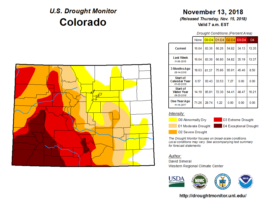
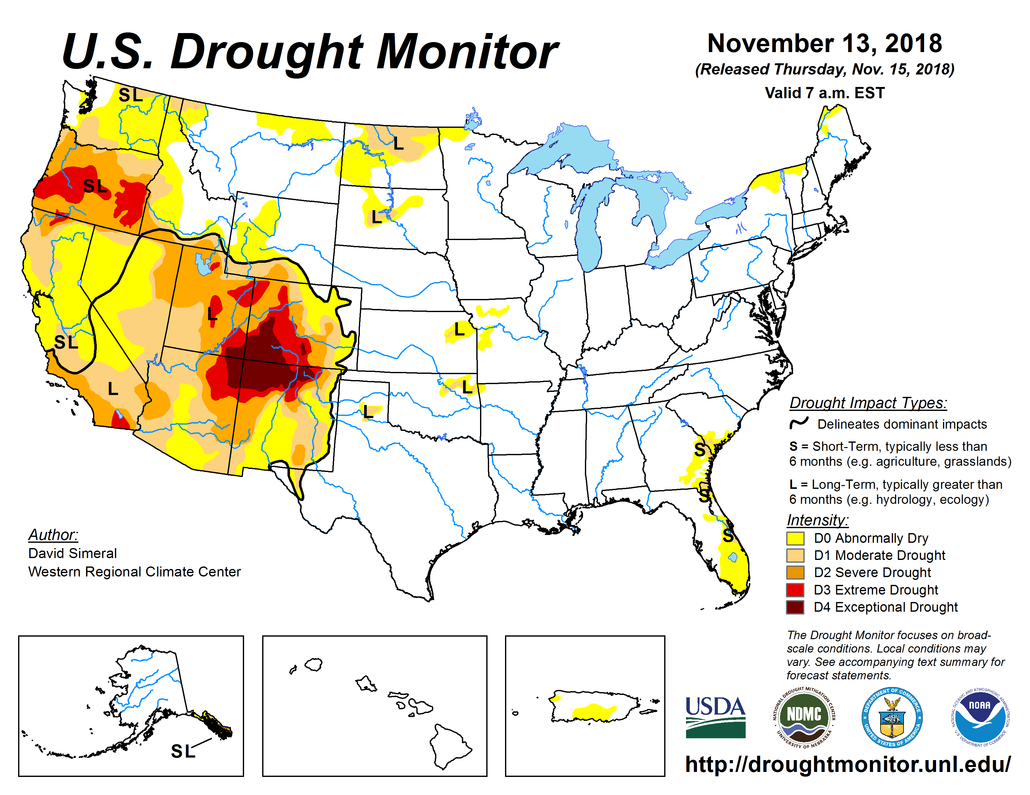
■ As of November 13th, exceptional drought, D4, continues to affect southern Colorado covering 13 percent of the state, extreme drought, D3, covers 21 percent of the state; severe drought 21 percent and 12 percent is classified as moderate drought. An additional 17 percent of the state is currently experiencing abnormally dry conditions.
■ An El Niño watch remains in effect, with a greater than 80 percent chance of an El Niño developing by the end of the calendar year, which could bring an increased chance of wet extremes for southern Colorado.
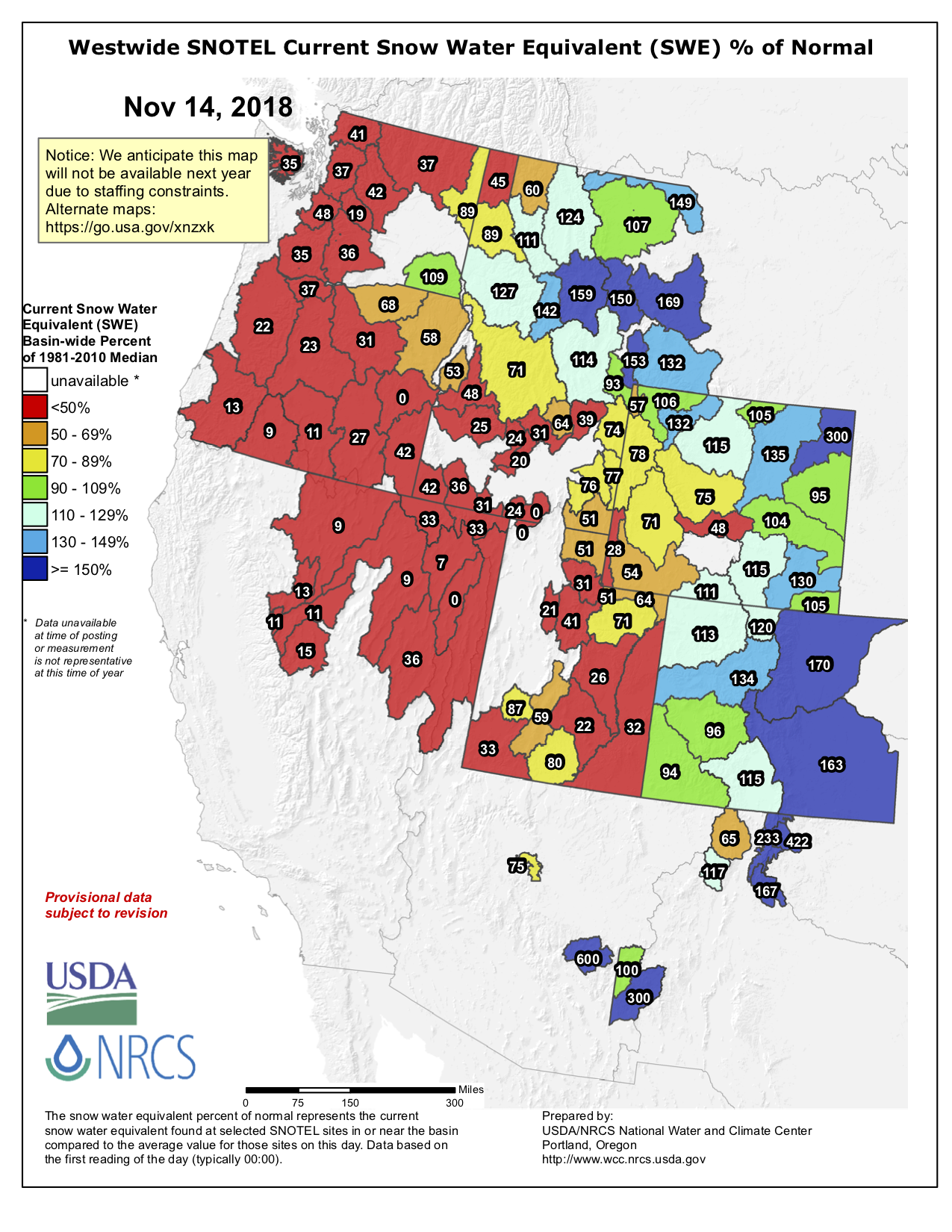
■ SNOTEL water year to-date precipitation statewide is 124 percent of average, but ranges from 92 percent of average in the Southwest basins to 170 percent of average in the South Platte River Basin. The Arkansas is at 163 percent, while the Colorado is at 134. The Rio Grande and Yampa- White are at 115 and 113 percent of average, respectively; while the Gunnison is at 96 percent.
■ Reservoir storage, statewide is at 81 percent of normal, with the Arkansas, Rio Grande, Yampa-White, and South Platte all above 90% of average for the end of October. Storage in the Colorado River basin is 89% of normal. The Southwest basins of the San Miguel, Dolores, Animas & San Juan, and Gunnison are now at 55 and 53 percent of normal, respectively.
■ Ridgway Reservoir is currently at its lowest point since it was first filled. Recovering from the rapid reservoir declines seen during the summer of 2018 will likely take some time. As of November 1, reservoir storage levels vary widely from near record high to near record low levels, with the Colorado, Gunnison and Southwest basins all below normal.
■ Long term forecasts indicate an increased likelihood of above average temperatures statewide November through January. Southwestern Colorado is forecast to continue to benefit from moisture as a result of the developing El Niño and has an increased likelihood of above average precipitation over the same time period.
■ Water providers are seeing decreased demands consistent with typical winter demands.
■ Fall moisture has helped with winter wheat planting and limited prevented acres were reported.
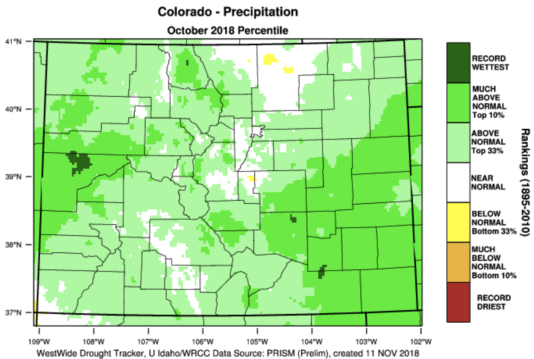
Widespread precipitation in October helped to alleviate drought conditions in some areas. Many areas of the state saw more precipitation in October than they saw collectively in the first half of Water Year 2018.
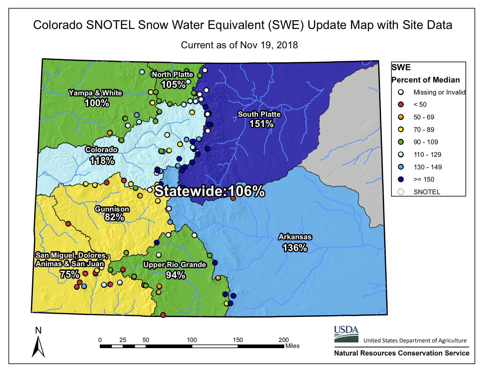
Colorado basin-filled snowpack map November 19, 2018 via the NRCS,
Snowpack is off to a good start with most areas of the state seeing above average accumulation in October and the first half of November.
Colorado Drought Monitor November 13, 2018.
Despite recent precipitation, Western Colorado is still dealing with severe, extreme and exceptional drought. Continued above average snow accumulation may help to alleviate these conditions as the winter progress and will be closely monitored.
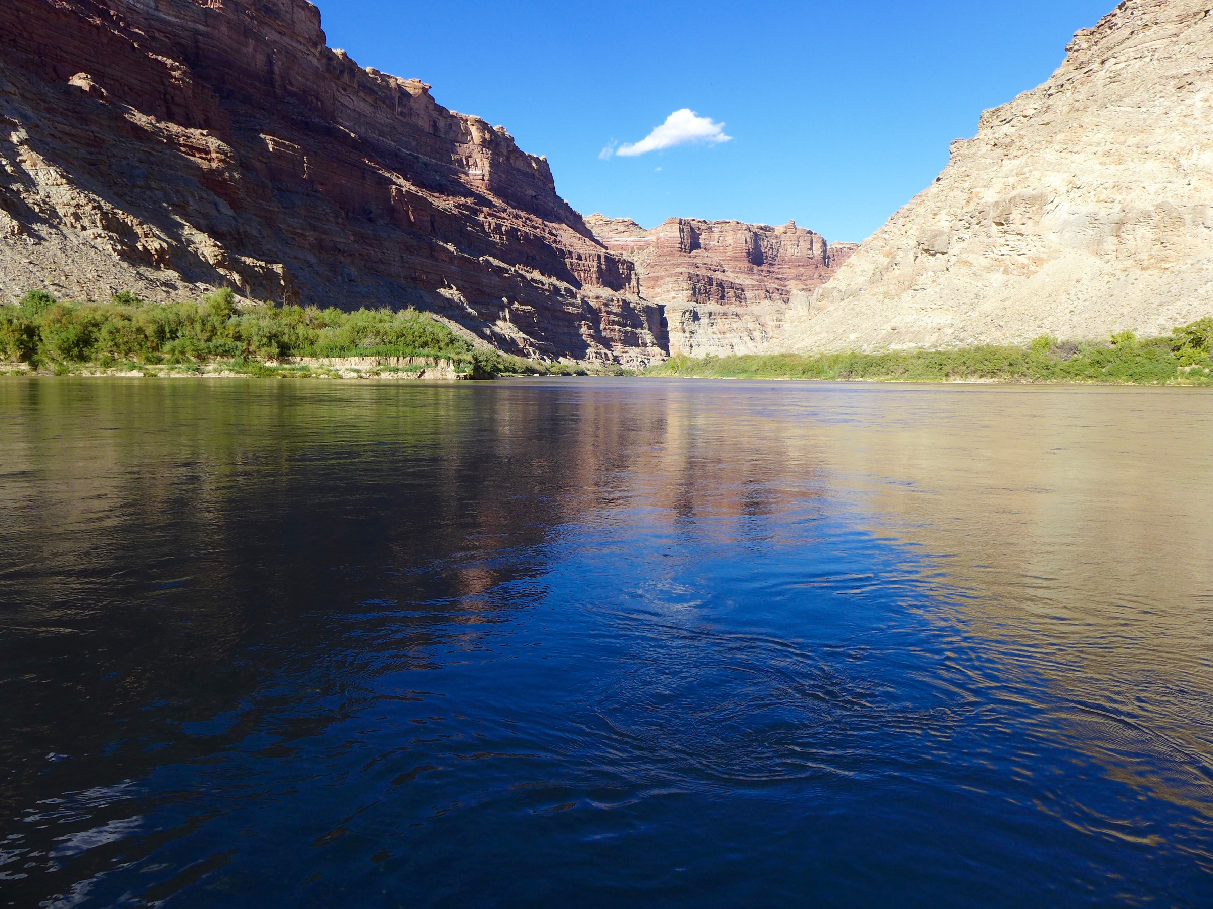
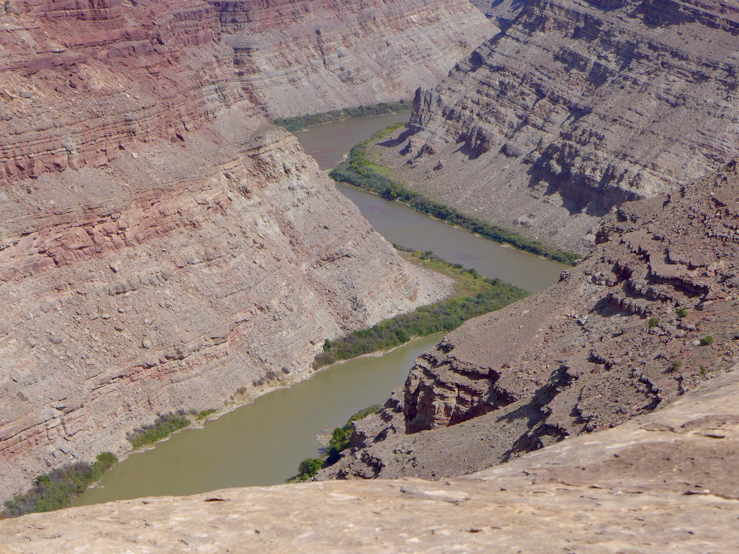
Looking upriver at the confluence of the Green and Colorado rivers in late September, one of the driest years on record for the Colorado River system. Water managers in both the upper and lower basins are working to get more water to this point in order to bolster the low level of Lake Powell, which is not far downstream.
The state of Colorado is now officially on board with a regional water strategy designed to keep enough water in Lake Powell behind Glen Canyon Dam to avoid violating the Colorado River Compact and keep generating hydropower at the dam.
At a meeting Thursday in Golden, the directors of the Colorado Water Conservation Board unanimously adopted a state policy giving its “full support” to proposed drought-contingency plans and agreements now being reviewed in both the upper and lower Colorado River basins.
“I think we’ve really done something important for the state today,” Russ George, a CWCB director from Rifle who represents the Colorado River basin within Colorado, told a meeting room filled with water managers, water users and water attorneys from around the state.
The new policy means Colorado, along with the other upper basin states of Utah, Wyoming and New Mexico, can declare its support for the drought-contingency plans (DCP) and agreements at a mid-December meeting in Las Vegas of the Colorado River Water Users Association.
The lower basin states of California and Nevada also are in support of the agreements, but water managers in Arizona are still working through a series of contentious, complicated issues and have yet to reach consensus.
If consensus in both basins can be reached by mid-December, legislation may be introduced during the current lame-duck session of Congress.
A sense of urgency to do something about the falling water levels in Lake Powell has been growing, and was heightened in Colorado in 2018 by the hot and dry conditions.
Lake Powell on Friday, November 15 was at 44 percent full and at an elevation of 3,588 feet above sea level on the upstream face of Glen Canyon Dam. That’s 98 feet above the “minimum power pool” level of 3,490 feet.
The reservoir level has dropped by 38 feet in the last year, and water officials are concerned if dry conditions persist, the reservoir could reach the minimum power pool level within three years.
Operations, and reservoir levels, in Lake Powell are tied by regulatory guidelines with levels in Lake Mead, which is 38 percent full today. The new DCP storage pool in Lake Powell would be exempt from the operating guidelines, however, and would serve as a secure, and separate, savings account within Lake Powell for the upper basin states.
A graphic showing the 38-foot-drop in the surface level of Lake Powell over the last year, from the website, lakepowell.water-data.com. Regional water managers want to keep the reservoir above minimum power pool level of 3,490 feet.
Bridging the divide
The new Colorado state policy adopted Thursday was crafted by staff members at the CWCB, a state agency within the Dept. of Natural Resources, and the attorney general’s office to bridge the latest chasm that had emerged between water managers on the Western Slope and the Front Range.
Water officials on both sides of the Continental Divide want to store water in Lake Powell in a regulatory pool controlled by the upper basin, with the goals of first, keeping the reservoir levels high enough to keep producing hydropower at the dam, and second, high enough to continue to release enough water from the dam to meet the upper basin’s downstream obligations under the Colorado River compact.
But exactly how water that is now being consumed by farmers and ranchers and city dwellers will be conserved and sent downstream to fill the new pool in Lake Powell is uncertain, and a key issue is whether the state might require mandatory cuts in water use to fill the new pool to avoid a compact call.
The Western Slope, lead by the Colorado River District in Glenwood Springs, also wanted the state to help ensure that the creation of the new pool of water didn’t lead to a buy-and-dry of irrigated agriculture on the Western Slope.
And they wanted assurances that the state would use a public process to devise any new rules or laws requiring mandatory cutbacks in water use, should low water conditions persist.
Meanwhile, Front Range water interests wanted to make sure that the state didn’t tie its own hands and restrict its abilities to take steps to avoid a compact.
The confluence of the Green and Colorado rivers, in September 2018. Most of the water that flows into Lake Powell each year flows past this remote spot in Canyonlands National Park.
Responsive to concerns
The state’s new policy says it will use an open public process to create a “demand management,” or water-use reduction, program that incentivizes water users — primarily irrigators — to temporarily cut back on their consumptive use of water, in exchange for monetary compensation.
And if mandatory cutbacks in water use are ever necessary, “any alternative measures or rules for compact compliance administration” will be developed after “timely and extensive public outreach” and with “the goal, but not the requirement, of achieving general consensus within the state,” the policy says.
“The CWCB was very responsive to our request that they display state leadership in establishing a policy that going forward provides some security for the Western Slope and other regions of the state, and that no one region is going to suffer the brunt of a demand-management program,” said Andy Mueller, the general manager of the Colorado River District, after the meeting.
Mueller also said the CWCB “clearly separated demand management from some form of involuntary curtailment. It was very important to do that, as they are two different things.”
Both Mueller and Bruce Whitehead, the general manager of the Southwestern Water Conservation District in Durango, thanked the CWCB board for listening to their concerns, and drafting a policy that attempted to address them.
“This was a hot topic,” said Whitehead.
Between the two, the Colorado River District and the Southwestern District represent all of the Western Slope. Both Mueller and Whitehead said they will recommend to their boards that they formally endorse the state’s policy at their upcoming board meetings.
The Front Range Water Council, an ad hoc group that includes the major municipal water providers between Fort Collins and Pueblo, sent the CWCB a letter of support for the DCP policy, urging adoption “without any changes.”
“Thank you for your thoughtful consideration of public input on this topic of critical importance to Colorado, and for developing a policy that will allow Colorado to engage in further processes that will protect our collective interests in the Colorado River and Upper Colorado River compacts,” said the letter, which was signed by Jim Lochhead, the CEO of Denver Water and the head of the Front Range Water Council.
Patti Wells, who represents the Denver metro area on the CWCB, said it was important that Colorado not be split by differences between the east and west slopes.
“There clearly is more that unites us in the ability for Colorado not to be subject to a compact call, then there is in the details of how we might avoid that,” she said.
She also challenged water managers to come up with a demand-management program that “makes everyone better off.”
“We ought to be able to figure out a way to get some water into Lake Powell without doing harm to anyone, and really making it a program that will benefit all the participants to the extent that we can,” said Wells, who recently retired as the general counsel for Denver Water. “I see no reason why we can’t approach this in that way, because we are Coloradans for God’s sake, and we are not anyone else.”
Colorado closed out its second-driest water year on record Sept. 30, with 72 percent of the state in some level of drought.
The water year, which started October 1 of 2017, was marked by abnormally high temperatures, low precipitation and some of the largest fires in Colorado history, but state climate scientists and hydrologists say the 2019 water year, which began Oct. 1, is off to a much better start.
“We are trending towards the path of a good or near-average water year,” Becky Bolinger, a research associate with the Colorado Climate Center, said at a statewide water-availability task force meeting Tuesday in Denver.
Colorado Drought Monitor November 13, 2018.
Still dry
October and the first half of November saw above-average precipitation and below-average temperatures in most of the state. While much of this precipitation along the Front Range will have little bearing on the water year as a whole, the heavy snowfall in the mountains near Grand Junction, on the Western Slope, will probably stick around until spring.
Despite a good start to the 2019 water year, water managers warn that a few early snowstorms will do little to lift Colorado from its water problems. The state has been in water-shortage conditions for almost two decades.
“I continue to be skeptical,” Russ George, a board member representing the Colorado River basin on the Colorado Water Conservation Board, said during the board’s meeting Thursday. “We know — and we need to keep telling the public — that this moisture doesn’t solve the Lake Powell problem.”
Lake Powell, the largest reservoir on the Colorado River, has dropped more than 94 feet since the year 2000 and is now 44-percent full.
If the reservoir falls much further, it will be below “minimum power pool,” and water will not be able to flow through the penstocks in the upstream face of the dam down to turbines near the base of the dam.
And if water levels drop even further, the surface of the reservoir will be below the level of the outlet pipes in the dam, and not enough water will be sent downstream to meet the legal obligations of the upper basin states as required by the Colorado River Compact of 1922.
The threat of El Niño has also tempered water managers’ celebration about recent snowfall.
Climate models show an 80 to 90 percent chance for a winter El Niño. The weather phenomenon typically causes drier weather in the northern part of North America and wetter weather in the south.
Since Colorado falls in the middle of the continent, El Niño weather patterns are hard to predict for the state, but past El Niños have left most of the mountains on the Western Slope drier than normal and sent large amounts of snow to the state’s southeastern corner.
Although an El Niño could be bad news for Western Slope ski resorts and limit the mountain snowpack that feeds the rest of the state, it could help alleviate drought conditions in the Four Corners region.
This section of the state experienced its worst drought this year since the Dust Bowl of the 1930s. To meet summer demand, the region drew down its reservoir storage to record levels and will need a wet winter to recoup those reserves.
“There’s a lot of winter to come, but that’s an encouraging start,” said Karl Wetlaufer, a hydrologist with the Natural Resources Conservation Service, which is part of the U.S. Department of Agriculture.
Westwide SNOTEL basin-filled map November 14, 2018 via the NRCS.
A big beach on the lower Green River in late September is indicative of the low flows in 2018, which have caused water levels in Lake Powell to continue to drop. Plans to bolster flows in the reservoir by sending water down the Green and Colorado rivers is raising hard questions for Western Slope irrigators.
Before the Colorado River District will support pending federal legislation allowing drought contingency plans in both the upper and lower Colorado River basins to proceed, it wants the state of Colorado to adopt a policy putting limits on a new water-use reduction program designed to bolster water levels in Lake Powell.
That was the clear message from the River District board that general manager Andy Mueller said he received during a passionate discussion during a district meeting Tuesday.
“Most of the board is saying that at a bare minimum we have to have the state, the Colorado Water Conservation Board, affirm that there are in fact some sideboards and protections from the risks we face,” Mueller said, in summarizing the board’s discussion. “We’ve got to have some principles that guide the way this program is set up, and its consistency with the state water plan.”
Mueller said the program has to be consistent with the state water plan, there has to be an equitable distribution of wet water coming from both the Front Range and the Western Slope, and the program has to be voluntary, temporary and compensated.
“This board is not OK with the idea of a mandatory curtailment to fill a demand management pool,” Mueller said. “We don’t feel that there is legal or statutory authority for such a program.”
The concerns of the River District directors stem from an ongoing multi-state effort to create and gain approval for “drought contingency plans” in the lower and upper basins.
The lower basin states include California, Arizona and Nevada, and the upper basin states include Colorado, Wyoming, Utah and Nevada.
And as part of the regional “DCP” effort, it is anticipated that federal legislation will be required to implement changes to how water is managed in the upper and lower basins, with the goal of keeping enough water in Lake Mead and Lake Powell to keep those massive reservoirs functioning in the face of an ongoing 18-year drought.
The proposed changes include modifying the current regulations that guide how much conserved, or saved, water can be stored in Lake Mead by lower basin entities.
The changes include developing a plan to release water in a coordinated fashion from Flaming Gorge, Blue Mesa and Navajo reservoirs, which can send water down the Green, Colorado and San Juan rivers, respectively, to Lake Powell.
And the changes include creating a legally secure pool of water in Lake Powell to be filled with water conserved after fallowing fields, primarily, in Colorado, Wyoming and Utah.
Officials from Los Angeles to Salt Lake City who are working on the drought contingency plans say legislation will be submitted to Congress during the lame-duck session after the midterm elections.
And it’s widely assumed that such legislation will pass only if there is no opposition from entities that would be affected, such as the Colorado River District, which represents 15 Western Slope counties.
Mueller said Wednesday he was “cautiously optimistic” that the CWCB, a state agency that manages water planning, will adopt a guiding policy at its November board meeting about the creation of a demand management program.
And a senior CWCB official Wednesday offered reasons for Mueller’s optimism, including that such a policy is now being drafted for the board’s consideration.
“The policy statement will be informed by the public testimony, letters received, and the feedback we’ve heard from stakeholders around the state in the past year of aggressive public outreach,” said Brent Newman, who is the section chief of CWCB’s Interstate, Federal and Water Information Section and the state agency’s point person on Colorado River issues. “Because we’re hoping to respond and provide CWCB leadership to concerns that our partners and stakeholders have raised, it will likely address these issues.”
Newman also emphatically told the river district’s directors Tuesday that the state is not working on a mandatory curtailment program to avoid a call on the river system under the 1922 Colorado River Compact.
“Not myself, not the CWCB staff, not our board, not the Attorney General’s Office, not the division of water resources, not the state engineer, none of us at the state are assessing or recommending any kind of mandatory anticipatory curtailment scenario,” Newman said. “That is not in our books. Yes, we’ve had some water users say that if voluntary, temporary and compensated isn’t sufficient, you may have to look at this. We are not doing that.”
It was also made clear during the river district’s meeting that “anticipatory mandatory curtailment” of water rights in Colorado is seen as a direct threat to family-run farms and ranches on the Western Slope.
“If we want to push the Western Slope to the brink, where people start to actually sit down at the kitchen table and consider whether or not they ought to sell the farm to some outside-the-Western-Slope interest, this is how we get there,” said Marc Catlin, who represents Montrose County on the River District’s board, and also represents District 58 in the Colorado House.
After Catlin’s comments, many other River District board members said they agreed.
“This just shows how important it is to get the demand-management program right, and that we don’t rush into a demand-management pool in Lake Powell before we’ve had this discussion and before we’ve agreed to a policy and principles to guide us,” said Tom Alvey, the current president of the district’s board, who represents Delta County. “From all the perspective of water users on the Western Slope, there is huge concern about this.”
Aspen Journalism is covering rivers and water in the Colorado River basin in collaboration with The Aspen Times and other Swift newspapers. The Times published this story on Thursday, Oct. 18, 2018.
In late August, as reservoirs levels declined across the American Southwest, Erin Light issued something common in most river basins of Colorado but which had never been done on the Yampa River. She issued a “call.”
When a call is issued, those with newer or younger water rights must cease their diversions from the river and its tributaries until the older or more senior rights are satisfied. This system is called prior appropriation. Eighteen states in the West use aspects of prior appropriation to sort out who gets how much water and when.
Light, as the division engineer for Colorado Division of Water Resources, administers the labyrinth of water rights in the Yampa River Valley. Water goes to ranches, a power plant, and other purposes, each occupying a specific place in the pecking order as determined by volumes, locations and, above all, date of adjudication. That’s the way it works when a river is under administration. Some Colorado rivers have been under administration since the late 1800s.
Until this summer, the Yampa was different. Those with legally adjudicated water rights took what they thought was theirs. Calls had been placed on tributaries, but not the river itself.
Then in late August, Light announced that those with water rights on the rivers’ main stem awarded since 1951 would have to cease diversions until those older, or seniors, had been satisfied. By mid-September, as irrigators slowed their demands and cooler temperatures eased losses from evaporation and transpiration, Light edged the call back to those rights junior to 1960. Last week, she suspended the call altogether.
Droughts hit the Yampa and many other river basins in Colorado hard this year. But this drought may best be viewed as part of an extended 21st century drought caused more by temperature increases than precipitation declines. It’s part of a clear trend of a warming and more erratic climate.
Ted Kowalski says the water call on the Yampa should be understood within the context of these hotter, drier times in the American Southwest. A former Colorado water official who is now senior program officer for the Walton Family Foundation’s Colorado River Initiative, Kowalski calls the Yampa River the first domino to fall.
Lower streamflows in all the rivers of the Colorado River Basin that produce declining reservoir levels represent the additional dominoes.
This is starkly demonstrated, says Kowalski, by the fact that reservoir storage in the Colorado River Basin has reached its lowest level since the late 1960s. That’s when the newly created Glen Canyon Dam was starting to create Lake Powell.
“All of this underscores the importance of developing and adopting and agreeing to drought contingency plans so that we can effectively manage if and when there is less water in the system,” says Kowalski. The work begins, he says, with conservation.
Conserving water in the 20th century
Far into the 20th century, conservation had a different connotation in the West. Managing water in the Colorado River Basin meant building dams and creating reservoirs, all with the intent of ensuring none of the water was “wasted” by flowing into the ocean.
Hoover Dam plugs the Colorado River on the Nevada-Arizona border. Photo December 2012/Allen Best
Nearly all this major hydraulic engineering was done on the tab of the federal government. Downstream, first Powell and then Mead, the second largest and largest reservoirs in the nation, respectively, provide most of the storage. If separated by 300 miles and the Grand Canyon National Park, the two reservoirs fundamentally operate in tandem, as a Colorado River Research Group report in August noted. They are “essentially one giant reservoir (bisected by a glorious ditch),” the report said in a nod to the Grand Canyon.
Reservoir levels rise after big snow years, but in the 21st century the more common trend has been decline.
Evidence emerging in recent years suggests the Colorado River’s decline can best be explained by rising temperatures instead of reduced precipitation. In a 2017 paper, Brad Udall, a senior water and climate research scientist at Colorado State University, and Jonathan Overpeck, the dean of the School for Environment and Sustainability, attributed two-thirds of water declines to temperature rather than precipitation. Not only is more water evaporating, they said, but plants have been transpiring more water.
“This is the kind of drought we will have to deal with in the future,” Overpeck said at a water conference in Santa Fe during April.
Doug Monger testifies to the warmer weather. A native of the Yampa Valley, he remembers 45-below temperatures, once in the 1980s for two days straight. Down the valley in Maybell, the temperature in that same cold spell hit 61 below. (It had also hit that same low in 1979.)
“I always prayed for climate change and global warming,” he jokes.
Now, he’s getting that warming. “We never had 90 degrees, and now it’s nothing to have 90-plus days for five or six days in a row.”
That heat has been taking a toll on the snow. About three-quarters of the precipitation in the Colorado River Basin originates as snow. Colorado itself provides 70 percent of the water in the river.
In the Yampa Basin, most of the snow collects in an elevation band of between 8,000 to 10,000 feet. The river originates on the flanks of the Flattops Wilderness Area as the Bear River, gurgles playfully along at the foot of the Gore Range and then, drawing more water from the usually snow-laden Park Range, hooks westward at Steamboat Springs for a 100-mile journey to Dinosaur National Monument.
Beyond Dinosaur, the Yampa’s water eventually flows into the Utah desert and Lake Powell.
The Park Range has a reputation as the snowiest place in Colorado. A gauge at 10,285-foot Buffalo Pass, located northeast of Steamboat Springs, reported 80 inches of water contained in the much deeper snowpack by early May on a recent, snow year.
When spring arrives in years such as that, the Yampa gushes through Steamboat Springs well into summer. Flows needed for commercial tubing during summer represent one measure of winter’s legacy. Tubers are not allowed to use the river until flows drop below 700 cubic feet per second. That commonly isn’t possible until after the Fourth of July.
This year, snowpack was better than in Southwest Colorado. Still, it came weeks early and was altogether modest in its surge. Tubing season in Steamboat began June 11. Commercial tubing season ended a month later, when it is usually starting. City and state wildlife officials asked all tubers and others river users to stay out. The river was dropping to 85 cfs, considered a critical threshold, and warming as it did, hitting 75 degrees, reported the Steamboat Pilot at the time.
“If the river’s getting above 75 degrees Fahrenheit, the aquatic life is severely stressed, and this is the time of year when they’re feeding, and they’re getting ready for winter,” said Kelly Romero-Heaney, the city water resources manager for Steamboat Springs.
No relief came with summer, hot and dry. Clouds produced just a few drops.
Water infrastructure in 21st century
Light, the water engineer on the Yampa since 2006, tells a complicated story of why the first call was made this year and not during prior years. Water rights always get complicated. The immediate repercussion will be that investments will necessarily be made in the devices that assure flows. In the Yampa River it was a point of pride that there was no call, unlike places like the South Platte Basin. But almost everybody agrees it was inevitable.
The Yampa River had almost no flows at Deerlodge Park, at the entrance to Dinosaur National Park, when this photo was taken in mid-August. Photo/Erin Light via The Mountain Town News
That inevitably stems in large part to trends in hydrology. In 20th century hydrologic records, three drought years stand out: 1935, 1955, and 1977. Now, in this still young century, there have been three more: 2002, 2012 and 2018.
“When you look at temperatures that were 5 to 10 degrees above average every day, that has to raise eyebrows about what the climate is saying,” she says.
Changes in the Yampa River Basin have not been well documented, but anecdotally at least comport with statewide trends reported in a 2015 report to the Colorado Water Conservation Board. That report, “Climate Change in Colorado,” says statewide average temperatures had increased 2 degrees F during the previous 30 years, with daily minimum temperatures warming more than maximum temperatures. Timing of snowmelt and peak runoff had shifted earlier in spring by one to four weeks. Snowpack as measured by April readings had been mainly below-average since 2000.
Anecdotal evidence of this abounds around Steamboat. Local ranchers long measured a winter’s severity by how deep it accumulated on their barbed wire fences. The 20th century produced many three-wire winters, enough snow to hit the top strand. Three-wire winters seldom come anymore. Last winter snow failed to reach the bottom wire. In some places, the was no snow at all on the ground, says Ken Brenner, who grew up on a ranch south of Steamboat Springs and is now president of the Upper Yampa River Water Conservancy District Board of Directors.
Light says the Snotel automated snowpack measuring sites fail to tell the full story. The stations maintained by the federal government’s Natural Resources Conservation Service record snow and water content at 8,000 to 10,000 feet. Some years, they report robust snow that cannot be seen in snow depths on the valley floor. This leaves locals wondering how this snowpack could be anywhere near normal. The rising levels for snowpack argue for a different monitoring system, says Light, one that captures dynamics of the low-elevation snowpack.
Water infrastructure for 21st century climate
Climate change models predict sharply increased temperatures in coming decades, Models also predict greater variability of precipitation, more extremes of both wet and dry. That could provide an argument for more reservoirs. The Yampa River has just 2 percent of Colorado’s reservoir capacity, but the river provides a much larger percentage of the state’s overall flows. The Gunnison River, with about the same runoff on average, has three giant federal dams, part of the same Congressional authorization in 1956 that created Lake Powell.
The Yampa, White, and Green Basin Roundtable, a decision-making body created by the Colorado Legislature, agree that instead of giant reservoirs, the basin could benefit from smaller reservoirs, discretely located, such as on tributaries, to serve specific needs, reports Light, the state’s liaison to the roundtable.
Monger does see the need for storage on the Yampa River. It could help Colorado manage its water so as to ensure it can meet its commitments to other states in the Colorado River Basin. “Let’s keep it in my backyard rather than sending it down to Lake Powell and have it be subject to the Bureau of Reclamation and the Department of Interior,” says Monger, a Routt County commissioner as well as a delegate to the Colorado River Water Conservation District. Higher elevation storage, he says, will reduce evaporative losses from Lake Powell, about six and a half feet a year off the surface.
About 90 percent of the Yampa’s total annual flows go downstream out of Colorado, ultimately to Lake Powell. That reservoir provides Colorado and other upper-basin states in the Colorado River Basin the ability to meet requirements for delivery of 8.3 million acre-feet annually to Arizona, California, and Nevada at Lake Mead.
That obligation of 7.5 million acre-feet plus the upper basin’s share for Mexico was derived by negotiators who met at a resort near Santa Fe in 1922. Disregarding contrary evidence, they assumed at least 16.5 million acre-feet average annual flows in the river and probably more. That rarely has been the case. In the hotter, drier 21st century, flows have been just 12.4 million acre-feet, say Eric Kuhn, former general manager of the Colorado River Water Conservation District.
At a recent conference called “Risky Business on the Colorado River,” Kuhn warned against overdrawing Lake Powell, Lake Mead, and other reservoirs.
“When you build reservoirs, you have to have some water. You have to have a little bit of money in the bank. We can’t bankrupt the system. We have to find ways to cut back before we bankrupt the system.”
In Vail on Wednesday, Kuhn took his vision of difficulty for the Colorado River a step further. As long as greenhouse gas emissions go untamed, he said, “there is no bottom” to how hot and how dry the Colorado River Basin could become.
It’s not that the past hasn’t also been drier. Kuhn looks to the past to warn against even more difficult times on the Yampa River and in the Colorado River Basin altogether. The evidence comes from examinations of batches of trees at eight different sites in the Colorado River Basin above Lee Ferry, located just above the Grand Canyon and below Lake Powell.
Dendrochronologists can estimate precipitation by the growth of tree rings. Using that technique, they have charted wet and dry periods since 1434.
Tree-ring research indicates there have been much more severe 19-year droughts in the Colorado River Basin than the current one—and without the impact of human-induced higher temperatures. Graphic via The Mountain Town News
“A number of folks claim that the current 19-year period of 2000-2018 is the driest 19 year period on the Colorado River. That’s nonsense,” says Kuhn, pointing to the graph. In the past there have been droughts both longer and deeper. (Above, see estimated river flows at Lee Ferry, at the top end of the Grand Canyon, from 1434 to 2018. For underlying data, see http://treeflow.org).
Those droughts occurred without the rising temperatures of today. “If these past 19-year droughts were to happen with today’s temperatures,” he adds, “things could be much worse.”
This article was published in the Oct. 4 issue of Mountain Town News, a weekly e-magazine. To subscribe, see options in the red boxes in the top-right corner of the http://mountaintownnews.net webpage.
A slide presented by Andy Mueller, general manager of the Colorado River District, on Sept. 14, 2018 at the district’s seminar called ‘Risky business on the Colorado River.’ The slide shows how water from the Colorado River system, within the state of Colorado, is used.
Andy Mueller, the general manager of the Colorado River District, presented six principles last week to guide an emerging federal and state program designed to reduce water use in order to avoid a compact call on the Colorado River.
Mueller spoke at a seminar produced by the River District in Grand Junction that attracted 265 people. The theme of the seminar was “Risky Business on the Colorado River.”
The first two principles Mueller described Friday at the meeting relate to a legal bucket-within-a-bucket that the upper-basin states of Colorado, Utah and Wyoming plan to create through federal legislation in Lake Powell, which would allow the three states to control water that they deliver to the big federal reservoir through a demand management, or water-use reduction program.
The River District’s first principle is that such a storage program in Lake Powell should be “free of charge” and designed “for the benefit of the upper basin to avoid a compact violation.”
The district’s second principle says water stored in Lake Powell from a demand-management program should “not be subject to equalization or balancing releases from Lake Powell.”
That principle stems from a set of interim guidelines approved in 2007 by the upper-basin states and the lower-basin states of California, Arizona and Nevada that seek to use water from Lake Powell, when it is at certain levels, to keep Lake Mead operational.
Mueller and other upper-basin regional water managers think the guidelines, which expire in 2026, now allow the lower basin to take more water than they deserve under the 1922 Colorado River Compact.
Mueller told his audience that the demand-management pool to be created in Lake Powell is “for preventing lower-basin entities from sucking too much water down that river.”
So, the second principle is meant to protect the upper basin from the lower basin.
The other principles are designed to either protect the Western Slope from the state, which is discussing potential mandatory cutbacks in water use in order to avoid a compact call, or from the Front Range, which may support such a measure, according to Mueller.
Andy Mueller, the general manager of the Colorado River District, addressing a crowd of 265 water managers, users and stakeholders in Grand Junction on Friday at a River District seminar called ‘Risky business on the Colorado River.’ Mueller spelled out six principles the River District wants the state to embrace as it develops a ‘demand management’ program designed to get the state’s water users to reduce their water use in order to bolster levels in Lake Powell.
Depletions
The River District’s board members are determined to protect agricultural interests on the Western Slope, which use about 1.4 million acre-feet of water from the Colorado River system every year, mainly for irrigating alfalfa fields and pastures.
By comparison, Front Range cities use about 360,000 acre-feet of water a year from the Colorado River Basin through their transmountain diversion systems, which are junior to the 1922 Colorado River Compact.
And if those cities have that water cut off in the face of a call under the compact, Mueller said they would come buy out willing irrigators on the Western Slope and dry up their fields.
The River District’s third principle is that any use-reduction program in the upper-basin states must be “voluntary, temporary and compensated” and “must reflect proportionate contributions from each upper division state.”
Mueller said the River District supports a “guided market” approach to paying water users to use less water and let it flow instead to Lake Powell.
“What we’re opposed to is some form of mandatory uncompensated curtailment of water rights, whether it is pre- or post-compact,” he said.
The fourth principle is that there must be “no injury to other water rights.”
The fifth principle is that there must be “no disproportionate impacts to any single basin or region with Colorado.”
Mueller said Friday that the demand-management program must “make sure that the pain that comes with the reducing consumption of water is actually equitably distributed and applied to all users, everybody with a straw in the river.”
Mueller explained that the post-1922 water rights in the Colorado River basin are roughly split equally between the transbasin diverters on the Front Range and users on the Western Slope.
“These junior water rights that are diverting significant amounts of water to the Front Range, along with our junior water rights on the West Slope, are the ones that need to be willing to share in this demand-management program, in the intentional reduced use,” Mueller said.
The sixth principle is that a demand-management program must be consistent with what’s known as “the conceptual framework” in Colorado’s 2015 water plan relating to future potential transmountain diversions.
“We’re not going to curtail our uses on the West Slope and send demand-management water down to Lake Powell, only to have another transmountain diversion come in and suck water to the East Slope,” Mueller said. “That’s what the state agreed to when it agreed to the state water plan, and we’re saying that needs to be upheld.”
One of the slides in Andy Mueller’s presentation deck on 9.14.18.
Bar fight?
Mueller’s last slide said “the Colorado Water Conservation Board and the state engineer should agree to abide by these principles and not go beyond them without unanimous agreement among those entities charged with protecting the state.”
He plans to deliver that message to the CWCB when it meets Wednesday in Steamboat Springs.
On Tuesday, the River District also released a series of letters and a draft resolution on the issue, including a letter from the River District and the Southwestern Water Conservation District to the CWCB board, a draft resolution from the River District and Southwestern they want the CWCB to approve, a letter from the Colorado Basin Roundtable to the CWCB, and a letter from the Front Range Water Council to the CWCB.
The letter from the Front Range Water Council, an ad hoc collection of the largest water providers on the Front Range, was dated Sept. 13. It includes a reference to the possibility of a non-voluntary water curtailment program in the upper Colorado River basin states of Colorado, Utah and Wyoming.
“If the quantity of conserved water made available through a voluntary compensated demand management program is not sufficient to ensure compliance with the Colorado River Compact,the state of Colorado and the Upper Colorado River Commission may need to adopt alternative measures to generate water for storage in an Upper Division storage account,” the letter states. “We will work with the state of Colorado to develop an alternative mechanism for generating conserved water for the Upper Division storage account.”
In its letter to the CWCB, the Colorado River District and the Southwestern River District, stressed the need for consensus, and their inclusion, on any sort of mandatory curtailment program.
“We are concerned about recent discussions that a demand management program might morph into a mandatory ‘anticipatory curtailment’ program or something else that has not been publicly vetted,” said the letter. “That is the reason we request that the CWCB adopt of (sic) formal resolution or policy-statement regarding a demand management program, and that the CWCB commit that such a program be consistent in particular with Principle 4 of the Conceptual Framework set forth in the Colorado Water Plan.”
Editor’s note: Aspen Journalism is collaborating with The Aspen Times, the Glenwood Springs Post Independent, the Vail Daily and other Swift Communications outlets on the coverage of rivers and water.
Click here to read the update and to check out their graphics:
In response to persistent and prolonged drought conditions throughout the southern half of the state and along the western border, the Governor activated the Colorado Drought Mitigation and Response Plan for the agricultural sector on May 2, 2018, additional counties in northwest Colorado were added this month; information can be found HERE.
With only three weeks left in the 2018 water year, October through August of this year has been the third warmest and the fourth driest October through August period in the 123 year record. Warm and dry conditions continued to persist in Western Colorado in August and early September.
SNOTEL water year to-date precipitation statewide is 68 percent of average, but ranges from 49 percent of average in the Southwest basins to 86 percent of average in the South Platte River Basin. The Rio Grande is at 54 percent of average; while the Gunnison is at 58 percent. The Arkansas is faring slightly better at 63 percent, while the northern basins of the Colorado and Yampa- White are at 76 and 75 percent of average, respectively.
High temperatures, and below average precipitation have led to increasing water demand across much of the state. Reservoir storage, statewide is at 82 percent of normal, with the Arkansas, Colorado, Yampa- White, and South Platte all above 90% of average for the end of August, despite recent declines. Storage in the Upper Rio Grande basin is 88% of normal. The Southwest basins of the San Miguel, Dolores, Animas & San Juan, and Gunnison have seen significant decreases in reservoir storage and are now at 48 and 59 percent of normal, respectively.
Agriculture has been heavily impacted this growing season by both high temperatures, drought, and hail. Hay prices are higher than in the last few years and producers are concerned about finding enough feed for cattle resulting in continued sell off. The Governor is likely to issue an executive order relaxing restrictions on trucks carrying hay into Colorado.
Long term forecasts indicate an increased likelihood of above average temperatures for September through November. Southwestern Colorado is forecast to continue to benefit from additional monsoon moisture and has an increased likelihood of above average precipitation into Fall.
ENSO-neutral conditions are likely to continue through September with El Niño conditions likely to develop in the fall. El Niño could bring an increased chance of wet extremes for southeastern Colorado this winter.
Reservoir storage remains strong, 82% of average for the end of August statewide. Water users with access to storage, especially municipal water suppliers, have been able to avoid major restrictions on water use operations by relying on storage.
Western Colorado has seen above normal and record warm temperatures for the water year to date.
4th driest in 123-year record (behind WY 2002, WY 1934, WY 2012), -4.55” below the 16.67” average.
FromColoradoPolitics.com (Marianne Goodland) via The Cortez Journal:
The Colorado water year, which ends Oct. 31, looks to be the fourth driest on record since the state began tracking water supplies 123 years ago.
Southwest Colorado is expected to set a record for the lowest precipitation and driest water year on record, according to water officials who met Tuesday to review the state’s water supplies. Statewide, 2018 looks to be about the fourth driest, behind 1934, 2002 and 2012, with precipitation (rain and snow) about 4.55 inches below the statewide average of 16.67 inches.
The [Water Availability Task Force] meets monthly to review precipitation and water levels at about 80 reservoirs scattered throughout the state. The review covers a water year – Nov. 1 to Oct. 31.
It has not been a good water year for most of Colorado. It started out badly with the warmest November on record, according to Zach Schwalbe of the Colorado Climate Center at Colorado State University. And this water year shapes up to be the third warmest on record, behind 1934 and 2000, at about 3.6 degrees Fahrenheit above the yearly average of 47.1 degrees.
Southwest Colorado has been exceptionally warm – a record, according to Schwalbe, – in addition to being exceptionally dry. Delta and Ouray counties alone were 4 degrees warmer than usual in August, Schwalbe said.
For example, a precipitation station at Mesa Verde National Park has recorded 7 inches of water this year. The average is about 20, he said.
The one bright spot has been northeastern Colorado, which has received above-average precipitation over the past two months, although it came with a fair amount of hail that caused considerable damage to farm crops in the region. One task force member from the area said his rain gauge was dented from baseball-sized hail, something he said has never happened before.
Schwalbe also spoke about hopes for an El Niño year, which would bring above-average moisture through the winter months. Experts predict about a 70 percent chance of a “moderate” El Niño year, but it won’t help all of Colorado. Forecast maps show northeastern and southeastern Colorado likely to see the most benefit.
At the same time, however, Schwalbe said that the National Oceanic and Atmospheric Administration predicts the next three months will be above average in temperatures.
Colorado’s reservoirs have taken major hits during the summer, with higher than normal water demands, according to municipal water officials. Thornton is expected to join the list of Front Range communities with voluntary water restrictions, an action that is expected to be approved this week by the City Council, according to John Orr of Thornton. Those restrictions, which would limit lawn-watering to three days a week, could become mandatory next month, he said.
Colorado Springs already has voluntary water restrictions in place, said Justin Zeisler of Colorado Springs Utilities.
Demand on reservoir storage to cover agricultural, municipal and recreational water needs has drawn down water levels almost everywhere in the state.
Brian Domonkos, a hydrologist with the USDA’s Natural Resources Conservation Service, reported that statewide, Colorado’s reservoir levels are at 82 percent of average and at about 50 percent full. Compare that with 2017 – at this same time last year, levels were at 120 percent of average.
The South Platte River basin, which has 32 of the state’s 80 reservoirs, is at 105 percent of average; 19 reservoirs are above 50 percent full and only one – Elevenmile – is listed at being at capacity, or full.
The Arkansas River basin, which covers southeastern Colorado, is also in good shape, because of above average rainfall in August.
The reservoirs tied to the San Miguel, Dolores, Animas and San Juan rivers are dramatically low.
The same story is repeated in the Gunnison River basin, where Blue Mesa reservoir, the second largest in the state, is at 39 percent of capacity.
Domonkos said the Gunnison basin has seen record low precipitation this year, but received above average rainfall in the first 10 days of September.
If you are so inclined click here to view Coyote Gulch’s Twitter feed hash tag #cwcbwatf from the meeting yesterday.
Low flows on the Colorado River near the Colorado-Utah state line, lead to falling water levels at Lake Powell, and Colorado and regional water managers are ramping up their efforts to develop a “drought contingency plan” in response. At the heart of such a program are payments to irrigators to willingly reduce their water use by fallowing fields. Photo credit: Brent Gardner-Smith
Water managers from around the state gathered for a three-day meeting of the Colorado Water Congress this week and were told it was time to develop a plan to cut back on water use in Colorado in order to prevent a compact call on the Colorado River.
At the heart of such a plan is a reduction in the use of water by agriculture — on a voluntary, temporary and compensated basis — in order to send more water downriver to bolster levels in Lake Powell.
If the giant reservoir, which is now 49 percent full, drops much lower, then Glen Canyon Dam, which forms Lake Powell, will not be able to produce electricity or release enough water to meet the terms of the 1922 Colorado River Compact, which requires Colorado, Wyoming and Utah to send water to California, Arizona and Nevada.
Colorado state officials are now taking steps to put together a “demand management” plan to bolster reservoir levels but are also careful to say the plan may still not be necessary, depending on how much snow falls in coming winters.
The Government Highline Canal, in Palisade. The Government Highline Canal near Grand Junction. The Grand Valley Water Users Association, which operates the canal, has been experimenting with a program that pays water users to fallow fields and reduce their consumptive use of water. Photo: Brent Gardner-Smith/Aspen Journalism
Demand management
During a panel on the topic on Friday, Aug. 24, Lain Leoniak, an attorney in the Colorado attorney general’s office, said state and regional water managers were now engaged in what amounts to “emergency response planning.”
“The goal is to identify methods to provide additional security to the entire Colorado River system to address this unprecedented hydrology that we’re experiencing, and have been since 2000,” Leoniak said.
There are three main elements of a such a regional drought contingency plan: short-term releases of water from the big reservoirs above Lake Powell, including Flaming Gorge, Navajo and Blue Mesa reservoirs; cloud-seeding to produce a deeper snowpack; and “demand management.”
“Demand management is defined as the temporary, voluntary and compensated reductions of diversions to conserve water that would otherwise be consumptively used, when and if it is needed,” Leonick told the crowd at the Water Congress meeting.
State water officials, led by staff at the Colorado Water Conservation Board, have been reaching out to water managers and users around the state over the past few months, trying to figure out how such a plan might work. And this year’s hot drought has added urgency, and relevance, to their work.
One such regional demand management effort, known as the System Conservation Pilot Program, has been underway over the past four years and has been paying willing ranchers and farmers about $200 per acre-foot of conserved consumptive use.
A chart used to illustrate concerns about low inflows into Lake Powell. 2018 is expected to be among the lowest years in the history of the reservoir.
‘Reduction in use’
But the program has also identified the need for a way to track, or shepherd, the saved water as it makes its way downstream to Lake Powell.
It’s also shown a need for a new legally identified pool of water in the big federal reservoir so that the upper basin states of Colorado, Wyoming and Utah can get credit for their water-saving efforts.
During the Friday discussion of demand management at the Water Congress meeting, Bruce Whitehead, the general manager of the Southwestern Water Conservation District, based in Durango, sought to put such an effort into plain terms.
“This is a reduction in use,” Whitehead said.
Whitehead also pointed out that “there are statewide usages of Colorado River water” and voluntary reductions of use of Colorado River water now diverted under the Continental Divide to the Front Range are going to have to be part of the solution.
“In tough times like this, we have to learn to work together,” he said.
“Our fear is that we’re not working cooperatively, and openly, in a very informed manner as a state, and we’re going to end up putting the West Slope agriculture as the sacrificial lamb on the alter of the Colorado River,” Mueller said. “And our belief is that will, in the short term, hurt the West Slope. In the long term, it will hurt the state.”
Lee Miller, an attorney for the Southeastern Water Conservancy District, which is based in Pueblo and imports water from the Colorado River basin, said it will be important to develop a demand management plan that has flexibility built into it, especially in the early years.
“The key part of this is that we have to have a framework that is flexible, one that allows us to make changes,” Miller said. “When we start making demands, and start making bright lines, ‘no this, no that,’ we put ourselves in a very difficult position to adjust in uncertain times.”
Editor’s note: Aspen Journalism is covering the Colorado River basin in collaboration with the Vail Daily, The Aspen Times, and other news organizations. The Vail Daily published this story on Saturday, Aug. 25, 2018.
Click here to read the latest update from the Colorado Water Conservation Board (Ben Wade):
In response to persistent and prolonged drought conditions throughout the southern half of the state and along the western border, the Governor activated the Colorado Drought Mitigation and Response Plan for the agricultural sector on May 2, 2018, additional information can be found HERE.
With only six weeks left in the 2018 water year, October through July of this year has been the second warmest and the fifth driest October through July period in the 123 year record. However, statewide values poorly convey the stark contrast across the state. July and August to-date have been as much as 5 degrees above average in parts of western Colorado, while the northeastern plains have been near normal with some isolated record low temperatures. Monsoon rains have brought beneficial moisture to some regions including the San Luis Valley and Arkansas Basin, however the Northwest has seen limited precipitation resulting in worsening drought conditions. This week brought nearly an inch of rain to parts of Mesa County, yet the 2018 water year remains the driest year on record for the Grand Mesa; indicating long term deficits continue to dominate.
■ SNOTEL water year to-date precipitation statewide is 67 percent of average, but ranges from 47 percent of average in the Southwest basins to 85 percent of average in the South Platte River Basin. The Rio Grande is at 53 percent of average; while the Gunnison is at 56 percent and would need 512 percent of average precipitation between now and September 30th to reach normal levels. The Arkansas is faring slightly better at 62 percent, while the northern basins of the Colorado and Yampa- White are at 76 and 75 percent of average, respectively.
■ High temperatures, and below average precipitation have led to increasing water demand across much of the state. Reservoir storage, statewide is at 86 percent of normal, with the Arkansas, Colorado, Yampa-White, South Platte and Rio Grande all near normal levels, despite recent declines. However, the Southwest basins of the San Miguel, Dolores, Animas & San Juan, and Gunnison have seen significant decreases in reservoir storage and are now at 52 and 64 percent of normal, respectively.
■ Warm water temperatures, coupled with low flows continue to stress fish populations, with continued fish kills reported and state hatcheries are struggling to keep up supplies, many of these areas are also impacted by ash flows and post fire related water quality issues. Water users have been working collaboratively across the state to maintain flows, where possible, and voluntary fishing restrictions are the most widespread the state has seen.
■ Agriculture has been heavily impacted this growing season by both high temperatures, drought, and hail. Irrigation canals are being shut off early due to lack of supply, and fail and prevent crop acreage is high. Hay production is down and range conditions poor, producers are concerned about finding enough feed for cattle resulting in continued sell off.
■ Some small water systems are being impacted by both continued dry conditions resulting in limited supply, and some reports of water hauling to meet demands. Restrictions, both voluntary and mandatory have been enacted in some communities, with Front Range water providers better situated than small west slope communities with limited storage.
■ Long term forecasts indicate an increased likelihood of above average temperatures for September through November. Southwestern Colorado is forecast to continue to benefit from additional monsoon moisture and has an increased likelihood of above average precipitation into Fall.
■ An El Niño watch has been issued, meaning there is a greater than 70 percent chance of an El Niño developing, which could bring an increased chance of wet extremes for southern Colorado beginning this Fall, however the Northwest corner remain an area of big concern going into the fall, as El Niño can result in dry conditions to the north.
Colorado Division of Water Resources Division Engineer Erin Light delayed a call on the river, which would curtail users according to the doctrine of prior appropriation. The delay comes as water managers wait to see if increased flows in the upper Yampa reach Dinosaur.
The Yampa River has never been placed on call.
“The last pumps on the river were sweeping the river,” Light said of her Tuesday visit to the lower Yampa. “If you can imagine, literally, the Yampa River getting to the point that all the water has been taken out of it, is frightening and monumental. It never has happened.”
The Colorado Division of Water Resources places a call on a river when water rights owners do not receive the amount of water they have a legal right to. When a call is in place, some water users are forced to reduce or stop their use in order to send enough water downstream to fulfill the older water right.
Though reservoir releases have boosted flows in the upper Yampa near Steamboat Springs and Craig, it’s not clear if or when that water reaches the state line. Water managers aren’t positive that the gauge measuring flows at Deerlodge Park in Dinosaur National Monument has been providing an accurate reading.
On Tuesday, flows at Deerlodge Park fell to about 35 cubic feet per second. On Wednesday, it was up to about 70 cfs. Historically, the river flows at 351 cfs on the same date.
“It’s very extremely dynamic what we’ve got going on here,” Light said. “Obviously the rains affect everything. As much as we love the rain, it makes it difficult to see what’s going on in the system and what effects it’s going to have, but the reservoir water that was in the river before is now being reduced.”
The Colorado Water Trust has been releasing reservoir water to increase flows for aquatic habitat and recreational use. Tri-State Generation and Transmission added a significant boost in flows with released reservoir water to maintain power generation at Craig Station. As weekend rain has increased flows, the organizations have slowed their releases.
“They only have so much contract water, and they have to manage and budget that contract water for times when it’s critical for their purpose,” Light said.
Last week, total releases from Stagecoach Reservoir jumped from 65 cfs to 125 cfs, Light said. This fell back to 70 cfs Wednesday. Releases from Elkhead Reservoir between Hayden and Craig were also reduced, from 75 cfs to 25 cfs.
“The reservoir water and the rainwater has hit Craig, and it has hit Maybell, but it’s just not getting to Deerlodge,” Light said. “I’m hoping it will.”
The first to be curtailed are those that do not have a water right or do not have a measuring device on their water intake. Then, users with the newest water rights are curtailed, followed by those with older rights…
Light said the fact that, if it occurs, this would be the first call on the Yampa, and that has made her and the water users on the river “very cautious.”
“We’re very hesitant about this scenario,” Light said. “Who wants to be the one that’s been tagged as being the first one to actually request administration by our office?”
More than 9,000 Landsat images provide vegetation health metrics for the Republican River Basin. Credit: David Hyndman
From the Kansas Department of Agriculture via The High Plains Journal:
The Governors and Attorneys General of Kansas and Colorado announced that they recently reached a settlement of claims regarding Colorado’s past use of water under the Republican River Compact. The Compact allocates the waters of the basins between the states of Colorado, Nebraska and Kansas.
“This settlement is an investment in the basin to ensure a better future for Kansas water users.” said Kansas Gov. Jeff Colyer. “Kansas and Colorado are committed to continuing to make the Compact work for the benefit of the citizens of our states, and this settlement recognizes the ties that bind our states together and is an important step for the economic development of the region.”
Kansas Attorney General Derek Schmidt also expressed his approval. “The Kansas water team at the Department of Agriculture and our legal team at the Attorney General’s office have done an outstanding job of resolving years of past disputes without litigation,” Schmidt said. “This settlement going forward promises a more cooperative approach to what really matters—the best possible management of the water resources in the basin’s South Fork on both sides of the state line.”
Colorado Gov. John Hickenlooper agreed that “This settlement provides funds that could be used in the Republican River Basin within Kansas and Colorado and creates additional opportunities for cooperative water management between the States.”
Colorado Attorney General Cynthia H. Coffman also expressed her approval, saying the agreement “avoids the costs and uncertainty of litigation and furthers the principles of the Compact, including removing controversy and fostering interstate cooperation.”
The agreement resolves the existing controversies between the two states regarding Colorado’s past use of water under the Republican River Compact and allows them to continue to work collaboratively through the compact as part of an overall ongoing effort which also involves the state of Nebraska.
The settlement was signed by the governors and attorneys general of both states. A copy of the settlement is available at http://agriculture.ks.gov/RRCA.
The lower Crystal River was running at 8 cfs near the state fish hatchery on Aug. 1, 2018. Lows flows on the Crystal have spurred action from the state, including curtailment and a call for instream flows. Photo credit: Heather Sackett via Aspen Journalism
Extremely low flows on the Crystal River have led to action by state officials, including turning down a diverter’s headgate and placing a call for water.
On Friday, the Colorado Water Conservation Board placed a “call” on the Crystal River, asking Division of Water Resources officials to administer an instream flow right on the river. The CWCB has an instream flow right on the Crystal for 100 cubic feet per second between Avalanche Creek and the confluence with the Roaring Fork River from June 1 through Sept. 30 each year.
The CWCB used the river [gage] near the state fish hatchery in Carbondale to determine that flow conditions were too low. As of Friday morning, the Crystal at that location was running at roughly 8.8 cfs.
Instream flow rights are owned and used by the state to help preserve and protect the natural environment, ecosystems and aquatic life, especially fish.
These rights, however, are junior to most agricultural and municipal rights in Colorado, which means the call may not do much to leave more water in the Crystal. The CWCB’s right on the Crystal dates to 1975.
Cows graze near the Crystal River, just upstream from the fish hatchery. The Crystal just downstream was running at around 8 cfs on Aug. 1, spurring action by state officials. Photo credit: Heather Sackett via Aspen Journalism
The goal, Bassi said, is to make sure future augmentation plans take into account instream flow rights.
“We have a duty to protect these water rights that we hold for the people of the state and we take it seriously,” said Linda Bassi, stream and lake protection chief at the CWCB. “It’s useful to have a record of when instream flow is not being met.”
Not having enough water in the lower Crystal River has been a concern in recent years. The 2012 drought left a section of the Crystal between Thompson Creek and the state fish hatchery dry during the late summer irrigation season. Several large diversions, including Town of Carbondale ditches, are located on that section.
This year conditions are approaching a similarly dry state, despite a goal of the 2016 Crystal River Management Plan to leave an additional 10 to 25 cfs in the river during moderate drought.
“It’s a sad state of affairs,” Bassi said. “There’s nothing we can do to make more water appear in the river.”
Sprinklers irrigate land on the east side of the Crystal River (in foreground), which is facing one of its driest years in recent history. Low flows on the Crystal have spurred action from the state, including curtailment and a call for instream flows. Photo credit: Heather Sackett via Aspen Journalism
Waste curtailed
On July 23, amid rapidly dropping flows on the Crystal, District 38 Water Commissioner Jake DeWolfe made the decision to turn down the headgate of the Lowline Ditch.
The diversion point for the Lowline is located on the Crystal River just north of the KOA campground, and has two water rights: one from 1902 for 19 cfs and one from 1936 for 21.5 cfs. The ditch irrigates land on the west side of Highway 133 roughly between River Valley Ranch Golf Club and Sustainable Settings.
At issue was a “tail ditch,” which is used to return water to the stream after it is used for irrigation. The amount of water in a tail ditch can vary during the irrigation season, but if irrigators are being efficient, in theory, not much water should be returned to the stream.
“There was excess water coming out of one of the tail ditches,” DeWolf said. “If there is an excess, we can go ahead and turn (the headgate) back down and leave the water in the river.”
DeWolf said they first turned the Lowline’s headgate down by about 5 cfs on July 23, then again the next day for a total reduction of about 8 cfs.
“There have been a couple of years when we asked the irrigator to turn it down themselves,” DeWolf said. “We did not even give them the opportunity in this case. We have the option to go ahead and curtail the ditch, which is what we did this time.”
The problem, Wolfe said, was not that the Lowline was diverting more than its decreed amount of 40.5 cfs; in fact it was diverting slightly less. The problem was that the Lowline Ditch was violating the newly implemented state guidelines regarding wasting water.
An internal guide to understanding waste, approved in June 2017 by the Colorado Division of Water Resources, defines “waste” as diverting water when not needed for beneficial use or running more water than is reasonably needed for application to beneficial use.
So how much is too much water in a tail ditch?
The guidelines say it is a judgement call that should be made on a case by case basis, but that “if the water commissioner can make adjustments to a diversion with no risk of depriving the irrigated land of the water necessary to accomplish the consumptive use of the plants being irrigated, then the amount of water at the tail end of the ditch is not reasonable and is waste.”
These new guidelines are a departure from the age-old Colorado water law doctrine of “use it or lose it,” which encourages water users to divert their full decreed amount, lest their water right be considered abandoned.
“With our new direction, (curtailment) is become more common,” DeWolfe said.
Because of diminishing flows on the Crystal, Wolfe said the Lowline Ditch was diverting roughly half the volume it was running at after it was curtailed July 23, which was about 19 cfs as of Friday.
But in a dry year like 2018, the Crystal River flows, not the state, will dictate if and how much diverters can take. There is so little water, in some cases senior water rights holders are having trouble getting enough water into their headgates, DeWolf said.
“There might be some ground to go unirrigated in this second cutting,” he said.
Editor’s note: Aspen Journalism is collaborating with The Aspen Times and the Glenwood Springs Independent on coverage of water and rivers. This story appeared in the Aug. 6, 2018 print edition of both papers.
Map of the Roaring Fork River watershed via the Roaring Fork Conservancy
The water year, which runs from October to October, is the third warmest in the 123 years the state has been keeping those records, said Becky Bolinger of the Colorado Climate Center at Colorado State University on Tuesday.
The average for this water year has been 2.9 degrees above average from October through June, she reported.
This warm year includes three months with above-average temperatures: last November, which was the warmest on record; May, which was the second warmest; and June, the third warmest.
Temperatures in June and July have been averaging three to five degrees above average, she said. And that’s not likely to change for the next three months, either, especially in Southwestern Colorado, which is facing the worst drought of any part of the state. At the same time, rainfall in June and July are still below normal, no surprise to many drought-stricken parts of the state, where rainfall is 4.21 inches below the state’s average annual rainfall of 12.74 inches.
But the moisture numbers, beginning in July, are promising, she said. Drought monitors are predicting a more active monsoon season, particularly for western Colorado. And an El Niño watch has been issued, which means that there’s a greater than 70 percent chance that an El Niño weather pattern will develop this fall and into the winter.
For Colorado, that means water, almost everywhere.
Bolinger sees it as a bright spot that will mean Colorado could be at the tail end of its current drought. She hopes for a “nice, snowy winter,” especially for Colorado’s southern mountains, which this year have been hit the hardest by lack of snow and rain and faster than average melting of the snowpack.
Brian Domonkos, a hydrologist with the National Resource Conservation Service of the U.S. Department of Agriculture, reviewed the situation for each of Colorado’s major river basins.
The Gunnison basin is at its worst point, Domonkos said, with rainfall in June at just 17 percent of average, drawing a comparison to the rain that failed to fall in 2002, the state’s worst drought year. Combined with a record low snowpack, Domonkos called the situation in the Gunnison basin “a double whammy.”
However, the start of the July monsoon season has been welcome in the area, which is drawing 75 percent of its normal precipitation.
The news for southwestern Colorado, home to the San Miguel, Dolores, Animas and San Juan rivers, is better — sort of. The area, which has been plagued all summer by the 416 fire, had 64 percent of average rainfall in June and 106 percent, or above average rainfall, so far in July. But that’s for an area that only sees an inch of rain per month, and the area’s reservoir levels are still fairly low, he said.
If you’re a farmer, the news on water supply in Colorado’s northeastern region couldn’t be better. There’s been record moisture in some parts of the South Platte River, the main waterway that serves that area, Domonkos said.
The state is so far at about 85 percent of normal rainfall through the first three weeks of July, not counting Monday or Tuesday’s heavy downpours in much of the state.
But the heavy rains are now creating other problems, according to southwestern Colorado representatives on the task force. Heavy rain in the 416 burn area has led to ash and other debris flowing into the Animas River. That’s led to a massive fish kill, according to Ryan Unterreiner, the southwest region water resource specialist for Colorado Parks and Wildlife. He believes the fish kill will be fairly significant and that it will take years for the fish population to recover.
In a fast-growing state that places greater demands on its water supply each day, a state that regularly faces withering droughts, Hickenlooper has spent his eight years in office navigating water issues and leading the development of a state water plan that Denver’s chief water official calls a “real act of political courage.”
But not everyone believes the governor has made all the right choices on water. Colorado still faces daunting water-supply challenges. Some say Hickenlooper should have done more to promote dams and reservoirs and there’s no clear way to pay for the ambitious state water plan he fostered.
Still, many give Hickenlooper credit for reshaping how Colorado deals with water.
“He was the first governor to put water at the forefront,” said veteran northern Colorado water manager Eric Wilkinson.
Hickenlooper’s legacy may depend on what is done with the water plan that he is leaving for his successor. Colorado Politics talked to members of Colorado’s water community to see what they think his legacy in water looks like – and the governor weighed in on that, too.
US Drought Monitor June 25, 2002.
The beginnings
When Hickenlooper became mayor of Denver in July 2003, the state was already entering the second year of a record-setting drought. Gov. Bill Owens, in his 2003 State of the State address six months earlier, claimed the 2002 drought was the worst in 350 years, with most of Colorado in what the U.S. Drought Monitor called “exceptional drought,” the worst stage in their rankings.
So water got into the future governor’s mind early on, although as mayor, his control was limited primarily to appointing commissioners to Denver Water, the state’s largest water utility.
But as he saw it, he wasn’t dealing with just Denver’s water. It was water that belonged to the entire state, he said.
At the time, state officials were also trying to figure out how to solve the water problem. In the midst of devastating drought, the General Assembly and Owens began working on several ideas that still hold water today, including a new assessment of Colorado’s water supply, known as the Statewide Water Supply Initiative (SWSI)…
In the 2005 session, the General Assembly approved a law setting up groups known as basin roundtables, which divided Colorado into nine regions, each representing a major river, plus one for Denver.
But the groups weren’t required to work with each other. There were differences among the regions, including claims from the Western Slope that the Denver area was seeking more “transmountain diversions” to channel water from the Colorado River and other western waters through the mountains to the Front Range. That claim still sticks today.
And there were long-standing hard feelings over what happened about 15 years earlier, when ski towns joined forces with environmentalists to help defeat a major Denver reservoir project…
Two Forks was a proposed dam on the South Platte River that would have created a million acre-feet reservoir, flooding 30 miles of canyon from Deckers south to the river’s confluence with its north fork.
Advocates said the project was vital to supplying growing metro Denver. But environmentalists sounded the trumpets, complaining of the potential drowning of much of Cheesman Canyon with its prime fishing, hiking and kayaking areas, and the Environmental Protection Agency vetoed a permit for the project in 1990.
Denver Water, which exhausted its appeals of the rejection in 1996, was forced to shift to conservation rather than looking for major new water supplies from storage.
That’s the environment that Hickenlooper walked into as mayor. And that’s when his water legacy started, says Eric Kuhn, who has spent 40 years working on the Colorado River, including as general manager of the Colorado River Water Conservation District.
It was then, he said, that the groundwork was laid with Denver Water board members to build cooperation with Western Slope water providers.
Knowing that Denver Water controlled a quarter of the state’s water supply, it meant new conversations with the Western Slope water community. Those discussions started in 2006 between Denver Water and 42 Western Slope partners, ranging from water providers to local governments to ski resorts.
That eventually became the groundbreaking Colorado River Cooperative Agreement, first reached in 2011 and signed by all parties by 2013. The agreement resolved at least some of the historic fights over the Colorado River. It focused on efforts to improve the river’s health and looked for ways to provide additional water supplies to Denver Water…
Hickenlooper got one other big advantage during his time as mayor: The Denver Water board selected a new general manager, Jim Lochhead, who would continue the agenda set forth by the board and with Hickenlooper’s vision in hand. That took place in 2010.
Hickenlooper “made very thoughtful appointments” to the Denver Water board, including people like Tom Gougeon, John Lucero and George Beardsley, Lochhead told Colorado Politics. They were “really strong leaders with the ethics for moving Denver Water forward but with having us take a far-sighted approach with the Western Slope,” he said.
Part of a strategic plan
Hickenlooper says he tackled water issues again shortly after being elected governor in November 2010. The state found itself in another multi-year drought starting in 2011, and that’s when Hickenlooper asked if drought would be the new normal and how Colorado would deal with it.
He talked to other governors to research the best practices they employed, and found that what Colorado lacked was a comprehensive water plan, which he called a “serious vacuum” in the state’s framework. It was a risky proposition, given that Coloradans were historically polarized around the issue of water, he said.
There were things – like boosting water conservation – that he knew would be difficult. He knew rural Colorado’s farmers and ranchers did not want to be told what to do. “We couldn’t deny people the right to sell their property,” he said, referring to water rights. But the plan would look at how to incentivize farmers to at least temporarily lease their water rather than sell.
With the traditional east-west divide over water evolving with the completion of the Colorado River agreement, the time to strike came early on in Hickenlooper’s first term. He began asking his cabinet about a water plan.
According to James Eklund, who first served as Hickenlooper’s senior deputy legal counsel and then as director of the Colorado Water Conservation Board (CWCB), the governor was asked if he was willing to spend his political capital by wading into the water wars.
“Some governors only touch (the issue) on a superficial level,” Eklund told Colorado Politics. Previous governors would go to the Colorado Water Congress (the state’s leading water advocacy organization), pound the table, say that water is the lifeblood of the West and then get out.”
After the discussions with the other governors, that wasn’t going to be Hickenlooper’s way. “We have no choice but to treat this as a serious discussion” and to engage in strategic planning, according to Eklund.
Hickenlooper – a former restaurateur – looks at everything through a business lens, Eklund said. That meant that if water is so important to Colorado’s bottom line and there isn’t a strategic plan, that’s not acceptable.
In May 2013, Hickenlooper announced he would task Eklund and the CWCB to come up with a state water plan…
In November 2015, the water plan was unveiled after more than 30,000 public comments from all over the state. “We wanted to make sure all the interests were represented, not just conservation,” Hickenlooper said. “We also put in water storage,” meaning reservoirs, but that also ruffled the feathers of environmentalists, he said.
Hickenlooper said he was most pleased with the ability of the basin roundtables – set up in that 2005 legislation – to take the long view, especially for groups historically polarized over water.
According to many in the water community, it’s the statewide water plan that most defines Hickenlooper’s water legacy…
‘Water at the forefront’
The water plan attempts to address what is now expected to be a 1 million acre-feet shortage of water in Colorado by 2050, based in part on projected population growth of another 3 to 5 million people on top of the state’s current population of 5.6 million.
It focuses on a number of strategic goals: 400,000 acre-feet of water to be gained through conservation, another 400,000 to be gained through new or enhanced storage (dams and reservoirs), and the rest from other steps, such as agricultural water sharing.
The plan has its detractors who have criticized it for lack of specific objectives in how to achieve those goals. And some lawmakers believe the General Assembly has been shut out of the process and that storage gets short shrift.
Senate President Pro Tem Jerry Sonnenberg of Sterling told Colorado Politics that he’s been frustrated with the plan’s lack of attention to storage and that there hasn’t been enough emphasis on how to avoid “buy and dry” – the practice of buying up agricultural land for its water rights and then draining the land dry…
Sonnenberg disagrees that the water plan is a positive legacy for Hickenlooper.
“He tried to put the plan together and it didn’t get a lot of attention other than from the environmental community that wants to make sure we leave more water in the rivers. If you want to be a water leader with a water legacy, you must support water storage that is paid for by the communities planning for growth,” Sonnenberg said, citing the Northern Integrated Supply Project (NISP), which plans two reservoirs – Glade, near Fort Collins and Galeton, east of Greeley.
Sonnenberg complained that the governor has not yet endorsed those projects, although Hickenlooper did endorse two other reservoir projects two years ago: Chimney Hollow, near Loveland, and expansion of Gross Reservoir, near Boulder.
But Eric Wilkinson, who recently retired as general manager of Northern Water, which runs NISP, does believe in Hickenlooper’s water legacy.
“He was the first governor to put water at the forefront,” Wilkinson told Colorado Politics. He was pleased with Hickenlooper’s endorsement of Chimney Hollow, a Denver Water reservoir project, which he said tells federal agencies that the project has cleared Colorado’s permitting and is ready to go forward. That was part of the state water plan, too, Wilkinson noted.
ilkinson also pointed to the people Hickenlooper put in charge of water issues as part of the legacy: Stulp, Eklund and Becky Mitchell, the current head of the CWCB; and both of his heads of the Department of Natural Resources, first Mike King and now Bob Randall.
In the water plan, the balance between conservation and new storage is a pragmatic solution for the state’s future, Wilkinson said. “We need to have a greater ability to manage the water resources, and to do that, conservation is first, but infrastructure is very much needed. The water plan calls that out.”
The timing was right and the leadership was right, Stulp told Colorado Politics.
Hickenlooper saw what had been taking place for the past seven to eight years, after the formation of the basin roundtables, which came up with projects for their own regions. The time was right to pull all that together, Stulp said.
Eklund, now with the law firm Squire Patton Boggs, is still involved in water issues, partly as Colorado’s representative on the Upper Colorado River Commission. He said Hickenlooper’s legacy isn’t only about the water plan; it’s also where he positioned Colorado internationally on water issues.
Colorado’s position as a headwater state that provides water to 18 downstream states and Mexico means “we punch above our weight on water policy,” Eklund said. The eyes of the water-stressed world are on the Southwest United States.
Colorado finally has a platform in that discussion by coming up with the water plan, which he called a “gold standard” for water planning. Other states and nations can look at what Colorado is doing and judge for themselves, he said.
Colorado now speaks with one voice on water, said Mitchell, who was in charge of water planning prior to becoming the CWCB’s latest director.
“The default starting point now on water talk is cooperation, not confrontation,” she told Colorado Politics.
The water plan shows what’s possible, she added, when people with polarized perspectives and faulty assumptions sit down together, listen and speak with civility and respect…
Hickenlooper told Colorado Politics he hopes the next governor recognizes the funding gap for implementing the plan. The General Assembly has so far devoted about $17 million over the past two budget cycles to funding projects in the water plan, but it’s a drop in the bucket compared to the need, which is estimated at around $20 billion.
Water providers are expected to shoulder most of that, but the state’s obligation is expected to be around $3 billion, at $100 million per year for 30 years, starting in 2020.
No one, including Hickenlooper, has come up with a solid plan for where that money is coming from. Lots of ideas have been floated, such as changes to the state’s severance tax structure on oil and gas operations – a no-go with Senate Republicans – bottle taxes, water tap fees and the like.
Hickenlooper said he believes funding for the water plan is sufficient for the next few years, but there is a gap, and at some point, the state will need to spend more money on water infrastructure…
That political courage, and part of the legacy, as Lochhead sees it, is that Hickenlooper opened the door for the next governor to come in and pick up where Hickenlooper ended and made it a little safer for a governor to jump into water issues.
So how does Hickenlooper view his legacy in water?
“If I was to look at the one thing that changed the most in my public life, it’s the collaborative approach,” the governor said. “This is everyone’s issue.”
Click here to read the update from Taryn Finnessey and Tracy Kosloff:
In response to persistent and prolonged drought conditions throughout the southern half of the state and along the western border,the Governor activated the Colorado Drought Mitigation and Response Plan for the agricultural sector on May 2, 2018, additional information can be found HERE.
The month of May was, on average, the second warmest on record and the warmest since 1934. While daytime highs were above normal, night time highs were also well above normal, which may have contributed to early snowmelt across much of Colorado. June has continued to see well above average temperatures with most of the state experiencing temperatures 4-10 degrees above normal. Precipitation for both May and June to-date has largely been well below average statewide, these conditions contribute to fire danger.
■ SNOTEL sites from the Grand Mesa to Mesa Verde National Park have broken low records for both peak snow accumulation as well as water-year to date precipitation.
■ Water demand is increasing; and reservoir storage in the Southwest basins of the San Miguel, Dolores, Animas & San Juan, Gunnison and Rio Grande have seen significant decreases in reservoir storage in recent months. The reservoir storage for the Southwest basins of the San Miguel, Dolores, Animas & San Juan has dropped from 91 percent of normal storage last month to 75 this month and has the lowest storage levels in the state.
■ Isolated cattle sell off and prevented planting of some acreage has been reported. High hay prices make purchasing adequate supplies to maintain livestock a challenge. There are some reports of cattle being moved to alternative grazing areas, including out of state, and we anticipate additional cattle sell off. Unless conditions improve additional prevented and failed crop acres are likely.
■ Windy, dry conditions have continued to fuel fires in June leading to numerous large wildfires, including the 416 Fire near Durango that is now the 5th largest fire in Colorado history. Weather forecasts indicate the potential for large scale moisture statewide in the coming week and in particular in southwest Colorado. While this will help alleviate drought and fire potential, it also introduces the potential for floods near burn scars.
■ As of June 12, exceptional drought, D4, continues to affect southwest Colorado and the Sangre de Cristo mountains, covering eight percent of the state. Extreme drought, D3, covers 27 percent of the state; severe drought 16 percent and 16 percent is classified as moderate drought. An additional 12 percent of the state is currently experiencing abnormally dry conditions (see image on reverse side).
■ Reservoir storage statewide is at 106 percent of normal. The Arkansas basin is reporting the highest average storage at 127 percent. Front Range water providers are seeing an increase in demand but mainly draw water resources from areas of the state that received near normal winter precipitation, and therefore have adequate supplies and are not anticipating any water use restrictions outside normal operations.
■ The Surface Water Supply Index (SWSI) values have declined slightly in June, with most of the western slope classified as extremely dry. These values are largely driven by well below average streamflow forecasts. Low streamflows are also a contributing factor to aquatic wildlife impacts that have been reported in isolated areas.
Here’s the release from the Colorado Water Conservation Board (Taryn Finnessey) and the Colorado Division of Water Resources (Tracy Kosloff):
In order to respond to persistent and prolonged drought conditions throughout the southern half of the state and along the western border, the Governor activated the Colorado Drought Mitigation and Response Plan for the agricultural sector on May 2, 2018 , in the following counties:Montezuma, La Plata, Archuleta, Conejos, Costilla, Las Animas, Baca, Prowers, Bent, Otero, Huerfano, Alamosa, Rio Grande, Mineral, Hinsdale, San Juan, Dolores, San Miguel, Ouray, Montrose, Saguache, Custer, Pueblo, Crowley, Kiowa, Cheyenne, Lincoln, El Paso, Elbert, Gunnison, Mesa, Delta, Garfield and Rio Blanco. All of these counties are experiencing severe, extreme or exceptional drought as classified by the US Drought Monitor , and many have already received some level of drought designation from USDA . If present trends continue, other regions and sectors of the state’s economy may also be affected. Those areas will continue to be monitored closely.
■ October 2017 through April 2018 was the 5th warmest and the 5th driest on record for the state as a whole. Some locations throughout southern CO have experienced their driest and/or warmest Oct-Apr period on record.
■ Most regions of Southern Colorado reached their snow accumulation peak two to three weeks early and have experienced rapid snowmelt, resulting in melt out occurring three weeks earlier than normal.
■ Streamflow forecasts in the southern half of the state are extremely low, with multiple sites showing below 15 percent of normal.
■ Demand is increasing and reservoir storage in the most heavily impacted areas, the Southwest basins of the San Miguel, Dolores, Animas & San Juan have seen significant decreases in reservoir storage over the last two months. This combined basin currently has 91 percent of normal storage, the lowest storage levels in the state.
■ Isolated cattle sell off and prevented planting of some acreage has been reported. Due to high hay prices we anticipate additional cattle sell off, and unless conditions improve additional prevented and failed crop acres are likely.
■ Windy, dry conditions fueled fires in April leading to numerous large wildfires on both the west slope and the eastern plains. Current forecasts indicate above average potential for large wildfires through June (see image on reverse side) with late summer fire potential dependent on monsoon conditions.
■ As of May 15, exceptional drought, D4, continues to affect southwest Colorado and has also been introduced in the Sangre de Cristo mountains, covering eight percent of the state. Extreme drought, D3, covers 23 percent of the state; severe drought 20 percent and 14 percent is classified as moderate drought. An additional 14 percent of the state is currently experiencing abnormally dry conditions (see image on reverse side).
■ Reservoir storage statewide is at 111 percent of normal, with all but the southwest basins above average. The Arkansas basin is reporting the highest average storage at 129 percent. Front Range water providers mainly draw water resources from areas of the state that received near normal winter precipitation, and are therefore expecting reservoirs to fill, and are not anticipating any water use restrictions outside normal operations.
■ The Surface Water Supply Index (SWSI) values have declined slightly May 1, with much of the western slope classified as extremely dry. These values are largely driven by below average streamflow forecasts. The sub-basin with the highest value includes Lake Granby, a large reservoir.
Here’s the update from the CWCB/DNR (Taryn Finnesey/Tracy Kosloff):
Exceptional drought has been introduced into the four corners region of Colorado as persistent precipitation deficits continue. While early April storms have helped improve conditions throughout northern Colorado, the southern half of the state remains extremely dry. Conditions are somewhat tempered by strong reservoir storage, but water providers are already seeing increased demands and implementing restrictions. Agriculture is also seeing loss of winter wheat and strong winds have fueled early fires. Water year-to-date accumulation at Mesa Verde is the lowest in its 95 year record.
As of April 19, exceptional drought has been introduced in southwest Colorado, covering 4 percent of the four corners region, primarily in Montezuma and La Plata County. Extreme drought, D3, covers 21 percent of the state; severe drought 29 percent and 16 percent is classified as moderate drought. An additional 15 percent of the state is currently experiencing abnormally dry conditions (see image on reverse side).
As of April 19, statewide snowpack at SNOTEL sites is 69 percent of average. However, there is a stark contrast between conditions in the southern half of the state and the northern half. The Gunnison basin has the lowest snowpack on record while the Southwest basins and Rio Grande have already achieved their peak snowpack and have now seen a 50 percent melt off of their snowpack.
Many southern basins’ year –to-date precipitation, based on SNOTEL is tracking near 2002; while other sites have the lowest in the nearly 40 year record (see image on reverse side).
Reservoir storage statewide is at 114 percent of normal, with all basins above average. The Arkansas basin is reporting the highest average storage at 131 percent. The Southwest basins of the San Miguel, Dolores, Animas & San Juan have the lowest storage levels in the state at 101 percent of normal. While still above average, storage levels have begun to decline from previous months.
The Surface Water Supply Index (SWSI) values have declined for April 1, with much of the western slope classified as extremely dry. These values are largely driven by below average streamflow forecasts. The sub- basins with the highest values are a result of large reservoirs such as Lake Granby and John Martin Reservoir (See image on reverse side).
Streamflow forecasts are well below average for the vast majority of the state with the South Platte the only basin with any near normal projections. The southern half of the state continues to see declines, and the southwest corner has streamflow forecasts below 50 percent of average.
Longterm forecasts indicate below average precipitation into May coupled with increased likelihood of above average temperatures.
Statewide snowpack basin-filled map April 23, 2018 via the NRCS. Note Rio Grande did not render correctly. It was at 31% of normal on April 22, 2018.
Statewide SNOTEL water year-to-date precipitation is below average across much of the state but particularly in the south with some sites in the San Miguel, Dolores, Animas and San Juan Basins recording all time lows.
Colorado Drought Monitor April 17, 2018.
Southern Colorado has continued to see an expansion of drought conditions through the snow accumulation season, with exceptional conditions now present in Montezuma and La Plata counties.
April 1 Surface Water Supply Index values are well below normal for the western half of the state, with the driest regions in the four corners area.
Here’s the notice from the Colorado Department of Water Resources (Tracy Kosloff):
NOTICE OF PUBLIC RULEMAKING HEARING
RULES AND REGULATIONS FOR THE PERMITTING AND USE OF WATERS ARTIFICIALLY RECHARGED INTO THE DENVER BASIN AQUIFERS AND NONTRIBUTARY GROUNDWATER AQUIFERS (2 CCR 402-11)
The short title for these rules and regulations is “Artificial Recharge Extraction Rules,” and they apply to groundwater outside of the Designated Basins.
Rulemaking Hearing Information
Date: Tuesday, May 1, 2018
Start Time: 8:00 a.m.
Location: Room 814, 1313 Sherman Street, Denver, CO 80203
Background
Section 37-90-137(9)(d), C.R.S. directs the State Engineer to conduct rulemaking for the extraction of water artificially recharged into the nontributary Denver Basin aquifers. The Denver Basin Extraction Rules (2 CCR 402-11) were finalized in 1995. House Bill 17-1076 amended section 137(9)(d) to direct the State Engineer to promulgate rules that apply to the permitting and use of water artificially recharged into nontributary groundwater aquifers outside of the Denver Basin by July 1, 2018.
The State Engineer’s approach is to modify the existing Denver Basin Extraction Rules to add nontributary aquifers outside of the Denver Basin (this does not include designated groundwater).
For additional information about the rulemaking process, the hearing, or to access the proposed rules, please visit DWR’s website at
Click here for all the inside skinny and to apply. Here’s the description:
Description of Job
This position provides leadership, guidance and oversight as a work leader to the Division 1 operations group responsible for Augmentation Plan and Water Operations coordination and administration. This group supports water rights administration by developing methodologies to collect and analyze water diversion and delivery data from water users reported water accounting submittals to verify augmentation plans and water diversions are operated and accounted for in compliance with all applicable court decrees, statutes, rules and regulations. This position identifies and determines applicable professional standards and concepts incorporated into governing water court decrees and provide written protocol and guidance to staff regarding proper analysis of Augmentation Plan, water diversions, and return flows operations submitted in water accounting in accordance with water court decree requirements. This position, when necessary, provides recommendations for new process and procedures to collect, report, analyze and coordinate practices to allow compliance of these plans with the applicable decrees. This position prepares expert reports and expert testimony in Water Court trials not related to enforcement actions. Position is the work leader of three or more full-time positions.
TASKS:
Oversee the performance of detailed reviews of existing and future Water Court decrees obtained by large capacity well augmentation plan and municipal entities to determine the specific requirements of each decree. Develop methodology for the collection, analysis, evaluation, reporting (water accounting) and administration of these plans on a plan by plan basis.
Responsible for the development of methodologies to collect and analyze water diversion and delivery data for large capacity well augmentation plans, water diversions and return flow tracking.
Perform and direct the analysis of water diversion, delivery, and return flow data contained in water users submitted water accounting using the application of established procedures, principles, conceptual models, professional standards and engineering/scientific judgment.
Oversee the performance of periodic field inspections of large capacity well augmentation and water users diversions structures, return structures, and water measurement devices to assure the structures and devices are all functioning within allowable tolerances, usually with the assistance and input of the applicable Water Commissioner, Well Commissioner and the South Platte Main Stem Coordinator.
Participate in all phases of any necessary enforcement actions resulting from the above described data analysis and review.
This position is the work leader, supervising the work product of 3 or more subordinate positions including correctness, timeliness and soundness of the work product in accordance to developed methodologies, standards and written protocol. The position assists in aspects of supervisory authority, but will not be directly accountable for signature authority for actions and decisions that directly impact the pay, status and tenure of other employees.
Click here to view the announcement from the State of Colorado website:
Description of Job
This Water Commissioner position exists to ascertain available water supply and distribute, control and regulate the waters in Division 1 Water District 8, including portions of the South Platte River, Cherry Creek, Plum Creek and tributaries, on a daily basis pursuant to water decrees, state statutes, and substitute water supply plans. Additionally, under the direction of the Division Engineer, this position exists to record and compile permanent records of water diversions and use; disseminate and explain information pertaining to water availability and use to the public;; monitor dams for unsafe conditions,; investigate new water rights and change of use applications for potential injury to existing water rights; coordination and administration of transmountain diversions; administration of water rights that include large municipal, industrial and irrigation water users; coordination and administration of several reservoirs including Cherry Creek Reservoir and Rueter-Hess Reservoir, storage and releases; administration of daily exchanges; administration of numerous augmentation plans; and to serve as a guide and authority to water users. This position requires knowledge of the different types of water rights and the ability to disseminate this information as may be required. This position also reviews, creates and operates computerized spreadsheets and databases. Must be knowledgeable of water distribution and regulation, general understanding of Colorado Water Law, Division 1 accounting principles and basic dam safety inspection procedures and techniquest.
The South Platte River typically all but vanishes as it passes through Denver’s industrial neighborhood north of downtown, downstream of the Burlington Ditch diversion, near the Cherokee power plant. Photo/Allen Best
The images above use daily precipitation statistics from NWS COOP, CoCoRaHS, and CoAgMet stations. From top to bottom, and left to right: most recent 7-days of accumulated precipitation in inches; current month-to-date accumulated precipitation in inches; last month’s precipitation as a percent of average; water-year-to-date precipitation as a percent of average. Graphic credit: The Colorado Climate Center
Click here to read the current assessment. Click here to go to the NIDIS website hosted by the Colorado Climate Center.
New Oroville spillway finish work. Photo credit California DWR.
Here’s an analysis from Emily Benson writing for The High Country News. Click through and read the whole thing. Here’s an excerpt:
To avoid the risk of further erosion, however, both spillways [at Oroville] needed to be patched up before this winter. By early November, following months of ‘round-the-clock work, the California Department of Water Resources announced that Oroville was ready for the rainy season, though final repairs will take another year. And the consequences of the incident could last far longer: Its sheer scale means it has the potential to affect legislation and policy, as did earlier disasters at other dams. Safety officials in California and across the West are already reassessing spillways, updating disaster plans and refining evacuation maps, hoping to prevent a repeat of Oroville — or worse.
Structural failures were the immediate cause of the Oroville catastrophe. The main spillway has successfully handled larger flows than what it saw last February. While it’s not yet clear exactly why it broke apart, some researchers say part of the blame lies in poor design and shoddy maintenance — and that those problems could have been addressed. An independent group of dam experts is investigating what went wrong, with a final report expected by the end of 2017. An interim report released in September notes that there was preexisting damage and repairs at the area that first crumbled. Weaknesses there could have allowed water to get beneath the spillway, potentially blasting apart the concrete from below.
Administrative failures — problems with inspections or regulations — may share the blame for what happened at Oroville. A patchwork of agencies meant to prevent such problems regulates dam safety in the United States. Federal agencies like the Bureau of Reclamation and the Army Corps of Engineers oversee inspection and maintenance at their own dams. Dams that belong to the state, like Oroville, or a utility company or other non-federal entity, are typically under the jurisdiction of a state agency; the Federal Energy Regulatory Commission (FERC) is also involved in dam inspections at non-federal dams with hydropower projects they license, including Oroville…
In Colorado, Oroville confirmed that dam safety officials were already on the right track, says Bill McCormick, the chief of dam safety at Colorado Division of Water Resources. There, the big test came in 2013, when widespread flooding in north-central Colorado driven by torrential rain led to the failure of about a dozen small dams. Nobody was hurt or killed as a result of the failures, “but they did get people’s attention,” McCormick says. (Several people died elsewhere during the flooding.) Another wet season in the spring of 2015 made clear the need to plan for different levels of flooding and dam releases. “Our main lesson from Oroville is that we still need to be vigilant,” he says, “but we’re doing the right things.”
The location of the potential Maroon Creek Reservoir, just below the confluence of East and West Maroon creeks, where a beaver dam now backs up water. The Maroon Bells are well within view from the dam site.
The city of Aspen now has until Dec. 29 to provide a “substantive” response to central questions raised by state officials in water court regarding the city’s efforts to develop dams and reservoirs on upper Maroon and Castle creeks.
The questions raised by the state include whether the city can get a permit for the dams, if it can build the dams in reasonable time, if it has a specific plan to build them, and if it needs the water the reservoirs would hold.
After a status conference on Nov. 9 in water court in Glenwood Springs regarding two due diligence applications the city filed in December 2016 for the two potential dam-and-reservoir projects, a water court referee said, for the second time since August, that the city must provide a substantive response to key issues raised by the state.
Susan Ryan, the referee in Division 5 water court, said the city must do so whether or not it is able to reach settlement agreements with the 10 opposing parties in the two cases.
“It is going to require a written response to that summary of consultation regardless of whether or not settlement is reached with all the opposers in the case,” Ryan said during the status conference. “And so I just wanted to clarify that that is what I typically require in every water case and that is what I will require here.”
A summary of consultation in water court can be a routine review of a water rights application by two state officials, the division engineer, who administers water rights, and the water court referee, who functions as an administrative judge and seeks to resolve cases, if possible, before they are sent to a water court judge.
But the twin summaries of consultation released on Jan. 23 concerning the city’s diligence applications for the Castle and Maroon creek reservoirs raised threshold questions.
They said the city “must demonstrate that it will secure permits and land-use approvals that are necessary to apply the subject water rights to beneficial use” and the city must show it “will complete the appropriations within a reasonable time.”
They also said “a specific plan is in place to develop the subject water rights,” that the city “must demonstrate substantiated population growth in order to justify the continued need for these water rights” and that the city is “not speculating with the subject water rights.”
Maroon Creek Reservoir would hold 4,567 acre-feet of water behind a 155-foot-tall dam and encroach on portions of the Maroon Bells-Snowmass Wilderness. Castle Creek Reservoir, as currently decreed, would hold 9,062 acre-feet of water behind a 170-foot-tall dam, and would also flood some land in the wilderness boundary.
In two diligence applications filed on Oct. 31, 2016, the city told the court it has “steadily applied effort to complete the appropriation” of the conditional water rights for both of the reservoirs over the past six years, and that it has done so “in a reasonably expedient and efficient manner under all the facts and circumstances.”
In July, the city said it was seeking a way to transfer decreed storage rights to locations other than the decreed locations on Castle Creek and Maroon Creek.
On Nov. 7, city of Aspen voters rejected a ballot question that would have given the city the go-ahead to issue $5.5 million in general obligation bonds to purchase a 60-acre parcel in Woody Creek to use for water storage, in conjunction with the gravel pit operated by Elam Construction.
But city officials, before the vote, had stated they intended to buy the Woody Creek parcel whether the ballot question was approved or not. A recent study for the city found that between 1,000 acre-feet and 8,000 acre-feet of water could be stored using varying combinations of the land the city intends to buy and the gravel pit.
Also in July, the city filed brief responses to the summaries of consultation. But in August the water court referee said the city’s effort fell short.
A wetland that would be flooded under the potential Castle Creek Reservoir. The reservoir would stand across the main channel of Castle Creek, about two miles below Ashcroft.
City not eager to file response
During the Nov. 9 status conference, the city’s water attorney, Cynthia Covell of Alperstein and Covell, told Ryan the city would still prefer not to lay out its case in a substantive response at this stage of the proceedings.
“Since the last status conference the city has been working to finalize the reports that it has needed to assist in the settlement process, including its supply-and- demand risk assessment study, and its evaluation of one or more alternative storage sites that are not located in federal wilderness areas or on Castle Creek or Maroon Creek,” Covell said.
Covell said the city has only this week received responses from all 10 of the opposing parties to a Sept. 20 settlement proposal from the city, and that the City Council was scheduled meet in executive session Monday to discuss the responses.
“So at this point, Aspen would like to devote its time and resources to seeing if we can reach a settlement by the end of the year, we hope in both cases,” Covell said.
Attorneys in the cases said in August the main sticking point in the settlement negotiations was that the city wanted to keep open its options regarding transferring rights tied to the potential Castle Creek reservoir, while opposing parties want the rights for the potential reservoirs fully removed from both valleys.
During the status conference, after determining it was still the city’s position that it would prefer not to provide substantive answers at this time, Ryan asked the opposing attorneys what they thought.
“I frankly don’t buy the argument that it’s a hiccup or roadblock in terms of settlement,” attorney Paul Noto said. “I actually feel that it may lay some cards on the table that may in fact help settlement.”
Noto is representing American Rivers, Colorado Trout Unlimited, and the Roaring Fork Land and Cattle Co. in the Maroon Creek case, and the two environmental groups in the Castle Creek case.
Also opposing the city in the cases are Western Resource Advocates, Wilderness Workshop, Pitkin County, USFS, Larsen Family Limited Partnership in the Maroon Creek case, and Double R Creek Ltd. and Asp Properties LLC in the Castle Creek case.
Editor’s note: Aspen Journalism is collaborating with The Aspen Times on coverage of water and rivers. The Times published this story online on Wednesday, Nov. 15, 2017.
The agricultural overpumping from thousands of wells continues despite decades of warnings from researchers that the aquifer — also known as the Ogallala, the world’s largest underground body of fresh water — is shrinking.
Even if farmers radically reduced pumping, the latest research finds, the aquifer wouldn’t refill for centuries. Farmers say they cannot handle this on their own.
But there is no agreement among the eight affected states (Colorado, Kansas, Nebraska, New Mexico, Texas, Oklahoma, Wyoming, South Dakota) to try to save the aquifer. And state rules allow total depletion.
Republican River Basin by District
In fact, Colorado officials faced with legal challenges from Kansas over dwindling surface water in the Republican River have found that their best option to comply with a 1942 compact is to take more water out of the aquifer. The state bought wells from farmers during the past decade and has been pumping out 11,500 acre-feet of water a year, enough to satisfy a small city, delivering it through a $60 million, 12-mile pipeline northeast of Wray to artificially resuscitate the river.
The overpumping reflects a pattern, seen worldwide, where people with knowledge that they’re exceeding nature’s limits nevertheless cling to destructive practices that hasten an environmental backlash.
The depletion of the High Plains Aquifer has been happening for decades, according to bulletins U.S. Geological Survey has put out since 1988. Colorado farmers this year pumped groundwater out of 4,000 wells, state records show, siphoning as much as 500 gallons a minute from each well to irrigate roughly 580,000 acres — mostly to grow corn, a water-intensive crop.
The depth where groundwater can be tapped has fallen by as much as 100 feet in eastern Colorado, USGS data show. That means pump motors must work harder to pull up the same amount of water, using more energy — raising costs for farmers. The amount of water siphoned from the aquifer since 1950 to irrigate farm fields across the eight states tops 273 million acre-feet (89 trillion gallons) — about 70 percent of the water in Lake Erie.
On one hand, the industrial center-pivot irrigation techniques perfected after World War II have brought consistency to farming by tapping the “sponge” of saturated sediment that links the aquifer to surface water in streams and rivers. America’s breadbasket produces $35 billion of crops a year. On the other hand, intense irrigation is breaking ecosystems apart.
Overpumping has dried up 358 miles of surface rivers and streams across a 200-square-mile area covering eastern Colorado, western Kansas and Nebraska, according to U.S. Fish and Wildlife-backed researchers from Colorado State University and Kansas State University who published a peer-reviewed report in the Proceedings of the National Academy of Sciences. The researchers also determined that, if farmers keep pumping water at the current pace, another 177 miles of rivers and streams will be lost before 2060…
Disappearing fish species — minnows, suckers, catfish that had evolved to endure periodic droughts — signal to biologists that ecological effects may be reaching a tipping point.
The amount of water held in the aquifer under eastern Colorado decreased by 19.6 million acre-feet — 6.4 trillion gallons — from 1950 until 2015, USGS records show. That’s an average loss of 300,000 acre-feet a year. Between 2011 and 2015, records show, the water available under Colorado in the aquifer decreased by 3.2 million acre-feet — an annual average shrinkage of 800,000 acre-feet. Climate change factors, including rainfall, play into the rate of the drawdown…
They say they’re trying. They’ve reduced the land irrigated in eastern Colorado by 30,000 acres since 2006. They plan to retire another 25,000 acres over the next decade, said Rod Lenz, president of the Republican River Water Conservation District, who for years has advocated use of technology to grow more crops with less water…
Farmer and cattleman Robert Boyd, a leader of the Arikaree Groundwater Management District, said the federal government should intervene to ensure survival of High Plains agriculture…
Kansas Aqueduct route via Circle of Blue
He pointed to proposals to divert water from the Missouri River Basin and move it westward through pipelines across the Great Plains…
But drawing down the aquifer does not violate any law in Colorado. The state engineer’s office monitors well levels and requires permits for wells, limiting the number of acres a farmer can irrigate. But there’s no hard limit on how much water can be pumped…
[Mike] Sullivan and state engineer Kevin Rein emphasized that thousands of acres no longer are irrigated. “And there need to be some more retirements of land to get us into a more balanced situation,” Sullivan said.
They defended Colorado’s practice of pumping more groundwater out of the aquifer, saying this is necessary to comply with the Republican River Compact. Disputes over river flows have risen as far as the U.S. Supreme Court and Colorado’s legal obligations to deliver water to Nebraska and Kansas are clear.
Here’s a report from Luke Runyon writing for KUNC. Click through and read the whole article. Here’s an excerpt:
[In the drought year of 2002] streams that flow from the nearby San Juan and Sangre de Cristo Mountains slowed to a trickle, some of them before the normal irrigation season had even begun. Rushing water created by snow from the previous winter failed to materialize. That left the ditches, creeks and rivers that recharge the valley’s aquifers dry. The precious groundwater had plenty of demands, and no supply.
“The aquifer was declining,” Messick says. “But nobody really started noticing until they started sucking air instead of water.”
Farmers began to cast blame as to who caused the problem. Fingers pointed at the state, water managers, Mother Nature, and among the farmers themselves, divided into camps depending on where they got their water. All the while, many farmers kept pumping whatever water they could find and the aquifer continued its unprecedented decline.
Instead of giving in to the divisions that could have so easily fractured the rural valley of about 47,000 residents, a group of farmers decided to embark on a risky experiment — the first of its kind in the United States. They agreed to pay more money for the water they pump out of the ground by imposing fees, a kind of tax, per acre-foot of water. To get to that point, family farmers had to put aside old grudges and recognize their shared fate in the aquifer under their feet.
Seeing hope in the farmers’ efforts, researchers are studying the risky gambit to see if it is working…
US Drought Monitor August 6, 2002
Community At A Crossroads
By the end of 2002, it was clear the valley’s farmers were fast approaching a crossroads. Colorado’s top water enforcer, the state engineer, made clear that if the farmers continued to pump from the underground aquifer he would be forced to shut them down.
They were running afoul of the state’s [prior appropriation doctrine] water laws, which prioritize water rights based on their effective date. Some farmers who held rights to divert water from streams dating back to the late 1800s were seeing their supplies drop, partially thanks to water wells dug decades later in the 1950s and ‘60s. In Colorado, when a younger water right is curtailing an older one, it is a serious problem.
In the years that followed the 2002 drought, scientists did enough research and monitoring to link the reduction of the aquifer to the limited availability of surface streams.
For the farmers that depend on the aquifer, the choice was simple: keep pumping until everyone’s supplies ran out and risk the ire of state water officials; or, find a way to curb their pumping.
“It was really the first effort here in a recognition that if they didn’t do something that the consequences would be pretty grave,” says Cleave Simpson, director of the Rio Grande Water Conservation District, the valley’s main water management authority.
After years of litigation, court cases and a round of state legislation, the farmers formed a plan. A majority made a painful decision. They agreed that it was in everyone’s best interest to pay more money for water, hoping that the higher cost would cause them to think twice when turning on their pump…
Communities formed a network of subdistricts that could levy fees on water use, self-governed by the farmers themselves. Subdistrict one, the largest and most heavily irrigated in the valley, was the first.
“This is kind of a classic ‘tragedy of the commons’ situation,” says Kelsey Cody, a doctoral student at the University of Colorado-Boulder who is part of a research team that studies groundwater pumping in the valley. “As an individual, I have no incentive to leave any water in the ground because any water I leave in the ground I know my neighbor is going to take out. And he knows the same thing.”
Today, farmers in subdistrict one pay $75 for each acre-foot of water they pump and another $8 for every acre of crops where that water is used. An acre-foot is the standard unit of measurement when talking about vast amounts of water, and easy enough to visualize. It’s the amount of water spread out over an acre at a depth of one foot.
If those same farmers are recharging the aquifer by applying surface water to their crops, they’re given a credit for that added water. Some farmers who pump end up paying nothing at all if their water use finds a balance between the amounts pumped and recharged.
For some bigger farms without surface water rights, that is not the case. Their annual water use fees can total tens of thousands, sometimes hundreds of thousands, of dollars. That money is then invested in a fallowing program that pays farmers not to plant or to purchase farmland outright. While the fees have been tough for some farmers to swallow, at least a majority have internalized the goal.
New research predicts that an increase in the frequency and magnitude of wildfires will double the rates of sedimentation in one-third of the West’s large watersheds, reducing reservoir storage and affecting water supplies.
In the Paonia Reservoir, completed in 1962 in Gunnison County, Colorado, for example, the dam’s outlet was built 60ft off the lake’s bottom. Now, Randle says, the bottom of the lake is above the outlet. The outlets in many other small reservoirs have become clogged with sediment, requiring expensive dredging or even the removal of the dams. Other times, boat ramps and marinas get buried and filled in. According to Randle, about 35 percent of the reservoirs managed by his agency have been surveyed for sediment fill. With most reservoirs, however, how much capacity has been lost is a matter of educated guesswork.
“Lake Powell probably has 1 million acre-feet less water than what we think,” Randle says.
And now the problem is predicted to get much worse.
According to new research from the U.S. Geological Survey, in many regions erosion rates are now accelerating thanks to wildfires and climate change. The western U.S., which relies on reservoirs for vital water storage and flood control, will be particularly impacted.
The problems of reservoir sedimentation have been at least somewhat understood for centuries, and most dams in the United States have been built with average rates of upslope erosion factored into the placement of the outflow pipes…
Authors of the USGS study, which was published September 7 in the journal Geophysical Research Letters, wrote that projected increases in the frequency and magnitude of wildfires will double the rates of sedimentation in one-third of 471 large watersheds in the western U.S. within the next 33 years. In almost nine out of 10 of the watersheds assessed, sedimentation could increase by at least 10 percent, the researchers warned. In some watersheds, the researchers predict, erosion and sedimentation could increase by 1,000 percent. Climate change, they concluded, is the underlying culprit.
Randle says climate change – which may already be increasing the intensity of droughts and, in turn, wildfires – is driving a vicious cycle whereby sedimentation rates increase. This reduces reservoir storage space, “which leaves you less prepared for the next drought.”
[…]
water and forest managers well know the correlation between fires and post-burn erosion. For example, more than 1 million cubic yards of sediment entered Strontia Springs Reservoir, a major supply lake for Denver Water, following the Hayman fire, which burned 138,000 acres in Colorado in 2002…
Once sediment has settled to the bottom, the most effective means of removal is dredging, which can be costly.
“It’s much more expensive to dredge out your reservoirs after a fire than it is to take preventive action, like reducing fuel loads and restoring forests,” said Jason Kreitler, a research geographer with the USGS and a coauthor of the study.
Dredging a reservoir can cost as much as $60 per cubic yard of material, according to Randle. Some operations remove hundreds of thousands, and even millions, of cubic yards of material. Finer-grained silt and clay is cheaper to deal with.
“Sand and gravel is coarser and tends to do more damage to the dredging equipment,” he noted.
Denver Water has spent $27 million removing debris and sediment from Strontia Springs Reservoir, according to a June report. The Los Angeles County Public Works plans to spend $190 million dredging four reservoirs impacted by sediment from the 2009 Station fire, according to a 2013 report from the U.S. Department of the Interior.
Fecko says his agency has removed 44,000 cubic yards of material from Ralston Afterbay, a small hydroelectric reservoir on the Middle Fork of the American River, at a cost of $2.2 million. Still, the reservoir has lost about 50 percent of its storage capacity thanks to long-term sedimentation, he says.
Besides lost reservoir storage, there are other impacts from sedimentation. Downstream from dams, rivers become depleted of gravel – essential for spawning salmon…
Randle, at the Bureau of Reclamation, thinks all water agencies and local governments would be wise to take a proactive stance against sediment entering reservoirs.
Here’s the update from the Colorado Water Conservation Board and the Colorado Division of Water Resources (Taryn Finnessey/Tracy Kosloff):
Following cooler than average temperatures in August across much of the state, September has been hot and dry. Consequently, both abnormally dry and moderate drought conditions have expanded across western Colorado. Reservoir storage is well above average, and municipal water providers have no immediate concerns with levels of supply and demand in their systems.
After receiving only 69 percent of statewide average precipitation in August at SNOTEL stations, September precipitation to date remains low at 30 percent of average as of September 14. The South Platte was the only basin to receive normal precipitation levels in August (100 percent); while the Arkansas is the only basin to receive above normal precipitation (122 percent) September to date. All other basins are experiencing well below average precipitation for the month, ranging from zero (Yampa/ White) to 44 percent (Upper Colorado).
Reservoir storage statewide is at 120 percent of normal, with all basins above average. The Rio Grande basin is reporting above average storage (133 percent) for the first time since 2009. The Colorado and Yampa/ White basins have the lowest storage levels in the state at 110 percent of normal.
31 percent of Colorado is classified as abnormally dry (D0), while 4 percent is classified as experiencing moderate drought, predominantly concentrated in Rio Blanco and Garfield Counties.
Warmer than normal temperatures have affected Colorado over the last few weeks, with western slope temperatures averaging as much as eight degrees above normal.
Temperature departure from average Colorado month to date through September 12, 2017 via the Colorado Climate Center.
Colorado Drought Monitor September 12, 2017.
ENSO-neutral conditions remain, but a La Nina watch has been issued by NOAA with more than 50 percent likelihood of a La Nina developing. Short term forecasts show that temperatures should cool off, with parts of the west receiving significant precipitation. This is a welcome change for those areas currently battling forest fires.
Long term forecast shows no major indication towards wet or dry in the upcoming months. If La Niña conditions set in, mountain snows are often enhanced during the winter season, but fall and spring tend to be dry.
Following record rainfall in July, water levels in area rivers have declined significantly, according to Colorado Division of Water Resources Division 3 Engineer Craig Cotten.
He said the annual streamflows on both the Rio Grande and Conejos River systems will wind up above normal, however, and the Rio Grande Basin (San Luis Valley) should have no trouble meeting its Compact obligations to downstream states.
“We have had a good season so far,” he said on Tuesday.
The basin experienced a good runoff, followed by a drop-off of flows and then above-average precipitation that bolstered streamflows, in some areas significantly, Cotten explained.
“We always anticipate precipitation in the monsoon periods, July and August time period, but the extent of that was a little bit unanticipated,” he added.
Streamflows in the San Luis Valley have dropped significantly in the last couple of weeks, Cotten said, on both the Rio Grande and Conejos River systems. The Rio Grande is currently below average for this time of year but should total about 700,000 acre feet streamflow for the year, which is above the average of 650,000 acre feet.
The Conejos River system should wind up with about 425,000 acre feet, which is well above the average of just over 300,000 acre feet…
Currently, irrigators are being curtailed 13 percent on the Rio Grande and 37 percent on the Conejos system, according to Cotten who said only three ditches with the highest priority are taking water on the Conejos River system right now.
Cotten said his goal is to meet the Compact obligation with some to spare but not over-deliver too much downstream…
With irrigation still ongoing, the Rio Grande Compact reservoir storage in Elephant Butte and Caballo Reservoirs in New Mexico has dropped below 400,000 acre feet to about 350,000 acre feet, Cotten explained. When that happens, reservoirs like Platoro Reservoir in the Valley that were built after the Compact went into effect cannot store water until the Compact reservoir storage in New Mexico exceeds 400,000 acre feet again. The storage prohibition will probably last until January, Cotten said.
Irrigation use is tapering off somewhat in the Valley for most crops except alfalfa, which is gearing up for a third cutting.
July was characterized by warm and wet conditions. The first half of August has been cool, particularly east of the Continental Divide with near normal precipitation. Reservoir storage remains high, and municipal water providers have no immediate concerns with levels of supply and demand in their systems.
Reservoir storage statewide remains high at 116% of average.
After receiving 130% percent of statewide average precipitation in July at SNOTEL stations, August precipitation through August 16 was 110% of average in the mountain areas. Much of eastern Colorado was exceptionally wet in early August.
Reference evapotranspiration (ET), an indicator of how much water that can be consumed by crops, has been below normal for the first half of August.
Colorado Drought Monitor August 15, 2017.
Colorado water and climate professionals are bidding a sad farewell to our longtime State Climatologist, Nolan Doesken. Nolan is retiring after 40 years of service to Colorado. In his presentation to the August Water Availability Task Force meeting, Nolan provided some long-term graphs relevant to Colorado climate and water supply.
Professor Emeritus and former State Climatologist Tom McKee, left, shared memories dating back to 1977, the year Nolan started working at CSU as Assistant State Climatologist.
The Colorado Parks and Wildlife Commission honored three water engineers for their work to secure water for a permanent fish and wildlife conservation pool in John Martin Reservoir. Celebrating, from left, are Dan Prenzlow, CPW Southeast Region manager, Steve Witte, Arkansas River Basin division engineer, CPW Director Bob Broscheid shaking hands with recently retired State Engineer Dick Wolfe, Bill Tyner, deputy Arkansas River Basin engineer, and Brett Ackerman, deputy manager CPW Southeast Region. Photo courtesy Colorado Parks and Wildlife / Bill Vogrin.
Here’s the release from Colorado Parks and Wildlife:
Three state water engineers who were instrumental in breaking a 40-year deadlock between Colorado and Kansas to secure water for a permanent fish and wildlife conservation pool in John Martin Reservoir were honored Thursday by the Colorado Parks and Wildlife Commission at its meeting here.
For their “outstanding support of Colorado’s wildlife,” CPW Director Bob Broscheid praised recently retired State Engineer Dick Wolfe, Steve Witte, Arkansas River Basin division engineer, and Bill Tyner, deputy Arkansas River Basin engineer.
The three, working with CPW Southeast Region Manager Dan Prenzlow and Deputy Region Manager Brett Ackerman, negotiated the breakthrough agreement that resulted in a new source of water flowing into John Martin, beginning in June, to help stabilize the permanent pool.
“This is a very big deal,” Broscheid said as Wolfe, Witte and Tyner were presented with wildlife statues in appreciation of their work.
The water for the permanent pool was approved on a one-year agreement between Colorado and Kansas, the two states whose citizens are the primary recreational users of the reservoir. If extended beyond the first year, it would have a significant beneficial impact on fishing and boating in drought years when the reservoir can run dry, killing fish and destroying habitat and recreational opportunities at John Martin Reservoir State Park and adjacent State Wildlife Area.
The improved maintenance of the permanent pool was made possible in May when the Arkansas River Compact Administration passed a historic resolution allowing CPW to run water in the Highland Ditch on the Purgatoire River in Bent County into John Martin Reservoir. Stipulations in the temporary agreement state that 6,000 acre-feet of water may be delivered during specific time periods, and with consideration of transit losses.
If the water flow goes as planned, CPW hopes to renew the agreement for 2018 and work to make it a permanent agreement.
The water agreement is the culmination of long negotiations between a variety of agencies including CPW, the Colorado Water Conservation Board, the Lower Arkansas Water Management Association and the Attorney General’s office, and brought to fruition through extensive collaboration between the state engineers of Colorado and Kansas.
“CPW has tried unsuccessfully for the past 40 years to get a new source of water approved by the Compact Administration,” Broscheid said. “That multimillion-dollar fishery has constantly been in flux and at risk. This will preserve that valuable fishery and recreational facilities at John Martin Reservoir State Park and State Wildlife Area.”
Broscheid said there are significant benefits to the new agreement, including:
Reducing the hundreds of thousands of dollars CPW has spent leasing Colorado River water.
Lowering the risk of fish loss, saving CPW approximately $165,000 annually in restocking costs when the fishery is damaged.
Improving the economies in surrounding communities by as much as $825,000 a year when the fishery is healthy.
Wolfe retired in June after a 24-year career with the Colorado Division of Water Resources including the last 10 as director and state engineer.
“This was a group effort,” Wolfe said, noting the intense involvement of Prenzlow and Ackerman and the important roles they played in elevating the issue as a priority and seeing it through the recent three-year negotiations.
“It’s been a long time in the making,” Wolfe said. “And it shows the importance of fostering good relationships between state agencies and how cooperation between the various agencies solved a complex water administrative system issue.”