From the Colorado Water Conservation Board (Taryn Finnesey) and Colorado Division of Water Resources (Tracy Kosloff):
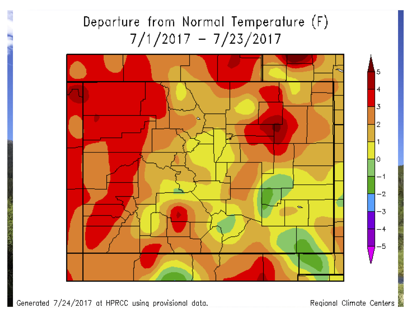
June was characterized by warm and dry conditions; statewide it was the 12th driest June on record and the driest we have seen since 2013. Above average temperatures have continued into July, particularly on the west slope where it has been as much as four degrees above average. Consequently, abnormally dry conditions have expanded west of the divide, should we have a strong monsoon season these conditions may be abated. Reservoir storage remains high, and municipal water providers have no immediate concerns with levels of supply and demand in their systems.
Reservoir storage statewide remains high at 113% of normal.
After receiving only 23% percent of statewide average precipitation in June at SNOTEL stations, July precipitation
to date statewide is 125% of average as of July 24.
Long-term forecasts for the monsoon season indicate a continuation of above average temperatures and above average chances of precipitation, mostly in August.
ENSO-neutral conditions are forecast to persist throughout the fall.
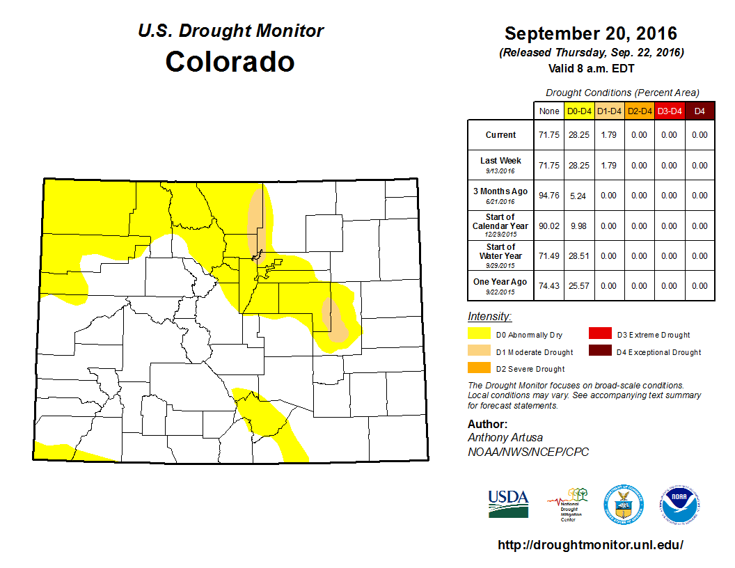
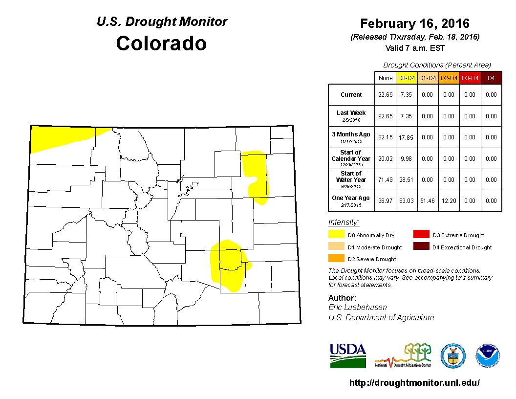
36 percent of Colorado is classified as abnormally dry (D0), with no other drought classifications in the state.
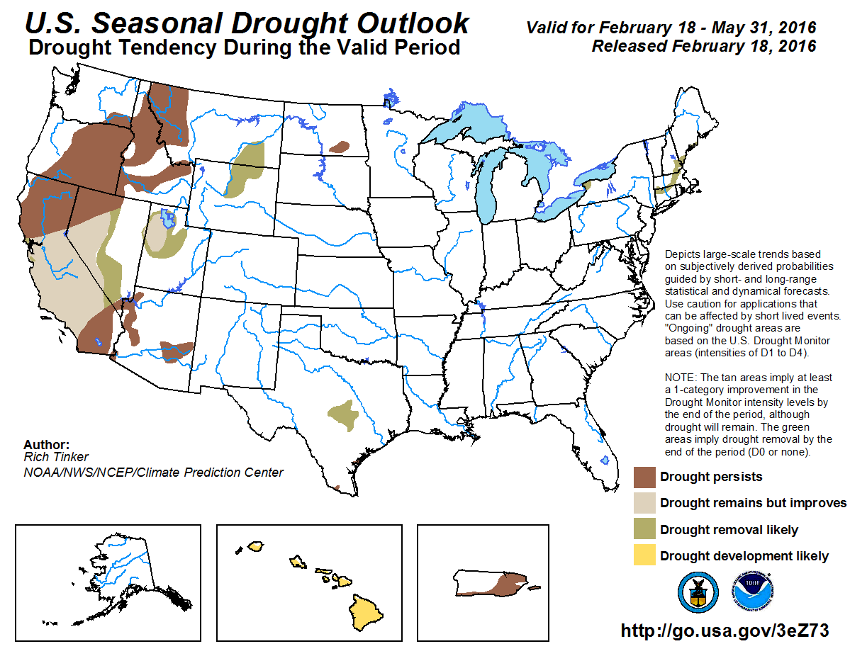
Warmer than normal temperatures have affected Colorado throughout the summer and are forecast to continue into the fall.Models indicate above normal chances of precipitation for parts of Colorado through the monsoon season (Aug-Oct). Should this forecast verify this would bring much needed moisture to parts of the state that are currently abnormally dry. Three month precipitation outlook through October 31, 2017 via the Climate Prediction Center.
The Colorado Division of Water Resources is the authority behind daily water administration across the state. Many are not aware that this agency has been highly instrumental in shaping how water in the San Luis Valley is distributed and utilized.
The Division of Water Resources operates under the authority of the office of the State Hydraulic Engineer, an office created by the state legislature in 1881. The office was directed by governor’s appointment and the initial duties included water rights administration, streamflow and diversion measurements, and reservoir capacity, cost and location. The office was added to the Department of Natural Resources in 1969.
The first and foremost responsibility for the Division of Water Resources is the oversight of all surface and groundwater across the state. It is the only state agency that is tasked with the direct and daily administration of water. The division is required to uphold Colorado water law which operates under what is known as the Prior Appropriation Doctrine. This means that those who were first to utilize the water are the first to have access to it during periods of shortage. In 1879, water commissioners were established in order to administer this doctrine. This made Colorado the first state that provides water administration by public officials. Currently, the major responsibilities of DWR include water administration, public safety, groundwater permitting, interstate compacts, a hydrographic program, and public information services.
The Division of Water Resources also has the authority to make recommendations in water court cases. This is an operation that occurs on a regular basis. Additionally, DWR can join the opposition in a case if there is potential for an injurious outcome and it is deemed necessary. Also, DWR can issue orders to those who refuse to comply with statutes and even take the matter to court.
There are seven divisions in DWR, divided by Colorado’s major drainage basins. Each division is under the direction of a division engineer who administers ground and surface water within the division. The San Luis Valley falls within Division 3. As of 2017, there are approximately 30 DWR employees for Division 3 including 11 water commissioners and eight districts. There are also well metering technicians and hydrographers at DWR. The Division 3 Engineer is Craig Cotten.
During his tenure, Cotten has observed that there are reasons why Division 3 is unique. The first reason is that it is arguably the most over-appropriated of all the divisions in Colorado. Secondly, it has one of the lowest storage capacities. This means that many of the other divisions have much larger reservoirs, hence much more ability to utilize and distribute water. However, Cotten attributed many challenges that occur within the division to over- appropriation. This has resulted in the need for closer monitoring of water usage in the San Luis Valley including well meters and 60 gauging stations along all of the rivers and streams of Division 3 to ensure that the correct amounts of water are delivered where they need to go.
An important aspect of Division 3 is well rules and regulations. Due to a limited amount of highly appropriated water, DWR found the need to consider long term considerations in the San Luis Valley. Also, maximum utilization was/is needed to assure that water rights are fulfilled but not inappropriately curtailed, and to maintain the economy. The replacement of injurious depletions and maintaining a sustainable aquifer system were/are also key considerations as to why the rules now exist. The conclusion became that less pumping is necessary, particularly for the aquifer system. Thus, the result was the drafting of the rules and their submission to the court by the State Engineer in 2015. The current rules require well owners to choose one of three options. The first option is to obtain a plan for augmentation. The second option is to participate in a groundwater management subdistrict. The third option is to cease pumping. The rules are now set to be finalized by the court in January of 2018. DWR is currently working towards resolutions with objectors.
One of the most important tasks that DWR oversees is the Rio Grande Compact. Quite simply, the Rio Grande Compact is law. Signed in 1938, it is an agreement between Colorado, New Mexico, and Texas. Reasons for this agreement include a limited water supply and over- development of surface and groundwater resources. The compact is intended/designed to equitably apportion the waters of the Rio Grande above Ft. Quitman, Texas. This law is administered by three commissioners who are the state engineers of Colorado and New Mexico and a governor’s appointee from Texas. Colorado is required to deliver water to the New Mexico state line and New Mexico has been required to deliver to Elephant Butte Reservoir since 1949.
The other compact that Division 3 administers is the Costilla Creek Compact. This is an agreement between Colorado and New Mexico. In addition, Cotten pointed out that the Costilla Creek Compact is also the only compact where Colorado is classified as the downstream state. This agreement operates under a priority system much like the Prior Appropriation Doctrine.
“These compacts are the only ones to be administered directly from our office,” said Cotten. Yet another aspect that is unique to Division 3.
This is also a time of transition at DWR due to the retirement of State Engineer Dick Wolfe. His successor is Kevin Rein. Despite the change, Cotten expressed confidence in the laws and system that are in place and that the high standard that was set by Wolfe will continue to be upheld.
There are many tasks that the Division of Water Resources is charged with and there is a great deal that happens daily to ensure that they are all accomplished. The Division 3 office can be reached by calling 719-589-6683 or on the web at http://www.dwr.state.co.us.
The Rio Grande Basin Roundtable meets the second Tuesday of every month at 623 East Fourth Street in Alamosa. For more information visit us at http://www.rgbrt.org
Helen Smith is the Outreach Specialist for the Rio Grande Basin Roundtable. Read part 1 here.
Here’s the release from Governor Hickenlooper’s office:
Gov. John Hickenlooper today announced Kevin Rein’s appointment as the new State Engineer and Director of the Colorado Division of Water Resources. Rein replaces Dick Wolfe, who retired at the end of June after 10 years in the position.
Rein has served as the Deputy State Engineer since 2008, where he directed and supervised the review and engineering evaluation of substitute water supply plans; water court and well permit applications; subdivision water supply plans; and other instruments that guide the management of water rights throughout Colorado. He has worked for the Division since 1998.
“The importance of water administration has never been more clear as we implement Colorado’s Water Plan,” said Governor John Hickenlooper. “Kevin’s experience and leadership will be crucial to our state’s long-term success in protecting this vital resource.”
As State Engineer, Rein will oversee and manage the Division of Water Resources within the Department of Natural Resources. The Division is responsible for administering Colorado’s water rights system, issuing water well permits, representing Colorado in interstate water compact proceedings, monitoring streamflow and water use, approving dam construction repair and safety inspections, and maintaining numerous water information databases.
“The chance to serve the state in this new capacity is an honor and a privilege,” Rein said. “The Division of Water Resources boasts a team of committed individuals focused on administering the state’s water resources and serving the public, and I am honored by this leadership opportunity. We will work with our customers to solve problems, exercise good stewardship, and assist the public in understanding Colorado’s water heritage.”
The State Engineer’s Office was created in 1881 and includes 260 employees. Its mission is to competently and dependably administer and distribute the waters of Colorado in accordance with the laws of the state, ensure that dams and water wells are properly constructed and maintained to ensure public safety, and to develop, maintain, and provide access to accurate and timely information regarding water resources.
Greg Hobbs was one of the guests at the celebration of Dick Wolfe’s retirement as State Engineer hosted by the Colorado Department of Natural Resources at the Governor’s Mansion’s Carriage House. He sent in this short poem and gallery of photographs.
This slideshow requires JavaScript.
Ten Years The State Engineer Dick Wolfe Celebration
Invite Dick Wolfe to his farewell party,
you’d expect somewhere out there
along a Colorado creek
A water commissioner on the other end
would be holding up a cell for
The Mother of Rivers dialing-in
to say, “Well done, my
faithful friend!”
Greg Hobbs 6/28/2017
Adiós Dick, it has been my great honor knowing you. I really appreciate your support for Coyote Gulch over the years. Keep on trucking. Here’s a quote from that blues guitarist we both loved. I think he could be talking about your service to Colorado:
“I don’t like to feel that I owe anything. I like to feel that I pay my own way — there’s no free lunch. And when people give me all these great compliments, I thank them but still go back to my room and practice. And a lot of times I say to myself ‘I wish I could be worthy of all the compliments that people give me sometime.’ I am not inventing anything that’s going to stop cancer or muscular distrophy or anything, but I like to feel that my time and talent is always there for the people that need it.” — B.B. King, from an interview on Slate.
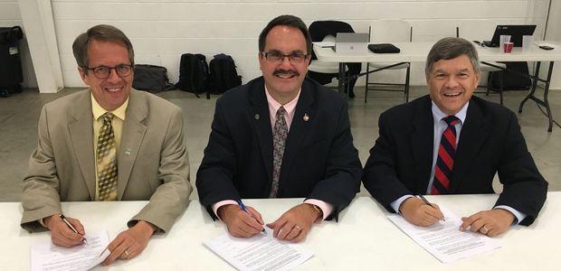
Photo: The commissioners of the Republican River Compact Administration sign the long-term resolutions on August 24, 2016: (from left) Commissioner David Barfield, Chief Engineer, Kansas Department of Agriculture; Commissioner Dick Wolfe, State Engineer, Colorado Division of Water Resources; Commissioner Jeff Fassett, Director of Nebraska’s Department of Natural Resources, via Governor Hickenlooper’s office.
May was characterized by wet and cool conditions, particularly in southeast Colorado. The first 20 days of June were a drastic change characterized by hot temperatures and little rainfall. In most parts of the state, streamflow forecasts throughout the summer season are projected to be near normal to above normal and reservoir storage remains high. These conditions leave municipal suppliers generally feeling comfortable with current levels of supply and demand in their systems.
After an early peak snow accumulation across the state, snow has melted out in most areas.
Reservoir storage statewide remains high at 109% of normal.
After receiving 132% percent of average precipitation in May at Snotel stations, June precipitation to date statewide is only 30% of average as of June 21.
Long-term forecasts for the summer season are not suggesting any major departure from normal conditions across Colorado.
Per the June 20 U.S. Drought Monitor, only 6 percent of Colorado is classified as abnormally dry (D0), the same as last month, with no other drought classification area in the state.
In the past 10 years, more than 15 people have drowned on the river from various accidents. Lopez’s death was the first in years involving a low-head dam.
These [weirs] dot rivers across the country, including in Fort Collins, where there is one low-head dam every 1.5 to 2 miles along much of the Poudre.
In Colorado, there is no agency in charge of overseeing safety at these dams. Instead, the Division of Water Resources has a team charged with overseeing the risks associated with large dams at sites such as Horsetooth Reservoir that could pose a hazard if they failed, Colorado Division of Water Resources Dam Safety Chief Bill McCormick said.
“I think these are some of the most dangerous type of structures we have in the country because most people are unaware of the dangers,” said Bruce Tschantz, a Knoxville, Tennessee, water resources engineer who has studied low-head dams extensively. “People tend to overestimate their ability to overcome the current and underestimate the dangers.”
General currents upstream and downstream from a low-head dam. Graphic via Bruce a. Tschantz
In much of the country, low-head dams have been in place for more than 100 years to serve now defunct mills. In Colorado, many of these dams are still active, diverting water into irrigation ditches for agricultural use. While the structures are old, the danger is relatively new.
“The problem of safety around them is more a recent phenomenon as people are using the rivers more,” McCormick said.
The dams slow water upstream and divert it away from the main channel. The water that flows over them creates a rapid on the downriver side that mimics the hydraulics of a washing machine. The water can force victims underwater and spin them around, making it nearly impossible to swim back up to the surface.
“These structures are often very deceiving,” said Kenneth Smith, Indiana Department of Natural Resources assistant director…
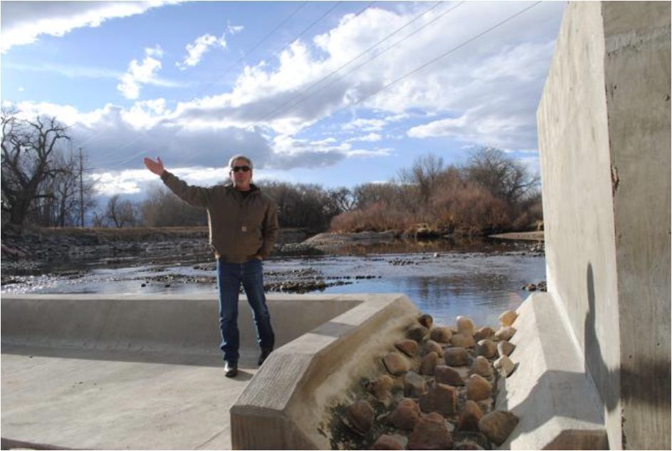
Simple engineering solutions can make low-head dams built today much safer by breaking up the flow of water as it moves over the dam. Solutions could include a set of concrete stairs or large rocks on the downstream side of the structure. In many cases, those solutions could be added to existing dams, but that can be costly, and it can be difficult to track down the owners of these century-old structures.
Poudre Fire Authority has been in discussions about what might be done to make sure people know about the dangers of the dams, including the possibility of installing signs along the river warning people of where they are.
Cool and wet conditions across much of Colorado throughout May have resulted in widespread elimination of drought conditions, abnormally dry conditions are present in Mesa and Park counties and will continued to be monitored. Water providers have no immediate concerns and expect reservoirs to fill. Some crops have been lost as a result of freeze, but will be replanted.
Statewide water year- to- date snowpack as of May 25th is at 149% of normal, however this time of year small amounts of snow accumulation can result in large percentile increases. All basins have seen their peak accumulation for the year and begun to melt out.
Reservoir storage statewide remains high at 112% of normal and all basins are at or above normal, with the highest storage levels in the Gunnison (126 percent) and the lowest in the Upper Rio Grande (98 percent).
While the higher elevations were a bit drier in April (89% of average precipitation), the statewide average April precipitation was 117% of average, primarily due to the large amounts that accumulated at the end of the month in southeast Colorado.
Given recent precipitation both streamflow forecasts and the Surface Water Supply Index (SWSI) are expected to rise in the June 1 update.
The June-August forecast from the Climate Prediction Center (CPC) supports the possible development of an El Nino with more moisture than average through the growing season. The temperature outlook indicates warm conditions in the south and west with equal chances of below, normal and above average temperatures in the east and north.
The Colorado Water Conservation Board and the Colorado Division of Water Resources is holding a series information and input meetings on the new Agricultural Water Protection Water Right law. A handful of local farmers and other interested parties attended the session on Wednesday at the Sterling Public Library.
The new law, which was sponsored by both Rep. Jon Becker, R-Fort Morgan, and Sen. Jerry Sonnenberg, R-Sterling, installs safeguards in the event that irrigators want to change part of their water right to a new beneficial use.
Deputy State Engineer Kevin Rein conducted the session, first walking through the process of writing rules and regulations to put the new law into effect, and then encouraging questions and discussion of the new rules.
Much of the discussion centered around whether the new program was even feasible for individual irrigators or would be a better fit for irrigation districts and ditch companies. It was generally agreed that, because of costs and the intricacies of water law, the larger the entity managing the lease, the better the plan would work. Individual irrigators could pledge a certain number of their water shares toward the ditch company’s AWPWR program and let the company worry about return flows, legal fees, and other details based on the total amount of water leased.
Don Ament, who represents Colorado in the South Platte Recovery Program, said he wants to follow up to see whether irrigators in the South Platte River Basin would, by virtue of being part of the SPRP, be automatically part of a conservation program, as required by the new law. He was told during the meeting that “Title 38” of Colorado Revised Statutes might prohibit that. It’s possible the wrong CRS was cited, since Title 38 has to do with tenant and landlord rights, while Title 37 is about water and irrigation. Ament said he would have to look into the law…
There also was significant discussion of just how much water a farmer could lease. The new law limits the amount of water an irrigator can lease out to half of his consumptive use right. That’s to help make sure most of the irrigation water still goes to irrigate crops.
Early in the discussion, Rein displayed a graphic that showed a water right that allowed 10 cubic feet per second of water flow through an irrigator’s head gate. If his historic return flow was four CFS, that meant his consumptive use is six CFS. He would then be allowed to lease half of the six CFS, or three CFS, under the AWPWR program. That would leave him a total of seven CFS of ditch flow to irrigate with. Because he would be running less water on his land, his return flow would naturally diminish. That’s why the law requires a substitute water supply plan; it would show how the irrigator would maintain his historic return flow of 4 CFS.
But that, it turns out, is the simple part. To complicate matters, irrigators don’t actually measure their water rights in a ditch company in cubic feet per second, but in shares. And farmers typically wouldn’t want to lease half of their total shares as part of an alternative transfer, even temporarily.
If, for instance, a farmer owns 100 shares in a ditch company, he may want to commit half of that, or 50 shares, to the AWPWR program. Because he would have only 50 shares in the program, he could lease only half of those 50 shares. But return flow still needs to be calculated, and return flow is measured in acre feet of water per year or in cubic feet per second. The irrigator (or his ditch company) would have to show how that return flow would be maintained.
To further complicate matters, shares don’t necessarily mean a specific amount of water. The amount of water a farmer’s 50 shares contains depends on how much water is available, who else is taking water with a higher, or older, priority, and other factors.
Rein said all of those factors would be up to the state engineer’s office to determine…
While discussion moved into the more esoteric realm of hypothetical legal matters, John Stulp, who serves as Gov. John Hickenlooper’s special policy advisor for water, reminded the group of the purpose of the new law.
“Keep in mind that the spirit of the law was to protect agriculture, and to give farmers the chance to participate in some of those revenue opportunities that are available through ATMs,” he said. “You need to be getting ready; it may not be your generation (that participates) but you need to do the groundwork for being flexible with your water right.”
Joe Frank, manager of the Lower South Platte Water Conservancy District, is known to be skeptical of ATMs because there is rarely any mention of how the water is to be stored for transfer and what kind of infrastructure will be needed to transfer it. He said after the meeting that, while he thinks flexibility in determining the end user on an ATM is a good thing, the new law still doesn’t address some of his concerns.
“There are still the inherent question marks about ATMs,” Frank said. “This just gives somebody who’s thinking about ATMs the ability to go to court once, change their water right, and be able to be flexible in who they lease the water to.
“But ATMs in general still have the issues that I brought up; you need a place to store it, you need a way to get it to the end user, you need a way of bringing multiple users together, so there are still those inherent issues.”
Frank said ATMs still represent a “drying up” of some farmland because the water is being diverted from irrigation to other consumptive uses.
“My alternative to ‘buy and dry’ is new supply,” he said. “We need to capture unappropriated water and store it, and maybe plug in ATMs. In my perfect world the best way to plug in an ATM is as part of a new project that takes advantage of available water supplies.”
The act authorizes an owner of an absolute decreed irrigation water right in water division 1 or 2 that is used for agricultural purposes to seek a change-in-use decree in water court to obtain an agricultural water protection water right.
Under the changed water right available in water division 1 or 2, the water right owner may apply for a renewable one-year substitute water supply plan through which the water right owner may lease, loan, or trade up to 50% of the historical consumptive use portion of the water subject to the water right without designating the specific beneficial use for the leased, loaned, or traded water. The one-year substitute water supply plan authorizing the lease, loan, or trade of water may be renewed twice without reapplying if the terms and conditions of the plan remain unchanged. A new application is required every 3 years to maintain the substitute water supply plan.
Pursuant to rules developed by the state engineer and reviewed by the water judge for water division 1, the state engineer may approve a one-year renewable substitute water supply plan authorizing the lease, loan, or trade of water subject to an agricultural water protection water right in water division 1 or 2 if the following conditions are met:
The remaining portion of the water subject to the water right must continue to be used for agricultural purposes;
The water right must be protected by the owner’s participation in an agricultural water protection water program, for which the Colorado water conservation board will establish minimum criteria and guidelines;
The owner shall not lease, loan, or trade water subject to the water right outside of the water division with jurisdiction over the location of historical consumptive use; and
The transferable portion of the water subject to the water right must be delivered to a point of diversion that is subject to an existing water court decree.
Retiring state engineer reveals all at Arkansas River Basin Water Forum
Those mystified about what the expression “use it or lose it” means to water rights will have the opportunity to hear Colorado’s State Engineer Dick Wolfe explain the myth and reality of the concept on April 26.
Wolfe, 55, is retiring from the position he has held for 10 years in June. But he agreed to explain how water rights can and cannot be abandoned at this year’s Arkansas River Basin Water Forum, April 26-27 at Hotel Elegante, 2886 S. Circle Drive, Colorado Springs.
“We started looking at what ‘use it or lose it’ really meant two years ago,” Wolfe said. “We wanted to sort out the issues for our stakeholders.”
What resulted was a special report from the Colorado Water Institute co-authored by Reagan Waskom, director of the CWI; Deputy State Engineer Kevin Rein; Wolfe; and consultant MaryLou Smith.
The report is written more like a conversation than an operating manual, and delves into the mistaken notion that every drop of irrigation water must be applied, or the owner of the water right will risk abandonment.
In practice, the owner of a water right must show the intention to abandon the water right for abandonment. However, the way in which water has been used affects the yield of a water right in change of use cases, according to the report.
The concept is important as the state moves into new concepts such as irrigation water conservation, rotational fallowing, and in-stream water rights donations.
Wolfe also plans to touch on his impending retirement, which he half-jokingly predicted when he told Gov. Bill Ritter in 2007 that he’d “like to have the job for 10 years and then retire.”
During his watch, there were major changes in administration of state water law in the Arkansas River basin.
The biggest change was the implementation of Surface Irrigation Improvement Rules, which were adopted to prevent expansion of water use by more efficient irrigation means such as sprinklers or drip tape. Wolfe addressed concerns by hosting months of meetings with irrigators and conservancy districts prior to filing an application in water court.
“The most unexpected thing was that we were able to address the concerns of 22 objectors without going to trial,” Wolfe said.
Another unexpected development was the rise of basin roundtables, which added new layers of review to already complicated water decisions.
Finally, filed under “unfinished business” is how water rights are administered for marijuana cultivation.
“That’s a statewide issue, but a lot of the activity seems to be centered in the Arkansas basin,” Wolfe said.
Division of Water Resources State Engineer Dick Wolfe tackled the “use it or lose it” concern during the Rio Grande Basin Ag Producers’ Water Future Workshop in Alamosa on Tuesday.
“People think they have got to divert everything under their water right or they will lose it,” Wolfe said.
He said the important thing to remember is historical consumptive use.
Most water in Colorado is diverted for irrigation, “for beneficial crop use,” he explained. Wolfe was involved in compiling a special report issued in February 2016 by the Colorado Water Institute in an effort to educate people on the “use it or lose it” concept.
The report addresses five main concerns: 1) maintaining conditional water right; 2) administering absolute water right; 3) abandoned water right; 4) changing use of a water right from agriculture to municipal use; and 5) implications of conservation program participation.
Wolfe specifically dealt with the fourth concern, changing the use of a water right, during Tuesday’s conference. He explained that water right changes come under dual administration, both from the state engineer’s office and the water court, which adjudicates the water right.
“Any change of water right can be time consuming and costly,” he said.
A change of water rights case has to consider whether the change will injure existing users or use more water than historically used.
Water rights come with restrictions such as the maximum that can be diverted, flow rate and area of land, Wolfe explained. The historic consumptive use is critical in water use change cases, he added, with the historical consumptive use of a water right often being less than the maximum that was allowed to be diverted under the original decree. Wolfe used a hypothetical example of a water right decreed for 150 cfs (cubic feet per second), but only 100 cfs had historically been used to irrigate the farmland, with only 60 cfs actually consumed by the crop and 40 cfs returning to the river. If the owner of the property wanted to dry up the farmland and sell the water right to a factory, for example, the owner could not transfer the full 150 cfs that was decreed in the water right, Wolfe explained. The owner could only transfer the 60 cfs that was historically consumed on that property. The water that has historically gone down the river must continue to do so.
Wolfe said someone might argue that they should divert their entire decreed right, then, but the crop can only consume so much water, and that consumptive use is what can be transferred.
“The measure of that is still historical consumptive use,” Wolfe said. “It’s limited by the amount the crop can consume.”
The duty of water is also something to consider, Wolfe added. If folks are diverting more water than they need, they could be depriving others and causing unintended impacts to the stream system, he explained.
Colorado water law does not permit wasteful water use, and Wolfe said he would be issuing an order in the next few months giving clear guidance on what wasting water means.
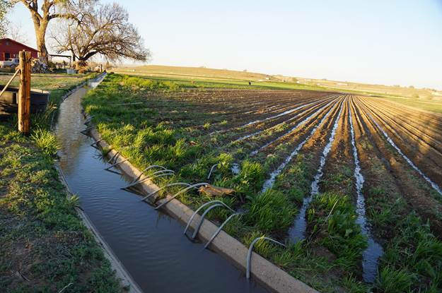
Flood irrigation in the Arkansas Valley via Greg Hobbs
From DWR/CWCB:
In early April, the Division of Water Resources (“DWR”) and the Colorado Water Conservation Board (“CWCB”) will jointly hold four informational meetings and solicit public input related to the implementation of House Bill 16-1228, known as the Agricultural Water Protection Water Right Bill. This legislation, enacted in 2016, allows water users, if they choose, to change an irrigation water right through the water court to an “Agricultural Water Protection Water Right.” The change allows a portion of the water right to be put to a new beneficial use through a substitute water supply plan (“SWSP”) approved by the State Engineer, while a portion of the original water right must continue to be used for agricultural purposes. The legislation directed the CWCB to develop Criteria and Guidelines to address provisions in the bill and directed the State Engineer to promulgate rules that would guide the approval of a SWSP.
The meetings will be held at the following times and locations:
Monday, April 3, 3 – 6 p.m., Island Grove Regional Park, Events Center Conference Room A, 501 N 14th Ave, Greeley, CO 80631
Tuesday, April 4, 3 – 6 p.m., Otero Junior College Student Center Banquet Room, 1802 Colorado Ave, La Junta, CO 81050
Wednesday, April 5, 3 – 6 p.m., Sterling Public Library Community Room, 420 N 5th St, Sterling, CO 80751
Thursday, April 6, 3 – 6 p.m., Upper Arkansas Water Conservancy District Board Room, 339 E Rainbow Blvd # 101, Salida, CO 81201
The agenda for each meeting will be the same: description of House Bill 16-1228; discussion of the draft SWSP Rules; and discussion of the draft Criteria and Guidelines for the Agricultural Water Protection Program. Please visit the DWR website for more information on the legislation, public meetings, and process for providing feedback. The CWCB’s draft Criteria and Guidelines and the State Engineer’s draft Rules related to the implementation of House Bill 16-1228 are also available on the website, and the public is encouraged to review these drafts before the meetings.
Please use this link to RSVP to a particular meeting location by March 30 if you plan to attend.
The Colorado Water Conservation Board and the Colorado Division of Water Resources will hold a series information and input meetings on the new Agricultural Water Protection Water Right law.
There will be a meeting in Sterling April 4 from 3 to 6 p.m. at the Sterling Public Library.
Correction: The meeting is April 5th.
The new law, which was sponsored by both Rep. Jon Becker, R-Fort Morgan, and Sen. Jerry Sonnenberg, R-Sterling, installs safeguards in the event that irrigators want to change part of their water right to a new beneficial use.
Under Colorado water law, an irrigator who wants to lease part of his water to another end-user must go through a state water court process to get what is called a “decree change.” A key to the decree change is making sure the irrigator maintains the return flow that would have resulted from using the water for irrigation. Return flow is water that has been used to irrigate a crop and either runs off or seeps down into the river aquifer to be used by irrigators downstream.
Because water leases tend to be temporary, they are called “alternative transfer methods” because they are an alternative to buying the irrigated land outright and drying up the farmland, a practice called “buy and dry.”
Previously, the irrigator had to have a specified end user for the ATM. If a change in the end user was desired, the irrigator had to go back to water court and repeat the decree change process.
Under the new law, an irrigator will be able to change the end-user by submitting a substitute water supply plan to the state engineer’s office. The SWSP will have to include an explanation of how the irrigator will maintain his return flow obligation. The irrigator will still have to have a conservation program in place through a local agency such as a water conservancy district or irrigation district.
Joe Frank, manager of the Lower South Platte Water Conservancy District, said the new law is an improvement over a similar measure that was introduced a year before.
“Before, there was some fear that (water transfers) could lead to speculation, and that’s just not something we want to see,” Frank said. “(SB 16-1228) allows some flexibility, but reins in on the speculation piece so you can’t change all of your water right.”
He said that while such alternative transfer methods are becoming more common, they aren’t ideal as a solution to the water shortage.
“We don’t want to make this the end-all solution to the gap (in water supply) because it is still drying up some ag, but it isn’t a permanent dry-up,” Frank said. “The good part is you don’t have to keep going back to change your end-user.”
Click here to read the update (Taryn Finnessey, Tracy Kosloff):
Following a warm a dry autumn, winter has brought significant precipitation to the entire state, along with occasional cold snaps. As a result, all basins have experienced dramatic snow accumulation and are now well above normal for snowpack. Increased precipitation has also helped to alleviate drought conditions in many regions of the state, although moderate and severe drought remains on the eastern plains. Reservoir storage is above average and at this time water providers and agricultural producers have no significant concerns entering into the spring snow accumulation months.
Statewide water year- to- date snowpack as of January 18 is at 156 percent of average, representing a dramatic change from two months ago when snowpack accumulation was off to a much later than normal start. . The Yampa & White currently has the lowest snowpack in the state at 141 percent of normal while the basins of the Southwest have the highest snowpack at 170 percent of normal.
All basins received well above average precipitation in December ranging from a low of 144 percent in the Yampa & White to a high of 187 percent in South Platte. January to-date has seen even more accumulation ranging from a low of 236 percent of average in the Rio Grande to a high of 345 percent of average in the South Platte. Statewide December precipitation was 168 percent of average and January to date is at 280 percent of average.
Reservoir storage statewide remains high at 105% of normal. The Yampa &White River basins along with the Southwestern basins have the highest storage levels in the state at 118 and 114% of average, respectively. The Upper Rio Grande has the lowest storage levels at 86% percent.
Temperatures in northern areas of the state reached record lows of -48 degrees Fahrenheit (Walden) during recent cold snaps; while some SNOTEL sites are reporting 400+ percent of normal accumulation. On the plains the presence of snow on the ground provides insulation and protection to crops, like winter wheat, during these arctic blasts.
The Surface Water Supply Index (SWSI), calculated based on January 1 streamflow forecast and reservoir storage, is near normal statewide.
Despite heavy precipitation statewide, much of the eastern plains remain in some level of drought classification following a warm and dry fall. 20 percent of the state is currently experiencing abnormally dry conditions (D0) while 35 percents is classified as moderate drought (D1), less than 1 percent of the state, mostly in Lincoln County, is experiencing severe drought. This is an improvement from recent conditions.
A weak La Niña was diagnosed for late 2016, but forecasts indicate that it is unlikely to last and instead El Nino conditions are projected to develop during the spring. The development of a strong El Nino would favor increased precipitation for Colorado; however it is unclear if this will be a strong event.
Short term forecast show less active systems through the end of the month that are likely to result in dryer conditions than we have seen during the first half of January.
Globally 2016 was the warmest year on record, in Colorado 2016 was the 5th warmest year on record.
Scott Hummer, general manager of North Poudre Irrigation Company, talks about how his agency worked with Fort Collins Natural Areas and Colorado Parks and Wildlife to include a fish passage when the irrigation company replaced a diversion structure on the Poudre River that was destroyed by the 2013 floods. Work was completed [in February 2016]. (Pamela Johnson / Loveland Reporter-Herald)
Here’s the release from Colorado State University (Jim Beers):
The Cache la Poudre River, which flows from the mountains through Fort Collins, Timnath and Windsor to the plains east of Greeley, is at the heart of countless activities: from irrigating crops and lawns to providing drinking water for more than 365,000 people and hosting numerous recreational activities.
Those with connections to and concerns for the Poudre River will gather on Friday, Feb. 3 for the fourth annual Poudre River Forum. After its first three years at Larimer County Fairgrounds, the forum is moving down the river to Greeley as a reminder that the Poudre River is important to all who benefit from it — from its headwaters to its confluence with the South Platte. This year’s forum — the theme is “As the Poudre Flows — Forest to Plains” — will be held from 8:30 a.m.-4:30 p.m. at the Island Grove Events Center, 501 N. 14th Ave., Greeley. Pre-registration is required for all participants.
Understanding the river, each other
Sponsored by the Poudre Runs Through It Study/Action Work Group, the forum serves as a community-wide gathering of people from agricultural, municipal, business, recreational and environmental backgrounds to learn about and discuss issues related to the Poudre River.
“The Poudre River Forum brings together those who use the river for agricultural and urban diversions and those who work to improve its ecological health. In the past those groups have not necessarily seen eye to eye,” said MaryLou Smith, PRTI facilitator. “Increasingly our participants are open to the idea that it takes collective vision and action to make the Poudre the world’s best example of a healthy, working river.”
Once again, this year’s event will be facilitated by the Colorado Water Institute at Colorado State University. “The Forum is a great opportunity for the communities connected by the Poudre River to come together to better understand the entire watershed, and each other,” said Reagan Waskom, director of CWI.
Forests and water quality/quantity
Laurie Huckaby with the U.S. Forest Service, will present “The last 1,000 years in the Poudre according to the trees,” to kick off the topic of how important the upper watershed is to water quantity and quality.
“Water quality and forests are inextricably linked,” said Joe Duda of the Colorado State Forest Service, who will join Huckaby as one of the presenters. “Forest conditions and insects, disease and fire all can have profound impacts on water flow and quality. Only healthy, resilient forests can continuously supply clean water.”
Global lessons for local success
“Finding the Balance: Managing Water for People and Nature” is the message of keynote speaker Brian Richter. Richter has been a global leader in water science and conservation for more than 25 years, and currently serves as chief scientist for the Global Water Program of The Nature Conservancy in Washington D.C. Richter’s ideas about the importance of recognizing the balance of working river/healthy river are the basis for which PRTI was initially formed. He has consulted on more than 120 water projects worldwide, and has served as a water advisor to some of the world’s largest corporations, investment banks, the United Nations, and has testified before Congress on multiple occasions. Richter co-authored,with Sandra Postel, the 2003 book Rivers for Life: Managing Water for People and Nature and in 2014 wrote Chasing Water: A Guide for Moving from Scarcity to Sustainability.
Change affects all sectors
An afternoon panel session will probe the impacts of change — positive and negative — along the Poudre River and how they have been similarly and differently addressed by agriculture, urban, and environmental sectors. They will discuss what anticipated future changes might these three sectors see as opportunities or incentives for mutually beneficial collaboration that could result in a healthier, working river?
“It has been said that the only thing that is constant is change,” said John Bartholow, retired ecologist from U.S. Geological Survey, and panel coordinator/moderator. “The question is, can we learn to adapt to those changes sure to come on the Poudre in ways that benefit agriculture, municipalities, and the environment?”
The panel will include Eric Reckentine, deputy director, City of Greeley Water and Sewer; John Sanderson, director of science, Nature Conservancy of Colorado; and Dale Trowbridge, general manager, New Cache la Poudre Irrigating Company.
Videos, displays and music too
The day-long forum also includes “River Snapshots” highlighting more than 15 projects undertaken by a variety of groups on the Poudre last year; “My How the Poudre Has Changed,” featuring historical 1970’s footage of the Poudre; updates from both the cities of Greeley and Fort Collins on current water programs; and over two dozen river-focused displays from community organizations and agencies. The day concludes with a social hour including food, beer and other beverages, and river-themed door prizes.
Registration is $50 and includes lunch. Scholarships for students and reduced rates are available. The deadline to register is Friday, Jan. 27 at http://prti.colostate.edu/forum_2017.shtml.
For more information, contact event coordinator Gailmarie Kimmel at PoudreRiverForum@gmail.com or 970-692-1443.
A long-awaited ruling issued Monday by the Colorado Supreme Court sends Aurora back to court to discern exactly how much water the municipality can divert from the headwaters of the Fryingpan River through the Busk-Ivanhoe Tunnel under Hagerman Pass.
And the ruling clarifies that transmountain water rights under the Continental Divide in Colorado do not automatically come with a right to store water in a reservoir, anymore than other water rights do.
Aurora had argued there had always been an implied right in its decree to store water from the Fryingpan headwaters in Turquoise Reservoir. But the court didn’t agree.
“The supreme court concludes that the right to store water in the basin of import prior to use is not an automatic incident of transmountain water rights, but rather, must be reflected, or at least implied, in the decree,” the court’s majority opinion stated. “In this case, the decree is silent with respect to storage of the water on the eastern slope prior to use for supplemental irrigation and, on the facts of this case, the record does not support the water court’s finding of an implied right in the decree for such storage. To the extent that unlawful storage of the water on the eastern slope expanded the decreed rights, such amounts cannot be included in the quantification of those rights.”
The Colorado River District, which represents 15 Western Slope counties, said Tuesday in a statement it is “very pleased with the supreme court’s well-reasoned opinion in which it reversed the Division 2 water court. In particular, we are pleased with the court’s recognition that transmountain water rights are subject to the same legal principles as all other water rights in the state.”
As might be expected, Aurora officials were less pleased.
“The city is disappointed with [Monday’s] supreme court opinion reversing the trial court’s earlier decision,” said an Aurora representative in a statement. “The city regrets the departure from what it believed to be settled law regarding use of transbasin waters.
“Additionally, it appears due consideration was not given to aspects of the trial court’s determinations regarding the state of the law when the water rights were originally requested,” the statement said. “Aurora is currently evaluating its possible next steps.”
One possible next step is for Aurora to file a petition within 14 days for the supreme court to rehear the case.
If Aurora does not petition for a rehearing, the case will be sent back to water court in Pueblo for a recalculation of how much water Aurora is allowed to divert via the Busk-Ivanhoe Tunnel for municipal purposes, instead of for irrigation purposes.
The supreme court said the new calculation should include the 22 years from 1987 to 2009 when Aurora used the water for municipal purposes without a decreed right to do so.
And by factoring in those 22 years of “zero use,” the new calculation is expected to lower the amount of water the Front Range city can divert from the Fryingpan in the future.
Another aspect of the ruling could also reduce the size of Aurora’s water right, as the court found that much of the water diverted through the Busk-Ivanhoe Tunnel since 1928 had been stored without a decreed right to do so.
“Because undecreed storage of a direct flow water right may amount to an expansion of that right, any expansion of the Busk-Ivanhoe water rights resulting from the unlawful storage of those rights on the eastern slope cannot be included in an historic consumptive use analysis,” the ruling stated.
The court also suggested that harm may have been caused to junior water rights owners on the Western Slope by undecreed diversion and storage of the Busk-Ivanhoe water.
“Storage of a decreed direct flow right can potentially expand that right by permitting the diversion of available water not immediately needed for beneficial use — water that would otherwise be left in the stream for junior water users,” the ruling said. “This impact on junior users does not cease to exist just because the water is diverted for export to another basin. Junior users in the basin of export have a right to divert and use water not lawfully diverted in the first place under a senior water right, regardless of whether that water is diverted for transmountain use.”
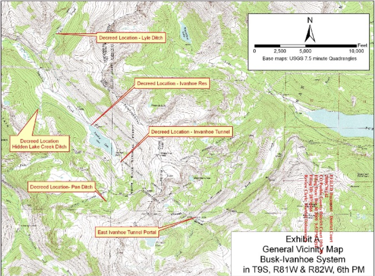
A map of the Busk-Ivanhoe system, with Ivanhoe Reservoir on the left side of the map and Turquoise Reservoir on the right.
Worth the fight
Pitkin County has been opposing Aurora in the case since 2009 and has now spent $353,000 in the process.
“It was worth it,” said John Ely, Pitkin County attorney. “It was important for Pitkin County to assert that transmountain diverters are subject to the same legal consideration as any other water diverter or water user, because Pitkin County hosts two of the larger water diversions in the state.”
In addition to the relatively small level of diversions through the Busk-Ivanhoe Tunnel by Aurora and Pueblo, significant amounts of water are diverted off the top of the Fryingpan and Roaring Fork rivers to the Front Range as part of the larger Fry-Ark and Twin Lakes projects.
Aurora still has a valid water right from 1928 to divert 2,416 acre-feet of water through the tunnel for irrigation uses in the Arkansas River basin.
But officials now want to use the same water for municipal purposes in Aurora, which is in the South Platte River basin.
And when the growing Front Range city came into the court in 2009 seeking a change to its water right, it admitted it was already using the Fryingpan water for municipal purposes without a decreed right to do so, and had been doing so since 1987.
However, Aurora told the court that that fact should not count against it in its change case. It also said it shouldn’t matter to the Western Slope how it used its water once it was sent under the Continental Divide, including if the water was stored in an East Slope reservoir or not.
A judge in Division 2 water court in Pueblo agreed with Aurora and ruled in its favor in August 2014. That decision was appealed by a list of Western Slope interests directly to the supreme court, which issued its opinion on Dec. 6, 2016.
Both the broad ruling, that storage is not an inherent right for transmountain diversions, and the narrow ruling, that Aurora needs to recalculate its historic consumptive use, were welcome news for Western Slope water interests.
“The reason our clients stayed involved is [that] from the get-go, Aurora was asserting some untenable legal positions that seemed to rely in large part on the concept that, ‘Well, we’re a transmountain diverter, so we look at things differently,’” said Kirsten Kurath, an attorney in Grand Junction.
She represented the Grand Valley Water Users Association, the Orchard Mesa Irrigation District, and the Ute Water Conservancy Districts in the case.
The other Western Slope parties in the supreme court case were Eagle and Grand counties and the Basalt Water Conservancy District.
The Colorado state engineer, and engineers in Divisions 1 and 5, were also in the case, and had sided with the arguments made by the Western Slope.
On the Front Range side of the arguments were Aurora, Colorado Springs, Denver Water, Pueblo Board of Water Works, Greeley, Northern Water, Southeastern Water Conservancy District, Twin Lakes Reservoir and Canal Co., Lower Arkansas Valley Water Conservancy District, Busk-Ivanhoe Inc., Cache La Poudre Water Users Association, and the city of Northglenn.
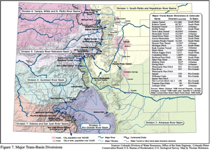
This graphic shows the transmountain diversions in Colorado. The Bousted Tunnel, at 53,871 AF, the Twin Lakes Tunnel, at 46,930 AF, and the Busk-Ivanhoe Tunnel, at 4,123 AF, have taken (in this data set) a combined average of 105,024 AF a year from the top of the Roaring Fork and Fryingpan rivers headwaters.
Editor’s note: Aspen Journalism, the Aspen Daily News, and Coyote Gulch are collaborating on the coverage of rivers and water. The Aspen Daily News published this story on Wednesday, Dec. 7, 2016.
A new proposal for storage in John Martin Reservoir will benefit both Kansas and Colorado, said Lower Arkansas Valley Water Conservancy District Manager Jay Winner on Wednesday
A new proposal for storage in John Martin Reservoir will benefit both Kansas and Colorado, said Lower Arkansas Valley Water Conservancy District Manager Jay Winner on Wednesday. This proposal is in line with the Colorado Water Plan. The plan was presented by LAVWCD Engineer Mike Weber. Phase I is paid for by a Water Supply Reserve Account grant supplied by the Colorado Water Conservation Board. Research by LAVWCD has determined water users which could potentially use the John Martin Reservoir Account. LAVWCD has also determined the types of water available to those entities that would be suitable for storage at JMR. Those entities include Kansas and Colorado District 67 Ditches (Fort Bent, Keesee, Amity, Lamar, Hyde, Manvel, X-Y Graham, Buffalo and Sisson-Stubbs). Amity is largest user at 49.5 percent of Colorado’s share. This would be in Phase II, if the plan is accepted at the meeting of the 2016 Colorado Kansas Arkansas River Compact. Down the line and several years in the future, other potential users of the storage in JMR might include Catlin Augmentation Association, City of La Junta, City of Lamar, Colorado Water Protection and Development Association, and water conservancy districts such as LAVWCD.
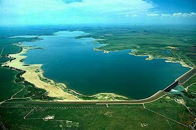
John Martin Reservoir back in the day
A permanent pool of 10,000 acre-feet is to be maintained at JMR and is to remain there as authorized by the 1976 resolution, for the purposes of recreation and not subject to a tax.
Several other projects were presented by Winner and commented upon by the Board of Directors, all of whom were present except Legal Director Melissa Esquibel. The North La Junta Water Conservancy District Project, Phase 2, will go before the Otero County Commissioners on Oct. 24, having passed the Otero County Planning Commission. A request has been made to negotiate the contract with the Pueblo Reservoir for 25 years rather than year by year. A commercial building in McClave has been purchased by the LAVWCD to locate some of its offices, notably the engineering having to do with Rule 10, nearer the location of the sites. Agreement with Water Quality through the Department of Agriculture is being sought. Another project had to do with sealing the irrigation ponds and testing for selenium in the ground.
The City of Fountain is contributing $24,000 more than their original $50,000 to the fund for cleaning up Fountain Creek. The other $200,000 is divided equally between the City of Pueblo and the LAVWCD. The money for the project is coming from the Aurora refund, said Winter.
Straight line diagram of the Lower Arkansas Valley ditches via Headwaters
You may have heard some discussion about the phrase Use It or Lose It lately. First, about how it is a guiding principle when using water under Colorado’s prior appropriation system. Then, more recently, about how it can be a misleading cliché.
It’s true that in certain straightforward situations, failure to use a water right for its decreed use will result in the loss of some or all of the water right. However, from there, it gets more complicated.
In 2015, a group of Colorado water professionals representing interests from around the state collaborated to explore Use It or Lose It’s application to water use. The discussion was initiated by the Colorado Water Institute. The Water Institute approached the concept by first identifying five areas where water users have concerns about losing their water rights.
The first three areas of concern are Maintaining a Conditional Water Right, the Continued Use of an Absolute Water Right and Abandonment of a Water Right. In Colorado a water user may obtain a conditional water right based on a non-speculative plan to use the water. If that person does not apply the water to its decreed use within a period of time, or at least maintain a diligent effort to develop the water right, it may be terminated by the water court. The water right is lost due to lack of use.
When the owner of a water right considers the risk of abandonment of some portion of a water right or the possibility of changing a water right to a different beneficial use (the fourth area of concern), the owner of the water right may consider it advantageous to divert as much water as possible — more than is needed for the applied use. The unintended consequences of doing that can range from unnecessarily taking water that could be used by water rights immediately downstream, to impacting sensitive fish and wildlife habitat, to increasing the water right owner’s own return flow obligation if the use is changed. Further, the water court doesn’t consider water diverted but not consumed as water that may be applied to a new use. So the practice of diverting more water than is needed, which is called “waste” in water administration, can actually be detrimental.
A fifth area of concern is the effect that Conservation and Sustainability Efforts can have on the value of a water right. To understand more about that area of concern and the rest of this issue, read Special Report No. 25: “Is ‘Use It or Lose It’ an absolute?” available on the Colorado Water Institute home page.
Kevin G. Rein is the deputy state engineer for Colorado Division of Water Resources.
Here’s the synopsis from Special Report No. 25 (Reagan Waskom, Kevin Rein, Dick Wolfe, MaryLou Smith):
Colorado water law is complicated and can easily be misunderstood. In particular, the component of a water right that requires it be put to a beneficial use without waste can create confusion.
It is a fact that wasteful water diversions and practices are not permissible under the state’s water law. Unfortunately, this has led to the adoption of the misleading adage “Use It or Lose It.”
This document clarifies how the use or nonuse of a water right affects its value.
…things look pretty good, according to the state’s Water Availability Task Force.
It’s all thanks to more rainfall than normal in August in most of Colorado, which left reservoirs across the state with an average of seven percent more water than they would normally have at this time of year.
“Our reservoirs are at pretty high levels for this time of year,” said Tracy Kosloff of the Colorado Division of Water Resources and co-chair of the task force. “That’s giving our water providers a lot of confidence going into the coming months.”
But rainfall in September has been below average and water providers on the Front Range are reporting low stream flows…
That is why state officials are waiting to see what snow might eventually come.
“We’re more looking forward to the winter season and what type of snowpack we’re going to accumulate in our mountains,” Kosloff said. “That’s really going to be the driver of our water supply going into the 2017 water year.”
The report from the task force notes the long-term forecast is still uncertain. El Nino is over and it’s not clear if a La Nina might develop. La Nina can mean drier conditions for Colorado.
From the Colorado Water Conservation Board/Colorado Division of Water Resources (Taryn Finnessey/Tracy Kosloff):
Following above average temperatures in June and July across the entire state, August was cooler with slightly below average temperatures. Precipitation has varied over the last two months with some basins seeing half of normal moisture while others have had upwards of 150 percent of normal rainfall. The Front Range corridor remains dry and warm and drought conditions have also been expanded into Elbert and Lincoln counties. The forecast for the next two weeks shows mostly dry conditions coupled with moderate temperatures.
The months of June, July and August were collectively the 13th warmest summer period on record. Temperatures in September have been above normal in the southern half of the state and near normal to the north.
With the exception of the Yampa & White River basins, the state received near to well above average precipitation in August. However, September precipitation is tracking well below average in all basins. Statewide water year- to-date mountain precipitation, as reported from NRCS, is at 96 percent of normal as of September 16th. The 2016 water year ends September 30th.
Reservoir storage statewide is 107 percent of normal. The South Platte and Yampa& White basins have the highest storage levels in the state at 112 and 110 percent of average, respectively. The Upper Rio Grande has the lowest storage levels at 91 percent. All other basins are above normal at 104 to 109 percent of average.
Front Range water providers all reported storage levels ranging from 80 to 126 percent of average, however they did express some concern regarding low stream flows, which this task force will continue to monitor.
The long term forecast is highly uncertain at this point. El Nino has concluded and ENSO neutral conditions exist. It remains unclear if La Nina conditions will develop. However, should La Nina materialize it does not necessarily mean Colorado will experience drought conditions.
MONTROSE — Dick Wolfe, Colorado’s state water engineer, told a group of irrigators here last week that it’s illegal for someone to take more water than they need because they are speculating on the future potential value of their water rights.
Wolfe was one of several guest speakers at the Uncompahgre Valley Water Forum, which was held on Sept. 1 at the Montrose County Fairgrounds.
“He’s going to talk about probably one of the most misunderstood parts of Colorado water law, and that is ‘use it or lose it,’” Lipton said.
Wolfe, who has been state engineer since 2007, began by saying that some people who own a water right can have a “misunderstanding” of what it means to “own and operate that water right in the context of ‘lose it or use it.’”
“They are really thinking in their minds, ‘I better divert it or I’m going to lose it,’” Wolfe said. “So oftentimes the context of ‘use it or lose it’ is ‘divert it or lose it.’”
But that thinking should actually “be framed as ‘beneficially use it or lose it,’” Wolfe said. “Because really the true measure of your water right is based on the beneficial consumptive use of that water right. Not how much you diverted, but how much you beneficially used it.”
Wolfe also said that when you go to change a water right in water court, “the measure of your water right is not based on how much you divert, but how much you consume of that. That’s how much you can take and transfer into the future. That’s what values that water right.”
He said it was easy for short adages to roll off one’s tongue, but when it comes to water rights in Colorado, the phrase “use it or lose it” should really be a mouthful, as in “establish and maintain a pattern of beneficially using it, for its decreed beneficial use, over a representative period of time, while in priority, without waste, or lose it.”
Or, in short, “beneficially use or lose it.”
“The essence of a water right is the application to a beneficial use without waste,” said Wolfe, the official responsible for enforcing compliance with Colorado water law. “In Colorado there are laws — specific provisions and statutes — that prevent someone from wasting water.”
(Please also see “Don’t take more than you need: wrangling wasted water on the Western Slope,” by Aspen Journalism.)
Well-tended fields along the White River west of Meeker irrigated by the Meeker Ditch. The ditch has been directed to divert less water at its headgate than it used to.
The ‘use it or lose it’ report
Wolfe said given the misperceptions about “use it lose it,” he began participating two years go with a group of stakeholders to help the Colorado Water Institute at Colorado State University issue a special report on the subject.
The report, released in February, is called “How diversion and beneficial use of water affect the value and measure of a water right,” and is subtitled “Is ‘use it or lose it’ an absolute?”
“It was engineers, attorneys, environmentalists, people from the cattleman’s association, corn growers,” Wolfe said of the group. “We thought we had a very wide range of stakeholders in this.”
He said the resulting 11-page document, which is in a question-and-answer format, is a helpful document that has been “very valuable in our administration efforts.”
“Administration” refers to managing the almost 180,000 decreed water rights in Colorado, which give people the right to use water from the state’s rivers and aquifers, but do so in priority based on the date of their water rights.
“We recognize that even some of our own staff had misunderstandings, misperceptions, of this ‘use it or lose it,’” Wolfe said. “So as water users come into contact with [our staff], we’ve got to make sure we are sending a consistent message on what it means when we talk about ‘use it or lose it.’”
A photo from the Resource Engineering report documenting waste on the Meeker Ditch in 2014. Water from the ditch is being turned out into Sulphur Creek, while the main flow in the ditch continues through the pipe above the outfall.
Still applies in some cases
Wolfe described several ways in which some aspects of “use it or lose it” can still shape a water right, which is why the phrase has such staying power.
One is when you have a conditional water right.
Every six years in Colorado “you either have to demonstrate that you are maintaining diligence or that you’ve put it to use to make it absolute,” Wolfe said of such rights. “If you have an inability to put that water to beneficial use, there is a potential to lose that through [the] diligence process.”
Another area where “use it or lose it” can apply is to absolute water rights, where water has been physically put to beneficial use.
But Wolfe said that “as long as you’re operating within the decreed conditions of that decree, you’re not going lose it.” And, he added, it is only in “very rare situations where an issue would come up with an absolute water right.”
Wolfe explained that every 10 years, regional division engineers prepare an “abandonment list” of water rights that have not been used consecutively in the last 10 years.
But once put on such a list, the holders of the water rights can usually explain that they never intended to abandon their water right.
Wolfe said it’s “pretty easy” for a water rights owner to get off the list, and “they can continue to move forward until we go to the next abandonment process 10 years later.”
Another area where “use it or lose it” comes up is in a change case in water court. If someone goes to sell a water right, they can’t sell the portion they’ve never put to beneficial use, Wolfe explained.
He then walked the audience through an example.
A field flooded with water from the Yampa RIver this year. The division engineer for Division 6 said this is an example of diverting more water than is necessary.
Farmer X
Say a farmer has a paper right to divert 150 cubic feet per second from the river, but they only divert 100 cfs.
“This could be because over time, maybe they’ve put in a sprinkler irrigation system, something that made them more efficient, so that they are only needing to divert 100 cfs,” Wolfe said.
The farmer’s corn crop consumes 60 cfs of the 100 cfs that has been diverted, and so 40 cfs returns to the river, either on the surface or underground.
So when the farmer goes to sell their water right to a city, they can sell the 60 cfs that was historically consumed by the crop. But they can’t sell the 40 cfs that returned to the river — in order to make sure that downstream users still get the same amount of water as before the sale.
“That’s the measure of your water right, how much you’ve historically consumed,” Wolfe said.
But if the farmer was overly worried about “use it or lose it,” they might instead divert 150 cfs — the full decreed amount of water in their right, he said.
“When someone is thinking about ‘use it or lose it,’ they oftentimes think about, in this example, ‘I’ve got 150 cfs water right, I’m only diverting 100 cfs, so boy, if I’m concerned about maybe selling that someday, and I might lose some of my water right, I better divert that entire 150 cfs,’” Wolfe said. “This can lead to a practice of diverting more water than someone needs.”
Wolfe said the state of Colorado has the right to reduce the amount of water someone diverts from the river, if they are taking more than they need to get the job done.
“If we determine in that process that there is waste occurring, then we can curtail that water right back to what we think is a representative duty of water,” Wolfe said. “Remember, in the state constitution, the water belongs to the public. It’s the public resource, and there are a lot of laws written trying to protect this precious resource we have.
“We have this duty to only use what you beneficially need without waste, because there is all these other people and other uses that rely on that public resource.”
Editor’s note: Aspen Journalism and the Aspen Daily News are collaborating on the coverage of rivers and water. The Daily News published this story on Tuesday, Sept. 6, 2016.
The Republican River Compact Administration signed off on a resolution presented by Colorado last week during the three-state entities’ annual meeting.
The resolution lays out the final steps Colorado has to take for compliance with the Final Settlement Stipulation and Republican River Compact, between it, Nebraska and Kansas.
If Colorado meets the requirements laid out in the resolution, it will be protected from any further lawsuit filings in the matter by Kansas or Nebraska.
“It basically means Kansas can’t come after us again and again,” Colorado State Engineer Dick Wolfe said. “It doesn’t prevent them from raising some other issue we haven’t thought of yet.”
He added the states have agreed to try to work out future issues among themselves instead of immediately going to the costly and time-consuming non-binding arbitration process.
“This is not nearly as restrictive as some people fear,” Deb Daniel, general manager of the Republican River Water Conservation District, said of the resolution.
A final agreement on the use of Colorado’s compact compliance pipeline, as well as the voluntary retiring of more acreage along the South Fork of the Republican River, are the key components in the resolution. Colorado already has removed 23,838 acres from irrigation in the South Fork Republican River Basin, through voluntary retirement programs such as the federally-funded CREP.
The resolution, presented last week in Burlington by Wolfe, and signed by him and Kansas’ David Barfield and Nebraska’s Gordon W. Fassett, calls for Colorado to utilize voluntary programs to retire up to an additional 25,000 acres from irrigation in the South Fork Republican River basin.
The resolution states Colorado will retire at least 10,000 acres by 2022, and the remaining 15,000 acres by December 31, 2027. It also includes language allowing Colorado to submit to the other states for their approval a plan to reduce consumption within Colorado by other means if the state cannot or will not retire 25,000 acres by the 2027 deadline.
“It gave us and the users the most flexibility going into the future,” Wolfe said.
Daniel noted the agreement does not make any mention of stream flows or how much acre feet of water must be removed from consumptive use, only acreage.
Erin Light, center, and Shanna Lewis in a pasture with a mule while checking on the Meeker Ditch on July 11. Light has curtailed diversions into the ditch, which she determined was wasting water.
MEEKER – The mule in a pasture east of Meeker along the White River seemed happy to see Erin Light, a state division engineer, and Shanna Lewis, a water commissioner, when they went to take a look at the amount of water flowing through the Meeker Ditch on July 11.
Lewis, who grew up on a Colorado ranch, praised the mule’s beautiful, deer-like coloring and said they’d become friends on her frequent visits to check the ditch.
But the warm equine reception the two enforcers of Colorado water law received differed from the response they sometimes get from ranchers in Division 6, which encompasses the Yampa, White and North Platte river basins, especially when they are visiting a ditch because they think its operator is diverting more water than they need through their head gate.
“I would say I’m more telling than I am curtailing,” said Light, who has been the division engineer based in Steamboat Springs since 2006. “There have only been a few situations where I’ve actually said, ‘That’s it. We’re curtailing you.’ And they’re very obvious situations where they’ve got a lot of water going down the tail end of their ditch, where you can’t argue that this isn’t waste.
“Where the problem becomes in determining waste is that I can go out to a piece of land and say, ‘Oh my gosh, you’ve got 6 inches of water on this land. There’s ducks swimming around. This is wasteful,’” she continued. “You can go to the landowner or the irrigator and say, ‘This is waste,’ and they’ll stare you right in the face and say, ‘The hell it is.’”
Division and state engineers working for Colorado’s Division of Water Resources, as Light does, are the only officials who have the authority to determine if waste is occurring on an irrigation system. And their primary response is to curtail wasteful flows at the head gate.
But determining if there is waste in a ditch is a case-by-case exercise. It’s site specific and time sensitive, and it can take time to understand how someone manages their ditch.
There’s no state definition of waste or written guidelines, but in the end it’s a fact-based analysis focused on how much water is needed to irrigate so many acres.
An allowance is also made for customary inefficiencies on a ditch system. Water leaking out of an old ditch, for example, is not considered waste. But beyond inefficiency, which is often a physical issue, there is waste, which is usually a water-management issue.
And waste is a much bigger issue on the Western Slope than on the state’s drier eastern plains, where irrigators have long watched for anyone wasting water.
A field flooded with water from the Yampa RIver this year. Erin Light, the division engineer for Division 6, said this is an example of diverting more water than is necessary.
Free river, or not
In 2014, Light served the Meeker Ditch with a written curtailment order, and she also told the big Maybell Canal on the Yampa River that they had to stop wasting water.
And she did so even though neither river was “under administration,” the term for the body of water being called out by senior downstream diverters, so both were considered in a “free river” condition.
Nor was there another water right that was being injured by either ditch’s diversions.
Just in the past 10 days, Light’s office has informed rancher Doug Monger that water is being wasted in the irrigation system he manages on his Yampa River Ranch three miles east of Hayden.
Monger is a Routt County commissioner, a member of the Yampa-White Roundtable, and a director on the Colorado River Water Conservation District’s board.
When asked Tuesday, during a break in a daylong strategic retreat at the River District, about Light’s belief that he was wasting water, he responded in a way that she has heard before.
“I don’t know what the hell difference it makes if I’m wasting water or not, it’s going back in the river,” Monger said. “Who the hell cares, if it’s a free river.”
“I know he is wasting water,” Light said Monday of Monger. “And he should be the poster child of what should be done, not what shouldn’t be done.
“About 10 days or so ago, our water commissioner approached a bunch of water users in the ditch system,” she explained. “There are several ditches that combine and co-mingle there.
“They were immediately going, ‘That’s Doug Monger’s responsibility, Doug’s the one controlling that,’ which I take as Doug is the one controlling the head gates,” Light said. “One of our water commissioners, Brian Romig, went to Doug and said, ‘We’ve got a problem here. You’re diverting too much water.’ From what Brian told me, Doug somewhat recognized it. He concurred that he needed to reduce his diversions.”
But Tuesday, Monger was not willing to go that far, saying he understood from the water commissioner only that he was still figuring out how Monger’s ditch works.
“I won’t acknowledge it,” Monger said of the allegation that he was diverting more water than he needs. “And if they start coming up with some scenario on it, we can always get our attorney. “
That was the same initial response that David Smith, the primary shareholder on the Meeker Ditch, had when Light curtailed his ditch in 2014.
But since then, and after spending $40,000 in legal and engineering fees, Smith has come around to see Light’s point.
“I would tell you that Erin and I started out on opposite ends on this thing, but both of us have kind of tried to work our way towards middle ground that we can both agree on,” he said.
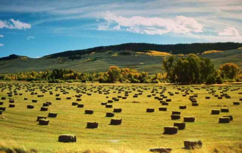
Smith was busy this week bringing in hay on his well-tended fields along the White River just west of Meeker — the same fields his grandfather irrigated.
“I’ve had some disagreements with her, but Erin is an intelligent gal,” he said of Light, who has a master’s degree in civil engineering from Colorado State University with an emphasis in hydraulics and hydrology. “We’ve worked with her, and we’ve worked with the people that she has here, and at the end of the day it’s helped all of us, and I think we’re all better educated because of it.”
Well-tended fields along the White River west of Meeker irrigated by the Meeker Ditch. The ditch has been directed to divert less water at its head gate than it used to.Shanna Lewis, a water commissioner in Division 6, inspecting the Meeker Ditch’s measuring flume. Lewis suggested it’s easy for outsiders to critique how ranchers manage their water, but that there are a lot of factors, and experience, involved that are not always readily apparent.
Laying down the law
The Meeker Ditch has a water right dating back to 1883 to divert 20 cubic feet per second (cfs) of water and two other later and smaller rights that allow it to divert 25.95 cfs in all.
The ditch diverts water from the White River just east of Meeker, runs it through Meeker proper, and then to fields west of town. (See map).
In her August 2014 curtailment order, Light said the historic water rights held by the Meeker Ditch represent enough water to irrigate about 1,000 acres, but today only 153 acres are actively being irrigated. And engineers at Resource Engineering Inc. calculated that the Meeker Ditch only needed 6 cfs to irrigate the fields still served by the ditch.
Attorney Kevin Patrick of Patrick, Miller and Noto, a water law firm with offices in Aspen and Basalt, had hired Resource Engineering to analyze the irrigation ditch on behalf of a client who owned commercial property under the ditch.
Since 2004, the property had been intermittently subject to flooding by water leaking from the ditch.
Patrick sent the engineering report and a letter to Light. “The ditch is diverting unnecessary water which is merely being spilled” and “the excessive running of water, over that reasonably required for the reasonable application of water to beneficial use for the decreed purposes and lands, is forbidden” under state law, the letter says.
After investigating the matter, Light found the ditch had been consistently diverting about 20 cfs at its head gate, but was then sending much of the water out of the ditch and down Curtis Creek, Sulphur Creek or Fairfield Gulch, back toward the White River.
Light then curtailed diversions at the Meeker Ditch head gate, which she has the authority to do. And when asked to do so by Smith, she put the curtailment order in writing.
“Colorado statute clearly prohibits the running of water not needed for beneficial use,” Light wrote in her order, dated Aug. 15, 2014.
Light cited a Colorado statute that reads “it shall not be lawful for any person to run through an irrigating ditch any greater quantity of water than is absolutely necessary for irrigating his land, it being the intent and meaning of this section to prevent the wasting and useless discharge and running away of water.”
And she addressed the issue of water being released from the ditch and back to the river.
“Generally when water is being wasted off the end of the irrigated acreage, through waste gates, or at the tail end of the ditch, the head gate should be turned down to eliminate that waste of water,” Light wrote. “In this case it appears that water is being diverted at too great a rate for the lands that are being irrigated, and the rate of diversion is not being reduced to eliminate waste.”
Light’s stance on enforcing waste has the backing of her boss, State Engineer Dick Wolfe.
A photo from the Resource Engineering report documenting waste on the Meeker Ditch in 2014. Water from the ditch is being turned out into Sulphur Creek, while the main flow in the ditch continues through the pipe above the outfall.
Use it or lose it?
Both Wolfe and Light served recently on a committee, convened by the Colorado Water Institute at Colorado State University, that issued a report in February on the widely brandished piece of advice to irrigators to “use it or lose it.”
The report is called “How diversion and beneficial use of water affect the value and measure of a water right” and is subtitled “Is ‘use it or lose it’ an absolute?”
The 11-page report ends with several declarative statements about waste that give further backing to Light’s approach, and that she might well wish to see chained to every head gate on the Western Slope.
“Water that is diverted above the amount necessary for application to a beneficial use (including necessary for transit loss) is considered waste,” states the report.
“Increased diversions for the sole purpose of maintaining a record of a larger diversion are considered waste,” it says, referring to the practice of diverting toward the full amount of a decree in order to bolster the future potential value of a water right.
And, “Wasteful diversions will either be curtailed, or will not be considered as part of the water right’s beneficial use.”
Wolfe, who recently gave a presentation to the Colorado Ag Water Alliance on the “use it or lose it” report, said that Light is not being overzealous in her enforcement of waste.
“She is not going out and as a division engineer purposely looking and being more assertive or aggressive about trying to find where waste is going on,” Wolfe said. “These are ones that just came to our attention.”
Alan Martellaro, the division engineer for Division 5, has not taken the same approach as Light when it comes to curtailing waste.
“To actually actively go look for waste is not something that’s historically been done unless there’s a call on the stream,” said Martellaro, who is based in Glenwood Springs and whose jurisdiction includes the Colorado, the Roaring Fork, and the Crystal river basins. “It just hasn’t been the mode we’ve ever been in.”
Kevin Rein, the deputy state engineer who also served on the “use it or lose it” committee, said issues vary from division to division.
“In Division 6, in the Yampa-White, we’ve had periods of free river without administration for a long time, because it hasn’t been over-appropriated,” Rein said. “That means not being water short. So very often people were just diverting whatever they wanted because, why not? But she’s really directing herself to getting people to measure their diversions and pay attention to duty of water. I think you choose what’s important in your division. That’s important in her division.”
“Duty of water” is essentially how much water someone needs to grow crops on a certain amount of land, without waste. In the Yampa and White river basins, the duty of water is generally held to be that it takes 1 cfs to adequately irrigate 40 acres of land.
After giving a presentation at a water workshop in Gunnison in June about the “use it or lose it” report, Rein was asked why the state doesn’t go around and curtail people who are over-diverting.
“We do, as resources allow,” Rein said. “It’s simply a matter of looking at our water districts where we, maybe, have one water commissioner and maybe a deputy. Maybe if they each had two or three more deputies, then we could do that.”
Light sounds like she could use some help.
“When it comes down to obvious waste,” she said, “I would say we have a tremendous problem with it. I had a long-standing water commissioner — he was with us for 40 years and grew up a rancher — tell me one day, ‘The problem with irrigators today is they don’t go out and move their sets. They just open the head gate wider.’”
“Sets” refers to how irrigators have set various control points, such as check dams and internal head gates, along their ditches.
“That just blew me away,” Light said. “Here’s a longtime rancher living in the community of Meeker his entire life who is more or less telling me that his co-irrigators … just open up their head gate and don’t move sets anymore. To me, that’s where the inefficiency is. Go out, divert less water, and move your damn sets.”
Erin Light, after being asked to pose for a photo at the head gate of the Meeker Ditch. Light has curtailed diversions into the ditch to reduce the amount of water being wasted in the ditch system.
Defending Light
After receiving Light’s written curtailment order in August 2014 on the Meeker Ditch, Smith appealed it to an administrative hearing officer, which was a rare move.
Wolfe said the appeal, which was addressed to him, “is the only curtailment order that I am aware of that has been appealed since I have been state engineer.” He’s been state engineer since since 2007 and has been with the Division of Water Resources since 1993.
An attorney for the Meeker Townsite Ditch Co., which owns the Meeker Ditch, told the state that Light was “attempting to restrict the diversion of water down the Meeker Ditch at a time when the White River is not under an administrative call and at a time when no other water rights owner is affected by the diversion.”
At that point, the state stepped in to defend Light’s curtailment order, and Philip Lopez, an assistant attorney general, prepared an answer to Smith’s appeal.
In his answer, Lopez cited a relatively straightforward statute that reads: “During the summer season it shall not be lawful for any person to run through his irrigating ditch any greater quantity of water than is absolutely necessary for irrigating his land, and for domestic and stock purposes, it being the intent and meaning of this section to prevent the wasting and useless discharge and running away of water.”
And he quoted the Colorado Supreme Court in Fellhauer v. People, where it said, “The right to water does not give the right to waste it.”
As to the matter of Light, or any other division engineer, not being able to curtail waste if there is not a call on the river, Lopez wrote “the division engineer has the authority to curtail [the Meeker Ditch’s] wasteful diversions at any time pursuant to [state law], regardless of whether or not the White River is under administration.”
Lopez did concede, though, that the water rights held by the Meeker Ditch still allowed it to divert water, as long as they did so “without waste.”
That’s an important distinction for Smith, who insists that he wasn’t technically curtailed, only that he can’t waste water when diverting.
“She hasn’t curtailed me to the amount of water that I can use,” Smith said. “All that Erin tells me is that whatever amount of water I have in the ditch, that she doesn’t want us wasting any water.”
Light has a different take.
“We curtailed them,” Light said. “We issued an order to stop wasting. They hired an attorney. They hired an engineer. It went to the hearing officer. They don’t waste anymore.”
The hearing officer in the case denied the ditch’s appeal, indicating it was a matter for water court. But Smith declined to go there.
“We kind of came to a working agreement that we were going to try to work with it, but as far as the laws, there was never a test case,” Smith said.
That may be, but on July 11, when Light and Lewis measured the flow in the Meeker Ditch, it was running at 6 cfs, not 20 cfs as it often used to.
The diversion structure for the Maybell Canal on the Yampa River east of Maybell. The ditch has been working to reduce diversions after the division engineer found it was diverting more water than it needed.
The Maybell Canal
Light has also curtailed another irrigation ditch in Division 6, the Maybell Canal on the Yampa River near Maybell, which she found was similarly diverting more water than it needed.
The canal diverts water from the Yampa into a head gate located in a canyon on the edge of Little Juniper Mountain, about 30 miles west of Craig. (See map).
The Maybell Canal has a senior water right for 42.2 cfs that was adjudicated in 1923 and appropriated in 1899. It also has a junior right for 86.8 cfs that was adjudicated in 1972 and was appropriated in 1946.
The waste on the Maybell Canal was brought to Light’s attention by one of her water commissioners who’d visited the ditch. Light then verbally instructed the canal’s manager to stop wasting water. Mike Camblin, manager of the Maybell Irrigation District, wasn’t happy when he got the curtailment order from Light, but he’s now working to secure funding to make $197,000 worth of improvements to the irrigation system.
On July 13, the Yampa-White-Green basin roundtable approved a $108,000 grant of state funds to help fix several issues on the ditch system. One of those improvements is a modern, automated “waste gate” a mile below the head gate.
Camblin said such a remote-controlled system won’t work at the head gate, which is higher up in the canyon without cell phone service and prone to being washed out by high water.
But he is willing to use the automated gate to reduce sending more water than necessary out the bottom of the ditch, where the water returns to the Yampa River.
The arrangement for the new gate does not entirely please Light, however. She insisted that Camblin agree to send someone up to the head gate within three days after receiving information from the new automated gate that they are over-diverting.
An agreement to that end has been worked out and is poised for adoption, both Light and Camblin said.
“The whole goal is to not only help Erin out but to make us better at what we do,” Camblin told his fellow roundtable members on July 13.
In an interview this week, Camblin said, “At times we were probably taking more water than we need, but that’s what this whole process is about, to cut that down.” He said he is forging a productive working relationship with Light.
“I think it all comes down to communication, especially with Erin and the water commissioners,” he said. “If they get to know us and how our ditch can run better, and we allow them to do that, and we communicate, we can solve a lot of problems.”
Water diverted into the Maybell Canal enters a flume a mile below the head gate and crosses the Yampa River. A remote-operated outlet is to be installed just above the flume in an effort to reduce diversions into the ditch.The Maybell Canal, toward its end, below the town of Maybell, on July 13, 2016. The ditch is working to waste less water by reducing diversions from the Yampa River.
Watch that stick
Dan Birch, the deputy general manager at the Colorado River Conservation District and a member of the Yampa-White basin roundtable, is supportive of the improvements that Camblin is trying make on the Maybell Canal.
“I think Mike’s really trying to do the right thing, and I think he wants to take a look at ways he can manage his diversions better,” Birch said. “I certainly don’t think he’s diverting just for the sake of diverting.”
Birch also cautioned against using a stick to beat back waste.
“You can’t go into a situation and say, ‘Hey, you guys are wasting water, I want you to reduce your diversions,’” Birch said. “You really have to be prepared to go into that situation and say, ‘Hey, look, here’s something that we’re seeing here. Let’s have a conversation. I’m interested in exploring what we might do to improve flow in the river.’”
But Light feels the Maybell Canal needed to be prodded into action.
“What has partially pushed the Maybell Canal to go the direction they have is us really putting our foot down that we’re not going to allow this waste to continue,” she said. “Again, the waste is so blatant. They were diverting about 54 cfs at the head gate, and we estimated about 18 cfs going out the tail end. It’s like, ‘No, you can’t do that.’”
Birch was asked directly if he thought the Maybell Canal would be making its proposed improvements without Light’s enforcement actions.
“That’s a fair question, and my immediate response is probably not,” he said.
While Light has been able to work with both Smith and Camblin, she knows she’s raising the hackles of ranchers in the Yampa and White river basins.
“I don’t think the irrigation community wants to be told they’re wasting,” she said. “I’d love to do more as far as waste, but I do have to tread lightly.”
Editor’s note: Aspen Journalism, the Aspen Daily News and Coyote Gulch are collaborating on coverage of rivers and water. The Daily News published this story on Sunday, July 24, 2016
Map of the Northern Integrated Supply Project via Northern Water
From the Fort Collins Coloradoan (Jacy Marmaduke):
Citing low flows in the winter and insufficient flushing flows in the spring, river experts give the health of the Cache la Poudre River moderate marks. Ken Kehmeier, senior fishery biologist at Colorado Parks and Wildlife, gives it a “C-plus.” Ellen Wohl, a Colorado State University geosciences professor, prefers “needs improvement.”
“It’s not going to catch on fire like the Cuyahoga River did in the ‘60s, but it’s a very different river than it was in say, 1858,” she said. “I’d never give up on the Poudre. It’s ailing in health, but it can recover, and it’s not anywhere near being done.”
What does the future hold for the Poudre? That interpretation depends a lot on who you ask. It also will depend on how Northern Colorado leaders respond to potential obstacles raised by climate change, urban development and the Northern Integrated Supply Project.
Climate change
Colorado’s in a weird spot when it comes to climate predictions.
While it’s clear temperatures will increase — they already have — there’s no consensus on whether climate change will bring more, less or the same precipitation to Colorado.
Regardless, warmer temperatures are an issue for the Poudre and its aquatic life and water users. The Poudre is fed primarily by mountain snowmelt, and as Colorado’s average temperatures rise, the spring pulse — the onset of higher spring flows fed by snowmelt — will come earlier than usual.
John Stokes, Fort Collins Natural Areas director, said he already sees it happening on the Poudre.
“Our snowmelt is getting earlier and earlier. It’s probably about two weeks earlier now than it used to be,” Stokes said. “As that accelerates, what does that do to our storage in the mountains, which is snow and ice? We rely on the timing of that storage.”
Not everybody agrees with Stokes. Poudre River Commissioner Mark Simpson said flows have varied so much during the last 50 years that he doesn’t see a shift in the peak, which generally occurs around the first week of June.
[Ellen Wohl] said she hasn’t necessarily noticed that trend on the Poudre — the system is so meticulously managed that it can be hard to tell when high flows are the work of Mother Nature or water engineers, she added…
Development
The biggest protection — literally — is a development buffer zone of 300 feet on either side of the river through most of Fort Collins. That’s nearly the length of a football field. The buffer zone, which is enhanced by city ownership of most of the land along the river, quells any fears that the Poudre will one day turn into a built-out river walk. It also mitigates flood risk.
“Maybe In a perfect world we would have had quarter- or half-mile setbacks from the river,” Stokes said. “This river used to go all over the place. It would change its course frequently. But now, it’s pretty much locked into its location because of the way we’ve developed around it.”
[…]
NISP
Proponents say Northern Colorado needed NISP yesterday. Opponents argue that the project will irreversibly damage the river that has long been a lifeblood for the region.
Reservoirs are “exhibit A” for the future of Western water, said Brian Werner, spokesman for NISP initiator Northern Water.
“We’re going to need reservoirs for the next 200 years,” he said. “We’ve got to figure out where to store that water in the wet times so you can use it in the dry times.”
It’s easy to reduce NISP to a lengthy timeline and a lot of bureaucratic jargon, but it’s more than that. The project has become symbolic of a major question about the future of water use: How do we meet the water needs of staggering population growth without harming our rivers?
NISP would divert from the Poudre during peak springtime flows. That causes concern for many because the river needs flushing flows to thrive.
“As the water moves, it has the power to carry things,” Kehmeier said. “When you take that power away from it, then all those sediment pieces drop out and deposit on the (river bed).”
Sediment buildup can make the river dirtier, smellier and fill it with algae and non-native, potentially invasive, species.
Wohl is skeptical of NISP, partially because of the flushing flows issue and partially because the river already lacks a natural flow regime.
Downstream, “the volume of the water isn’t really natural,” Wohl said. “That has a cascade of effects. If you change the amount of water in a river, you change the energy available for processes like picking up and moving sediment, you change the shape and size of the river, you change the habitat available for organisms.”
But it’s possible for NISP to coexist with a healthy river if Northern Water plans accordingly, Kehmeier said.
“With these flushing flows, you’re looking for a recurrence interval,” he said. “Every one-and-a-half to two years, you should have a flow that’s considered bank-full.”
NISP could also boost historically low winter flows on the Poudre by releasing reservoir water into the river during dry times, Kehmeier said.
“From a fisheries standpoint, the Poudre is as limited by low flows, probably more so, than it is by flushing flows,” he said. “Fish don’t survive very well without water.”
Wintertime releases are a component of Northern Water’s recently unveiled conveyance refinement proposal, which is basically a plan to run 14,000 acre feet of the diverted water through most of the Poudre’s stretch in Fort Collins. The move was partially intended to address some of the city of Fort Collins’ issues with NISP, but the city, which is not a NISP member, has yet to respond to the new plan…
What’s next for NISP:
The Army Corps of Engineers says it will release a final environmental impact statement for the project sometime in 2017. After that must come a 401 permit and a record of decision, which NISP opposition group Save the Poudre Executive Director Gary Wockner anticipates will come in 2019. If the record of decision approves the project, Save the Poudre is prepared to challenge it in court, setting off a legal battle which could take years.
From the Fort Collins Coloradoan (Jacy Marmaduke):
Poudre River Commissioner Mark Simpson knows that better than anybody. It’s his job to keep track of water rights for the various groups who’ve sometimes paid roughly the price of a new car for each share of water to irrigate their crops, power their businesses and provide to their residents.
Technically, the people of Colorado own the water flowing in Northern Colorado’s Cache la Poudre River. If you want to put the water, to use, though, you have to buy a water right. That can sometimes be as simple as going to the state’s water court, paying a fee and filling out some paperwork…
If you want to use water during a dry year, you need an old water right — some date back to the 1860s and 1870s. People sell older, senior water rights for astronomical prices.
For Simpson, the last several years have been a relief because the Poudre’s flow has been higher than average. The amount of water that runs through the Poudre varies wildly annually, from 100,000 acre feet during dry years to 700,000 acre feet during historically wet years.
The average is about 300,000 acre feet, almost enough to fill Horsetooth Reservoir twice.
During dry years, when everybody wants water but few can get it, Simpson works months without a day off.
“You’ve really got to be paying attention,” he said. “You don’t want a dry-up in town because you shorted somebody. I make it a big point for myself to always be watching the river when it’s on its way down.”
Simpson estimated about 85 percent of the Poudre’s water is diverted for agriculture — mostly corn and hay — and about 15 percent is used for municipal water supplies and industry.
Some of the biggest industry users of Poudre water include breweries, microprocessor factories and other industrial manufacturers. Municipal users of the Poudre include Fort Collins and Greeley. Recreational users have an important place at the table, although their use is classified as “non-consumptive” and is free.
Click through to read the whole article. Ms. Marmaduke talks to users of the river’s water.
To look at the numbers, you’d expect to see otters frolicking everywhere in the Arkansas River basin.
Then you realize that the nearly 10,000 storage vessels in Southeastern Colorado are spread over more than 28,000 square miles in mostly arid or semiarid areas. Then consider that many of the reservoirs are seldom full. Finally, the vast majority are pond-sized, not lakes.
Still, someone has to keep an eye on them all, because water stored in them rightfully belongs to someone else. In the past 10 years, there have been 79 orders issued by the state in relation to improper storage practices.
“The Arkansas River is a big basin, and there’s a lot of complexity in the basin,” Assistant Division Engineer Bill Tyner told the Lower Arkansas Valley Water Conservancy District last week. “We put our emphasis on the top 200 structures.”
Tyner then walked the board through the different types of reservoirs that are known to exist. Even that can be a problem to determine, because reservoirs are man-made, while natural features such as lakes, ponds or wetlands on a creek might show up in aerial photographs.
There are more than 1,500 decreed structures in the Arkansas Valley, although some may not be in use or are restricted.
Of those, only 20 hold more than 10,000 acrefeet (3.25 billion gallons), and another 169 hold more than 100 acre-feet.
The rest are there, legal to use, but subject to water rights administration. In other words, they cannot store water if a user with a senior appropriation right is calling for the water downstream.
The largest reservoirs are John Martin Reservoir, which was built for flood control and to settle interstate compact differences between Kansas and Colorado, and Lake Pueblo, which was built as part of the Fryingpan-Arkansas Project for water supply, flood control and recreation.
There are nearly 1,800 erosion control dams, which must be under 15 feet in height, store less than 10 acre-feet and can be drained in 36 hours. They have to be dry 80 percent of the time.
“There are a lot of these at the Pinon Canyon Maneuver Site to mitigate vehicle damage,” Tyner said.
As would be expected, erosion control dams are found in the hilly areas of the basin in the Upper Arkansas, El Paso County and the Spanish Peaks area.
There are more than 5,400 livestock tanks, which fall under a specific state statute that has the same criteria as erosion dams, but also sets a chronological priority within the same drainage.
“Livestock ponds have a seniority system, but it’s not as formal as a decreed right,” Tyner said.
Gravel pit ponds are a different category. There are about 750. The ponds intercept groundwater because of activities by humans, so must be augmented to replace evaporation losses. Those are most common on the Eastern Plains, where gravel mining is prevalent.
There are roughly 140 head stabilization ponds, which are limited to storing water up to 72 hours, by state policy, primarily to reduce sediment for sprinkler or drip irrigation.
Aside from the known reservoirs, there are unknown storage systems including post-wildland fire facilities, stormwater detention ponds and unregistered ponds used for erosion control, livestock or head stabilization.
Artesian well Dutton Ranch, Alamosa 1909 via the Crestone Eagle FromThe High Country News (Paige Blankenbuehler):
The San Luis Valley in southern Colorado is an 8,000-square-mile expanse of farmland speckled with potato, alfalfa, barley and quinoa fields between the San Juan and Sangre de Cristo mountain ranges. Only about 7 inches of rain fall each year in the San Luis Valley. But while farmers and ranchers can’t depend on moisture above ground, they make up the difference beneath it. The valley is underlain by a vast aquifer, which is punctured by more than 6,000 wells that pump water onto the valley’s crops and supports the livelihoods of 46,000 residents.
For generations, the aquifer provided enough water to sustain the arid farming community. But beginning in 2002, a multi-year drought shrunk the nearby streams and water table. Farmers and ranchers began to notice the falling levels of the Rio Grande and the rapidly draining aquifer. Some wells throughout the valley abruptly stopped working.
The aquifer dwindled so much that the Closed Basin Project, a Bureau of Reclamation pumping effort that had long met downstream water diversions and delivered flows to the Rio Grande River to maintain the Alamosa National Wildlife Refuge, failed to convey enough water to the valley’s farms and ranches. “We operate in a highly over-appropriated system,” says Cleave Simpson, manager of the Rio Grande Water Conservation District, the main water management entity in the San Luis Valley. “Agriculture had overgrown and far outstretched water supply.”
Without change, state water regulators could shut off thousands of wells. So the valley’s farmers and ranchers, unlike other agriculture communities in the West, did something nearly unprecedented: They decided not to ignore the problem.
In 2006, the Rio Grande Water Conservation District and San Luis Valley water users created the sub-district project, an innovative solution for solving water problems. The plan would charge farmers and ranchers $75 per acre-foot for the groundwater they pumped, and in turn use the funds to pay farmers to fallow portions of their fields, limiting demand on the water supply, as High County News reported in 2013. The experiment began at sub-district 1, the valley’s largest of six sub-districts, which sits at the heart of the San Luis Valley in aptly named Centre, just west of the Great Sand Dunes National Park.
Center-Pivot and Acequia Farms. The green belts along the Río Culebra and tributaries in San Acacio, San Luis, Chama, Los Fuertes and other unmarked villages are the principal acequia farm bottomlands in Costilla County. The center-pivot circles are concentrated in the Blanca-Ft. Garland vicinity to the N and the Mesita-Jaroso vicinity due W and SW of the acequia bottomlands. Source: Google Maps (screenshot).
Today, four years into the operation of the project after it launched in 2012, the aquifer is rebounding. Water users in sub-district 1 have pumped one-third less water, down to about 200,000 acre feet last year compared to more than 320,000 before the project. Area farmers have fallowed 10,000 acres that once hosted thirsty alfalfa or potato crops. Since a low point in 2013, the aquifer has recovered nearly 250,000 acre-feet of water. By 2021, the sub-district project plans to fallow a total of 40,000 acres, unless the ultimate goal of rebounding the aquifer can be reached through other conservation efforts, like improving soil quality and rotating to more efficient crops.
The plan’s proponents say it provides a template for groundwater management in other arid communities whose agricultural economies are imperiled by drought. “The residents of the valley know that they are in this together, and that the valley has overgrown the water available to us,” says Craig Cotten, Almosa-based division engineer for the Colorado Division of Water Resources. “This is a water user-led solution, which makes it unique. I really think this can be a model.”
Crucially, the plan is state-mandated, which requires everyone to either participate in a district, fallow their fields or work with water engineers to develop their own augmentation plans, which in turn need to be approved by state water courts. Those choices — paying premiums for groundwater or scaling down operations significantly — have been tough for farmers. Nevertheless, Simpson says the valley’s water users have gotten on board. “It’s not comfortable but most everyone has really come forward,” Simpson says. “It’s a bit of a paradigm shift for farmers who are individualistic and don’t typically work together — but by necessity they realize that we will bankrupt ourselves if we continue to stretch our water resource.”
But water users in the San Luis Valley have also gone beyond the call of duty, says Heather Dutton, manager of the San Luis Valley Water Conservancy District. While the SLVWCD helps include users in its augmentation plan as an alternative to joining the sub-district project, Dutton says that few water users have gone that route. That’s partly because farmers and ranchers themselves have helped create the sub-district rules, through participating in public meetings and getting involved with the board of managers. “This has been a good exercise in self-governance,” Dutton says. “It’s been a success story in people coming together and trying things that my grandpa’s era would have thought were crazy.”
Although sub-district 1 has proved a success, the broader sub-district project remains in its fledging stages. In March, Colorado District Court in Rio Grande County mandated that sub-district 2, a cluster of a hundred or so wells between Monte Vista and Del Norte, unroll as phase two of the program. The second district is currently forming a board of managers to develop official rules for farmers and ranchers within the territory. The Rio Grande Water Conservation District is still working with valley residents to implement the remaining four sub-districts.
Still, the project’s first phase has been encouraging for residents. Patrick O’Neill grew up in Central California’s San Joaquin Valley and first came to the San Luis Valley in 1998 to work as an intern at Agro Engineering, a consulting company. Though he later returned to his family farm in California, he came to feel that the Central Valley, built on its own wasteful groundwater use, was not sustainable. He returned to the San Luis Valley in 2005, where he now owns Soil Health Services in Alamosa and works with area farmers and ranchers to improve soil health. “I chose this place in a very deliberate way for my home because there’s potential for putting our water system back into balance,” O’Neill says. “People here are much more conscious of how much water they are using.”
Spring snowmelt is already bringing fast-moving and rising water to the Arkansas River in Pueblo, according to the local Swift Water Rescue Team, and kayakers and fishermen alike are being urged to take caution.
The U.S. Geological Survey showed the Arkansas River spiking by 600 cubic feet per second on Monday through Pueblo, deepening one stretch by a whole foot. The river at the Moffat Street gauge was running at 1,440 cfs on Wednesday afternoon, making water in the city kayak course in particular a challenge, according to KOAA Channel 5.
“The kayak course … was designed for people who are used to kayaking or boating, who know what they’re doing and have more river experience,” Pueblo Fired Department engineer Ryan Moran told the news outlet. “This is not a place for just inner-tubing leisurely.”
Denver Water says, so far this year, their water supply is in good shape thanks to above-average snowpack levels in the local collection areas, nearly full reservoirs and continued efficient water use by consumers.
But what will it look like as the state heads into the hot, summer months?
Water conservation is not only needed in dry years. Colorado is a dry area, and water is finite. It’s vital for those who live in the state to conserve water in order for Colorado’s economy to thrive. Farmers and ranchers across the state rely on higher water levels. Wildlife and aquatic life in local rivers and streams need enough to live off of. Those who enjoy the recreational activities in the state want higher river and reservoir levels.
No matter what the conditions may be, Coloradans must use water efficiently. Denver Water has annual summer watering rules in place from May 1 until Oct. 1. The rules should reinforce best practices to help customers use water properly and when needed while still keeping landscapes healthy.
The biggest mistakes people make is with their irrigation controller settings. Sprinkler systems are not meant to be forgotten once they are set. It’s important that consumers adjust their settings depending upon the month and recent rainfall. That means, if it rains, and your system doesn’t have a rain sensor, turn off your irrigation system until your landscape needs water again.
Colorado’s longtime ban on residential rain barrels has come to an end. Now most homeowners in the state are allowed to collect precipitation for later outdoor use.
Gov. John Hickenlooper recently signed House Bill 1005, which allows a maximum of two rain barrels — with a combined capacity of 110 gallons — are allowed at each household. The measure is to take effect on Aug. 10.
Rainwater collection, also called rainwater “harvesting,” is the process of capturing, storing and directing rainwater runoff and putting it to use. Water from roof gutter downspouts that is directed onto landscaped areas is not regarded as rainwater harvesting under this legislation.
The Colorado Legislature passed the bill last month after previously rejecting the measure in past sessions over concerns that household rain barrels would take water from the supply available to agriculture and other water-rights holders.
But a study conducted by the Colorado Stormwater Center, housed within the Department of Civil and Environmental Engineering at Colorado State University, showed otherwise. Nearly all of the water would be absorbed in the ground by the downspout or in the ground in the garden, the CSU analysis indicated.
“We do not think any changes to the water cycle could be accurately quantified or measured,” said Chris Olson, a researcher and program manager at the Stormwater Center. “The water is going to be infiltrated or evaporated. The only difference is the timing, a day, maybe two, before the rain barrel is emptied.”
Colorado has been the only state with an outright ban on residential rain barrels and one of just four states that restrict rainwater harvesting.
Water law experts say rain barrels are only technically illegal, because proving they injure the water rights of other users is nearly impossible.
Collection systems
Collected rainwater may be used to irrigate outdoor lawns, plants or gardens. Untreated rainwater collected from roofs is not safe to drink.
Any container capable of collecting the rain shedding from a roof or patio can be used as a rainwater harvesting system. To comply with Colorado water law, the container must be equipped with a sealable lid. Rainwater collection systems vary from simple and inexpensive to complex and costly.
Typically, rooftop rainwater collection systems are simple — gutters, downspouts, and storage containers. Inexpensive rainwater storage systems commonly make use of an above-ground container such as a barrel or plastic tank with a lid to reduce evaporation and bar access for mosquitoes to breed. More sophisticated systems have “first flush” diverters that are recommended to exclude capture of the initial rain that might carry impurities from the roof.
Rain barrel use under HB 1005
There are several restrictions that are important to follow in order to use rain barrels legally in Colorado. These restrictions differ depending on your residential situation.
Under House Bill 1005, rain barrels can only be installed at single-family households and multi-family households with four or fewer units. A maximum of two rain barrels can be used at each household and the combined storage of the two rain barrels cannot exceed 110 gallons. Rain barrels can only be used to capture rainwater from rooftop downspouts and the captured rainwater must be used to water outdoor lawns, plants and/or gardens on the same property from which the rainwater was captured. Rain barrel water cannot be used for drinking or other indoor water uses.
“The capture and use of rainwater using rain barrels does not constitute a water right,” said Reagan Waskom, director of the Colorado Water Institute, part of CSU’s Office of Engagement. “HB 1005 includes language that could result in the State Engineer curtailing the use of individual rain barrels if a water-right holder can prove that those rain barrels have impacted their ability to receive the water that they are entitled to by virtue of their water right.”
Colorado State University Extension has created a fact sheet with additional details on rainwater harvesting.
It’s now legal for residents to collect rain water and use it to water their gardens — something most probably haven’t thought twice about.
Before Gov. John Hickenlooper signed a rain barrel bill into law Thursday, only well owners were able to utilize rain barrels legally. A similar bill died in the Legislature last year, but with the governor’s signature on House Bill 1005, anyone can collect rainwater in two 55-gallon barrels.
The bill is only a small aspect to the larger picture of water rights in Colorado — which rain barrel owners are not guaranteed.
The bill’s passage also means — at least for now — a pause on discussion around major changes to Colorado’s water laws. There have only been grumblings and some failed attempts to put water laws to a vote, but the slight change of legalizing of rain barrels is one that puts the conversation to rest — for now.
“For the first time we really have a situation in place where we can account for and make sure water rights are protected,” said Marc Arnusch, a farmer in Keenesburg.
Colorado’s water laws, in short give water rights to people on a first-come, first-served basis. The priority goes to senior water holders — those who got rights to use the water first. The trickle-down system puts junior rights holders are the lowest on the totem pole when it comes to using and taking water sources. But if the junior water rights holder takes more then their share, the senior holder can hold them responsible for damages to the supply.
That’s where the rain barrel discussion fits in. Even with rain water coming from clouds, Colorado’s water supplies rely on runoff water from storms. Rain barrel collections could reduce the amount of runoff water, but only when a large amount of water is collected from rain barrel owners.
Hesitation during the discussion of the bill was to protect the rights of the junior water rights holder. Legislators wanted to make sure junior holders weren’t held responsible for less available water due to a diversion into rain barrels.
Colorado State University researchers studied the effect rain barrels collections might have on downstream water from the rain and found there would be little, if any, change. This also plays into how many rain barrels will, realistically, be used. Arnusch said urban residents will most likely use the barrels, and Northern Water’s Brian Werner said a good utilization of the barrels would be if 10-15 percent of Colorado residents actually used the barrels. But even that might take time.
The CSU study didn’t convince everyone, though. Sen. Jerry Sonnenberg, R-Sterling, was one of three in the Senate Agriculture, Natural Resources and Energy committee to vote against the bill. His disagreement came from a lack of solutions to make sure the barrels wouldn’t take water away from those who own it and how to keep the rights in check. There was talk of a statute that would hold rain barrel owners responsible if there was a deficit from water rights owners, but there was no consensus, as the CSU study said there would be little, if any noticeable change in runoff water.
Even though the study said there wouldn’t be much of a change, statutes to hold barrel owners responsible in case of a reduction were rejected.
“If there isn’t an impact, why would they be worried about a statue?” Sonnenberg said in March.
But there was a checks and balance system put in place in which state officials can check to see — if rain barrels prevent water owners from getting their full share — how that can be fixed and changed. Werner said the chance for a revisit, along with the results from the CSU study was a large reason why the bill passed this year, unlike past sessions.
“If everyone were to (buy barrels) there are the checks and balances in there so somebody can go back there and look on a regular basis to see if there is, indeed, an impact,” Werner said.
The impact comes down to whether there will be enough water when rain barrels are used. With water rights remaining as they are, Arnusch said the bill is a step in the right direction to keep the water rights structure as is.
The biggest overhaul talks have been about switching to a public trust doctrine system. Arnusch is on the Ground Water Commission for the Colorado Division of Water Resources and said talks about the public trust doctrine system would still be priority-based, but the priority would go to wherever need is seen, rather than water ownership. That could mean years with less agricultural priority, which is why farmers and ranchers oppose the system.
“If the public trust doctrine were to go into effect in Colorado, that would be just a catastrophe for agriculture,” he said.
While a change to the public trust doctrine isn’t favorable to agriculture, Arnusch said it’s still important to evaluate and make reasonable changes within the existing water use system. Rain barrels were one of those changes. Now, the micro-storage options have a place in Colorado’s complex priority system, he said.
But there is a difference between the use of rain barrels and who owns that water.
“At the end of the day, a rooftop doesn’t entitle you to a water right,” Arnusch said.
A plan to allow water to pass through Cucharas Reservoir until a new dam is built has been approved in a settlement of a legal case that has been drawn out for more than a year.
Two Rivers Water and Farming Co. filed an objection last August to a February 2015 state order to remove the dam, located 12 miles northeast of Walsenburg, claiming it still intends to build a new dam downstream. The Colorado Supreme Court returned the case to Division 2 water court, where a settlement was approved last month by Water Judge Larry Schwartz in lieu of a trial.
“The state and division engineers were very helpful in developing a common-sense plan for rebuilding the Cucharas dam,” John McKowen, Two Rivers CEO, said in a press release this week. “The plan will insure the public’s safety and increase the water efficiency inside the entire Huerfano River basin.”
Two Rivers is required in the next six months to remove the rock fill embankment of the entire length of the dam. It also must cut a channel allowing 150 cubic feet per second to pass through the reservoir and dam on the Cucharas River in Huerfano County. The Cucharas River merges with the Huerfano River before it empties into the Arkansas River.
Those remedies are more stringent than McKowen’s claim last year that the dam was safe because its crest had been removed and it was storing no water because the gates were locked open.
McKowen plans to build a new dam downstream that would allow storage at the site, which has been under restriction by the state since the old dam began leaking in 1987.
In the settlement discussions, McKowen talked with the state about using Two Rivers’ assets in the Huerfano River basin to address other water issues in the basin. Two Rivers owns all of the Orlando Reservoir in Huerfano County and canal system and 95 percent of the Huerfano- Cucharas Irrigation Co., which includes Cucharas Reservoir and farmland in Pueblo County.
While the settlement resolved issues with the state, there are still legal issues between Two Rivers and other water users in the Huerfano River basin.
As part of the settlement, Two Rivers would pay Huerfano County $100,000 if it fails to comply with the consent decree. The state has reserved the authority to evaluate compliance and to take further action, if necessary.
The major water bodies around Summit County and throughout most of the state are in strong shape after a slightly above-average winter season. However, the region is far from out of the woods on the matter of water in the West.
That was the thrust of speakers at Summit’s 23rd annual State of the River meeting on Wednesday evening, May 4 at the Silverthorne Pavilion — the first of six such meetings along the Colorado River Basin. With the Western Slope encompassing an average of 28 percent of the state’s water and spanning 15 counties, including Summit, this meeting of water wonks often sets the tone on consumption strategy and planning for rest of the year.
“There are no passengers on Spaceship Earth,” Troy Wineland, Summit County’s water commissioner, told the congested room, “there are only crewmembers. We’re all in this together.”
Wineland stressed that despite snowpack totals currently at about 115 percent of average above Dillon Reservoir — and with peak flows still to come around the first or second week of June once meltoff takes hold — circumstances are not as favorable. Other states in the country that also primarily rely on the Colorado River remain at near-critical shortages.
“While things are nice and rosy and wet and looking great here in the county,” he said, “you look throughout the entire Colorado river basin … not quite as rosy. The Lower Basin states right now are facing some very serious problems with access to water and need.”
[…]
WATER WAYS
Both Wineland and Denver Water’s Bob Steger were sure to discuss the present levels at Lake Powell during their respective presentations. Each noted how vital the resource is to every state along the Colorado Basin, even though water has already passed by many of them to arrive to Powell.
Aside from Powell functioning as the chief water supply for drinking, crop irrigation and recreation for 30-to-40 million residents in the region, the Glen Canyon Dam there also provides hydroelectric power. Besides contractual obligations of an annual average of 7.5 million acre-feet at Powell through that basin compact, of course, when water there gets below necessary levels, that has an impact back up to the Upper Basin states with increased electrical bills…
“(Lake Powell) is our bank account against accounts payable to the Lower Basin states,” re-iterated Wineland. “We’re probably within 20 feet of the critical threshold, at which point, Arizona and Nevada are going to have to make some hard decisions and really cut back on their water use.”
CHAMPIONING CONSERVATION
Despite the challenges even in what seems a healthy water year locally, all hope is not lost. The overall tenor of the meeting was mostly positive, with emphasis on how collaborative efforts across Colorado, as well as through such multi-state interdependence and agreements, proper attention on this limited resource is increasing.
Steger, Denver Water’s manager of raw water supply, brought encouraging news that the water from snowpack averages just a couple days ago are not only well above both the 20-year average on Dillon Reservoir (14.6 inches), but also ahead of 2015 (16.5 inches) as well. Current measures are 19.5 inches from this winter’s snowfalls.
On top of that, snowpacks on the South Platte River are also above normal for this time of year. That means Denver Water can most likely avoid pulling much water from Dillon Reservoir through one of its primary transmountain water diversion, Roberts Tunnel, this season for the South Platte and Denver’s consumption needs.
In fact, if that happens, that will continue a beneficial trend where 2014 and 2015 were actually the two lowest years within a 50-plus-year span for how much water has had to be removed from Dillon Reservoir through Roberts for the Platte and North Fork rivers.
“I attribute that partly to Mother Nature,” explained Steger to the audience, “because we’ve had good water supplies on the South Platte, but also our customers are doing a better and better job every year I think of conserving water. When our Eastern Slope supplies are good, that means we don’t have to take as much water from the Western Slope to the other side of the divide. That indirectly helps Lake Powell.”
Wineland also discussed how momentous the unveiling of Colorado’s statewide water plan — years in the making — in November is for the general conservation movement. To boot, regional endeavors like the recent $32,000 Colorado Water Conservation Board grant awarded to the Frisco-based High Country Conservation Center (HC3) for development and execution of a countywide water efficiency program are additional steps in the right direction. His parting words were of encouragement and optimism for the Colorado River Basin’s future.
“I just want to bring it back to the bigger picture,” he said. “We have leaders who are putting forth all this legislation and these cooperative efforts. But what we’re lacking are champions, and those champions, really, are you and I — everyone in this room. We need to take this legislation and work to the next level and implement these changes.”
Click here to read the latest board meeting summary from the Colorado River Water Conservation District. Here’s an excerpt:
The Colorado River District has found that there is no compelling safety reason to proceed with remediation of Ritschard Dam at Wolford Mountain Reservoir in Grand County, now or in the foreseeable future.
This conclusion comes after exhaustve study of the settlement and a failure-risk assessment of the rock-fill, clay-core dam put into service in 1995. The River District’s consulting engineers and a separate Consultant Review Board it commissioned, together with the State of Colorado Dam Safety Branch, have concluded that the dam remains safe.
Irrigators in the San Luis Valley may get a boost thanks to the completion of a $4.6 million overhaul of a high country reservoir near Creede.
The Santa Maria Reservoir Co. completed the renovations on Continental Reservoir and its spillway last fall, making the reservoir eligible to have storage restrictions lifted later this summer should it pass muster from state inspectors.
The Continental was completed in 1928 and has a capacity of 27,000 acre-feet.
But seepage through the reservoir’s dam spurred the imposition of state restrictions in the late 1980s that have limited storage to about 15,000 acre-feet, reservoir company manager Jay Yeager said.
An acre-foot is roughly 326,000 gallons of water.
The added water would be a boost to the company’s 250 shareholders who irrigate on 70,000 acres on the valley floor.
“It helps the stockholders have more options to store more water for other entities and they can store more for their needs,” Yeager said.
While the Continental is not a large reservoir — less than a tenth of the size of Pueblo Reservoir — the added storage is significant given the small amount of storage on the Rio Grande’s headwaters.
The Continental is only one of four reservoirs whose combined storage amounts to just under 130,000 acre-feet.
The repairs to the reservoir included the layering of sand and gravel on the dam’s exterior designed to filter out sediment from the seeping.
While it won’t stop the seep completely it eliminates the sediment’s potential to make that seepage worse.
The project also included the repair of the siphon and canal system that connects the Continental to the Santa Maria Reservoir, which was also under state restrictions.
But full capacity might not be reached this season.
“It could take several years before it could really be full unless Mother Nature kicks in,” Yeager said.
Although a trial for new groundwater regulations in the San Luis Valley isn’t set until January 2018, State Engineer Dick Wolfe said his staff is working toward settlements to avoid that court date.
Wolfe told a Thursday meeting of the Rio Grande Compact Commission that efforts to compromise with the 30 objectors in the case have been underway for a few months.
“I’m very optimistic we’re going to be successful working through those issues with those other objectors in hopes to reach stipulation with all of those objectors and hopefully avoid going to trial,” he said.
Wolfe’s office submitted rules to the valley’s water court in September.
They were the first attempt by the state to issue comprehensive groundwater rules for the valley since the 1970s, when a previous effort never reached implementation.
The rules governing the roughly 4,500 highcapacity irrigation wells that tap into the valley’s two large aquifers require users to join a subdistrict, have an augmentation plan, or at least a temporary water supply plan.
The aim of the rules is to mitigate the impact of groundwater pumping on the valley’s streams and rivers, which are hydraulically connected to the aquifers in varying degrees. The objections to the rules cover a number of issues but many question the use of the state’s Rio Grande Decision Support System, a computer model that’s used in the calculation of stream loss caused by pumping.
But even if the rules do end up at trial, working toward settlements now can still pay off, Wolfe said.
“Even if we don’t ultimately get to an agreement with all those objectors we hope to at least limit the number of objectors so ultimately that would have to go to trial and the number of issues we would have to litigate,” he said.
From the Glenwood Springs Post Independent (Hannah Holm):
A recent Bureau of Reclamation report projects that Western river basins, including the Colorado Basin, are likely to experience a 7-27 percent decline in spring streamflows during this century.
The bureau’s 2016 SECURE Water Act Report to Congress, which can be found at http://usbr.gov/climate/secure/, is just the latest to warn of reduced streamflows in our region as temperatures climb.
The Colorado River Basin has already experienced more than a decade in which more water has been pulled out of rivers and streams for farms and cities than has come back in through rain and snow. As a result, water levels in Lake Mead and Lake Powell have begun to approach critical levels. For Mead, that means dropping too low to reliably meet demands. For Powell, that means dropping too low to generate hydropower and meet downstream obligations.
One of the efforts to head off this looming crisis is the System Conservation Pilot Program, which pays for voluntary, temporary water use reductions. This program, funded by major cities and other water suppliers that rely on Colorado River Basin water, was initiated in 2014 to test the feasibility of voluntary, compensated measures to curtail water use in order to prop up water levels in lakes Powell and Mead. Details on the program can be found at http://bit.ly/1UUSbIC.
Farmers and ranchers in western Colorado are among those who have participated and are considering participating in the program. Agricultural approaches tried so far include foregoing irrigation for part of a season, fallowing ground, leasing water and converting to lower water use crops. Some of these farmers recently met with program funders, researchers and supporters to discuss how the program is working.
The group included representatives of Denver Water, the Colorado Water Conservation Board, Colorado Division of Water Resources, the Nature Conservancy, Trout Unlimited, the Colorado River District, Colorado State University and Colorado Mesa University.
On the positive side, being paid to temporarily fallow land or reduce water use can provide money and time to upgrade aging headgates or other irrigation infrastructure, improve soil health or explore alternative crops.
Some farmers are hoping to use the program to receive income while transitioning ground from conventional to certified organic production, a three-year process that can lead to long-term economic benefits for the farmer. Farmers also like the opportunity to take the lead in figuring out how they could get by with less water, since there is concern that they may have to do so in the future. State law provides that participants in approved conservation programs will not have their water rights diminished as a result.
On the other hand, the first year of the pilot revealed many logistical hurdles to increasing flows into Lake Powell by paying farmers and ranchers to use less water. One major problem is how to ensure that saved water makes it to Lake Powell without being picked up by another water user that was previously short.
A related issue has so far hobbled attempts to lease water under the program. How can you lease water to an undefined recipient for an undefined use? According to some interpretations, this doesn’t square well with Colorado water law.
How to recognize the full value of agricultural water was also discussed. In addition to the need to compensate producers for forgone crop sales, concern was expressed about the impact of reduced production on farmworkers, implement dealers and the community at large. And how can you make sure that temporary water use reductions to get through a crisis really stay temporary, and don’t just permanently transfer that use elsewhere, from farms to cities? The fact that some cities are also participating in the program by reducing their water withdrawals or treating and returning wastewater helps address this concern, but doesn’t eliminate it.
The amount of water saved through the system conservation program so far is miniscule in relation to the amount needed to significantly reduce the risk of the reservoirs hitting critical lows. With all the issues involved with implementing the program and the growing demand for water, a major concern is whether this mechanism will ever be able to move enough water to really make a difference. Meeting participants noted that resolving the legal and logistical challenges, as well as building community understanding and acceptance of the program, are preconditions for scaling it up.
Avoiding critically low levels in Lakes Mead and Powell will require either significantly more action to reduce water demands or a lot more snow in the mountains. As of March 1, the 2016 water year inflows into Lake Powell were forecast to be 83 percent of average. That’s not terrible year, but it’s also not good enough to take the pressure off water users to control demand.
From email from the Colorado Water Conservation Board (Ben Wade):
A Joint Water Availability & Flood Task Force meeting will be held on Thursday, March 24, 2016 from 9am-12:00p at the Colorado Parks & Wildlife Headquarters, 6060 Broadway, Denver in the Bighorn Room.
Group plans that will help resolve water issues for more than 160 farms were filed this week with the Colorado Department of Water Resources by the Lower Arkansas Valley Water Conservancy District.
Called Rule 10 plans, they give farmers a way to comply with surface irrigation rules put in place in 2010 as a response to on-farm improvements such as sprinklers and drip irrigation. The state went to court to implement the rules to head off future challenges of the Arkansas River Compact by Kansas.
The state must approve the plans and comments are open on them until April 11.
The Lower Ark district filed two plans, one for farmers on the Fort Lyon Canal, the largest ditch in the Arkansas Valley, and another for farmers on other ditches.
The Fort Lyon plan covers 62 farmers and 99 farms. It projects a credit of 639 acre-feet, but because of monthly accounting, will have to provide some replacement water, said Jack Goble, Lower Ark engineer.
The non-Fort Lyon plan covers 46 farmers and 62 farms on 11 ditches: Amity, Baldwin Stubbs, Bessemer, Buffalo, Catlin, Fort Bent, High Line, Holbrook, Lamar, Las Animas Consolidated and Rocky Ford. It projects a credit of 315 acre-feet, but some recharge and replacement water will be provided on a monthly basis.
Among sources of replacement water for the two plans are Lower Ark storage at Lake Pueblo, Fryingpan-Arkansas water, ditch return flows and leased water from Pueblo Water.
Most of the improvements involve sprinklers fed by ponds, and the Lower Ark district sponsored a study over the past three years which showed leakage from ponds is twice the value originally presumed by the state. The new figure, about four inches per day, is incorporated into both plans.
All of the farms are on ditch systems, since water is generally used in rotation.
Straight line diagram of the Lower Arkansas Valley ditches via Headwaters
Here’s the update from the Colorado Water Conservation Board and the Colorado Division of Water Resources (Taryn Finnessey and Tracy Kosloff). Here’s an excerpt:
Statewide precipitation, as of February 16, is at 106% of average. January brought beneficial storms to the state but so far in February, Colorado has only experienced 77% of average precipitation. This recent lull in precipitation is not unusual at this time of the year. The spring months will be the key to determine whether or not the state has a good water year. National forecasts predict a wet spring for Colorado but also suggest a warm next few months. The February 16 US Drought Monitor map for shows 92% of Colorado is drought free and the remaining 8% of the state is experiencing D0 or abnormally dry conditions.
January was the 42nd warmest on record in Colorado with the Eastern Plains being the one region that has been above average temperature statewide. The temperature to date in February remains average to slightly above average for the east side of the Continental Divide while most of the western half of the state is below average. There are wildfire concerns in the southeastern corner of the state.
Statewide SNOTEL water year-to-date precipitation is 106% of normal. Statewide, January precipitation was 98% of normal and half way through February, precipitation is 77% of normal. The Southwest basins have the highest snowpack percent of median at 113%. The lowest snowpack in the state is in the Yampa/White & North Platte basins which are slightly below normal at 99% & 97% respectively.
The state experienced at least six spring storms in 2015 which eliminated drought conditions across the state. The state will need three to four storms this spring, especially in the South Platte & Arkansas basins, to keep drought conditions from reappearing this summer and beyond.
Reservoir storage statewide remains above normal at 110% which is the same as January. The Arkansas basin has the highest storage levels in the state; the Upper Rio Grande has the lowest storage levels, just slightly below normal. However, the Rio Grande levels have risen slightly since the beginning of the water year in October 2015. Water providers in attendance reported their respective systems are in decent shape at this time.
The Surface Water Supply Index (SWSI) as of February 17 is near or above average across the majority of the state, with the southern half of the state faring better than the northern half. The lowest SWSI value, -1.41 in the South Platte Basin, is due to the emptying of Antero Reservoir. At this time of year the index reflects reservoir storage and streamflow forecasts.
Streamflow forecasts are normal to above normal in most basins. Forecasts in the Yampa/White ranged from a maximum of 102% on the North Platte River near Northgate & the Laramie River near Woods to a low of 80% on the Little Snake River near Dixon. The highest streamflow forecasts are in the Southwest basins ranging from 108%-122%.
Seasonal drought outlook through May 31, 2016 via the Climate Prediction Center.
The Court for Water Division No. 3 is expected to set a trial date later this month for the proposed state groundwater rules in the San Luis Valley.
That trial date may not come until 2017, according to a draft case management order filed with the court Friday, but a long window before the trial may help State Engineer Dick Wolfe with his goal of coming to an agreement with objectors before trial.
To date, 29 parties have filed comments, although at least three of them did so in support of the rules.
The rules would cover the roughly 4,500 wells that draw off either of the valley’s two major groundwater bodies.
The unconfined aquifer is the shallower of the two and is recharged both by streamflow at the valley’s edge and by return flows from irrigation.
The confined aquifer is recharged mainly by streamflows on the valley rim, sits beneath the unconfined aquifer and holds artesian pressure.
Both are hydraulically connected, in varying degrees, to stream flows in the valley, meaning that groundwater pumping can injure surface water users.
The rules are designed to protect surface water users and restore aquifer levels by requiring groundwater users to either join a groundwater subdistrict, create an augmentation plan, or create a substitute water supply plan.
All three would require the mitigation of pumping impacts as determined by a staterun computer model that simulates the behavior of the valley’s groundwater.
Comments were filed by 21 parties at the end of November, although the court extended the comment period because of problems noticing the rules in the north end of the valley.
Many of those comments focused on whether the state’s groundwater model was sufficient for the rules.
Since then eight others have also weighed in.
As with previous objectors, there were two protestors among the latest group who argue that the rules only be approved to the extent that the groundwater model is accurate. Other objections focus on the proposed process the engineer’s office would use to set an irrigation season. The subdistrict operating under the Trinchera Water Conservancy District has also entered a protest, calling for the rules to allow it to submit a groundwater management plan. While the valley’s existing subdistrict and the four other proposed ones would all operate under a groundwater management plan, Trinchera is unique in that it is the only subdistrict not operating under the umbrella of the Rio Grande Water Conservation District.
Trinchera is in Costilla County, which is not a part of the Rio Grande district.
The state law that allows for the creation of conservancy districts does not make clear whether Trinchera can create a groundwater management plan.
Complying with the state groundwater rules will not be painless or cheap for the City of Alamosa.
The city, like hundreds of well owners throughout the San Luis Valley, will have to comply with the recently filed state groundwater rules for the Rio Grande Basin.
City staff and legal counsel Erich Schwiesow have already been preparing for the inevitable compliance.
Well owners who must comply with the groundwater rules must join a water management sub-district or submit their own augmentation plans to the water court. The city of Alamosa is submitting an augmentation plan that will detail how the city plans to comply with the rules so it can continue pumping water from its wells for municipal use.
Schwiesow updated the Alamosa city council during a recent work session on the compliance process, and City Manager Heather Brooks updated the council on the compliance cost.
Brooks estimated the city’s cost to comply with the rules would be about $2.1 million. The rules require those who are pumping water from wells which constitutes the city’s water supply to replace the injuries their well pumping causes to surface water rights and to help restore the basin’s underground aquifer system. In Alamosa’s case, Schwiesow said the city must repair injuries to three rivers in the Valley, the Rio Grande, Conejos and Alamosa Rivers.
The city does not yet possess enough water rights to make up for its calculated injuries and sustainability obligations, so city staff members are currently negotiating for one water purchase that would help take care of that problem but may need to make more than one water purchase.
“We are looking for surface water and we are looking for groundwater,” Schwiesow said.
Brooks said the purchase the city is currently negotiating would be for surface water rights, but finding groundwater to help the city meet its sustainability obligations might be more difficult.
“We’ve been looking. There’s just not a lot out there,” she said.
The cost of the water rights is part of the $2.1 million compliance cost, with other portions including legal fees and possible water storage costs. Brooks said initial estimates were much higher than that, at about 3 million.
Bringing that cost down, Schwiesow and Brooks told the council, is the fact the city will receive credit for its accretions, the water it puts back into the system from the wastewater treatment plant. In fact the city has surplus accretion credits of 800 acre feet annually it is offering for bid starting at $250 an acre foot for a five-year lease. See the city’s web site at http://cityofalamosa.org/ultimate-auction/augmentation-credit/
Schwiesow explained that the city has made an application in the water court to exchange the accretion credits it has below Alamosa farther upstream on the Rio Grande and Conejos Rivers to cover depletions the city is obligated to replace on those two rivers.
How much the city will have to replace is determined by a groundwater model that predicts how the pumping of certain groups of wells, designated in “response areas ,” affects surface streams, Schwiesow explained. Alamosa is in the Alamosa/La Jara Response Area, he said.
He also gave a hydrology lesson to the city council about how water melting from snow in the mountains recharges the San Luis Valley’s aquifer system and how the water under the Valley floor is divided by clay into unconfined (more shallow) and confined (deeper) aquifers , but there is connectivity between the aquifers. The city’s potable water wells are located in the deeper confined aquifer ranging in depth from 1,400-1,700 feet, according to Alamosa Public Works Director Pat Steenburg. The city has a total of seven wells.
Schwiesow also gave the council a water history lesson about priority being given to water rights on the basis of when they were first granted, with older rights having more seniority. Groundwater rights are very junior, he explained, because the wells were drilled long after water rights were granted to those using the surface streams. However, the state has not administered the wells in the past under the priority system, and a prior attempt to do so failed. The state was successful , however, in issuing moratoriums on drilling new wells both in the confined and unconfined aquifers, Schwiesow explained to the council.
Last fall the state promulgated rules requiring the junior groundwater rights to replace depletions they are causing to surface streams, and although filed, those rules are not yet in effect, pending challenges being resolved in court, Schwiesow added.
Councliman Charles Griego asked about how soon the city had to come into compliance with the state water rules. Schwiesow said the city has to be in a sub-district or have an augmentation plan or substitute supply plan within a year after the rules are finally approved by the court.
Griego asked why the city was in such a hurry to put the augmentation plan together now if the legal process could take years before the rules are finally approved.
“Because it takes time,” Schwiesow said, “and we want to be ahead of the curve. If we wait until the rules are approved, we can’t get it done in a year. It’s a long process.”
He added, “We can’t just sit here and wait until the court cases are over.”
The council talked about the role of the weather and climate in the basin’s diminished aquifer levels and how important it is to emphasize conservation measures with city water customers. Brooks said city staff is looking at ways the city itself can conserve water, perhaps implementing more xeriscaping for example.
“We could do a better job in the conservation piece,” said Councilor Jan Vigil.
Instead of denying or ignoring the problem, [San Luis Valley] farmers are facing the fact that agriculture has outgrown its water supply. They admit they must live within new limits, or perish. Determined to avoid state intervention, they’ve created an innovative irrigation market, charging themselves to pump and using that money to pay others to fallow their land. Thousands of acres have come out of production, and their sights are set on fallowing tens of thousands more.
Brian Brownell is among those cutting back. When I visited last September, the valley’s potato harvest was in full swing, and dust clouds over fields where farmers were exhuming spuds were visible from miles away. Dust also levitated above a field on Brownell’s farm, but nothing was being harvested. Instead, the Sudan grass he’d planted was being hacked to pieces and tilled into the soil. He’d received $96,000 for putting 480 of his 1,680 acres into this “green manure” instead of a more water-hungry and profitable commercial crop.
“Everybody’s pumping too much water,” he said. His gray sideburns bristled on tanned skin, and his lips curved down in thought. “People have to start to buy in to the community thing, instead of ‘me,’ ‘my farm,’ ‘my deal.’ ”
This time, farmers are scrambling to save local agricultural not from outsiders who covet their water, but from themselves.
“It’s only going to work,” said Brownell, “if everybody does something to save the water.”
The San Luis Valley’s 8,000 square miles are flat as plywood, hemmed in by the San Juan Mountains to the west, and to the east by the Sangre de Cristos, a dramatic wall of serrated peaks edged by sand dunes that seem plucked from a North African desert. The valley’s 46,000 residents live in scattered small towns, beneath lonely willows and cottonwoods, and around highway outposts where a few stores merit a mark on a map. It’s a tough place to live, and attracts some unconventional folks: The valley is home to hot springs (and a communal kitchen) frequented by nudists, an alligator farm, a community of 1,500 with 23 spiritual centers, and a UFO watchtower unimpaired by light pollution, where camping costs $10 a night.
But mostly, there are farms — big ones. The center-pivot sprinklers here are among the most tightly packed in the world, and their hulking aluminum spines give the valley floor the illusion of topography. The annual harvest — largely potato, barley and alfalfa — is worth some $300 million, and without it, a number of the towns probably wouldn’t exist. There are no mines, no ski resorts, no gas wells. Alamosa, the biggest town at 8,937 residents, boasts a small college and a hospital. Almost everything else — the fertilizer and tractor dealers, the Safeway, the county governments and K-12 schools — is supported primarily by money from the fields.
At a more basic level, everything runs on irrigation water. From the 1850s, when Hispanic settlers dug the first ditches, until the 1950s, most of that water was diverted from the Rio Grande and its tributaries and flooded onto fields. Then, drought and technological innovation spurred a well-drilling boom. Groundwater nursed crops through dry years and the late season, when rivers shrank. Soon, center-pivot sprinklers were hooked up to wells, watering crops evenly and efficiently all season long, and many farmers started irrigating exclusively with wells, using river water merely to recharge the aquifer. Marginal land became profitable, crop yields — and water consumption — grew, and large-scale commercial agriculture came into its own.
For decades, the Colorado Division of Water Resources, also called the State Engineer’s Office, granted well permits as generously as dentists dispense toothbrushes, ignoring basic hydrology. The water in the ground and the rivers was connected, and voracious well-pumping could lower streamflows — a serious problem, since the river water was already claimed. Following the logic of prior appropriation — the Westwide system that gives priority to those with the oldest water rights — wells that were connected to streams should only pump after older river irrigators are sated. But the opposite happened. In the late ’60s, the state clamped down on river irrigators to comply with the Rio Grande Compact, which requires Colorado to leave water in the river for Texas and New Mexico. Well owners, meanwhile, pumped happily away.
In 1975, the State Engineer tried to phase out a slew of wells, but a court encouraged a softer approach. Wells were drilled in the valley’s “closed basin,” where streams don’t drain to the Rio Grande. They sipped gingerly from a high water table, “salvaging” what would otherwise evaporate and piping it to the river. The Closed Basin Project seemed like a win-win: Wells kept pumping, river irrigators got water, and regulators backed off. It produced less water than expected, but the ’80s and ’90s were so wet that few people cared. Mother Nature bought rounds for everyone.
Map of the South Platte River alluvial aquifer subregions — Colorado Water Conservation Board via the Colorado Water Institute From the South Platte Sentinel (Forrest Hershberger):
The Logan County Commissioners Tuesday received a report on an effort to lower the water level in the Pawnee Ridge and Country Club Hills subdivisions…
The legislature approved HB 12-1178 which was authored to address the rising ground water in the three communities.
In November 2015, the Logan County Commissioners agreed to act as the fiscal agent for a grant application for projects to correct the problem.
Tuesday the commissioners met with a geologist from the Colorado [Division of Water Resources].
Andy Horn, a geologist, is working with homeowners in the subdivisions who have been affected by high water. In some places, the water table is within inches of the ground surface. Horn approached the commissioners Tuesday about acting as the fiscal agent for a grant application.
He said there will be two applications, one for Pawnee Ridge and the second for the Country Club Hills subdivision.
“The issues in each subdivision are different,” Horn said.
He said HB 12-1178 allocates grant funding for two fiscal years. The Sterling subdivisions will be competing with Gilcrest and LaSalle communities for a share of the $290,000 budgeted.
The plan for the Pawnee Ridge subdivision includes piping water from dewatering wells and discharging it into the Gentz pond. Two wells will be manifold together and a flow meter installed. Horn expects about 400 gallons per minute to be discharged from the wells.
Another area of Pawnee Ridge, near Dakota Road and Westwood Drive, have only a couple of houses with issues, he said. The proposal includes installation of a subsurface drain along Westwood Drive.
He said there is one area that in December had water about six inches below ground level.
“We’ve got applications and also prepared right of way requests for Dakota Road,” he said.
The project in Country Club Hills could involve easements on land under the trust of the board of county commissioners, according to Horn.
The project will also include excavating and installation of a sump by Cottonwood Lane under Forest Road. The pipeline would be four to six inches and move about 100 gpm, he said. Horn said the pipe is bigger than needed. The design is to decrease the resistance.
“The water table doesn’t seem to be rising as much as Pawnee Ridge,” Horn said.
Power for the pump will be paid the first couple of years by a grant, according to Horn.
The Commissioners and County Attorney Alan Samber expressed concern with leaving the cost of the pump’s energy to individual landowners. Samber said a special tax district.
Horn said he would like applications completed and submitted to the Colorado Water Conservation District board by the end of February. The board meets in March.
Click here to read the first article in Ruth Heide’s series about responses to the San Luis Valley groundwater rules.
Here’s the second article in Ruth Heide’s series about the responses to the San Luis Valley groundwater rules running in the Valley Courier:
Some well users in the San Luis Valley are asking the water court to reject a portion of the Rio Grande Basin groundwater rules regarding sustainability .
In its statement of opposition to the rules, SLV Confined Aquifer Sustainability, Inc. (CAS), a group founded in 2014 and representing water users with wells in the confined aquifer system in the Alamosa-La Jara and Conejos Response Areas, asked the court to reject the section of the rules regarding sustainability on the basis that section is “arbitrary, confiscatory, inconsistent with Colorado statutes and the Colorado Constitution, speculative, and unsupported by sound science and existing data.”
CAS members were part of the group assisting the state engineer in developing the rules and commended the state engineer for the process he followed in including many diverse interests and groups. CAS supported much of the rules but had concerns about some portions.
“These response areas face significant challenges in meeting the proposed rules,” the group’s response stated. “Not only must they replace injurious well depletions to multiple streams; they are presented with onerous sustainability requirements that may not be achievable.”
One of the objectives of the rules is to bring artesian pressures back (and maintain them) to the level they were between 1978 and 2000, and CAS argued that there is not enough data from that time period to know reliably what the pressure levels were then.
CAS argued the information regarding that time period was incomplete, limited or nonexistent.
The state plans to gather data from monitoring wells from the present forward in order to estimate pressure levels from 1978-2000 , and CAS supported the data collection as useful but stated, “attempting to determine the pressure levels that existed between 1978 and 2000 on the basis of data from 2015 forward cannot provide reliable results.”
Many of the monitoring wells did not exist before this year, “and the reliability of the data to be gathered is untested,” CAS argued. “It is and will be unknown how these monitoring wells can be used in determining and protecting sustainability until they have been in operation for a longer time.”
The state plans to conduct a 10-year study of these new monitoring wells, and CAS argued that any cutbacks on well usage before the 10 years were up would “result in the taking of vested property rights without compensation.”
The only pressure levels that could be relied on at this time, CAS argued, are the ones in existence before this year, so the state engineer should only focus on preserving and improving the pressure levels of 2015.
CAS argued that the state engineer does not have the information he needs to promulgate the sustainability rules at this time, so the court should reject that portion of the rules.
CAS also argued that the rules maintain the confined aquifer can be controlled by limiting withdrawals when there are other factors that can affect aquifer pressures such as climate, geologic conditions, inflows and outflows and the location of withdrawals.
CAS stated, “The pressure levels within the confined aquifer system during the period of 1978 through 2000, upon which the sustainability provisions of the proposed rules are based, may be impossible to restore through curtailment of withdrawals from confined aquifer wells without an improvement in climatic conditions and water supply.”
Other complaints the group had with the groundwater rules included:
the method used to estimate groundwater withdrawals , which CAS argued was inaccurate and would deprive well owners of their legitimate property rights;
requirements differing for confined aquifer wells depending on where they are located in the basin, which CAS argued was a violation of state statute (” aquifers of the same type in the same water division shall be governed by the same rules regardless of where situated);
the confined aquifer system wells were inappropriately grouped and that wells outside a given response area could still affect aquifer pressures within that response area;
the rules should have allowed for a sub-district for the confined aquifer wells in the basin, as a group, which CAS stated retired Chief District/Water Judge O. John Kuenhold had required when the sub-district process began
under the rules, estimated reduction in water withdrawals for confined aquifer irrigators would be disproportionately high, for example approximately 35 percent in the Conejos Response Area, contrary to state statute standards that “any reduction in underground water usage required by such rules shall be the minimum necessary to meet the standards “” CAS stated in its protest to the rules that 35 percent reduction would not be the minimum required to meet the standards and senior water rights would be protected and sustainability standards met by a reduction of much less than 35 percent.
time limits for complying with the 1978-2000 sustainability requirement are too short and too “onerous.” Rather than a 10-year time frame as set in the rules, CAS argued a 20-year time frame would be more appropriate.
Here’s the third article in Ruth Heide’s series about the responses to the San Luis Valley groundwater rules running in the Valley Courier:
While some well users objecting to the Rio Grande Basin groundwater rules argue they went too far, some surface water users objecting to the rules argue they do not go far enough.
Collaborating on one statement of opposition, several Conejos County farmers and ranchers asked the water court not to approve the state engineer’s rules until the groundwater model used to determine how much well users should “pay back” injured surface water rights was “correctly designed and calibrated.”
Specifically , the Conejos County landowners maintained the computer groundwater model did not accurately reflect the injurious depletions well users have caused residents with surface water rights on Arroya Springs and Arroya Creek. Namely, the groundwater model does not show any injuries on those streams because they were dried up as a result of well pumping before the model was developed, objectors stated.
That does not mean well users shouldn’t make up for those injuries, the Conejos County surface water right owners added.
“Groundwater withdrawals from the confined aquifer predominantly by wells junior in priority to the protestors’ water rights have caused the potentiometric head of the confined aquifer in the vicinity of Arroya Springs and Arroya Creek to decrease,” the objectors stated.
They estimated that the aquifer potentiometric head had declined in the vicinity of Arroya Springs 25 feet between 1970 and 2014, adding, “There is a strong inverse correlation between groundwater withdrawals in the vicinity of Arroya Springs and the flow of water from Arroya Springs.”
As more water was diverted by wells from the 1930s to the early 1970s, the Conejos County water users stated , the flow from Arroya Springs decreased. From 1916-1923 , the flows in Arroya Springs ranged from 22-58 .3 cubic feet per second (cfs), they stated, but by 1967, the flow had decreased to 7 cfs, by 1975 to 3 cfs, by 2009 to 1 cfs and by 2013 the Arroya was dry.
To put it another way, annual diversions from Arroya Creek and Arroya Springs declined from more than 9,000 acre feet in 1937 to 655 acre feet in 1964.
Objectors said Arroya Springs was recharged by precipitation, seepage from La Jara Creek and irrigation ditch seepage and return flows . Even though the development of irrigation ditches may have increased the amount of water that discharged at Arroya Springs, the springs existed and discharged water prior to that development, the objectors stated. The groundwater rules will not preserve the priority water system and replace injurious depletions caused by well usage, as they are set up to do, if they rely on a groundwater model that does not take into account depletions to the Arroya Creek and Springs, objectors stated. They added it would be unlikely groundwater users would voluntarily develop an alternative model showing depletions to Arroya because then they would have to replace water to those streams.
Objectors argued that the proposed rules violate state statute because the model the rules rely on “does not preserve the priority system of water rights.” The rules should not become effective until the model is correctly designed and calibrated , the objectors stated.
Those listed in this statement of opposition to the rules included: 2 J Ranches Inc.; Charles and Valerie Finnegan; Colin and Karen Henderson; Donald Larsen; Joseph A. Martinez; LeRoy and Rosalie Martinez; Querina Martinez; Edon Ruybal; Dick and Georgann Smith; and Armando and Jessica Valdez. Their surface water rights date back to appropriation dates of 1889 and 1902.
Colin and Karen Henderson , El Sagrado Farm, filed a separate protest urging the state to take into consideration well monitoring data already available in determining what will be required to replenish the aquifer and replace injuries to senior water users. They did not object to further data gathering but said where there is already data available, the state should use it.
“We demand the rules state the data available from monitoring wells collected between 1978 and 2000 be used immediately in subdistrict reparation plans and our water rights be returned to us,” the Hendersons said in their statement of opposition.
They also argued that the state should close down wells, starting with the most junior well rights, until the Arroya Springs flow again. Those closest to the springs should be curtailed first , they added.
The Hendersons attached a well readings graph as documentation for the injuries they and other Conejos County senior water users had sustained. The graph showed measurements between 1983 and 2013. When the water level in the well was above 7628 feet, the Arroya Springs flowed , the Hendersons pointed out, but when the drought of the early 2000’s began, there was less water replenishing the aquifer, but the wells continued to pump, the aquifer level dropped, and the springs stopped flowing.
“This is hard data that can- not be refuted and demands the state take immediate action to repair our water rights,” the Hendersons stated.
In a similar statement of opposition, a group of Conejos County senior water users on the El Codo Ditch, Llano Ditch, Las Sauces Ditch and Chavez Ditch also argued that the groundwater model relied upon by the state engineer’s rules was not correctly designed or calibrated and the rules should not become effective until the model is corrected.
This group also argued that the rules should include additional provisions to require the demonstration of aquifer sustainability progress on an annual basis. They stated that while the rules refer to a 10-year period when the engineer will gather data to determine what the aquifer sustainability requirements should be, during that 10 years well users would be continuing to injure senior water rights “without remedy to an already depleting water source.”
The objectors added, “The lack of a more concise governance to address immediate injury must be addressed to improve current aquifer sustainability levels.”
The protestors stated that groundwater withdrawals had already lowered aquifer levels over time, which negatively affected surface water rights, some of which dated back to 1855 and 1867.
The objectors also stated that they were curtailed in the amount of water they could use from their ditches in order for the state to meet its Rio Grande Compact obligation to downstream states, but well users had no similar curtailment. That essentially meant that the junior groundwater rights superseded the more senior surface rights, they added.
“Groundwater withdrawals have not been subject to curtailment for compact obligations . Meanwhile, groundwater withdrawals have been reducing the aquifer sustainability levels contributing to streams losses and depletions forcing surface water users to contribute increasing amounts of water from their respective decreed water rights to satisfy compact obligations, in lieu of its intended consumptive use,” objectors stated.
As well usage increased from the late 1930s to early 1970s, the objectors stated, the number of days they were curtailed for compact obligations increased.
“The manner in which groundwater withdrawals have been administered have allowed superseding rights to those groundwater withdrawals over the senior priority right of which prior appropriation allows ” Lack of comprehensive rules improperly reallocates to junior wells the water that was previously appropriated by senior surface water rights, including the protestors’ water rights.”
Here’s the fourth article in Ruth Heide’s series about the responses to the San Luis Valley groundwater rules running in the Valley Courier:
This is the fourth and final of a series focusing on the responses filed to the Rio Grande Basin groundwater rules.
Longwater warrior Kelly Sowards said a mouthful in a few handwritten lines in his statement of opposition to the Rio Grande Basin groundwater rules.
Sowards from Conejos County and Norman Slade from Rio Grande County filed individual statements with concerns about the rules.
Without an attorney or typewriter, Sowards told the water judge the rules should be granted “only in part.” He specifically objected to the 1978-2000 period that the rules and state legislature use as the goal for sustainability in the basin, which encompasses the San Luis Valley. Sowards objected to the “lack of history and facts” for that period and said this time period was “years after the Conejos system lost all of its return flows and artesian springs flows.”
Sowards also found the rules lacking in that they do not require irrigation wells to pay their fair share of Rio Grande Compact requirements ; “administration of water to comply with Colorado obligation under Rio Grande Compact; “the conjunctive use of surface and groundwater by state not enforcing groundwater usage” ; and the use of Closed Basin Project water for the water management sub-districts .
Slade, who retained attorney John Cyran, generally supported the rules and was present during the many meetings occurring over several years to develop the rules. However, Slade stated he believed the rules could be firmed up in a few areas:
provisions to require the curtailment of wells that are not replacing injurious depletions or operating under augmentation or sub-district plans, which are the measures permitted under the rules. Groundwater irrigators who are not replacing injuries to surface water rights through sub-districts or individual augmentation plans are to be curtailed or even shut off. Slade argued that the rules do not include sufficient provisions to require wells to be curtailed if they do not follow the rules.
provisions to provide additional flexibility by recognizing methods such as prepayment, banking or advance dedication of water to satisfy sustainability requirements.
clarity in what the rules mean by allowing water users to replace injurious stream depletions by contractual remedy. “The proposed rules are unclear as to what types of contractual arrangements are acceptable ‘remedies,” Slade’s statement read, “and it is not clear that such ‘remedies’ are acceptable under Colorado law.”
provisions to monitor the effectiveness of the rules and to modify them if they prove ineffective. Slade’s statement argued that the rules should require the state engineer to prepare a report concerning the rules’ effectiveness no later than five years after operation. Based on that report, the state engineer should propose modifications to the rules identifying sources of water for aquifer sustainability or demonstrating why no modification is necessary , Slade stated.
reporting requirements for those operating under sub-districts or augmentation plans should include an annual report regarding sustainability, and the rules should require reporting regarding credit allowed under the groundwater model for phreatophytes (plants soaking up groundwater) “or for other depletions that are determined noninjurious.”
better define/explain “proportional responsibility” for maintaining a sustainable water supply. Slade concluded by questioning whether the rules would be sufficient in achieving their goal of sustainability in this basin.
“The proposed rules generally may be insufficient to ensure sustainability of the Division 3 surface and ground water supply.”
The groundwater rules also incorporate the irrigation season, and the only objection to that portion came from the San Luis Valley Irrigation Well Owners, La Jara, who said the portion setting the beginning and ending of the irrigation season should not be approved the way it is written.
These irrigators operate at the southern end of the San Luis Valley and receive some of their water supply from Los Pinos, which travels through northern New Mexico, as well as the San Antonio River, which has divertible flows earlier than other rivers in the Valley. These irrigators also rely on water associated with the Taos Valley Canal No. 3, which historically diverts water in March.
If San Luis Valley Irrigation Well Owners are not allowed to begin irrigating until April 1, the start date designated in the rules, it might deprive them “of a significant and important portion of their vested water rights,” the group stated.
Diversions in March, they argued, are especially important to them in dry years “due both to the fact that the San Antonio will begin running earlier in the year, the need for augmentation water may be greater in driver years and the relative priority of the water right may result in it being called out earlier in the season.”
The water users stated the irrigation season portion of the rules should be revised to take into account situations like theirs.
They also objected to the compliance time in the rules, maintaining it was too short and should be extended because developing augmentation plans, negotiating agreements and building infrastructure is a lengthy process.
Needing more time may not be the strongest argument of any of the statements of opposition to the rules, since the state engineer has been working on these rules in full view of the public and with public participation since 2009.
A key figure in the San Luis Valley water community will step down from his post this spring.
Steve Vandiver said Friday he’ll resign as general manager of the Rio Grande Water Conservation District in the spring.
The district will begin a formal search for his replacement in the next 10 days.
“It’s been a long road, but a good one,” he said. “It’s time for me to do some other things and let some fresh, young, energetic minds take over.”
Vandiver, who’s been the district’s general manager since 2005 and spent 24 years before that as the division engineer in the valley, said he is stepping down for personal reasons.
“There’s nothing wrong at work. I’m not unhappy with my job,” he said.
The district hopes to hire his replacement by March 1 and Vandiver will stay on for a few months to help with the transition.
“We do so many darn things that trying to sit down in a room and tell somebody in a day what they’re going to do and have them go do it isn’t going to work,” he said.
The district is in the midst of bringing as many as six new subdistricts online in the coming years.
The subdistricts levy fees on their members to help restore groundwater levels and mitigate the impacts of pumping on surface-water users.
It has also sponsored a recovery plan for a pair of federally protected birds to help farmers and ranchers avoid the more stringent provisions of the Endangered Species Act.
The district also plays a formal role in the Rio Grande Natural Area Commission, which was founded to protect a 33mile stretch of the river above the state line.
And it expects to move into a new 7,400-squarefoot building March 1.
Beyond the transition period, Vandiver hopes he can continue to represent the district in some of its external roles.
Vandiver sits on both the Rio Grande Basin Roundtable and the statewide Interbasin Compact Committee.
He also was just appointed to the state’s Water Resources and Power Authority Board, which oversees a $2 billion revolving fund for water and sewer projects.
“I’m not just going to go fishing,” he said, although he allowed that he intended to do more angling once the transition is complete.
The La Junta native came to the valley in 1973 to work at the division engineer’s office and has since been involved in valley efforts to fight off export schemes, avoid federal encroachment on water issues and regulate groundwater use.
“I’ve really come to love this place and certainly have tried my best in my positions to protect it as best I could,” he said.
San Luis Valley. In this perspective, S is on top. Costilla County is along the edge of the southeastern side of the Valley between the Sangre de Cristo sub-range known as the Culebra Mountains (on the E) and the Rio Grande (on the W); upper left quadrant within SLV on this map. Source: http://geogdata.scsun.edu.
The country’s second largest potato producing region, is in its 18th year of drought in 2020. The San Luis Valley in Colorado is known for its agriculture yet only has 6-7 inches of rainfall per year. San Luis Lake via the National Park Service
Artesian well Dutton Ranch, Alamosa 1909 via the Crestone Eagle
San Luis People’s Ditch via The Pueblo Chieftain
Early winter along the Rio Grande on the Gilmore Ranch via the Rio Grande Initiative
The country’s second largest potato producing region, is in its 18th year of drought in 2020. The San Luis Valley in Colorado is known for its agriculture yet only has 6-7 inches of rainfall per year. San Luis Valley via National Geographic
Pond on the Garcia Ranch via Rio Grande Headwaters Land Trust
The proposed rules that would govern pumping by roughly 4,500 high-capacity groundwater wells in the San Luis Valley have gotten comments from 21 parties.
When State Engineer Dick Wolfe submitted the proposed rules to the Division No. 3 Water Court at the end of September, he said he hoped to avoid a trial by negotiating settlements with protesters.
But to do so he’ll be contending with an array of opponents from around the valley, a number of whom have objections to the state’s computer model and the rules’ sustainability requirements for groundwater, among other issues.
When the proposed rules were submitted, some hailed the computer model as an advance over the last time the engineer’s office tried to institute rules four decades ago.
The modeling forms the basis for calculations by the engineer’s office that determine whether and by how much well pumping in a given area depletes stream flows.
But the model and the reliance of the rules upon it drew comments from seven parties.
Four municipalities, including Crestone, Del Norte, Monte Vista and Saguache, said the rules should only be implemented insofar as they are supported by accurate computer modeling. [ed. emphasis mine]
A group of 11 water users in the Alamosa River drainage already have concluded that the model is not a reliable tool for the rules, pointing to its failure to measure depletions from pumping on Arroya Springs and Arroya Creek. Moreover, they call for an avenue by which water users make comment on any changes to the model made by the state.
They also argue that the rules should contain tougher sustainability requirements for the confined aquifer. Another group from the Alamosa River and La Jara Creek drainages, this one made up of well users, also argues against the rules’ provisions for restoring the confined aquifer, which is the deeper of the valley’s two major groundwater bodies.
Their protest argues that there is not enough historical data on artesian pressures in the area to determine what their mitigation should be.
They also contend the rules don’t take into account that factors other than pumping, such as climatic conditions, hydrology and geology that can influence pressure levels of the confined aquifer in a given area.
Some of the submissions to the court stated general support for the rules while also serving as placeholders that would allow the parties to participate in the proceedings.
The Rio Grande Water Conservation District, the Rio Grande Water Users Association and the Conejos Water Conservancy District all submitted such statements.
And more submissions may be on the way.
The court extended the deadline for comment on the proposals to the end of December because published notice was delayed in Saguache County.
A pair of environmental groups are challenging a proposed land exchange by the U.S. Forest Service that would assist with repairs to the San Luis Valley’s biggest reservoir.
The Forest Service would exchange 6 acres of federal land with the San Luis Valley Irrigation District that would help the district repair the 103-year-old Rio Grande Reservoir in return for 8 acres of private land.
As part of the package, the irrigation district also has offered to sell the agency a 23-acre inholding on the Weminuche Wilderness for $1 and grant a 1,400-foot trail easement.
Jen Pelz, the wild rivers program director for WildEarth Guardians, said the groups do not object to the dam repairs.
They do, however, want the Forest Service to better analyze the impact from eliminating seepage at the dam, which ranges from zero to 6 cubic-feet-persecond, and mitigate the impact to fish and wildlife on the river segment below the dam.
Mike Blakeman, a public affairs officer for the Rio Grande National Forest, said the criticism of the agency’s analysis of the seepage was off base.
“Rio Grande Reservoir dam seepage was repaired last year and occurred on private property,” he said. “We don’t have jurisdiction over that.”
He added that the seepage also was part of the irrigation district’s water right that also was not subject to agency authority.
The reservoir, which sits roughly 20 miles west of Creede on the Rio Grande, assists the irrigation district in delivering water to roughly 70,000 acres of farm ground in the northern half of the valley.
The 54,000-acre-foot reservoir also plays a key role in helping water officials time deliveries to comply with the Rio Grande Compact and mitigate the impact to the river from groundwater pumping on the valley floor.
Resolution of the objection by WildEarth and Western Lands Project now sits with officials at the agency’s regional office in Denver.
The resolution period started Tuesday and could take anywhere from 45 to 75 days.
So far, the only “statement of objection” filed in connection to the proposed Rio Grande Basin groundwater rules is one in favor of them.
Because of the way the response process is set up, all reactions to the rules must be submitted as “statements of objection.” However, “statements of objections” may be submitted in support of the rules.
Colorado Division of Water Resources Division 3 Engineer Craig Cotten said on Monday the only response filed so far in regard to the basin groundwater rules was a “statement of objection in support” by the Rio Grande Water Conservation District.
He said no objections against the rules have yet been filed.
During a recent water meeting Pat McDermott from the Division 3 office explained that if there are no objections to the rules as written, they will move forward through that meticulously worked its way through the rules over the course of about six years to try to iron out any problematic “wrinkles” in the rules before they were promulgated.
The public has also been involved during that process, with all of the advisory group meetings open.
Wolfe officially filed the groundwater rules on September 23 at the Alamosa County courthouse. The rules apply to hundreds of irrigation and municipal wells in the Rio Grande Basin, which encompasses the San Luis Valley. They set up the means to halt the drawdown of the Valley’s underground aquifers and restore the aquifers to more robust levels. They also are designed to protect senior surface water rights and Rio Grande Compact compliance. the water court for approval and implementation.
Objectors have a specific amount of time to file responses after the rules have been published. The rules have been published in newspapers as well as in the water court resume.
If there is opposition to the rules, the water division will try to work out issues with objectors short of a water court trial.
State Engineer Dick Wolfe is hoping to eliminate or at least minimize the number of objections to the rules and has gone to great lengths to accomplish that goal. He developed a large advisory group, for example, The rules are clear “that nothing in the rules is designed to allow an expanded or unauthorized use of water .”
The rules are also clear that they “are designed to allow withdrawals of groundwater while providing for the identification and replacement of injurious stream depletions and the achievement and maintenance of a Sustainable Water Supply in each aquifer system, while not unreasonably interfering with the state’s ability to fulfill its obligations under the Rio Grande Compact. The rules apply to all withdrawals of groundwater within Water Division No. 3, unless the withdrawal is specifically exempted by the rules, and the rules pertaining to the Irrigation Season apply to all irrigation water rights.”
McDermott reminded folks attending a recent Rio Grande Roundtable meeting that once the rules go into effect which could be sooner than later if there are no objections well irrigators will have a limited time to either join a water management sub-district or submit their own augmentation plans. Those measures will have to be taken in the next year or two.
By 2018, he added, the water division will have the ability to shut down wells that have not come into compliance under the rules.
“This is an exciting time,” he said. “It’s time for us to do the right thing. We have done it in Division 1 and 2, South Platte and the Arkansas, and it’s very important to get it down here.”
Part of the groundwater rules define the irrigation season for this basin, which ended in most parts of the Valley at midnight on November 1. Unless Cotten has good reason to decide otherwise, the irrigation season will run from April 1 to November 1 for all irrigators, including those using wells as their irrigation water sources.
On another note, McDermott said Colorado is in good shape with Rio Grande Compact compliance this year and may in fact over deliver the amount of water it is required to send downstream to New Mexico and Texas. This winter should bring a fair amount of moisture, McDermott added. He said the National Oceanic and Atmospheric Administration (NOAA) is predicting above normal precipitation and slightly below normal temperatures for the next several months in this region.
Pond on the Garcia Ranch via Rio Grande Headwaters Land Trust
The Republican River Water Conservation District Board of Directors has a new president for the first time in its history.
Dennis Coryell of Burlington has held that position since the RRWCD was formed one decade ago. Fellow Burlington resident Tim Pautler also has been a board officer since the inception, the only holdovers from the original executive committee.
However, that changed a bit last week when the board held its annual officer elections, during its regular quarterly meeting held in Wray.
The board voted Rod Lenz as the president, but that was the only change to the Executive Committee. Greg Larson was the only candidate for vice president. Pautler remains as secretary, beating a challenge from Rod Mason. Incumbent Byron Weathers and Wil Bledsoe were the candidates for treasurer, with Weathers voted to remain in that role…
Six board seats also were up for appointment for new three-year terms. All the current board members were appointed to new terms — Stan Laybourn, representing Washington County; Wil Bledsoe, Lincoln County; Wayne Skold, Sedgwick County; Jack Dowell, W-Y Ground Water Management District; Brent Deterding, Central Yuma Ground Water Management District; and Coryell as the Plains District’s representative.
Pipeline
Dick Wolfe, Colorado’s State Engineer, reported to the board about negotiations with Kansas and Nebraska in regards to Colorado’s compact compliance pipeline, as well as credit to be received for draining Bonny Reservoir.
He said if the states can agree to an action plan by November 1, the agreement of operating the pipeline will automatically renew for 2016. He said the three states have met monthly all year, and came to a “conceptual agreement” on September 26, on the action plan. Wolfe said he expects it will be finalized when the three states meet October 28-29 in Manhattan, Kansas.
The low water level in Lake Christine exposes the bottom of the reservoir and keeps a fishing pier high and dry. The state is determining how high the water level can go without saturating an adjacent hillside — photo / Scott Condon
Bill McCormick, chief of dam safety for the water resources division, said the agency worked with Colorado Parks and Wildlife, the reservoir owner, to determine the source of water that was saturating a hillside beneath the reservoir and above Two Rivers Road. The water isn’t leaking from the dam, he said, but water is saturating the hillside when the reservoir is full.
“It’s not a dam-safety issue, but it is a public-safety issue,” McCormick said.
The hillside got so saturated the weekend of April 18 and 19 that mud and debris sloughed onto Two Rivers Road. The town of Basalt had to use heavy equipment to remove the debris. The water resources division and wildlife division came up with a plan to determine the source of the water. Lake Christine’s water level was lowered and increased throughout the summer to gauge the effect on the seepage, according to Perry Will, area wildlife manager for Colorado Parks and Wildlife. He said Basalt Mountain is riddled with natural springs, including some in the area of Lake Christine. The springs continued flowing even when the reservoir was at its lowest level, he said.
“The dam is fine,” McCormick said. The test established that water seeps into the surrounding terrain when water is above a certain level. That makes the hillside unstable and creates the potential for slides that could endanger people traveling on the road below, McCormick said.
The water resources division hasn’t established yet what level of water is allowable in Lake Christine. The seepage appears to occur when the reservoir’s water level is above 9 feet, or about 10 acre-feet, according to Erin Gleason, a dam safety engineer in Glenwood Springs for the Division of Water Resources. The normal storage when full is about 15 feet high and 30 acre-feet, she said.
The division needs to collect more information before formally issuing the water restriction, Gleason said.
When State Engineer Dick Wolfe turned in a set of proposed groundwater rules and regulations to the division water court on Sept. 23, he channeled Yogi Berra.
“When you come to the fork in the road, take it,” he said, quoting the Hall of Fame Yankees catcher who passed away the day before.
But for nearly four decades, the San Luis Valley’s water users avoided any path that involved giving the state engineer the authority to shut down or limit pumping by the valley’s roughly 4,500 irrigation wells.
Two aquifers supply the water for those wells and help farmers irrigate valley staples such as potatoes, barley and alfalfa.
The shallower of the two, the unconfined aquifer, is fed by streams, seepage from irrigation canals and return flows from fields, and some upward leakage from a deeper aquifer.
The deeper aquifer, known as the confined aquifer, is fed by streams at the rim of the valley and is under artesian pressure.
Both aquifers are hydrologically connected to the valley’s surface streams to varying degrees, a fact that underlies complaints from surface-water users that their rights are injured by groundwater pumping.
Wolfe’s predecessor had proposed rules in 1975 only to see them shelved as the valley’s water users looked for another way to mitigate the impacts of well pumping on surfacewater users. And while this version still will have to gain approval from water court, enough had changed in the intervening decades to prompt a second stab at rules and regulations.
To begin, the federal Closed Basin Project, which pumps groundwater from the eastern edge of the valley for delivery to the Rio Grande, has been ineffective.
The valley’s water user groups signed an agreement in 1985 that divvied up how the project’s water would apply toward Colorado’s obligations to the Rio Grande Compact.
The move was regarded as an olive branch to surface-water users on the Conejos and Rio Grande rivers, since they alone carried the burden of complying with compact obligations.
Without the policing powers rules could give the state engineer, groundwater users faced no such burden.
The pact, commonly known as the 60-40 Agreement, also included a provision that kept valley surface-water users from going to court to shut down groundwater wells.
But since 2000, the amount of water produced by the project has never exceeded 20,000 acre-feet — far below envisioned amounts of up to 100,000 acre-feet when it was authorized by Congress in 1972.
Another change since the last rule proposals involved a pair of unsuccessful efforts in the 1990s to ship large amounts of the valley’s groundwater to the Front Range.
The proposals from American Water Development and later the Stockmen’s Water Company put all of the valley’s water users in the same boat, said Ralph Curtis, who managed the Rio Grande Water Conservation District for 25 years.
“We kind of just grew and grew together to realize we are neighbors,” he said.
Moreover, less was known in the 1970s about the two major groundwater bodies that sit beneath the valley floor. When the 1975 rules were proposed, a monitoring network that could measure levels in the unconfined aquifer in the north-central part of the valley still was a year away.
Exactly how much was pumped from the aquifers was not known either until 2006 when the engineer’s office implemented well-metering requirements.
Mac McFadden, who was the division engineer for the valley in 1975, and Steve Vandiver, who later would serve 24 years in the same post, both pointed to the development of the state’s groundwater computer model as an important advancement.
While that model could be a point of contention in court hearings for the current version of rules, it provides the basis for estimating how much instream losses are caused from well pumping Lastly, both Curtis and Vandiver point to the drought that began in 2002 as a pivotal point in the valley’s water politics and one that would pave the way to a new version of state rules.
“The drought of 2002 just tipped over the bucket of worms,” Vandiver said. “It was obvious then what the impacts of wells were on the (Rio Grande) — river just went away.”
The lowest flows ever recorded on the Conejos and the Rio Grande rivers where they enter the valley floor came in 2002.
And much of those meager flows were lost to aquifers that were being drawn on heavily by irrigators that had no surface supplies.
The division engineer’s annual report for that year estimated stream losses on the Rio Grande were as high as 40 percent at times, while on the Conejos they peaked as high as 60 percent.
“That provided the impetus for the surface-water users to say we’ve had enough,” Vandiver said.
Vandiver credited Manassa rancher Kelly Sowards and other surface-water users for creating the subsequent push to regulate wells.
Two years later, state lawmakers would pass a bill that created the framework for the current version of the rules and groundwater management subdistricts.
The first such subdistrict, which buys water to return to the Rio Grande and also pays ditch companies for losses caused by pumping, went into operation four years ago in the north-central part of the valley.
Kansas has concerns that the effects of a large dam on Fountain Creek are not adequately modeled in a study of flood control and water rights that is nearing completion.
But comments from Kevin Salter of the Kansas Division of Water Resources indicate the modeling done by the Fountain Creek Watershed Flood Control and Greenway District is “reasonable” when it comes to side-detention ponds.
Kansas is an important player because its 1985 federal lawsuit over the Arkansas River Compact raised storage issues along with wells. The Supreme Court ruled in Colorado’s favor on the storage questions, but new dams would be untested waters.
“The methodology in this draft report appears reasonable to protect water rights below the confluence of Fountain Creek and the Arkansas River for the scenario involving side-detention facilities,” Salter said.
“As for the scenario to construct a multipurpose reservoir on Fountain Creek; Kansas is concerned.”
In an email to a committee looking at engineer Duane Helton’s draft report, Salter said more study is needed to look at the full impact of a 52,700 acre-foot reservoir that would include a 25,700 acre-foot pool for recreation and water supply and 27,000 acre-feet for temporary flood storage.
“Should the actual implementation of detained flood flows on Fountain Creek impact compact conservation storage Kansas would fully expect that those flows be restored,” Salter said.
Larry Small, executive director of the Fountain Creek district, said a more complete evaluation would be made of water rights if a large reservoir is pursued.
“The district will complete a full evaluation of alternatives and a feasibility study of the preferred alternative in the future before any decision is made on flood control facilities, to include multipurpose facilities,” Small said in an email reply.
Helton’s study shows there would be little impacts on water rights if flood control structures allowed a flow of 10,000 cubic feet per second to flow through Pueblo during large floods. Water would be released as quickly as possible following the peak flow.
The study discounted extremely high flows, such as the 1999 or 1965 floods, saying there would be little damage to water rights because the high volume would fill John Martin Reservoir, creating a free river.
Division Engineer Steve Witte said Kansas concerns must be treated carefully, so a new round of litigation isn’t triggered.
Witte would like the 2015 flooding to be studied. Flows on Fountain Creek exceeded the 10,000 cfs mark on three occasions during six weeks of elevated flows. John Martin Reservoir did not fill, so it would be an ideal opportunity to explore how flood storage could be administered, he said.
“I think we need to be careful in any scenario to make sure there isn’t some material depletion,” Witte said.
After the 1999 flood, when Kansas and Colorado were in litigation over the Arkansas River Compact, Kansas raised questions about how such large flows should be divided. Those issues have not been resolved, Witte said.
Another downstream party, Tri-State Generation and Transmission Association which owns half of the Amity Canal in Prowers County, said more study is needed to determine the damage if water is detained at lower flows and how water would be allocated after a flood.
The committee looking at the report, which includes some downstream farmers, Kansas, Colorado Springs Utilities, Tri-State and others, will meet again at 10 a.m. Oct. 14 at the Southeastern Colorado Water Conservancy District offices.