Click here to read the newsletter. Here’s an excerpt:
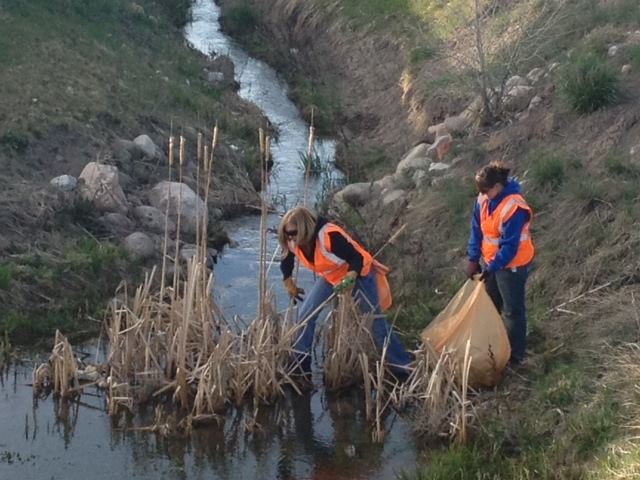
23rd Annual Eagle River Cleanup
About 300 people participated in this year’s Eagle River Cleanup, which was the 23rd annual. A large youth turnout at this year’s event helped forward one of the goals of the watershed council — to leave a conservation legacy for generations to come.
“It’s a start of environmentalism,” watershed council executive director Holly Loff said Saturday. “It connects the community; everyone has worked hard to do something that does make a difference.”
Loff said they expect to see about 4,000 pounds of trash collected from local waterways as a result of Saturday’s efforts.
While the trash itself isn’t often as detrimental to the river as the pollution you can’t see, a clean riverbank says a lot about a community, said Eagle County Commissioner Jeanne McQueeney.
“It takes away from the experience when you see trash as you’re rafting past, or when you’re trying to fish,” McQueeney said.
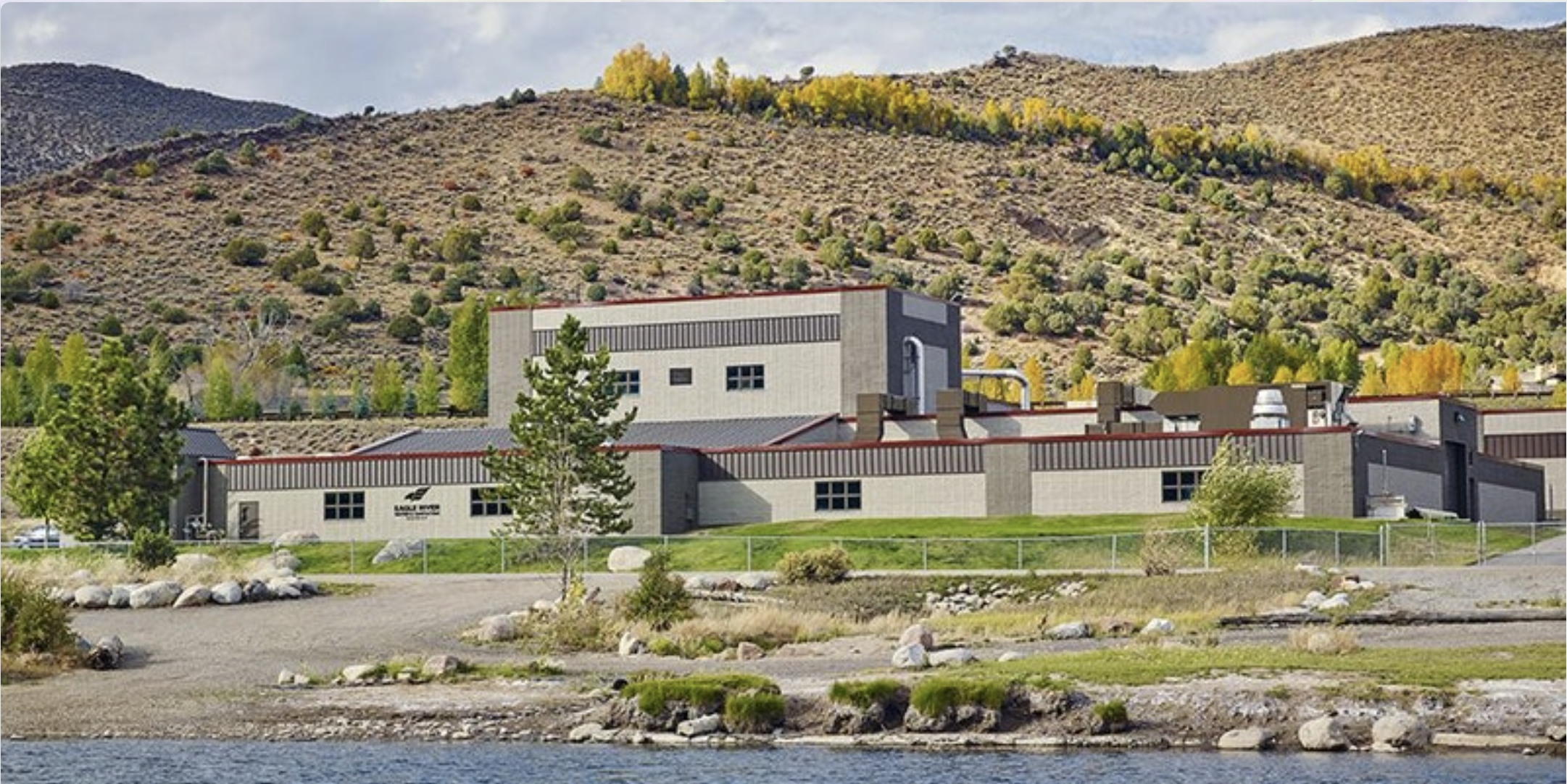
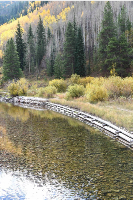
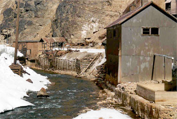
Edwards Wastewater Treatment Facility photo credit Eagle River Water & Sanitation District.
Click here to view the Eagle River Water & Sanitation event page and to register:
Join us for a reception and tour of the $25 million Edwards wastewater treatment facility solids handling improvement project. Now that the landscaping is done, we’re ready for visitors!
Please register so we can plan enough food for all participants.
11 a.m. to 2 p.m. – Open house, facility tours, and complimentary food.
Noon to 1 p.m. – Welcome, acknowledgements, speakers, and short tour.
Click here to read the newsletter. Here’s an excerpt:
New Developments on the Horizon for the Eagle Mine
Long-time residents of the Eagle Valley remember a time nearly 30 years ago when the Eagle River ran orange. Linda Jones, who worked at Battle Mountain High School, would pass by the river and its orange-stained rocks on her way to work, football games, and ski practices. Joe Macy and his colleagues at Vail Resorts (then Vail Associates) dealt with blowing orange snow on Beaver Creek’s ski slopes in the winter of 1989-90, as their snowmaking process pulls water straight from the Eagle. Those who weren’t around in the eighties might not realize that the scene at the Eagle River was not unlike the 2015 Gold King Mine spill on the Animas River. The leaching of hazardous heavy metals into the lifeblood of the Eagle Valley eventually caused the mining area to be declared a Superfund Site by the U.S. Environmental Protection Agency in 1986.
Gold and silver mining activity in the 235-acre area dates back to the 1870s, until lead and zinc mining took over in 1905. Ownership of the operation changed hands multiple times, until 1984, when the mine operator, Glenn Miller, went into bankruptcy and failed to pay the electricity bills. Without electricity, the water pumps in the mine stopped running and the mine workings began to flood. For the next five years, the water level in the mine continued to creep higher, until finally spilling over and flooding the river with lead, cadmium, copper, arsenic and zinc. Water quality began suffering long before the spill, however, as up until the Clean Water Act of 1972 was enacted, discharging contaminated water into the river was a perfectly legal and common practice.
The State of Colorado and the EPA both filed separate lawsuits against the former and current mine operators resulting in the cleanup being governed by two settlement agreements. Today, the site is owned by Battle Mountain, but the successor of Gulf + Western—CBS Corporation—is still paying for the cleanup and will continue to in perpetuity.
Over the past three decades, multiple agencies and partners have worked together to remediate, monitor, and improve the cleanup and the Eagle River. In many ways, the Superfund Site is an example of a very successful remediation in Colorado. Ore was originally processed through roasting and magnetic separation, resulting in metals-laden roaster waste. The tailings from the milling process also contained high concentrations of metals and were slurried through a pipeline away from the mine area. The deposited waste led to acid mine drainage. To date, all of the roaster waste and tailings that threatened human health and water quality have been consolidated from the old tailings pile, capped with a protective cover and revegetated to prevent any further groundwater contamination. Contaminated groundwater is currently treated at a water treatment facility before entering the river. Institutional controls and monitoring were established around the waste rock piles to determine acid generation potential and the water quality impact from runoff. The EPA also created secondary cribbing walls beneath Belden as a safeguard from waste rock crumbling into the Eagle.
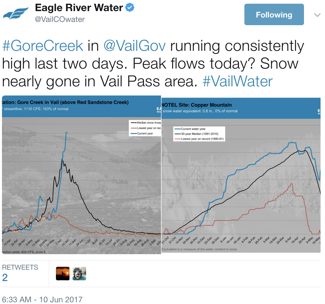
Though extensive remediation has occurred on site, the primary remaining concern is water quality and the ecological risks to fish and the tiny aquatic insects they feed on. The Eagle River is currently being managed as a brown trout fishery under Colorado Parks and Wildlife. In 2008, the Colorado Water Quality Control Commission set new standards for cadmium, copper, zinc, and arsenic levels. The change in standards required a new “feasibility study,” a Superfund process for the development and evaluation of new plans for cleanup. Today, the need for further cleanup is clear as the metal levels tend to exceed limits in March and April, as the snow is melting at the Eagle Mine site but the river hasn’t hit peak flow yet.
It’s important to note while arsenic levels peak in the spring, they are still well below limits for safe consumption of fish. The highest arsenic level is about .31 micrograms per liter (ug/L), while the Colorado Department of Public Health and Environment sets the standard for safe fish consumption at 7.6 ug/L, and under the Safe Drinking Water Act the limit is 10 ug/L. At a recent panel discussion of the Eagle Mine, both project managers from the EPA and CDPHE said they would let their kids and pets play in the river, and eat a fish from it as well.
The EPA broke the site into three manageable operable units (OUs): OU1 deals with site-wide water quality; OU2 is concerned with human health, primarily in the town of Gilman; and OU3 encompasses the North Property Redevelopment, or the Battle Mountain Project. The EPA and CDPHE have recently released Proposed Plans for Operable Units 1 and 3, which can be found online here and here or at the Minturn Town Hall. These new plans outline different alternatives for future remediation of the Superfund Site, to both bring metal concentrations into compliance in the spring as well as address land use changes in the future. Public comments on the plans will be accepted until September 10th of this year and can be submitted by email or mail—the addresses for each can be found within the plans. As these Plans are the first step in determining the next actions in the ongoing cleanup of the Superfund site, the Watershed Council encourages the community to read the plans and provide comments.
Lizzie Schoder is the Education and Outreach Coordinator for Eagle River Watershed Council. The Watershed Council has a mission to advocate for the health and conservation of the Upper Colorado and Eagle River basins through research, education, and projects. Contact the Watershed Council at (970) 827-5406 or visit
Gore Creek is healthy as it emerges from the Eagles Nest Wilderness Area, but has problems soon after, via The Mountain Town News. All photos by Jack Affleck.
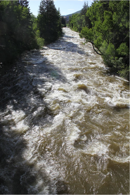
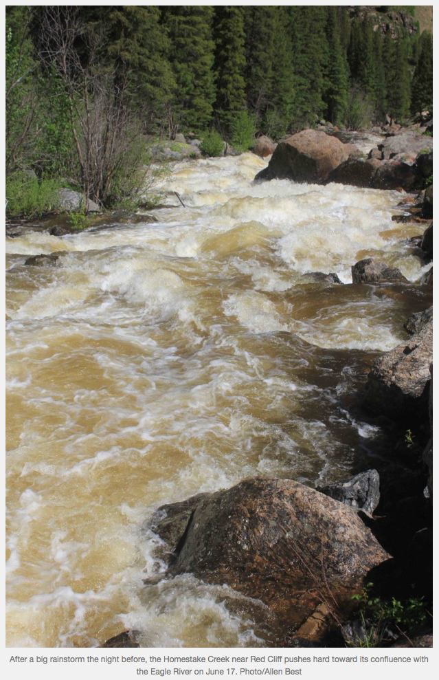
The Eagle River roils with spring runoff in June 2011 near Edwards, Colo. Photo/Allen Best
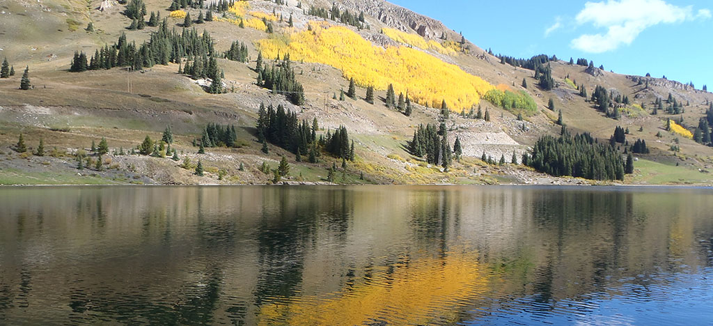
Eagle River Basin
Eagle Park Reservoir. Photo credit: The Mountain Town News.
Climax Mine
Homestake Reservoir circa 2010. Photo credit Aurora Water.
In drought years, holders of the most senior water rights can “call” on those with junior rights. That means junior rights holders have to stop diverting water.
The town of Gypsum was in that situation not long ago.
Town water manager Matt Franklin said senior rights holders taking their allocated water put a significant strain on the town’s ability to provide water to residents.
“Nothing’s more stressful than trying to meet demand when there’s a call on the river and you can only put out a quarter of what you need,” Franklin said.
Gypsum, over the past 20 years or so, has acquired some of the most senior water rights on Gypsum Creek. The most senior rights came from the former Albertson Ranch, now the moribund Brightwater development. Other senior rights came from Cotton Ranch closer to town.
Still, Franklin said, there are some rights senior to the Albertson Ranch rights that can take precedence in April. That month in 2013 — a historic drought year — was tough to cover, Franklin said.
In those dry years, the town has to pull water from farther downstream, and the quality isn’t as good. Treating that water requires more chemicals, more electricity, more manpower … more of just about everything, Franklin said.
GOOD RIGHTS, GOOD SUPPLIES
Still, that town is in good shape today regarding its water inventory. So is most of the rest of the Vail Valley.
Front Range water attorney Glenn Porzac knows more than just about anyone about mountain water. He said local water providers have worked over the years to ensure steady water supplies.
The town of Eagle is a good example, Porzak said. Town officials there “have been very aggressive,” Porzak said. “They approve annexations and developments only with all the water rights. Over time, they’ve really cornered that market.”
Farther east, the Eagle River Water & Sanitation District, along with the Upper Eagle Regional Water Authority, has also put in a lot of effort to ensure steady, stable supplies of water.
Those two entities have separate elected boards, but share staff and other resources. The district and the authority have an integrated system, Porzak said, which allows water to move as needed from roughly Edwards to East Vail.
The third major player in the upper valley is Vail Resorts, which requires water for snowmaking between November and January.
Most of that water supply comes from the Eagle River, but there are a few reservoirs that play crucial roles as streamflows drop between late summer and late winter.
Aurora and Colorado Springs control most of the water from Homestake Reservoir roughly between Red Cliff and Camp Hale. From there, water is pumped to Turquoise Lake near Leadville. Then, water is pumped either into the Arkansas River for Colorado Springs or into the South Platte for Aurora.
But there’s some local water sitting in Homestake, used to ensure streamflows in the Eagle River.
MORE LOCAL SUPPLIES
Near the Climax Mine atop Fremont Pass is the Eagle Park Reservoir, which is used by local providers for streamflows and some supply. Black Lakes, atop Vail Pass, is also used for local supply.
Still, local streams can run almost dry. Porzak said he has 2013 pictures of Gore Creek running at just a trickle. Portions of Brush Creek near Eagle have run almost dry in other drought years.
That’s why the water-pumping systems used by the upper valley water and sanitation district and water authority are crucial to ensuring adequate supplies for everyone.
Another player in the mix of who controls local water is the Colorado River District, which oversees use of the Colorado River from its origin in Rocky Mountain National Park to the Colorado/Utah state line.
Porzak said the river district has contracts to provide water to a number of small developments between Wolcott and Dotsero. The river district also provides some reservoir water to back up systems in Eagle and Gypsum.
Then there’s the most-senior water right in the valley. That one, the only one in the valley that dates to the 1800s, came off the Nottingham Ranch at Avon and serves Beaver Creek.
The Vail Valley’s water supplies are more stable than they were even a few years ago. Starting in about the middle of the 20th century, Front Range cities came to the mountains looking for water to feed their growing communities.
Part of those efforts included buying ranches for their water. Park County — the Fairplay area — is among the most-affected high-mountain areas, since it’s on the eastern side of the Continental Divide.
Denver Water, which bought thousands of acre-feet of mountain water over the years, also purchased water rights at 4 Eagle Ranch north of Wolcott and on the upper Eagle River. There was at one time talk of building a large reservoir near Wolcott.
A few years ago, thanks to an agreement with local providers, Denver gave up those rights, stabilizing the water supplies for local providers.
That cooperation is starting to show up in other parts of the mountains, Porzak said.
“Denver Water and the Western Slope get along pretty well now,” he said. “You’re seeing more cooperation in Summit and Grand counties now.”
Click here to read the newsletter. Here’s an excerpt:
An Ode to Water
It’s easy to forget that fresh water is not a limitless resource. In fact, there isn’t much of it in the world. The precious supply we do have must be protected and preserved. That’s where Eagle River Watershed Council (ERWC) comes in.
The group, comprised of three full-time staff members, a board, a team of about 1,000 volunteers and countless partners and overseers that range from the Environmental Protection Agency to the Town of Vail, considers itself “the watch dogs” of the Eagle River and the Vail Valley’s rare bounty of fresh waterways. The council works to preserve and restore the Eagle and Colorado Rivers, and all of the tributaries that run through Eagle County. It organizes mass trash pickups along the roads that line the waterways, tests water quality levels and makes sure the ecosystems of the rivers and streams are intact and also cleans up areas that have been compromised by pollution. Some of the organization’s bigger cleanup and restoration tasks include the portion of the Eagle River below Gilman that has been declared a Superfund site due to the area’s mining toxins leaking into the water. Another project involves storm and infrastructure work along Gore Creek to restore the diversity of the creek’s insect habitat, which then ensures that it maintains its status as Gold Medal fishing waters.
Ask any member of the ERWC why the organization refers to the Eagle River as the “lifeblood” of the Vail Valley, and the explanations are staggering.
“We call it the lifeblood because it affects every piece of life here in the valley, whether it’s recreation or the ski resorts,” says Brooke Ranney, ERWC’s projects and events coordinator. “We all depend on the river for drinking water, and we make sure we have a good quality water source. Then, there’s getting out on the river and its economic value.”
According to the group, the fly-fishing industry alone is worth $4 billion, to say nothing of the valley’s most prized asset—the ski industry which relies on the Eagle River for snowmaking.
“The Eagle River as well as the Upper Colorado draw a lot of people here, even if that means they came to ski or snowboard. People are using the mountains for skiing and snowboarding, not realizing that the manmade snow comes from water pulled from the river. As people stay here or come to visit in the summer and expand their visitation of Eagle County, the river plays a huge role in their decision to stay or come back again,” says Holly Loff, ERWC executive director.
Lizzie Schoder, the group’s education and outreach coordinator, heads up Watershed Wednesdays, free interactive tours, workshops and presentations centered around the watershed. The group also travels to local schools, teaching students of all ages various components of the watershed, from vegetation, insects and wildlife that comprise the streams’ habitat to ways they can preserve and protect the water supply—being mindful not to litter, turn off water while brushing teeth, pick up after one’s dog and avoid overusing water for landscaping or washing cars.
“We’re noticing people are unaware that storm drains flow directly to the river, so picking up after your dog is a huge one, not mowing lawns all the way to the river, letting native plants grow along it, being mindful of chemicals and pesticides used on the lawn,” Schoder says. “It’s something often forgotten … that we have so little true, fresh water in the world, so the way we allocate it and manage it is vital.”
The council collaborates with numerous local, regional and national entities to protect and preserve the water that runs through Eagle County. Also crucial to keep in mind is that while the rivers are the lifeblood of everything in this valley—the drinking water, snowmaking source and cornerstone of the flyfishing, kayaking and rafting industries—it also trickles down … quite literally.
“It’s important to note that we’re the headwaters of both the Colorado and the Eagle Rivers, so if we do anything to impact water quality here, everybody downstream suffers,” Loff points out. “If our rivers weren’t protected and there wasn’t vegetation there, it wouldn’t have the impact and draw that it does. Our economy would suffer quite a bit. It goes beyond people who are hardcore kayakers and recreationists. Water slows everyone down and reconnects you to nature and things that are really important in life. The EPA is always front and center in protecting clean water nationwide. Although drinking water is critical to all of us, people need to be more vigilant and stand up for clean water.”
Needless to say, the Eagle River Watershed Council is doing its part for the Vail Valley and beyond.
This panel will explore the history of the Eagle Mine and the collaborative cleanup efforts of the past two decades. The discussion will highlight the business, operational and regulatory perspectives, as well as those of our local community.
This discussion will be moderated by Larissa Read, president of the board of directors for Eagle River Watershed Council and owner of Common Ground Environmental Consulting.
Jamie Miller is a remedial project manager with the U.S. Environmental Protection Agency. She has a B.S. in Environmental Science, with a focus on Planning and Administration. She began her career in the environmental field with a private consulting firm and spent six years working with the EPA as a contractor on the Superfund Technical Assessment and Response Team contract, providing technical assistance to the EPA Emergency Response and Removal Program.
Wendy Naugle, P.E. is an engineer and groundwater hydrologist in the Superfund/Brownfields Unit at the Colorado Department of Public Health and Environment and has been working on the Eagle Mine cleanup for the past 18 years. Naugle holds a Bachelor’s degree in Geology from The Colorado College and a Master’s degree in Geological Engineering from the Colorado School of Mines.
John Widerman is a member of the Minturn Town Council. He has lived in the Eagle Valley for nine years and in Minturn for six of those years. He is a local environmental steward, a Colorado Mountain College Alum and an employee of Eagle County Schools.
The Eagle River roils with spring runoff in June 2011 near Edwards, Colo. Photo/Allen Best
Eagle River Basin
Here’s the release from the Environmental Protection Agency (Jennifer Chergo):
The U.S. Environmental Protection Agency (EPA) and the Colorado Department of Public Health and Environment (CDPHE) today released two Proposed Plans for environmental remediation at the Eagle Mine Superfund Site. Both Proposed Plans focus on further reducing heavy metal contamination created by nearly one hundred years of mining activity at the site.
“The cleanup proposals represent both EPA and CDPHE’s commitment to protect human health and the environment at the Eagle Mine Superfund Site,” said Acting Regional Administrator Deb Thomas. “These plans also highlight EPA’s commitment to bringing contaminated lands back to health and reuse.”
The Eagle Mine Superfund Site is located in Eagle County, Colorado. The site is defined as the area impacted by past mining activity along and including the Eagle River between the towns of Red Cliff and Minturn. Mining activities at the Eagle Mine began in 1879 and continued until 1984. EPA listed the site on the National Priorities List (NPL), commonly known as the list of Superfund Sites, in 1986 because of the mine metals discharge, uncontrolled mine waste piles and the close proximity of the population to the mine and associated features. To better manage the site, EPA divided it into operable units (OUs). OU1 focuses on protecting surface water by reducing metals loading from the site to the Eagle River. OU2 focuses on potential human health risks from contaminated soils in the abandoned company town of Gilman. OU3 focuses on soil remediation necessary to protect human health due to planned future development by the current landowner.
EPA issued a final Record of Decision (ROD) for OU1 in 1993 and a final ROD for OU2 in 1998. Over the years, all required environmental cleanup work has occurred at the Eagle Mine Superfund Site under a number of state and federal directives. Response actions at the site addressed the major sources of metals contamination to the Eagle River, including the old and new tailings pile, rex flats and various roaster waste piles near Belden. In 2001, EPA declared all cleanup construction activities complete at the Eagle Mine Superfund Site, except for ongoing operation and maintenance of remedial features like the water treatment plant. Remediation conducted to-date resulted in significant improvement in water quality and reduction in risk to human health and the environment. Continued operation of the existing remedy, including drawdown from the mine pool and treatment at the water treatment plant, is required to maintain this condition. Contaminant concentrations in surface water and groundwater have decreased, and the aquatic ecosystem continues to show signs of recovery.
In 2009, water quality standards established by the Colorado Water Quality Control Commission specifically for the Eagle Mine site became effective. Water quality monitoring in the Eagle River revealed that the water quality standards for cadmium, copper and zinc are not attained in March and April of most years. In response, the Proposed Plan released today for OU1 describes a number of alternatives designed to further reduce metals loading to the Eagle River. The preferred OU1 alternative includes the collection and treatment of groundwater from Belden and at the mouth of Rock Creek.
The Proposed Plan for OU3 presents cleanup alternatives focusing on soil remediation necessary to protect human health should future development occur. EPA created OU3, after a developer purchased a large portion of the Eagle Mine Superfund Site in 2004 with plans to develop the property into a private, residential community. The preferred alternative includes a combination of the following elements for areas at OU3 proposed for development: placing a soil exposure barrier; grading the site; placing institutional controls and conducting monitoring; and/or demolishing structures.
Here’s the release from the US Bureau of Reclamation:
Bureau of Reclamation Acting Commissioner Alan Mikkelsen announced that Reclamation has awarded $664,754 to seven entities to implement watershed management projects. The funding will be used for projects that enhance water conservation, improve water quality and ecological resilience, reduce water conflicts, and advance goals related to water quality and quantity.
“Cooperative watershed groups bring together diverse partners to address water management needs in their local communities,” Mikkelsen said. “The projects announced today will help restore watersheds and reduce water conflicts that were collaboratively developed within their communities.”
These are the first projects selected under Phase II of the Cooperative Watershed Management Program…
Eagle River Watershed Council, Inc., will receive $90,000 for a total project cost of $1,363,500 to improve instream flows in Abrams Creek, southwest of Eagle, Colorado. This project is being completed in conjunction with Trout Unlimited, Colorado Parks and Wildlife and Buckhorn Valley Metropolitan District.
Dave Dresman, the Vail Valley Foundation’s event director for the games, has worked on the events since the foundation acquired the event in 2008. Dresman said in those few years, attendance has more than doubled and sponsorships have increased nearly fivefold. With that kind of growth, it’s no surprise that planning the event has become a full-time job.
“It really doesn’t stop now,” Dresman said.
While those plans will take some time to jell, there’s already a tentative window for the 2018 edition of the games: June 7-10.
As planning for 2018 continues, a lot of information from this year’s games will inform what next year will look like.
Much of that planning will be well-defined, from the number of volunteers to expanding bus service to finding better ways for people to navigate the events. But there’s always a wild card: weather.
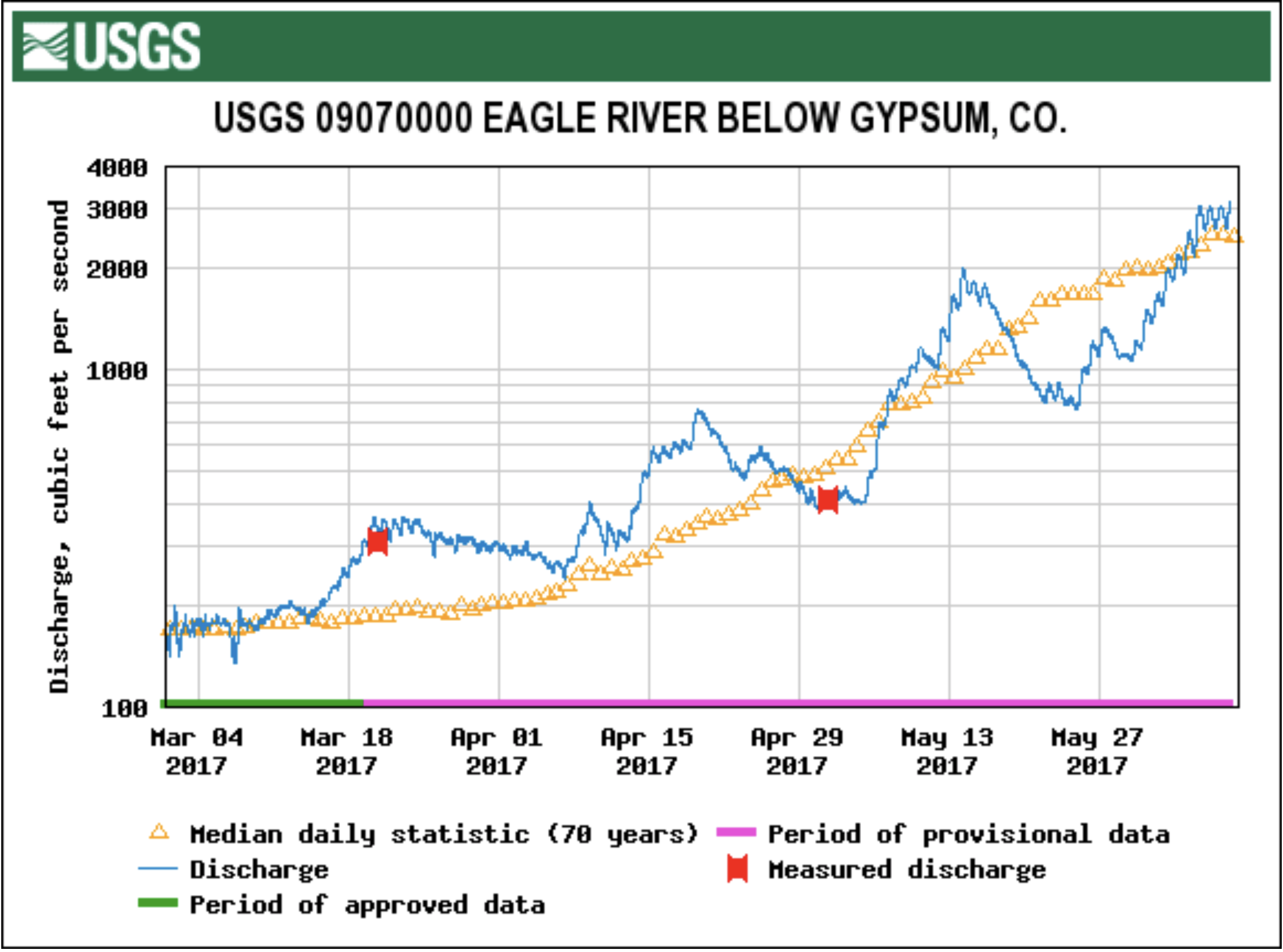
This year’s games were held in virtually perfect conditions, with good, but not overwhelming, streamflows and warm, sunny weather…
This year’s games were the best-attended ever. The 2016 Mountain Games drew an estimated 67,000 people. Dresman said he expects the final tally for 2017 to approach 80,000.
What is known is this year’s games set records for registered competitors — about 3,300 — as well as more than 145 vendor tents.
A number of those sponsors set up shop in and near Adventure Town in Lionshead Village. This was the second year there have been Mountain Games events in Lionshead, with more events and action in this location in 2017 than there were for the 2016 games.
[The Arkansas River] was flowing at 3,770 cubic feet per second late Friday afternoon at Parkdale, just west of Royal Gorge, according to the United States Geological Survey. Colorado Parks and Wildlife issues a high water advisory and recommends not rafting when flows reach 3,200 cubic feet per second level in the gorge, known for its whitewater rapids.
The high river flow wasn’t unexpected and isn’t out of the ordinary, said Bill Banks with USGS.
“A great deal of water is moving downstream right now because we’ve had a pretty abundant snowfall,” Banks said. “This is just the normal cycle.”
Colorado has seen a relatively slow, steady snowmelt this year, he said.
“That’s what we like – a long, controlled runoff,” Banks said. “That’s the best for the environment, best for stakeholders in the region. It’s best all around.”
A cool month of May suppressed local runoff and streamflows. But recent warm weather, with more sunshine in the forecast, may bring streams to peak runoff in the next several days.
The runoff picture is good news for the GoPro Mountain Games, set to begin today with the Steep Creek Championship on Homestake Creek…
While runoff will be good for the games’ boating events, this year’s so-so snowpack ensures there’s little danger of flooding. That also means boating events will almost certainly go on as scheduled…
Keeping safe on local streams is an all-the-time thing. Current conditions should soon turn more friendly for casual float trips.
Boyd, a valley native, said he looks every day from his home in Avon up to Game Creek Bowl on Vail Mountain. The bit of snow remaining on that slope means there should be a little more room for higher streamflows, he said.
Pete Wadden is the town of Vail’s water quality education specialist. Unsurprisingly, Wadden is also a boating enthusiast. Wadden has only lived in the valley for a few years, but looking at this year’s snowpack — bolstered by a large May snowfall — as well as the weather forecast for the next several days, he believes local streamflows should peak soon.
Boyd said he thinks streams will peak during the weekend. Wadden thinks the peak will come within the next 10 days or so.
Click here to read the newsletter. Here’s an excerpt:
New Bill Clarifies Water Uses for Eagle County
Colorado water law received some needed clarification in the 2017 session of the Colorado Legislature.
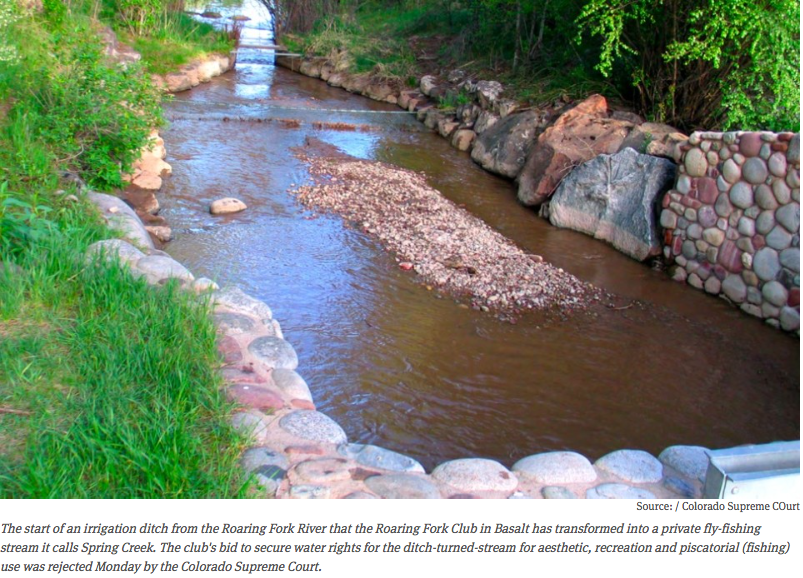
The legislature, this session, passed a bill in response to the 2015 Colorado Supreme Court decision in the case of St. Jude’s Co. v. Roaring Fork Club LLC. That decision held that direct diversions of water from a river to a private ditch for “aesthetic, recreational and piscatorial” purposes are not “beneficial uses” under state water law.
“Beneficial use” is a much-used term in state water law and originally encompassed primarily to agricultural and municipal uses. That definition has been evolving throughout the years — through both court decisions and legislation — to protect recreational uses, too, and the new legislation makes that clearer.
THE DEBATE CONTINUES
According to a summary on the legislature’s website, “The bill provides that the decision in the St. Jude’s Co. case interpreting section 37-92-103 (4) does not apply to previously decreed absolute and conditional water rights or claims pending as of July 15, 2015.”
What this means is that those who hold water rights from a stream can legally divert that water for purposes other than agriculture or municipal use.
The bill was sponsored in the House of Representatives by Democrat K.C. Becker and co-sponsored in the Senate by Republican Jerry Sonnenberg. In a statement after Gov. John Hickenlooper signed the bill, Becker said the law “provides the needed certainty for water rights holders in Colorado.”
Eagle River Watershed Council Executive Director Holly Loff agreed. In an email, Loff wrote that the group is celebrating the bill’s passage.
“It protects the tools that local governments have at their disposal to protect flows — both recreational and environmental — which were threatened by the broad language in the (Supreme Court) case. Recreational and piscatorial uses are most definitely beneficial and we are happy to see those protected.”
Top 10 sources of plastic pollution in our oceans.
Click here to read the newsletter. Here’s an excerpt:
Plastic Rivers
Driving along I-70 in the springtime as the snow melts, various types of trash can be seen scattered along the grass median. This isn’t uncommon for a major highway running through a populated area, but unlike other communities, our roadways run parallel to our water source–the Eagle River and its tributaries.
Wind can obviously blow lightweight litter to the streams, but snow and rainfall also picks up plastic bags, motor oil, chemicals, fertilizers, cigarettes, and dog waste left on or near our roads and carries it directly into the river or into our storm drains, which aren’t filtered before emptying out into our streams. Our roadways have historically been built along the path of least resistance, following our valley floors, and as a result, everything flows downhill to the nearby rivers. Urbanization and an increase in impervious surfaces (parking lots, roads, rooftops, and other materials that aren’t absorbent) have been identified as the one of biggest threats to water quality in not just Gore Creek, but also the Eagle River and its tributaries.
In fact, this past year in Vail, dry cement mix, paint, window cleaner, cooking grease, and 120 hot dogs were dumped down storm drains, according to Pete Wadden, the Town of Vail’s Watershed Education Coordinator. Our storm drains are different than our sanitary sewers, and dumping anything down a storm drain is equivalent to dumping it directly into a creek. But this awareness isn’t fully present in our valley yet, and people that love our rivers are polluting them unintentionally from improper disposal.
The effects of trash in our rivers extends beyond the reaches of our community, too. The Ocean Conservancy found 2,117,931 cigarettes, and over one million plastic bags and plastic bottles each in our oceans in 2016. By now, plastic-covered beaches around the world have been covered widely in the news. The statistic from World Economic Forum that by 2050, our oceans will contain more plastic than fish has hit home with many. It is commonly known that water bottles and to-go containers create problems, but the lesser known forms of pollution are microplastics—either microbeads from beauty products, microfibers from our clothing, or the breakdown of bigger pieces of plastic from the sun. When these microplastics break down, the chemicals they contain such as PCBs, PETs, DEHPs, antimicrobials, and bioretardants, are released and consumed by the food chain.
“Recently a huge fact came to light, that in U.S. and Indonesian fish markets, a quarter of the fish contain microplastics, and a third of shellfish contain microplastics. And ultimately, where do those microplastics and contaminants end up? With the top predator,” explains Dr. Maria Campbell, a marine biologist with Plymouth University in the film, Plastico.
And since our rivers all flow to our oceans, it’s essential that we as a river-side community not contribute to the plastic pollution epidemic.
How can you help? Most importantly, reduce your use of disposable plastics such as to-go containers, plastic bags, straws, etc. before they make their way into our rivers, and recycle plastics whenever possible. Choose beauty products without microbeads such as natural face washes. Aside from these preventative measures, we also welcome you to join us in picking up the trash that has blown out of vehicles traveling our roadways. Each spring, following ski season and just as the trash emerges from underneath the layers of snow, the Watershed Council hosts the Community Pride Highway Cleanup with more than 950 volunteers. You can come out and help to clear trash from more than 138 miles of Eagle County roadways (I-70, Highways 6, 24, and 131) on May 6th. In the Watershed Council’s 17-year history of coordinating the event, the amount of trash cleared has decreased significantly from 45 tons collected per year to 10 tons. With greater public awareness, more recycling, and greater care for where our trash goes, hopefully this number will continue to decrease. The Watershed Council is always looking for more volunteers for this great community event. To get registered for the event, please call the office at (970) 827-5406 or email ranney@erwc.org.
Lizzie Schoder is the Education and Outreach Coordinator for Eagle River Watershed Council. The Watershed Council has a mission to advocate for the health and conservation of the Upper Colorado and Eagle River basins through research, education, and projects. Contact the Watershed Council at (970) 827-5406 or visit http://www.erwc.org.
Click here to read the newsletter from the Eagle River Watershed Council. Here’s an excerpt:
“There is a religious experience in coming over top of a huge rapid and burying your bowman’s face down until you maybe can’t see him,” Claude Terry describes of our 39th president, Jimmy Carter—then Georgia Governor—completing the first tandem descent of the wild Chattooga River in 1974.
President Carter grew up near rivers under the guidance of his father, an avid fisherman, which built the foundation of his admiration and respect for wild waters. Under the tutelage of Claude Terry, the co-founder of American Rivers, he learned all he could about kayaking and canoeing, and the pair became the first to run the Class IV+ rated Bull Sluice rapid in an open canoe. The experience through the beautiful, rugged, and wild rapids on the Georgia-South Carolina border led him to advocate for the listing of the Chattooga River through the Wild & Scenic Rivers Act.
The Wild & Scenic Rivers Act, signed into law in 1968 by President Lyndon B. Johnson, is one of the earliest pieces of environmental regulations surrounding water. The Act’s aim is to protect the natural and healthy flow of certain rivers that exhibit “outstandingly remarkable” scenic, cultural, historical, recreational, geologic, and other similar values worthy of preservation for future generations. Essentially, it ensures the river will remain in its current free-flowing form and defends against future damming or development that would harm the river and its surrounding ecosystem.
Typically, a quarter-mile buffer surrounds designated Wild & Scenic Rivers. Included with the designation of each river is a management plan specific to that stream to ensure the conservation of the “Outstanding Remarkable Values” (ORVs) for which the wild river was identified. The management plan is developed through a process that promotes participation across political boundaries and from the public. Existing water rights, private property rights, and interstate compacts are not affected by a listing or designation.
While there are about 3.6 million miles of rivers and streams in the U.S., only about 12,709 miles are protected under the Wild & Scenic Rivers Act—about 0.35%. And while there is only one river in Colorado, the Cache la Poudre, currently protected by the Wild & Scenic Rivers Act, Deep Creek in our own Eagle County was found “suitable” for Wild & Scenic designation in 2014. American Rivers and Eagle River Watershed Council are currently working with the Bureau of Land Management (BLM) and the U.S. Forest Service (USFS) to designate this pristine river as such.
Flowing from the Flat Tops and Deep Lake to its confluence with the Colorado River just before Dotsero, the river passes through a deep and narrow canyon of limestone rock that hosts one of the biggest and most complex cave systems in Colorado. Deep Creek is also home to rare species from riparian plants to bats, all of which will fall under the umbrella of protection with a Wild & Scenic designation. Sheep and cattle ranchers graze their livestock in the area as well. The Watershed Council and American Rivers have been working with these ranchers to ensure that their grazing rights are protected as they have used this land without impacts on the wild and scenic values of the creek for generations.
President Carter continued his legacy of environmentalism throughout his presidency, blocking numerous dam projects throughout the U.S. that would have negatively and permanently altered rivers and their ecosystems. A film by American Rivers, entitled “The Wild President” explores the groundbreaking first descent, and will be one of 10 inspiring and adventurous films shown at the Wild & Scenic Film Festival on April 12th at the Riverwalk Theatre in Edwards. The film festival was created by Patagonia and is hosted locally by Eagle River Watershed Council in an effort to increase community awareness of our relationship with the planet, particularly our waterways, and to inspire action. For more information and to buy tickets, visit http://www.erwc.org/events/calendar.
Lizzie Schoder is the Education and Outreach Coordinator for Eagle River Watershed Council. The Watershed Council has a mission to advocate for the health and conservation of the Upper Colorado and Eagle River basins through research, education, and projects. Contact the Watershed Council at (970) 827-5406 or visit http://www.erwc.org.
Passages are narrowing as the snow piles up in Crested Butte. Photo/Town of Crested Butte Facebook page
Click here to read the newsletter. Here’s an excerpt:
River-Friendly Snow and Ice Removal
Are you a pusher or a scooper? Of snow, that is.
With all of the snow earlier this winter you likely have a distinct preference for one or the other. I’ll leave it to the medical professionals to advise on proper shoveling techniques. What I’d like to focus on is how to remove snow and ice without negatively impacting our streams. Looking out the window as I write this, it feels a bit out of touch to be writing about snow and ice, but looking at the calendar, I am hoping this information will be put to good use very soon!
Where you put your snow and how you get rid of ice can affect our streams in several ways. Here are some tricks:
First, remove the snow as it falls, before it gets tracked down. This is your first and best defense in preventing ice from forming.
Next, you want to take an extra second to think about where to pile the snow—this will help you down the road. Those that live along a stream may be tempted to push snow into it. After all, “snow is just water.” This is not a good practice, however!
Here is why: Snow from your driveway and sidewalks absorbs oil, antifreeze, overcast fertilizers (particularly with the first snowfall of the year), sand, road salts, or any chemicals that drip off of vehicles. Dumping snow straight into the river introduces all of these to the stream in high concentrations. This reduces water quality, impacting habitat.
Sure, as it melts this is mobilized and makes its way to the stream anyway. However, a large portion of it soaks through the soil first. The ground and our native riparian plants are nature’s water filter, separating the contaminants from the water before it eventually makes its way back to the river.
Therefore, piling the snow in your yard is your greatest option. Pile it in a place where when it melts it doesn’t run across a sidewalk, road or driveway. As we all know, what melts in the day refreezes at night and you could wake up to an ice rink the next morning. A blanket of snow can actually be beneficial to your lawn, as it provides an insulating layer that protects against extreme temperature fluctuations and harsh winds. Additionally, once water reaches an impervious surface (concrete, asphalt, etc.), it’s headed for the gutter and from there the storm sewer—which sees little to no treatment before running straight into a stream near you.
If you follow these tips and still end up with ice, you have a few options. Chipping away by hand provides a great arm and cardio workout right in the driveway. If you are rolling your eyes, you likely are thinking about deicers instead. Deicers, when used properly, are a great tool. When used improperly they can ruin your concrete, impact our streams, hurt your pet’s feet and even ruin your floors if you track them in on your shoes.
Available options range from rock salt (sodium chloride), calcium chloride, calcium magnesium acetate and even urea (fertilizer) or sand. Each has varying costs, benefits and problems—diving into these would take an entire article to cover. That said, sand doesn’t melt ice—it just provides traction. Urea is only effective in high quantities and will runoff into the streams adding excessive levels of nitrogen, which grows algae and causes many imbalances in the stream. It should be avoided out of respect for our rivers and in-lieu of truly better options.
Whatever you use, it’s important to read the label carefully and apply only the amount necessary. If after the ice is melted some of the product remains, you’ve applied too much and can use less in the future. Remember to sweep up the excess before it makes way for the gutter.
Keep in mind that if a product has the potential to damage your landscaping, shoes, concrete or pet’s feet, it will wreak havoc on the nearest stream, too.
Follow these tips and you can rest easy knowing that your snow removal is effective and isn’t impacting our high-quality fishing, rafting and drinking water.
Holly Loff is the Executive Director for the Eagle River Watershed Council. The Watershed Council advocates for the health and conservation of the Upper Colorado and Eagle River basins through research, education, and projects. Contact the Watershed Council at (970) 827-5406 or visithttp://www.erwc.org.
Gore Creek is healthy as it emerges from the Eagles Nest Wilderness Area, but has problems soon after, via The Mountain Town News. All photos by Jack Affleck.
This revegetation project uses log cribbing to hold the bank of Gore Creek in place while the plants get established. The logs will slowly decay. Photo credit Jack Affleck via The Mountain Town News.
Riparian areas were crowded or completely eliminated as the town was developed. In this, Vail is hardly alone. Photo by Jack Affleck via The Mountain Town News.
Streets and other artificial impervious areas result in rapid runoff of pollutants into the creek. Photo via The Mountain Town News and Jack Affleck.
A host of problems threaten Gore Creek in Vail, but one of the biggest is what runs through the town’s storm drains.
Some of the problem will take years and a lot of money to solve. For instance, much of the runoff in town is no longer filtered through the soil, which has been replaced by pavement, concrete and rooftops throughout the years. But a number of problems may be due to people simply not knowing what happens when something runs into a storm grate.
Vail Watershed Education Coordinator Pete Wadden recently updated the Vail Town Council about state of stormwater and its treatment in town.
IMPROVED FILTRATION
There are a number of ways to treat stormwater, including catch basins that can capture sand, oil and other material before it flows into the creek. There are 27 of those basins in town at the moment, and they’re cleaned out a couple of times every year, Wadden said. Upgrading those basins would be effective, but expensive, Wadden said.
Filtration has been improved at the town’s snow storage site, and improvements are planned for this year at the East Vail Interstate 70 interchange.
But the basins don’t catch everything.
There are also more than 2,000 storm drains, many of which flow directly into the creek. Slowing the runoff is a good start at cleaning up those areas. Creating zones where runoff could filter through rocks and soil before going into the creek could be effective.
Then there’s the problem of people dumping stuff into the storm grates.
During his presentation, Wadden went through a small list of stuff that people dropped into storm grates in 2016. That list includes cooking grease, paint and window cleaner.
A member of a construction crew in Vail Village dumped a bag of cement into a storm drain.
Town crews had to vacuum out the storm grate to catch as much of the powdered cement as possible. Wadden said the construction company wouldn’t name the employee who dumped the cement, so no ticket was issued.
In a separate incidence, no ticket was issued to a vendor at the 2016 GoPro Mountain Games who dumped 120 hot dogs down a storm drain, which resulted in another good-sized cleanup.
“People just don’t know where the water goes,” Wadden said.
Council members said that needs to change.
An education campaign is already under way that includes advertising on town buses, and a proposal to create awareness-raising art on town storm drains. There’s also a town hotline, 970-476-4673 (GORE), to report dumping into storm drains. But that phone is only answered during normal business hours.
Council member Dick Cleveland asked if the phone could be routed into the town’s emergency dispatch center.
‘EASY TO UNDERSTAND’
Cleveland also asked Wadden if the education campaign could be expanded to include some sort of notice at virtually every storm grate in town. Cleveland said that’s the case in a California town near the beach.
The U.S. House of Representatives Monday passed the Bolts Ditch Access and Use Act, and the Arapaho National Forest Boundary Adjustment Act, legislation sponsored by Rep. Jared Polis, D-Colo. to help Colorado communities and protect public lands. Several Colorado members of Congress co-sponsored the bills.
Bolts Ditch Access and Use Act will allow the town of Minturn to use its existing water rights to fill Bolts Lake by giving the town special use of the Bolts Ditch headgate and the segment of the Bolts Ditch within the Holy Cross Wilderness Area. When Congress designated Holy Cross Wilderness Area in 1980, Bolts Ditch was inadvertently left off the list of existing water facilities.
The Arapaho National Forest Boundary Adjustment Act would expand the Arapaho National Forest to include 10 new parcels of land, informally known as the “Wedge,” which are currently undeveloped. The move enables the U.S. Forest Service to protect and preserve an area were millions of people travel annually.
Polis, who lives near Boulder, represents part of the mountains including Summit County and about one-third of Eagle County.
“Today was a great win for Coloradans,” Polis said. “At a time when it seems that partisanship and divisiveness is at historic levels, it’s heartening to see members of the Colorado delegation work together to protect our public lands and find practical solutions for our communities. We should all be proud of the passage of these bills that will protect our wonderful wilderness and help our local economies.”
TWO ADDITIONAL BILLS APPROVED
The House of Representatives also approved two additional bills that Polis co-sponsored. Both bills settled long-standing land disputes in Colorado. The Elkhorn Ranch and White River National Forest Conveyance Act would resolve a costly title dispute between the federal government and private landowners. It would convey a small portion of land near Rifle to property owners who have used and paid property taxes on the acreage for years. The Crags, Colorado Land Exchange Act would convey 320 acres of land on the west side of Pikes Peak to the U.S. Forest Service. The Broadmoor Hotel currently owns the land, and in exchange, the government will transfer an 83-acre parcel located at Emerald Valley Ranch to the Broadmoor.
Both Colorado Senators Michael Bennet and Cory Gardner introduced Senate companion legislation to these four bills this session.
The Eagle River roils with spring runoff in June 2011 near Edwards, Colo. Photo/Allen Best
Click here to read the newsletter. Here’s an excerpt (Lizzie Schoder):
This past year will likely break 2015’s mark of being the hottest year on record. Colorado has seen a similar trend, with a 2 degrees Fahrenheit bump statewide in the last 30 years. Colorado, like much of the Southwest, has also seen drought for the past decade, which has been felt most strongly in the western part of the state.
How does this affect our rivers? A warmer atmosphere has a drying effect overall — meaning more precipitation falls as rain rather than snow and peak runoff and snowmelt happen earlier in the year. Although there is no significant change detected (so far) in the amount of precipitation, the change in the form of precipitation is what’s significant. Our snowpack levels, measured in snow water equivalent, act as nature’s time release to recharge our rivers. Less snowpack, or more precipitation that falls instead as rain, means less natural recharge, since rain runs through the watershed at a quicker rate.
The National Oceanic and Atmospheric Administration reports show trends of peak runoff and snowmelt occurring anywhere from one to four weeks earlier in the spring. Rain is an immediate surge to our rivers, but can give way to evaporation during hotter months of the summer. Snow, on the other hand, melts slowly, recharging the rivers at a steadier pace, especially during July and August when we need it most. Though predictions of how this will affect annual runoff vary, the 2011 Bureau of Reclamation report estimates that Colorado River flows will decrease by about 8.7 percent by 2060, or roughly the annual amount diverted by canal to Los Angeles, Orange and San Diego counties. These trends along with increased evaporation due to warmer temperatures does not bode well for a region already dealing with prolonged drought.
Snowpack levels are a pivotal factor in ski communities. But it matters too for agriculture, irrigation, hydropower, river recreation and water quality. Lower water levels lead to shallower and therefore warmer rivers, affecting our plant and fish populations, as well as the aquatic bugs they need for food. Warming temperatures also mean that everything from crops to humans will need more water to compensate. The Colorado River supplies water to 40 million people in seven different southwest states. The rising temperature trend will only put more pressure on an over-allocated system, pushing both the supply and demand of the Colorado River in the wrong direction.
While communities that depend on the Colorado River have gone to extraordinary lengths to buffer the impacts of climate change, we are heading for times where water shortages will be felt more than ever. According to the New York Times, Lake Powell provides water to one in eight Americans and waters one-seventh of the nation’s crops. Like the other dams and reservoirs in the Colorado River system, it’s completely over allocated — the water levels continue to dwindle and more water is being taken out than what flows into it. If Lake Powell isn’t able to supply the 7.5 million acre feet annually to the Lower Colorado Basin as required by the 1922 interstate compact, then a river call requiring Upper Basin communities, such as Eagle County, to use less water could come into effect in coming years.
The national political debate over the legitimacy of climate change will inevitably continue. But with our county’s population projected to nearly double by 2050, we must recognize that water is a nonpartisan issue. It is important that we voice our opinions and demand action at the national level, while also encouraging action at state and local levels where it can likely happen more quickly. From the standpoint of water and river protection however, we do not need to stand around waiting for our leaders to reach consensus on the existence of climate change.
There is no arguing that the level of water in Lake Powell — and its sister, Lake Mead — continue to drop, making it clear that water conservation and efficiency is of critical importance. That can happen through legislative actions, regulatory measures, but also where you can make an impact — in your home and garden. For more information, visit http://erwc.org.
Lizzie Schoder is the education and outreach coordinator for Eagle River Watershed Council. The Watershed Council has a mission to advocate for the health and conservation of the Upper Colorado and Eagle River basins through research, education and projects. Contact the Watershed Council at 970-827-5406 or visit http://www.erwc.org.
The Bolts Ditch Access and Use Act would authorize special use of the Bolts Ditch headgate and the segment of the Bolts Ditch within the Holy Cross Wilderness Area, allowing Minturn to use its existing water right to fill Bolts Lake. This would solve a problem created in 1980 when Congress designated Holy Cross Wilderness area, but inadvertently left Bolts Ditch off of the list of existing water facilities.
The Florissant Fossil Beds National Monument legislation will allow for enhanced wildfire protection as well as additional habitat for wildlife and recreational opportunities for visitors. Established as a national monument in 1969, the Florissant Fossil Beds National Monument is located west of Pikes Peak and less than 40 miles from Colorado Springs. The monument is home to diverse fossil deposits, maintaining a collection of over 12,000 specimens. It also provides recreational experiences and curriculum-based education programs for its visitors. A private landowner submitted a proposal to donate 280 acres of land adjacent to Florissant Fossil Beds Monument, but due to current law the land donation cannot take place. This commonsense legislation would permit a landowner to donate private land to Florissant Fossil Beds National Monument.
The Wedge Act would aid the Forest Service in acquiring several parcels of land adjacent to Rocky Mountain National Park. This Act would help preserve critical wildlife habitat, Colorado River headwaters, and a highly visible view shed in the area commonly referred to as the Wedge.
The Crags, Colorado Land Exchange Act is a federal land exchange where the Forest Service would acquire pristine land in the Pike National Forest allowing for more outdoor recreation near Pikes Peak.
The Elkhorn Ranch and White River National Forest Conveyance Act would correct the discrepancy that took place from conflicting land surveys and require the Forest Service to convey acreage to private ownership that is rightfully private property, according to the Forest Service’s own conclusion and recommendation. For nearly 100 years, 148 acres of land has been used as private land even though it is included in Forest Service survey maps, and this legislation allows for the resolution between the Forest Service and the private landowner.
“Colorado’s public lands are national treasures and I’m proud to work across the aisle to protect our state’s natural beauty,” Gardner said in an afternoon statement. “Each of these measures proposes a legislative fix that will have a lasting impact on Colorado and ensure future generations are able to enjoy Colorado’s great outdoors. I look forward to working with my colleagues to advance these bills through the legislative process.”
Bennet added. “Our public lands define Colorado and help drive our outdoor recreation economy. These bipartisan, commonsense measures will help to preserve our pristine lands, protect wildlife habitats and expand outdoor access for years to come.”
Gore Creek is healthy as it emerges from the Eagles Nest Wilderness Area, but has problems soon after, via The Mountain Town News. All photos by Jack Affleck.
Click here to read the newsletter. Here’s an excerpt:
It’s been a busy year for the Watershed Council. The board and staff would like to take this time to thank everyone that participated in the wide variety of activities presented by our organization in 2016—from our educational Watershed Wednesdays series held throughout the valley, the sold out Wild and Scenic Film Festival, our annual Highway Cleanup, to our signature River Cleanup event. We would like to thank all of our funding partners that supported our mission of advocating for our rivers through educational programs, special events, restoration projects, monitoring, research, and community engagement.
Eagle River Watershed Council believes that our rivers and streams are the life-blood of our valley. Their preservation and restoration supports our economy, culture and quality of life.
The Watershed Council’s annual programs and events represent the public side of the work we do, but we are also involved in a variety of partnership efforts such as providing water quality sampling along Gore Creek, the Eagle River, and various tributary streams within the watershed. The sampling data collected and compiled by the Watershed Council is available in an interactive and easy to understand format online at http://wqcourier.erwc.org. The data also provides a baseline which can be used to identify emerging threats or effectiveness of stream health improvement projects.
Eagle River Watershed Council has coordinated the effort to improve water quality in our local streams through its participation in the Urban Runoff Group, a stakeholder committee that includes entities such as Eagle County, CDOT, Eagle River Water and Sanitation District, the towns of Avon and Vail, Vail Resorts and the Vail Recreation District. This group initiated the Gore Creek Water Quality Improvement Plan in 2013 and the Gore Creek Strategic Action Plan in 2015 culminating in the “Restore the Gore” program, for which projects are currently underway. The Watershed Council applauds the Vail Town Council for their vision in understanding that the health of Gore Creek benefits all user groups and for beginning the process of improving water quality on the Gore.
The three major factors that are likely affecting aquatic life in Gore Creek are not exclusive to that stream and can affect all urbanized waterways within the watershed. They are:
Pollution from chemicals used in urbanized areas adjacent to streams, such as fertilizers, weed killers and pesticides used in landscaping.
An increase in stormwater runoff from impervious areas such as roads, parking lots, buildings, and other hardscape areas that prevent infiltration of rain and snowmelt that would recharge the aquifer and support base flows.
Loss of vegetation along the stream. These riparian plants normally play a critical role in filtering pollutants from storm water runoff before it enters the stream.
The Watershed Council, through the Urban Runoff Group, has just completed an action plan for a segment of the Eagle River from its confluence with Gore Creek downstream to the EagleVail half diamond interchange. In assessing this section of river, the Watershed Council provided recommendations to mitigate the effects of urbanization affecting water quality. This includes recommendations for changes to land use regulations, improved storm water infrastructure, and projects to restore vegetation along the stream.
In 2017, we look forward to assisting with the implementation of the completed Action Plans and completing the same process through the other communities in the valley.
We have a full schedule of Watershed Wednesdays, filled with great tours and engaging presentations, coming together for the year as well. Our 2017 restoration projects are in design and planning now, we look forward to utilizing our wonderful cadre of volunteers this next summer in implementing those. Stay tuned if you are interested in getting involved.
With the addition of new boat ramps, increased river access through open space parcels and an increase in population over the last several years, river usage is at an all time high. We as a community need to be vigilant to balance the economic and recreational usage of our rivers that we all enjoy with the need to improve or maintain a high level of water quality throughout the watershed.
Gary Brooks is the Board Chairman for Eagle River Watershed Council. The Watershed Council has a mission to advocate for the health and conservation of the Upper Colorado and Eagle River basins through research, education, and projects. Contact the Watershed Council at (970) 827-5406 or visit http://www.erwc.org.
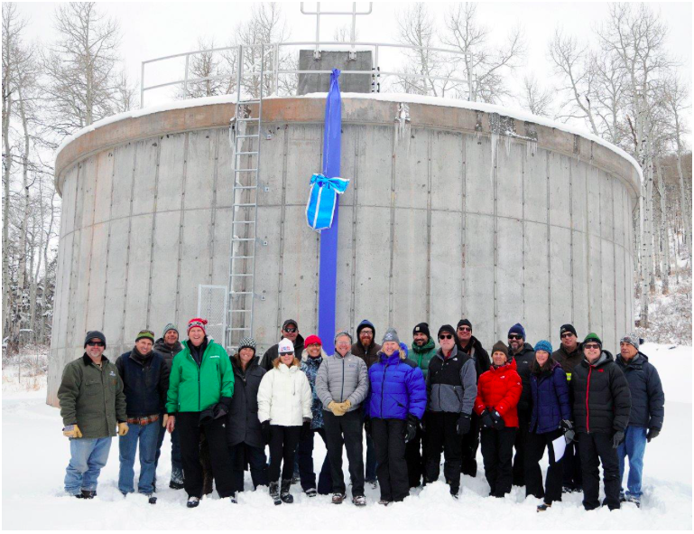
Eagle River Water & Sanitation District staff members with Upper Eagle Regional Water Authority board members and representatives of the town of Avon, Mountain Star Association, and contractors involved in developing and constructing the 270,000-gallon water storage tank in Mountain Star.
Here’s the release from the Eagle Valley Water and Sanitation District:
Water Authority brings new water storage tank online.
Representatives of the Upper Eagle Regional Water Authority, town of Avon, and Mountain Star Association gathered Dec. 8 to mark the completion of a new water storage tank that serves the Mountain Star community.
The Water Authority put the 270,000-gallon tank into service Nov. 15, after it was completed on time and under budget during a six-month construction window.
Envisioned in 1993 – when Avon originally approved the subdivision – the tank is one of five that along with five booster pump stations comprises the potable water supply system that had to be built to deliver water from the valley floor to the high alpine development north of Avon.
The 1993 subdivision approval anticipated this tank being built at a future date when suitable U.S. Forest Service land could be obtained. The then-existing Avon Metro District agreed that it would collect tap fees from homes that were built and served by a somewhat-temporary water supply system until this storage tank could be constructed.
The Water Authority acquired the necessary Forest Service property in May 2013 as part of the complex, multi-year Eagle Valley Land Exchange agreement. With the site acquisition costs and ongoing pump station improvements, the Authority has recently spent about $2.2 million on the Mountain Star system.
Mountain Star, Avon, and Authority representatives worked together for several years to agree on funding and construction of the final storage tank, which resulted in an Implementation Agreement. The project cost estimate of $1.85 million was more than the amount of tap fees collected by Avon since 1993, so Mountain Star homeowners agreed to fund the remaining cost. The Authority committed $135,000 to upgrade to a longer-lasting, less maintenance-dependent tank. The Agreement also included a guaranteed maximum price contract and a provision that Mountain Star homeowners would receive any cost savings.
The Water Authority used an integrated project delivery method for the tank and the actual cost is projected to be $1.55 million, a savings of about $300,000. The Authority will refund this savings to Mountain Star after final accounting of the actual project costs.
At 9,380 feet, the new tank serves higher-elevation residences and benefits public safety via enhanced fire protection. While the tank provides additional water storage, the parties are committed to efficient water use with many homeowners participating in the Authority’s water demand management pilot study to establish new irrigation practices that benefit landscapes while decreasing overall water use.
Contact: Linn Brooks, General Manager: 970-476-7480
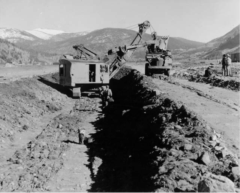
In 1942, a new channel for the Eagle River was built at Camp Hale to replacing the naturally meandering route. Photo/Denver Public Library Western History Department via The Mountain Town News.
A vision gains support for freeing Eagle River from WWII straitjacket
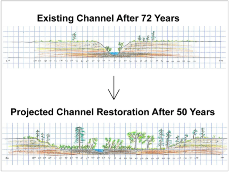
Work could begin in 2018 in restoring the Eagle River at Camp Hale, the training site for the 10th Mountain Division, to something more closely resembling its pre-World War II look and functions.
Photos of the valley by William Henry Jackson, the famous landscape photographer of the 19th century, show a meandering river through the valley, called Eagle Park, clogged with willows and wetlands. A steam train chugged through the valley and later, at a railroad siding called Pando, ice was harvested.
All this changed in 1942. The U.S. Army first considered a site near Yellowstone National Park and other options before settling on the valley, elevation 9,200 feet, for training of elite troops capable of engaging enemy soldiers in mountainous terrain. Access to a transcontinental railroad was key. Within a few months, streets had been created, barracks erected, and the river confined to a straight-as-an-arrow ditch.
Photo via The Mountain Town News.
Now, 74 years later, it’s still in that same ditch.
After the 10th Mountain soldiers were dispatched in 1944 to Texas for toughening up, the Army began dismantling Camp Hale. Barracks and other buildings were leveled, including the auditorium where visiting dignitaries such as prize- winning fighter Joe Louis and actress Jane Wyman, the first Mrs. Ronald Reagan, appeared. The camp was used once more from 1959 to 1965, this time by the Central Intelligence Agency for training of Tibetan guerrillas, before the military reservation was returned to the U.S. Forest Service.
But even now, cleanup from the war efforts continues. In 1997, an unexploded mortar shell was discovered on Mt. Whitney, in the nearby Homestake Valley. The U.S. Army Corps of Engineers later tried to recover all old weapons of war from the landscape,
returning again this summer for a final sweep using metal detectors. There’s some lingering asbestos. And there’s the ditch called the Eagle River.
Many stakeholders in Camp Hale
Talk about restoring the river has occurred several times since the 1970s, says Marcus F. Selig, of the National Forest Foundation, a non-profit partner of the U.S. Forest Service, but never made significant progress. The new effort began in 2013, when 40 groups with a direct interest in the valley were gathered to work toward a coherent vision for a restored landscape.
While adjoining streets and buildings were quickly removed, the Eagle River today flows in a ditch created at Camp Hale in 1942. Photo credit Allen Best The Mountain Town News.
The Aspen-based 10th Mountain Division Hut Association has several huts in the area. Meeker residents Sam and Cheri Robinson have grazed thousands of sheep every summer in the mountains above Camp Hale. The dwindling number of 10th Mountain vets and now their descendants want the legacy of their war training remembered.
Stakeholders agreed that what exists now is “not a healthy aquatic ecosystem,” says Selig, the vice president of programs for the National Forest Foundation.
What has emerged is a plan that would create five to seven miles of a meandering, ox-bowed Eagle River in the valley bottom as it winds around to the east, from the Climax Mine. The work would also create 200 acres of wetlands. The dirt moving would create a 300-foot-wide flood plain or riparian area.
A related but somewhat separate effort involves creating an even stronger historical presence. A pullout along Highway 24 has exhibits, but the 10th Mountain has enough of a compelling story to justify a book. In fact, about 10 of them have been written, along with films and other remembrances.
In Italy, the 10th Mountain engaged in fierce fighting in the Apennine Mountains of Italy. Among the veterans were Fritz Benedict, the architect who was an integral part of the post-World War II revitalization of Aspen, and Pete Seibert, who also spent several years in Aspen during its early incarnation as a ski town before eventually creating Vail. The two are just the tip of the ski history iceberg involving Camp Hale.
Then there are side-stories. Camp Hale was also used to hold prisoners of war, in particular those of Field Marshal Erwin Rommel’s Afrika Corps. For mystifying reasons, the Army also stationed German sympathizers deemed too risky to become front-line soldiers next to the POW camp.
One of them included a brilliant Harvard- trained philologist, Dale Maple, who engineered an escape with two POWs. As told in a New Yorker story, they made it as a far as Mexico before being apprehended.
What it will take
What will it take to get the Eagle River out of its straitjacket? Money, obviously. The cost has been estimated at $10 to $20 million. The plan also needs Forest Service approval. The proposal is currently being reviewed under the National Environmental Policy Act process.
“It’s not happening anytime soon,” says Selig, of dirt-moving. “It’s a multi-year project. In the best-case scenario we would start work in 2018.”
One possibility is that wetlands created at Eagle Park could be used to offset wetlands destroyed elsewhere, such as by creation of a reservoir. One such reservoir is among the options on nearby Homestake Creek being studied by two Front Range cities and their Western Slope partners. Such in- lieu payments would provide money.
Another possibility is if Camp Hale gets federal designation as a national historic landscape. The idea was proffered by U.S. Sen. Michael Bennet on Memorial Day. No such designation classification now exists. It would literally take an act of Congress. But there is some speculation that a designation could also produce money for river restoration along with historical preservation.
Plans for Camp Hale call for a loosening of the Eagle River into a setting resembling what existed prior to 1942. Graphic via The Mountain Town News.
“That would be wonderful,” says Aaron Mayville, district ranger for the Eagle-Holy Cross District of the Forest Service, of the idea of federal funding. However, he also reports he has seen nothing in writing.
Mayville reports that the Army Corps of Engineers this year, in addition to trying to find old bullets and perhaps mortars with a metal detector, has been working to clean up asbestos. “They used asbestos building materials at just about every building out there,” he says. He says the final work on asbestos removal will occur this fall.
Whatever happens in the future, says Mayville, the plans must honor the reality that there have been both multiple historic and current users. “It’s a very complex piece of ground,” he says.
Selig says the National Forest Foundation’s plan recognizes these different histories and the multiplicity of current stakeholders. “We are not doing full ecological restoration. We not putting it back to exactly what it was. We are not leaving all history untouched,” he says. It is a “vision built on compromise.”
This story was originally published in the Aspen (Colo.) Daily News on Sept. 25.
FromThe Glenwood Springs Post Independent (Pam Boyd):
…a new report prepared by the Colorado Rural Water Association for the town of Gypsum has reminded the community that wildfire impact is the top risk identified for its drinking water system.
Source water specialist Paul Hempel prepared the report for the town.
“People don’t ever think about water safety, really. Water just comes out of the tap,” said Hempel.
But water does come from somewhere, and ensuring the safety of their water sources is a prime concern for municipal providers. Source water assessment and protection came into existence in 1996 as a result of Congressional amendments to the Safe Drinking Water Act. The amendments required each state to develop a source water assessment and protection program. In Colorado, the Water Quality Control Division, an agency of the state Department of Public Health and Environment, assumed the responsibility for conducting the program.
The effort includes four parts:
• Delineating the source water assessment area for each of the drinking water sources.
• Conducting a contaminant source inventory to identify potential sources of contamination within each of the source water assessment areas.
• Conducting a susceptibility analysis to determine the potential susceptibility of each public drinking water source to the different sources of contamination.
• Reporting the results of the source water assessment to the public water systems and the general public.
GYPSUM’S THREATS
Gypsum obtains its drinking water from one intake on Mosher Spring and two intakes on Gypsum Creek. The town supplies drinking water to approximately 7,000 residents with 2,791 connections. The average daily demand on the system is 1.23 million gallons, and the average peak demand is 1.43 million gallons.
The Gypsum stakeholder group included representatives from the town, Eagle County, the U.S. Forest Service, the U.S. Bureau of Land Management, the Gypsum Fire Protection District, the Eagle River Watershed Council and several local landowners.
Through the process, Hempel assisted a steering committee as they categorized the potential course of contamination and issues of concern for the town’s water. The identification noted both the probability of impact from various sources as well as the level of risk they presented.
VERY HIGH AND CATASTROPHIC
The study revealed wildfire impact to the upper watershed, located on Forest Service property, was the greatest danger to Gypsum’s water supply. The risk level was categorized as “very high” and the impact to the system was classified as “catastrophic.”
“It is certainly Gypsum’s No. 1 concern” said Hempel.
But the community isn’t unique in this regard. Hempel noted many mountain communities that get water from surface sources identified similar risks and impacts. While it may be a cliche, it is still true that identifying the problem is the first step toward addressing it.
In Gypsum’s case, Hempel said the town needs to complete more soils and slope study for the area around its intakes to determine a defensible space. Defensible space is a familiar term for anyone who lives in wooded mountain areas, and it refers to a series of actions that can lessen the chances of wholesale property loss due to wildfire. These actions include everything from cutting back thick brush to laying down gravel or other material to limit fuels around a structure.
West Fork Fire June 20, 2013 photo the Pike Hot Shots Wildfire Today
West Fork Fire June 20, 2013 photo the Pike Hot Shots Wildfire Today Click here to read the newsletter. Here’s an excerpt:
Wildfires and Our Mountain Streams
With the arrival of fall colors, wildfire season in the West is on the retreat. It’s important to look back on the toll these fires have taken on Colorado’s watersheds. In 2015, wildfires burned a record-breaking 10.1 million acres across the U.S., according to High Country News. We’ve seen a similar magnitude of burns this summer from California to Idaho and in our own backyard with the Hayden Pass, Cold Springs near Boulder, Beaver Creek and Sylvan Lake fires. Aside from the risks to houses and human lives, wildfires also pose threats to our watershed and river systems.
Wildfires have been scorching the earth as long as humans have existed. They are a natural force that keeps our ecosystems in check and natural cycles in motion. As human populations grow and encroach into wild places, wildfires have left that balance teetering. In mountain communities, our local firefighters, Forest Service, and water providers continuously monitor and manage the risks.
Increasing global temperatures means an increase in forest fires in the West, putting greater pressure on our natural resources, including water systems. So what kind of effects are they having on our rivers?
LOW TO MODERATE INTENSITY
Fires, when low-to-moderate in intensity, can actually maintain the long term health of forest and riparian ecosystems by facilitating vegetation succession, which leads to diverse riparian zones. Diversity and regrowth in riparian banks is essential in maintaining bank stabilization and the natural filtration capabilities of native plants. High water flow, flooding, and a surge in nutrients can provide natural habitat for fish reproduction, and can load organic matter that can spike productivity. When these fires are lower intensity, and even prescribed as a forest management tool, they carry on healthy, natural processes.
HIGH INTENSITY
The most detrimental effects to a watershed from high intensity fires are excessive erosion and runoff. Unburned forests act like sponges with rainfall, with the healthy vegetation and litter absorbing water and protecting the soil layer from intense rain. The plant layer slows down the water’s speed as it runs towards the river. The loss of vegetation after a burn leads to greater-exposed, loose soil and less absorption leading to higher runoff volumes. Some plants even release a waxy, water-resistant cover after being burned, further decreasing the forest’s absorptive capacity.
These effects can last years following a fire. The increased runoff leads to flash flooding as river banks overflow with excess volumes. Ash, woody debris, and sometimes fire retardant chemicals are flushed through our rivers, loading pollutants such as phosphorus, nitrate, and ammonia into our water systems. Increased runoff and loss of plants leads to stream banks eroding, adding on to increased sedimentation in our rivers which negatively effects spawning fish and can even clog their gills.
All of this harms aquatic insect life, water temperatures, fish habitat and reproduction, fisheries, and irrigation systems. Increases in sediment load can also put additional pressures on drinking water treatment processes and congest reservoirs downstream of the burn.
PROTECT YOURSELF
Our local firefighters and wildland specialists can only do so much to manage the force of fire — it’s essential to be proactive and aware yourself. Heed fire warnings and bans, fully put out fires while camping, and do not store your firewood on your deck. Homes should be surrounded by fire breaks, or 200 feet of defensive space between their perimeter and the nearest trees. Home consultation services, such as REALFire, exist in our valley to best protect where we live and work. More information can be found at http://www.realfire.net. If, as expected, our county population doubles by 2050, the wildland-urban interface will continue to be tested severely, but deliberate, responsible measures can prevent adding unnecessary risks to our already threatened watershed.
Lizzie Schoder is the education and outreach coordinator for Eagle River Watershed Council. The Watershed Council has a mission to advocate for the health and conservation of the Upper Colorado and Eagle River basins through research, education and projects. Contact the Watershed Council at 970-827-5406 or visit http://www.erwc.org.
CLick here to read the newsletter. Here’s an excerpt:
Are you a teacher in Eagle County who would like to incorporate place-based, hands-on learning with a focus on our local watershed into your curriculum?
Through our Watershed Ed program, we offer individualized, standards-correlated lessons for grades K-12. Email schoder@erwc.org with inquires.
Stay tuned for our next Watershed Wednesday featuring Seth and Jessica Mason of the US Men’s and Women’s Whitewater Raft Teams! They will share photos and talk about their experiences paddling rivers all over the world, and how different cultures interact with water! Details to come.
FromAspen Journalism (Allen Best) via the Aspen Daily News:
Two Front Range cities along with Western Slope parties and the Climax Molybdenum Co. hope to narrow their plans during the next 18 months for new or expanded reservoirs in the upper Eagle River watershed near Camp Hale.
One configuration of a possible new reservoir on Homestake Creek, a tributary of the Eagle River, would force a minor tweaking of the Holy Cross Wilderness Area boundary.
That adjustment along with the presence of ecologically important wetlands along where Whitney Creek flows into Homestake Creek are among the many complexities that partners — including the cities of Aurora and Colorado Springs — face as they consider how to satisfy their projected water needs.
Work underway this fall and expected to wrap up next year focuses on technical feasibility of individual projects. None alone is likely to meet the needs of all the partners.
Also at issue is money. One set of projects would cost $685 million, according to preliminary engineering estimates issued by Wilson Water Group and other consultants in April.
Aurora Water’s Kathy Kitzmann likens the investigation to being somewhere between the second and third leg around the bases.
“We’re not in the home stretch,” Kitzmann said at a recent meeting.
Still to be decided, as costs estimates are firmed up, is how badly Aurora, Colorado Springs and other water interests want the additional storage.
The Glenwood Springs-based Colorado River Water Conservation District has decided it only needs another several hundred-acre feet of yield.
John Currier, chief engineer for the river district, said that the less expensive studies have been done. Coming studies will be more expensive.
“I think we are to the point that the cost of investigations themselves are going to start driving the decisions, and I also think that the timing and need of the partners is helping drive those decisions,” Currier said.
At one time, the idea of pumping water eastward from Ruedi Reservoir was considered. That idea has been discarded as part of this investigation.
This exploration of water what-ifs is governed by a 1998 agreement, the Eagle River memorandum of understanding, or MOU.
The MOU envisioned water projects collaboratively constructed in ways that benefit parties on both Eastern and Western slopes, as well as Climax, the owner of the molybdenum mine that straddles the Continental Divide at Fremont Pass. Minimal environmental disruption is also a cornerstone of the agreement.
Long legal fight
The collaboration stems from a milestone water case. Aurora and Colorado Springs in 1967 completed a major water diversion that draws water from Homestake Creek and its tributaries.
Homestake Reservoir has a capacity of 43,500 acre-feet, or a little less than half of Ruedi, and is located partly in Pitkin County. The water is diverted via a 5.5-mile tunnel to Turquoise Lake near Leadville and into the Arkansas River.
Near Buena Vista that water is pumped 900 feet over the Mosquito Range into South Park for eventual distribution to Aurora and Colorado Springs.
But the cities left water rights on the table. In 1987, they returned to Eagle County with plans to divert water directly from the Holy Cross Wilderness.
The Colorado Wilderness Act of 1980 that created Holy Cross left the legal door open for a new water diversion. The law specified that “this act shall not interfere with the construction, maintenance, and/or expansion of the Homestake Water Development Project of the cities of Aurora and Colorado Springs in the Holy Cross Wilderness.”
But Colorado had changed greatly from 1967 to 1987 and state laws adopted in the early 1970s gave Eagle County expanded land-use authority. County commissioners in 1988 used that authority to veto Homestake II.
That veto, which was appealed all the way to the U.S. Supreme Court, along with the denial of the Two Forks Dam southwest of Denver at about the same time, signaled that Colorado was in a new era of water politics.
Under Colorado water law, though, the two cities still owned substantial water rights in the Eagle River Basin. Guided by the Glenwood Springs-based Colorado River District, negotiations led to an agreement to develop projects to jointly benefit the former protagonists: 10,000 acre-feet of guaranteed dry-year yield for Western Slope users, 20,000 acre-feet of average-year yield for the cities, and 3,000 acre-feet for Climax.
Eagle Park Reservoir is an off-channel reservoir located on property formerly owned by the Climax Molybdenum Company (Climax) at the Climax Mine in the upper Eagle River Basin, which was originally used to store mine tailings. As part of the mine reclamation process, Climax removed tailings deposits from the reservoir and converted the facility to a fresh water storage reservoir. In 1998, Eagle Park Reservoir Company (EPRC) purchased the reservoir from Climax and began using it for municipal, industrial, irrigation, and environmental water supply purposes. Photo via Leonard Rice Engineers.
Water supply options
Expansion of Eagle Park Reservoir is one option being studied.
Located near Fremont Pass at the headwaters of the East Fork of the Eagle River, it was originally created to hold mine tailings from Climax. In the 1990s it was gutted of tailings in order to hold water. A consortium of Vail Resorts, two-interrelated Vail-based water districts, and the Colorado River District combined to create a reservoir.
Aurora and Colorado Springs agreed to subordinate water rights in order to ensure firm yield for the Western Slope parties.
To expand the reservoir from the existing 3,300 acre-feet to 7,950 acre-feet could cost anywhere from $39.1 million to $70.8 million, depending upon how much work, if any, is needed to manage seepage beneath the existing dam. Test borings that began Sept. 12 will advance the design of the larger reservoir. Five possible configurations date from 1994.
Another option is to create a new relatively small dam on or adjacent to Homestake Creek, near its confluence with Whitney Creek. This is three miles off of Highway 24, between Camp Hale and Minturn.
Among the four possible configurations for this potential Whitney Creek Reservoir is a tunnel to deliver water from two creeks, Fall and Peterson, in the Gilman area.
A third option is restoration of a century-old dam at Minturn that was breached several years ago. Bolts Lake, however, would serve only Western Slope interests.
Still on the table is a new reservoir on a tributary to the Eagle River near Wolcott. That reservoir has been discussed occasionally for more than 30 years. However, like a Ruedi pumpback, it’s not part of the current discussion involving the Eagle River MOU partners.
Complex wetlands
Most problematic of the options is Whitney Creek. It would require relocation of a road and, in one of the configurations, water could back up into the existing wilderness area. For that to happen, Congress would have to tweak the wilderness boundary.
Wetlands displacement could also challenge a Whitney Reservoir. An investigation underway seeks to reveal whether those wetlands include areas classified as fens. Fens are peat-forming wetlands fed primarily by groundwater. As they may take thousands of years to develop, the U.S. Fish and Wildlife Service specifies that “every reasonable effort should be made to avoiding impact fens.”
“If fens are found, I expect a lengthy debate about the quantity and quality of fens required to be a fatal flaw,” said the river district’s Currier in a July memorandum. That determination will be made before drilling is authorized to determine whether a dam is possible.
Western Slope parties, said Currier in the memo, “believe an Eagle Park enlargement may ultimately become very attractive because the environmental and permitting issues are much, much simpler than a Whitney Creek alternative.”
Nearly all the alternatives being considered in the Eagle River Basin would require extensive pumping, as opposed to gravity-fed reservoir configurations. Water would have to be pumped 1,000 vertical feet into Eagle Park Reservoir, for example, then pumped again to get it across the Continental Divide.
A Whitney Creek Reservoir would require less, but still expensive pumping. Water in the reservoir would be received by gravity flow, but from there it would be pumped about seven miles up to Homestake Reservoir. Whether it can accommodate more water has yet to be determined, one of many dangling question marks.
Earlier, the parties had investigated the possibility of using an aquifer underlying Camp Hale as a reservoir. But drilling to determine the holding capacity proved maddening complex. Accounting for water depletions from pumping would have been very difficult. Further, operation of the system to prevent impact to other water users and instream flows would have been problematic. The idea was abandoned in 2013.
Currier, in his July report to the River District board of directors, outlined several questions that he said should provoke discussion among the Eagle River partners this fall: How much of the water outlined under the 1998 agreement does each party realistically need, and when? Are they ready to begin seeking permits after this new round of investigation to be completed next year?
Need for water?
This week, in response to questions from Aspen Journalism, the Eagle River MOU partners explained the need for the water to be developed between 2036 and 2050.
Both Aurora and Colorado Springs have added major projects in recent years. After the drought of 2002, a very-worried Aurora pushed rapidly for a massive reuse project along the South Platte River called Prairie Waters. It went on line in 2010 — far more rapidly than any project on the Eagle River could have been developed.
Colorado Springs last year began deliveries of water from Pueblo Reservoir via the Southern Delivery System, an idea first conceived in 1989. The Vail-based water districts also increased their storage capacity after 2002.
At a meeting in Georgetown in August, representatives of the two cities said they were unsure of the precise need for water.
Greg Baker, a spokesman for Aurora Water, describes a “delicate balancing act” about what is “going to be most reliable and what is going to be most environmentally permittable and permissible.”
Brett Gracely, of Colorado Springs Utilities, said project costs are “still in the realm of other projects are we looking at.”
The 1998 agreement specified that costs of initial studies should be divided equally, four ways. As the project progresses, the costs are to be split according to percentage of yield that each party would gain.
Editor’s note: Aspen Journalism and the Aspen Daily News are collaborating on the coverage of rivers and water. More at http://www.aspenjournalism.org.
Aurora Prairie Waters ProjectSouthern Delivery System map via Colorado Springs Utilities
The Eagle River roils with spring runoff in June 2011 near Edwards, Colo. Photo/Allen Best
Click here to read the newsletter. Here’s an excerpt:
A great big thank you to all who came out and participated in our 22nd Annual Eagle River Cleanup! Over 300 volunteers came out to clean nearly 70 miles of the Eagle, Upper Colorado, and Gore Creek. Stay tuned for how many bags and tons of trash were cleared from our rivers! Good times were had afterwards at the “Thank You” BBQ in Arrowhead. As always, thank you to our presenting sponsor, Vail Resort’s Epic Promise. This event would not be possible without all of our generous business partners, and we’d like to especially thank Vail Board of Realtors, Antlers at Vail, Newfields, and United Companies.
Mountains reflect off of Bolts Lake as seen from US 24 S in Colorado. Photo via LessBeatenPaths.com.
Here’s the release from Congressman Polis’ office via Real Vail:
Polis’s Bolts Ditch bill passes House of Representatives
WASHINGTON – Rep. Jared Polis (D-Colo.) today passed the Bolts Ditch Access and Use Act (H.R. 4510) out of the House of Representatives. This bill directs the U.S. Department of Agriculture to authorize special use access of Bolts Ditch for the diversion of water and maintenance by the town of Minturn, Colorado.
When Congress designated Holy Cross a Wilderness Area in 1980, legislators inadvertently left Bolts Ditch off the list of existing water facilities. The bill would authorize special use of the Bolts Ditch headgate and the segment of the Bolts Ditch within the Holy Cross Wilderness Area, allowing the Town of Minturn to use its existing water rights to fill Bolts Lake.
“This bill provides the Town of Minturn access to clean and affordable drinking water while preserving the sanctity of the surrounding wilderness areas,” Rep. Jared Polis said. “We can all agree that water is a precious resource, and we must be deliberate about how we use it. The efforts by our residents, the conservation community, and water utilities displays how we can work together to resolve a long-term problem, and I look forward to swift passage by the Senate.”
“The Town of Minturn has actively pursued a common sense solution to fill Bolts Lake,” Matt Scherr, mayor of Minturn, said. “This bill will give our community the ability to use existing water rights and obtain clean water without harming the wilderness. We commend Rep. Jared Polis for his leadership in the House of Representatives on passing this practical bill, and are excited that it’s one step closer to becoming law.”
Sen. Michael Bennet (D-Colo.) and Sen. Cory Gardner (R-Colo.) introduced companion Bolts Ditch legislation in the Senate. Both Rep. Doug Lamborn (R-Colo.) and Rep. Scott Tipton (R-Colo.) are co-sponsors of H.R. 4510 in the House of Representatives.
…a lot of people. But on Tuesday the House of Representatives actually passed a bipartisan bill that should prove very helpful for the town of Minturn. Sponsored by U.S. Rep. Jared Polis, D-Boulder, it’s called the Bolts Ditch Access and Use Act.
If it passes in the Senate, where Colorado Sens. Michael Bennet and Cory Gardner have introduced a version in the upper chamber, the bill would allow the town of Minturn to access Bolts Ditch in order use existing water rights to fill Bolts Lake. Right now that’s problematic because Bolts Ditch was accidentally included in the Holy Cross Wilderness Area back in 1980.
That’s why it’s a good idea to get all the local water authorities and local governments on board before proposing wilderness legislation. One of the big hurdles in drafting a Senate version of Polis’ Continental Divide Wilderness and Recreation Act was understandable resistance from the Eagle Valley Water and Sanitation District, which wants to maintain access to water sources in any proposed additions to the Eagles Nest and Holy Cross Wilderness Areas.
“Eagle River Water and San has been kind of a thorn, but it sounds like they’ve got things worked out,” Eagle County Commissioner Kathy Chandler-Henry said during an EcoFlight flyover of the proposed wilderness additions last month. “All of that [access for management of water resources] is in the language already, and I’ve heard they’re ready to say OK.”
Looking up the Colorado River as it flows through Horseshoe Bend, just east of downtown Glenwood Springs. The site is one of three where Glenwood Springs seeks to build a whitewater park. The city is now in the process of obtaining a water right for the parks but has yet to reach agreements with Aurora and Colorado Springs about the proposed water rights.
GLENWOOD SPRINGS – The city of Glenwood Springs is making progress toward securing a recreational water right for three potential whitewater parks on the Colorado River, but it has yet to come to terms with Aurora, Colorado Springs and the Colorado Water Conservation Board.
In kayaking terms, it could be said the city has greased close to a dozen Class II and III rapids so far since it started its run through water court in 2013. And it’s recently made it cleanly through a Class IV hole called “Denver Water.” But it is now facing two gnarly Class V rapids called “Homestake” and “CWCB.”
Aurora and Colorado Springs are co-owners of the Homestake Project, which includes a reservoir on Homestake Creek in the upper Eagle River basin that holds 43,300 acre-feet of water.
The water is stored and then shipped through the Homestake Tunnel to Turquoise Reservoir and on to the two Front Range cities, which also hold conditional water rights in the Homestake Project that could allow for development of more water.
The two cities, acting jointly as Homestake Partners, have told the water court and the Colorado Water Conservation Board (CWCB) that Glenwood Springs is claiming more water than it needs for a valid recreational experience.
And they say Glenwood Springs’ proposed water right for the parks would prevent the additional development of more water-supply projects in the upper Colorado River basin within Colorado.
“Glenwood’s proposed RICD [recreational in-channel diversion] would unilaterally foreclose development in the Colorado River basin above Glenwood, affecting users both in the basin and on the Front Range,” Aurora and Colorado Springs told the water court in June 2015. “This will result in further ‘buy and dry’ of agricultural water rights, and could in addition motivate West Slope users to make trans-basin diversions from other river basins, such as the Yampa and Gunnison.”
Looking up the Colorado River as it flows past the No Name rest stop on I-70. The site is one of three locations for potential whitewater parks that the city of Glenwood Springs is seeking a water right for.
Seeking flow
Glenwood Springs has filed for a single water right tied to “three proposed boating parks” to be known as the No Name, Horseshoe Bend and Two Rivers whitewater parks. Each park would include two wave-producing structures.
The whitewater parks would be able to call for between 1,250 cubic feet per second of water from April 1 to Sept. 30, for 2,500 cfs between June 8 and July 23, and for 4,000 cfs for five days between June 30 and July 6.
The ability for Glenwood to call for 1,250 cfs doesn’t seem to be much of an issue in the case, as that’s the same amount of water that the Shoshone hydropower plant upstream of the proposed whitewater parks has been calling downriver since 1902.
But flows of 2,500 and 4,000 cfs are apparently a different matter.
“We see nothing substantiating that there is any demand for water-based recreational experiences beyond those that are already available in view of the current stream regimen,” wrote attorneys for Homestake in 2014.
Yet the city has so far managed to file signed stipulations in water court with Denver Water, Ute Water Conservancy District, Orchard Mesa Irrigation District, Grand Valley Water Users Association, Ute Water Conservancy District, Glenwood Hot Springs Lodge and Pool, Bureau of Land Management and Colorado Dept. of Transportation.
The most recent of those agreements approved in Div. 5 water court in Glenwood Springs was with CDOT on July 25 and with Denver Water on May 31.
The agreement with Denver Water includes a provision where Glenwood Springs will not oppose a future, and as yet undefined, project to develop an additional 20,000 acre-feet of diversions from the West Slope, as contemplated in the 2013 Colorado River Cooperative Agreement, or CRCA, which Glenwood Springs signed.
“We’ve just agreed that we’re not going to have our water right impede that project once it’s defined and agreed to by the signatories of the CRCA,” said Mark Hamilton of Holland and Hart, the attorney representing Glenwood Springs in the case (2013CW3109).
Glenwood Springs has also reached conceptual agreements with the Colorado River District, West Divide Water Conservancy District and the town of Gypsum, but has yet to file signed stipulation agreements with the court.
Also in the case, but in support of Glenwood Springs’ application, are American Whitewater, Western Resource Advocates, and Grand County.
“We’ve made a really diligent specific effort to address a whole variety of concerns from a whole bunch of different people,” Hamilton said. “We’re making every effort to get there, but until Homestake and CWCB come to rest, we can’t assure anybody we still don’t need to have some kind of hearing in front of Judge Boyd.”
Judge James Boyd oversees water court proceedings in Div. 5 water court. The city’s application is still before the water court referee, who works with opposing parties to see if settlements can be reached before referring the case to the judge.
The referee has given the parties at least until Oct. 27 to see if agreements can be reached, but extensions of time are not usually hard to obtain.
Hamilton is set to meet on Sept. 8 with representatives from Aurora and Colorado Springs in another effort to reach an agreement. It will be the fourth such meeting since February.
Joe Stibrich, the water resources policy manager for Aurora Water and a member of the board of the Homestake Steering Committee, said last week he couldn’t discuss the ongoing settlement negotiations, but did say Aurora and Homestake Partners were working in good faith.
He also said, however, that the concerns already articulated by the two cities to the court and CWCB are still outstanding.
A view from the Pitkin County end of Homestake Reservoir, located on Homestake Creek, a tributary of the upper Eagle River.
Carving out the MOU
Aurora and Colorado Springs are both parties to the Eagle River Memorandum of Understanding, which is tied to the Homestake Reservoir and Tunnel.
The 1998 agreement allows for a new water supply project in the upper Eagle River basin that would provide 10,000 acre-feet of water for a variety of West Slope entities and 20,000 acre-feet for Aurora and Colorado Springs.
Such a project is now being actively studied, and may include a new dam on lower Homestake Creek that would flood complex wetlands.
Hamilton put a clause in the draft water rights decree that Glenwood Springs “shall not use the RICD water rights as a basis to oppose” projects described in the Eagle River MOU.
“That’s something that we offered up without even having a settlement agreement with them,” Hamilton said. “It was my initial shot at trying to draft a ruling that I though would address their concerns. And so I would envision that any additional settlement terms would be laid on top of what we’ve already put in there.”
There is likely more than the Eagle River MOU of interest to Aurora and Colorado Springs.
In 2012, the two cities told the BLM and USFS, in comment letters regarding potential Wild and Scenic designation on a section of the Colorado River, that “as much as 86,400 acre feet of water supplies may be developed by completion of the Homestake Project” and that “Aurora and Colorado Springs plan to develop the remaining portions of Homestake Project.”
Looking up the Colorado River toward Glenwood Springs at Two Rivers Park, where the city of Glenwood may someday build a whitewater park. The city has been working since 2013 on securing a recreational water right for three such parks on the river.
The CWCB
Even if an agreement can be worked out with Aurora and Colorado Springs, Glenwood Springs will still need to come to terms with the Colorado Water Conservation Board, which recommended in June 2015 that the water court deny the city’s RICD filing.
The CWCB is charged by the state legislature with reviewing proposed RICDs and then making a recommendation to the water court.
When it came to Glenwood’s filing, the CWCB board of directors concluded in an 8-to-1 vote that it would “impair Colorado’s ability to fully develop its compact entitlements” and would not promote “the maximum beneficial use of water” in the state.
The state agency also directed its staff to oppose Glenwood’s filing in water court.
It’s not clear at this point how Judge Boyd might handle the recommendation-to-deny from the CWCB, or if Glenwood Springs might be able to get the CWCB to change its stance opposing the proposed water right.
“If we reach settlements with Homestake it’s possible that the CWCB would then reconsider and change its recommendations,” Hamilton said.
When it comes to reaching terms with Aurora and Colorado Springs, Hamilton said he remains “optimistic.”
“There is diligent ongoing discussion on all sides and good faith efforts being made,” he said. “And if it fails, it fails, and we’ll go to Judge Boyd and start setting deadlines and dealing with things more formally. But I think everybody is giving it a fair shot and seeing if we can get there shy of that.”
Editor’s note: Aspen Journalism and the Aspen Daily News are collaborating on coverage of rivers and water. The Daily News published this story on Monday, Sept. 5, 2016.
Macro Invertebrates via Little Pend Oreille Wildlife Refuge Water Quality Research
Click here to read the newsletter. Here’s an excerpt:
We had a wonderful time with Beaver Creek Summer Day Camp, bug sampling on Gore Creek and learning about different types of macroinvertebrates. Stoneflies and mayflies galore! Looking for a fun, engaging, and educational way to get kids on the river during the summer? Email schoder@erwc.org for inquiries!
While most rivers and streams in the San Luis Valley now have steady flows, peak runoff is in the rearview mirror.
Despite recent years in which high-elevation snowpack has offered some surprises for state officials managing Colorado’s obligations under the Rio Grande Compact, this runoff is looking somewhat more predictable.
Assistant Division Engineer James Heath was in the high country above Rio Grande Reservoir last week to take a look.
“There’s some but it’s not a large snowfield that would have a significant impact on the production of the basin,” he said.
Predictability is a bonus in managing the compact, which has a sliding delivery scale that increases with higher flows on the Rio Grande and Conejos River.
Projected annual flow on the Rio Grande now stands at 700,000 acrefeet, which, if it holds, would call for a delivery of 204,000 acre-feet at the state line. So far this year, 105,400 acre-feet have been delivered to New Mexico.
The Conejos River and its tributaries in the southwestern corner of the valley have separate compact requirements.
Its projected annual flows sit at 305,000 acrefeet and would require a delivery of 112,800 acrefeet by year’s end.
The Conejos has delivered 58,300 acre-feet so far this year.
Since the 1968 settlement of a U.S. Supreme Court lawsuit, Colorado has imposed restrictions on irrigators to make sure compact obligations are met.
Currently, the restriction on the Rio Grande comes in the form of an 18 percent curtailment on the amount of available water. On the Conejos, curtailment is at 28 percent.
Long-term forecasts from the National Weather Service call for a wetter than average June and July but hot and dry conditions in late summer and fall.
After a warm weekend that saw very high streamflows in places on area creeks and rivers, it looks like the streams have peaked. But those streams will still run high and fast for a while.
According to data provided by the Eagle River Water & Sanitation District, Gore Creek and the Eagle River above Avon have hit their peaks for the season. In addition, the snow measurement sites the district uses have either melted completely or are expected to by the weekend.
While the streamflows seem to have peaked — barring a severe thunderstorm or two that could cause isolated flooding — local streams are still running well above their average flows for this part of June.
As of June 12, the Eagle River at Dowd Junction was running at 217 percent of its normal flow for that date. Gore Creek above Red Sandstone Creek was running at 142 percent of normal — median flows over a 30-year period.
The high flows are good news for rafting companies. Sage Outdoor Adventures is the only local company that runs raft trips on Gore Creek. Those trips depend on healthy streamflows, and don’t happen every year.
Weather rules streamflow — heat shrinks high streams more quickly and cool extends flows — but Cole Bangert of Sage said it’s possible the company could be rafting the Gore until the end of June or so.
That will leave the Eagle River, but only for another few weeks, Bangert said.
But while local streams are running fast, Bangert said the Eagle River has some of the “best whitewater in the state.”
“There’s a stretch between Kayak Crossing (in Eagle-Vail) and Edwards that’s 10 miles of Class 3 and 4 rapids — it’s great,” Bangert said.
John Packer is the owner of Fly Fishing Outfitters in Avon. Packer said while local streams are largely too fast to fish, a solid runoff season is a benefit for those who want to cast a fly later this season.
“The runoff cleans out sediment, and stuff that comes off the roads, and moves it out of the system,” Packer said. “It improves aquatic insect habitat, and healthy bugs mean healthy fish.
Here’s the release from the Eagle River Water & Sanitation District (James Wilkins):
The Eagle River Water & Sanitation District issued $23.3 million of new bonds to fund required improvements to its wastewater treatment system. The bond issuance was authorized in May 2014, when district voters passed a ballot measure (70 percent in favor) approving the new general obligation debt, to be paid back by property tax within the district boundaries.
The mill levy associated with the new debt will begin in 2017, after an existing mill levy expires. According to finance director James Wilkins, the district is paying off a 1998 bond this year. “The mill levy assessed for the ‘98 bonds for the 2015 property taxes, which are paid in 2016 by real property owners within the district’s boundaries, was 0.621 mills,” said Wilkins. “With the new bonds’ annual payment, that mill would drop just a bit – based on last year’s valuations – to 0.619 mills, so it’s a slight tax decrease.” Similar to the mill levy expiring this year, the new one is tied to an annual debt service payment, so the mill levy may fluctuate up or down to generate the exact amount needed each year.
Prior to the 2014 election, the district indicated to the public that the new bond issue’s repayments would be timed with the payoff of the 1998 bond, such that the impact to property taxes would be nominal. “With the payment on the new bonds almost matching the ones paid off this year, the taxes paid to the district for general obligation bonds will be almost identical,” stated Wilkins.
The 2014 ballot language restricted spending of the bond proceeds to capital expenses related to the district wastewater master plan, which was developed to meet newly enacted statewide regulations that limit the discharge of nutrients from wastewater treatment facilities to waterways. That plan is being implemented in phases, with the first large project at the Edwards wastewater treatment facility scheduled for completion this fall.
The current low interest rate environment allowed the district to finance the improvements at an average interest rate of 3 percent. Additionally, due to the current market appetite for high quality municipal bonds, Wilkins said the district received a coupon discount of nearly $2 million, which covered the issuing costs and allowed the district to realize a full $25 million in proceeds.
Standard & Poor’s Ratings Services assigned its ‘AA-’ rating to the bonds, noting the district’s “favorable service area economy, extremely strong wealth and very strong income levels, and strong liquidity position” as well as “relatively stable utility operations, strong underlying economy, and favorable debt profile” in its ratings report.
The bond sale closed March 31; Wilkins noted its success was due in part to buyers wanting bonds from well-managed local governments. The proceeds will fund a substantial component of the next phase of the wastewater master plan, which is closely evaluated at each step, so the district meets the nutrient regulations goal of improved stream water quality in a fiscally responsible manner.
For more information, go to http://www.erwsd.org or contact Wilkins at 970-477-5442.
From the Eagle River Water & Sanitation District (Click through for the agenda):
Eagle River Water & Sanitation District, in partnership with the Colorado River District and the Eagle River Watershed Council, is hosting the Eagle River Valley State of the River community meeting, Monday, May 16, at Colorado Mountain College in Edwards.
All members of the public are invited to hear about issues that affect Gore Creek, the Eagle River, the Colorado River, Western Colorado’s changing climate, local water supply, and streamflow and runoff projections. A reception with food and soft drinks will be held at 5:15 p.m., with presentations scheduled to begin at 6 p.m.
For more information, contact Diane Johnson, Communications and Public Affairs Manager, at 970-477-5457.
Gore Creek is healthy as it emerges from the Eagles Nest Wilderness Area, but has problems soon after, via The Mountain Town News. All photos by Jack Affleck.
Gore Creek originates in splishes and splashes among tussocks of grass in the eponymously named range of 13,000-foot peaks in north-central Colorado. There, the water is as pure as the driven snow. Emerging from the Eagles Nest Wilderness Area, the creek passes a national forest campground, located along Interstate 70. Still, everything remains good, as attested by a profusion of bugs. Bugs provide food for fish, and what is a healthy stream, creek or river without fish?
Downstream as Gore Creek flows through Vail for 10 miles, it has a more checkered life. As the creek flows through lawns and parks and under city streets, the bug counts decline, not uniformly, but enough so that the Colorado Department of Public Health and Environment in late 2011 put Gore Creek on a state list of impaired waters. It’s still supporting fish. Four miles of Gore Creek remain classified by the state as a gold medal trout fishery. But it’s not what it could be.
Gore Creek is not alone among waterways in mountain valleys that look pristine—but aren’t. Also listed on the impaired lists are segments of creeks and rivers at Breckenridge, Silverthorne, Aspen, Winter Park, and Telluride Colorado has 65 stream segments with impaired aquatic life because of high water temperatures, mining-related impacts or, as in the case of Vail and other mountain towns, the impacts of urbanization.
It’s a story of a thousand minor, seemingly innocuous cuts:
Lawns grown to the creek edge, kept in mint weed-free condition by the application of herbicides and pesticides.
Twin frontage roads and a four-lane interstate highway, altogether eight lanes of pavement in a narrow mountain valley, along with paved areas for bus stops, traffic roundabouts, and all the other impervious surfaces of a transportation system that, together, provide an expedited pathway for pollutants to the creek.
An ill-advised community stormwater system.
Even the most minor of infractions, the slop from solvents used to clean windows that can, from blocks away, eventually get into the creek.
But this is also a story about a community decision to confront the problem sooner, not later. The town council in March approved the first $2 million of what could ultimately be $9 million in actions to address urban stormwater runoff. Vail is an affluent resort community, yes, but also one that says that having a creek that doesn’t measure up, no matter how good it still looks, just is not OK.
This nexus between land use and water quality is something that state water officials see as an emerging area of understanding.
“It’s just so important to have that local dialogue about land use and water,” says Tammy Allen, restoration and protection utility manager with the Colorado Water Quality Control Commission.
The creek long ago was put into a channel to accommodate the golf course, highways and roads. Photo Jack Affleck via The Mountain Town News.
The Gore Creek Action Plan identifies 27 immediate actions to be taken from a total of 217. Some actions have already begun. In cooperation with the Colorado Department of Transportation, plans are being readied to address the mass of impervious surfaces at the East Vail interchange. The town also plans to modify its snow dump, ironically created 20-plus years ago to avoid putting contaminants from plowed roads directly into the creek. For some reason, it’s not working as well as intended.
Then there are the manicured buffers along the creek, both along the parks and golf course. Can they be restored to more closely resemble what existed before in the riparian zones? On a cost-sharing basis, can those riparian areas of private property owners also be restored?
Education is a big part of the project. The town budget includes funding for a full-time employee during the next two years. The employee will be assigned to work with the community, advising residents how to adopt what are considered best-practices to avoid pollution of Gore Creek.
Yet other actions being launched are more tentative. What grounds does the town have for limiting how far property owners can mow the grass to water’s edge? What authority does the town government have to limit pesticide use on lawns and gardens?
A more familiar story of water pollution once existed in the nearby Eagle River, to which Gore Creek becomes tributary at Dowd Junction. Extensive mining had occurred between the towns of Minturn and Red Cliff beginning in the late 1870s. Extraction of zinc, lead, gold, and other minerals at the Eagle Mine continued until the late 1970s, but with a lingering legacy familiar to nearly all places of hard-rock mining: the orange water that results from contact with fractured sulphur-based rock faces. At one point, the Eagle River ran so orange that water drawn from the creek to make snow at Beaver Creek, located several miles downstream, had an orange hue.
Streets and other artificial impervious areas result in rapid runoff of pollutants into the creek. Photo via The Mountain Town News and Jack Affleck.
The story of the Eagle River had turned around by the mid-1990s, thanks to the deep pockets of Viacom, the corporation that had swallowed the mining company – and took on its obligations— and the stick of the federal Superfund law. The Eagle River had fish again at Minturn. But just as they proclaimed success immediately below the abandoned mine, state wildlife biologists announced they had detected another problem. Shocking fish on the Eagle River at Edwards, about 10 miles downstream from both Vail and Minturn, they found disturbing evidence of declining sculpin and other fish. The problem, they said, was probably the result of urbanization in what had become known as the Vail Valley.
In Vail, both the Forest Service and the Town of Vail had conducted periodic sampling of insects in Gore Creek. There was an awareness of a problem. Then sampling of bugs along the creek was stepped up in 2008 as the Eagle River Water and Sanitation District prepared for new state regulations governing nutrients from wastewater treatment plants. The district maintains a plant in Vail, just below Lionshead.
Bracketing samples were taken up and down the creek: above and below the treatment plant, for example, and above and below the commercial area. This took time, but it also provided a clearer definition of problem areas. It also yielded a surprise: the area downstream from the treatment plan actually showed elevated counts of insect populations. Sewage effluent wasn’t the problem.
“What immediately struck us was that the creek was probably going to get listed as impaired, and it had nothing to do with the point source, the treatment plan,” says Linn Brooks, general manager of Eagle River Water and Sanitation District. Reduced bug counts were being found upstream, “and so they must have to do with urbanization of the town. We didn’t know exactly what it was when we started, but we knew it wasn’t the wastewater treatment plant.”
Riparian areas were crowded or completely eliminated as the town was developed. In this, Vail is hardly alone. Photo by Jack Affleck via The Mountain Town News.
Driving all this was the Clean Water Act. Adopted by Congress in 1972 in response to outrages, such as the burning of the Cuyahoga River in Cleveland, the federal law was used to address the worst problems of point-source pollution. Examples include untreated sewage and pollutants released from factories into rivers and creeks. Administered by the Environmental Protection Agency, in the case of Colorado through the state government, the law has also been used to address the more prickly problems of urban and agriculture pollution.
In the late 1990s, the EPA began implementing the law and refining the implementation.
“Colorado mountain streams are generally in good shape,” says Karl Hermann, senior water quality analyst for the EPA Region 8 in Denver. “It’s typically mining impacts that cause water quality problems. But you do have this other situation of stormwater runoff that causes water quality problems. There’s a strong correlation with water quality problems and development, and typically stormwater is the cause of that.”
But confusing in Vail, and some other locations, was the lack of a clear trigger to explain problems. “If you just measured metals in Gore Creek, you would never suspect something is going on,” says Hermann.
One metric of stream health in Colorado’s high country is the state’s wildlife department’s specified listing for gold medal trout streams. Colorado has 322 miles, give or take. Included are the last four miles of Gore Creek, below the wastewater plant and before the creek flows into the Eagle.
The state in March added a 24-mile segment of the Colorado River while delisting a 19-mile stretch of the Blue River, from the northern edge of Silverthorne to Green Mountain Reservoir. The river segment has not met the criteria of gold medal water for production of trout for some time. Jon Ewert, an aquatic biologist with Colorado Parks and Wildlife, pointed to the cumulative effects of unnatural stream flows, sparse aquatic invertebrate populations, low nutrient content, and degraded habitat.
Vail’s listing on the state’s 303-D list of impaired waters provoked community meetings. Dozens were eventually held. Key stakeholders—the town, the river district, the Forest Service, Vail Resorts, and C-DOT, among others—were engaged early on. Many were looking for a single cause, a smoking gun, that could be addressed. Some suggested the pine beetle epidemic was the problem. Others pointed the finger at I-70 and the use of mag chloride on roads.
“Everybody was hoping that we would have a silver bullet, just one, two or three things, that we could get done by 2013. But early on, it became apparent that this was death by a thousand cuts,” says Diane Johnson, communications officer for Eagle River Water and Sanitation District.
This revegetation project uses log cribbing to hold the bank of Gore Creek in place while the plants get established. The logs will slowly decay. Photo credit Jack Affleck via The Mountain Town News.
Vail’s problem can be seen as flip sides of the same equation. Pollutants have been created in the long, narrow valley that end up in the creek. It’s no one thing. That’s partly why the town’s action plan calls for just $2 million in spending at the outset, to give time to figure out what makes a difference.
In addition to the pollutants that end up in the creek, it’s also the pathways to the creek. Large impervious areas provide easy pathways for pollutants to go to the creek. But the creek itself has been extensively modified, mostly brazenly where it was channelized during the construction of I-70, now sandwiched by a frontage road and a golf course.
In many places in Vail, the creek’s messy riparian areas have been sheared, manicured lawns installed right to the water’s edge. This might have an aesthetic appeal, but those native riparian areas served a function.
Brooks, of Eagle River Water, calls the riparian area the creek’s immune system. Without that riparian area to filter and treat the water, pollutants directly enter the creek and impair the waters. This was part of the simplified message that she said had to be taken to the public.
Vail’s story, says Brooks, is not unlike stories occurring all over the country, including other resort areas of Colorado. They differ in some particulars. Aspen, for examples, doesn’t have an interstate highway paralleling it, nor does Telluride. They do, however, have urban impacts, too.
Where Vail stands out, she believes, is that the town was quick to react. “The political will was already there, and the science was already there.”
As this is fundamentally a land use issue, the onus is on Vail, the municipality, as it owns 40 percent of the streambanks. But a majority is in private ownership.
There was some pushback in Vail. Some thought C-DOT should have accepted greater responsibility. And at le ast one homeowner along Gore Creek protested that “bugs and beavers don’t pay taxes.” But that was not the dominant mood. There was, says Kristen Bertuglia, the town sustainability director, much less controversy than when Vail banned throw-away plastic grocery bags or mandated curbside recycling. Instead, the dominant response was “This is our creek; this is our home.”
As for the measures in the action plan, they’re not particularly novel. For the most part, says Bertuglia, they were picked out from the EPA’s watershed manual.
In the case of Vail, a community process was absolutely crucial, and it will be in other places, too, she says. “We don’t have a smoking gun, and they won’t either.”
That’s another way of saying that with urban runoff pollution, there’s no one guilty party, but everyone is part of the problem —and everyone has to be part of the solution. That’s a long, involved conversation to have.
Eagle residents overwhelmingly approved a sales tax increase to fund a river park project in a record-turnout election for the town.
The 20-year, half-percent sales tax increase to 4.5 percent will spark development of a $12 million riverpark project designed to transform a dirt parking lot used by truckers into a gateway for the growing town.
In a record turnout election for Eagle — spurred in part by an abundance of yard signs urging support for Ballot Question 1 — voters approved the measure 962 to 589. The project includes a whitewater park for kayakers and stand-up paddlers and terraced fields designed to lure passersby off Interstate 70 and into town. The hope is the project spurs mixed-use development on private land between the park and Eagle’s historic downtown.
“This is total validation for what’s going on right now in Eagle,” said Mayor Yuri Kostick, noting the proliferation of mountain bike trails that has elevated his town as a biking destination.
Kostick was heading over to the Bonfire Brewery, which served as an informal headquarters for river park supporters.
A contract for a pilot program that would leave some of Pueblo’s water on the Western Slope was approved Tuesday by the Pueblo Board of Water Works.
Pueblo Water will leave 200 acre-feet (65 million gallons) of water from the Ewing Ditch for a fee of about $134,000 as part of an $11 million pilot project to test tools to manage drought in the Colorado River basin.
The program is paid for by the Upper Colorado River Commission, Bureau of Reclamation, Southern Nevada Water Authority, Denver Water, Central Arizona Water Conservation District and the Metropolitan Water District of Southern California.
It will test methods to maintain levels in Lake Powell and Mead through conservation techniques in all seven states in the Colorado River basin.
“How is it tracked?” water board member Kevin McCarthy asked.
“It’s going to be hard to watch 200 acre-feet from the top of Tennessee Pass to Lake Powell,” said Alan Ward, water resources manager. “But in theory, it gets there.”
Pueblo Water only has to bypass the flows, Ward explained.
The board approved the concept last summer, and the bypass is only about one-third of what originally was proposed.
The Ewing Ditch was purchased by Pueblo Water from Otero Canal in 1954 after it was dug in 1880 to bring Colorado River basin water over Tennessee Pass into the Arkansas River basin. It typically yields about 900-1,000 acrefeet per year, although the amount can vary. In some years, such as 2015, there might not be places to store the water.
The water board also passed a resolution supporting HB1005, which would legalize rain barrels in Colorado. Board President Nick Gradisar requested the resolution after already offering his personal support to the bill’s co-sponsor, Rep. Daneya Esgar, D-Pueblo.
A contract of $275,000 to Black & Veatch to study water distribution was also approved.
Colorado transmountain diversions via the State Engineer’s office
Since the creek landed on the list, people who work for the town and the Eagle River Water & Sanitation District have worked on plans to repair the damage. The district, in fact, has done the lion’s share of research and studying. But it’s ultimately the town government that has responsibility for rehabilitation efforts.
IMMENSE TO-DO LIST
Those efforts will be complicated. After studying the problem, then working on possible solutions, the plan has roughly 220 action items on its to-do list.
That to-do list is so long because the problem is so complicated. It became apparent early on that the stream’s health couldn’t be improved by one, or even 10, efforts.
Town of Vail Environmental Sustainability Manager Kristen Bertuglia said that what’s affecting the creek is called non-point source pollution, meaning it comes from places up and down the watershed. That spread-out pollution will have to be addressed through actions including education and getting residents involved in helping clean the creek through their own actions.
But there are other, more easily-defined problems. Road sand is a problem, of course. So is storm runoff. The first year’s plan alone has budgeted $750,000 for design and improvement work to the town’s storm drain system…
COMMUNITY INVOLVEMENT KEY
That’s why there’s a big educational element in the plan, and money budgeted to carry it out. In fact, the town will for two years hire a full-time employee to handle education and public outreach.
Beyond that, there will be money set aside for programs including a landscaping course at the Betty Ford Alpine Gardens, newspaper ads and information on the town’s website.
All of it is important, Bruno, said.
“We really need to get the community involved,” she said. “We need to get (residents) to understand we’re serious about bringing the Gore back.”
[…]
Bertuglia said she has modest, but realistic, expectations of what she’d like to see as 2020 approaches.
“I’d like to see a stable, or upward trend in the number of macroinvertabrates,” she said. “That would be progress.”
Macro Invertebrates via Little Pend Oreille Wildlife Refuge Water Quality Research
How dry was February? The Natural Resources Conservation Service’s snow measurement stations at Beaver Creek and Vail Mountain recorded just more than 50 percent of the average snowfall for the past 30 years — 58 and 54 percent, respectively.
That’s still better than other areas around the Western Slope. The measurement site at Schofield Pass, between Aspen and Crested Butte, reported 33 percent of the historical average during February.
Despite a lack of new snow and warmer-than-normal temperatures, the area’s snowpack remains in good shape.
The Eagle River Water & Sanitation District reported that snowfall at the Vail, Copper Mountain and Fremont Pass recording sites was tracking either at or slightly above historical averages on Feb. 1.
“Being at 90 percent (of average) — that’s all right,” Eagle River Water & Sanitation District communications and public affairs manager Diane Johnson said. “We were in worse shape in 2013 until we got bailed out by that storm that hit after (Vail) Mountain closed.”
HIGH PRESSURE RIDGE BREAKS
That dry February was largely the result of a ridge of high barometric pressure that set up to the west of Colorado and stayed for a few weeks.
Matthew Aleksa, a meteorologist at the Grand Junction office of the National Weather Service, said that high pressure ridge let only a few small snowstorms into this part of the Rockies after the last significant snow-making system hit the area between Jan. 30 and Feb. 2. Johnson said that storm boosted snowpack in this area to levels that helped the area ride out a dry month.
Aleksa said the high pressure ridge has finally broken down and moved off to the east. That opened the door for the storm system that hit the Vail Valley March 6 and 7.
MONDAY’S SNOWSTORM
That system left a coating of wet snow on local roadways that snarled Monday traffic from about 7 a.m. into the late morning. At one point, it took just more than an hour to drive from a point about a mile west of Avon on Interstate 70 into the Vail Daily building in Eagle-Vail.
While snow fell past the early-morning reporting period, Vail Mountain’s website was reporting 3 inches of new snow Monday morning. Beaver Creek’s website reported 4 inches of new snow during the same period.
Aleksa said areas to the west of the Vail Valley were harder hit, with snow reporting stations on the Grand Mesa, southwest of the valley, reporting between 5 and 10 inches of new snow.
LOOKING INTO THE FUTURE
While snowpack held largely steady during February, that is one of the area’s more snowy months, so there’s catching up to do.
That won’t come for a while. Aleksa said current prediction models forecast another warm, sunny week through the region, with no new snow in the forecast until March 15 or so.
That’s about as far into the future as meteorologists can look with any certainty. Longer-range forecasts aren’t nearly as accurate. Still, the National Weather Service Climate Prediction Center has some potentially good news.
The 90-day outlook for precipitation shows a 50 percent chance of above-average precipitation for all of Colorado through the end of May. That could bode well for the final month or so of the current ski season at Vail and Beaver Creek. It could also be good news for water supplies, since most of the valley’s drinking water comes from snowpack.
This snow season — which stretches from October through May — also seems to be hewing to historical norms for El Nino weather patterns, which develop to the west of South America in the Pacific Ocean. Those patterns, which are typified by warmer-than-normal ocean temperatures in that area, usually bring more precipitation early and late in the snow year, with relatively dry conditions through the mid-winter months.
There’s more potentially good news in the future for the Vail Valley. While this year’s El Nino pattern has about run its course, Aleksa said that temperature monitors show that the next pattern to develop will be a La Nina, which has cooler-than-normal temperatures in the same area of the Pacific. The storms spawned by La Nina conditions are generally more favorable to this part of the Rockies. The epic snow season of 2010 — 2011 came during a La Nina pattern.
But that’s next season — maybe. For now, it looks as if the region is on track for a good finish to the snow season, if not the ski season.
“The big thing for us, we want the snow to stick around,” said Diane Johnson, public affairs manager with the Eagle River Water & Sanitation District. “The snow is our largest reservoir in the state.”
[…]
As of Wednesday, the SNOTEL site on Vail Mountain (not the Vail Resorts measuring site, but located near Eagle’s Nest) recorded the snow-water equivalent as 104 percent of normal (11.9 inches compared to the 30-year recorded median of 11.4 inches on Feb. 10).
“It means we’re in good standing right now,” said Brian Domonkos, Colorado Snow Survey supervisor for the Natural Resources Conservation Service. “We still have a third of the season to go, and hopefully snowpack will be pretty close to normal.”
Snow-water equivalent at Vail Mountain was at 11.9 inches on Wednesday, and the median peak which comes in late April is 22.6 inches, so it’s about 52.6 percent of the way to normal with a third of the season to go.
DRY SPELL
With the recent high pressure systems in the valley bringing warmer temperatures and no snow, Domonkos said being slightly above normal snowpack acts as a buffer as the season goes along. With temperatures still dropping below freezing overnight, the snowpack is solid enough to stave off a dry spell, he said.
“There’s a bit of a forecast that states we’ll be relatively dry over the next few weeks,” Domonkos said. “And then usually we return to a wetter spell, especially these El Nino years, for the late winter, early spring months — March and April.”
In a small system such as Eagle County, one or two storms can really make a difference, Johnson said. January was at 70 percent of normal snowpack until the big storm that dropped over a foot of a snow at the end of the month and into February, bringing totals to above 100 percent of normal.
In 2013 when Vail Mountain reopened due to late-season snow, local water officials were on edge until the welcome dump of snow, which “totally changed the water picture,” Johnson said.
“One storm can make a difference,” Domonkos said, “but it’s pretty normal to see dry spells, decent storms and dry spells again and kind of get a more stair-step progression.”
RIVER INDICATORS
Regional SNOTEL data from Copper Mountain and Fremont Pass also help local water officials get an indication of what will be melting off the mountains and flowing into local waterways.
As of Wednesday, the SNOTEL site at Copper Mountain read 10.1 inches, 117 percent of the normal, and the data from Fremont Pass measured 10.9 inches, 110 percent of normal.
Copper Mountain stats are indicative of snow-water equivalent in the Vail Pass area, which flows into Black Gore Creek before joining Gore Creek in East Vail. Fremont Pass presents an idea of what will eventually come down to Camp Hale and the Eagle River headwaters, Johnson said.
“We want the snow up high, and we want it to hang around,” Johnson said.
State officials in 2012 placed Gore Creek — as well as a number of other mountain-town streams — on a list of ecologically impaired waterways in Colorado, but that doesn’t mean the creek is the equivalent of a Rust Belt river that can catch fire. Still, humans have affected Gore Creek’s aquatic life — particularly bugs that are the food supply for fish.
To help repair that damage, town officials have been working for some time on a plan called Restore the Gore. The plan’s design so far has included working with consultants, the Eagle River Water & Sanitation District and residents. The plan has also been the subject of six hearings at the Vail Planning and Environmental Commission. The Vail Town Council is the final step to putting the plan — and its 217 recommended actions — into place. Council members Tuesday took a close look at the plan, with an eye toward final approval at the board’s March 15 evening meeting.
MINIMIZING POLLUTANTS
The plan in its current form has a good bit of regulation in it — including what people can spray on weeds they’re legally obligated to control.
But a majority of the recommendations fall into two categories: specific projects and management practices.
The identified projects cover nearly the length of Gore Creek, from the Interstate 70 runaway truck ramp nearest to town to the parking lots at the town’s two supermarkets. The projects run the gamut from restoring creekside vegetation to creating an artificial wetland area — a natural pollutant filter — to catch cinders falling off of I-70 to working to treat runoff from supermarket parking lots.
Gary Brooks, an engineer who is part of the town’s consultant team, said the idea behind all of the projects is to either dilute or interrupt pollutants that would otherwise make their way into the stream.
EDUCATION IS KEY
Education and management practices are similarly broad. Vail Environmental Sustainability Director Kristen Bertuglia said education is a significant part of virtually every element of the plan, from helping homeowners to teaching the landscaping companies those property owners hire.
Those educational efforts seem to be well-received so far. Bertuglia said an informational meeting for landscaping companies in 2015 drew between 80 and 100 people, most of whom were company owners.
Landscape companies that take a sustainable landscaping class — organized in cooperation with the Betty Ford Alpine Gardens and scheduled for the spring of this year — can earn a creek-friendly certification from the town. Those companies can use that certification in their own efforts to line up clients for the coming season.
And residents in general seem interested in learning more, Bertuglia said.
“I’ve been inspired by how the community has gotten behind this effort,” Bertuglia said.
VAIL RESORTS INVOLVEMENT
Responding to a question about Vail Resorts’ involvement in the plan, Bertuglia said the environmental team from the company has been involved in drafting the plan, and this winter has moved one of its major snow piles on the valley floor so it will have less impact on the creek when the pile melts.
PRICE TAG FOR PROJECTS
All of these efforts will cost money, of course. Just one project — the stormwater treatment project at the I-70 truck ramp — has an estimated price tag of more than $150,000. Better treatment of runoff from the supermarket parking lots will certain cost more. Another project, a 2017 redo of Slifer Plaza, carries an estimated price of more than $1.3 million, much of which will be spent on replacing an aging storm sewer that runs from north of the Vail Village parking structure into the creek.
The best use of taxpayer money will be a key element of the plan.
Gore Creek
Kayaking Gore Creek via Vail Recreation
Gore Creek through Vail golf course summer 2002
Big snows coated the Gore Range in March 2014. bberwyn photo.
As Eagle contemplates a plan to develop a water park — complete with in-stream features, beaches, trails and green space at what is currently the truck parking area west of Chambers Park and east of the Eagle County Fairgrounds — the town organized a panel discussion featuring representatives from Colorado towns that have completed their own park projects. This week, a large crowd of Eagle residents gathered to hear about Colorado communities that were transformed by their river park developments. Representatives from Salida, Buena Vista and Golden shared their respective experiences, offered advice as Eagle looks at its own river project and generally shared the notion that great river spaces make great towns even better.
Salida businessman and Arkansas River Trust member Mike Harvey noted that the community is historically a railroad town, and while boat races on the river date back to the 1940s, the waterway was not truly integrated into the community. However, once the trust was formed in the late 1990s, Salida was able to attract grant money for river park projects.
“What has really happened over the past 15 years is the Arkansas River has become a focal point for our community,” said Harvey.
Businesses have sprung up along the river corridor, community events are planned along the riverbanks and the Arkansas has transformed into a community-defining amenity.
“The economic value of the river is significant. It has become the economic attraction for Chafee County,” said Kitson. “It’s not unusual to see 10 tubers, 20 fisherman and 40 rafts on the river on any given day.”
LOOKING FOR BEAUTY
In neighboring Buena Vista, developer Jed Selby saw the Arkansas River as the focus of his South Main development. The multi-use project features housing, retail and restaurant uses and has a strong focus on riverfront space.
“Our town had turned its back on the river,” said Selby.
The first part of his project was a river park, and Selby said he has learned a lot of lessons from his attempts to build perfect in-stream features to attract water sports enthusiasts.
“It’s one thing to have a wave. It’s another thing to have a spectacular wave,” he said. “We have kept at it year after year after year.”
OCCUPY CLEAR CREEK
Rod Tarullo, director of parks and recreation for the city of Golden, noted Clear Creek “has become the heart and soul of Golden.”
Tarullo noted for the past 18 years, the Clear Creek Park has become an integral part of the community, but when 2012 brought an exceptionally hot summer, the park proved almost too popular.
“We called it Occupy Clear Creek,” said Tarullo, while he shared a picture of an average day on the river that year which showed the waterway crowded with inner-tubes and the riverbanks teeming with people.
After that year, Golden undertook a massive master planning process for its popular amenity to make sure is was not loved to death. “We didn’t want to screw it up. We knew that it is something really good,” said Tarullo…
No one argued the potential of the plan, but some residents questioned the cost. The Eagle Town Board is contemplating a sales tax question for the April 5 municipal election that would increase the local tax by 0.5 percent to generate money for the initial phase of development. That tax is estimated to generate around $4 million over a 20-year period and the total park plan is estimated to cost around $10 million. Eagle hopes to attract grants and funding partners to complete the overall vision.
Dara MacDonald, city administrator for Salida, noted that river park development is expensive, but said it can also be the catalyst for broader economic development.
“Private investment follows public dollars,” she said. “There is so much more vitality in our downtown (since the river park development).”
“These river parks are more than water parks. They are magnets for people,” said Harvey.
Based on new standards of stream health, the Colorado Department of Public Health and Environment put Gore Creek on a list of impaired streams in the state in 2012. The local creek isn’t alone. A number of streams through and near mountain towns are on the list.
Still, “impaired stream” and “mountain playground” don’t sound good together. That’s why local officials have been working on plans to improve aquatic life in the creek for the past several years
That work took a lot of time because a host of causes affect the stream’s health, ranging from road sand and de-icer to runoff from parking lots to what landowners use to control weeds on their creekside properties. All of those things affect aquatic life in the creek — specifically, the small bugs that allow other aquatic life to flourish.
This week, the Vail Planning and Environmental Commission approved a town action plan to help with the creek cleanup. The Vail Town Council is expected to get its first look at the approved plan in February and will likely approve the plan soon after…
ENHANCEMENT PROJECTS
The plan has identified 42 streamside enhancement projects between the farthest reaches of East Vail and the confluence of Gore Creek with the Eagle River. Brooke Ranney, the projects and events coordinator with the Eagle River Watershed Council, said each of those areas is an acre or less in size. Those sites have also been prioritized. Most of the improvements focus on storm drainage. But some will have a direct effect on how people can reach the stream.
Ranney said one project is just west of the skier bridge in Lionshead Village. That area sees a lot of foot traffic, which has caused erosion along the banks. That project will stabilize the stream bank. But, Ranney said, the trick with that and other projects is stabilizing areas while still allowing access to the stream.
Arriving at the point of having a restoration plan in place has taken years of research and planning.
While Gore Creek landed on the state’s list in 2012, the new water-quality standards were understood several years before. Diane Johnson, of the Eagle River Water & Sanitation District, said the district started gathering data about the stream in 2008 as part of an effort to understand how the standards would affect the wastewater treatment plant just west of Lionshead in Vail.
RESEARCH GUIDES RESULTS
While the treatment plant can clean up water downstream, Johnson said there’s nothing the district can do about pollution upstream. But the research the district has done over the past several years will guide the town’s plan.
“We’re finally moving from field work, research and analysis to action,” Johnson said.
That field work has involved a lot time beating the bushes — literally. In 2015, the town hired SGM, a Glenwood Springs-based engineering company, to do a comprehensive inventory of the town’s storm sewer system.
“They did an excellent job,” Bertuglia said. “They literally got into the weeds and tracked where the (storm sewer) basins go.”
While the watershed council is a nonprofit group with a limited budget, Ranney said that group can help coordinate educational projects and, in some cases, round up volunteers for restoration projects. The council used a lot of volunteer help for a stream restoration project in Edwards a few years ago.
Community involvement is important in cleanup and restoration efforts, and Bertuglia said town residents seem ready.
“It’s encouraging how engaged the community has been,” she said.
Johnson said that’s going to be important in the future — and not just for people who live along the creek.
“We can all make personal choices,” Johnson said. “Anything that runs off your driveway or your lawn eventually makes it down to the creek.”
Progress made during 2015 set to help improve watershed
The Eagle River, its tributaries and streams and the 55 miles of the Colorado River that runs through Eagle County are directly related to our economic wealth. A healthy watershed means a strong tourism economy, the main driver in our area. And it’s not only about the money. The water attracts wildlife — moose, bear, eagles and foxes frequent our waterways. It’s drinking water for our entire
community. It is important that the visitors and residents of Eagle County understand this, and also understand the threats to and condition of our watershed, especially as the population grows. The more each of us knows about the issues affecting our watershed, the more able we are as a community to take steps as needed. At the policy making level, awareness will help our representatives make educated and responsible decisions.
Eagle River
This year was a busy year for Eagle River Watershed Council. One exciting accomplishment was launching new projects on the 55 miles of the Colorado River in Eagle County, each recommended in the 2014 Colorado River Inventory and Assessment. Among these are restoration projects that foster new alliances with the ranching community. Through collaborative efforts with private landowners, federal agencies and other nonprofit organizations, we have improved the health of this stretch of the Colorado River and provided an example of
progressive environmental attitudes toward the watershed.
Gore Creek
GORE CREEK IMPROVEMENTS
Deserving recognition at year end is the town of Vail for its efforts along Gore Creek. The town of Vail is committed to improving the health of its gold medal stream. In 2015, Vail completed the Gore Creek Water Quality Improvement Plan and has moved forward with the implementation phase of the program. Key components of the plan are to revise land-use regulations, repair damaged sections of the riparian zone and work with Colorado Department of Transportation to improve stormwater runoff systems near Interstate 70. Vail has identified 42 restoration projects and 61 stormwater runoff enhancements. Eagle River Watershed Council is excited to be working with the town of Vail to implement revegetation projects that will serve as examples of beautiful, river-friendly landscaping. The Watershed Council will continue to lead the Urban Runoff Group to create similar action plans for downstream communities.
Eagle Mine
MAKING DIRTY WATER CLEAN AGAIN
While the images from the Gold King Mine Spill shocked us, the reality is that amount of acid mine runoff is spilled into Colorado’s mountain streams every two days from thousands of abandoned mining sites. We’ve seen what the Eagle Mine is capable of doing to our river when left unchecked. In fact, this is where the Watershed Council has its roots. Every minute, 250 gallons of acid mine runoff flow into a water treatment plant in Minturn created solely for the treatment of Eagle Mine water. The plant removes an astounding 251 pounds of metals each day. The Watershed Council’s diligent efforts have held the responsible party accountable and have helped to develop a strategy to prevent a major event like the one in Silverton.
The Basin of Last Resort has been a problem for years. This is the pond on Vail Pass which catches traction sand from I-70 and prevents it from migrating into Black Gore Creek, a tributary to the Gore. The basin has reached a critical level more than once, and the permitting process to remove the sand has been cumbersome in the most bureaucratic sense. The Watershed Council is helping CDOT to design and implement a plan that allows more efficient access to the basin so that it can be cleaned more regularly. This approach will likely not be implemented until 2017, but the end result will be a long-term solution.
The Watershed Council is fortunate to have an incredibly-competent staff, expert consultants and a compassionate board of directors to guide it. But it is the support of the Eagle County community that allows us to succeed; the individuals and businesses who donate, the municipalities, the volunteers. We have a dedicated and reliable group of people who regularly attend our events. We thank you for your continued participation and want to let you know that there is always room for more. Please join us as a volunteer or at our Watershed Wednesday educational series, where we discuss and dissect relevant water topics. Also, if you share our values, then please donate or contact us about aligning your business with the Watershed Council’s Business Partner Program.
Just so you are aware, the meeting on Wednesday night is intended to be an opportunity for the engineering firm (S20 Design) that the Town has hired to gather public input on the design of in-stream and riverbank improvements for the Eagle River Park. S20 is not working on the design of the riverside park area. Unfortunately the Vail Daily article didn’t do a great job of explaining the intent of Wednesday’s meeting so I have feeling there might be some confusion about the purpose of Wednesday’s meeting. I have attached a poster that was prepared for the upcoming meeting. Feel free to distribute this poster if you’d like.
The town of Eagle will host a public information meeting regarding the recently adopted Eagle River Corridor Plan on Wednesday.
The session is planned at 6 p.m. at Eagle Town Hall.
The Eagle River Corridor Plan was officially adopted by the Eagle Planning and Zoning Commission Dec. 1. Adoption of the plan establishes the document as the town’s guide for future growth and development along the Eagle River.
“The Eagle River is a tremendous asset of the town of Eagle, and this plan will enable the community to take better advantage of this natural resource,” said Eagle Town Board member Andy Jessen. “The community has made it clear that they want to connect the town with the river, while preserving it for future generations.”
The planning process for the Eagle River Corridor Plan began in September 2014. The plan was prepared in partnership with Community Builders (formerly the Sonoran Institute) and under the guidance and direction of a steering committee that was comprised of interested citizens, landowners, elected and appointed public officials of Eagle and Eagle County staff. There were several opportunities for public input regarding the plan and a total of five drafts were prepared throughout the course of the planning commission’s review.
“We heard loud and clear through our river corridor planning process that the community wants improved access to the river. The Chambers Park boat ramp improvements are a great start. These improvements are something that the town can build off of as the Eagle River Corridor Plan is implemented over the coming years.” — Matt FarrarAssistant planner, town of Eagle
HIGHLIGHTS OF THE PLAN
The planning area encompasses approximately 3.4 miles of the Eagle River and more than 300 acres. Design and construction of the Eagle River Park, much of which is located at the current truck parking site on the eastern side of the Eagle County Fairgrounds, was identified as a priority. The town has hired an engineering firm, S20 Design, to work on the design of in-stream and riverbank improvements and is negotiating with a landscape architect firm, studioINSITE, to create a conceptual landscape plan of the Eagle River Park that will be used to guide future discussion with the public on what the park should include.
The park plan includes a variety of amenities such as a riverside park, beaches, river viewing areas, trails and in-stream features to create a river park.
Eagle officials say the park plan reflects six major themes:
• Conservation: Protect water quality of the Eagle River and create a network of open space along the river to preserve important wetlands, riparian areas and wildlife habitat while allowing for active recreation in select areas.
• Economic development: Increase public and private sector investment within the river corridor that results in economic growth.
• Recreation: Provide high quality, river oriented recreation amenities that allow for a wide variety of user groups to enjoy the Eagle River and its immediate environs.
• Place making: Create authentic and memorable places along the Eagle River for both residents and visitors.
• Transportation and access: Provide safe and convenient public access from Eagle’s neighborhoods to the Eagle River.
• Education and awareness: Use elements of the Eagle River and adjacent land to promote understanding of the river ecosystem and other qualities of the river corridor.
“The Eagle River is probably our most under utilized natural resource,” Jessen said. “We’ve seen success with our trail building efforts; the town of Eagle River Corridor Plan allows for additional recreation opportunities in Eagle, as we continue to establish ourselves as a premier outdoor recreation destination in Colorado and provide a high quality of life for our residents and guests.”
S20 DESIGN
Last fall, the town of Eagle worked with S20 Design to improve the Chambers Park boat ramp. S20 enlarged the take-out eddy for the boat ramp and did some boulder terracing work along the edge of the eddy. The improvements to the eddy should make it easier for boaters to catch the eddy for the Chambers Park boat ramp and avoid the Rodeo Rapids down river. The boulder terracing will reduce erosion and impacts from boaters walking the bank. The boulder terracing also creates convenient access for visitors to relax and hang out next to the river.
S20 Design’s work also entailed repositioning the boulders in the weirs located upstream and downstream of the boat ramp. Upstream and downstream boulders were reconfigured to improve the function of the eddy at higher river flows to discourage people from climbing out onto the boulders at higher flows.
“The improvements made at the Chambers Park boat ramp this fall create better access to the takeout eddy and the boat ramp, improve safety and create a unique place in Eagle for people to hang out along the river,” said Matt Farrar, town of Eagle assistant planner. “We heard loud and clear through our river corridor planning process that the community wants improved access to the river. The Chambers Park boat ramp improvements are a great start. These improvements are something that the town can build off of as the Eagle River Corridor Plan is implemented over the coming years.”
For more information about the Town of Eagle River Corridor Plan, contact Matt Farrar at 970-328-9651 or matt.farrar@townofeagle.org.
Click here to read the newsletter. Here’s an excerpt:
While the West has transformed and evolved greatly since the pioneer days, mining laws remain largely unchanged. Hardrock mining and extraction is, to this day, governed by President Ulysses S. Grant’s General Mining Law of 1872.
Five U.S. Senators, including Sen. Michael Bennet of Colorado, have introduced the Hardrock Mining and Reclamation Act of 2015 in an attempt to reform that 140-year-old law and provide a modern mechanism by which we might cleanup abandoned mines throughout the West…
Kate is the education & outreach coordinator for the Watershed Council. Click here to read more about the proposed legislation.
From the Eagle River Watershed Council (Kate Burchenal):
While the West has transformed and evolved greatly since the pioneer days, mining laws remain largely unchanged. Hardrock mining and extraction is, to this day, governed by President Ulysses S. Grant’s General Mining Law of 1872.
Five U.S. Senators, including Sen. Michael Bennet of Colorado, have introduced the Hardrock Mining and Reclamation Act of 2015 in an attempt to reform that 140-year-old law and provide a modern mechanism by which we might cleanup abandoned mines throughout the West.
Colorado’s past and present are intricately tied to the hardrock mining industry. In the late-1800s, pioneers ventured West in search of storied riches awaiting discovery beneath the earth. The pioneers were by no means the first people to occupy the land, but their capacity for appropriating and shaping the land far exceeded the practices of their Native American predecessors. Beginning with the Pike’s Peak Gold Rush in 1858 and lasting for decades, Colorado experienced an enormous population boom as people flocked to the area in search of gold, silver and other valuable minerals.
Today, mining still plays a large role in our economy, and active as well as abandoned mines dot the landscape. It is estimated that there are currently 7,100 abandoned mines in Colorado, more than 200 of which are collectively leaking thousands of gallons of acid mine drainage every minute.
“Disastrous spills like the Gold King Mine blowout are easy to see, but the unnoticed toxins leaking out of thousands of abandoned mines are doing enormous damage to our watersheds every day,” said Sen. Martin Heinrich of New Mexico.
Throughout the West, estimates soar upwards of 500,000 abandoned mines.
Under current law, companies can extract gold, silver, copper, uranium and other minerals from public land without paying any federal royalties. This is one of the last vestiges of the old public land giveaways that enticed and encouraged people to settle the Wild West. Oil, gas and coal companies, on the other hand, pay annual rental payments for extraction activities on public lands.
“Hardrock mining companies have enjoyed a sweetheart deal for nearly 150 years, leaving taxpayers on the hook to clean up hundreds of thousands of abandoned mines leaking toxins and threatening communities across the West,” said Sen. Tom Udall of New Mexico, who has been pushing for mining reform since he gained federal public office in 1998.
Current funding mechanisms fall far short of the tens of billions of dollars needed to clean up harmful mines around the West. A major component of the new bill would be the creation of a Hardrock Minerals Reclamation Fund, under which new mining companies would pay annual royalties into fund totaling 2 to 5 percent of gross income. In addition, new and existing active mines would pay reclamation fees totaling 0.6 to 2 percent of gross income. The fees alone are expected to generate upwards of $100 million annually. The Reclamation Fund would provide resources to aid abandoned mine reclamation projects and would be distributed to states, tribes and other organizations through a grant program.
WON’T IMPACT EAGLE MINE
Before the questions come pouring in, I will make it plain that this law would have zero impact on the cleanup effort underway at the Eagle Mine.
First of all, the new act has no retroactive power. Owners of inactive and abandoned mines would not pay fees or royalties; only active mining operations, both new and existing, would contribute to the Reclamation Fund.
Secondly, the royalties would not be sufficient to cover all abandoned mine cleanups, thus the distribution of funds will be prioritized to reflect immediate needs. We are extremely fortunate to have a willing and able responsible party at the Eagle Mine who has been an active partner in the cleanup effort for nearly three decades. In places around the state where there is no active responsible party, taxpayers (read: you and me) are footing the cleanup bill. The 2015 Act aims to shift the financial responsibility from taxpayers to mine operators; it is not intended to help responsible parties conduct ongoing cleanup efforts.
The Colorado Mining Association has released statements expressing concern with the new law. Stuart Sanderson, President of CMA, says the proposed legislation “doesn’t provide workable solutions associated with abandoned historic mines that operated prior to the era of modern mining regulation.”
While the Hardrock Mining and Reclamation Act of 2015 will not be a panacea capable of reversing the harmful legacy of mining in the West, we believe it is a step in the right direction.
Kate Burchenal is the education and outreach coordinator for Eagle River Watershed Council. The Watershed Council has a mission to advocate for the health and conservation of the Upper Colorado and Eagle River basins through research, education and projects. Contact the Watershed Council at 970-827-5406 or visit http://www.erwc.org.
It was a long, difficult road as the community of Leadville went through a more-than-20-year process through the Environmental Protection Agency’s hazardous cleanup Superfund program. But local government officials here on Thursday told a large constituency of Southwest Coloradoans that, ultimately, it was worth it.
Various agencies from the Animas River watershed are on a three-day tour of several Superfund sites in Colorado, hoping to gain knowledge on the process as stakeholders look to make a decision about long-term water treatment in the Animas basin.
The situation in Leadville, in many ways, has a striking similarity with the leaking mine network north of Silverton – with its long mining history, relative isolation and fragile economy…
But after more than a century of unregulated mining in Leadville, a two-hour drive west of Denver, an adit suffered a blowout, causing a die-off along the Arkansas River down to Pueblo. In 1983, Leadville was placed on the EPA’s Superfund list, just a few years after the program was signed into law by President Jimmy Carter.
It wasn’t until 2007 that the town was officially taken off the National Priorities List. After the many battles between local, state and federal agencies, local officials there said it left a bittersweet feeling throughout the community.
“In the beginning, it definitely had an impact on our economic development,” said Howard Tritz, an assessor at the time. “It was a real obstacle. But the stigma of being a Superfund site has pretty much blown away; people are starting to come back here. It was bittersweet.”[…]
Melissa Sheets, a reclamation project manager with the Colorado Department of Public Health and Environment, said this week’s tour, which includes a number of stakeholders, is a sign the agencies have learned from past mistakes in dealing with local communities.
“I think we’re learning as Superfund grows up,” Sheets said. “Unfortunately for this community (Leadville), they got the Superfund designation when this program was brand new, so I think they got a lot of the bumps in the road. This outreach we’re doing is absolutely unprecedented. We’re trying to make sure everyone has an opportunity for input.”
After visiting Leadville, the group went to Minturn’s Eagle Mine Superfund site, where residents said there really was no other option beside Superfund.
“There’s always some tension and disagreement as to what cleanup measures are going to be most effective,” said Bob Weaver of Leonard Rich Engineering. “But it’s really important to realize everybody wants to achieve the same goal. You’re not always going to agree, but it’s a lot better than doing nothing.
Representatives from the Animas River were sure to point out the many differences between Leadville and Minturn, ranging from potentially responsible parties to differences in geology. But San Juan County Commissioner Ernie Kuhlman said overall it’s been a productive trip.
“I’ve learned a hell of a lot,” he said. “Anything we’re going to get is from working together. That’s what we’re doing here.”
Durango Mayor Dean Brookie said seeing the actual physical implementation of Superfund helped push the decision-making process…
Leadville Mayor Jaime Stuever offered one last bit of advice for the group before a tour of the California Gulch Superfund site.
“We live in an environment in today’s world were we have problems,” he said. “If you look at how many years mining took place here, you realize it takes a long time to clean up a mess that’s been here many, many years. How could we have done it ourselves? We couldn’t have done it ourselves.”