National Climate Assessment: Great Plains’ Ogallala Aquifer drying out — @NOAA

Ogallala Aquifer. This map shows changes in Ogallala water levels from the period before the aquifer was tapped to 2015. Declining levels appear in red and orange, and rising levels appear in shades of blue. The darker the color, the greater the change. Gray indicates no significant change. Although water levels have actually risen in some areas, especially Nebraska, water levels are mostly in decline, namely from Kansas southward. Image credit: Nation Climate Assessment 2018

From NOAA (Michon Scott):

The Ogallala Aquifer underlies parts of Colorado, Kansas, Nebraska, New Mexico, Oklahoma, South Dakota, Texas, and Wyoming. From wheat and cows to corn and cotton, the regional economy depends almost exclusively on agriculture irrigated by Ogallala groundwater. But according to the Fourth National Climate Assessment (NCA4), producers are extracting water faster than it is being replenished, which means that parts of the Ogallala Aquifer should be considered a nonrenewable resource.

This map shows changes in Ogallala water levels from the period before the aquifer was tapped to 2015. Declining levels appear in red and orange, and rising levels appear in shades of blue. The darker the color, the greater the change. Gray indicates no significant change. Although water levels have actually risen in some areas, especially Nebraska, water levels are mostly in decline, namely from Kansas southward.

In the early twentieth century, farmers converted large stretches of the Great Plains from grassland to cropland. Drought and stress on the soils led to the 1930s Dust Bowl. Better soil conservation and irrigation techniques tamed the dust and boosted the regional economy. In 2007, the market value from the Ogallala region’s agricultural products totaled roughly $35 billion. However, well outputs in the central and southern parts of the aquifer are declining due to excessive pumping, and prolonged droughts have parched the area, bringing back Dust Bowl-style storms, according to the NCA4. Global warming is likely to make droughts across the Ogallala region longer lasting and more intense over the next 50 years.

The Agriculture chapter of NCA4 describes the risks and opportunities for resilience across the Ogallala region:

“Recent advances in precision irrigation technologies, improved understanding of the impacts of different dryland and irrigation management strategies on crop productivity, and the adoption of weather-based irrigation scheduling tools as well as drought-tolerant crop varieties have increased the ability to cope with projected heat stress and drought conditions under climate change. However, current extraction for irrigation far exceeds recharge in this aquifer, and climate change places additional pressure on this critical water resource.”

The RRWCD continues its partnership with Colorado NRCS in their continuous investment in water conservation, public meeting January 10, 2018

From the Republican River Water Conservation District (Tim Davis) via The Julesberg Advocate:

The Republican River Water Conservation District (RRWCD) acting through its Water Activity Enterprise (RRWCD-WAE) will again partner with NRCS to encourage water conservation and provide incentives to producers that voluntarily implement water conservation measures.

Since the Ogallaa Aquifer Initiative (OAI) sunset with the end of the 2014 Farm Bill, the RRWCD will partner with NRCS through the Environmental Quality Incentives Program (EQIP) to help producers transition from irrigated to drylands agriculture or grassland. The RRWCD founding will augment NRCS funding to producers that voluntarily agree to permanently retire irrigation wells and convert the irrigated cropland to drylands farming or grazing land.

NRCS will provide approximately two hundred fifty dollars ($250.00) per acre to producers that enroll in the permanent water retirement program. The RRWCD will provide additional incentives of between six hundred ($600.00) and one thousand five hundred dollars ($1,500) per acre depending on the location of the well within the District boundary.

Additional conservation practices may be appropriate on the converted acts. These practices will provide substantial water conservation and will help sustain the life of the aquifer. Recent research has suggested that in some cases higher capacity wells can reduce water consumption by as as much as twenty percent (20%) with little or no effect on the overall profitability…

Water conservation measures such as weather stations, soil moisture monitoring and conversion from sprinkler irrigation to a more efficient irrigation system can contribute substantially to prolonging the life of the quiver, while maintaining a strong irrigated agricultural economy. The EQIP program also provides these additional voluntary incentive based tools that all producers can use to prolong the life of this aquifer.

The RRWCD has consulted with groundwater management districts, the Water Preservation Partnership, and others to develop strategies to assist producers through financial incentives to voluntarily reduce water consumption. Several surveys distributed throughout the District to producers have indicated that voluntary, incentive based programs were preferred over regulatory water restrictions. It is important that each and every irrigated agriculture producer evaluate their individual irrigation practices to determine if they can help reduce the impact on the aquifer by implementing one or more of these conservations practices.

The deadline for application for EQIP is January 18, 2019 so please contact your local NRCS office at https://www.nrcs.usda.gov/wps/portal/nrcs/site/co/home/ or the RRWCD office in Wray, Colorado, at 970-332-3552 as soon as possible if you wish to apply for conservation funding through this program.

South Fork of the Republican River

From The Yuma Pioneer:

The Republican River Water Conservation District Board of Directors will have a public hearing on the proposed new water use fee policy during its regular quarterly meeting, Thursday, January 10, in Burlington.

The meeting will be held at the Burlington Community and Educational Center, 340 S. 14th St., beginning at 10 a.m.

The public hearing on the proposed new water use fee policy will be at 1 p.m.

RRWCD General Manager Deb Daniel said the proposed policy would not change the fee for irrigation, while municipal and commercial wells would have a minimal reduction in the fee per acre feet pumped.

Junior surface water right fees would be based on comparing the impact on compact compliance of diversions of surface water for irrigation as compared to the impact of groundwater withdrawals.

Daniel said the proposed policy addresses the fees charged by the RRWCD for compact compliance, based on the impact each type of use and consumption has on the determination of Colorado’s compliance with the Republican River Compact as determined by the RRCA Accounting Procedures.

Public comment will be heard immediately following the water use fee public hearing.

Besides the regular reports, the board will hear a presentation from Mark Lengel about concerns on the South Fork. The board also will discuss South Fork Water Rights.

For more information, please contact Daniel at 332-3552 or email her at deb.daniel@rrwcd.com.

@NASA: Scarcity Of Water Will Be The Environmental Challenge Of The Century

Groundwater storage trends for Earth’s 37 largest aquifers from UCI-led study using NASA GRACE data (2003 – 2013). Of these, 21 have exceeded sustainability tipping points and are being depleted, with 13 considered significantly distressed, threatening regional water security and resilience.
Credits: UC Irvine/NASA/JPL-Caltech

From PulseHeadlines.com (Pablo Luna):

A recent NASA study was performed to track global freshwater trends from 2002 to 2016 by collecting from the NASA Gravity Recovery and Climate Experiment. James Famiglietti, of the NASA Jet Propulsion Laboratory in California, explained, “What we are witnessing is major hydrologic change. We see for the first time a very distinctive pattern of the wetland areas of the world getting wetter, in the high latitudes and the tropics, and the dry areas in between getting drier. Within the dry areas, we see multiple hotspots resulting from groundwater depletion.” One of the areas that has been most affected is Antarctica, where 10% of its glaciers are in retreat.

According to those involved with the study, there is “clear human fingerprint” on the global water cycle. NASA has a first-of-its-kind satellite, showing that over 30 parts of the globe show dramatic depletion of fresh water. “This report is a warning and an insight into a future threat. We need to ensure that investment in water keeps pace with industrialisation and farming. Governments need to get to grips with this,” said Jonathan Farr, a senior policy analyst at the charity WaterAid. Farr says, “We have been solving the problem of getting access to water resources since civilisation began. We know how to do it. We just need to manage it, and that has to be done at a local level.”

Both the climate crisis and human activity are the two main factors causing water scarcity today, calling upon greater action and better water management by humans before the issue gets worse.

The Great #Kansas Aqueduct: Solution or Folly from a Bygone Era? — Water Finance & Management

Kansas Aqueduct route via Circle of Blue

From Water Finance & Management (Michael Warady):

In 1982, the Army Corps of Engineers released the Plains Ogallala Aquifer Regional Resources Study, which detailed for the first time (in any official capacity) the cost and opportunity related to the construction of a 360-mile concrete aqueduct beginning at the Missouri River in the Northeastern part of Kansas and ending in Utica – traveling nearly three-quarters of the way across the state. This aqueduct would deliver approximately 3.4 million acre-ft (AF) of water annually (1 acre-ft = 325,851 gallons) to parched farmers and communities. In turn, the canal would require 15 pumping stations in order to rise nearly 1,750 ft in altitude to reach its ultimate, Utica reservoir.

The cost? $18 billion up-front with an estimated $1 billion in annual ongoing expenses ($400 million in operational costs and $600 million in interest).
The costs are exorbitant – resulting in a $470/AF price of new water for farmers who, according to a 2013 report by the US Department of Agriculture, currently pay approximately $47/AF for off-farm purchased water. Can an agricultural industry with shrinking margins due to increased competition and international trade tariffs handle a 10x increase in water prices?

And yet, there remains something romantic about the Great Kansas Aqueduct. Arizona has its 336-mile Central Arizona Project; California has its 701-mile State Water Project; why shouldn’t Kansas have its Great Kansas Aqueduct? After all, as the Kansas Aqueduct Coalition has stated, “With sedimentation reducing water storage in the East, and the Ogallala being rapidly depleted in the West, Kansas stands to lose more than 37 percent of its water in 50 counties across the state by 2062, or an annual shortfall of 1.86 million acre-feet.”

Thirty-six years after this project was first conceived in full, though, shovels and backhoes remain in their sheds as the Ogallala aquifer drops nearly two feet per year in some counties due to groundwater over pumping. If groundwater withdrawals continue at current rates, most of southwest Kansas will exhaust its water reserves within 25 to 50 years. One tends to think that in times of yesteryear, individuals would have begun construction on this project in February of 1982, begging for forgiveness later. But the time of unbridled infrastructure construction has passed and Kansas continues to stress its water resources.

As one sits and considers the need for the Great Kansas Aqueduct, three questions come to mind: 1) does the Great Kansas Aqueduct solve a problem? Yes – it would increase water supplies for Western Kansas. 2) would it solve the problem for generations? Yes – it would likely be operational for decades. And 3) would it be cost-effective? Unfortunately, not. While the volume of water delivered to Western Kansas may increase, very few people would actually be able to afford it. In fact, the $18 billion estimated to build the Great Kansas Aqueduct does not even include the legal, economic, and ethical costs inherent to initiating eminent domain and forcibly removing people in the way of the canal off of their land.

Legislation needed to change current boundaries of the Republican River Water Conservation District to include all depletions

Map shows current water district boundary in red, proposed boundary in black. Blue area shows the Ogallala Aquifer. (Courtesy Republican River Water Conservation District)

From The Sterling Journal-Advocate (Jeff Rice):

[Deb Daniels] told the commissioners her district is working with the Colorado legislature to redraw the boundaries of the RRWCD after it was discovered two years ago that the district’s borders didn’t match the Republican River’s drainage basin. That basin’s northwest border matches the South Platte’s southeast border, although experts differ on exactly where the dividing line is.

The problem, Daniels said, is that there are wells in the southern area of the Republican basin that aren’t covered by the conservation district’s augmentation plan. That plan is necessary in order for Colorado to be in compliance with a 1943 water compact with Nebraska and Kansas that allocates water from the Republican River among the three states…

Several hundred wells, mostly in Cheyenne and Kit Carson counties, have been found to be depleting the river aquifer, and so need to be brought into the RRWCD. Those well owners will then have to pay the per-acre fees to help pay for Colorado’s augmentation plan.

Daniels said there are a few wells in Logan County that now are part of the Lower South Platte’s augmentation plan that would be taken into the Republican district, but because those wells already are covered by an augmentation plan, they wouldn’t be charged the Republican district’s fees.

Joe Frank, contacted at the LSPWCD office after the meeting, said changing the Republican district’s boundary wouldn’t affect Lower’s boundary, as there is a narrow strip of property between the two district boundaries.

“Right now we’re in a fact-finding mode, but we will make a recommendation to the legislature before the bill comes up next year,” Frank said.

Burlington: Republican River Compact Use Rules meeting, Monday, August 13, 2018

Downtown Burlington (2014) via Wikipedia.

From The Yuma Pioneer:

A public meeting will be held in Burlington on Monday to go over the state engineer’s Republican River Compact Use Rules.

The meeting will be 10 a.m. at the Burlington Community and Education Center, 340 S. 14th St. State Engineer Kevin Rein and staff will provide updates involving the rule making.

An advisory committee of volunteers met with the State Engineer’s Office monthly for a while to provide input. The committee has not met in quite some time as the state worked on various issues.

Republican River Water Conservation District General Manager Deb Daniel explained the formulation of these “basin rules” came about as the Republican River Domain is larger than the RRWCD boundaries.

The RRWCD was created through legislation in the Colorado Legislature early last decade, to assist the State of Colorado in coming up with ways to help bring the state into compliance with the 1942 Republican River Compact.

Well owners within the RRWCD pay an assessment fee annually to help fund augmentation efforts, such as the creation of the compact compliance pipeline located at far east edge of Yuma County right by the state line with Nebraska. Many wells also have been retired through the CREP program, and surface water rights purchased — all in an effort to get the State of Colorado in compact compliance.

Most of the wells located within the domain but outside the RRWCD are located south of Burlington and down into Cheyenne County.

The wells owners have not been subjected to the assessment fee, but Daniel explained the wells still are factored into compact compliance. Those wells do not have an augmentation plan.

Eventually, when these new rules are put into place with the Water Court, there possibly could be forced curtailment unless an augmentation plan is put in place. The wells could be brought into the RRWCD, and pay the annual assessment fee.

Daniel said efforts to have a bill carried in the Colorado Legislature to change the RRWCD boundaries to match the Republican River Domain have not come to fruition.

Any interested parties are invited to attend Monday’s public meeting.

#Colorado agrees to $2 million payment to #Kansas to benefit the South Fork of the Republican River

South Fork of the Republican River

From the Associated Press via KOAA.com:

Colorado has agreed to pay Kansas $2 million in a settlement resolving claims regarding Colorado’s past use of water under the Republican River Compact.

Kansas Gov. Jeff Colyer said in a news release Friday that the settlement is an investment in the basin to ensure a better future for Kansas water users…

Under the provisions of the settlement , Kansas agreed to pursue “a good faith effort” to spend the money Colorado paid for the benefit of the South Fork of the Republican River Basin within Kansas.

Colorado also agreed to pursue an effort to spend an additional $2 million by 2027 in the basin within Colorado.

Understanding Falling Municipal Water Demand in a Small City Dependent on the Declining Ogallala Aquifer: Case Study of Clovis, New Mexico

Clovis, New Mexico. Photo credit: Clovis and Curry County Chamber of Commerce

Here’s the abstract from WorldScientific.com:

Municipal water demand has declined over the past several decades in many large cities in the western United States. The same is true in Clovis, New Mexico, which is a small town in arid eastern New Mexico, whose sole water source is from the dwindling southern Ogallala Aquifer. Using premises-level monthly panel data from 2006 to 2015 combined with climate data and additional controls, we apply a fixed effects instrumental variable approach to estimate municipal water demand. Results indicate that utility-controlled actions such as price increases and rebates for xeriscaping and water saving technology have contributed to the decline. Overall water demand was found to be price inelastic and in the neighborhood of −0.50; however, premises receiving toilet and washing machine rebates were relatively more price inelastic and premises receiving landscaping rebates were more price elastic, though still inelastic. In addition, the average premises receiving its first toilet rebate reduced water use by 8.4%, washing machine rebates lowered use by 9.2%, and the average landscaping rebate reduced water use by less than 5.0%. From the utility’s perspective, and assuming a 5.0% discount rate, levelized cost analysis indicates that toilet rebates are 34% more cost effective than washing machine rebates and nearly 800% more cost effective than landscaping rebates over their respective lives per volume of water conserved. While this research focuses on Clovis, estimation results can be leveraged by other small to mid-sized cities experiencing declining supplies, confronting climate change, and with little opportunity for near-term supply enhancement.

@WaterLawReview: Crisis on the High Plains: The Loss of America’s Largest Aquifer – the Ogallala

Center pivot sprinklers in the Arikaree River basin to irrigate corn. Each sprinkler is supplied by deep wells drilled into the High Plains (Ogallala) aquifer.

From the University of Denver Water Law Review (Jeremy Frankel):

The grain-growing region in the High Plains of America—known as America’s breadbasket—relies entirely on the Ogallala Aquifer. But long term unsustainable use of the aquifer is forcing states in the region to face the prospect of a regional economic disaster. As the High Plains states reach the verge of a major crisis, the states have taken different approaches to conservation with varying results.

The Ogallala Aquifer supports an astounding one-sixth of the world’s grain produce, and it has long been an essential component of American agriculture. The High Plains region—where the aquifer lies—relies on the aquifer for residential and industrial uses, but the aquifer’s water is used primarily for agricultural irrigation. The agricultural demands for Ogallala water in the region are immense, with the aquifer ultimately being responsible for thirty percent of all irrigation in the United States. The Ogallala Aquifer has long been unable to keep up with these agricultural demands, as the aquifer recharges far slower than water is withdrawn.

Aside from the obvious agricultural ramifications from the Ogallala’s depletion, recent studies have shown that groundwater depletion also has a severe effect on freshwater ecosystems in the region. Each state has had to confront the issue in their own way, but the depletion of the aquifer has become severe enough to warrant the attention of the federal government as well. At the state level, the focus has been on maintaining an orderly depletion of the aquifer rather than developing a plan for sustainable use. However, some states have achieved some level of success in slowing down the aquifer’s depletion. Kansas, for example, has recently achieved mild success by adopting a program that put conservation in the hands of the State’s farmers. On the other hand, Nebraska has seen more success than Kansas by being tougher on farmers and exercising its enforcement powers. The federal government has also set up financial and technical assistance for farmers who commit to conservation and is funding large-scale pipeline projects to bring in water to the more desperate areas of the High Plains.

Some folks in SW #Kansas are pushing the “Great Canal of Kansas”

Kansas Aqueduct route via Circle of Blue

From the Kansas News Service. (Ben Kuebrich) via the Hillsboro Free Press:

Great Canal of Kansas

Clayton Scott also uses the latest water technology on his farm in Big Bow. Yet he said that just using water carefully won’t be enough.

He thinks any pumping limits severe enough to preserve the aquifer would dramatically cut back the region’s harvest. That would push up local grain prices, and without cheap grain, livestock feed yards would close, and meatpacking plants would follow.

At its core, the western Kansas economy is built on irrigation.

A 2015 study calculated that losses in irrigation could cost some 240,000 Kansans their jobs and wipe out $18.3 billion of yearly economic activity, or about 10 percent of the state economy.

Scott and others in the region have their eyes on a more drastic solution to the water problem. Kansas could invest in a 360-mile series of canals and pumping stations to bring in water from the Missouri River.

He knows it sounds extreme, but Arizona has already built a similarly sized aqueduct. The Central Arizona Project diverts water from the Colorado River and there’s been extensive research into building a similar canal across Kansas.

“Arizona looked at their situation and decided, ‘We have no other choice,’ ” Scott said. “They estimate almost a trillion dollars of benefit to the economy of Arizona.”

Arizona’s aqueduct has always been controversial. The federally funded canal remains at the center of multi-state disputes of water usage.

Experts say that a generation later, the legal and regulatory hurdles of building a long-distance canal through Kansas only look more daunting.

Water from the Colorado River is channeled through Arizona, much the way some people think it should be diverted from the Missouri River across Kansas.

Pricey pipeline

Still, Kansas and surrounding states have been considering aqueducts for a long time. A 1982 study came up with a plan to bring water from the Missouri River to a reservoir near Utica, Kansas, but nothing ever came of it. At the time, though, losing the Ogallala seemed like a distant prospect.

In 2011, while western Kansas was in a drought and farmers struggled to pump enough water to keep their crops alive, the Missouri River was flooding. Scott says that sparked renewed interest in a canal.

“It’s a long-term solution,” Scott said. “We can harvest the high flows of water off of the eastern rivers and bring them out here into the western High Plains, offset the droughts … and bring things into more of a balance.”

In 2015, the Kansas Water Office and the U.S. Army Corps of Engineers re-assessed that 1982 study. The agencies estimated that, depending on the capacity of the canal, it would now cost between $5 billion and $20 billion to build.

Because the water would have to be pumped uphill as it goes west, it could take more than $500 million a year in energy costs alone, for the largest-capacity canal. With interest costs from construction, the yearly tab could exceed $1.5 billion.

At the time, the head of the water office said, “this thing we studied is unlikely to happen.” The costs would simply run too steep.

A canal project would have other barriers. Although the Missouri river sometimes floods, it also experiences lows, and levels would have to be maintained to permit barge traffic. There would also be challenges displacing people in the path of the aqueduct. While a highway can be redirected to avoid a town, a canal’s path is more constrained by topography.

At the same time, environmental issues could come both from taking water from the Missouri and in the path of any aqueduct. Upstream and downstream states on the waterway already tangle over how to manage the water. An effort to siphon away water would further complicate the situation.

Scott knows the project would be massive, and massively controversial, but that’s why he’s talking about it now—before the Ogallala runs dry.

An uncertain future

At a conference in April, Kansas Secretary of Agricul­ture Jackie McClaskey said public support for an aqueduct is unlikely unless farmers show first that there’s no other way to water their crops.

“Until we can show people that we are utilizing every drop of water in the best way possible, no one outside of this region is going to invest in a water transfer project,” McClaskey said.

Clayton Scott says he isn’t looking for the rest of Kansas to bail out the farmers out west.

Scott imagines the canal would be a federal project, similar to Arizona’s aqueduct. Water users would repay the costs of construction and maintenance through a water use fee.

He also contends that an aqueduct could help a broader region.

Scott says an aqueduct could extend out to Colo­rado’s Front Range to supply booming cities such as Denver and Colorado Springs that draw water off of the dwindling Colorado River. If they drank from Kansas’ aqueduct instead, that would leave more water to trickle down the Colorado, which extends out into water-starved southern California.

A canal, advocates contend, could supply water at a fraction of the price that southern California farmers pay now and help alleviate shortages in that region.

Scott’s interest in water transfer is common in southwest Kansas but far from universal. For example, Roth isn’t convinced.

“It’s impractical and it’s one heck of a distraction,” Roth said. “Right now we need to concentrate on local conservation with what we do have, what we can do right now.”

Ray Luhman, Northwest Water district manager, thinks the state should consider all options, including channeling water across the state.

“The conversation needs to be had,” Luhman said. “But to, let’s say, mortgage your future on a project maybe 20 to 30 years from completion? We also need to look to something in the interim.”

Ben Kuebrich reports for High Plains Public Radio in Garden City and the Kansas News Service, a collaboration of KMUW, Kansas Public Radio, KCUR and HPPR covering health, education and politics.

Recap of the first Ogallala Water Summit

From The Hutchinson News (Chance Hoener):

When early explorers Zebulon Pike and Francisco de Coronado came upon the High Plains, they described it as a desert — an impossible region to farm.

Irrigation changed that. It allowed residents to pull water from the Ogallala Aquifer, and grow crops nearly anywhere. The first irrigation wells in Kansas were drilled east of Garden City in 1908.

The Ogallala is a massive, underground sponge, spanning from South Dakota and Wyoming, down through the High Plains to west Texas and New Mexico. Over 27,000 of the total 35,000 wells with active water rights in Kansas overlie the Ogallala, with 87 percent used for irrigation.

But decades of pumping water out, with little return, has taken its toll.

After 110 years of drilling and draining, the world’s largest aquifer is drying up.

The Ogallala is the primary source of water for western Kansas farms, ranches and some communities, but projections indicate several areas that will go dry within 25 to 50 years at current usage rates. Some regions in Haskell County may have a decade or less…

The Ogallala Aquifer Summit was organized by Colorado State University’s Ogallala Water CAP Program — a coordinated agriculture project funded by the United States Department of Agriculture – National Institute of Food and Agriculture. The summit brought together scientists, government agents and producers from the eight states situated over the Ogallala to discuss shared challenges and current initiatives to preserve the aquifer.

Conversations between states had a rocky start, partly because they were spurred out of litigation regarding the Republican River basin along the Colorado, Nebraska and Kansas borders. The conflict led to monthly meetings of the Republican River Compact Administration — comprised of one member from each state — to change the approach and improve water management.

“No offense to those that are here, but I’m just excited to come to an interstate water conference that doesn’t have more lawyers than it does farmers and ranchers,” Kansas Secretary of Agriculture Jackie McClaskey said to applause from the summit crowd.

Nebraska Natural Resources Program Director Jesse Bradley and Colorado Commissioner of Agriculture Don Brown joined McClaskey for the first panel of the summit, discussing the cultivation of interstate conversations.

Brown joked that the whole problem was Nebraska’s fault — Nebraska native Frank Zybach invented center pivot irrigation while living in Colorado — and Bradley fired back that ‘you always blame the upstream state.’

She credits interstate conversations regarding the Republican River as a critical factor for changing the tone of the discussion. Instead of fighting over the water, the group is now working together to preserve water.

“The biggest way we learned this lesson is from the complete 180 we’ve done on the Republican River discussions,” McClaskey said. “In July 2014, we started meeting month-to-month and created a true, long-term agreement, and are using those lessons to expand to all the states.

“Now, I would call my colleagues from Nebraska and Colorado friends, which may not seem like a big deal, but it’s a lot easier to solve a problem with a friend than with an enemy.”

@Ogallala_water: Ogallala Aquifer Summit April 9-10, 2018

High Plains aquifer water-level changes, predevelopment (about 1950) to 2015. Figure 1 from USGS SIR 2017-5040.(Public domain.)

Click here for all the inside skinny and to register.

Groundwater levels steady in western Kansas, decrease around Wichita — @KUNews

Graphic via the University of Kansas.

From the University of Kansas:

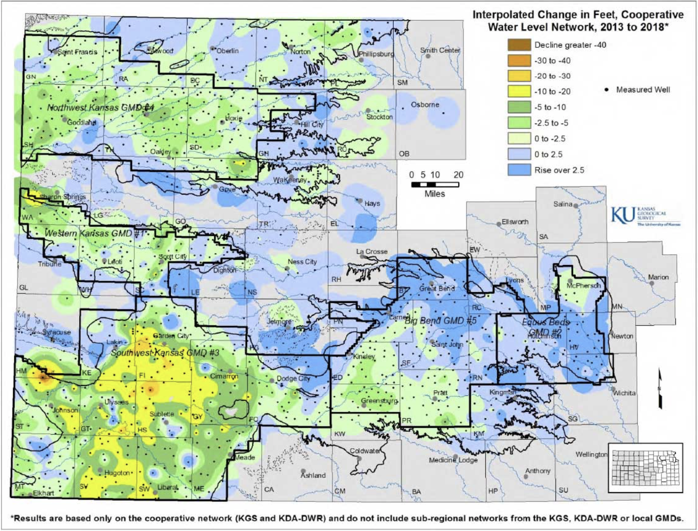
Groundwater levels during 2017, on average, rose slightly or nearly broke even in western Kansas but fell in the Wichita area, according to preliminary data compiled by the Kansas Geological Survey. This was a reversal from 2016 when overall groundwater levels dropped in western Kansas and increased significantly near Wichita.

The KGS — based at the University of Kansas — and the Division of Water Resources (DWR) of the Kansas Department of Agriculture annually measure levels in about 1,400 water wells in western and central Kansas. The collected data are used to monitor the condition and long-term trends of the High Plains aquifer, the state’s most valuable groundwater resource, as well as smaller deep and shallow aquifers.

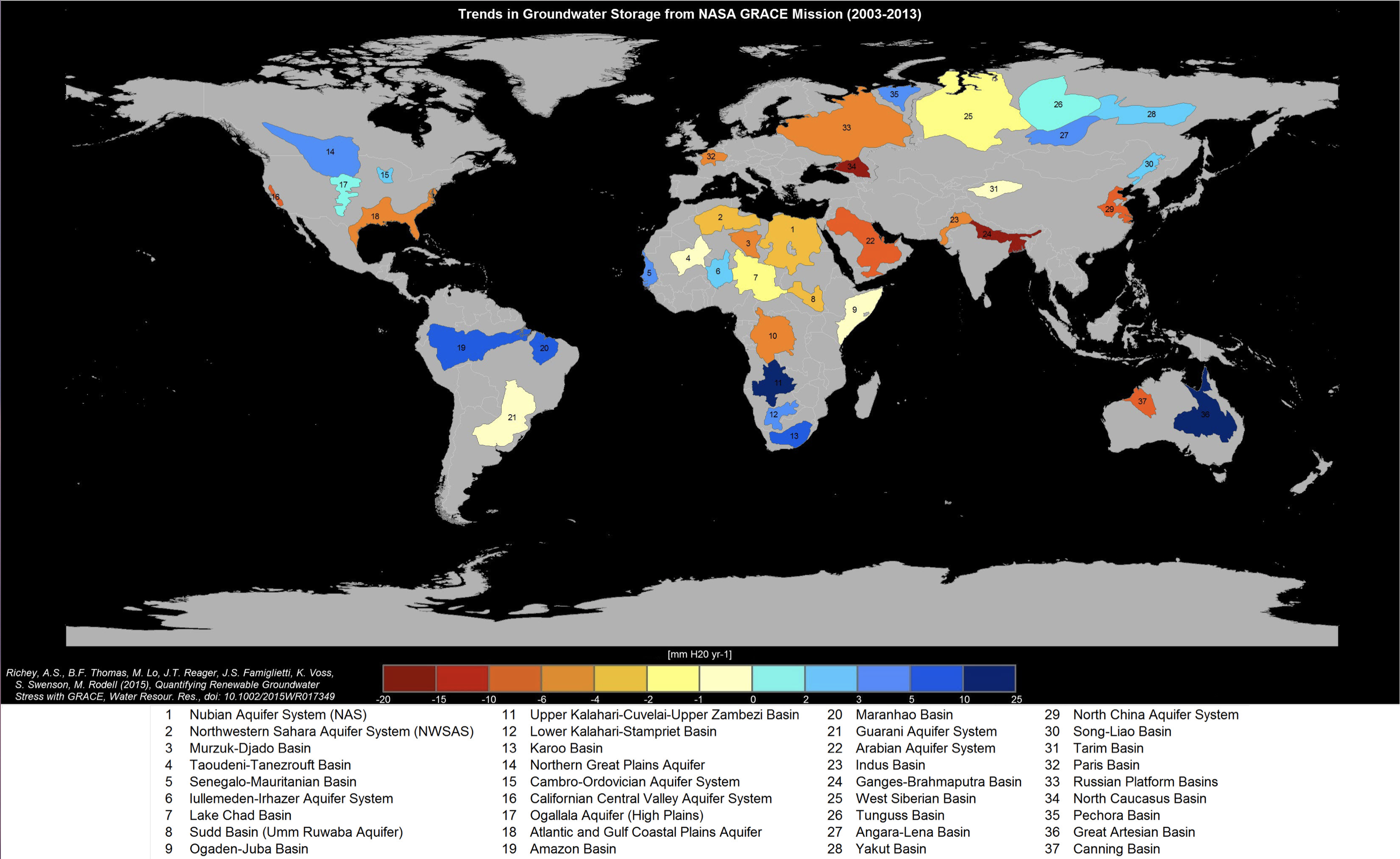
The High Plains aquifer is a network of water-bearing rocks that underlies parts of eight states and, in Kansas, comprises three individual aquifers—the far-reaching Ogallala aquifer that makes up the majority of the High Plains aquifer, the Equus Beds around Wichita and Hutchinson, and the Great Bend Prairie aquifer in the center of the state. Ninety percent of the measured wells draw from these three aquifers.

Water level changes or stability in the Ogallala aquifer in western Kansas correspond primarily with the amount of water withdrawn for irrigation, which in turn is influenced by the rate and timing of precipitation.

“Much of the western border of Kansas and eastern Colorado saw above normal precipitation patterns in 2017, especially through most of the growing season,” said Brownie Wilson, KGS water-data manager. “As a consequence, water levels were at or above the 2016 levels in much of the region.”

Water level increases in western Kansas mainly occur when the levels in wells rebound as pumping slows. Recharge — water seeping down from the surface — is negligible in western Kansas. In central Kansas, where the aquifer is shallower and average precipitation is higher, recharge can make a difference.

“For areas that have higher local recharge capabilities, such as along and north of the Arkansas River in the Equus Beds and Great Bend Prairie aquifer, precipitation generally influences both pumping and recharge,” Wilson said. “There you can get large swings in declines and rises from year to year.”

The 2017 growing season around the Equus Beds was fairly dry, which led to low recharge and higher withdrawal for irrigation, industry and municipal water supplies. Consequently, the Equus Beds declined nearly 2 feet. The Great Bend Prairie aquifer, which encompasses Great Bend, Kinsley, Greensburg and Pratt, fared better with an increase of about a quarter of a foot.

Most of the wells in the network monitored by the KGS and DWR are within the boundaries of the state’s five Groundwater Management Districts (GMDs), which are organized and governed by area landowners and local water users to address water-resource issues.

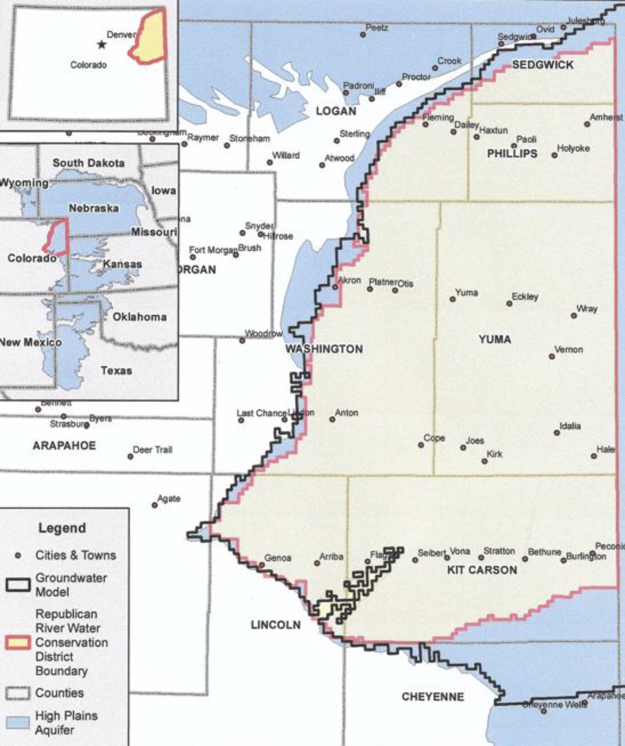
In Southwest Kansas GMD 3, average levels dropped just 0.05 feet, the lowest decline there since since the state began administrating the water-level program in 1996. In comparison, the average level fell a total of 23 feet over the previous 10 years.

“Water levels were notably higher in Morton County and along and north of the Arkansas River,” Wilson said. “Still, there were localized areas in the GMD that experienced declines of 1 to 3 feet.”

Even with better overall measurement results in the region for the year, the aquifer is nearly depleted in places.

Wells monitored in GMD 3 are drilled into the Ogallala aquifer except in a few areas where they draw from the deeper Dakota aquifer. The district includes all or part of Grant, Haskell, Gray, Finney, Stanton, Ford, Morton, Stevens, Seward, Hamilton, Kearny and Meade counties.

Another rare water-related event in the region occurred in the summer of 2017 when the Arkansas River flowed in Garden City. The river there has been mainly dry for decades due to high water use and less river flow from Colorado. When there is surface water in the river, it interacts with groundwater in an adjacent shallow alluvial aquifer.

Western Kansas GMD 1 experienced a slight drop of 0.19 feet in 2017 following a 0.55 feet in 2016. Although decreases there have been less drastic than farther south, annual levels have risen only twice since 1996. The GMD includes portions of Wallace, Greeley, Wichita, Scott and Lane counties, where the majority of wells are drilled into the Ogallala aquifer.

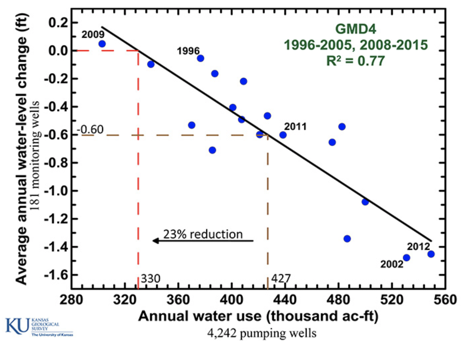
Northwest Kansas GMD 4 had an average increase in water levels of 0.33 feet after falling slightly in all but two year since 1996. GMD 4 covers Sherman, Thomas, Sheridan and parts of Cheyenne, Rawlins, Decatur, Graham, Wallace, Logan and Gove counties. Groundwater there is pumped almost exclusively from the Ogallala aquifer and shallow alluvial sources associated with streams.

Big Bend GMD 5 had an average increase of 0.26 feet following an increase of 0.88 feet in 2016. Since 1996, annual levels there rose nine times and fell 13 times. The GMD is centered on the Great Bend Prairie aquifer underlying Stafford and Pratt counties and parts of Barton, Pawnee, Edwards, Kiowa, Reno and Rice counties.

Equus Beds GMD 2, a major source of water for Wichita, Hutchinson and surrounding towns experienced a decline of 1.93 feet, which followed an increase of 2.08 feet in 2016. Since 1996, annual levels there rose nine times and dropped 13 times. The GMD covers portions of Reno, Sedgwick, Harvey and McPherson counties.

“Even with the big declines in GMD 2, this is one of the best years we’ve seen in quite a long time,” Wilson said.

The KGS measures approximately 570 wells in western Kansas each January, and DWR staff from field offices in Stockton, Garden City and Stafford measure about 220, 224 and 360 wells in western and central Kansas, respectively. Most of the wells, spread over 48 counties, are used for irrigation and have been measured for decades.

Measurements are taken primarily in January when water levels are least likely to fluctuate due to irrigation. Infrequently, however, later-than-normal pumping during dry conditions may affect measurement results.

The results are provisional and subject to revision based on additional analysis. Data by well will be available in late February at http://www.kgs.ku.edu/Magellan/WaterLevels/index.html.
The University of Kansas is a major comprehensive research and teaching university. The university’s mission is to lift students and society by educating leaders, building healthy communities and making discoveries that change the world. The KU News Service is the central public relations office for the Lawrence campus.

@NSF: How much water flows into agricultural irrigation? New study provides 18-year water use record

Here’s the release from the National Science Foundation (Cheryl Dybas/Val Ostrowski):

Irrigation for agriculture is the largest use of fresh water around the globe, but precise records and maps of when and where water is applied by farmers are difficult to locate. Now a team of researchers has discovered how to track water used in agriculture.

In a paper published in the journal Geophysical Research Letters, the researchers detail their use of satellite images to produce annual maps of irrigation. The findings, the scientists said, will help farmers, water resource managers and others understand agricultural irrigation choices and make better water management decisions.

“We want to know how human activities are having an impact on the environment,” said hydrogeologist David Hyndman of Michigan State University (MSU), principal investigator of the project. “Irrigation nearly doubles crop yields and increases farmer incomes, but unsustainable water use for irrigation is resulting in depletion of groundwater aquifers around the world. The question is: ‘How can we best use water?'”

The paper highlights the need to know when and where irrigation is occurring to effectively manage water resources.

The project focuses on an economically important agricultural region of the central U.S.–the Republican River Basin–that overlies portions of Colorado, Nebraska and Kansas, and provides surface water and groundwater to the High Plains Aquifer. The team found that irrigation in this area roughly doubled between 2002 and 2016.

Water use in this region can be complicated because it is regulated to preserve stream flow into Kansas in accordance with the Republican River Compact of 1942.

“Previously, we knew what farms were equipped to irrigate, but not which fields were actually irrigated in any particular year,” said Jillian Deines, also of MSU and the paper’s lead author. “Our irrigation maps provide this information over 18 years and can be used to understand the factors that contribute to irrigation decisions.”

The researchers used Google Earth Engine, a cloud-computing platform that makes large-scale satellite and environmental data analyses available to the public, to quantify changes in irrigation from year to year–an important finding for farmers, crop consultants and policymakers working to improve the efficiency of irrigation.

Google Earth Engine has been an asset for computing the large number of satellite images needed, the scientists said. “It allows researchers to use consistent methods to examine large regions through time,” Deines said.

The project, which also involves MSU research associate Anthony Kendall, is supported by the joint National Science Foundation (NSF)-USDA National Institute of Food and Agriculture (NIFA) Water, Sustainability and Climate (WSC) program and the joint NSF-NIFA Innovations at the Nexus of Food, Energy and Water Systems (INFEWS) program.

“Knowing what to plant, how much land to plant, and how much irrigation water is necessary to support a crop through harvest has been a challenge for farmers throughout time,” said Tom Torgersen, NSF program officer for WSC and INFEWS. “Farmers can now envision a future where models will provide options to help guide decisions for greater efficiency and crop productivity.”

Program managers at USDA-NIFA said that demand for agricultural products will likely increase in the future, while water for irrigation may decrease due to water quality issues and competitive uses.

The Republican River Basin researchers “leveraged new computing power to handle the ‘Big Data’ of all available Landsat satellite scenes, and developed irrigation maps that help explain human decisions about irrigation water use,” said Jim Dobrowolski, program officer in NIFA’s Division of Environmental Systems. The maps hold the promise, he said, of the ability to make future water use predictions.

A NASA graduate fellowship program award also funded the research.

High Plains Aquifer pumping is impacting surface water and native fish

High Plains Aquifer via Colorado State University.

From The Denver Post (Bruce Finley):

The agricultural overpumping from thousands of wells continues despite decades of warnings from researchers that the aquifer — also known as the Ogallala, the world’s largest underground body of fresh water — is shrinking.

Even if farmers radically reduced pumping, the latest research finds, the aquifer wouldn’t refill for centuries. Farmers say they cannot handle this on their own.

But there is no agreement among the eight affected states (Colorado, Kansas, Nebraska, New Mexico, Texas, Oklahoma, Wyoming, South Dakota) to try to save the aquifer. And state rules allow total depletion.

Republican River Basin by District

In fact, Colorado officials faced with legal challenges from Kansas over dwindling surface water in the Republican River have found that their best option to comply with a 1942 compact is to take more water out of the aquifer. The state bought wells from farmers during the past decade and has been pumping out 11,500 acre-feet of water a year, enough to satisfy a small city, delivering it through a $60 million, 12-mile pipeline northeast of Wray to artificially resuscitate the river.

The overpumping reflects a pattern, seen worldwide, where people with knowledge that they’re exceeding nature’s limits nevertheless cling to destructive practices that hasten an environmental backlash.

The depletion of the High Plains Aquifer has been happening for decades, according to bulletins U.S. Geological Survey has put out since 1988. Colorado farmers this year pumped groundwater out of 4,000 wells, state records show, siphoning as much as 500 gallons a minute from each well to irrigate roughly 580,000 acres — mostly to grow corn, a water-intensive crop.

The depth where groundwater can be tapped has fallen by as much as 100 feet in eastern Colorado, USGS data show. That means pump motors must work harder to pull up the same amount of water, using more energy — raising costs for farmers. The amount of water siphoned from the aquifer since 1950 to irrigate farm fields across the eight states tops 273 million acre-feet (89 trillion gallons) — about 70 percent of the water in Lake Erie.

On one hand, the industrial center-pivot irrigation techniques perfected after World War II have brought consistency to farming by tapping the “sponge” of saturated sediment that links the aquifer to surface water in streams and rivers. America’s breadbasket produces $35 billion of crops a year. On the other hand, intense irrigation is breaking ecosystems apart.

Overpumping has dried up 358 miles of surface rivers and streams across a 200-square-mile area covering eastern Colorado, western Kansas and Nebraska, according to U.S. Fish and Wildlife-backed researchers from Colorado State University and Kansas State University who published a peer-reviewed report in the Proceedings of the National Academy of Sciences. The researchers also determined that, if farmers keep pumping water at the current pace, another 177 miles of rivers and streams will be lost before 2060…

Disappearing fish species — minnows, suckers, catfish that had evolved to endure periodic droughts — signal to biologists that ecological effects may be reaching a tipping point.

The amount of water held in the aquifer under eastern Colorado decreased by 19.6 million acre-feet — 6.4 trillion gallons — from 1950 until 2015, USGS records show. That’s an average loss of 300,000 acre-feet a year. Between 2011 and 2015, records show, the water available under Colorado in the aquifer decreased by 3.2 million acre-feet — an annual average shrinkage of 800,000 acre-feet. Climate change factors, including rainfall, play into the rate of the drawdown…

They say they’re trying. They’ve reduced the land irrigated in eastern Colorado by 30,000 acres since 2006. They plan to retire another 25,000 acres over the next decade, said Rod Lenz, president of the Republican River Water Conservation District, who for years has advocated use of technology to grow more crops with less water…

Farmer and cattleman Robert Boyd, a leader of the Arikaree Groundwater Management District, said the federal government should intervene to ensure survival of High Plains agriculture…

Kansas Aqueduct route via Circle of Blue

He pointed to proposals to divert water from the Missouri River Basin and move it westward through pipelines across the Great Plains…

But drawing down the aquifer does not violate any law in Colorado. The state engineer’s office monitors well levels and requires permits for wells, limiting the number of acres a farmer can irrigate. But there’s no hard limit on how much water can be pumped…

[Mike] Sullivan and state engineer Kevin Rein emphasized that thousands of acres no longer are irrigated. “And there need to be some more retirements of land to get us into a more balanced situation,” Sullivan said.

They defended Colorado’s practice of pumping more groundwater out of the aquifer, saying this is necessary to comply with the Republican River Compact. Disputes over river flows have risen as far as the U.S. Supreme Court and Colorado’s legal obligations to deliver water to Nebraska and Kansas are clear.

Solving the problem of the declining Ogallala aquifer: “It’s for the generation that’s not here” — Dwane Roth

The High Plains Aquifer provides 30 percent of the water used in the nation’s irrigated agriculture. The aquifer runs under South Dakota, Wyoming, Nebraska, Colorado, Kansas, Oklahoma, New Mexico and Texas.

From The Hutchinson News (Amy Bickel):

Because of technology, [Dwane] Roth is working to embrace what might seem like an unfathomable concept in these parts – especially when you can’t see what is happening underground.

Sometimes the crop isn’t thirsty.

“It’s difficult to shut off,” Roth said. “But I called my soil moisture probe guy. He said the whole profile was full and it was only the top 2 inches that was actually dry. So there was no need to turn that irrigation engine on and pump from the Ogallala.”

Now he is hoping to change the mindset of his peers across a landscape where corn is king and the Ogallala Aquifer – the ocean underneath the High Plains – has been keeping the decades-old farm economy going on the semi-arid Plains.

At least it is for now.

Underlying eight states across the Great Plains, the Ogallala provides water to about one-fifth of the wheat, corn, cotton and cattle production in the United States. It’s also a primary drinking water supply for residents throughout the High Plains.

But the aquifer that gives life to these fields is declining. It took 6,000 years to fill the Ogallala Aquifer from glacier melt. It has taken just 70 years of irrigation to put the western Kansas landscape into a water crisis.

An economy centered on water is drying up.

With his own water levels declining, Roth wants to make sure there is water for the next generation, including his nephews who recently returned to the farm.

On this hot, summer day, water seeped out of a high-tech irrigation system he is testing on his Finney County farm. Soil probes are scattered about, telling him what is happening below the surface.

Roth also has pledged to the state to cut back his usage by 15 percent through changing farming practices and implementing new technology.

He wants to make a difference, but, he stressed, he can’t slow the decline alone.

For the past two years, Roth’s fields have been part of a closely watched demonstration project aimed at showing farmers how to use less irrigation water on their crops. Now he he is taking it a step further.

With some areas in northern Finney County declining by more than 70 feet since 2005, Roth is helping spearhead a regional effort to curtail pumping through a Local Enhanced Management Area. LEMAs were implemented five years ago as a tool to extend the life of the state’s water resources.

He’s not the only one looking toward the future. A small but growing group of irrigators are considering different tools to cutback water use. Some are implementing technology. Some are looking at LEMAs. Others are forming their own, farm-wide plans for mandatory cutbacks.

“It’s for the kids you don’t see yet,” Roth said of why he’s doing this. “It’s for the generation that’s not here.”

Ogallala aquifer via USGS

Stabilizing water levels in [High Plains Aquifer] possible, survey shows — @KUnews

Graphic via the Kansas Geological Survey.

Here’s the release from the University of Kansas:

For at least the next one to two decades, irrigators in western Kansas may not have to cut groundwater use nearly as drastically as once thought to stem declines in the High Plains aquifer, according to water experts at the Kansas Geological Survey based at the University of Kansas.

Most water in western Kansas is drawn from the expansive High Plains aquifer, an underground network of water-bearing sediments whose main component is the Ogallala aquifer. Underlying portions of eight states, the High Plains aquifer is the primary source of irrigation, municipal, industrial and domestic water for western and central Kansas.

As groundwater pumping from the aquifer increased significantly over the last 70 years, groundwater levels have fallen precipitously in some parts of the aquifer compared with pre-pumping levels. Such declines will continue unless pumping is reduced.

The critical question is how much should pumping be reduced to make a significant impact on the decline rate. To help irrigators with that question, KGS scientists developed a method to determine how much of a reduction in water use would be needed to achieve a specific decline rate or even stabilize water levels in the aquifer.

“We came up with a new approach for estimating the impact pumping reductions have on the rate of water-level declines,” said Jim Butler, KGS senior scientist and geohydrology section chief. “It’s tailor-made for the High Plains aquifer in Kansas, where groundwater is pumped mainly during the growing season, and exploits the great groundwater data we have in the state.”

Scientists originally predicted groundwater use might have to be reduced 75 percent or more to maintain the aquifer in western Kansas at or near current water levels. Based on their new analyses, Butler and his colleagues assert that can be achieved with just 25 percent to 45 percent reductions in most areas. Promising results for irrigators who reduced pumping at those lower levels have already been seen in one area of northwestern Kansas.

In mid-July, Kansas Gov. Sam Brownback asked Butler to accompany him to present the KGS findings to a group in Hoxie in Sheridan County, where local irrigators had initiated a Local Enhanced Management Area, or LEMA, to reduce usage on a voluntary basis. Water users within the LEMA’s boundaries created a plan to reduce pumping in a way that would not hinder crop production.

Actions that can be taken to achieve reductions include shutting off irrigation pivots when it rains, growing more drought-resistant crops and growing a greater variety of crops. Technologies such as soil-moisture probes that indicate when irrigation is or isn’t needed and high-efficiency irrigation systems that lose less water to evaporation have made reduction efforts easier.

Although members of the Sheridan County, or SD-6, LEMA were aiming to reduce pumping by 20 percent, in actuality they achieved a 35 percent reduction over four years.

“The result is that the decline rate there has gone from about 2 feet per year to about 5 inches per year without affecting the bottom line of producers in the area,” Butler said. “That’s a big deal.”

However, water levels, which have dropped as much as 80 feet in southwest Kansas since just 1996, will never be restored to pre-pumping levels.

“Realistically, we are talking about reducing the rate of decline or stabilizing water levels,” Butler said. “Replenishment of the aquifer is really not in the cards.”

Even if pumping were stopped completely, it would take hundreds of years to recharge the aquifer.

“The hope is that the success of the SD-6 LEMA will inspire others to follow suit,” Butler said.

The SD-6 LEMA is the only one implemented in the state so far, although LEMAs are under consideration elsewhere. On the trip to western Kansas with the governor, Butler also presented the KGS findings to an interested group of irrigators north of Garden City. KGS analysis shows that a 28 percent reduction in pumping in their area would stabilize water levels.

Besides encompassing the Ogallala aquifer, the High Plains aquifer includes the smaller Equus Beds aquifer around Wichita and Hutchinson and Great Bend Prairie aquifer in the vicinity of Great Bend, Kinsley, Greensburg and Pratt. Because the central part of the state generally receives more annual precipitation than far-western Kansas, stable water levels appear to be attainable in the Equus Beds and Great Bend Prairie with pumping reductions of less than 10 percent.

The KGS researchers’ new approach to estimating pumping reductions was inspired by groundwater flow patterns observed in the real-time data from several wells they monitor continuously. Results found with the approach are based on pumping data recorded by flow meters that the state of Kansas requires on all nondomestic wells as well as water-level data collected annually by the KGS and the Kansas Department of Agriculture’s Division of Water Resources (DWR) from more than 1,400 wells in western and central Kansas.