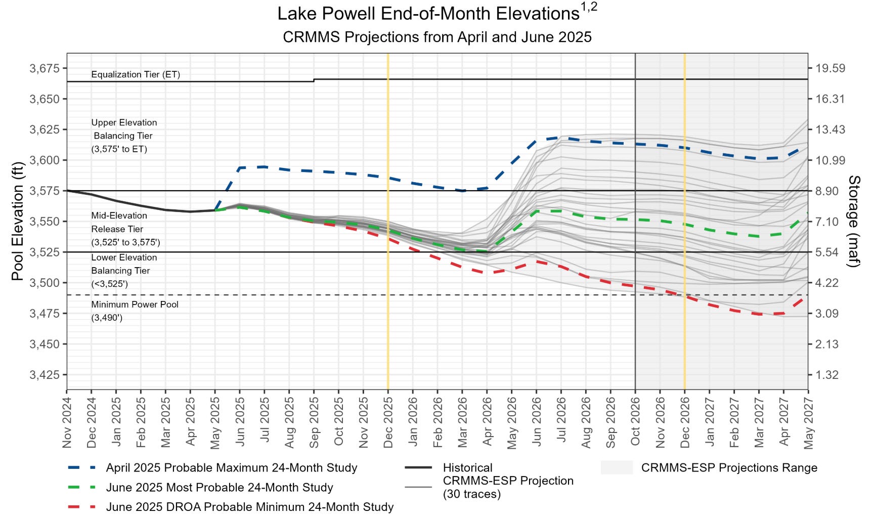
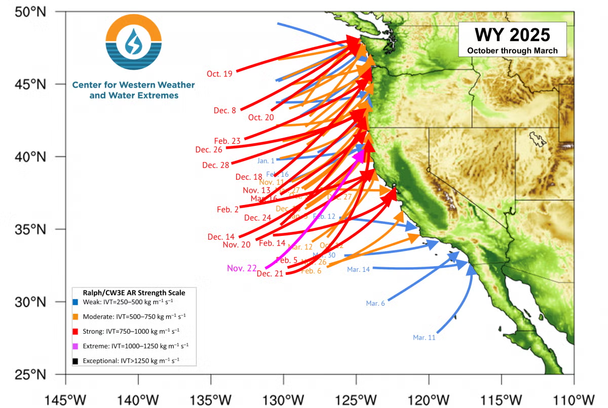
The latest Bureau of Reclamation 24-month studies show a clear risk of Lake Powell dropping below minimum power pool in late 2026, with Lake Mead dropping to elevation 1,025 by the summer of 2027. This should be hair on fire stuff.
The “clear risk” here is based on Reclamation’s monthly “minimum probable” model runs – what happens if we have bad snowpacks next year, and the year after? These are probabilistic estimates, not predictions. But the whole point of Reclamation doing this is so that we can be prepared. We need a robust public discussion about what our plan is if we end up on this fork in the hydrologic road.
The warning signs are clearly there in Jack’s analyses. Frustrated by the delay in the traditional metrics we use for measuring and monitoring the Colorado River, Jack’s been doing routine updates on reservoir storage contents. The traditional metrics we use – the Upper Basin Consumptive Uses and Losses Reports, the Lower Basin Decree Accounting Reports, the Natural Flow Database – have significant lags. The reservoir data is there in real time, integrating how much the climate system provides and how much humans use. The data here are all public. Jack’s value add is to sum them up and slice and dice the resulting data structures.
The somewhat arcane but incredibly useful framework he’s been using his his recent analyses is the period of accumulation, when reservoirs rise as river flows exceed human uses above them and extractions below them, following by the period of decline, when we’re drawing down the reservoirs. This is a tool, or a way of thinking, that we could use in real time to adjust our behavior, noting bad reservoir conditions and reducing our use. This is not something our water allocation framework is well suited to do.
The Negotiations
For more than a year, those involved in the delicate interstate negotiations over future Colorado River water allocation rules have repeatedly asked that we give them space to have the hard conversations they need to have in private. The results, or lack thereof, have done nothing to earn our trust.
The potential path forward.
When Arizona’s Tom Buschatzke moved the up-until-then super secret “supply driven” allocation concept into public view a month ago, it seemed like a good sign along two dimensions. First, the idea of basing the amount of water delivered from Upper Basin to Lower Basin past Lee Ferry on actual hydrology, on a percentage of how much water the climate is actually providing, seemed like an eminently reasonable approach. Second, Buschatzke was talking about this in public.
Folks from the Upper Basin followed suit, and a round of positive press followed.
But as this shifts from the brief sunshine of public statements back to the closed door negotiations, any glimmer appears dim indeed.
The problems were already visible in that brief, glorious bit of sunshine of public discussion last month.
There are two critical questions that need to be settled to make this work. The obvious one is the number – what percentage of the three year natural flow are we talking about shepherding down past Lee Ferry? The second is more subtle: What happens if the Lee Ferry flow falls short of that number?
Speaking to the Arizona Reconsultation Committee, Buschatzke was clear that whatever percentage number they settled on would be an Upper Basin “delivery obligation” at Lee Ferry. Becky Mitchell, speaking on behalf of Colorado, (but effectively as the de-facto Upper Basin voice, the role the other Upper Basin states seem to have for all practical purposes ceded to her) said (per Heather Sackett’s excellent reporting) it was in no way to be considered a delivery obligation.
When I suggested in a blog post that Upper Basin states might need to curtail water users in order to ensure the agreed-upon-percentage (whatever that is) is met, I got an angry call informing me that the Upper Basin was considering no such thing.
What this makes clear is that the same disagreement over the irreducibly ambiguous legal question in Article III of the Colorado River Compact – does the Upper Basin have a Lee Ferry delivery obligation or not? – is simply being shifted to a new modeling framework.
Never mind the equally intractable question of what the Lee Ferry don’t-call-it-a-delivery-obligation percentage might be. I don’t know anything more than gossip, but the gossip suggests the attempt to settle on a number, or even a range of numbers that Reclamation might model as part of its NEPA analysis, also is not going well.
If I was talking to Alex Hager today, I would no longer describe a glimmer of hope.
The Failure Mode
One of the most useful questions I learned to ask as a reporter covering water involved drilling down to the question of what happens when scarcity finally bites. What is the failure mode? Who actually doesn’t get water? How does that work? [ed. emphasis mine]
The combination of Jack’s analysis and Reclamation’s latest 24-month study suggests that we need to be asking that question in the near term. When Powell approaches minimum power pool, and Mead drops below 1030, whose water use will be curtailed to protect the system? If your answer involves a defense of why your own water supply should not be reduced, you’re doing this wrong. Everyone needs to be realistic about their risk of a legal outcome different from their agency lawyer’s position. But we also need to recognize moral obligations here, to find ways to share in this shrinking river. How are we going to come together, as a community, to respond?
The longer term argument also needs to begin to take this form.
Let us imagine going to the Supreme Court to settle the question of whether the Upper Basin does or does not have a legal delivery obligation under Article III of the Colorado River Compact to deliver 75 million or 82.5 million acre feet per year past Lee Ferry. If you lose that litigation, what is the failure mode? Who actually doesn’t get water? If your groupthink has convinced you that this is not a meaningful question, that you’re sure to win, and the other basin is the one that needs to be thinking about failure modes, you need a second opinion, to get out of your groupthink bubble.
Whatever “bring it on” enthusiasm for litigation you’re hearing from your groupthinkers needs to be tempered by an honest discussion about what happens to your communities’ water supplies if you lose.
I’ll also make a modest pitch here for a need to recognize moral obligations, to find ways to share this shrinking river.
Map of the Colorado River drainage basin, created using USGS data. By Shannon1 Creative Commons Attribution-Share Alike 4.0
against the state of Colorado to clear the way for construction of the Perkins County Canal, a contentious proposal to divert water from the South Platte River in Sedgwick County to a storage facility on the Nebraska side of the state line.
The lawsuit was filed in the U.S. Supreme Court on Wednesday and claims Colorado is threatening Nebraska’s water supply through “unlawful water diversions” that have deprived Nebraska’s farmers of water.
Nebraska’s Western Irrigation District, a beneficiary of the compact, was recently forced to shut off the majority of its surface water irrigation due to lack of supply from the South Platte River, according to the lawsuit.
“These breaches have harmed Nebraska and pose a significant, ongoing threat to Nebraska, from its agricultural economy to the water security of its major population centers,” the lawsuit said.
Perkins County Canal Project Area. Credit: Nebraska Department of Natural Resources
The complaint also alleges Colorado is obstructing Nebraska’s efforts to build the Perkins County Canal.
In February, landowners in Sedgwick County, where the river leaves Colorado and flows into Nebraska, received notices of condemnation, giving them 90 days to accept a buyout from the state of Nebraska or face eminent domain.
The letters escalated what was until then a simmering disputebetween the states over enforcement of the South Platte River Compact, an agreement ratified by the governors of Colorado and Nebraska in 1923.
The compact guarantees Nebraska a flow of 120 cubic feet per second from April 1 to Oct. 15 where the South Platte leaves Colorado just northeast of Julesburg. For the other half of the year, the compact allows Nebraska 500 cubic feet per second through a canal that would pull from the river near Ovid. Without a canal, Colorado gets first dibs on the South Platte’s winter flow.
Historically Colorado has sent significant winter water across the state line, but the state’s rapid development in recent years spooked officials in Nebraska.
The century-old compact permits Nebraska to use eminent domain to build the canal, but is unclear about whether eminent domain can be used in another state.
The lawsuit said the states are at an impasse about key terms in the compact.
Earlier this year, Attorney General Phil Weiser called the move onto Colorado soil “novel” and said that he was willing to challenge the move by Nebraska in court.
It appears he will get his chance.
In an emailed statement Wednesday, Weiser said that the lawsuit is “unfortunate and predictable given the misguided effort driving the proposed canal.”
“Nebraska has now set in motion what is likely to be decades of litigation. And if, after decades of litigation, the court allows Nebraska to move forward with its wasteful project, Nebraska’s actions will force Colorado water users to build additional new projects to lessen the impact of the proposed Perkins County Canal,” Weiser wrote.
At that point, Weiser started making trips to the northeastern corner of Colorado to brief people about the project, under the impression that it was unlikely to move forward based on the cost, the cross-border dealings and evaluations by a state water engineer.
“I also said I think this feels more like a political stunt. It doesn’t make sense,” Weiser told The Colorado Sun in February.
Nebraska hopes to complete the Perkins County Canal by 2032.
The Platte River is formed in western Nebraska east of the city of North Platte, Nebraska by the confluence of the North Platte and the South Platte Rivers, which both arise from snowmelt in the eastern Rockies east of the Continental Divide. Map via Wikimedia.
Nebraska Attorney General Mike Hilgers, at center, and Gov. Jim Pillen, at right, announce a lawsuit against Colorado before the U.S. Supreme Court seeking to assert Nebraska’s water rights to the South Platte River that crosses state lines. At left is Jesse Bradley, director of the Nebraska Department of Water, Energy and Environment. July 16, 2025. (Zach Wendling/Nebraska Examiner)
LINCOLN, Nebraska — Nebraska state leaders filed a lawsuit against Colorado on Wednesday seeking to have the U.S. Supreme Court assert the Cornhusker State’s century-old water rights to the South Platte River that crosses state lines.
Nebraska Gov. Jim Pillen, announcing the legal action at a news conference with Nebraska Attorney General Mike Hilgers and other state and local officials, said, “Every drop of water matters.”
Pillen and Hilgers accused Colorado officials of siphoning off more and more water every day, even as Nebraska had been “nice” with Colorado, which has seen increases in housing, agricultural and business development along the waterway.
“We’re here to put our gloves on,” Pillen said, to defend what he called a “multi-generation investment” afforded under the South Platte River Compact that took effect in 1926.
“We’re going to fight like heck. We’re going to get every drop of water,” Pillen continued Wednesday. “We’ve been losing to Colorado on this issue for too long. It’s time we win.”
Colorado Attorney General Phil Weiser called Wednesday’s lawsuit “unfortunate” and said Pillen and Hilgers “put politics above farming communities and the regional agricultural economy.”
“The failure to look for reasonable solutions and to turn to litigation is both unfortunate and predictable given the misguided effort driving the proposed canal,” Weiser said in a statement.
‘They want everything’
Hilgers said his team had exercised all options in communications with Weiser’s office before filing the 55-page complaint before the U.S. Supreme Court.
Governor Clarence J. Morley signing Colorado River compact and South Platte River compact bills, Delph Carpenter standing center. Unidentified photographer. Date 1925. Print from Denver Post. From the CSU Water Archives
The complaint accuses Colorado of violating the interstate compact between Colorado and Nebraska, which was ratified in the states in 1923 and enacted federally in 1926. Under the agreement, Nebraska is entitled to at least 120 cubic feet of water per second each day of the summer, during irrigation season.
State Sens. Kathleen Kauth, Carolyn Bosn, Jana Hughes, John Fredrickson and Dave Murman tour part of what could be part of the proposed Perkins County Canal in western Nebraska on Monday, May 1, 2023. (Courtesy of State Sen. Carolyn Bosn)
Hilgers said it’s hard to say precisely how long more water than allowed has been taken and that it’s getting worse, an assertion Colorado officials denied in 2022. So far this summer, Hilgers said, Nebraska has gotten its mandated water flows about half the time, averaging 75 cubic feet per second of water daily.
Nebraska’s Western Irrigation District was also recently forced to shut off the majority of its surface water irrigation due to a lack of water from the South Platte River, despite the compact, according to the lawsuit.
Pillen said Colorado is storing more water for its “upstream economy,” which he said comes at the expense of Colorado and Nebraska farmers, with Nebraska’s western neighbors having “no interest in anything being fair and just.”
“They want absolutely everything, they’re even stealing the water from their own farmers, for crying out loud,” Pillen told reporters.
‘All-front war’
The interstate compact also allows Nebraska to construct the “Perkins County Canal,” a major water project through Keith County and into Colorado that would allow Nebraska to divert at least 500 cubic feet of water per second in the winter, during non-irrigation season.
Nebraska is also afforded “eminent domain” over some Colorado land to build the canal, meaning the state could seize private land if needed.
Work on the Perkins County Canal near Ovid, Colorado, began in 1894, but the project halted after running out of money. (Courtesy of the Perkins County Historical Society)
State lawmakers, to the tune of more than $600 million, have approved funding to build a canal up to 1,000 cubic feet of water per second to capture more water flow in above-average water years. Nebraska officials say newly captured water would flow statewide and is not just focused on western Nebraska.
According to the court filing, Nebraska officials in January tried to purchase land from landowners in Sedgwick County, Colorado, at 115% of fair market value, deals that ultimately fell through. Nebraska pledged to take land “only if the parties failed to reach amicable terms.”
Hilgers said the situation escalated to an “all-front war” in the past year, with Hilgers and Pillen accusing Colorado officials of stepping up opposition, including through local Colorado landowners.
Nebraska-Colorado ‘impasse’ reached
Hilgers said he and his team have had many conversations with their Colorado counterparts but are at an “impasse,” largely over the project’s scope, including canal size, location and Nebraska’s eminent domain rights, a provision Weiser has said he is ready to challenge Nebraska on.
The eminent domain provisions are believed to be one of a kind among any interstate compacts in the nation’s history, according to Hilgers.
“There is no alternative forum capable of fully resolving the claims Nebraska asserts against Colorado, which are of such seriousness and dignity as to justify the exercise of the court’s jurisdiction,” the complaint to the Supreme Court states.
Weiser said that if the Supreme Court does greenlight the “wasteful project,” it will force Colorado water users to build additional projects to lessen the impact of the canal. He encouraged “collaboration and collaboration, rather than litigation,” which could lead to a “durable and thoughtful solution” that increases regional resiliency and agricultural strength.
In 2022, a spokesperson for Colorado Gov. Jared Polis called the project a “canal to nowhere” and a “boondoggle.”
Polis on Wednesday called the lawsuit “meritless” and said the state had continued to meet with Nebraska in “good faith” despite its efforts to intimidate some Colorado landowners. He reasserted that his state has always complied with the South Platte River Compact.
“This escalation by Nebraska is needless, and Colorado will take all steps necessary to aggressively defend Colorado water users, landowners, and our rural economy,” Polis said in a statement.
Pillen, asked whether he had talked to Polis about the canal or lawsuit, said plainly: “No.”
“The bottom line: He and I do not agree one iota. And there’s no sense in further conversations,” Pillen said. “I’m not playing goober politics on this. We’re going to fight for Nebraska.”
Then-Gov. Pete Ricketts joined other state officials in an unannounced visit in September 2022 to the area of the proposed Perkins County Canal. (Courtesy of Nebraska Governor’s Office)
Former Gov. Pete Ricketts, now a Republican U.S. senator for Nebraska, unearthed and reinvigorated the compact in 2022 with Hilgers, the then-speaker of the Legislature.
Hilgers said it was probably always “inevitable” that the U.S. Supreme Court would decide the issue. He acknowledged that while a minority of state senators have tried to claw back funding for the Perkins County Canal, he anticipated that future efforts to do so would continue to fail.
‘The future of Nebraska’
Jesse Bradley, director of the newly merged Nebraska Department of Water, Energy and Environment as of July 1, said his team would continue to move forward with the project, parallel to the litigation, estimating that permitting and design would finish by 2028 for construction to begin.
The hope is that water will flow through the new canal no later than 2032.
“This is critical to the future of Nebraska,” Bradley said. “We will continue to push forward aggressively.”
Also joining Wednesday’s news conference were representatives of the Nebraska Public Power District, Central Platte Natural Resources District, Central Nebraska Power and Irrigation District, Twin Platte Natural Resources District, the Nebraska Western Irrigation District, the South Platte Natural Resources District and the state’s chief water officer, Matt Manning.
Hilgers estimated the state lawsuit could cost a couple of million dollars, including hiring outside experts or legal counsel, and take three to five years before the Supreme Court decides.
Pillen said Nebraska would not “save pennies” on the project and would have the “A Team 100% of the time” to win, “not a shadow of a doubt.”
Weiser estimated that “when the dust finally settles,” more than a billion dollars would be spent over a possible decade of litigation, and “no one in Nebraska or Colorado will be better off.”
Hilgers said he’s thankful the U.S. Supreme Court will decide the issue.
“We could maybe not get everything we want in front of the Supreme Court. But if we don’t file, we will lose. Period, full stop,” Hilgers said. “And what we will lose will so far outstrip the cost of this particular project that will really be a ‘shame on us’ moment if we don’t actually follow through.”
Nebraska Examiner is part of States Newsroom, a nonprofit news network supported by grants and a coalition of donors as a 501c(3) public charity. Nebraska Examiner maintains editorial independence. Contact Editor Aaron Sanderford for questions: info@nebraskaexaminer.com.
The South Platte River Basin is shaded in yellow. Source: Tom Cech, One World One Water Center, Metropolitan State University of Denver.
Rio Grande looking upstream, taken from Albuquerque’s Central Avenue Bridge, 2:15 p.m. July 14, 2025
Click the link to read the article on the InkStain website (John Fleck):
July 15, 2025
The “official” call: the Rio Grande went dry in the Albuquerque reach, just upstream of the city’s wastewater treatment plant (click here for the map), on Sunday evening (July 13, 2025), for only the second time in the 21st century.
“Dry” in this case has a formal definition. The thinning ribbons of water you see in the picture above, taken mid-afternoon Monday (July 14, 2025) have to break. It’s still a muddy mess; the river’s subsurface manifestation, the shallow aquifer, still has water in it, the trees (look at their lovely green!) still have access to that part of the river. But if you’re a fish or a turtle, these are sad times.
The fact package
We got an excellent update on river conditions (as we do every month) at the meeting of the Middle Rio Grande Conservancy District, the government agency responsible for river flood control, drainage, and irrigation in New Mexico’s Middle Rio Grande. Most of what follows I learned by attending that meeting.
The last time the river dried in the heart of New Mexico’s largest city was 2022. Before that, it hadn’t happened since the 1980s.
Drying is common to the south, between Albuquerque and Elephant Butte Reservoir. Happens most every year. What’s new is drying in the heart of this large urban area.
Imported Colorado River water, via the San Juan-Chama Project, delayed the Albuquerque drying. The Middle Rio Grande Conservancy District used that water to supplement flows and get water to irrigators from June 16 to July 6, when their San Juan-Chama supplies ran out. (Source: Anne Marken’s report to the MRGCD board)
The Conservancy District is currently operating under the rules of “prior and paramount” operations, meaning a subset of the lands of the valley’s six Native American Pueblos get water, while all non-Indian irrigators upstream of Isleta Pueblo are being curtailed. (Source: Marken, if you wanna understand what’s happening on the Rio Grande, you can do no better than Anne’s monthly report to the board)
As of July 8, the federal government had ~31,545 acre feet of P&P water in storage in El Vado (there’s a bit of space available despite the dam’s problems) and Abiquiu. (Source: USBR report to the MRGCD board)
Downstream from Isleta, once the Pueblos have gotten their P&P water, some irrigation is possible using return flows. Because of the structure of the plumbing, this favors the river’s east side communities. (Source: Matt Martinez report to the MRGCD board, ditto what I said about Marken: “If you wanna understand….”)
The pumps that have kept water flowing to Corrales in the absence of the rickety old siphon that used to get water there were shut down June 26. (Source: Matt Martinez)
Current flow at the Central Avenue Bridge, as measured by the USGS: is it even worth trying to measure this? What does “1.78 cubic feet per second” mean in a river like the one you see in the picture above?
Click the link to read the article on the InkStain website (Jack Schmidt Center for Colorado River Studies, Utah State University):
July 14, 2025
Water stored in the reservoirs of the Colorado River represents the account balance from which we draw water for use. The amount in the account is especially important during dry times when the demand by water users throughout the Basin exceeds income to the account, primarily snowmelt runoff, and is met by account withdrawals.
The annual cycle of reservoir hydrology includes two seasons – a relatively short season when reservoir storage increases and a relatively long season when storage decreases. In wet years, the season when storage increases typically begins in March or early April and may last until late July. In dry years, this season might not begin until May and end in mid-June. During the rest of the year, the Basin’s reservoirs are progressively depleted.
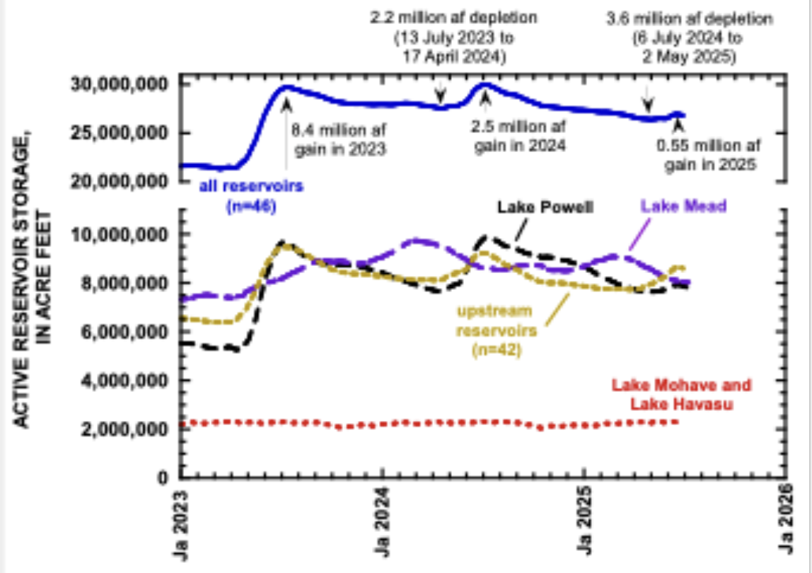
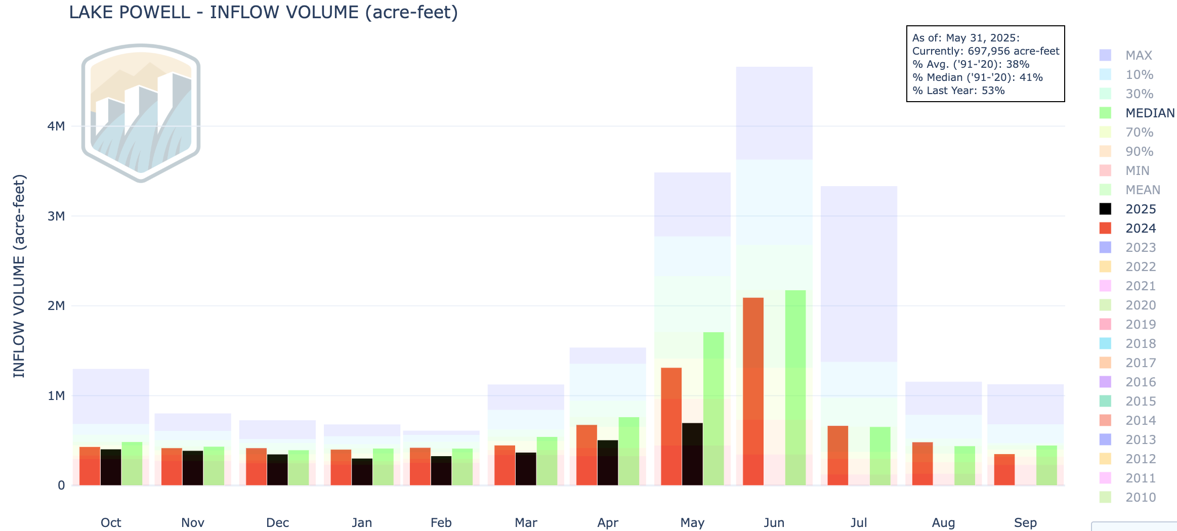
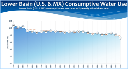
Snowmelt in 2025 was low, similar to what it was in 2012 and 2013; in early June, the Colorado Basin River Forecast Center predicted that this year’s unregulated snowmelt inflow to Lake Powell will end up being 54% of the recent 30-yr average. In the 21st century, only 2002, 2018, and 2021 had lower inflows to Powell. Not surprisingly, the amount of water that accumulated in the Basin’s reservoirs during the 2025 snowmelt season was also unusually low. There are a few ways to consider the Basin’s reservoirs. We can consider every reservoir for which data are readily available[1]; we can consider the major reservoirs actively managed by Reclamation[2]; or, we can consider just Lake Powell and Lake Mead (hereafter, Powell+Mead). Considering only Lake Powell or only Lake Mead doesn’t tell us much, because all of the Rocky Mountain snowmelt is first stored in Lake Powell and subsequently transferred to Lake Mead. In 2025, the 46 Basin reservoirs gained only 0.55 million af (acre feet) of water, of which only 0.28 million af accumulated in the 12 federal reservoirs and only 0.11 million af accumulated in Powell+Mead. That is a very small amount, especially compared to 2023 and 2024 (Fig. 1). That accumulation is being quickly consumed. By 1 July 2025, all of the 2025 accumulation in Powell+Mead had been released downstream or evaporated.
Figure 1. Graph showing reservoir storage in different parts of the Colorado River Basin since 1 January 2023. Total storage in March 2023 was the lowest in the 21st century. Storage significantly increased due to 2023 snowmelt, but the accumulation from the 2024 snowmelt was entirely lost. This will also happen in the coming months. On 30 June 2025, active storage in 42 reservoirs upstream from Lake Powell was 8.58 million af, active storage in Lake Mead was 8.05 million af, and storage in Lake Powell was 7.88 million af.
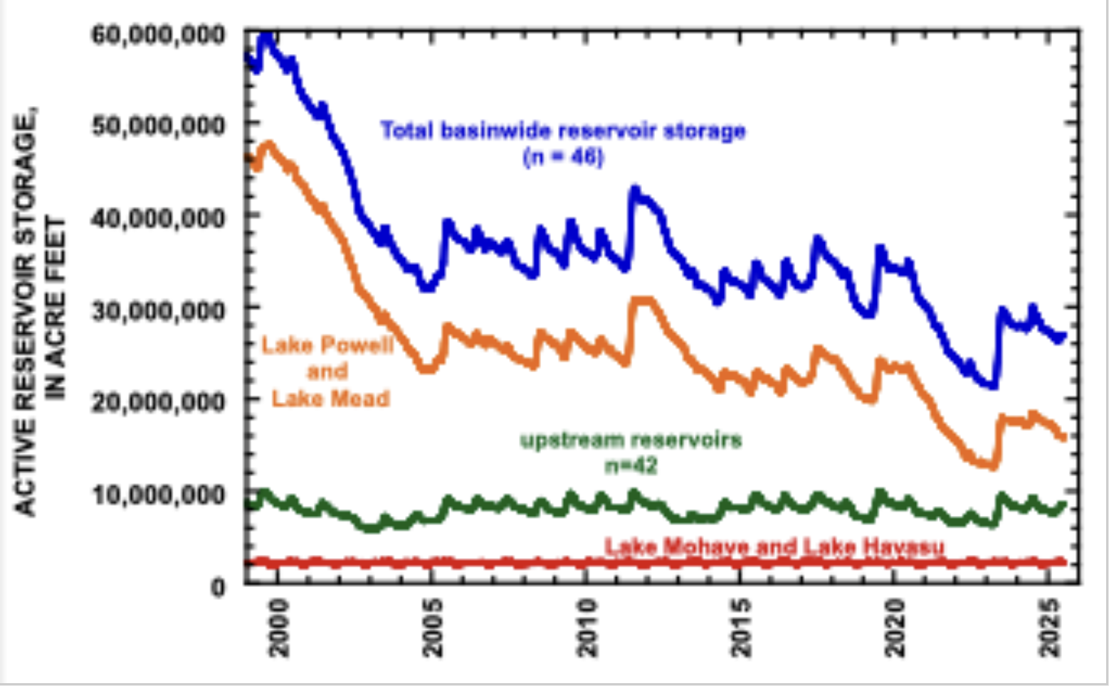
In contrast to previous dry years, however, today’s account balance is unusually low, about the same as in late July 2021 (Fig. 2). Depending on how you think about the reservoir system, today’s contents are between 34 and 45% full in relation to their condition at the beginning of the 21st century (Table 1).
Figure 2. Graph showing reservoir storage in different parts of the Colorado River Basin since 1 January 1999. On 30 June 2025, total basin storage was comparable to what it was in late July 2021
Table 1. Present storage contents of reservoirs in the Colorado River Basin in relation to past conditions.
Storage contents, in million acre feet
on 30 June 2025
Last time storage was as low
Present storage as a percentage of storage in late July 1999
entire Basin (n=46)
26.8
25-Jul-21
45%
federal reservoirs (n=12)
23.64
4-Sep-21
42%
Powell + Mead
15.93
20-Nov-21
34%
The implications for Lake Powell depend on whether Reclamation decides to emphasize water storage in Lake Powell or in Lake Mead, and whether water presently in Flaming Gorge reservoir will be released to supplement storage in Lake Powell. As of June 30, 32% of the reservoir storage in the Basin was in 42 reservoirs upstream from Powell, 30% was in Mead, and 29% was in Powell (Fig. 1). if past management practices prevail, storage upstream from Powell will be quickly reduced, and storage in Powell and Mead will be reduced more slowly. If Reclamation emphasizes storage in Lake Powell by reducing releases to Lake Mead through the Grand Canyon, hydropower production at Glen Canyon Dam will be maintained and the risk of entrainment of smallmouth bass through the turbines will be reduced. But this management approach will cause Lake Mead to fall more quickl, thereby reducing hydropower production at Hoover Dam and perhaps the quality of water withdrawn to southern Nevada. Water storage can’t be maximized in both reservoirs at the same time. Indeed, we are living in dry times!
[2] There are 12 included in Reclamation’s monthly 12-month study reports (Taylor Park, Blue Mesa, Morrow Point, Crystal, Fontenelle, Flaming Gorge, Navajo, Vallecito, Lake Powell, Lake Mead, Lake Mohave, and Lake Havasu).
Click the link to read the article and listen to the Valley Pod on the Alamosa Citizen website:
July 9, 2025
A draft agreement settling the long-running Rio Grande Compact lawsuit dealing with New Mexico’s delivery of water to the Texas border is on the one-yard line and should be pushed across the goal line come fall, says Colorado Attorney General Phil Weiser.
Weiser was on a two-day tour of the San Luis Valley this week when he gave an update on the lawsuit to members of the Rio Grande Basin Roundtable. All three compact states – Colorado, New Mexico and Texas will be party to the settlement.
Earlier this week, Special Master D. Brooks Smith scheduled a hearing for the week of Sept. 29 on the parties motions toward a settlement.
The states had worked out a previous agreement to the 2013 case, only to have the federal government object when the proposed settlement was presented to the U.S. Supreme Court. This time, said Weiser, the federal government’s role has been addressed.
“We’re on track,” Weiser said during a recording of The Valley Pod. “We have a settlement that properly has the federal government in its place and resolves the concerns which were mostly between New Mexico and Texas.”
Listen here to the full Valley Pod episode with AG Phil Weiser.
Colorado has nine interstate water compact agreements, including the Colorado River Compact which dominates the headlines. At the Rio Grande Basin Roundtable meeting, Conejos Water Conservancy District Manager Nathan Coombs asked Weiser how the state and local water users could collaborate on more “creative ways” in administering the river compacts.
“We all agree with keeping our compacts whole. But I would ask what are some of the processes we could go through to make them more vehicles for the water users within the state as we see this drying?” Coombs said.
On The Valley Pod, Weiser addressed the Valley’s efforts to recover the Upper Rio Grande Basin’s confined and unconfined aquifers.
“We will have to continue looking at this situation of groundwater and have to keep asking ‘How do we best manage this precious resource?’ I don’t have any immediate views on what to do in the face of the challenging hydrology. I do believe we have to keep thinking hard about a series of strategies that include ‘How are we most smartly storing water, how are we re-using water, and how are we conserving water?’”
Weiser, a two-term attorney general, is a candidate for governor, seeking the Democratic Party nomination in 2026. In The Valley Pod episode he talks more about his candidacy as well as the 27 different lawsuits Colorado has been party to in the past six months in challenging the Trump Administration.
“This is an extraordinary moment unlike any in history,” Weiser said.
Rio Grande and Pecos River basins. Map credit: By Kmusser – Own work, Elevation data from SRTM, drainage basin from GTOPO [1], U.S. stream from the National Atlas [2], all other features from Vector Map., CC BY-SA 3.0, https://commons.wikimedia.org/w/index.php?curid=11218868
A houseboat docks on the mudflats near Wahweap Marina during the summer of 2021, when reservoir levels dropped perilously low. Jonathan P. Thompson photo
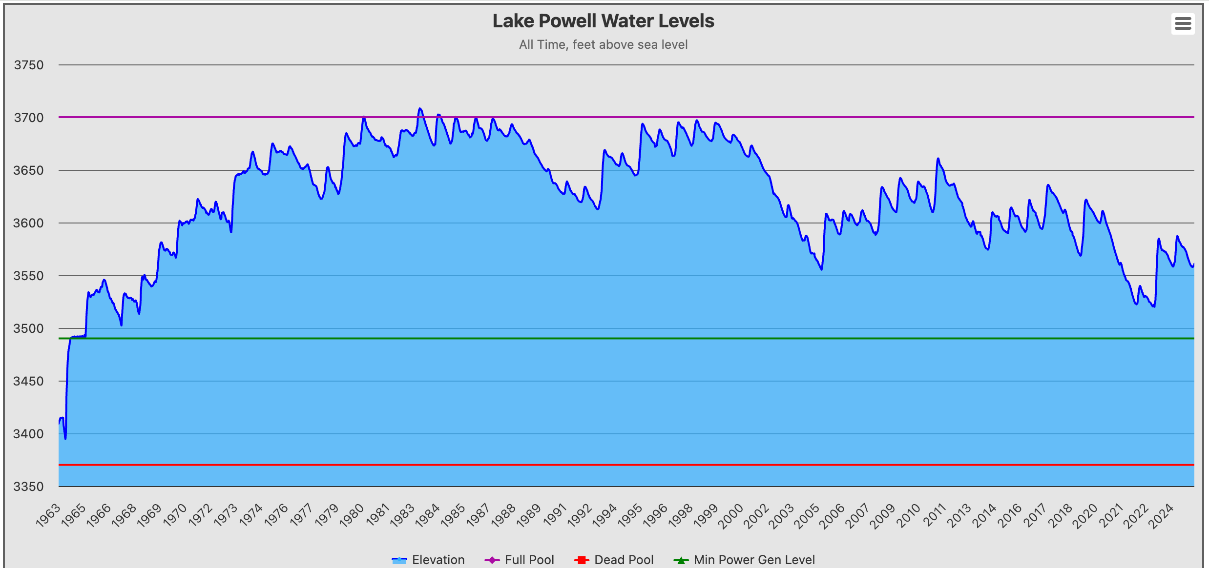
If Lake Powell is like a big thermometer gauging the hydrologic health of the Upper Colorado River Basin, then it’s running a high fever.
In one case, the fever analogy is a bit too literal: The National Park Service has detected high concentrations of cyanotoxins in the reservoir around the mouth of Antelope Canyon, and is warning folks to limit their exposure to the water. Warm water is one of the drivers of cyanotoxin growth.
The surface level peaked out on June 19 at 3,562 feet above sea level, with about 7.8 million acre-feet of storage (or about one-third of its capacity). That means the big, white “bathtub” ring on the sandstone cliffs has grown by about 27 feet in the past year, re-revealing some landforms and rendering some boat ramps unusable. Levels will continue to drop throughout the summer.
This is because more water is leaving the reservoir via downstream releases and evaporation than is flowing into it. Reservoir inflows during June were a mere 883,000 acre feet, or about 41% of the median inflows. That’s far lower than the last two years and is only marginally higher than in 2002, 2018, and 2021, some of the worst years on record. And with the water year three-fourths of the way done, only 4.2 million acre-feet has flowed from the Colorado River and its upstream tributaries into the reservoir, setting the stage for a water year total of just about 5.5 million acre-feet — or 2 million acre-feet less than the minimum release from Glen Canyon Dam.
The only good news is that temperatures at the reservoir mostly have been in the 80s or 90s for the past several weeks, which is about normal for this time of year. Oh, and another sorta-kinda silver lining: As the reservoir levels drop, the surface area decreases, reducing the rate of evaporation. Yay?
Inflow volumes at Lake Powell have been pretty skimpy this water year, with June of 2025 delivering just 41% of the median flows for that month. 1983 was the biggest water year on record since Glen Canyon Dam was completed in 1963, and 2002 was the lowest inflows.
Meanwhile, many of the Colorado River’s users continue under the illusion that the Colorado River Compact and the Law of the River will trump nature and the reality of diminishing flows.
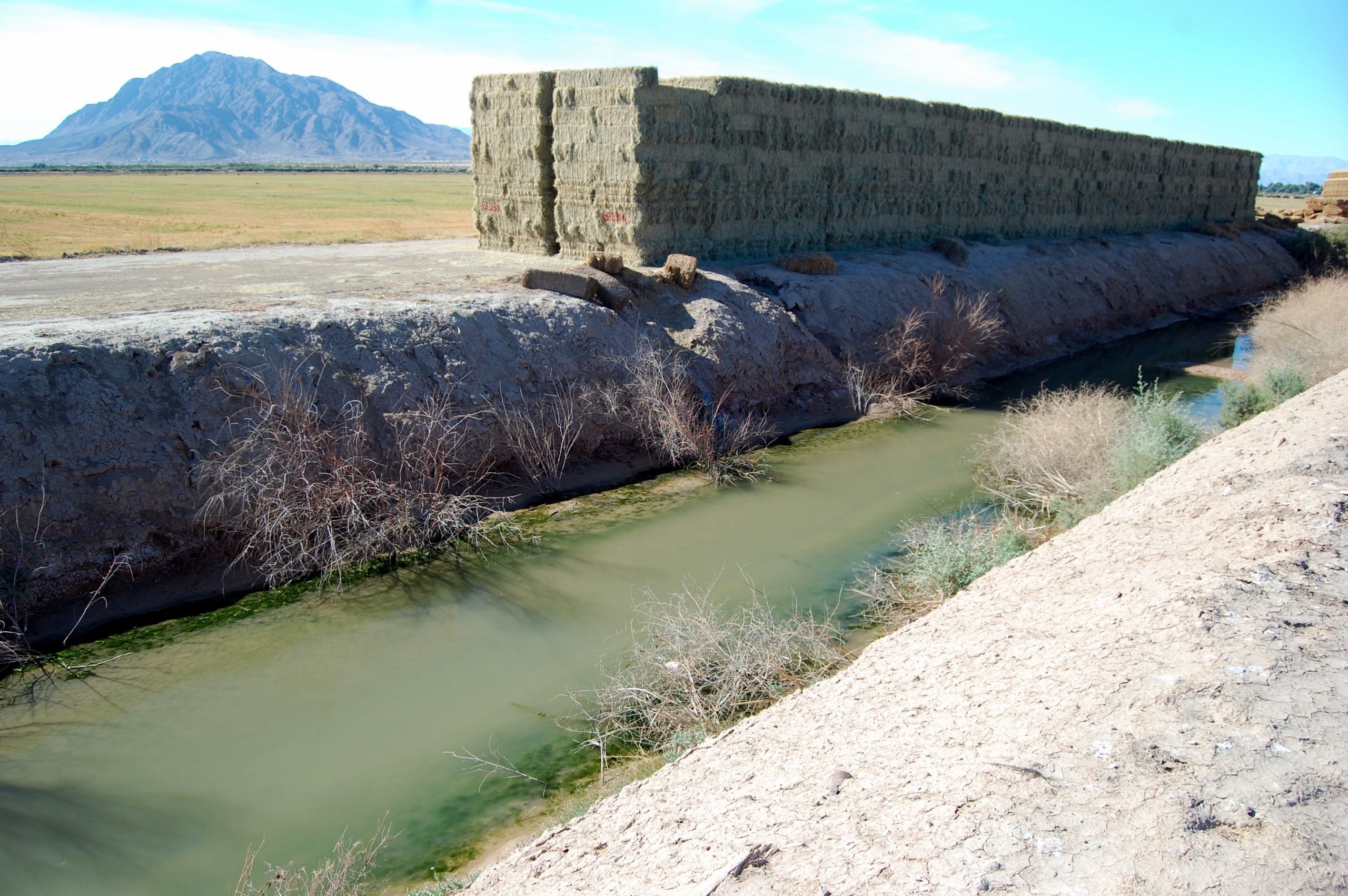
Take the Imperial Valley in southern California. The Imperial Irrigation District is the single largest water user on the river, consuming some 2.3 million acre-feet during the 2024 calendar year to grow various food crops and a lot of alfalfa. That’s about seven times more Colorado River water than all of southern Nevada’s casinos, hotels, golf courses, and homes consume.
Bales of alfalfa in the Imperial Irrigation District of southern Calfornia, grown with Colorado River water. Photo by Brian Richter
But it’s also about 200,000 acre-feet less than the irrigation district consumed in 2013. That’s in part because some farmers are being paid to not irrigate or to irrigate less, often meaning they must fallow their fields, at least temporarily. And some of those farmers have chosen to lease their land — about 13,000 acres — to solar companies for utility-scale energy installations, allowing them to continue to make money off the land without further depleting the Colorado River.
Thanks to Dustin Mulvaney for tipping us off to this resolution on Bluesky.
That irks the Imperial Irrigation District’s board, which recently passed a resolution“opposing the continued expansion of utility-scale solar projects on active or historically farmed agricultural land” in the district. “Our identity and economy in the Imperial Valley are rooted in agriculture,” said IID Board Chairwoman Gina Dockstader, in a written statement. “Solar energy has a role in our region’s future, but it cannot come at the cost of our farmland, food supply, or the families who depend on agriculture. This resolution is about protecting our way of life.”
The resolution doesn’t carry any legal weight, but the IID has a lot of influence, and could easily push the county to ban or heavily restrict solar installations on farmland as dozens of other counties across the nation have done.
Granted, taking land out of agriculture and irrigation has consequences. It can become a weed-choked, dust-spawning expanse. In the Imperial Valley, irrigation runoff feeds the Salton Sea. And, of course, you lose food production and farmworker jobs.
Nevertheless, the resolution seems somewhat short-sighted. It is based on the assumption that the IID will be able to flex its senior water rights in perpetuity, and never have to give up significant amounts of irrigation. It robs farmers of their private property rights, their ability to diversify their income sources, and an opportunity to conserve increasingly scarce water.
And, if the solar installations aren’t built there, they are likely to end up on public land in desert tortoise and other wildlife habitat that could require the removal of hundreds or even thousands of Joshua trees. Worse, it might result in new natural gas or even coal plants to meet the burgeoning demand for power driven by the proliferation of energy- and water-intensive data centers.
And on that note, there’s Kanab, in south central Utah. I’ve driven through Kanab many a time, but usually I just roll on through, finding more of interest in Ordervilleor Fredonia or even Colorado City and Hildale. I mean, Orderville does have “Ho-Made Pies,” or so the sign declares, and was founded as a bastion of the United Order, the tenets of which were communalism, cooperation, and equal distribution of wealth.
Kanab, meanwhile, was notable to me only as the home of former Utah state representative Mike Noel, who was a Wise Use/Sagebrush Rebel leader of the early 2000s, and I wasn’t going to stop in for a cup of coffee — er, a soda — with the guy. So I failed to notice that the little community was not only growing, but sprawling into the surrounding red-rock desert in the form of upscale resorts and housing communities and even a brand new town. A friend sent me this video, which enthusiastically offers details:
There is, for example, Catori Canyon “a premium housing development & luxury gated community” that “redefines modern indoor-outdoor living.” Prices start at $450,000 — for a bare lot. It also predictably has a pickleball court, which is what I think they mean when they say it “isn’t just home — it’s a lifestyle.” I call that real estate propaganda.
And Ventana Resort, which is on state trust lands and is described by the Utah Trust Lands Administration as an “ambitious project that includes townhomes, affordable housing, nightly rentals, single-family homes, and even a hotel.” The Kane County Water Conservancy District, headed by the aforementioned Mike Noel, had hoped to build a golf course on the land, but pickleball — yes, the development has courts — and four swimming pools won out, apparently. The townhomes are expected to begin at $650,000, according to the Southern Utah News.
The new town? It was originally just a huge subdivision called Willow Preserve Estates, which received county approval (after the county had denied its proposed public infrastructure district). But apparently the developers weren’t content with the limits of the subdivision approval, so they petitioned the state to incorporate their own municipality called Willow, which would allow them to approve their own PID with higher housing density. Kane County commissioners are miffed. If the state approves the municipality, it will include 1,200 to 1,400 home sites along with commercial areas on a big parcel of land east of Kanab and just south of Hwy 89.
That’s a lot of homes; Kanab has about 2,000 households, and that doesn’t count Catori Canyon or Ventana Resorts, let alone Willow. And, if you’re like me, you’re wondering where these folks — along with the other developments with their swimming pools and lawns — are going to get their water.
It appears the answer is: wells. Kanab currently supplies its 5,000 residents with several groundwater wells and springs. Willow will likely get its water from Kane County Water Conservancy District’s Johnson Canyon system, which is also fed primarily by groundwater. Which is to say, they aren’t taking it directly out of the Colorado River system, but they are taking it indirectly from the system, since groundwater and surface water is all connected. Plus, aquifers all over the Colorado River Basin are being depleted by over-pumping. Pulling more out of them is not sustainable.
But that’s not all. Kanab is also about to be home to two new ultra-exclusive resorts in a similar vein as Amangiri, the posh place frequented by the Kardashians and located just outside the (past and possibly present) polygamist community of Big Water, Arizona.
Canyon Country, my friends, is rapidly being gentrified.
Kaia, by Outdoor Citizen, bills itself as a “new ultra-luxury RURAL EB-5 investment opportunity.” That is, if you’d like to migrate to America, just fork out a million or so bucks for one of the 40 planned residences in Johnson Canyon outside Kanab and, voila!, you have permanent U.S. residency. In Europe they call that a “golden passport.” The project’s developer is FirstPathway Partners, whose sole purpose is to facilitate these EB-5 visas.
Kaia, by Outdoor Citizen, bills itself as a “new ultra-luxury RURAL EB-5 investment opportunity.” That is, if you’d like to migrate to America, just fork out a million or so bucks for one of the 40 planned residences in Johnson Canyon outside Kanab and, voila!, you have permanent U.S. residency. In Europe they call that a “golden passport.” The project’s developer is FirstPathway Partners, whose sole purpose is to facilitate these EB-5 visas.
Kaia’s website says the development …
Yeah, the BLM land might be protected for now. But a warning to the rich folks that might want to invest: Utah politicians are leading the charge to turn that lovely “Greenbelt” of public land over to housing developers. So instead of those fetching red rocks, you might one day have a view of a subdivision out your giant front window. And if Sen. Mike Lee and his ilk can’t sell the public land straight out, the Trump administration might just fast-track a uranium or coal mine, AI-crunching data center, or oil and gas development in that greenbelt just a few hundred meters from your luxury home.
Late light on Glen Canyon rock formations. Jonathan P. Thompson photo.
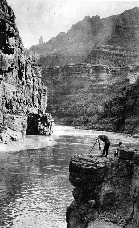
Mapping the Grand Canyon. In this photo we have Claude Birdseye (right) – expedition leader and Chief Topographic Engineer of the USGS, and Roland Burchard (left) – expedition topographer. Photo credit: USGS
Click the link to read the article on the Big Pivots website (Allen Best):
June 30, 2025
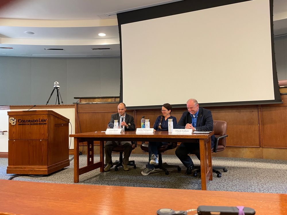
Becky Mitchell and Doug Kenney had much to say at Crested Butte. Just as important may have been what they did not say.
The apple cart of the Colorado River has been upset for 25 years, and Doug Kenney and Becky Michell were on stage June 24 at the Crested Butte Public Policy Forum to talk about the bruised apples.
There’s broad understanding that what worked in the past won’t work in the future. As to what will work — ah, well, that has yet to be resolved. “So far, we haven’t really been able to pull the demands down as quickly as supplies have been going down,” said Mitchell.
Adding tension to the conversation is another so-so or worse spring runoff in the river. Despite a decent snow year in northern Colorado, yet another early, warm and mostly drier-than-usual spring has produced an anemic projected runoff of a little over 9 million acre-feet. Average runoff into Lake Powell has been 12 million in recent years. The compact governing the river between the three lower-basin states and the four upper basin states assumed at least 20.
Douglas Kenney. Photo credit: University of Colorado Boulder
Kenney directs the Western Water Policy Program at the University of Colorado Boulder’s Getches-Wilkinson Center. The program puts on a conference each June that is considered one of several must-attend events for those drawn to the unceasing drama about Colorado’s namesake river.
The river and its tributaries provide water for farms almost to Kansas and Nebraska and, on the west side, to 23 million people crowded along the Pacific Ocean in southern California.
In Crested Butte, Kenney said that unlike other people in Colorado River discussions, whether they represent environmental or agriculture organizations, he enjoys a rare freedom. “I tell people sometimes, I don’t have a dog in the fight, and by that, I just mean I don’t have to represent an interest.”
Then he added: “That’s not entirely true.” He went on to confess that when he sees the Colorado River “sometimes it gives me goosebumps. And I’m not a goosebumps sort of guy.”
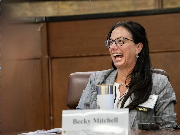
Colorado’s Becky Mitchell had a hearty laugh at the 2024 Getches-Wilkinson Center’s Colorado River conference. Photo/Getches-Wilkinson Center
Mitchell shared that she was a “solid B student” who had grown up in Hawaii before arriving in Colorado to pick up two degrees at the Colorado School of Mines. She worked primarily as a consulting engineer before becoming the director of the Colorado Water Conservation Board. In 2024, Gov. Jared Polis named her to a new position in Colorado government: the state’s negotiator on Colorado River issues. Unlike others in such roles, she’s not a lawyer.
“Often I think of everything as a math problem,” she said. “And a lot of what you see with the Colorado River is a math problem. It’s kind of simple math, almost like just addition and subtraction, not even algebra or multiplication.”
The two provided a high-level, yet sometimes detailed overview of the Colorado River during their hour on stage. However, students of the Colorado River, especially about the dramas, might have wanted another hour and the opportunity to ask additional questions.
For example, what do they make of the so-called “natural flow proposal” that was first formally discussed at a public meeting earlier that day in Arizona. As reported by the Las Vegas Review-Journal, this would base the release of water from Lake Powell on a three-year average of the “natural flows” of the river.
In their comments at Crested Butte, Mitchell and Kenney both broadly identified the need for the river to be shared in ways aligned with what Mother Nature is delivering, not a century-old compact.
Later, at a different meeting, Mitchell had this to say: “What we know today is that for any approach to work, it must be supply driven, perform well under both dry and varying hydrologies, and adapt to uncertain future conditions fundamental to this ‘divorce,’ or how we call it in Colorado, the conscious uncoupling.’”
Others might have asked Mitchell about the tensions behind the closed-door sessions — and the things that Kenney mentioned she could not really talk about in a public forum.
Or about the amount of water used to grow hay, including alfalfa, and other fodder crops for livestock. A 2020 study published in Nature Sustainability found that 55% of the water in the Colorado River Basin altogether goes to crops to feed primarily cattle. In the upper basin, it’s much higher.
Mitchell and Kenney did talk about Mead and Powell, the two big reservoirs in the basin, as all Colorado River conversations must.
“Those are the two biggest reservoirs in the United States, and they happen to fall on a river that’s not even one of the top 20 biggest rivers in the U.S. in terms of volume,” observed Kenney. The reservoirs were close to full 25 years ago. Now, they’re two thirds empty. “Optimists would say one-third full,” he said.
If you have more water going out than you have coming in, he explained, you have a mass balance problem. “That’s happening 8 out of 10 years. More water leaves than is coming into the reservoirs under guidelines adopted in 2007. Those interim guidelines govern operations, including how much water is released from the reservoirs and when.
“When we talk about Big River issues right now, the Big River issue is getting the system into balance and bringing back the sustainability of the system,” Kenney explained.
Management of the reservoirs was premised on meeting demand. To be more precise, demands of the lower-basin states. Until relatively recently, the lower-basin states were taking an average 10 million acre-feet even if the river delivered only 5 to 10 million acre-feet for the entire basin. Having two big reservoirs upstream allowed them to ignore the winters of scant snow in the headwaters and the rising spring temperatures that spiked evaporation and transpiration.
The first big shock was in 2002, when the river delivered only 3.8 million acre-feet. That was bad, very bad. But the reservoirs still had a lot of water. And there had been bad snow years before. In 1934, for example, the river delivered only 3.9 million acre-feet. And in 1977, a cold but uncommonly snowless winter, it had delivered 4.8 million acre-feet.
By May 2022, Lake Powell had dropped to the lowest levels since the 1960s, when it began filling after construction of Glen Canyon Dam. Photo/Allen Best
A big snow year did not soon follow 2002, so the states, guided by the Bureau of Reclamation, came up with a sort-of short-term set of solutions called the 2007 Interim Guidelines. Those guidelines remain in effect but are to be replaced with new guidelines. That’s a way of saying how the river is to be managed and, more precisely, who gets what and when. They’re called the post-2026 guidelines.
As were the 2007 guidelines, these will be interim, because the hydrology of the Colorado River Basin is not static. It is changing, with some concern that the river, already slimmed down from its 20th century average, will continue to shrink. The Colorado River Compact that was devised in 1922 to apportion the river’s waters assumed somewhere around 20 million acre-feet. This century the average has been 12.5 million acre-feet.
“The math problem is becoming worse,” said Kenney.
It will likely worsen. Some scientists have projected a further decline in decades ahead, conceivably to an average 10 million acre-feet or less.
How to shrink demands to correspond with the shrinking river?
Mitchell offered some thin optimism. Demands have ceased to rise. They have actually declined. The lower-basin states have reduced their take from the river to 7.5 million acre-feet.
That’s what the compact apportioned. But again, the compact from 1922 was flawed. It assumed more water than the river has delivered. Because of the two big reservoirs in the deserts of Utah and Arizona, the lower-basin states have been able to get their 7.5 million acre-feet (and more, until relatively recently). Arizona and California take way more than half of the river’s harvest. And because the upper-basin states were not taking their full allocation, they could get away with it without causing harm.
The 21st century combined with the aridification caused by rising temperatures have forced the issue. Even so, the reckoning has come slowly. The lower basin states did not reduce demand to stay within the compact until forced to by a declared shortage in August 2021.
While the decision was not a surprise to veteran Colorado River watchers, it vaulted the Colorado River troubles high into the national consciousness. The story ran on the front page of the New York Times: “In a First, U.S. Declares Shortage on the Colorado River, Forcing Water Cuts.” Arizona farms took the brunt of this declaration, but as the Times noted, wider reductions loomed as climate change continues to affect flows into the river.
The upper-basin states have been averaging 4.4 to 4.5 million acre-feet, far less than the 7.5 million acre-feet apportionment in the compact. How much they take depends upon how much it snows and rains.
“We have highs and lows because of hydrology. That can shift a lot. A really good example is from 2021 to 2022. Our use was 4.9 (million acre-feet), and then it went down to 3.9 the following year. That wasn’t because we’re amazing people.”
It was, Mitchell explained at Crested Butte, as she does in all of her talks, because the upper basin is limited by what Mother Nature actually delivers. The upper basin has no big dams upstream to serve as an aqua bank account. It has to moderate demand based on what kind of snow — and rain — year occurs.
Some 92% of all the water in the Colorado River originates in the upper basin states, including the Yampa River, seen here emerging from Cross Mountain Canyon in northwest Colorado. Photo/Allen Best
When there’s insufficient water, the state engineer in Colorado and his district engineers cut off water users, mostly ranchers irrigating grasses.
The compact struck among the four-upper basin states in 1948 used a more common-sense approach for how to allocate the 7.5 million acre-feet in the 1922 compact. It allocated the water among the four states based on proportions. Colorado gets a little more than half — and uses most of it. Wyoming has never come close to developing its share. Regardless, the rule of percentages makes sense for an uncertain hydrology.
“We realized real quickly that Mother Nature reigned supreme,” said Mitchell. I would be in big trouble if I said the lower basin should do the same. I think they should, but they’re not there yet.”
Mitchell used an analogy to describe the difficult transition for the lower basin. It is much harder to take candy from a baby after they have it,” she said.
“It’s going to be hard for them, and my heart goes out to them. But we have an example up here of how it works. Seniors work with juniors,” she explained, using the shorthand for senior and junior water uses under the prior appropriation system governing water use in Colorado and most Western states. Ag works with environment interests, utilities with agriculture, and so on. They cut deals in advance of water-short years.
“We have examples of how to make it work. You have a budget. You have to work within it. That’s the deal. And sometimes that budget might fluctuate.”
“We’ve not lost all of our junior water-right holders in Colorado because of one bad year or two bad years or three bad years, in a row, because we figure out how to make it work. And what we are saying to the lower basin is figure out where the deals are to be made.
And she drew upon her childhood for another dynamic.
“What my mom always said is, you can have anything you want, but you can’t have everything you want.”
Translated to the lower basins, that means “you can’t have chip factories and the largest agriculture in the world and golf courses and pools and Scottsdale and whatever. You can have the capability to have a strong economy, a sustainable system. You just can’t have it all.”
The federal government, through the Bureau of Reclamation, an agency housed within the Department of Interior, built the dams. Reclamation manages the dams. As Mitchell said, they turn the spigots. The onus is on the states to create a solution, an agreement of how to share the shrinking river, but the federal government could step in, if forced to. Mitchell said the feds don’t want to.
“They really want a consensus deal with the seven states,” she said. That’s a hard thing, because there’s no way to do this without change. The math is the math. The facts are the facts. There’s not the 50 million acre-feet in these reservoirs that there were when these (2007) guidelines started. And so the consensus is harder.”
Mitchell said she wouldn’t disparage those who created the now obviously flawed 2007 guidelines. Climatologists had suggested only a 3% probability of the runoff that has happened since then would come to pass.
“What we’re trying to create through this federal process is something that can handle all the hydrologies. How do we all suffer when the river is suffering? How do we all benefit when the river is flush? And what does benefit look like? That’s different in the upper basin than in the lower basin.”
The federal government in this case has been nudging the states toward agreement.
“They’re trying to say, ‘You know, you might be able to open up different project funding if you guys can get to a deal.’ We know we need a deal. I’m not going to promise you that we’re going to get there, but it is a goal. And (the federal agencies) are part of that goal. They don’t want to make the hard decisions of cutting people off. They are the water masters in the lower basin. They can turn the valves, and that’s their role.”
Added Kenney: “Typically the states are happiest when the federal government is silent, (but) sometimes it’s helpful to have a federal government that is throwing out some ultimatums and some deadlines and some threats.”
In the last six months, the federal involvement in the negotiations has grown, and it might grow yet. But a big part of the process — as Mitchell had said — is that the states need to be coming up with their wish list for Congress for consideration next spring.
“So there is a federal role,” Kenney summarized. “It evolves based on how the states are doing. But the tradition is you want the feds to stay away until it’s time for someone to write the check.”
MItchell had the last word. She again pointed to the meager runoff from this year’s upper-basin rivers, source of 92% of the river’s water. Runoff is projected at a little more than 5 million acre-feet into Powell, which is to release 7.48 million acre-feet to the lower basin.
Again, it’s a match problem. And it could get worse.
“If next year looks anything like this year, or even as a 12 million acre-foot river, actions absolutely have to be taken., and those actions are going to be greater than anybody has put on the table voluntary.”
Udall/Overpeck 4-panel Figure Colorado River temperature/precipitation/natural flows with trend. Lake Mead and Lake Powell storage. Updated through Water Year 2024. Credit: Brad Udall
On July 3, Larimer County District Court Judge Michelle Brinegar ruled that commissioners were justified in their decision to approve the application for 10 miles of pipeline through the county…In its lawsuit, Save The Poudre asked the judge to vacate the board’s decision to approve the pipeline. The nonprofit alleged that commissioners didn’t adequately follow the county’s standards for these kinds of applications. Specifically, Save The Poudre contends that commissioners should have required Thornton to present a plan for the so-called Poudre River option, which would have conveyed the water through the Poudre River downstream of Thornton’s current diversion point…But commissioners concluded that while they could encourage the Poudre River option, they couldn’t require it. Brinegar sided with commissioners, saying they can’t compel Thornton to present all possible alternatives, only those that are reasonable.
The clock is ticking for seven states to figure out how they’ll share dwindling water in the Colorado River for the foreseeable future. In a meeting at the Utah State Capitol Thursday [June 26. 2025], the river’s four Upper Basin state commissioners further embraced the idea of a “divorce” with their Lower Basin neighbors — an idea also floated at a meeting in eastern Utah last week, as reported by Fox 13.
“Today we stand on the brink of system failure,” said Becky Mitchell, the commissioner for Colorado. “We also stand on the precipice of a major decision point.”
…negotiations between the four Upper Basin states, which includes Utah, Colorado, Wyoming and New Mexico, have been in a standstill with the remaining three Lower Basin states for more than a year. The Interior Department’s acting assistant secretary for water and science, Scott Cameron, has met with leadership in the seven states that use Colorado River water since April, working to broker a deal.
Udall/Overpeck 4-panel Figure Colorado River temperature/precipitation/natural flows with trend. Lake Mead and Lake Powell storage. Updated through Water Year 2024. Credit: Brad Udall
“We all have to live in the physical world as it is,” he said, “not as we might hope it will be.”
On Thursday, Cameron presented water managers with a deadline. The Interior Department plans to release a draft environmental impact statement evaluating different alternatives for the river’s future in December, which will then open to public comment. The department will make its final decision on how to proceed by June of 2026.
“The goal is to essentially parachute in a seven-state deal as the preferred alternative,” Cameron said.
For that to work, the states will need to reach an agreement by Nov. 11. By Feb. 14, they’ll need to hand over the details of their plan. Whatever the states decide on, Cameron reminded commissioners, will likely take an act of Congress and new policy adopted by most of the affected states’ legislatures…
The idea of framing the future relationship of the river users as a “divorce” was first pitched by the Lower Basin states, Mitchell said. Under that proposal, the Upper Basin states would release water from Lake Powell based on the average natural flow measured at Lee’s Ferry, a point just downstream of the reservoir and upstream of both Grand Canyon National Park and Lake Mead.
“If done correctly,” Mitchell said, “it should provide the opportunity for the Upper and Lower basins to manage themselves, with the only real point of agreement being the Powell release.”
On the evening of June 24, the GWC’s Doug Kenney joined Becky Mitchell, Colorado’s lead negotiator on Colorado River matters, at the Crested Butte Public Policy Forum for a conversation about current and future Colorado River issues. Well over 100 people packed the Center for the Arts for the public event that in previous years has featured speakers as varied as Ted Turner, Sandra Day O’Connor, and the GWC’s Senior Fellow Anne Castle.
The primary focus of discussion was how “big river” issues—that is, the changing rules determining how Colorado River supplies are shared amongst the seven states—impact the availability of water on Colorado’s West Slope. This required a review of the three numbers in the basin that increasingly are out of step: the amount of water entering the system each year through snowmelt and rain; the amount of water consumed by water users throughout the basin; and the amount of consumptive use that has been promised to water users in the Colorado River Compact and other laws. This mismatch of supplies, demands and allocations is not a new problem, but is of particular urgency now as Lakes Powell and Mead are two-thirds empty, the EIS process for new determining new reservoir operations is well underway, and the current year runoff is shaping up as one of the worst in decades.
The conversation was led by Julie Nania, an icon in Crested Butte for her work with High Country Conservation Advocates in protecting Mt. Emmons—the so-called “Red Lady”—from development into a molybdenum mine, as well as her service on the Board of Directors of the Upper Gunnison Water Conservancy District and as Executive Director and Faculty Chair of the Coldharbour Institute based at Western Colorado University. Julie began her career at Colorado Law (class of 2011), which included a post-graduate fellowship with the GWC from 2013-2014 working on tribal water rights. Julie stands as a great example of the GWC’s ongoing influence in protecting the resources and places that we all value.
Udall/Overpeck 4-panel Figure Colorado River temperature/precipitation/natural flows with trend. Lake Mead and Lake Powell storage. Updated through Water Year 2024. Credit: Brad Udall
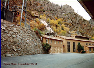
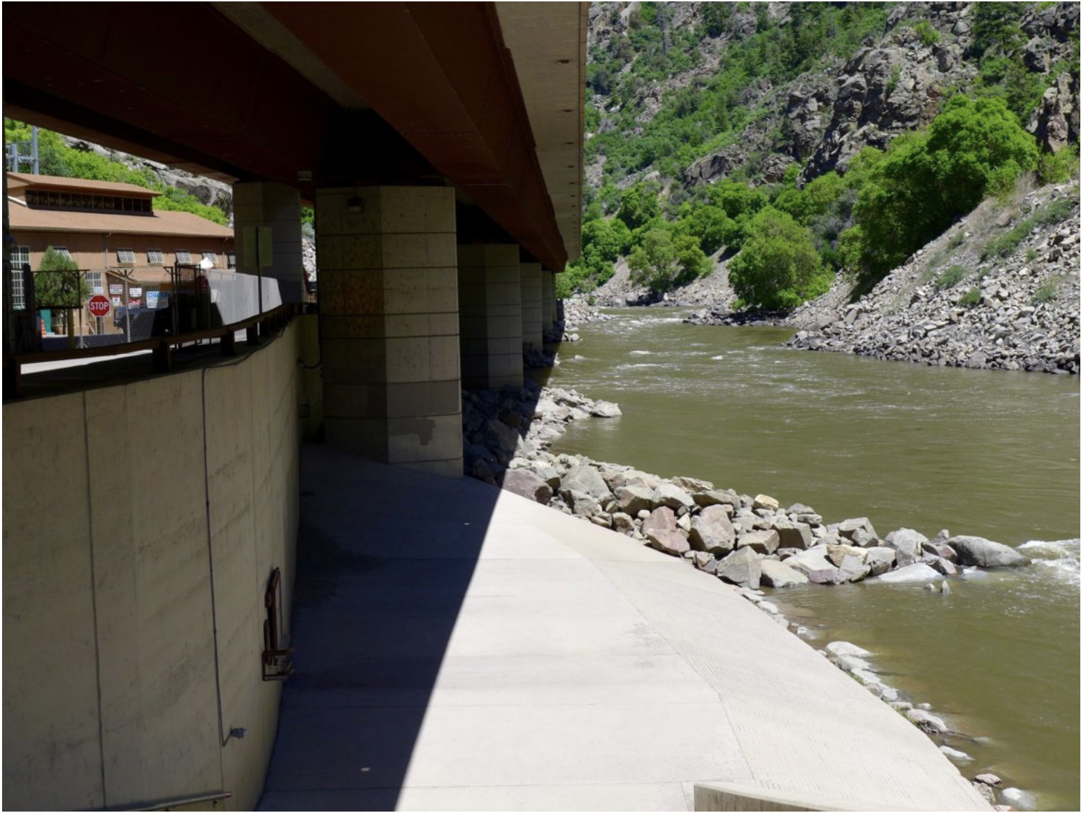
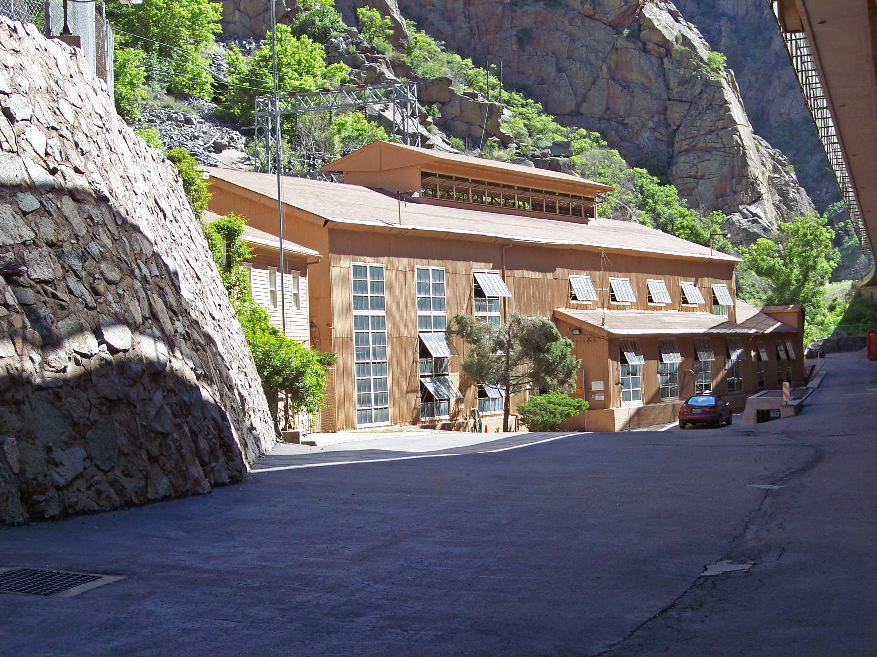
Water runs down a spillway at the Shoshone hydro plant in Glenwood Canyon. Rockfalls, fires and mudslides in recent years have caused frequent shutdowns of plant operations. Credit: Heather Sackett/Aspen Journalism
{The Colorado Water Conservation Board] unanimously agreed Tuesday to hear out Front Range water operators’ concerns about a Western Slope plan to purchase historic Colorado River water rights.
The Colorado River Water Conservation District, which represents 15 Western Slope counties, negotiated a $99 million deal to purchase water rights tied to the century-old Shoshone Power Plant, owned by a subsidiary of Xcel Energy.
The River District and the Front Range groups — Aurora Water, Denver Water, Colorado Springs Utilities and Northern Water — all want to maintain the historical flows past Shoshone to provide predictable water supplies long into the future. They mainly disagree about the amount of water involved. Front Range providers say, if the number is too high, it could hamper their ability to provide water to millions of people.
In June, the Front Range water managers asked the Colorado Water Conservation Board to hold a hearing to air concerns. That hearing will be held during the board’s meeting, Sept. 16-18.
“We look forward to the hearing, and we appreciate the effort and the time that you and the staff have put into this effort,” Andy Mueller, the River District’s general manager, said during the board meeting Tuesday. “[We] look forward to finishing this in September.”
The decision Tuesday also opened up a seven-day period, ending July 9, for others to ask to join the September hearing. The board will share updates with the public on its website.
The hearing is part of a larger [CWCB Instream and water court] process to decide whether Shoshone Power Plant’s water rights can become an environmental water right, called an instream flow right. These rights aim to keep water in rivers to help aquatic ecosystems.
Photo: 1950 “Public Service Dam” (Shoshone Dam) in Colorado River near Glenwood Springs Colorado.
In this case, the environmental water right would focus on a 2.4-mile stretch between Shoshone’s intake dam, which takes water out of the Colorado River, and the end of its penstocks, which return all of Shoshone’s water to the river. The power plant is tucked into Glenwood Canyon along Interstate 70 a few miles east of Glenwood Springs.
At times, the power plant sucks nearly all of the Colorado River’s flow — depending on the amount of water in the river above the dam — through its turbines before returning it to the river channel. When this happens, the 2.4-mile stretch immediately below the dam is reduced to a narrow channel of water.
The environmental flow right would allow water managers to keep more water in that stretch of the river to help fish and other aquatic species. If approved, it would be the largest, most influential instream flow right in the state’s portfolio. The Colorado water board has until Sept. 18 to make its decision.
The Colorado River District wants to purchase the water rights as part of a larger plan to permanently shore up water supplies for Western Slope communities, which have long worried that Shoshone’s flows could change if Xcel decided to shut down the power plant or sell the water rights.
The district has a purchase agreement with Xcel Energy to buy the rights and lease the water back to Xcel to generate electricity. One of the terms of the deal is getting the instream flow use approved by the state.
The Front Range water providers and water managers want to prevent any changes to Shoshone’s water rights from harming their water supplies.
Shoshone’s water rights are like the bottom blocks in a game of Jenga: change to the rights could cause ripple effects statewide, in part, because of their age, location and amount of water.
Shoshone’s oldest water right can impact up to 10,600 other upstream water rights because of the plant’s geographic location, according to the Colorado Division of Water Resources. Those junior water users include Front Range water managers, like Denver Water and Northern Water, that send water to millions of people.
Colorado transmountain diversions via the State Engineer’s office
The Front Range water operators want to resolve their concerns about the historical flows through Shoshone during the instream flow approval process this summer.
The Colorado River District says their questions can be resolved during the subsequent water court proceedings, where opposing parties will have another opportunity to voice their concerns and make sure their water supplies aren’t negatively impacted.
“We are deeply concerned that the Front Range entities requesting this contested hearing are asking the CWCB to encroach on the jurisdiction of water court,” the district said in a prepared statement Tuesday.
Rifle ranch owners John Powers, left, and plant ecologist Lisa Tasker talk about the Rifle Creek restoration project at a tour of the property on June 3. The project has replaced invasive species with native plants. CREDIT: HEATHER SACKETT/ASPEN JOURNALISM
The banks of a previously degraded 1-mile stretch of Rifle Creek are now thick with willows and cottonwoods, and have signs that deer, elk and beavers are once again frequent visitors.
This summer marks 10 years since an ambitious, multiphase riparian restoration project began on John Powers’ ranch, located north of Rifle and off Colorado 325. Since 2016, the property has been a worksite of the Colorado Natural Heritage Program, which has cataloged species; replaced invasive Russian olive, thistles and weeds with native trees, flowers, shrubs and grasses; and trained the next generation of scientists and conservationists on how to restore the health of a stream.
On June 3, Powers, who is a self-described lover of the outdoors, along with friend and associate Janna Six, as well as interns from CNHP, hosted a public-outreach day with conservation professionals who worked on the project, including representatives from local governments, agencies and nonprofit organizations, for a tour of the project. Powers called it a living lab for education and hopes it can serve as a demonstration project for other ranches in the area that want to control erosion.
A decade ago, the banks of the creek were severely eroded — bare of vegetation in places and steep. Part of the reason for these conditions is the upstream Rifle Gap Reservoir, which was completed in 1967. Sediment collects behind the dam, meaning the water released downstream is clean and erosive, cutting into the streambanks. The three-phase project sought to remedy that.
“Rifle Creek used to be shallow, allowing horse-drawn hay wagons to cross it,” Powers said in a written response to questions from Aspen Journalism. “After the Rifle Gap Reservoir was built, severe erosion occurred downstream, making creek banks vertical and 12-15 feet deep.”
Powers said the goals of the project are to improve the habitat for songbirds, pollinators and wildlife; increase carbon sequestration, including cultivating healthy soil and minimizing erosion; and maintain the economic benefits of a working ranch while enhancing the ecological condition of the riparian area.
Small cottonwoods and other native trees have fencing to protect them from wildlife and livestock until they get established. The riparian restoration project on the Powers Ranch near Rifle planted thousands of native trees, shrubs and grasses. CREDIT: HEATHER SACKETT/ASPEN JOURNALISM
The thousands of native plants were put in over a three-year intensive effort by volunteers and interns, led by plant ecologist Lisa Tasker. Some are protected by fencing from wildlife and livestock until they become established, and are watered with a drip irrigation system.
“My hope is that I live long enough that I won’t be able to see one side of the creek from the other side of the creek,” Powers told tour participants.
David Anderson, director and chief scientist at CNHP, said conditions on the ranch have changed dramatically for the better over the past decade due to the restoration work.
“We’re seeing a lot more birds now that there’s some woody structure,” he said. “There’s just a whole different suite of wildlife that can utilize the riparian area there now.”
Anderson added that with the new vegetation providing shade to cool the stream, conditions for native fish will improve.
Sprinklers have replaced flood irrigation on part of the Powers Ranch property near Rifle. This summer marks the 10th year since the beginning of a creek restoration project on the ranch. CREDIT: HEATHER SACKETT/ASPEN JOURNALISM
Restoration tactics take time
Rivers and wetland habitats comprise a small amount of Colorado’s land area, but they are of outsize importance to wildlife. Improving the health of Rifle Creek is a focus of the Middle Colorado Watershed Council, a nonprofit organization that works to protect and improve watershed health. Between 2015 and 2019, the creek was the subject of a watershed assessment, which looked primarily at water quality.
The council has also been implementing the goals of its Riparian Restoration Implementation Plan, which spans the entire Colorado River watershed from Glenwood Springs to DeBeque. But the stretch of Rifle Creek from below Rifle Gap Reservoir to its confluence with the Colorado River is a main concern.
“We won’t be able to restore the whole thing right away,” said Kate Collins, executive director of the council, referring to plans to conduct additional restoration work along Rifle Creek beyond the Powers ranch. “But what we want to do is identify certain projects that are either the most urgent or perhaps they are the most low-hanging fruit — in other words, there’s the best opportunity for restoration.”
The health of many streams across the Western Slope is impacted by erosion, invasive species and agriculture. Collins said the tactics for fixing them are often low-tech, such as replacing invasives with native plants.
“Some of these techniques are being widely used, and this Rifle Creek project could be a model for others,” she said, referring to the Powers ranch restoration project.
Rifle Creek in 2015 before the riparian restoration project. The banks of the creek were severely eroded. CREDIT: JOHN POWERS
Future plans for the ranch include another bio blitz in 2026 in which CNHP interns will document as many species of plants and animals on the ranch as possible over a 24-hour period and compare the results to their bio blitzes in 2016 and 2017.
Powers and Anderson are also interested in potentially building what are called beaver dam analogs (BDAs), which are human-made structures that mimic beaver dams, helping to slow streamflow and keep water on the landscape. These temporary wood structures usually consist of posts driven into the streambed with willows and other soft materials weaved across the channel between the posts. Environmental groups and local governments are using BDAs to improve stream health and wildlife habitat.
“We’re really interested in doing some of those,” Anderson said. “I hope that maybe next year or in another subsequent year that we’ll work with the interns to build some of those structures right in Rifle Creek.”
For Powers, the Rifle Creek restoration on his ranch has been a passion project that keeps a riparian area thriving, as well as adapting to climate change and a future with less water. Collins sees the project as a step toward reconnecting the community to its local waterway.
“(Rifle Creek) is a vital part of what runs through that town and that community, and it’ll be exciting to see what positive ecological changes those bring about to virtually everything else,” Collins said…
Shoshone Falls hydroelectric generation station via USGenWeb
Click the link to read the article on The Denver Post website. (Elise Schmelzer). Here’s an excerpt:
July 2, 2025
Four major Front Range water providers — Denver Water, Aurora Water, Colorado Springs Utilities and Northern Water — will present their concerns about the purchase of the Shoshone Power Plant water rights by the Colorado River District during a hearing in September before the Colorado Water Conservation Board. The board during a special meeting Tuesday decided to hold the hearing to hash out the urban utilities’ concerns about how much water should be allocated to the right. The board must decide by September whether to approve the new use of the water right proposed by the district…The Colorado River District, a taxpayer-funded agency that works to protect Western Slope water, in 2023 announced a $99 million deal to buy the water rights from Xcel Energy, which owns the power plant. The purchase — a decades-long effort by the district — will ensure that water will continue to flow west past the plant tucked into Glenwood Canyon and downstream to the towns, farms and others who rely on the Colorado River even if the century-old power plant were decommissioned.
Each of the Front Range utilities have said they do not oppose the purchase itself. They do, however, question the river district’s calculations of how much water has been used historically under the rights. Under Colorado water law, that number will determine how much water must flow through the plant in the future. The district’s calculations are too high, the four utilities argue, and would leave them with less water from the Colorado River for their own uses. The river district has repeatedly said it plans to maintain the status quo and will not use more water than has been used in the past. Disputes about the amount of water historically used under a water right should be settled in water court, the district’s general manager Andy Mueller said Tuesday in a statement.
“We are deeply concerned that the Front Range entities requesting this contested hearing are asking the CWCB to encroach on the jurisdiction of water court,” Mueller said. “… We believe maintaining public trust relies on following the right path and avoiding political intrusion.”
Colorado transmountain diversions via the State Engineer’s office
Four major Front Range water agencies have requested a state hearing to fully air their objections to a Western Slope plan to purchase historic, coveted Colorado River water rights.
The Colorado River Water Conservation District, which represents 15 Western Slope counties, is leading the effort to purchase the $99 million water rights tied to the century-old Shoshone Power Plant, owned by a subsidiary of Xcel Energy. The district wants to buy the rights to protect historical water resources for Western Slope communities long into the future.
Aurora Water, Denver Water, Colorado Springs Utilities and Northern Water also want to maintain the historical flows past Shoshone which provides stability for their water supplies. They just disagree over the numbers, namely how much water is included in the deal. If the number is too high, it could throw a wrench in their water systems.
The state’s water board, the Colorado Water Conservation Board, will decide during a special meeting Tuesday whether to grant the hearing requests.
“If, as the River District asserts, the status quo will be maintained, this acquisition can be a win-win for both the Front Range and the West Slope,” wrote Marshall Brown, general manager of Aurora Water in a letter on June 9. “However … we have significant concerns.”
The Colorado River District already has passed a few hurdles in its years long effort to purchase the powerful water rights for Shoshone, located just east of Glenwood Springs.
It has a purchase agreement with Xcel Energy. A diverse array of Western Slope cities, agricultural groups, the Colorado legislature and others have promised millions of dollars toward the asking price.
Democratic and Republican Congressional representatives from Colorado have spoken in support of the purchase. U.S. Rep. Jeff Hurd, a Republican from Grand Junction, asked Secretary of the Interior Doug Burgum to release the funds in a committee meeting this month.
120 days to decide
The district is moving on with its next step: working with the state to use the water rights to help protect the environment. This is where the concerns over historical flows come in.
The River District wants Shoshone’s rights to be used to keep water in the Colorado River near the power plant in Glenwood Canyon to benefit aquatic ecosystems when the power plant isn’t generating electricity.
The additional environmental use would secure the flow of water past the power plant, even if the plant goes out of commission — maintaining the status quo flows permanently. That water could otherwise be used further upstream.
The Colorado Water Conservation Board, faces a September deadline to decide whether to approve this new environmental use, called an instream flow right.
The four Front Range water managers were the only entities to submit notices within that 20-day window.
They want to recalculate how much water has been used at Shoshone in past decades before the matter goes to water court, where opposing parties will have another opportunity to voice their concerns and make sure their water supplies aren’t negatively impacted.
Collectively, the four agencies help deliver water to over 3 million people along the Front Range cities and northeastern plains.
In its letter, Aurora Water said the river district’s estimate could overstate historic use by up to 300,000 acre-feet. One acre-foot roughly equals the annual water use of two to three households. The utility did not respond in time for publication.
Northern Water is concerned about its ability to fill Green Mountain Reservoir in Summit County, which depends in part on downstream water rights, like Shoshone’s. The reservoir delivers water to the Western Slope, including to a 15-mile stretch of the Colorado River that provides vital habitat for endangered and threatened fish.
Colorado Springs Utilities’ letter said a too-high estimate could cut into the amount of water the provider can divert from the Blue River and the Homestake Water Project, which directs water from the Western Slope to the Eastern Slope.
Denver Water cited similar concerns, saying the proposal, as is, will change the “status quo” in ways that would harm the utility’s ability to provide water to over 1.5 million people during severe or prolonged drought.
Colorado Springs and Denver Water declined to comment further, referring to their written letters.
If the Colorado Water Conservation Board approves the hearing request, people will have until July 9 to ask to join the hearing process, said Rob Viehl, chief of the Stream and Lake Protection Section at the Colorado Water Conservation Board. The board will share updates with the public on its website and decide the date of the hearing during its meeting Tuesday.
Shoshone hydroelectric generation plant Glenwood Canyon via the Colorado River DistrictShoshone Falls hydroelectric generation station via USGenWebThe blown-out penstock in 2007 at the Shoshone plant. Photo credit: Brent Gardner-Smith/Aspen JournalismXcel truck at Shoshone plant. Photo credit: Brent Gardner-Smith/Aspen JournalismThe penstocks feeding the Shoshone hydropower plant on the Colorado River in Glenwood Canyon. Photo credit: Brent Gardner-Smith/Aspen JournalismThe Shoshone plant and boat ramp on the Colorado River. Photo credit: Brent Gardner-Smith/Aspen JournalismThe Shoshone hydro plant in Glenwood Canyon, captured here in June 2018, uses water diverted from the Colorado River to make power, and it controls a key water right on the Western Slope. Photo credit: Brent Gardner-Smith/Aspen JournalismShoshone Hydroelectric plant. Photo credit: The Colorado River DistrictThis historical photo shows the penstocks of the Shoshone power plant above the Colorado River. A coalition led by the Colorado River District is seeking to purchase the water rights associated with the plant. Credit: Library of Congress photoPhoto: 1950 “Public Service Dam” (Shoshone Dam) in Colorado River near Glenwood Springs Colorado.View of Shoshone Hydroelectric Plant construction in Glenwood Canyon (Garfield County) Colorado; shows the Colorado River, the dam, sheds, a footbridge, and the workmen’s camp. Creator: McClure, Louis Charles, 1867-1957. Credit: Denver Public Library Digital CollectionsThe twin turbines of Xcel Energy’s Shoshone hydroelectric power plant in Glenwood Canyon can generate 15 megawatts. The plant was down for about a year and a half, according to the Colorado Division of Water Resources. Credit: Heather Sackett/Aspen JournalismWater runs down a spillway at the Shoshone hydro plant in Glenwood Canyon. Rockfalls, fires and mudslides in recent years have caused frequent shutdowns of plant operations. Credit: Heather Sackett/Aspen JournalismThe Shoshone hydro plant in Glenwood Canyon. The River District has made a deal with Xcel Energy to buy the water rights associated with the plant to keep water flowing on the Western Slope. Credit: Heather Sackett/Aspen Journalism
Sen. Mike Lee, the Utah Republican and Trump sycophant, has slightly backed off on his proposal to sell-off public lands, but only slightly.
Lee posted the following on X/Twitter at 5:42 a.m. today:
Big sigh of relief? Nope. Sure, it’s great he’s removing Forest Service land from the pool of land eligible for “disposal.” This means the Hidden Valley/Falls Creek areanear Durango is out of danger, as are parcels near Flagstaff and Boise and Santa Fe that could have ended up on the auction block under the original provision. The 5-mile limit from population centers will also take some remote BLM parcels out of consideration — parcels that wouldn’t have been prioritized, anyway.
The change reduces the size of the pool of available land, and presumably also reduces the amount of land that would be sold to between 1.25 million and 1.9 million acres. That’s still a crap-ton of public lands that will be privatized, cluttered up with houses and roads and cul-de-sacs and power lines and so forth, and to which the public will lose access. If this goes forward, you can plan on houses popping up on some of your favorite hiking, trail-running, or biking areas.
And it still includes places like:
Animas Mountain and upper Horse Gulch near Durango;
swaths of BLM land near Naturita and Nucla, Colorado;
BLM land, including wilderness study areas, near Moab (wilderness study areas and areas of critical environmental concern are not exempted from the sell off);
parcels that abut Zion National Park’s boundaries (within five miles of Springdale and Rockville);
the lower slopes of Jumbo Mountain near Paonia;
parcels on Las Vegas’s fringe, along with tracts around Mesquite and Moapa that the Freedom Cities folks have their eyes on;
other Freedom City-proposed parcels near Fruita and Grand Junction;
the list goes on and on. (To get an idea just check out the Wilderness Society map, ignore the green areas, and look for “population centers” around the brass-colored areas to see what might be eligible).
Lee says he will protect ranchers, which may or may not mean his provision would again leave out land that is in active grazing allotments. He doesn’t explain what the hell he means by “FREEDOM ZONES,” except to imply that he wouldn’t let any foreigners buy the land(?). Lee once again doesn’t mention a damned thing about affordable housing, meaning he’s just fine with public lands being used for luxury developments or even multi-million dollar mansions.
Oh, and then there’s that little aside about the Byrd Rule. Yeah, that might get in Lee’s way. See, the Senate parliamentarian ruled that the public land sell off provision, along with several other sections relating to energy development on public lands, were subject to a 60-vote threshold. This means they would likely be dropped from the reconciliation bill altogether, since leaving it in could sink the entire “Big Beautiful” whatever. Still, the GOP has a thing about ignoring the parliamentarian and the usual rules, and Lee indicated he would push on with this concept in one form or another. So now is not the time to back down.
The public lands sell-off provision has generated a huge amount of outrage and public push back, which is clearly working (after all, why else would Lee make those changes?). But it’s not the only or even the worst thing the MAGA folks are inflicting on the American public’s lands.
For example, yesterday Agriculture Secretary Brooke announced that the U.S. Forest Service plans to repeal the Clinton-era Roadless Rule, which blocks roadbuilding and other development on about 58 million acres of Forest Service land. If the rollback survives inevitable legal challenges, it will open up a lot of forest to logging.
Glen Canyon Dam, January 2022. Jonathan P. Thompson photo.
🥵 Aridification Watch 🐫
To be a Colorado River watcher is to ride a slow-motion emotional roller coaster. We reached extreme highs during the late 1980s and into the 1990s, fell into a two-decade depression beginning in 2002 — with ebullient spikes in 2005, 2008, 2011, 2019 — and then the bountiful winter of 2023 came along and was followed up by a not-so-sad 2024.
It was enough to convince us we were recovering, and we could quit therapy, cut back on the meds, and stop worrying (all figuratively, of course). During this period of relative abundance, all of the studies about climate heating diminishing snowpacks and threatening the West’s lifeline seemed a bit abstract: Scary, sure, but we still had years and years before it manifested itself.
Yeah, no. It turns out that 2023 was just another manic and anomalous episode that falsely lulled us into complacency. And now that it has past, we’ve been sent spiraling back down into a deep aridification-sparked depression (somewhat figuratively speaking).
The snowpack-meagre 2025 winter delivered the first buzzkill to the Upper Colorado River Basin, followed by a warm and dry and dismal spring. Now, Lake Powell’s surface level is flatlining just as it should be shooting upward, an indicator that the river is back to its new normal. That is to say it is once again shrinking, and the gap between how much water has been allocated to the river’s users and what’s actually in there continues to grow. Which is to say, we’re still f&$#ed, and getting even more so with each passing year.
In fact, the U.S. Bureau of Reclamation’s latest projection has Lake Powell possibly dropping below the minimum power pool, or the level at which hydropower production shuts down, as soon as the end of 2026. Mind you, that’s their worst case scenario, but these forecasts often lean towards optimism. Most notable is how dramatically the forecast has changed since April, a difference that is visible in the graph below.
Click the link to read the article on the KUNC website (Alex Hager):
June 23, 2025
This story is part of ongoing coverage of the Colorado River, produced by KUNC and supported by the Walton Family Foundation.
There’s a break in the clouds that have hovered over Colorado River negotiations for more than a year. State water leaders appear to be coalescing behind a new proposal for sharing the river after talks were stuck in a deadlock for more than a year.
The river is used by nearly 40 million people across seven states and Mexico, but it’s shrinking due to climate change. As a result, state leaders need to rein in demand. For months, they were mired in a standoff about how to interpret a century-old legal agreement. The new proposal is completely different.
Instead of those states leaning on old rules that don’t account for climate change, they’re proposing a new system that divides the river based on how much water is in it today.
“We finally have an approach that at least allows a glimmer of hope that the laying down of arms is possible,” said John Fleck, a writer and water policy researcher at the University of New Mexico.
The long, tense negotiations have mostly been stuck on one issue: How much water should the Upper Basin states — Colorado, Utah, Wyoming, and New Mexico — send downstream from their largest reservoir, Lake Powell?
The new plan says the amount should be based on a three-year rolling average of the “natural flows” in the river — basically, how much water would flow through it if human dams and diversion weren’t in the way.
States would still have to negotiate the exact percentage of those “natural flows” that would go downstream to the Lower Basin states of California, Arizona and Nevada. Picking that number will likely be difficult, but the fact that states are willing to base it on current climate conditions represents a major philosophical shift in how the river is divided.
“This new approach gets beyond the obsessively arcane discussions about various interpretations of laws written 100 years ago, with people hoping that their lawyers’ arguments can mean they get more water,” Fleck said. “It says, ‘Look, we all have to share this river. We have to do some math about how much water it really has.’”
Nevada’s John Entsminger, Arizona’s Tom Buschatzke, and California’s JB Hamby sit on a panel of state water leaders at the Colorado River Water Users Association annual conference in Las Vegas on December 5, 2024. Arizona’s Tom Buschatzke (center) brought details of a Colorado River plan to the public, and said it “allows for a fair division of what Mother Nature provides to us. Alex Hager/KUNC
Details of the plan first emerged in a meeting of the Arizona Reconsultation Committee, where the state’s water leaders gather to discuss Arizona’s position in multistate talks. Tom Buschatzke, director of the Arizona Department of Water Resources, described the plan as “innovative.”
“I was very pessimistic that we were on a path towards litigation,” he said. “I’m more optimistic now that we can avoid that path if we can make this work.”
Buschatzke emphasized that the proposal is in its early stages. The concept is now heading to the Bureau of Reclamation, the federal water agency which manages dams and reservoirs in the West. Employees there will run models to figure out exactly how much water would flow between the two basins.
State and federal leaders are in a crunch to finalize new water sharing rules before a 2026 deadline, when the current rules expire.
“It is still just a concept,” Buschatzke said. “We haven’t agreed to anything at this point, but we agreed to test it.”
Colorado, which often speaks on behalf of all four Upper Basin states, appears cautiously supportive of the plan.
“Colorado remains committed to developing supply-driven, sustainable operations of Lake Powell and Lake Mead,” Becky Mitchell, Colorado’s top water negotiator, wrote to KUNC in a statement. “The natural flow approach is one way to achieve this, if it is done right.”
Colorado and its allies initially dug in their heels on a very specific interpretation of the 1922 Colorado River compact, arguing that they shouldn’t have to take new cutbacks to their water supplies since they feel the impacts of climate change-fueled shortages more than their downstream neighbors.
“There is no doubt that Arizona views things differently than the Upper Division States, and a successful framework will set aside our differing views and focus instead on the health and sustainability of the Colorado River System for all who depend upon it,” Mitchell wrote.
The San Juan River near Navajo Dam, New Mexico, Aug. 23, 2015. Photo credit: Phil Slattery Wikimedia Commons
From email from Reclamation (Conor Felletter):
June 23, 2025
The Bureau of Reclamation has scheduled an increase in the release from Navajo Dam from 350 cubic feet per second (cfs) to 450 cfs for Tuesday, June 24th, at 4:00 AM.
Releases are made for the authorized purposes of the Navajo Unit, and to attempt to maintain a target base flow through the endangered fish critical habitat reach of the San Juan River (Farmington to Lake Powell). The San Juan River Basin Recovery Implementation Program recommends a target base flow of between 500 cfs and 1,000 cfs through the critical habitat area. The target base flow is calculated as the weekly average of gaged flows throughout the critical habitat area from Farmington to Lake Powell.
This scheduled release change is subject to changes in river flows and weather conditions. If you have any questions, please reply to this message, call 970-385-6500, or visit Reclamation’s Navajo Dam website at https://www.usbr.gov/uc/water/crsp/cs/nvd.html
Lake Mendocino, in Northern California’s wine country, was the proving ground for Forecast-Informed Reservoir Operations. (Source: California Department of Water Resources)
Western Water in-depth: For years, atmospheric rivers were a mystery. now, an innovative dam management approach is putting them to work
In December 2012, dam operators at Northern California’s Lake Mendocino watched as a series of intense winter storms bore down on them. The dam there is run by the U.S. Army Corps of Engineers’ San Francisco District, whose primary responsibility in the Russian River watershed is flood control. To make room in the reservoir for the expected deluge, the Army Corps released some 25,000 acre-feet of water downstream — enough to supply nearly 90,000 families for a year.
In doing so, the Army Corps averted the possibility of a catastrophic flood. But almost as soon as the water headed downstream, the pendulum swung in the other direction. The weather turned dry, and the months that followed proved to be the driest on record in California up to that point. A year later, the reservoir became a drought-cracked mudflat. The local water supplier, Sonoma County Water Agency, was forced to reduce releases by 60 percent during the dry summer, impacting urban and agricultural water users downstream.
State officials were frustrated. Members of a drought task force created by then-Gov. Jerry Brown traveled to Lake Mendocino, tucked into the coastal wine country near Ukiah, to hold a press conference. An exasperated John Laird, the state resources secretary at the time, asked some of the Army Corps’ top brass what they’d been thinking when they sent so much water downstream.
“I just blurted it out,” says Laird, now a state senator. “It was one of those emperor-has-no-clothes moments, because somehow nobody was speaking up about this.”
It made for an uncomfortable moment. But the incident catalyzed a wide-reaching effort to manage dams more nimbly in the face of wildly variable weather, and particularly to meet the challenge of atmospheric rivers — intense winter storms that pummel California and other parts of the West with huge amounts of rain.
In the wake of the controversy at Lake Mendocino, the quest to harness the power of atmospheric rivers birthed a new water-management approach: Forecast-Informed Reservoir Operations, or FIRO. The concept has been tested on three dams in California since 2019, with programs in development for several other dams across the West.
By pairing FIRO with accurate forecasts of where those storms will hit and how much rain they’ll bring, dam operators can work in real time to not only reduce the risk of dangerous floods, but also capitalize on atmospheric rivers’ potential as a source of additional water for protection from drought.
Now, the concept is poised to improve operations at 39 more dams across the arid Southwest and another 71 throughout the rest of the country. That will vastly increase FIRO’s potential and help dam operators stand ready for the wilder weather that the future will likely bring: storms intensified — and made more erratic — by climate change.
Some 50 atmospheric rivers hit the West Coast of the U.S. during the 2024-25 season. (Source: Center for Western Weather and Water Extremes)
Atmospheric Rivers Enter the Lexicon
For decades, the “Pineapple Express,” a type of storm that feeds off warm tropical moisture, figured prominently in local weather lore. By the early 1990s, researchers realized that it was just one kind of a broader category of unique storms that take shape far out in the Pacific. In a 1994 research paper, Yong Zhu, now at North Carolina State University, and MIT’s late Reginald Newell, christened them atmospheric rivers.
According to a 2019 study, atmospheric rivers caused $5.2 billion in damage in Sonoma County over the preceding two decades and were responsible for 99.8 percent of all insured flood losses there. A single 1995 storm — the most damaging event in 40 years of record keeping in the West — inundated the town of Guerneville on the Russian River and caused $50 million in insured losses countywide. The study determined that atmospheric rivers are the primary driver of flood damage in the West.
These powerful plumes of water vapor — which, on average, carry 25 times the flow of the Mississippi River — deliver 30 to 50 percent of total annual precipitation in California.
“Atmospheric rivers are the hurricanes for the West Coast,” says Cary Talbot, the FIRO National Lead with the Army Corps’ Engineer Research and Development Center.
But when they fail to arrive, that can also have a big impact, leaving the state parched and reeling. Their influence isn’t limited to just California, either: In 2021, researchers Mu Xiao, now at the Scripps Institution of Oceanography at UC San Diego, and Dennis Lettenmaier, now at University of California, Los Angeles found that almost one third of snowpack in the Upper Colorado River Basin comes from snowfall brought by atmospheric rivers.
The Army Corps’ primary responsibility is the high-stakes task of controlling floods, or as the agency puts it, “flood risk management.” As a result, the Army Corps tends to be extremely risk averse, and it literally runs its dams by the book: Each of its dams has an individually formulated water control manual with flood control curves, more commonly known as “rule curves,” that are practically chiseled in stone.
“When those things are written, they go through a really rigorous (vetting) process because it’s what we are going to be graded on in the courts,” says Talbot. “When somebody sues us for how we operated, they’re going to look at the water control manual and say: ‘Did the operators follow the rules?’ So, water managers don’t really want to stray too far from what it says.”
Rule curves typically force operators to keep reservoir levels low during wet seasons so they can catch and hold back the rainfall from anticipated storms and reduce the impacts of flooding downstream. But if those storms veer off their predicted course, or dissipate before they arrive, operators can’t get back the water they’ve already released — exactly what happened at Lake Mendocino in 2012.
The public outcry over that incident, which would be followed by the driest three-year period on record until then, helped nudge the Army Corps toward a more flexible approach.
Flood-control releases in December 2012, followed by months of drought, sent reservoir levels in Lake Mendocino — shown here in December 2013 — plummeting. (Source: Sonoma Water)
“The disaster of a really bad drought in California focused congressional attention,” says Talbot. In 2015, Congress added a line in the Army Corps’ budget for a research-led Water Operations Technical Support program. “It wasn’t much money — it was really just $2 million to get it started — but the direction from Congress was to see if we can’t find a better balance between flood risk management and water supply, especially with respect to atmospheric rivers.”
The following year, the Army Corps modified its regulations to allow for the use of forecasts in operations planning. Actually incorporating that change into each dam’s water control manual, many of which are decades old, still required an administrative process that typically takes several years. But the announcement was a significant first step in the shift away from the hidebound rule curves that governed dam operations.
To make it all work, though, dam operators had to have weather forecasts that they could trust.
Decoding Atmospheric Rivers
As it happened, weather researchers were already on a quest to crack the mystery of how atmospheric rivers work. A key figure in the effort was Marty Ralph, who spent more than two decades as an atmospheric scientist at the National Oceanic and Atmospheric Administration (NOAA) beginning in 1992.
Marty Ralph, head of the Center for Western Weather and Water Extremes (CW3E), worked with colleagues to vastly improve the accuracy of atmospheric river forecasts. (Source: CW3E)
Ralph had begun studying cyclones off the U.S. West Coast in the mid-1990s. To get an up-close view of the storms in their spawning grounds far out at sea, he wheedled and cajoled the use of weather research aircraft from NOAA, NASA and the Air Force that sat idle following the busy summer hurricane season on the Gulf Coast. (At one point, Ralph experimented with — but ultimately gave up on — using a long-range surveillance drone called the Global Hawk, an $80-million-plus “hand-me-down,” as he puts it, from the Air Force to NASA.)
Ralph’s research focus gradually zeroed in on what would turn out to be atmospheric rivers. He didn’t read Zhu and Newell’s groundbreaking work on the phenomenon until 2003, but when he did, “the light bulb just went off, like, ‘Oh — that’s what we’re studying!’”
Ralph organized a series of annual “field campaigns” to learn more about atmospheric rivers and racked up more and more flight time. In 2013, he left NOAA to start the Center for Western Weather and Water Extremes, or CW3E, at the Scripps Institution of Oceanography at UC San Diego. There, working with other researchers, he continued to research atmospheric rivers’ origins and behavior. But along the way, he says, “it became clear to me that we should be trying this as an operational program to help with forecasting” so that dam operators could have a more accurate real-time picture of individual storms’ paths and intensity.
Lake Becomes Proving Ground
Meanwhile, Lake Mendocino was emerging as the first test case for FIRO. At the time, Jay Jasperse was the chief engineer and director of groundwater management for Sonoma Water, which gets much of its supply from the lake. Despite the Army Corps’ new openness to using forecasts for more flexible dam operations, he says, there initially was “a lot of skepticism from some parties, and there was a lot of concern that the Army Corps was going to be incurring a lot of liability, and that this is going to negatively impact their flood risk management operations.”
During the 2020 water year, FIRO allowed an extra 19 percent, or 11,175 acre-feet of water, to be captured in Lake Mendocino. (Source: Sonoma Water)
“There were some spirited debates, and I think it took us a few years just to learn about each other and about each other’s agencies and how we worked and what our needs were,” Jasperse says. “But we all stuck with it, because the overall idea just made too much sense.”
Before FIRO was tried at Lake Mendocino, it went through an exhaustive modeling process to determine how it would affect dam operations. Gradually, Jasperse says, “we started seeing this was pretty doable, and the Army Corps started to get more comfortable with it.”
After extensive modeling, FIRO was first tested at Lake Mendocino during the 2020 water year and immediately proved its worth: That year, FIRO allowed an additional 11,175 acre-feet of water to be captured and stored there. That helped show that dams originally built principally for flood control could also be used to increase water storage and reliability.
“There’s ways to do both under the right conditions, and Lake Mendocino is proof of that,” says Patrick Sing, the lead water manager for the Army Corps’ San Francisco District. “When all the weather forecasts say it’s going to be dry, we can hold onto a lot of water instead of releasing it. We’re not impairing our flood management mission, and we’re doing our part to be stewards of a resource that’s very valuable in the event that the next year is a drought.”
Still, Sing notes that FIRO isn’t a silver bullet.
“You do all this research and modeling, but at the end of the day, it comes down to the reservoir operator to make a decision, and their agency is going to be held responsible for that decision,” he says. “If they’re not comfortable enough with FIRO, it’s probably not going to move forward. And they shouldn’t be forced to do it. They should be comfortable and convinced that it is safe to do.”
At Lake Mendocino, Sing says, “there’s been enough research and development and testing that we’re comfortable doing this.”
Forecast-Informed Reservoir Operations are currently underway or being actively assessed at 21 dams on the West Coast. (Source: U.S. Army Corps of Engineers)
Expanding FIRO
In 2022, FIRO-based operations were extended to Lake Sonoma, the other reservoir that supplies Sonoma Water within the Russian River watershed. And this year, FIRO was put in place on a preliminary basis at another dam, Prado Dam on the Santa Ana River in Southern California. Since 2020, FIRO has contributed to an additional 95,000 acre-feet of storage in the three reservoirs — an amount equal to just over 75 percent of Lake Mendocino’s total volume.
“We’re getting better and better,” says Jasperse, who now works as a consultant for both Sonoma Water and CW3E. “Everybody’s getting more and more experience every year.”
FIRO won’t work at all dams, especially in areas where forecasts are less reliable. In the summertime in the Deep South, for example, “pop-up thunderstorms can happen any day, any time,” says the Army Corps’ Talbot, who is based in Mississippi. “We’ve got a lot of moisture coming up from the Gulf, so it’s much harder to predict that kind of impactful rain here than it is in the West.”
But experience has shown that where FIRO is viable, it can provide additional water at a cost far lower than traditional approaches for boosting water supply, like increasing the size of a dam.
“Those are lengthy, expensive and complicated processes. It’ll take, in some cases, a decade or more to realize those benefits,” says Talbot. “FIRO is something that we literally can do today. We didn’t have to change the dam at all. This is just taking existing infrastructure and making it work better.”
At Prado Dam in Southern California, the Orange County Water District is expanding the possibilities of FIRO by pairing it with a groundwater recharge program to ensure that water that’s released from the dam isn’t lost. There, releases can be diverted into recharge basins downstream, where the water then soaks into the local aquifer.
Adam Hutchinson, the district’s recharge planning manager, says the agency anticipates getting an average of an extra 6,000 acre-feet per year through its FIRO operations. That’s not a lot of water, but it makes a big difference. The water retailers in the district’s service area rely on groundwater for the majority of their water supply, but they still have to import about 15 percent from Northern California and the Colorado River, at a cost of more than $1,000 per acre foot.
“So for that 6,000 acre-feet that we hope to get,” he says, “that’s $6 million a year that we’re saving by putting this free water in the ground.”
“AR Recon” flights to improve the accuracy of atmospheric river forecasts, which have been carried out from California and Hawaii for years, are now also being launched from Guam and Japan. (Source: U.S. Air Force 403rd Wing)
More Dams on the Radar
While FIRO is currently in place at just three dams, it is on the brink of a dramatic expansion. Earlier this year, two more dams — both significantly larger than any at which FIRO is currently in place — were added to the roster of potential FIRO sites: The Yuba Water Agency’s New Bullards Bar on the Yuba River, and Lake Oroville, the 3.5-million-acre-foot flagship of the State Water Project on the Feather River. A group of federal and state agencies and CW3E completed a final viability assessment at the two dams. The California Department of Water Resources and Yuba Water are now contemplating what steps to take to put FIRO into practice at those facilities. (In 2019 a more limited program, often referred to as “FIRO Lite,” went into operation at the federal Bureau of Reclamation’s Folsom Dam, on the American River just upstream of Sacramento.)
FIRO-implementation efforts are also in progress for several other dams: Seven Oaks, upstream of Prado on the Santa Ana River; a system of 14 dams in Oregon’s Willamette Valley; and Howard Hanson Dam near Seattle.
And now, FIRO is about to get a much bigger boost. In May, the Army Corps completed an initial evaluation of the suitability of FIRO at each of the 593 flood-control dams under its authority nationwide. It found that implementing FIRO is promising at 110 of those, including 39 across the Southwest. Another 299 dams nationwide may have potential as candidates for FIRO, although they face some significant barriers to implementation.
The Army Corps is now moving forward on two more-detailed rounds of evaluation on the 110 top-tier dams. Then, beginning in 2027, it will move toward implementing FIRO at those with the most potential.
The biggest impediment to more widespread implementation of FIRO remains a lack of accurate forecasts in parts of the country that don’t experience atmospheric rivers.
“The most common reason it’s not going to work is forecast skill” — essentially, accuracy, says Talbot. “That’s the leading factor for eliminating dams in the screening process.”
In the West, the effort to improve forecasts only continues to advance. In December 2023, then-President Biden signed the Atmospheric River Reconnaissance, Observations and Warning Act, which had been introduced by California’s senior U.S. senator, Alex Padilla. The law called for what has become known as the AR Recon aerial surveillance program, led by Ralph and Vijay Tallapragada of the National Weather Service, to be expanded throughout the full winter season. The past two years, AR Recon carried out 107 reconnaissance flights across the Pacific, flying not only out of California and Hawaii, but Guam and Japan, as well.
“The farther West we go, the greater the lead time improvement we get” in forecasting, says Ralph. “We’ve been able to improve the forecast of extreme precipitation in California by about 12 percent just by adding the (AR Recon) data. That’s the equivalent of 10 years of the typical process of improving forecasts through research — so we’re buying a decade of advances just by adding these data.”
The Army Corps’ Talbot says those strides forward are welcome news for dam operators.
“If you take a water manager and you give them three extra days of lead time, they can do a lot with that. Water managers always tell me, ‘Look, you give me a weather crystal ball and I’ll manage water better,’” he says.
“As long as we keep the aircraft flying and people advancing on the science and the meteorological wizardry, these water managers are getting closer and closer to that crystal ball.”
Today, Monday, June 23rd at noon MT, the releases from Crystal Dam will increase to 1,650 cfs. On Tuesday, June 24th at 9am MT, the scheduled releases from Crystal Dam will increase to 1,750 cfs. Releases are currently at 1,550 cfs. This release change is intended to meet the baseflow target in light of rapidly declining tributary flows. Reclamation will evaluate the need for further release increases in the coming days based on updated forecasts.
Gunnison River flows in the Black Canyon/Gunnison Gorge are currently ~500 cfs and are anticipated to increase to approximately 700 cfs. Gunnison Tunnel diversions remain at 1025 cfs.
Releases are made for the authorized purposes of the Aspinall Unit, and to attempt to maintain a target base flow through the endangered fish critical habitat reach of the Gunnison. Future release changes will be determined based on changes in tributary flows and weather
Click the link to read the article on the AZCentral website (Brandon Loomis). Here’s an excerpt:
June 18, 2025
Key Points
Arizona officials present details of a new proposal to share future shortages on the Colorado River.
The “supply-driven” solution would base allocations on the river’s actual flows, not on storage in the reservoirs.
Upper Basin states say the plan has problems, but Gov. Katie Hobbs insisted Arizona will defend its river allocation and demand other states take cuts.
Negotiators for the seven states arguing over diminished Colorado River water are discussing an option they hope will end their deadlock, one that Arizona officials say would focus less on who gets what and more on what the river can realistically provide. They’re calling it the “supply-driven” solution, Arizona Water Resources Director Tom Buschatzke said, and it links the required water deliveries out of Glen Canyon Dam to what might naturally be flowing downstream at Lees Ferry if the dam weren’t there. The Rocky Mountain states upstream from there would have to let that amount pass, and the Southwestern states would have to live within its limits. It’s intended as a fair way of adapting — and shrinking — the region’s use of a river whose flow was once thought to exceed 15 million acre-feet of water a year but, in the last 25 years, has averaged 12.4 million…
Jennifer Pitt and Brad Udall at the Getches-Wilkinson Center/Water and Tribes Initiative conference June 5, 2025. Photo credit: Allen Best/Big Pivots
Udall/Overpeck 4-panel Figure Colorado River temperature/precipitation/natural flows with trend. Lake Mead and Lake Powell storage. Updated through Water Year 2024. Credit: Brad Udall
So far, agreement about what’s fair has appeared distant. The Lower Basin states of Arizona, California and Nevada have the bulk of the region’s population and farm production, and have fully developed and then started to cut back on the half of the river’s flow that the compact awarded them. The Upper Basin states of Colorado, New Mexico, Utah and Wyoming have not fully developed their share of the water — a share that no longer fully exists. They have balked at cutting their existing uses to meet the compact’s requirement that they send at least half of the river’s flow of a century ago now that a changing climate has exposed the folly of the compact’s numbers. The supply-driven model would generally mandate a flow past Lees Ferry to the Southwestern states equal to a rolling three-year average of the natural flow that the mountain snowmelt provides, Buschatzke said. There would be upper and lower bounds on that number, to account for needs such as protecting reservoir levels that are safe for Glen Canyon and Hoover dam operations. Those bounds are as yet unidentified.
Map of the Colorado River drainage basin, created using USGS data. By Shannon1 Creative Commons Attribution-Share Alike 4.0
Peak river flows have come and gone on the Western Slope, with most rivers seeing below normal peaks and currently running well below last year’s levels. According to Aspen Journalism’s real time local streamflow tracker, streams are flowing at 42-63% of normal in the Roaring Fork Watershed.
Streamflows peaked on June 3 or June 4 with the Roaring Fork River flowing as much as 3,050 cfs at Glenwood Springs, which was 87% of average peak flow, and the Colorado River running up to 11,400 cfs near the stateline the next day, which was 64% of normal.As of June 18, the Colorado River is running at about 4,370 cfs at Glenwood Springs, or 43% of average, down from 5,640 cfs last week and from last year’s 13,000 cfs, while the Colorado flowed at 5,360 cfs near the Colorado-Utah stateline, or 33% of average.For more river data, check out Aspen Journalism’s streamflow tracker.According to the National Resources Conservation Service’s June 1 Water Supply Outlook report, statewide snowmelt was tracking about 10 days earlier than average and the streamflow forecasts for all Western Slope basins were below average and down from the April forecasts.
The low streamflows are sure to affect reservoir levels. According to a June 11 update from Tim Miller, a hydrologist with the Bureau of Reclamation, Ruedi Reservoir on the Fryingpan River is no longer forecast to fill. The seasonal inflow forecast for June is 66% of average, a 34,000-acre-foot drop from the April forecast. Miller said the plan is to keep releases to a minimum until the third week in July when the Cameo call is expected to come on. The Aspen Yacht Club boat ramp should be useable through the end of August.
According to the June forecasts from Reclamation, spring runoff into Lake Powell is forecast to be 45% of average, down from April’s forecast of 67%. Lake Powell is currently about 33% full.
The Central Arizona Project canal carries water through Phoenix in 2019. The project’s former general manager, Ted Cooke, was recently nominated to run the top federal agency for the Colorado River. Those who have worked with Cooke described him as a qualified expert. Ted Wood/The Water Desk
Click the link to read the article on the KUNC website (Alex Hager):
June 17, 2025
This story is part of ongoing coverage of the Colorado River, produced by KUNC and supported by the Walton Family Foundation.
President Donald Trump has tapped longtime water manager Ted Cooke to be the next commissioner of the U.S. Bureau of Reclamation. The nomination, submitted Mondayto the Senate Committee on Energy and Natural Resources, attempts to fill a pivotal role at the top federal agency for Western rivers, reservoirs and dams.
If confirmed, Cooke will become the main federal official overseeing Colorado River matters. His nomination comes at a tense time for the river. The seven states that use its water appear deadlocked in closed-door negotiations about sharing the shrinking water supply in the future.
Cooke will likely try to push those state negotiators toward agreement about who should feel the pain of water cutbacks and when. If they can’t reach a deal ahead of a 2026 deadline, the federal government can step in and make those decisions itself.
Cooke has spent most of his lengthy career with the Central Arizona Project, which brings Colorado River water to the Phoenix area. He first joined the agency in 2003, according to his LinkedIn page. He climbed the ranks and served as CAP’s general manager from 2015 to 2023.
Ted Cooke and Tom Buschatzke: Photo credit: Arizona Department of Water Resources
Water experts across the Colorado River basin, including some who have worked with him in the past, told KUNC they regard Cooke as a qualified technical expert. Sharon Megdal, whose tenure on CAP’s board of directors overlapped with Cooke’s time as general manager, said she had “great admiration” for Cooke.
“He’s thorough, he’s deliberative, he looks for solutions, and boy, we need to find solutions right now,” said Megdal, who now directs the Water Resources Research Center at the University of Arizona. “My observation of seeing him in action in tough situations shows that he’ll keep working until a resolution is reached or a solution is achieved, and I think that’s what we need now.”
John Entsminger, Nevada’s top water negotiator, called Cooke’s appointment a “great choice,” and cited his work in shaping the 2019 Drought Contingency Plan. If confirmed, Cooke will likely be in the same negotiating rooms as Entsminger.
“There are times when [the Bureau of Reclamation Commissioner] has to level pretty realistic threats at everybody,” Entsminger said. There’s also times when they have to be the mediator… I think Ted has both of those skills. I’ve seen him be pretty pointed, and I’ve seen him drive compromise.”
The seven states working on the next set of rules for managing the Colorado River are currently split into two caucuses – the Upper Basin states of Colorado, Wyoming, Utah and New Mexico and the Lower Basin states of California, Arizona and Nevada.
The appointment of Cooke, a longtime Arizonan, could upset some on the other side of that divide. The Central Arizona Project, his former employer, is generally among the first entities to lose water under any plan for cutbacks.
Eric Kuhn is the former general manager of the Colorado River District. The taxpayer-funded agency was founded to keep water flowing to the cities and farms of Western Colorado. He said Cooke is qualified, but added “the nomination of someone from Arizona is interesting at a time when the Lower Division and the Upper Division states are far off.”
“I assume that he would recuse himself from decisions that could affect the CAP – which is just about any decision in the basin,” Kuhn wrote to KUNC. “None the less, his nomination is a plus for Arizona and the Lower Division States.”
Negotiators from Colorado and New Mexico declined to comment, and negotiators from Wyoming and Utah did not get back to KUNC in time for publication. Chuck Cullom, executive director of the Upper Colorado River Commission and a former colleague of Cooke’s, also declined to comment.
Click the link to read the article on the InkStain website (John Fleck):
June 18, 2025
Arizona yesterday finally moved the super-secret idea at the heart of current Colorado River negotiations out of the shadows.
The idea is deceptively simple: base Lake Powell releases on a percentage of the three-year rolling average of the Colorado River’s estimated “natural flow” at Lee Ferry. Allocate water based not on a century-old hydrologic mistake, but rather based on what the river actually has to offer. It presents an attractive alternative to the increasingly baroque and unproductive shitshow that had taken over interstate negotiations.
It has the great virtue of each basin getting out of the other basin’s business – one clean, simple number. But establishing the right percentage remains the hard part. Make the percentage too high and the Upper Basin will have to cut users with pre-Compact water rights. Make the percentage too low and Lake Powell fills up while Central Arizona goes dry.
But some of the early modeling suggests that there may be a sweet spot where a combination of Lower Basin cuts along the lines of what the Lower Basin has already been willing to offer, combined with modest Upper Basin system conservation programs, might thread a needle that could allow the crafting of a compromise. This is very good news if the negotiators and the folks back home who have been egging them on can seize this opportunity to set aside parochial smallness and think at the basin scale.
The possibility of a new approach was hinted at a CU Boulder’s Colorado River conference two weeks ago (I spent most of the conference hidden away watching and listening on Zoom through a covid haze, so it might have just been a fever dream, but I thought I heard the hints), and I’m told was a topic of some of the hallway conversations. But Tom Buschatzke’s reveal at yesterday’s meeting of the Arizona Reconsultation Committee (the closest thing we have to the much-needed C-SPAN for the Colorado River Basin) was the first public discussion of the hush-hush stuff that shouldn’t be quite so hush-hush given, y’know, 40 million of us stakeholders.
The full slide deck from the Colorado River C-SPAN Arizona Reconsultation Committee is useful. Reclamation’s Dan Bunk, for example, shared a slide slowing the latest “min probable” forecast (hilarious typo – “min problem” now corrected) showing the system tanking – dropping below minimum power pool at Powell – in winter 2026. The min probable forecast has been a useful guide lately, frankly, and the latest version is horrifying. (On any other day this would be the lead, and probably deserves its own post, but I try not to work on Wednesdays.)
In his brief slot on the panel, Udall was first a cheerleader for Colorado River problem solving but reminding listeners that climate change was the elephant in the room, as several speakers later in the conference acknowledged.
Following are his remarks, lightly edited:
Given the policy expertise on this panel, I’m going to constrain my remarks to what’s going on in the climate space. I want to make the following two points and end with a heartfelt plea.
Within this basin, we can and have worked together to deal with a really sticky, difficult issue like climate change, to inform decision-making given the right partners, including the federal government at the table. Point two is our current climate trajectory is beyond awful, and that makes our challenge even worse.
So let me get to point one. We can, in fact, work together on a really difficult issue. In late 2006 Terry Fulp (then regional director of the Lower Colorado Basin Region for the U.S. Bureau of Reclamation), pulled together six different sciences to consider how a changing climate would impact runoff, to inform the 2007 Interim Guidelines EIS. That effort became Appendix U.
Interestingly, it was the first time climate science was incorporated into a major EIS. It was not particularly controversial, and it was done during a Republican administration. It set the stage for future (Bureau of) Reclamation climate change efforts, efforts that have continued to this day.
But put an asterisk next to that.
The next year (2008), the Water Utility Climate Alliance was formed by eight major national water providers, and four of those were actually in our basin: the San Diego County Water Authority, Denver Water, Metropolitan Water District of Southern California, and Southern Nevada Water Authority.
Members have led the way in figuring out how to adapt to climate change, including hiring certain staff to deal with this. And a hat tip for this to both Jim (Lochhead, former CEO of Denver Water) and Bill Hasencamp (Colorado River resources manager for Metropolitan).
Let me mention Reclamation again, because in 2009 Mike Connor, as a congressional staffer, wrote the SECURE Water Act, which made Reclamation perform a series of continuing climate change studies that are important to this day.
The lesson here is that when faced with such a daunting and unknown challenge, we actually can come together to discover scientific truths, but we need both federal and basic leadership to make this happen. Unfortunately, right now, one leg of this is seriously threatened, hence my asterisk.
My second point is about our awful moment, our global climate change trajectory. Hold on to your seats, because I’m going to make you uncomfortable. The world is on track for 3 degrees Celsius warming by 2100. This far exceeds anything agreed to by the 2015 Paris Climate Accords. And frankly, terrifies scientists. Three Celsius is a projected average global warming, but over land, that’s 5 Celsius. Converted into Fahrenheit, it’s nine Fahrenheit. Imagine every day, 9 Fahrenheit warmer. Highs, 9 Fahrenheit warmer. Lows, 9 Fahrenheit warmer. That’s a world unlike anything we currently know, and it’s going to challenge us all on every front.
And what’s worse about this, and not particularly appreciated, is that to get to 3 Celsius, we need large global greenhouse emissions to continue through this century to 2100. So, it will continue to warm significantly beyond 2100. Nine Fahrenheit is not where we end up. It’s kind of where we start.
This 3 Celsius outcome has been has been obvious for at least five years, as climate policy progress has stalled and even gone backwards. You know, post-Paris in 2015 there were all kinds of great net-zero by 2050 pledges by government and industry, including the fossil fuel industry.
But since then, the fossil fuel industry is trying to have it both ways. They love to tout these goals while at the same time talking to the shareholders about how they’re going to expand production in ways that are completely incompatible with 2 Celsius. And there are about 25 large, mostly national oil companies that are living this lie. Each one thinks they’re going to be the last one standing, selling a product that’s fundamentally incompatible with a stable climate. [ed. emphasis mine]
If you think we’ve got plenty of time to solve this, like 75 years, normally, I’d agree with you. But think about what’s happened over the past 35 years. Emissions have gone up 60% and continue to rise. With these bad actors and with banks willing to finance this and governments willing to subsidize it, what we’re witnessing is a monumental failure of both capitalism and governance.
Now, if this weren’t all bad enough for you, we now have an anti-knowledge president and his vile enablers systematically attacking all forms of knowledge using illegal and unconstitutional tactics. Nowhere has this been more true than in this climate science space, where they’re going after anything and everything that has the word climate on it, every federal agency.
I’ll mention three here in our basin that are really critical: NOAA, the USGS and Reclamation. All of that climate work is in the sights of these vile enablers and the administration. Hence that nasty asterisk again. This administration aims to stop all work at preventing future greenhouse gas emissions as well as our ability to adapt to coming changes.
And 95% of what I can say on this panel about this is not suitable for this room, but let’s call it what it is: it’s insanity what they’re doing.
There are also recent, strong signs that climate warming is speeding up. So 2023 and 2024 were 1.5 Celsius above a pre-Industrial average. And there, those two years have a trend line that’s twice what we’re used to seeing, and it has climate scientists flummoxed about the reasons behind it.
So why talk about global climate issues in a conference about the Colorado River? Well, it should be obvious. There is no way this makes for a better world in which we live, a better world in which the Colorado River flows, and if you live in that world, tell me how to join in la-la land, because I’d love to be there.
I’m now convinced that we need to plan for the worst possible climate future, and that’s somewhere around 10 million acre-feet runoff. But what it also means is taking a hard look at every existing agreement in the river. It either breaks them or substantially modifies them.
Let me get to my plea. These facts should be a call to action to everybody. Not only are we in a really deep climate hole, we’re continuing to dig. Absolutely the last thing we need is the federal government undercutting our efforts to meet the water supply challenges in this basin. There’s a term called the pessimism aversion trap. I’m going to urge you not to fall on that. And it’s the tendency to look the other way when confronted with dark realities. We still control our destiny, even if the solutions seem daunting.
So I’m going to ask for two things. One, obviously, fight back against all these harmful cutbacks to all aspects of our national climate effort, including the abandonment of science and scientists. Our federal allies are critical partners in this fight, and lasting damage has been done.
Second, some of you think that your job description doesn’t include worrying about reducing greenhouse gas emissions or what might happen at 2100 or beyond. I disagree. I plead with you to get serious about figuring out how to reduce the emissions of your organization and even your own personal emissions. I agree that individual actions aren’t going to solve this, but they send a really strong signal to everyone around us.
Finally, I need to apologize to and beg forgiveness our next speaker who deserves to follow someone far nicer than I am.
Fascinating observation from Jim Lochhead this morning at the Getches-Wilkinson Center Colorado River Conference about the nature of the current negotiations and the role of the federal government. It came during a panel moderated by Anne Castle focused on what we learned from the expiring 2007 river management guidelines, which are the subject of intense renegotiation among the seven basin states.
From the perspective of the panel’s charge – what have we learned since the 2007 agreements – the way I phrased that, the the way the current process is going, should seem weird to us: “intense negotiation among the seven basin states.”
According to Lochhead, a Coloradan who was in the room for the ’07 negotiations, the current cloistered seven-state process is very different from what happened leading up to the ’07 agreement. In 2007, Lochhead explained, the states weren’t the decision maker, the federal government was the decision maker, playing a much more active role as facilitator compared to the current process, which has deferred to the states to come up with a deal.
This is not going well. At least I think it’s not going well. Who knows? Lochhead likened it to the selection of a pope, as we all await the puff of smoke. “The current process seems to me to be like the conclave.”
In my gossip network, I’ve heard good things about the current role being played by Scott Cameron, the Trump Administration’s point person on this stuff. We will hear from him tomorrow. I look forward to that.
Other stuff from the morning sessions
Weirdly, after driving all the way to Colorado for the meeting, I spent the morning in my hotel room on Zoom – a bit under the weather, not feeling up to the social battery drain of all those people, saving energy for tomorrow when I’m moderating the closing panel. But what I lost in social capital construction and maintenance, I made up for in being able to focus on the talks. Among them.
Brad Udall, our modern-day E.C. LaRue, was pretty frank about the climate change trajectory, arguing that we need to prepare for a 10 million acre foot river. For those not steeped in the numbers, that’s not very much water. The current climate trajectory, Brad said, is “beyond awful.”
Gov. Stephen Roe Lewis from the Gila River Indian Community argued that enduring solutions to the Colorado River’s problems will require federal financial help.
A couple of useful nuggets from my Bill Hasencamp of the Metropolitan Water District of Southern California. One: Bill talked about a really interesting analysis his team has done of the Intentionally Created Surplus Program, which concludes that there is a lot more water in the reservoirs right now, including in Lake Powell, than would otherwise be the case. They’ve briefed me on their analysis and shared the report with me, I just haven’t had the time to write about it yet, it’s super interesting.
Bill also talked about the weird state of the current state negotiations. One on one, people say they’re interested in compromise, in finding an agreement. In the negotiating room, they stick to hard line positions. This circles back nicely to Lochhead’s point that last time around, this was a federal process, not a state-run process.
Anne Castle made an incredibly important point about the challenges face by the state’s negotiators. They are sent into the room to advocate for their state’s water supplies. They need permission from their constituents to compromise, to be able and willing to give up some water in order in the interests of the good of the basin.
The Middle Colorado Watershed Council presented to Rifle City Council during the June 4 meeting for their plans on the restoration of Rifle Creek. The watershed is facing multiple challenges, including overallocation, ecological stress, aging irrigation infrastructure, salinity and natural contaminants, and growing pressure from climate-related threats like prolonged drought and wildfire risk.
“We’ve got some invasive species issues…the creek is creating a deeper channel because there’s no meandering and there’s nothing stopping it from racing towards the Colorado River,” said Wes Collins, director of restoration services at EcoPoint. “With some love, with some care, it can be a centerpiece for a lot of folks to enjoy, as well as create educational opportunities for our kids here in town.”
Kate Collins, executive director of the Middle Colorado Watershed Council, described the group’s Rifle Creek Master Plan for Resilience, which covers a 6.5-mile stretch from Rifle Gap Reservoir to the Colorado River confluence…The Middle Colorado Watershed Council is focusing on infrastructure upgrades, habitat restoration and monitoring water quality and flows to get the Rifle Creek watershed back to being healthy. This Resilience Plan aligns with Colorado’s Water Plan, supporting robust agriculture, thriving watersheds and the environment and fish passage among many other alignments, while also supporting Rifle community values through recreation, environment, agriculture and more…nitial projects include the Middle Colorado Watershed Council will be at Centennial Park, Deerfield Park, the Re-2 School District property, Government Creek, Grand Tunnel Ditch, the golf course and the Wisdom Ditch Outtake. Proposed improvements range from step pools and invasive species removal to flume replacement. These projects will hopefully lead to better instream flow, water quality, healthy vegetation, vibrant agriculture and crop production, public access and wildlife and fish migration.
I’m calling it! Spring runoff appears to have peaked on most Western streams — and almost definitely has done so on the streams in this year’s Land Desk Super Predict the Peak Contest.
The good news is, the runoff was later and bigger than a lot of folks — including myself — predicted it would be. The bad news is that the flows were still downright pathetic compared to other years, even though in most cases the peak snowmelt was supplemented by heavy rain, meaning the runoff numbers don’t necessarily reflect a healthy snow year. Which is to say: The megadrought persists across much of the Western United States, with extreme conditions in the Southwest.
Unfortunately, we had very few entries this year, possibly because these things are really hard to predict. That said, it looks like Andrew High has a winning formula, at least on a few of these stream segments. Here are the winners and their predictions:
Animas: Andrew High, 2,710 cfs on May 21.
North Fork: Andrew High, 1,260 cfs on June 7.
Rio Grande: Jim O’Donnell, 1,150 cfs on May 15.
San Miguel: B Frank, 692 cfs on May 15.
Colorado: Andrew High, 13,160 cfs on June 13.
Congratulations, winners! Andrew, B, and Jim, please send me your mailing address and t-shirt size at landdesk@substack.com and I’ll get your prizes in the mail ASAP.
Now, on to the not so happy news. What a difference a year can make. Last year at this time, the West seemed to be on its way to being drought-free, with the exception of New Mexico. Now? Not so much. It’s looking downright grim for New Mexico, Arizona, and southern Nevada, even though the Las Vegas area received a healthy dose of rain in May.
Source: National Drought Monitor.
And, after a couple years of respite, it’s time once again to start worrying about Lake Powell — the barometer of the Colorado River’s health. Thus far this year, the volume of water flowing into the reservoir has been far lower than last year, which already was below normal. Judging by the runoff patterns so far, it appears as if June’s inflows may be even lower than May’s. If the rest of June is hot and dry, prompting greater evaporation from the reservoir, it could actually draw reservoir levels down this month during a time when water levels normally would rise.
The black bars show inflow volumes for the 2025 water year compared to the red bars for 2024. Source: USBR.
Normally Lake Powell’s surface level would jump substantially over the next month or so before dropping later in the summer after all of the mountain snowpack has completely melted. While reservoir levels are currently rising, it likely won’t continue for long. Source: Lake Powell Water-Data
But one of those truths about the West, is that aridification provides no buffer against flooding — especially flash-flooding. Some hikers found that out the hard way last week when a flash flood ripped down Big Horn Canyon in Utah, stranding them on the opposite side of the arroyo from their vehicle. They called for help and Bureau of Land Management rangers and Garfield County deputies responded and rescued the folks, according to the BLM’s Utah office. The Escalante River nearby jumped from 0 cfs to 1,200 cfs in just minutes around the same time. You can see some video of the flash flooding here: http://www.facebook.com/watch/?v=1036784068519285
📈 Data Dump 📊
As long as we’re doing the graphs and charts thing, we might as well check in on that ol’ Trumpian “energy dominance” thing. The rig count — which is a snapshot of the number of rigs actively drilling at any given time — is the most accurate indicator of the oil and gas industry’s enthusiasm to extract the fossil fuels. And that verve appears to be waning under Trump. The number of rigs operating in the West has dropped since Trump took office, and is down significantly from the most recent peak in 2023 when, yes, Joe Biden was president and was supposedly waging a “war” on fossil fuels.
The red and blue shades indicate Republican and Democratic administrations, respectively. Source: Baker Hughes.
Colorado River Basin reservoir storage. Credit: InkStain.net
Click the link to read the article on the InkStain.net website (Jack Schmidt and John Fleck):
June 1, 2025
We now begin June, when the Colorado River’s two largest reservoirs, Lake Mead and Lake Powell, should be swelling with melting snow for use later this year and beyond, but that is not happening. Although Lake Powell is our reservoir and Lake Mead is theirs (or vice versa), the two reservoirs are effectively one very large facility located downstream from Upper Basin consumptive users and upstream from Lower Basin users. At least 60% of the total storage in 46 reservoirs tracked by Reclamation is in Lake Powell and Lake Mead. The total contents of the two reservoirs have been steadily declining since early July 2024 and continued to decline through at least 31 May 2025. Never in the past 15 years has the decline in total storage of Powell and Mead extended so late into spring. Current reservoir storage data are showing us, in real time, an ominous pattern familiar from past dry years: upstream use of water before it has a chance to get to Lake Powell combined with releases from Lake Mead to users further downstream is outpacing the melting snowpack’s ability to replenish the two reservoirs.
While the normal tools we use for measuring and managing use of Colorado River water – the Consumptive Uses and Losses Reports and the Lower Basin decree accounting reports – lag by weeks or even years, reservoir storage, which is the net difference between stream flow into reservoirs and what is released downstream or is lost to evaporation, provides the closest thing we have to an accurate, real-time measure of the Colorado River basin’s water budget. Right now, we are not doing well.
The duration of time this year during which total storage in Lake Powell and Lake Mead has declined is unprecedented in the past 15 years. In a typical year, the steady decrease in the combined contents of Powell and Mead that begins the preceding summer ends in early May when Rocky Mountain snowmelt becomes significant. However, inflows to Lake Powell this year have yet to exceed releases from Lake Mead , and the total contents continue to decline, suggesting that this year’s recovery in storage will be minimal.
Data from other years also suggests that reservoir recovery this year will be relatively small. This year, total unregulated inflow to Lake Powell is predicted to be 55% of normal. Based on past trends, net increase in total reservoir storage of the 46 reservoirs tracked by Reclamation will be ~1.2 million acre feet (af). By July, we are likely to resume draw down the basin’s reservoirs until the 2026 snowmelt season begins.
Presently, storage in the watershed’s reservoirs is comparable to conditions in late summer and fall 2021 when water managers expressed significant concern. The very wet conditions of 2023 averted a major crisis, but the system remains depleted. In 2024, total basin reservoir storage climbed by 2.5 million af, but subsequent drawdown of those reservoirs was 3.6 million af during the following 10 months. Although the net difference between reservoir gain and subsequent drawdown of 1.1 million af might be considered “balanced” in the context of the last 15 years, there is no question that we have begun to mine the bounty of 2023, and we are likely to continue to do so until at least spring 2026 unless we greatly reduce consumptive uses.
For too long, we have hoped that big wet years will occur with sufficient frequency to avert true crisis, but there have been too few of those wet years during the 21st century. Only three of the last 15 years have been sufficiently wet to result in a significant increase in reservoir storage given the magnitude of the basin’s consumptive uses. We can’t continue with a water management policy that hopes for another wet year. The basin’s water managers have no choice but to further reduce consumptive uses to sustainably manage the dwindling water supply.
In response to a previously posted mini-white paper on reservoir storage, a supportive friend commented, “Nobody cares.” Another friend said, “I don’t see how we can get agreement about recovering storage. Let’s hope for more wet years.” We should care, and we need to try harder.
These mini-white papers seek to demonstrate that reservoir storage data, analyzed in aggregate, provide timely and accurate data relevant to understanding the reliability and security of the Colorado River’s water supply. These data are more precise, accurate, and timely than estimates of natural runoff, reservoir inflow, consumptive uses, or evaporation. Reservoir storage data provided by Reclamation are a significant contribution to transparency in water management. However, these data are under-utilized and under-analyzed and are typically reported without long-term context. We can do better.
These data can be used to develop an excellent correlation between April-July unregulated inflow to Lake Powell, forecast by the Colorado Basin River Forecast Center, and anticipated increase in basin-wide storage. Such an analysis strongly indicates that the 2025 snowmelt runoff will yield only a small increase in basin storage and necessitate greater reductions in consumptive use so as to better position the basin’s water users should next year also be dry.
In May 2022, a couple paused at once had been the bottom of the boat put-in ramp in Antelope Canyon to lok down on the receding waters of Lake Powell. The reservoir at that point was 22% full. Photo/Allen Best
Almost 300 water wonks converged on Boulder Thursday [June 3, 2025] for two days of sobering conversations about the river’s future punctuated by frustration, pleas for creative solutions and references to everything from the musician Lizzo to the kids movie “Frozen.”
Udall/Overpeck 4-panel Figure Colorado River temperature/precipitation/natural flows with trend. Lake Mead and Lake Powell storage. Updated through Water Year 2024. Credit: Brad Udall
The Colorado River Basin is in dire straits: The water supply for 40 million people has been dwindling, and climatologists say the climate future is bleak. State officials have spent months mired in thorny negotiations over things like how to split painful water cuts in the driest conditions — with scant progress to report publicly. The lack of progress and insight into the talks had some conference-goers feeling frustrated. Concerned. Uncertain.
High-ranking federal officials joined the Boulder event to reassert the federal government’s frequent role in talks over the Colorado River’s future: The parent ready to stop the car if the kids can’t stop fighting.
In the event that the states can’t agree on how to manage the river’s reservoirs and water supply in a timely fashion, Department of Interior Secretary Doug Burgum is ready to wield his federal authority over reservoirs, water contracts and more in the basin.
“He’s not looking forward to that, but in the absence of a seven-state agreement, he will do it,” Scott Cameron, the Department of the Interior’s acting assistant secretary for water and science, said Friday at the 45th annual Conference on the Colorado River at the University of Colorado’s Getches-Wilkinson Center.
The basin’s task is to submit a joint management proposal to the federal government for analysis. For months, however, they’ve been stuck working on separate ideas for how to manage the river.
Upper Basin states — Colorado, New Mexico, Utah and Wyoming — are on one side, and Lower Basin states — Arizona, California and Nevada — on the other. The 30 tribal nations in the basin are advocating for their individual needs, as is Mexico.
Notably, the top state negotiators, except California’s, skipped the Boulder conference this year, unlike in the past.
The Interior Department will analyze a joint basin proposal as part of a larger process to select draft alternatives and then settle on a final plan.
The final plan could determine everything from how key reservoirs store and release water to who takes cuts in dry years and how environments, like the Grand Canyon, will be impacted for years to come. It will impact water supplies for cities, like Denver, Phoenix and Los Angeles, ecosystems, a multibillion-dollar agricultural industry, hydroelectric power and more.
“The time for action is now,” Cameron told the gathering in a speech. “We do not have a lot of time to waste, people.”
Mounting challenges and a bleak climate future
The Bureau of Reclamation plans to release a draft outlining management options by the end of 2025 with a final plan in place by early summer 2026, Cameron said.
But the negotiating challenges are significant. State officials face the political problem of bringing home a deal that includes water cuts. Policymakers distrust each other. Anxious water users are nixing ideas before they have time to grow into policy solutions.
L. to R. Chris Winter, Colby Pelligrino, Chuck Cullom June 4, 2025 during the “Turning Hindsight into Foresight: The Colorado River at a Crossroads” the annual Getches Wilikinson Center/Water & Tribes Initiative shindig in Boulder.
We have to let people develop their ideas, said Colby Pellegrino with the Southern Nevada Water Authority and part of the Nevada negotiating team.
“We’ve done a really crappy job of that. Everyone in this room,” she said. “We need to do more to support the compromise.”
The basin states are already running behind schedule: In March, Upper Basin officials said the basin states had until May to submit their joint management proposal for federal analysis. But May passed, and nothing happened.
It’s like watching the Catholic Church’s secluded conclave to select the next pope, Jim Lochhead, former CEO of Denver Water and state negotiator, said.
“The smoke is all black right now,” he said. “I’m not hearing of any major breakthroughs.”
That’s not for lack of effort: The states are meeting twice a month, and they’re at the negotiating table together.
“We know that we get the best solutions when the states work together,” Colorado’s top negotiator Becky Mitchell said in a prepared statement. (She wasn’t at the conference.) “I am focused on building a broad consensus to address the risks facing the Basin States.”
One of those risks is a changing climate: The basin, along with the rest of the planet, is facing a “beyond awful” climate future, said Brad Udall, senior research scientist at Colorado State University.
The world is on track to warm by 9 degrees Fahrenheit by 2100, and continue warming from there. It’s a future with even less water to share among the U.S., Mexico and 30 tribal nations — and an outcome that, frankly, terrifies scientists, Udall said.
“That’s a world unlike anything we currently know, and it’s going to challenge us all on every front,” Udall told the gathering.
Searching for a unicorn
While some conference-goers were frustrated, speakers took the opportunity to pull lessons from past interstate negotiations and share their ideas for how to break the deadlock.
Tribal leaders called for continued and increased tribal involvement in the Colorado River talks.
“Honestly, I think if our state representatives are going to sit silent, then we have 30 tribal nations that are ready to take over and make a decision and save our river,” said Lorelei Cloud, a member of the Southern Ute Indian Tribe bordered by Colorado and chair of the Colorado Water Conservation Board. “We’ve been doing it since time immemorial.”
Some suggested solutions, like bringing in an external facilitator. Former negotiator and federal official Mike Connor said the states need to seize every olive branch and set aside personal agendas or political legacies. (This is where speakers turned to the “Frozen” mantra: “Let it go.”)
Jennifer Pitt of the National Audubon Society said building personal connections has been the key to progress in the past. Many people pushed for states to find creative solutions, like desalting seawater — a very expensive solution with a relatively small benefit (the equivalent of Lizzo’s tiny, Valentino purse, one water expert said).
“People are trying to turn this thing upside down and sideways to find a unicorn,” Chuck Cullom, executive director of the Upper Colorado River Commission, said.
Concerns abounded. Lochhead said the basin had a once-in-a-generation influx of federal funding — and blew it. Reclamation’s staff has been cut, something that Cameron said he was working to address. With shrinking water supplies, the basin’s communities are feeling the impacts of dry conditions more immediately than in the past.
Western Slope water leader Andy Mueller pushed for more information and faster action to help Colorado communities have more time to adapt and come up with water conservation plans.
“I think failure of our negotiators would be to fail to recognize that our hydrology could be just as bad as Brad Udall is predicting, or worse,” Mueller said.
Colorado River “Beginnings”. Photo: Brent Gardner-Smith/Aspen Journalism
Click the link to read the article on the AZCentral.com website (Austin Corona). Here’s an excerpt:
June 7, 2025
Key Points (AI assisted summary)
After months of little progress and public battles, negotiators from the seven Colorado River states may have regained their footing toward a shortage-sharing agreement.
Officials say the Trump administration has engaged in the work to complete an agreement, spurring the states to resume talks. Without a deal, the federal government would impose its own plan.
An official said a new agreement could require changes in the bedrock laws that govern the river, suggesting that even the “Law of the River,” a 100-year old management framework, could face scrutiny.
Metaphors about divorce and grief defined an emotional presentation about the Colorado River in Boulder, Colorado, on June 6. Those metaphors, however, did not represent strife or disaster in stalled water negotiations, but apparent progress and the willingness to let go of past ideas and move toward compromise.
“We’ve heard about the stages of grief … about denial and anger and the need to be at bargaining,” said Chuck Cullom, executive director of the Upper Colorado River Commission. “Well, I believe the basin states are there.”
Officials involved in tense negotiations over how to manage shortages on the Colorado River suggested that months of harsh talk and stalemates have ended and negotiators are exploring new options…Federal officials indicated that even parts of the “Law of the River,” a 100-year-old legal framework that governs Colorado River allocations, could change as a result of the negotiations.
“We’re trying to pivot to something else and be creative, and we have good engagement on that right now,” said Colby Pellegrino, deputy general manager of the Southern Nevada Water Authority…While most of the negotiators from the seven Colorado River basin states did not attend the conference at the University of Colorado in Boulder, the speakers who did attend were cautiously optimistic about their chances at making a deal.
Bill Hasencamp with the Metropolitan Water District of Southern California speaks at the University of Colorado, Boulder on June 5, 2025. More than 300 Colorado River experts attended, but the region’s top water policymakers skipped the event. Alex Hager/KUNC
Click the link to read the article on the KUNC website (Alex Hager):
June 6, 2025
This story is part of ongoing coverage of the Colorado River, produced by KUNC in Colorado and supported by the Walton Family Foundation. KUNC is solely responsible for its editorial coverage.
Closed-door negotiations about the future of the Colorado River are at a standstill. The news of the day is that there’s barely any news. So, when more than 300 water experts got together for an annual conference this week, they had little to do besides wring their hands, listen for crumbs of news, and talk about how they would do things differently if they were on the inside of those negotiations.
“The current process to me kind of feels like the conclave,” said Jim Lochhead, who formerly served as Colorado’s top water negotiator.
Top policymakers caused a stir when they decided to skip the meeting at the University of Colorado, Boulder, withdrawing further into the shadows as tense talks about sharing water appear to be making little progress. The people excluded from those meetings — scientists, academics, tribal leaders, environmental advocates and others with a stake in the river — have been left waiting like the masses gathered in St. Peter’s Square.
“We’re waiting for the black smoke or the white smoke to come out of the seven-state negotiating room,” said Lochhead, who once served as CEO of Denver Water and now works as an independent consultant.
On the other side of this Colorado River “conclave,” seven state-appointed negotiators are trying to come up with a new set of rules for sharing water after 2026. They’re under pressure to cut back on demand for water because the river’s supply is shrinking due to climate change. Until they emerge with a new set of rules, farmers, cities and everyone else will be wondering if they will feel the sting of those cuts.
Across the Colorado River basin, those who depend on the river’s water are making preparations however they can. Cities are spending big on technology that will help stretch out their water supplies if they’re given less in the future. Tribes are trying to get a more formal role in river negotiations, so future water-sharing policies don’t leave them behind like so many in the past.
Efforts like those have been underway for years now. But in Boulder, as top state negotiators keep their heels firmly planted in incompatible policy positions and an unpredictable federal government has yet to appoint a top official to oversee Colorado River matters, everyone else was left to marinate in the anxiety that will linger until a new set of rules is formed.
Looking to the past
With little information about the future, the talks in Boulder mainly focused on lessons from history.
Some of those lessons were relatively recent. For example, Lochhead pointed to talks ahead of a 2007 plan that saw more than seven people in the negotiating room, including federal government representatives who were able to push the states towards consensus. He said today’s negotiations would benefit from a similar approach.
Other lessons were more than a century old. Tribal leaders advocated for the presence of Indigenous interests in today’s talks. Were they included in previous discussions, said Lorelei Cloud, things might be different today.
September 21, 1923, 9:00 a.m. — Colorado River at Lees Ferry. From right bank on line with Klohr’s house and gage house. Old “Dugway” or inclined gage shows to left of gage house. Gage height 11.05′, discharge 27,000 cfs. Lens 16, time =1/25, camera supported. Photo by G.C. Stevens of the USGS. The Colorado River flows past a measuring device at Lee’s Ferry in Arizona on Sept. 21, 1923. Speakers at a recent conference on the Colorado River drew lessons from history to inform the next chapter of water management in the region.. Source: 1921-1937 Surface Water Records File, Colorado R. @ Lees Ferry, Laguna Niguel Federal Records Center, Accession No. 57-78-0006, Box 2 of 2 , Location No. MB053635.
“The past century has really shown that the exclusion of tribal voices has really led to this crisis that we’re dealing with now in the basin,” said Cloud, a member of the Southern Ute Tribe and the recently appointed chair of the Colorado Water Conservation Board. “If we had just honored tribal sovereignty from years back, even from the beginning, we probably would have had serious offers that provided solutions to what we’re dealing with now. We wouldn’t be sitting here talking about hindsight to foresight.”
Patty Limerick, a historian and author whose work focuses on the American West, also brought lessons from more than a century ago when she told the story of a man named E.C. LaRue.
LaRue was a federal engineer who studied the river in the early 1920s. He urged his higher-ups to be conservative in their estimates about the amount of water in the Colorado River. They largely ignored LaRue, instead signing legal agreements that promised more water than the river, in most years, is able to provide.
If policymakers had listened to LaRue more than a hundred years ago, some say, those who rely on the Colorado River today would not be in such a crisis.
Limerick finished describing LaRue’s tale and posed a question to the room.
“Is there a latter-day counterpart to E.C. LaRue to whom we should be paying attention?” she asked. “Is that person among us?”
Another speaker suggested that counterpart might be climate scientist Brad Udall. When he spoke shortly thereafter, his outlook was grim.
Udall/Overpeck 4-panel Figure Colorado River temperature/precipitation/natural flows with trend. Lake Mead and Lake Powell storage. Updated through Water Year 2024. Credit: Brad Udall
‘Beyond awful’ forecasts
Udall and other scientists have provided a rare, uncomfortable dose of certainty to Colorado River talks: The planet is getting warmer, the Colorado River is losing water, and cutbacks to water demand are unavoidably necessary.
He told the audience to “hold on to [their] seats” before describing the climate forecast as “beyond awful.”
While his predictions are rarely rosy, Udall struck a more pessimistic tone than previous years, calling out fossil fuel companies and an “anti-knowledge president and his vile enablers” for attacking science and efforts to gird the nation against the harms of climate change, including water shortages.
“Not only are we in a really deep climate hole,” he said, “We’re continuing to dig and absolutely the last thing we need is the federal government undercutting our efforts to meet the water supply challenges in this basin.”
What the feds said
Those in attendance looking for crumbs of information about negotiations from state leaders were left empty-handed. But one federal representative, perhaps surprisingly, dropped a few tiny ones.
The federal government has stayed relatively tight-lipped on Colorado River matters since Donald Trump returned to the White House. In the administration’s early days, it paused funding for water conservation and infrastructure projects. It has yet to appoint a new commissioner for the Bureau of Reclamation, the agency which manages dams and reservoirs across the West.
Scott Cameron, the Interior Department’s acting Assistant Secretary for Water and Science, speaks at a conference in Boulder, Colorado on June 6, 2025. He said federal officials are working closely with state negotiators to shape the next chapter of Colorado River management. Alex Hager/KUNC
With that role unfilled, the administration’s highest-ranking official focused on Colorado River matters is Scott Cameron, a longtime federal official who currently serves as the Department of the Interior’s acting Assistant Secretary for Water and Science.
Cameron said he’s been meeting with state negotiators roughly “every other week for the last eight weeks” after his boss, Interior Secretary Doug Burgum, said he wanted the department’s leadership to be “personally, intensely, and constantly” involved in discussions with the seven states. Cameron did, however, say he did not believe the states needed an external moderator to help break their deadlock.
“My impression is they really want a deal, they really want to find a path forward to working together, and I’m convinced that they’re all sincere in that regard,” he said.
Cameron also said he was “constantly” asking Reclamation’s senior leadership to bolster the agency’s staff on Colorado River matters as a way to “mitigate any unintended consequences of national level initiatives to reduce overall federal spending.”
Map of the Colorado River drainage basin, created using USGS data. By Shannon1 Creative Commons Attribution-Share Alike 4.0
Workers from Denver Water and contractor Kiewit Barnard stand in front of Gross Dam in May 2024 to mark the start of the dam raise process. Photo credit: Denver Water.
Click the link to read the article on the Colorado Politics website (Michael Karik). Here’s an excerpt:
Although she stood by her prior determination that the project permit was unlawful, a federal judge last week decided construction on a major Denver Water infrastructure project should continue for safety reasons…Earlier this spring, U.S. District Court Senior Judge Christine M. Arguello found that, as a result of federal law violations, the expansion of Gross Reservoir and Dam should cease permanently and any further construction on the ongoing project would stop temporarily. The pause on construction, Arguello explained, would give her time to hear from engineers and determine what work would need to occur to make the dam safe…
However, on May 29, Arguello retreated from her prior bellicose tone.
“There is a risk of environmental injury and loss of human life if dam construction is halted for another two years while Denver Water re-designs the structure of the dam,” she wrote in her latest order. “Furthermore, the evidence shows that enjoining dam construction would harm Denver Water and the general public by requiring Denver Water to lay off much of its specialized workforce (which also harms those workers), as well as interfere with Denver Water’s contracts with contractors supplying materials and labor for the Project, which in turn, would significantly increase the costs.”
L. to R. Chris Winter, Colby Pelligrino, Chuck Cullom.
I was at the Getches-Wilkinson Center & Water and Tribes Initiative shindig this week live-posting on BlueSky (Click the “Latest” tab). The question of whether the negotiators from the seven states were being candid about their proceedings came up. Colby Pelligrino described her frustration with folks jumping all over every proposal as unfair or damaging to their rights. They can’t make any progress towards building a solution if every proposal is prevented from going forward. Chuck Cullom let everyone know that the data the negotiators are working with is available.
Also, Eric Kuhn, maintained that since the Colorado River Compact was written for a river that doesn’t exist any longer parts need to be reworked. He emphasized living with the river we have.
With a deep sigh, he acknowledged that managing the vital river system “is a huge burden” for those mere mortals charged with that task.
Atlas bearing the weight of the current Post-2026 negotiations. Credit: ADWR
The Director included in his presentation to the conference audience an image he often uses when describing the on-going negotiations over new guidelines for river management: a depiction of the mythical Greek god Atlas holding up the world.
Buschatzke told the WRRC attendees that “one thing that Atlas had going for him that we don’t have is that Atlas was a god, and we are not gods, so it is a huge burden for us to try to deal with this river.”
Divided into Upper and Lower Basins, comprised of seven U.S. states, the Colorado River system is operated by the Bureau of Reclamation under the terms of agreements that are scheduled to run out at the end of 2026. For well over a year, representatives of those seven states have been locked into often-intense negotiations over what the new operating guidelines should look like. Director Buschatzke is Arizona’s representative to those negotiations.
Image credit: ADWR
The Director described Lower Basin conservation efforts in recent years. Among those efforts, the Lower Basin and the Republic of Mexico having combined to reduce consumptive use of river water by 20 percent since 2000. He also noted that Lower Basin states and Mexico have left enough water in Lake Mead, especially since 2014, to raise surface levels by more than 100 feet.
“Without this, we’d be in a heap of trouble,” he said. “We’ve shown that we can take proactive measures and we’ve been successful in doing it.”
That 100 feet of elevation in Lake Mead, he said, represents a little over 8 million acre-feet of conserved water.
“And Arizona itself has done 4.6 million acre-feet of that 8 million,” said Director Buschatzke.
The Director emphasized his primary message as it relates to the river-management negotiations: Everyone who benefits from the river needs to contribute to conservation efforts on the river. His Upper Basin counterparts have rejected proposals to share any Colorado River water conservation efforts, he noted.
Image credit: ADWR
In a luncheon address preceding the Director’s keynote, Arizona Governor Katie Hobbs observed the importance of cooperation and collaboration in reaching agreement.
“Collaboration is the foundation of water policy and management discussions in which Arizona is on the cutting edge,” Governor Hobbs told conference attendees.
Collaboration proved a key element in two of the most important water-rights settlements in recent Arizona history.
Under Governor Hobbs, the State in 2024 concluded two tribal water settlements including four Native American tribes – settlements that concluded Arizona’s involvement in water-rights negotiations that in some cases had lasted decades.
Created by Imgur user Fejetlenfej , a geographer and GIS analyst with a ‘lifelong passion for beautiful maps.’ It highlights the massive expanse of river basins across the country – in particular, those which feed the Mississippi River, in pink.
L. to R. Chris Winter, Colby Pelligrino, Chuck Cullom.
I was at the Getches-Wilkinson Center & Water and Tribes Initiative shindig this week live-posting on BlueSky (Click the “Latest” tab). The question of whether the negotiators from the seven states were being candid about their proceedings came up. Colby Pelligrino described her frustration with folks jumping all over every proposal as unfair or damaging to their rights. They can’t make any progress towards building a solution if every proposal is prevented from going forward.
Also, Eric Kuhn, maintained that since the Colorado River Compact was written for a river that doesn’t exist any longer parts need to be reworked. He emphasized living with the river we have.
Chuck Cullom let everyone know that the data the negotiators are working with is available.
Roller-compacted concrete will be placed on top of the existing dam to raise it to a new height of 471 feet. A total of 118 new steps will make up the new dam. Image credit: Denver Water.
Afederal judge will allow Denver Water to continue work on a $531 million project to raise a dam in Boulder County, dealing a blow to environmentalists who had hoped to stop the construction.
However, Senior U.S. District Judge Christine Arguello in her ruling May 29 prohibited Denver Water from filling Gross Reservoir until federal environmental permits can be rewritten by the Army Corps of Engineers.
“There is no evidence that there would be additional environmental injury resulting from completion of the dam construction. In fact, the opposite is true,” Arguello wrote. “There is a risk of environmental injury and loss of human life if dam construction is halted for another two years while Denver Water redesigns the structure of the dam and gets that re-design approved by” the Federal Energy Regulatory Commission.
FERC is involved because of the hydroelectric plant at the base of the dam.
Denver Water’s general counsel, Jessica Brody, said Friday her agency was pleased the judge recognized the safety issues in leaving the dam half-built.
“We’re relieved that the judge understood and appreciated the safety issues. We are relieved as well that she understood the impact to Denver Water’s customers,” Brody said.
The construction is expected to be completed this year, she said. In the meantime, she said, her agency will move forward in asking a federal appeals panel to rule on whether key environmental permits need to be rewritten, as Arguello has ordered.
If the permits are redone, it could mean that the U.S. Army Corps of Engineers will determine that the metro Denver water provider, which serves 1.5 million people, needs less water from the Fraser River to fill an expanded Gross Reservoir than the original permit authorized.
Save The Colorado, one of the plaintiffs in the case, said Friday morning that it will defend the portion of the Thursday ruling that could prevent or reduce additional diversions from the Fraser River, a key tributary in the Upper Colorado River system.
“Importantly,” said Save The Colorado’s Gary Wockner, “her original 86-page ruling still stands … so they can’t cut trees and they can’t put water in it until it is all resolved.”
Denver Water is helping ensure its future water security with the Gross Reservoir Expansion Project. When the project is complete, it will nearly triple the Boulder County reservoir’s capacity to 119,000 acre-feet. CREDIT: HEATHER SACKETT/ASPEN JOURNALISM
How the case progressed
In her April 3 ruling, Arguello said Denver Water had acted recklessly in proceeding with construction in 2022, knowing that important legal questions were being challenged by Save The Colorado, the Sierra Club and others.
The massive construction project to raise the dam 131 feet and triple the capacity of Gross Reservoir has sparked fierce opposition in Boulder County and prompted several legal challenges from Save The Colorado, a group that advocates on behalf of rivers. Though its early lawsuits failed, the group in 2022 won an appeal that put the legal battle back in play. Despite months of settlement talks, no agreement was reached.
Denver Water first moved to raise Gross Dam more than 20 years ago when the water provider began designing the expansion and seeking the necessary federal and state permits. Denver Water has said raising the dam and increasing capacity of the reservoir is necessary to ensure it has enough water throughout its delivery system and to help with future water supplies as climate change continues to reduce streamflows.
After years of engineering, environmental studies and federal and state analyses, Denver received a permit from the U.S. Army Corps of Engineers, and construction began in 2022.
Arguello’s April 3 ruling said, in part, that the Army Corps should have considered whether ongoing climate change and drought would leave the Colorado River and Western Slope waterways too depleted to safely allow transfer of Denver Water’s rights into a larger Gross Reservoir for Front Range water users.
At the same time, she ordered a permanent injunction prohibiting enlargement of the reservoir, including tree removal and water diversion, and impacts to wildlife.
Almost immediately, Denver Water filed for temporary relief from the order, saying, in part, that it would be unsafe to stop work as the incomplete concrete walls towered above Gross Reservoir.
Arguello granted that request, too, allowing Denver to continue work on the dam considered necessary for safety.
The Airborne Snow Observatories plane prepares for takeoff at the Eagle County Regional Airport in April 2023. Photo credit: Mark Schwab, Airborne Snow Observatories Inc.
If you want to know about the snow, the sky is the limit when it comes to collecting data about the mountain snowpack.
That’s why Denver Water, the Colorado Water Conservation Board and other water providers across the state are investing in a high-tech program to measure snowpack using lasers from a plane.
And in mid-May, Colorado Gov. Jared Polis signed a bill to formally incorporate the program into the Colorado Water Conservation Board. The board’s mission is to conserve, develop, protect and manage Colorado’s water for present and future generations.
Monitoring the mountain snowpack is critical for Denver Water because once the snow melts, it becomes the water supply for the 1.5 million people the utility serves in Denver and surrounding suburbs.
Traditionally, Denver Water has tracked the snowpack by sending crews to collect and measure snow samples on the ground and monitoring data from automated backcountry weather stations called SNOTELs.
In 2019, to help improve water supply forecasts, Denver Water began working with Airborne Snow Observatories Inc., or ASO for short, to gain a fuller picture of the snowpack. The company uses advanced technology developed at NASA to measure the snowpack that’s built up across entire watersheds.
“Getting this high-tech information about the snowpack from ASO before the snow starts to melt improves the accuracy of our spring runoff and water supply forecasts for the coming year,” said Nathan Elder, Denver Water’s manager of water supply.
“Having the ASO information in the spring helps us manage our water resources and gives us a better idea of if we’ll need to have watering restrictions for our customers in the summer. The data also gives us a very good idea of how the spring runoff in the rivers could impact aquatic habitat and recreation.”
Space age tech
ASO planes fly with two key pieces of technology and equipment onboard: a lidar and an imaging spectrometer.
The ASO plane uses lidar (the front laser beam under the wings) to measure the depth of the snow. The spectrometer (the rear beam near the tail) measures the amount of solar energy that is reflected by the snowpack. Image credit: Airborne Snow Observatories.
The spectrometer measures how much solar energy is reflected by the snow. This information is used to help determine how fast the snowpack will melt.
Lidar, which stands for light detection and ranging, uses beams of light to measure distance. To determine snow depth, the plane flies over a watershed in the summer and uses lidar to scan the earth’s surface when it’s free of snow.
Then in the spring, when the landscape is covered with snow, the ASO team flies over the same territory again and measures the distance from the plane to the snow surface below. By comparing the differences in elevation, the ASO team can accurately calculate the depth of the snow.
Digging it old school
To supplement the data collected from the plane, ASO also incorporates three “old-school” sources of data. It uses information collected by automated weather stations called SNOTELs, from snow samples collected and measured by crews at predetermined locations in watersheds, and data from samples collected by the ASO team or partners from snow pits dug in the same watersheds the plane flies over.
Denver Water crews use a special tube [Federal Sampler] to gather snow samples near Winter Park as part of pre-set snow courses. ASO uses these ground measurements to supplement data collected from the planes to determine how much water is in a watershed. Photo credit: Denver Water.
This ground-based data helps to verify the airborne snow-depth measurements. The ground data also provides snow density information, which is used to calculate the volume of water in the snowpack, called the snow water equivalent, or SWE.
“We’re able to use the traditional methods in combination with our next generation technology to measure the mountain snowpack to an accuracy that has never before been possible,” said Jeffrey Deems, ASO’s co-founder.
Cara Piske, an ASO operations scientist, collects a sample of snow from a pit dug in Mayflower Gulch near Copper Mountain in Summit County. The sample is weighed to determine its density, which is used to calculate the amount of water frozen in the snow, called the snow water equivalent. Photo credit: Denver Water.
Deems said the data from the ASO flights is incredibly valuable because the plane can accurately measure the snow across an entire watershed and at high elevations that don’t have automated weather stations and are inaccessible to people.
ASO snow depth measurements in the Blue River Basin above Dillon Reservoir in April 2021. Photo credit: Jeffrey Deems, Airborne Snow Observatories.
In 2023, ASO flew over eight regions in Colorado (including Denver Water’s watersheds in the Upper South Platte, Blue, Fraser and South Boulder Creek river basins.)
During the first set of flights in April, which aimed to capture the peak snowpack, the ASO team calculated that there was 108,000 acre-feet of water packed into the snow in the Upper South Platte Basin, 175,000 acre-feet of water in the Blue River Basin which feeds into Dillon Reservoir, and 104,000 acre-feet of water in Denver Water’s Moffat Collection System located in the Fraser River Basin.
A second round of flights were conducted in late May and early June to capture any new snow and to see how fast the snow melted.
Elder said the ASO snowpack estimates in 2023 turned out to be a very strong prediction of the actual streamflow during that year’s spring runoff.
The ASO plane flew over the Blue River Basin in Summit County in early May. Scanning the entire watershed takes three to six hours. Photo credit: Kat McNeal, Airborne Snow Observatories.
“Having ASO really helps reduce uncertainty and improve decision making for our water planning, and each flight uncovers new insight into the snowpack that is otherwise unmeasurable,” Elder said. “Our first charge is to ensure we have an adequate water supply for our customers, and the sooner we can make that determination the better.”
Having the additional data helps water planners because traditional snowmelt forecasts can have significant errors or wide ranges, which makes it more challenging to manage water supplies.
Building a statewide program
Recognizing the value of building a statewide ASO effort, in 2021, Denver Water helped coordinate and develop the Colorado Airborne Snow Measurement program or CASM.
The CASM program includes agricultural and municipal water providers such as Denver Water, as well as environmental groups and nonprofits with support from the Colorado Water Conservation Board and federal agencies.
In 2025, Colorado Gov. Jared Polis signed H.B. 1115 into law, which formally integrated the CASM program into the Colorado Water Conservation Board. The bill created a dedicated staff member to administer the program to help coordinate ASO flights, distribute data and manage funding statewide.
ASO flew over eight regions in 2023 as part of the Colorado Airborne Snow Measurement, or CASM, program. Two rounds of flights were conducted in April, May and June. Image credit: CASM.
“Having accurate water supply data helps all water users,” said Taylor Winchell, climate adaptation specialist at Denver Water. “Our goal with CASM has always been to create a sustainable statewide program, and this new legislation is a major step in making that goal a reality.”
The Colorado Water Conservation Board will formally coordinate CASM’s planning team, which includes Denver Water, Colorado River District, San Luis Valley Water Conservancy District, Northern Water, St. Vrain & Left Hand Water Conservancy District, Upper Gunnison Water Conservancy District, and the Dolores Water Conservancy District, along with ASO and LRE Water.
Benefits today and tomorrow
Winchell said one of the big benefits of the ASO flights is that the data is available within a few days of collecting it, so water managers have a better estimate of how much water supply they’ll have for the coming year — and when to expect the water to end up in mountain streams.
The other benefit is having a wealth of high-quality data covering thousands of square miles to monitor the effects of climate change.
“As our snowpack changes with the changing climate, being better able to measure that snowpack becomes more important as more snow falls as rain, as the timing of the spring melt changes and as snow falls at ever-higher elevations because of warming,” Winchell said.
“We can’t rely as much on historical snowpack datasets to understand the new snowpack reality.”
ASO, which also conducts data collection flights in California, Wyoming, Oregon and internationally, also continues to develop its technology and modeling to help water providers get the information they need.
“We’re really proud of what we’re doing,” Deems said. “We love the snow and feel like we’re making a difference in helping our society better understand our mountain snowpack reservoir.”
Members of the ASO team, (left to right) Jeffrey Deems, Kate Burchenal and Cara Piske, teamed up with Denver Water’s Taylor Winchell (in the black jacket) to dig a snow pit in Summit County. Photo credit: Denver Water.
The sun shines on homes in Phoenix, Arizona on October 19, 2024. A significant portion of the Colorado River basin’s groundwater losses came from Arizona, but the new study says those losses might have been worse without state regulations. Experts are now calling for more regulations around groundwater pumping to stem further depletion. Alex Hager/KUNC
Click the link to read the article on the KUNC website (Alex Hager):
June 2, 2025
This story is part of ongoing coverage of water in the West, produced by KUNC in Colorado and supported by the Walton Family Foundation. KUNC is solely responsible for its editorial coverage.
The Colorado River basin has lost huge volumes of groundwater over the past two decades according to a new report from researchers at Arizona State University.Researchers used data from NASA satellites to map the rapidly-depleting resource.
The region, which includes seven Western states, has lost 27.8 million acre-feet of groundwater since 2003. That’s roughly the volume of Lake Mead, the nation’s largest reservoir.
Udall/Overpeck 4-panel Figure Colorado River temperature/precipitation/natural flows with trend. Lake Mead and Lake Powell storage. Updated through Water Year 2024. Credit: Brad Udall
The findings add a layer of complication for the already-stressed Colorado River. As demand for its water outpaces supply, more users may be turning to groundwater instead, which is often less regulated than water from above-ground rivers and streams.
The majority of water conservation work throughout the Colorado River basin has been focused on cutbacks to surface water use. Some river experts say the focus should be broader.
Brian Richter analyzes water policy and science as president of Sustainable Waters. He was not an author of the study but says its findings show the need for a “holistic perspective” on water management from the region’s leaders.
“It suggests that we have to become more aggressive and more urgent in our reduction of our overall consumption of water,” he said.
Creating a balance of water that’s taken from aquifers and water that replenishes aquifers is an important aspect of making sure water will be available when it’s needed. Image from “Getting down to facts: A Visual Guide to Water in the Pinal Active Management Area,” courtesy of Ashley Hullinger and the University of Arizona Water Resources Research Center
The study found that groundwater losses in the Colorado River basin were 2.4 times greater than the amount of water lost from the surfaces of Lake Powell, Lake Mead, and a number of other smaller reservoirs that store Colorado River water. The study highlights agriculture’s outsized water use in the Colorado River basin, and said that industry could suffer some of the greatest consequences if the region keeps sapping limited water supplies.
Most of the losses happened in the river’s Lower Basin states of Arizona, California and Nevada. The study says Arizona’s “Active Management Areas,” which the state set up to regulate groundwater withdrawal, may have helped slow depletion.
Kathleen Ferris, an architect of Arizona’s groundwater laws, said much more work is needed to protect groundwater.
“We are not on track,” said Ferris, who was not involved in the study. “We are way behind the eight ball, and I’m really sad that nothing seems to get done. We should have been thinking about this issue 25 years ago.”
Ferris is now a senior research fellow at Arizona State University’s Kyl Center for Water Policy.
As experts call for more robust groundwater management policies, Richter said this study presents a small silver lining: scientists are producing better data than ever before, giving policymakers a better sense of the region’s water problems.
“From a public policy standpoint, this is bad news,” he said. “This tells us that it’s worse than we thought, because now we understand what’s going on underground as well. From a science perspective, this kind of study is good news, because it says that we are now much more capable of accurately describing a water problem like what we’re experiencing in the Colorado River system.”
Map of the Colorado River drainage basin, created using USGS data. By Shannon1 Creative Commons Attribution-Share Alike 4.0
Click the link to read the article on The Denver Post website (Elise Schmelzer). Here’s an excerpt:
May 31, 2025
Concerningly low amounts of water are flowing from Rocky Mountain snowpack this spring, a summer of drought looms across swaths of the West, and the negotiators tasked with devising a sustainable long-term water plan for the 40 million people who rely on the Colorado River are running out of time. Commissioners from the seven states in the Colorado River Basin — Colorado, New Mexico, Wyoming, Utah, Arizona, California and Nevada — must create a plan that will govern how those states divvy up the river’s water after the current guidelines expire at the end of 2026. As the river shrinks due to drought and climate change, the negotiators must decide who will take less water — and they need to do so in the next few months.
“The way the law of the river is set up, this is a decision that takes the seven states, and there are so many stakeholders and users who depend on that,” said Jennifer Pitt, Colorado River program director at the National Audubon Society. “We are really at their mercy and we are just about out of time.”
Udall/Overpeck 4-panel Figure Colorado River temperature/precipitation/natural flows with trend. Lake Mead and Lake Powell storage. Updated through Water Year 2024. Credit: Brad Udall
Those who depend on the river are already dealing with uncertainty: this season’s mountain snowpack is expected to deliver about half the median amount of water to the system’s two major reservoirs, which are already two-thirds empty. Years of drought not balanced by decreases in water consumption have drained Lake Mead and Lake Powell, and aridification fueled by climate change is expected to continue to reduce the flow of the river that makes modern life possible across the Southwest. The Colorado River irrigates more than 5 million acres of farmland — including water supplies for much of the nation’s winter vegetables — and comprises large portions of many Western cities’ water portfolio, said Brad Udall, senior water and climate research scholar at Colorado State University’s Colorado Water Institute.
The Blue River flows through Silverthorne on May 22 on its way to the Colorado River. Photo/Allen Best
Click the link to read the article on the Big Pivots website (Allen Best):
May 29, 2025
Even-steven. That was the intent of delegates from the seven basin states in 1922 when they met near Santa Fe to forge a compact governing the Colorado River.
But what exactly did they agree upon? That has become a sticking point in 2025 as states have squared off about rules governing the river in the drought-afflicted and climate-changed 21st century. The negotiations between the states, according to many accounts, have been fraught with tensions. Becky Mitchell, Colorado’s lead negotiator, delivered a peek into that dispute at a forum on May 22 in Silverthorne along the headwaters of the river.
The Colorado River Compact was a quid pro quo. California, in particular, but also Arizona, was ready to see the highs and lows of the rivers smoothed out. They, as well as Nevada, wanted a giant reservoir in Boulder Canyon near the small town of Las Vegas, which then had a population of 2,300. Those Southwestern states couldn’t do it alone, though. They needed the federal government to build the dam later called Hoover. For that, they needed the support of Colorado and the three other upper-basin states.
Colorado, represented by Delph Carpenter, and the three other headwaters states realized that they had best reach a compromise, as they would more slowly develop the rivers. If the doctrine of prior appropriation that they had all adopted within their own states prevailed on the Colorado River, the water would be gone by the time they found need for it.
This was the foundation for Article III of the Colorado River Compact. It apportions 7.5 million acre-feet in perpetuity for the exclusive beneficial consumption by each of the two basins. On top of this 15 million acre-feet, they knew there would be water lost to evaporation, now calculated at 1.5 million acre-feet annually, plus some sort of delivery obligation to Mexico, which later turned out to be 1.5 million acre-feet.
In Santa Fe, delegates had assumed bounteous flows in the river, as had occurred in the years prior to their meeting. And so, embracing that short-term view of history, they believed the river would deliver 20 million acre-feet.
Source: Colorado River Water Conservation Board.
It has not done so routinely. Even when there was lots of water, during the 1990s and even before, as Eric Kuhn and John Fleck explained in their 2019 book, “Science be Dammed,” troubles ahead could be discerned. And by 1993, when the Central Arizona Project began hoisting water to Phoenix and Tucson, the river ceased absolutely to reach the ocean.
Then came the 21st century drought. Those framing the compact understood drought as a temporary affliction, not the multi-decade phenomenon now perplexing the states in the Colorado River Basin.
Nor did they contemplate a warming, drying climate called aridification. Similar to drought in effects, it is rooted in accumulating atmospheric gases. Unlike drought, it has little to no chance of breaking.
Now, faced with creating new rules governing the sharing of this river, delegates from the seven states are at odds in various ways, but perhaps none so much as in their interpretation of compact’s Article D. It says that the upper-division states “will not cause the flow of the river at Lee Ferry to be depleted below an aggregate of 75,000,000 acre-feet for any period of ten consecutive years.”
The lower division states have so far received 75 million acre-feet over every revolving 10-year period. The upper-basin states have not fully developed their apportionment, although Colorado has come close. In the last 25 years, the upper-basin states have been using 3.5 million to 4.5 million acre-feet. The lower-basin states that a decade ago were still using 10 million acre-feet have cut back their use to 7.5 million acre-feet.
In May 2022, water levels at Glen Canyon Dam were dropping so rapidly as to make relevant discussions about potential loss of hydroelectricity. Photo credit: Allen Best/Big Pivots
Lake Powell serves as a water bank for the upper basin states. The storage in 2022 had declined to 22%, although a good snow winter in 2022-23 restored levels somewhat. Today, the two reservoirs are at a combined 34% of full.
“That means 66% empty,” said Mitchell at the forum along the Blue River in Silverthorne at a “state of the river” forum organized by the Colorado River Water Conservation District.
Mitchell, an engineer by training, has a large on-stage presence. She’s spunky, not one to mince words, sometimes straying into the colloquial. This outspokenness is more evident when she speaks exclusively to a home-town crowd. Silverthorne certainly counted as one.
Shared risk is at the heart of the dispute. Colorado and other upper-basin states want the lower-basin states to accept that the river will not always satisfy all needs.
“How do we handle drought? We know how to do that in the upper basin, and most of the people in this room know that you get less,” said Mitchell, Colorado’s representative on the Upper Colorado River Commission. “That hasn’t been the case in the lower basin.”
The two basins differ in three fundamental ways. One is the pace of development. The lower basin developed quickly. The upper basin still has not used its full allocation. From the upper-basin perspective, that does not mean that the lower-basins states should expect something beyond a 50-50 split.
“The main thing that we got from the compact was the principle of equity and the ability to develop at our own pace,” said Mitchell. “We shouldn’t be punished because we didn’t develop to a certain number. The conversation now, she added, is “what does equity look like right now?”
Another difference is that the upper basin has thousands of individual users. Sure, there are a few big ones, like Denver Water and the other Front Range transmountain water diverters who collectively draw 400,000 to 450,000 acre-feet annually across the Continental Divide. The lower basin has just a handful of diverters, and the diversions are massive.
Also different — as alluded to by Mitchell — is that the lower basin has the big reservoirs lying upstream. The largest is Mead, with a capacity of almost 29 million acre-feet, followed closely by Powell at a little more than 25 million acre-feet. Mead was created expressly to meet needs of irrigators and cities in the desert southwest.
Source: Colorado River Water Conservation Board.
Powell was created essentially to ensure that the upper-basin states could meet their delivery obligations. Mitchell shared a telling statistic: More water has been released from Powell in 8 of the last 10 years than has arrived into it.
Upper-basin states must live within that hydrologic reality, said Mitchell. If it’s a particularly bad snow year in the upper basin, the farms and ranches with junior water rights and even the cities can get shorted. The lower basin states? Not a problem. They always get their water — at least so far. But the two big reservoirs have together lost 50 million acre-feet of stored water.
“We’re negotiating how to move forward in a way different place than we were negotiating 20 years ago,” said Mitchell.
Upper-basin states have managed to deliver the 75 million acre-feet across 10 years that the compact specifies, but what exactly is the obligation? That has long been a gray area.
At a forum two days before Mitchell spoke in Colorado, her counterpart in Arizona, Tom Buschatzke, reiterated at a conference in Tucson that they see the compact spelling out a clear obligation of upper-basin states to deliver 75 million acre-feet plus one-half of the water obligated to Mexico.
What if the water isn’t there? That’s the crux of this dispute as the upper and lower basin states negotiate in advance of a September deadline set by the Bureau of Reclamation.
Denver Water sends diversions from the Ffaser River and other headwater tributaries through the Moffat Tunnel at Winter Park. Photo/Allen Best
In theory, if the situation were dire enough, Colorado could stop all its post-1922 diversions to allow the water to flow downstream. But is that what those gathered in Santa Fe in the shortening days of November 1922 had in mind?
Will lawsuits toss this into the court system for resolution? That process might take decades and, if it ended up at the Supreme Court, it might not yield a nuanced outcome. Mitchell didn’t address that directly, although she did say everybody on the river wants to avoid litigation.
The situation described by Mitchell and other upper-basin proponents is perhaps analogous to a divorce settlement. The settlement may call for a 50-50 split of all earnings between the partners, but what if one becomes destitute and has no money to pool?
Upper-basin states do have reservoirs to help buffer them from short-term droughts. Altogether, however, they don’t come close to matching the capacity of Powell.
Again, from the perspective of upper-basin states, California and Nevada have a sense of entitlement. Not that the upper basin states are angelic, said Mitchell. It’s because they have no choice.
“I say we use three to four million acre-feet less than our apportionment. It varies. You know why? Because hydrology varies. And so we respond to hydrology. It’s all based on snowpack and it’s all gravity. Most of it is gravity dependent. We don’t have those two big reservoirs above us like the lower basin does. We don’t have those reservoirs to equal out the flows or allow us to overuse. We have to live with variable hydrology, and we take cuts every single year.”
Upper-basin states want a willingness in this settlement for agreement that focuses on the water supply, not the demand. “Common sense would tell you, maybe Mother Nature should drive how we operate the system.” That, she said, is the bedrock principle of the proposal from the upper division.
With plentiful snowfall, greater releases from Powell might be possible, said Mitchell, and in times of extreme duress, water from Flaming Gore and perhaps the Blue Mesa and Navajo too. She said there might be room for greater conservation measures in the upper basin states.
But there must be “real work happening down in the lower basin,” she said.
The audience in Silverthorne was comprised of many “rookies” to the water world. Some who might have attended, those more knowledgeable about the negotiations, would have wanted more: What are the deal breakers; what are the red lines, what are the issues they intend to kick down the road?
As the session in Silverthorne neared its end, time remained for one last question, and I asked it:
“I have to wonder about who we have in the White House right now, and how the President might alter the negotiations on the Colorado River. Any thoughts you might be willing to share?
“No!” she barked back without hesitation. “Allen, you know better than that.”
I laughed heartily, and so did many others.
Given what we’ve seen since January, though, I must continue to wonder.
Postscript: Before her remarks in Silverthorne, Becky Mitchell offered the opportunity for an in-depth interview with Big Pivots sometime later in June. I intend to take up that offer.
Delph Carpenter’s original map showing a reservoir at Glen Canyon and one at Black Canyon via Greg Hobbs
Lorelei Cloud, Vice-chair of the Southern Ute Tribal Council, and Southwest Colorado’s representative of the Colorado Water Conservation Board, which addresses most water issues in Colorado. Photo via Sibley’s Rivers
The Colorado Water Conservation Board, Colorado’s top water policy agency, has a new leader: Southern Ute tribal member Lorelei Cloud.
The 15-member board sets water policy within the state, funds water projects statewide and works on issues related to watershed protection, stream restoration, flood mitigation and drought planning. On May 21, board members elected Cloud to serve a one-year term as chair, making her the first Indigenous person to hold the position since the board was formed in 1937.
Cloud said her new role gives Indigenous people a long-sought seat at the table where water decisions are made.
“This is history,” Cloud said during the meeting. “What a moment. What a great moment for the state of Colorado.”
In 2023, Gov. Jared Polis appointed Cloud for a three-year term, making her the first known tribal member to hold a seat on the board. Cloud also served as the board’s vice chair for a year starting in May 2024.
Part of the Colorado Water Conservation Board’s purpose is to protect Colorado’s water interests in dealings with other states, like the water sharing agreements among seven states in the Colorado River Basin.
She represents the San Miguel-Dolores-San Juan basin in southwestern Colorado, which is part of the larger Colorado River Basin, a key water source for about 40 million people across the West.
The Colorado River Basin’s water supply has been strained by over two decades of prolonged drought, rising temperatures and an unyielding demand for water.
The rules that govern how water is stored and released from the basin’s reservoirs are set to expire in 2026, leaving officials with the difficult task of negotiating a new set of management rules that will last for years to come.
The seven basin states have been at odds over how water should be managed in the basin’s driest possible conditions. Tribal officials have been working to ensure their priorities are considered in the high-stakes negotiations.
“This moment isn’t just about me or about the Indigenous people — it’s about all of the people in this room,” Cloud said, adding that the board is “making decisions that aren’t just about today. It’s about our future.”
Decision-makers in the Colorado River Basin have a history of excluding tribal nations that dates back to the 1922 Colorado River Compact.
The compact laid the foundation for how water is shared between the Upper Basin — Colorado, New Mexico, Wyoming and Utah — and the Lower Basin — Arizona, California and Nevada. The agreement includes one line about tribal water, and tribal nations were not involved in the negotiations.
Native America in the Colorado River Basin. Credit: USBR
Tribal water is a key issue in the basin: The 30 basin tribes have recognized rights to over 25% of the Colorado River’s average flow.
Cloud said her new role is “part of the reconciliation that we’ve all been waiting for as Indigenous people.”
“Having an Indigenous person in a position that makes water management decisions — it’s a seat at the table that we’ve been wanting for such a long time, and it’s finally here,” Cloud said. “It’s a joyous moment.”
Cloud has twice served as vice chairman of the Southern Ute Tribal Council. She has also held leadership positions in The Nature Conservancy Colorado, the Indigenous Women’s Leadership Network, the Ten Tribes Partnership, and the Water and Tribes Initiative.
As board chair, Cloud will run the meetings, ensure fair voting and represent the board as spokesperson when needed. She will continue to represent the southwestern basin, which reaches 10 counties and includes cities like Cortez, Durango and Telluride.
The Southern Ute Indian Tribe and the Ute Mountain Ute Tribe — the two federally recognized tribes with reservation land in Colorado — are also located in the southwestern basin.
“I’ve been lucky to witness Chair Cloud’s rise as a leader in the Colorado water community,” said Dan Gibbs, Department of Natural Resources executive director. “No one is more deserving or better positioned to chair the CWCB in this critical moment.”
Click the link to read the article on the InkStain website (John Fleck):
May 26, 2025
The Bureau of Reclamation has released its May 24-Month Study. It confirms that 2025 will be another very dry year and the consequences will be significant. Under the minimum probable forecast, active storage in Lake Powell will fall to an elevation of 3530’ (5.8 maf), only about 9 feet higher than the February 2023 low of 3521’ (5.3maf). Just as alarming, under the “most probable” scenario, 2027 is projected to be another year for a 7.48 maf release from Glen Canyon Dam. This means that the ten-year flows at Lee Ferry are projected to fall well below the 82.0 maf tripwire – the point at which the basin states’ disagreement over interpreting the Colorado River Compact’s Lee Ferry delivery/non-depletion requirement could trigger interstate litigation.
The May 1st “most probable” forecast for unregulated April to July inflow to Lake Powell was 3.5 maf, down from an April 1 st forecast of 4.3 maf. Since May 1st. However, the runoff forecast has continued to decline, down another ~400kaf as we write this (May 26, 2025). No one should be surprised if we end up with an actual inflow closer to the May 1st “minimum probable” forecast of 2.6 maf.
Even with continued crop fallowing programs, storage in Lake Mead also continues to decline, dropping to an elevation of 1047’ at the end of Water Year 2026 under the “most Probable” forecast and to elevation 1041’ under the “minimum probable” forecast.
cloudy forecast, part II
Lower Basin use continues to run well below long term averages, with this year’s consumptive use by Arizona, California, and Nevada forecast at 6.3maf, well below the legal paper water allocation of 7.5maf. Yet Mead keeps dropping. The latest analysis of total reservoir storage from our colleague and collaborator Jack Schmidt (here’s Jack and colleagues from March, with an update expected later this week) clearly shows that we are once again failing to rebuild reservoir storage. We’re draining the system.
Of course, the 2007 Interim Guidelines expire after 2026, so we do not know what the rules will be for Glen Canyon Dam releases in Water Year 2027. Lacking any better information, the Bureau of Reclamation has assumed a continuation of the 2007 Interim Guidelines rules. Another approach would be for the Bureau of Reclamation to assume that absent an agreement among the states, the Secretary of the Interior could return to an annual release of 8.23 maf from Glen Canyon as set by the 1970 Long-range Operating Criteria. And curiously, under the “minimum probable” scenario, assuming a continuation of the 2007 Interim Guidelines, the projected 2027 annual release at Glen Canyon Dam reverts to 8.23 maf. Under a quirk in the 2007 Interim Guidelines, if the December 31, 2026, projected elevation of Lake Powell is below 3525’ and the projected elevation of Lake Mead is below 1075,’ the release reverts to 8.23 maf. This was referred to as the “sacrifice Lake Powell to save Lake Mead” strategy (seriously!).
Unless the 2025-26 winter is very wet or the Basin States can find consensus, the choices facing the Basin are stark: sacrifice Lake Powell for Lake Mead and perhaps keep ten-year Lee Ferry flows above the tripwire (no guarantee) or reduce annual releases from Glen Canyon Dam to maintain a balanced but small amount of storage in both reservoirs, which risks pushing cumulative 10-year flows past Lee Ferry across the tripwire.
Grays and Torreys, Dillon Reservoir May 2017. Photo credit Greg Hobbs.
Click the link to read the article on the Summit Daily website (Ryan Spencer). Here’s an excerpt:
May 25, 2025
Both the Dillon Reservoir and the Green Mountain Reservoir are expected to reach capacity this summer, Colorado Division of Water Resources division engineer James Heath said at the State of the River in Silverthorne on Thursday, May 22…An about-normal snowpack in Summit County this winter means both reservoirs are expected to “fill and potentially spill,” Heath said. While the snowpack levels were close to normal, the runoff has been slightly below normal because the county went into last winter with dry soils, he said…
The snowpack in the Colorado River Headwaters Basin peaked April 7, about a week earlier than normal, Heath said. At 89% of the 30-year-median…The Blue River Basin [peaked] April 8, at 108% of the 30-year-median, Heath said…
.Dillon Reservoir should reach an elevation of 9,012 feet by June 18, allowing both the Dillon and Frisco marinas to be fully operational by that time. Outflows…should exceed 500 cubic feet per second — the level ideal for rafting the Blue River — around the third week in June and continue until around the Fourth of July weekend, he said.
Green Mountain Reservoir. Photo credit: Colorado Parks & Wildlife
Glen Canyon Dam during high flow experimental release about a decade ago. These occasional releases are just about the only time the river outlet works (where water is gushing out above) operate. Photo credit: Jonathan P. Thompson/The Land Desk
Click the link to read the article on the AZCentral webiste (Brandon Loomis). Here’s an excerpt:
May 23, 2025
Story Summary
Federal officials have confirmed that they will not flood the Grand Canyon this spring, citing ongoing work on Glen Canyon Dam and in the Colorado River downstream.
Colorado River advocates say failing to flood the Canyon will hurt efforts to restore beaches and preserve the environment below Glen Canyon Dam.
Some river advocates say the government’s decision may run afoul of the Grand Canyon Protection Act, which requires the feds to preserve ecological and recreational aspects of the Canyon.
Federal officials have rejected a plan to release floodwaters from Lake Powell to restore Grand Canyon beaches this spring, frustrating river advocates who question the government’s commitment to protecting the canyon’s environment…With repeated decisions not to open the floodgates even when the sand is available, some are questioning whether the Glen Canyon Dam Adaptive Management Program is preserving Grand Canyon’s ecology and recreation as required under the Grand Canyon Protection Act of 1992…
“We are failing,” said Ben Reeder, a Utah-based river guide who represents the Grand Canyon River Guides on a technical work group that considers management options for the Reclamation Bureau.
Reclamation officials said in April that they would recommend that new Interior Secretary Doug Burgum not authorize the flood because a National Park Service contractor was excavating in a slough downstream of the dam to disrupt its use as a spawning bed by non-native fish, including smallmouth bass. Work on relining the bypass tubes to protect their steel pipes also interfered…The floods cost perhaps $1 million or $2 million in lost hydroelectric production, according to Leslie James, who represents mostly rural and tribal power consumers in the program as executive director of the Colorado River Energy Distributors Association. Last year, when there was no major flood but the dam managers regularly pulsed cold water through the bypass tubes to keep the river inhospitable to bass spawning, the agency said the cost in lost power production was $19 million. The losses deplete a fund that pays for dam maintenance and environmental programs, James noted, and drawing more from that fund this year could cause delays in maintenance.
This historical photo shows the penstocks of the Shoshone power plant above the Colorado River. A coalition led by the Colorado River District is seeking to purchase the water rights associated with the plant. Credit: Library of Congress photo
Denver, Aurora, Colorado Springs and Northern Water voiced opposition Wednesday to the Western Slope’s proposal to spend $99 million to buy historic water rights on the Colorado River.
The Colorado River Water Conservation District has been working for years to buy the water rights tied to Shoshone Power Plant, a small, easy-to-miss hydropower plant off Interstate 70 east of Glenwood Springs. The highly coveted water rights are some of the largest and oldest on the Colorado River in Colorado.
The Front Range providers are concerned that any change to the water rights could impact water supplies for millions of people in cities, farmers, industrial users and more. The Front Range providers publicly voiced their concerns, some for the first time, at a meeting of the Colorado Water Conservation Board, a state water policy agency.
The proposed purchase taps into a decades-old water conflict in Colorado: Most of the state’s water flows west of the Continental Divide; most of the population lives to the east; and water users are left to battle over how to share it.
“If this proposal were to go forward as presented in the application, it could harm our ability to provide water for essential use during severe or prolonged drought. I think it’s important for the board to understand that,” Jessica Brody, an attorney for Denver Water, told the 15-member board Wednesday.
Denver Water, the oldest and largest water provider in Colorado, delivers water to 1.5 million residents in the Denver area.
The Colorado River District, which represents 15 Colorado counties west of the Continental Divide, wants to keep the status quo permanently to support river-dependent Western Slope economies without harming other water users, district officials said.
The overstressed and drought-plagued river is a vital water source for about 40 million people across the West and northern Mexico.
“That right is so important to keeping the Colorado River alive,” Andy Mueller, Colorado River District general manager, said during the meeting’s public comment period. “This is a right that will save this river from now into eternity … and that’s why this is so important.”
Over 70 people, nearly twice the usual audience, attended the four-hour Shoshone discussion Wednesday, which involved 561 pages of documents, over 20 speakers and a public comment period.
The Western Slope aims to make history
The water rights in question, owned by Public Service Company of Colorado, a subsidiary of Xcel, are some of the most powerful on the Colorado River in Colorado.
Using the rights, the utility can take water out of the river, send it through hydropower turbines, and spit it back into the river about 2.4 miles downstream.
One right is old, dating back to 1905, which means it can cut off water to younger — or junior — upstream water users to ensure it gets its share of the river in times of shortage. Some of those junior water rights are owned by Denver Water, Aurora, Colorado Springs Utilities and Northern Water.
The rights are also tied to numerous, carefully negotiated agreements that dictate how water flows across both western and eastern Colorado.
Bicycling the Colorado National Monument, Grand Valley in the distance via Colorado.com
Over time, Western Slope communities have come to rely on Shoshone’s rights to pull water to their area to benefit farmers, ranchers, river companies, communities and more.
The Colorado River District wants to buy the rights to ensure that westward flow of water will continue even if Xcel shuts down Shoshone (which the utility has said, repeatedly, it has no plans to do).
They’ve gathered millions of dollars from a broad coalition of communities, irrigators and other water users. The state of Colorado plans to give $20 million to help fund the effort.
Supporters sent over 50 letters to the Colorado Water Conservation Board before Wednesday’s meeting.
“I wanted to just convey the excitement that the river district and our 30 partners have, here on the West Slope, to really do something that is available once in a generation,” Mueller said.
The Front Range water providers all said they, too, wanted to maintain those status quo flows. They just don’t want to see any changes to the timing, amount or location of where they get their supplies.
Under the district’s proposal, the state would be able to use Shoshone’s senior water rights to keep water in the Colorado River for ecosystem health when the power plant isn’t in use.
The Colorado Water Conservation Board is tasked with deciding whether it will accept the district’s proposal for an environmental use. The meeting Wednesday triggered a 120-day decision making process.
“Any change to the rights will have impacts both intended and unintended, and it is important for the board to understand those impacts to avoid harm to existing water users,” Brody said.
The water provider plans to contest the Colorado River District’s plan within that 120-day period.
How much water is at stake?
The Front Range providers voiced another concern: The River District’s proposal could be inflating Shoshone’s past water use.
Water rights come with upper limits on how much water can be used. It’s a key part of how water is managed in Colorado: Setting a limit ensures one person isn’t using too much water to the detriment of other users.
For those who have a stake in Shoshone’s water rights — which includes much of Colorado — it’s a number to fight over.
The River District did an initial historical analysis, which calculated that Shoshone used 844,644 acre-feet on average per year between 1975 and 2003. One acre-foot of water supplies two to three households for a year.
Denver Water said the analysis ignored the last 20 years of Shoshone operations. Colorado Springs, Northern Water and Aurora questioned the district’s math. Northern was the first provider to do so publicly in August.
“We think the instream flow is expanded from its original historic use by up to 36%,” said Alex Davis, Aurora Water’s assistant general manager of water supply and demand.
She requested the board do its own study of Shoshone’s historical water use instead of accepting the River District’s analysis — which would mean the state agency would side with one side of the state, the Western Slope, against the other, Davis said.
The River District emphasized that its analysis was preliminary. The final analysis will be decided during a multiyear water court process, which is the next step if the state decides to accept the instream flow application.
Water court can be contentious and costly, Davis said.
“This could be incredibly divisive if we have to battle it out in water court, and we don’t want to do that,” Davis said.
Due to decreased water flow from Stagecoach Reservoir, Colorado Parks and Wildlife (CPW) will implement a mandatory full-day fishing closure on a 0.6-mile stretch of the Yampa River between the dam at Stagecoach State Park downstream to the lowermost park boundary.
To avoid and minimize fish mortality within this tailwater fishery, a closure will take effect beginning Monday, May 19, until further notice.
“We are trying to be proactive in protecting the outstanding catch-and-release fishery we have downstream of Stagecoach Reservoir,” said Marisa Eley, CPW Steamboat Springs Area Aquatic Biologist. “This closure is an effort to protect the resource by giving the fish a bit of a reprieve as they are prone to increased stressors related to these low-flow conditions.”
When water flows are minimal, fish become concentrated in residual pool habitat and become stressed due to increased competition for food resources. The fish become much easier targets for anglers, an added stressor that can result in increased hooking mortality.
CPW works closely with the Upper Yampa Water Conservancy District (UYWCD), which owns and operates Stagecoach Reservoir, to stay informed on reservoir releases.
“We are grateful for our partnership with UYWCD,” said Stagecoach State Park Manager Craig Preston. “Their dedication to keeping us updated on water flows in and out of the reservoir greatly contributes to protecting this unique fishery for current and future generations.”
“We will continue to closely monitor the inflow at Stagecoach Reservoir,” said Andy Rossi, UYWCD General Manager. “If we see increased inflow, we can respond quickly to adjust outflow and work with CPW to determine if the closure could be lifted.”
Like many rivers and streams in Western Colorado, the Yampa River offers world-class fishing and attracts thousands of anglers every year.
For more information or current fishing conditions at Stagecoach State Park, call 970-736-2436.
For more information about fishing in Colorado, including current fishing conditions and alternative places to fish, visit the CPW website.
The Northern Integrated Supply Project, currently estimated at $2 billion, would create two new reservoirs and a system of pipelines to capture more drinking water for 15 community water suppliers. An environmental group is now suing the Army Corps of Engineers over a key permit for Northern Water’s proposal. (Save the Poudre lawsuit, from Northern Water project pages)
You might have read recently about how the Northern Integrated Supply Project, or NISP, is contributing $100 million to a fund for projects to improve the Cache la Poudre River in northeastern Colorado. That funding is part of an agreement between the Northern Colorado Water Conservancy District, known as Northern Water, and the nonprofit group Save the Poudre that will conclude a federal lawsuit against the project.
It’s an outcome that both sides can accept because of the importance of both the Poudre River and a much-needed water supply to communities throughout the region.
The agreement should catch the attention of Denver metro-area water providers that are looking to export existing irrigation water supplies out of northeastern Colorado to serve their future customers.
Brad Wind of Loveland is the general manager of Northern Water, which supplies water to more than 1 million people in northeastern Colorado.
For background, NISP was conceived in the 1990s and early 2000s to provide water to the emerging communities of the northern Front Range. The project will consist of two off-channel reservoirs, one located northwest of Fort Collins and one north of Greeley. It also anticipates exchanges of water with nearby farmers eliminating the dry-up of some agricultural land in the future.
Throughout the lengthy permitting process for NISP, the public has had many opportunities to offer comments and concerns to federal, state and local officials. Some of the concerns were incorporated into mitigation and improvement requirements associated with the project, and all written comments were addressed specifically in the final Environmental Impact Statement produced by the U.S. Army Corps of Engineers.
The $100 million settlement of the federal litigation identifies even more improvements that can be made in the region beyond those required by permitting agencies.
Unfortunately, actions by certain Denver metro-area water providers that anticipate removing water from northeastern Colorado do not undergo such robust scrutiny. Oftentimes, advocates for water resources in the region learn about potential water transfers only when an item appears on a meeting agenda of a metro-area water provider. By then it is too late to consider the regional economic, environmental and social impacts that such a change could produce.
Frequently, these water deals are brokered by third parties who quietly accumulate water and land assets to present them behind closed doors in neat and tidy packages to thirsty cities. There are few, if any, opportunities to discuss how these water transfers will impact local communities in northeastern Colorado or how these impacts could be mitigated by those who seek to move water to the Denver metro area.
The half-million residents who receive water from NISP participants are going to pay billions of dollars to develop water resources for their communities while addressing concerns in the Poudre River watershed. At the same time Denver metro communities are working to undercut the existing supplies that previous northeastern Colorado residents have invested in and relied upon for decades.
Water providers in the Denver area need to be part of the long-term solution to how our northeastern Colorado communities remain vibrant, not distant parties to single point-in-time transactions that provide a perpetual benefit to communities beyond the horizon.
If native water supplies must depart for the Denver metro area from northeastern Colorado, it is appropriate that the new water user should not just pay for the costs to acquire water but also offset the impacts to northeastern Colorado’s degraded quality of life, and diminished regional economy.
All of our futures are diminished by the loss of water from our region. Public processes and mitigation can lessen, to a degree, the perpetual impacts such a loss will endure.
The May 1st forecast for the April – July unregulated inflow volume to Blue Mesa Reservoir is 460,000 acre-feet. This is 72% of the 30 year average. Snowpack in the Upper Gunnison Basin peaked at 93% of normal. Blue Mesa Reservoir current content is 527,000 acre-feet which is 64% of full. Current elevation is 7483.4 ft. Maximum content at Blue Mesa Reservoir is 828,00 acre-feet at an elevation of 7519.4 ft.
Based on the May forecasts, the Black Canyon Water Right and Aspinall Unit ROD peak flow targets are listed below:
Black Canyon Water Right
The peak flow target is equal to 2,360 cfs for a duration of 24 hours.
The shoulder flow target is 300 cfs, for the period between May 1 and July 25.
Aspinall Unit Operations ROD
The year type is currently classified as Moderately Dry.
The peak flow target is 4,585 cfs for a duration of 1 day (based on a May 15 forecast of 430 Kaf)
There are no half bankfull duration or peak duration targets.
Pursuant to the Aspinall Unit Operations ROD, releases from the Aspinall Unit will be made in an attempt to match the peak flow of the North Fork of the Gunnison River to maximize the potential of meeting the desired peak at the Whitewater gage, while simultaneously meeting the Black Canyon Water Right peak flow amount. The latest forecast for flows on the North Fork of the Gunnison River shows a period of high and near peak flows beginning on May 29th.
Therefore ramp up for the spring peak operation will begin on Saturday, May 24th, with the intent of timing releases with this potential higher flow period on the North Fork of the Gunnison River. Releases from Crystal Dam will be ramped up according to the guidelines specified in the EIS, with 2 release changes per day, until Crystal begins to spill. The release schedule for Crystal Dam is:
Crystal Dam will be at full powerplant and bypass release on May 28th and Crystal Reservoir will likely begin spilling by the next day. The peak release from Crystal Dam should be reached on May 29th and the peak flow on the Gunnison River at Whitewater should be reached on May 30th.
The current projection for spring peak operations shows flows in the Gunnison River through the Black Canyon peaking around 3700 cfs in order to achieve the desired peak flow at Whitewater. Actual flows will be dependent on the downstream contribution of the North Fork of the Gunnison River and other tributaries. Lower tributary flows could lead to higher releases from the Aspinall Unit and vice versa. Once the peak target has been reached, details of the ramp down operation will be released.
Black Canyon July 2020. Photo credit: Cari Bischoff
North Fork Snake River. Melted snow is the primary source of drinking water for the 1.5 million people who rely on Denver Water every day. Photo credit: Denver Water.
News headlines this spring offered a bleak picture of Colorado’s snowpack heading into the spring runoff season. But, as always with headlines, it is best to also read the story that follows.
Because the story for Denver Water isn’t quite so dour.
Snowpack woes hit Colorado’s southern half hard. For Denver Water, positioned farther north, the water supply looks better.
First, let’s do the numbers.
Denver Water had a weak showing in the South Platte River Basin, with peak snowpack hitting just 84% of normal and — most unhelpful of all — peaking on April 6, 19 days earlier than typical.
The news was far better in the Colorado River Basin (north of the South Platte River Basin), which accounts for the other half of Denver Water’s supply. There, peak snowpack clocked in at 109% on April 25, right on the mark for a typical peak date.
“Overall, not great, but not terrible either,” summed up Nathan Elder, water supply manager for the utility.
The best news for Denver Water: The utility is starting the runoff and reservoir-filling season with existing storage levels about 2% above average.
That’s a credit to its customers’ efforts to conserve water and translates into a good chance that Denver Water will be able to fill its storage reservoirs that help 1.5 million people get through the summer hot season.
But “fill” doesn’t mean “spill.” That is, there won’t be excess water to spill into rivers in what can make for dramatic visuals and provide an extra boost to river flows.
“We hope to fill our reservoirs right to the brim, but that’s where it stops,” Elder said.
Denver Water’s planners are concerned about a hot-and-dry trend taking hold in May, and emphasize the need for residents to adhere to the utility’s annual summer watering rules that allow irrigation only in the evening and morning hours (between 6 p.m. and 10 a.m.) and limit irrigation to no more than three days a week — preferably just one or two days when springtime temperatures are lower.
And watch the skies. When we do get a good rainstorm, turn your sprinkler dial to “off” for a few days.
The generally poor snowpack and early runoff in much of the state, including in the South Platte River Basin, also stokes concerns for a rough fire season, as 9News meteorologist Chris Bianchi pointed out in a May 13, 2025, story:
“This year’s snowpack levels resemble those recorded in 2018, 2012, 2002 and 1992. All of which were marked by intense wildfire activity. Three out of those four years saw large-scale fires, raising concerns that 2025 could follow a similar trajectory unless weather patterns shift dramatically.”
And, on a too-long-didn’t-read basis, here’s Bianchi’s tweet that summed up the story:
Denver Water’s watershed experts agree that conditions could increase wildfire risk.
“The risk of wildfire is relatively low when there is snow on the ground. When snowpack melts rapidly, vegetation can dry out quickly and become susceptible to wildfire ignitions,” said Madelene McDonald, a watershed scientist and wildfire specialist for Denver Water.
Though McDonald notes that experts anticipate “average” wildfire behavior in Colorado in 2025, that still means thousands of fires that could collectively affect more than 100,000 acres in the state.
“It’s important to stay vigilant and prepared to experience wildfire under any snowpack conditions or fire outlook scenarios,” she said.
An April pivot
The current outlook is a pivot from what had been looking like a normal year for snowpack as recently as April 1, Elder said.
“For Denver Water, April is typically a month where we build snow,” he said.
But that didn’t happen this year, and by mid-May the snowpack had shriveled to half its typical percentage.
The tepid spring in the South Platte River Basin also highlights the importance of Denver Water’s Gross Reservoir Expansion Project, which recently has been slowed in federal court. (Read Denver Water’s recent statement on a May 6 court hearing.)
That project will expand the reservoir and add roughly 80,000 acre-feet of water storage capacity in the utility’s north system, which gathers snowmelt from the Upper Colorado River Basin. That additional water storage will provide a buffer to protect the utility’s customers from the effects of years when the snowpack is weaker, like this year, in Denver Water’s separate and unconnected south system.
“Our system is robust but suffers from significant imbalance,” Elder said.
“We rely too heavily on our south system, on the South Platte, which accounts for 90% of our storage,” he said. “Increasing storage to the north will give Denver Water far more flexibility to handle these weaker snowpack years on the South Platte.”
And years marked by a weaker snowpack in the South Platte River Basin have become more common.
In four of the last five years, the South Platte snowpack above Denver Water’s collection system has peaked below normal. And in that fifth year — last year — it barely cleared the “normal” bar at 101%. All of which amplifies the need for the Gross Reservoir Expansion Project.
Raising Gross Dam, seen here on April 8, 2025, will nearly triple the water storage capacity of the reservoir behind it. The project has been in the permitting and review process for 23 years. Photo credit: Denver Water.
Now, as June approaches, water managers will turn their focus to runoff levels, temperatures and fire potential. And come summer, they will once again — as always — hope for a big dose of monsoonal moisture.
Those big rainstorms not only deliver a boost to rivers and reservoirs but prompt attentive customers to turn off their irrigation system and let their grass and plants drink up nature’s soaking bounty.
Remember, the less you pour, the more your water utility can store.
And it’s never a bad time to consider transforming your landscape, or even parts of it.
Denver Water has a new guide to help: the DIY Landscape Transformation Guide, and it includes ways to eradicate grass in the areas where you want to remodel your landscape with native plants and other changes.
Denver Water relies on a network of reservoirs to collect and store water. The large collection area provides flexibility for collecting water as some areas receive different amounts of precipitation throughout the year. Image credit: Denver Water.
Governor Jared Polis signs HB-1115 in Dillon, CO. Photo: CWCB
From email from the Colorado Water Conservation Board (Katie Weeman):
May 15, 2025 –Yesterday, Governor Jared Polis signed two critical pieces of legislation that will enhance Colorado’s water management and conservation efforts.
“Water is the basis of life in Colorado. Securing our water future is important for our economy, environment and every Colorado family. With these new laws, we will have a better understanding of Colorado’s water resources, invest in efforts to secure our water, and plan for the future, ensuring Colorado’s access to clean water for generations to come,” said Governor Polis.
House Bill 25-1115: Advancing Water Supply Measurement & Forecasting: House Bill 25-1115 launches a new statewide effort to improve water supply measurement and forecasting across Colorado. The bill authorizes the Colorado Water Conservation Board (CWCB) to establish a comprehensive program to collect and share data on snowpack levels—providing essential information to navigate Colorado’s water future amid a changing climate.
The new effort includes a dedicated full-time employee to manage the program, which will focus on: Collecting and disseminating snowpack data, the primary indicator of Colorado’s annual water supply; investigating advanced technologies for snow measurement and water supply forecasting, including airborne and remote sensing tools; and gathering additional water supply data to help water managers, farmers and policymakers make more informed decisions.
Snowpack functions as Colorado’s largest natural reservoir, feeding streams, rivers and reservoirs throughout the year. And with snow levels becoming increasingly variable, better data and forecasting are essential for water planning that supports agriculture, environmental needs and a growing population.
“In Colorado’s challenging water landscape, we need all the tools in the toolkit,” said Lauren Ris, CWCB Director. “Using new technologies to get a clearer picture of our snowpack water supply is a critical step toward sustaining our water resources for future generations.”
The legislation follows years of collaboration between the CWCB and the Colorado Airborne Snow Measurement group, as well as feedback from water leaders across the state. Water managers have consistently voiced the need for a more coordinated, cost-effective approach to snowpack data collection that allows for more timely and reliable water forecasting.
Senate Bill 25-283: Securing Funding for Critical Water Projects: In addition to HB25-1115, Governor Polis also signed Senate Bill 25-283, the CWCB Projects Bill, which allocates approximately $67 million for water projects across Colorado. This annual legislation funds a wide range of initiatives aimed at enhancing water infrastructure and planning efforts statewide.
The 2025–26 funding includes $2 million for the innovative water forecasting initiatives mentioned above, as well as: $1.4 million for a statewide turf analysis; $29 million for Water Plan Grant funding; $6 million for South Fork focus zone irrigated acreage retirement; $5 million to continue Colorado watershed restoration and Wildfire Ready Watershed programs and more. These investments are designed to support the diverse water needs of Colorado’s communities, agriculture and environment, ensuring a resilient water future for all Coloradans.
“High-quality water data and strategic investment in water infrastructure are both essential to preparing for Colorado’s future,” said Dan Gibbs, Executive Director of the Department of Natural Resources. “Together, these bills represent a major step forward—modernizing how we forecast water supplies while also funding critical projects that strengthen our communities, support agriculture and protect our rivers and streams. We’re grateful for the broad bipartisan support that made these efforts possible.”