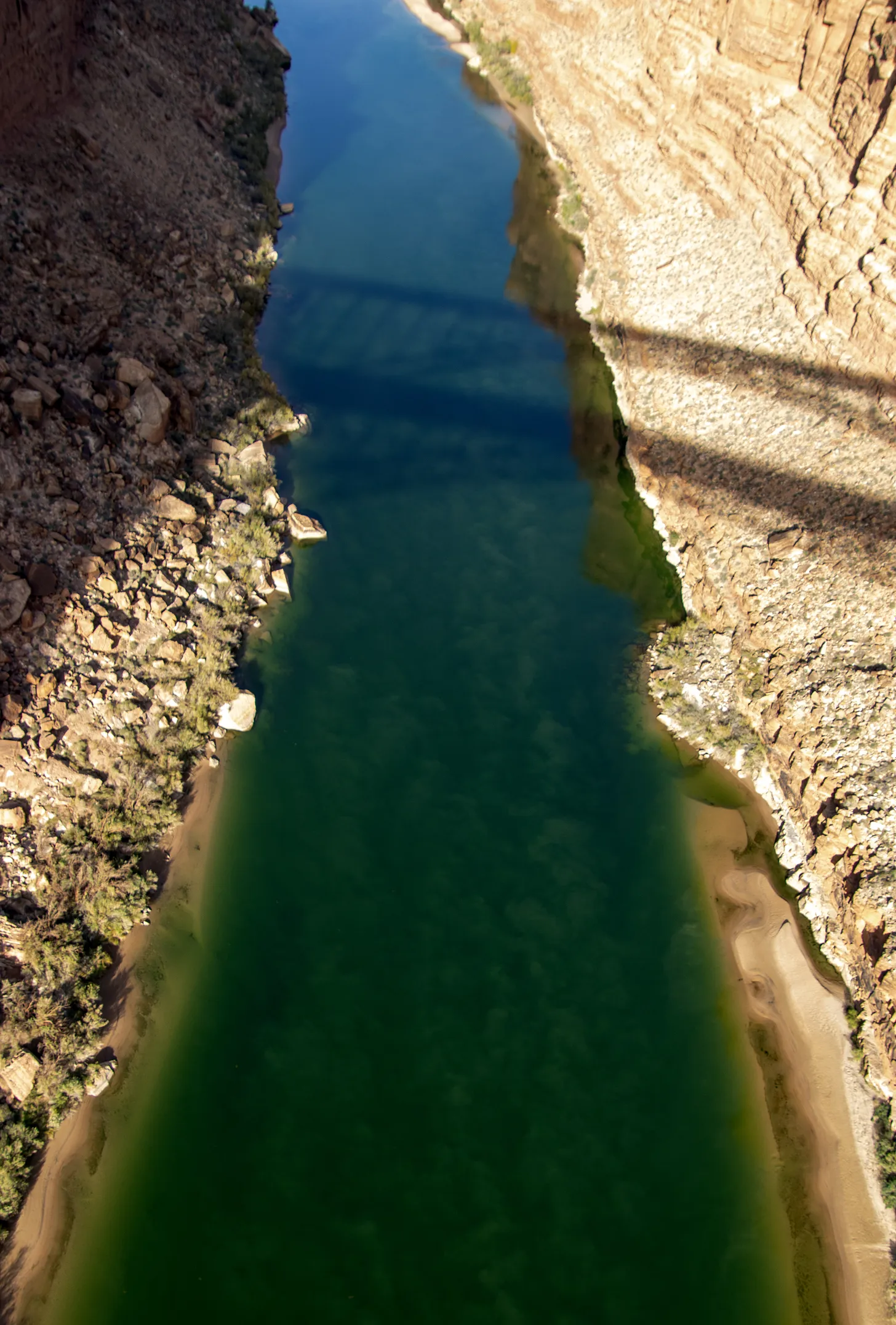
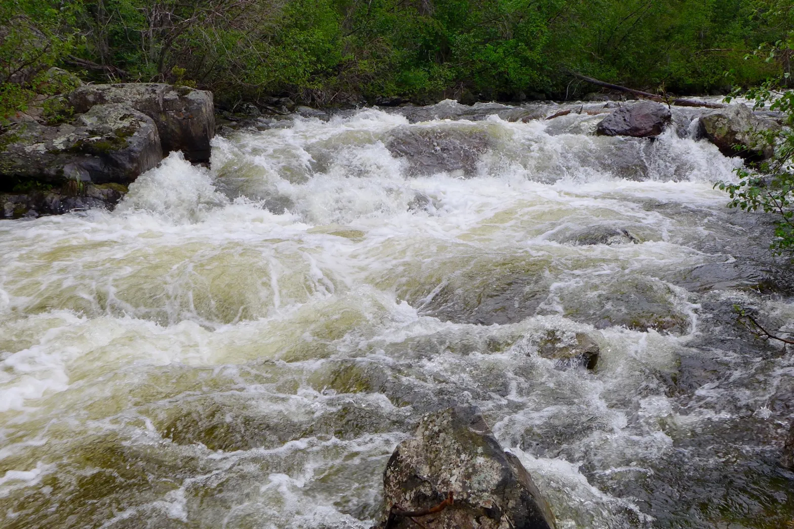
Due to decreased water flow from Stagecoach Reservoir, Colorado Parks and Wildlife (CPW) will implement a mandatory full-day fishing closure on a 0.6-mile stretch of the Yampa River between the dam at Stagecoach State Park downstream to the lowermost park boundary.
To avoid and minimize fish mortality within this tailwater fishery, a closure will take effect beginning Monday, May 19, until further notice.
“We are trying to be proactive in protecting the outstanding catch-and-release fishery we have downstream of Stagecoach Reservoir,” said Marisa Eley, CPW Steamboat Springs Area Aquatic Biologist. “This closure is an effort to protect the resource by giving the fish a bit of a reprieve as they are prone to increased stressors related to these low-flow conditions.”
When water flows are minimal, fish become concentrated in residual pool habitat and become stressed due to increased competition for food resources. The fish become much easier targets for anglers, an added stressor that can result in increased hooking mortality.
CPW works closely with the Upper Yampa Water Conservancy District (UYWCD), which owns and operates Stagecoach Reservoir, to stay informed on reservoir releases.
“We are grateful for our partnership with UYWCD,” said Stagecoach State Park Manager Craig Preston. “Their dedication to keeping us updated on water flows in and out of the reservoir greatly contributes to protecting this unique fishery for current and future generations.”
“We will continue to closely monitor the inflow at Stagecoach Reservoir,” said Andy Rossi, UYWCD General Manager. “If we see increased inflow, we can respond quickly to adjust outflow and work with CPW to determine if the closure could be lifted.”
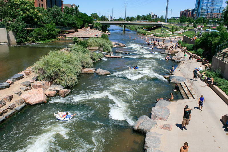
Like many rivers and streams in Western Colorado, the Yampa River offers world-class fishing and attracts thousands of anglers every year.
For more information or current fishing conditions at Stagecoach State Park, call 970-736-2436.
For more information about fishing in Colorado, including current fishing conditions and alternative places to fish, visit the CPW website.
The Northern Integrated Supply Project, currently estimated at $2 billion, would create two new reservoirs and a system of pipelines to capture more drinking water for 15 community water suppliers. An environmental group is now suing the Army Corps of Engineers over a key permit for Northern Water’s proposal. (Save the Poudre lawsuit, from Northern Water project pages)
You might have read recently about how the Northern Integrated Supply Project, or NISP, is contributing $100 million to a fund for projects to improve the Cache la Poudre River in northeastern Colorado. That funding is part of an agreement between the Northern Colorado Water Conservancy District, known as Northern Water, and the nonprofit group Save the Poudre that will conclude a federal lawsuit against the project.
It’s an outcome that both sides can accept because of the importance of both the Poudre River and a much-needed water supply to communities throughout the region.
The agreement should catch the attention of Denver metro-area water providers that are looking to export existing irrigation water supplies out of northeastern Colorado to serve their future customers.
Brad Wind of Loveland is the general manager of Northern Water, which supplies water to more than 1 million people in northeastern Colorado.
For background, NISP was conceived in the 1990s and early 2000s to provide water to the emerging communities of the northern Front Range. The project will consist of two off-channel reservoirs, one located northwest of Fort Collins and one north of Greeley. It also anticipates exchanges of water with nearby farmers eliminating the dry-up of some agricultural land in the future.
Throughout the lengthy permitting process for NISP, the public has had many opportunities to offer comments and concerns to federal, state and local officials. Some of the concerns were incorporated into mitigation and improvement requirements associated with the project, and all written comments were addressed specifically in the final Environmental Impact Statement produced by the U.S. Army Corps of Engineers.
The $100 million settlement of the federal litigation identifies even more improvements that can be made in the region beyond those required by permitting agencies.
Unfortunately, actions by certain Denver metro-area water providers that anticipate removing water from northeastern Colorado do not undergo such robust scrutiny. Oftentimes, advocates for water resources in the region learn about potential water transfers only when an item appears on a meeting agenda of a metro-area water provider. By then it is too late to consider the regional economic, environmental and social impacts that such a change could produce.
Frequently, these water deals are brokered by third parties who quietly accumulate water and land assets to present them behind closed doors in neat and tidy packages to thirsty cities. There are few, if any, opportunities to discuss how these water transfers will impact local communities in northeastern Colorado or how these impacts could be mitigated by those who seek to move water to the Denver metro area.
The half-million residents who receive water from NISP participants are going to pay billions of dollars to develop water resources for their communities while addressing concerns in the Poudre River watershed. At the same time Denver metro communities are working to undercut the existing supplies that previous northeastern Colorado residents have invested in and relied upon for decades.
Water providers in the Denver area need to be part of the long-term solution to how our northeastern Colorado communities remain vibrant, not distant parties to single point-in-time transactions that provide a perpetual benefit to communities beyond the horizon.
If native water supplies must depart for the Denver metro area from northeastern Colorado, it is appropriate that the new water user should not just pay for the costs to acquire water but also offset the impacts to northeastern Colorado’s degraded quality of life, and diminished regional economy.
All of our futures are diminished by the loss of water from our region. Public processes and mitigation can lessen, to a degree, the perpetual impacts such a loss will endure.
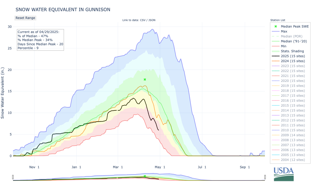
The May 1st forecast for the April – July unregulated inflow volume to Blue Mesa Reservoir is 460,000 acre-feet. This is 72% of the 30 year average. Snowpack in the Upper Gunnison Basin peaked at 93% of normal. Blue Mesa Reservoir current content is 527,000 acre-feet which is 64% of full. Current elevation is 7483.4 ft. Maximum content at Blue Mesa Reservoir is 828,00 acre-feet at an elevation of 7519.4 ft.
Based on the May forecasts, the Black Canyon Water Right and Aspinall Unit ROD peak flow targets are listed below:
Black Canyon Water Right
The peak flow target is equal to 2,360 cfs for a duration of 24 hours.
The shoulder flow target is 300 cfs, for the period between May 1 and July 25.
Aspinall Unit Operations ROD
The year type is currently classified as Moderately Dry.
The peak flow target is 4,585 cfs for a duration of 1 day (based on a May 15 forecast of 430 Kaf)
There are no half bankfull duration or peak duration targets.
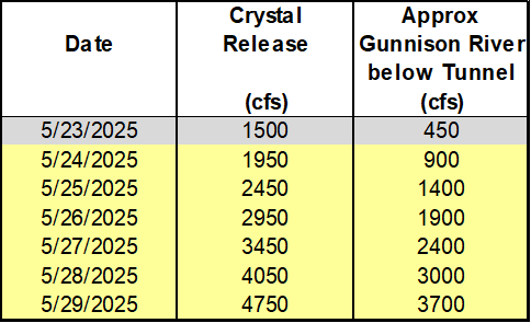
Pursuant to the Aspinall Unit Operations ROD, releases from the Aspinall Unit will be made in an attempt to match the peak flow of the North Fork of the Gunnison River to maximize the potential of meeting the desired peak at the Whitewater gage, while simultaneously meeting the Black Canyon Water Right peak flow amount. The latest forecast for flows on the North Fork of the Gunnison River shows a period of high and near peak flows beginning on May 29th.
Therefore ramp up for the spring peak operation will begin on Saturday, May 24th, with the intent of timing releases with this potential higher flow period on the North Fork of the Gunnison River. Releases from Crystal Dam will be ramped up according to the guidelines specified in the EIS, with 2 release changes per day, until Crystal begins to spill. The release schedule for Crystal Dam is:
Crystal Dam will be at full powerplant and bypass release on May 28th and Crystal Reservoir will likely begin spilling by the next day. The peak release from Crystal Dam should be reached on May 29th and the peak flow on the Gunnison River at Whitewater should be reached on May 30th.
The current projection for spring peak operations shows flows in the Gunnison River through the Black Canyon peaking around 3700 cfs in order to achieve the desired peak flow at Whitewater. Actual flows will be dependent on the downstream contribution of the North Fork of the Gunnison River and other tributaries. Lower tributary flows could lead to higher releases from the Aspinall Unit and vice versa. Once the peak target has been reached, details of the ramp down operation will be released.
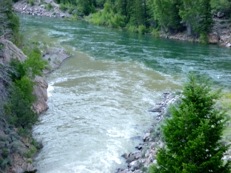
Black Canyon July 2020. Photo credit: Cari Bischoff
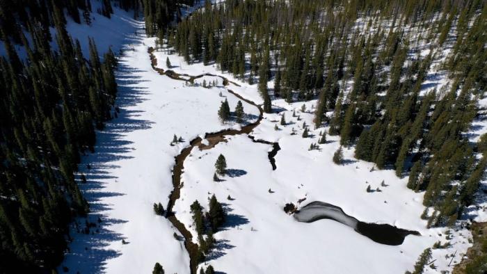
North Fork Snake River. Melted snow is the primary source of drinking water for the 1.5 million people who rely on Denver Water every day. Photo credit: Denver Water.
News headlines this spring offered a bleak picture of Colorado’s snowpack heading into the spring runoff season. But, as always with headlines, it is best to also read the story that follows.
Because the story for Denver Water isn’t quite so dour.
Snowpack woes hit Colorado’s southern half hard. For Denver Water, positioned farther north, the water supply looks better.
First, let’s do the numbers.
Denver Water had a weak showing in the South Platte River Basin, with peak snowpack hitting just 84% of normal and — most unhelpful of all — peaking on April 6, 19 days earlier than typical.
The news was far better in the Colorado River Basin (north of the South Platte River Basin), which accounts for the other half of Denver Water’s supply. There, peak snowpack clocked in at 109% on April 25, right on the mark for a typical peak date.
“Overall, not great, but not terrible either,” summed up Nathan Elder, water supply manager for the utility.
The best news for Denver Water: The utility is starting the runoff and reservoir-filling season with existing storage levels about 2% above average.
That’s a credit to its customers’ efforts to conserve water and translates into a good chance that Denver Water will be able to fill its storage reservoirs that help 1.5 million people get through the summer hot season.
But “fill” doesn’t mean “spill.” That is, there won’t be excess water to spill into rivers in what can make for dramatic visuals and provide an extra boost to river flows.
“We hope to fill our reservoirs right to the brim, but that’s where it stops,” Elder said.
Denver Water’s planners are concerned about a hot-and-dry trend taking hold in May, and emphasize the need for residents to adhere to the utility’s annual summer watering rules that allow irrigation only in the evening and morning hours (between 6 p.m. and 10 a.m.) and limit irrigation to no more than three days a week — preferably just one or two days when springtime temperatures are lower.
And watch the skies. When we do get a good rainstorm, turn your sprinkler dial to “off” for a few days.
The generally poor snowpack and early runoff in much of the state, including in the South Platte River Basin, also stokes concerns for a rough fire season, as 9News meteorologist Chris Bianchi pointed out in a May 13, 2025, story:
“This year’s snowpack levels resemble those recorded in 2018, 2012, 2002 and 1992. All of which were marked by intense wildfire activity. Three out of those four years saw large-scale fires, raising concerns that 2025 could follow a similar trajectory unless weather patterns shift dramatically.”
And, on a too-long-didn’t-read basis, here’s Bianchi’s tweet that summed up the story:
Denver Water’s watershed experts agree that conditions could increase wildfire risk.
“The risk of wildfire is relatively low when there is snow on the ground. When snowpack melts rapidly, vegetation can dry out quickly and become susceptible to wildfire ignitions,” said Madelene McDonald, a watershed scientist and wildfire specialist for Denver Water.
Though McDonald notes that experts anticipate “average” wildfire behavior in Colorado in 2025, that still means thousands of fires that could collectively affect more than 100,000 acres in the state.
“It’s important to stay vigilant and prepared to experience wildfire under any snowpack conditions or fire outlook scenarios,” she said.
An April pivot
The current outlook is a pivot from what had been looking like a normal year for snowpack as recently as April 1, Elder said.
“For Denver Water, April is typically a month where we build snow,” he said.
But that didn’t happen this year, and by mid-May the snowpack had shriveled to half its typical percentage.
The tepid spring in the South Platte River Basin also highlights the importance of Denver Water’s Gross Reservoir Expansion Project, which recently has been slowed in federal court. (Read Denver Water’s recent statement on a May 6 court hearing.)
That project will expand the reservoir and add roughly 80,000 acre-feet of water storage capacity in the utility’s north system, which gathers snowmelt from the Upper Colorado River Basin. That additional water storage will provide a buffer to protect the utility’s customers from the effects of years when the snowpack is weaker, like this year, in Denver Water’s separate and unconnected south system.
“Our system is robust but suffers from significant imbalance,” Elder said.
“We rely too heavily on our south system, on the South Platte, which accounts for 90% of our storage,” he said. “Increasing storage to the north will give Denver Water far more flexibility to handle these weaker snowpack years on the South Platte.”
And years marked by a weaker snowpack in the South Platte River Basin have become more common.
In four of the last five years, the South Platte snowpack above Denver Water’s collection system has peaked below normal. And in that fifth year — last year — it barely cleared the “normal” bar at 101%. All of which amplifies the need for the Gross Reservoir Expansion Project.
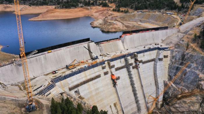
Raising Gross Dam, seen here on April 8, 2025, will nearly triple the water storage capacity of the reservoir behind it. The project has been in the permitting and review process for 23 years. Photo credit: Denver Water.
Now, as June approaches, water managers will turn their focus to runoff levels, temperatures and fire potential. And come summer, they will once again — as always — hope for a big dose of monsoonal moisture.
Those big rainstorms not only deliver a boost to rivers and reservoirs but prompt attentive customers to turn off their irrigation system and let their grass and plants drink up nature’s soaking bounty.
Remember, the less you pour, the more your water utility can store.
And it’s never a bad time to consider transforming your landscape, or even parts of it.
Denver Water has a new guide to help: the DIY Landscape Transformation Guide, and it includes ways to eradicate grass in the areas where you want to remodel your landscape with native plants and other changes.
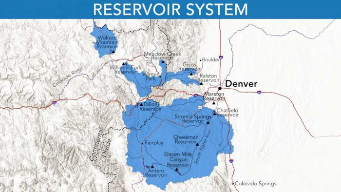
Denver Water relies on a network of reservoirs to collect and store water. The large collection area provides flexibility for collecting water as some areas receive different amounts of precipitation throughout the year. Image credit: Denver Water.
Governor Jared Polis signs HB-1115 in Dillon, CO. Photo: CWCB
From email from the Colorado Water Conservation Board (Katie Weeman):
May 15, 2025 –Yesterday, Governor Jared Polis signed two critical pieces of legislation that will enhance Colorado’s water management and conservation efforts.
“Water is the basis of life in Colorado. Securing our water future is important for our economy, environment and every Colorado family. With these new laws, we will have a better understanding of Colorado’s water resources, invest in efforts to secure our water, and plan for the future, ensuring Colorado’s access to clean water for generations to come,” said Governor Polis.
House Bill 25-1115: Advancing Water Supply Measurement & Forecasting: House Bill 25-1115 launches a new statewide effort to improve water supply measurement and forecasting across Colorado. The bill authorizes the Colorado Water Conservation Board (CWCB) to establish a comprehensive program to collect and share data on snowpack levels—providing essential information to navigate Colorado’s water future amid a changing climate.
The new effort includes a dedicated full-time employee to manage the program, which will focus on: Collecting and disseminating snowpack data, the primary indicator of Colorado’s annual water supply; investigating advanced technologies for snow measurement and water supply forecasting, including airborne and remote sensing tools; and gathering additional water supply data to help water managers, farmers and policymakers make more informed decisions.
Snowpack functions as Colorado’s largest natural reservoir, feeding streams, rivers and reservoirs throughout the year. And with snow levels becoming increasingly variable, better data and forecasting are essential for water planning that supports agriculture, environmental needs and a growing population.
“In Colorado’s challenging water landscape, we need all the tools in the toolkit,” said Lauren Ris, CWCB Director. “Using new technologies to get a clearer picture of our snowpack water supply is a critical step toward sustaining our water resources for future generations.”
The legislation follows years of collaboration between the CWCB and the Colorado Airborne Snow Measurement group, as well as feedback from water leaders across the state. Water managers have consistently voiced the need for a more coordinated, cost-effective approach to snowpack data collection that allows for more timely and reliable water forecasting.
Senate Bill 25-283: Securing Funding for Critical Water Projects: In addition to HB25-1115, Governor Polis also signed Senate Bill 25-283, the CWCB Projects Bill, which allocates approximately $67 million for water projects across Colorado. This annual legislation funds a wide range of initiatives aimed at enhancing water infrastructure and planning efforts statewide.
The 2025–26 funding includes $2 million for the innovative water forecasting initiatives mentioned above, as well as: $1.4 million for a statewide turf analysis; $29 million for Water Plan Grant funding; $6 million for South Fork focus zone irrigated acreage retirement; $5 million to continue Colorado watershed restoration and Wildfire Ready Watershed programs and more. These investments are designed to support the diverse water needs of Colorado’s communities, agriculture and environment, ensuring a resilient water future for all Coloradans.
“High-quality water data and strategic investment in water infrastructure are both essential to preparing for Colorado’s future,” said Dan Gibbs, Executive Director of the Department of Natural Resources. “Together, these bills represent a major step forward—modernizing how we forecast water supplies while also funding critical projects that strengthen our communities, support agriculture and protect our rivers and streams. We’re grateful for the broad bipartisan support that made these efforts possible.”
The Colorado River from the Navajo Bridge. Jonathan P. Thompson photo.
Click the link to read the article on the AZCentral.com website (Austin Corona). Here’s an excerpt:
May 15, 2025
Key Points
With no settlement yet on how to manage shortages on the Colorado River, the Trump administration is preparing to fill its last vacant Western water post, commissioner of the Bureau of Reclamation.
The seven states who draw water from the Colorado have struggled for years to agree on a plan to deal with shortfalls. The divisions remain among the states on the upper river and lower river.
Arizona’s top water negotiator says the Trump administration seems more willing to talk about different approaches to shortage sharing, but issues about who should take the largest cuts remain
The Trump administration is preparing to announce its pick to head the Bureau of Reclamation, a crucial position in deciding the future of the Colorado River, a White House spokesperson told The Arizona Republic. The move would effectively complete the new federal team overseeing strained negotiations over one of Arizona’s largest water sources. The new commissioner will take charge amid tense negotiations among the seven states that use the Colorado River, which has strained under multi-decade drought and high water demand…
Experts worry that this year’s poor river flows could trigger lawsuits over foundational river-management laws as soon as 2027. States only have months to reach a deal, and negotiators have not shown signs of progress.
Tom Buschatzke, director of the state Department of Water Resources and Arizona’s Colorado River negotiator, has said the Trump administration is already more “engaged in a much more meaningful way” on the Colorado River than former President Joe Biden’s team and has responded to some of Arizona’s long-unanswered requests in the negotiating process. Trump officials could give Arizona and the other Lower Basin states of California and Nevada a new opportunity to convince federal regulators that those states should not have to take all the cuts on the river. Biden negotiators would not call for cuts in the Upper Basin, while Buschatzke said the new administration may be more open to finding a “collaborative” solution. Even so, Upper Basin states — Colorado, Wyoming, Utah and New Mexico — have continued arguing that they cannot be forced to cut their water use if climate change and drought are the causes of low flows in the river, meaning any attempts to cut their use could lead to a lawsuit. A case could drag on for years, while water levels in the reservoirs continue to drop.
The Cache la Poudre River flows through Bellevue, Colorado on May 12, 2025. Water from the river will be used to fill the nearby Glade Reservoir once it’s built. The cost to build the new water storage project has grown from $400 million to $2.2 billion. Alex Hager/KUNC
Click the link to read the article on the KUNC website (Alex Hager):
May 15, 2025
This story is part of ongoing coverage of water in the West, produced by KUNC in Colorado and supported by the Walton Family Foundation. KUNC is solely responsible for its editorial coverage.
There’s a stretch of highway in Larimer County where prairie grasses sway with each passing vehicle. Cars, horse trailers and semi trucks zip through the valley on their way between Fort Collins and Laramie. Soon, it’ll be under more than 200 feet of water.
U.S. Highway 287 runs through the future site of Glade Reservoir. The Larimer county Board of County Commissioners approved the 1041 Land Use Permit for NISP in September, 2020. Photo credit: Northern Water
It’s the planned site of Glade Reservoir, the cornerstone of a massive new water storage system designed to meet the demands of fast-growing towns and cities in Northern Colorado. After more than two decades of permitting, planning and environmental lawsuits, it’s closer than ever to breaking ground.
But along the way, some things changed. Over the years, costs to build the reservoir system — and reroute seven miles of U.S. Highway 287 — have ballooned. Price estimates for the Northern Integrated Supply Project, often referred to as NISP, went from $400 million to $2.2 billion. Because of that, some of the towns that signed up to use its water are cutting back on their involvement before the reservoir system stores a single drop.
Northern Water, the agency building NISP, has projected confidence that it will still get built as planned. The long road from idea to construction, and the things that have changed along the way, can tell us a lot about how Northern Colorado uses water, and how much it costs to keep taps flowing.
The Northern Integrated Supply Project, currently estimated at $2 billion, would create two new reservoirs and a system of pipelines to capture more drinking water for 15 community water suppliers. (Northern Water project pages)
Rising costs
When it was first pitched, in the early 2000s, NISP garnered support as a way to make sure small towns with fast-growing populations could host new housing developments without going dry.
For a tiny town like Severance, that was an attractive proposition. Just 11 years ago, about midway through the NISP planning process, the town had a population of about 3,000. That’s when Nicholas Wharton took the job as town manager. Since then, he’s overseen the installation of the town’s first stoplight, the from-scratch development of its own police department and a homebuilding boom that has nearly quadrupled Severance’s population.
Signing on to NISP, he said, was a way to make sure Severance had enough water for all that growth.
“I think for smaller towns,” he said, “It was a great idea back when it was affordable to us.”
Wesley Lavanchy, the town administrator for Eaton, Colo., poses outside of his office on April 15, 2025. His town is one of four water agencies that reduced the amount of water it would store in NISP, and the amount it would pay to keep it there. Alex Hager/KUNC
Since then, Severance has cut back on the amount of water it will store in NISP, and the amount it will pay to be a part of the project. At one point, the town held 2,000 shares of the project. In 2024, it sold off 1,500 of those shares. Wharton said the town council might try to sell off even more.
And Severance isn’t alone.
Due West, in Eaton, town officials also got cold feet. They were one of four NISP shareholders to offload a portion of their involvement in the new reservoir project on the same day in July 2024.
For years, the water agencies that were part of NISP were mostly focused on paperwork — making sure the project had the permits it needed to get built. Then, there was a lawsuit from environmentalists standing in the way. But after NISP’s proponents were mostly seeing green lights on permits and decided to settle a major lawsuit, the focus shifted to money.
“I think the question for us now is, how do we afford this?,” said Wesley Lavanchy, Eaton’s town administrator. “Moving forward, how much can we afford? It’s like chocolate cake. You like it, it tastes great, but you can’t eat the whole thing.”
Ultimately, Eaton decided to sell off more than half of its NISP shares.
“I suspect that more entities would have been able to hold their commitment had the permitting process not drug on so long, the cost escalated, the litigation kind of wrapped things up,” Lavanchy said.
Cheaper alternatives
While the cost to build NISP has gone up, the cost of other water sources has gone down. Eaton and Severance said it’s getting easier to afford shares of the Colorado-Big Thompson project, which was a big motivator in their pullback from NISP.
That project, referred to as CBT, pipes water from the Colorado River across the continental divide. It flows underneath Rocky Mountain National Park and into major reservoirs along the Northern Front Range, such as Horsetooth Reservoir near Fort Collins and Carter Lake outside of Loveland.
Water from the Colorado-Big Thompson project is managed by Northern Water, the same agency building and operating NISP.
Boats cruise across Horsetooth Reservoir near Fort Collins, Colorado on May 12, 2025. The reservoir holds water from the Colorado-Big Thompson project, which has seen prices level off in recent years. Glade Reservoir is expected to be even larger than Horsetooth. Alex Hager/KUNC
For years, the CBT system was the main way for growing cities in Larimer and Weld Counties to get water for residential development. Typically, farms have sold their portion of CBT water to cities, towns, or developers. Occasionally, they are taken to auction, where cities bid against one another for water stored in those big reservoirs.
The cost of that water skyrocketed between 2010 and 2022. Estimated prices, adjusted for inflation, went from less than $20,000 per share, to around $100,000 per share, according to data from the consulting firm Westwater research. Since 2022, that soaring rise has leveled out.
“We believe that’s largely driven by a softening in the home construction sector,” said Adam Jokerst, a Fort Collins-based regional director for Westwater. “A lot of CBT purchases are by municipalities and developers who dedicate them to municipalities. And when new home construction slows, we see less demand for those shares.”
How did NISP get so expensive?
Northern Water said the price to build NISP has been climbing for about 15 years. Brad Wind, the agency’s general manager, cited inflation and rising interest rates as major drivers. He doesn’t, however, expect that to stop or significantly change the reservoir project.
“It’s an expensive project,” Wind said. “We and the participants advancing the project like it was envisioned.”
The lengthy process to get the project’s two reservoirs — Glade, and a smaller one called Galeton reservoir — from concept to construction gave time for the winds of economic change to shift direction. It’s not uncommon for a massive dam project like NISP to take more than fifteen years to attain a laundry list of environmental permits.
The project also faced opposition from local governments and nonprofits. At one point, Fort Collins voted to oppose the project. The most significant roadblock came from the environmental nonprofit Save the Poudre.
The group rallied local support and took legal action to try and stop NISP. At a 2015 event, Save the Poudre director Gary Wockner told a crowd of supporters that he would “fight to stop the project for as long as it takes.”
In late February, Wockner’s group settled for $100 million dollars. Northern Water will pay that sum into a trust over the course of the next two decades, and the money will be used to fund river improvement projects. In the intervening time, though, the price tag to build NISP likely grew significantly.
Wind said Northern plans to hire a contractor that could find ways to bring down the price by changing construction methods, but doesn’t expect “substantial reductions” to building costs, especially with rising prices of imported construction materials.
Over the years, the towns and water agencies that wanted to use NISP signed periodic agreements to stay part of the project. Now, time is ticking for those participants to sign a binding contract.
Eaton’s Lavanchy said that upcoming contract made his town take a harder look at their water needs, and whether those needs would be satisfied by NISP.
“We’re not dating anymore,” he said, “We’re getting married, and there’s no way out. Divorce is not an option. So it’s like, ‘Let’s be smart and think about, what are these obligations going to run us?’”
‘Demand continues to increase’
Even as some entities cut back on their financial ties to NISP, the project still has momentum.
For one, those towns and water agencies looking to sell their shares found a willing buyer. Eaton, Severance, Fort Lupton and the Left Hand Water District all sold their shares to the Fort Collins Loveland Water District.
Vehicles drive on U.S. Highway 287, near Bellevue, Colo. on May 12, 2025. The highway will be rerouted to make way for a massive new reservoir. Alex Hager/KUNC
The Fort Collins Loveland Water District, which serves an area roughly between Harmony Road and State Route 34, declined to be interviewed for this story.
Second, NISP has a total of 15 participants, and many of them are still on board for the same amount of water they signed up for years ago.
“No matter what,” Severance’s Wharton said, “In one way, you’ll see those 15 probably still continue to be a part of it no matter what, because everybody does realize how precious that water is and how this will be one of the last [big reservoirs.] I don’t think anybody’s discouraged.”
Even the towns that reduced the amount of water they’ll pay to use from NISP are keeping some. Severance and Eaton said they want to make sure they’re getting water from a diverse group of sources, especially with climate change and political bickering threatening their main source of water — the Colorado River via the CBT.
Ultimately, the fast-growing region served by Northern Water — from Boulder County to Fort Collins, and east to Fort Lupton — will keep needing water for a future that will likely see plenty of new home construction.
“It doesn’t appear that folks are shying away from moving to Northern Colorado,” Brad Wind said. “Either from within our state or from outside of our state, so the demand continues to increase for a high quality water supply, which NISP will produce.”
The recently released Yampa River Scorecard Project grade of C-plus for the upper segment of the Yampa River shows a need for some improvements for overall river health in the stretch between Stillwater and Stagecoach reservoirs. Jenny Frithsen, environmental program manager at Friends of the Yampa, oversees the long-term river health monitoring and evaluation project. Frithsen said a major reason for the lower score is because that river segment is heavily utilized by agricultural water users but has less water coming in from smaller tributaries compared with downstream sections of the river.
“The first and foremost contributor to river health is water in the river, and the Upper Yampa and the Bear River are arguably the hardest-working and most heavily administered sections of river in the Yampa River system,” Frithsen said. “It probably is no surprise that the flow regime has lower scores for our ecological river health assessment. It is an altered flow regime.”
Frithsen presented a high-level overview of the 2024 river study segment during a South Routt Water Users meeting Monday evening at Soroco High School. The study looks at 45 indicators and nine characteristics of river health to determine and issue a score for combined flow and sediment regime, water quality, habitat and riverscape floodplain connectivity, riparian condition, river form, structural complexity and biotic community. On the positive side, the study team found the Upper Yampa stretch rated good in water quality, structural complexity, beaver activity, channel morphology and invasive weeds. The healthy beaver activity, especially on U.S. Forest Service land, showcases the natural engineering work of the large rodents to help mitigate the impacts of human water use and infrastructure. The beavers’ work maintains minimum flows in late summer and fall and provides a refuge for fish during low flows.
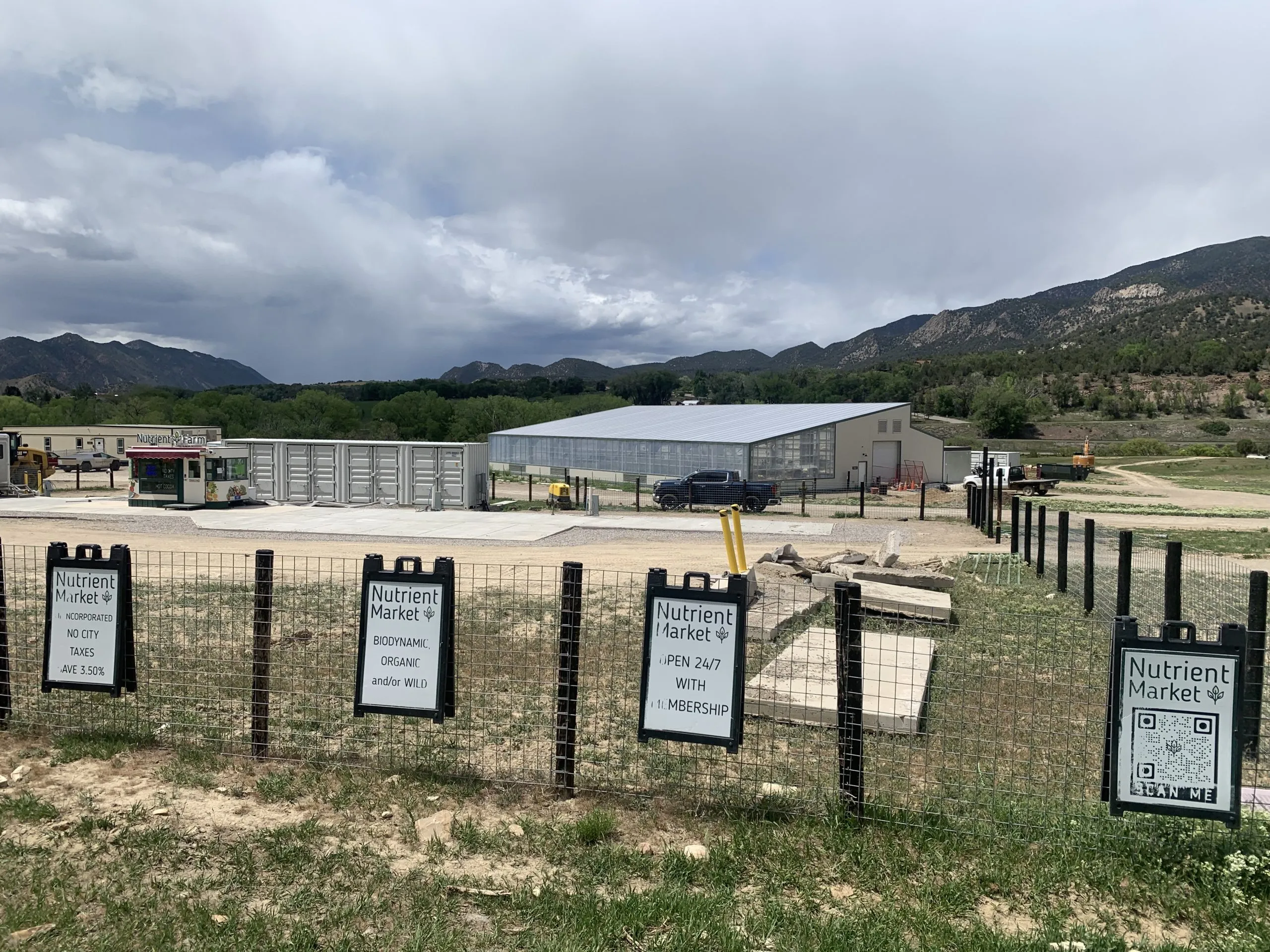
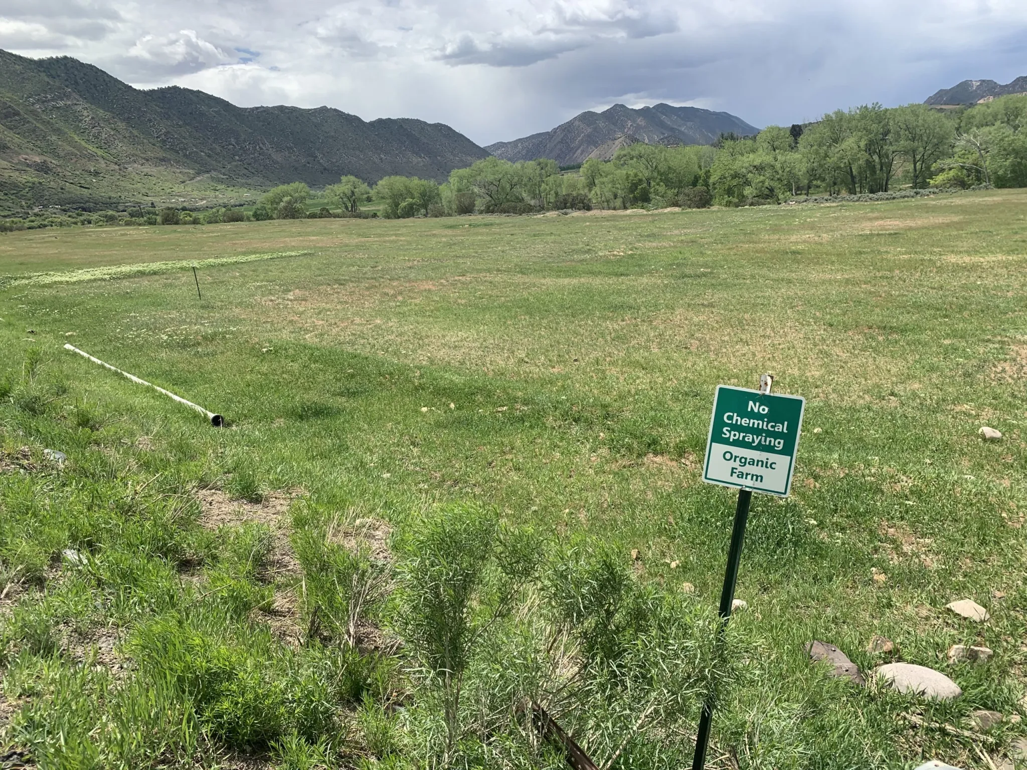
The Nutrient Farm store and greenhouse are located on Garfield County Road 335. Garfield County is considering a PUD application from Nutrient Farm to expand its operations into a restaurant, housing, lodging facilities, a music/entertainment area, campground, a health and wellness retreat, and other agricultural tourism-related operations. Credit: Heather Sackett/Aspen Journalism
The source of water — and whether there’s enough to go around — is at the heart of concerns about a proposed agritourism development for some local residents and Garfield County officials.
Nutrient Farm, an organic farm and ranch on the south side of the Colorado River between Glenwood Springs and New Castle, is seeking approval from Garfield County for a new planned unit development (PUD), which would include a restaurant, housing, lodging facilities, a music/entertainment area, campground, a health and wellness retreat, and other industrial and agricultural tourism-related operations on its 1,140 acres. Nutrient Farm would need water for its planned expansion of outdoor agricultural production including a “u-pick” orchard, nursery trees, pasture grass, hay, corn, vegetables, lawns and landscaping.
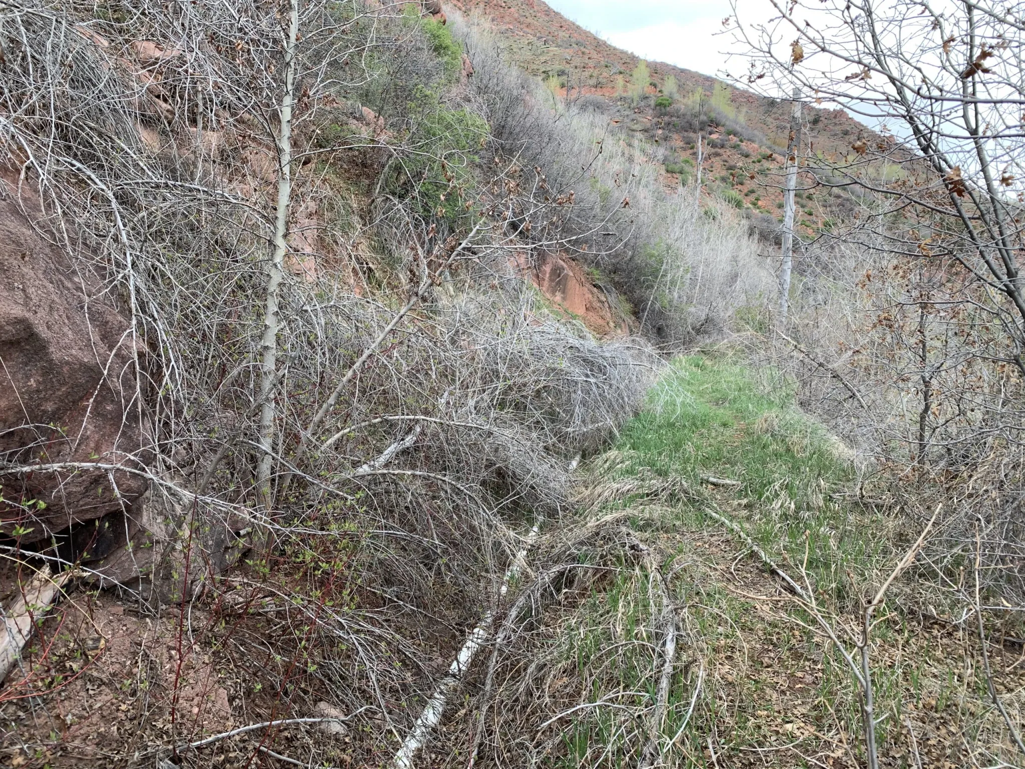
At the confluence of Canyon Creek and the Colorado River. Photo credit: Friends of Canyon Creek
Nutrient Farm is proposing that the main water supply would come from Canyon Creek, a tributary on the north side of the Colorado River. It would be taken out of the creek 1.5 miles upstream from its confluence with the Colorado River and conveyed across the river and Interstate 70 via the Vulcan Ditch.
According to Colorado Division of Water Resources records, the Nutrient Farm property has not used water from Canyon Creek or the Vulcan Ditch in more than two decades.
Water supply studies found that there may not be enough water in Canyon Creek for the Vulcan Ditch to take the full amount to which it is entitled during the late irrigation season in dry years, raising questions about the adequacy of the Canyon Creek water supply and the project’s impacts on the creek.
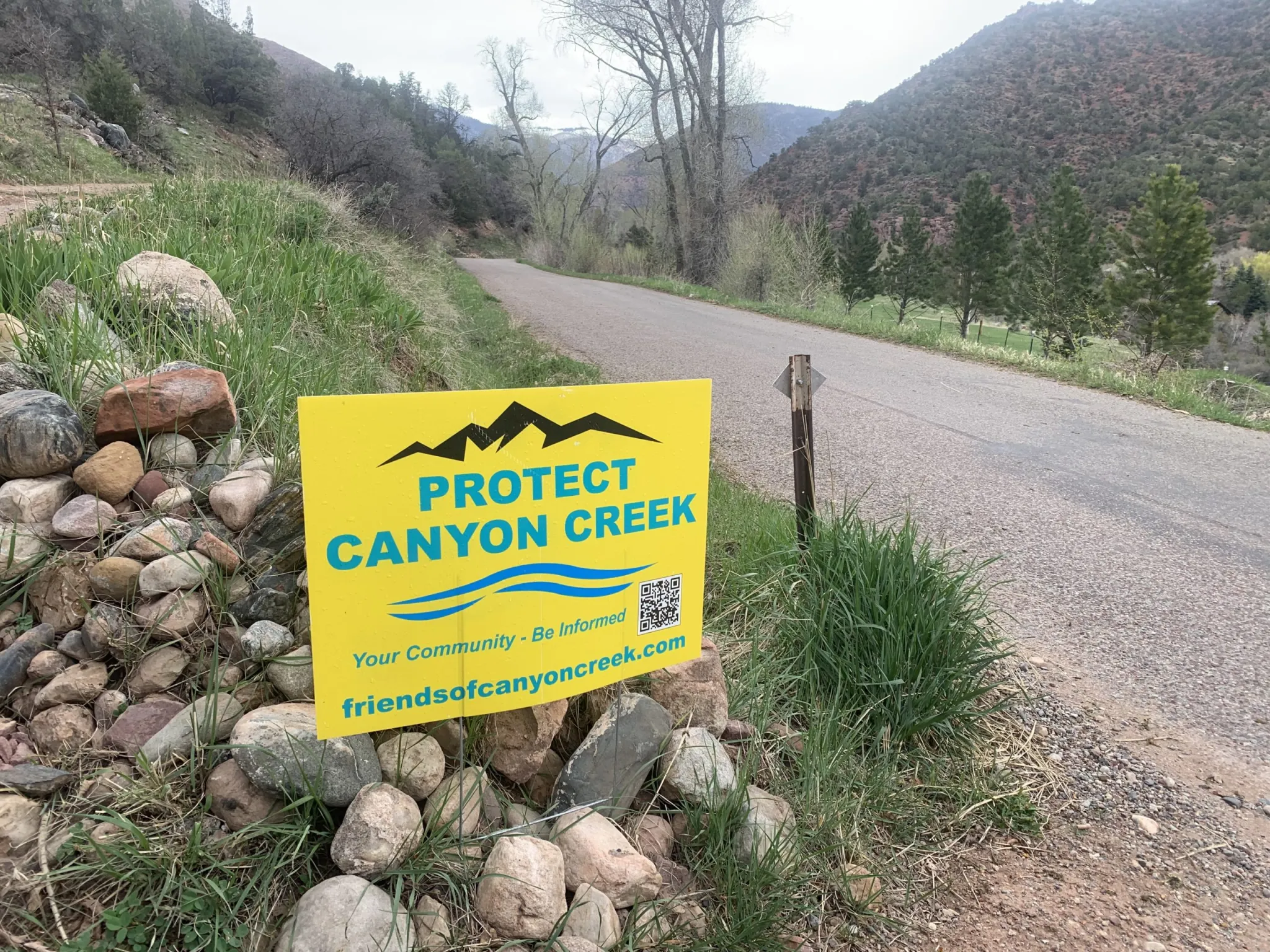
Concerned residents who live on Canyon Creek have formed Friends of Canyon Creek, a group dedicated to maintaining the ecological health of the stream. Six nearby property owners have hired a lawyer to oppose three water court cases related to Nutrient Farm’s water rights.
Sonia Linman lives along the creek and is an outspoken member of Friends of Canyon Creek. She is one of several residents who own property on the creek and don’t want to see the Vulcan Ditch reopened. Linman and others say the draw on the creek that Nutrient Farm is proposing could devastate wetlands, would harm the ecological values of properties that are protected by conservation easements between some landowners and the Aspen Valley Land Trust, and put the wildfire-prone valley at risk if the source of water to fight the frequent blazes is diminished.
“For me, I’d be losing a family member,” Linman said of the creek. “For most of us who believe nature is in an especially tenuous place right now, it would be reflective of a death of hope. We must do what’s right to protect something that is clearly, legally, morally, ethically deserving of that protection.”
Nutrient Farm’s proposal has been contentious, with the overwhelming majority of public comment and letters expressing concern about the project. Many took issue with impacts that the water use could have on Canyon Creek. After being continued twice — in January and March — the PUD application is scheduled to be revisited by the Garfield County Planning Commission on May 28.
AVLT has 12 conservation easements across eight properties in Canyon Creek, with the common goal to preserve and protect the ecological health of the creek and its habitat.
“Not only would [proposed water diversions] have a devastating impact on the ecology of Canyon Creek itself, it would also have extreme, irreversible and likely impermissible
impacts to the conservation values protected by AVLT’s conservation easements,” the letter reads.
But under Colorado water law, drawing a creek down to a trickle is not illegal, as long as the water is being put to beneficial use. And the state has no problem with someone using their water right — especially one that dates to before the 1922 Colorado River Compact — to the fullest extent possible.
Under Colorado’s arcane, century-old system of management, water usually belongs not to those who need it most, nor to the stream itself, but to the legacies of the European American settlers who got there first. Water is treated as both a natural resource that belongs to the public and a potentially valuable private property right. For some observers, Nutrient Farm’s plan highlights the system’s inherent imbalance and demonstrates how few options there are for protecting the health of streams in a warming and drying climate.
Canyon Creek water supply
The Vulcan Ditch snakes across the hillside on the west side of Canyon Creek, roughly parallel to County Road 137. It is filled with downed trees, boulders, marmot holes, and an overgrown tangle of bushes and weeds. Nutrient Farm plans to reconstruct and realign the ditch, and install a 24-inch pipe, work that would require at least a 15-foot-wide — in some places, a 30-feet-wide — construction corridor, according to its PUD application. Water would have to be conveyed south across I-70 and the Colorado River to get to the Nutrient Farm property.
Dave Temple is the only other current water user on the ditch, which he maintains just enough in certain places to get his .13 cubic feet per second of water through a narrow, plastic pipe running along the bottom of the ditch to his property, located north of I-70 and the river. He walks parts of the Vulcan Ditch every other day during irrigation season.
“The ditch is a disaster,” Temple said. “I’ve always done it by myself, and it’s always taken me at least two weeks to get everything cleaned up enough to where I could turn the water in. … It’s in bad shape and even though [Nutrient Farm is] going to put it in pipes, it’s still going to devastate the whole hillside here.”
Nutrient Farm holds two water rights on Canyon Creek: a larger right, from 1908, and a smaller right, from 1952. According to a water supply adequacy report from Glenwood Springs-based engineering firm SGM, in dry years in the late irrigation season (August through October), the available streamflow may be limited to the senior 1908 water right.
A revised version of the SGM report, from this past March, clarified that although Nutrient Farm has the legal right to divert its full Vulcan Ditch right of 8.93 cfs, it will not — and cannot — divert continuously, year-round. The amount of water allowed to be used by crops (known as consumptive use) is capped at 393 acre-feet per year, which limits how much can be taken from the stream. At its maximum diversion rate of 8.93 cfs, Nutrient Farm would be able to divert only 34 days a year.
The report says the legal and physical water supply from Canyon Creek is sufficient.
“Whether diverting at higher rate for fewer hours, or diverting at a lower continuous rate, the proposed diversions are limited and are well within the supply available from Canyon Creek even in a dry year,” the report reads.
At the request of Canyon Creek property owners, Wright Water Engineers reviewed the original report from 2020 and submitted a memo to Garfield County. The Wright engineers agreed that there would be limited water available in Canyon Creek at the Vulcan Ditch headgate during the late irrigation season of dry years. Further, they concluded when using 1977, the driest year on record in the Colorado River Basin, as a benchmark, that the streamflow available at the Vulcan Ditch headgate would be below the property’s average demand at that time.
“Therefore, the Canyon Creek physical and legal supply is not sufficient to provide for Nutrient Farm’s demands during the late irrigation season in dry years,” the memo reads.
During late summer and early fall is when many streams in Colorado experience dry-ups as natural seasonal streamflows dwindle but irrigation continues. Many streams in Colorado are overappropriated, meaning there are more water rights on paper than there is water in rivers, depending on the season, and it’s not uncommon for irrigators to experience shortages during these times.
Nutrient Farm is owned by Andy Bruno, who bought the property in 2018. He did not answer a list of specific questions sent by Aspen Journalism, but he provided a statement about the project’s intended use of Canyon Creek.
“There is a long-standing adjudicated right for the entire Nutrient Farm water supply,” Bruno wrote in an email. “There is more than ample water available in the Canyon Creek to address all needs and Nutrient Farm remains subject to Division of Water Resources oversight. Nutrient Farm owns senior water rights, has a water management plan and will use this resource responsibly.”
Canyon Creek resident Dave Temple at the headgate of the Vulcan Ditch on Canyon Creek. Besides Nutrient Farm, Temple is the only other water user on the ditch, with a .13 cfs water right. Credit: Heather Sackett/Aspen Journalism
Water for fish
In a comment letter to the Garfield County Planning Commission, leaders of the Colorado chapter of Trout Unlimited said that if Nutrient Farm’s water right — in full or in part — was diverted during fall and winter low-flow periods, it could be devastating to spawning fish.
In 2021, Trout Unlimited completed a $250,000 project to upgrade the culvert system that conveys Canyon Creek under I-70 to improve access for spawning fish from the Colorado River. Trout Unlimited representatives said Nutrient Farm should permanently use water from the Colorado River, and that Canyon Creek should be protected from additional diversions.
“TU is primarily concerned about the detrimental impacts of additional diversion from Canyon Creek on brown trout spawning and subsequent egg incubation and fry emergence,” the letter reads. “In a drier, hotter climate, aquatic systems like Canyon Creek should be given special consideration.”
But historically, the health of aquatic ecosystems have been given very little consideration in the laws that govern water use in Colorado. And the section of lower Canyon Creek where the Vulcan Ditch headgate is located lacks one of the only protections available to rivers in Colorado: a minimum instream-flow water right.
These rights are held by the Colorado Water Conservation Board and are designed to preserve the natural environment to a reasonable degree. They date to the 1970s or later, and under the Western water management system of prior appropriation, where the oldest rights get first use of the creek, they aren’t always effective at keeping water in streams because they are so much younger than many big irrigation rights.
An upper reach of Canyon Creek between the confluence with Johnson Creek and the headgate of the Baxter Ditch has a series of minimum instream-flow water rights, but lower Canyon Creek lacks this protection.
Several other ditches besides the Vulcan Ditch take water from Canyon Creek, including the Williams Canal, the Mings-Chenoweth, Wolverton and Johnson ditches.
DWR does not have a problem with a water user taking so much water that it dries up the creek as long as they are not taking more than legally allowed or increasing their overall consumptive use to more than what is allowed in their water court decrees.
“That’s called tough luck,” said Aaron Clay, a retired water attorney, water court referee and expert who teaches community courses about the basics of water law across the Western Slope. “That’s the way the law works and DWR has no control over that. … Unfortunately, the prior appropriation system does not recognize environmental concerns on creeks.”
The Vulcan Ditch, which takes water from Canyon Creek, is overgrown and hasn’t been used in more than two decades. Nutrient Farm plans to pipe the ditch and begin using it for a farm and agritourism business. Credit: Heather Sackett/Aspen Journalism
Vulcan Ditch history
According to Nutrient Farm’s project narrative, “the Vulcan Ditch has historically provided irrigation water to the property from Canyon Creek and will continue to do so.” Nutrient Farm plans to use the Canyon Creek water for potable indoor use, irrigating crops, livestock, landscaping, grass fields, open space and recreational ponds.
But although the Vulcan Ditch may have brought water to what is now the Nutrient Farm property decades ago, state diversion records indicate that hasn’t happened in the past 24 years. The year 2000 was the last year that the ditch took a large quantity of water, about 1,500 acre-feet. Records are spotty for the next decade with either a very small amount of water diverted or no diversions at all, until 2010, when diversions resumed, but at a much lower level than in the 20th century. These numbers reflect the diversions of the only other water user on the ditch: Temple, who uses a small pipe to get water from the headgate to his property downstream.
Under Colorado water law, water rights holders must use the water if they want to keep their legal right to it. If they don’t, the water right could be abandoned. Abandonment is the legal term for one of Colorado’s best-known water adages: Use it or lose it. Abandonment means that the right to use the water is canceled. The principle came about to discourage hoarding of water rights that weren’t being used and to make sure that someone who used water long ago — but then stopped — couldn’t suddenly begin diverting water again and disrupt the flows of a river that more current water users have come to depend on.
“We’re afraid that this kind of precedent is dangerous,” Linman said. “When water has not been used and a ditch has not been maintained, to have the power to reopen a clearly abandoned structure puts residents at risk across the entire West.”
The reason that Nutrient Farm’s water rights on the Vulcan Ditch haven’t been formally abandoned, despite the ditch itself not being used in more than two decades, is because the farm has been taking water from the Colorado River using what’s known as an alternate point of diversion.
But those records are spotty. Diversion records indicate that a small amount of water was taken from the Colorado River to the Nutrient Farm property using a pump in five years between 2006 and 2023. Assistant Division Engineer for Division 5 Caleb Foy said his office must evaluate how to best use its resources in pursuing abandonment cases, which are subject to a determination of the court. For a water right to be abandoned, the water user must intend to abandon it in addition to not having used it in the previous 10 years.
“The water court has typically applied a relatively low standard for users to show they did not intend to abandon their rights,” Foy said in an email. “As such, within Division 5, partial abandonment of rights diverted at structures with a record indicating some water use were generally not a priority… .”
There may be another reason the Vulcan Ditch and associated water rights have not ended up on the state abandonment list: For the past 25 years, the state of Colorado has also given an extra layer of protection to pre-Colorado River Compact water rights. The state engineer’s office has had a policy of keeping them off the abandonment list for the past two cycles.
Nutrient Farm, an organic farm between New Castle and Glenwood Springs, is planning to use water from Canyon Creek for its proposed expansion of outdoor agricultural operations. It would involve reopening the Vulcan Ditch, which hasn’t been used in almost 25 years. Credit: Heather Sackett/Aspen Journalism
Data gaps
Garfield County planning staff has also expressed its concerns with Nutrient Farm’s water plan, which they outlined in two recommended conditions of approval. The county land-use code requires that applications for land-use change permits have an adequate, reliable, physical, long-term and legal water supply. To ensure this, the county wants Nutrient Farm to use water from the Colorado River instead of Canyon Creek and to complete an additional water supply plan analysis, which includes an assessment of impacts on stream flows in Canyon Creek.
However, counties typically don’t have jurisdiction over water rights issues in Colorado. Normally, that is the responsibility of departments of state government such as the water courts, DWR and the CWCB.
In a written response to the county, Nutrient Farm attorney Danny Teodoru said both these conditions are far outside the proper scope of zoning review in Colorado.
“Nutrient Farm, and frankly any water owner in the state of Colorado or the American West, can in no way agree to tie their legal use of legally decreed water rights to a discretionary zoning review,” Teodoru wrote. “Such a notion is absolutely untenable and again flies in the face of long-established Colorado law on incredibly valuable water rights.”
He added that Nutrient Farm would participate in a collaborative stream study if other Canyon Creek water rights holders do.
A stream management plan for Canyon Creek would go a long way to fill what Kate Collins, executive director of the Middle Colorado Watershed Council, called an area with a lot of data gaps. Canyon Creek was not included in the 2021 Middle Colorado Integrated Water Management Plan and was left out of the 2024 Wildfire Ready Action Plan. In addition to having no minimum instream flow for the lower portion of the creek, stream gauge data has been spotty over the years, without a long, consistent record.
“We believe finding out more science and data to make good decisions is always a good idea when it comes to the watershed,” Collins said.
Signs have popped up in yards and along roads around New Castle and Glenwood Springs supporting Friends of Canyon Creek, a group dedicated to protecting the watershed. Nutrient Farm wants to resume using a ditch for its planned development that hasn’t been used in more than two decades. Credit: Heather Sackett/Aspen Journalism
Few options for protecting streams
The issue of who can use water on Canyon Creek gets at a central tension of Western water law: Is water a public resource or a private property right? The answer is both. There are other options for leaving water in streams during environmentally critical times of year, including nondiversion agreements or water leasing programs. But there’s no way to force it to happen without the willing participation of water users.
“It has to be a negotiated deal because it’s a property right and the property right says: ‘I have the right to dry up the stream,’” Clay said. “If the dispute is beyond the headgate, it’s no longer a water rights issue — it’s a private property issue. Those disputes are between private property owners, not DWR.”
The Friends of Canyon Creek have few options to protect their local stream. Linman said her group shouldn’t be responsible for funding an assessment of impacts when they want to leave the creek the way it is. Within the limited confines of the system, the water court process — which seeks to minimize harm to other water users — is the best opportunity to have a say in how Nutrient Farm uses water. Three cases related to Nutrient Farm’s water rights are still pending. However, none of the cases directly affects the project’s right to use water from the Vulcan Ditch.
“Our intention is to protect the creek and make sure that a new draw wouldn’t be pulled from an already threatened watershed that is significantly responsible for fire mitigation, ecological stability and community well-being,” Linman said.
Linman, Temple and others are frustrated by what they say is a lack of communication between them and Bruno and his representatives. Temple said he learned of Nutrient Farm’s plan to reopen and pipe the ditch when he talked with an employee of SGM who was surveying the Vulcan Ditch.
“I have not had any communication,” Temple said. “They have never ever come over here to talk to me. They should understand you can’t just be secretive; you have to communicate with your neighbors.”
Residents worry they will soon live next to a diminished stream, harming their quality of life and ability to fight wildfires. They are also concerned that the construction needed to clear the ditch of debris, repair the ditch and pipe the ditch will damage their property. They said they would be more likely to support Nutrient Farm’s development plan if it used water from the Colorado River, a much bigger water source than Canyon Creek and better able to handle the diversion.
According to SGM’s report, Canyon Creek should be the preferred source for Nutrient Farm’s water supply because it’s better quality than the notoriously silty Colorado. Last year, Nutrient Farm filed water court applications to renew water rights from 1983 that would allow the farm to take an additional 2 cfs from the Colorado River and for a 2,000 acre-foot reservoir in which to store this water.
Basalt attorney and JVAM partner Ryan Jarvis represents six property owners who are opposers in the three water court cases that Nutrient Farm filed last year related to its water use.
“Besides a decreed instream-flow water right, I don’t know of any other way, per se, to protect the flows in the creek for environmental concerns,” Jarvis said.
But residents are holding out hope that there is another potential way forward. They say Nutrient Farm could choose to be a good neighbor.
“There is an easy and achievable solution,” Jarvis said. “Take your water from the Colorado River and don’t unnecessarily harm Canyon Creek and its community. My clients are still here and willing to have conversations and find solutions.”
Click the link to read the article on the Alamosa Citizen website:
May 14, 2025
OUTDOOR CONDITIONS
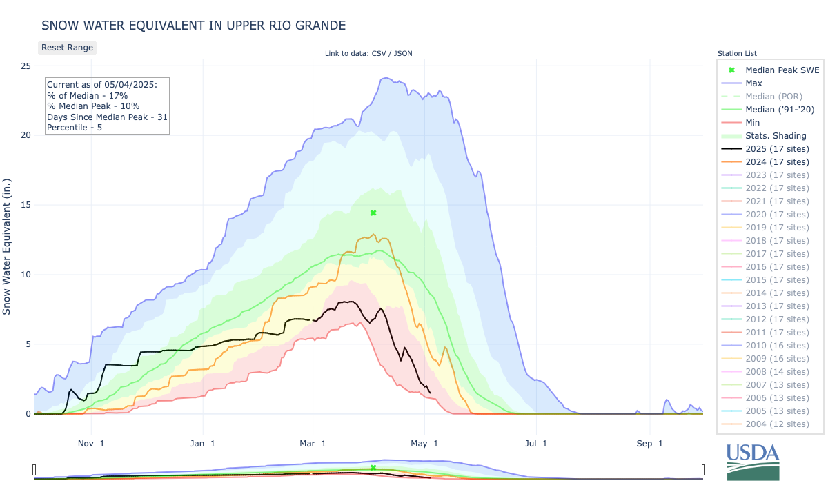
The early May rain delivered a recharge to the Upper Rio Grande Basin, and perhaps there’s more snowmelt coming from the higher elevations that forecasters haven’t yet figured out?
Craig Cotten of the Colorado Division of Water Resources, in speaking at this week’s May 13 meeting of the Rio Grande Basin Roundtable, said airborne snow forecasts are predicting “much higher” streamflows on the Rio Grande and Conejos than the other two sources the state relies on to make its predictions – U.S. Natural Resources Conservation Service (NRCS) and National Weather Service.
Cotten explained the state division of water resources uses all three sources to help it forecast the depths and the amount of water in the rivers. Colorado is forecasting 390,000 acre-feet this water year on the Rio Grande and 180,000 acre-feet on the Conejos – both measurements at around 60 percent of the long-term averages for the river system.
While NRCS and National Weather Service have been predicting low river flows from a light snow year, the Colorado Airborne Snow Measurement Program and its ASO Snow Survey has data that suggests “much higher” streamflows and is a source of information that the state is “trying to figure out what’s going on,” Cotten said.
“We still think it’s not going to be a great year on any of our stream systems,” he said.
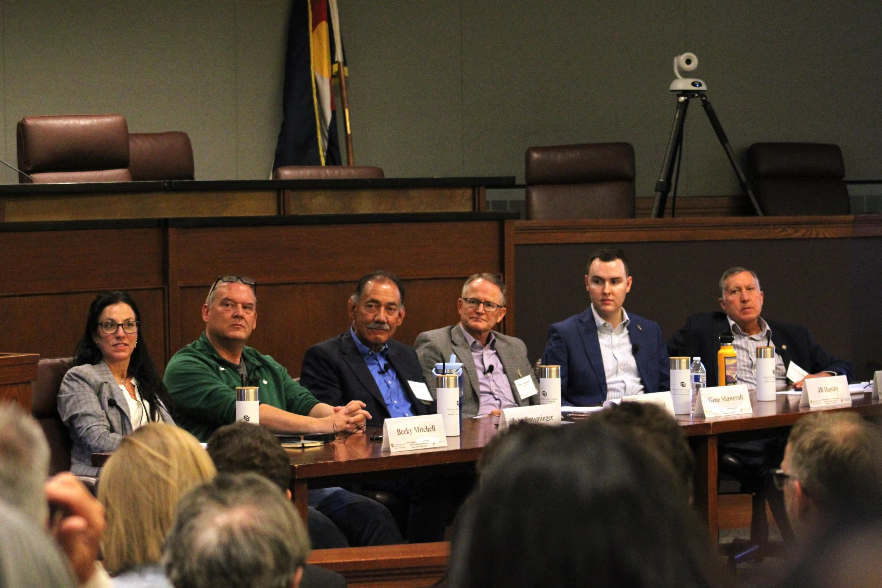
Six of the seven state representatives who will shape the next chapter of Colorado River rules speak on a panel at the University of Colorado, Boulder on Jun. 6, 2024. The same group is opting not to speak at this year’s conference. Alex Hager/KUNC
Click the link to read the article on the KUNC website (Alex Hager):
May 11, 2025
This story is part of ongoing coverage of the Colorado River, produced by KUNC in Colorado and supported by the Walton Family Foundation. KUNC is solely responsible for its editorial coverage.
As tense negotiations about the future of the Colorado River are stuck at a standstill, the people in charge are retreating further into the shadows.
A group of negotiators – one from each of the seven states that use Colorado River water – will not be speaking at a major water law conference in June. Those representatives have appeared together on a panel at the conference for the last few years, and rarely appear together in public otherwise.
“The unwillingness to answer the public’s questions suggests that negotiations aren’t going well,” said John Fleck, who teaches water policy at the University of New Mexico. “I think it misses an important obligation in democratic governance of a river that serves 40 million people.”
The event, the Getches-Wilkinson Conference at the University of Colorado, Boulder, is typically one of two times each year that the negotiators appear together in public. In recent iterations of the same conference, they all spoke on one panel. Occasionally, a state representative has fallen ill or sent a deputy in their stead.
They seemed starkly divided at the other annual appearance, too. In December, they opted to split into two separate panels at the Colorado River Water Users Association conference in Las Vegas.
Water policymakers from (left to right) Utah, New Mexico, Colorado and Wyoming speak on a panel at the Colorado River Water Users Association conference in Las Vegas on December 5, 2024. The two rival factions of states chose to appear on two separate panels then, and have opted to avoid speaking entirely in June. Alex Hager/KUNC
People with knowledge of the situation confirmed to KUNC that state leaders told conference organizers they did not want to speak publicly. There is currently no seven-state panel on the published conference agenda.
JB Hamby, California’s top water negotiator, said he would attend the conference but not speak, and he was “100%” sure the other top officials wouldn’t be speaking. Representatives from Arizona, Colorado and New Mexico confirmed their states’ Colorado River negotiators would not be speaking.
Unlike many government processes, Colorado River policymakers work in a space that does not involve a mandate for public access. Their meetings are often held behind closed doors, are not listed publicly and do not yield minutes or records that can be viewed by the public.
“You need to listen to and have spaces to discuss with the people who are going to be impacted by your decisions,” Fleck said. “That’s not happening now, and that’s really disturbing.”
Those water policymakers are stuck in a standoff about how to use less water from the shrinking Colorado River. Negotiators seem to agree with the broad concept that the farms, businesses and 40 million people of the Colorado River basin need to cut back on water use as the river gets smaller due to climate change. They don’t, however, agree on who should cut back.
Talks so far have largely stayed divided along a decades-old fault line. On one side is the Upper Basin – which consists of Colorado, Utah, Wyoming and New Mexico. The other side, the Lower Basin, is made up of California, Arizona and Nevada.
The Lower Basin has volunteered relatively modest cuts in proposals for how to manage the river after the current rules expire in 2026. The Upper Basin has not volunteered any cuts, insisting that its states are already forced to use less water due to climate change and a longstanding legal requirement to send a fixed amount of water to those Lower Basin states.
“I am fully focused on the negotiations for post-2026 operations of Lake Powell and Lake Mead,” Becky Mitchell, Colorado’s top negotiator, wrote in an email to KUNC. “As the Getches-Wilkinson conference drew nearer, it was unclear where we would be in that process, and I wanted to be cognizant of the sensitivity of the work. Time is of the essence, and these critical negotiations have my full attention at this time.”
The states have dug their heels in on those positions for months now, and their willingness to talk about the status of their closed-door attempts to break the deadlock has only gone down over time.
Reporters’ requests to state water authorities that once yielded interviews with top policymakers are now often met with written statements that tend to be short on detail.
Glen Canyon Dam holds back the waters of Lake Powell near Page, Arizona on Sunday, Feb. 2, 2025. Lake Powell, has approached dangerously low levels in recent years as policymakers have struggled to come up with a long-term management plan for the water it stores. Photo credit: Spenser Heaps/Utah News Dispatch
“I have a lot of respect for the people who are doing these negotiations,” Fleck said. “They’re trying to solve really hard problems, and I respect the idea that they need some space to do that, but not showing up in public at all is granting them more space than I’m willing to grant them.”
Joanna Allhands, an opinion writer at the Arizona Republic who has written about the Colorado River’s “bankruptcy of leadership,” said more transparency from water policymakers “would be smart as a matter of self preservation.”
“Whatever the decision is made,” she said, “Whatever alternative gets chosen, if people feel like they’ve been left out, guess where we’re headed? We’re going to the Supreme Court.”
Colorado River negotiators have said that they want to avoid taking this issue to the Supreme Court, but have made little recent progress to steer talks away from that outcome.
Colorado River “Beginnings”. Photo: Brent Gardner-Smith/Aspen Journalism
Homestake Creek is a tributary of the Eagle River. CREDIT: BRENT GARDNER-SMITH/ASPEN JOURNALISM
Click the link to read the article on the Vail Daily website (Zoe Goldstein). Here’s an excerpt:
May 8, 2025
Every year brings different water conditions in Eagle County. With climate change, the promise of full rivers in the summer may become even less certain. To prepare for future drought years, the Eagle River Water and Sanitation District and Upper Eagle Regional Water Authority have a new water shortage response plan.
“The goal of this plan is to provide water security, to ensure that we can provide our core services,” said Justin Hildreth, the district’s water resources engineer, when presenting the plan to the district board for approval on April 10. Among the core services included in the list are safe drinking water and water for structure fire suppression…According to the plan, “a water shortage occurs when the (district/authority) lacks the physical or legal water supplies needed” to provide their services and maintain required streamflow levels. This can happen when there are extended calls from older water rights, (like the Shoshone water rights on the Colorado River), when stream flows are low for long periods and when local reservoirs (Eagle Park Reservoir and the Black Lakes) have low supply. The district and authority boards approved the plan during their April 10 meetings after learning about the plan during Feb. 27 work sessions…
One of the best early predictors of a drought scenario is if the snow water equivalent measure has not reached an average of 15 inches across the Vail, Fremont Pass and Copper SNOTEL stations by April 1. “That directly relates to Eagle Park Reservoir, that relates to the flows in Gore Creek and the flows in the Eagle River,” Hildreth said. This year, the average was just shy of 16 inches across the three stations on April 1.
Map of the Colorado River drainage basin, created using USGS data. By Shannon1 Creative Commons Attribution-Share Alike 4.0
Click the link to read the article on the AZCentral.com website (Branson Loomis). Here’s an excerpt:
May 13, 2025
Key Points
Arizona has “real skin in the game” as negotiations continue over shares of a smaller Colorado River, Gov. Katie Hobbs said. Now she wants other states to step up.
The seven Colorado River states are trying to reach a shortage-sharing agreement this year, but are also looking to the new Trump administration to see if there are alternatives.
Arizona officials say other parts of the state, such as Yuma, may have to take cuts. Tribes say they expect the state to honor settlements.
Arizona is doing its part and taking its hits to conserve the Colorado River, Gov. Katie Hobbs said, and it’s time for upstream states to do the same. The governor assembled a roundtable of water users and officials on May 13 to present what she called a unified front among the state’s interests in defending Arizona’s share of the Colorado River as time runs short for reaching a deal with other states that use the water. So far, states upstream from Arizona have not offered cutbacks beyond the limits that a paltry snowpack naturally extracts from their farmers.
“It’s been more than a little frustrating,” Hobbs said. “We’ve come to the table with real solutions, with real proposals. We have real skin in the game,” she said, including billions of dollars in water infrastructure upgrades and in conservation agreements that keep water in the river’s reservoirs. “The upper states need to be willing to take their share as well.”
[…]
So far, the Rocky Mountain states known collectively as the Upper Basin have declined to specify new cuts they might take, because they say they already suffer the consequences of a reduced snowpack that shortchanges their farmers every year. The federal government has paid some Lower Basin farmers and others to cut back on their demands from Lake Mead’s storage bank, and the four Upper Basin states of Colorado, New Mexico, Utah and Wyoming argue that their year-in, year-out hardship is unrewarded and largely invisible to water users in the Southwest.
Udall/Overpeck 4-panel Figure Colorado River temperature/precipitation/natural flows with trend. Lake Mead and Lake Powell storage. Updated through Water Year 2024. Credit: Brad Udall
(They do one of these every month, I always find them interesting, and I always forget to post them.)
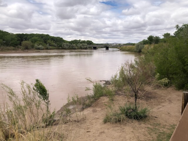
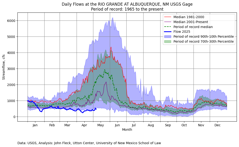
26.5 miles are currently dry in the lower stretch of New Mexico’s Middle Rio Grande, in the stretch between Socorro and Elephant Butte Reservoir, though the Low Flow Conveyance Channel (a big canal next to the river’s main channel through this lower reach – it’s an engineered system, what counts as “river” is semantics at this point) is flowing, and water is still flowing through the Elephant Butte Narrows.
The river’s actually up right now through Albuquerque thanks to last week’s rain and the warmup melting off some last bits of snow. But this is likely the peak.
Rio Grande and Pecos River basins. Map credit: By Kmusser – Own work, Elevation data from SRTM, drainage basin from GTOPO [1], U.S. stream from the National Atlas [2], all other features from Vector Map., CC BY-SA 3.0, https://commons.wikimedia.org/w/index.php?curid=11218868
Click the link to read the article on the InkStain website (John Fleck):
May 8, 2025
A week of rain (I exaggerate, six days) has lifted our spirits after one of the driest starts to a calendar year on record in Albuquerque. The river was muddy yesterday on the family Wednesday lunch outing, and the cottonwoods looked so happy. The wild roses were blooming, we stuck our noses in them to smell.
And yet….
Lowest on this date since 1996.
Percentile ranking of yesterday’s flow: 7 (record goes back to 1965)
Click the link to read the release on the NRCS website:
May 7, 2025
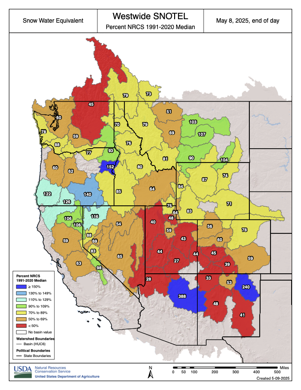
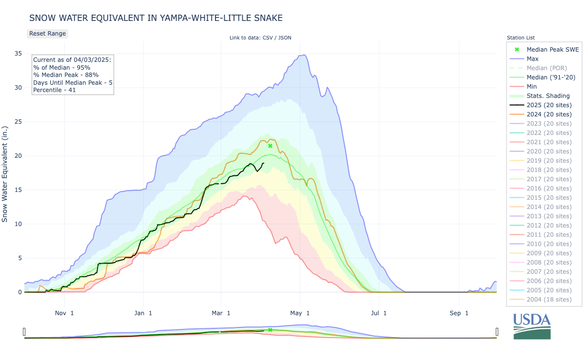
Snowpack across Colorado is well below normal following a warm, dry April. Statewide snowpack has begun its seasonal decline, with SWE at 57% of median. Despite a dry April, early May storms brought helpful precipitation to higher elevations.
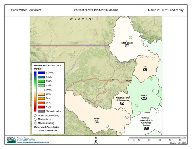
As of May 1st, Colorado’s snowpack peaks and begins its seasonal decline. Statewide snow water equivalent (SWE) is at 57% of median, reflecting a sparse and well below average snowpack with drier conditions in central, southwest and southeast basins. In the Gunnison, combined San Miguel-Dolores-Animas-San Juan (SMDASJ), Upper Rio Grande (URG) and Arkansas snowpack is at 34% of median. Northern basins are at 73% of median with higher snowpacks in northeast mountains.
Statewide peak SWE occurs 11 days earlier than the historical median with 90% of sites observing earlier dates. April brings limited storm activity, making for a less eventful month and resulting in a -28% SWE departure of the 30-year median. That negative departure translates to a decline of 2.6 inches of SWE at 82% of sites over the past 30 days. Looking at the full accumulation season from late October through April, the cumulative SWE departure deepens to 5.5 inches.
May began with a strong storm system delivering over 3 inches of moisture at some sites in the Sangre de Cristos and San Juans, including the SMDASJ, URG and Arkansas River basins. The Front Range mountains are also benefitting from the early May storm, primarily east of the divide. Southwest basins typically receive around 7% of their annual precipitation in May, much of which falls as snow at higher elevations. During spring, however, this precipitation can fall as rain on snowpack unless temperatures cool significantly. “With this recent storm cooler temperatures prevailed, resulting in observed snowfall in many high elevation sites. While this early May storm did not benefit all regions equally, the widespread drop in temperatures will help reduce melt rates and slow runoff timing across the state,” notes Nagam Bell, NRCS hydrologist.
Water year to date (WYTD) precipitation is at 85% of median statewide, with basin values ranging from 74 to 95 percent. Northern basins lead the state with drier conditions found in the URG (74%) and SMDASJ (77%), while the Gunnison and Arkansas measure 82 and 86 percent of median, respectively. April finishes as the driest month for the primary accumulation period with statewide totals at 59% of median. Northern and central basins fall well below average: Yampa-White-Little Snake end at 43%, Colorado Headwaters at 47% and Gunnison at 49%. Southern basins fair slightly better over the last 30 days: SMDASJ reports 75% and the URG 70% for the month. Sixty day precipitation trends show a modest bump in some areas. Laramie-North Platte reaches 84% and the SMDASJ reports 88% of median.
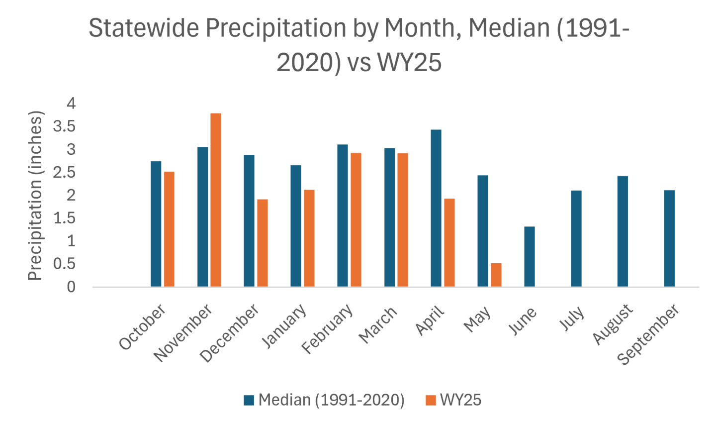
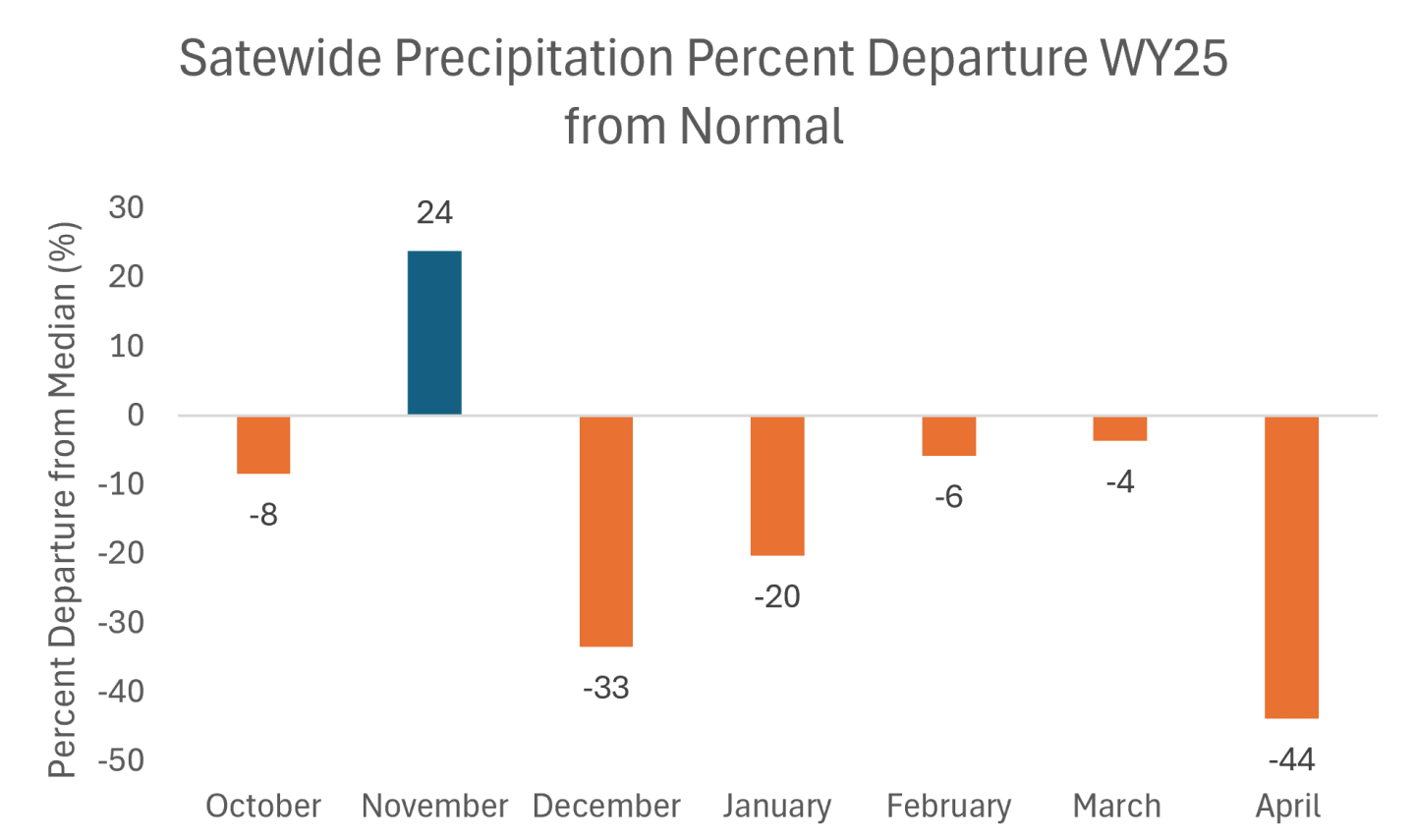
On the lower end, the Arkansas and URG observe 66 and 73 percent, respectively. The 90 day averages highlight increased variation, spanning 64 to 98 percent. Northern basins remain the strongest performers while precipitation values taper farther southeast. The following charts highlight statewide totals (see Figure 1) and departures from median. November remains the only month with a notable surplus, while April records the steepest drop at 44% below normal (see Figure 2).
Figure 1. Statewide monthly precipitation totals comparing the 1991-2020 median with Water Year 2025. May totals reflect values through May 5th and are not yet complete. Credit: NRCS
Figure 2. Percent departure from median precipitation by month for Water Year 2025. November records a surplus and April has the largest negative departure. October, February and March observe closer to normal precipitation. Credit: NRCS
Statewide reservoir storage is at 93% of median and 61% of total capacity as of the end of April. Despite below average snowpack storage levels at most higher capacity reservoirs are holding near or above average volumes and include: Dillon, Lake Granby, Blue Mesa and Pueblo Reservoir. The exceptions are McPhee at 73% of median and 62% capacity and Navajo Reservoir at 74% of median and 61% capacity.
Streamflow forecasts continue to reflect widespread degradation heading into the remaining runoff period. The exception is a handful of points remaining closer to normal that are clustered northwest of the divide in the Colorado Headwaters. The lack of April moisture and precipitation deficits from primary accumulation months compounded by an early and accelerated snowmelt, particularly in southern basins, limits streamflow potential through the remainder of the forecast season based on conditions leading into the May 1 forecast.
As of early May, 24% of Colorado SNOTEL sites have reached melt out primarily in the southern basins. These sites melted out an average of 16 days earlier, with the median statewide melt out date on May 24th. “Lower snowpack volumes and increased temperatures drive early melt, which translates into earlier and likely lower peak streamflow. The potential result is a compressed runoff window and in many cases a muted response in flows,” notes Bell. Soil moisture data further supports these trends, with snowmelt signals registered throughout soil stacks across most basins.
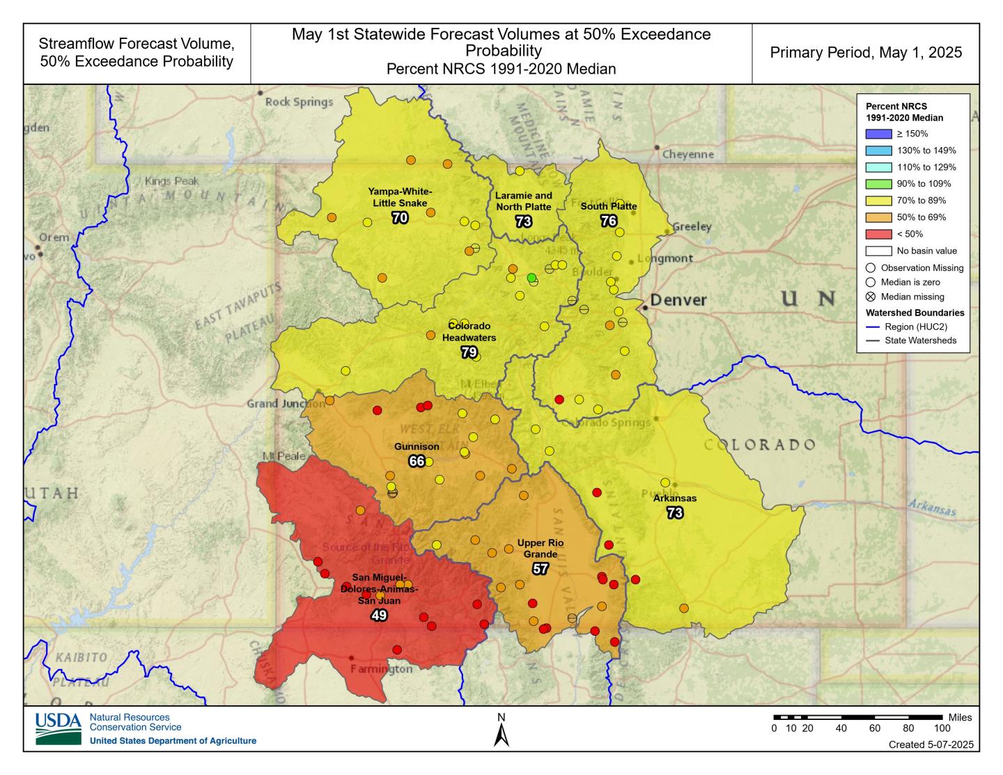
Statewide, the 50% exceedance forecasts are at 71% of median with 86 forecast points averaging in the 19th percentile. Basins in the Upper Colorado Region that make up the Colorado western slope are at 72% of median forecasts. All 50% probabilities show a negative departure from median volumes with lowest outlooks in the southwest region ranging from 49% in the SMDASJ, 57% in the URG and 66% in the Gunnison. Streamflow’s in the Arkansas are at 73% of median with higher output points ranging from 71% of median at Pueblo Reservoir inflow to 85% of median at the Arkansas River at Salida. These suppressed forecasts reflect the combined effects of limited April precipitation, early and accelerated snowmelt, and low antecedent water year precipitation.
As the season progresses and fewer forecasts updates remain the range of forecasted outcomes narrows and uncertainty decreases as late season inputs come in. In general, most exceedance values remain low and can be compared for the entire forecast season at each point using the evolution forecast plots. In years like this the drier forecast range, including the 90% exceedance, can be especially informative. If dry conditions persist, these lower projections may prove most reflective of what materializes. It’s essential to consider the full range of forecast probabilities, not just the median, when planning around potential runoff outcomes.
Denver Water is helping ensure its future water security with the Gross Reservoir Expansion Project. When the project is complete, it will nearly triple the Boulder County reservoir’s capacity to 119,000 acre-feet. CREDIT: HEATHER SACKETT/ASPEN JOURNALISM
Adam engineer who designed a major expansion of Gross Reservoir Dam in Boulder County told a federal judge Tuesday that the raising of the dam, facing a potential halt due to an April federal court ruling, needs to proceed to protect public safety.
Mike Rogers, the civil engineer who designed the $531 million expansion of the dam, said bad weather could create flood conditions that would lead to a catastrophic failure similar to what occurred with the Oroville Dam failure in California in 2017.
But Stephen Rigbey, a Canadian dam safety expert testifying for Save The Colorado, said any issues with putting the construction project on hold, even in its partially-complete state, could be addressed, and that the risk of a catastrophic failure was “negligible.”
Workers from Denver Water and contractor Kiewit Barnard stand in front of Gross Dam in May 2024 to mark the start of the dam raise process. Photo credit: Denver Water.
Rogers’ and Rigbey’s testimony Tuesday came during a federal hearing in Denver, after which U.S. District Court Judge Christine Arguello will determine whether to allow construction to move forward on the Denver Water project or whether the construction will be paused until new federal reviews she has ordered are completed and legal questions are answered.
But at the end of Tuesday’s hearing, Arguello said the parties to the case had not provided enough information for her to make a decision and ordered them to submit more data later this month.
The massive construction project has raised fierce opposition in Boulder County and prompted several legal challenges from Save The Colorado, a group that advocates on behalf of rivers. Though its early lawsuits failed, in 2022 the river defenders won an appeal that put the legal battle back in play. Despite months of settlement talks, no agreement was reached.
Boulder County Commissioner Ashley Stolzmann was unmoved by Rogers’ testimony, saying she hopes the judge halts the work to prevent further environmental damage in Boulder County and to protect the Fraser River, a tributary to the Upper Colorado River. The Fraser has served as the source of water for Gross Reservoir since the 1950s, when it was built.
“It’s incredibly disappointing that Denver has chosen to move forward,” Stolzmann said. “With climate change, it really is a time for different entities to work together to repair the climate. I want to see Denver seek alternative solutions.”
Denver Water first moved to raise Gross Dam more than 20 years ago when the water provider began designing the expansion and seeking the necessary federal and state permits. Denver Water has said raising the dam and expanding the reservoir is necessary to ensure it has enough water throughout its delivery system and to help with future water supplies as climate change continues to reduce streamflows.
The Gross Reservoir Expansion Project involves raising the height of the existing dam by 131 feet. The dam will be built out and will have “steps” made of roller-compacted concrete to reach the new height. Image credit: Denver Water
After years of engineering, environmental studies and federal and state analyses, Denver received a permit from the U.S. Army Corps of Engineers and construction began in 2022. It has involved taking apart a portion of the original dam and raising its height by 131 feet to nearly triple the reservoir’s storage capacity to 119,000 acre-feet from 42,000 acre-feet.
The case took center stage again April 3, when Judge Arguello put a temporary halt to construction of the higher dam, at Save The Colorado’s request.
In that high-profile ruling, Arguello said, in part, that the Army Corps should have considered whether ongoing climate change and drought would leave the Colorado River and Western Slope waterways too depleted to safely allow transfer of Denver Water’s rights into a larger Gross Reservoir for Front Range water users.
At the same time, she ordered a permanent injunction prohibiting enlargement of the reservoir, including tree removal and water diversion, and impacts to wildlife.
Almost immediately, Denver Water filed for temporary relief from the order, saying, in part, that it would be unsafe to stop work as the incomplete concrete walls towered above Gross Reservoir.
Arguello granted that request, too, allowing Denver to continue work on the dam considered necessary for safety.
Denver Water has also filed an appeal with the U.S. 10th Circuit Court of appeals, seeking to permanently protect its right to continue building the dam. The appeals court is expected to wait for the lower court to rule, before considering Denver Water’s request.
Udall/Overpeck 4-panel Figure Colorado River temperature/precipitation/natural flows with trend. Lake Mead and Lake Powell storage. Updated through Water Year 2024. Credit: Brad Udall
Skiers descend Arapahoe Basin Ski Area in Colorado on May 4, 2025. Snowpack across the mountains that supply the Colorado River is far below normal for this time of year. Forecasts call for 55% of average runoff into Lake Powell, the nation’s second-largest reservoir. Alex Hager/KUNC
Click the link to read the article on the KUNC website (Alex Hager):
May 8, 2025
This story is part of ongoing coverage of the Colorado River, produced by KUNC and supported by the Walton Family Foundation. KUNC is solely responsible for its editorial coverage.
If you took a look at a map of Rocky Mountain snow right now you would see a lot of red.
The mountains that feed the Colorado River with snowmelt are strikingly dry, with many ranges holding less than 50% of their average snow for this time of year. The low totals could spell trouble for the nation’s largest reservoirs, but those dry conditions don’t seem to be ringing alarm bells for Colorado River policymakers.
Inflows to Lake Powell, the nation’s second largest reservoir, are expected to be 55% of average this year, according to federal data released this week. If forecasts hold true, 2025 would see the third-lowest amount of water added to Lake Powell in the past decade.
Westwide SNOTEL basin-filled map May 8, 2025 via the NRCS.
“It’s looking like a pretty poor water supply and spring runoff season,” said Cody Moser, a hydrologist with the Colorado River Basin Forecast Center.
If Lake Powell drops too low, the reservoir would lose the ability to generate hydropower for about five million people across seven states. Much lower, and it could lose the ability to pass enough water downstream, where tens of millions of people depend on it.
Eric Balken, who watches Lake Powell closely as director of the nonprofit Glen Canyon Institute, said this year’s snow data is concerning, but it isn’t driving the same level of concern from policymakers and media outlets that emerged in previous dry years.
Balken said that may be happening for two reasons.
First, it’s because negative outcomes might not be felt immediately. Lake Powell is unlikely to drop low enough to lose hydropower capabilities this summer, but the dry spring is making that more likely to happen in 2026.
Second, it’s because water managers simply have bigger fish to fry.
The federal offices that manage Western water are in disarray amid layoffs and restructuring since Donald Trump returned to the White House. The Bureau of Reclamation, the top federal agency for Colorado River dams and reservoirs, is without a permanent commissioner.
All the while, state and federal policymakers are spending most of their time and attention on drawing up new water-sharing rules. The current rules expire in 2026. Talks between states have reached a standstill, and negotiators say they’re working toward a compromise.
“That chaos within the agencies, the broader negotiations happening on the Colorado River, all of these other factors, I think, are sort of drowning out the severity of the drought situation right now,” said Balken.
Glen Canyon Dam creates water storage on the Colorado River in Lake Powell. Low water levels in Lake Powell could jeopardize the dam’s ability to produce hydropower or pass water downstream. Credit: U.S. Bureau of Reclamation
This year got off to a strong start for mountain snow, but took a dip during a dry spell that lasted from December through February. Snowmelt from Colorado accounts for about two-thirds of the water in Lake Powell. A portion of Western Colorado saw less than 15% of normal precipitation from December through April.
Scientists say these low snow years are the result of climate change, which is causing less snow to fall, and more of it to be soaked up by dry, thirsty soil before it has a chance to reach rivers and reservoirs. That has left the Colorado River in a dry trend going back more than two decades.
Balken said the climate reality is here to stay, and should spur the region’s leaders to rein in demand accordingly.
“Just because we’ve gotten used to it doesn’t mean that it’s not a problem,” he said. “We have to stay laser focused on what’s happening on the Colorado River, because there are some very big problems that need to be addressed.”
Click the link to read the article on the Alamosa Citizen website (Heather Dutton and Daniel Boyes):
May 2, 2025
San Luis Valley water managers have reviewed streamflow forecasts, available water stored in reservoirs, and anticipated reservoir operations for the 2025 spring, summer, and fall seasons, and determined that 2025 will likely be a year with early runoff, low flows in streams and rivers, and a short boating season.
The Colorado Division of Water Resources Division 3 Engineer’s March 31 10-day report forecasted the total annual flow at the Del Norte gage will be 390,000 acre-feet. For reference, the flows in 2020 totaled 377,000 acre-feet. The National Weather Service is forecasting hot and dry conditions into July, with chances of a normal monsoon season in late summer. The snow water equivalent for the Upper Rio Grande Basin was 25 percent of the median for the 1991-2020 time period on April 28, 2025. The irrigation season began on April 1 on the Rio Grande. As such, on-stream reservoirs are required to pass all inflows to satisfy the needs of downstream senior water rights holders.
Given the low amount of snow remaining in the mountains and the anticipated summer drought conditions, it is likely that local rivers and streams will reach their peak runoff in May. The reservoir operators at Rio Grande, Santa Maria, and Continental Reservoirs will begin releasing stored irrigation water to downstream farmers after the river peaks. The San Luis Valley Irrigation District (SLVID) will release water from Rio Grande Reservoir to the Farmers Union Canal as soon as their first direct flow priorities come into priority on the Rio Grande at anticipated rates of 150-400 cubic feet per second for up to 15 days.
Rio Grande. Photo Credit: The Citizen
This schedule will be updated through May as river conditions change.
The Santa Maria Reservoir Company anticipates beginning releases from Santa Maria and Continental Reservoirs to the Rio Grande Canal and Monte Vista Canal in late May or early June. The timing of the releases of water will depend on flow rates in the canals and when farmers order water. The natural river flows and releases of irrigation water will provide the highest rates of flow during the summer season. As such, boatable flows on the Rio Grande may diminish as early as mid to late June.
Entities including Colorado Parks and Wildlife (CPW), the San Luis Valley Water Conservancy District (SLVWCD), and the Rio Grande Water Conservation District (RGWCD) store water in reservoirs in the Upper Rio Grande Basin and call for releases for their operations in accordance with their water rights decrees. Where possible, releases by these organizations will be prioritized during hot periods to supplement the natural flow of the Rio Grande helping to reduce high water temperatures and low river flows, thereby protecting the health of fish. Generally, when water temperatures reach 68 degrees, fish become very stressed and voluntary fishing restrictions are enacted at 72 degrees. Stakeholders will watch temperatures on the Rio Grande and the South Fork of the Rio Grande carefully and take action to release water where possible.
The water managers and reservoir operators in the Rio Grande Basin are working in partnership to manage water in order to meet multiple needs. These efforts build off of many years of collaboration amongst water users on the Rio Grande. In order to better inform the local communities of water management operations, additional information will be compiled and shared via news outlets, social media, and email as reservoir releases are planned and executed.
Dusk falls on Lake Powell near Bullfrog Marina on July 15, 2024. A new letter from water policy experts gives negotiators some recommendations on how to sustainably manage the Colorado River in the future. Alex Hager/KUNC
Click the link to read the article on the KUNC website (Alex Hager):
May 3, 2025
This story is part of ongoing coverage of the Colorado River, produced by KUNC in Colorado and supported by the Walton Family Foundation. KUNC is solely responsible for its editorial coverage.
The seven states that use the Colorado River are deadlocked about how to share it in the future. The current rules for dividing its shrinking supplies expire in 2026. State leaders are under pressure to propose a new sharing agreement urgently, so they can finish environmental paperwork before that deadline.
Right now, they don’t appear close to an agreement, so a group of prominent Colorado River experts co-signed a letter outlining seven things they want to see in the next set of rules.
The letter gives a clear, concise list of recommendations for ways to keep taps flowing while protecting tribes and the environment. Whether the states will listen is another matter entirely.
‘Shared pain’
The letter, written by a group of academics and retired policymakers, makes no bones about it: states need to find a collective solution to their collective problem. And some of them might not be happy.
State leaders have been reluctant to volunteer cutbacks, and have largely stayed divided along a decades-old fault line. On one side, the Upper Basin – which consists of Colorado, Utah, Wyoming and New Mexico. The other side, the Lower Basin, is made up of California, Arizona and Nevada.
The recent letter is interesting in part because it’s co-authored by people from both sides of the Colorado River debate. Eric Kuhn led an agency that defends Western Colorado’s water. Kathryn Sorensen led Phoenix’s water department.
The letter was also written by Anne Castle, who has worked in federal water policy positions, and Jack Schmidt, a water researcher at Utah State University. Co-authors John Fleck and Katherine Tara research water policy at the University of New Mexico.
The authors write that states need to engage in some level of “shared pain,” meaning cutbacks to the amount of water that flows to farms, homes, and businesses.
“‘Shared’,” the letter writes, “Does not mean equal, either in amount, triggers, or duration.”
Water from the Colorado River flows through the East Highline Canal on its way to farms in the Imperial Valley on June 20, 2023. The Colorado River’s single largest user has taken federal money through incentive programs to cut back on water use. Alex Hager/KUNC
The Lower Basin states have already proposed relatively modest cutbacks, and the Upper Basin seems to be digging in its heels on the idea that they should not have to give up any water at all.
This letter pushes back on that stance.
“There’s lots of wonderful legal arguments about why it shouldn’t be me that needs to use less water,” Anne Castle, one of the letter’s authors, told KUNC. “But in order to have a viable and politically viable agreement, everybody has to do a share.”
Other recommendations
In addition to calling for states to put their heads together, the authors also warned against leaning too hard on federal checks as a way to conserve water. Money from the federal government has been a key part of avoiding catastrophe on the Colorado River in recent years. Hundreds of millions of dollars have gone to big water users, often farmers, as an incentive to use less water.
Those funds have come under threat during President Donald Trump’s second term. The letter says new rules for the Colorado River “cannot assume that federal taxpayers will reimburse Western water users over the long term to forgo the use of water that does not exist.”
The letter goes on to advocate for groups that can sometimes be an afterthought in Western water policy. It essentially re-ups an earlier call from a group of tribes in the Colorado River basin, which are asking for a bigger seat at the table after more than a century of exclusion. It also pushes for new rules to be more flexible, which would make it easier to protect river ecosystems. That mirrors similar comments from a group of nonprofits.
The shortest and final recommendation in the letter says that any new Colorado River rules have to make sure there’s enough water to keep people safe and healthy.
“There must be absolute protection of domestic water deliveries for public health and safety,” it reads.
In short, it’s asking to make sure that a worst-case-scenario doesn’t see drinking water reserves go dry, while agriculture and other industries keep their faucets flowing.
“I don’t think that would happen,” Castle said. “I think the market would intervene and take care of this situation.”
The reaction
KUNC reached out to top water negotiators in Arizona and Colorado for this story. Their answers fell in line with oft-repeated talking points from each basin.
A spokesman for the Arizona Department of Water Resources wrote that its director, Tom Buschatzke, “agreed with the authors that ‘every state and sector of the economy must contribute to the solution to this imbalance.’”
Water policymakers from (left to right) Utah, New Mexico, Colorado and Wyoming speak on a panel at the Colorado River Water Users Association conference in Las Vegas on December 5, 2024. The Upper Basin states have been reluctant to volunteer cutbacks ahead of the next set of river-sharing rules. Alex Hager/KUNC
Colorado’s top water official, Becky Mitchell, wrote that the recommendations overlooked climate change’s impact on Upper Basin water supplies, and that states already take “mandatory and uncompensated” cuts.
“Colorado water users do not enjoy a guaranteed delivery of the full amount of their water rights each year,” she wrote.
Jennifer Gimbel, Colorado’s former top water official, did not contribute to the letter and also took issue with the suggestion that both basins could afford to make cutbacks.
“Are the authors of the paper thinking that federal law should be enacted to override state law?” Gimbel wrote to KUNC in an email. “Are they thinking that users in the Upper Basin, who they say should not rely on federal compensation, should just give up their livelihoods voluntarily or be compensated by the state legislatures? I don’t know because they don’t say.”
Udall/Overpeck 4-panel Figure Colorado River temperature/precipitation/natural flows with trend. Lake Mead and Lake Powell storage. Updated through Water Year 2024. Credit: Brad Udall
Click the link to read the article on the InkStain website (John Fleck):
April 25, 2025
A group* of my Colorado River collaborators has put together what we hope can be a useful set of foundational principles as the basin states and federal leadership search for a path toward a negotiated agreement for post-2026 Colorado River management. They’re based on a number of key premises:
The Colorado River Compact will remain the foundation of the river’s management, but we have to find a way past the deep disagreement between Upper and Lower basin states on what the Compact actually says.
Colorado River Basin tribes must be essential partners in crafting the next set of guidelines, including through compensation for foregone water use.
Shared pain is essential. The path toward a sustainable river system requires everyone to contribute to the solution to the problem of the river we all share.
Click the link to read the article on the KVNF website (Brody Wilson):
April 29, 2025
The Colorado River is the lifeblood of the American Southwest. Forty million people depend on it — not just here in Colorado, but in cities like Phoenix, Las Vegas, and Los Angeles.
Here on the Western Slope, we don’t always feel directly connected to the Colorado River. After all, we live in the Gunnison Basin — a different watershed, right?
Not quite. The Gunnison River contributes about 17% of the Colorado River’s total annual flow. So any decision made about the Colorado River’s future directly affects us — how much water we can use, when, and for what purpose. For decades, the river has been in a slow-moving crisis. Climate change, explosive population growth, and overallocation have pushed the system to the brink. In 2022, the river’s two main reservoirs — Lake Powell and Lake Mead — reached such low levels that hydropower turbines at Glen Canyon Dam were nearly shut down and dam operators were near “dead-pool” where water would no longer be able to pass through the dam. But today, nearly three years later, the system isn’t bouncing back. Andy Mueller, General Manager of the Colorado River District, has a blunt message: the Colorado River is carrying less water than it used to, and if we don’t change course, the future of agriculture, recreation, and the our way of life across the Western Slope could be at risk.
“The average temperature in March has gone up 4.2 degrees Fahrenheit,” Mueller told the crowd in Ridgway. “And for every 1 degree of warming, streamflow drops by 3 to 5 percent. We’re looking at a 20% decline right here in the Uncompahgre Valley over the last 125 years.”
These trends are part of a long-term warming and drying pattern. Less snow is falling, and what does fall melts earlier. That means less water reaches our rivers — and more of it is lost to evaporation or absorbed by plants growing in longer, hotter seasons.
In 1922, Federal and State representatives met for the Colorado River Compact Commission in Santa Fe, New Mexico. Among the attendees were Arthur P. Davis, Director of Reclamation Service, and Herbert Hoover, who at the time, was the Secretary of Commerce. Photo taken November 24, 1922. USBR photo.
To understand what’s happening now, you have to go back to 1922. That’s when the seven states in the Colorado River Basin signed a compact to divide the river’s water. Colorado, New Mexico, Utah, and Wyoming became the “Upper Basin.” California, Arizona, and Nevada formed the “Lower Basin.” Each side was promised 7.5 million acre-feet of water per year. But there was a problem: the river wasn’t carrying that much water — and certainly doesn’t now. For decades, this over-allocation was masked by big reservoirs like Lake Powell and Lake Mead. But as the drought continues, those buffers have disappeared. In 2007, the states and federal government adopted a temporary fix: interim guidelines to manage the system during dry years. Those guidelines are set to expire in 2026. New rules must be negotiated now — and the clock is ticking.
“There’s a lot of confusion out there,” Mueller said. “People talk about renegotiating the Compact — but that’s not what’s happening. The Compact isn’t being touched. What’s being negotiated are the guidelines for how Powell and Mead are operated — especially in times of shortage.”
Click the link to read the paper on the InkStain.net website (Kathryn Sorensen, Sarah Porter, Eric Kuhn, and Cynthia Campbell). Here’s an excerpt:
April 18, 2025
Conserving water now in reservoir savings banks, as a hedge against future risks associated with drought and declining flows, has emerged as one of the central tools for managing the Colorado River. The Lower Basin “Intentionally Created Surplus” program, created in the 2007 Interim Guidelines, has shown the idea’s promise and given the basin nearly two decades to learn the strengths and weaknesses of the approach. With tweaks to allow similar efforts in the Upper Basin and other modifications based on what we have learned about the current ICS approach, such “Floating Pools” are one of the key tools being considered as negotiators try to thread the needle of a seven-state agreement for post-2026 Colorado River management. Done properly, they have the potential to finesse the states’ disagreement over the terms of the 1922 Colorado River Compact in a way that could avoid potentially disruptive litigation. But getting the details right will be crucial to the development of an enduring bargain that can help the basin avoid the risk of interstate litigation.
Context
Negotiations over post-2026 operating rules for Lakes Powell and Mead are a proxy battle over whether the 1922 Compact acts as a limitation on yet-to-be used water in the Upper Division States or as a cut to existing water uses in the Lower Division States. Much of the conflict focuses on Article III(d) of the Colorado Compact, which states, “The states of the Upper Division will not cause the flow of the river at Lee Ferry to be depleted below an aggregate of 75,000,000 acre-feet for any period of ten consecutive years. . .”
The Upper Division States have a fundamentally different interpretation of their Compact obligations at Lee Ferry than the Lower Division States. Clearly, the best-case scenario for the Lower Division States, especially in Central Arizona, is a court decision that confirms the Upper Division States have a compact obligation to not deplete the flow of the river below 75 million acre-feet every ten years plus ½ of the annual delivery to Mexico under the 1944 Treaty, approximately 82 million acre-feet every ten years. This outcome would mostly stabilize the water supply available to the Lower Division States and likely limit consumptive uses in the Upper Division States to about the same or a little less water than they are currently using, approximately 4 million acre-feet per year. If the high court rules instead that the Upper Division States have a non-depletion obligation, and that consumptive uses in the Upper Division States are not the “cause” of inadequate flows needed to deliver 8.23 million acre-feet to the Lower Division States and Mexico, the result in a declining river system is a cut, potentially even to zero, for water delivered via the Central Arizona Project (CAP) into the Sun Corridor from Phoenix to Tucson and potential cuts to water-right holders in Western Arizona, Southern California and Nevada who are next on the chopping block.
Distilled to its core, here is the question before us: in a declining river system and in the absence of an agreement among the Divisions, does the operation of Article III(d) of the Compact result in a limitation on future new uses in the Upper Division States or an elimination to existing ones in the Lower Division States?
Map of the Colorado River drainage basin, created using USGS data. By Shannon1 Creative Commons Attribution-Share Alike 4.0
Udall/Overpeck 4-panel Figure Colorado River temperature/precipitation/natural flows with trend. Lake Mead and Lake Powell storage. Updated through Water Year 2024. Credit: Brad Udall
It’s easy to take for granted the accounting innovations in the Colorado River governance regime’s 2007 guidelines, which have governed river management and the upstream-downstream relationships between the upper and lower basins. “Intentionally Created Surplus” (ICS) is now part of the lexicon, and the idea behind it shows enough promise that it’s at the heart of the current negotiations over the post-’07 guidelines management of the river.
But we need to be careful about the lessons that we learn, and the details of how we implement the successor to ICS. How should the successor to ICS related to action levels for reservoir management? How do we ensure that water in ICS-like accounting pools is really conserved water, part of a sincere effort to reduce basin consumptive use?
Those questions are at the heart of the argument in Floating Pools & Grand Bargains, a new white paper by Kathryn Sorensen from Arizona State University and a group of colleagues, including Eric Kuhn:
As Save the Colorado and Denver Water prepare to face off in a federal courtroom Tuesday, water officials across the state are watching the Gross Dam expansion case closely for its environmental impact and its affect on water projects across the West.
Kirk Klancke, a long-time Grand County environmentalist and president of the Colorado River Headwaters Chapter of Trout Unlimited, said a decision that shuts down the $531 million water project, could also shut down 12 years of work on the Fraser River and its tributaries.
Denver Water is one of 18 partners who signed the Colorado River Cooperative Agreement in 2013, ushering in a new era of cooperation between the utility and West Slope stakeholders, all with the vested interest in protecting watersheds in the Colorado River Basin. As part of that agreement, a process called “Learning by Doing” was created, which has helped the utility stay better connected on river conditions in Grand County. The partnership is a collection of East and West Slope water stakeholders who help identify and find solutions to water issues in Grand County. “Denver Water has been part of Grand County for over 100 years, and we understand the impact our diversions have on the rivers and streams,” said Rachel Badger, environmental planning manager at Denver Water. “Our goal is to manage our water resources as efficiently as possible and be good stewards of the water — and Learning By Doing helps us do that.”
Here’s why: Denver Water owns much of the Fraser with water rights dating back more than 100 years. And it is that water that has historically been piped through the Moffat Tunnel near Rollinsville to fill the existing Gross Reservoir. The new water for the expanded reservoir will come largely from that river as well.
After what’s known as the 2013 Colorado River Cooperative Agreement was signed, Denver Water agreed to conduct extensive restoration work on the river in exchange for being able to raise Gross Dam and bring more water from the Fraser River over to the Front Range.
Klancke said the heavily diverted, scenic waterway would suffer if the deal falls apart. “To dissolve that partnership will be the death of the Fraser River,” he said.
Under the terms of the Colorado River Cooperative Agreement, the work on the Fraser River can only be finalized if the Gross Dam expansion proceeds.
On the upside though, Klancke said, if a new environmental settlement were reached, it could mean more money and more work to restore South Boulder Creek on the other side of the Continental Divide. The creek carries that Fraser River water from the reservoir to Denver Water’s northern storage system.
“I would love to see Denver put a whole bunch of money into South Boulder Creek,” Klancke said.
Gary Wockner, the head of Save The Colorado, disputes the notion that the case could harm environmental work already underway in Grand County.
“We are not causing environmental damage,” he said. “If Denver Water chooses to stop, that’s their choice. That’s on their shoulders. Not ours.”
For its part, Denver says it hopes to continue the Grand County work, but that the terms of the Fraser River agreement are all based on the successful completion of the Gross Dam expansion.
The agency also says it has already set aside $30 million to help offset any environmental harm caused by the massive construction project, including providing 5,000 acre-feet of water to improve streamflows along a 17-mile stretch of South Boulder Creek. An acre-foot of water equals nearly 326,000 gallons, enough water to serve two to four urban households for one year.
Roller-compacted concrete will be placed on top of the existing dam to raise it to a new height of 471 feet. A total of 118 new steps will make up the new dam. Image credit: Denver Water.
Denver Water first moved to raise Gross Dam more than 20 years ago when it began designing the expansion and seeking the necessary federal and state permits.
After years of engineering, studies and federal and state analyses, construction began in 2022. It has involved taking apart a portion of the original dam, built in the 1950s, and raising its height by 131 feet to nearly triple the reservoir’s storage capacity to 119,000 acre-feet from 42,000 acre-feet.
Save The Colorado has launched several unsuccessful challenges to the project, but in 2022 it won an appeal that put the legal battle back in play. Despite months of settlement talks, no agreement was reached.
Then the case took center stage again April 3, when Senior U.S. District Court Judge Christine Arguello put a temporary halt to construction of the higher dam, at Save The Colorado’s request.
Almost immediately, Denver Water filed for temporary relief from the order, saying, in part, that it would be unsafe to stop work as the incomplete concrete walls towered above Gross Reservoir.
Arguello granted that request, too, allowing Denver to continue working on the dam.
Gross Dam case spurred $100 million settlement in a different lawsuit
What happens next is anyone’s guess. Jennifer Gimbel, a water policy scholar at Colorado State University who also serves on Northern Water’s board of directors, said the case has already had an impact on a $2 billion water project to deliver water to residents of fast-growing northern Colorado. The Northern Integrated Supply Project, as it is known, also faced a legal challenge from Save The Colorado, and ultimately the water agency opted to settle the case for $100 million. The cash will help restore the Cache la Poudre River with new diversion agreements and improved streamflows, among other benefits.
Gimbel said the Gross Reservoir case was a key factor in that settlement. “Because of Denver’s troubles with Save the Colorado, Northern Water decided to resolve their lawsuit because they were worried about their own permit getting stale and because as you delay construction costs increase.”
The Gross Dam case is also noteworthy because it has stopped a major construction project already underway and may significantly change it. Judge Arguello has ordered the U.S. Corps of Engineers, the major permitting agency, to redo its original permitting work.
Denver Water General Manager Alan Salazar has said his agency would take the case to the U.S. Supreme Court, if they lose in the lower courts.
As both sides prepare for Tuesday’s hearing, the 10th Circuit Court of Appeals panel has said it will wait to see what information emerges from the Tuesday hearing before it rules on Denver Water’s appeal before the 10th Circuit, according to Denver Water General Counsel Jessica Brody. That action seeks to permanently protect what Denver believes is its right to raise Gross Dam.
Denver Water has also raised national security concerns in the case because Save The Colorado has asked and been granted the right to review construction documents on the dam project, documents that would normally be kept from public view.
In response, the judge has told participants to expect the court to be closed periodically during the hearing to address those security concerns.
Rio Grande and Pecos River basins. Map credit: By Kmusser – Own work, Elevation data from SRTM, drainage basin from GTOPO [1], U.S. stream from the National Atlas [2], all other features from Vector Map., CC BY-SA 3.0, https://commons.wikimedia.org/w/index.php?curid=11218868
Mexico and the United States said Monday they had reached an agreement that involves Mexico immediately sending more water from their shared Rio Grande basin to Texas farmers after U.S. President Donald Trump threatened tariffs and sanctions earlier this month.
“Mexico has committed to make an immediate transfer of water from international reservoirs and increase the U.S. share of the flow in six of Mexico’s Rio Grande tributaries through the end of the current five-year water cycle,” U.S. State Department spokesperson Tammy Bruce said in a statement.
Bruce thanked Mexico President Claudia Sheinbaum for her involvement in facilitating cross-border cooperation…The countries’ joint statement Monday, while lacking specific details of the agreement, said both countries had agreed that the 1944 treaty regulating how the water is shared was still beneficial for both countries and not in need of renegotiation. Under the treaty, Mexico must deliver 1,750,000 acre-feet of water to the U.S. from six tributaries every five years, or an average of 350,000 every year. An acre-foot is the amount of water needed to cover 1 acre of land to a depth of 1 foot.
View of Shoshone Hydroelectric Plant construction in Glenwood Canyon (Garfield County) Colorado; shows the Colorado River, the dam, sheds, a footbridge, and the workmen’s camp. Creator: McClure, Louis Charles, 1867-1957. Credit: Denver Public Library Digital Collections
The town of New Castle has agreed to contribute $100,000 to the Western Slope’s efforts to buy the historic Shoshone hydroelectric power plant water rights, while the towns of Parachute and De Beque also have agreed to kick in smaller amounts…Parachute will be contributing $25,000 and De Beque, $5,000. The De Beque Plateau Valley Soil Conservation District also is kicking in $5,000…Combined, more than 30 Western Slope local governments, water entities and regional partners have committed over $17 million toward the $99 million purchase. The river district and state of Colorado also have committed $20 million apiece, and the federal Bureau of Reclamation committed $40 million in the final days of the Biden administration. That funding has been frozen by the Trump administration but the river district remains hopeful of eventually receiving it.
The fickle “children of the Pacific Ocean,” El Niño and La Niña, have again dealt the Gunnison River Basin a bad hand. A weak La Niña winter sent the storm-bearing jet streams over the northwestern United States and southern Canada, leaving the Southwest, and southern half of Colorado, relatively dry for 2025, according to Bob Hurford, Colorado’s Division 4 (Gunnison Basin) Engineer. Hurford visited Gunnison on April 17 for an annual “State of the River” program, along with Andy Mueller, general manager of the Colorado River Water Conservation District, known as the “River District,” the program’s sponsor. Sonja Chavez, manager of the Upper Gunnison River Water Conservancy District, and Jesse Kruthaupt, Gunnison agent for Trout Unlimited’s Colorado Restoration Program spoke on the state of the Upper Gunnison River.
Hurford led with a discussion of what is unfolding locally in water year 2025 (Oct. 1, 2024 through Sept. 30, 2025). The Upper Gunnison Basin’s April 1 snowpack (usually at or near the maximum depth for the winter) contains only 59% of the 30-year average water content. It is projected at this point to yield through July about 540,000 acre-feet of runoff or less for the river — probably not enough to fill Blue Mesa Reservoir after downstream water rights are filled. An acre-foot of water is the amount it would take to cover the playing area of a football field to the depth of one foot. As the changing climate warms the planet, March is becoming the “new April.” This year’s snowpack peaked in mid-March. With the big melt usually beginning sooner nowadays, spring-like weather is causing trees and other plants to also begin “drinking” sooner…Increasing evaporation and plant transpiration also come with the changing climate. According to Mueller, for every additional degree Fahrenheit in the ambient temperatures, another 3-5% of water on the surface and in plants disappears as water vapor. These are changes to be anticipated for as long as we continue to warm the planet’s climate. Hurford concluded his presentation with a chart indicating that the decade beginning with 2020 is on track at this point to be the driest decade on record, including the droughts of the 1930s and 2000s.
The agreements propping up Lake Mead and Lake Powell expire in 2026, and negotiations for new agreements have stalled.
The Trump administration’s lack of clear direction and delay in appointing a Reclamation commissioner are exacerbating the crisis.
Arizona will face significant water cuts, potentially deeper than any previous shortages. It needs time to process them.
Many of us have seen this train wreck coming for years, the slow buildup of chronic overuse, coupled with a river that no longer produces as much water as it used to, that is draining Lake Mead and Lake Powell, the nation’s two largest water savings accounts. And if things don’t change soon, 40 million people who rely on this river are about to suddenly realize that decisionmakers squandered every dollar spent on buying time to fix this fundamental problem…The mismatch between supply and demand began emerging around 2000, and by 2007, the feds had created the first set of shortage guidelines, hoping those mandatory cuts would be enough to stave off crisis. But we now know that they weren’t nearly enough to reduce the drag on the lakes. Deeper cuts were made. Billions of dollars were set aside to pay people to temporarily not use water. And we’ve stabilized Lake Mead and Lake Powell, for now.
But those rules and agreements expire at the end of 2026…The Trump administration hasn’t said anything about those alternatives. And after dropping an executive order to nix a longstanding review process, it’s unclear how the feds will evaluate or collect public input, presuming that said alternatives are still on the table…It’s telling that while state negotiators continue to meet (and make no real progress), no one from the Bureau of Reclamation — the federal agency tasked with operating Lake Mead and Lake Powell — has attended those negotiation sessions since the Trump administration took office. In fact, Reclamation still doesn’t even have a commissioner. The administration has been dragging its feet on getting the leadership in place to finally break this logjam…Now is not the time to be hands-off. The Trump administration must prioritize naming a Reclamation director who can offer firm, clear and fair direction — and who isn’t afraid to bust a few heads if state negotiators refuse to budge.
Colorado River “Beginnings”. Photo: Brent Gardner-Smith/Aspen Journalism
Lake Powell at Wahweap Marina as seen in December 2021. Dwindling streamflows and falling reservoir levels have made it more likely that what some experts call a Colorado River Compact “tripwire” will be hit in 2027. Credit: Heather Sackett/Aspen Journalism
When Colorado convened a working group on water speculation, its members shared stories of times in which they’d seen or thought they might have seen investment water speculation occurring — when water rights are purchased with a primary purpose of profiting from the future sale or lease of that water as demand drives up its price. On the list was the notion that buyers with no real interest in agriculture would buy agricultural land and water rights with the primary intention of enrolling in a program that pays water rights holders not to use that water.
The concern, essentially, was that programs that compensate farmers for fallowing fields like the Upper Colorado River Basin’s System Conservation Pilot Program, and nonprofits that fundraise to keep water in streams weren’t sufficiently guarded against abuse, particularly when it comes to an increasingly constrained Colorado River system.
“The impacts of drought and the risks that drought causes in the Colorado River Basin, just by way of example, attract money to the concept that money can be made from taking water out of production — conservation,” says Peter Fleming, general counsel for the Colorado River District.
“Where do you draw the line in that?” Fleming asks. “Which one is a good, socially recognized benefit that the state as a whole should support versus which one is bad because it encourages speculation in water resources, and it makes things more difficult for others, and it has adverse secondary impacts in the local economies when you take water out of production?”
A few guardrails exist to make real conservation efforts — those that serve the common good — clear. But questions remain on whether those protections can really stop investment water speculation before speculation occurs.
Little Cimarron Ranch, where a first-of-its-kind agreement allows water rights to go to irrigation in the spring and summer, and to instream flows to support river health in the summer and fall. Photo courtesy of Mirr Ranch Group
Streamflows for the Public Good
In 1973, Colorado lawmakers legally recognized instream flows, in which water is allocated to the river to maintain flows and habitat as a “beneficial use” in parallel with industries, cities and agriculture. That 1973 legislation tried to prevent speculators from prospectively appropriating instream flows and locking up the state’s water by taking measures like limiting who can operate instream flows to a single state agency, the Colorado Water Conservation Board.
“There is government oversight for specifically this reason — to prevent speculation,” says Josh Boissevain, staff attorney with the Colorado Water Trust, a nonprofit that works to secure water for streams. “Instream flow is a decreed use, so using that water for instream flow is not speculation at all, even though it’s left in the river.”
When water rights owners work with the water trust to use their water to restore flows, it takes a lot of paperwork and a close look at the web of other users affected. The process can be tedious and time-consuming, and the profits marginal.
“Nobody is doing that for the money,” Boissevain says. “They do it because they care.”
Some loopholes have been closed. For example, a 1994 change to Colorado’s water law prevents conditional water rights holders, who hold onto water rights for unbuilt projects or potential future uses, from transferring those rights to instream flows. That law blocks speculators from selling conditional water rights to the CWCB for a profit.
Shoshone Hydroelectric Plant back in the days before I-70 via Aspen Journalism
Having a perfected water right — one that is fully established and has been put to beneficial use — converted to instream flows is fine, Fleming says. The Colorado River District participates in those programs and is working to buy a water right currently used to generate 15 megawatts at Xcel Energy’s aging Shoshone hydroelectric power plant. The River District aims to convert that hydropower right to an instream flow right to ensure that this water continues to flow from the headwaters down through boating hotspots in Glenwood Canyon, regardless of the 115-year-old power plant’s future.
But Fleming, who worked on a 2021 report that reviewed Colorado’s legal sideboards on speculation, remains concerned that the lines are not clearly enough drawn between those recognizable benefits to the state and local economies, and the place where speculators could start counting on those efforts and “conserving” to make a profit. At a certain scale, the effects of taking water off farm fields could ripple out beyond bare fields to farm supply stores and gas stations, as well as the local job market in rural communities.
Perhaps the most frightening possibility that could result from profiteering is that water rights bought and steered from use in Colorado will somehow be sold to thirsty fields or towns in Arizona or Nevada. But even if both buyer and seller are willing, specific language in interstate compacts and existing law complicates the likelihood of selling water from one state to a buyer in a different state.
Meanwhile, conservation groups are also concerned about speculators cornering them out of the increasingly expensive water rights market, Boissevain says. To adapt to the current water market, the Colorado Water Trust is exploring a new acquisition model with Qualified Ventures, a consulting company based in Washington, D.C. Through this new approach, the water trust would buy land with water rights through financing from lenders. A conservation easement would protect the land as agricultural, and the tax rebate from that status would partially repay the loan. The water trust would reassess how to profitably farm that land while sharing the water rights between agriculture and environmental flows. Then the land could be sold, potentially at a reduced price, perhaps to a first-generation farmer.
“It’s another way to keep ag in production and keep water on the land,” Boissevain says. “It’s another step up in the competition against people that might try and buy [irrigated farms] for speculation or maybe even development.”
Confluence of the Cimmaron and Gunnison rivers. Photo: Brent Gardner-Smith/Aspen Journalism
The results might resemble a project on the Little Cimmaron River near Gunnison, where the Colorado Water Trust purchased 5.8 cubic feet per second of flow in the McKinley Ditch to return water to a river that was nearly dry in late summer months. The water trust partnered with a land trust to buy the water rights and land, put a conservation easement on the land, then sell the land and water rights to a private landowner. In a first-of-its-kind agreement, the water rights can go to irrigation in the spring and summer, and to the CWCB for instream flow in the late summer and fall when the river needs it most. In a very dry year, all of the water can be left in the stream protected, and in a wet year, all of it can be diverted for agriculture.
This map shows the 15-mile reach of the Colorado River near Grand Junction, home to four species of endangered fish. Map credit: CWCB
Environmental groups contend that for the environment to thrive, the entire river system needs this kind of adaptability, particularly as Colorado River Basin states renegotiate operations for Lake Powell and Lake Mead ahead of the current guidelines’ expiration in 2026.
“We want to see better, more realistic management of the Colorado River that accounts for climate change and … drastic shifts in hydrology,” says Matt Rice, Southwest regional director with American Rivers. “It’s all about creating, from our perspective, more flexibility in the system to avoid emergency action after emergency action because we’re collectively afraid to make hard decisions when we need to.”
With an eye on the prospect of a compact call or other crisis, WaterCard, a Colorado-based company, aims to leverage private market dynamics to promote water conservation in the Colorado River system. It also provides an avenue for companies and individuals to offset their water footprint.
It works like this: A person can buy a WaterCard, which gives them conservation credits linked to a quantifiable amount of water conserved on a Colorado farm or ranch. It’s like an offset. The WaterCard buyer also receives an NFT digital token as proof of purchase.
In the field, WaterCard funds are used to compensate farmers and ranchers who sign up for the program and voluntarily reduce water usage by fallowing fields for a season, decreasing irrigation, or transitioning to drought-resistant crops.
To demonstrate the concept, WaterCard founder James Eklund, who is also a working water attorney and rancher, is fallowing 66 acres of grass-alfalfa hay at his family ranch in western Colorado’s Plateau Valley. Introducing a market-based mechanism for water conservation in a headwaters state does not equate to speculation, Eklund says, because buyers are only purchasing credits tied to conserved water, not the underlying water rights themselves.
“This approach aligns fully with the anti-speculation doctrine, which I strongly support. That doctrine prohibits buying a water right, leaving it unused, and flipping it for profit — that’s speculation,” he says.
WaterCard’s model is designed to work within the Upper Colorado River Commission’s System Conservation Pilot Program (SCPP) and, Eklund hopes, eventually within a demand management framework. SCPP was designed to explore solutions to low flows in the Upper Colorado River Basin by granting funding to irrigators who voluntarily apply to conserve water for the season. If a demand management program is developed, conserved water could serve as a “savings account” in Lake Powell, helping Colorado meet future obligations to send water to downstream states under the Colorado River Compact.
By piggybacking off of the SCPP, WaterCard benefits from the SCPP’s efforts to verify conservation efforts. Therefore, producers enrolled in WaterCard must also have a project enrolled in the SCPP. WaterCard will simply boost the amount of funding those irrigators receive for conservation efforts, making SCPP participation more appealing. As of early 2025, however, it’s unclear whether the SCPP will continue. Eklund argues that this model allows private entities and individuals to play a meaningful role in preventing water crises, one $3.50 WaterCard — representing 500 gallons of water saved — at a time.
Farmers and ranchers who participate can diversify revenue sources while continuing to farm and ranch. Eklund contends that current SCPP payments are insufficient and rejects the notion that fair compensation would cause agricultural producers to abandon their livelihoods.
“That idea is insulting,” he says. However, if farmers and ranchers can derive a higher dollar value for conserved water through a market-based system, he says, that’s not speculation, that’s “market-based capitalism.”
Independent journalist Elizabeth Miller has written about environmental issues around the American West for publications including The Washington Post, Scientific American, Outside, Backpacker and The Drake.
Map of the Colorado River drainage basin, created using USGS data. By Shannon1 Creative Commons Attribution-Share Alike 4.0
Workers from Denver Water and contractor Kiewit Barnard stand in front of Gross Dam in May 2024 to mark the start of the dam raise process. Photo credit: Denver Water.
A federal judge on Tuesday ordered Denver Water to share information with the environmental groups who successfully challenged a reservoir expansion project in Boulder County, as both sides prepare for a hearing to determine how much additional construction is necessary to stabilize the structure…Days later, Arguello allowed for necessary construction to temporarily resume, and the U.S. Court of Appeals for the 10th Circuit has since extended that window while it reviews Arguello’s order. However, last Wednesday, the groups that challenged the project’s legality asked Arguello to intervene on another issue related to the upcoming hearing about how much stabilizing work is warranted…In response to the groups’ questions about risk management plans, spillway capacity and failure modes — plus a request for project documents — Denver Water told the petitioners that disclosure “poses Dam security risks.”
“The fact remains that Denver Water is the only party that currently has available to it extensive documentation that bears directly on the specific safety issues that this Court ordered all parties to address at the hearing,” the environmental groups added in their court filing.
The Shoshone hydro plant in Glenwood Canyon. The River District has made a deal with Xcel Energy to buy the water rights associated with the plant to keep water flowing on the Western Slope. Credit: Heather Sackett/Aspen Journalism
Pitkin County on Wednesday joined 29 other Western Slope counties, cities and towns, irrigation districts and water providers in financially backing a plan to buy a critical Colorado River water right.
Pitkin County commissioners unanimously approved a resolution supporting the Shoshone Permanency Project and pledging $1 million toward the campaign to keep the water rights associated with the Shoshone hydropower plant in Glenwood Canyon on the Western Slope. Pitkin County’s Healthy Rivers Board recommended the $1 million contribution from its fund at its regular meeting April 17.
The Colorado River Water Conservation District plans to purchase the water rights from Xcel Energy for nearly $100 million. The water rights are some of the biggest and oldest non-consumptive water rights on the mainstem of the Colorado River, and ensure water keeps flowing west to the benefit of downstream cities, farms, recreation and the environment.
“From our perspective we view this as an opportunity to really create and enhance a partnership that should be incredibly functional in the future,” River District General Manager Andy Mueller told commissioners on Wednesday. “We’re committed to working with you to keep the upper Roaring Fork healthy and figuring out creating solutions to bring water into the watershed at the right times of year.”
About 40% of the headwaters of the Roaring Fork River is diverted across the Continental Divide for use in the Arkansas River basin. It’s long been Pitkin County’s goal to mitigate the effects this has on the health of the Roaring Fork.
In exchange for support of the Shoshone project, Pitkin County will be able to use some water from Grizzly Reservoir, owned by the city of Aspen and the River District, to boost flows in the upper Roaring Fork River.
“One of the most productive things to come out of this, in addition to the benefits you’ve already discussed with the Shoshone project itself … is going to be that the River District has agreed that Pitkin County can now have a voice in working with Aspen and the River District on that Grizzly water,” said Jennifer DiLalla, an attorney with Moses, Wittemyer, Harrison and Woodruff. DiLalla is the county’s outside counsel who works on water issues. “That is one of the only sources of water available upstream of you. It’s not going to be there all that often, but when it is, it’s a really great benefit for the upper Fork.”
The $1 million pledge may help the county and the River District repair their rocky relationship after years of being at odds over certain water issues. Pitkin County didn’t initially support the Shoshone campaign because of the complex interaction of the water rights with another big set of downstream irrigation water rights in the Grand Valley known as the Cameo call.
“We’ve come a long way because it used to be not too long ago that we were just going to oppose this, period,” said Pitkin County Commissioner and River District representative Francie Jacober. “I would say that we are on the road to a new era of cooperation with the River District.”
Pitkin County’s concern was that with Shoshone under new ownership — and the proposed addition of an instream flow use for the water along with hydropower — the call for the water through Glenwood Canyon might delay or reduce the need for the Cameo call. Aspenites like to see the Cameo call come on because it forces the Twin Lakes diversion to shut off, which means more water flowing down the Roaring Fork, typically during a time of year in late summer and early fall when streamflows are running low and river health is suffering.
North Star Nature Preserve on the Roaring Fork River just upstream of Aspen experienced high water in June of 2023. Pitkin County is supporting the River District’s campaign to buy the Shoshone water rights in exchange for help boosting flows in the upper Roaring Fork. Credit: Heather Sackett/Aspen Journalism
Some of the mistrust between the two local governments can be traced to water rights owned by the River District that would have kept alive huge reservoirs on the Crystal River near Redstone. The district eventually abandoned those rights, but not without first being challenged in water court by Pitkin County. Pitkin County also opposed the widely supported River District 2020 tax increase — ballot measure 7a — which funds water projects across the district’s 15-county area.
To secure the Shoshone water rights — which comprise a 1902 right for 1,250 cubic feet per second and another from 1929 for 158 cfs — the River District must add an instream flow use to the water rights in addition to their current use for hydropower. That requires working with the Colorado Water Conservation Board, which is the only entity in the state allowed to hold instream flow rights which preserve the environment, as well as getting a new water court decree to allow the change in use.
Despite the support and $1 million pledge, Pitkin County still may oppose the change case in water court. The county hired Golden-based engineering firm Martin and Wood Water Consultants to do an analysis of the Shoshone and Cameo call interaction to see if the Roaring Fork could be harmed. According to Tara Meininger, an engineer with Martin and Wood, there could potentially be an annual impact of 26 acre-feet on average to the upper Roaring Fork.
But a final report is still not complete, said Pitkin County Attorney Richard Neiley, which is why the county reserved the right to oppose the River District in water court.
“It’s an important goal to make sure that change does not result in injury to the Roaring Fork forever,” Neiley said. “We haven’t given anything away with respect to being able to argue or oppose the change case on that basis.”
With Pitkin County’s $1 million contribution, the River District has now raised $57 million from local and regional partners. In addition, the project was awarded $40 million in the final days of the Biden administration, but that funding has since been frozen, though River District officials are hopeful that the federal funding will still be realized.
The River District plans to present an agreement on the instream flow water rights to the Colorado Water Conservation Board at its regular meeting in May.
“We’re about to enter into a process with the Colorado Water Conservation Board where your support will be essential to a successful experience there and then on into water court,” Mueller told commissioners. “So we just want to say thank you very much.”
Colorado transmountain diversions via the State Engineer’s office
GLENWOOD SPRINGS, Colo. — The effort to permanently protect the Shoshone Hydroelectric Power Plant’s water rights gained additional momentum this week as Pitkin County committed $1 million toward the Colorado River District’s $99 million purchase agreement with Xcel Energy. This contribution is bolstered by additional funding from middle Colorado River communities, including the Town of New Castle ($100,000), Town of Parachute ($25,000), Town of De Beque ($5,000), and the De Beque Plateau Valley Soil Conservation District ($5,000), which are committed to safeguarding flows vital to the region’s economy and way of life. Reliable flows in the Colorado River are essential to the health and future of these interconnected communities. By supporting Shoshone, they join a broader coalition of Western Slope entities committed to long-term water security for the region.
“The Shoshone water rights are essential to the health of our rivers, ecosystems, and communities across the Western Slope,” said Francie Jacober, Pitkin County Commissioner and Colorado River District Board Member. “This isn’t just a smart investment, it’s a legacy decision. Pitkin County proudly stands with our neighbors to protect this lifeline for future generations.”
“The Town of New Castle recognizes the critical importance of protecting Colorado River water rights on the Western Slope and proudly supports the long-term preservation of non-consumptive flows,” said New Castle Town Administrator David Reynolds. “These rights are vital to a strong recreational economy, improved water quality, sustainable agriculture, and consistent stream flows in the upper Colorado River Wild and Scenic Management areas. New Castle fully supports the work of the Colorado River District and the Shoshone Water Rights Preservation Coalition to safeguard the river’s health and sustainability.”
The Shoshone Water Rights Preservation Project, led by the Colorado River District, now includes 30 local governments, water entities, and regional partners across the Western Slope. Together, they have committed over $17 million toward the $99 million purchase price. Along with the $20 million pledged by the State of Colorado through the CWCB Projects Bill (HB24-1435) and $20 million from the River District’s Community Funding Partnership, more than $57 million has been committed to date.
“From headwaters counties like Pitkin to towns along the Colorado River, the West Slope is demonstrating what true collaboration looks like,” said Andy Mueller, General Manager of the Colorado River District. “The momentum behind Shoshone Permanency reflects a powerful and unified vision where agricultural producers, recreation economies, and rural communities stand shoulder to shoulder to protect the water resource that sustains us all. This is a once-in-a-generation opportunity, and our region is rising to meet it.”
The Shoshone hydroelectric plant, located in Glenwood Canyon, holds nonconsumptive senior water rights that date back to 1902. These rights are essential for supporting flows in the Colorado River, benefiting agriculture, recreation, rural economies, and water users across the West Slope.
In December 2023, the Colorado River District entered a purchase and sale agreement with Xcel Energy to acquire and permanently protect the water rights, with plans to negotiate an instream flow agreement with the Colorado Water Conservation Board. This agreement would safeguard the flows into the future, regardless of the operational status of the Shoshone plant itself.
In January 2025, the Bureau of Reclamation awarded $40 million in federal funding through a program authorized by the Inflation Reduction Act. The River District continues to work with the Bureau of Reclamation and remains optimistic that the project’s broad support and clear public benefit will secure the federal dollars needed to complete this once-in-a-generation investment.
Learn more about the Shoshone Water Rights Preservation Project & Coalition at KeepShoshoneFlowing.org.
Researchers at the University of Utah recently published a first-of-its-kind study that measures the impact dust has on melting snow in the Colorado River basin.
Dust has long been credited to accelerating snowmelt in the Intermountain West. Blowing from arid regions and settling in the mountains, the dust darkens the snow, lowering its albedo — essentially, darker snow doesn’t reflect the sunlight as well, leading to more heat absorption and speeding up the melting process.
It’s particularly prevalent in the Colorado River basin, with large mountain ranges like the San Juans, La Sals and Maroon Bells pushed up against dry expanses of desert. As drought continues to impact the region, dust events have worsened, depleting the snowpack at faster rates and complicating an already precarious situation for the Colorado River and the 40 million people who get their drinking water from it.
And while previous papers have recorded the impact dust has on snowmelt, University of Utah researchers are the first to study an area as large as the Colorado River headwaters, which spans multiple states. According to the university, there are no snowmelt models — streamflow forecasts in mountain basins essential for areas that rely on snowpack for water — that take dust into account.
“The degree of darkening caused by dust has been related to water forecasting errors. The water comes earlier than expected, and this can have real world impacts — for example if the ground is still frozen it’s too early for farmers to use. A reservoir manager can store early snowmelt, but they need the information to plan for that,” said McKenzie Skiles, associate professor at the university’s School of Environment, Society and Sustainability. “If we can start to build dust into the snowmelt forecast models, it will make water management decision-making more informed.”
Stiles is a co-lead author of the study, which was published in the scientific journal Geophysical Research Letters in March.
Stiles and other researchers analyzed 23 years of satellite images, from 2021 to 2023, to observe snow darkened by dust in the spring months. They found that dust accelerated snowmelt in the Colorado River Basin every spring, even during less-dusty years.
During runoff season, typically between April and May, the snowpack melts about 10 to 15 millimeters each day. According to the study, dust deposition can accelerate snowmelt by 1 millimeter per hour during peak sunlight — during a “high-dust” year, that can factor out to about 10 extra millimeters each day.
“It’s not just how much dust gets deposited over a season, but also the timing of dust deposition that matters,” said Patrick Naple, doctoral candidate of geography at the University of Utah and lead author of the study. “Dust is very effective at speeding up melt because it’s most frequently deposited in the spring when days are getting longer and the sun more intense. Even an extra millimeter per hour can make the snowpack disappear several weeks earlier than without dust deposition.”
One of the most comprehensive analyses of dust and snowmelt yet, the university says this research could improve water forecasting and allocation for communities that rely on the Colorado River.
The western boundary of Senator Beck Basin is pictured May 12, 2009, after a dust event. That year was an exceptionally dusty one, with 12 dust events. The basin has experienced five dust events so far this year. CREDIT: COURTESY PHOTO BY THE CENTER FOR SNOW AND AVALANCHE STUDIES
The dam raise process begins at the bottom of the dam using roller-compacted concrete to build the new steps that will go up the face of the dam. Photo credit: Denver Water.
Denver Water vowed this week to take the high-stakes battle over a partially built dam in Boulder County to the U.S. Supreme Court if necessary to defend what it sees as its well-established right to continue construction and deliver water to its 1.5 million metro-area customers.
“It would be irresponsible not to do that,” Denver Water’s General Manager Alan Salazar said in an interview Tuesday as a tense month of legal maneuvering continued.
Senior U.S. District Court Judge Christine Arguello on April 3 put a halt to construction of the $531 million Gross Reservoir Dam raise nearly four months after Denver Water and the river-defending nonprofit Save the Colorado failed to negotiate a settlement that would add new environmental protections to the project. When settlement talks stalled, Save the Colorado asked for and was granted an injunction.
Almost immediately, Denver Water filed for temporary relief from the injunction, saying, in part, that it would be unsafe to stop work as the incomplete concrete walls towered above Gross Reservoir in western Boulder County.
Arguello granted that request, too.
Now the water agency, the largest utility in the Intermountain West, has filed an emergency request with the federal appeals court, seeking to permanently protect its right to continue construction as the legal battle continues.
A decision could come as early as this week as a 10th Circuit Court of Appeals panel considers Denver Water’s emergency request, according to environmental advocate Gary Wockner. Wockner leads Save The Colorado, a group that has financed and led litigation against Denver Water and many other agencies seeking new dams or river diversions. Wockner said he is ready to continue the fight as well.
“We are prepared to defend the district court’s decision,” Wockner said, referring to the construction halt.
Alan Salazar, who became Denver Water CEO/Manager in August 2023 Photo credit: Denver Water
The high-profile dispute erupted in Denver just weeks after Northern Water agreed to a $100 million settlement with Save The Colorado and its sister group, Save The Poudre, to allow construction of the Northern Integrated Supply Project, or NISP, to proceed.
The money will be used to help restore the Cache la Poudre River, including moving diversion points and crafting new agreements with diverters that will ultimately leave more water in the river. Northern Water, which operates the federally owned Colorado-Big Thompson Project for the U.S. Bureau of Reclamation, is overseeing the permitting and construction of NISP.
But two years of talks and negotiations between Save The Colorado and Denver Water failed to yield a similar environmental settlement over the Gross Reservoir Dam expansion project. It was after the talks failed that Federal District Court Judge Arguello agreed to halt construction on the dam.
Whether a new environmental deal will be forthcoming now isn’t clear. Both sides declined to comment on whether settlement talks had resumed.
Salazar also declined to discuss whether a deal similar to the $100 million NISP settlement would emerge over the Gross Reservoir lawsuit.
“I don’t want to get into the cost of a settlement,” Salazar said. “But the impact on ratepayers would be significant.”
Case sets the stage for future water projects in Colorado
Across the state, water officials are closely watching the case play out.
For fast-growing Parker Water and Sanitation, the preliminary injunction to stop construction, though temporary, is worrisome.
Its general manager, Ron Redd, said he wasn’t sure how his small district, which is planning a major new water project in northeastern Colorado, would cope with a similar injunction or a U.S. Supreme Court battle.
“In everything permitting-wise you need consistency in how you move projects forward,” Redd said. “To have that disrupted causes concern. Is this going to be the new normal going forward? That bothers me.”
Denver Water first moved to raise Gross Dam more than 20 years ago when it began designing the expansion and seeking the federal and state permits required by most water projects.
After years of engineering, studies and federal and state analyses, construction began in 2022. It has involved taking part of the original dam, built in the 1950s, and raising its height by 131 feet to nearly triple the reservoir’s storage capacity to 119,000 acre-feet from 42,000 acre-feet. An acre-foot of water equals 326,000 gallons, enough to serve up to four urban households each year.
The giant utility has said it needs the additional storage to secure future water supplies as climate change threatens stream flows in its water system, a key part of which lies in the Fraser River, a tributary to the Upper Colorado River in Grand County. The expansion was also necessary to strengthen its ability to distribute water from the northern end of its system, especially if problems emerged elsewhere in the southern part of its distribution area, as occurred during the 2002 drought.
And the judge agreed climate change is a factor but she said it’s not clear the water would ever even materialize as flows shrink. She overturned Denver Water’s permits because she said the Army Corps had not factored in Colorado River flow losses from climate change, and whether Denver would ever actually see the water it plans to store in an expanded Gross. Arguello also ruled the Army Corps had not spent enough time analyzing alternatives to the Gross Reservoir expansion.
Wockner said forcing Denver Water and the U.S. Army Corps of Engineers to re-analyze water projections under new climate change scenarios, as his group has asked, is critical to helping protect the broader Colorado River and stopping destructive dam projects.
Whether the questions the case raises about permitting and environmental protections ultimately make their way to the U.S. Supreme Court isn’t clear yet.
But James Eklund, a water attorney and former director of the Colorado Water Conservation Board, the state’s lead agency on water planning and funding, said Denver Water has the expertise and financial muscle to take it there.
“They have really sharp people over there,” he said. “I would say they are not only willing, they would have the facts to present a case they believe would be successful.”
The Gross Reservoir Expansion Project involves raising the height of the existing dam by 131 feet. The dam will be built out and will have “steps” made of roller-compacted concrete to reach the new height. Image credit: Denver Water
U.S. Sen. John Hickenlooper, D-Colo. stopped in Glenwood Springs on the bank of the Colorado River on April 15 for a roundtable with Western Slope water users. Many who spoke were promised federal funding for projects to address environmental and drought issues, which has now been frozen by the Trump administration. Credit: Heather Sackett/Aspen Journalism
During a tour of the Western Slope last week, U.S. Sen. John Hickenlooper, D-Colo., said he was frustrated with the pace of negotiations that could determine how the Colorado River is shared in the future and that the Upper Basin states may be pushing back too hard.
A deal should have been reached last summer, he said.
“Colorado should have a right to keep the water that we have been using the way we’ve been using it, and I don’t think we should compromise that,” Hickenlooper said. “But there are a lot of things we could do to give a little to be part of the solution to the Lower Basin and get to a collaborative solution. Again, I’m frustrated by our lack of progress.”
The remarks came during a Q&A with reporters April 15 after a roundtable in Glenwood Springs with Western Slope water managers, many of whom spoke about their projects that were promised funding through the Inflation Reduction Act, which was earmarked for environmental and drought issues. That funding has since been frozen by the Trump administration.
Hickenlooper added that Colorado River management decisions should not be coming from Washington and that the only path forward is an agreement among the seven states that comprise the two basins. Hickenlooper has supported conservation efforts in the Upper Basin (Colorado, New Mexico, Utah and Wyoming), including the System Conservation Pilot Program, which paid water users to cut back in 2023 and 2024.
The seven states that use water from the Colorado River – Arizona, California and Nevada comprise the Lower Basin – have just over a month left to agree on how the nation’s two largest reservoirs would be operated and cuts shared in the future before the federal government may decide for them.
“It’s our understanding from Reclamation that they are going to start the impacts analysis in early June, so they are seeking a consensus alternative by the end of May,” said Chuck Cullom, executive director of the Upper Colorado River Commission.
The current guidelines for the management of the Colorado River expire at the end of 2026, and new ones need to be in place by that August, when reservoir operations for the next water year are set. That means the clock is ticking on the National Environmental Policy Act (NEPA) process that will develop and adopt new guidelines. Without an agreement between the basins, the U.S. Bureau of Reclamation will move forward with its own management plan.
“[Reclamation] is targeting a record of decision in the summer of 2026 so that it is implementable on Oct. 1, 2026, when the next new water year starts,” Cullom said.
From left, J.B. Hamby, chair of the Colorado River Board of California, Tom Buschatzke, Arizona Department of Water Resources; Becky Mitchell, Colorado representative to the Upper Colorado River Commission. From left, Colorado River negotiator for California JB Hamby, Arizona’s Tom Buschatzke and Colorado’s Becky Mitchell. Water managers from all seven Colorado River Basin states have just over a month left to reach a consensus on how the river will be shared in the future.Credit: Tom Yulsman/The Water Desk
Although water managers say coming to an agreement that all seven states can live with is better than the federal government imposing its own rules, the Upper Basin and the Lower Basin remain divided. Talks ground to a halt at the end of last year, but they have since resumed, according to Colorado officials.
Lead negotiator for Colorado Becky Mitchell said in a written statement that Colorado is focused on working with the basin states towards a consensus approach for the post-2026 operations of Lake Powell and Lake Mead that would fit within Reclamation’s timeline for the NEPA process.
“The basin states share common goals: we want to avoid litigation, and we want a sustainable solution for reservoir operations,” Mitchell said. “In light of these goals, I see the basin states working towards sustainable, supply-driven operations of Lakes Powell and Mead that are resilient across a range of hydrologic conditions experienced in the basin.”
In March 2024, each basin submitted competing proposals to federal officials. In January, the bureau released an alternatives analysis, which outlined five potential paths forward. It did not include either basin’s proposal as an option and instead looked at a “basin hybrid” option, with elements from each basin’s proposal.
A major sticking point that has not yet been resolved is that Lower Basin water managers say the Upper Basin states must share cuts under the driest conditions. Upper Basin officials maintain they already suffer annual shortages of about 1.3 million acre-feet because they are squeezed by climate change and shouldn’t have to share additional cuts because their states have never used the entire 7.5 million-acre-foot apportionment given to them by the Colorado River Compact. Upper Basin officials, however, have offered to voluntarily conserve up to 200,000 acre-feet of water a year.
“A lot of the difference in the two proposals is that the Lower Basin seems much more comfortable running the system at a lower volume of water in the reservoirs, and we view that as leading to crisis management,” Andy Mueller, general manager of the Glenwood Springs-based Colorado River Water Conservation District, said at the district’s regular board meeting April 15. “So if you keep the system in a constant state of crisis, then it’s one emergency after another, which should feel familiar to anybody who’s been following the Colorado River for the last 20 years, because that’s what has been happening.”
This 2023 diagram shows the tubes through which Lake Powell’s fish can pass through to the section of the Colorado River that flows through the Grand Canyon. Credit: USGS and Reclamation 2023
Of the five potential options in the bureau’s analysis, the “federal authorities” alternative may be the most likely way forward if a consensus between the two basins is not reached. That alternative includes up to 3.5 million acre-feet of cuts in the Lower Basin, no Upper Basin conservation and a focus on upstream reservoir releases to keep Lake Powell full enough to make hydropower at Glen Canyon Dam.
“We have to remember that creating your own solution for the consensus is always better than allowing somebody else to create it for you, so we are hopeful that will happen,” Mueller said.
Adding to the urgency of finding agreement on future river operations is a rapidly diminishing snowpack and spring-runoff forecast that could once again drive reservoirs to crisis levels. Hot and dry conditions have pushed snowpack across the Upper Basin down to 74% of average — a 27% loss in the past two weeks. Conditions may be beginning to resemble 2021 and 2022, when Lake Powell fell to its lowest point ever, threatening the ability to make hydropower and triggering emergency upstream reservoir releases and calls from federal officials for 2 million to 4 million acre-feet in conservation from the states.
“It’s the opposite of good,” Cullom said of this year’s runoff forecast. “Now through the first week of May, either we’ll get some replenishment or the snowpack will collapse. My money’s on collapsing, unfortunately, similar to 2021.”
Map of the Colorado River drainage basin, created using USGS data. By Shannon1 Creative Commons Attribution-Share Alike 4.0
From email from the Salazar Rio Grande del Norte Center (Paul Formisano):
Join Colorado attorneys Bill Paddock and David Robbins as they present “Elephant Butte Reservoir, the Rio Grande Compact, and Water Administration in the San Luis Valley” on Thursday, April 24, 2025, from 3:00 p.m. to 5:00 p.m. in McDaniel Hall 101 at Adams State University.
Paddock and Robbins have worked for many decades protecting water interests in the San Luis Valley and throughout Colorado. Their perspectives will provide timely insights into the 1938 Rio Grande Compact, how it shapes current river management in the San Luis Valley and the broader river basin, and last year’s Supreme Court ruling on Texas v. New Mexico and Colorado.
These events will be held in conjunction with the Rio Grande Compact Commission meeting on Friday, April 25, 2025 starting at 9:00 a.m. at the Rio Grande Water Conservation District office in Alamosa. This annual meeting brings together officials from Colorado, New Mexico, and Texas to discuss river policy and management. The meeting is free and open to the public.
For more information about the April 24th events, please contact Salazar Center director Paul Formisano, Ph.D., at pformisano@adams.edu.
Rio Grande and Pecos River basins. Map credit: By Kmusser – Own work, Elevation data from SRTM, drainage basin from GTOPO [1], U.S. stream from the National Atlas [2], all other features from Vector Map., CC BY-SA 3.0, https://commons.wikimedia.org/w/index.php?curid=11218868
Colorado River officials are debating six options for how to manage the overstressed river after 2026 with the goal of reaching a seven-state agreement by May. Under this year’s ultra dry water conditions, all of the proposed plans would call for mandatory cuts in the three Lower Basin states with reductions ranging from 1.3 million to 3.2 million acre-feet. The basin’s legal share of the river is 7.5 million acre-feet, although estimates say its actual use is higher.
Under most of the different management options, Colorado and its sister states in the Upper Basin would be asked to voluntarily conserve up to 500,000 acre-feet of water. One acre-foot roughly equals the annual water use of two to three households.
In Arizona, the state that would be hardest-hit, cities, farms and tribes are already making alternative plans, Tom Buschatzke, Arizona’s Colorado River negotiator, said.
“The impacts are going to be meaningful,” Buschatzke, who is also director of the Arizona Department of Water Resources, said. “They are going to have some pain attached to them.”
It’s been a tough water year for parts of Colorado and the Colorado River Basin. In Colorado, the snowpack on the Western Slope — where the Colorado River starts — ended up with a below average peak this winter.
Across the basin, more than 20 major reservoirs and tributaries can expect a lower-than-usual water supply between April and July, according to the Colorado Basin River Forecast Center.
Lake Powell, one of the immense reservoirs that provides storage for millions of water users in the basin, will likely receive less than 70% of its normal inflows from the Upper Basin region of Colorado, New Mexico, Wyoming and Utah.
It’s the kind of water year that starts to worry officials about late-summer irrigation supplies and wildfire risks, according to fire officials, irrigators and water providers.
With this year’s conditions, Colorado River states would be conserving or cutting back on their water use under any of the six plans dominating current planning discussions: two competing proposals from basin states — one from the Upper Basin and one from the Lower Basin — and four options from the federal government.
The fifth federal option, called the “no action” alternative, is theoretical and a required part of the federal planning process. It would not sustainably manage the river, officials say.
The final management plan won’t be decided until later this year or early in 2026.
Colorado snowpack basin-filled map April 20, 2025 via the NRCS.
How would the Upper Basin manage the river?
If the Upper Basin’s proposal were being used to manage the river basin, the Lower Basin states would be reducing their use by 1.5 million acre-feet this year.
The proposal calculates cuts by taking a snapshot every Oct. 1 of the water level at Lake Powell and the amount of water stored in Lake Powell and Lake Mead. This year, Powell’s surface was 3,577 feet above sea level and the combined storage in both reservoirs was 17.8 million acre-feet on Oct. 1, about 36% of their combined capacity, according to Colorado’s Colorado River team.
Colorado and the other Upper Basin states would take more voluntary action, like conserving water or releasing water from reservoirs further upstream if needed.
Sticking to voluntary conservation would be a win for the Upper Basin, where officials have said they should not be required to cut their use because their water supply is already unpredictable and limited by each year’s precipitation.
The Upper Basin, located upstream of the basin’s biggest reservoirs, lakes Mead and Powell, relies on smaller reservoirs to try to pace the flow of water from year to year. The Lower Basin depends on the vast storage in lakes Powell and Mead to pace its water supply, which offers more predictability over a longer time span.
What would cuts look like under the Lower Basin’s plan?
Arizona, California, Nevada and Mexico would also cut their use by a total of 1.5 million acre-feet this year if their own proposal were to manage the river basin.
Arizona would cut its use by 760,000 acre-feet; California, by 440,000; and Nevada, 50,000. Lower Basin officials estimated Mexico would have to cut its use by 250,000 acre-feet, but those reductions are being decided in separate negotiations between Mexico and the U.S.
The Upper Basin would not be required to cut its use at all this year under the Lower Basin proposal, Buschatzke said. (If the basin’s water supply was even worse, the Upper Basin would be required to share in the water cuts instead of voluntarily conserving.)
In Arizona, one water project, the Central Arizona Project, would take the brunt of the hit, Buschatzke said.
Central Arizona Project map via Mountain Town News
The 336-mile water delivery system serves cities, like Phoenix and Tucson, and several tribes, including one of the project’s largest users, the Gila River Indian Community.
Other cities and farms along the Colorado River, like Bullhead City, Lake Havasu City, Kingman and the Cibola Valley Irrigation District, could also take a hit. That’s dependent on how Arizona decides to distribute cuts inside the state, Buschatzke said.
“We will be able to continue to live sustainably within the CAP service area, but it’s going to cost more money,” he said.
It will mean that creative things, like treating wastewater so it can be used to drink, will have to be developed and deployed, which also means significant infrastructure costs of hundreds of millions of dollars, Buschatzke said.
The state will face tough decisions about how to use water, like choosing between restoring ecosystems along rivers or diverting that water to support other uses.
“We’ve been talking about these things for many, many years, but it’s coming to the fore now where some policy decisions are going to have to be made,” Buschatzke said.
What would water cuts look like under the federal plans?
The Lower Basin states are ready to face 1.5 million acre-feet in cuts, but some of the federal plans would call for cuts up to 3.2 million acre-feet in a year like 2025, according to an analysis by the Upper Colorado River Commission.
The commission used a federal study of reservoir levels and projected inflows from February to gauge the minimum, maximum and probable water cuts in the Lower Basin. The Lower Basin’s outlook hasn’t changed much since February, Chuck Cullom, the commission’s executive director, said in early April.
Under water sharing agreements, California can use 4.4 million acre-feet of Colorado River water; Arizona, 2.8 million acre-feet; and Nevada 300,000 acre-feet.
For Colorado and other Upper Basin states, cuts will not be mandatory under the federal plans. Instead, the states would commit to other actions, like voluntary conservation.
There’s not enough detail at this point in the negotiations to say exactly how much the Upper Basin would try to conserve based on this winter’s water conditions, Cullom said.
Under a former water conservation pilot project — the System Conservation Pilot Program — the Upper Basin has been able to cut its use by a maximum of 37,800 acre-feet. That was in 2023, a very wet year with a much higher snowpack across the Western Slope than in 2025.
“What we’ve observed is that there’s greater participation in voluntary programs when there’s more water in the system. So that’s what the modeling reflects,” Cullom said. “The commitment is that we would develop conservation programs. They’re voluntary, so they would be targets to achieve, not requirements.”
Udall/Overpeck 4-panel Figure Colorado River temperature/precipitation/natural flows with trend. Lake Mead and Lake Powell storage. Updated through Water Year 2024. Credit: Brad Udall
The Bureau of Reclamation has scheduled a decrease in the release from Navajo Dam from 400 cubic feet per second (cfs) to 350 cfs for Friday, April 18th, at 4:00 AM. Releases are made for the authorized purposes of the Navajo Unit, and to attempt to maintain a target base flow through the endangered fish critical habitat reach of the San Juan River (Farmington to Lake Powell). The San Juan River Basin Recovery Implementation Program recommends a target base flow of between 500 cfs and 1,000 cfs through the critical habitat area. The target base flow is calculated as the weekly average of gaged flows throughout the critical habitat area from Farmington to Lake Powell.
Milkweed, sweet peas, and a plethora of other flora billow from Farmer’s Ditch in the North Fork Valley of western Colorado. Jonathan P. Thompson photo.
“I was standing there looking at a trickle running down a very large ditch thinking, ‘Man, it’s going to be hard to irrigate with that,’” said Jesse Kruthaupt of Trout Unlimited. “It was the summer of 2012, and I was visiting with a ranch manager about options to improve his irrigation system and water delivery, while also improving flows in Ohio Creek. As many remember, the snowpack that winter was pretty lean, and by the middle of June, there wasn’t much water left in many streams or ditches in western Colorado.”
It is situations like the one above that are at the core of the Upper Gunnison River Water Conservancy District’s grant program. Since 2009, the program has provided funds to address many of the issues facing basin water users, including drought resiliency. The district’s board of directors initiated the program in 2009 with a budget of $100,000. That year, only two grant applications were awarded for a total of $45,000. Since it was brand new and many of our constituents didn’t have a good grasp of what the program was all about, we were pretty excited to see the two applications then and happy to fund a pond lining project and ditch rehabilitation project. Since then, thanks to the success of many projects we have funded, the great outreach efforts of Jesse Kruthaupt and other consultants and the district’s education efforts, triple the amount of funding is available. The grant program continues to be hugely supportive of a variety of water projects. I am pleased to see that a number of projects have been dipping into available technology to achieve the best possible results and better water management. The number of applications and the requested funding amounts have grown steadily over the past 15 years. In 2025, we received 14 applications with a whopping $470,420 in requests, and $1.94 million in total project costs (applicants are required to contribute matching funds).
The $2 billion pumped hydroelectric project proposed on private land located some 7 miles southeast of Craig would include an upper reservoir at Buck Peak. This view from the peak shows Craig Station visible in the distance. rPlus Hydro/Courtesy photo
Agency leaders and stakeholders have until May 26 to submit comments to the Federal Energy Regulatory Commission, or FERC, regarding the “pre-application document” for a proposed $2 billion pumped-hydro-storage clean energy project that could be built southeast of Craig.
On March 27, around 40 people attended or listened remotely to a meeting hosted at Colorado Northwestern Community College that provided updated information on the project proposed by Salt Lake City-based rPlus Hydro. The presentation at the joint agency meeting included an overview of the project and operations and a review of information in the FERC pre-application document. The meeting outlined proposed studies to be conducted by rPlus Hydro for the FERC licensing process and provided agency representatives and stakeholders the opportunity to give feedback. A smaller group attended an afternoon tour at the proposed site…
Shapiro said water use from the Yampa River would not be extensive at 4,000 acre-feet of initial fill for the project’s lower reservoir, plus some 600 acre-feet of water annually to account for evaporation and seepage from two new reservoirs on 170 acres. The goal would be to use a portion of the water rights already owned by the coal-fired power plants, Shapiro said…
The majority of the pumped-hydro system would be located underground, including a below-ground powerhouse with three pump-turbine units with generation capacity of 200 megawatts each. The project would consist of one upper and one lower reservoir joined by 2.5 miles of underground water tunnels, an above-ground switchyard, access tunnel, tailrace surge chamber and accessary facilities.
An electric transmission line from the project would run either 11 miles to Craig or less than 2 miles to a Western Area Power Administration line, Shapiro said. Target completion of the licensing process is estimated for 2028, with construction from 2029 to 2033, Shapiro said.
The Northern Integrated Supply Project, currently estimated at $2 billion, would create two new reservoirs and a system of pipelines to capture more drinking water for 15 community water suppliers. Credit: Northern Water project pages
Click the link to read the article on The Denver Post website (Elise Schmelzer). Here’s an excerpt:
March 5, 2025
Two new bodies of water in northern Front Range will boost water supplies for 15 communities
Plans for a $2 billion water supply project in northern Colorado will move forward after the communities supporting it agreed to pump $100 million into improving the health of the Cache la Poudre River — a settlement ending decades of dispute over the water infrastructure plans. Leaders from the Northern Integrated Supply Project and the nonprofit environmental group Save the Poudre finalized the settlement on Friday, clearing the way for two new reservoirs. The deal will funnel $100 million over 20 years into a fund to sustain 50 miles of the river from the mouth of the Poudre Canyon, northwest of Fort Collins, to the river’s confluence with the South Platte. The Poudre River Improvement Fund will pay for projects to enhance the river’s flows, water quality, ecosystem and recreational opportunities. The settlement ends Save the Poudre’s 2024 lawsuit alleging the Army Corps of Engineers did not adequately consider the environmental impacts of the Northern Integrated Supply Project when it issued a Clean Water Act permit for its construction. Environmentalists with the group have opposed the project for decades because it would drain the river and damage its ecosystems…
Northern Water, the utility that’s spearheading the project, and other water suppliers have pursued the water infrastructure improvements since 1980, stating they are critical to meeting the needs of the growing region. When complete, the Northern Integrated Supply Project will include Glade Reservoir northwest of Fort Collins, Galeton Reservoir northeast of Greeley, 50 miles of buried water pipelines and five pump plants. The project will send more than 40,000 acre-feet of water annually to the participating water suppliers in Boulder, Weld and Larimer counties — enough water for about 80,000 households.
“This is a milestone day for the communities participating in the project,” Northern Water General Manager Brad Wind said in a news release. “The settlement agreement will close the permitting process for the project, open the door to constructing a project that will deliver much-needed water supplies to vibrant communities, and allow for dozens of large-scale riverine investments in and along the Poudre River.”
Construction of Glade Reservoir is expected to begin in 2026. It will hold about 170,000 acre-feet of water from the Poudre River — a capacity slightly larger than that of Horsetooth Reservoir, according to Northern Water’s release. Construction of 45,600-acre-foot Galeton Reservoir will begin after the first reservoir is complete, and it will store water from the South Platte. An acre-foot of water is enough to support two Colorado households for a year. The project will support water supplies for 15 towns and water districts in northern Colorado, including the Fort Collins-Loveland Water District, the Left Hand Water District, Fort Morgan and Erie.
Click the link to read the article on the InkStain website (John Fleck):
April 4, 2025
We are heading into a remarkable year on New Mexico’s Middle Rio Grande. Here are some critical factors:
The preliminary April 1 forecast from the NRCS is for 27 percent of median April – July runoff at Otowi, the key measurement gage for New Mexico’s Middle Rio Grande.
Current reservoir storage above us is basically nothing.
Reclamation’s most recent forecast model runs suggest flow through Albuquerque peaked in February. It usually peaks in May.
We will learn a great deal this year.
What I’m Watching
New Mexico water projects map via Reclamation
City Water
At last night’s meeting of the Albuquerque Bernalillo County Water Utility Authority’s Technical Customer Advisory Committee, water rights manager Diane Agnew said the utility is planning to shut down its river diversions, shifting system operations to groundwater, by the end of April. Albuquerque invested ~half a billion dollars in its river diversion system, in order to make direct use of our San Juan-Chama Project water, to relieve pressure on the aquifer. This will be the fifth year in a row that Rio Grande flows have been so low that we can’t use the new system for a substantial part of the year.
(For the nerds, Diane’s incredibly useful slides from last night’s TCAC meeting are here, the 4/3/2025 agenda packet.)
We have groundwater. My taps will still run, and I’ll be able to water my yard. But we’ll once again be putting stress on the aquifer that we’ve been trying to rest, to set aside as a safety reserve for the future. Is that future already here?
Reclamation operates pumps to move water from the Low Flow Conveyance Channel into the Rio Grande. The LFCC acts as a drain for the lower part of the Middle Rio Grande.
Irrigation
Middle Rio Grande Conservancy District irrigators who depend on ditch water are going to have a tough year, with supplies running short very early. The impacts here are a little weird.
Most of the relatively small number of the non-Indian full-on commercial farmers have supplemental wells. Smaller operators, who farm as a second income, will have to rely on their first income, whatever that is, and hope for some monsoon rains to get more cuttings of hay. Lots of hobby farmers will just run their domestic wells, or buy hay for their horses from out of state.
Native American farming is a more complicated story that I don’t fully understand. State and federal law recognize the fact that they were here first – we really do kinda comply with the doctrine of prior appropriation here. Their priority rights – “prior and paramount” – were enshrined in federal law in the 1928 act of Congress that kicked in federal money through the predecessor of the Bureau of Indian Affairs – crucial money to get construction of the Middle Rio Grande Conservancy District started when no one else – neither the rest of the federal government, nor the bond market – was willing to pony up the money. (Buy our new book Ribbons of Green, as soon as UNM Press publishes it! It includes a deep dive into the critical role of the Pueblos in supporting the formation and early funding of the MRGCD, without which there likely would be no MRGCD.)
Is there a way to set aside some prior and paramount water for Pueblo farmers this year to keep their fields green?
Side channels were excavated by the Bureau of Reclamation along the Rio Grande where it passes through the Rhodes’ property to provide habitat for the endangered silvery minnow. (Dustin Armstrong/U.S. Bureau Of Reclamation)
River Drying
The Rio Grande through Albuquerque will go dry, or nearly so, in a way we haven’t seen since the early 1980s. That means a very tough year for the endangered Rio Grande silvery minnow. We’re testing the boundaries of the definition of “extinction”. (To understand the minnow story, I again commend you to my Utton Center colleague Rin Tara’s terrific look at the minnow past and future.)
Do people care, either about the minnow or the river itself? We’ll find out!
Birds and water at Bosque de Apache New Mexico November 9, 2022. Photo credit: Abby Burk
Bosque
Our riverside woods, a ribbon of cottonwood gallery forest that took root in the mid-20th century between the levees built by the Bureau of Reclamation, will likely stay relatively green. The trees dip their roots into the shallow aquifer. As we’ve seen with the more routine river drying that happens every year to the south, the bosque muddles through.
New Mexico Lakes, Rivers and Water Resources via Geology.com.
At Colorado Water Trust, we’ve spent more than two decades working to restore the health of Colorado’s rivers, primarily in rural and agricultural areas. But as Colorado’s population grows, as our urban spaces expand, and as our climate gets hotter and drier, our rivers and streams face new sets of challenges. These new challenges are surfacing at the same time that cities and towns across the state are reevaluating and rediscovering their relationships with their local waterways.
As part of our Strategic Plan, Colorado Water Trust is embarking on an exciting new initiative to see how we can help protect and restore river flows in more urban settings than we have historically operated in. As part of this initiative, we are thrilled to announce that we’re partnering with the University of Colorado’s Master of the Environment (MENV) capstone program to help us get a better understanding of how to do just that.
This partnership brings together a team of three talented MENV capstone students, who will work alongside Colorado Water Trust staff to help us better understand how cities and towns across the state relate to the streams and rivers that run right through their communities. Whether that’s recreation, water quality, wildlife or something else, Colorado Water Trust wants to know what residents care about most when it comes their local waterway.
Historic Arkansas Riverwalk of Pueblo, credit: Jeffrey Beall
Throughout 2025, the MENV students will be systematically analyzing the needs, opportunities, and challenges for urban river flow restoration around the state. Through their collaboration with Colorado Water Trust, these students will gain invaluable experience in water law, environmental policy, and community mapping and engagement—all while contributing to the future of urban water management in Colorado. To learn more about the MENV capstone program, check out their website. And stay tuned here, as we will also be featuring blog posts by the MENV students throughout their project to give you an inside look at who they are and what they are learning.
Why Urban River Flow Restoration Matters
In Colorado, the conversation about river health has historically centered on rural rivers and agricultural uses of water. While those concerns remain critical, urban rivers face their own set of unique challenges. With climate change, rapid urbanization, population growth, and competing demands on water resources, cities (and towns) need innovative solutions to ensure their waterways remain healthy, vibrant, and accessible to local communities. And by urban, we don’t just mean Denver and Colorado Springs, we mean towns of all sizes that have natural waterways running through their population centers.
Urban rivers provide a host of ecological, recreational, and social benefits. They help mitigate urban heat islands, improve water quality, provide green spaces for recreation, and offer an opportunity to connect with nature. Unfortunately, many of Colorado’s urban rivers are struggling with degraded water quality, reduced flows, and lack of public access. These problems are compounded by infrastructure demands, development pressures, competition from other water uses, and the complexities of managing water in urban settings.
Restoring water to urban rivers is crucial for sustaining these benefits. But to make meaningful progress, we need to develop strategies that reflect the unique needs and perspectives of urban communities. And to do that, we need to better understand the lay of the land. That’s where our community mapping approach with the MENV students comes in.
Pueblo River Walk at Night, credit: John Wark
The Power of Community Mapping
Community mapping doesn’t mean literal mapping of cities and their water ways, rather it is a process that involves identifying a community’s assets, resources, and challenges (in this case related to how residents of towns and cities interact with their local streams). Through conversations with water managers, municipal staff, residents, organizations, and local businesses, the MENV capstone students will gather insights into how these communities use and value their rivers, as well as any challenges or barriers they face in accessing or engaging with these waterways.
This participatory process will allow us to create a flow-restoration strategy that is tailored to the unique needs of each community. For example, understanding whether a river is used primarily for recreation, as a wildlife corridor, or as a local water source can help us develop solutions that not only improve river health but also meet the needs of the people who live and work alongside these rivers.
BNSF Train at The Arkansas River in Pueblo
What’s Next
With Colorado Water Trust staff support, the MENV capstone students will play the lead role in this mapping process. By conducting interviews and surveys, collecting data, and analyzing community needs, they’ll provide valuable insights that will inform the ways Colorado Water Trust supports these communities to implement their visions.
Our collaboration with the MENV capstone program offers several benefits for the students involved. The capstone project is designed to be a hands-on, real-world experience where students can apply the knowledge and skills they’ve gained throughout their academic careers to tackle complex and pressing environmental issues like urban river restoration.
Additionally, Colorado Water Trust will continue to emphasize equity and inclusion in all aspects of this project. Ensuring that the voices of historically marginalized communities are heard and incorporated into the process is critical to creating a water management strategy that works for everyone.
In the coming months keep an eye out for more blog posts as we’ll be introducing the MENV team and sharing more updates on our progress. If you are interested in being involved in this process and would be open to sharing thoughts about your local urban stream, please reach out to Josh Boissevain at jboissevain@coloradowatertrust.org.
Roller-compacted concrete will be placed on top of the existing dam to raise it to a new height of 471 feet. A total of 118 new steps will make up the new dam. Image credit: Denver Water.
From email from Denver Water:
April 4, 2025
Denver Water is gravely concerned about this ruling and its ramifications for the future of metro Denver and its water supply. We plan to appeal and seek an immediate stay of this order that leaves a critical project that is 60% complete on hold and puts at risk our ability to efficiently provide a safe, secure and reliable water supply to 1.5 million people. Denver Water will do everything in its power to see this project through to completion.
It’s impossible to reconcile the judge’s order with what is clearly in the broader public interest.
We view this decision as a radical remedy that should raise alarm bells with the public, not only because of its impacts to water security in an era of longer, deeper droughts, catastrophic wildfire and extreme weather, but because it serves as an egregious example of how difficult it has become to build critical infrastructure in the face of relentless litigation and a broken permitting process. In this case, the order is even more appalling with the project so deep into construction.
Denver Water will abide by the judge’s order and temporarily halt construction on the dam pending a hearing with the judge and will rapidly appeal the decision. Work for the spring season was scheduled to begin April 10, and the final part of the dam raise was to be completed this year. Leaving the project incomplete creates ongoing safety and water supply issues, as Denver Water cannot fill the reservoir to capacity during construction and, as we have testified to the judge, the original gravity dam has been deconstructed and its foundation excavated, exposing steep rock slopes that depend on bolts to temporarily shore them up. These are among the issues that we will address with the judge in an upcoming hearing.
This order is also exacting a significant human cost, as it comes just as Denver Water and its contractors were preparing for spring construction season. With an extended freeze on construction, hundreds of men and women will be thrown out of work, many with specific skillsets who relocated to the region to work on this specific project. It also required enormous effort over years from Denver Water and its contractors to build the workforce for this complex project. All of that now stands in jeopardy, causing immediate harm to our valued workers, their families, the dozens of business partners, and our local economy.
It’s crucial to understand that Denver Water was granted all required local, state and federal permits to move ahead with the project after a regulatory oversight process stretching over nearly two decades, dating to 2002. Further, Denver Water has committed more than $30 million to over 60 environmental mitigation and enhancement projects on the Front Range and West Slope. The utility proceeded with construction on the expansion in 2022, under an order from the Federal Energy Regulatory Commission to complete the project by 2027.
On top of that legally binding FERC order, Denver Water has an enormous sense of urgency surrounding the project, considering increasingly variable weather and water supply patterns, how close we have come to falling short of water on the north side of our system in years past, our harrowing experiences with the threats and impacts of wildfire in our collection area and the need for system flexibility to ensure we can provide a critical public resource under crisis conditions.
To be clear, these are not theoretical matters. Denver has seen the impact of drought and catastrophic wildfire before. The starkest example came in 2002, when extended drought and fast-moving wildfire struck the region in dramatic fashion. Denver Water came very close to being unable to provide our northern customers with safe, clean drinking water – an absolute human health and safety priority, and the responsibility of this utility, as the region’s water provider.
Denver Water is also missing opportunities to store additional, critical water supplies. Had the expansion been complete in 2013, for example, Denver Water could have easily filled Gross Reservoir, including storing additional storm water during the catastrophic flooding that year. In 2015, water flowed out of state because existing Denver Water reservoirs were full and there was no place to capture and store it. In the hot, dry 2018 summer, we would have been able to provide extra water to the Fraser River or Williams Fork River basin to help enhance the conditions of these dry rivers.
The expansion of Gross Reservoir is intended to protect the people who rely on us, now and in the future. The Gross Reservoir expansion reduces the significant pressure on our southern system, which delivers 80% of our water supply, depends heavily on the South Platte River and has seen a series of wildfires that threaten water delivery, water quality and water treatment. In both 1996 and 2002, sediment loads from deluges following the Buffalo Creek and Hayman fires created impacts to our southern system that challenged our ability to ensure water supply to our customers; we are still addressing these impacts to this very day.
Denver Water is responsible for providing a safe and secure water supply for 1.5 million people in Denver and portions of the surrounding metro area and has understood the urgency of the Gross Reservoir expansion since the 1990s, when the environmental community recommended expansion of the reservoir as part of a plan to address future supply and water security.
To repeat: The utility began working on permitting for this project in 2002, more than 20 years ago. The project has been analyzed and permitted in various forms by no fewer than seven state and federal environmental agencies, and Denver Water has consulted extensively with environmental organizations, nonprofits, the public and other stakeholders to identify efforts to enhance and reasonably restore resources on both the West Slope and Front Range. Denver Water is operating under a legally mandated deadline for project completion in 2027 from the Federal Energy Regulatory Commission, which is not part of this current lawsuit.
Throughout the permitting process, Denver Water has been driven by these values: the need to do this expansion the right way and the safe way, by involving the community; upholding the highest environmental standards; providing a sustainable, high-quality water supply to our customers; and protecting and managing the water and natural environment that define Colorado. In keeping with these values, Denver Water designed and implemented the project to provide a net environmental benefit to impacted local watersheds.
Denver Water looks forward to working with the agencies and the courts to move this critical project toward completion.
Workers from Denver Water and contractor Kiewit Barnard stand in front of Gross Dam in May 2024 to mark the start of the dam raise process. Photo credit: Denver Water.
Click the link to read the article on The Denver Post website (Elise Schmelzer). Here’s an excerpt:
April 4, 2025
Colorado’s largest water provider must stop construction on a $531 million dam expansion already underway in Boulder County after a federal judge found that assessments of how the project would impact the environment were flawed. U.S. District Court Judge Christine Arguello in an order late Thursday blocked Denver Water from enlarging Gross Reservoir east of Nederland until major federal environmental permitting processes are redone. The judge found that allowing the reservoir expansion to continue without redoing the permits would cause irreparable environmental damage that cannot be compensated for by monetary payments. That harm would outweigh any financial costs Denver Water would incur from halting construction, she wrote.
“Environmental injury is often the very definition of irreparable harm — often permanent or at least of long duration,” Arguello wrote. “All parties agree that there will be environmental harm resulting from completion of the Moffat Collection System Project, including the destruction of 500,000 trees, water diversion from several creeks, and impacts to wildlife by the sudden loss of land.”
She issued a preliminary injunction ordering Denver Water to halt construction on the dam until a further hearing when engineers can explain how much further construction is needed to make the partially built dam safe and structurally sound. Denver Water planned to raise the height of the dam by 131 feet, allowing the utility to store more water. She will then issue a permanent injunction on how much more construction will be allowed. The order is a huge victory for environmental groups that for years have opposed the controversial project. A coalition of environmental groups first filed suit in 2018 to stop the expansion of the reservoir, which they say would harm the health of the Colorado River system — where the reservoir’s water is sourced.
State officials at the Division of Water Resources office in Steamboat Springs are predicting river flows and reservoir levels — which are key for agricultural, municipal and recreational uses — to land this year slightly below conditions of 2024. That means, based on current snowpack and water supply forecasts, the water season for 2025 should land about in the middle, or at median, of the past 34 years of record keeping of water flows down the Yampa River, said William Summers, water resources assistant division engineer in Steamboat…
Last year, Stillwater, Yamcolo, Stagecoach, Fish Creek and Elkhead reservoirs all filled to capacity. However this year, Stillwater, Yamcolo and Stagecoach reservoirs in southern Routt County “are a little uncertain, probably pretty close,” Summers said. The engineer noted Fish Creek Reservoir east of Steamboat Springs and Elkhead Reservoir on the border of Routt and Moffat counties “pretty much fill every year.”
[…]
SNOTEL stations for snow telemetry information record snow water equivalent amounts in the area for March 23, 2025. Credit: NRCS
The Yampa-White-Little Snake River basins currently sit at 101% of median snowpack water equivalent based on Natural Resources Conservation Service data from 1991 to 2020. The data is collected by eight area snow telemetry stations, or SNOTEL, that help forecast water supply and drought conditions. Looking more closely at individual SNOTEL stations on March 23, Dry Lake SNOTEL near Buffalo Pass registered 120% of median, while on the lower end Bear River SNOTEL by Stillwater Reservoir was at 95% of median.
Lake Powell at Wahweap Marina as seen in December 2021. Dwindling streamflows and falling reservoir levels have made it more likely that what some experts call a Colorado River Compact “tripwire” will be hit in 2027. Credit: Heather Sackett/Aspen Journalism
Time is ticking for states that share the shrinking Colorado River to negotiate a new set of governing rules. One major sticking point, which has the potential to thrust the parties into a protracted legal battle, hinges on differing interpretations of a few sentences in a century-old agreement.
In a recent letter, the river’s Lower Basin states – California, Nevada and Arizona – asked federal officials to analyze the effects of a hypothetical legal concept known as a “compact call.”
The problem? The 1922 Colorado River Compact says nothing about a compact call. And although the phrase often looms like a threat over Colorado River discussions, there is no agreed-upon definition of the term, what would trigger a compact call nor how one would play out. In fact, the Upper Basin states – Colorado, New Mexico, Utah and Wyoming – don’t believe the laws governing the river even contemplate it.
The February letter comes as water managers from all seven Colorado River Basin states are in the midst of deciding how Lake Powell and Lake Mead will be operated and cuts will be shared after 2026 when the current guidelines expire. In March 2024, each basin submitted competing proposals to the U.S. Bureau of Reclamation. In January, federal officials with the outgoing Biden administration released their analysis of five different potential ways forward and did not include either basin’s proposal, but a “basin hybrid” that incorporated elements from both.
In essence, the Lower Basin states have identified a potential opening with the Trump administration, and asked new leaders at the Interior Department to adopt the Lower Basin’s view on some of the most contentious and disagreed-about parts of Colorado River management.
“I believe that under the law, the compact requires delivery of 7.5 million acre-feet of water on a 10-year rolling average, plus one-half of the Mexico Treaty obligation to the Lower Basin,” said Tom Buschatzke, director of Arizona’s Department of Water Resources. “So we want to see Reclamation, as our request indicated, incorporate that outcome into the modeling for any alternative to look at. That includes how reductions in the Upper Basin states might have to occur.”
Members of the Colorado River Commission, in Santa Fe in 1922, after signing the Colorado River Compact. From left, W. S. Norviel (Arizona), Delph E. Carpenter (Colorado), Herbert Hoover (Secretary of Commerce and Chairman of Commission), R. E. Caldwell (Utah), Clarence C. Stetson (Executive Secretary of Commission), Stephen B. Davis, Jr. (New Mexico), Frank C. Emerson (Wyoming), W. F. McClure (California), and James G. Scrugham (Nevada)
CREDIT: COLORADO STATE UNIVERSITY WATER RESOURCES ARCHIVE via Aspen Journalism
Over a century ago, the compact split the river’s water evenly, with half (7.5 million acre-feet a year) going to the Upper Basin and half to the Lower Basin. Another 1.5 million acre-feet a year was later allocated to Mexico.
The crux of the dispute comes from how the Upper Basin states and the Lower Basin states each interpret a key phrase in the compact: “The States of the Upper Division will not cause the flow of the river at Lee Ferry to be depleted below an aggregate of 75,000,000 acre-feet for any period of ten consecutive years…”
To the Upper Basin states, “will not cause” means that their use won’t be the reason the Lower Basin doesn’t get its allocation. They see it as a “non-depletion” obligation.
According to Colorado officials, they’re not delivering water downstream, but rather they’re not causing the flows to be depleted.
“What this means is that if the flows were to drop below 75 million acre-feet over a ten-year period, there would be an inquiry into what caused that to occur,” Michael Elizabeth Sakas, Colorado River communications specialist with the Colorado Water Conservation Board said in a written response to questions from Aspen Journalism.
On the other hand, the Lower Basin states say they’re owed the water, with the Upper Basin states required to send the 75 million acre-feet over 10 years, plus half of the Mexico Treaty obligation (which works out to 82.5 million acre-feet every 10 years) downstream to the Lower Basin.
Compact “tripwire” threatens to complicate
Colorado River expert Eric Kuhn says that the latest report from the U.S. Bureau of Reclamation is a major caution sign for the basin. An anemic snowpack this past winter could be setting the basin on the road to a compact call (as defined by the Lower Basin). The most recent federal forecast predicts that in 2027, the 10-year cumulative flow at Lee Ferry could drop below 82.5 million acre-feet, a threshold Kuhn calls the first “tripwire” for a compact call.
“If flows were to go below 82.5 million, then that’s the first time, in theory, the lower division states could point to the Upper Basin and say, ‘You’re not complying with your compact obligations,’” Kuhn said. “This is not going to sneak up on us. I think most of the modeling shows that it’s almost inevitable we will drop below 82.5 in the next three or four years.”
But Upper Basin officials disagree. In their interpretation, this tripwire doesn’t exist. A compact call is a concept recognized only by the Lower Basin.
They also point out that calls for water apply to situations where there is a senior rights holder and a junior rights holder. Under the prior appropriation system, the oldest water rights get first use of the river, and senior rights can force junior rights to stop using water so seniors can get the full amount they are entitled to. But Upper Basin officials say there is no priority between the two basins; they are on equal standing. [ed. emphasis mine]
That may be true, but the three Lower Basin states are also home to the basin’s biggest water users and cities, with more political power than the sparsely populated Upper Basin states.
Navajo Bridge spans the Colorado River downstream from Lake Powell near Lee Ferry, the dividing line between the upper and lower basin. Some federal forecasts predict that in 2027, the flow at Lee Ferry could drop below a critical threshold that some experts call a “compact tripwire.”
River headed for “wildly uncharted territory”
So what would happen if and when the river shrinks enough to trigger the first compact tripwire?
In practice, a compact call could mean the Lower Basin states would sue the federal government to get them to send more water downstream from Lake Powell. (The U.S. Bureau of Reclamation is responsible for making releases from Lake Powell and Lake Mead.) The Lower Basin states could also demand that the Upper Basin states implement cuts to get more water into Lake Powell. But the Upper Basin states will almost certainly argue they are in compliance with the compact and don’t need to make cuts. The Supreme Court could then decide whether the Upper Basin states are in compliance with the compact.
“It’s wildly uncharted territory,” said Chuck Cullom, the executive director of the Upper Colorado River Commision. “It’s not a straightforward path to say: ‘We need you to release more water out of Glen Canyon Dam and curtail uses.’”
Udall/Overpeck 4-panel Figure Colorado River temperature/precipitation/natural flows with trend. Lake Mead and Lake Powell storage. Updated through Water Year 2024. Credit: Brad Udall
The Upper Basin’s argument hinges on what is causing the flows at Lee Ferry to drop. The four states say it’s not their fault, because they only use between 3.5 and 4.5 million acre-feet a year, far less than their allocation of 7.5 million acre-feet. The culprit, they say, is climate change, which according to scientists has contributed to a 20% decline in flows from the 20th century average. They have also shown that every 1 degree Celsius of warming results in a 9% reduction in flows.
With a fixed number for how the river is shared, and a slowly dwindling amount of water available, the Upper Basin has been bearing the brunt of the effects of climate change, a phenomenon that Kuhn calls the “Upper Basin squeeze.” But the climate change argument could open a can of worms.
“There are numerous other water compacts between states,” Kuhn said. “Are we reopening every one of those? It could mean that other states do not have to comply with their compact obligations.That would be a precedent decision that would affect every compact in the western United States.”
How would cuts work?
Water users on Colorado’s Western Slope are eager to know how cuts could play out and over the past few years they have asked state officials repeatedly for more clarity on this issue. One reason is because most of the big transmountain diversions that take water from the mountainous headwaters of the Colorado to Front Range cities date to after the 1922 compact, meaning they would likely be cut first. But as the population centers and economic engines of the state, it’s unlikely a plan to cut water use would include turning off the taps to Denver.
In a crisis situation where cuts are mandatory, the strict prior appropriation system would probably not hold.
“They’re going to have to make hard decisions, and they are going to primarily meet the human health and safety needs of people first,” Kuhn said. “It’s an open secret that the priority system works under normal conditions; it doesn’t work in emergencies.”
Western Slope water users also want to know the state’s plan for cuts, because some areas may be more at risk of forced cutbacks than others. The Yampa/White/Green River basin in the northwest corner of the state, for example, developed later than other places, with lots of more junior water rights. Would they be first on the chopping block?
“We believe that regardless of where things stand on the river, clarity can’t hurt water users,” said Peter Fleming, general counsel with the Colorado River Water Conservation District. “In the long run, clarity will help people to plan better.”
But state officials have been reluctant to provide clarity about how cuts could be implemented, saying now is not the time to plan for it and that the Upper Basin states have always been in compliance with the compact.
“Colorado is not at risk of any compact curtailment scenario in the near future,” Sakas said in a written response to Aspen Journalism. “For the last 20 years, the Upper Basin has been using half of what we are allowed to use under the 1922 Compact while our downstream neighbors use significantly more than their apportionment.”
Figuring out who would be the first to take cuts and tracking that water to the state line would not be an easy task, said Colorado River expert Jennifer Gimbel. Gimbel is the senior water policy scholar at the Colorado State University Water Center and is the former director of the Colorado Water Conservation Board.
“It would be a tremendous headache and a huge undertaking,” she said. “But I don’t know if that means we shouldn’t be doing it.”
The Colorado Division of Water Resources, in a first step, has been developing measurement rules and requiring measurement devices for water users across the Western Slope. According to state officials, the goal of this effort is to accurately measure diversions so that if necessary, Colorado sends downstream only the water that is required to maintain compact compliance and not a drop more.
From left, J.B. Hamby, chair of the Colorado River Board of California, Tom Buschatzke, Arizona Department of Water Resources; Becky Mitchell, Colorado representative to the Upper Colorado River Commission at the Colorado River Water Users Association Conference in 2023. Water managers from all seven Colorado River Basin states are in the midst of deciding how Lake Powell and Lake Mead will be operated and cuts will be shared after 2026Credit: Tom Yulsman/Water Desk, University of Colorado, Boulder
Trying to stay out of court
One thing most water managers agree on is that finding a seven-state consensus is better than the potentially protracted litigation possible under some kind of compact call scenario. Some are hoping for the best but preparing for the worst. The Arizona Department of Water Resources requested about $1 million last year for Colorado River litigation from the state budget. Buschatzke said the Upper Basin states might fare worse under a compact call than they would by adopting the Lower Basin proposal.
“Because there are a lot of moving parts, litigation — a compact call — is a possibility,” he said. “It’s not a possibility I want to see occur. But I’ll have to do what I have to do to protect the state of Arizona.”
If the states can come up with new guidelines that fairly share the river, the threat of a compact call, which has long hung over Colorado River management discussions, could evaporate like water from the surface of Lake Mead. Cullom said that in 2007 when the seven states implemented the soon-to-expire guidelines that are currently in place, they agreed that if the two basins made good on their commitments outlined in those guidelines, they would set aside the issue of compact compliance — at least until after 2026.
“If they can figure out a way to live within the means of the river in such a manner that both the Upper Basin and Lower Basin agree, hopefully addressing a compact call again won’t be needed because it’s been addressed,” Gimbel said.
This story was produced by Aspen Journalism, in partnership with The Water Desk at the University of Colorado’s Center for Environmental Journalism.
Map of the Colorado River drainage basin, created using USGS data. By Shannon1 Creative Commons Attribution-Share Alike 4.0
Grand opening of the Gunnison Tunnel in Colorado 1909. Photo credit USBR.
From email from Reclamation (Erik Knight):
March 17, 2025
Releases from the Aspinall Unit will be increased from 700 cfs to 1200 cfs Tuesday, March 18th. Releases are being increased to coincide with the start of diversions at the Gunnison Tunnel.
Flows in the lower Gunnison River are currently above the baseflow target of 1050 cfs. After this release change river flows are expected to remain above the baseflow target for the foreseeable future.
Pursuant to the Aspinall Unit Operations Record of Decision (ROD), the baseflow target in the lower Gunnison River, as measured at the Whitewater gage, is 1050 cfs for March through May.
Currently, Gunnison Tunnel diversions are 0 cfs and flows in the Gunnison River through the Black Canyon are around 650 cfs. After this release change Gunnison Tunnel diversions will be 450 cfs and flows in the Gunnison River through the Black Canyon will be around 700 cfs. Current flow information is obtained from provisional data that may undergo revision subsequent to review.
This scheduled release change is subject to changes in river flows and weather conditions. For questions or concerns regarding these operations contact:
This historical photo shows the penstocks of the Shoshone power plant above the Colorado River. A coalition led by the Colorado River District is seeking to purchase the water rights associated with the plant. Credit: Library of Congress photo
Western Slope water leaders hope bipartisan support can thaw $40 million in frozen federal money aimed at securing some of the Colorado River’s oldest water rights. The Colorado River District is spearheading an effort to purchase senior rights from Xcel Energy used at the Shoshone hydroelectric plant in Glenwood Canyon. The water allocated by the rights passes through the facility and back into the river, making them “nonconsumptive” rights, but by purchasing them for $99 million Western Slope leaders hope to ensure that water can continue to flow downstream and avoid the possibility it could be rerouted to Front Range users. The effort to buy the rights raised more than $50 million between the state of Colorado, the River District and more than two dozen entities on the Western Slope. In January, the federal government announced $40 million worth of support to the project. Just days later, the Trump administration took over, and that money was put on hold.
“I think that has been frozen,” Republican Congressman Jeff Hurd, who represents Colorado’s 3rd Congressional District, said in response to a question about the grant during a tele-town hall event on March 11. “Just know that we are working hard behind the scenes to see what we can do to make sure that that funding is allocated and completed.”
Andy Mueller, general manager for the Colorado River District, said the group anticipated delays in the funding from the start on account of the changing administrations. But, because the group has been working on pooling the money in advance, they’re not being left high-and-dry by the funding freeze just yet.
“We’re one of the fortunate grantees, if you will, in that situation. I know there are a lot of grantees who were actually engaged in digging dirt and had hired staff in anticipation of grants,” Mueller said. He noted the deal is still pending a water court change case, giving the Shoshone purchase deal extra runway to haggle over the federal contribution.