High precipitation reported in July, #drought level decreases — The #PagosaSprings Sun #SanJuanRiver #ColoradoRiver #COriver #aridification

Colorado Drought Monitor map August 16, 2022.

Click the link to read the article on the Pagosa Springs Sun website (Josh Pike). Here’s an excerpt:

July was the fifth wettest July in the past 128 years, according to the National Oceanic and Atmospheric Administration’s National Integrated Drought Information System (NIDIS), with 3.05 inches more precipitation than average. 2022 to date is the 55th wettest year in the past 128 years according to the NIDIS, with 0.1 inches more precipitation than average.

The NIDIS also indicates that the levels of drought in the county have declined significantly from July and early August, with 36.2 percent of the county being affected by drought, down 1 percent from last week and 64 percent from last month.

River report

Stream flow for the San Juan River on Aug. 17 at approximately noon was 134 cubic feet per second (cfs), according to the U.S. Geological Service National Water Dashboard. This is down from a nighttime peak of 168 cfs at 7:45 p.m. on Aug. 16. These numbers are down from last week’s reading of 237 cfs at noon on Aug. 10.

Protected pastures: New tax incentives boost interest to #conserve private lands — The #Durango Telegraph

Ancient juniper at Weaselskin, La Plata County. Photo credit: KeepItColorado.org

Click the link to read the article on the Durango Telegraph website (Jonathan Romeo):

A year after being passed, a new state law that increases the financial benefits of conservation easements has reinvigorated efforts, at unprecedented rates, of people who want to protect their land from development.

In Colorado, a conservation easement is a voluntary agreement with a property owner in which the owner agrees to limit development on the land for the preservation of scenic views, wildlife habitat and watersheds, among other values that benefit the public. While an agreement to limit development can devalue the full potential of a property, in return, the property receives a tax advantage. One such recent success story is a property known as “Weaselskin,” south of Durango on Florida Mesa, just off Highway 550. For years, the property owner, Jennifer Thurston, tried to get the land placed under a conservation easement, but the 50% tax credit just didn’t make the deal financially feasible. But the passage of HB 1233 pushed the project over the finish line. Now, 180 acres of farmland and piñon-juniper forest, an area critical for wildlife and home to untold numbers of Native American ruins, is protected under a conservation easement. And, the move is just the first of a multi-phase project to protect the larger Weaselskin property.

“We could have quit or stopped,” Thurston said. “But I said, ‘I will do this.’ Hopefully, we’ll serve as a model to show other property owners conservation easements can happen and not feel like you’re giving away the value of the land in the process.”

A vital role

In the late 1990s, Colorado started offering conservation easements, recognizing private lands play a vital role in the protection of open space and ecologically important areas, and to promote the heritage of Colorado’s rural landscape. But it wasn’t until the early 2000s that it became more popular as an option for preservation…Conservation easements, too, can take many forms. In 2016, the James Ranch family placed the bulk of its 420-acre property in the Animas Valley into a conservation easement to ensure the property continues to provide local meat and produce. In 2021, more than 700 acres northeast of Durango were conserved, mainly to protect the city of Durango’s water supply. And most recently, a Native American ruin site called Haynie, northeast of Cortez, received the designation. But the one common (and required) theme to properties that qualify for a conservation easement: they must have some public benefit quality…

But it’s not just the tax credit that’s persuading them. More than ever, landowners are feeling a sense of urgency to protect open space amid the influx of people moving to Colorado and extreme development pressures in the wake of the pandemic. James Reimann, conservation director for Montezuma Land Conservancy, which covers Dolores, Montezuma and western San Miguel counties, said he’s received six calls in just the past two weeks…Much like in La Plata County, [James] Reimann said landowners in his region want to protect their farms or ranches from development. Some hope to pass the land onto their children or the next generation. Others simply want to conserve the landscape for views or wildlife habitat.

Navajo Dam operations update (August 19, 2022): Releases bumping down to 500 cfs #SanJuanRiver #ColoradoRiver #COriver #aridification

From email from Reclamation (Susan Novak Behery):

In response to continued forecast precipitation, the Bureau of Reclamation has scheduled a decrease in the release from Navajo Dam from 650 cubic feet per second (cfs) to 500 cfs for tomorrow, August 19th, at 4:00 AM.

Releases are made for the authorized purposes of the Navajo Unit, and to attempt to maintain a target base flow through the endangered fish critical habitat reach of the San Juan River (Farmington to Lake Powell). The San Juan River Basin Recovery Implementation Program recommends a target base flow of between 500 cfs and 1,000 cfs through the critical habitat area. The target base flow is calculated as the weekly average of gaged flows throughout the critical habitat area from Farmington to Lake Powell.

Navajo Dam spillway via Reclamation.

The San Juan Water Conservancy District presents #SanJuanRiver #water supply and demand analysis to public — The #PagosaSprings Sun

San Juan Mountains December 19, 2016. Photo credit: Allen Best

Click the link to read the article on the Pagosa Springs Sun website (Dorothy Elder). Here’s an excerpt:

The study’s first task was to identify municipal demand, and in doing so, the analysis provided population projection ranges for Archuleta County. Using a variety of sources, the ranges project that, in 2050, the population could be at 16,623 (low), 21,652 (medium) or 24,979 (high). In 2050, these ranges put municipal water demand at 4,208 acre-feet (low), 5,481 acre-feet (medium) or 6,323 acre-feet, calculated using a constant of 226 gallons per capita per day, which reflects the current demand.

[Wilson Water Group] also calculated demand needs in agriculture, environmental and recreation, using a variety of sources and data. Cumulatively, all of these demands (including municipal needs) were used to calculate different shortage scenarios and, ultimately, explore solutions for meeting these potential shortages. This included calculating potential reservoir sizes, which was met with contention at the event. The limiting factors in reservoir sizing are the legally and physically available water to fill the reservoir, the 50 cubic feet per second (cfs) filling constraint, and the demands driving reservoir releases, the analysis explains. The 50 cfs limit is based on the Dry Gulch Reservoir water right, and that the Dry Gulch environmental flow stipulations had to be met when the reservoir was filling, [Erin] Wilson explained…The recommendations for the reservoir size were 1,600 acre- feet to meet low demand and 10,000 acre-feet to meet mid-range demand. Wilson clarified these calculations are usable volume numbers, not the total volume of the reservoir…

Other highlights of the report include:

• Municipal water demands could more than double if the pace of population growth in Pagosa Area Water and Sanitation District’s area continues at current rates.

• Under historical climate conditions, agricultural demands are not expected to increase and may actually decrease due to urbanization.

• The two largest concerns affecting current and future water uses are earlier runoff and the potential for a catastrophic fire. Having storage to help capture earlier runoff could continue to be important in the future, and additional storage could provide redundancy and help mitigate the effects of a fire.

• Other alternatives, including stream restoration, fallowing and forest health, have the potential to improve streamflow and the SJWCD should continue to monitor on-going projects to see how the results could be applicable in the Upper San Juan Basin.

The public comment period is open until Aug. 31. Comments can be sent to comment.sjwcd@ gmail.com.

Navajo Dam operations update (August 13, 2022): Bumping up releases to 650 cfs #SanJuanRiver #ColoradoRiver #COriver #aridification

The outflow at the bottom of Navajo Dam in New Mexico. Photo: Brent Gardner-Smith/Aspen Journalism

From email from Reclamation (Erik Knight):

The forecast for low flows on the San Juan River continues and actual looks a little worse today. Therefore, the Bureau of Reclamation has scheduled an increase in the release from Navajo Dam from 450 cubic feet per second (cfs) to 650 cfs for August 13th at 4:00 AM.

Releases are made for the authorized purposes of the Navajo Unit, and to attempt to maintain a target base flow through the endangered fish critical habitat reach of the San Juan River (Farmington to Lake Powell). The San Juan River Basin Recovery Implementation Program recommends a target base flow of between 500 cfs and 1,000 cfs through the critical habitat area. The target base flow is calculated as the weekly average of gaged flows throughout the critical habitat area from Farmington to Lake Powell.

Navajo Dam operations update: Bumping up to 450 cfs August 12, 2022 #SanJuanRiver #ColoradoRiver #COriver #aridification

SAN JUAN RIVER The San Juan River at the hwy 64 bridge in Shiprock, NM. June 18, 2021. © Jason Houston

From email from Reclamation (Erik Knight):

In response to the forecast for low flows on the San Juan River, the Bureau of Reclamation has scheduled an increase in the release from Navajo Dam from 350 cubic feet per second (cfs) to 450 cfs for August 12th at 4:00 AM.

Releases are made for the authorized purposes of the Navajo Unit, and to attempt to maintain a target base flow through the endangered fish critical habitat reach of the San Juan River (Farmington to Lake Powell). The San Juan River Basin Recovery Implementation Program recommends a target base flow of between 500 cfs and 1,000 cfs through the critical habitat area. The target base flow is calculated as the weekly average of gaged flows throughout the critical habitat area from Farmington to Lake Powell.

High precipitation totals reported in Archuleta County — The #PagosaSprings Sun #SanJuanRiver #ColoradoRiver #COriver #aridification #monsoon2022

Click the link to read the article on the Pagosa Springs Sun website (Josh Pike). Here’s an excerpt:

This week, according to the Community Collaborative Rain Hail and Snow Network (CoCoRaHS) website, Station CO-AU-33, located on Cactus Drive in Aspen Springs west of Pagosa Springs, experienced the third highest rain total in Colorado of 3.46 inches for the period between July 27 and Aug. 3. CoCoRaHS also indicates that, for the period between July 20 and Aug. 3, sites in Archuleta County received between 2.85 and 4.20 inches of rain. Higher precipitation totals were concentrated in and to the north and west of Pagosa Springs, with the highest total being reported near Hidden Valley Lake up Four- mile Road north of Pagosa Springs…

Rivers and drought

Stream flow for the San Juan River on Aug. 3 at approximately 12 p.m. was 611 cubic feet per second (cfs), according to the U.S. Geological Service (USGS) National Water Dashboard. This is down from a nighttime peak of 1,020 cfs at 8:30 a.m. on Aug. 2. These numbers are down from a recent peak flow of 1,470 cfs at 4:15 a.m. on July 29. However, flows are up from last week’s reading of 134 cfs at noon on July 27.

Colorado Drought map Monitor August 2, 2022.

The National Oceanic and Atmospheric Administration (NOAA) National Integrated Drought In- formation System (NIDIS) reports that 100 percent of the county is experiencing drought. The NIDIS places the entire county in a moderate drought…The NIDIS also places 46 percent of the county, primarily the southern and western portions, in a severe drought.

A real gold mine: Multimillion-dollar settlements raise questions among #Colorado officials — The #Durango Telegraph #AnimasRiver #SanJuanRiver

This image was taken during the peak outflow from the Gold King Mine spill at 10:57 a.m. Aug. 5, 2015. The waste-rock dump can be seen eroding on the right. Federal investigators placed blame for the blowout squarely on engineering errors made by the Environmental Protection Agency’s-contracted company in a 132-page report released Thursday [October 22, 2015]

Click the link to read the article on the Durango Telegraph website (Jonathan Romeo). Here’s an excerpt:

With the recent news that the Environmental Protection Agency agreed to pay New Mexico and the Navajo Nation more than $63 million for damages related to the Gold King Mine spill, some Coloradoans are asking: What about us?

“I just always question, should we have been louder, because holy smokes, that’s a lot of money,” La Plata County Commissioner Matt Salka said. “And it is concerning when $60 million-plus goes to communities at the end of the river, yet (Durango and Silverton) were the most heavily impacted.”

[…]

The “Bonita Peak Mining District” superfund site. Map via the Environmental Protection Agency

After the plume passed by, the communities closest to the headwaters – Silverton and Durango – decided not to pursue litigation against the EPA. Instead, they chose to push for the cleanup of mines that pock the mountains around Silverton and have degraded water quality in the Animas River since the heydey of mining in the late 1800s, early 1900s. And indeed, in fall 2016, a collection of historic mines in the area, including the Gold King, received a Superfund designation with widespread local support…

Downstream communities in New Mexico and on the Navajo Nation, however, went a different route. New Mexico sued the EPA in May 2016, with the Navajo Nation following suit a few months later. The $63 million settlement, announced in June, is now under question by upriver elected officials.

“Those are funds I would have liked to see go to the actual source of the issue,” Salka said. “We should be addressing the Superfund site, making sure water quality is good and preventing another mine blowout.”

[…]

While the sheer sight of the spill alarmed even the most involved members of groups such as the Animas River Stakeholders Group (a now-defunct organization of volunteers dedicated to protecting the health of the river), the fact that a mine blew out near Silverton wasn’t a shock. It has happened many times over the years. Looking at the long view: roughly 5.4 million gallons of acid mine drainage leaches into the Animas each day, compared to 3 million in the one-time Gold King blowout. The spill, however, was the catalyst that finally secured a Superfund designation for the mines draining around Silverton. In the past, some community members objected that a Superfund declaration carried a stigma that would imperil the town’s tourism economy and destroy any possibility of reviving the local mining industry. But after the Gold King blowout drew national attention, there was no stopping the momentum, and the Bonita Peak Superfund site was established. It’s composed of 48 historic mining sites around Silverton that are the biggest culprits of metal loading…

Prior to mining, snowmelt and rain seep into natural cracks and fractures, eventually emerging as a freshwater spring (usually). Graphic credit: Jonathan Thompson

It should be noted New Mexico also reached an $11 million settlement with Sunnyside Gold, the last operating mining company in Silverton, and is still pursuing a lawsuit against the EPA’s contractor…

The orange plume flows through the Animas across the Colorado/New Mexico state line the afternoon of Aug. 7, 2015. (Photo by Melissa May, San Juan Soil and Conservation District)

On the Navajo Nation, a different case was made about the Gold King Mine spill. From a Native American cultural perspective, waters are sacred, and the disturbing sight of a bright orange San Juan River had a traumatic impact on tribal members (not to mention the history of environmental injustice on tribes throughout North America). According to media reports, some farmers on the Navajo Nation refused to use San Juan River water for years after the spill…

That’s not to say Silverton and Durango were shorted. Both governments received some reimbursement for dealing with the spill itself. The EPA built a $1 million water treatment plant that continues to operate at a cost to the EPA of $2.5 million a year. And, the agency has spent about $100 million to date on the Superfund site and expects to spend significantly more in the coming years…

Since the Gold King Mine spill happened, a lot of money has been exchanged (and not exchanged: the EPA, for instance, denied liability for $1.2 billion in private damages, such as rafting companies that took a hit during the river closure, lost wages for the tourism sector and alleged damage to crops and livestock). EPA’s Basile added a separate lawsuit settlement will have Sunnyside Gold pay $41 million to the federal government and $4 million to Colorado, all to be used on top of the federal government’s $45 million for the Bonita Peak site…At the end of the day, however, local officials say the best payout of all would be improved water quality in the Animas River watershed. Yet, Brookie said it does sting to see the dollar amount going to a New Mexico community that may not necessarily have a case for claiming they were impacted by the Gold King Mine spill.

San Juan River Basin. Graphic credit Wikipedia.

Upper #SanJuanRiver conditions report — The #PagosaSprings Sun #ColoradoRiver #COriver #aridification

Click the link to read the article on the Pagosa Springs Sun website (Josh Pike). Here’s an excerpt:

Rivers and drought

Stream flow for the San Juan River on July 27 at approximately 9 a.m. was 148 cubic feet per second (cfs), according to the U.S. Geological Service (USGS) National Water Dashboard. This is down from a nighttime peak of 191 cfs at 12:30 a.m. on July 27. These numbers are down from a recent peak flow of 328 cfs at 8:45 p.m. on July 25. However, flows are up from last week’s reading of 113 cfs that occurred at 9 a.m. on July 20.

Colorado Drought Monitor map July 26, 2022.

The National Oceanic and Atmospheric Administration (NOAA) National Integrated Drought Information System (NIDIS) reports that 100 percent of the county is experiencing drought.

Although June 2022 was the second wettest June in 128 years, with 2.48 more inches of precipitation than normal, 2022 to date is the 33rd driest year in the last 128 years, with 2.84 fewer inches of precipitation than normal, according to the NIDIS. The NIDIS places the entire county in a moderate drought…The NIDIS also places 46 percent of the county, primarily the southern and western portions, in a severe drought.

The San Juan #Water Conservancy District sees draft of #SanJuanRiver water supply and demand analysis — The #PagosaSprings Sun

Pagosa Springs Panorama. Photo credit: Gmhatfield via Wikimedia Commons

Click the link to read the article on the Pagosa Springs Sun website (Dorothy Elder). Here’s an excerpt:

The San Juan Water Conservancy District (SJWCD) Board of Directors saw the first draft of an Upper San Juan River Basin water supply and demand analysis at its July 25 meeting.

The analysis, conducted by Lakewood-based consultant Wilson Water Group (WWG), studied the supply and demand through 2050 in the Upper San Juan River Basin and was commissioned by the SJWCD. Presenting the results, Erin Wilson, principal at WWG, noted that the results are still a draft and that its findings could be revised or expanded depending on feedback from the board.

The goals of the analysis were to document “current and potential future demands for water from municipal, agricultural, and environmental and recreational users” in the region, as well as “identify options for meeting any potential shortages in water supply in the future,” Wilson stated. The “unprecedented growth” of the Town of Pagosa Springs and ongoing drought conditions of the San Juan region emphasize the importance of this study, Wilson explained…

These demands showed an average annual future shortage that ranges from around 4,100 acre-feet to 73,000 acre-feet in the analysis. Wilson clarified that the shortages incorporate the area’s current water storage capabilities. From these numbers, the analysis suggests potential Dry Gulch reservoir sizes that could meet the needs of the demand projections. The limiting factors in reservoir sizing are the legally and physically available water to fill the reservoir, the 50 cubic feet per second (cfs) filling constraint, and the demands driving reservoir releases, the analysis explains. The 50 cfs limit is based on the Dry Gulch Reservoir water right, and the Dry Gulch environmental flow stipulations have to be met when the reservoir is filling, Wilson explained.

“Note that because the annual high demand shortages are greater than water available for filling (limited by 50 cfs), the reservoir inflow cannot keep up with the reservoir releases; therefore, a reservoir cannot meet the high demand shortages regardless of size,” the report reads.

The recommendations for the reservoir size are 1,600 acre-feet to meet low demand and 10,000 acre- feet to meet mid-range demand. Wilson clarified these calculations are usable volume numbers, not the total volume of the reservoir. The report also offers alternatives to the construction of a reservoir that could potentially lessen shortages and meet demand projections. These include stream restoration, agricultural fallowing and improved forest health…Many of these potential solutions are experimental at this point, and the report suggests that SJWCD “continue to monitor on-going projects to see how the results could be applicable in the Upper San Juan basin.”

Overall, board members brought forward many suggestions to strengthen the report. This included a deeper analysis of wildfire resiliency, leaking issues with PAWSD and a more in-depth look at the need for a reservoir.

There was also a dispute over the 226 gallons per capita per day metric, which board member Joe Tedder thought sounded too high based on Colorado averages.
Wilson clarified the number is the region’s entire demand — commercial included — and not just household use.

Navajo Dam operations update (July 28, 2022): Bumping releases down to 400 cfs #SanJuanRiver #ColoradoRiver #COriver #aridification

From email from Reclamation (Susan Novak Behery):

In response to continued forecast precipitation, the Bureau of Reclamation has scheduled a decrease in the release from Navajo Dam from 500 cubic feet per second (cfs) to 400 cfs for today, July 28th, at 4:00 PM.

Releases are made for the authorized purposes of the Navajo Unit, and to attempt to maintain a target base flow through the endangered fish critical habitat reach of the San Juan River (Farmington to Lake Powell). The San Juan River Basin Recovery Implementation Program recommends a target base flow of between 500 cfs and 1,000 cfs through the critical habitat area. The target base flow is calculated as the weekly average of gaged flows throughout the critical habitat area from Farmington to Lake Powell.

Navajo Dam operations update: Bumping down to 500 cfs July 27, 2022 #SanJuanRiver #ColoradoRiver #COriver

Humpback chub

From email from Reclamation (Susan Novak Behery):

In response to continued forecast precipitation, the Bureau of Reclamation has scheduled a decrease in the release from Navajo Dam from 600 cubic feet per second (cfs) to 500 cfs for today, July 27th, at 4:00 PM.

Releases are made for the authorized purposes of the Navajo Unit, and to attempt to maintain a target base flow through the endangered fish critical habitat reach of the San Juan River (Farmington to Lake Powell). The San Juan River Basin Recovery Implementation Program recommends a target base flow of between 500 cfs and 1,000 cfs through the critical habitat area. The target base flow is calculated as the weekly average of gaged flows throughout the critical habitat area from Farmington to Lake Powell.

Navajo Dam operations update: Bumping down to 600 cfs #SanJuanRiver #ColoradoRiver #COriver #aridification

Since the late 1980’s, this waterfall formed from interactions among Lake Powell reservoir levels and sedimentation that redirected the San Juan River over a 20-foot high sandstone ledge. Until recently, little was known about its effect on two endangered fishes. Between 2015-2017, more than 1,000 razorback sucker and dozens of Colorado pikeminnow were detected downstream of the waterfall. Credit: Bureau of Reclamation

From email from Reclamation (Susan Novak Behery):

In response to continued forecast precipitation, the Bureau of Reclamation has scheduled a decrease in the release from Navajo Dam from 800 cubic feet per second (cfs) to 600 cfs for today, July 26th, at 4:00 PM.

Releases are made for the authorized purposes of the Navajo Unit, and to attempt to maintain a target base flow through the endangered fish critical habitat reach of the San Juan River (Farmington to Lake Powell). The San Juan River Basin Recovery Implementation Program recommends a target base flow of between 500 cfs and 1,000 cfs through the critical habitat area. The target base flow is calculated as the weekly average of gaged flows throughout the critical habitat area from Farmington to Lake Powell.

#SanJuanRiver flow below median despite wet June — The #PagosaSpringsSun #ColoradoRiver #COriver #aridification

Click the link to read the article on the Pagosa Springs Sun website (Josh Pike). Here’s an excerpt:

Stream flow for the San Juan River on July 13 at approximately 9 a.m. was 132 cubic feet per second (cfs), according to the U.S. Geological Service (USGS) National Water Dashboard. This is down from a nighttime peak of 150 cfs at 4 a.m. on July 13. Flows are down from last week’s reading of 328 cfs at 9 a.m. on July 6 and from that day’s nighttime peak of 499 cfs at 2:45 a.m. The median flow for July 13 for the period between 1987 and 2022 is 205 cfs. Last year, the San Juan River was at 86.1 cfs at 9 a.m. on July 13, down from a nighttime peak of 102 cfs at 9:15 p.m. on July 12.

Colorado Drought Monitor map July 12, 2022.

Drought

The National Oceanic and Atmospheric Administration (NOAA) National Integrated Drought Information System (NIDIS) reports that 100 percent of the county is experiencing drought. Although June 2022 was the second wettest June in 128 years, with 2.48 more inches of precipitation than normal, 2022 to date is the 33rd driest year in the last 128 years, with 2.84 inches of precipitation less than normal, according to the NIDIS.

The NIDIS places the entire county in a severe drought, which the
website notes may cause farmers to reduce planting, producers to sell cattle and the wildfire season to be extended, among other impacts. The NIDIS also notes that a severe drought is associated with low surface water levels and reduced river flows.

The NIDIS provides an evaporative demand (EDDI) forecast…The forecast for the area indicates that in the next two weeks, the majority of Archuleta County will be experiencing a mix of severe wet and extreme wet conditions while the four-week forecast shows the county will be experiencing a mix of severe wet and moderate wet conditions.

The Pagosa Area Water and Sanitation District (PAWSD) board will hold a public hearing concerning proposed upgrades to the Snowball #Water Treatment Plant on August 18, 2022 — The #PagosaSprings Sun

The water treatment process

Click the link to read the article on the Pagosa Springs Sun website. (Josh Pike). Here’s an excerpt:

He explained that the engineer had estimated that the cost would be $25 million but that the contractor placed the price at “closer to $40 million,” necessitating that PAWSD reapply for a larger loan. The meeting will be held at 5 p.m. at the PAWSD administrative office at 100 Lyn Ave.

The Evolution of Agriculture — @WaterEdCO

Photo courtesy of Ben Wolcott, Wolcott Ranches

Click the link to read the article on the Water Education website (Sensa Wolcott):

My family has been raising cattle in the Southwest for almost 50 years, and last year we experienced a first – producers in our valley did not receive any supplemental irrigation water from the reservoir. Agricultural producers in the river valleys and winding canyons of the Southwest are feeling the impacts of climate change. Temperatures are rising, snowpack is decreasing, runoff is occurring earlier in the year, and it’s becoming drier. As climate change continues to impact the Southwest, understanding how these environmental changes impact us will help farmers and ranchers like myself adjust our land management practices to remain resilient to drought and climate change.

Ecosystems Adapt & So Can We!

Areas that receive low amounts of rainfall are especially susceptible to changes in the environment. The plants and animals that live in dry areas are specialized to this unique landscape, and as the world around them changes, they must adapt or face extinction. Fortunately, healthy ecosystems respond to change, and so can we. The key to responding is diversity. Biodiversity is what gives species the genetic advantage they need to adapt to changing environments. The environment is changing, and just as genetic diversity allows for change, farmers and ranchers can proactively use innovative, versatile strategies to respond and help their enterprises survive.

Healthy Livestock Make Happy, Profitable Ranchers

Ensuring livestock remain healthy is the top priority for those who raise animals. Managed grazing that supports healthy soils and robust forage is a must. Lack of water affects the nutritional content and digestibility of forage. This leads to animals – and ranchers – becoming stressed. Adjusting stocking rates and pasture rotation are a few strategies recommended by the USDA Southwest Climate Hub that can help support the health of your pastures, which in turn supports the health of your animals.

Increased temperatures aren’t just uncomfortable; livestock consume more water when it is hot, making stock water especially important when water is scarce. Warmer temperatures also directly impact the health of our livestock, which in turn reduces profits. Providing access to pastures with trees or shade structures where livestock can get out of the sun is just as important as providing access to water.

It’s No Surprise That Plants Need Water

Photo courtesy of Sensa Wolcott

When water is limited, our fields produce less hay, forage and produce, making it challenging to grow what we need to be successful. Changing temperature will affect which crops thrive in particular areas. The Colorado State University Extension office provides many helpful strategies for how we can tackle these challenges. Prepare to make adjustments to the specific plants that you cultivate. Try planting crop varieties that require less water to thrive and research how specific crops use water. Rotate crops in a way that better promotes growth and productivity during drought and incorporate strategies that slow down water and increase infiltration, such as installing contour swales in fields.

Changes in temperature and precipitation patterns will impact the harvest timing of hay and produce and increase the likelihood of weeds popping up. Be prepared for changes in when you typically harvest and focus on increasing biodiversity by planting a mixture of different types of plants in a hayfield or pasture. Variety provides resilience as well as defense against invasive species, which are less likely to move into healthy, drought-resilient pastures and hayfields.

Healthy Watersheds Support Us All

Wetland. Photo courtesy of Sensa Wolcott

Water is critical to life in Colorado because it supports the biodiversity and health of the entire watershed, including the animals and plants so important to farmers and ranchers. Improving irrigation efficiency and upgrading diversion structures can help us adapt to rising temperatures that cause snow to melt and runoff earlier in the year. Early runoff means there is less water later in the season, when animals, plants, and irrigators all need water. Practicing irrigation strategies that encourage keeping rivers wet and implementing practices that increase groundwater storage support healthy waterways and support the needs of farmers and ranchers.

Riparian area management techniques like those mentioned in this article from Agri-Food Canada can benefit producers and the ecosystem. Try fencing livestock out of parts of the riparian corridor to support healthy riparian ecosystems. Livestock can cause erosion and water quality concerns – but well-planned access points that provide livestock with access to crucial drinking water can support both a healthy herd and a thriving waterway.

Farmers and ranchers want to see water in the river – the longer the better – which also supports the health and well-being of the aquatic ecosystem. Protecting our riparian areas is imperative; when our riparian corridors are healthy and thriving, so are we.

We Have a Choice

The future of agriculture is tied tightly to the future of our waters. Healthy ecosystems that have a variety of plants and animals are vital. Choosing innovative management strategies enables us to be good stewards of the natural world while also improving our farms and ranches so that we all can remain resilient in the face of drought and a changing climate.

Sensa Wolcottt.

Sensa Wolcott works as the Watershed Coordinator for the Mancos Conservation District. She is pursuing her Masters in Biology through Miami University’s Project Dragonfly, where her work focuses on community-based conservation and connecting people with the land through dialogue and collaboration. Sensa and her family live on their family owned and operated cattle ranch and enjoys hiking, camping, mountain biking, and photography.

Mancos and the Mesa Verde area from the La Plata Mountains.

Navajo Dam operations update (July 13, 2022): Bumping up to 700 cfs #SanJuanRiver #ColoradoRiver #COriver #aridification

Navajo Reservoir, New Mexico, back in the day.. View looking north toward marina. The Navajo Dam can be seen on the left of the image. By Timthefinn at English Wikipedia – Transferred from en.wikipedia to Commons., Public Domain, https://commons.wikimedia.org/w/index.php?curid=4040102

From email from Reclamation (Susan Novak Behery):

In response to low flows in the critical habitat reach and increased irrigation, the Bureau of Reclamation has scheduled an increase in the release from Navajo Dam from 500 cubic feet per second (cfs) to 700 cfs for today, Wednesday, July 13th at 12:00 PM, and additional increase from 700 cfs to 800 cfs at 2:00 PM.

Releases are made for the authorized purposes of the Navajo Unit, and to attempt to maintain a target base flow through the endangered fish critical habitat reach of the San Juan River (Farmington to Lake Powell). The San Juan River Basin Recovery Implementation Program recommends a target base flow of between 500 cfs and 1,000 cfs through the critical habitat area. The target base flow is calculated as the weekly average of gaged flows throughout the critical habitat area from Farmington to Lake Powell.

How this tribe survives in #Colorado’s worst #drought region with as little as 10% of its hard-won water supply — The #Denver Post #DoloresRiver #SanJuanRiver #COriver #aridification

South of Hesperus August 2019 Sleeping Ute Mountain in the distance. Photo credit: Allen Best/The Mountain Town News

Click the link to read the article on The Denver Post website (Bruce Finley). Here’s an excerpt:

“A lot of reckoning” as Colorado low water flows imperil farming and ranching

The Utes are surviving, for now, by relying on a unique asset: a mill built in 2014 where tribal crews de-husk, grind and package all the corn they can harvest: “Native American Grown whole grain Non-GMO.” Sales nationwide to whiskey distilleries, health-oriented grocery stores and others help make ends meet — even as less water is available. Dry times led reservoir operators to cut the Utes’ water to 10% of their allotment last year and 25% this year. Only 13 of the tribe’s 110 center pivot irrigation sprinklers can run…

Mcphee Reservoir

The agricultural economy of far southwestern Colorado once encompassed more than 75,000 irrigated acres, including 7,700 acres on the Ute Mountain Ute reservation. It relies on the huge McPhee Reservoir completed in 1986, one of the largest and last that the federal government built to enable settlement in the arid Southwest. The reservoir is less than half full. Snowpack in the high San Juan Mountains has been shrinking — recent federal research has found these mountains will be dry before 2080 — and the cumulative impacts are such that runoff toward the reservoir disappears more quickly into parched terrain. The snow melts earlier, complicating planting, and unusually high winds and heavy dust accelerate water depletion.

Towaoc-Highline Canal via Ten Tribes Partnership/USBR Tribal Water Study

By tribal leaders’ own reckoning and multiple historical assessments, the Utes have been dealt repeated bad hands, forced in the 19th Century onto some of North America’s harshest land – high desert southwest of Cortez — with limited access to water.

For thousands of years, Utes migrated in sync with nature’s seasons across valleys and deserts that became Colorado, Utah and New Mexico. A tribal website video celebrates Utes’ role as stewards of the mountains. European settlers displaced them and disrupted nomadic lifestyles. A 1908 U.S. Supreme Court ruling said water on reservations had to fulfill the purpose of the reservations, which included agriculture. Yet, access to sufficient water remains difficult. Ute Mountain Utes lacked domestic drinking water in Towaoc, the tribal capital, until the late 1980s. Tribal members had been hauling snow down from Sleeping Ute Mountain on their backs and melting it.

San Juan River Basin. Graphic credit Wikipedia.

#The Pagosa Area Water and Sanitation District (PAWSD) is continuing to provide water for #Chama — The #PagosaSprings Sun #SanJuanRiver #ColoradoRiver #COriver #aridification

Chama Train Depot. By Milan Suvajac – Own work, CC BY-SA 4.0, https://commons.wikimedia.org/w/index.php?curid=40166802
CC BY-SA 4.0

Click the link to read the article on the Pagosa Springs Sun website (Josh Pike). Here’s an excerpt:

The Pagosa Area Water and Sanitation District (PAWSD) is continuing to provide water to Chama, N.M., with that community continuing to deal with a water shortage. PAWSD Manager Justin Ramsey reported Wednesday the district will continue to provide water through July 10. Ramsey elaborated on PAWSD’s involvement in providing water for Chama in a June 30 press release.

The release states, “Due to a pipeline break and operator issues the community of Chama New Mexico is suffering a severe water issue. The state of New Mexico has declared a state of emergency due to this predicament. The Chama community has asked for our help to provide some relief to this dire situation. The Pagosa Area Water and Sanitation District (PAWSD) has agreed to provide Chama with temporary emergency water.

“This may appear imprudent on PAWSD’s part due to our own drought concerns. However, PAWSD has developed a plan allowing 6,000 gallon tanker trucks to use uptown fill stations with water coming from our San Juan Water Treatment Plant to transport up to 150,000 gallons per day to Chama. Using these fill stations and water from the San Juan Water Treatment Plant has the lowest impact on our water reserves.

Rivers and drought

Stream flow for the San Juan River on July 6 at approximately 9 a.m. was 328 cubic feet per second (cfs), according to the U.S. Geological Service (USGS) National Water Dashboard. This is down from a nighttime peak of 499 cfs at 3 a.m. on July6. Over the night, due to heavy rains, the flow rose from 239 cfs at 7 p.m. on July 5 to the peak early in the morning of July 6. Flows are down from last week’s reading of 402 cfs at 9 a.m. on June 29.

Colorado Drought Monitor map July 5, 2022.

The National Oceanic and Atmospheric Administration (NOAA) National Integrated Drought Information System (NIDIS) reports that 100 percent of the county is experiencing drought…

The NIDIS also provides an evaporative demand (EDDI) forecast, an experimental tool for predicting drought conditions through measuring atmospheric evaporative demand or the “thirst of the atmosphere.” The forecast for the area indicates that in the next two weeks, the majority of Archuleta County will be experiencing extreme wet conditions, while the four-week forecast shows the county will be experiencing a mix of extreme wet and severe wet conditions.

The Pagosa Area Water & Sanitation District implements Level 1 water-use restrictions — The #PagosaSprings Sun #SanJuanRiver #ColoradoRiver #COriver #aridification

Click the link to read the release from PAWSD on the Pagosa Springs Sun website (Justin Ramsey):

Due to current drought conditions and decreasing water supply levels, the Pagosa Area Water and Sanitation District (PAWSD) began implementation of Level 1 water-use restrictions last week. Below is an abridged summary of the levels of water-use restrictions. A full and detailed explanation of forthcoming water use restrictions will be mailed to all PAWSD customers. It is expected that all affected customers will become familiar with the requirements and employ the demand reduction mandates so as to preserve the current water supply.

Copies of the PAWSD Drought Management Plan are available at http://www.pawsd.org or at the PAWSD office located at 100 Lyn Ave.

The Pagosa Area #Water & Sanitation District providing water to #Chama — The #PagosaSprings Sun #SanJuanRiver #ColoradoRiver #COriver #aridification

Ranch near Chama, New Mexico. By Jeff Vanuga / Photo courtesy of USDA Natural Resources Conservation Service., Public Domain, https://commons.wikimedia.org/w/index.php?curid=24839450

Click the link to read the article on the The Pagosa Springs Sun website (Josh Pike). Here’s an excerpt:

The Pagosa Area Water and Sanitation District (PAWSD) is currently providing water for Chama, N.M., with that community facing a water shortage and lack of running water. District Manager Justin Ramsey explained in an interview with The SUN that PAWSD is currently working with the New Mexico Department of Homeland Security and Emergency Management (DHSEM) to provide water for Chama.

According to Ramsey, DHSEM has a contract with PAWSD for up to 150,000 gallons of water a day for five days, which they are currently drawing from to help provide water for Chama, which is facing extensive water line breakages and extreme water shortages from a lack of running water.
“I know it’s gonna seem odd ‘cause we just went into drought restrictions, but this is an emergency,” Ramsey said of PAWSD’s involvement. “They have no water … to water their grass and their vegetables, … so we opted to be good neighbors.”

Ramsey also commented, “We’re trying to get ‘em to take it from … the fill station at [the PAWSD Vista office] and the fill station at Trails so that it’s coming from our San Juan plant. … Once it passes that diversion at San Juan, it’s gone, we don’t have it anyway, so that’s where we’re trying to grab it from. It’s water that would flow by us anyway.”

Rivers and drought

Stream flow for the San Juan River on June 29 at approximately 9 a.m. was 402 cubic feet per second (cfs), according to the U.S. Geological Service (USGS) National Water Dashboard. This is down from a recent peak of 911 cfs at 6:30 a.m. on June 27 and up from last week’s reading of 220 cfs at 9 a.m. on June 22.

Colorado Drought Monitor map June 28, 2022.

The National Oceanic and Atmospheric Administration (NOAA) National Integrated Drought In- formation System (NIDIS) reports that 100 percent of the county is experiencing drought. The NIDIS indicates May 2022 was the 19th driest May in 128 years, with 1.03 fewer inches of precipitation than normal, and with 2022 to date being the sixth driest year in the last 128 years, with 5.22 inches of precipitation less than normal. The NIDIS places the entire county in a severe drought, which the website notes may cause farm- ers to reduce planting, producers to sell cattle and the wildfire season to be extended, among other impacts. The NIDIS also notes that a severe drought is associated with low surface water levels and reduced river flows. The NIDIS also places a portion of the county in an extreme drought…

The forecast for the area indicates that in the next two weeks, the majority of Archuleta County will be experiencing extreme wet conditions, while the four-week forecast shows the county will be experiencing a mix of extreme wet and exceptionally wet conditions.

Navajo Dam operations update: Bumping down to 400 cfs June, 29, 2022 #SanJuanRiver #ColoradoRiver #COriver #aridification

From email from Reclamation (Susan Novak Behery):

In response to continued forecast precipitation and sufficient flows in the critical habitat reach, the Bureau of Reclamation has scheduled a decrease in the release from Navajo Dam from 500 cubic feet per second (cfs) to 400 cfs for Wednesday, June 29th, at 4:00 AM.

Releases are made for the authorized purposes of the Navajo Unit, and to attempt to maintain a target base flow through the endangered fish critical habitat reach of the San Juan River (Farmington to Lake Powell). The San Juan River Basin Recovery Implementation Program recommends a target base flow of between 500 cfs and 1,000 cfs through the critical habitat area. The target base flow is calculated as the weekly average of gaged flows throughout the critical habitat area from Farmington to Lake Powell.

Low #SanJuanRiver flows trigger #drought plan restrictions — The #PagosaSprings Sun #ColoradoRiver #COriver #aridification

Click the link to read the article on the Pagosa Springs Sun website (Josh Pike). Here’s an excerpt:

Low river flows in the San Juan river have triggered drought stage 1 for the Pagosa Area Water and Sanitation District (PAWSD), according to a June 21 press release from District Manager Justin Ramsey. Ramsey’s press release contin- ues that entering the drought stage requires a vote of the PAWSD Board of Directors, which is scheduled to come during a 4 p.m. special meeting on Wednesday, [June 22, 2022].

In an interview with The SUN, Ramsey explained that drought stage determinations are based on lake levels at Hatcher Lake, river flow in the San Juan River and the state drought stage, with the variables to weighted to give Hatcher the highest priority, followed by the river flows, followed by the state drought stage. Ramsey commented that, while Hatcher is “still in good shape,” the median river flow for June 21 is 929 cubic feet per second (cfs) and the flow for that day in 2022 was 250 cfs…

Rivers and drought

Stream flow for the San Juan River on June 22 at approximately 9 a.m. was 220 cfs, according to the U.S. Geological Service (USGS) National Water Dashboard. This is down from a recent peak of 662 cfs at 7:15 p.m. on June 19 and up from last week’s reading of 137 cfs at 9 a.m. on June 15.
According to Ramsey, the rise in river levels is linked to the recent storms in the area.

Colorado Drought Monitor map June 21, 2022.

The National Oceanic and Atmospheric Administration (NOAA) National Integrated Drought Information System (NIDIS) reports hat 100 percent of the county is experiencing drought. It notes May 2022 was the 19th driest May in 128 years, with 1.03 fewer inches of precipitation than normal, and with 2022 to date being the sixth driest year in the last 128 years, with 5.22 inches of precipitation less than normal. The NIDIS also places the entire county in an extreme drought, which may cause pasture conditions to worsen and large fires to develop. The NIDIS also notes that an extreme drought can cause extremely low reservoir levels, mandatory water use restrictions and increases in water temperatures.

Low waters in Navajo Lake impact recreation, marina — The #PagosaSprings Sun #SanJuanRiver #ColoradoRiver #COriver #aridification

Navajo Reservoir, New Mexico, back in the day.. View looking north toward marina. The Navajo Dam can be seen on the left of the image. By Timthefinn at English Wikipedia – Transferred from en.wikipedia to Commons., Public Domain, https://commons.wikimedia.org/w/index.php?curid=4040102

Click the link to read the article on the Pagosa Springs Sun website (Josh Pike). Here’a an excerpt:

According to the Lake Navajo Water Database, the lake was at 56.4 feet below full pool, an eleva- tion of 6,028.6 feet, on June 12 and at 55.78 percent by volume of full pool on that same date. Before this year, the lowest level that had been observed in Navajo Lake on June 12 in the last 10 years was in 2013, when the lake was at 6,029.17 feet of elevation. Last year, the water level on June 12 was 6,041.47 feet of elevation. The Navajo LakeWater Database also notes that the San Juan and Piedra rivers, which feed Navajo Lake, are at 11.92 percent of their combined aver- age and that inflows for water year 2022, which began on Oct. 1, 2021, and ends on Sept. 30, 2022, are at 89.6 percent of those for water year 2021.

In an interview with The SUN, Colorado Parks and Wildlife Manager for Navajo State Park Brian Sandy explained the impact the low water levels have had on the park. He commented that the low water levels have had a “really negative impact” on the park’s marina and the services it can provide, with the on-the-water fuel pump dock and the pump-out station for houseboats both inactive. He noted that no slips are available at the dock, with the few that remain usable reserved for patrol and rental boats. He added that the water level in the mooring cove is sufficiently low to render most of the mooring balls unusable. Sandy stated that the low water level has had a particularly severe impact on houseboats, many of which depend on the mooring cove and the pump-out station…

Sandy commented that water levels in the reservoir are likely to continue to drop over the season with water commitments for the Navajo Indian Irrigation Project and municipal water for communities including Farmington, N.M., contributing to the decrease in lake levels, along with the drought and high winds.

Sandy added that releases of water from the reservoir also occur for the purposes of improving endangered fish species habitat downstream by raising water levels in rivers.

San Juan River Basin. Graphic credit Wikipedia.

$32 million settlement reached over toxic #GoldKingMine spill damages — The Farmington Daily Times #AnimasRiver #SanJuanRiver #ColoradoRiver #COriver

This image was taken during the peak outflow from the Gold King Mine spill at 10:57 a.m. Aug. 5, 2015. The waste-rock dump can be seen eroding on the right. Federal investigators placed blame for the blowout squarely on engineering errors made by the Environmental Protection Agency’s-contracted company in a 132-page report released Thursday [October 22, 2015]

Click the link to read the article on The Farmington Daily Times website (Mike Easterling). Here’s an excerpt:

A little less than seven years after contractors working at the site of an abandoned mine in southwest Colorado triggered a spill of toxic materials that led to perhaps the worst environmental disaster in the history of the Four Corners region. Federal and New Mexico officials announced during a June 16 press conference they had agreed on a settlement of $32 million to compensate the state for damages related to the incident…

The announcement came on the same day that Navajo Nation officials announced in a statement that they had reached a $31 million settlement with federal officials for damages caused by the same incident…

[Governor] Lujan Grisham noted New Mexico’s settlement with the EPA does not include an additional $11 million the state has received from private entities that shared responsibility for the Aug. 5, 2015…

“The river has largely healed, which is incredible,” Lujan Grisham said while announcing the settlement, adding that a variety of partners worked together to resolve the issues created by the spill. “What hasn’t happened is creating a holistic investment in the community.”

Ute Mountain Ute Tribe faces another devastating #drought year, but recent rain, wheat prices bring hope — @WaterEdCO

South of Hesperus August 2019 Sleeping Ute Mountain in the distance. Photo credit: Allen Best/The Mountain Town News

Click the link to read the article on the Water Education Colorado website (Rachelle Todea):

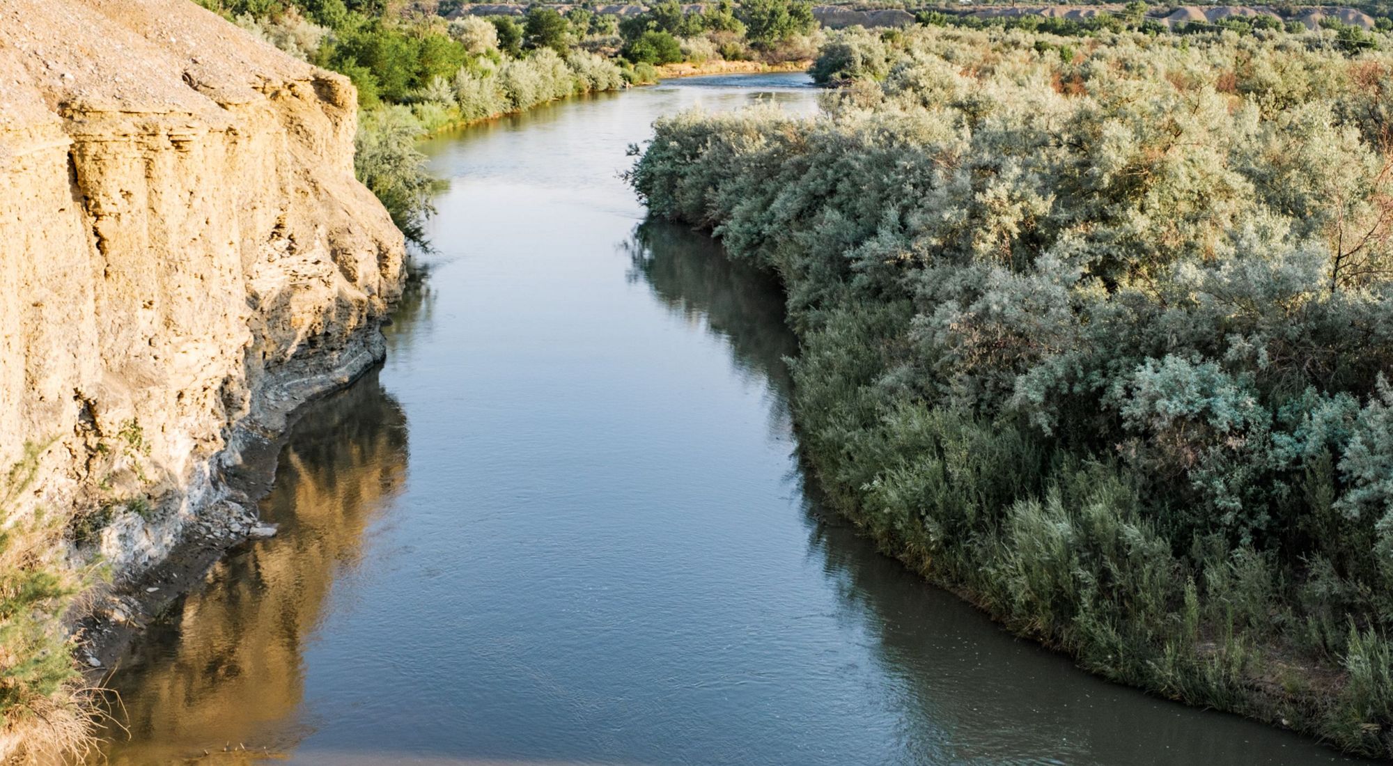
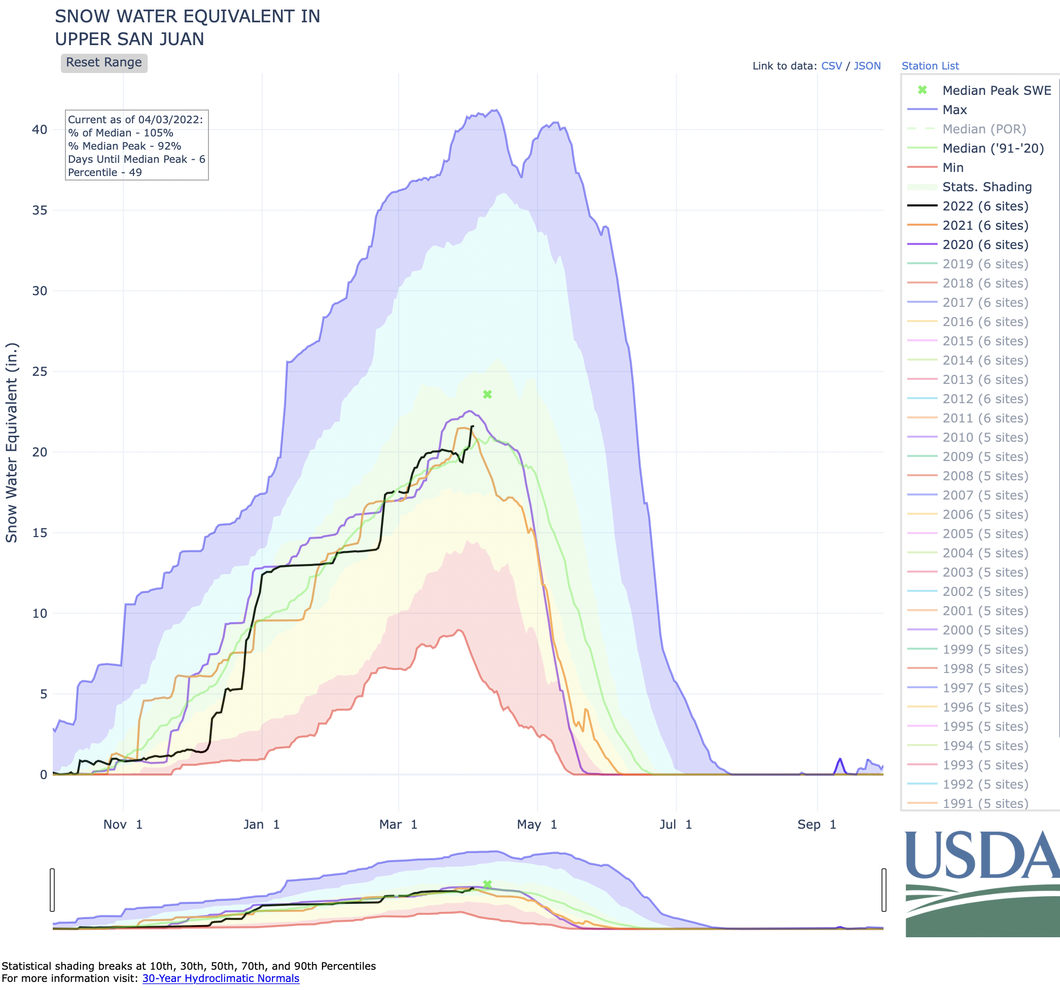
Low snowpack and soaring temperatures made 2020 the third-driest year on record in Colorado. When similar conditions repeated in 2021, tribal farmers in southwest Colorado had to scramble, fallowing thousands of acres of land and laying off workers at the Ute Mountain Ute Tribe’s farm and ranch outside of Cortez.

“It made me very aware that our farm is in the desert. We have to look at it that way,” says Simon Martinez, general manager for the Ute Mountain Ute Tribe Farm and Ranch Enterprise and the Bow and Arrow Brand non-GMO cornmeal business. The 7,700-acre farm is located on the tribe’s 553,008-acre reservation in southwest Colorado, less than 20 miles from the Four Corners.

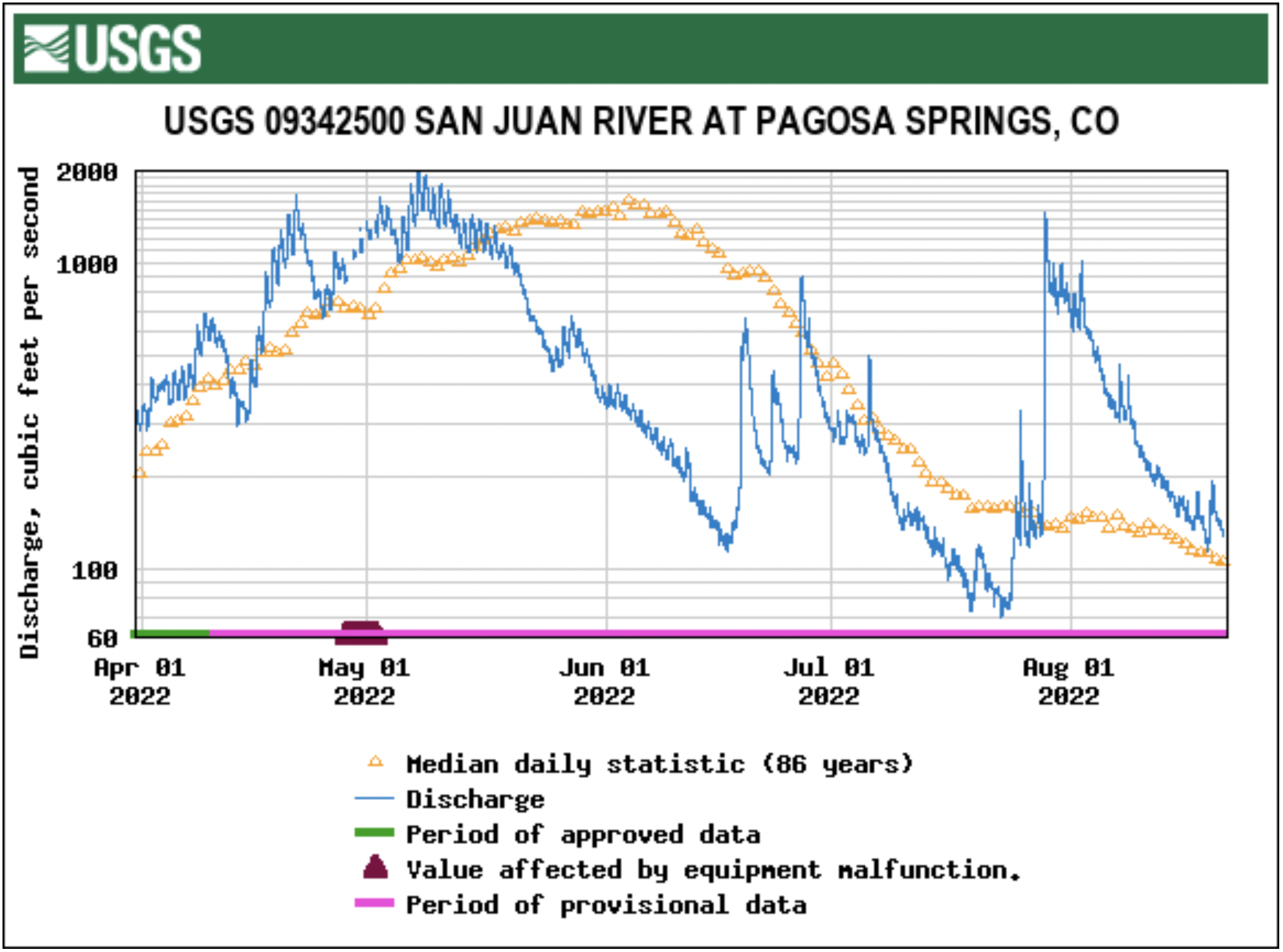
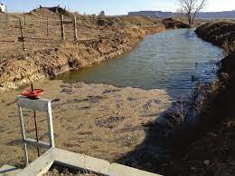
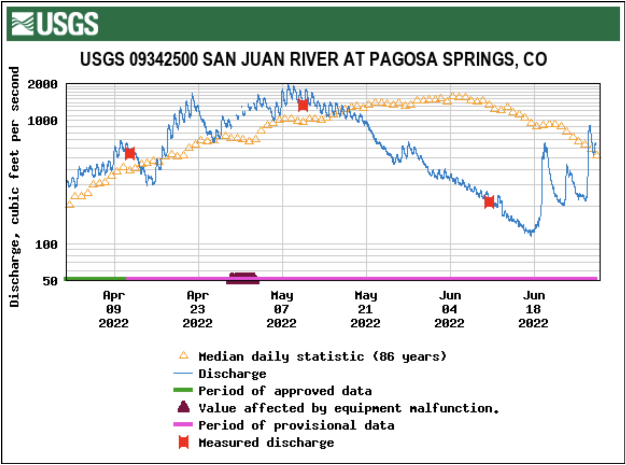
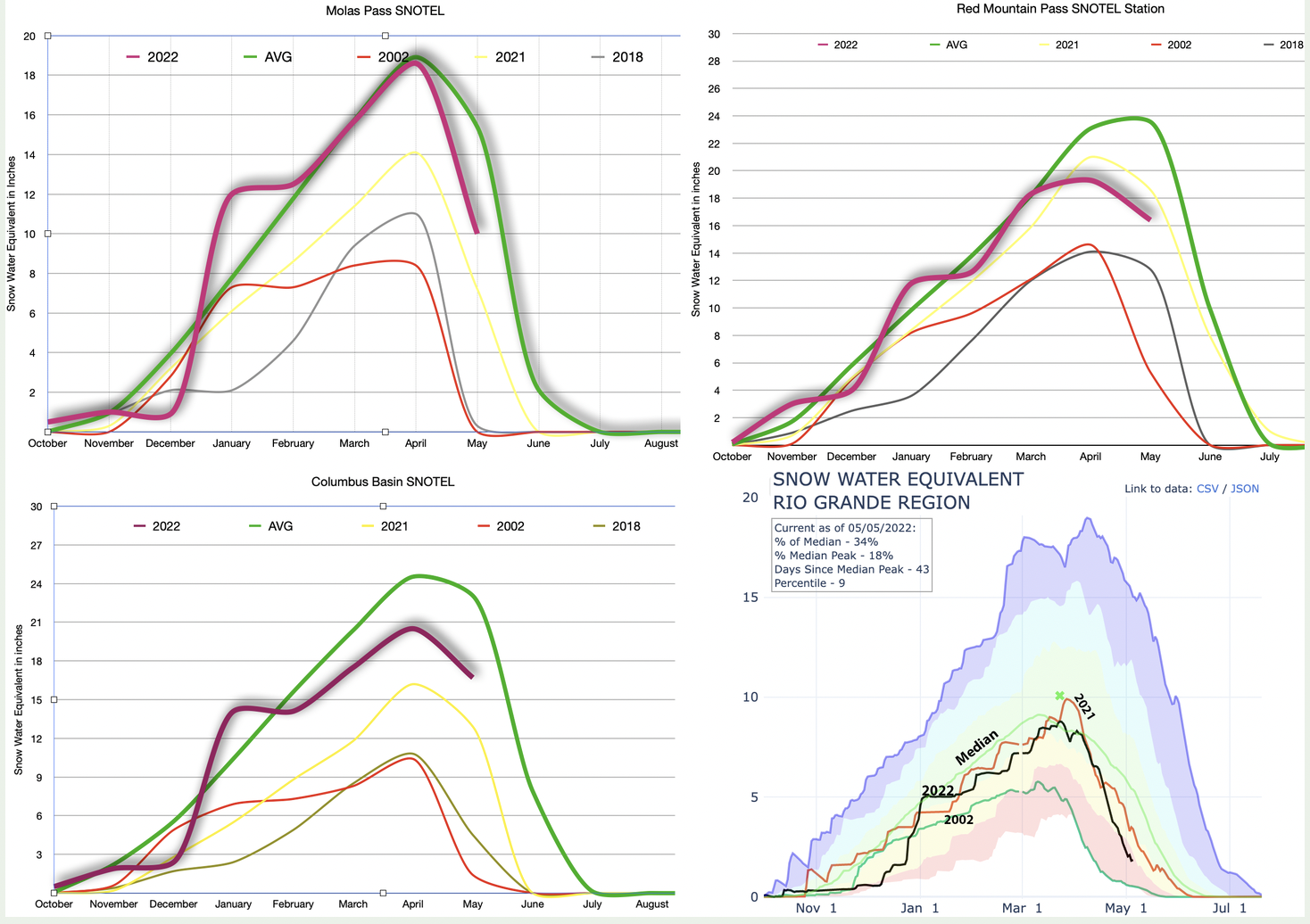
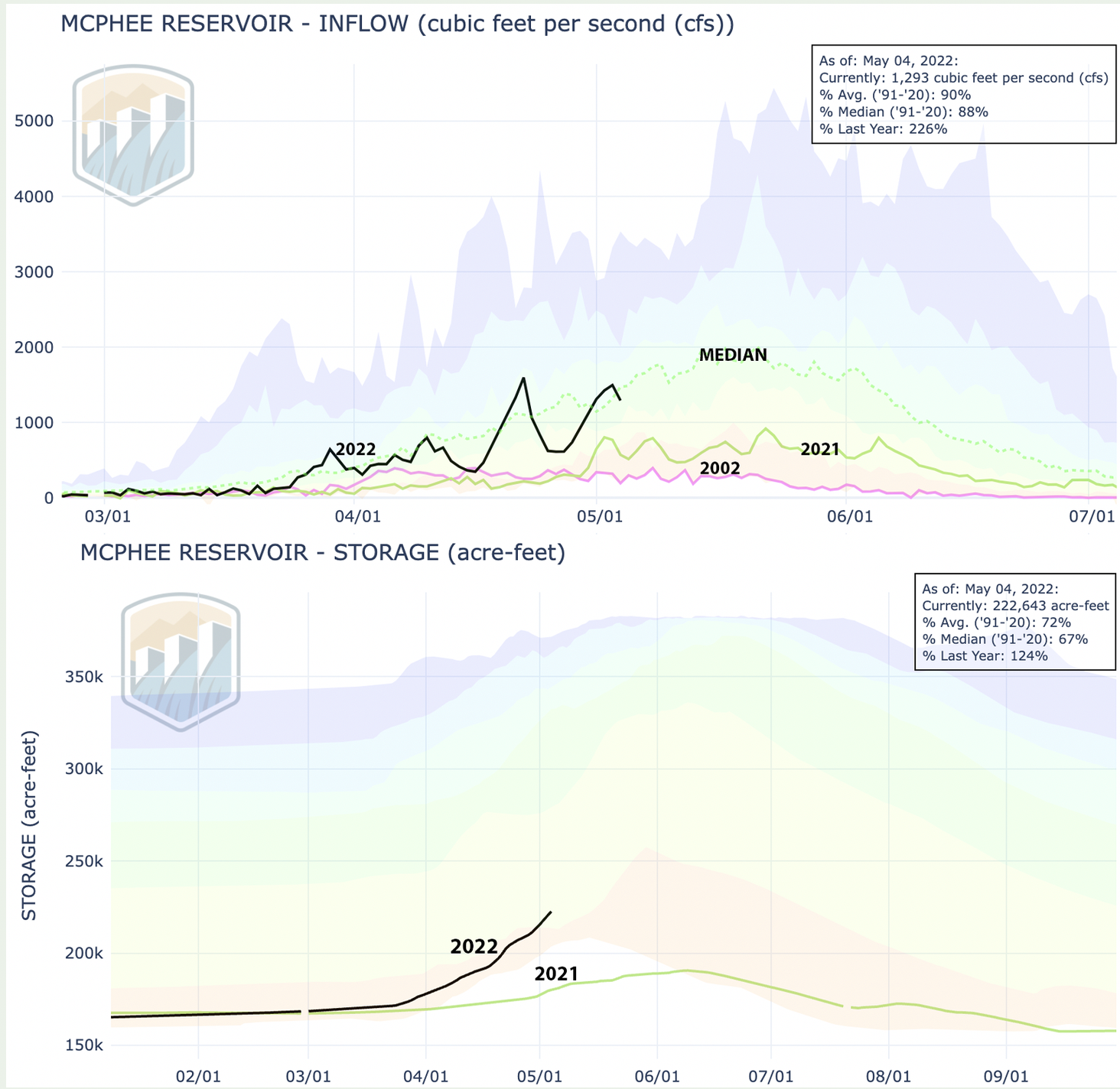
When Dolores River flows below McPhee Reservoir were reduced to just 10% of normal in 2021, the tribe was able to operate only eight center pivot sprinklers, compared to its usual capacity of 110 sprinklers. A single center pivot sprinkler system irrigates circles of crops ranging from 32 to 141 acres in area. Lack of water meant fallowed acres, leaving the tribe to use only 500 acres in 2021, compared to 4,500 acres of alfalfa alone grown in 2020.

Without irrigation water, the farm’s ability to grow its mainstay crops of alfalfa and corn was majorly reduced, and without crops to harvest, employment, too, was cut to 50%. Twenty farm workers lost their jobs.

This year the tribe is expecting slightly more water, 20% to 25% of its normal allocation, or roughly 6,000 acre-feet of water, according to Mike Preston, president of the Weenuch-u’ Development Corporation, which oversees the farm’s operations. But some 6,000 acres of its 7,700-acre farm remain fallowed, a situation that requires the tribe to spend millions of dollars to keep weeds in check.

There is also hope in rising wheat prices, which are expected to reach $11.16 a bushel by December, according to Wall Street Journal crop pricing data. Preston said the tribe hopes to plant a late wheat crop this year to capitalize on the world-wide wheat shortages triggered by the war in Ukraine.

Overall, the tribe’s farm and ranch enterprises operate for economic empowerment and employment. And operations are largely successful—before the drought, the farm had been productive and profitable since it began operating in the late 1980s.

For Bow and Arrow Brand, operations didn’t slow, even last year. The cornmeal operation was launched years ago in order to stretch the shelf life of the tribe’s corn. Fresh sweet corn can last about two weeks, but by creating cornmeal, the produce remains profitable for around 18 months. Even during the drought and pandemic, sales continue. Full staff employment has been maintained.

Sustaining everything has been a challenge, but Martinez is up for the challenge, as he must be, he says. “We’re going to do our best to keep employment.”

Some help and funding is available to make up for losses, such as drought impact funding. And Martinez is working to help the farm adapt. He’s spreading the limited amount of water as far as possible through work with the Natural Resources Conservation Service to upgrade sprinkler nozzle packages and continued consultations with agronomists on crop selection for increased drought tolerance. But those efforts can only go so far.

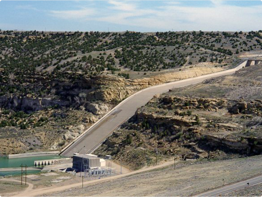
Martinez is hopeful that McPhee, the third-largest reservoir in Colorado, which serves the tribe, will see its water levels restored to meet tribal needs.

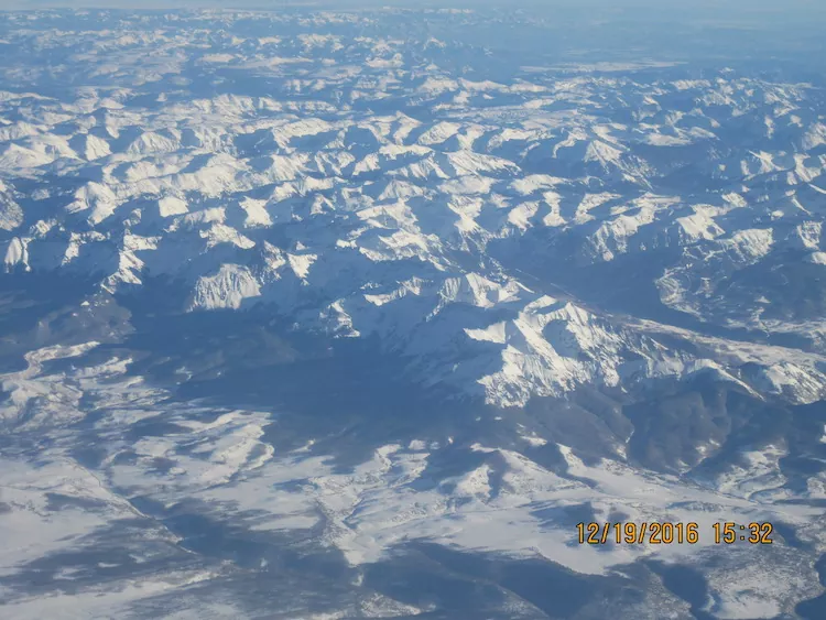
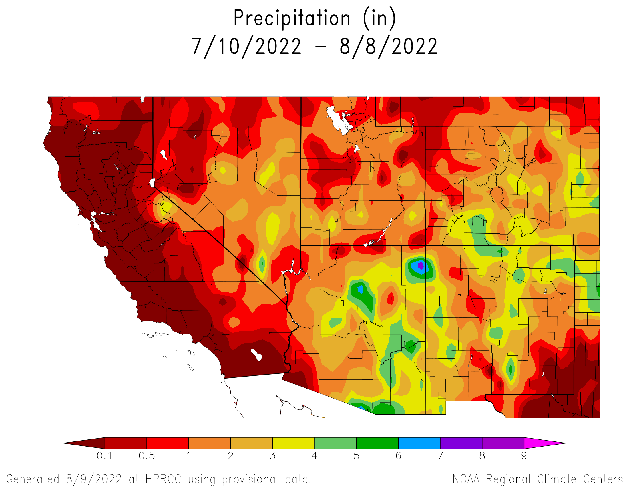
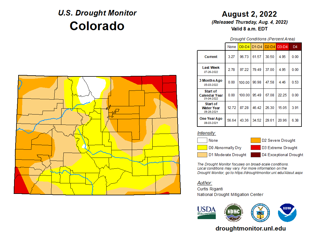
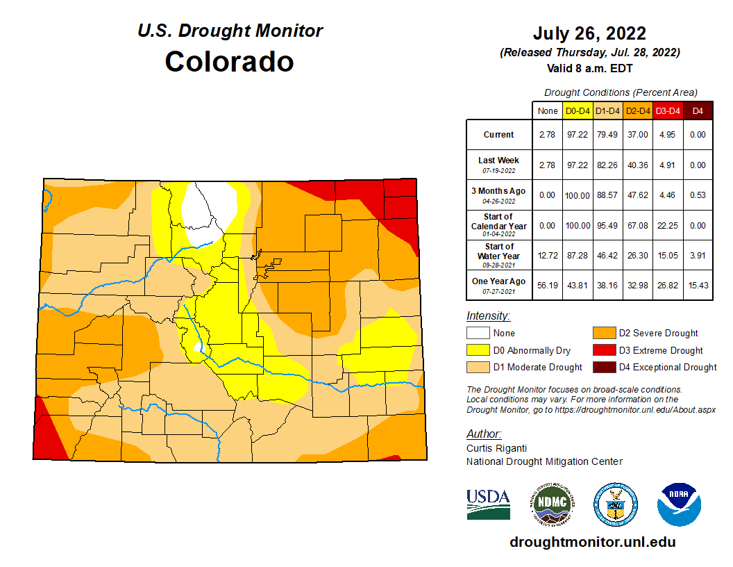
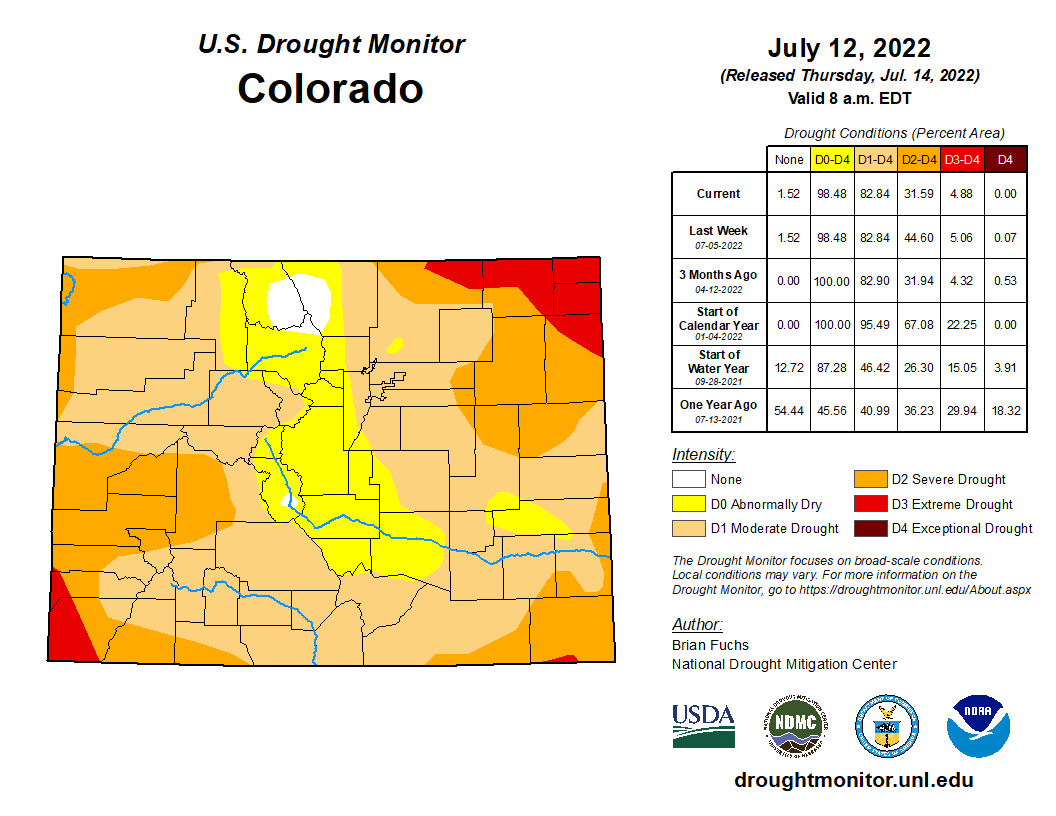
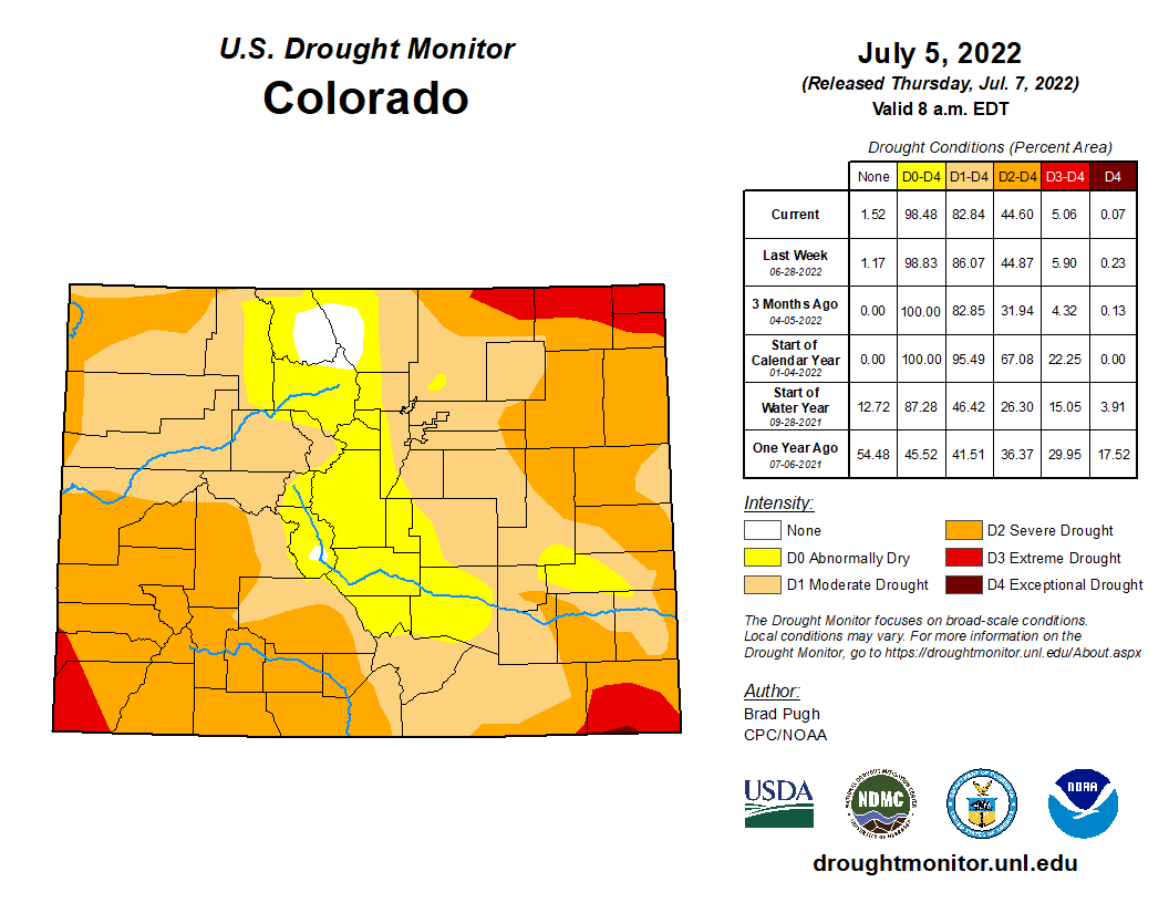
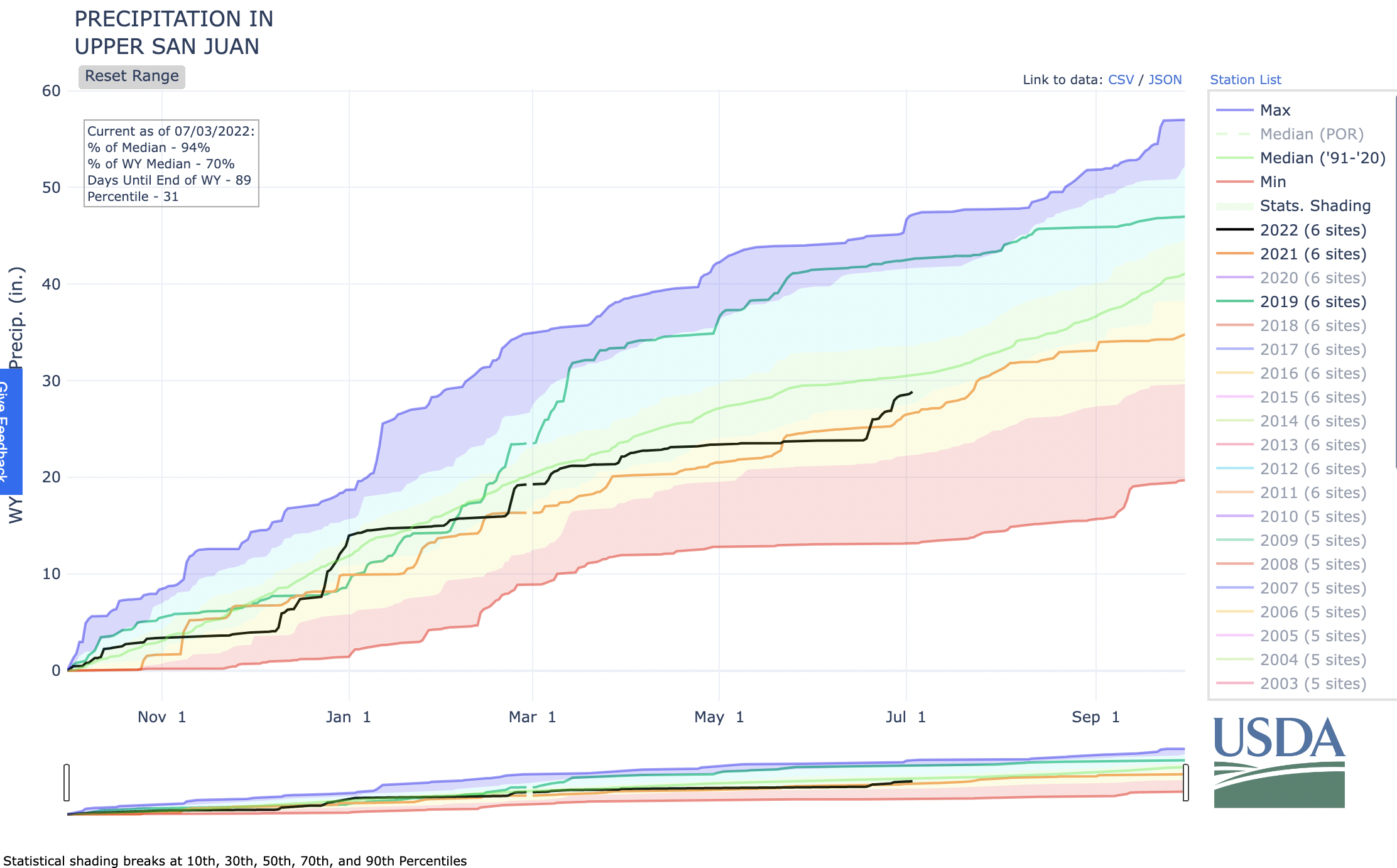
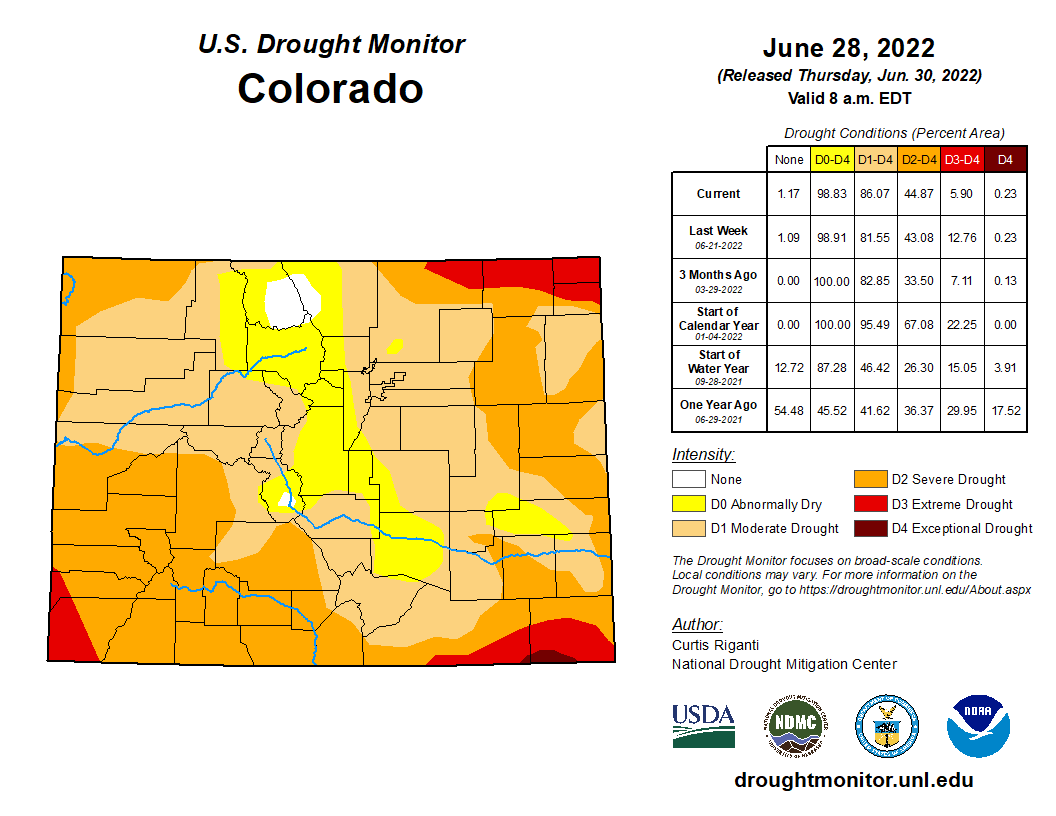
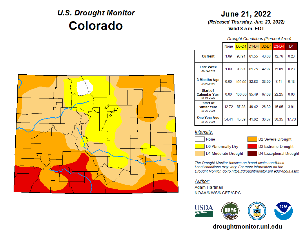
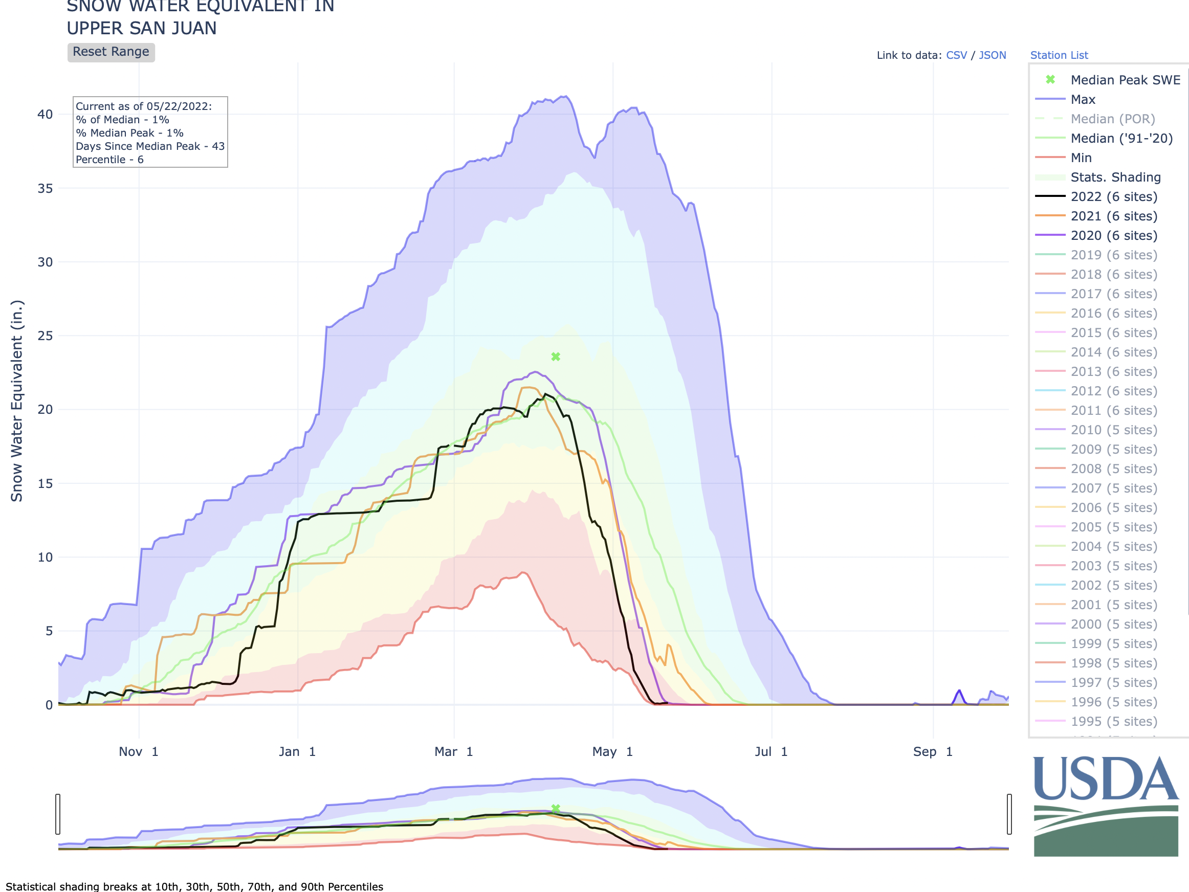
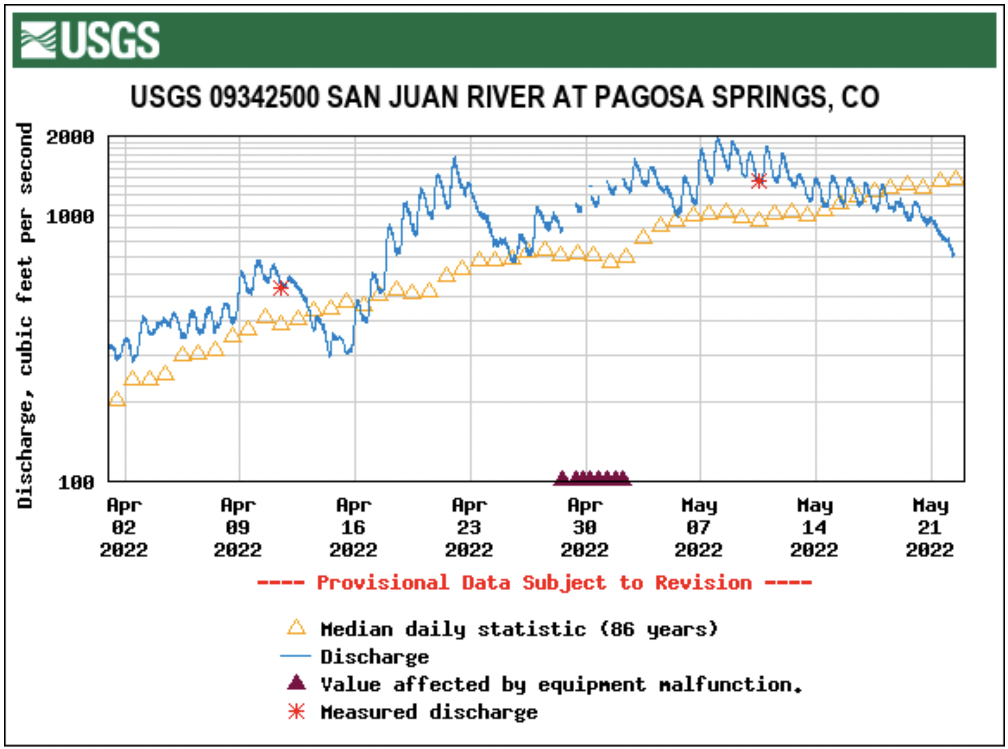
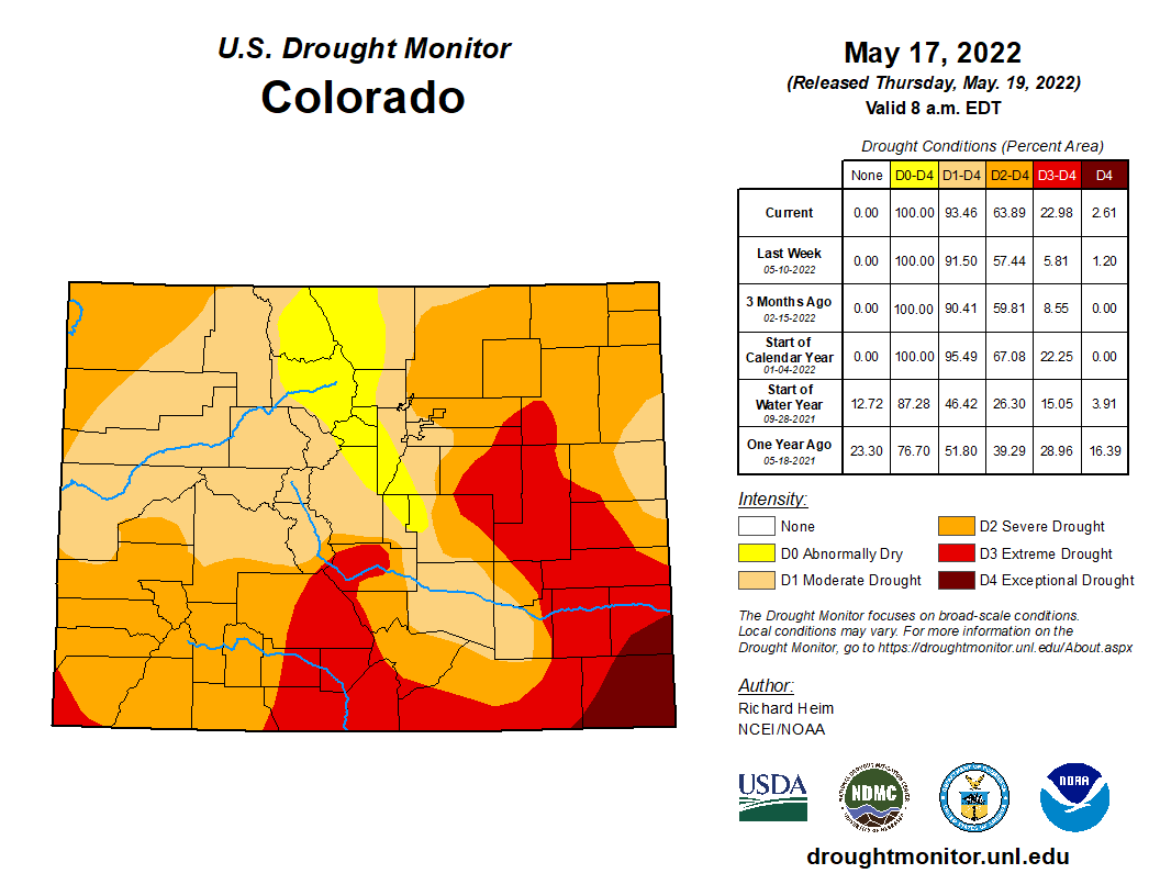
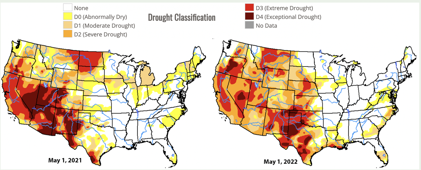
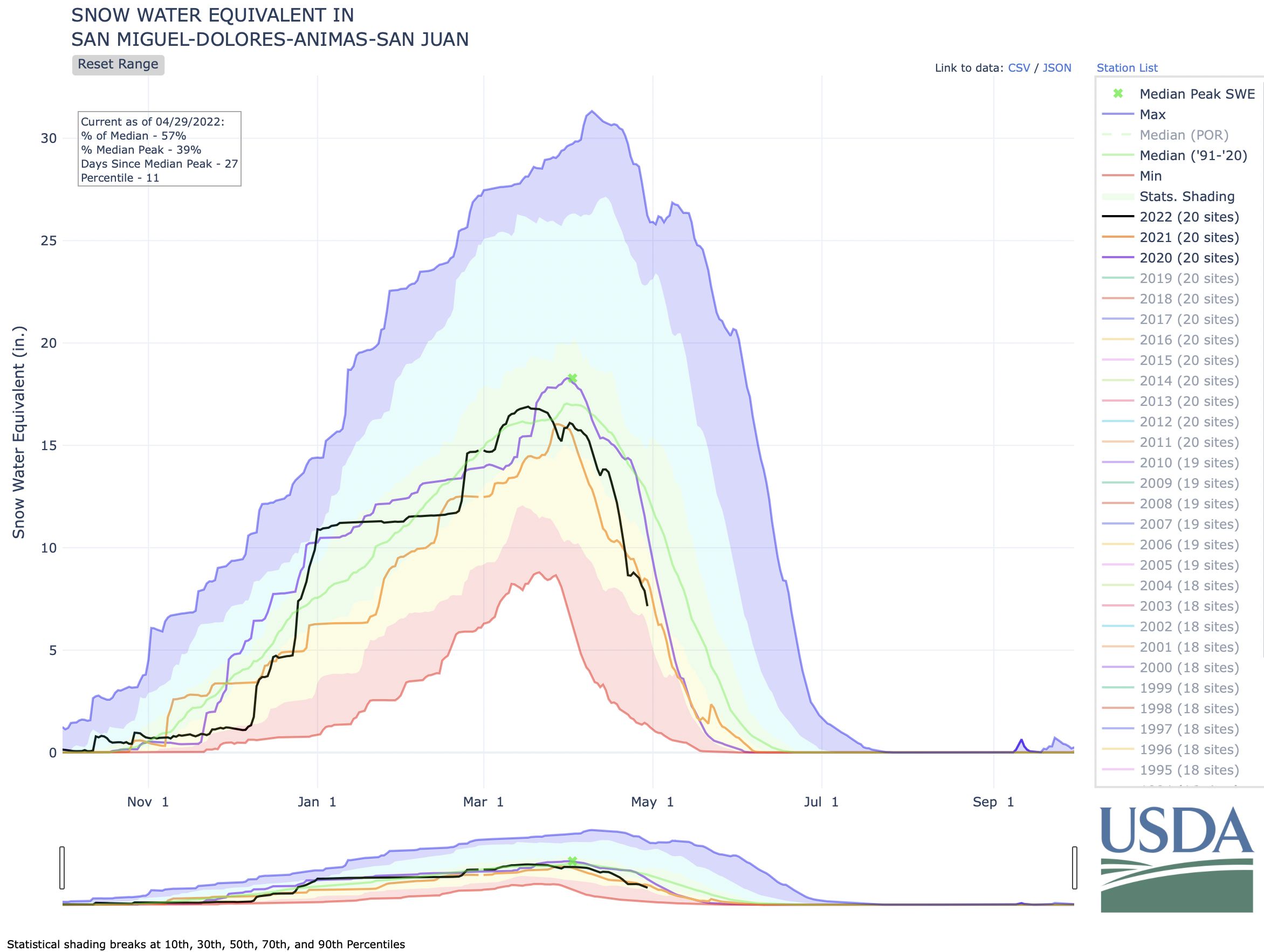
“We’re kind of teetering on the brink,” says Preston. The Dolores River watershed relies entirely on snowpack. But conditions aren’t looking great—100% of Montezuma county remains in severe or extreme drought, according to the National Drought Mitigation Center. Forecasts for the Dolores River Basin, as of June 1, project 45% to 60% of water supply availability this year, according to the Colorado River Basin Forecast Center.

What seems clear to many in the region is that desert-like conditions are likely to continue and that means the Ute Mountain Utes must shift their operating plans to accommodate drier conditions.

“We’ve got to adapt,” Martinez says.

An earlier version of this article appeared in the Spring 2022 edition of Headwaters magazine. Additional reporting was contributed by Fresh Water News Editor Jerd Smith.

Rachelle Todea is Diné and a citizen of the Navajo Nation. She is a freelance reporter based in Westminster, Colo., who reports on climate change and Indigenous peoples.

Cisco Resort and other water buffalo oddities: A 1946 report called for the #ColoradoRiver System to be dammed, diverted, and industrialized — @Land_Desk #COriver

The Colorado River from Navajo Bridge below Lee’s Ferry and Glen Canyon Dam. The proposed Marble Canyon Dam would have been just downstream from here. Jonathan P. Thompson photo.

Click the link to read the article on The Land Desk website (Jonathan Thompson):

Reading and listening to accounts of running the Colorado River and its tributaries before the dams came can be heartbreaking because it reminds us of all that has been lost. Imagine what Tiyo, the Hopi boy who piloted a cottonwood raft from somewhere in Glen Canyon to the Sea of Cortez long, long ago, saw on his journey. Consider the experiences of John Wesley Powell, E.C. La Rue, Emery Goodridge, Bert Loper, and, albeit not on a boat, Everett Ruess. Those experiences cannot be duplicated, even in some modern form. Where once ran water wild and free, now are still and stagnant reservoirs held back by giant, concrete monoliths.

But sometimes when I read old papers about the Colorado River Basin, I become grateful, as well, knowing that it could have been a heck of a lot worse. Such is my experience recently as I’ve made my way through the 1946 Bureau of Reclamation report titled: The Colorado River: A Natural Menace Becomes a National Resource1.

The rather off-putting name, aside, the 300-page report is a fascinating read, chock full of information about population in the Basin, industries, and so forth. But it’s also a blueprint for plumbing the Colorado River system, from the headwaters to the Sea of Cortez, with diversions, dams, canals, hydropower plants, tunnels, and trans-basin exports. That’s the insane part.

As I read the report, instead of envisioning all that had been lost to development, I imagined what the West would look like had the water buffalos realized all of their dam dreams. It’s scary. Nary a mile of river would have remained unaltered. They had plans for dams in the Grand Canyon, in Glen Canyon, in Cataract Canyon; on the Green and the Yampa; in Echo Park and in the Goosenecks of the San Juan; and, perhaps most byzantine, the Animas-La Plata project (which I’ll get to in a moment). But first, a little sampling of potential projects:

  • The Glen Canyon Project: The proposal is similar to what was eventually realized. Notable quote from the report: “This lake would have unusual recreational opportunities.”
  • Dark Canyon Project: This dam would have been on the Colorado River a few miles above the current Hite bridge and the reservoir would have inundated all of Cataract Canyon and stretched to the edge of Moab and almost to Green River.
  • The Moab Project: A dam on the Colorado just upstream from Moab with a reservoir stretching all the way to the Dewey Bridge.
  • Dewey Project: A dam on the Colorado three miles downstream from its confluence with the Dolores River. The 8.2 million acre feet reservoir would have extended 55 miles up the Colorado and 20 miles up the Dolores and would have inundated Cisco. From the report:

    “The town of Cisco, population 53, lies entirely within the reservoir site but if relocated on the reservoir shore line and on both a railroad and transcontinental highway, it should have ample opportunity to become a resort center.”

  • Echo Park Project: A dam on the Green River 3.5 miles below its confluence with the Yampa with a lake that would inundate Dinosaur National Monument. This is the reservoir David Brower and the Sierra Club—with help from the coal industry, which didn’t want more hydroelectric competition—were able to stop.
  • Bluff Project: A dam on the San Juan River just below Comb Wash. It would have put the town of Bluff under about 100 feet of water.
  • Goosenecks Project: A 500,000 acre foot reservoir with hydroelectric dam some 43 miles downstream from Bluff.
  • Slick Horn Canyon Project: Another San Juan River dam, probably just below Slick Horn Canyon.
  • This diagram showing some of the madness … er, proposed dams … is best viewed at http://LandDesk.org.

    And now for the big doozy: The Animas-La Plata Project in Southwestern Colorado. Now, I know some of you will think, Here he goes, talking about the Animas River again. And, yeah, I get it. But as crazy as all of the aforementioned proposals are, this one was more complex and convoluted and involved than any of the others.

    From 1946 “Menace” report, USBR. Credit: The Land Desk

    The Animas-La Plata project was first conceived of in the early 1900s. It was intended to move water from Animas River to the “Dry Side” in the La Plata River watershed, about a dozen miles west of the Animas. The Dry Side has oodles of fertile, flat farmland, but not enough water to irrigate it; the Animas Basin has relatively reliable and abundant flows of water, but not a lot of farmable land. The A-LP would provide “supplemental water for 24,700 acres of insufficiently irrigated land in the La Plata River Basin and a full supply for 86,300 acres of new land in that basin and adjacent areas, including 25,500 acres under the Monument Rock project on the Navajo Indian Reservation.”

    You might think this would be simple: Just tunnel through the divide between the two watersheds and send the water through. But that’s not nearly as fun as building nine reservoirs, miles of canals and tunnels and conduits, and a handful of hydropower plants. Here’s the rundown:

  • An aqueduct would be built near Silverton to catch water from Mineral Creek and Cement Creek and deliver it to the 54,000 acre feet Howardsville Reservoir on the Animas upstream from Silverton. From there, a pressure conduit would send water to a 12 megawatt power plant in Silverton.
  • A dam on the Animas at Whitehead Gulch, about four miles below Silverton. Silverton Reservoir would only be about three miles long (and would not inundate Silverton, but would flood the railroad tracks), as its main purpose is for hydropower production and to divert water through a tunnel to the Lime Creek drainage, where …
  • … another dam would be built, presumably just above the confluence with Cascade Creek. In addition to the water from Silverton Reservoir, the Lime Creek Reservoir would also get “unregulated inflows from Cascade Creek through a collection conduit and tunnel.” And, from Lime Creek another tunnel would lead back through the West Needles to a power plant on the Animas River w/ a static head of 1,155 feet and installed capacity of 40 megawatts. Wow.
  • The dam for the 140,000 acre feet Teft Reservoir would be on the Animas River somewhere below Tefft (the proper spelling) Spur (close to the Cascade Wye). Maybe it would be in the Rockwood Gorge, but I’m not sure. Water would back up into Cascade Creek and, most likely, would inundate Needleton. The railroad tracks would be underwater.
  • The main project canal—the one that takes water over to the La Plata—would begin at or just below Teft Dam and go along the west side of the Animas River, intercepting the flows of Hermosa, Junction, and Lightner Creeks, along with storage releases from …
  • … Hermosa Park Reservoir (25,000 acre feet) on Hermosa Creek. That would add an interesting twist to skiing the backside of Purgatory. Ice skating, anyone?
  • Whether the canal would skirt Durango, or would cross higher ground west of Durango is not clear. But somehow it would wend its way westward, and would “cross the Animas-La Plata Divide northeast of Fort Lewis College and extend across the La Plata River Valley to the Dry Side. It would continue southwest along the Mancos-La Plata Divide to the head of Salt Creek,” which in turn would serve the …
  • … Monument Rocks Reservoir (20,000 af) and project lands below it, located north of Shiprock.
  • Long Hollow Reservoir (14,000 af) would be “connected the La Plata River by inlet and outlet canals.” Another canal from Long Hollow would irrigate the McDermott-Farmington Glade area near Colorado-New Mexico state line. (Note: This is the only component of the 1946 plan that got built).
  • State Line Reservoir (32,000 af) would straddle the State Line on the La Plata River. A canal would lead from there to the southwest to …
  • … Meadows Reservoir (11,400 af).
  • The Land Desk’s rendering of the 1946 description of the proposed Animas-La Plata Project in Southwest Colorado. Legend: Pink Box=Dam; Blue Line=River/Creek; Green Line=Canal; Dotted Black-Orange Line=Tunnel.
    Lake Nighthorse and Durango March 2016 photo via Greg Hobbs.

    The Animas-La Plata Project ultimately was built, but it looks nothing like this. It’s a single off-stream reservoir, Lake Nighthorse, filled with water pumped uphill from the Animas River. A small amount of water is piped westward, but it doesn’t make it to the Dry Side. In fact, the water—much of which belongs to the Ute Mountain Ute and Southern Ute Tribes—mostly is just sitting there, providing a nice place for Durangoans to cool off on hot summer days. There currently is no mechanism for delivering the water to the tribes. Long Hollow Reservoir was also constructed later, but separately from the A-LP.

    Excerpt from the 1946 “Menace” report. Credit: The Land Desk

    Most of the other projects on the water buffalo wishlist didn’t come to fruition, either, and Cisco, Utah, won’t be a lakeside resort town anytime soon.

    The Land Desk is about to take the old Silver Bullet on the road to do some reporting. You know how we fund this stuff? With your subscriptions! We got no ads, no corporate sponsors, no fancy grants — just you (which is a lot). So, yeah, the Bullet is pretty darned fuel efficient, but still with gas prices these days? We sure could use your help. Thanks! — Subscribe

    #AnimasRiver #water quality is improving in #Durango, study shows — The Durango Herald #SanJuanRiver #ColoradoRiver #COriver

    Upgrades made to the Santa Rita Water Reclamation Facility have improved water quality in the Animas River. Reduced nutrients and E. coli make the river safer for recreationists and limit impacts on aquatic life. (Courtesy of Mountain Studies Institute)

    Click the link to read the article on The Durango Herald website (Aedan Hannon). Here’s an excerpt:

    A study by Mountain Studies Institute, the city of Durango and the Colorado Department of Public Health and Environment released late last year has revealed that upgrades made to the Santa Rita Water Reclamation Facility from 2017 to 2020 have improved water quality in the Animas River. The improvements have decreased the nutrients and bacteria the reclamation facility discharges into the Animas River, creating a healthier ecosystem for aquatic life and making the river safer for recreation…

    The improvements were extensive and included new headworks, which is where the wastewater enters the plant, secondary processing infrastructure and an ultraviolet disinfection system. They completely changed parts of the water treatment process at Santa Rita. From 2017 to 2020, the city, CDPHE and MSI conducted a study to quantify the water quality improvements in the Animas River from the facility’s upgrades as a part of CDPHE’s Measurable Results Program. They took water samples above and below Santa Rita, as well as at the point where the facility discharged treated water back into the river, and measured the concentrations of nutrients and E. coli.

    The changes were significant.

    The study found the upgrades reduced phosphorous by 93%, nitrogen by 59% and E. coli by 90% in the water the treatment plant releases into the Animas. Santa Rita’s May 2020 permit allowed for 100 mg/L of nitrogen in the water it released. After the improvements, it was releasing 7.16 mg/L. For E. coli, the facility’s permit allows 1,756 mpn/ml. With the new UV system, it now releases less than 10 mpn/ml, Elkins said. Mpn/ml stands for most probable number per milliliter and is a measurement of the concentration of bacteria in water.

    “That should give you an idea of how well we’re doing,” Elkins said.

    Upper #SanJuanRiver #drought #snowpack #runoff conditions (May 22, 2022) — The #PagosaSprings Sun #ColoradoRiver #COriver #aridification

    Click the link to read the article on the Pagosa Sun website (Josh Pike). Here’s an excerpt:

    A May 16 press release from Pagosa Area Water and Sanitation District (PAWSD) District Manager Justin Ramsey urges residents to reduce water consumption due to worsening drought conditions.

    It states, “The NRCS SnoTel station reached a Snow Water Equivalency (SWE) of 0” on May 10th a full three weeks quicker than the median. The median date for reaching a SWE of 0” is May 31st.

    “Per the Districts Drought Management Plan we would have triggered the Voluntary Drought Stage had the SWE occurred 2 days earlier on the 8th of May.

    “Although we are not in a Voluntary Drought Stage, the unseasonably high temperatures and winds will make for a high water use season. Our weekly water use has increased by 2 million gallons over last years weekly usage.

    “The District is requesting everyone conserve water and use outside irrigation sparingly. Please do not water between 9:00 am and 6:00 pm. Watering during the hottest part of the day wastes water as a significant portion of the irrigation water evaporates prior to percolating into the soil, wasting not only water but your money.

    Drought outlook

    Stream flow for the San Juan River on May 18 at approximately 9 a.m. was 1,120 cubic feet per second (cfs), according to the U.S. Geologi- cal Service (USGS) National Water Dashboard, down from a nighttime peak of 1,320 cfs at 2 a.m.

    These numbers are down from May 11, when the river flow was at 1,390 cfs at 9:15 a.m. with a nighttime peak of 1,830 cfs at 12:15 a.m.
    As referenced in Ramsey’s press release, the U.S. Department of Agriculture (USDA) National Water and Climate Center’s snowpack report at the Wolf Creek summit, at 11,000 feet of elevation, had zero inches of snow water equivalent as of 11 a.m. on Wednesday, May 18. The report also notes that the San Miguel, Dolores, Animas and San Juan river basins were at 4 percent of the May 18 median in terms of snowpack.

    Colorado Drought Monitor map May 17, 2022.

    Upper #SanJuan River #snowpack, #runoff, and #drought report: The Upper San Juan is pretty much melted-out — The #PagosaSprings Sun #ColoradoRiver #COriver #aridification

    Click the link to read the article on the Pagosa Springs Sun website (Josh Pike). Here’s an excerpt:

    Stream flow for the San Juan River peaked on May 8 at approximately midnight at 1,970 cubic feet per second (cfs), according to the U.S. Geological Service (USGS) National Water Dashboard. This peak matches almost exactly the timing of last year’s peak flow of 1,280 cfs, which occurred on May 8 at approximately 1 a.m. As of 10:45 a.m. on May 11, the river flow was at 1,360 cfs, down from a nighttime peak of 1,830 cfs at 12:15 a.m.

    According to the U.S. Department of Agriculture (USDA) National Water and Climate Center’s snowpack report, the Wolf Creek summit, at 11,000 feet of elevation, had 9.9 inches of snow water equivalent as of noon on Wednesday, May 11. The Wolf Creek summit is at 30 percent of the May 11 snowpack median. The San Miguel, Dolores, Animas and San Juan river basins were at 19 percent of the May 11 median in terms of snowpack.

    Colorado Drought Monitor map May 10, 2022.

    The National Oceanic and Atmospheric Administration’s (NOAA) National Integrated Drought Information System (NIDIS) reports that 100 percent of the county is experiencing drought, with April 2022 being the eighth driest April in 128 years, with 1.22 fewer inches of precipitation than normal, and with 2022 being the 11th driest year in the last 128 years, with 4.15 inches of precipitation below normal. The NIDIS places the entire county in a moderate drought, which the website notes may cause rangeland growth to be stunted, very little hay to be available, dryland crops to suf fer and wildfires to increase. The NIDIS also shows 18.8 percent of the county, primarily on the southern edge, in a severe drought, which may cause farmers to reduce planting, producers to sell cattle and the wildfire season to be ex tended. The NIDIS also notes that a severe drought is associated with low snowpack and surface-water levels and reduced river flow.

    Westwide SNOTEL basin-filled map May 14, 2022 via the NRCS.

    #Aridification Watch: May edition As the snow season wraps up, how are things looking? — @Land_Desk #snowpack #runoff

    Click the link to read the article on The Land Desk website (Jonathan Thompson) and to drop some dough in the tip jar:

    It’s that time of the year, again, folks. Yep, you guessed it, it’s … Yukigata Time! Okay, maybe you didn’t guess it. Maybe you have no idea what the word even means. But I’m willing to bet you are familiar with the concept and, if you are a farmer or a gardener, you probably use a yukigata.

    A yukigata is a pattern formed by melting snow on a mountain slope or hillside in the spring. They often serve as agricultural calendars, letting farmers know when to plant certain crops, or when the danger of a tomato-killing freeze has passed. The calendars can be simple: over in the Montezuma Valley gardeners wait until Ute Mountain is free of snow to plant. Or more elaborate: In the Grand Valley of Colorado, it would be foolish to plant before the Swan’s Neck has melted. And in the North Fork Valley of Western Colorado, gardeners wait for the Devil’s Neck on Mt. Lamborn to “break.”

    But the yukigatas have been doing their thing, or disappearing, sooner than in the past, tricking people into planting too early and making their crops vulnerable to the inevitable spring freeze. In Durango, Colorado, for example, gardeners once planted according to when the snow melted off the north face of Smelter Mountain. Now that can happen as soon as March—if there’s snow on the mountain at all—which is just too early.

    This also messes with plants’ internal calendars, tricking fruit trees into blossoming too early. A study published this spring found wildflowers in the sagebrush ecosystem now bloom weeks earlier than they did in the 1970s. And here’s a cool map from the National Phenology Network showing where trees leafed out earlier (or later) than usual this year.

    Clearly the premature melting of the yukigata is caused by less snow to begin with combined with warming temperatures. Dust on the snow causes it to melt faster, too. As does, wait for it, atmospheric thirst! That’s right, the increasing temperatures are making the atmosphere thirstier, and it’s guzzling up snow, drying out plants, sucking up reservoirs, and so on. Last month, scientists from the Desert Research Institute published a study tracking changes in evaporative demand and found it is increasing everywhere, especially in the Southwest.

    As evaporative demand increases, it pulls more water from the land into the air via evaporation and transpiration from plants (and snow and reservoirs), leaving less in the streams and soil. In the Rio Grande Basin, the authors say, that means crops need 8% to 15% more irrigation now than they did in 1980. They go on to note, “These increases in crop water requirements are coincident with declining runoff ratios on the Rio Grande due to warming temperatures and increased evaporative losses, representing a compounding stress on water supplies.”

    The authors conclude:

    “These higher evaporative demands mean that, for every drop of precipitation that falls, less water is likely to drain into streams, wetlands, and aquifers across the region. Soils and vegetation spend more time in drier conditions, increasing potential for forest fire, tree mortality, and tree regeneration failure.”

    So the thirsty atmosphere is likely a factor in the catastrophic fires currently burning in New Mexico. The Hermits Peak Fire—in the Pecos River watershed, east of the Rio Grande—has grown to a monstrous 166,000 acres and is threatening Las Vegas, Mora, and Montezuma.

    This year neither the Rio Grande nor the Pecos watershed has done all that well, snowpack-wise. Not many watersheds have, although Southwest Colorado is in better shape than it was last year. Snow season is pretty much over. That doesn’t mean it won’t snow any more in the high country. It’s just that the snowpack peak has almost certainly passed, runoff is underway, and many lower elevation SNOTEL stations are registering zero, which can throw off basin-wide graphs. So, below we offer the snowpack season finale with May 1 readings at our three go-to high country SNOTEL , plus the current graph for the Rio Grande Basin.

    The bright spot is definitely Columbus Basin, high in the La Plata Mountains. It’s below the average level for the period of record, but still doing far better than 2021. The La Platas feed the Animas, La Plata, Mancos, and Dolores Rivers. Last year the Dolores had an awful year. Things are looking up this time around—relatively speaking. The Dolores River through its namesake town shot up to 1,800 cfs at one point, dropped, then shot back up again, pushing up levels at McPhee significantly. Still, don’t goo excited. McPhee’s only at 59% of capacity and water managers are releasing virtually nothing from the dam.

    River runners better get out on the water now, while they still can.

    Native American tribes assert #water rights on #ColoradoRiver Basin: 1922 compact that divided the water between states left out tribes, which own 25% rights — The #Cortez Journal #COriver #aridification

    Lake Nighthorse in the Ridges Basin in La Plata County, Colorado. The view is from the overlook on County Road 210. By Jeffrey Beall – Own work, CC BY 4.0, https://commons.wikimedia.org/w/index.php?curid=81402953

    Click the link to read the article on The Cortez Journal website (Jim Mimiaga). Here’s an excerpt:

    Ute Mountain Chairman Manuel Heart and Southern Ute Council member Lorelei Cloud presented their perspectives and plans for water management during a session of the Southwestern Water Conservation District’s annual meeting Friday [April 22, 2022] in Durango. The tribes were not invited to the discussions when the states and federal government divided water rights in the West during the early 20th century. Native Americans did not gain U.S. citizenship until two years after the 1922 Colorado River Compact divided Colorado River water between upper and lower basins.

    Cloud said the Southern Ute Tribe has 129,000 acre-feet per year of federally reserved water rights on seven rivers that run through its reservation, but they only have the capacity to divert 40,600 acre-feet per year. The tribe stores water in Vallecito, Lemon and Lake Nighthorse Reservoirs.

    The tribe recently built a reservoir to store water for its water treatment plant, which serves 500 households, many of which are nontribal homes in the checkerboard area of the reservation that includes private and tribal lands. The new reservoir allows for a 30-day reserve, up from one-day reserve. Water storage at the treatment plant is critical because it is served by the tribe’s junior water rights on the Pine River, which are vulnerable to calls from senior right holders…

    In a historic meeting on March 28 in Albuquerque, 20 tribes, including Utes, met with U.S. Department of Interior Secretary Deb Haaland to discuss their involvement with Colorado River Basin water negotiations. Haaland is the first Native American appointed to the post. Cloud said tribes are now at the table to provide input on the Drought Response Operation Agreement set by the Bureau of Reclamation. The guidelines determine how water is released from Colorado River storage reservoirs.

    San Juan River Basin. Graphic credit Wikipedia.

    Latest settlement involving 2015 #GoldKingMine spill to send $90 million for cleanup: Federal officials say they’ll drop their cases against mining companies with the settlement — The #Denver Post

    Bonita Mine acid mine drainage. Photo via the Animas River Stakeholders Group.

    Click the link to read the article on The Denver Post website (Conrad Swanson). Here’s an excerpt:

    The Sunnyside Gold Corporation and its corporate owner will pay about $45 million under yet another settlement connected to the 2015 Gold King Mine spill, which dumped a yellow plume of heavy metals into the Animas River, federal officials announced Friday [April 29, 2022]. The federal government will kick in another $45 million as well. Under the finalized settlement, the company and its Canadian owner, Kinross Gold Corporation, will pay the United States $40.1 million and another $4 million to the Colorado Department of Public Health and Environment for cleanup efforts, Environmental Protection Agency spokesman Rich Mylott said in a release.

    Cleanup is needed in the broader Bonita Peak Mining District Superfund site, in southwest Colorado’s San Juan County. That site includes dozens of abandoned mines, which are polluting the area’s waterways but it’s also the location of the 3-million-gallon spill at the Gold King Mine, which EPA officials triggered…

    Already, cleanup efforts have cost more than $70 million, The Denver Post previously reported. Sunnyside also agreed to a $1.6 million settlement in December and agreed last year to pay $10 million to the Navajo Nation and $11 million to New Mexico, downstream of the mines and spill site.

    The Pagosa Area Water and Sanitation District Board of Directors declines to extend lease for Dry Gulch site — The #PagosaSprings Sun #SanJuanRiver #ColoradoRiver #COriver #aridification

    San Juan Mountains December 19, 2016. Photo credit: Allen Best

    Click the link to read the article on The Pagosa Springs Sun website (Josh Pike):

    …as [Justin] Ramsey explained at the meeting, the Webers had recently approached PAWSD again, hoping to reopen negotiations to extend the lease under terms that were similar to the PAWSD counter offer with some minor changes…

    PAWSD treasurer Glenn Walsh then raised concerns that he had not seen the terms of the proposed lease and that he would be “ex- tremely concerned” if any lease was approved before its terms had been distributed to the PAWSD board…

    [Al] Pfister also mentioned that his priority in considering extending or not extending the lease was its impact on SJWCD’s state park nomination for the site…

    He also mentioned that an ex- tension of the mining lease would likely delay reclamation before stating that he would prefer to not extend the Weber lease so reclama- tion could start immediately…

    After discussion surrounding the motion’s language, the SJWCD board then unanimously voted for a follow-up motion commanding Pfister to work with Ramsey on de- termining the Weber’s responsibili- ties for reclamation and clarifying the meaning of SJWCD’s potential responsibility for long-term man- agement in the IGA.

    #Water managers see runoff as positive sign (April 29, 2022): Heading into summer, forecasts aren’t great, but they are slightly better than last year — The #Durango Herald

    Click the link to read the article on The Durango Herald website (Aedan Hannon). Here’s an excerpt:

    Water forecasts remain below average, but above last year’s troubling lows – a positive sign for water managers adapting to sustained drought in the region. Yet, much will depend on the impact of recent dust events and summer monsoons.

    According to SNOTEL data from the U.S. Department of Agriculture’s National Resources Conservation Service, a little more than half of the snowpack in the San Miguel, Dolores, Animas and San Juan basins has melted so far. Snowpack is measured using the metric of snow water equivalent, or the water content of the snow.

    The Animas River was flowing at 669 cubic feet per second in Durango on Wednesday afternoon, the Dolores River at 556 cfs in Dolores and the San Juan River at 895 cfs, according to Colorado Basin River Forecast Center data. Southwest Colorado’s rivers have slowed since Friday, but the Colorado Basin River Forecast Center predicts that flows will again increase over the next week and a half. Forecasts show the Animas River will peak at 3,100 cfs in late May or early June, slightly above last year’s peak of 2,910 cfs on June 7. Forecasts project peaks of 1,500 cfs for the Dolores River and 1,600 cfs for the San Juan River also in late May and early June…

    Snow is melting earlier than average this year, according to the SNOTEL data, a trend that Wolff and other water managers have noted. Typically, snowpack would peak around April 1 and runoff would last from April through May and even into June, Wolff said…While runoff is happening earlier this year, water supply forecasts suggest more optimism. The Animas, Dolores and San Juan rivers are hovering just above 70% of average, according to Colorado Basin River Forecast Center forecasts…

    Ken Curtis, general manager for the Dolores Water Conservancy District, told Wolff the district was hoping to get at least 70% of its average water.

    Pagosa Springs Sanitation General Improvement District update — The #PagosaSprings Sun

    The springs for which Pagosa Springs was named, photographed in 1874. By Timothy H. O. Sullivan – U.S. National Archives and Records Administration, Public Domain, https://commons.wikimedia.org/w/index.php?curid=17428006

    Click the link to read the article on the Pagosa Springs Sun website (Josh Pike):

    At the April 14 Pagosa Area Water and Sanitation District (PAWSD) board of directors meeting, District Manager Justin Ramsey updated the board on the situation concerning the Pagosa Springs Sanitation General Improvement District (PSSGID).

    Ramsey highlighted that he had met with the Town of Pagosa Springs and PSSGID and that they had together developed an emergency plan if the pumps moving sewage from downtown to the PAWSD Vista Treatment Plant fail. Ramsey also explained that the town is “really frustrated” by the current pumping arrangement and is considering developing a new wastewater treatment facility near the proposed Yamaguchi South Park, which he estimated might cost the town $10 million to $20 million. Meanwhile, Ramsey added, PAWSD is planning state-mandated improvements to the Vista Wastewater Treatment Plant at the cost of $20 million to $30 million.
    Ramsey then suggested the possibility of the town and PAWSD cooperating on developing a plant by Yamaguchi South and reversing the current pipeline from that area to Vista to transport sewage downhill from Vista to the new plant. However, he added that, even if this plan is approved, it would likely be at least eight years before the project would be completed.

    #Colorado, #Utah tribe worries nation’s last uranium mill is contaminating water, causing uptick in illness — The #Denver Post #nuclear

    Energy Fuels’ White Mesa Mill from inside Bears Ears National Monument. Photo credit: Jonathan Thompson

    Click the link to read the article on The Denver Post website (Conrad Swanson). Here’s an excerpt:

    The White Mesa Mill produces refined uranium, vanadium and rare earth compounds used for nuclear fuels, the creation of steel, batteries and electric cars. Toxic compounds left over from the process, called tailings, are poured into massive ponds on site. White Mesa residents take note when smoke rises from the mill and keep close watch over the tailing ponds, Badback said. They cough painfully when the wind blows. Children suffer from respiratory problems and adults worry about cancer. Little information is shared with those in White Mesa, part of the Ute Mountain Ute Tribe’s territory that extends into Colorado and New Mexico, Badback said. Residents are mostly on their own.

    Documents obtained and analyzed by The Denver Post show that Utah regulators have cited the mill at least 40 times since 1999 for violations ranging from administrative issues and failures to adequately collect and report data to “discharging pollutants” into the state’s waterways. For all those violations the mill has paid a total of $176,874.91 in penalties. For context, in the third quarter of 2021, Energy Fuels, the company that owns and operates the mill, reported that it had more than $100 million in cash. Monitoring wells at the site show concentrations of uranium, nitrates, cadmium, nickel and more regularly testing above state limits. Uranium levels at one well spiked over 600% higher than acceptable federal limits for drinking water, data collected by the mill shows.

    Tribal officials say recent protests and official appeals against contamination in the ground water only resulted in state regulators raising the thresholds for acceptable limits. Experts hired by the tribe caught leaks at the tailing ponds and say other leaks are likely. Ultimately tribal officials and residents in the area say they’re concerned the toxins will seep deeper into the ground and contaminate the Burro Canyon Aquifer — which is already showing signs of contamination — and then into the Navajo Aquifer underneath, on which some 50,000 Native Americans depend.

    The Pagosa Springs Sanitation General Improvement District Board of Directors authorizes more emergency expenditures — The #PagosaSprings Sun

    Wastewater lift station

    Click the link to read the article on the Pagosa Springs Sun website (Dorothy Elder). Here’s an excerpt:

    At its April 6 meeting, the Pagosa Springs Sanitation General Improvement District Board of Directors authorized up to $120,000 to be spent out of the sanitation fund reserve for additional emergency expenditures, most of which are meant to safeguard the system from an emergency as the sanitation system’s issues continue to worsen. The system has two pump stations. Each pump station is meant to have two pump trains and four pumps, and each is down to a single pump train with two pumps, Manager Andrea Phillips reminded the board on Wednesday.

    #Durango dodges problems with low reservoirs, but is subject to rivers’ whim: City can’t be proactive about #drought without significant water storage — The Durango Herald

    Lemon Dam, Florida River. The Florida River is Durango’s main water source, but the city can pull from the Animas River when needed. Because of water shortages and a prolonged drought, city officials are looking at using water stored in Lake Nighthorse

    Click the link to read the article on The Durango Herald website (Christian Burney). Here’s an excerpt:

    Durango faces a different scenario than many other municipalities that rely on large water reservoirs for their supplies, he said. When a municipality saves a gallon of water, for example, that water stays right there in its reservoir until it is needed. But Durango “lives on the flow” of the Animas and Florida rivers, Biggs said. On one hand, the city isn’t reliant on reservoirs that may be in short supply of water. But on the other, if the rivers are short on supply because there isn’t enough runoff, the city’s only choice is to clamp down on restrictions and wait out the shortage, he said…

    Lake Nighthorse and Durango March 2016 photo via Greg Hobbs.

    The city is looking into installing a pipeline that would connect Lake Nighthorse to the College Mesa water-treatment facility, Mayor Kim Baxter said, which would allow Durango to take a more proactive approach to drought management and mitigation.

    The full drought management plan can be viewed at https://www.durangogov.org/DocumentCenter/View/16674/City-of-Durango-Drought-Plan-Feb-2020?bidId=.

    Tribes assert #water rights on #ColoradoRiver Basin: 1922 Colorado River Compact that divided resources between states left out Native Americans — The #Durango Herald #COriver #aridifcation

    Lake Nighthorse and Durango March 2016 photo via Greg Hobbs.

    Click the link to read the article on The Durango Herald website (Jim Mimiaga). Here’s an excerpt:

    The Ute Mountain Ute and Southern Ute tribes of Southwest Colorado are fighting for water, including an effort to reclaim rights flowing downstream to other users. Ute Mountain Chairman Manuel Heart and Southern Ute Council member Lorelei Cloud presented their perspectives and plans for water management during a session of the Southwestern Water Conservation District’s annual meeting last week in Durango…

    Native Americans did not gain U.S. citizenship until two years after the 1922 Colorado River Compact divided Colorado River water between upper and lower basins. Now, the 1922 compact is under review for water management changes in the mega-drought era and has a 2026 deadline for new interim guidelines. This time, tribes are asserting their water rights and demanding to be included in negotiations about how Colorado River Basin water is divided…

    From the 2018 Tribal Water Study, this graphic shows the location of the 29 federally-recognized tribes in the Colorado River Basin. Map credit: USBR

    Thirty tribes within the Colorado River Basin hold 25% of the water rights, but some of the water has not been available for use or has not been recognized as tribe-owned.

    “When the laws were made, we were not included; we were an afterthought. We know (tribes) have 25% or more of that water,” Cloud said. “If tribes were to put that water to use, it will be a major impact for those downstream who have been using it for free. As tribes put our water to use, there will be less water down river.”

    Cloud said the Southern Ute Tribe has 129,000 acre-feet per year of federally reserved water rights on seven rivers that run through its reservation, but it only has the capacity to divert 40,600 acre-feet per year. The tribe stores water in Vallecito, Lemon and Lake Nighthorse reservoirs…

    Ute Mountain Ute Chairman Manuel Heart said his tribe is also continuing its fight for water rights. He is chairman of the 10 Tribe Partnership, a coalition of tribes working to protect their water rights and provide input on Colorado River Basin water management.

    Navajo Dam operations update: Bumping down to 300 cfs April 5, 2022 #SanJuanRiver #ColoradoRiver #COriver #aridification

    Swim class on the San Juan River. Photo: Brent Gardner-Smith/Aspen Journalism

    From email from Reclamationk (Susan Novak Behery):

    In response to increasing flows in the critical habitat reach, the Bureau of Reclamation has scheduled a decrease in the release from Navajo Dam from 350 cubic feet per second (cfs) to 300 cfs for Tuesday, April 5th, at 4:00 AM.

    Releases are made for the authorized purposes of the Navajo Unit, and to attempt to maintain a target base flow through the endangered fish critical habitat reach of the San Juan River (Farmington to Lake Powell). This release change is calculated as the minimum required to maintain the target baseflow.

    The San Juan River Basin Recovery Implementation Program recommends a target base flow of between 500 cfs and 1,000 cfs through the critical habitat area. The target base flow is calculated as the weekly average of gaged flows throughout the critical habitat area from Farmington to Lake Powell.

    Bulkheads caused the Gold King Mine spill. Could they also be part of the solution? Remediation tool can limit acidic drainage, but experts must also understand the complicated hydrology — The #Durango Herald

    Bulkheads, like this one at the Red and Bonita Mine, help stop mine water discharges and allow engineers to monitor the mine pool. Credit: EPA.

    Click the link to read the article on The Durango Herald website (Aedan Hannon). Here’s an excerpt:

    Bulkheads remain relatively obscure except to those involved in mine remediation, but their purpose is to plug mines and limit the release of mine waste while reversing the chemical processes that contribute to acid mine drainage. They can be simple fixes for extraordinarily complex mining systems and produce unintended consequences. But they are also a critical tool for the EPA and those working to improve water quality and reduce the lingering effects of more than a century of mining in the Bonita Peak Mining District…

    The role of bulkheads in the Gold King Mine Spill

    In its October 2015 technical assessment of the incident, the U.S. Bureau of Reclamation argued that bulkheads were at least partially responsible for the Gold King Mine spill. The Gold King Mine is a maze of tunnels, faults and fissures located at different elevations inside Bonita Peak and the surrounding mountains in Gladstone. The mine opening that drained when the EPA crews struck a plug holding back water was actually what’s known as the “Upper Gold King Mine,” or Gold King Mine Level 7. A short distance away lies the “Gold King Mine,” which refers to a mine adit called American Tunnel…

    With oversight from the Colorado Division of Reclamation, Mining and Safety, Sunnyside Gold Corp. first installed a bulkhead in American Tunnel in 1995 to stop mine drainage from entering Cement Creek. The company closed the valve on the first bulkhead in October 1996 and would go on to install two other bulkheads in American Tunnel. With the installation of the bulkheads, the flow of toxic mine waste into Cement Creek decreased from 1,700 gallons per minute to about 100 gallons per minute. But as the impounded water rose behind the bulkheads, the water rose elsewhere, including in Gold King Mine Level 7, which sits about 750 feet above American Tunnel, according to the Bureau of Reclamation’s assessment…The EPA has yet to determine if it was faults and fractures in the rock or other internal mine workings that carried water from American Tunnel to Gold King Mine Level 7, but the EPA and the Bureau of Reclamation have both said the spill was in part the result of this buildup from the bulkheads in American Tunnel. Bulkheads have been used in mine remediation efforts in Colorado for more than three decades, and there are about 40 installed across the state, said Jeff Graves, director of Colorado Division of Reclamation, Mining and Safety’s Inactive Mine Reclamation Program…Bulkheads back up water and fill mine tunnels. When they do so, they limit the air rocks can come into contact with, preventing the chemical reaction that creates acid mine drainage…

    Prior to mining, snowmelt and rain seep into natural cracks and fractures, eventually emerging as a freshwater spring (usually). Graphic credit: Jonathan Thompson

    Acid mine drainage can also still make its way into river systems. Water naturally moves through rock and can turn into acid mine drainage when exposed to oxygen, though in smaller volumes.

    The “Bonita Peak Mining District” superfund site. Map via the Environmental Protection Agency

    Upper #SanJuanRiver #snowpack report (April 3, 2022) — The #PagosaSprings Sun #ColoradoRiver #COriver #aridification

    Click the link to read the article on the Pagosa Springs Sun website (Josh Pike):

    Snowpack report

    According to the U.S. Department of Agriculture (USDA) National Water and Climate Center’s snowpack report, the Wolf Creek summit, at 11,000 feet of elevation, had 34.0 inches of snow water equivalent as of 10 a.m. on Wednes- day, March 30. That amount is up 0.2 inches from the snow water equivalent depth of 33.8 inches reported Wednesday, March 23. The Wolf Creek summit is at 121 percent of the March 30 snowpack median.

    The San Miguel, Dolores, Animas and San Juan river basins were at 93 percent of the March 30 median in terms of snowpack.

    San Juan Water Conservancy District and Pagosa Area Water and Sanitation District discuss future of Dry Gulch Reservoir — The #PagosaSprings Sun #SanJuanRiver

    View to the south into the snaking West Fork of the San Juan River as seen from US 160, halfway up to the summit of Wolf Creek Pass. By User:Erikvoss, CC BY-SA 3.0, https://commons.wikimedia.org/w/index.php?curid=61976794

    Click the link to read the article on the Pagosa Springs Sun website (Josh Pike). Here’s an excerpt:

    At their March 10 joint meeting, the boards of the San Juan Water Conservancy District (SJWCD) and Pagosa Area Water and Sanitation District (PAWSD) discussed the future of the Dry Gulch reservoir.

    The meeting opened with SJWCD board president Al Pfister providing an update on the organization’s activities related to Dry Gulch.

    “We haven’t really … done a lot of work in the past two years,” Pfister said.

    He continued to explain that SJWCD had unanimously voted to hire Wilson Water Group to perform a water needs assessment study at its meeting earlier in the day. This study will cost $15,000 and will be completed over a three- month period. The study will examine the mu- nicipal, agricultural, industrial, environmental and recreational water needs of the community and assess how these needs are likely to change in the future given the population increases the county has recently experienced…

    Secrist provided an update on SJWCD’s work with Colorado Parks and Wildlife (CPW) to potentially nominate the Dry Gulch site to be a state park site. According to Secrist, this process began in the summer of 2021 when Secrist was approached by CPW representatives about the possibility of locating a state park at the Dry Gulch site…He explained that the state park application would need to be submitted by June 1 and that CPW is interested in creating the park whether or not the site contains a reservoir.

    #NewMexico seeks approval to store #RioGrande water at Abiquiú — The Albuquerque Journal

    El Vado Dam and Reservoir. Photo credit: USBR

    Click the link to read the article on the Albuquerque Journal website (Theresa Davis). Here’s an excerpt:

    New Mexico water agencies are slowly piecing together a regulatory puzzle in order to store Rio Grande water in Abiquiú Reservoir for middle valley irrigation this summer as El Vado Dam is repaired. But an objection from Texas water managers could interfere with the reservoir’s use for non-pueblo irrigators. The U.S. Army Corps of Engineers operates the northern New Mexico reservoir on the Rio Chama. Nabil Shafike, the Army Corps Albuquerque District’s water management chief, said Abiquiu was once authorized only to store Colorado River Basin water that is diverted into the Rio Grande Basin with a series of tunnels and dams for the San Juan-Chama Project.

    “All the Corps reservoirs – Abiquiú, Cochiti, Galisteo and Jemez Canyon – work as one unit to protect the middle valley from flood,” Shafike said. “Any storing of native (Rio Grande) water would require a deviation from the current operation.”

    The agency is weighing two potential changes at Abiquiu:

    • A request from the New Mexico Interstate Stream Commission to store up to 45,000 acre-feet, or 14.6 billion gallons, of Rio Grande water in Abiquiú each year for release later in the season to meet middle Rio Grande irrigation demand.

    • A request from the U.S. Bureau of Reclamation to store up to 20,000 acre-feet, or 6.5 billion gallons, of Rio Grande water in Abiquiú each year to meet direct flow right for the six middle Rio Grande pueblos of Isleta, Sandia, Santa Ana, San Felipe, Santo Domingo and Cochiti.

    The Army Corps could approve both storage plans or may choose only one.

    #NewMexico finalizes $1 million in restoration projects from #GoldKingMine spill — The Sante Fe New Mexican #AnimasRiver #SanJuanRiver

    Click the link to read the article on the Sante Fe New Mexican website (Scott Weyland). Here’s an excerpt:

    The $1 million in restoration work is part of the $11 million settlement New Mexico reached last year with Sunnyside Gold Corp. and its two parent companies…

    The plan calls for:

  • San Juan County to build the Cedar Hill Boat Ramp on the Animas River.
  • The city of Farmington to build the Festival and Farmers Market Pavilion at Gateway Park.
  • The San Juan County Soil and Water Conservation District to implement a soil restoration project in San Juan Valley.
  • The Tse Daa Kaan Chapter of Navajo Nation to upgrade its irrigation system.
  • The other $10 million in the settlement covers environmental response costs and lost tax revenue, among other things.

    Bulkheads, like this one at the Red and Bonita Mine, help stop mine water discharges and allow engineers to monitor the mine pool. Credit: EPA.

    Sunnyside Gold oversaw construction of the bulkheads that led to mines filling with acidic water…

    Some money from the EPA settlement will go to northwestern New Mexico communities for agriculture and outdoor recreation, partly to ease the stigma the spill caused in that region, state officials said in a news release. It will cover some of New Mexico’s costs responding to the spill. And it will pay the state to restore and conserve river and land habitats, monitor water quality, and clean up pollution to protect drinking water.

    Archuleta County discusses river enhancement grant funding — The #PagosaSprings Sun #SanJuanRiver

    Yamaguchi South Planning Project site layout via the City of Pagosa Springs.

    Click the link to read the article on the Pagosa Springs Sun website (Josh Pike):

    At its March 15 work session, the Archuleta County Board of County Commissioners (BoCC) heard an update and funds request from Al Pfister, project manager for Upper San Juan Watershed Enhancement Partnership (WEP). Pfister gave a brief overview of WEP’s Yamaguchi South Project, which will include river restoration, the creation of a new whitewater feature and a new boat put in ad- jacent to the planned Yamaguchi Park South.

    Navajo Dam operations update (March 17, 2022): Bumping down to 350 cfs #SanJuanRiver #ColoradoRiver #COriver #aridfication

    Aerial image of entrenched meanders of the San Juan River within Goosenecks State Park. Located in San Juan County, southeastern Utah (U.S.). Credits Constructed from county topographic map DRG mosaic for San Juan County from USDA/NRCS – National Cartography & Geospatial Center using Global Mapper 12.0 and Adobe Illustrator. Latitude 33° 31′ 49.52″ N., Longitude 111° 37′ 48.02″ W. USDA/FSA, Public domain, via Wikimedia Commons

    From email from Reclamation (Susan Novak Behery):

    In response to increasing flows in the critical habitat reach, the Bureau of Reclamation has scheduled a decrease in the release from Navajo Dam from 400 cubic feet per second (cfs) to 350 cfs for Thursday, March 17th, at 4:00 AM.

    Releases are made for the authorized purposes of the Navajo Unit, and to attempt to maintain a target base flow through the endangered fish critical habitat reach of the San Juan River (Farmington to Lake Powell). This release change is calculated as the minimum required to maintain the target baseflow.

    The San Juan River Basin Recovery Implementation Program recommends a target base flow of between 500 cfs and 1,000 cfs through the critical habitat area. The target base flow is calculated as the weekly average of gaged flows throughout the critical habitat area from Farmington to Lake Powell.

    The Pagosa Area Water & Sanitation District cancels May, 2022 election — The #PagosaSprings Sun

    A ballot box used in France. By Rama – Own work, CC BY-SA 2.0 fr, https://commons.wikimedia.org/w/index.php?curid=2067181

    Click the link to read the article on the Pagosa Springs Sun website (Josh Pike). Here’s an excerpt:

    At a special meeting of the Pagosa Area Water and Sanita- tion District (PAWSD) Board of Directors on March 3, the board unanimously voted to cancel the upcoming district election.
    According to District Manager and Engineer Justin Ramsey, the board had three openings and three candidates for board posi- tions after a fourth candidate withdrew…

    The three candidates declared elected after the cancellation of the election are Drew Mackey and current board member Blake Brueckner for three-year terms and Bill Hudson for a one-year term.

    Proposed Archuleta County Flood Map reflects changes to local flood risk, insurance rates — FEMA #PiedraRiver

    Map credit: FEMA

    Click the link to read the release on the FEMA website:

    Updates to Archuleta County’s flood insurance rate maps are nearing completion. The new maps will provide Archuleta County with more accurate flood risk information that can help local officials and residents make informed decisions about reducing flood risks and purchasing flood insurance.

    The mapping project is a joint effort between Archuleta County, the Colorado Water Conservation Board, and FEMA. It is part of a nationwide effort led by FEMA to increase local knowledge of flood risks and support actions to address and reduce those risks.

    Before new flood insurance rate maps become effective, there is a 90-day appeal period during which local residents and business owners can provide additional data for consideration before the maps are final. This appeal period starts on March 10, 2022.

    Officials encourage residents and business owners to review the proposed flood insurance rate maps to learn about local flood risks, potential future flood insurance requirements, and any concerns or questions about the information provided.

    Appeal packages may be submitted during the 90-day appeal period. The sole basis of the appeal must include the possession of knowledge or information indicating that the proposed flood hazard determinations are scientifically and/or technically incorrect.

    For further details on this process, visit https://www.floodmaps.fema.gov/fhm/BFE_Status/bfe_main.asp.

    To view preliminary mapping, visit the Colorado Hazard Mapping Website (https://coloradohazardmapping.com), or contact your local floodplain administrator. Preliminary mapping also may be viewed on FEMA’s Map Service Center (https://hazards.fema.gov/femaportal/prelimdownload/).