According to the U.S. Department of Agriculture (USDA) National Water and Climate Center’s snowpack report, the Wolf Creek summit, at 11,000 feet of elevation, had 31.8 inches of snow water equivalent as of 11 a.m. on Wednesday, March. 2. That amount is up 2 inches from the snow water equivalent depth of 29.8 inches reported Wednesday, March 9. The Wolf Creek summit is at 126
percent of the March 9 snowpack median.
The San Miguel, Dolores, Animas and San Juan river basins were at 101 percent of the March 9 median in terms of snowpack.
WEP’s work to leverage the knowledge it has accumulated is reflected in the organization’s two ongoing stream enhancement projects.
[Al] Pfister explained that stream enhancement involves “enhancing channel stability [and] doing some reworking of the river so that you have a low stream channel instead of flat stream bed.”
WEP’s current stream enhancement projects focus on enhancements to the San Juan River both near the proposed Yamaguchi Park South and upstream from Pagosa for 2.5 miles from near Bob’s LP. Pfister stated that both of these projects build off of prior work undertaken by the Town of Pagosa Springs and its partners to enhance the section of the San Juan River that flows through downtown Pagosa.
Yamaguchi South Planning Project site layout via the City of Pagosa Springs.
Yamaguchi South project
The planned stream enhancements in Yamaguchi Park South involve both modifications to the river itself and enhancements to the recreational resources along its banks. Pfister explained that, in terms of river modifications, “There’s going to be one whitewater feature in there, but then also enhancing the stream morphology. Pfister stated that these changes are aimed at providing healthier fish habitat and promoting the health of the riparian corridor for all its users, including birds, mammals and insects. He also suggested that the stream modifications required for conservation synergize with the needs of recreational users by promoting healthy fish populations for fisher people. They also provide deep stream channels and shallow bank pools that benefit boating and riverside recreation. On the banks, the project will involve the creation of a new boat put in and take out in Yamaguchi Park South to replace the current put in at the south end of Yamaguchi Park.
Pfister commented that this will improve “access for people so there’s not the conflict that currently exists down there at the end of Yamaguchi Park now.”
Pfister elaborated, saying, “The county and town both use that as a location to fill their water trucks. So … it can create some challenges.”
Pfister explained that the new boat take out will include a gravel road to the new take out location, in contrast to the dirt road currently used to access the take out, and a larger area for taking out and launch- ing boats. Pfister said that the goal was “to have more of a permanent thing, whereas now it’s a dirt road, and having the put in or take out such that it doesn’t have negative impacts on the stream morphology/hydrology.”
Pagosa gateway project
WEP’s second major stream enhancement project is the Pagosa gateway project, which involves enhancements to the San Juan River for approximately 2.5 miles north of Bob’s LP. This project will involve similar stream improvements to the Yamaguchi South project as well as the removal of several car bodies that are currently deposited in the river upstream from Pagosa. Pfister highlighted that the removal of these car bodies is “a big issue as far as river recreationists are concerned, and it’s not healthy for the river.”
Both the Pagosa gateway and South Yamaguchi projects are await- ing the completion of final steps, including pieces of grant funding and private landowner permissions. However, Pfister expressed optimism that both projects would begin to break ground in the “next couple years.”
The Navajo-Gallup Water Supply Project is receiving $123 million from the recent federal infrastructure law to help complete the regional water system.
U.S. Department of the Interior Secretary Deb Haaland announced this week that $1.7 billion from the Bipartisan Infrastructure Law will be used to fulfill settlements for several tribal water rights claims, in addition to funding for the Navajo-Gallup Water Supply Project…
Components of the Navajo-Gallup Water Supply Project remain under construction in northwest New Mexico. When completed, it will deliver San Juan River water to communities on the Navajo Nation and the Jicarilla Apache Nation as well as the city of Gallup…
The $123 million will fully fund four existing construction projects and two new construction contracts that the bureau plans to award this fiscal year…
According to the bureau, the current construction projects are pumping plants in Sheep Springs and in the area of Bahatl’ah and Coyote Canyon chapters, a pipeline from Yah-ta-hey to Tsé Bonito and the segment that will serve Church Rock, Iyanbito, Bááháálí, Chichiltah and Tsé Lichíí chapters.
The amount will also pay for the project’s portion on a new electrical transmission line being built by Western Area Power Authority and Navajo Tribal Utility Authority…
That settlement will bring a regional water system to the Pueblos of Nambe, Pojoaque, San Ildefonso and Tesuque.
Many Indian reservations are located in or near contentious river basins where demand for water outstrips supply. Map courtesy of the Bureau of Reclamation.
Click the link to read the newsletter at Nine Basins Bulletin. Here’s an excerpt:
This is your new water newsletter.
The Nine Basins Bulletin is the new newsletter from the Southwestern Water Conservation District and the Water Information Program, a summary of the latest updates from southwest Colorado. In this email forum, we want to raise awareness, engagement, and coordination among our nine distinct watersheds—and share our successes with the state. It’s for you.
Send your updates, jobs, and events to lauras@swwcd.org.
What would you like your newsletter to be called? Submit the best newsletter name and win free admission to the seminar and kudos in the next edition…
Southwestern Water Conservation District Awards $197,500 to Local Water Projects
At their February meeting, the Southwestern Water Conservation District Board of Directors approved grants to support the following local water projects:
$60,000 for the Eaklor Ditch Company’s emergency piping project in the Navajo river basin
$28,500 to repair Lone Cone Reservoir’s outlet and intake in the San Miguel river basin
$25,000 toward the Mancos Conservation District’s remote metering program for three historic irrigation ditches
$16,500 to support the Dolores River Restoration Partnership’s ongoing monitoring and stewardship of their tamarisk removal project
$30,000 for the Town of Pagosa Springs’ Yamaguchi South river restoration project on the San Juan river
$16,000 to help Animas Watershed Partnership launch a basin-wide stream management planning process
$5,000 for the Mancos Conservation District’s urban water quality and conservation plan
$16,500 for Science on the Fly’s innovative partnership with anglers to collect water quality data in the San Miguel, Animas and La Plata basins
Wolf Creek Ski Area reported 17 inches of fresh snowfall on Tuesday afternoon and 25 inches from the storm as of 6 a.m. Wednesday…According to the U.S. Depart- ment of Agriculture (USDA) National Water and Climate Center’s snow pack report, the Wolf Creek summit, at 11,000 feet of eleva- tion, had 25.9 inches of snow water equivalent as of 10 p.m. on Tuesday, Feb. 22. The Wolf Creek summit was at 113 percent of the Feb. 22 snow- pack median. The San Miguel, Dolores, Ani- mas and San Juan river basins were at 88 percent of the Feb. 22 median in terms of snow pack.
Westwide SNOTEL basin-filled map February 26, 2022 via the NRCS.
The San Juan Water Conservancy District (SJWCD) Board of Directors discussed future water supplies and housing in Archuleta County at its February 21, 2022 meeting. During a discussion on hiring a consultant for water demand analysis, the board considered the broader question of the future water needs of Archuleta County. This discussion focused on the construction and design of SJWCD’s Dry Gulch Reservoir project, a proposed reservoir to provide additional water to the area.
Questions emerged, however, about what size of reservoir would be needed to satisfy Archuleta County’s demands for water and when such a reservoir might be needed. The directors agreed that COVID has caused a large spike in population growth over the last two years. However, there were differing opinions on whether this growth would continue and how rapidly it would occur. According to the directors, the statistics on growth, in turn, would impact the water demands of the county. If these water demands were sufficiently large, they would necessitate the construction of the Dry Gulch Reservoir, which the board agreed is currently unnec- essary to meet Archuleta County’s present water needs.
San Juan Mountains December 19, 2016. Photo credit: Allen Best
From email from Reclamation (Susan Novak Behery):
In response to decreasing flows in the critical habitat reach, the Bureau of Reclamation has scheduled an increase in the release from Navajo Dam from 350 cubic feet per second (cfs) to 400 cfs for tomorrow, Saturday, February 26th, at 4:00 AM.
Releases are made for the authorized purposes of the Navajo Unit, and to attempt to maintain a target base flow through the endangered fish critical habitat reach of the San Juan River (Farmington to Lake Powell). This release change is calculated as the minimum required to maintain the target baseflow.
The San Juan River Basin Recovery Implementation Program recommends a target base flow of between 500 cfs and 1,000 cfs through the critical habitat area. The target base flow is calculated as the weekly average of gaged flows throughout the critical habitat area from Farmington to Lake Powell.
This scheduled release change is subject to changes in river flows and weather conditions. If you have any questions, please contact Susan Behery (sbehery@usbr.gov or 970-385-6560), or visit Reclamation’s Navajo Dam website at https://www.usbr.gov/uc/water/crsp/cs/nvd.html
Winter storms on Tuesday blanketed Southwest Colorado, dropping 6 inches of snow in Dolores and Mancos, and more than a foot on mountain passes. A winter storm that began Monday afternoon and evening stretched into Tuesday largely followed predictions from the National Weather Service. A second storm Tuesday evening is expected to more than double snow totals and leave travelers facing blizzard conditions in places…Dolores received about 6 inches of snow, and Mancos, 5 to 7 inches, depending on elevation. Durango received 2 to 4 inches of snow, and Pagosa Springs, 1 to 3 inches…[Jim] Andrus reported that snowfall for Cortez was 67% of normal, with 16.7 inches by Feb. 22. Cortez received 10.6 inches in January. Andrus measured Tuesday morning’s snow water equivalent to be 0.27 inch of precipitation, and predicted that it would rise to 0.5 to 0.6 inch of precipitation by the end of the storm. He described the storm as a strong jet stream parked over the Four Corners…Telluride received 11 inches of new snow from the storm, and Purgatory received 14 inches.
As of Tuesday, combined totals for five SNOTELS that measure snowpack in the Dolores River Basin showed 90% of normal, up from 89% on Monday. The Animas River Basin snowpack is at 87% of normal. The SNOTEL stations for the Dolores Basin are located at El Diente Peak, Lizard Head Pass, Lone Cone, Scotch Creek, and Sharkstooth. Winter season snowpack statewide was 90% of normal as of Feb. 22, according to the Natural Resources Conservation Service.
Westwide SNOTEL basin-filled map February 22, 2022 via the NRCS.
During its regular meeting on Feb. 10, the Pagosa Area Water and Sanitation District (PAWSD) Board of Directors voted unanimously to approve Resolution 2022-03, which authorizes the submittal of a ballot issue in regard to the district’s Taxpayer’s Bill of Rights ( TABOR) restrictions. District voters will be able to vote on the ballot issue during this year’s special district election slated for May 3.
PAWSD district voters approved a ballot issue on May 3, 2016, sub- jecting the district to TABOR laws…
PAWSD District Manager Justin Ramsey explained in a previous interview that the TABOR ballot resolution, if approved by voters, will allow the district to receive an unrestricted amount of grant funding.
Ron Rogers biologist with Bio-West Inc., holds a large razorback sucker captured in Lake Mead near the Colorado River inflow area
Click the link to read the article on The Durango Herald (Aedan Hannon). Here’s an excerpt:
Hickenlooper, D-Colo., and Sen. Mitt Romney, R-Utah, introduced the Upper Colorado and San Juan River Basins Recovery Act in the Senate on Thursday to bolster the Upper Colorado River Endangered Fish Recovery and San Juan River Basin Recovery Implementation programs. The legislation would extend the two programs by one year and give communities more time to develop long-term management plans for the fish species they protect…
Humpback chub
A Colorado pikeminnow taken from the Colorado River near Grand Junction, and in the arms of Danielle Tremblay, a Colorado Parks and Wildlife employee. Pikeminnows have been tracked swimming upstream for great distances to spawn in the 15-mile stretch of river between Palisade and Grand Junction. An apex predator in the Colorado, pikeminnows used to be found up to six feet long and weighing 100 pounds. Photo credit: Lori Martin, Colorado Parks and Wildlife via Aspen Journalism
Wild bonytail chub
Ron Rogers biologist with Bio-West Inc., holds a large razorback sucker captured in Lake Mead near the Colorado River inflow area
The Upper Colorado River Endangered Fish Recovery and San Juan River Basin Recovery Implementation programs aim to recover and protect four threatened and endangered fish species: humpback chub, bonytail, Colorado pikeminnow and razorback sucker…
The Upper Colorado River Endangered Fish Recovery and San Juan River Basin Recovery Implementation programs were established in the late 1980s and early 1990s with cooperative agreements between public land agencies, states, tribes and other stakeholders…
The decadeslong conservation efforts have largely been successful with the U.S. Fish and Wildlife Service recommending the downlisting of the razorback sucker and humpback chub from endangered to threatened in 2018.
But the added threat of climate change could affect these fish populations, with the razorback sucker, Colorado pikeminnow and bonytail still reliant on active management from the agencies and their partners.
Click the link to read the article on The Pagosa Springs Sun (Clayton Chaney). Here’s an excerpt:
As of 11 a.m. on Wednesday, Feb. 9, Wolf Creek Ski Area is reporting a total of 251 inches of snowfall for the season so far.
According to the U.S. Department of Agriculture (USDA) National Water and Climate Center’s snow pack report, the Wolf Creek summit, at 11,000 feet of elevation, had 25.1 inches of snow water equivalent as of 11 a.m. on Wednesday, Feb. 9. That amount is 121 percent of that date’s median snow water equivalent and is up from last week’s reading on Feb. 2 of 24.1 inches of snow water equivalent. The San Miguel, Dolores, Animas and San Juan river basins were at 95 percent of the Feb. 9 median in terms of snow pack.
River report
According to the U.S. Geological Survey (USGS), the San Juan River was flowing at a rate of 48.4 cfs in Pagosa Springs as of 11 a.m. Wednesday, Feb. 9. Based on 86 years of water records at this site, the average flow rate for this date is 61 cfs. The highest recorded rate for this date was in 2015 at 116 cfs. The lowest recorded rate was 27 cfs, recorded in 1964.
Glen Canyon Dam August 2021. The white on the sandstone reflects where the water level once was. Dropping levels at Lake Powell are forcing a reduction in outflows from the Glen Canyon Dam. Photo credit: USBR
As the crisis on the Colorado River continues, the U.S. Bureau of Reclamation and the four Upper Basin states—Colorado, New Mexico, Utah and Wyoming—have drawn up a proposed framework called the Upper Basin Drought Response Operations Plan. The framework would be used by water managers to create plans each year, as necessary, to maintain Lake Powell water levels.
The effort to keep Lake Powell healthy is critical to ensuring hydropower production from its turbines is maintained and to protect the Upper Basin states from violating their legal obligation to send Colorado River water to Arizona, California and Nevada, the Lower Basin states.
Whether the new plan will be activated this year is uncertain. During a webinar about the working draft on Jan. 28, Rod Smith, an attorney with the U.S. Department of Interior, described this year’s early winter weather as a yo-yo. “December was excellent,” he said, “but January was kind of blah.”
Lake Powell’s water levels were successfully stabilized last year after a series of major emergency water releases from reservoirs in Utah and Colorado. Lower Basin states also cut water use.
Graphic credit: Chas Chamberlin
Modeling last year had found a nearly 90% probability that Powell levels in 2022 would fall below the elevation of 3,525, triggering more emergency releases. But as of Feb. 3, water levels in Powell were almost 6 feet above that elevation.
Much can change between now and April, when Reclamation and the states hope to complete the framework.
Last year’s disastrous runoff — the snowpack was roughly 85% of average but the runoff was 32% of average — surprised everyone, and ultimately forced the emergency releases from Blue Mesa and Flaming Gorge, two of three federal dams operated by the agency upstream of Powell. Reclamation also operates Navajo, the reservoir located primarily in New Mexico, whose waters can also be used to boost levels in Powell, subject to other limitations.
The proposed framework identifies how much water from the three reservoirs is available for release to prop up levels in Powell, but only after operations at Powell itself have been managed to best maintain levels of 3,525 feet or above. To slow the decline, Reclamation is holding back 350,000 acre-feet of water in Powell that it would normally release during January-April.
The agency plans this year to release 7.48 million acre-feet from Powell to flow down the Grand Canyon to Lake Mead.
Smith emphasized that the releases from Blue Mesa and other Upper Basin reservoirs will be subordinate to the many preexisting governance mechanisms on the Colorado River, including treaties, compacts, statutes, reserve rights, contracts, records of decision and so forth. “All that stays,” said Smith.
Taylor Park Reservoir
This can get complicated. For example, some water from Taylor Park Reservoir, near Crested Butte, can be stored in Blue Mesa but is really meant for farmers and other users in the Montrose-Olathe area. That water is off-limits in this planning.
Navajo Reservoir, New Mexico, back in the day.. View looking north toward marina. The Navajo Dam can be seen on the left of the image. By Timthefinn at English Wikipedia – Transferred from en.wikipedia to Commons., Public Domain, https://commons.wikimedia.org/w/index.php?curid=4040102
Navajo Reservoir releases can get even more complicated. Water was initially identified last summer for release from the reservoir to help replenish Powell, but then delayed. Reasons were identified, including temperatures of the San Juan River downstream in Utah. But feathers were ruffled, as was revealed during the Colorado River Water Users Association meeting, held in Las Vegas in December. Tribes were consulted only belatedly.
Now, the draft framework language specifies the need for consultation with tribes. Water in Navajo Reservoir is owned by both the Jicarilla Apache and Navajo. To be considered are diversions to farmers but also to Gallup. “Getting this right, particularly in the operational phase, will be critical,” said Smith.
How might this affect ditch systems in Colorado? “There will be timing issues of when the extra water comes down, but in terms of whether there are any direct impacts to a ditch authority operating under its own decree, there should not be,” said Michelle Garrison, senior water resource specialist with the Colorado Water Conservation Board, during the webinar. “We don’t expect any disruption to other water users because of this.”
[…]
“You can help make the best of a bad situation by having any drought operation releases benefit other things on the river, including benefits to threatened and endangered fish species while potentially producing more hydropower revenue [used in part to support endangered fish recovery programs],” said Bart Miller, water program manager for Western Resource Advocates.
But Miller and others also note that Reclamation’s draft framework represents a short-term solution to a festering long-term problem.
Brad Udall: Here’s the latest version of my 4-Panel plot thru Water Year (Oct-Sep) of 2021 of the Colorado River big reservoirs, natural flows, precipitation, and temperature. Data (PRISM) goes back or 1906 (or 1935 for reservoirs.) This updates previous work with @GreatLakesPeck.
The word drought is found everywhere in the planning documents. Colorado State University climate scientist Brad Udall insists that another word, aridification, better describes the hydrology that has left the Colorado River with nearly 20% less water in the 21st century as compared to the 20th century. Trying to reconcile 21st century hydrology with 20th century infrastructure and governance is like walking on a rail that gets ever more narrow.
“I think it’s totally appropriate to use this tool but not as a substitute for dealing with the overall imbalance between supply and demand,” says Anne Castle, a senior fellow at the Getches-Wilkinson Center for Natural Resources, Energy and the Environment at the University of Colorado Law School.
Long-time Colorado journalist Allen Best publishes Big Pivots, an e-magazine that covers energy and other transitions in Colorado. He can be reached at allen@bigpivots.com and allen.best@comcast.net.
San Juan Mountains December 19, 2016. Photo credit: Allen Best
From email from Reclamation (Susan Novak Behery):
In response to increasing flows in the critical habitat reach, the Bureau of Reclamation has scheduled a decrease in the release from Navajo Dam from 400 cubic feet per second (cfs) to 350 cfs for Wednesday, February 9th, at 4:00 AM.
Releases are made for the authorized purposes of the Navajo Unit, and to attempt to maintain a target base flow through the endangered fish critical habitat reach of the San Juan River (Farmington to Lake Powell). This release change is calculated as the minimum required to maintain the target baseflow.
The San Juan River Basin Recovery Implementation Program recommends a target base flow of between 500 cfs and 1,000 cfs through the critical habitat area. The target base flow is calculated as the weekly average of gaged flows throughout the critical habitat area from Farmington to Lake Powell.
The Good Samaritan Remediation of Abandoned Hardrock Mines Act introduced in the U.S. Senate on Thursday would allow “Good Samaritan” groups to assist in the cleanup of abandoned mines by limiting their legal and financial liability for mine pollution. Sen. Michael Bennet, D-Colo., co-sponsored the bill, which would drastically expand the capacity for communities to address toxic mine waste from hundreds of thousands of abandoned mines in the U.S…
The bill establishes a pilot program of 15 sites in which Good Samaritans – anyone from state mine reclamation agencies to local conservation groups – receive permits from the U.S. Environmental Protection Agency to carry out cleanups at abandoned mine sites.
The legislation has a seven-year sunset and is meant to test a more constructive approach to limiting the pollution from the hundreds of thousands of mines that don’t qualify for the EPA’s Superfund status.
For years, conservation groups and local governments have argued that the Clean Water Act, though critical for protecting water, limits their involvement in mine cleanups.
The Clean Water Act characterizes the pollution from abandoned mines in two different ways. One is “nonpoint source,” which means there is no single identifiable source actively emitting pollution. Solid waste rock at an abandoned mine would qualify as a nonpoint source because it releases toxic materials only when rain and snow wear down the rock.
Nonprofits and other Good Samaritans have been able to clean up nonpoint source abandoned mine pollution since at least 2007 after the EPA issued a policy that protected these groups from any liability for the pollution.
The Clean Water Act also identifies “point source” pollution, which is actively emitted by a single source such as a pipe. Under the Clean Water Act, any entity that wants to clean up the infrastructure of an abandoned mine that discharges pollution, such as a tunnel, must assume liability for that pollution permanently.
To comply with the Clean Water Act, these entities would have to undertake costly efforts to ensure that any water released by the mines during their work meets stringent standards.
This issue of liability prevented state agencies, local governments and conservation organizations from cleaning up tens of thousands of abandoned mine sites that spew toxic chemicals.
Prior to mining, snowmelt and rain seep into natural cracks and fractures, eventually emerging as a freshwater spring (usually). Graphic credit: Jonathan Thompson
At its next regular meeting, the Pagosa Area Water and Sanitation District (PAWSD) Board of Direc- tors will be voting on a new Tax- payer’s Bill of Rights (TABOR) ballot resolution, which, if approved by voters, will allow the district to receive an unrestricted amount in grant funding, according to District Manager Justin Ramsey.
Ramsey explained in an interview that under TABOR, the district
is limited to the amount of grant money it can receive, which is a percentage based on the district’s annual budget. He estimated that to be at 10 percent.
“The only thing it changes is our availability to receive grants,” he added. “It will have zero effect on mill levies.”
He explained that the resolution would remove any restriction on the district’s ability to receive grant funding…
If the board votes to approve the ballot issue, district voters will be able to vote on the issue during the district’s regular election slated for May 3…
Smith indicates in his responses, also published in the Jan. 27 edition of The SUN, that the district’s Water Enterprise Fund is expected to have an increase in expenditures of 31 percent in 2022.
Smith also notes that engineering costs for rebuilding the Snowball water plant, new state and federal mandates, along with inflation and costs of materials will cause expenditures to rise.
Ramsey indicates in his response that the Snowball water
plant will be rebuilt and up and running in 2024.
Smith also notes in his response that the district’s Wastewater Enterprise Fund is projected to increase by 29 percent, also due to state and federal regulations.
“Due to some state and federally mandated regulations PAWSD will need to spend several million dol- lars on capital improvements. To take advantage of some of the cur- rent grant opportunities PAWSD will be asking voters to rescind a portion of the TABOR require- ments.” Ramsey wrote.
He also explains that the district will hold in place the property tax limitations but ask to rescind the limitations on grants…
The next regular PAWSD board meeting is scheduled for Thursday, Feb. 10, at 5 p.m. The meeting will be held both in person at the district office located at 100 Lyn Ave. and virtually via Zoom. Login information for the meeting can be found online at: https://www.pawsd.org/district-business/public-meetings/.
More snow fell over Pagosa Coun- try this week as a winter storm warn- ing was issued for the area by the National Weather Service (NWS) on Tuesday at 5 p.m. and lasted through Wednesday until midnight today, Thursday, Feb. 3…
As of 9 a.m. on Wednesday, Feb. 2, Wolf Creek Ski Area reported 14 inches of new snow since 4 p.m. on Tuesday. This snowfall brings the season total at the ski area to 238 inches…
According to the U.S. Department of Agriculture (USDA) National Water and Climate Center’s snowpack report, the Wolf Creek summit, at 11,000 feet of elevation, had 24.1 inches of snow water equivalent as of 9 a.m. on Wednesday, Feb. 2. That amount is 125 percent of that date’s median snow water equivalent.
The San Miguel, Dolores, Animas and San Juan river basins were at 103 percent of the Feb. 2 median in terms of snowpack.
Last week’s $90 million settlement relating to the 2015 Gold King Mine Blowout that turned the Animas and San Juan Rivers TANG-orange for over 100 miles downstream did not bring an end to the legal saga that has dragged on for more than six years (lawsuits against the federal government are still pending). But when the agreement is finalized, Sunnyside Gold Corp—the owner of the nearby, now-shuttered Sunnyside Mine—will finally be free of the mess. Extricating themselves from any further liabilities has cost them about $67.6 million: $40.5 million to the feds; $6.1 million to the State of Colorado; $11 million to the State of New Mexico; and $10 million to the Navajo Nation, not to mention the tens of millions they’d already spent cleaning up a century’s worth of mining mess.
In agreeing to the payments, Sunnyside and its parent company, Canada-based global mining giant Kinross, have made it clear that they are not admitting wrongdoing or liability. They don’t own the Gold King Mine and never did. So why did the company fork out so much money?
The simple answer is that the bulkheads Sunnyside installed in the American Tunnel in the 1990s and early 2000s caused water to back up inside Bonita Peak and make its way into the Gold King Mine, resulting in the 3 million-gallon blowout. The truth is a bit more complicated.
Bulkheads, like this one at the Red and Bonita Mine, help stop mine water discharges and allow engineers to monitor the mine pool. Credit: EPA.
The real question is not whether Sunnyside’s bulkheads backed up water into the Gold King Mine. That’s pretty much a given. More important is exactly where the water came from in the first place. And to get at that answer, we need to go back in time a century and some to the days when the Gold King Mine was one of the most profitable operations in Colorado.
To see the photos in full resolution, please view this at http://LandDesk.org.
A Timeline of the American Tunnel
1887 Olaf Arvid Nelson, while working at the nearby Sampson Mine, surreptitiously locates the original Gold King claim on the slopes of Bonita Peak, and goes to work on it immediately. He eventually digs a 50-foot shaft and a 50-foot drift, but never makes money from it.
1891 Nelson dies, perhaps from pneumonia, silicosis or just overwork. A year later his widow, Louisa, patents the Gold King claim, taking title to it. And in 1894 Louisa sells the Gold King claim to Northeastern capitalists Cyrus W. Davis and Henry Soule, for a mere $15,000. They hire local Willis Z. Kinney to run the mine.
1897 About 40 employees pull ore from the Gold King mine’s 2,000 feet or so of underground workings and ships it down a 5,600-foot long tramway from the mine opening’s lofty perch on Bonita Peak’s slope to a new mill at Gladstone for processing.
1898 The Gold King owners form the American Mining and Tunnel Co. and begin construction on a lower-elevation, safer access to the Gold King Mine several hundred feet below the current access adit (Gold King Level #1). They originally name the lower access point the American Tunnel, but after it is completed in 1903 and becomes the mine’s primary portal, it will be renamed the #7 Level of the Gold King Mine. This is level that will blowout in 2015 and is not the same American Tunnel in which Sunnyside placed its bulkheads many years later.
1900 USGS geologist Frederick Ransome visits the Gold King Mine, noticing that the main adit—or opening to the mine—is not draining any water, which is highly unusual for the area. He hypothesizes that the American Tunnel #1 (aka Gold King Level #7)—which at the time was under construction—is “deep draining” the water from the Gold King’s upper operations.
1900 The Gold King Mine owners begin construction on another American Tunnel (still known by that name today) at Gladstone. They plan to burrow into Bonita Peak until they are directly below the Gold King workings, then connect the two via a 1,000+ foot shaft. This will enable them to bring ore directly to the Gladstone mill, obviating the need to move it by tram across avalanche-prone terrain. But the project is abandoned after only 700 feet of tunneling (they need to go more than a mile underground before they will be in position to link with the Gold King).
1906 (or thereabouts) A photo of the Gold King Mine #7 Level appears to show about 200 to 300 gallons of water draining from the mine adit.
Gold King Mine drainage. Photo via The Land Desk
1908 The structures at the mouth of the Gold King #7 Level catch fire, destroying the tram terminal, boardinghouse, compressor house, carpenter shop, and stables, killing six. The mine rebuilds, but it will never be the same. In 1909 the new boardinghouse burns, killing a waiter, and in 1911 an avalanche hits the boardinghouse, killing four people. After that operations are on-again, off-again and profits hard to come by.
1921 The Gold King miners are working again to open the Gladstone tunnel, aka. the American Tunnel, that goes from the Gold King mill at Gladstone into Bonita Peak and under the Gold King Mine, about 860 feet below the Gold King #7 Level. The intent is to provide a long haulage tunnel for Gold King ore, thereby rendering the treacherous trams obsolete, but the connection to the upper mine is never made. A later report indicates that the American Tunnel is 6,233 feet deep when work is finally halted. The tunnel “deep drains” the groundwater of Bonita Peak, leaving the Gold King mine virtually dry.
This shows the relative elevations of different levels of the Gold King and the American Tunnel. The Gold King was accessed via adits (mine openings) on Level 1 and Level 7. The other levels were mined, but did not have their own adits. Gold King Level 7 was called the American Tunnel when it was first built in the late 1890s, but the name was transferred to the far lower and longer American Tunnel that was originally built to link Gladstone with the Gold King Mine workings. The link was never completed and Standard Metals later took over the American Tunnel to access the Sunnyside Mine. Credit: The Land Desk
1922 The Gold King Mine’s parent company goes bankrupt, leaving the Sunnyside Mine, on the opposite side of Bonita Peak, as one of the region’s biggest mines. But it struggles because the mine opening is above the workings, meaning water and ore must be pulled up and out of the mine, against gravity, which increases operational expenses.
Text from a 1918 proposal to extend the Gold King Mine to meet up with the Sunnyside Mine workings. Credit: The Land Desk
1960 Standard Metals takes over the dormant Sunnyside Mine and plans to revive it by extending the unused, partially complete American Tunnel to access it. The tunnel will provide gravity-assisted ore-haulage and water drainage for the Sunnyside by way of Gladstone. When it’s finished, the tunnel is 11,000 feet long, and brings mining, and prosperity, back to Silverton.
General view of the Sunnyside Mine and Lake Emma, southwestern Colorado photo via the Denver Public Library
1978 On a Sunday, when no miners are working, the floor of Lake Emma collapses into the Sunnyside Mine, sending tens of millions of gallons of water shooting out the American Tunnel at Gladstone and shutting the mine down for months. To this day some folks remain suspicious of the collapse, theorizing that it was planned by a beleaguered company looking for an insurance payout: Miners had warned management about increasing amounts of water pouring into the mine and worried that they were getting too close to the lake’s floor. Ultimately, Standard Metals received $9 million, but they had to drag the insurance company to court to get it. The company will go bankrupt in the early 1980s and sell the Sunnyside Mine to Echo Bay, a Canadian company, doing business as Sunnyside Gold Corp.
1986 Meanwhile, a company called Gerber Minerals takes over the Gold King and sets about to re-open it. They apply for a mining permit for the Gold King, but not a discharge permit, because: “No drainage occurs from any of the portals—the district is deep-drained by the American Tunnel located at Gladstone.” As a result, the American Tunnel flows with about 1,600 gallons per minute of acidic, heavy-metal laden water draining into Cement Creek and, ultimately, the Animas River. Note: The first mile and some of the American Tunnel runs through Gold King Mine patented claims, meaning it belongs to the owners of the Gold King.
1987 Donald “Donnie” Goode killed when a 100-pound rock falls from the ceiling of Gold King #7 Level, about 2,500 feet underground, striking him in the head.
1988 Sunnyside overhauls the old American Tunnel water treatment plant. It uses one ton of lime per day to raise pH levels, causing toxic metals to precipitate out of solution and settle into ponds, cleaning the 1,600 gallons per minute of discharge to a level that can support sensitive fathead minnows. The process costs approximately $500,000 per year, and results in 365 tons per year of metal-laden sludge.
1991 The Sunnyside Mine closes for good. A year later the re-born Gold King suspends operations, as well, but holds onto its permits. In preparation for plugging, or bulkheading, the American Tunnel, Sunnyside Gold and Washington Mining Co. commission an exhaustive hydrological study of the Sunnyside, which concludes that bulkheads in the American Tunnel should not cause flooding of the Gold King, and that it would take 150 years for mine pool water to reach Cement Creek.
Cement Creek aerial photo — Jonathan Thompson via Twitter
1994 Animas River Stakeholders Group is formed as a citizen-led effort to study and address mining pollution in the watershed and propose realistic water quality standards. It’s seen as a collaborative alternative to Superfund. Bill Simon is chosen as coordinator. Other notable members include Peter Butler, who had just received his Ph.D. in natural resource management, Larry Perino of Sunnyside Gold, and Steve Fearn.
1996 Sunnyside enters into a consent decree with the state, a sort of pollution trading scheme. Sunnyside will install three bulkheads in the American Tunnel, one on its property to back up water into the Sunnyside’s workings, and two more on Gold King property nearer to the surface. They will also clean up a list of abandoned mines in the watershed in order to offset the increased heavy metal loading that will result when Sunnyside turns off its American Tunnel water treatment plant. At about the same time, the state division of minerals and geology inspects the Gold King and finds that it’s draining just one to two gallons of acidic, metal-laden water per minute, a mere trickle.
1996 The valve is shut on the first bulkhead over 6,000 feet into the American Tunnel, beyond the Gold King property line. Water backed up behind this will inundate the Sunnyside Mine workings and create what’s known as the Sunnyside mine pool. By robbing the system of oxygen, it should slow acid mine drainage reactions. Sunnyside also dumped 625 tons of lime in from the top of the mine to raise pH levels.
1991 The Sunnyside Mine closes for good. A year later the re-born Gold King suspends operations, as well, but holds onto its permits. In preparation for plugging, or bulkheading, the American Tunnel, Sunnyside Gold and Washington Mining Co. commission an exhaustive hydrological study of the Sunnyside, which concludes that bulkheads in the American Tunnel should not cause flooding of the Gold King, and that it would take 150 years for mine pool water to reach Cement Creek.
1997 A Gold King Mines environmental protection plan notes that the mine is discharging between 4 gpm and 30 gpm, with a pH as low as 2.25. However, the authors of the report theorize that it’s groundwater, not Sunnyside mine pool water, based on the 1992 hydrology report. A 1998 inspection finds that the Gold King #7 level portal had collapsed, just inside the portal, and is impassible. It does not say how much water is draining from the mine.
An aerial view of the Gold King Mine days after the 2015 blowout showing the approximate path of the American Tunnel, which runs beneath the Gold King. The Sunnyside Mine is beneath Lake Emma. Jonathan P. Thompson photo enabled by EcoFlight.org.
1999 A water analysis report of the Gold King Mine finds that the mine is discharging between 11 gpm and 30 gpm with a very low pH and very high concentrations of dissolved metals. The following year Steve Fearn buys the Gold King mine from CCTC, trustee for Pitchfork “M” Corp. The state inspection later that year notes: “Though this year has been abnormally dry, the No. 7 level discharge appears to have increased significantly … from around 30 gpm to around 45 gpm.”
2001 The Sunnyside Mine Pool is thought to have reached equilibrium, based on the findings of the 1992 hydrological study. The mine pool, some 1,200 feet deep, exerts nearly 500 psi on bulkhead #1. Sunnyside then installs bulkhead #2, which is closer to the surface and, in 2002, bulkhead #3, which is right at the surface, in preparation for its exit from the area. By now Sunnyside Gold has spent upwards of $25 million on cleanup and reclamation. Discharges from both the Gold King and the nearby Mogul Mine—which was also mostly dry prior to the first bulkhead installation—continue to increase.
2003 A byzantine agreement transfers ownership of the Sunnyside water treatment plant to Gold King owner Fearn, allowing Fearn to treat Gold King water, and allowing Sunnyside to leave—in theory. Also involved in the deal is Todd Hennis, owner of the Mogul Mine in the Cement Creek drainage, who acquires most of the Gladstone townsite. The deal will go bad a year later when Hennis evicts Fearn, and thus the water treatment plant, from his property at Gladstone, shutting down water treatment for good (proving detrimental to downstream fish populations). Meanwhile, Fearn’s mining ventures have gone broke. Hennis will acquire the Gold King and in coming years set about to mine it, first with a new company called Colorado Goldfields, and then on his own.
When treatment of water draining from the Gold King Mine ceased in 2004, downstream water quality—and fish populations—were negatively affected. Credit: The Land Desk
2005 Gold King mine discharges have increased to 200 gallons per minute or more. Animas River Stakeholders Group calls in the Environmental Protection Agency to help figure out the cause and potentially fund a solution. In its annual report to the Security Exchange Commission, Colorado Goldfields says it intends to re-open Gold King #7 Level, and that it hopes to enter into an agreement with the EPA allowing it to deal with increasing flows of acid mine drainage, which the company believes are coming from the “2150 vein workings of the Sunnyside Mine.” The report also notes the danger for a “blow out of potentially impounded mine waters.”
2009 The State Division of Mining Reclamation and Safety calls the Gold King, now dumping nearly 200,000 pounds of metals into the watershed per year, “one of the worst high quantity, poor water quality draining mines in the State of Colorado.” It backfills the mine portal, or opening, because it had collapsed, and installs drainage pipe.
2014 Sunnyside Gold Corp. offers $10 million towards water treatment and other upper Cement Creek cleanup—as long as Superfund isn’t declared.
2015 EPA contractors begin excavating dirt piled up at the opening of Gold King Mine #7 Level until the operator notices a “spring” spurting from the dirt. Within minutes, the tiny fountain has grown to a 3-million gallon torrent of electric-orange, acidic, heavy metal-laden water pouring into the North Fork of Cement Creek far below.
Prior to mining, snowmelt and rain seep into natural cracks and fractures, eventually emerging as a freshwater spring (usually). Graphic credit: Jonathan Thompson
So, yeah, I know: That made it about as clear as the Animas River was in the days following the blowout. This puzzle will never be solved definitively. Bonita Peak’s hydrology is all a tangled maze of fractures and faults and veins, a sort of lithic Swiss cheese comprised of hundreds of miles of drifts, shafts, crosscuts, and tunnels, creating innumerable potential paths the water could follow.
But from what we can glean from the history we can conclude:
• The Gold King Mine had water flowing through it early on. When the first American Tunnel, aka #7 Level, was dug, it deep drained the upper levels, making them appear to be dry.
• About 200 to 300 gallons of water per minute flowed out of the #7 Level adit until the new American Tunnel was drilled under the Gold King in the 1920s, deep draining the entirety of Bonita Peak.
• It wasn’t until after Sunnyside installed bulkheads in the American Tunnel that drainage returned to the Gold King #7 level (as well as to the Mogul Mine). It’s safe to conclude in this case that correlation is causation: The installation of the bulkheads caused drainage to return to the Gold King.
Not clear, though, is precisely where the water was coming from: Did the Sunnyside mine pool water back up, then find a pathway through to the Gold King Mine? If so, then it would seem that Sunnyside is at least partially responsible for the resulting 2015 blowout, since that nasty orange water originated on its subterranean property. Or did the lower two bulkheads—which are on Gold King property—simply return Bonita Peak’s hydrology to a pre-American Tunnel state of affairs, or a “natural flow regime,” as one Sunnyside employee put it in the early 2000s? In that case it is not Sunnyside Gold’s water, it’s the Gold King’s, which would absolve Sunnyside of responsibility.
While conclusive answers to those questions aren’t exactly forthcoming, a look at the timeline suggests that the water that spewed from Gold King #7 Level on Aug. 5, 2015, may have come from both sources. Drainage from the Gold King first started increasing—albeit only marginally—in 1997, after bulkhead #1 had been installed but before the next two were sealed. But flows remained pretty low until after the valves on bulkheads #2 and #3 were closed. It was only then that the Gold King became a major source of acid mine drainage and conditions established that would lead to the blowout.
But at this point maybe it doesn’t matter: Even if Sunnyside could prove that it’s not liable for what happened in 2015, it still would have been the last and only viable mining concern in the vicinity when it happened. Whether it’s culpable or just happened to be in the wrong place at the wrong time is probably irrelevant. In either case, the company would have had to take responsibility or else risk damaging its corporate image. That’s the price one pays for playing the mining game.
The Pagosa Area Water and Sanitation District (PAWSD) Board of Directors recently approved increases in the district’s monthly service and volume charges. The board voted unanimously to approve the increases at its regular meeting held last week on Thursday, Jan. 13.
The board initially discussed the increases at its regular meeting held on Dec. 9, 2021.
District Manager Justin Ramsey explained during that meeting that the increases approved were the result of a water rate study that was performed in 2018. That study suggested a 6 percent increase in rates annually through 2022…
According to documentation attached in the meeting’s agenda, the approved increases included an increase in the monthly service charge from $27.98 to $29.66. Also approved were increases in the volume charges for 2,001 to 8,000 gallons used from $5.02 to $5.32, 8,001 to 20,000 gallons used from $10.05 to $10.65, and over 20,001 gallons used from $12.61 to $13.37. Additionally, the water fill station charge per 1,000 gallons increased from $10.84 to $11.49. Also noted in the agenda documentation is that the wastewater service charge will increase at an annual rate of 2.5 percent beginning in 2024 and ending in 2027…
Treasurer Glenn Walsh men- tioned the board may consider ad- ditional changes in the water and wastewater fees for next year…
Accessory dwelling unit fee discussion
During the same meeting, the board held a discussion on the topic of accessory dwelling units (ADU) and if the district should be charging additional monthly service fees for properties with an ADU that uses the district’s infrastructure. Walsh indicated that the board has held previous discussion on the topic and the consensus was that it would not impose any additional fees.
This image was taken during the peak outflow from the Gold King Mine spill at 10:57 a.m. Aug. 5, 2015. The waste-rock dump can be seen eroding on the right. Federal investigators placed blame for the blowout squarely on engineering errors made by the Environmental Protection Agency’s-contracted company in a 132-page report released Thursday [October 22, 2015]
We have just received word that the federal government and the owner of the Sunnyside Mine have agreed to pay a total of $90 million to settle claims relating to the 2015 Gold King Mine blowout. The proposed consent decree will be posted in the Federal Register and opened to public comment for 30 days prior to being finalized.
That consent decree will “resolve all claims, cross-claims, and counterclaims between the United States and Sunnyside Gold Corporation and Kinross Gold Corporation (the “Mining Defendants”) in this multidistrict litigation,” according to the U.S. District Court of New Mexico filing.
The Land Desk will have more details—along with a wonkfest explaining why Sunnyside is even involved with an incident that occurred at a mine it doesn’t own—next week.
The settlement by the numbers:
The “Bonita Peak Mining District” superfund site. Map via the Environmental Protection Agency
$40.95 million
Amount Sunnyside Gold Corp., a subsidiary of Canada-based Kinross Gold, will pay to the federal government under the settlement, all of which will be used to finance cleanup relating to the Bonita Peak Mining District Superfund site.
$4.05 million
Amount Sunnyside Gold will pay to the Colorado Dept. of Health and Environment.
$45 million
Amount the U.S. government, on behalf of federal settling agencies—the Environmental Protection Agency, the Bureau of Land Management, and the U.S. Forest Service—will pay to “appropriate federal accounts” under the settlement.
Prior to mining, snowmelt and rain seep into natural cracks and fractures, eventually emerging as a freshwater spring (usually). Graphic credit: Jonathan Thompson
The Environmental Protection Agency, Justice Department, Department of the Interior, Department Agriculture and state of Colorado announced Friday they have reached a settlement with Sunnyside Gold Corp. and its parent company Kinross Gold Corp. to fund remediation in the Bonita Peak Mining District near Silverton.
In the case of an old-fashioned standoff, the federal government will drop its claims against Sunnyside Gold Corp. and Canadian mining company Kinross Gold Corp. and the two companies will drop their claims against the federal government after the settlement.
Sunnyside Gold Corp. will pay $40.95 million to the federal government and the EPA and another $4.05 million to Colorado, while the United States will contribute $45 million to the cleanup of mining contamination in the area…
The agreement marks the end of Sunnyside Gold Corp.’s remediation work in the Bonita Peak Mining District. The EPA previously ordered the company to undertake a costly investigation of groundwater in the area in March 2018.
The state of Colorado has also released Sunnyside from its reclamation permit obligations, which require the company to clean up its past mining operations and meet the conditions of a reclamation plan approved by the Colorado Department of Reclamation, Mining and Safety, a branch of the state’s Department of Natural Resources.
In addition, the settlement limits the future liability of both Sunnyside Gold Corp. and its parent company…
The settlement was made as a matter of practicality with no admission of wrongdoing or liability, Myers said in an email to The Durango Herald.
Myers noted the federal government’s matching $45 million was a result of the federal government’s own liability for the Gold King Mine spill and damage to the surrounding area…
The Colorado and the federal governments have argued that Sunnyside Gold Corp. is partly at fault and responsible for funding remediation in the Bonita Peak Mining District after placing bulkheads in the 1990s to prevent the drainage of contaminated water.
Bulkheads, like this one at the Red and Bonita Mine, help stop mine water discharges and allow engineers to monitor the mine pool. Credit: EPA.
In legal filings, the state has said the bulkheads backed up waste in surrounding mines, including the Gold King Mine, which was released when EPA contractors accidentally caused a blowout…
The EPA has already spent more than $75 million to remediate the site.
The Bonita Peak Mining District Community Advisory Group is working to define water-quality targets and other environmental standards that will need to be met for the area to be considered decontaminated. Those targets will help guide the work of the EPA…
[Ty Churchwell] said a full cleanup of the site will likely take at least another decade. He pointed to similar Superfund sites near Leadville and Idaho Springs that each took about two decades.
The settlement is a step in that direction.
Silverton, Colo., lies an at elevation of 9,300 feet in San Juan County, and the Gold King Mine is more than 1,000 feet higher in the valley at the left side of the photo. Photo/Allen Best
FromThe Associated Press (James Anderson) via The Colorado Sun:
The agreement must be approved by the U.S. District Court in the District of New Mexico after a 30-day public comment period…
An EPA-led contractor crew was doing excavation work at the entrance to the Gold King Mine, another site in the district not owned by Sunnyside, in August 2015 when it inadvertently breached a debris pile that was holding back wastewater inside the mine.
Settling ponds used to precipitate iron oxide and other suspended materials at the Red and Bonita mine drainage near Gold King mine, shown Aug. 14, 2015. (Photo by Eric Vance/EPA)
An estimated 3 million gallons of wastewater poured out, carrying nearly 540 U.S. tons of metals, mostly iron and aluminum. Rivers in Colorado, New Mexico and Utah were polluted…
Monies will be used for water and soil sampling and to build more waste repositories. The EPA said in a statement Friday it has spent more than $75 million on cleanup work “and expects to continue significant work at the site in the coming years.”
The orange plume flows through the Animas across the Colorado/New Mexico state line the afternoon of Aug. 7, 2015. (Photo by Melissa May, San Juan Soil and Conservation District)
The proposed consent decree follows Sunnyside settlements with New Mexico and the Navajo Nation earlier this year. Sunnyside admits no fault in the agreement.
Cement Creek aerial photo — Jonathan Thompson via Twitter
Durango City Council on Tuesday approved a 3% rate increase for all customers who use the city’s sewer infrastructure.
The ordinance passed with a vote of 4 to 1…
[Jarrod] Biggs said that although there is a surplus in the sewer fund, it won’t last with rising costs outpacing sewer revenues…
According to Biggs, inflation in the past year has driven up sewer operations considerably. He said the cost of chemicals used to operate the city’s water treatment facility went up 35% in 2021…
City Manager José Madrigal said the 3% increase will, on average, translate to a $2.22 increase for sewer ratepayers.
Sewer increases are tied to the base rate charges for residential and commercial customers. Those who go over the base rate of usage will not be charged anything more than they normally would for going over.
Base rates are determined by the size of a person’s water meter. Most residential homes have a water meter size of five-eights of an inch; the new base rate for homes with that meter size inside Durango city limits will be $23.71 per month…
Revenue from sewer rates in Durango is about $7.9 million per year, while the operating budget of the city’s sewage infrastructure is $3.6 million. Another $3.4 million is diverted from sewer rate revenue to pay off debt from large projects, such as construction on the Santa Rita Water Reclamation Facility.
Over the past three years, sewage revenues left over to pay for capital expenses have been around $900,000 annually. However, the annual cost of capital expenses for the sewer system has been around $2 million. Capital expenses include projects such as sewer line rehabilitation and manhole replacements, Biggs said.
“If we don’t have adjustments to bring in more revenue, we will have to watch and limit capital improvement projects, and defer maintenance,” he said.
The first major snowstorm of the 2021-22 winter season came late this year, but when it finally rolled into Northern New Mexico on New Year’s Eve, dropping several inches to a couple of feet, depending on elevation, it dramatically changed the picture of what snowpack levels could look like this year.
According to data recorded by the Natural Resources Conservation Service National Water and Climate Center, precipitation levels in Taos County more than doubled from mid-December through Tuesday (Jan. 18), rising from approximately 5.1 inches on Dec. 19 to 11.6 inches as of Jan. 18.
Data from the United States Department of Agriculture shows that the Sangre de Cristos currently have between 65-82 percent of expected snowpack for a typical winter season. That varies depending on location, of course, with the lower spine of the mountain range near Santa Fe seeing about 69 percent, the area near Cimarron at 65 percent and Taos with the highest at 82 percent.
On Jan. 18, Taos Ski Valley reported 38 inches of snow at its base and 54 inches of “packed powder.” Nearly all of its lifts are open, except for two and 76 of its 110 runs are open.
Despite the sudden shift from unusually dry to snowy, historical studies of snowpack levels don’t bode well for the future of snow in the Western United States or for the ski resorts that rely on it to keep their businesses thriving.
A November 2021 study, “A low-to-no snow future and its impacts on water resources in the western United States,” estimated that snow water equivalents are expected to decline by 25 percent by 2050, largely due to persistent greenhouse gas emissions. The study drew its conclusions from what is already known: since the 1950s, snowpack in the Western U.S. has fallen by 20 percent.
The implications of this decline, and the continued reduction in snowpack for the future, predict more serious consequences than resorts suffering or recreationalists missing out on their favorite winter activities.
“Diminished and more ephemeral snowpacks that melt earlier will alter groundwater and streamflow dynamics,” the study reads. “The direction of these changes are difficult to constrain given competing factors such as higher evapotranspiration, altered vegetation composition and changes in wildfire behavior in a warmer world.”
New Mexico has been under varying levels of drought for roughly 20 years, which was part of the motivation behind a cloud seeding operation that was introduced last year by the Roosevelt Soil and Water Conservation District in Southeast New Mexico. Despite evidence that shows cloud seeding can enhance precipitation levels significantly, the application, submitted by Western Weather Consultants of Durango, Colorado, was retracted in November following strong public pushback from opponents who believe cloud seeding can be harmful to the environment and public health.
Here’s the release from The Nature Conservancy (Lindsay Schlageter):
Will help address water security in the face of climate change
The Jicarilla Apache Nation, the New Mexico Interstate Stream Commission (NMISC), and The Nature Conservancy (TNC) announced today a new agreement to lease water from the Nation to the NMISC. As the western US is facing critical drought and water shortages are occurring throughout the Colorado River Basin, the Nation has worked with the NMISC and TNC to develop and implement this project.
This innovative agreement between a sovereign Tribal Nation, a Colorado River Basin state government, and a conservation organization will allow the NMISC to lease up to 20,000 acre-feet of water per year. This amount will benefit threatened, endangered, and sensitive fish and will increase water security for New Mexico.
“This first-of-its-kind project demonstrates how meaningful sovereign-to-sovereign cooperation, with support from environmental organizations, can lead to creative solutions,” said Daryl Vigil, water administrator for the Jicarilla Apache Nation. “This project should serve as a model for effective tribal collaboration and arms-length negotiations among sovereigns throughout the Colorado River Basin.”
The Jicarilla Apache Nation’s water rights provide access to water for the Nation to conduct cultural practices, provide drinking water to its community, and support economic development. The Nation subcontracts some of its water to users outside the Reservation. Subcontracts can be a source of income to help build the Nation’s economic self-sufficiency while providing water to others that need it.
For the last several decades, the Nation leased water to coal-fired power plants that are now facing closure. This transition presented a new opportunity for the Nation, the NMISC and TNC to work together.
“The Colorado River Basin’s tribal nations are among the most important leaders and partners in efforts to find lasting solutions to the pressing water scarcity and ecological challenges that face the millions of people who rely on this incredible river,” said Celene Hawkins, Colorado and Colorado River tribal engagement program director for The Nature Conservancy.
As many across the Colorado River Basin work to develop projects and solutions to address climate change and drought, the Nation, the NMISC, and TNC hope this innovative water sharing project can serve as a model for water sustainability within the basin. This project demonstrates that the Colorado River Basin’s tribal nations are important leaders and partners in crafting transformative water solutions across the West.
“This agreement is unique for New Mexico as it creates a framework for sovereign-to-sovereign contractual agreements that support and benefit both sovereigns,” said Rolf Schmidt-Petersen, director of the New Mexico Interstate Stream Commission. “It may serve as an example for other Colorado River Basin states and tribal nations that have settled water rights to find collaborative solutions that benefit multiple interests and users of the San Juan and Colorado Rivers.”
The Navajo Dam on the San Juan River.Photo credit Mike Robinson via the University of Washington.
From email from Reclamation (Susan Novak Behery):
In response to decreasing flows in the critical habitat reach, the Bureau of Reclamation has scheduled an increase in the release from Navajo Dam from 350 cubic feet per second (cfs) to 400 cfs for Thursday, January 13th, at 4:00 AM.
Releases are made for the authorized purposes of the Navajo Unit, and to attempt to maintain a target base flow through the endangered fish critical habitat reach of the San Juan River (Farmington to Lake Powell). This release change is calculated as the minimum required to maintain the target baseflow.
The San Juan River Basin Recovery Implementation Program recommends a target base flow of between 500 cfs and 1,000 cfs through the critical habitat area. The target base flow is calculated as the weekly average of gaged flows throughout the critical habitat area from Farmington to Lake Powell.
Less than a month ago, on Dec. 8, 2021, the snowpack level for the San Miguel, Dolores, Animas and San Juan river basins was at 31 percent of that date’s median, according to the U.S. Department of Agriculture (USDA) National Water and Climate Center’s snow pack report.
As of 11 a.m. on Jan. 5, the San Miguel, Dolores, Animas and San Juan river basins were at 136 per- cent of the Jan. 5 median.
According to the USDA, as of 11 a.m. on Wednesday, Jan. 5, the Wolf Creek summit, at 11,000 feet of elevation, had 22.6 inches in snow water equivalent.
That amount is 149 percent of that date’s median snow water equivalent…
River report
According to the U.S. Geological Survey (USGS), the San Juan River was flowing at a rate of 53.7 cfs in Pagosa Springs as of noon on Wednesday, Jan. 5. Based on 86 years of water records at this site, the lowest recorded flow rate for this date is 26 cfs, recorded in 1990. The highest recorded rate for this date was in 1987 at 116 cfs. The average flow rate for this date is 59 cfs.
An instantaneous reading was unavailable for the Piedra River near Arboles.
Colorado Drought Monitor map January 4, 2022.
Drought report
The National Integrated Drought Information System (NIDIS) was last updated on Dec. 28, 2021. The NIDIS website indicates 100 percent of Archuleta County is abnormally dry and also in a moderate drought. The NIDIS website also notes that 47.66 percent of the county is in a severe drought stage. Additionally, the NIDIS website notes that 10.33 percent of the county remains in an extreme drought. No portion of the county is in exceptional drought.
On Dec. 21, 2021, the Archuleta County Board of County Commissioners (BoCC) committed $10,000 through a letter of commitment to be used as part of the cash match for the Town of Pagosa Springs and the Upper San Juan Watershed Enhancement Partnership’s ( WEP) grant application for the south Yamaguchi Park project.
The funds will be taken from the county’s Conservation Trust Fund, which can only be used for outdoor recreation purposes.
The grant being applied for will be dispersed by the Colorado Water Conservation Board (CWCB) next March.
WEP representative Al Pfister first approached the BoCC in regard to the matching fund request on Dec. 7, 2021.
Pfister previously explained that the total cost of the project is just over $664,000, with more than $500,000 coming from the grant.
The WEP needs a 25 percent cash match, or just over $166,000, to be awarded the grant. Six other entities have been asked to com-mit funds including the Town of Pagosa Springs, San Juan Water Conservancy District, Trout Unlimited, Friends of the Upper San Juan, The Nature Conservancy and Weminuche Audubon.
County Attorney Todd Weaver noted that “it’s a community col- laborative effort.”
The letter of commitment sent to the CWCB reads, “This project is part of the Upper San Juan Basin Integrated Water Management Plan and would create various new and/or improved river access points and channel features for the San Juan River, thereby enhancing recreation options at various river flows, reducing access conflicts, create diverse aquatic habitat to support fisheries, and develop a more resilient river facing changing hydrology and temperatures in the future.”
Commissioner Warren Brown mentioned he felt it was a “worthwhile” project to support, noting it will likely have a positive impact on tourism in the community.
Commissioner Ronnie Maez mentioned the project will be a “huge improvement.”
Commissioner Alvin Schaaf noted it will serve as a benefit “to all of the community.”
The letter of commitment of funds was approved unanimously.
Fly fishers on the San Juan River below the Navajo Dam.U.S. Bureau of Reclamation
From email from Reclamation (Susan Novak Behery):
In response to decreasing flows in the critical habitat reach, the Bureau of Reclamation has scheduled an increase in the release from Navajo Dam from 300 cubic feet per second (cfs) to 350 cfs for Tuesday, January 4th, at 4:00 AM.
Releases are made for the authorized purposes of the Navajo Unit, and to attempt to maintain a target base flow through the endangered fish critical habitat reach of the San Juan River (Farmington to Lake Powell). This release change is calculated as the minimum required to maintain the target baseflow.
The San Juan River Basin Recovery Implementation Program recommends a target base flow of between 500 cfs and 1,000 cfs through the critical habitat area. The target base flow is calculated as the weekly average of gaged flows throughout the critical habitat area from Farmington to Lake Powell. Note that due to low storage and forecast inflows in WY 2022, the minimum release of 250 cfs, as documented in the Navajo Record of Decision (2006), may be implemented this winter or spring as long as that release can satisfy the target baseflow.
Ute Mountain Ute Tribe area map via USBR/Ten Tribes Partnership Tribal Water Study
FromThe Cortez Journal (Jim Mimiaga) via The Durango Herald:
Limited water supply consolidated to keep corn crop and flour mill operating; jobs lost, canal payment assistance requested
In the Ute Mountain Ute language, paa is the word for water, nüvav means “snow,” uway means “to rain” and tühpar üatüaa means “dried up cropland.”
These words weigh heavily on the minds of Ute Mountain Utes in Southwest Colorado because they are missing the critical ingredients of snow in the mountains and rain in the valleys.
Tribal member Wilford Lang drove a tractor for more than 20 years for the tribe’s 7,600-acre alfalfa and corn farm, southwest of Towaoc.
He has seen water supply fluctuate up and down. But when flows in the Dolores River and McPhee Reservoir came in at 10% for the 2021 season, he and 20 other workers on the farm suddenly lost their jobs…
Water is sacred for the Ute Mountain Ute Tribe, and with less to go around, the tribe is searching for ways to augment its supply.
Tribal elders remember water scarcity long before the Colorado Ute Water Rights Settlement of 1988, which provides water for tribal lands from the Dolores River and McPhee Reservoir.
Vera Summa remembers the 1950s, when she and her grandmother collected water from the springs and mesas of Sleeping Ute Mountain. During winter, adults, elders and children collected snow in bundles and hauled it out on their backs, Summa said…
Mancos River in Montezuma County
The Mancos River runs through Ute Mountain reservation lands, but it dried up after Jackson Reservoir was built in 1950 to serve the Mancos area upstream, said elder Laverna Summa, Vera’s sister.
Water shortages are happening again, brought on by a worsening dry spell that started in 2002…
In 2021, drought-stricken fallow fields have replaced the bounty of alfalfa and corn harvests on the Ute Mountain Farm and Ranch operations, an economic hardship brought on by the worst water year in McPhee Reservoir history.
Marginal mountain snowpack was sucked up by dry ground and whisked away on the warm spring wind.
Mcphee Reservoir
The runoff from mountain snowmelt never made it to McPhee, where the water level already was low from the previous parched year.
The 2021 deficit caused a 90% water shortage for farmers tied to the Dolores Water Conservancy District, including the Ute Mountain Ute Tribe.
The tribe’s 7,600-acre farm received just 10% of its 24,517 acre-foot allocation.
The water shortage dried out fields and brought financial challenges for the farming and ranching operations. The tribe laid off half its farm workers, about 20 total, most of whom are tribal members…
Farm operations include the Bow and Arrow mill, a state-of-the-art facility opened in 2014 that sells non-GMO, gluten-free and kosher cornmeal to food manufacturers, grocery stores and distilleries.
The mill’s products are used to make chips, polenta, pasta, grits, cornbread, whiskey and more.
Simon Martinez, general manager of the Ute Mountain Ute Bow and Arrow Brand and Farm & Ranch Enterprises, talks Oct. 20 near Towaoc about how drought and reduced irrigation have affected crop production. (Jerry McBride/Durango Herald)
Jerry McBride
The Ute Mountain Ute Bow and Arrow Brand mill on Oct. 20 near Towaoc. (Jerry McBride/Durango Herald)
Jerry McBride
Martinez used most this year’s limited water supply to irrigate the white, yellow and blue corn crops and keep the mill and its staff of 13 going. The tribe’s ranching operation, with a 600 cow-calf herd, has been kept whole.
So far, business has been brisk at the corn mill, but the drought weighs on everyone’s mind…
South of Hesperus August 2019 Sleeping Ute Mountain in the distance. Photo credit: Allen Best/The Mountain Town News
Lang said the farm and ranch operation and Bow and Arrow corn mill have been an economic boon for the tribe. They provide well-paying careers for many tribal members and create a deep sense of pride…
Towaoc-Highline Canal via Ten Tribes Partnership/USBR Tribal Water Study
The drastic drop in crop revenue fell short of the $660,000 in annual delivery costs for the water on the U.S. Bureau of Reclamation’s Towaoc-Highline Canal.
So far this year, Martinez said, the tribe has paid $150,000 of that bill and has asked the Bureau of Reclamation for drought assistance to pay the rest…
Martinez and his reduced farm staff still must tend to thousands of acres of fallow fields, and they are discing the soil and controlling weeds to prep the fields for next year.
Long-term forecasts for the Four Corners region of Colorado, New Mexico, Arizona and Utah call for abnormally dry and hot weather…
Senior water rights buffer drought impacts
Ute Mountain Ute water rights have a complex history.
As part of the Colorado Ute Water Rights Settlement of 1988, the Ute Mountain Ute Tribe gave up 1868 rights on the Mancos River in exchange for more junior water rights to the Dolores River in McPhee Reservoir, said Mike Preston, a water consultant for the tribe.
The settlement was made partly in response to the Mancos River going dry through Ute Mountain Ute land after Jackson Lake was built upstream in Mancos.
As original inhabitants, Native American tribes have inherent water rights, which were codified by the Winters Doctrine, a 1908 U.S. Supreme Court decision that mandates that tribal reservations have access to water.
As part of the 1988 settlement, the Dolores Project and McPhee Reservoir satisfied Ute Mountain Ute water rights via delivery from McPhee and the gravity-fed 39-mile Towoac-Highline Canal to Ute Farm and Ranch.
The settlement also created a reliable domestic water line to Towaoc from the Cortez water treatment plant, which gets the water from McPhee…
Ute Farm and Ranch shares equally with other water district farmers when water supply is below normal.
Consequently, the tribe took a 90% hit this year, along with other ranches and farms. The fish pool, 32,500 acre-feet earmarked for native fish habitat downstream of McPhee Reservoir, also took the cut. Municipalities do not share in the shortage.
Montezuma Tunnel
McPhee, the Dolores Water Conservancy District and the tribe are more exposed to drought because their water rights on the Dolores River are junior to those of Montezuma Valley Irrigation Co.
In these dry times, the tribe has redoubled its efforts to study and potentially claim all its water rights, including on the San Juan River, said Ute Mountain Ute Chairman Manuel Heart. The river touches the Ute Mountain reservation while flowing from New Mexico to Utah…
Colorado’s prior appropriation water system of “first in line, first in right” can leave more junior water right holders high and dry in extreme drought, a situation that is playing out now.
The practicality and fairness of the system in a new era of aridification and chronic water shortage has been a point of discussion, Heart said.
“We have been here the longest, but don’t have senior status, plus we have OandM costs on the canal to get our water,” Heart said. “We’re seeing a megadrought. In the future if the drought gets worse, who will get cut short, Montezuma, Cortez or us?”
Looking west across the northeast bay of Totten Reservoir with the boat in the background; the photo was taken from the peninsula between the two bays at the north end of Totten Reservoir. Sources/Usage Public Domain via USGS. Photographer: Keelin Schaffrath
The tribe has hired additional staff to work on water issues, and Heart encourages leaders to “think out of the box.” He said the tribe should have looked into buying Totten Lake, which recently was sold to Montezuma Valley Irrigation Co. Totten feeds McElmo Creek, which flows through tribal lands…
“We’d like to talk about adding storage to Jackson Lake, so we could release our share down the Mancos and collect it here,” Heart said. The water could augment water shortages from the Dolores River and McPhee Reservoir.
Montezuma Tunnel steel arches.
Montezuma Valley Irrigation Co. has senior rights
Montezuma Valley Irrigation’s senior water rights date to 1888 and 1885 and include the first 795 cubic feet per second of the Dolores River. Anything above that flow mostly goes to Dolores Water Conservation District.
In normal runoff years, the river flows well above that level and is enough to satisfy MVIC rights and fill McPhee reservoir.
But during extreme dry periods, MVIC’s senior position buffers the impact of drought somewhat for its shareholders because at lower flows, their river rights are more senior and more likely to be filled.
View to southwest, looking down on Groundhog Reservoir. Photo via dcasler.com.
MVIC, which stores water in Narraguinnep, Groundhog and Totten reservoirs, has rights to about 130,000 acre-feet of Dolores River Basin water annually. This year, it received only 92,000 acre-feet because of the drought.
The poor snowpack caused a 30% shortage this year for MVIC, and the irrigation season was shortened by about 20 days, said MVIC manager Brandon Johnson.
According to the U.S. Department of Agriculture (USDA) National Water and Climate Center’s snow pack report, the Wolf Creek summit, at 11,000 feet of elevation, had 9.6 inches of snow water equivalent as of 11 a.m. on Wednesday, Dec. 22.
That amount is 75 percent of that date’s median snow water equivalent.
The San Miguel, Dolores, Animas and San Juan river basins were at 72 percent of the Dec. 22 median in terms of snow pack.
Note: It looks like the gage may be icing up.
River report
According to the U.S. Geological Survey (USGS), the San Juan River was flowing at a rate of 40.6 cubic feet per second (cfs) in Pagosa Springs as of 11 a.m. Wednesday, Dec. 22.
Based on 86 years of water records at this site, the lowest recorded flow rate for this date is 23 cfs, recorded in 1990.
The highest recorded rate for this date was in 1987 at 132 cfs. The average flow rate for this date is 62 cfs.
An instantaneous reading was not available as of 11 a.m. on Wednesday, Dec. 22, for the Piedra River near Arboles.
According to the U.S. Department of Agriculture (USDA) National Water and Climate Center’s snow pack report, the Wolf Creek summit, at 11,000 feet of elevation, had 8.2 inches of snow water equivalent as of 11 a.m. on Wednesday, Dec. 15.
That amount is 79 percent of that date’s median snow water equivalent.
San Miguel, Dolores, Animas, and San Juan Basin High/Low graph December 16, 2021 via the NRCS.
The San Miguel, Dolores, Animas and San Juan river basins were at 80 percent of the Dec. 15 median in terms of snow pack.
That figure is up nearly 50 percent from the Dec. 8 report.
Westwide SNOTEL basin-filled map December 19, 2021 via the NRCS.
During a work session held by the Archuleta County Board of County Commissioners (BoCC) on Dec. 7, the board heard from Al Pfister with the Upper San Juan Watershed Enhancement Program (WEP) in regard to a matching fund request for the south Yamaguchi Park project.
The WEP is requesting $10,000 in matching funds. The funds would come from the county’s Conserva- tion Trust Fund (CTF), which can only be used for outdoor recreation purposes.
The total cost of the project is estimated at just over $664,000, with more than $500,000 coming from the grant.
The WEP needs a 25 percent cash match, or just over $166,000 to be awarded the grant.
Pfister explained the WEP is a stakeholder group that was formed to develop a stream management plan for the upper San Juan River basin…
He explained the WEP is working under the Colorado Water Plan and the Southwest Basin Roundtable Implementation Plan (SWBIP), “which sets the framework for how water issues are going to be addressed throughout the state.”
He mentioned that, currently, the SWBIP is being revised and should be coming out for public comment in January 2022.
As part of that plan, the WEP is applying for a matching grant from the Colorado Water Conservation Board (CWCB), Pfister noted…
He explained that the project objectives are to enhance the recreational experience for both anglers and river enthusiasts, improve pub- lic access to recreational features, improve fish habitat quality and pro- mote sediment movement through this section of the San Juan River.
“Everybody in the county is going to see some benefit from it, even if they don’t get in the river,” Commissioner Alvin Schaaf said.
During a work session held by the BoCC on Dec. 14, County Attorney/ Interim Administrator Todd Weaver indicated that the county does have sufficient funds in its CTF to commit $10,000 to the WEP out of the 2021 budget.
He noted the BoCC will likely vote on the matter at its next regular meeting scheduled for 1:30 p.m. on Dec. 21at 398 Lewis St., in the commissioners’ room.
This image was taken during the peak outflow from the Gold King Mine spill at 10:57 a.m. Aug. 5, 2015. The waste-rock dump can be seen eroding on the right. Federal investigators placed blame for the blowout squarely on engineering errors made by the Environmental Protection Agency’s-contracted company in a 132-page report released Thursday [October 22, 2015]
A $1.6 million settlement agreement with Sunnyside Gold Corp. was approved by the Colorado Natural Resources Trustees to resolve the company’s liability for damaged natural resources at the Bonita Peak Mining District Superfund Site where the 2015 Gold King Mine blowout occurred.
Colorado Natural Resources Trustees include state Attorney General Phil Weiser, Executive Director of the Colorado Department of Natural Resources Jill Hunsaker Ryan and the Executive Director of Colorado Department of Public Health and Environment Dan Gibbs.
The settlement will allow trustees to fund restoration projects in natural areas damaged by the spill and other releases of hazardous substances within the Superfund site.
Trustees will now begin to consult with regional stakeholders, including local governments and nonprofit groups, solicit proposals and allocate the money for environmental restoration and property acquisition projects.
“The settlement announced today is a step in the right direction to address the damage suffered in Southwest Colorado and the Four Corners region in the wake of the Gold King Mine disaster and other degradation of our natural resources,” Weiser said in a news release. “The trustees look forward to partnering with the local community on how to invest the funds.”
The work reflects the mandate of the trustees to take necessary actions to address when Colorado’s natural resources are injured or destroyed.
In an email to The Durango Herald, Gina Meyers, director of reclamation operations for Sunnyside Gold Corp., said the settlement agreement was reached as a matter of practicality, with no admission of liability or wrongdoing.
The settlement agreement resolves the trustees’ claims that Sunnyside caused or contributed to releases of acidic, metals-laden mine wastewater into the Upper Animas River watershed. Sunnyside operated the Sunnyside Mine from 1986 until 1991…
The settlement agreement will be filed with the U.S. District Court in Denver. Once filed with the court, the agreement will go through a 30-day public comment process.
After the close of the comment period, Sunnyside Gold Corp. and the trustees will present all comments received to the court. The court will ultimately decide whether to approve the settlement.
“The trustees look forward to infusing funds into the local economy through community endorsed reclamation projects that improve watersheds and address legacy mining impacts,” Gibbs said in a news release.
Cement Creek aerial photo — Jonathan Thompson via Twitter
According to the U.S. Geological Survey (USGS), the Piedra River near Arboles was flowing at a rate of 48.1 cfs as of 2 p.m. on Wednesday, Dec. 8.
Based on 59 years of water records at this site, the average flow rate for that date is 101 cfs.
The highest recorded rate for this date was 645 cfs in 2008, while the lowest recorded rate was 26 cfs in 1964.
According to the USGS, the San Juan River was flowing at a rate of 49.4 cfs in Pagosa Springs as of 2 p.m. on Wednesday, Dec. 8.
Based on 86 years of water re- cords at this site, the lowest recorded flow rate for this date is 15 cfs, recorded in 1964.
The highest recorded rate for this date was in 2008 at 459 cfs. The average flow rate for this date is 76 cfs.
Colorado Drought Monitor map December 7, 2021.
Drought report
The National Integrated Drought Information System (NIDIS) was last updated on [December 7, 2021]
The NIDIS website indicates 100 percent of Archuleta County is abnormally dry.
The website also notes that 100 percent of the county is in a moderate drought. This is up from the previous report of 70.86 percent from previous report.
The NIDIS website also notes that 47.66 percent of the county is in a severe drought stage, consistent with the previous report.
Additionally, the NIDIS website notes that 10.33 of the county remains in an extreme drought, consistent with the previous report.
According to the U.S. Department of Agriculture (USDA) National Water and Climate Center’s snow pack report, the Wolf Creek summit, at 11,000 feet of elevation, had 4.2 inches of snow water equivalent as of 11 a.m. on Wednesday, Dec. 1.
That amount is just 53 percent of that date’s median snow water equivalent.
The San Miguel, Dolores, Animas and San Juan river basins were at 33 percent of the Dec. 1 median in terms of snow pack.
River report
The Piedra River near Arboles continues to flow at record low rates.
According to the U.S. Geological Survey (USGS), the Piedra River was flowing at a rate of 37.1 cfs as of 11 a.m. Wednesday, Dec. 1.
The highest recorded rate for this date was 360 cfs in 1987.
Based on 59 years of water re- cords at this site, the average flow rate for that date is 85 cfs.
According to the USGS, the San Juan River was flowing at a rate of 52.6 cfs in Pagosa Springs as of 11 a.m. Wednesday, Dec. 1.
Based on 86 years of water records at this site, the lowest recorded flow rate for this date is 33 cfs, recorded in 1938.The highest recorded rate for this date was in 2008 at 761 cfs. The average flow rate for this date is 83 cfs.
Colorado Drought Monitor map November 30. 2021.
Drought report
The National Integrated Drought Information System (NI- DIS) was last updated on Nov. 23.
The NIDIS website indicates 100 percent of Archuleta County is abnormally dry.
The percentage of the county in a moderate drought is listed at 70.86, which is consistent with the previous report.
The NIDIS website also notes that 47.66 percent of the county is in a severe drought stage, consis- tent with last week’s report.
Additionally, the NIDIS website notes that 10.33 of the county remains in an extreme drought, consistent with last week’s report.
No portion of the county is in exceptional drought.
water scarcity driven by drastic climate-change along the Dolores River in southwest Colorado has been a real jaw-grinder for folks who bear a century’s worth of grudges over who gets water, how much and when.
After 22 years of drought, the river is down to a trickle this late fall and the water storage it feeds, McPhee Reservoir, has shrunk to its lowest level in decades. Even when the runoff was flowing last spring, the Dolores project was already in water shortage mode and farmers only got 10% of what they’re normally allocated, which means they were only able to grow 10% of the crops they’re used to producing.
Much of the farmland lays fallow…
The water that was released from McPhee Dam tells the story, said Colorado State University senior water and climate scientist Brad Udall: “The agreement is for 25 cubic feet per second minimum flow release and they were releasing 1/5 of that.”
Colorado Drought Monitor map November 23, 2021.
The U.S. Drought Monitor map shows Colorado’s Four Corners region in bright red, in the extreme drought category.
“I have said for years that the southwest portion of the state is very much at risk for these kinds of drought,” Udall said. “We should expect for them to occur repeatedly throughout the 21st century.”
[…]
Desperate times
At the mouth of the Dolores, one of the only things standing between a shovel to the head and civility is a Montezuma County sheriff deputy whose job it is to keep watch on water robbers.
Dave Huhn is a tall, silver-haired deputy with a bad back from 12 years of ditch riding. He sips from a Big Gulp-sized iced tea as he travels miles of county roads; a badge, a gun and a tablet of citations are his shield.
“Communication is everything and just because you’ve lived out here 100 years doesn’t mean you’re doing it right,” explains Huhn, who was given the responsibility of enforcing complicated Colorado water laws by the county commissioners in 2009. “You can’t steamroll these people. You’re not out there talking with a physicist. You’re out there talking with someone who needs to produce your food. You’ve got to listen to the problem.”
[…]
[Marty] Robbins is the keeper of the ditch deeds, which are the official record of water rights. He opened a drawer and pulled out a thick leather-bound dossier of evidence. It is the smoking gun in the world of water crime.
“My whole world changed when Dave took over ditch issues,” Robins said. “Around here, you have a whole lot of attitude and very little forgiveness.”
According to the U.S. Geological Survey (USGS), the San Juan River was flowing at a rate of 51.5 cfs in Pagosa Springs as of noon on Wednesday, Nov. 17.
Based on 86 years of water records at this site, the lowest recorded flow rate for this date is 24 cfs, recorded in 1952. The highest recorded rate for this date was in 1995 at 312 cfs. The average flow rate for this date is 93 cfs.
As of noon on Wednesday, Nov. 17, the Piedra River near Arboles was flowing at a rate of 48.1 cfs. The highest recorded rate for this date was 365 cfs in 1995. The lowest recorded rate for this date was 47.3 cfs in 2003. Based on 59 years of water records at this site, the average flow rate for that date is 115 cfs.
Snow report
According to the U.S. Department of Agriculture (USDA) National Water and Climate Center’s snow pack report, the Wolf Creek summit, at 11,000 feet of elevation, had 4 inches of snow water equivalent as of 12 p.m. on Nov. 17.
The San Miguel, Dolores, Animas and San Juan River Basins were at 69 percent of the Nov. 17 median in terms of snow pack.
Colorado Drought Monitor map November 16, 2021.
Drought report
The National Integrated Drought Information System (NIDIS) was last updated on Nov. 9.
The NIDIS website indicates 100 percent of Archuleta County is abnormally dry. The percentage of the county in a moderate drought is listed at 70.86, which is consistent with the previous report. The NIDIS website also notes that 47.66 percent of the county is in a severe drought stage, consistent with the previous week’s report. Additionally, the NIDIS website notes that 10.33 of the county remains in an extreme drought, consistent with the previous week’s report. No portion of the county is in an exceptional drought.
According to the U.S. Geological Survey (USGS), the San Juan River was flowing at a rate of 59.2 cfs in Pagosa Springs as of 1 p.m. Wednesday, Nov. 10.
Based on 86 years of water records at this site, the lowest recorded flow rate for this date is 20 cfs, recorded in 1951.
The highest recorded rate for this date was in 1987 at 348 cfs. The average flow rate for this date is 98 cfs.
As of 1 p.m. Wednesday, Nov. 10, the Piedra River near Arboles was flowing at a rate of 51.4 cfs.
The highest recorded rate for this date was 460 cfs in 1987.
The lowest recorded rate for this date was 50 cfs in 1965.
Based on 59 years of water records at this site, the average flow rate for that date is 122 cfs.
Snow report
Pagosa’s high country received a small dusting this past week, with Wolf Creek Ski Area reporting 2 inches of fresh snowfall Wednesday morning.
According to the U.S. Department of Agriculture (USDA) National Water and Climate Center’s snow pack report, the Wolf Creek summit, at 11,000 feet of elevation, had 3.5 inches of snow water equivalent as of 1 p.m. on Nov. 10.
The San Miguel, Dolores, Animas and San Juan River basins were at 69 percent of the Nov. 10 median in terms of snow pack.
Colorado Drought Monitor map November 9, 2021.
Drought report
The National Integrated Drought Information System (NIDIS) was last updated on Nov. 2.
The NIDIS website indicates 100 percent of Archuleta County is abnormally dry.
The percentage of the county in a moderate drought is listed at 70.86, which is up slightly from the previous report of 70.79 percent.
The NIDIS website also notes that 47.66 percent of the county is in a severe drought stage, consistent with last week’s report.
Additionally, the NIDIS website notes that 10.33 of the county remains in an extreme drought, consistent with last week’s report.
No portion of the county is in an exceptional drought.
The Pagosa Area Water and Sani- tation District (PAWSD) Board of Directors voted to exit the Stage 1 Drought, as defined in its drought management plan, at its regular meeting held on Oct. 28.
The board initially voted to enter the Stage 1 Drought on July 19.
District Manager Justin Ramsey explained during the meeting that the primary driver of the district’s drought management plan is the San Juan River flow in conjunction with the U.S. Drought Monitor.
Ramsey noted that the district has met conditions to exit the Stage 1 Drought for almost a month now.
He explained that since the only restriction was irrigation times, and not many people are still irrigating this time of year, he didn’t feel the need to call for a special meeting for the board to vote on exiting sooner…
Snow report
According to the U.S. Department of Agriculture (USDA) National Water and Climate Center’s snow pack report, the Wolf Creek summit, at 11,000 feet of elevation, had 3.2 inches of snow water equivalent as of 10 a.m. on Nov. 3.
The San Miguel, Dolores, Animas and San Juan River Basins were at 106 percent of the Nov. 3 median in terms of snow pack.
The USDA website notes that readings “may not provide a valid measure of conditions” in regard to the basins.
River report
According to the U.S. Geological Survey (USGS), the San Juan River was flowing at a rate of 68.7 cfs in Pagosa Springs as of 10 a.m. Wednesday, Nov. 3.
Based on 86 years of water re- cords at this site, the lowest recorded flow rate for this date is 22 cfs, recorded in 1956.
The highest recorded rate for this date was in 1987 at 657 cfs. The average flow rate for this date is 116 cfs.
As of 10 a.m. Wednesday, Nov. 3, the Piedra River near Arboles was flowing at a rate of 53.2 cfs.
The highest recorded rate for this date was 800 cfs in 1987.
A new lowest recorded rate was recorded this year for this date, earlier in the day at 37.5 cfs.
Based on 59 years of water records at this site, the average flow rate for that date is 146 cfs.
Colorado Drought Monitor map November 2, 2021.
Drought report
The National Integrated Drought Information System (NIDIS) was last updated on Oct. 26.
The NIDIS website indicates 100 percent of Archuleta County is ab- normally dry.
The percentage of the county in a moderate drought is listed at 70.79, which is up slightly from the previous report of 69.81 percent. The NIDIS website also notes that 47.66 percent of the county is in a severe drought stage, consistent with last week’s report. Additionally, the NIDIS website notes that 10.33 percent of the county remains in an extreme drought. This is up slightly from last week’s report of 9.12 percent. No portion of the county is in
exceptional drought.
The Upper San Juan Watershed Enhancement Partnership (WEP) has been working under the Colorado Water Plan to develop a stream management plan (now referred to as an integrated watershed management plan) for the Upper San Juan, Blanco and Navajo River watersheds.
The past three years of efforts have emphasized identifying the environmental, recreational and agricultural infrastructure needs of these three watersheds and what enhancements in the watersheds might be made. This has been accomplished via field data gathering, interviews and surveys with different user groups, stakeholders and landowners, under the guidance of a steering committee representative of the agricultural, environmental, municipal and recreational water interests of the community.
In June, the WEP initiated its third and final phase of a planning process to develop a local water plan that includes project opportunities that support river health and our community’s ability to rely on rivers for multiple uses, now and in the future.
For example, several projects have already been identified by or shared with WEP with the potential to enhance the efficiency of irrigation infrastructure, recreational opportunities and improve the health of the rivers.
We hope these will just be the start of many project ideas com- munity members can consider and add their own ideas for projects or actions to develop a shared list of on-the-ground opportunities to support the agricultural, environ- mental, municipal and recreational water use needs in the San Juan, Blanco and Navajo watersheds.
The WEP hopes to offer multiple options for community members and visitors to participate and in- form this water planning process.
First, we hope you will join our next public meeting on Dec. 8 from
5:30 to 7:30 p.m. (virtual or in-per- son to be determined depending on COVID-19 guidelines).
Second, you can take one or all three of the WEP’s watershed sur- veys (upper San Juan, Blanco and Navajo) to share your opinions and project ideas, including options to mark on maps specific areas or locations you are concerned about or want to suggest an improvement project idea.
Third, you can sign up as an individual or small group to discuss your water-related values, concerns or project ideas with members of the WEP.
Details on how to join our Dec. 8 public meeting, links to watershed surveys and to the project discussion sign-up sheet can all be found at: http://www.mountainstudies.org/sanjuan/smp.
If you would like to learn more about the WEP and the planning process, visit http://www.mountainstudies.org/sanjuan/smp and contact Al Pfister (westernwildscapes@ gmail.com) or Mandy Eskelson (mandy@mountainstudies.org).
The outflow at the bottom of Navajo Dam in New Mexico. Photo: Brent Gardner-Smith/Aspen Journalism
From email from Reclamation (Susan Novak Behery):
In response to decreasing irrigation and increasing flows in the critical habitat reach, the Bureau of Reclamation has scheduled a decrease in the release from Navajo Dam from 350 cubic feet per second (cfs) to 300 cfs for Tuesday, November 2nd, at 4:00 AM.
Releases are made for the authorized purposes of the Navajo Unit, and to attempt to maintain a target base flow through the endangered fish critical habitat reach of the San Juan River (Farmington to Lake Powell). This release change is calculated as the minimum required to maintain the target baseflow.
The San Juan River Basin Recovery Implementation Program recommends a target base flow of between 500 cfs and 1,000 cfs through the critical habitat area. The target base flow is calculated as the weekly average of gaged flows throughout the critical habitat area from Farmington to Lake Powell. Due to low storage and forecast levels in WY 2022, the minimum release of 250 cfs, as documented in the Navajo Record of Decision (2006), may be implemented this winter as long as that release can satisfy the target baseflow.
Wolf Creek Ski Area got another round of snow, with 6 inches falling throughout the day on Tuesday, Oct. 26, according to its snow report.
The ski area has received 28 inches so far this season.
According to the U.S. Depart- ment of Agriculture (USDA) National Water and Climate Center’s snow pack report, the Wolf Creek summit, at 11,000 feet of elevation, had 3 inches of snow water equivalent as of 10 a.m. on Oct. 27.
The San Miguel, Dolores, Animas and San Juan River basins were at 431 percent of the Oct. 27 median in terms of snow pack.
River report
According to the U.S. Geological Survey (USGS), the San Juan River was flowing at a rate of 80.4 cfs in Pagosa Springs as of 10 a.m. Wednesday, Oct. 27.
Based on 86 years of water records at this site, the lowest recorded flow rate for this date is 29 cfs, recorded in 1967.
The highest recorded rate for this date was in 1942 at 870 cfs.
The average flow rate for this date is 133 cfs.
As of 10 a.m. Wednesday, Oct. 27, the Piedra River near Arboles was flowing at a rate of 66.2 cfs.
The highest recorded rate for this date was 645 cfs in 1999.
A new lowest recorded rate was recorded this year for this date, earlier in the day, at 40.4 cfs.
Based on 59 years of water re- cords at this site, the average flow rate for that date is 158 cfs.
The highest recorded rate for this date was 4,140 cfs in 1973.
Colorado Drought Monitor map October 26, 2021.
Drought report
The National Integrated Drought Information System (NIDIS) was last updated on Oct. 19.
The NIDIS website indicates 100 percent of Archuleta County is ab- normally dry.
The percentage of the county in a moderate drought is listed at 69.81 percent.
The NIDIS website also notes that 47.66 percent of the county is in a severe drought stage, which is up slightly from last week’s report of 42.68 percent.
Additionally, the NIDIS website notes that 9.12 percent of the county, mostly the southwestern portion of the county, remains in an extreme drought, consistent with the previous report.
The NIDIS website notes that under an extreme drought stage, large fires may develop and pasture conditions worsen.
No portion of the county is in an exceptional drought.
Lake Powell is shown here, in its reach between where the Escalante and San Juan rivers enter the reservoir, in an October 2018 aerial photo from the nonprofit environmental group EcoFlight. Colorado water managers are considering the implications of a program known as demand management that would pay irrigators on a temporary and voluntary basis to take less water from streams in order to boost water levels in Lake Powell, as an insurance policy against compact curtailment. CREDIT: ECOFLIGHT
From email from Reclamation (Susan Novak Behery):
In response to decreasing irrigation and increasing flows in the critical habitat reach, the Bureau of Reclamation has scheduled a decrease in the release from Navajo Dam from 400 cubic feet per second (cfs) to 350 cfs for Tuesday, October 26th, at 4:00 AM.
Releases are made for the authorized purposes of the Navajo Unit, and to attempt to maintain a target base flow through the endangered fish critical habitat reach of the San Juan River (Farmington to Lake Powell). This release change is calculated as the minimum required to maintain the target baseflow.
The San Juan River Basin Recovery Implementation Program recommends a target base flow of between 500 cfs and 1,000 cfs through the critical habitat area. The target base flow is calculated as the weekly average of gaged flows throughout the critical habitat area from Farmington to Lake Powell. Be advised, due to low storage and forecast levels in WY 2022, the minimum release of 250 cfs, as documented in the Navajo Record of Decision (2006), may be implemented this winter as long as that release can satisfy the target baseflow.
Navajo Reservoir, New Mexico, back in the day.. View looking north toward marina. The Navajo Dam can be seen on the left of the image. By Timthefinn at English Wikipedia – Transferred from en.wikipedia to Commons., Public Domain, https://commons.wikimedia.org/w/index.php?curid=4040102
From email from Reclamation (Susan Novak Behery):
In response to decreasing irrigation and increasing flows in the critical habitat reach, the Bureau of Reclamation has scheduled a decrease in the release from Navajo Dam from 500 cubic feet per second (cfs) to 400 cfs for Monday, October 18th, at 4:00 AM.
Releases are made for the authorized purposes of the Navajo Unit, and to attempt to maintain a target base flow through the endangered fish critical habitat reach of the San Juan River (Farmington to Lake Powell). This release change is calculated as the minimum required to maintain the target baseflow.
The San Juan River Basin Recovery Implementation Program recommends a target base flow of between 500 cfs and 1,000 cfs through the critical habitat area. The target base flow is calculated as the weekly average of gaged flows throughout the critical habitat area from Farmington to Lake Powell. Be advised, due to low storage and forecast levels in WY 2022, the minimum release of 250 cfs, as documented in the Navajo Record of Decision (2006), may be implemented this winter as long as that release can satisfy the target baseflow.
The San Juan Mountains and parts of Larimer County also had their hottest September on record, the data shows. Statewide, it was the third-warmest September in Colorado’s history, tying with September 1998…
It was also a drier month than usual for the Front Range and much of southern Colorado, according to state climatologists. After a wet spring and summer — the result of timely monsoon rains — moderate to severe drought conditions have started to return to eastern parts of the state. A swath of northwest Colorado remains under exceptional drought.
State officials anticipate fall will be warmer and drier than normal, stressing vegetation and soil that is already parched across the state, according to a report from the Colorado Department of Natural Resources.
San Luis Valley residents are currently fighting about how much water is available to them, McCracken said. Farmers growing potatoes, barley and alfalfa are pumping much of that water from wells, he said, all while the area’s snowpack is melting earlier than normal and evaporating before it can recharge local water sources.
From The Upper San Juan Enhancement Partnership (Mandy Eskelson) via The Pagosa Springs Sun:
This summer, the Upper San Juan Watershed Enhancement Partnership (WEP) started Phase 3, the last phase of a planning process to develop a local water plan, with potential project opportunities that support river health and our community’s ability to rely on rivers for multiple uses, now and in the future.
The WEP originally planned to host a public workshop in September to share updates and next steps of this planning process, but our group needed to delay this event due to scheduling challenges, as well as developments on new multipurpose pilot projects along the San Juan River that WEP and our partners have been exploring.
The WEP hopes exploring project ideas now could address immediate needs revealed through our Phase 2 watershed assessments and stakeholder interests for ecological and recreational improvements on the San Juan River. We hope these will just be the start of many project ideas community members can consider when we all get together again to develop a list of on-the-ground opportunities to support the agricultural, environmental, municipal and recreational water use needs in the San Juan, Blanco and Navajo watersheds.
We plan to share more about these concept-level projects at our upcoming workshop in October for the community to consider and weigh in on. Projects within the Yamaguchi South area have been publicly shared and reviewed through several town council meetings and http://MyPagosa.org. We hope to share other developing project components very soon, but first, the WEP is connecting with individual landowners adjacent to the project areas to gather their feedback and approval before we open it up to the broader community for input.
The WEP will announce a new workshop date in the next few weeks and details on how anyone from the public can attend this event. The goal of the workshop will be to share areas that our Phase 2 assessment results identified as highly valuable or areas of concerns for river health and/or our community’s ability to use the rivers we rely on.
The WEP is also working on drafting an initial list of goals and objectives to help in identifying specific actions or projects to address these broader watershed goals. We need your feedback to refine and add to this initial list, so we hope you all will attend the WEP’s future workshop to share locations, actions and projects you would like prioritized for this water plan.
If community members cannot attend the workshop, the WEP will offer other options for you to share your feedback and participate. We are currently finalizing a survey that can be done via your computer, phone app or printed options to submit your answers. We also intend to host other public events for stakeholders to help with this planning process.
The WEP will announce the workshop date and share details on how you can get involved and share your ideas in the next few weeks.
If you would like to learn more about the WEP and the planning process, visit http://www.mountainstudies.org/sanjuan/smp and contact Mandy Eskelson (mandy@mountainstudies.org) or Al Pfister (westernwildscapes@gmail.com).
At its regular meeting held on Thursday, Sept. 23, the Pagosa Springs Town Council unani- mously approved two resolutions which approved $150,000 in matching funds needed for grants for river improvement projects in the San Juan River along Yamaguchi South Park and a portion of the river northeast of town.
Planning Director James Dickhoff presented the resolutions to the council, beginning with Resolution 2021-13, supporting submitting grant applications to the Colorado Water Conservation Board for recreational and ecological enhancement of the San Juan River adjacent to Yamaguchi South Park.
With this resolution, the council approved $96,000 of matching funds needed for the grant.
Town Manager Andrea Phillips explained in an email to The SUN that the council approved those funds to be taken out of the reserves for the 2021 budget.
“However, due to the timing of the grant application and notification, it may need to be included in next year’s budget instead. This would require additional council action in the future,” Philips wrote.
Dickhoff noted during the meeting that the total budget for the project along Yamaguchi South Park is $664,720 and the grant application is for $498,540.
Dickhoff explained that the Upper San Juan Watershed Enhancement Partnership ( WEP) has been working on identifying projects that are eligible for grant funding from the Colorado Water Conservation Board.
He noted that the town will administer the grant, if awarded, with help from the WEP…
The initial proposal presented by Dickhoff was structured in a fashion that contemplates the project over three years.
However, the council determined that it would have a stronger application for the funds if the entire amount of matching funds from the town is committed up-front…
Dickhoff explained that a total of $166,180 in matching funds is need- ed for the grant to be awarded.
Along with the $96,000 committed from the council, the WEP will also be requesting funds from other local entities.
He explained that WEP is planning on requesting $22,500 from the tourism board, $30,000 from Archuleta County, $10,000 from the Southwest Water Conservation District, $3,000 from Trout Unlimited, $750 from Friends of the Upper San Juan, $750 from Weminuche Audubon, $1,500 from the Nature Conservancy and $2,500 from Great Outdoors Fund…
The second resolution presented by Dickhoff during the meeting was Resolution 2021-14, supporting grant applications to the Colorado Water Conservation Board for recreational and ecological enhance- ments of the San Juan River upstream of town.
Dickhoff explained that the WEP is also assisting the town with this grant application as well, and that Trout Unlimited would be the entity to administer the grant “on behalf of the community.”
With the resolution, the council unanimously approved $56,000 in matching funds to be taken from the town’s 2022 budget and is contingent upon Trout Unlimited being approved for the grant.
Dickhoff explained that this grant is for river cleanup projects along the section of the San Juan River stretching from Bob’s LP to the Running Iron Ranch…
Dickhoff indicated that the WEP will also be presenting this opportunity to the other entities for requests for matching funds.
He explained that the WEP is planning on requesting $86,859 from the RESTORE Colorado Grant; $300,000 from the Bureau of Reclamation Watersmart Program; $22,500 from the tourism board; $30,000 from Archuleta County; $10,000 from the Southwest Water Conservation District; $3,000 from Trout Unlimited; $750 from Friends of the Upper San Juan; $750 from the Weminuche Audubon; $1,500 from the Nature Conservancy at $1,500 and $2,500 from the Great Outdoors Fund.
Agenda documentation on the topic also indicates funding being requested from the San Juan Water Conservancy District.
The perpetual pump problems that have perplexed the Pagosa Springs Sanitation General Improvement District (PSSGID) continue to persist, with two additional pump failures occurring, leaving the district with no operational backup pump on site.
Should the pumps go down, there is potential for a sewage spill, with the district looking to reduce the possibility of any sewage going into the river.
The district’s sanitation system includes “three lift stations, and the pumping stations that transport
the town’s wastewater to Pagosa Area Water and Sanitation District (PAWSD) for treatment. There are approximately 835 customers using … the collection system,” according to an agenda brief from Tuesday’s PSSGID meeting.
“In 2016, the GID and the Pagosa Area Water and Sanitation District (PAWSD) entered into an Intergovernmental Agreement (IGA) to pump the town’s sewage to the PAWSD Vista Treatment Plant,” explains the brief.
The board discussed the challenge of securing a backup pump in the event of another pump failure at Tuesday’s meeting.
“There continue to be unsustainable failures with the pumps,” a June board agenda brief reads.
The root of the issue is the ability for the district to pump poop uphill from town to the PAWSD ponds west of town.
“Since the last update to the board, we have experienced two more pump failures,” said Public Works Director Martin Schmidt as part of his update on the pump replacement process and the state of the district’s pump stations. “Staff was able to make the adjustments, and move the pumps around to keep the sewage pumping. We are currently out of spare shufflable pumps.”
“The pumps failed due to a seal failure and due to an electrical failure,” reads an agenda brief for the meeting. “Both were stemming from issues that we are addressing with the replacement pumps.”
Schmidt noted that an American Technical team from Farmington came up Tuesday to look at rebuilding a pump…
Schmidt explained they could get the pump to work with bearings and seal replacements. He also noted that it was an older type of pump that has tended to last longer and had the potential to become a spare for the future redesign.
The downside, according to Schmidt, is that rebuilt pump would not be at 100 percent of capacity. It would take about a month to rebuild the pump at a cost between $10,000 and $13,000. The district has spent approximately $2,000 on investi- gating the potential of the pump rebuild…
The rebuild project
The district is in the process of a re-engineering of the pump system. “A $400,000 grant from the Colorado Department of Public Health Environment has been awarded for replacement of the eight pumps at Pump Stations 1 and 2,” reads an
agenda brief.
“The cost of the pump replacement project is $800,000 with a $400,000 grant helping to pay for that project,” Martin explained of the rebuild project.
“Staff is continuing to work with Pentair-Fairbanks on getting the pump engineering complete and all of the orders submitted. Pentair has assured staff that every element of the construction of the pumps is being expedited and and that the last of the submittals for construction are imminent. Once the submittals are complete, a meeting with all involved parties will be conducted to coordi- nate the planning and replacement of the pumps. This meeting will be critical for the smooth transition to the new pumping system because of the complexity of making the change while we are still receiving sewage at the pump station,” reads the agenda brief. “Staff is cautiously optimistic about getting the pumps changed out before the I&I season in the spring, but at this time there is no set schedule.”
In response to a question from board president DonVolger, Schmidt clarified that the district will be getting eight pumps from Pentair-Fairbanks.
“We’re hoping that when we take care of the re-engineering and installation of eight new pumps that our system will be pretty much intact, maybe like it should have been engineered in the first place,” said Volger, with Schmidt confirming.
Schmidt reminded the board that former employee Gene Tautges wrote a grant and the district built a 250,000-gallon overflow tank.
“Right now, in a 24-hour period, we are anywhere between about 215,000 and 260,000 gallons,” Schmidt said regarding current sewage flows. “That usually holds
It was a strange water year in San Juan County, with months of deepening drought and three glorious months of rain. The overall result for the water year, which wrapped up on September 30, was remarkably close in some areas to the precipitation amounts for a normal water year.
For the water year, Monticello received 14.91 inches of precipitation. This is 99 percent of the multiyear average of 15.1 inches.
The year-end total represents a remarkable turnaround from the year-to-date totals in June, before the arrival of the annual monsoon season. On June 30, Monticello had just 66 percent of normal precipitation.
Since that time, Monticello has received 8.67 inches of rain, which is 172 percent of the normal three-month average of 5.03 inches.
In contrast, the monsoon season brought wet weather to other locations of San Juan County, but not in as dramatic a fashion. Bluff finished the water year with 4.53 inches of precipitation, which is just 58 percent of the historic average of 7.76 inches. Bluff received 2.04 inches of rain during the monsoon season.
Blanding received ten inches of rain for the water year, which is 75 percent of the historic average of 13.3 inches. Blanding received 5.46 inches of rain during the monsoon season.
For the water year, the Camp Jackson weather station in the Abajo Mountains received 25.4 inches of precipitation.
The months of wet weather have given a wonderful start to the dryland farmers who plant crops in the fall. The winter wheat crop appears to be green and healthy and gives hope to farmers who have struggled during the drought. Similarly, the landscape is greener than normal, offering hope to the ranchers who rely on grazing for their livestock.
While the monsoon season has alleviated the stress of the continued drought on dryland agriculture and ranching, the water storage situation remains a major concern.
The water level in Lake Powell, the massive reservoir on the Colorado River, has fallen to record levels…
Lake Powell currently holds less than 30 percent of its capacity, with a water level 155 feet below capacity. The water is 50 feet below the level one year ago.
Similarly, the level of local reservoirs – including Loyds Lake and Recapture Reservoir – is significantly below full capacity and below the levels of one year ago.
In the past summer, Loyds Lake has dropped ten feet and Recapture Reservoir has dropped seven feet.

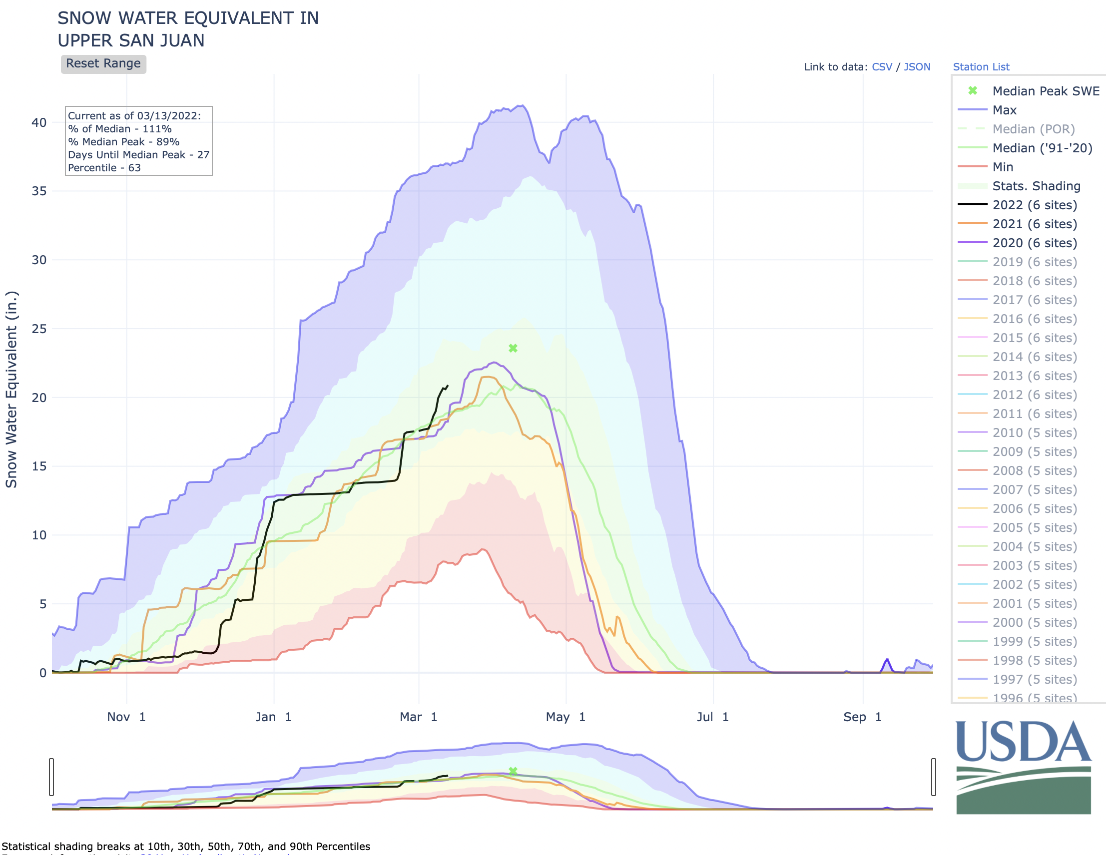


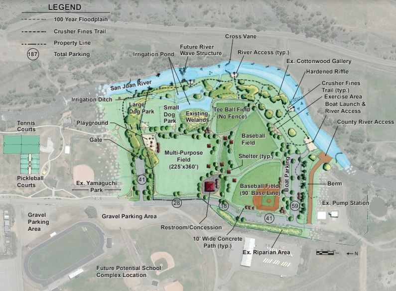


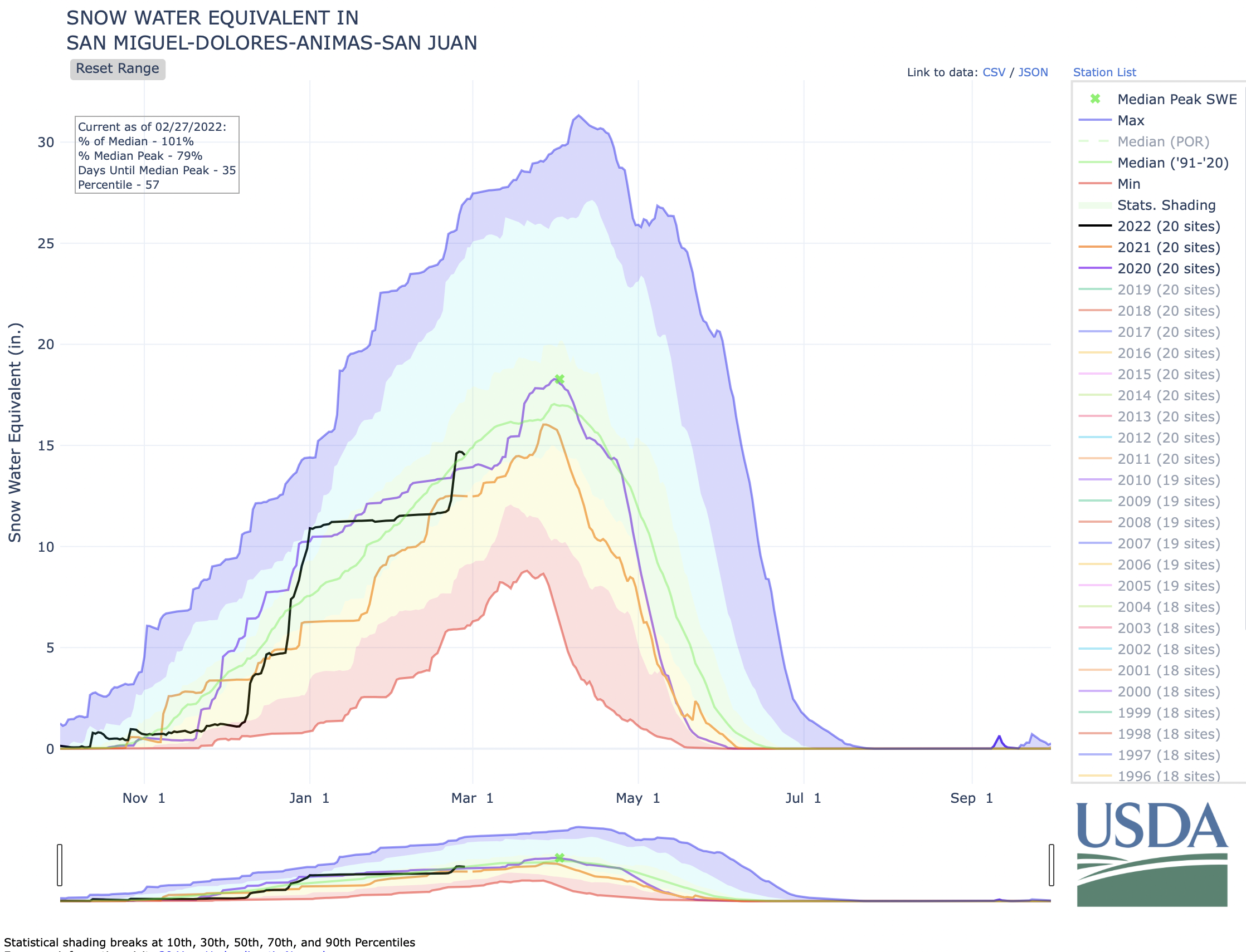
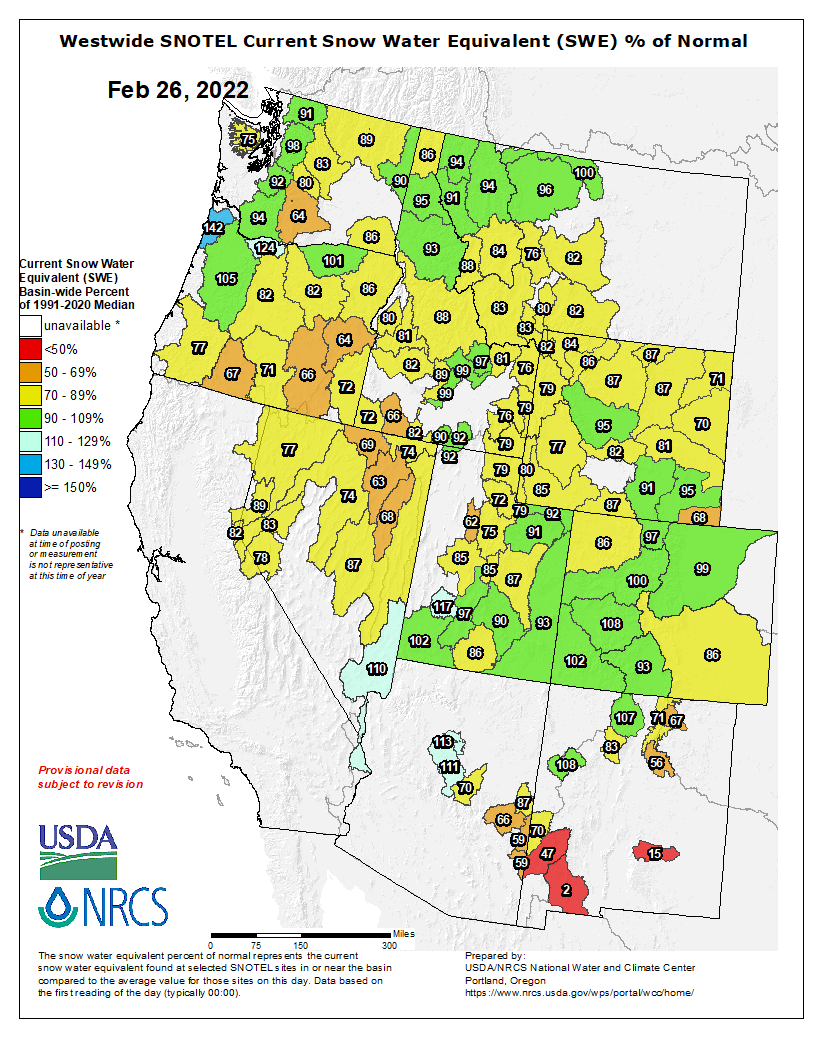

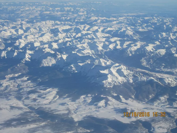
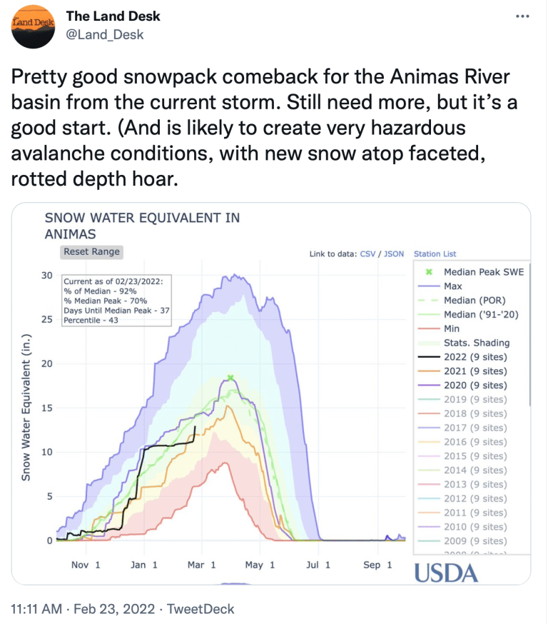
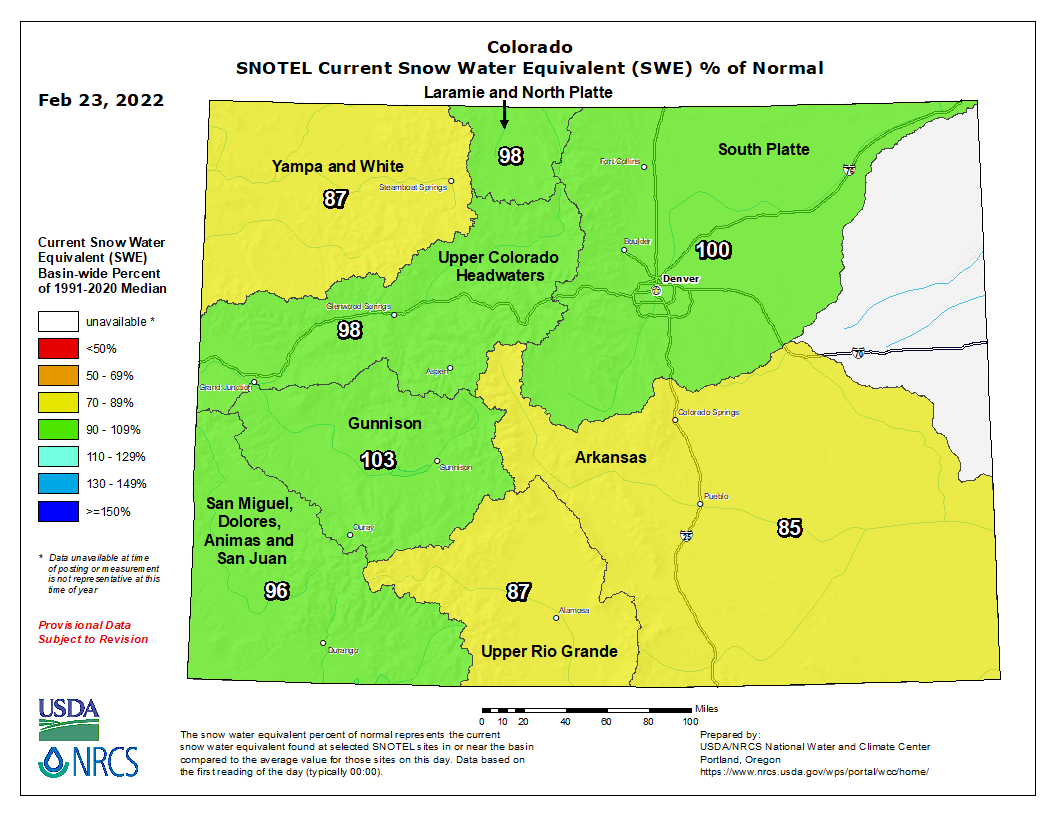

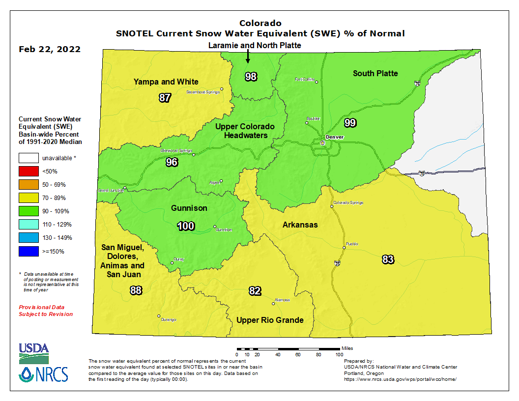
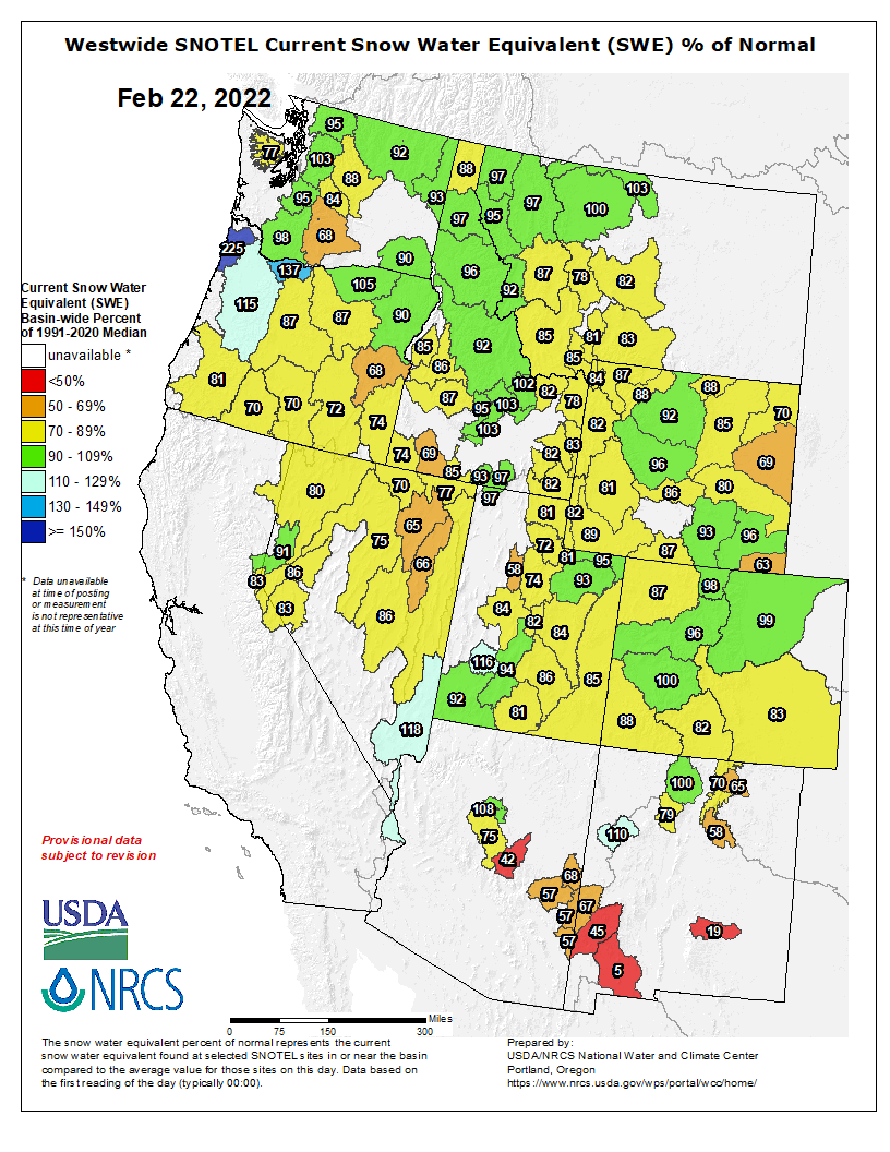

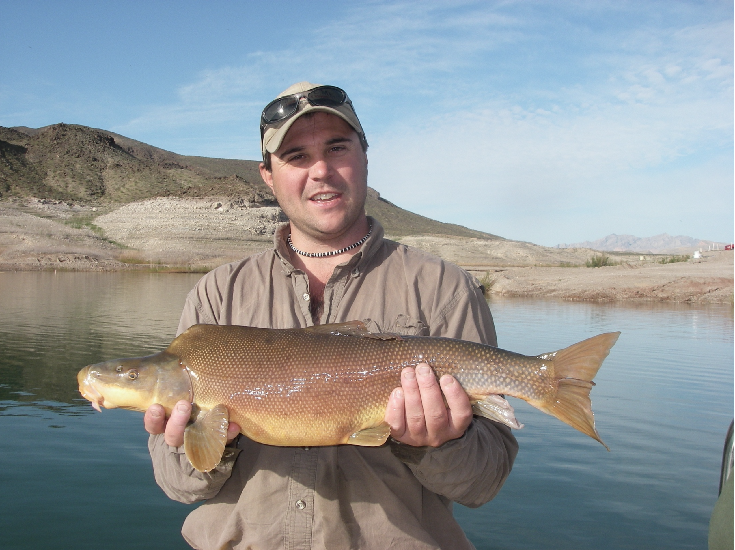


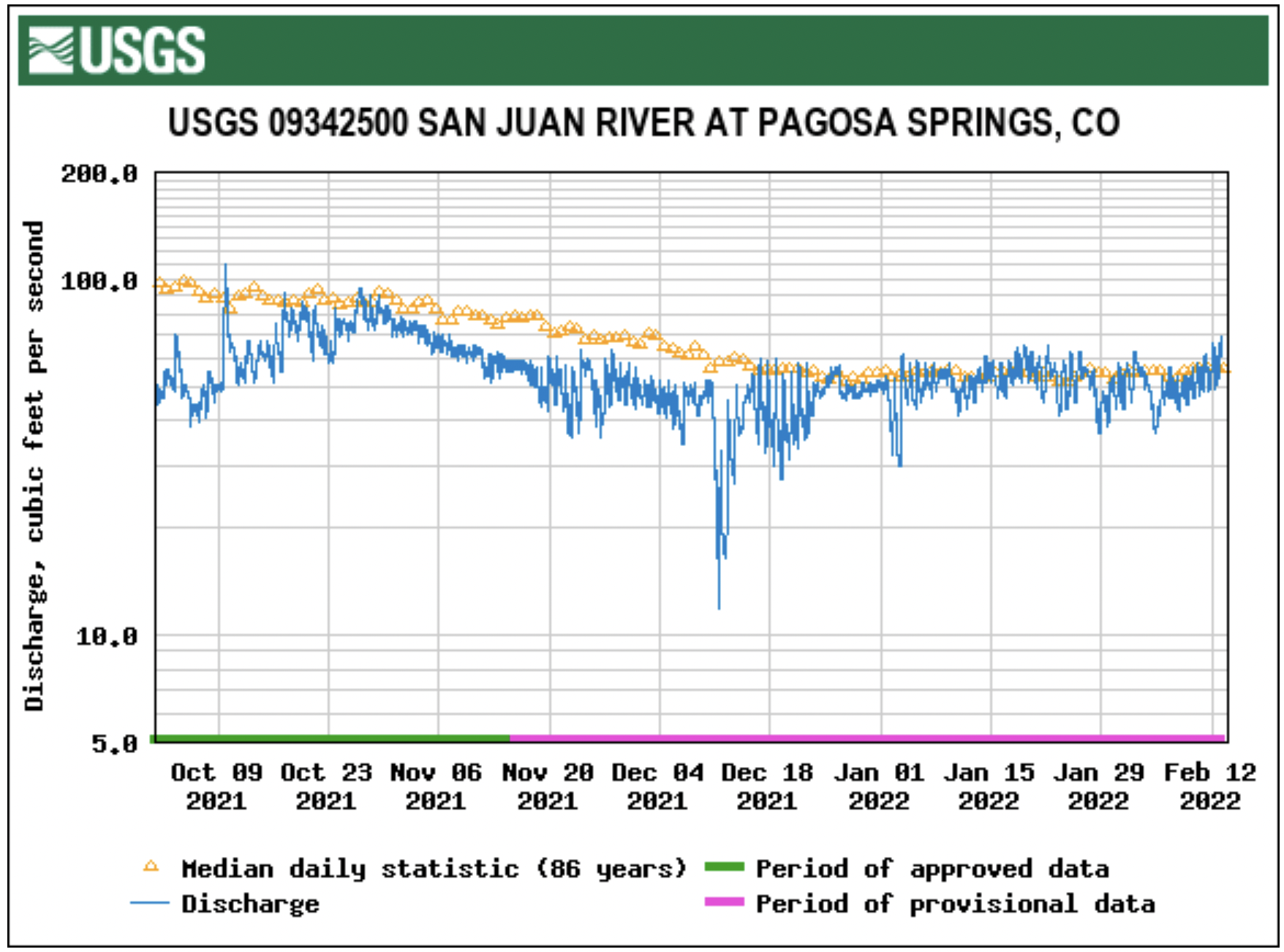
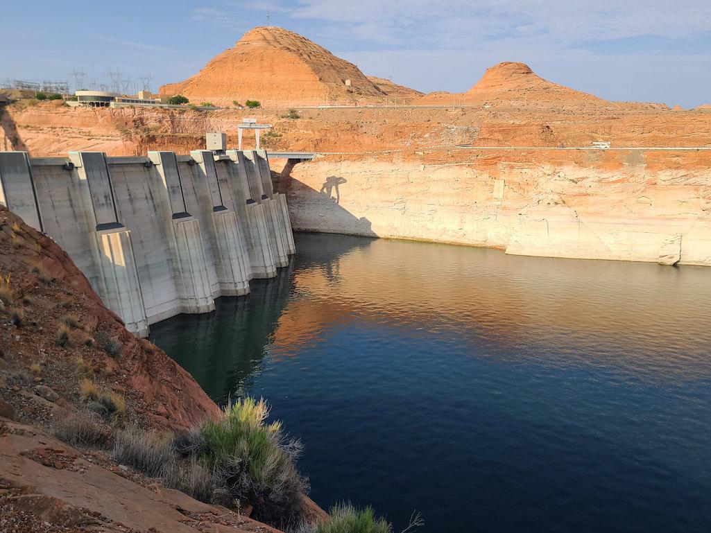

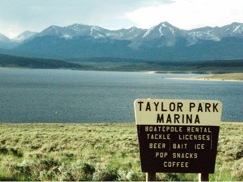


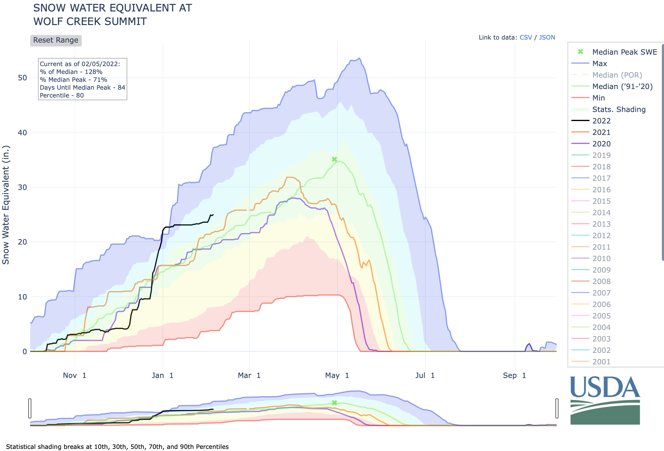

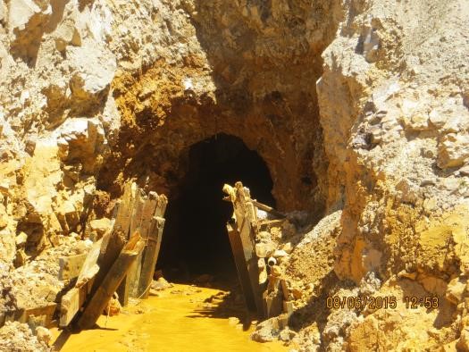


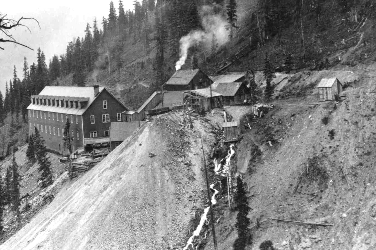
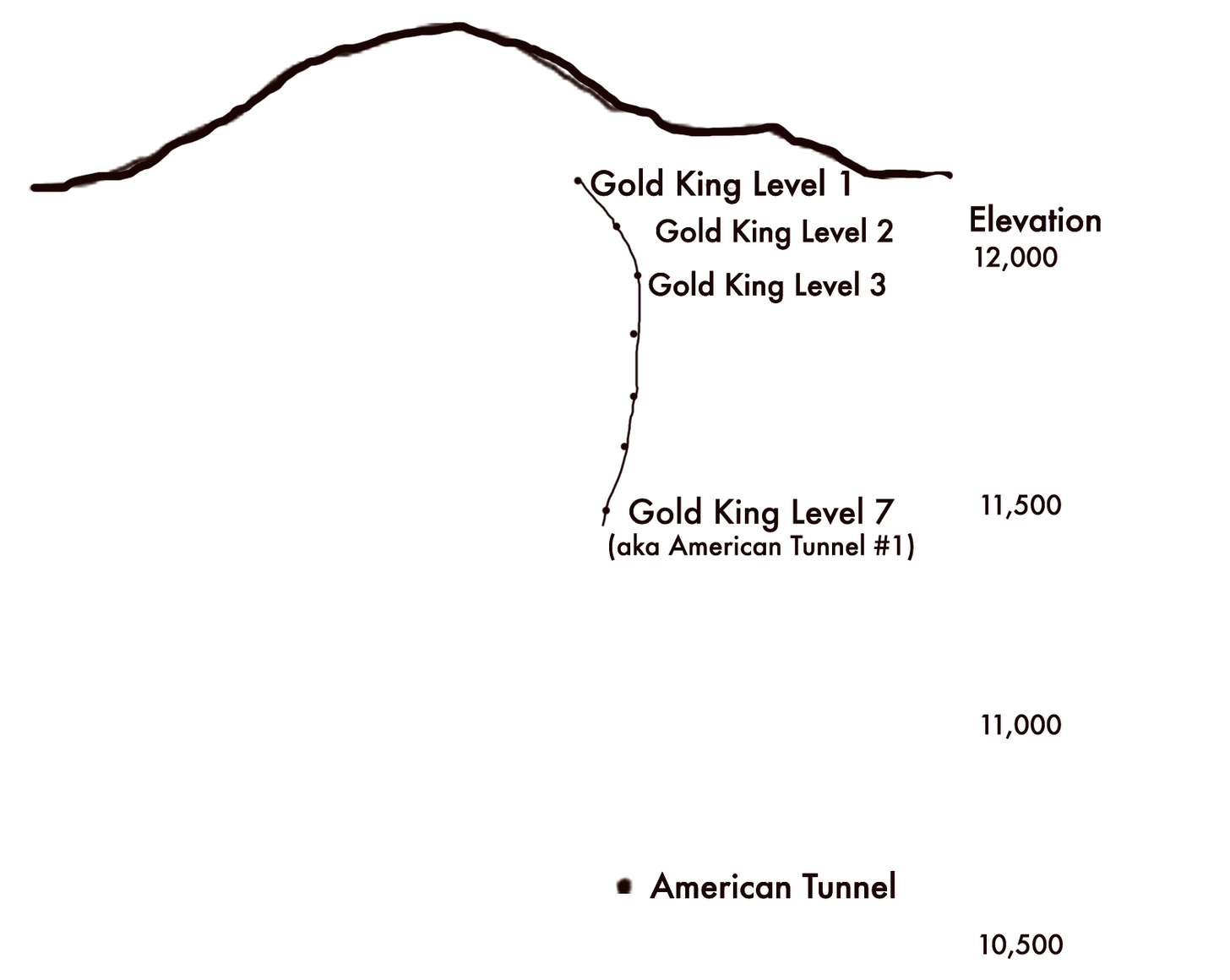
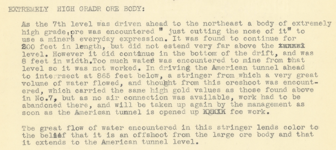


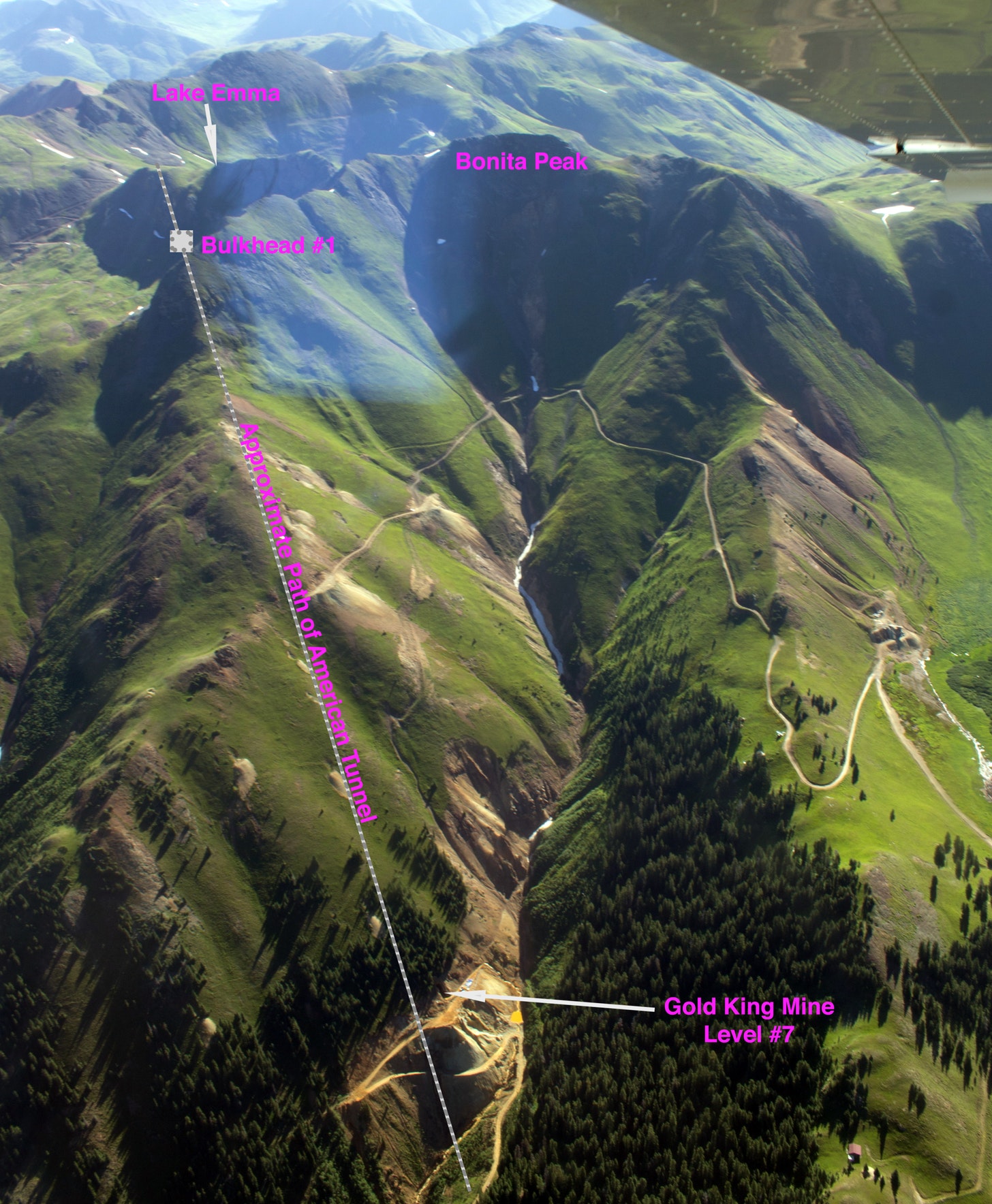
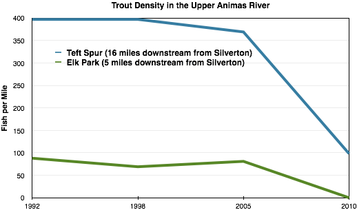


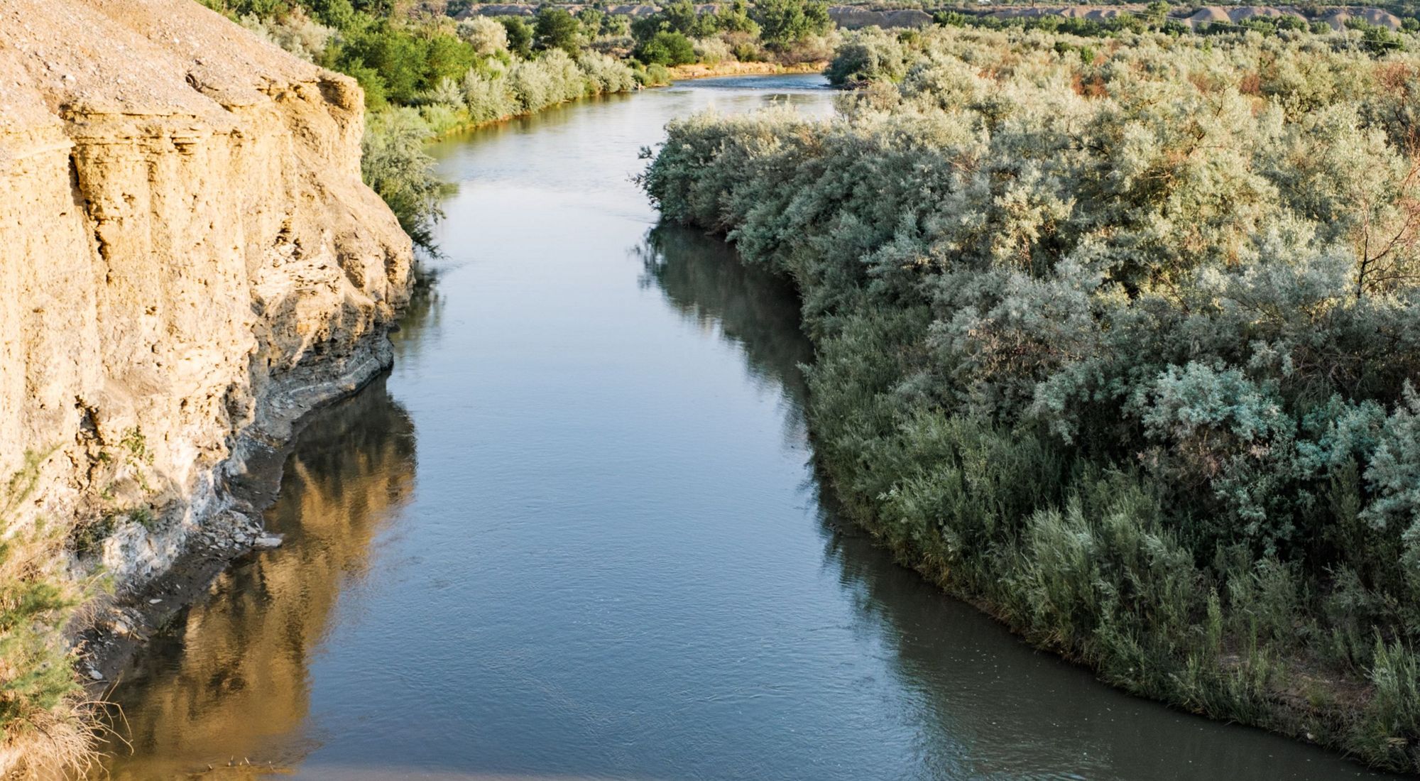
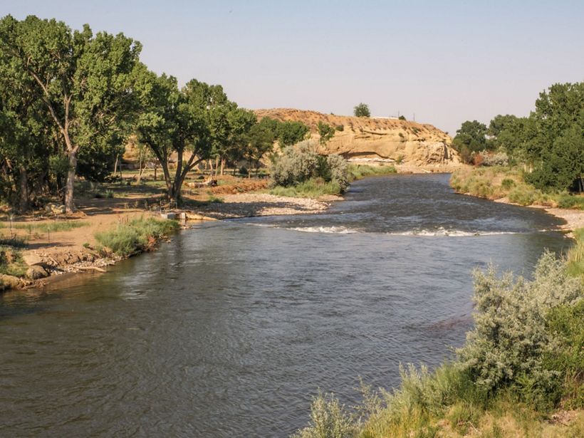
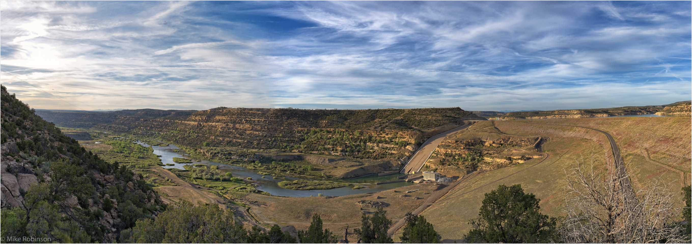

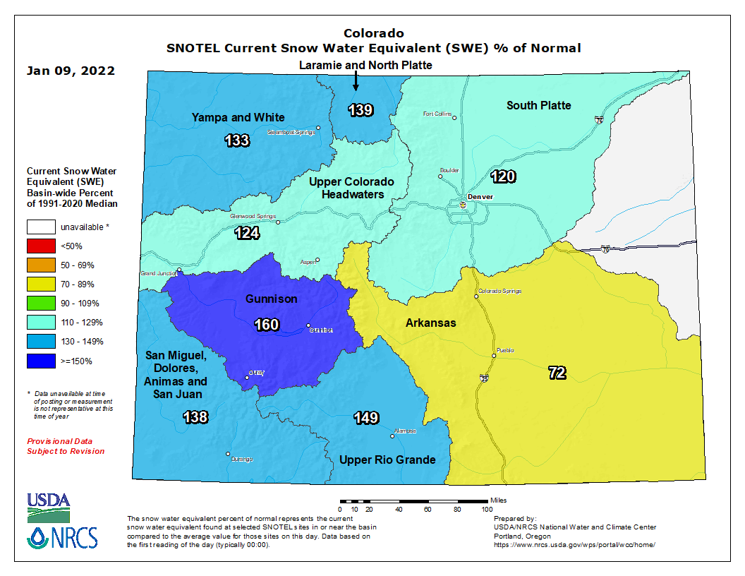
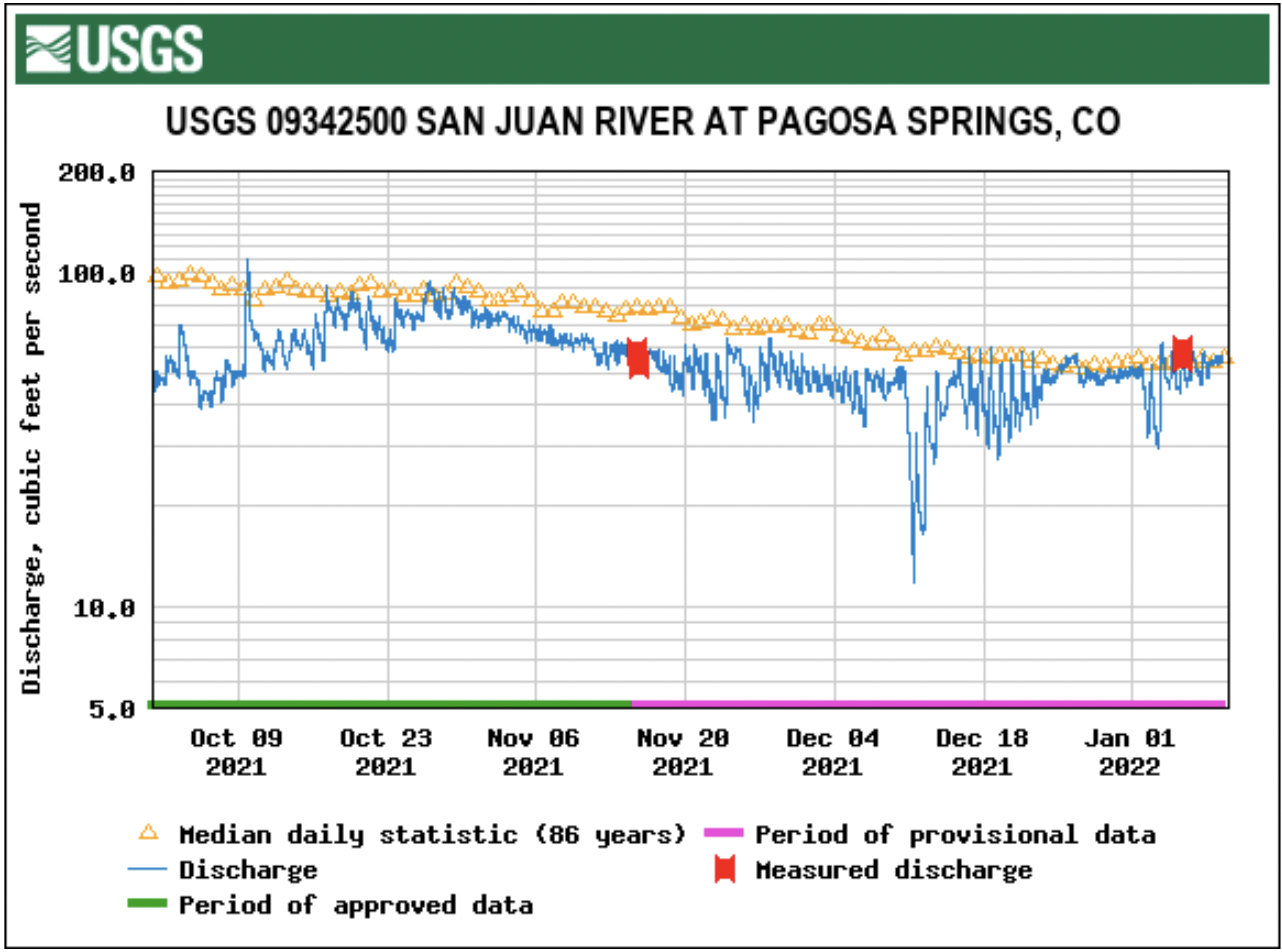


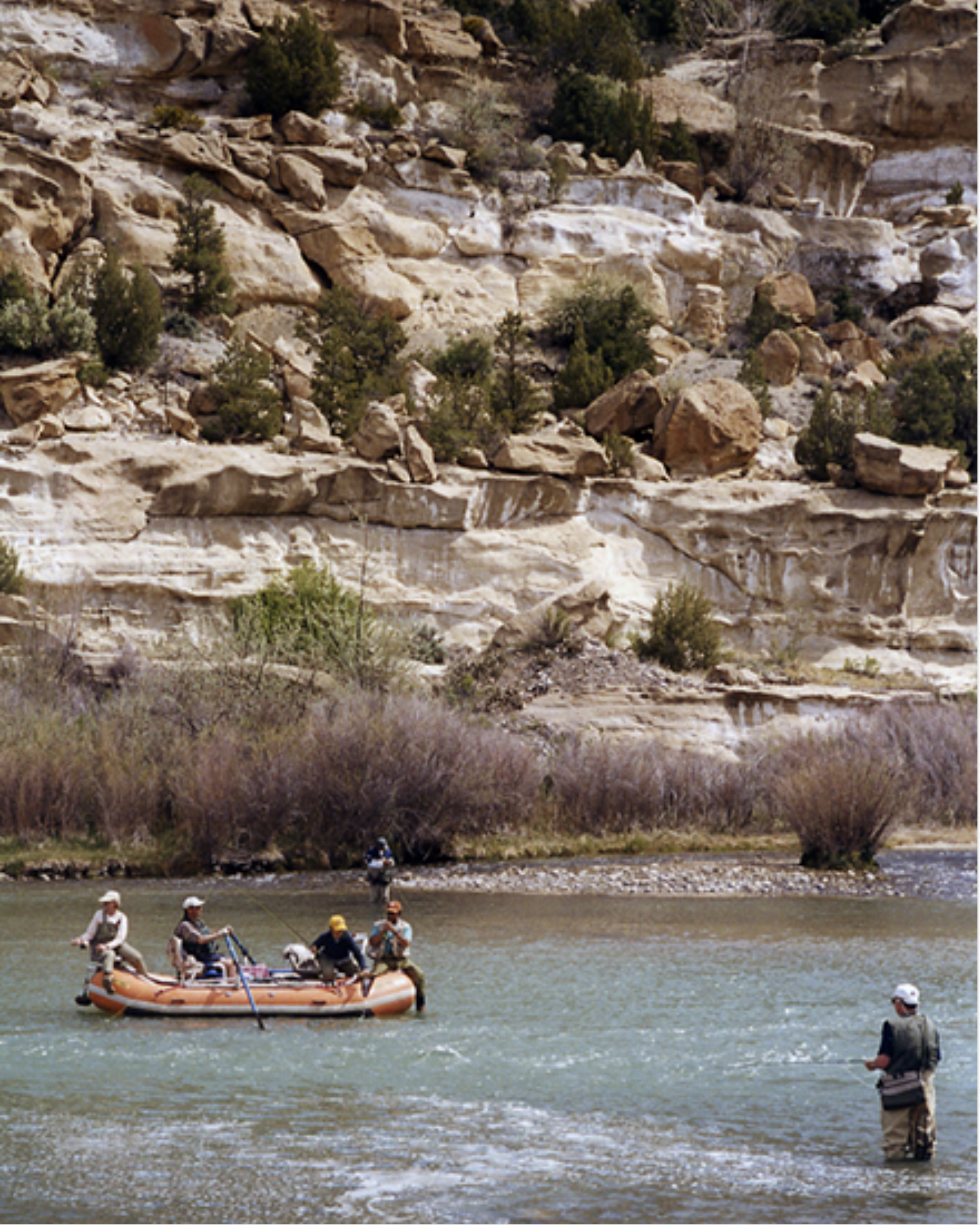


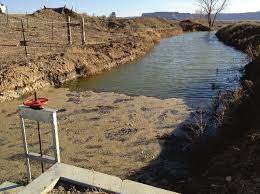
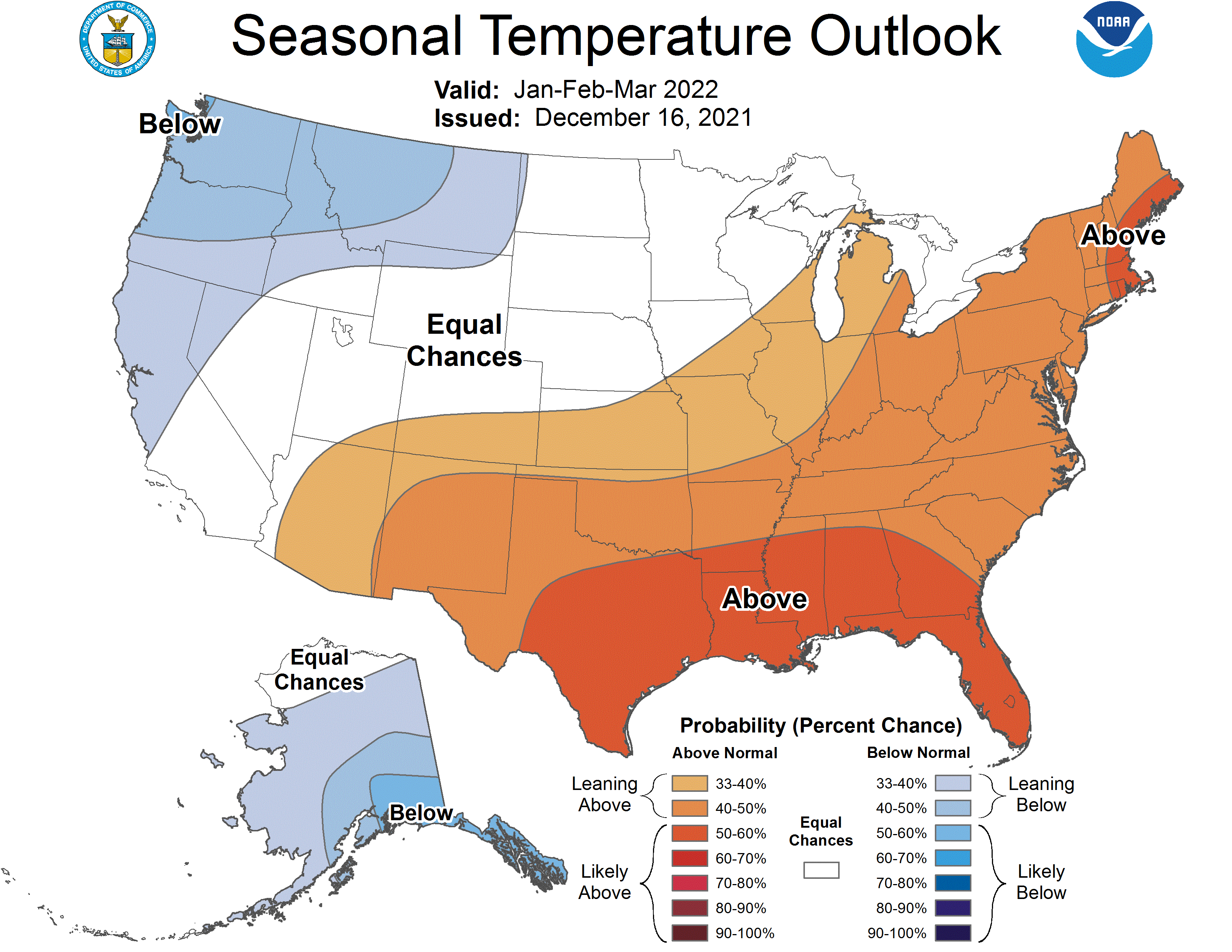


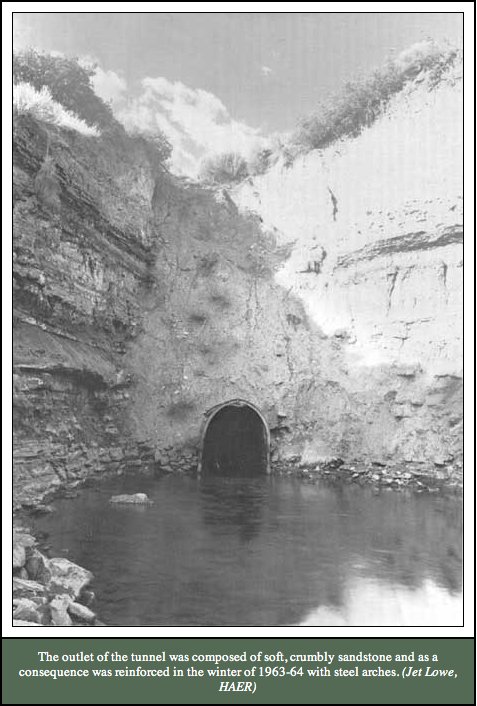


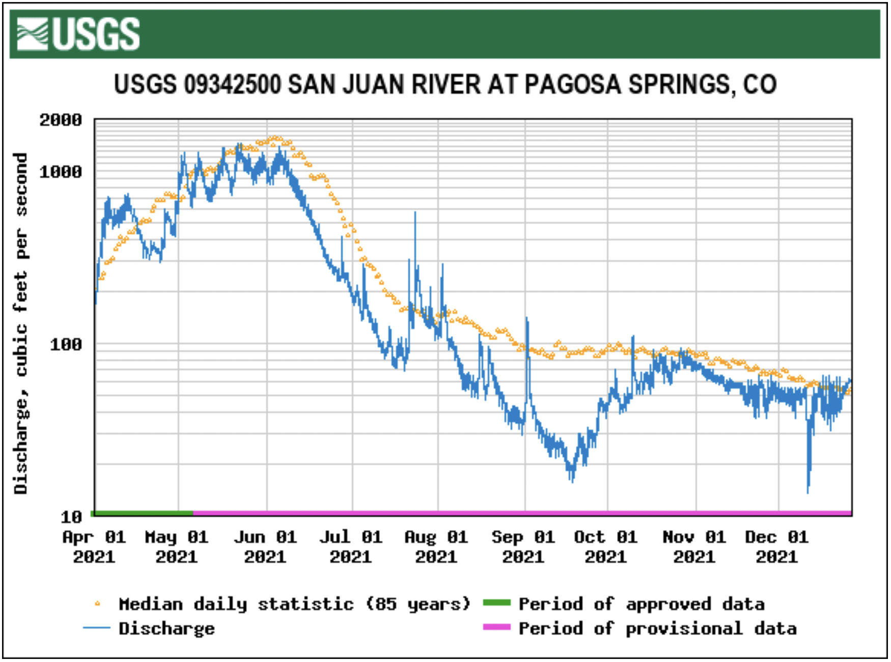
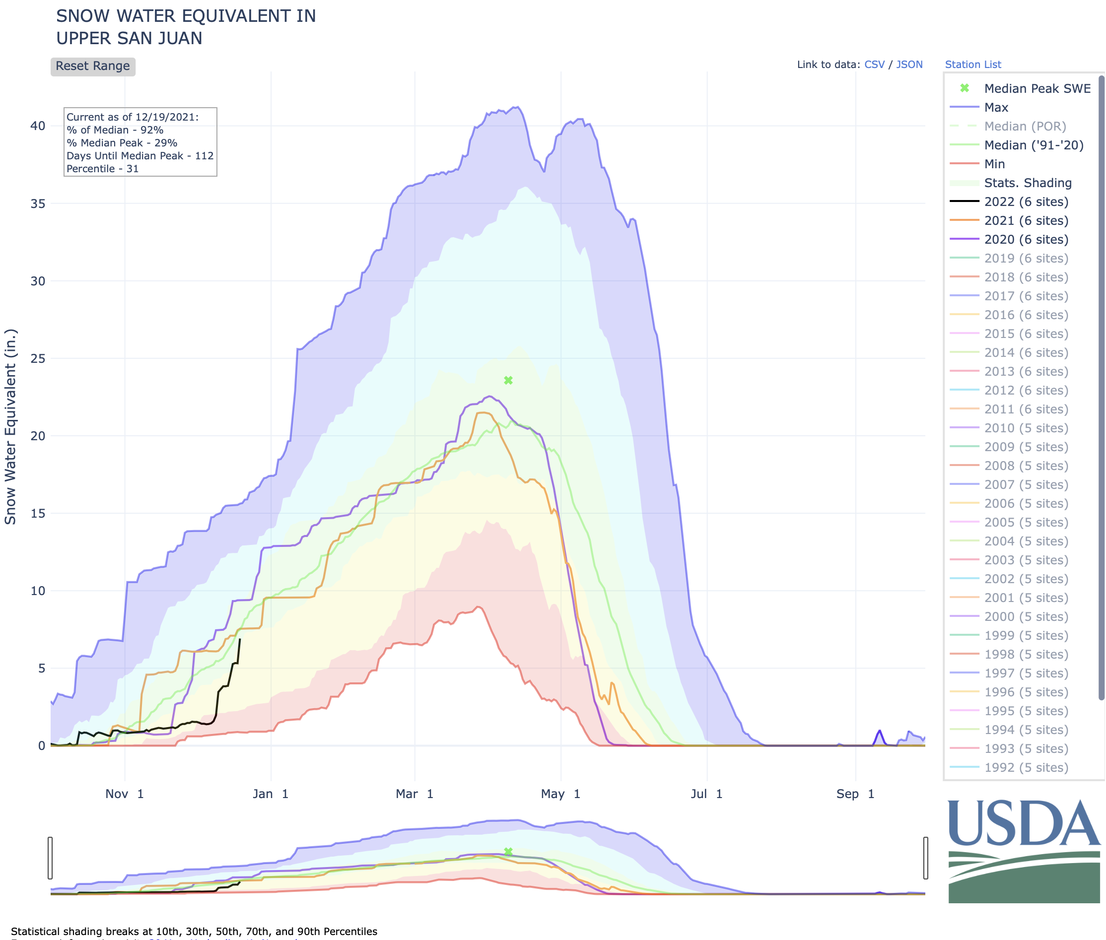
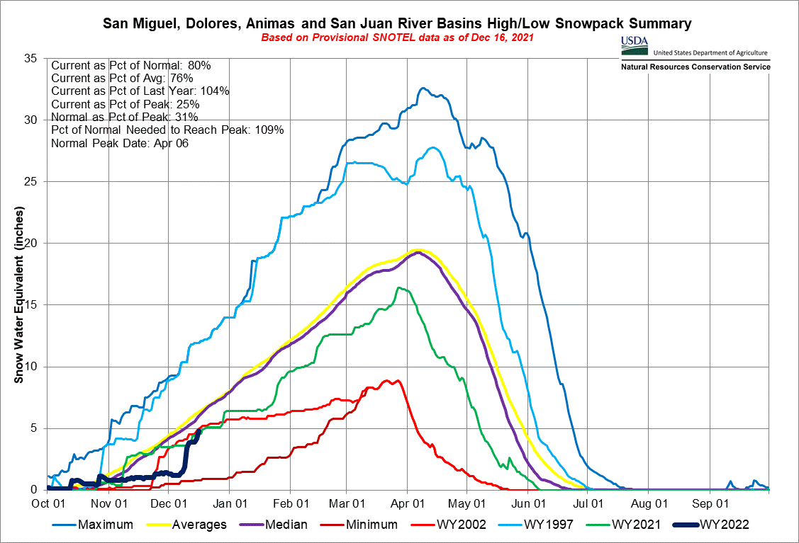
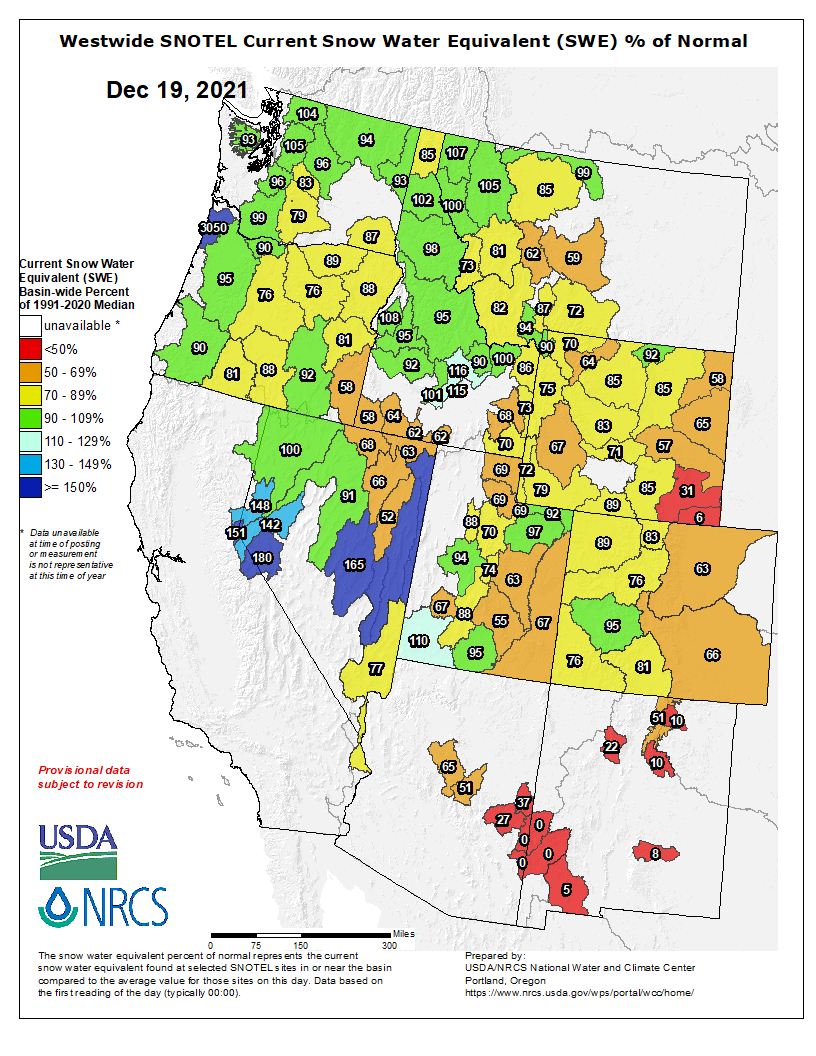
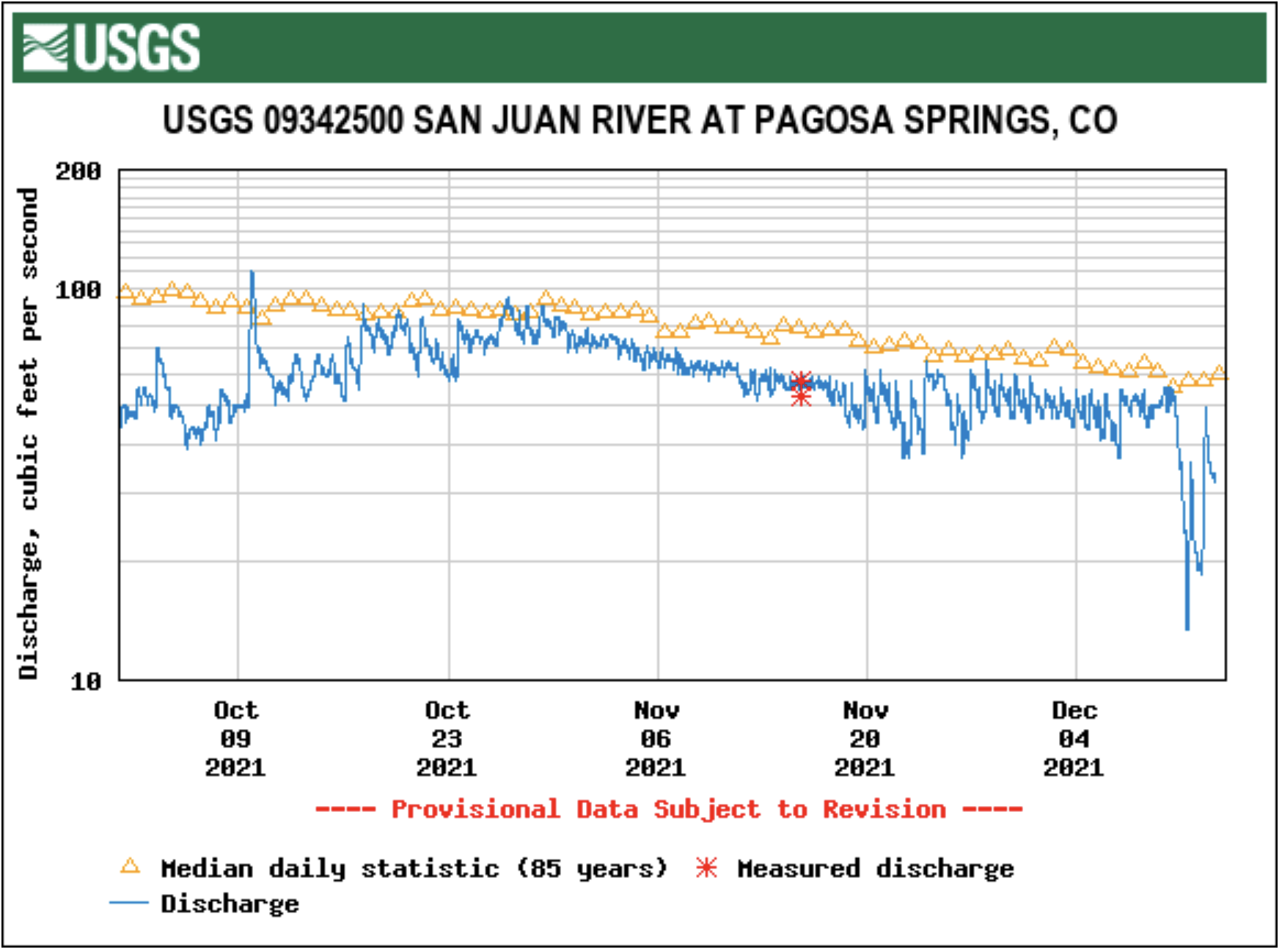

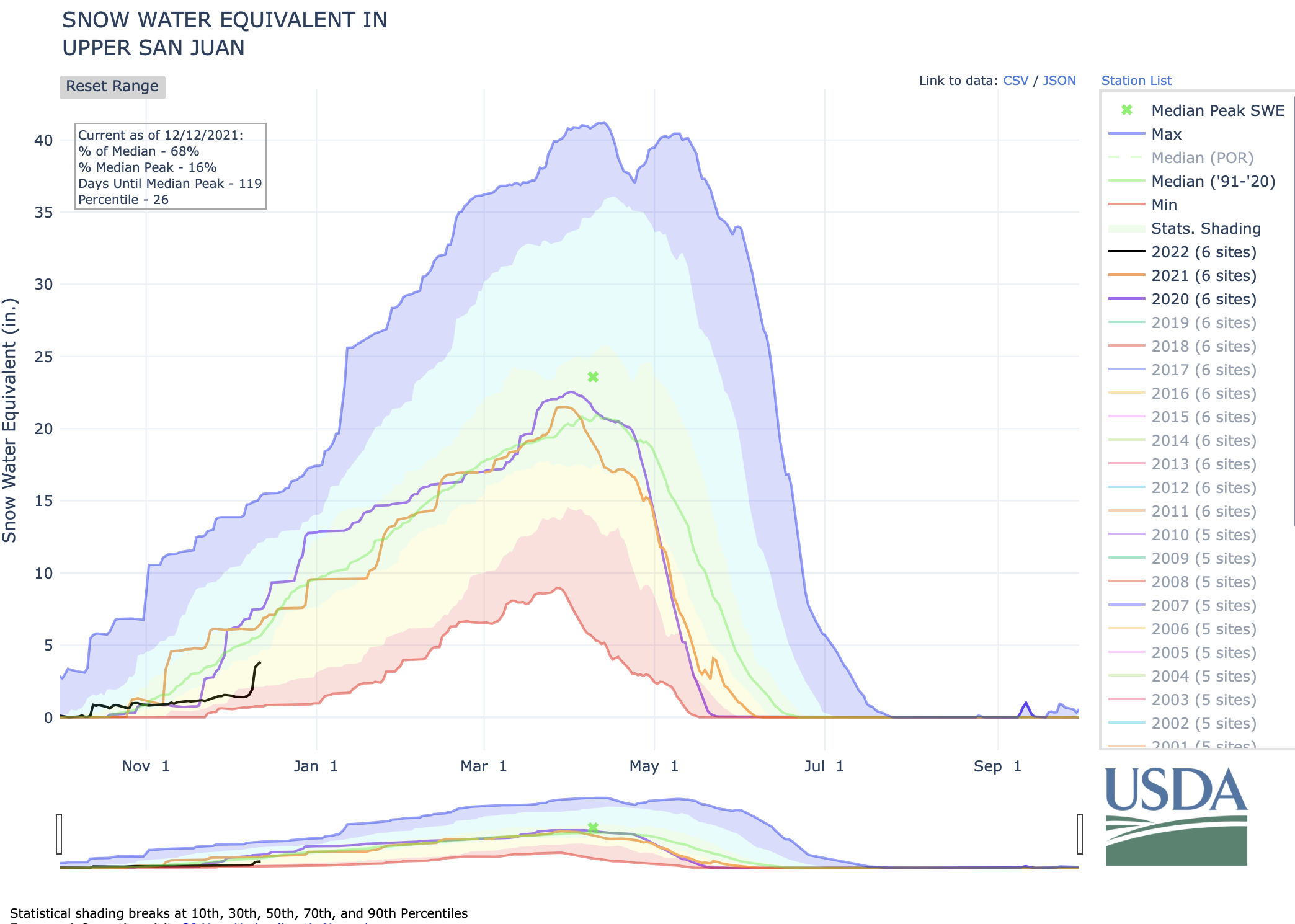
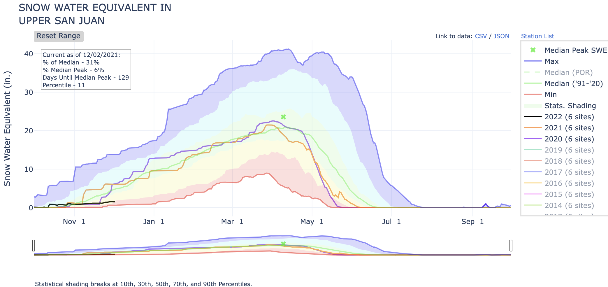
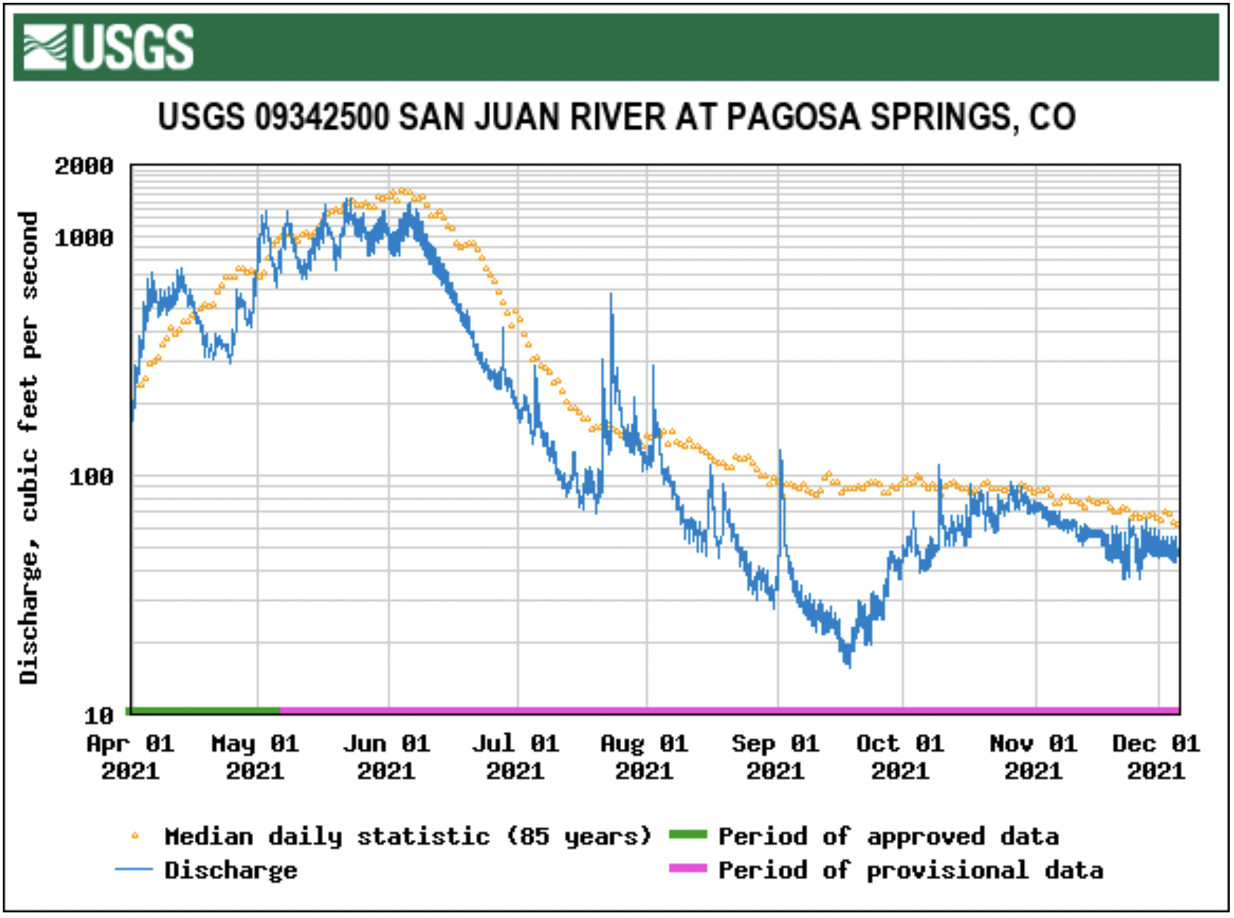
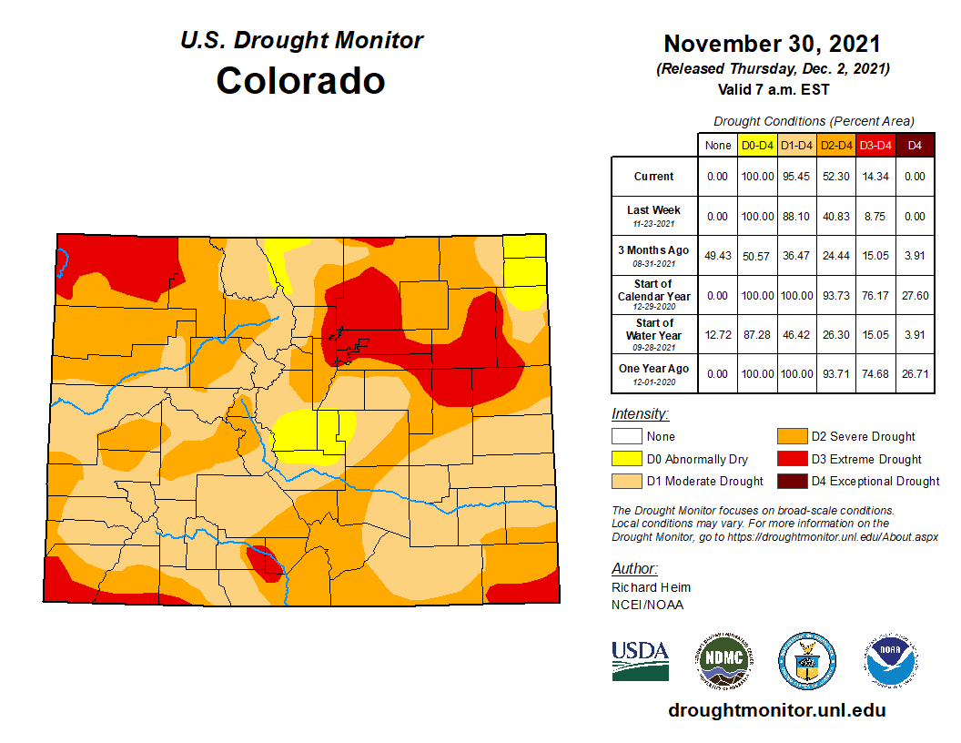


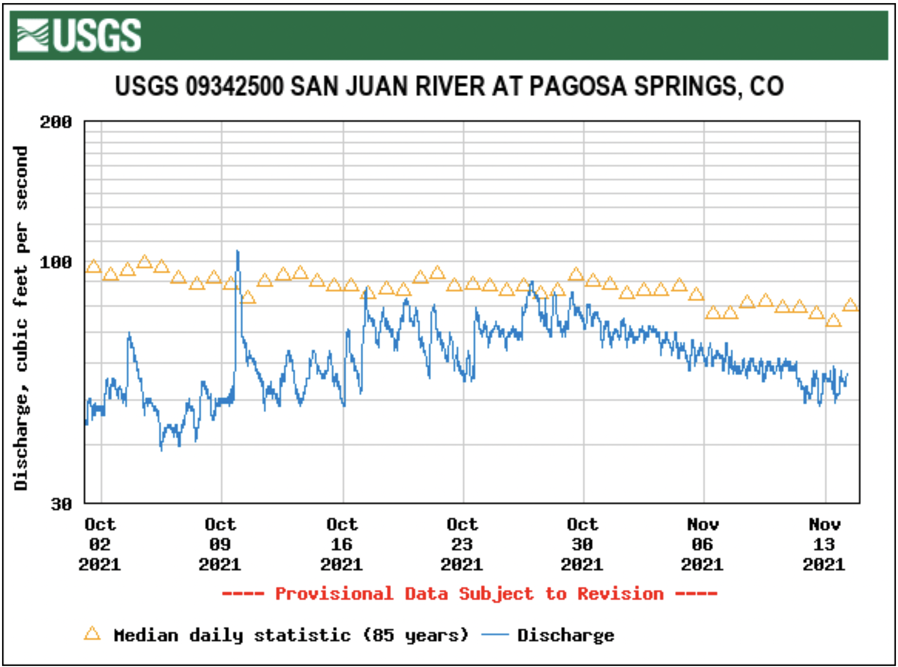
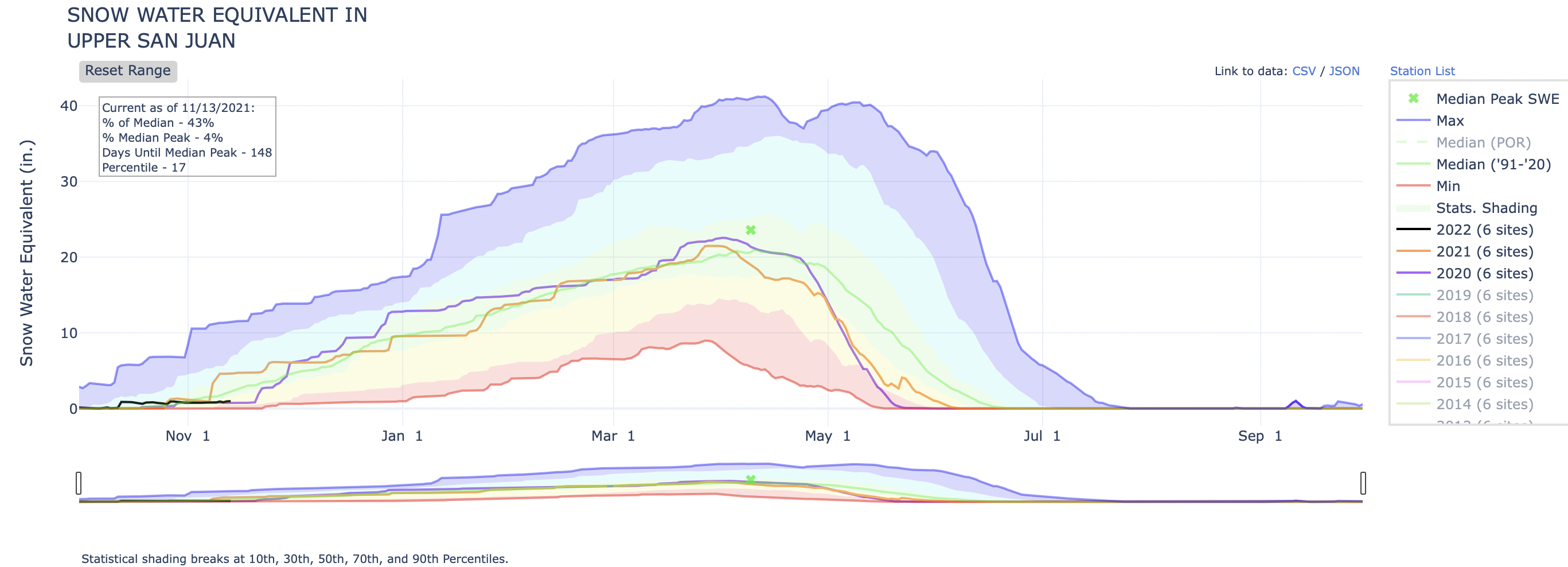
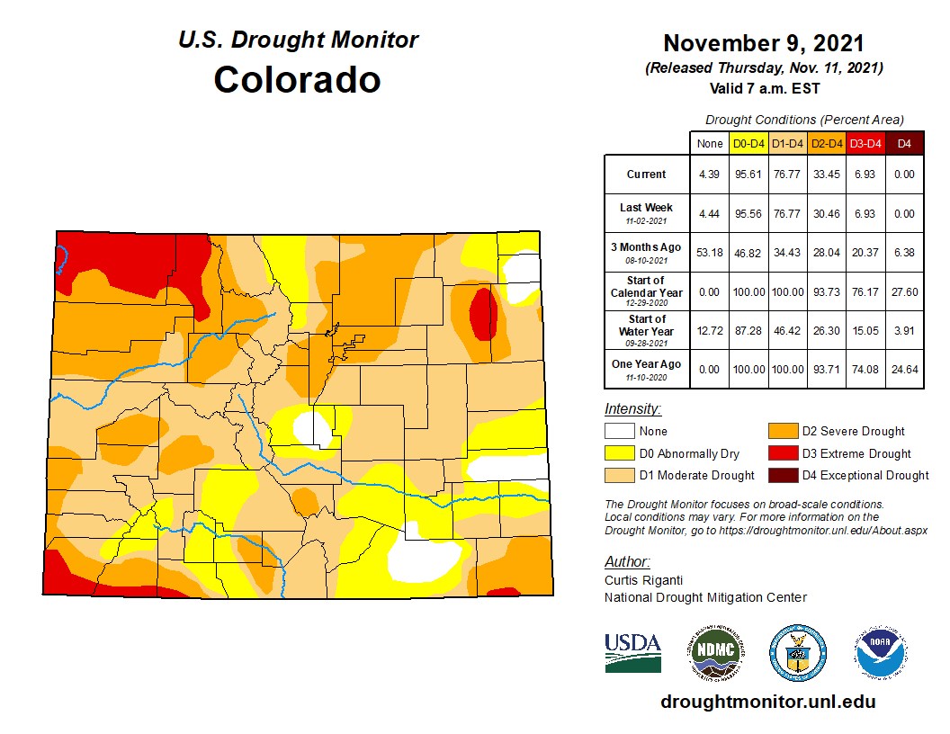

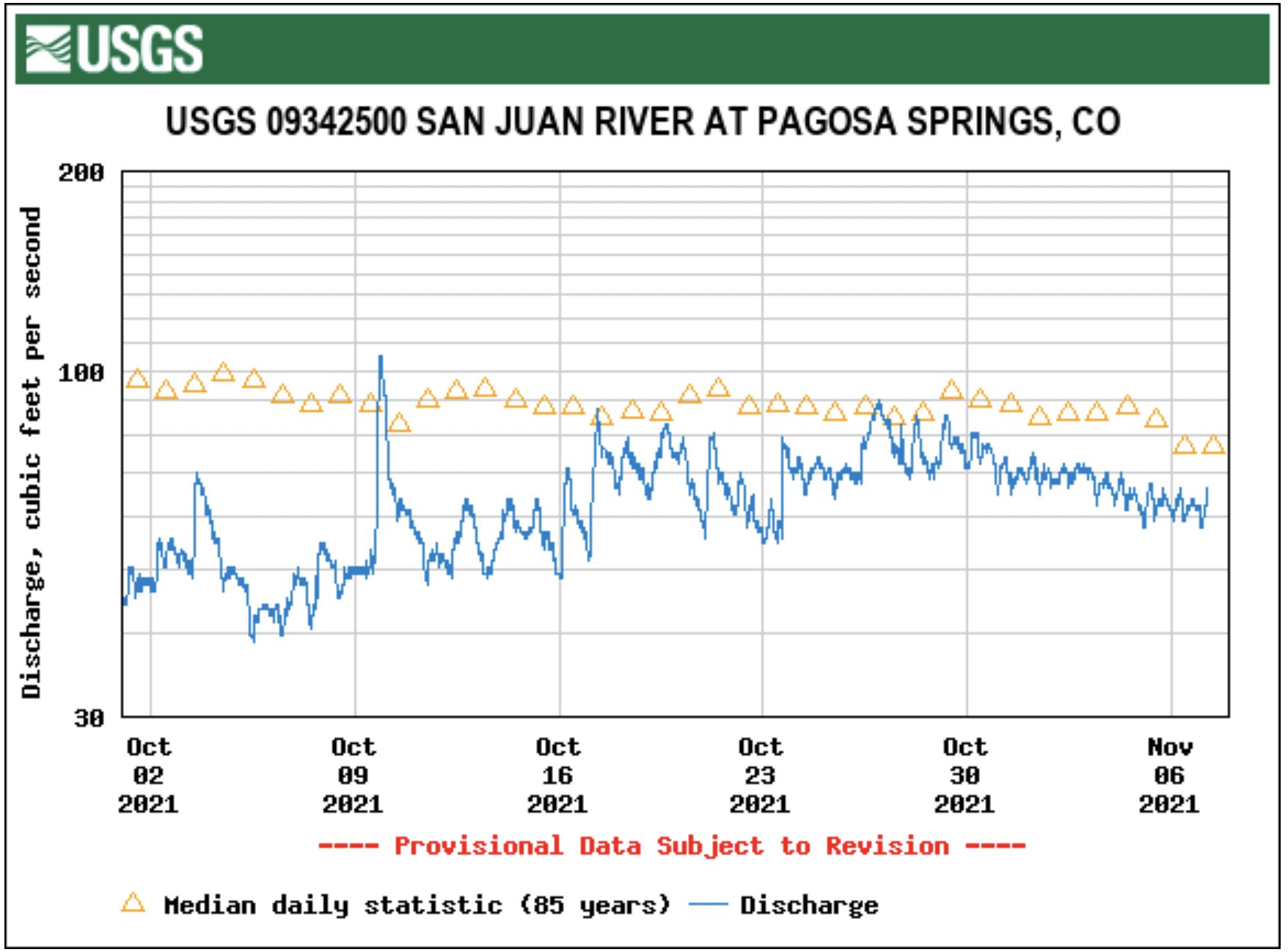


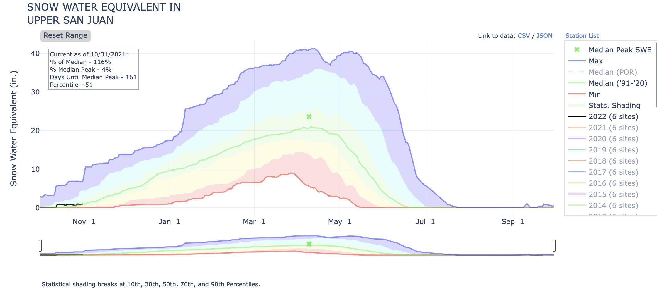
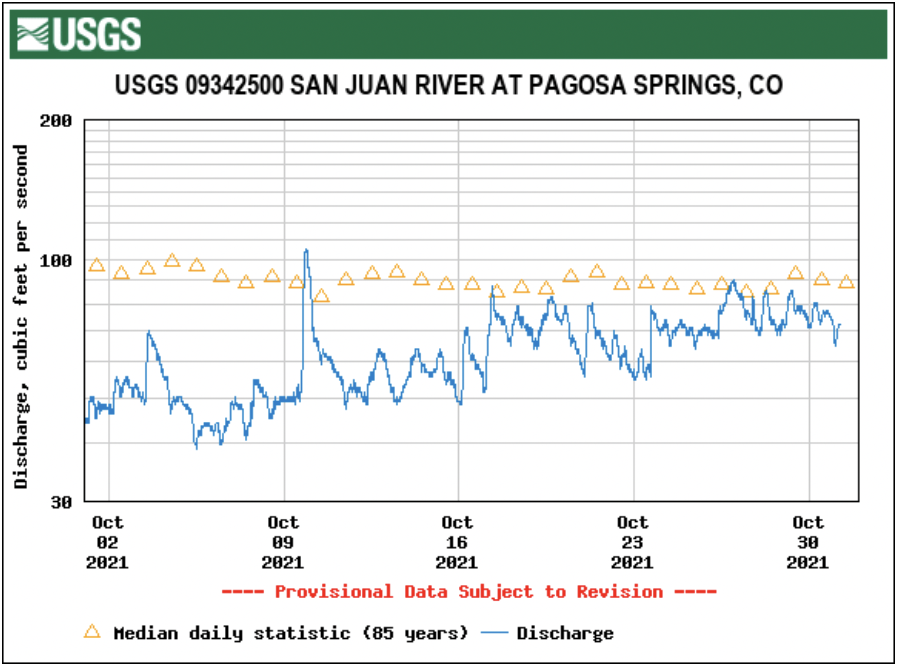
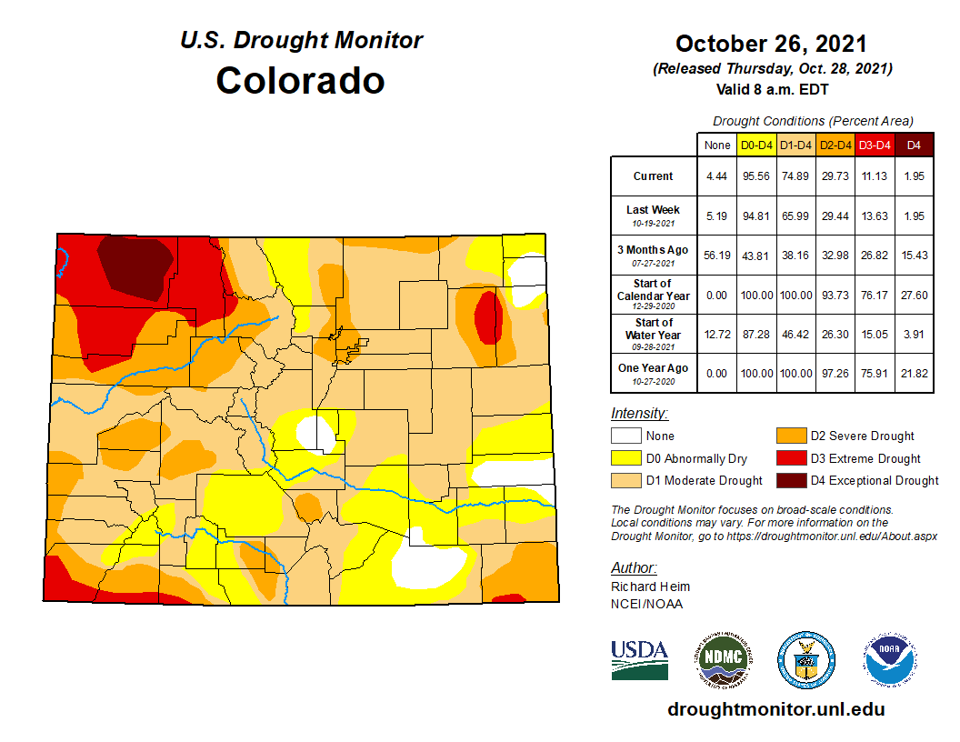

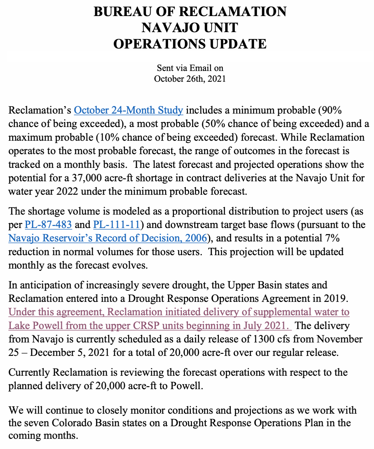
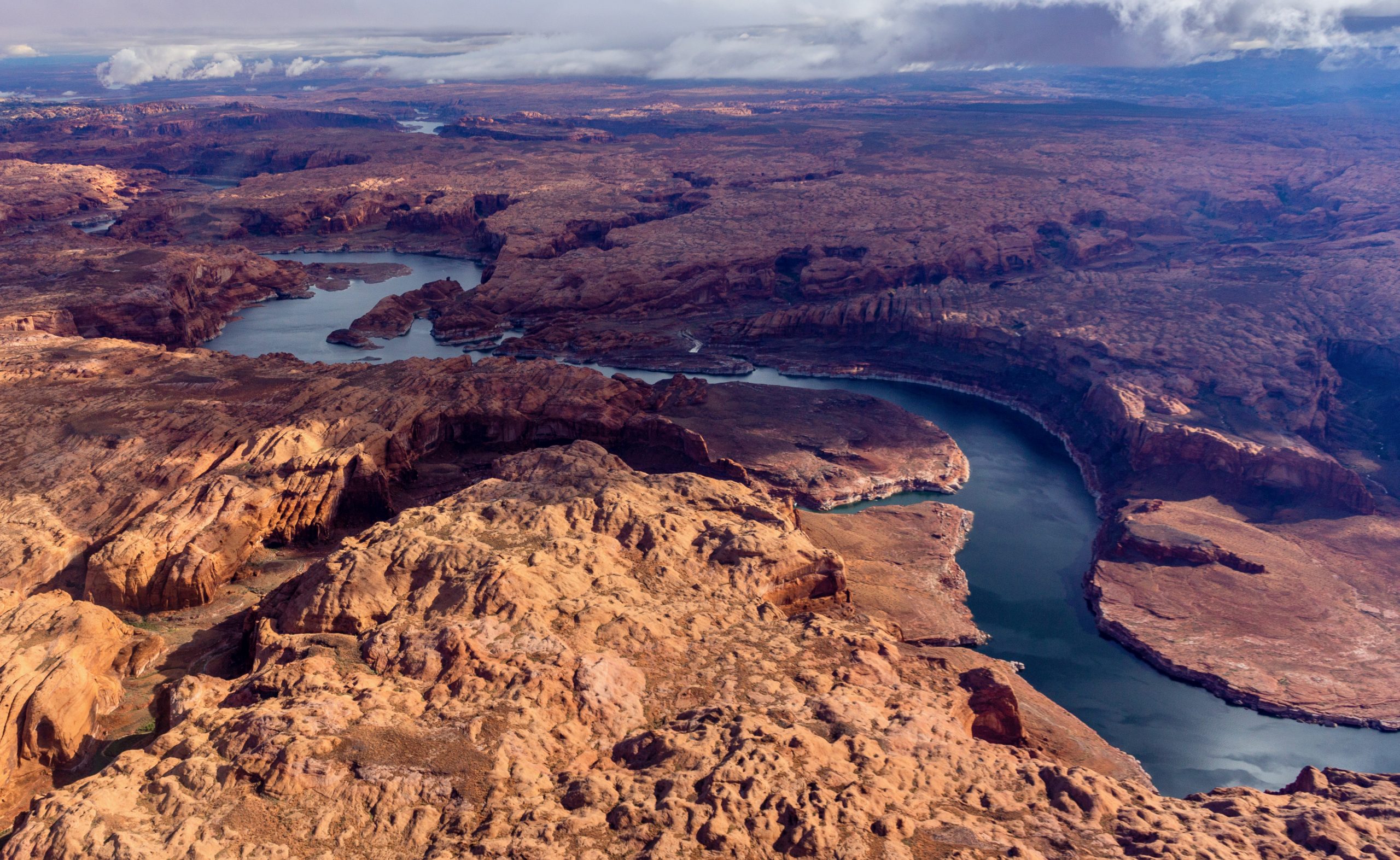
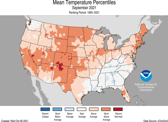


