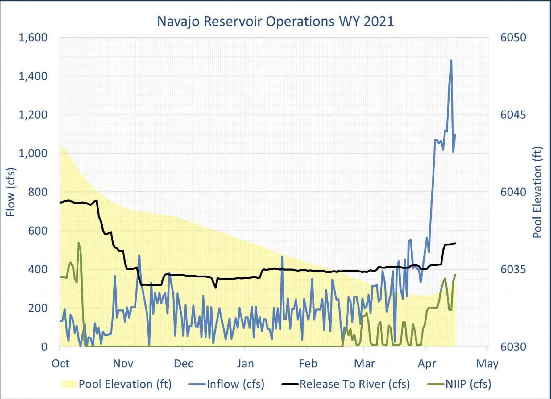
In response to a forecast lull in flows in the critical habitat reach, the Bureau of Reclamation has scheduled a temporary increase in the release from Navajo Dam from 400 cubic feet per second (cfs) to 600 cfs on Tuesday, May 11th, starting at 0400 AM. Releases are made for the authorized purposes of the Navajo Unit, and to attempt to maintain a target base flow through the endangered fish critical habitat reach of the San Juan River (Farmington to Lake Powell).
The San Juan River Basin Recovery Implementation Program recommends a target base flow of between 500 cfs and 1,000 cfs through the critical habitat area. The target base flow is calculated as the weekly average of gaged flows throughout the critical habitat area from Farmington to Lake Powell. Please be advised, due to the dry conditions this year, more release changes than usual may occur.
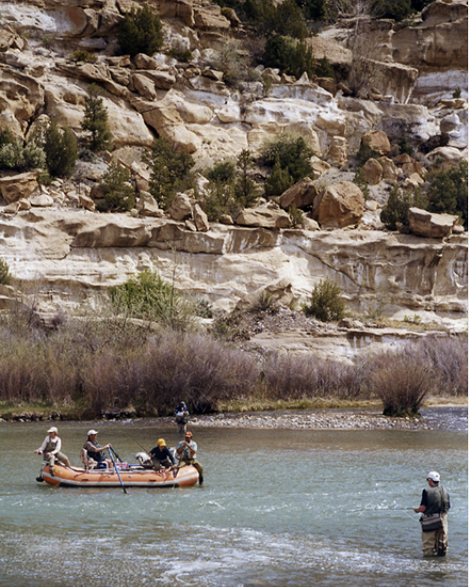
Fly fishers on the San Juan River below the Navajo Dam.U.S. Bureau of Reclamation
During the Pagosa Springs Sanitation General Improvement District board meeting on Tuesday, May 4, Town Public Works Director Martin Schmidt shared increasing concerns with the town’s wastewater pumping.
“About a year ago, I came to the board with a report from an engineer from the company that sold us the pumps, Sulzer, and they were very confident in a replacement pump to be put into the lift stations because it would solve our net-pressure suction head issue,” Schmidt said. “It exacerbated issues down the line and acceler- ated some pump failures. That’s a big issue.”
In his agenda brief, Schmidt states that after the board approved pur- chasing a different pump that was recommended by the supplier, the newer pump exacerbated issues with other parts of the pumping train and inadvertently increased the speed of the pump failures at the lift stations.
“What we need is a system that will pump sewage and not destroy pumps at the rate they’re destroying them,” Schmidt said.
Schmidt explained that pumps should be lasting between 15 and 20 years with minor maintenance. Currently, some of them are lasting not even six months.
“Staff has been working on a solution for this from the very moment we realized the problem has been occurring,” he said. “We worked with them throughout the fall and into the winter and around Christmastime, we realized Sulzer wasn’t coming forward with any reasonable solutions.”
[…]
During a phone call the follow- ing day, Phillips explained several options for the emergency backups she referred to during the meeting.
“We do have an overflow vault that is located under the ground next to Pump Station 1, and that is for taking any kind of overflow that the pumps would not be able to handle,” she said. “That would get us maybe about 12 hours of time and if we needed to do more than that, we’ve identified a supplier of a bypass pump that we would utilize.”
Phillips explained that there are two pump stations with four pumps each in service at any given time. Typically 150,000 to 250,000 gallons per day of wastewater are being pumped. Both pump stations are suffering from issues.
“We also could utilize the existing old sewer lagoons that are down there, one of which is par- tially lined,” she said. “We could get several days of overflow by utilizing those old lagoons, and in the meantime would be requesting emergency assistance from Sulzer and other suppliers to ship us on an emergency basis additional pumps.”
“We are waiting on [the engineer’s] report. I anticipated it this afternoon; it will probably be here tomorrow,” said Schmidt during the meeting.
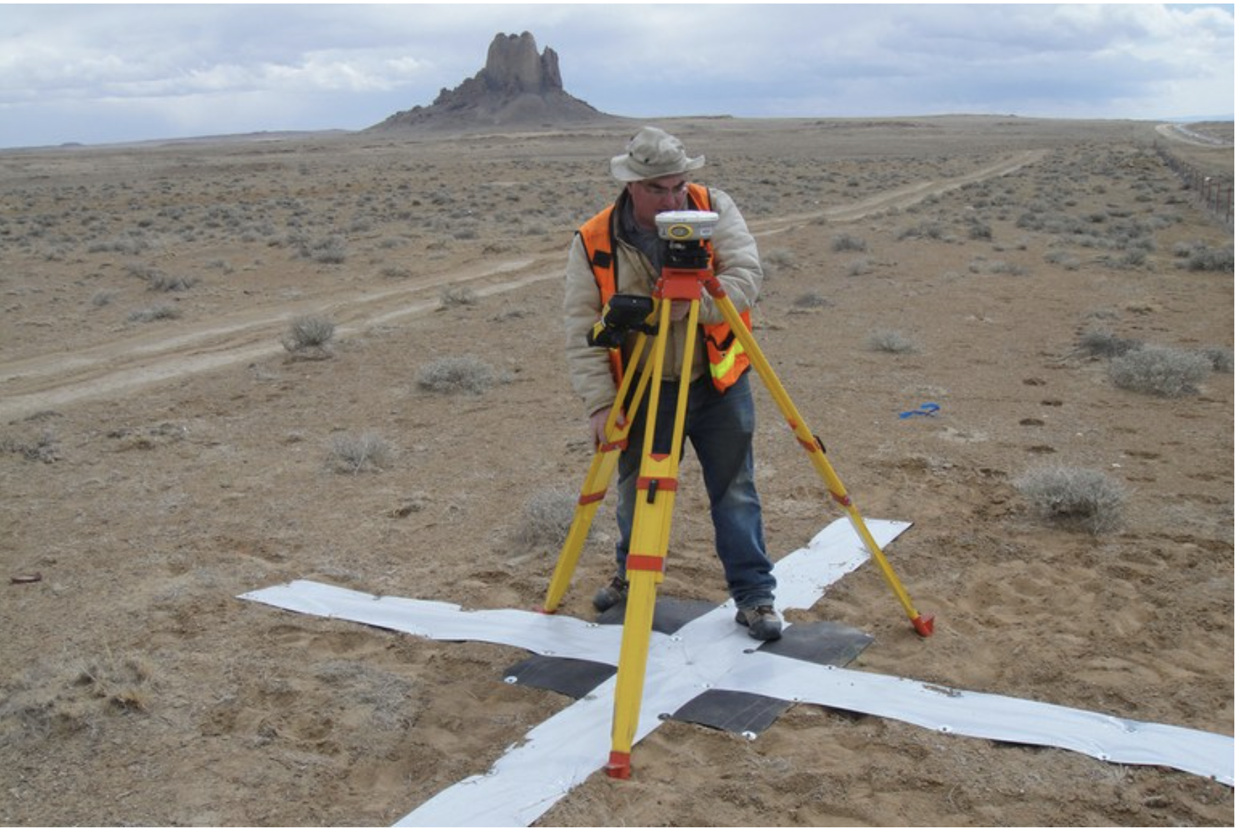
Survey work begins in 2018 for the Navajo-Gallup Water Supply Project on the Navajo Nation. Photo credit: U.S. Bureau of Reclamation via The High Country News
Early this year, five of Gallup, New Mexico’s 16 water wells stopped producing water, including two of its biggest. After a few days of maintenance, two worked. The other three were out of commission for more than a month. Had it happened in summer, the city might have asked residents to dramatically reduce use…
The shortage isn’t wholly surprising — 20 years ago, the city decided it could limp along on aging groundwater wells with dropping water levels until a new water project began delivering San Juan River water in late 2024. The project is also connecting nearby Navajo communities, where many residents lack running water, an issue the Navajo Nation says is long past due and in need of a fix. But now a potential four-year delay could force a growing number of people to rely on these strained groundwater sources. A plan to keep taps from running dry will come with a price tag.
The situation highlights how precarious water has become for this city of almost 22,000 in western New Mexico and offers a peek inside the complicated mix of relationships, creativity and familiarity with multiple government agencies that’s required to manage water in the 21st century.
Gallup sits in the high desert along the red sandstone mesas of the Colorado Plateau. For much of its history, it has functioned as an industrial town and a bustling commercial center. Named in 1881 after railroad paymaster David L. Gallup, freight trains and Amtrak still rumble through, in addition to a steady flow of semi-truck traffic around the exits for Interstate-40. Surrounded by the Navajo Nation, on the first weekend of the month the town swells by 100,000 as people stream in for supplies. Those with no running water at home fill water containers. People do laundry, wash cars, go out to eat.
For decades, the Navajo Nation bordertown has relied on groundwater stored in sandstone layers deep underground. With no nearby rivers, wells tapping that water have been the city’s only option. But because annual rain and snowfall don’t replenish the water, levels have dropped over recent decades. In the 1990s, the city projected shortages by as early as 2010.
“Not only was Gallup running out of water, everybody was running out,” said Marc DePauli, owner of DePauli Engineering and Surveying, which the city has hired to work on the water systems. About 20 smaller surrounding water systems had “straws in the same bucket,” all leaning on dwindling reserves.
Help is coming in the form of the Navajo-Gallup Water Supply Project, the result of a historic agreement that settled Navajo Nation claims to water in this arid region of the Southwest after decades of discussions.
Consisting of two major pipelines that run through Navajo communities in western New Mexico, the project will bring water from the San Juan River to within reach of some of the one in three homes without it on the Navajo Nation. One of the pipelines, the Cutter Lateral that branches to northwest New Mexico, is complete. The other, the San Juan Lateral, will move 37,700 acre feet of water each year for 200 miles along the western edge of the state, up to 7,500 acre-feet of which will come as far south as Gallup. In the future, the city will rely largely on water from the San Juan…
The water was supposed to flow by 2024, but a new design proposed by the Bureau of Reclamation will now likely push that date back by three to four years, putting Gallup in a tight spot, monetarily and water-wise. The construction delay coupled with the city shouldering more demand will require new wells to supply everyone until water from the San Juan arrives.
In response to increasing flows in the critical habitat reach, the Bureau of Reclamation has scheduled a decrease in the release from Navajo Dam from 500 cubic feet per second (cfs) to 400 cfs on Saturday, May 8th, starting at 0400 AM. Releases are made for the authorized purposes of the Navajo Unit, and to attempt to maintain a target base flow through the endangered fish critical habitat reach of the San Juan River (Farmington to Lake Powell).
The San Juan River Basin Recovery Implementation Program recommends a target base flow of between 500 cfs and 1,000 cfs through the critical habitat area. The target base flow is calculated as the weekly average of gaged flows throughout the critical habitat area from Farmington to Lake Powell. Please be advised, due to the dry conditions this year, more release changes than usual may occur.
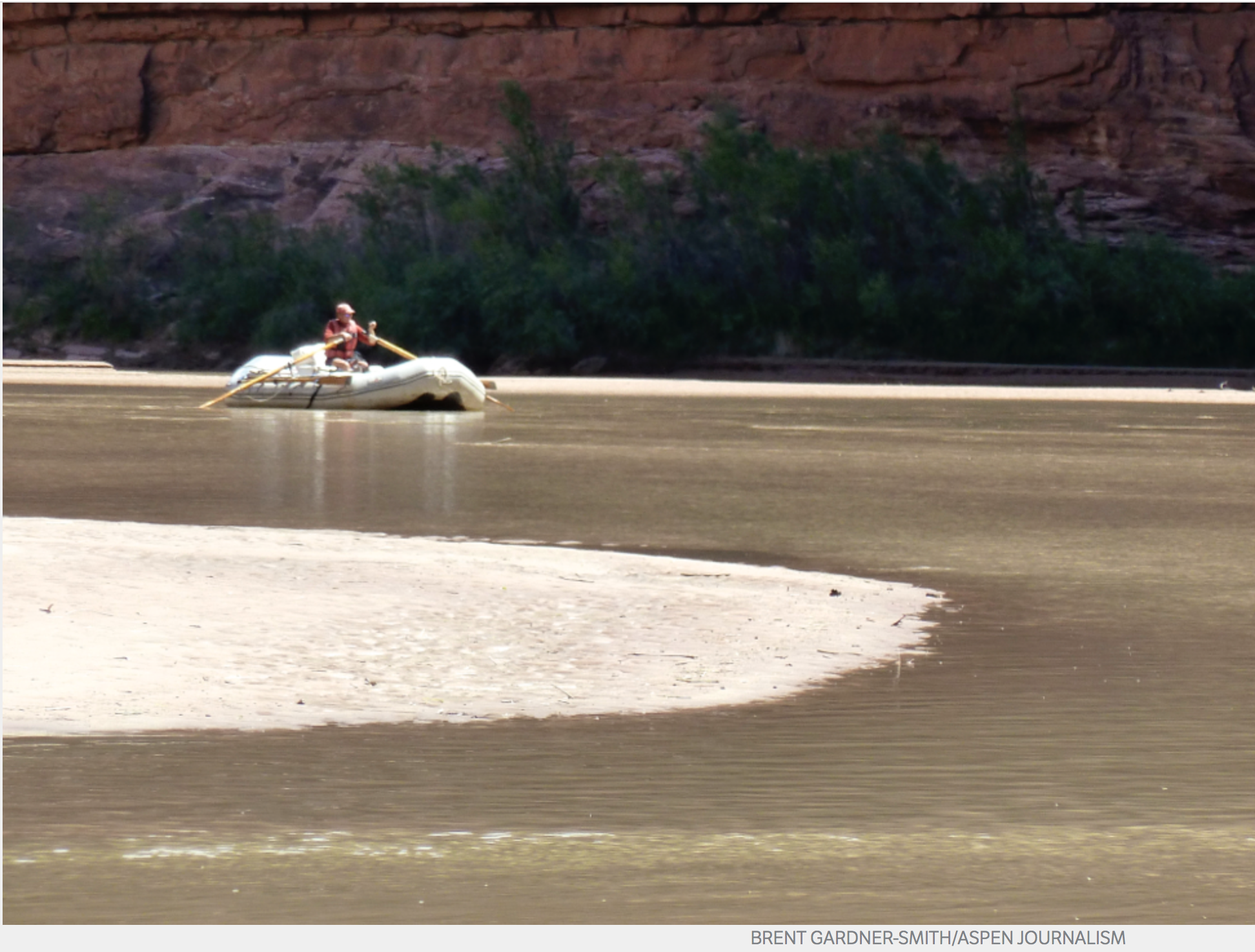
A boater, John Dufficy, makes his way down the lower end of the San Juan River toward the take-out, in 2014. Photo Credit: Aspen Journalism/Brent Gardner-Smith
Navajo Reservoir, New Mexico. View looking north toward marina. The Navajo Dam can be seen on the left of the image. By Timthefinn at English Wikipedia – Transferred from en.wikipedia to Commons., Public Domain, https://commons.wikimedia.org/w/index.php?curid=4040102
From email from Reclamation (Susan Novak Behery):
In response to forecast warmer weather and increasing flows in the critical habitat reach, the Bureau of Reclamation has scheduled a decrease in the release from Navajo Dam from 600 cubic feet per second (cfs) to 500 cfs on Friday, May 7th, starting at 0400 AM. Releases are made for the authorized purposes of the Navajo Unit, and to attempt to maintain a target base flow through the endangered fish critical habitat reach of the San Juan River (Farmington to Lake Powell).
The San Juan River Basin Recovery Implementation Program recommends a target base flow of between 500 cfs and 1,000 cfs through the critical habitat area. The target base flow is calculated as the weekly average of gaged flows throughout the critical habitat area from Farmington to Lake Powell. Please be advised, due to the dry conditions this year, more release changes than usual may occur.
A kayaker makes her way down the San Juan River, which delivers water from Colorado, New Mexico and Utah to Lake Powell. Photo credit: Brent Gardner-Smith/Aspen Journalism
From email from Reclamation (Susan Novak Behery):
In response to forecast warmer weather and increasing flows in the critical habitat reach, the Bureau of Reclamation has scheduled a decrease in the release from Navajo Dam from 700 cubic feet per second (cfs) to 600 cfs on Saturday, May 1st, starting at 0400 AM. Releases are made for the authorized purposes of the Navajo Unit, and to attempt to maintain a target base flow through the endangered fish critical habitat reach of the San Juan River (Farmington to Lake Powell).
The San Juan River Basin Recovery Implementation Program recommends a target base flow of between 500 cfs and 1,000 cfs through the critical habitat area. The target base flow is calculated as the weekly average of gaged flows throughout the critical habitat area from Farmington to Lake Powell.
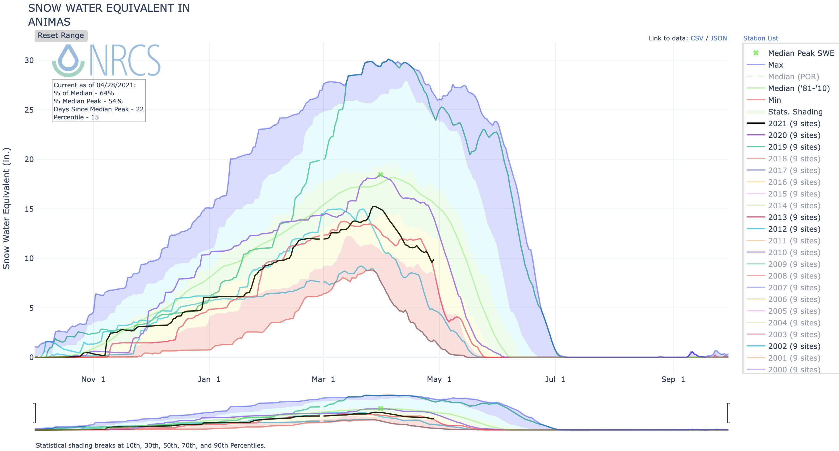
Snowpack has already peaked, and remains below average
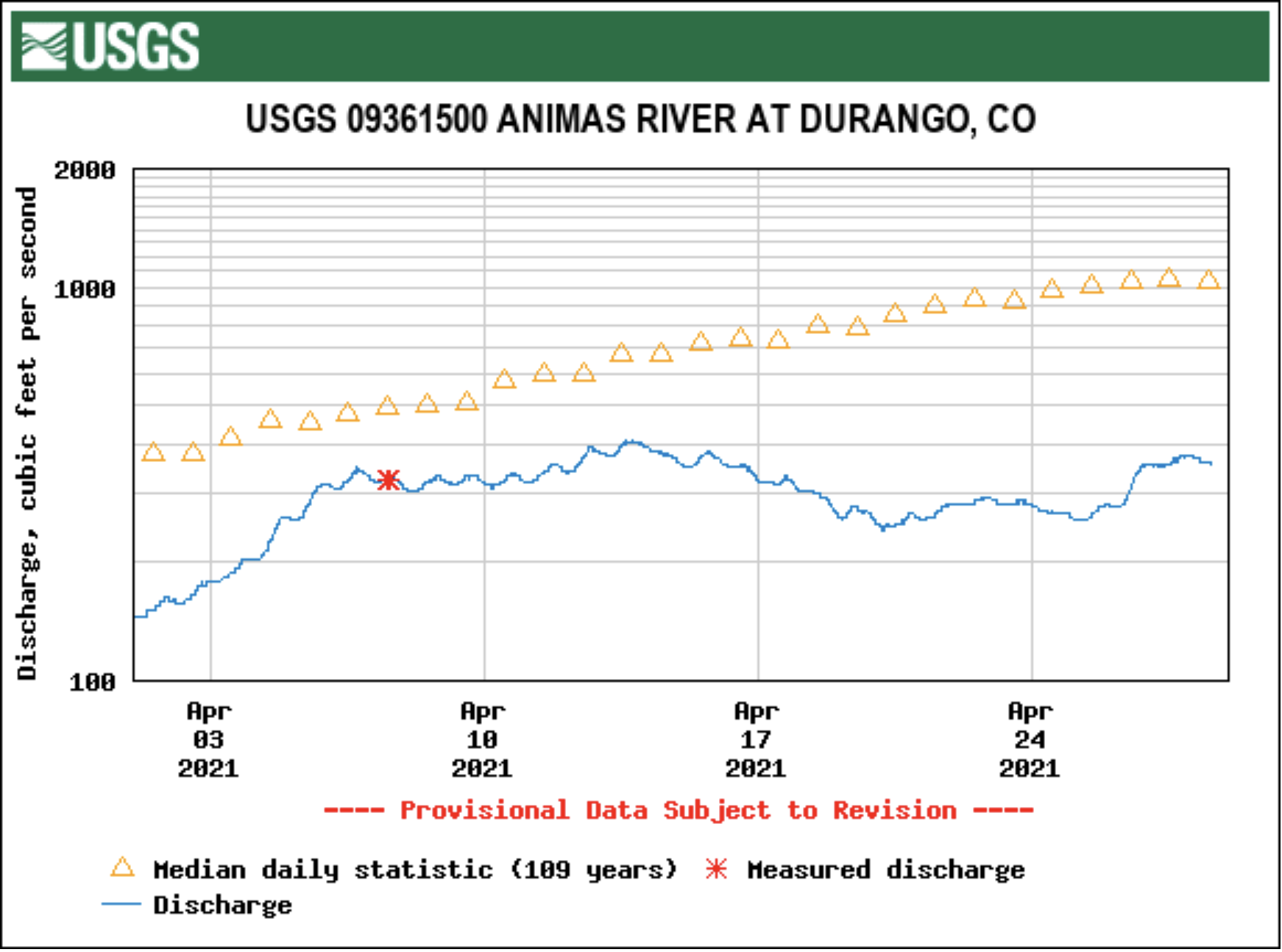
Snowmelt season is in full swing, but one may not know that by looking at the Animas River, which this week more closely resembles a slow trickle through Durango than a roaring, muddy torrent more common for this time of year.
The river’s flow Monday was about 328 cubic feet per second, according to the U.S. Geological Survey. By comparison, the average flow for April 26, based on 109 years of data, is 1,180 cfs. For reference, 1 cfs equals about 7.5 gallons flowing by a particular point in one second.
The Animas River’s peak runoff is still to come, but on average, the river’s flow is expected to be lower than usual through July, according to the National Weather Service. In fact, the river is expected to see about 45% of the volume it normally sees between April and July, said Aldis Strautins, National Weather Service hydrologist…
There are multiple reasons why the river is lower than average and projected to stay that way, Strautins said.
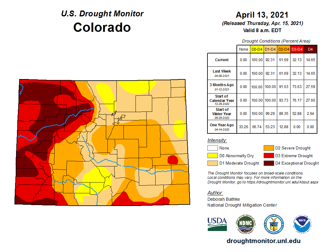
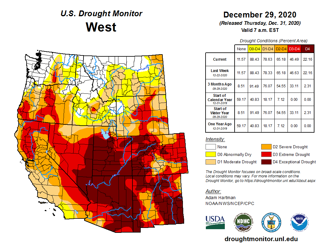
First, the region is in drought. Almost all of La Plata County was categorized as “extreme” or “exceptional” drought as of April 22, according to the U.S. Drought Monitor. Those are the most severe of five drought rankings.
Below-average precipitation and a poor monsoon season contributed to a dry summer and fall for Southwest Colorado, Strautins said.
Dry conditions led to low soil moistures. What precipitation the region did receive was immediately absorbed into the soil instead of running off.
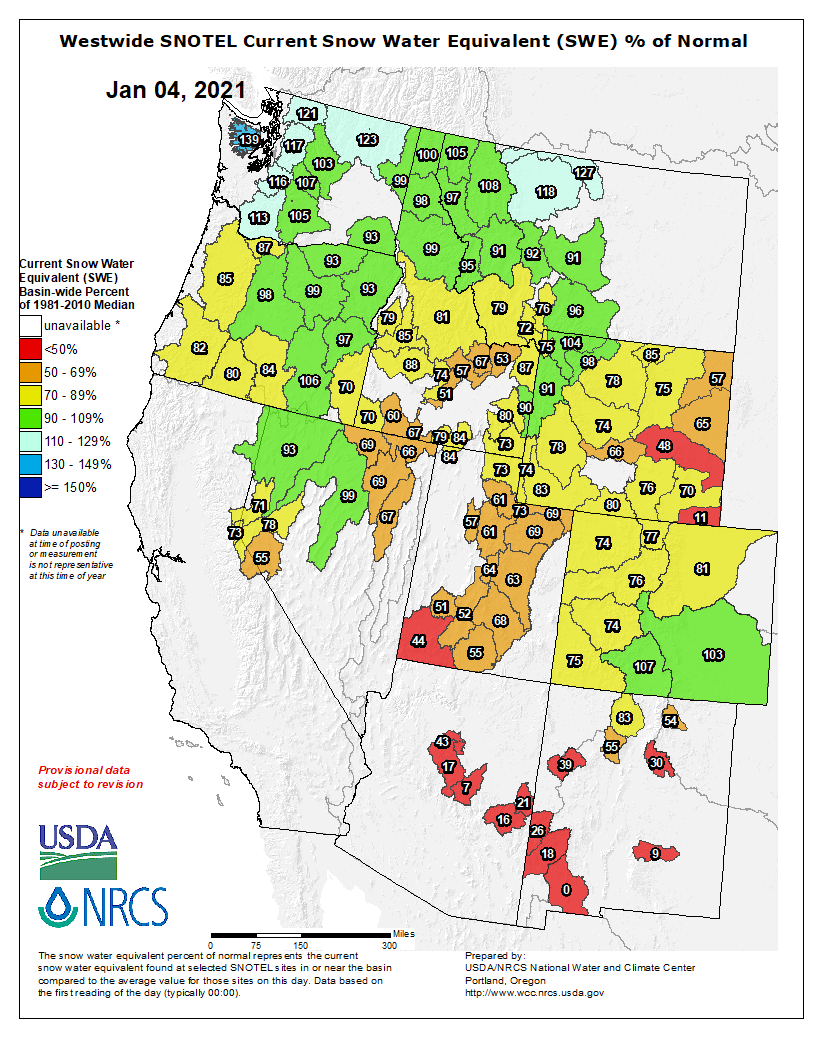
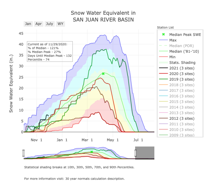
As of Tuesday, the snowpack was at 57% of the basin’s average. It also peaked earlier than usual, March 28 instead of April 6, according to provisional Snotel data from the U.S. Department of Agriculture.
The snowpack started melting after a warm spell in early April, then the melt slowed because of winter storms and some cloudy, cool days.
In response to decreasing flows in the critical habitat reach, the Bureau of Reclamation has scheduled an increase in the release from Navajo Dam from 600 cubic feet per second (cfs) to 700 cfs on Saturday, April 24th, starting at 0400 AM. Releases are made for the authorized purposes of the Navajo Unit, and to attempt to maintain a target base flow through the endangered fish critical habitat reach of the San Juan River (Farmington to Lake Powell).
The San Juan River Basin Recovery Implementation Program recommends a target base flow of between 500 cfs and 1,000 cfs through the critical habitat area. The target base flow is calculated as the weekly average of gaged flows throughout the critical habitat area from Farmington to Lake Powell.
Thank you for all who attended the April 20th, 2021 Navajo Unit Coordination Meeting. Please see the links below for the meeting summary and slides. Feel free to contact me with any questions or comments. The next meeting is scheduled for August 24th, 2021 at 1:00 PM.
The San Juan River, below Navajo Reservoir. Photo: Brent Gardner-Smith/Aspen Journalism
From email from the Bureau of Reclamation (Susan Novak Behery):
In response to decreasing flows in the critical habitat reach, the Bureau of Reclamation has scheduled an increase in the release from Navajo Dam from 500 cubic feet per second (cfs) to 600 cfs on Wednesday, April 21st, starting at 12:00 PM. Releases are made for the authorized purposes of the Navajo Unit, and to attempt to maintain a target base flow through the endangered fish critical habitat reach of the San Juan River (Farmington to Lake Powell).
The San Juan River Basin Recovery Implementation Program recommends a target base flow of between 500 cfs and 1,000 cfs through the critical habitat area. The target base flow is calculated as the weekly average of gaged flows throughout the critical habitat area from Farmington to Lake Powell.
FromThe Pagosa Springs Sun (Clayton Chaney and Randi Pierce):
The Pagosa Area Water and Sanitation District (PAWSD) is asking water users to practice responsible water use, with the district currently in a voluntary drought stage in compliance with its 2020 Drought Management Plan.
According to a press release from PAWSD District Manager Justin Ramsey, “The primary driver of this drought stage is the U.S. Drought Monitor (USDM),” which indicates that “our area is in a Severe to Extreme Drought.”
Ramsey’s press release notes that Hatcher Lake is lower than the median volume for this time of year, “however the lake is currently filling.”
“The flow of water in the San Juan is currently above the median flow for this time of year,” the press release further notes.
Ramsey also noted in his press release that so far this spring Pagosa Country has seen higher-than-normal temperatures.
He explained that the higher-than-normal temperatures combined with “a reduction in late spring precipitation will lead to a quicker-than-normal melting of the snowpack,” which will reduce the volume of available water and “could lead to water use restrictions.”
According to the press release, there are no mandatory water use restrictions, “however PAWSD does encourage responsible water use.”
[…]
River report
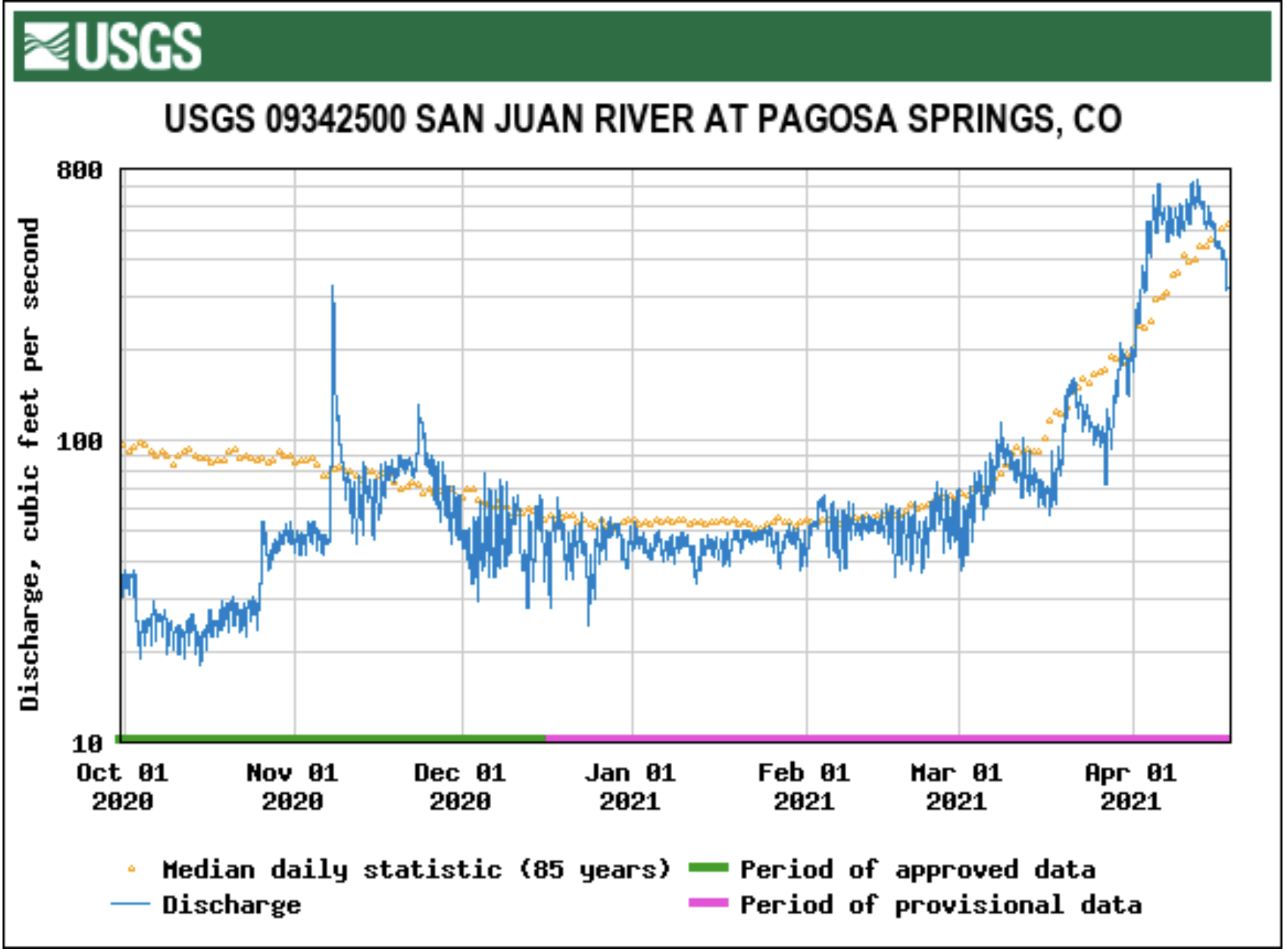
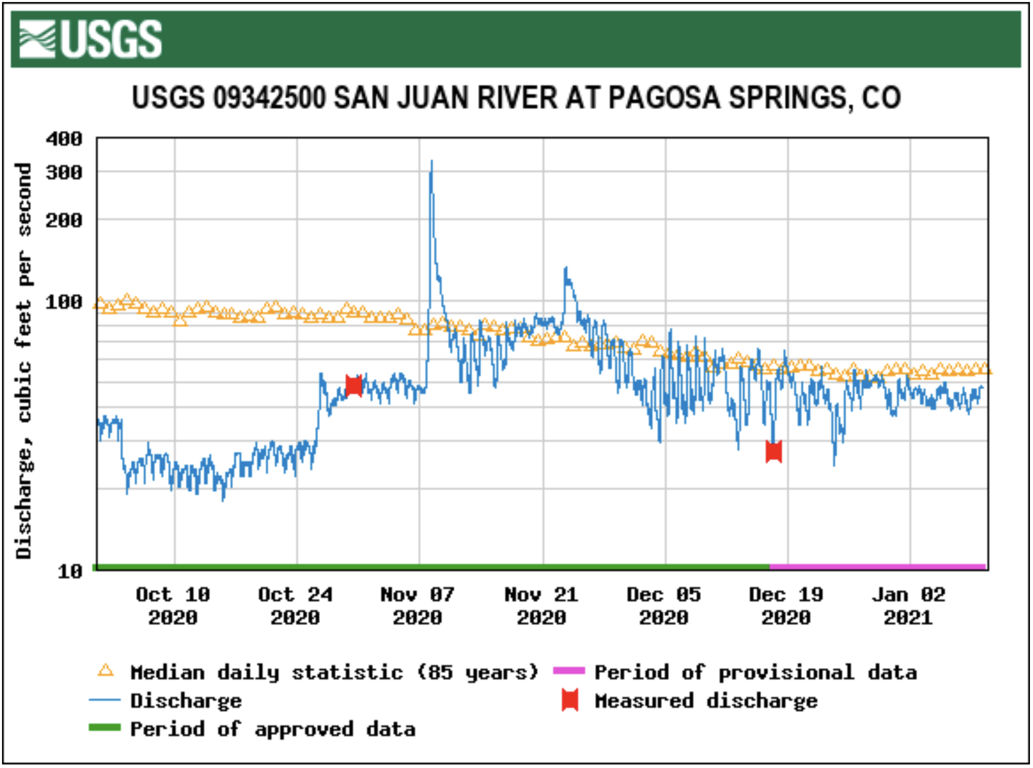
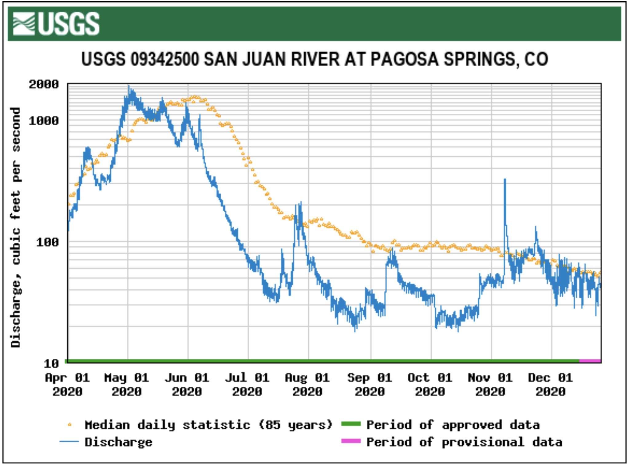
According to the U.S. Geological Survey (USGS), the San Juan River was flowing at a rate of 606 cubic feet per second (cfs) in Pagosa Springs as of 10 p.m. on Tuesday, April 13.
Based on 85 years of water records at this site, the average flow rate for this date is 514 cfs.
The highest recorded rate for this date was in 1985 at 1,930 cfs. The lowest recorded rate was 120 cfs, recorded in 1977.
As of 10 p.m. on Tuesday, April 13, the Piedra River near Arboles was flowing at a rate of 492 cfs. Based on 58 years of water re- cords at this site, the average flow rate for this date is 784 cfs.
The highest recorded rate for this date was 2,600 cfs in 1985. The lowest recorded rate was 128 cfs in 1977.
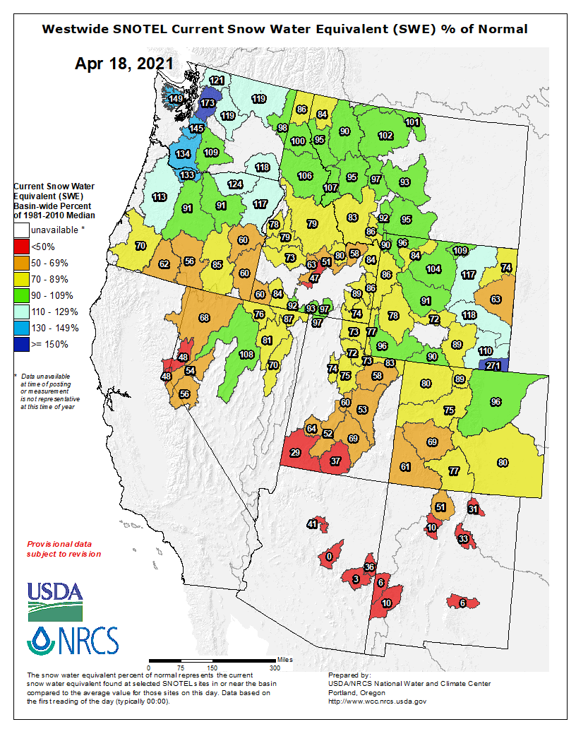
Westwide SNOTEL basin-filled map April 18, 2021 via the NRCS.
Snow report
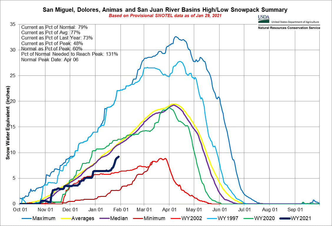
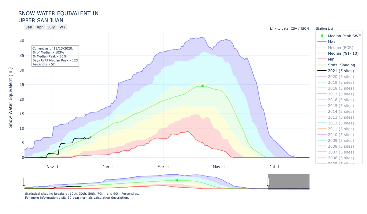
According to the U.S. Department of Agriculture National Water and Climate Center’s snowpack report, the Wolf Creek summit, at 11,000 feet of elevation, had 33.8 inches of snow water equivalent as of 10 p.m. on April 13.
That amount is 79 percent of the April 13 median for this site.
The San Miguel, Dolores, Animas and San Juan River basins were at 61 percent of the April 13 median in terms of snowpack.
U.S. Bureau of Reclamation construction inspector Kenny Redhouse carefully watched crewmembers install a section of pipe in an area south of Newcomb on April 15 as construction continued on a pipeline that will eventually deliver San Juan River water to Gallup and communities on the Navajo Nation.
The water will replace dwindling groundwater supplies and meet future demand…
Project broke ground in 2012
It was in June 2012 when then Secretary of the Interior Ken Salazar, former Navajo Nation President Joe Shirley Jr. and others broke ground for construction of the first phase of the Navajo-Gallup Water Supply Project.
Almost a decade later, construction proceeds on the San Juan Lateral, the largest of two segments that comprise the project. This lateral will eventually pump water from the San Juan River near Waterflow then deliver it south to Gallup and to Navajo Nation chapters along the pipeline and that surrounds the city.
As the lateral approaches Gallup, it branches east toward Crownpoint while another branch will serve Window Rock, Arizona, and areas along New Mexico Highway 264.
The bureau marked in October the completion of the Cutter Lateral, which will deliver water to several chapters on the eastern side of the Navajo Nation and to the southwestern portion of the Jicarilla Apache Nation.
Bart Deming, the project’s deputy construction engineer, said construction of the San Juan Lateral is about 50% complete…
Seven more years of work
The total cost of the project is about $1.5 billion, and the entire project will be operational in 2028, he said.
It is not difficult to notice construction activities alongside U.S. Highway 491 in Newcomb and Sheep Springs.
Rick Reese, field engineering division manager for the bureau’s Four Corners office, said sections of pipe near Burnham Junction, in Naschitti and portions of Newcomb have been installed within the last year and a half…
The area of focus now is south of Newcomb into Sheep Springs.
Completion on this portion of the lateral is on track to end in early 2022, Reese said…
The bureau awarded in September 2020 a nearly $46 million contract to Archer Western Construction LCC of Phoenix to build the pumping plant and a second one in Twin Lakes.
A report given to the San Juan Water Conservancy District (SJWCD) on March 29 was approved by the board, leading to future considerations to be considered for the district’s West Fork reservoir and canal water rights.
The report, crafted by Wilson Water Group (WWG), reviewed the district’s water rights portfolio and other storage studies to “understand opportunities and limitations” based on original decrees, previous diligence efforts and other storage locations.
WWG was hired by the SJWCD via a board decision at a Sept. 21, 2020, meeting for a cost of $19,050.
According to the report, not only were studies done for alternative uses for the West Fork reservoir and canal water rights of the district, but analyses were done to estimate water available to the San Juan River Headwaters Project reservoir water rights and to a junior storage right.
Currently, the district has a West Fork canal water right that is specifically 50 cubic feet per second (cfs) of conditional water that includes decreed uses of irrigation, industrial and municipal.
The report notes that this right will be abandoned by the water court if not used or perfected at the time the San Juan River Headwaters Project facilities are constructed.
The SJWCD also has a water right associated with the second enlargement of the Dutton Ditch, the report describes.
This water right is 20 cfs that in- cludes decreed uses of irrigation, municipal and domestic.
This right will also be abandoned by the water court if not used or perfected at the time the San Juan River Headwaters Project facilities are constructed, the report notes.
“A significant physical limitation to development of the Dutton Ditch Second Enlargement water right is the location; there is not reliable wa- ter supply available on these smaller tributaries except during the runoff period primarily in May and June,” the report reads.
Additionally, the district has a 50 cfs conditional water right at the San Juan River Headwaters Project pumping station, the report indicates.
“This right cannot be diverted if the San Juan River at Pagosa Springs streamflow gage shows flow less than 100 cfs from March 1 to August 31 or less than 60 cfs from September 1 to February 29,” the report states. “Besides the potential cost versus benefit imbalance of pumping water for potential storage at this location, the water available in many years can be significantly limited by the stipulated flow requirements at the San Juan River at Pagosa Springs streamflow gage.”
The SJWCD also has 1.1 cfs of absolute water rights associated with shares in the Park Ditch Company at the Park Ditch, the report notes.
This water right notes that the Park Ditch must be the location to divert water to store in the San Juan River Headwaters project, among other stipulations.
According to the report, the district has storage water rights at the West Fork reservoir, which is about 24,000 acre feet in conditional water rights.
“The stipulation subordinating the West Fork Reservoir storage rights to upstream water rights senior to a December 31, 2013 is significant; as it essentially changes the water right appropriation date to January 1, 2014 as to any water rights located upstream,” the report reads. “The requirement to move the water right downstream of Boot- jack Ranch to a likely off-channel reservoir site is not as limiting, because permitting an on-channel reservoir at any location on the San Juan River would be a significant challenge. The uses under the storage right may be limiting, as it does not include the authorization to release water to the San Juan River to meeting environmental or recre- ational needs.”
The SJWCD also has 6,300 acre- feet of conditional storage rights at the San Juan River Headwaters proj- ect site and another 4,700 acre-feet on first fill and 11,000 acre-feet on refill of conditional storage rights.
Swim class on the San Juan River. Photo: Brent Gardner-Smith/Aspen Journalism
The outflow at the bottom of Navajo Dam in New Mexico. Photo: Brent Gardner-Smith/Aspen Journalism
From email from Reclamation (Susan Novak Behery):
In response to decreasing flows in the critical habitat reach, the Bureau of Reclamation has scheduled an increase in the release from Navajo Dam from 400 cubic feet per second (cfs) to 500 cfs on Friday, April 9th, starting at 4:00 AM. Releases are made for the authorized purposes of the Navajo Unit, and to attempt to maintain a target base flow through the endangered fish critical habitat reach of the San Juan River (Farmington to Lake Powell).
The San Juan River Basin Recovery Implementation Program recommends a target base flow of between 500 cfs and 1,000 cfs through the critical habitat area. The target base flow is calculated as the weekly average of gaged flows throughout the critical habitat area from Farmington to Lake Powell.
From The Upper San Juan Watershed Enhancement Partnership (Mandy Eskelson and Al Pfister) via The Pagosa Springs Sun
A Pagosa Springs-based collaborative group, called the Upper San Juan Watershed Enhancement Partnership (WEP), has been working since 2018 to identify concerns and opportunities to address the needs of the diverse water users of the Upper San Juan River Basin.
The WEP strives to be a community-driven effort that supports values and needs unique to our basin while assisting the broader state and regional goals of the Colorado State Water Plan and Southwest Basin Implementation Plan. The state calls these local planning efforts of multiple water uses either Stream Management Plans (SMP) or Integrated Water Management Plans (IWMP).
The WEP’s three-phased IWMP process is designed to ensure there is ample time to gather public feed- back, conduct analysis and create a plan with local priorities, which is why we encourage all community members to attend our upcoming virtual public meeting. We are excited to share our updates from our work and hear your ideas on how this information can be used to support local water users.
In Phase I, the WEP organized a steering committee comprised of representatives of the agricultural, environmental, municipal and recreational water users of our community to begin outlining water-related needs and issues. Through multiple public meetings, the steering committee gathered input on the geographic scope/focus, concerns and potential project opportunities to help guide what information was known, what gaps existed, new data to collect, and what analysis and modeling the community wanted in Phase II.
In 2020, as part of Phase II, the WEP has partnered with experts Lotic Hydrological and San Juan Conservation District/NRCS to analyze components identified as priorities during public meetings, such as current and future river flows, riparian habitat, forest health/wildfire risk influences on water resources, and agricultural infrastructure conditions and needs. Based on public feedback and the capacity of models and our partners, the WEP’s work has mainly focused on the upper San Juan watershed, but we continue to include steering committee members and project components from the Rio Blanco and Navajo watersheds.
Results from Phase II’s data analysis, field assessments and model outputs now need to be reviewed and approved by you, the community. Our upcoming public meeting on Wednesday, March 31, held via Zoom
from 5:30 to 7:30 p.m., will present the preliminary results of these assessments and models, gather feedback to ensure it aligns with local experience and knowledge, or identify where additional data and analysis may be needed. WEP steering committee members Joe Crabb and Justin Ramsey will also present on local water systems and drought preparations.
Learn how to access the March 31 public meeting and find additional information about the Upper San Juan Watershed Enhancement Partnership at http://www.mountainstudies.org/sanjuan/smp.
To learn more about other Colorado watershed groups conducting a SMP/IWMP process, visit www. coloradosmp.org. If you have questions, please contact Al Pfister at westernwildscapes@gmail.com or Mandy Eskelson at mandy@mountainstudies.org. We hope to “see” you on March 31.
The Pagosa Area Water and Sani- tation District (PAWSD) Board of Directors approved its drought management plan at its regular meeting on March 11, with things mostly staying the same from last year’s plan, except for changes made to drought triggers.
In an interview on Monday, PAWSD Manager Justin Ramsey explained the reason behind the changes in drought triggers.
“Historically, it’s been a cumulative amount of water: how much water is in the lakes, how much water is in the river, altogether,” he said. “Now, we’re going to break that up. If the lake gets too low, we’re going to go into drought management regardless of what the river is doing, or vice versa.”
Drought management stages could also be triggered by snow water equivalency (SWE) data and whether or not a call is made on Fourmile Creek, he added later.
“We did it the exact same way, we just broke it up so it’s not a cumulative amount of water, it’s individual pieces of water that could put us into a drought stage,” he said.
According to the plan, there are four stages of drought, which in- cludes a voluntary period of water
reduction.
The voluntary stage, according to the plan, is intended to give the community advanced notice about developing drought conditions and aims to start the process of water conservation, according to the plan.
Level-one drought management, or a low category of drought, could be triggered by a variety of methods, whether it be SWE, a call date on Fourmile, the reservoir level in Hatcher Lake, drought stages or the San Juan River flow, Ramsey noted.
Level one is categorized as being a stage that aims to build upon the voluntary efforts while also incorporating basic mandatory water-use restrictions that look to curb excessive outdoor irrigation. This stage would also include an “increase community outreach and awareness campaign,” according to the plan.
The plan further notes that there would no surcharges or modifications to rate structures, but penalties for noncompliance could be issued.
“For all of them, anything could go on depending on how early it happens,” Ramsey said of the four stages of drought triggers. “Any of these triggers could put you into a drought stage one through four. It just depends on what happens.”
Level two, or moderate level of drought, is described as an “advance notice” of severe drought conditions.
This stage of drought features amplified mandatory water-use restrictions, more aggressive com- munity outreach and a modified water-use rate structure for residential users.
Level three, or serious level of drought, is defined by the plan as drought conditions that threaten water availability.
“Mandatory water use restrictions are further amplified to curb water consumption and extend the usability of current water supplies,” the plan reads. “A drought surcharge will be implemented on both residential and commercial customers and the water use rate structure will be implemented for commercial customers and be further modified for residential customers.”
The final stage, level four, or severe drought, indicates “dangerously low” water supply levels, according to the plan.
This stage would feature drought surcharges and the water-use rate structure being further modified, according to the plan.
Ramsey explained that sur- charges will not be triggered until level three. There will be a charge for heavier water use at level two, but no surcharge will be incurred. The surcharge for drought stage three is $17.23 per equivalent unit (EU) and for drought stage four it’s $21.53 per EU, he noted.
A small crowd gathered to watch as Jim Dunlap pressed a control button. Moments later, the people inside the small building could hear the sound of water from Lake Nighthorse rushing through a pipe and out of the dam.
It was a simple move, but one that had been decades in the making for Dunlap. It was the first time water from the reservoir had been released into the Animas River at the request of the San Juan Water Commission.
While the Animas-La Plata Operations, Maintenance and Replacement Association has released water from the dam as part of maintenance operations and to ensure everything is properly functioning, this was the first time it had been released based on an official request.
Lake Nighthorse stores water for municipal use for the San Juan Water Commission as well as other water users, including Navajo Nation and the Southern Ute Indian Tribe and the Ute Mountain Tribe. Filling of the reservoir began in 2009, and there was a ribbon-cutting ceremony in 2018…
Drought management plans for the San Juan County Commission include using water stored in Lake Nighthorse, but little is known about what would happen to the water once it is released.
The commission hopes one day there will be a pipeline to transport the water from Colorado to New Mexico, but, until then, the water must be released into the Animas River. The March 15 release will help gather data that can be used in the future to predict how much water could be lost from the time it is released from Lake Nighthorse to the time it reaches pump stations for water users downstream.
The San Juan Water Commission continues to monitor conditions around the Animas River, including flow and snowpack, to decide if it will request a release from Lake Nighthorse this month.
San Juan Water Commission Director Aaron Chavez said the decision will likely be made later this week…
The City of Farmington initially requested a possible release from the reservoir as a way to test the water delivery from Lake Nighthorse to entities in San Juan County. The City of Aztec has expressed interest in also taking some of the water released if it does occur…
The release depends on the water levels in the river remaining low because the test release will be a way to gather data for a drought scenario…
A test release could help provide data about water loss as the water would flow down the Animas River channel. Because the irrigation ditches are closed for the winter, it would also provide data about water flow and downstream recovery in the river without any of that water being diverted for agriculture.
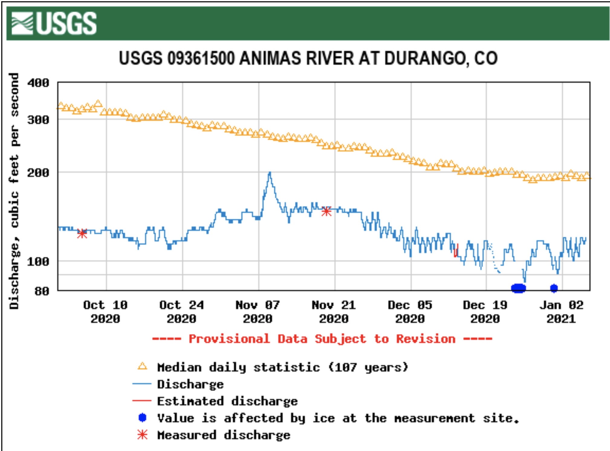
On the morning of March 8, the Animas River was flowing at 138 cubic feet per second in the Cedar Hill area near the state line, according to the U.S. Geological Survey stream gauge. A stream gauge in Farmington was registering 175 cubic feet per second. These readings are about half of what would typically be seen on the Animas River in a normal year.
According to the U.S. Department of Agriculture National Water and Climate Center’s snowpack report, the Wolf Creek summit, at 11,000 feet of elevation, had 25.5 inches of snow water equivalent as of 2 p.m. on March 3.
That amount is 101 percent of the March 3 median for this site.
The average snow water equivalent for this date at the Wolf Creek summit is 25.8 inches.
The San Miguel, Dolores, Animas and San Juan River Basins were at 79 percent of the March 3 median in terms of snowpack. This is a 6 percent decrease in snowpack for the region compared to last week’s report.
River Report
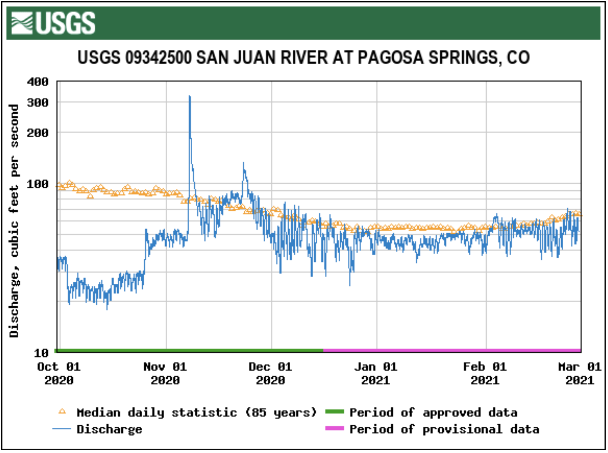
According to the U.S. Geological Survey (USGS), the San Juan River was flowing at a rate of 59.2 cfs in Pagosa Springs as of 2 p.m. on Wednesday, March 3.
Based on 85 years of water re- cords at this site, the average flow rate for this date is 87 cfs.
The highest recorded rate for this date was in 1986 at 359 cfs. The lowest recored rate was 29.3 cfs, recorded in 2002.
An instantaneous reading was unavailable for the USGS station for the Piedra River near Arboles.
It is noted on the USGS website for this station that the reading of the river flow rate is affected by ice at the station.
Based on 58 years of water records at this site, the average flow rate for March 3 is 152 cfs.
The highest recorded rate was 573 cfs in 1995. The lowest recorded rate was 26.5 cfs in 2003.
The San Juan Water Conser- vancy District (SJWCD) approved its strategic plan for 2021 at a meeting on Feb. 15.
The strategic plan, which had been in development since 2018, is to be used to help the district identify water resource issues in the Upper San Juan River Basin within the district’s geographical scope, according to the plan.
Additionally, the plan outlines that its purpose is to help the district evaluate its options for addressing water resource issues and outlining which options could be acted upon.
Other objectives include the SJWCD Board of Directors developing long-term goals and direction for the district and relaying that information to the public, the plan notes.
Mission and value statements
Included within the plan is the SJWCD’s mission statement, which reads “To be an active leader in all issues affecting the water resources of the Upper San Juan River Basin.”
[…]
These statements note that the SJWCD board is “committed to ensuring that various current and future water supply needs are met through whatever conservation and water management strategies and methodologies are available.”
Another value statement reads, “The Board opposes any new transfers of water from the Upper San Juan River and its tributaries upstream of Navajo Reservoir to basins outside of the Upper San Juan River Basin.”
The opposition toward this comes from the SJWCD believing that transfers would interfere with existing beneficial uses of water, damage to economic stability and reduced environmental quality, the plan indicates.
Other value statements include that the SJWCD board is commit- ted to managing water rights it holds, supporting wise land-use policies and processes, and man- aging and funding effective monitoring, protection and restoration programs.
One value statement notes that the SJWCD board believes that the district must participate in statewide processes, like the Colorado Water Plan, to address various issues such as climate change, drought and water shortages.
According to the U.S. Department of Agriculture National Water and Climate Center’s snowpack report, the Wolf Creek summit, at 11,000 feet of elevation, had 25.7 inches of snow water equivalent as of 2 p.m. on Feb. 24.
That amount is 109 percent of the Feb. 10 median for the site.
The average snow water equivalent for this date at the Wolf Creek summit is 23.5 inches.
San Miguel, Dolores, Animas, and San Juan Basin High/Low graph February 26, 2021 via the NRCS.
The San Miguel, Dolores, Animas and San Juan River Basins were at 85 percent of the Feb. 24 median in terms of snowpack…
River report
According to the U.S. Geological Survey (USGS), the San Juan River was flowing at a rate of 49.4 cfs in Pagosa Springs as of 2 p.m. on Wednesday, Feb. 24.
Based on 85 years of water re- cords at this site, the average flow rate for this date is 73 cfs.
The highest recorded rate for this date was in 1995 at 269 cfs. The lowest recored rate was 28 cfs recorded in 1961.
At its meeting on Feb. 11, the Pagosa Area Water and Sanitation District (PAWSD) Board of Directors nailed down its drought management system.
PAWSD Manager Justin Ramsey went over the trigger points in place for establishing drought stages.
Ramsey said, “The way we’re going now is based upon a couple different trigger points, and it’s also based on the date that the trigger point hit. For example, if Hatcher is down 6 feet and if it’s in late September, no big deal; if it’s in early May we’ve probably got problems coming. So, this way it kind of helps us see what’s coming on.”
He continued, “Later on, in the summer, then we’ll start looking at three other issues: the amount of water in the Hatcher reservoir, the amount of water that’s going down the San Juan River and the state’s drought statement.”
PAWSD Treasurer Glenn Walsh voiced a concern.
“The two triggers early in the season, the call date and the snow water [equivalent] … those just need to be aligned better. If we’re operating off hitting both triggers, then I have less concern. But if we’re operating off hitting one of the two triggers, for instance the call date in 2018 was 4/11, and if we had a 2018-type year, I wouldn’t be comfortable with just starting the year full-blown stage 4 — ‘your lawns are going to die’ — because my impression was 2018 was not that type of year … Even though we do have two indicators that we use up until June 1 and then three that we use after June 1, it would be good if those were aligned so there’s not some discordance where we’re in level 4 then when we turn over to the river and lake level and the regional drought declaration we’re back to level 1 — you know? We’re jumping back and forth,” he said.
“I guess my question is we’re going to trigger the early season stages by one of the two measures, or are we going to go with the least restrictive? … If we’re only going by one trigger, that could wind up being kind of a false alarm,” Walsh said.
Ramsey responded, “Yes and no … They typically do fall fairly close together. … I don’t know how often they do a call before we run out of snow — it’s usually within a week. … Just because the trigger says to do that, if there’s a reason for the board to say, ‘Let’s not do it because of x, y, or z,’we call it. It just gives us a starting point … To go to stage 1, 2, 3, 4 takes a board decision; it doesn’t just do it automatically.”
[…]
At the meeting, Ramsey mentioned that entering a voluntary level 1 or level 2 drought stage in the early season might help to eliminate the chances of reaching level 3 or level 4 later in the season by means of alerting the public to be conservative with their water usage.
“The way we’re moving now, we’re probably going to go at a voluntary level 1, level 2 a little earlier than we have historically. We are not going to charge a surcharge to throw you into level 3 or level 4. When we get into level 2, there will be an increase in excess water use in residential, and when we get to level 3 there will be an excess water use in commercial. But, there will be no surcharge until we get to level 3 and level 4,” notified Ramsey.
He added, “The way I calculated the surcharge was … for every drought stage we have it goes to a decrease on one use by x percentage, so I just assume that we decreased our water use by x percentage, which means that we decreased our income by x percentage, and I’m making it up with that.”
He continued, “The hope is by going into drought mitigation level 1, level 2 voluntary, early … the only way to get to that surcharge is if we were in great dire straits.”
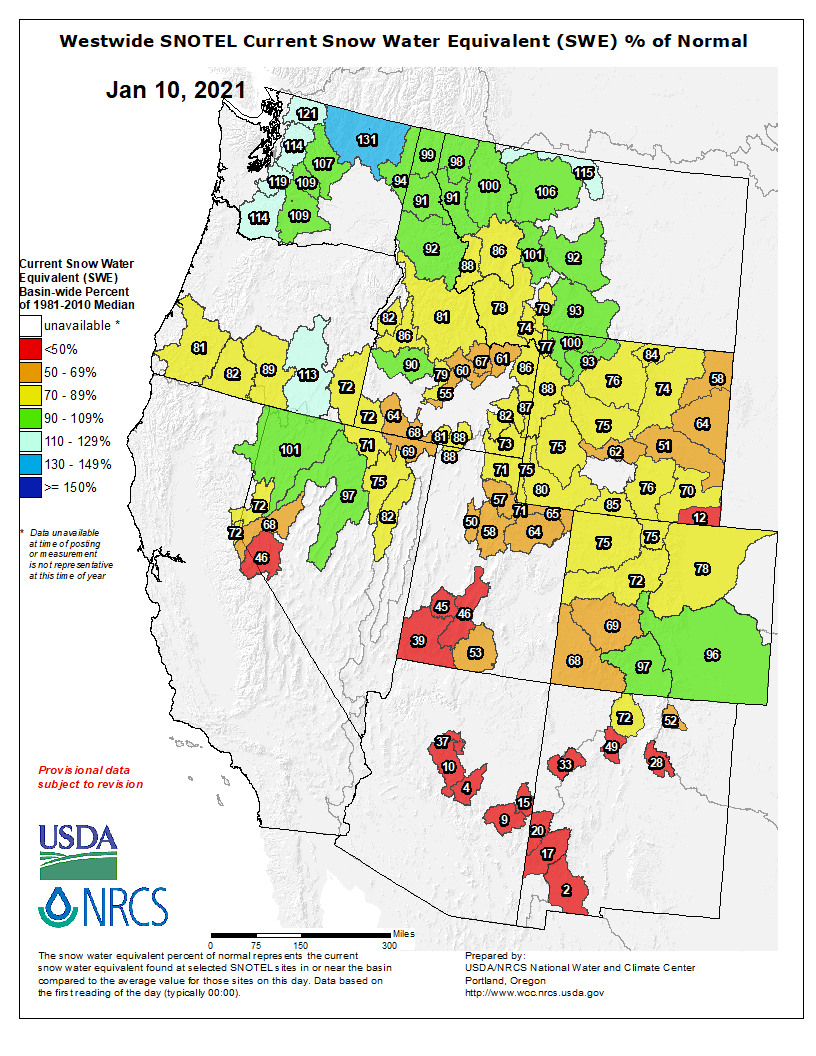
A recent trio of storms that provided significant moisture to many parts of San Juan County has brought the snowpack up to near normal in the mountains of southwest Colorado for the first time all season.
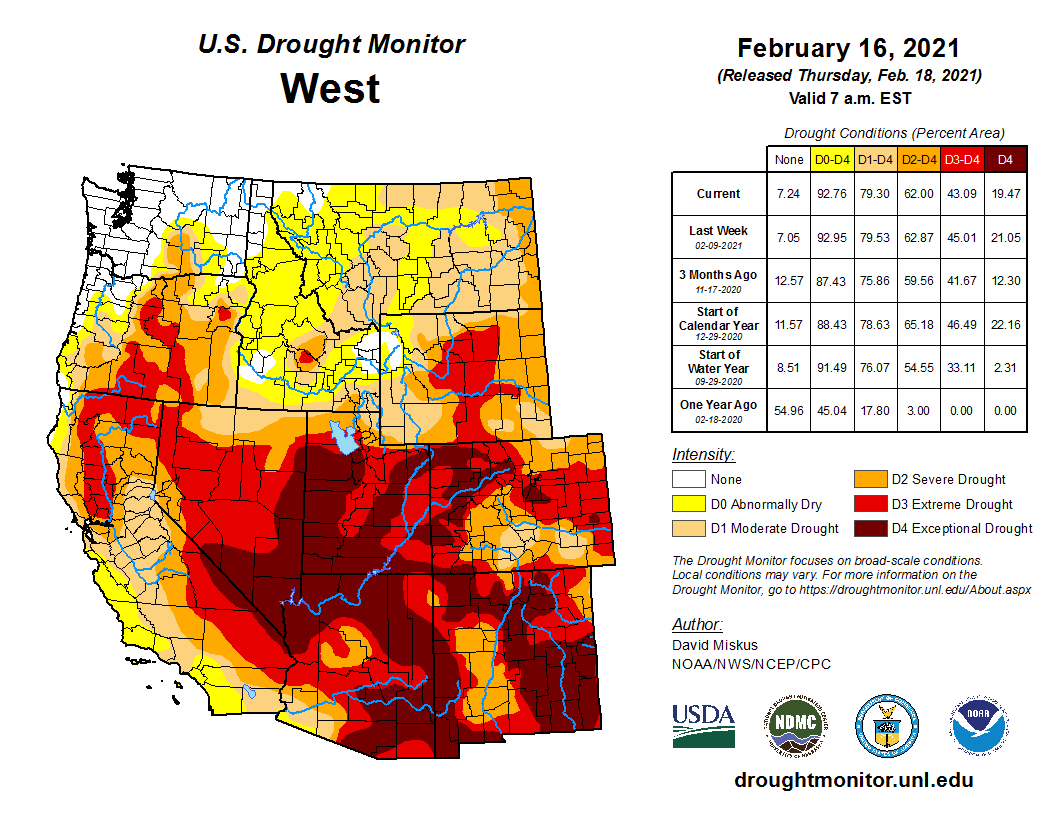
But it did little to make a dent in the drought that has plagued the area for the last year and a half.
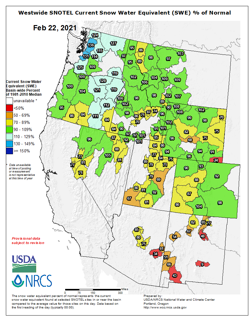
According to the U.S. Department of Agriculture’s summary for the San Miguel, Dolores, Animas and San Juan river basins, the snowpack stood at 89% of normal and 84% of average on Feb. 19. That was a significant step up from just 10 days earlier, when those figures were near 60% and falling rapidly.
Sharon Sullivan, a meteorologist for the National Weather Service bureau in Albuquerque, said those figures were buoyed by storms that left 4 to 5 inches of snow in parts of Farmington, Aztec and Bloomfield from Feb. 12 through Feb. 16.
West Drought Monitor February 16, 2021.
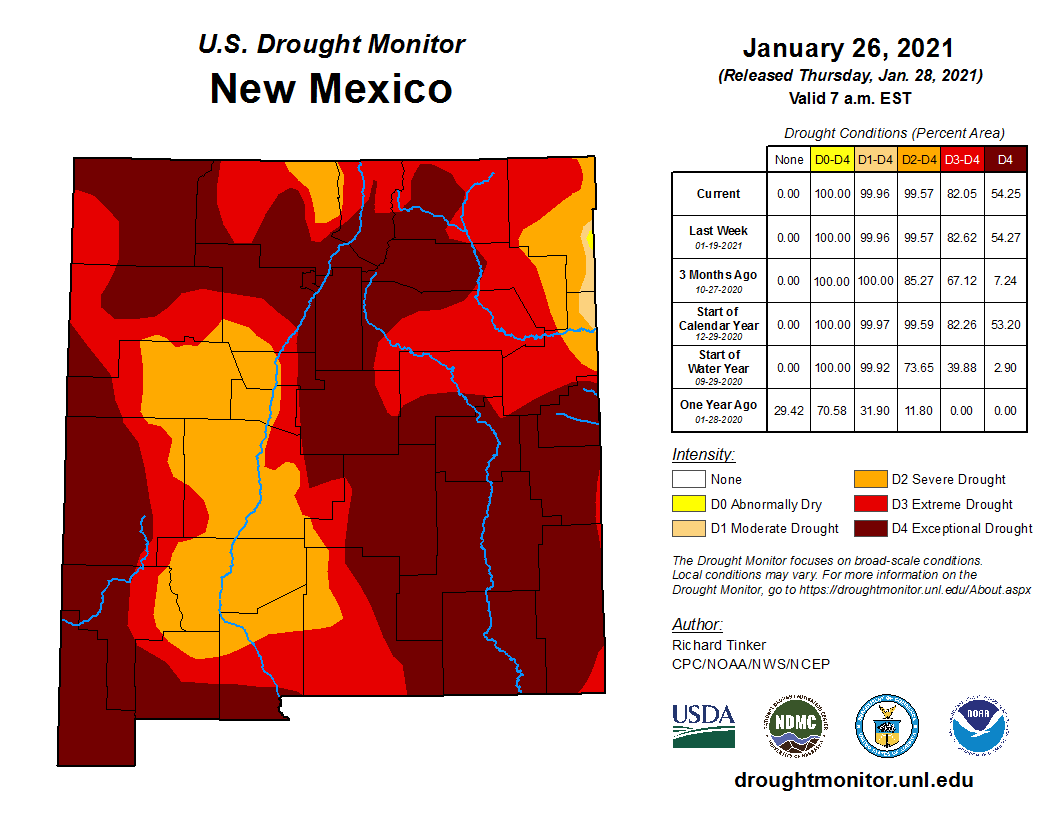
But anyone who takes this as a sign that the drought has been chased away would be well advised to curb his or her enthusiasm. According to the U.S. Drought Monitor, most of San Juan County remains locked in exceptional drought, the worst classification. That includes all but the southwest corner of the county, which is characterized as being in extreme drought, the second-worst category, or severe drought, the third-worst category in the five-tier drought system…
The outlook for significant additional moisture is not promising. Sullivan said the long-range forecast calls for above-average temperatures and below-average precipitation in the area.
San Juan County residents may find some small consolation in the fact that conditions are even worse in other parts of the state. According to the drought monitor, 54.2% of the state is characterized as being in exceptional drought — a condition that can lead to the closure of federal lands for fire precautions, the implementation of burn bans by local governments, the encroachment of bears on developed areas, a change in flight patterns by migratory birds and the absence of surface water for agricultural use, leading farmers to rely on wells.
The state’s southeast corner has been hit the hardest, with two counties — Eddy County and Chaves County — entirely in exceptional drought, and four others — De Baca, Curry, Roosevelt and Lea counties — having only small slivers of their territory escaping that designation. Additionally, most of Lincoln and Torrance counties are in exceptional drought.
Colorado Springs Collection System via Colorado College.
The 25 reservoirs in the Colorado Springs Utilities network of water storage, still have several years of water stored. Another dry year could take a toll.
Snowpack started slow in December and January. “February 1st we were looking at snowpack averages maybe 75 to 78% of average,” said [Kalsoum] Abbasi. In the two weeks since then multiple snowstorms helped make up for low totals. Numbers in the water basins important to Colorado Springs are now at or just below normal. It’s certainly a relief to see those numbers go up the past couple of weeks.”February is when data tracking for the Colorado snow season officially begins. It is off to a good start, but the numbers have to be maintained with more storms through May.
Climate change will both decrease water supplies and increase demand, and the New Mexico Interstate Stream Commission hopes a 50-year water plan will provide the tools and resources needed to navigate the future.
This water plan, which is currently in the first phase of work, is among the Gov. Michelle Lujan Grisham’s priorities.
A study session on Feb. 18 provided the ISC commissioners with background on water planning in New Mexico, from the 19th century belief that rain would come if the land was farmed to the 2018 water plan that highlighted work needed in New Mexico’s 16 water planning regions.
The 50-year water plan will likely be completed in 2022. The ISC is supposed to learn more about it during the March study session.
Regions with limited aquifers rely almost entirely on surface water. Lucia Sanchez, the ISC’s water planning program manager, gave the San Juan River basin as an example of one of those areas. Meanwhile, there are other regions of the state with no surface water. In those regions, they rely almost entirely on groundwater. Sanchez highlighted Lea County as an example of an area that relies on groundwater.
Looking to the future, Sanchez said there is a projected gap in supplies even without accounting for climate change in regions that rely heavily on groundwater. Under a drought scenario, she said all regions of the state will be impacted.
“I almost feel like a state water plan is like somebody asking for directions and that’s easy enough to come up with if you know where the destination is,” said Commissioner Aron Balok. “And I feel like we’ve been asked to come up with directions but haven’t been given the destination, where we want to arrive.”
He explained that New Mexico uses prior appropriation doctrine to react to scarcity. That means the oldest water rights have priority if there is a shortage. Balok said a state water plan should look at alternatives to prior appropriation…
Commissioner Greg Carrasco said it is easier to project future water supplies than to predict what the demand will be for water in 50 years.
The contract between the San Juan Water Conservancy District (SJWCD) and its current board consultant, Renee Lewis, will not be renewed, and the existing contract between the two parties will continue for an additional month.
During the Feb. 15 meeting of the SJWCD board, SJWCD Chair Al Pfister explained that Lewis had sent an email to himself, SJWCD board member John Porco and SJWCD’s legal counsel, Jeff Kane, informing them that she did not want to take on a new agreement with a continuation of services.
As snow and rain fell outside, about 50 audience members gathered at the indoor arena of the Montezuma County Fairgrounds for the morning meeting session to hear presentations, some broadcast via Zoom…
State House bills
Republican Marc Catlin, state representative for the 58th District, listed some bills he plans to introduce.
A watershed mitigation bill proposes to provide funding for cities and counties for timber thinning projects on private land. A water rights bill would protect the water rights of mutual ditch companies. Another bill would allow tribes to operate their own foster homes so Native American foster children could grow up in their culture. Catlin said a bill providing a tax exemption for the removal of beetle-killed trees in forests would be an incentive to remove the fire-prone dead trees.
A fresh face was appointed to the Southwestern Water Conservation District to bring new ideas to decades-old problems surrounding water in the arid Southwest – at least that’s the hope of La Plata County officials.
In January, La Plata County commissioners Gwen Lachelt and Julie Westendorff, in their last meeting before leaving office, along with commissioner Clyde Church, appointed local water attorney Amy Novak Huff to the district.
The move ousted longtime board member Bob Wolff, who has represented La Plata County on the commission for more than 10 years.
Lachelt, speaking to The Durango Herald, said commissioners will sometimes replace people who have served long bouts of time to bring in new perspectives about various issues facing the county…
Huff was raised in Southern California, but went to school at the University of Colorado-Boulder and never looked back. After teaching high school in Durango and Mancos, she went to law school at the University of Denver while working at Denver Water, where she became drawn to water law.
After she passed the bar exam, Huff was selected for a judicial clerkship in Division No. 1 Water Court and then worked for a water law firm in Denver. All those years on the Front Range, where water is scarce, allowed her to experience firsthand the contentious water issues…
Huff said she has now been practicing water law for 18 years, the majority of which has been in Southwest Colorado where water issues abound, exacerbated by drought, increasing demand and tricky multi-state compacts…
Huff, for her part, will take a seat at her first board meeting Tuesday. She said she understands the gravity of the moment and how important local decisions will affect water availability and people’s way of life.
“We’re going to be faced with water restrictions, changing landscapes and people are going to be forced to learn (about water issues),” she said. “It’s a lot more complicated than people think.”
Swamps, wet meadows, floodplains, bottomlands, bogs, freshwater and saltwater marshes, places where the water stands still and the soil becomes inundated to the point of saturation — these are wetlands.
Tuesday, Feb. 2, marked the annual celebration of World Wetlands Day (check out http://worldwetlandsday.org). Though this day will have passed once this edition of The SUN makes it to print, it’s important to note that this often-neglected habitat type is a true reflection of life and biodiversity, so let’s celebrate it.
After all, wetlands are the great defenders. They control flooding events by slowing down and spreading out pulse runoff flows, they absorb and purify water by trapping excess sediment, they sequester many impurities by trapping and storing them in their anaerobic soils, thereby protecting the adjacent and often more vulnerable aquatic life in riparian zones. Along coastlines, wetlands act as bulwarks, taking the brunt of tidal shifts and defending inland waterways from erosion.
Why, then, must we continue to undermine and take for granted this portent of necessity and life? In 1990, the U.S. Fish and Wildlife’s National Wetlands Inventory determined that between the 1780s and 1980s in what we now call the lower 48 of the United States, we had somewhere close to a net loss of 53 percent of its total wetlands. A startling figure, it’s been estimated that during this 200-year period, 60 acres of wetland were lost every hour to development and associated means. A more recent (2019-2020) toll included the devastating and uncensored groundwater pumping from the iconic 2,400- acre San Bernardino National Wildlife Refuge in southern Arizona for border wall construction. This wetland complex houses a wide array of diverse life, including two species of native and endangered fish found nowhere else. The bottom line is: We have a long-standing debt to pay back on our wetland take.
Now for the good news. Among other top-line priorities, the current administration plans to restore protections ensured within the Clean Water Act and National Environmental Policy Act (NEPA), two measures that offer wetlands hope and security. If you have access to water rights and have an interest in re-establishing defunct wetlands, consider contacting the Colorado Division of Water Resources to learn more about what you can do to provide valuable habitat. Additionally, development projects can visit Colorado’s Wetland Information Center to learn more about the difference between Compensatory Mitigation vs. Voluntary Restoration.
Ask yourself, how familiar are you with your local wetlands? Consider a visit to a local wetland and ask some questions. If you have children, here are a few activities to try out:
(1) How many different types of plants can you find in and around the wetland? Notice that some of the plants are either partially or fully submerged in the water. These are hydrophytes. What adaptations may these plants have adopted to live in a wetland?
(2) What kind of wildlife can you detect? Though it’s still winter time, pay a visit to our warm-water wetlands downtown and with a few minutes of observation, one may note a surprising amount of life. There are roughly 180 species of birds that visit this area yearly. How many can you spot? Once the red-winged blackbirds arrive, watch for their unique breeding and nesting activities.
(3) As we advance toward spring, keep an eye out for increased activity and noises. One spring tradition I have with my daughter is to crawl commando-style on our bellies as close to our neighborhood wetland as possible to see if we can spot the Houdini-act of the boreal chorus frogs as they emanate piercing mating songs. Give it a shot.
(4) For more age-appropriate challenges, visit http://plt.org/stem-strategies/ watch-on-wetlands/ where Project Learning Tree offers STEM-based activities ranging from mapping activities to quantifying ecosystem goods and services gained from preserving wetlands.
For more regional-appropriate resources, visit http://rockies.audubon.org and enter “wetlands” into our search bar. Additionally, learn of upcoming plant and bird walks along the downtown San Juan Riverwalk by following Weminuche Audubon Society events at http://weminucheaudubon.org and by following Pagosa Wetland Partners, an associated group, on Facebook.
Photo credit from report “A Preliminary Evaluation of Seasonal Water Levels Necessary to Sustain Mount Emmons Fen: Grand Mesa, Uncompahgre and Gunnison National Forests,” David J. Cooper, Ph.D, December 2003.
The San Juan Water Commission authorized Director Aaron Chavez to request a release from Lake Nighthorse in an attempt to capture that water for San Juan County residents — if the conditions are right.
The San Juan Water Commission hopes to someday have a pipeline that can reduce the losses from the river if a release from Lake Nighthorse is requested. However that pipeline does not yet exist.
That means the only way to deliver water from Lake Nighthorse to the City of Farmington is through the Animas River, and that has never been tried before.
The City of Farmington requested the action as it hopes to gather data while the river levels are low and the irrigators are not pulling water out of the river, the city’s Community Works Director David Sypher explained during the Feb. 3 meeting…
The proposed release would either be 40 cubic feet per second or 53 cubic feet per second. The release would last for five days and the City of Farmington would draw the water out of the Animas River using its pump at the Penny Lane diversion…
Chavez said during low flows he anticipates it could take 103 hours for the water to reach Penny Lane and there will likely be loss along the way. The water commission is projecting that 30 cubic feet of water per second would reach Penny Lane if 40 cubic feet per second was released. One reason Farmington hopes to do the release is to get better data about the amount of water lost.
If this release occurs, it will likely happen in March and it would cost $4,500 to $6,000 to replace the water in Lake Nighthorse. Sypher and Chavez would work together to ensure none of the water released from Lake Nighthorse passes the diversion at Penny Lane, where the pump station would take the water to Lake Farmington…
Multiple organizations would need to be notified, requiring two weeks of notification. These include the Colorado and New Mexico offices of the state engineer as well as the Animas-La Plata Association…
There has never been a release from Lake Nighthorse upon request of the San Juan Water Commission…
Sypher said the current drought forecasts are awful for the region. If the Animas River was to go dry, the water commission would likely need water released from Lake Nighthorse.
The San Juan Water Commission is considering asking for a release of Animas-La Plata Project Water. This water is stored in Lake Nighthorse in Durango, Colorado.
If the commission chooses to move forward with the release, it would be the first time that water is released from Lake Nighthorse upon the request of the San Juan Water Commission.
During the drought of 2018, the San Juan Water Commission took steps to request a release on behalf of the City of Farmington. However that release was cancelled as storms brought rain to the Four Corners region.
The water commission has been discussing a release from Lake Nighthorse as a test run that would allow it to address potential issues that could emerge. For example, making sure the water released from the reservoir reaches its intended destination.
The San Juan Water Commission meets at 9 a.m. Feb. 3 via Google Meets. A link is available on the agenda posted at sjwc.org.
Other agenda topics include legislation and long-term water development opportunities.
New Mexico water agencies are urging farmers to think twice about planting crops in what could be a tight water year. The state faces a big water debt to downstream users, and a multi-year drought is taking its toll.
The Office of the State Engineer recommends “that farmers along the Rio Chama and in the Middle Valley that don’t absolutely need to farm this year, do not farm,” according to a staff report that Interstate Stream Commission Director Rolf Schmidt-Petersen presented to the Commission earlier this month.
Irrigation supply along the river from Cochiti Dam to Elephant Butte Reservoir is governed by the Middle Rio Grande Conservancy District. The district cut its 2020 irrigation season a month short, because there wasn’t enough water to go around. A shorter season also helped deliver some river water to Elephant Butte as part of New Mexico’s Rio Grande Compact obligations.
In January, the district board voted to delay the start of the 2021 season until April 1, a month later than usual.
This year is on track to be a situation of water shortages and storage restrictions unlike any since the 1950s, said Mike Hamman, the district’s chief engineer and CEO and an Interstate Stream Commissioner. The district also anticipates receiving as little as half the usual allotment of San Juan-Chama water.
“The hydrology really started to shift in the early ’90s,” Hamman said. “We’ve got into this cycle of below-average, average, above-average years, and I’ve noticed that our climatic conditions (limit) the available snowpack. That exacerbates things a little bit more now, where we need to have well-above-average snowpacks to address the poor watershed conditions that may have resulted from a poor summer rain period or fall moisture.”
[…]
Regional farmers are advised to prepare for severe water shortages by exercising “extreme caution” in planting crops this spring and by using any available water only for the most essential uses…
The current Rio Grande Compact water debt of about 100,000 acre-feet, or 32 billion gallons, restricts how much the state can store in reservoirs.
By the end of January, the state will have released about 3,200 acre-feet, or about 1 billion gallons, of “debit water” from El Vado and Nichols Reservoir near Santa Fe to Elephant Butte.
Last year’s monsoon season from May to September was the driest on record for New Mexico.
The Rio Grande could go completely dry this summer all the way from Angostura Dam north of Bernalillo through Albuquerque, especially if this year brings another lackluster monsoon season…
‘Last page in our playbook’
The fail-safe options New Mexico relied on last year to stretch the Rio Grande water supply won’t be available this year. This summer on the river may look like what water managers and environmental groups worked to stave off during last year’s hot, dry summer months.
The Middle Rio Grande didn’t look good in July 2020. The MRCGD had just a few days of water supply left.
No water could have meant no irrigation for farmers, but also limited river habitat for endangered species, scarce drinking water supply for local communities, and meager flows for river recreation.
Then came word from the other Rio Grande Compact states of Colorado and Texas: New Mexico had permission to boost river flows by releasing a total of 12 billion gallons from El Vado Reservoir.
“That was the last page in our playbook, or pretty darn close to it,” Schmidt-Petersen told the Journal.
The release kept the Rio Grande from drying completely in the Albuquerque stretch and helped extend the irrigation season for central New Mexico farmers.
Colorado River water diverted via the San Juan-Chama Project also added to the trickling native Rio Grande flows.
Last summer’s massive release from El Vado was water that had been stored as assurance that the state’s Rio Grande Compact debt would be paid.
That water is gone. New Mexico still has to “pay back” the 12 billion gallons, plus any obligations accrued this year.
State Engineer John D’Antonio said the drought is shaping up to be as severe as the conditions the state experienced in the 1950s.New Mexico Drought Monitor January 26, 2021.
Gov. Michelle Lujan Grisham’s December 2020 emergency drought declaration could provide some financial relief for communities affected by the record-setting dry conditions.
“There could be appropriated up to $750,000 for each eligible and qualified applicant that the governor may designate from the surplus unappropriated money in the general fund, if there is any,” D’Antonio said.
The state Drought Task Force would determine which organizations or local governments receive the money, which under the emergency declaration could be used for water conservation projects, to offset economic losses caused by the drought, or as a match for federal funding.
Dylan Wilson on the banks of the Rio Grande near Las Cruces, N.M. Photo credit: Allen Best
Gloomy forecast
New Mexico will endure another double whammy of limited water supply and growing Rio Grande Compact water debt if snowpack levels don’t improve dramatically by early spring.
Statewide snowmelt runoff forecasts published Jan. 1 showed most of New Mexico at less than 80% of normal levels.
Since then, some snowstorms have brought much-needed moisture to the northern half of the state.
But New Mexico needs several months of above-average snow and rain to dig out of a drought before the hot summer months.
Westwide SNOTEL basin-filled map February 1, 2021 via the NRCS.
Groundwater wells in the lower Rio Grande region of southern New Mexico supply water for municipal and agricultural uses when the river is low.
“That’s not the same in the middle valley for all the farmers there,” Schmidt-Petersen said. “There are limitations on wells that have been in place for long periods of time, so some places can pump and some cannot, and similarly all the way up the Chama.”
Pagosa Country received nearly 20 inches of snow throughout the past week.
As of 2 p.m. on Wednesday, Jan. 27, Wolf Creek Ski Area reported 51 inches of new snow received over the previous seven days. The recent storms put the ski area at 228 inches of total snowfall received so far this season…
According to the U.S. Department of Agriculture National Water and Climate Center’s snowpack report, the Wolf Creek Summit, at 11,000 feet of elevation, had 20.4 inches of snow water equivalent as of 2 p.m. on Jan. 27.
That amount is 102 percent of the Jan. 27 median for this site.
San Juan, Dolores, Animas, and San Juan Basin High/Low graph January 29, 2021 via the NRCS.
The San Miguel, Dolores, Animas and San Juan River basins were at 79 percent of the Jan. 27 median in terms of snowpack.
River report
According to the U.S. Geological Survey, the San Juan River was flowing at a rate of 37 cfs in Pagosa Springs as of 2 p.m. on Wednesday, Jan. 27.
Based on 85 years of water records at this site, the average flow rate for this date is 58 cfs.
The highest recorded rate for this date was in 2005 at 152 cfs. The lowest recorded rate was 22 cfs, recorded in 1990.
The Piedra River was flowing at a rate of just under 50 cfs near Arboles as of Monday, Jan. 25. An instantaneous value was unavailable for Jan. 27.
Based on 58 years of water records at this site, the average flow rate for Jan. 27 is 75 cfs.
The highest recorded rate was 287 cfs in 2005. The lowest recorded rate was 18.6 in 2003.
Pagosa Springs Panorama. Photo credit: Gmhatfield via Wikimedia Commons
From The Pagosa Springs Sun (Chris Mannara) [I could not find a deep link]:
The Pagosa Area Water and Sanitation District (PAWSD) approved changes to non-rate revenues and set the schedule of fees and charges for 2021 at a meeting on Jan. 14.
According to agenda documentation, most of the non-rate revenues are related to changes that have been made to service charges.
Changes that are highlighted include changes to water and wastewater connections, which, according to agenda documentation, vary annually depending upon quotes received for applicable equipment inside the meter pit, inside the pit, and the cost of the radio read equipment.
Additionally, equity buy-in fees were recalculated according to a prescribed formula, with water equity buy-in fees decreasing by $106 and wastewater equity buy-in fees going down by $102 as a result of “no major additions to assets and ongoing depreciation.”
Within the changes, water equity buy-in fees will go from $5,044 to $4,938 per equivalent unit (EU). Wastewater equity buy-in fees will go from $3,897 to $3,795 per EU.
Wastewater equity buy-in fees will go from $3,897 to $3,795 per EU.
Additional changes
The affordable housing water surcharge will increase from $0.68 to $0.69 and the standard three-quarter inch meter will go from $1,475 per connection to $1,550.
The water system capital investment fee will increase from $4,898 per EU to $5,045 per EU. The wastewater system capital investment fee will increase from $1,079 per EU to $1,111 per EU.
Additionally, the water model data use fee will go from $62 per EU to $62.25, with the max increasing from $6,200 to $6,225.
For raw water charges, the annual rate will increase from $145 per EU to $154 per EU…
Additional changes include an increase in potable water fill station and treated water tanker charges from $1.02 per 100 gallons to $1.08 per 100 gallons.
Prohibitive discharge inspection fees are going to increase from $50 to $55 per inspection and the tax replication fee is going to increase from $10.76 to $13.15.
Changes were approved to water rates by the Pagosa Area Water and Sanitation District (PAWSD) at a regular board meeting on Jan. 14.
Back in September of 2018, the PAWSD board approved changes to its rates for water service customers that would take place in 2021, ac- cording to a public notice.
These changes, according to the notice, will increase the minimum monthly service charge per equiva- lent unit (EU) and will also increase the volume rate charges by 6 percent annually through 2023. They will equate to a 33.74 percent cumulative increase over a five-year period.
For 2021, the monthly service charge per EU will increase from $26.40 to $27.98, the release notes.
For those who use between 2,001 to 8,000 gallons, the rate per 1,000 gallons will increase from $4.74 to $5.02, according to the release.
Additionally, from 8,001 to 20,000 gallons, the rate per 1,000 gallons will increase from $9.48 to $10.05. For over 20,001 gallons usage, per 1,000 gallons, the charge will increase from $11.90 to $12.61.
The water fill station charge per 1,000 gallons will also increase from $10.25 to $10.84, the release notes.
Water availability of service and the wastewater availability of service charges will remain the same at $14.30 and $12.50, respectively, the notice reads.
The release also notes that the capital investment fees for both water and wastewater will increase by 3 percent per year.
Wastewater charges
PAWSD will also be implementing increases to wastewater charges in 2024 and will end in 2027, according to the release.
The changes will include a 2.5 percent annual rate increase, which amounts to a 10.38 percent cumu- lative increase over the four-year period, the release notes.
All basins in the state continue to decrease in snowpack totals, according to the Natural Resources Conservation Service.
The San Miguel, Dolores, Animas and San Juan River basins sit at 68 percent of median this week, compared to 72 percent of median last week.
A 5.94 percent decrease was reported for the Wolf Creek summit, with totals going from 101 percent of median to 95 percent of median this week.
A reported 15.9 inches of snow water equivalent was posted at Wolf Creek Summit as of 10 a.m. on Wednesday.
The Upper Rio Grande Basin has a snowpack total of 95 percent of median this week. Last week it was 102 percent of median.
At the Arkansas River Basin, totals were 100 percent of median last week and are 93 percent of median this week.
At the Yampa and White River basins, snowpack totals went from 82 percent of median this time last week to 72 percent of median this week.
The Laramie and North Platte River basins were 82 percent of median last week, whereas they are 71 percent of median this week.
The South Platte River Basin’s snowpack total is 77 percent of median this week. Last week, it was 82 percent of median.
Snowpack totals at the Upper Colorado River Basin were 76 percent of median this time last week. This week they are 70 percent of median.
The Gunnison River Basin was 73 percent of median last week. This week, it is 67 percent of median…
River report
As of Wednesday, the San Juan River had a reported flow of 37.9 cfs, which falls below the 57 cfs average for Jan. 13, according to the U.S. Geological Survey.
The highest reported flow total for Jan. 13, based on 85 water years of record, came in 1987, when the San Juan had a reported flow of 114 cfs. The lowest flow total came in 1946, when the San Juan River had a flow of 26 cfs.
Westwide SNOTEL basinf-filled map January 17, 2021 via the NRCS
The board began by voting to certify its mill levies. A mill levy of 11.778 was certified for District 1 that will lead to $1,514,389 in revenue. For District 2, the board voted to certify a levy of 5.098 mills that will produce $565,839 in revenue.
PAWSD Director of Business Services Aaron Burns gave a summary of changes made since the draft budget was presented.
PAWSD had $1,111,059 in total revenue for its general fund for 2019, had $1,094,782 in total 2020 revenue, and proposed $1,143,197 for 2021 total revenue.
As far as expenditures, in 2019 PAWSD had $1,088,605 in total expenditures, $1,115,160 in 2020, and $1,243,667 for the 2021 proposed budget.
Its beginning balance for 2020 was $983,500 and the end-of-year balance was $963,122.
The budget projects that the end-of-year balance for 2021 will be $862,652.
In terms of its water enterprise funds, PAWSD planned to spend $1,246,368 in 2020 on total water treatment and actually spent $1,201,778. The budget projects that in 2021 it will spend $1,212,748.
For total water distribution, PAWSD planned to spend $1,354,525 for 2020. It actually spent $946,928 in 2020 and plans to spend $1,178,166 in 2021.
The total water enterprise expenditures were expected to be $5,725,406 for 2020 and by the end of the year were actually $5,033,192.
The water enterprise budgetary fund balance for the beginning of 2020 was $6,285,577 and the budgetary fund balance for the end of 2020 was $7,497,054.
In regard to its wastewater enterprise fund, PAWSD budgeted for $918,856 in total wastewater collection in 2020, but ended up receiving $694,034 by the end of 2020. It projects to make $839,393 in wastewater collection for 2021.
It budgeted $802,080 in total wastewater treatment for 2020, but actually spent $763,109 for the year. In 2021, PAWSD expects to spend $953,140 in this area.
Total wastewater enterprise expenditures for 2020 were expected to be $2,636,374, but ended up being $2,324,183. It projects that expenditures for the waste- water enterprise in 2021 will be $2,874,099.
The budgetary fund balance for PAWSD’s wastewater enterprise at the beginning of 2020 was $3,110,691 and by the end of 2020 it was $3,461,858.
This image was taken during the peak outflow from the Gold King Mine spill at 10:57 a.m. Aug. 5, 2015. The waste-rock dump can be seen eroding on the right. Federal investigators placed blame for the blowout squarely on engineering errors made by the Environmental Protection Agency’s-contracted company in a 132-page report released Thursday [October 22, 2015]
FromThe Associated Press (Susan Montoya Bryan) via The Colorado Sun:
Under the settlement with the Navajo Nation, Sunnyside Gold Corp. — a subsidiary of Canada’s Kinross Gold — will pay the tribe $10 million
The Navajo Nation’s Department of Justice announced Wednesday it has settled with mining companies to resolve claims stemming from a 2015 spill that resulted in rivers in three western states being fouled with a bright-yellow plume of arsenic, lead and other heavy metals.
Under the settlement with the Navajo Nation, Sunnyside Gold Corp. — a subsidiary of Canada’s Kinross Gold — will pay the tribe $10 million…
The orange plume flows through the Animas across the Colorado/New Mexico state line the afternoon of Aug. 7, 2015. (Photo by Melissa May, San Juan Soil and Conservation District)
The tribe said the toxic water coursed through 200 miles (322 kilometers) of river on Navajo lands…
The tribe’s claims against the EPA and its contractors remain pending. About 300 individual tribal members also have claims pending as part of a separate lawsuit…
The state of New Mexico also confirmed Wednesday that it has reached a settlement with the mining companies. Under that agreement, $10 million will be paid to New Mexico for environmental response costs and lost tax revenue and $1 million will go to Office of the Natural Resources Trustee for injuries to New Mexico’s natural resources…
The settlement was not an admission of liability or wrongdoing, but Sunnyside agreed to it “as a matter of practicality to eliminate the costs and resources needed to continue to defend against ongoing litigation,” Myers said in an email…
In August, the U.S. government settled a lawsuit brought by the state of Utah for a fraction of what that state was initially seeking in damages.
In that case, the EPA agreed to fund $3 million in Utah clean water projects and spend $220 million of its own money to clean up abandoned mine sites in Colorado and Utah.
The “Bonita Peak Mining District” superfund site. Map via the Environmental Protection Agency
After the spill, the EPA designated the Gold King and 47 other mining sites in the area a Superfund cleanup district. The agency still reviewing options for a broader cleanup.
From the Land Desk newsletter (Jonathan Thompson):
Whether the company [Kinross] is at all culpable for the spill is a question the courts have yet to answer. But there is definitely a connection, both hydrological and historical.
Here’s the short(ish) bulleted explanation:
The Gold King Mine workings are on one side of Bonita Peak (in the Cement Creek drainage) and the Sunnyside Mine workings are on the other side of Bonita Peak (in the Eureka Creek drainage). If you look at the two mines in a cross-section of the peak, they sit side-by-side, separated by a lot of rock.
In the early 1900s the owners of the Gold King started drilling the American Tunnel straight into Bonita Peak below the Gold King. The plan was then to link up with the Gold King in order to provide easier access. More than one mile of tunnel was dug, but the link was never completed, prior to the Gold King’s shutdown in the 1920s.
Photographic and other evidence suggests that prior to the construction of the American Tunnel, water drained from the Gold King Mine. However, after the tunnel’s construction the mine was said to be dry, suggesting that the tunnel hijacked the hydrology of the Gold King.
In 1959 Standard Metals continued drilling the American Tunnel through the mountain in order to provide a better access (from the Cement Creek side) to the then-defunct Sunnyside Mine.
After the Sunnyside shut down, the parent company at the time (Echo Bay), reached an agreement with the state to plug the American Tunnel with huge bulkheads to stop or slow acid mine drainage. They placed three bulkheads, one at the edge of the workings of the Sunnyside Mine (1996), one just inside the opening of the American Tunnel (2003), and another in between (2001).
Shortly after the bulkheads were placed, the Gold King ceased being a “dry” mine, and drainage resumed, eventually flowing at more than 250 gallons per minute. After the ceiling of the adit collapsed, water began backing up behind it until it was finally released in one catastrophic swoop in August 2015.
It seems pretty clear that one or more of the bulkheads caused water to back up inside the mountain and enter the Gold King Mine workings, eventually leading to the blowout. At this point, however, no one knows which bulkhead is the culprit, so no one knows whether the water is coming from the Sunnyside mine pool, or whether it is actually coming from the part of the American Tunnel that is still on Gold King property. Until that is determined, the root cause of the Gold King blowout will remain a mystery.
For the longer explanation of the Gold King saga, read my book, River of Lost Souls: The Science, Politics, and Greed Behind the Gold King Mine Disaster. And for more maps showing the relationship between the Sunnyside and the Gold King, check out my River of Lost Souls reading guide.
Prior to mining, snowmelt and rain seep into natural cracks and fractures, eventually emerging as a freshwater spring (usually). Graphic credit: Jonathan Thompson
Local basins have seen an 11.11 percent decrease in snowpack totals over the last week, with the San Miguel, Dolores, Animas and San Juan River basins sitting at 72 percent of median this week, compared to 81 percent of median last week.
According to the Natural Resources Conservation Service (NRCS), that site was at 117 percent of median this time last year.
A 9 percent decrease was reported for the Wolf Creek summit, with totals going from 111 percent of median to 101 percent of median this week…
Other snowpack reports
The Upper Rio Grande Basin has a snowpack total of 102 percent of median this week. Last year at this time it was 116 percent of median.
At the Arkansas River Basin, totals were 119 percent of median this time last year and are 100 per- cent of median this week.
At the Yampa and White River basins, snowpack totals went from 117 percent of median this time last year to 82 percent of median this week.
The Laramie and North Platte River basins were 112 percent of median this time last year, whereas they are 82 percent of median this week.
The South Platte River Basin’s snowpack total is also 82 percent of median this week. Last year it was 122 percent of median.
Snowpack totals at the Upper Colorado River Basin were 107 percent of median this time last year. This week they are 76 percent of median.
The Gunnison River Basin was 105 percent of median last year. This week, it is 73 percent of median…
River report
According to the U.S. Geological Survey, the San Juan River was flowing below the average rate at 43.5 cfs as of Wednesday at 2 p.m.
Based on 85 years of water records, the average flow rate for Jan. 6 is 59 cfs.
The San Juan River had the lowest flow total for Jan. 4 in 1990. The lowest flow total from that year for Jan. 4 was recorded at 24 cfs.
The highest flow total for that date came in 1987, when the San Juan River had a flow of 116 cfs.
In response to decreasing tributary flows, the Bureau of Reclamation has scheduled an increase in the release from Navajo Dam from 350 cubic feet per second (cfs) to 400 cfs on Saturday, January 9th, starting at 4:00 AM. Releases are made for the authorized purposes of the Navajo Unit, and to attempt to maintain a target base flow through the endangered fish critical habitat reach of the San Juan River (Farmington to Lake Powell).
The San Juan River Basin Recovery Implementation Program recommends a target base flow of between 500 cfs and 1,000 cfs through the critical habitat area. The target base flow is calculated as the weekly average of gaged flows throughout the critical habitat area from Farmington to Lake Powell.
The outflow at the bottom of Navajo Dam in New Mexico. Photo: Brent Gardner-Smith/Aspen Journalism
The water treatment plant, however, is located on a site known as Gladstone, about 8 miles north of Silverton up County Road 110, owned by the same person who owns the Gold King Mine, Todd Hennis.
Hennis, an entrepreneur based in Golden, has long had an interest in the mines that dot the San Juan Mountains around Silverton, and over the years, has been buying up old mine sites with the hopes of revamping the industry…
After the spill, Hennis agreed to let the EPA use the Gladstone property for a temporary water treatment plant, albeit somewhat begrudgingly.
“When the Gold King event happened, I gave the keys to (the EPA) for Gladstone, and said ‘Go ahead, use anything, just return it after you’re done,’” Hennis said in October 2015. “That rapidly changed into having the hell torn out of my land.”
The water treatment plant continues to operate to this day, and is seen by some invested in the cleanup of mines around Silverton as a possible long-term solution to improving water quality in the Animas River.
Since 2015, the EPA has operated on the Gladstone property through a “general access order,” though the agency has not paid Hennis for use of the land, said EPA spokeswoman Katherine Jenkins.
The EPA has, however, worked for years to come to a long-term lease agreement with Hennis that would include payments for use of the land based on fair market value, but those efforts have not been successful.
“Mr. Hennis has declined EPA’s multiple requests for long-term access and has rejected a long-term lease agreement for EPA’s use of the Gladstone property,” Jenkins said.
Because, in part, of the resources and staff time required to send Hennis monthly general access orders, the EPA on Jan. 6 sent him an “administrative order” that requires him to give the EPA full access to the Gladstone property.
An administrative order, according to the EPA website, is an enforcement tool under the Superfund program.
“We want to have consistent access to the water treatment plant so we can maintain and provide water treatment, that’s the reasoning,” Jenkins said.
When contacted, Hennis said, “I cannot comment on this development, other than to say the EPA currently has access to the site.”
Indeed, Jenkins said that while Hennis has refused to come to a long-term lease agreement, he has not blocked access to the site.
The long-term future of the water treatment plant is an issue high atop the list of priorities in the Superfund around Silverton, known as the Bonita Peak Mining District Superfund site.
Some local officials and members of the public have called to expand the operating capacity of the plant to take in discharges from other mines around Cement Creek, a tributary of the Animas River.
But questions have loomed about this prospect, namely who would be financially on the hook to operate the plant in perpetuity.
But for Hennis, all this is a moot point. He’s still adamant that there are plenty of metals, like gold and tellurium, to be mined in the mountains around Silverton.
“Some of you have government pensions to rely on when you retire,” Hennis said at a public meeting in October 2015. “My retirement is Gladstone. Sitting here, listening to people say Gladstone would make a perfect site for a remediation laboratory, having my land cavalierly dealt with, is not a happy feeling.
“I know you wouldn’t want your backyard or your retirement stolen from you,” he continued. “This is not going to happen. I’ve tried to be very reasonable.”
The EPA’s Jenkins said the administrative order would terminate if a lease agreement is signed or if access to the property is no longer needed by the EPA to conduct response activities at the Bonita Peak Mining District Superfund site.
Records show the Animas River recently broke the all-time low flow set on the water gauge behind the Powerhouse Science Center, which has collected data for 109 years.
The previous record low flow at the U.S. Geological Survey’s water gauge was set March 2, 1913, when the Animas River was running at 94 cubic feet per second…
On Dec. 21, flows on the Animas dipped below 94 cfs and continued to fall. At its lowest point, the river was running at 79.6 cfs on Christmas Day, as well as the day after.
As of Tuesday, the Animas was running around 120 cfs, nearly half the historic average on the more than century-old water gauge.
“It’s one of the oldest gauges in Southwest Colorado,” said Steve Harris, with Harris Water Engineering…
A few years ago, the USGS, looking to cut costs, floated the idea of decommissioning the gauge by the Powerhouse Science Center. In response, local stakeholders banded together to form a partnership to help with funding…
The fact the Animas recorded an all-time record low in 109 years of records is a testament to the prolonged drought hitting the region.
As of Tuesday, the U.S. Drought Monitor had Southwest Colorado listed in an “exceptional” drought – the highest category of drought…
West Drought Monitor December 29, 2020.
And snowpack, so far, in Southwest Colorado is behind – federal records show snowpack is just 74% of historic averages as of Tuesday.
Westwide SNOTEL basin-filled map January 4, 2021 via the NRCS.
Upper San Juan River Basin SWE December 26, 2020 via the NRCS.
From The Pagosa Springs Sun (Simone Mounsamy):
According to the U.S. Department of Agriculture National Water and Climate Center’s snow pack report, the Wolf Creek summit, at 11,000 feet of elevation, had 13.1 inches of snow water equivalent as of 1:15 p.m. on Dec. 23.
The median snow water equivalent amount for that date was 13 inches.
While the amount of 13.1 inches of snow water equivalent is 101 per- cent of the Dec. 23 median for Wolf Creek summit, the entire basin, including the San Miguel, Dolores, Animas and San Juan River basins, were at 72 percent of the Dec. 23 median in terms of snowpack.
Last week’s reading showed that the Wolf Creek summit had 12.7 inches of snow water equivalent.
River report
As of Wednesday, the San Juan River had a flow of 45.4 cfs and the average for Dec. 23 was 62 cfs, according to the U.S. Geological Survey.
Based on 85 years of water records, the San Juan River had the lowest flow total for Dec. 23 back in 1990, when the river had a flow of 24 cfs.
The highest flow total came in 2011, when the San Juan River had a flow of 130 cfs.
At a public hearing in Septem- ber of 2018, the Pagosa Area Water and Sanitation District (PAWSD) Board of Directors approved changes to the rates for water ser-vice customers.
According to information provided by PAWSD, the following changes will be implemented in 2021.
Water charges
Monthly service charges (per equivalent unit) are set to increase from $26.40 to $27.98.
Volume charges (rates per 1,000gallons) are as follows:
For 2,001 to 8,000 gallons of usage, the charge will increase from $4.74 to $5.02.
For 8,001 to 20,000 gallons of usage, the charge will increase from $9.48 to $10.05.
For over 20,001 gallons of us- age, the charge will increase from $11.90 to $12.61.
Water fill station charges per 1,000 gallons are slated to increase from $10.23 to $10.84.
The water availability of service charge will remain at $14.30.
The wastewater availability of service charge will remain at $12.50.
Changes to the rates for water service customers will increase the volume rate charges by 6 percent annually through 2023.
PAWSD Manager Justin Ramsey explained that these volume rate charge increases began in 2019 and were based on a rate study done in 2018.
These increases will equate to a 33.74 percent cumulative increase over the five-year period.
The capital investment fees for both water and wastewater will increase by 3 percent per year.
Wastewater charges
The changes to wastewater service charges include a 2.5 percent annual rate increase beginning in 2024 and ending in 2027.
These increases will equate to a 10.38 percent cumulative increase over the four-year period.
According to the U.S. Department of Agriculture National Water and Climate Center’s snow pack report, the Wolf Creek summit, at 11,000 feet of elevation, had 11 inches of snow water equivalent as of 8:30 a.m. on Dec. 9.
That amount is 115 percent of the Dec. 9 median for the site.
River report
According to the U.S. Geological Survey, the San Juan River was flowing at a rate of 43.5 cfs in Pagosa Springs as of 8:30 a.m. on Wednes- day, Dec. 9.
The maximum flow rate for Pagosa Springs for that date, based on 85 years of records was recorded in 2008 at 240 cfs, and the mini- mum for that date was recorded in 1957 at 14 cfs.
CPW Southwest Region Public Information Officer Joe Lewandowski informed The SUN that during a routine inspection of the dam in late October, “A crack in the earthen dam at Echo Reservoir was discovered.”
He explained that CPW’s dam safety engineers worked with Division of Water Resources (DWR) dam safety engineers to control the water level drawdown, and have filled and covered the crack.
According to Lewandowski, dam safety engineers will continue to monitor the embankment over winter. Though the crack has been reported to be stable, CPW is working with DWR to determine future measures that would ensure the integrity of the dam embankment.
“That process will take several months and there is no timeline,” Lewandowski stated.
The Pagosa Springs area experienced multiple winter storms over the past week and is forecasted for more snowfall starting Thursday through Saturday, according to the National Weather Service.
According to the U.S. Department of Agriculture National Water and Climate Center’s snowpack report, the Wolf Creek summit, at 11,000 feet of elevation, had 10.6 inches of snow water equivalent as of 11 a.m. on Nov. 24.
That amount is 145 percent of the Nov. 24 median for the site.
The San Miguel, Dolores, Animas and San Juan River Basins were at 103 percent of the Nov. 24 median in terms of snow pack.
[River Report]
According to the U.S. Geological Survey, the San Juan River was flow- ing at a rate of 113 cfs in Pagosa Springs as of 11 a.m. on Tuesday Nov. 24.
Based on 84 years of water records, the average flow rate for this date is 84 cfs.
The highest recorded rate for this date was in 1987 at 321 cfs. The lowest recored rate was 29 cfs, recorded in 1968.
Colorado snowpack basin-filled map November 29, 2020 via the NRCS.
During a meeting on Nov. 16, the San Juan Water Conservancy District (SJWCD) Board of Directors approved the deactivation of a loan the district currently has with the Colorado Water Conservation Board (CWCB).
According to SJWCD President Al Pfister, the reasoning behind the decision is the state budget situation.
“The state was asking us whether we wanted to deactivate our existing loan of $1.9 plus million that we had applied for and had been approved contingent upon us getting a mill levy approved to pay for that,” Pfister explained during the meeting. “It’s been three years since that was initially approved and, I’ll say, standard procedure is to, basically, after three years of actions have been taken, they deactivate those loans.”
Pfister noted that he told CWCB that the district was fine with deactivating its loan at this time but, by doing this, it would not preclude the district from applying in the future.
“I just want to clearly emphasize that this does not in any way mean that we are not going to pursue a reservoir project in the future,” SJWCD board member John Porco added.
In conversations with CWCB representatives, Pfister explained that the CWCB indicated that CWCB would not take this decision to mean that SJWCD was not pursuing its San Juan River Headwaters Project…
The motion to approve the CWCB loan deactivation was approved unanimously by the SJWCD board.
In a follow-up interview on [November 23, 2020], Pfister explained that the loan that was deactivated was to enable the SJWCD to purchase additional lands that were needed to complete the district having ownership of the pool basin for the San Juan River Headwaters Project.
Additionally, the loan was for environmental work for the land exchange, Pfister added.
The New Mexico Interstate Stream Commission and The Nature Conservancy hope to demonstrate that the strategic water reserve can help endangered fish recover while also providing the ability to meet water compact requirements in the San Juan Basin.
San Juan River. Photo credit: USFWS
The Interstate Stream Commission approved allowing ISC Director Rolf Schmidt-Petersen to continue negotiations with the Jicarilla Apache Nation to lease up to 20,000 acre feet of water annually that became available as it is no longer needed for operation of the San Juan Generating Station.
San Juan Generating Station. Photo credit: Jonathan Thompson
The Jicarilla Apache Nation acquired rights to water stored in Navajo Lake in 1992 and has the authority to lease this water to other entities to help the tribe. Up until recently, the nation has leased water to Public Service Company of New Mexico to operate the San Juan Generating Station.
Navajo Lake
But the potential of the power plant closing in 2022 as well as a reduction in the amount of water needed to operate it due to the closure of two units in 2016 means that this water is now available for the state to potentially lease.
The water would be placed in the strategic water reserve, which has two purposes: assisting with endangered species recovery and ensuring the state meets its obligations under water compacts. When needed, the water could be released from the reservoir to help with the fish or to meet the requirements of the 1922 Colorado River Compact…
Terry Sullivan, the state director of The Nature Conservancy in New Mexico, said the organization has been working on the San Juan River for 15 years trying a variety of restoration projects to help create habitat. The fish rely on slow backwaters for reproduction…
Sullivan said the water lease is a great step forward to achieve both compact requirements and benefits to endangered species.
The amount leased each year would depend on funding available. One of the details of the lease agreement that has not yet been determined is the price…
Peter Mandelstam, the chief operating officer for Enchant Energy, said in a statement that the company believes it has enough water rights without the Jicarilla Apache lease to successfully retrofit the San Juan Generating Station with carbon capture technology and operate it.
An update was given on Wilson Water Group’s (WWG) efforts in completing a water use and water demand analysis for the San Juan Water Conservancy District (SJWCD) and completing a water availability analysis for the West Fork reservoir and canal water rights during a regular meeting on Monday.
WWG was hired by the SJWCD via a board decision at a Sept. 21 meeting for a cost of $19,050 and will complete the efforts by the end of 2020.
Currently, WWG has been working on its first task, which is to develop a water demand analysis strategy, Project Engineer Brenna Mefford noted, adding that the first task would be completed in the next week or so.
The next task, to complete a current water use and water demand analysis, will be completed soon after, Mefford explained.
Task three, which is to complete a water availability analysis, will be started in December, Mefford added…
If the SJWCD were to go through with diligence on the West Fork water rights, it would have to show it has a potential demand for the water and that the district needs it, Mefford explained, adding that the SJWCD needs to show water availability.
“Finally, you have to show that you have the means to develop that water and put it to that use that you had identified earlier,” she said…
“We’ve talked to most of the people we planned to try and fig- ure out how we’re going to lay out this analysis and now we’re going to move into task two, where we’re actually going to do the current water use and water demand analysis. For this task there are a few more people that we need to reach out to and have talks with about water demand,” Mefford said, adding that WWG will need to talk to PAWSD, for example.
In response to decreasing tributary flows, the Bureau of Reclamation has scheduled an increase in the release from Navajo Dam from 300 cubic feet per second (cfs) to 350 cfs on Saturday, November 21st, starting at 4:00 AM. Releases are made for the authorized purposes of the Navajo Unit, and to attempt to maintain a target base flow through the endangered fish critical habitat reach of the San Juan River (Farmington to Lake Powell).
The San Juan River Basin Recovery Implementation Program recommends a target base flow of between 500 cfs and 1,000 cfs through the critical habitat area. The target base flow is calculated as the weekly average of gaged flows throughout the critical habitat area from Farmington to Lake Powell.