This Parshall flume measures the water in the Alfalfa Ditch on Surface Creek near Cedaredge. The Colorado Division of Water Resources estimates there are 2,800 diversions of more than 1 cfs without measuring devices across the Western Slope. CREDIT: HEATHER SACKETT/ASPEN JOURNALISM
The state of Colorado is ramping up an effort to measure water use on the Western Slope, developing rules and standards and rolling out a grant program to help water users pay for diversion measurement devices.
With input from water users, officials from the Colorado Division of Water Resources are creating technical guidance for each of the four major Western Slope river basins on how agricultural water users should measure the water they take from streams. The state is now doling out $7 million from the U.S. Bureau of Reclamation to eligible water users with faulty or missing devices to install structures such as flumes, weirs and pumps at their point of diversion.
Twenty-five percent of the funding is earmarked for each of the four river basins: Gunnison (Division 4); Colorado River mainstem (Division 5); Yampa-White-Green (Division 6); and San Juan-Dolores (Division 7). The first round of funding will go to Divisions 6 and 7, and applications close at the end of January. The goal is to have all the projects complete by 2029.
Measurement rules for Divisions 6 and 7 have been finalized and are in effect; rules for Division 4 are in the draft phase, and state officials are accepting comments until Dec. 19 on the draft rules in Division 5.
With thousands of diversions from small tributaries across rural, remote and mountainous areas, figuring out precisely how much water is used in Colorado has historically been challenging. According to state officials, there are about 2,800 diversions of more than 1 cubic foot per second from Western Slope rivers and streams that are not currently being measured. Historically, the state has required measuring devices on only diversions that have been involved in calls. When a downstream senior water rights holder is not getting the full amount of water they are entitled to, they can place a “call,” which forces junior upstream water users to cut back.
This Parshall flume measuring device is being installed on a ditch on Morrisania Mesa near Parachute. The state of Colorado has $7 million in federal funds to distribute to water users to install measuring devices on their diversions from waterways. CREDIT: HEATHER SACKETT/ASPEN JOURNALISM
Compact compliance
The push for more-accurate measurement comes at a time when there is increasing competition for dwindling water supplies, as well as growing pressure on the Colorado River’s Upper Basin states (Colorado, New Mexico, Utah and Wyoming) to conserve water. Whether through forced cuts under the terms of the 1922 Colorado River Compact or through a voluntary conservation program that pays water users to cut back, the state will almost certainly face future cuts to its water use.
According to Jason Ullmann, who is the state engineer and director of the division of water resources, accurate and consistent water measurement is a prerequisite for making basinwide cuts related to the compact.
“While we’ve always been in compliance with the [1922 Colorado River] compact, we haven’t had to do a West Slope-wide administration,” Ullmann said. “We just don’t want to be in the position of having to do that on an emergency basis. We want to be proactive and provide people consistent and reliable standards for what we expect and work with them to get to a point where we do have that more accurate measurement network before that happens.”
Although the Colorado River Compact splits the river’s water evenly between the Upper Basin and the Lower Basin (California, Arizona and Nevada) with 7.5 million acre-feet each annually, the agreement says nothing about what happens when there’s not enough water to meet these allocations. A “compact call” is a theoretical legal concept, whose definition is hotly debated among water managers.
One way it could play out is that the Upper Basin states would have to cut off some water users in order to send enough water downstream to meet their obligations to the Lower Basin. If that happens, Colorado would need a plan for who gets cut off first. Under the strict application water law known as prior appropriation, the oldest water rights get first use of rivers and junior water rights are the first to be cut.
Michael Cohen, a senior fellow at the Pacific Institute, where he has written about the uncertainties of water use and measurement in the Upper Basin, said collecting better data will help water managers figure out where cuts should come from.
“Moving forward, it looks more and more likely that there’s going to be some kind of compact call,” Cohen said. “Then the state of Colorado, as well as the other Upper Basin states, need to figure out how they’re going to enforce that kind of call.”
This Parshall flume was installed in the Yampa River basin in 2020 and replaced the old rusty flume seen in the background. The state of Colorado is working toward creating measurement rules and installing measurement devices across the Western Slope. CREDIT: HEATHER SACKETT/ASPEN JOURNALISM
Managing scarcity
But compact compliance is not the only reason that water measurement is needed. Scientists have shown that climate change has contributed to a 20% decline in flows from the 20th century average, and that every 1 degree Celsius of warming results in a 9% reduction in flows. The combination of climate change and a historic drought means that rivers that had never before experienced shortages or calls have started experiencing them in recent years. In the past few years, the Yampa and White rivers, in the northwest corner of the state, have had first-ever calls and have been designated “over-appropriated,” meaning there’s more water demand than supply at certain times.
“Even if you toss the compact situation out, it’s just the practical reality that we’re seeing less snowpack and we have more calls,” Ullmann said. “We’re just in need of improving that measurement accuracy because of the need for administration.”
John Cyran, an attorney who worked on developing the measurement rules for the South Platte River basin and is now a senior attorney with the Healthy Rivers department of Boulder-based environmental group Western Resource Advocates, uses the analogy of a pizza party with too-few pizzas where hungry partygoers are allowed only two slices each to illustrate how measurement is needed in times of scarcity.
“Just like sharing a shrinking pizza or Thanksgiving pie, our water supply is declining,” Cyran said. “The pie is getting smaller. So it is increasingly important to make sure that people don’t take more than their share. But we can’t manage what we don’t measure.”
Tightening up water measurement across the Western Slope could also help Upper Basin water managers as they grapple with a future conservation program that pays water users to cut back and then stores that water in a pool in Lake Powell. A criticism of past pilot programs was that the saved water was not tracked to Lake Powell. Water users downstream of a conservation project could pick up the extra water, with no guarantee that any of it reached the reservoir. Measurement rules and devices could help ensure that this conserved water is “shepherded” to Lake Powell.
Measurement is the first step toward management of a scarce public resource, Cyran said.
“The first step is measuring how much water is being diverted,” Cyran said. “The next step is management – making sure that folks only divert their share and that water we conserve stays in the stream and is not diverted by another user.”
Colorado River Basin map via the Babbit Center for Land and Water Policy/Lincoln Institute of Land Policy
Click the link to read the article on the Aspen Times website (Ali Longwell). Here’s an excerpt:
September 23, 2025
La Nina prepares to make a brief appearance in Colorado this fall before winter forecasts turn even more unpredictable than usual
Following an extremely warm, dry summer on the Western Slope, recent rainfall is beginning to chip away at the worst of Colorado’s drought conditions. In mid-August, “exceptional” drought conditions — the most severe among the national drought monitor rankings — developed across nearly 7% of the state in northwest Colorado for the first time since May 2023. The exceptional rating hit portions of Moffat, Routt, Rio Blanco, Garfield, Eagle, Pitkin, Gunnison, Delta, and Mesa counties following one of the hottest, driest summers on record for the region.
“Fortunately, the exceptional drought that we had in early to mid-August is over in western Colorado with the persistent rains of the last few weeks,” said Russ Schumacher, Colorado’s state climatologist, at September’s Colorado Water Conditions Monitoring Committee meeting on Tuesday.
Comparing the Aug. 20 Colorado Drought Monitor to the most recent Sept. 16 map, Schumacher said, “you can see big improvements in a lot of places, but still long-term drought — severe to extreme drought — across much of western Colorado.” During the last month, only portions of North Park, Grand County and the Denver metro area saw worsening drought conditions as they missed out on recent storms, Schumacher noted…“It’s not that all the drought concerns are over in that part of the state, but it’s not these extreme conditions that we had a month ago, where wildfires were starting and growing every day and things like that,” Schumacher said. “Fortunately, that period is over for now. But then the flip side of that, we’ve seen flash flooding and debris flows, especially on the burn scars.”
A flume and ditch is covered with silt, mud, rocks and debris along the White River following run-off damage from rains after the Lee Fire in Rio Blanco County.
Colorado Division of Water Resources/Courtesy photo
A flume and ditch is covered with silt, mud, rocks and debris along the White River following run-off damage from rains after the Lee Fire in Rio Blanco County.
Colorado Division of Water Resources/Courtesy photo
Irrigation ditch structures can be seen buried under mud in rural Rio Blanco County. Some livestock ponds are contaminated with ash and are unusable for animals. Residents posted post-rain videos last week of black, mucky water crossing roads, surging through culverts, rushing down bar ditches and running onto fields. Colorado Parks and Wildlife reports some fish have died in the White River on the northwest edge of the Lee Fire burn scar after heavy rains that pushed silt and ash into the river…With every rainstorm, there is another chance for flash flooding and debris flows, said Rio Blanco County Commissioner Callie Scritchfield.
An irrigation ditch is filled in with sediment and debris on Piceance Creek in Rio Blanco County due to run-off damage after the Lee Fire.
Colorado Division of Water Resources/Courtesy photo
[Suzan] Pelloni, a Realtor in Meeker, said ranchers and landowners are helping each other as best they can right now, such as sharing heavy equipment.
“They are pooling resources. They are working together to try and help the immediate needs of the neighbor,” Pelloni said.
Pelloni highlighted some example immediate concerns for the rural landowners ranging from water tanks where electricity service repair is delayed to a ranch where both summer and winter grazing lands were burned. Looking at the big picture, Pelloni said ranchers may have to sell cattle early or sell more cattle than anticipated, and ranchers who supplement their income with guided hunting likely will lose income this fall too…In the meantime, the White River & Douglas Creek Conservation Districts soil conservation agency, along with the Bureau of Land Management and Rio Blanco County, are hosting weekly question-and-answer sessions on Thursday afternoons continuing on Sept. 11 and 18. The meetings provide resources to assist with questions for residents in need of recovery recommendations and financial and technical recovery resources.
Trail building by the Civilian Conservation Corps on Notch Mountain, then a popular destination for its view of the Mount of the Holy Cross and the throngs of religious pilgrims who were drawn to the site in the early days of the Holy Cross National Forest, now part of the White River National Forest. CREDIT: U.S. FOREST SERVICE
Editor’s note: This story is the third of a three-part series examining the notion of public lands, both in the United States and in our region. Part one looked at the earliest expressions of the commons in territories that would become the United States. Parts two and three look at the history and legacy of what is now the White River National Forest.
The hunger for land was an insatiable draw to legions of the dispossessed who were on the march across America eager for land ownership. The Utes were simply in the way of an advance that could not or would not be stopped. The tragic story of these first inhabitants of the White River National Forest (WRNF) played out to a violent end amid a rush for land and resources in the Colorado Rockies that had 5,000 people per day pouring into the state by the 1870s.
Native inhabitants had been hunting and gathering here for more than 10,000 years. The Utes — the “People of the Shining Mountains,” according to the title of a book by Charles Marsh — ruled a vast and rugged empire of about 225,000 square miles that stretched from the Central Rockies west into Utah and Nevada, south into New Mexico and east onto the Great Plains where they hunted buffalo on horseback. The Utes were among the first Native Americans to acquire the horse from Spanish stock that, it was assumed, had been lost. Horses were key to Ute identity, and equestrian skills were a mark of manhood that provided rapid mobility and warrior status.
White River Ute warrior Gray Eagle and his young bride Honey Dew of the Mountains, on horseback on the western slope of the Wasatch Range in Utah, then roaming their vast territory west of the White River before the White River Agency was established. Circa 1871-1875. CREDIT: DENVER PUBLIC LIBRARY
Broken treaties and war
The advance of Europeans into Ute lands set up a tension that grew with every treaty violation and every trespass. As their domain was carved away, the U.S. government naively assumed the Utes could be transitioned from nomadic hunter-gatherers and cordoned off as sedentary farmers. Indian agents were hired to effect this transition, which, in the long run, proved futile and disastrous. There was no reasonable answer to “the Ute problem,” which was the terminology used by Frederick Pitkin, Colorado’s second governor from 1879-82, to refer to the cultural impasse.
The ensuing drama escalated at the White River Agency near today’s Meeker in 1879 when Indian agent Nathan Meeker, a naive and misguided minister, attempted to force the Utes’ compliance to “white man’s ways” by denying them their horses, rationing allotments and plowing over their racetrack to plant crops. Meeker and others believed that the Utes were in need of redemption for their spiritual welfare. The Utes, who found spiritual depth in the natural world around them, believed otherwise and clung to their sacred traditions.
The conflict boiled over in the late summer of 1879 when Meeker had a violent altercation with a Ute sub chief. The frightened Meeker sent for the U.S. Army, which advanced from Wyoming and was met by a strong Ute force. When the detachment of 190 troops crossed into Ute territory on Sept. 29, shots rang out, kicking off a grueling six-day battle of attrition that saw 17 U.S. soldiers killed and wounded 44, while the Utes saw 24 killed, in what became known as the Battle of Milk Creek. As the battle raged 17 miles away, Utes also attacked the White River Agency, killing Meeker, 10 men under his employ, and kidnapped women and children, including Meeker’s wife and daughter.
All captives were later released from a Ute camp on Grand Mesa. But the violent outbreak provided ample pretext for the whites to pursue a campaign of ethnic cleansing. In 1881, Pitkin issued an edict stating that the Utes would either be removed to reservations in Utah and southern Colorado or exterminated. Many were marched out of their homelands near the Uncompahgre River at gunpoint, while remaining bands roamed northwest Colorado until an 1887 military campaign known as the Colorow War.
With that Pitkin proclamation, 12 million acres of western Colorado opened for settlement. The White River Timberland Reserve was later created on these former Ute lands, placing them under federal administration. The Utes were compensated about $22 per capita in a settlement for all that they were forced to surrender. However, draws from those payments were taken from Ute hands to fund pensions paid to families of soldiers and agency staff killed during the violence surrounding the Meeker incidents. So ended the empire of the Utes.
Milk Creek Battlefield Park, 18 miles northeast of Meeker, Colorado. Battle of Milk Creek, Sept. 29 through Oct.5, 1879, between the Utes and the U.S. troops, which triggered the Meeker incident. The battle persisted with the Utes surrounding the wagon-circled troops until military reinforcements arrived. Most sources tally 17 whites killed and 44 wounded, along with 24 Utes killed and unknown numbers wounded, while 127 horses and 183 mules of the U.S. troopers died. By Jeffrey Beall – Own work, CC BY-SA 3.0, https://commons.wikimedia.org/w/index.php?curid=70937831
Exploitation, waste and destruction
“One of the most pressing problems facing Colorado in the 1880s and 1890s,” wrote Justine Irwin, author of the 1990 manuscript “White River National Forest: A Centennial History,” “was the prevalent exploitation of its natural resources by westward moving pioneers … [who] accepted the waste and destruction that followed as a small price to pay for their dream of prosperity.”
The prevailing attitude of the day regarded “wilderness” as a wasteland ripe for the biblical mandate in the Book of Genesis: “Increase, multiply, replenish the earth and subdue it.” These newcomers to western Colorado, wrote Irwin, viewed the land with “utilitarian spectacles,” through which “trees became lumber, prairies became farms, and canyons became the sites of hydroelectric dams.”
A dramatic example of the settlers’ creed was the extermination of the native elk herd as meat hunters ignored sustainable yields and fecklessly shot and killed all the native elk in the region, selling their harvest to railroad builders and mine workers. So-called “market hunting” flourished only as long as the herds lasted, and the 6,000 to 8,000 elk estimated to have been in the WRNF region in 1879 were soon extirpated. Hunters took only the hindquarters of the animals, leaving the rest as waste. The selling price for meat was 7 cents a pound for deer, 9 cents for elk, 10 cents for bighorn sheep and bear, and 50 cents for grouse.
Meanwhile, the General Land Office, a real estate branch of the Department of Interior, was busy selling off the commons at $1.25 per acre. The Homestead Act gave land away to qualifying settlers in 160-acre allotments for each adult member of a family. Large families could acquire considerable acreage of public lands. The Timber Culture Act of 1873, the General Mining Act of 1872 and the Railroad Act of 1862 gave away huge swaths of the public domain, all to encourage monetizing the commons and capitalizing on the riches of the continental empire of the United States.
“Ranchers, loggers and others invaded railroad lands taking what they wished and giving no thought to the long-range future of the region,” wrote Irwin, who describes a ruthless lawlessness that discouraged any interference in this land-based free-for-all. But there was change in the air as lawmakers recognized that there were limits to the nation’s natural resources. The giveaways continued, but national parks and designated forests were proposed and gradually established to preserve legacy Western landscapes for future generations in a first glimmer of conservation. The philosophy behind this growing movement was shared by Henry David Thoreau, George Catlin, John James Audubon, John Muir and an influential cadre of preservationists who began to win over advocates in Washington, D.C. The conservation ethic is summed up by author Rod Nash in his “Wilderness and the American Mind” (1967), in which he wrote, “Doesn’t the present owe the future a chance to know the past?”
Environmental concerns for preserving intact ecosystems to protect valuable and irreplaceable watersheds played a utilitarian role in conservation efforts on Western lands. Forestry management entered the lexicon of policymakers when, in 1875, Section 6 of the Colorado Constitution called for “Preservation of Forests: The General Assembly shall enact laws in order to prevent the destruction of, and to keep in good preservation, the forests upon the lands of the state.”
Citizen involvement through civic forestry associations amplified the call to protect national assets and save something for the future. In 1889, a timber reserve was called for on the Western Slope of Colorado to safeguard against wildfires, overgrazing and irresponsible timber harvests — all of which were decimating irreplaceable landscapes. A similar approach to nature aesthetics was winning hearts and minds for preserving the inspiring vistas that were beginning to sensitize America to the natural treasures of which it had taken possession.
In 1891, a groundswell of support led President Benjamin Harrison to enact the General Revision Act, a sweeping mandate to protect Western lands that led Harrison to issue a proclamation establishing the White River Plateau Timber Land Reserve, the first binding federal protection for a large expanse of central and northwest Colorado and the second of its scale and scope in the United States, after a forest reserve designated near Yellowstone National Park. Supporters called it a great victory, but detractors — of which there were many — impugned the initiative as a “taking” of what they considered the entitlement of free land.
The account of a boasting pioneer quoted in “White River National Forest: A Centennial History” and who had unconscionably plundered the public domain is a grim tale of misuse without supervision and reasonable limits of what was perceived as an infinite cornucopia: “In the summer of ’89, I killed about 700 deer and pulled the hides off, just for the hides. That fall, I got 43 bear near Lost Park. I shipped the hides to Chicago and they netted me clear $1.50 apiece. Everybody killed game for the hides and made money that way. I’ll tell you a fact: In ’89 I could ride up anywhere and there would be 40 to 50 bucks lying in one bunch. You could ride up to within a few feet of them. I killed 23 bucks in one day and jerked the hides off.”
Such carnage became repugnant to many and shameful to a growing number of nature lovers who advocated protective legislation such as the Forest Management Act of 1897 that granted the secretary of the interior power to regulate “occupancy and use” of federal lands. Implementation was another thing as new and often-inexperienced forest rangers came up against hardened libertarians who were armed and militant — namely, loggers and ranchers. Threats against rangers, who lacked policing power, were said to “make your eyes swell shut and your nose bleed,” according to “A Centennial History.”
“A ranger must be able to take care of himself and his horses under very trying conditions; build trails and cabins; ride all day and all night; pack, shoot and fight without losing his head. All this requires a very rigorous constitution,” read one early Forest Service job posting. A group of White River National Forest rangers are shown here at a 1921 meeting. CREDIT: U.S. FOREST SERVICE
Forest rangers bring law to the wilderness
According to Irwin’s manuscript, “the forest ranger had to become not only a conservationist, a lands manager, a grazing expert, a timber expert, a watershed manager, a wildlife protector and jack-of-all-trades, he also had to become an expert in public relations with a keen understanding of community and national politics.” Few could match up to these requirements without rigorous training and a deep commitment to the role.
In 1898, Charles W. Ramer of Fort Collins was appointed the first supervisor of the White River Plateau Timber Land Reserve, headquartered in Meeker. Jack Dunn, Harry Gibler and Solon Ackley were the first rangers hired to patrol the reserve, which was divided into nine districts. The rangers were assigned to observe that loggers and ranchers kept to their assigned boundaries, to ensure that game regulations were followed and to put out brush fires.
These early rangers faced tremendous personal risks from unruly forest users, as described in an account by ranger William Kreutzer, who faced repeated threats from his efforts to enforce regulations. One night in the early 1900s, wrote Irwin, “as he was returning to his camp from a day patrolling, three men sprang suddenly from the aspen thickets and attacked him. Almost instantly he was struck on the head with something that rendered him unconscious. When he recovered, many hours later, he was lying beside the road, his head ached, his nose was bruised.”
Early forest rangers faced personal risks from unruly forest users. One account by ranger William Kreutzer, shown here, described facing beatings and attempted shootings from his efforts to enforce regulations.
Another incident from Irwin’s manuscript revealed that Kreutzer boldly confiscated tools from a group of timber cutters felling trees inside the protected reserve. “One day he was riding a trail and a bullet whizzed by close to his head. He rolled from his saddle and sought shelter behind a large tree. Four more bullets struck near him. The boom that followed each shot told him they had come from a large rifle fired from a spot some distance away. He had only his six-shooter, but ascertaining as best he could the spot whence the shots came, he elevated the barrel of his gun and fired every cartridge. The shots of his assailant ceased. He decided that someone had just tried to scare him a bit.”
Trophy hunters flocked to hunt in the White River Reserve, the most prestigious of whom was President Theodore Roosevelt whose special train passed through Glenwood Springs in 1901. The Roosevelt party hunted the Danforth Hills near Meeker, killing 14 mountain lions. Although Roosevelt championed conservation of wild lands, he withdrew substantial acreage from the reserve on the advice of his chief forester, Gifford Pinchot, in order to appease complaints from forest users of “locking up the land.”
Meanwhile, posted notices advertised the following: “Men Wanted!! A ranger must be able to take care of himself and his horses under very trying conditions; build trails and cabins; ride all day and all night; pack, shoot and fight without losing his head. All this requires a very rigorous constitution. It means the hardest kind of physical work from beginning to end. It is not a job for those seeking health or light outdoor work. Invalids need not apply.”
Requirements were incredibly demanding, but men equal to the challenge answered the call and were hired only after completing a grueling exam that included saddling a horse, riding a required distance, packing a horse or mule with tools and camping gear, pacing the pack animal over a designated trail, taking bearings with survey tools and more. The annual salary for the few who were able to pass the test was $900 to $1,500, but starting at a lower figure.
The staunchest objectors to enforcement were cattlemen whose livelihood required substantial range. Among them was Roaring Fork Valley rancher Fred Light, who protested the charging of range fees for grazing his stock. Light’s story traces a reluctant yet gradual progression from vehement protests to acceptance of the principles of forest management.
Trophy hunters around the turn of the 20th century flocked to the newly created White River Reserve, the most prestigious of whom was President Theodore Roosevelt whose special train passed through Glenwood Springs in 1901. The Roosevelt party hunted the Danforth Hills near Meeker, killing 14 mountain lions. CREDIT: U.S. FOREST SERVICE
Light of the Roaring Fork
Fred Light (1856-1931) came to the Roaring Fork Valley in 1880. He prospected before locating a homestead on East Sopris Creek where he cut and sold hay in Aspen to feed the many teams required for mining and camp life. Eventually, Light proved up on his land, expanded his operation, and raised cattle and horses. In 1885, he was elected to the Colorado legislature and served two terms. He was a prominent, well-respected rancher who had political savvy — and clout.
“We want no forest reserves,” Light announced to cheers and applause at a meeting of the Stockmen’s Association in 1907. “If we must have reserves, we want no grazing tax; if we must have reserves and the tax, the cattlemen claim the privilege of saying who will be placed in charge of the reserves.”
Light gained notoriety when, that same year, he allowed his cattle to drift into the newly formed White River Forest Reserve where grazing was prohibited. Light, like many early ranchers, was resistant to government control over a resource that he and many ranchers took possession of as an entitlement by simply being there first and assuming a right of ownership.
Light was cited, which started a grazing-trespass case with the U.S. Department of Forestry and which eventually reached the Supreme Court. Light lost his case, but he had made a bold statement of rugged individualism that animated the spirit and the myth upon which much of the American West was settled. The decision against him, however, verified the government’s legitimacy in charging grazing fees and regulating uses on reserve land. Light accepted the decision and thereafter paid the appropriate fees. He also agreed to the rules and regulations, and he even came to endorse them as he witnessed how competing forest users were beginning to negatively impact the land.
Light’s story is compelling, but there was a far more sensational and dire event in his colorful life in the Roaring Fork Valley that describes a sad, personal anecdote. The Aspen-Democrat Times reported a dramatic event: An electrical storm, proclaimed “the worst in the history of this locality,” killed one person and wounded others in the Capitol Creek area.
According to the July 14, 1909, news story, “Early last evening an electrical storm set in which surpassed in severity any before experienced in this locality and brought disaster to the household of Hon. Fred Light of Capitol Creek, one of the most prominent and highly respected families of Pitkin County.” That evening, a bolt of lightning struck a potato cultivator outside the home, jumped to the gable on the home’s roof and ran down to the basement, where Light’s five children were packing meat. Light’s son Ray, 18, was killed with four others rendered unconscious.
Light’s conversion to the ways of the forest was a sign of progress, but, unfortunately, it did nothing to ameliorate an even more vitriolic conflict. A range war erupted in the early 1900s that pitted cattlemen and sheepherders against one another in a blood feud that resulted in thousands of sheep being slaughtered and a number of men being beaten and killed. The Western tradition of “first in time, first in right” gave cattlemen the wherewithal to declare the range existed for cattle only. Sheepherders were not forbidden by law or permit, but they took their lives in their hands if they violated the cattlemen’s self-imposed privilege.
Chapman Dam in the Fryingpan River basin, shown here in 1940, was a Great Depression-era Civilian Conservation Corps project. CREDIT: WWW.WATERARCHIVES.ORG
Range wars
While the Glenwood Post became amenable to regulations in the White River Reserve by acknowledging the advantages of range protection, increased pasturage and peaceable possession for cattlemen, the advent of sheepherders lit the fuse of a conflict that blew up repeatedly. Irwin describes the George Woolley Sheep Massacre in Routt County when, in 1911, several hundred sheep were “rimrocked” in a stampede that drove them off a cliff. In 1913, many sheep were killed by strychnine poisoning. Finally, a full-on range battle ensued in 1913 in the Battle of Yellowjacket Pass, between Craig and Meeker, when warring sheepherders and cattlemen fired upon one another, necessitating the calling out of the Colorado State Militia.
Changes in the cattle industry — such as growing domestic hay for winter feed and breeding more efficient strands of range cattle — increased weight gain and reduced the desperate need for vast grazing acreage. Forest rangers also played a part as peacemakers and mediators who headed off range feuds. They also took on rapidly expanding responsibilities to regulate timber cutting and supervise road-building, water diversions, irrigation, reforestation, erosion control, trail-building, sign-postage, wild game and fish management, and many other tasks. When elk were reintroduced to the forest in 1912 — Fryingpan Valley rancher Nelson Downey reportedly killed the last bull elk of the original herd in 1895 — rangers monitored the habitat and protected the imported elk from over-hunting.
As a more peaceful era settled on the reserve (renamed the White River Forest Reserve in 1902 by Roosevelt), a new use with rapidly growing popularity became evident as people came to the reserve, not to graze animals or cut timber, but to simply enjoy the sublime natural beauty that is in such profusion here. Enter recreation and a new identity for the public commons.
A U.S. Forest Service photo dated between 1910 and 1930 shows a man with a fishing pole near a tent at Snowmass Lake, with Snowmass Peak in the distance covered with snow. Recreation grew in popularity throughout the early 20th century, creating new priorities for the Forest Service. CREDIT: DENVER PUBLIC LIBRARY
For the love of nature
Pinchot, the chief forester, considered recreation to be only an “incidental use” until 1905, when hotels and sanitariums were introduced to the reserve for popular enjoyment and therapeutic healing. Gradually, roads and trails became part of the White River National Forest (Congress renamed it so in 1907) with the mandate to include all users. This brought commercial use into local cultural and economic equations and began a shift of management priorities.
An annual report on the forest in 1913 stated that natural resources would now be managed to reduce impacts from grazing and logging in order to “preserve the natural beauty of the location unmarred for the enjoyment of the public.” A potentially lucrative recreation economy spurred a tangential threat of privatizing public lands for commercial gain as stated in a letter to the U.S. Forest Service from the Denver Chamber of Commerce in 1913: “We deny that it is right or advisable for the federal government to retain title to and lease the public lands for any purpose whatsoever.”
The Forest Service was not alone in wariness of privatizing the commons for private development. In a major turnabout from only a decade before, Colorado stock growers shared the alarm: “We earnestly object to any action by Congress abolishing the national forests or transferring their control or administration from the national government, and we must respectfully urge our congressmen to oppose any measures materially changing the present method regulating grazing on the national forests.”
Even Light came to the forest’s defense as reflected in a report in the Glenwood Post in 1916: “Fred Light was even ready to kiss and forgive the forestry officials. … Mr. Light says he has learned to adapt himself to the forestry regulations and that the officials mean only good to the stockmen.”
Grazing and logging continued as fundamental to the forest economy, especially during World War I when resources were in great demand, and yet the clamor for private resorts and vacation cabins began exerting influence. Trappers Lake was a sought-after locale for a proposed lodge and several hundred cabins that threatened to commercialize a scenic focal point on this White River National Forest wilderness enclave. In 1919, Arthur Carhart, landscape architect for the U.S. Forest Service, made a survey of the area and later advocated for a new concept in public-lands management — wilderness — especially after a meeting with assistant forester Aldo Leopold, America’s first conservation biologist.
“How far shall the Forest Service carry or allow to be carried manmade improvement in scenic territories?” wrote Carhart. “The Forest Service is obliged to make the greatest return from the forests to the people of the nation that is possible.” Carhart acknowledged forest yields in economic terms, but then urged for a higher concept of land use. “There is a great wealth of recreational facilities and scenic values within the forests,” he opined. “There are portions of natural scenic beauty which are God-made and which of a right should be the property of all the people. There are a number of places with scenic values of such great worth that they are rightfully property of all people. They should be preserved for all time for the people of the nation and the world.”
With that statement, Carhart leaped beyond the utility of conversation via Pinchot into the notion of preservation along the aesthetic and spiritual lines of Muir and Leopold. Carhart concluded: “If Trappers Lake is in or anywhere near in the class of superlatives, it should not have any cabins or hotels intruding in the lake basin.” Trappers Lake was preserved, and Carhart’s memo became a strong endorsement of the Wilderness Act of 1964.
The mess tent at a Civilian Conservation Corps work project camp at Maroon Lake,1935. The CCC put the impoverished and the unemployed to work on federal lands to build roads, trails and facilities. CREDIT: ASPEN HISTORICAL SOCIETY
A Civilian Conservation Corps work project camp at Ashcroft, 1938. The workers at the camp were improving Castle Creek Road and building and repairing bridges. CREDIT: ASPEN HISTORICAL SOCIETY
The scenic WRNF and the CCC
There is a mountain in the distant West That, sun-defying, in its deep ravines Displays a cross of snow upon its side.
William Henry Jackson wrote that verse after photographing Mount of the Holy Cross (at 14,009 feet) during his wilderness sojourn in 1874 with the Ferdinand Hayden geologic survey team. Located in Eagle County, this dramatic peak became a religious icon in the 1920s when pilgrimages were made to nearby Notch Mountain for the spectacular view. Visitors came from around the world to see the sight, having either to hike there or to travel by horseback. President Herbert Hoover declared the peak a national monument in 1929. In 1950, that status was rescinded after the pilgrim era had tapered down to almost nothing.
Still, the religious influence of this remarkable mountain left an imprint in the American psyche that, for growing numbers, infused scenic lands with sacred status. A tide had turned when Western lands attained a divine countenance that glowed with ethereal majesty and touched the hearts, minds and imaginations of those who saw them. This love of the land became a national balm when, in 1929, the stock market crashed and America entered the Great Depression.
As many Americans suffered economic privation, the forests of the West became sanctuaries, places to escape the grit and grime of depressed cities and breathe fresh air. When Franklin D. Roosevelt was elected president in 1932, his socially progressive legislative agenda included the formation of a national service component called the Civilian Conservation Corps (CCC).
Federal dollars put the impoverished and the unemployed to work on federal lands to build roads, trails and facilities. CCC workers, each paid $30 per month, were mostly young men, from all walks and all corners of the nation, who spent weeks, months and sometimes years working in national forests, living in communal camps and recognizing the virtues of public lands.
During the 1930s, there were CCC camps in Woody Creek and at Norrie in the Upper Fryingpan. Gradually, forest access was opened to more users as land improvements mitigated erosion with the planting trees and shrubs, removing invasive or poisonous species, and making the forests prime recreation areas under the multiple-use mandate, which the Forest Service described as “inseparably interwoven into the social and economic future of forest communities.”
Maintaining the health of the range within the White River National Forest was a constant challenge made more practical by the Taylor Grazing Act of 1934, named for U.S. Rep. Edward Taylor, D-Colo., of Glenwood Springs. The act was designed specifically to prevent overgrazing and soil deterioration, and to provide for the orderly use and improvement of public lands, while also stabilizing the livestock industry dependent on the public range. Fundamentally, the act protected the health of the rangelands and the resources they provided.
Members of the 10th Mountain Division climb a slope during a winter training exercise where the troops skied from Leadville to Aspen. This image was likely captured near Mount Champion. After the war, many 10th Mountain veterans were among the legions of young skiers and mountaineers who established the Colorado ski industry that was soon to develop resorts on national forest land. CREDIT: 10TH MOUNTAIN DIVISION RESOURCE CENTER, DENVER PUBLIC LIBRARY
World War II and the 10th Mountain Division
America’s entering World War II with the Japanese attack on Pearl Harbor in 1941 raised demands for resources from the White River National Forest and reduced its workforce as all attention was focused on national defense. A different kind of attack, this one by the Engelmann spruce beetle, saw huge mortality rates throughout the forest, prompting foresters to implement the sustainable yield concept for renewable timber harvests, especially given the decimation from beetle-killed trees. This resulted in the passage, in 1944, of the Sustained Yield Forest Management Act, which found favor with the War Production Board and opened the forest to widespread logging. A deep cold snap in 1951 greatly reduced spruce beetle populations, restored forest health and obviated the need for insecticide applications that had been tested on Basalt Mountain.
The war brought a new user group to the forest when the 10th Mountain Division trained at Camp Hale, near Leadville. After the war, legions of young skiers and mountaineers were attracted to the state’s Rocky Mountains, where many established the Colorado ski industry that was soon to develop resorts on national forest land. Aspen became a focal point for Colorado’s identity with skiing, which brought Walter and Elizabeth Paepcke from Chicago to Aspen in 1945. Elizabeth Paepcke, who founded the Aspen Center for Environmental Studies (ACES), is described by Irwin as “an ardent conservationist trained by family friend, Gifford Pinchot,” and later by early wilderness advocate Enos Mills.
A Civilian Conservation Corps work project on Castle Creek Road,1937. Workers camped on public lands near Ashcroft improved Castle Creek Road and built and repaired bridges. CREDIT: ASPEN HISTORICAL SOCIETY
NEPA boosts environmental oversight
As recreation created mounting pressures for land development, the Forest Service recognized the need for greater environmental oversight, leading Congress in 1969 to pass the National Environmental Policy Act (NEPA). This groundbreaking legislation focused initially on the impacts of ski-area design and later became an overarching management tool for all public land uses.
Meanwhile, the White River National Forest became “the ski-area forest” as thousands of acres of public lands were permitted for ski runs and resort infrastructure. The town of Vail was incorporated in 1966, where by the end of the 1967-68 ski season, 1 million lift tickets were sold and revenues reached nearly $3 million. General forest visitation had also grown to 171,000 in 1947 from 96,000 in 1946. “For every two who pitched camp in our forests in 1948,” wrote a forester in 1950, “three or more did in 1949.” The recreation boom had begun.
By the mid-1950s, public demand for designated campgrounds created an ever-growing budget for facilities that could accommodate nature-seeking Americans. The role of the forests became focused on serving visitors in unprecedented numbers. The 1960 Multiple Use-Sustained Yield Act ushered in a new thrust for outdoor recreation as “multiple use” became the law of the land. Along with the explosion in tourism came ambitious water diversions as natural watersheds were impounded to fill dams and regulate flows for human benefit under the Bureau of Reclamation. Transmountain diversions and dams proliferated in the WRNF throughout the upper Fryingpan, Roaring Fork and Lincoln Gulch basins.
William Henry Jackson, who is credited with the image here, first photographed the cross of snow on the northeast face of the Mount of the Holy Cross in 1873, and the peak became one of the Rocky Mountains’ best known features. It was declared a national monument in 1929, but saw that status rescinded in 1950 as the number of religious pilgrims declined. The 14,009-foot peak has been protected by the Holy Cross WIlderness since 1980. CREDIT: DENVER PUBLIC LIBRARY
The wilderness idea
As human impacts threatened over-development of forest lands, a chorus of wilderness advocates called for a balance by establishing primitive and wilderness areas based on Carhart’s memo urging the preservation of Trappers Lake. The Wilderness Act of 1964 made possible the formation of the Maroon Bells-Snowmass Wilderness Area and many other mountain redoubts with roadless designations and pristine environments. Today, containing eight wilderness areas, the WRNF has 751,900 acres of statutory wilderness, the highest protected landscapes in the country, and 640,000 roadless acres.
The wilderness philosophy calls for preserving the nation’s legacy landscapes, where man is only a visitor. Although a mere 2% of the 48 contiguous states is protected with wilderness designation, these irreplaceable landscapes are sought after more and more frequently. They are fast becoming overcrowded, with many wilderness areas requiring permits merely to set foot in them. A deeper concept of nature has redefined recreation with access to quiet, peaceful settings where visitors may experience a spiritual balm and even a moral grounding for humanity. Lakota Sioux Luther Standing Bear said as much when he wrote at the turn of the 20th century: “The old Lakota was wise. He knew that a man’s heart away from nature becomes hard; he knew that lack of respect for growing, living things soon lead to a lack of respect for humans too.”
By the turn of the 21st century, the WRNF strained to manage for multiple uses of limited resources as competing users seek a balance among development, land conservation, wilderness preservation and environmental oversight. Management pressures are only growing, but under the current Trump administration’s Department of Government Efficiency (DOGE), many forest rangers and administrators have been dismissed, staffing is nearing a critical shortage, and the long-range management goals that have underpinned the health and resilience of the White River National Forest are under grave risks that are likely to impact the quality of our public lands.
A national forest mission statement describes what’s at stake: “The White River National Forest provides quality recreation experiences for visitors from around the world. Through strong environmental leadership we maintain a variety of ecosystems, producing benefits of local and national importance. Our success is due to active partnership with individuals, organizations and communities. Our strength is a diverse and highly skilled workforce.”
A current map of the White River National Forest, in green, which is Colorado’s largest, containing eight wilderness areas shaded dark green on this map.
The WRNF by the Numbers:
Total Acres of Land: 2.3 million
Wilderness Acres: 751,900
Roadless Acres: 640,000
Miles of System Trails: 2,500
Miles of System Road: 1,900
Miles of Streams: 4,000
Ski Resorts/Acres: 12 Resorts, 45,500 acres
Number of Campgrounds/ Picnic Areas: 85
Visitors per year: 9.2 million
This story, and Aspen Journalism’s ongoing coverage of challenges facing local public lands, is supported by a grant from the Fund for Investigative Journalism.
An undated historic photo shows the U.S. Forest Service ranger near the Mount of the Holy Cross. Before the turn of the 20th century, public lands lacked formal protection. “Nowhere has the strength and vitality of America been better reflected in the last 100 years than in the evolution of the National Forest System,” a forest official wrote in 1990. CREDIT: U.S. FOREST SERVICE
Editor’s note: This story is part two of a three-part series examining the notion of public lands, both in the United States and in our region. Part one looks at the earliest expressions of the commons in territories that would become the United States. Parts two and three look at the history and legacy of what is now the White River National Forest.
The evolution of the White River National Forest (WRNF) in just over a century mirrors the settlement of the American West — from an unregulated, free-for-all wilderness to strategically managed industrial tourism and sustainable, extractive industries. As the WRNF formed, it refined its management purview over user groups as they expanded from traditional timber and ranching to the ski areas, recreation sites and wilderness terrain that define the forest today.
Beginning with its original designation as a forest reserve in 1891, forest management was besieged by militant factions that argued against any management at all. This was an era when user groups included homestead farmers, fiercely independent ranchers and opportunistic loggers. Shrill denunciations and blatant noncompliance often occurred with these original land claimants who argued that public lands should be designated for those who came first and that its uses should be for what was best for them alone. Only as the forest adapted to changing times and needs did the multiuse mandate create opportunities and protections for all.
A prime example was Fred Light, a traditional rancher in the Roaring Fork Valley from the 1880s who at first resented the overlay of federal control over lands where he and other ranchers had grazed their cattle with no oversight and no fees. Light later came to appreciate the forest as it protected his interests from other users who threatened to overrun grazing lands, usurp water from the range or, in other ways, impinge on grazing entitlements. Light’s shift in temperament and his eventual willingness to follow forest regulations reflected a growing, if reluctant, acceptance that management principles are essential for all forest users to ensure equal access to the public commons.
Light’s transformation spread to other users as complexities arose around the need for sustainability. As a result, the forest mission grew into the broader interpretation of what is the best and highest use for all. This egalitarian approach required a deep and pragmatic exploration of values and resources that led to accommodating conflicting interests.
In the early days of the WRNF, however, forestry officials were immersed in countless disputes and occasional violent conflicts. Rangers were harassed, beaten and fired upon as they performed their duties according to the evolving directives of forest administrators. Juggling over the ensuing decades the utilitarian and esoteric aspects of this remarkably diverse topography of mountains, valleys, meadows, forests and rock-and-ice alpine splendor has required scientifically based and diplomatically advanced regulations to avoid the impacts of overgrazing, timber clear-cutting, mining, overcrowded recreation and other issues yet to surface.
Through it all, the WRNF remains public land — 2.3 million acres (3,593.75 square miles) of the most visited national forest in the United States, stewarded by rangers trained with the necessary skills of backwoodsmen, diplomats, defenders, peacemakers, resource managers and ecologists.
The story of the WRNF is therefore a weave of time and place, and of a people for whom the forest is both an economic lifeblood and a battleground for conservation and preservation. For many, the forest is a place of sacred, cherished, iconic and legacy landscapes in which any and all visitors may experience and celebrate the power and splendor of pristine nature.
The White River Plateau Timber Land Reserve, the second federal forest reserve to be created, came into existence in 1891 and has evolved into the White River National Forest we know today as the most visited national forest in the country. Its management purview reflects two centuries of tension between exploitation and preservation for the greater good. CREDIT: U.S. FOREST SERVICE
Snowmass Mountain is shown in a historic U.S. Forest Service photo. The architecture of the White River National Forest was determined by vast and nearly incomprehensible geologic forces that shaped the mountain landscapes we see today. CREDIT: U.S. FOREST SERVICE
Public lands with no protection
In a foreword to Justine Irwin’s unpublished manuscript “White River National Forest: A Centennial History,” Thomas Hoots, the WRNF supervisor in 1990, led off with a crucial observation: “Before the turn of the century, the public lands were without a protector.” The national commons was being plundered and exploited by whoever got there first. Such was the opportunism that was rampant during the fever of westward expansion marked by Manifest Destiny and a willful disregard to impose limits on human agency.
This land hunger was described the following way by Gifford Pinchot, chief of the U.S. Forest Service from 1898 to 1910 and one of America’s original wise use conservationists: “There is no hunger like land hunger, and no object for which men are more ready to use unfair and desperate means than the acquisition of land.”
Pinchot led a growing advocacy for conservation of national resources against great odds as they lobbied for protection of federal lands from the unbridled influences of capitalistic greed.
Richard A. Ballinger, secretary of the interior from 1909-11, clearly defined a prevailing view: “You chaps who are in favor of this conservation program are all wrong. In my opinion, the proper course to take with regard to [the public domain] is to divide it up among the big corporations and the people who know how to make money out of it.”
Thanks to those with clearer vision for a public lands legacy for America, the world and for future generations, Ballinger’s idea did not come to fruition. And yet such has been the message from the transactional Trump administration as the monetization of public lands offers yet again the potential for financial gain.
Thirty-five years ago, Hoots described a different ethic: “The nation’s leadership recognized this dilemma and so began the long climb towards public land and resource management as we know it today. Nowhere has the strength and vitality of America been better reflected in the last 100 years than in the evolution of the National Forest System.”
Gifford Pinchot portrait via the Forest History Society
The WRNF is an integral part of that system. It is also a stellar example of a forest that has withstood numerous threats and, despite many compromises toward achieving the multiple-use mandate, has retained the conservation principles that has made it one of the most successful stories of land management in the United States. “The strength of our nation,” concluded Hoots on the centennial of the WRNF, “demands nothing less of the stewards of these public resources.”
Federal forest management dates to 1876 when Congress created the office of special agent in the U.S. Department of Agriculture to assess the quality and conditions of forests in the United States. In 1881, the department expanded the office into the Division of Forestry. A decade later, Congress passed the Forest Reserve Act of 1891, authorizing the president to designate public lands in the West into what were then called “forest reserves.”
Enter what would become the White River National Forest, the preliminary boundaries of which were drawn on federal maps under the direction of administrators in Washington, D.C. These long-distance planners for a realm of national treasures gazed over mountainous regions whose value they could only speculate, but which they reasoned were valuable in ways other than extractive, fast-buck profits measured only in capital gains for the few.
Responsibility for these reserves fell under the Department of the Interior until 1905 when President Theodore Roosevelt transferred their care to the Department of Agriculture’s new division: the U.S. Forest Service. Pinchot led this agency as its first chief, charged with caring for the newly renamed public commons.
The WRNF was created as the White River Plateau Timber Land Reserve on Oct. 16, 1891, by President Benjamin Harrison. This reserve was the second oldest in the newly conceived forest system, after a reserve established east of Yellowstone National Park, which two decades earlier became the country’s first national park. The WRNF would become the largest forest in Colorado when, in 1945, it absorbed the Holy Cross National Forest, created as a reserve in 1905. This newly defined national forest was a priority because it was being exploited with unsustainable resource extraction. It soon earned a place of immeasurable importance in the mosaic of public lands designated across the rugged western United States.
A geologic map of Colorado, produced by the survey team led by Ferdinand Hayden in 1873-74, helped draw prospectors to the mountains. CREDIT: DENVER PUBLIC LIBRARY
Nature laid the foundation
The architecture of the WRNF was determined by vast and nearly incomprehensible geologic forces that shaped the mountain landscapes we see today. Precambrian granite is the bedrock that was heaved up, twisted, broken, eroded and later covered with beds of sandstone and, later still, covered with an inland seaway that stretched from Mexico to Canada.
That seaway propagated plant and marine life-forms that speak to a far-different climate and ecology than today and that would eventually, under enormous pressure, form into huge coal deposits. This Cretaceous Seaway then gave rise to new landscapes as several major uplifts shed the accumulated water into major river systems and began building the mountain peaks rising from the bedrock floor. The uplifting, some from magma upwelling, brought metals and minerals to the surface where they were dissolved in super-heated groundwater and conveyed in solution into bedrock faults and fissures where they precipitated out at concentration. This formed the veins that gold and silver miners would later extract through labyrinthine tunnels and shafts.
Glaciation sculpted the finishing touches on the landscape by paring mountains into ragged escarpments and precipitous arêtes, and gouging deep U-shaped valleys where glacial runoff cut deeper still in the V-shaped drainages that we see today. Nature’s work is never complete, and so the mountains and valleys continue to be formed by erosion and an almost immeasurable continued uplifting from energies emanating from Earth’s depths.
Then biology stepped in and established an overlay of life, the flora and fauna that we see today inhabiting the niches where they are genetically suited to proliferate and thrive. These are the desert scrublands, grassy meadows, mixed forests and lichen-covered alpine terrain comprising a half-dozen life zones and multiple ecosystems that give the WRNF the diversity that characterizes a healthy and vibrant ecology.
The forest is home to one of the largest mule deer herds and one of the largest elk herds in the nation, as well as bighorn sheep, mountain goats, black bears, mountain lions, snowshoe hare, marmot, porcupine, badger, marten, ground squirrels and chipmunks, hundreds of bird types, and thousands of plant species in a veritable Garden of Eden of biodiversity.
But the human stories are what capture our imaginations, as noted in Irwin’s WRNF Centennial History; the people of the forest have differed greatly in their relationship to it: “Some have loved her, some have abused her, some have hated her, but all have made her what she is today.”
A map shows the route of the 1776 Dominguez-Escalante expedition, led by two Spanish priests trying to find a way from Santa Fe to California. They reached Utah Lake before turning back, becoming the first Europeans to explore a vast portion of what would later become Colorado and Utah. CREDIT: WIKIMEDIA COMMONS
The first Europeans
The first Europeans to visit the region of the WRNF and enter the traditional homelands of the native Utes were Spanish Franciscan friars Fray Silvestre Velez de Escalante and Fray Francisco Atanasio Dominguez. The two explorers and their party left Santa Fe on an ambitious exploratory mission to find an overland route to the Roman Catholic mission in Monterey, in what later became California. They ventured into the Western wilderness in July 1776, the same year the American colonies declared independence from British rule.
After traversing what is now northern New Mexico and southwest Colorado, the party traveled north, eventually passing through the Paonia area and Muddy Creek. They met the Colorado River near Divide and Mamm creeks along the Grand Hogback, a diagonal sawtooth range near Silt and New Castle. With Ute guides, they crossed the White and Green rivers, making it as far as what is now known as Utah Lake along the Wasatch Front, where they encountered a thriving indigenous community. With winter approaching, the party turned back toward Santa Fe and faced starvation as they struggled to cross the Colorado River at a location now flooded by Lake Powell, but all made it back alive.
The Louisiana Purchase of 1803 opened the door to more exploration, this from the east where a few adventuresome parties reached Colorado’s Front Range. The towering Rockies were considered too severe an obstacle to pass through, except for freelancing traders and trappers who knew no bounds and no limits in their pursuit of trade and beaver pelts.
A French trapper, Antoine Robidoux, was perhaps the first Anglo to trap in the White River in 1825, harvesting beaver pelts from Trappers Lake on the north side of the Flat Tops. The Yampa Valley, to the north, became widely visited by mountain men such as Jim Bridger, Kit Carson and Jedediah Smith.
John Fremont, an Army officer and explorer, took part in an 1845 journey that crossed Tennessee Pass from the Arkansas River basin and then followed the White River into Utah. Credit: Wikimedia Commons
The seizing of Texas from Mexico in 1836 by Sam Houston stretched the promising Western U.S. boundaries, inviting more visitation as manifest destiny became a divine entitlement for Western settlement and provided a God-given mandate to force out native peoples and exploit the land and its many resources.
In 1845, John Fremont, guided by Carson, crossed Tennessee Pass from the Arkansas Valley and along the White River to Utah. With the announcement that gold had been discovered in California, streams of fortune-seekers flowed west through Colorado, many of whom recognized the grazing potential of verdant mountain valleys well-watered by rolling streams and rivers. After striking out on California gold, some returned to what would, in 1876, become Colorado to farm and raise cattle. The discovery of gold along Cherry Creek, near today’s Denver, made Colorado a hot new prospect in 1859, popularizing this mostly unmapped territory.
The next year, 1860, Capt. Richard Sopris, for whom Mount Sopris is named, prospected the Roaring Fork Valley with a party of 14. In journals, it was mentioned that they stopped to take in the soothing waters of Yampa Hot Springs at today’s Glenwood Springs. The Homestead Act was passed by Congress in 1862, encouraging more western migration and providing a relief valve for growing national tensions during the Civil War.
Official U.S. survey teams were sent west to report on resources and tribal relations. Foremost among them was John Wesley Powell, a Civil War veteran who had lost his right arm in the Battle of Shiloh, but it didn’t impede him from exploring the Green, Yampa, White and Colorado rivers. By the early 1870s, cattlemen began grazing their herds in Brown’s Park and the Meeker area in what would become northern Colorado.
As permanent settlements became established, some officials in the federal government became aware that Western lands had no protective management. They garnered congressional funding for a particularly seasoned survey team under the leadership of Ferdinand Vandeveer Hayden, who would later win acclaim for surveying Yellowstone. Hayden’s 1873-74 visits to the Gunnison Country, the Roaring Fork Valley and the White River produced maps that would later draw hordes of mining prospectors into Ute lands in the late 1870s.
The Hayden Survey produced detailed drawings of multiple mountainscapes across Colorado, including these depictions of Pikes Peak, the Sawatch Range and Elk Range. CREDIT: DENVER PUBLIC LIBRARY
Hayden and his “Rover Boys,” including renowned photographer and artist William Henry Jackson and geographer Henry Gannett, for whom the highest peak in Wyoming is named, summited, triangulated, mapped and named most of the major peaks that we know and climb today. The scientific acumen that this team provided was monumental in their understanding of geology, flora and fauna. Hayden correctly referred to the Elk Mountains as an example of an “eruptive range” and a “geologic jumble” for the upheavals he recognized. Described as “tall, slender, with soft brown hair and blue eyes,” Hayden, a consummate geologist, was given a nickname by the Utes that translated to “crazy man who runs around picking up rocks.”
A letter from Rover Boy J.T. Gardner to his daughter in New York state characterized what must have been a crowning moment in history to witness a pure wilderness: “We are in full tide of successful career camping almost every night at 11,000 or 12,000 feet and climbing peaks 14,000 feet and over, their tops overlooking crested ridges and grand rock-walled amphitheaters where old glaciers were born, I cannot tell you how I am enjoying this wonderful region. … What a sweet sight. … The terrible grandeur around me here where life is represented by the grim bears crawling along the edges of perpetual snow fields or the mountain sheep scaling the shattered crags.”
In a later letter, Gardner described the party’s discovery of Mount of the Holy Cross where a horizontal ridge and vertical couloir form a snow-filled cross. “We are undoubtedly the first who have ever reached this peak. I do not feel in the least over-fatigued and am very well and strong.” Enduring an early-winter storm, Gardner wrote: “On this climb I wore four heavy shirts and a thick buckskin coat. The snow blew so that I had to wear spectacles to protect the eyes.”
Hayden spent 20 days nursing a sick member of the party at the base of Mount Sopris while his party explored the Crystal River Valley, with Jackson photographing it all. Unfortunately for history, Jackson’s load-bearing mule stumbled and fell into the Crystal River, breaking the glass plate negatives. All photographic documentation from that portion of the survey was lost.
Nonetheless, Hayden’s Atlas of Colorado was published by the U.S. Department of the Interior in 1877, featuring six finely drawn resource maps identifying forests, pastures, croplands, and regions of coal, gold and silver. These geologic maps became a spur for treasure-seekers eager to flood into Ute lands. And there lay the age-old conflict between European trespass on the Western Slope of Colorado still controlled by the Utes under treaties, later broken, that were doomed at keeping the peace.
This story, and Aspen Journalism’s ongoing coverage of challenges facing local public lands, is supported by a grant from the Fund for Investigative Journalism.
The main topic of the most recent Rio Blanco Water Conservancy meeting was news that despite the recent $2.5 Million repair, the Hydro power unit is not in operation yet. Originally, the hydraulics seized due to solids in the oil, all the oil has been flushed and replaced and the hydraulics are in working order. Currently they are working on the part known as the face seal. It is being refurbished in California and will be delivered and installed asap. Once the face seal is installed then RBWCD will finalize wet testing to verify that it is properly functioning before going fully online with it.
The issue was discovered while the hydro power unit was running during the initial wet testing. They ran the hydro for approximately 12 hours over a couple of days. At this time is when the stuck face seal was discovered. It appears that this part may have been faulty for several years and it is the belief of the contractor, engineer and RBWCD Staff that this fix will help remedy these persistent issues the hydro has been having.
CPW and RBWCD is working on education and prevention for the zebra mussels at Kenney Reservoir. The lake has seen an increase of use due to closures of other lakes in the area due to mussels, capacity restrictions and construction.
The District continues to solicit responses to their Irrigation Study and Recreation Study and intend on using the results to support in NEPA (National Environmental Protection Act) for the Wolf Creek mega reservoir project. According to Executive Director Alden Vanden Brink, they are having better than expected participation. The next survey will be a Rangely Water Needs assessment.
Regarding the Wolf Creek Reservoir on-going project, the district is still working to get an approval from the Army Corps of Engineers on their purpose and need statement to justify the project. Despite data from NRCS showing a drop of roughly 1/3 in water usage by area irrigators over the past 5 years, they have received funding to assess area water users need and or desire for additional water. The District will pursue a Recreation Survey as well.
Snowfall in March has helped decrease the likelihood of drought developing this spring in Colorado’s northwest mountains. However, a warm and dry spring could still change the tide heading into summer. The National Weather Service, a division of the National Oceanic and Atmospheric Administration, released its latest seasonal drought outlook on Thursday, March 20. It showed that drought conditions are unlikely to develop in most of northwest Colorado through June…Brad Pugh, a forecaster with the National Oceanic and Atmospheric Administration’s climate prediction center, said these outlooks predominantly take into account the current conditions, climatology temperature and precipitation outlooks over the next three months.
“In northwestern Colorado at this time of year, you know going into the springtime, mountain snowpack is a critical factor,” Pugh said.
As of March 18, much of northwest Colorado was in line with, or just above, normal snowpack. This has continued to improve in the state’s north-central mountains since January. According to OpenSnow, as of Monday the snow totals and percentage of normal on the season so far were as follows:
Winter Park – 315 inches (117%)
Copper Mountain Resort – 303 inches (113%)
Vail Mountain – 292 inches (101%)
Breckenridge Ski Resort – 284 inches (107%)
Steamboat Resort – 279 inches (108%)
Aspen Highlands — 267 inches (88%)
Loveland Ski Area – 261 inches (108%)
Snowmass – 243 inches (83%)
Keystone Resort – 239 inches (107%)
Beaver Creek – 227 inches (108%)
Arapahoe Basin Ski Area – 225 inches (112%)
Aspen Mountain – 210 inches (92%)
Ski Cooper – 206 inches (106%)
Buttermilk – 147 inches (89%)
Colorado Drought Monitor map March 25, 2025.
The latest U.S. Drought Monitor for Colorado reported no drought in many of the northwest counties including Summit, Grand, Routt and Jackson counties as well as the eastern reaches of Eagle and Moffat counties. Heading west, the monitor shows abnormally dry conditions in Pitkin County and the eastern portions of Garfield and Rio Blanco counties. Conditions continue to get progressively drier the further west toward the border.
March 7, 2025 — The Colorado State Engineer officially designated the White River Basin above the Taylor Draw Power Conduit at Taylor Draw Reservoir, in northwest Colorado, as over-appropriated. A stream system is considered over-appropriated when at some or all times of the year, there isn’t enough water available to satisfy all the water rights within the system. The change will be effective May 1, 2025.
Water rights owners in the White River, which is part of the Colorado River basin and flows through Division 6 (Yampa, White, Green, and North Platte River Basins), have expressed in multiple years that they were not receiving their decreed amount and requested that the Colorado Division of Water Resources (DWR) staff to curtail water usage, which is known as a “call.” In December 2022, there was a call on the White River upstream of Taylor Draw Power Conduit, and another in July 2023. These events led Erin Light, DWR Division 6 Engineer, along with her team, to evaluate the situation and formally recommend that the Colorado State Engineer and Director of the Colorado Division of Water Resources designate the basin as over-appropriated.
“Calls in the past few years have made it clear to me that the White River does not supply enough water to meet demands during part of the year, leading me to request this designation that will protect senior appropriators from future unreplaced well depletions,” said Light.
This designation means new, non-exempt well permits above the Taylor Draw Power Conduit will require an augmentation plan. An augmentation plan is a court-approved plan that would allow the water user to pump groundwater by replacing that water with an equivalent amount from another source.
“This designation is part of the unfortunate story we’re seeing play out across the Upper Colorado River Basin,” said Jason Ullmann, Colorado State Engineer and Director of the Colorado Division of Water Resources. “Extended drought and hotter temperatures, made worse by climate change, means there’s less water to go around. Even very senior water rights holders aren’t getting their full supply. Designating the White River as over-appropriated will help ensure senior water rights are protected and not harmed by additional groundwater pumping, which can impact surface water supplies.”
As the basin continues to develop, future water rights holders will develop water with an understanding that those rights will be administered in many or most years, depending on hydrology.
A link to the memo can be found here(opens in new window). The map below shows the newly designated areas as over-appropriated in yellow:
The Colorado River District’s State of the River meetings are a spring tradition in Western Colorado, bringing communities together to discuss the most pressing water issues facing our region. These free public events provide valuable insights into river forecasts, local water projects, and key challenges impacting West Slope water users.
Eleven meetings are planned across the Western Slope; see the list below. These events offer an opportunity to hear directly from water experts and better understand the factors shaping the future of our rivers. A complimentary light dinner will be provided, and all events include a Q&A session to address your questions and concerns.
While each program is tailored to reflect local water priorities, key topics at all events will include:
River flow forecasts
Updates on the Colorado River system
Local water projects and priorities
Current challenges facing Western Colorado water users
Shoshone Water Rights Preservation Project updates
If there are specific local issues or projects you would like to see highlighted, please include that information in your registration.
Registration is required, but attendance and dinner are free. We encourage all community members—whether deeply involved in water issues or just beginning to engage—to join us and participate in this important conversation.
Secure your spot today and be part of shaping the future of water in Western Colorado.
Click each event below to register!
Agendas will be posted for each meeting once they are finalized.
A view looking down the Wolf Creek valley toward the White River. The proposed off-channel dam would stretch between the dirt hillside on the right, across the flat mouth of the valley, to the hillside on the left. CREDIT: BRENT GARDNER-SMITH/ASPEN JOURNALISM
The Colorado River District has contributed $550,000 toward efforts to pursue permitting for a possible 66,720 acre-foot reservoir on a tributary of the White River in Rio Blanco County. The river district board recently approved the funding after approving a previous grant of $330,000 in 2021 to help with permitting efforts. The funding is coming from Community Funding Partnership money that is generated by a tax increase approved by voters in the 15-county district in 2020.
The Rio Blanco Water Conservancy District has been pursuing the project for more than a decade. In 2021, the Rio Blanco district and state Division of Water Resources reached an agreement averting a trial in water court and resulting in a decree giving the district the right to store 66,720 acre-feet of water for a number of uses. The Rio Blanco district’s preferred reservoir site would be on Wolf Creek, and the reservoir would be filled with water pumped from the White River. Among anticipated uses, it would supply water to the town of Rangely and to farmers and ranchers.
The river district board hasn’t taken a formal position on the project itself. But it approved the 2021 funding after district staff endorsed the need for an inclusive, collaborative permitting process, and for a robust review of alternatives and reservoir sizing that identified local water needs, according to a river district staff memo to the district’s board. The board also encouraged the Rio Blanco district at that time to seek more river district funding as the permitting process progressed.
While the Rio Blanco district, through a Bureau of Land Management process, completed the permitting work that the initial river district funding supported, the U.S. Army Corps of Engineers in January determined the project will require an individual Corps of Engineers permit, meaning more review will be needed. The Rio Blanco district spent about $3.25 million for permitting and pre-permitting work on the project from 2021-23. It has estimated that permitting will cost another $2.7 million through 2025, and other project expenses in 2024-25, such as design and engineering, will cost nearly $2 million. It had asked for $1.5 million from the river district in its latest request.
One option for the White River storage project would be an off-channel dam and reservoir at this location. Water would have to be pumped from the White River into the reservoir site. Photo credit: Heather Sackett/Aspen JournalismA view of the White River between Meeker and Rangely. The Rio Blanco Water Conservancy District on Jan. 7 secured a conditional water storage right for 66,720 acre-feet for the Wolf Creek Reservoir. Photo credit: Brent Garndner-Smith/Aspen JournalismA view of the White River foreground, and the Wolf Creek gulch, across the river. The Rio Blanco Water Conservancy District and the State of Colorado have reached a settlement for a reservoir and dam project at this site. Photo credit: Aspen Journalism/Brent Gardner-SmithThe site of the potential off-channel Wolf Creek Reservoir on the White River. Photo: Brent Gardner-Smith/Aspen Journalism
Colorado’s statewide snowpack is currently at 96% of the 30-year average, and storms in the forecast could push it closer to 100%. While a majority of the snow is slated to arrive early next week, experts are predicting snowfall varying from 1 to 3 inches for many of Colorado’s ski resorts over the course of the next couple days…[Jim] Kalina said a storm system moving in early next week is expected to bring favorable conditions to those looking to hit the ski slopes.
The Colorado Headwaters Basin — including the northern and central mountain regions as well as parts of the Western Slope — is currently at 97% of the 30-year median. In terms of whether or not it will push the Colorado Headwaters Basin up to 100% snowpack, Kalina said “It looks like a pretty good storm, so it could bump it up a little bit to be in that kind in of range.”
…the Yampa-White-Little Snake River Basin, which is currently at 105% of the 30-year median for snowpack…The USDA National Resources Conservation Service reported that The Colorado Headwaters Basin generally reaches its snowpack peak around April 12, and the Yampa-White-Little Snake River Basin generally reaches its snowpack peak around April 7.
A second atmospheric river of moisture in a matter of days is further bolstering Colorado snowpack levels that have continued to lag a bit behind normal…An initial atmospheric river storm system that wound down over the weekend dumped as much as three feet of snow in parts of the mountains, with the Colorado Avalanche Information Center saying the Ruby and Ragged ranges west of Crested Butte and south of Marble were particularly hard-hit. The Mesa Lakes area on Grand Mesa got about 15 inches of snow in that storm and Park Reservoir saw about a foot of snow fall, while another measuring site on Grand Mesa got only about 4 inches, said Dennis Phillips, a meteorologist for the National Weather Service in Grand Junction. The second atmospheric river that arrived this week is expected to be a stronger system, he said…
The federal Natural Resources Conservation Service on Tuesday said that statewide snowpack in Colorado stood at 93% of normal for Feb. 6. It has seen little growth since the middle of last month or so, after increasingly sharply from below 70% of normal at the start of January.
Snowpack in the Colorado headwaters basin on Tuesday stood at 96% of normal for Feb. 6. The Yampa-White-Little Snake basins were at 95% of normal, as was the Gunnison River Basin, and the Arkansas River Basin was at 91%.
Southwest Colorado is drier, with the combined San Miguel-Dolores-Animas-San Juan basins at 84% of normal and Upper Rio Grande River Basin at 80%. On Grand Mesa, snowpack levels at NRCS sites Tuesday ranged from 93% at Mesa Lakes to 74% at Overland Reservoir. Mountain snowpack is relied upon to bolster streamflows, reservoirs and agricultural and municipal supplies when that snow melts and runs off.
Colorado Drought Monitor map February 6, 2024.
Most of Southwest Colorado is in varying levels of drought, with moderate drought stretching into western and southern Mesa County, according to the U.S. Drought Monitor.
Scott Hummer, former water commissioner for District 58 in the Yampa River basin, checks out a Parshall flume installed on an irrigation ditch in this August 2020 photo. CREDIT: HEATHER SACKETT/ASPEN JOURNALISM
From email from the Colorado Division of Water Resources (Michael Elizabeth Sakas):
January 26, 2024
The Colorado Division of Water Resources announced that as of January 16, 2024, new rules governing the measurement of surface and groundwater diversions and storage are now in effect for Division 6. The division includes the Yampa, White, Green and North Platte River basins.
“The Division 6 Measurement Rules are the first set of rules covering surface water measurement in the State of Colorado and are a significant milestone for the Division of Water Resources,” said Erin Light, Division 6 Engineer. “The adoption of the rules will provide the Division of Water Resources greater leverage in assuring that the diversion and use of water is administerable and properly measured and recorded.”
For background, Colorado statutes include a requirement that owners of ditches and reservoirs install headgates where water is taken from the natural stream. These statutes also give the state and division engineer the authority to require owners and users of water rights to install measuring devices.
“Accurate measurement of diversions is critical to protect Colorado’s entitlement to water, including under the Colorado River Compact, and to ensure we are maximizing the beneficial use of the public’s water resource for consumptive and environmental purposes,” said Jason Ullmann, Deputy State Engineer.
The statutes, however, do not include any specifics regarding what is considered an acceptable headgate or measuring device. Historically, it has been administered by the Division of Water Resources (DWR) through issuing orders to owners for the installation of headgates or measuring devices.
“Over several years, Division 6 has issued hundreds of orders for the installation of operable headgates and measuring devices with varying degrees of success,” said Division Engineer Light. “I believe that these rules will help water users in Division 6 by providing clarity regarding what structures require measurement and what is considered an acceptable level of accuracy for the required measurement methods.”
The rules describe two types of measurement methods: measuring devices, which are physical devices (flumes, weirs, etc) that are placed in a diversion for measurement. Then there are alternative measurement methods, which are typically indirect methods of measuring flow rates without a physical device.
Water users are provided the following time periods to comply with the rules:
Diversion structures with a capacity or water rights greater than or equal to 5.0 cfs – 12 months (January 16, 2025);
Diversion structures with a capacity or water rights greater than or equal to 2.0 cfs and less than 5.0 cfs – 18 months (July 16, 2025);
Diversion structures with a capacity or water rights less than 2.0 cfs – 24 months (January 16, 2026);
Reservoirs with a capacity or water rights greater than or equal to 5.0 AF – 12 months (January 16, 2025);
Reservoirs with a capacity or water rights less than 5.0 AF – 24 months (January 16 2026).
Water users unsure of their decreed water right or permitted well permit flow rates and volumes can use DWR’s online tools available through CDSS (https://dwr.state.co.us/Tools/) to find this information. Anyone who has questions regarding how these Rules apply to their diversion or how to install a measuring device on their system can contact the DWR’s Division 6 Lead Hydrographer at (970) 291-6551. The Rules are available on the DWR website as a Laserfiche imaged document.
Yampa River Basin via Wikimedia.
Map of the North Platte River drainage basin, a tributary of the Platte River, in the central US. Made using USGS National Map and NASA SRTM data. By Shannon1 – Own work, CC BY-SA 4.0, https://commons.wikimedia.org/w/index.php?curid=79266632
RiversEdge West (REW) is pleased to accept a $48,788 grant award from the Colorado River District’s Community Funding Partnership to continue important riverside (riparian) restoration work along the White River in Rio Blanco County.
REW leads the White River Partnership (WRP), a group committed to restoring and maintaining healthy riparian areas along the White River in northwest Colorado and northeast Utah through collaboration among public, private, and non-profit entities. REW works with WRP partners to prioritize and plan restoration sites, coordinate invasive plant removal with contractors and youth corps, and to monitor restoration sites after invasive plant removal.
Tamarisk
This project will remove invasive plant species, like tamarisk and Russian olive, from the White River corridor on public and private lands. Removing these invasive plants will enhance public access to river recreation areas and improve wildlife habitat and agricultural productivity on nearby privately-owned property. To complete this work, REW will partner with Western Colorado Conservation Corps, based in Grand Junction, which engages young adults on the Western Slope in conservation and restoration work by training them for careers in land management.
“The Community Funding Partnership is a solution-driven funding program to ensure our communities thrive in a hotter, drier future. Riparian restoration projects, such as the White River Project, are critical to West Slope rivers by protecting water quality, improving habitat, and moderating high flow events,” said Amy Moyer, Director of Strategic Partnerships with the Colorado River District.
In addition to the award from the River District, this project is also supported by the Colorado Water Conservation Board and the Bureau of Land Management.
Flows in the White River (pictured above) and other Upper Basin tributaries have declined dramatically over the last 20 years, a trend experts warn will worsen as the West becomes hotter and drier. (Source: The Water Desk)
Western Water Notebook: Upper Basin States Seek added Leverage to protect their river shares amid difficult talks with California and the Lower Basin
The states of the Lower Colorado River Basin have traditionally played an oversized role in tapping the lifeline that supplies 40 million people in the West. California, Nevada and Arizona were quicker to build major canals and dams and negotiated a landmark deal that requires the Upper Basin to send predictable flows through the Grand Canyon, even during dry years.
But with the federal government threatening unprecedented water cuts amid decades of drought and declining reservoirs, the Upper Basin states of Wyoming, Utah, Colorado and New Mexico are muscling up to protect their shares of an overallocated river whose average flows in the Upper Basin have already dropped 20 percent over the last century.
They have formed new agencies to better monitor their interests, moved influential Colorado River veterans into top negotiating posts and improved their relationships with Native American tribes that also hold substantial claims to the river.
While the Upper Basin has had a joint-bargaining arm in the Upper Colorado River Commission since 1948, the individual states are organizing outside the commission and doing more to look out for their own interests.
Pat Mulroy, who helped shape Colorado River water policy for nearly 30 years as former general manager of the Southern Nevada Water Authority, said the moves signal a political shift in the Upper Basin to become a tougher negotiator and force California, Nevada and Arizona to live with less.
“I see [the Upper Basin states] absolutely gearing up and being ready for a full-blown confrontation with the Lower Basin,” Mulroy said.
Unprecedented Federal Action Looms
The 1922 Colorado River Compact divided the river into Upper and Lower Basins and entitled each with 7.5 million acre-feet of water per year. While the Upper Basin routinely uses far less than its yearly apportionment, the Lower Basin commonly uses its full share even during dry years. The discrepancy in usage as drought depletes key reservoirs on the river remains a chief source of discontent between the two Basins, a century after the Compact’s signing.
Currently, the seven Basin states and tribes are negotiating immediate water-use reductions. They must reach a deal in the coming months to fend off the federal government, which is threatening to intervene if the Basin’s water users don’t come up with an acceptable plan to address chronic water shortages.
Long-term drought, rising demand and the changing climate have severely diminished the river’s main reservoirs, Lake Powell behind Glen Canyon Dam on the Arizona-Utah border and Lake Mead behind Hoover Dam near Las Vegas.
A key negotiating priority for the Upper Basin is forcing the Lower Basin to shoulder evaporative losses at Lake Mead (pictured above) and elsewhere downstream of Lee Ferry, the dividing point between the basins. (Source: The Water Desk/Lighthawk)
With both reservoirs falling to record-low levels, the Department of the Interior gave the Basin states and tribes an ultimatum: Agree to buoy the reservoirs and keep the giant dams producing hydropower, or we’ll unilaterally decide who takes cuts. Interior’s Bureau of Reclamation directed the parties to trim their combined usage by 2 million to 4 million acre-feet, or 16 percent to 33 percent, of the river’s average annual flow dating back to 2000.
Earlier this month, Interior officials presented three options it may take absent a seven-state consensus. One would cut supply to senior water-rights holders, including California’s Imperial Irrigation District, the biggest single user of Colorado River water. Officials said they will make a final decision this summer and that the revised rules will go into effect next year if the states can’t make a deal.
Mulroy, a senior fellow for climate adaptation and environmental policy at the University of Nevada, Las Vegas, called the plans “ambitious” and said they would likely spark a lawsuit from California if senior rights are targeted. She said the federal government’s probable goal is to push the states into further negotiations.
JB Hamby, chair of the Colorado River Board of California, pushed back on the federal proposals and argued that they wrongly shield the Upper Basin.
“The pain is moved around between the three Lower Basin states without even modeling or considering participation from our partners in Mexico or the Upper Basin states,” Hamby said.
In addition to a short-term drought fix, the Basin states and 30 tribes are also scrambling to replace the river’s operating rules, which expire in 2026. The states have a golden opportunity to craft a framework that addresses climate change and the river’s changing hydrology, said Eric Kuhn, a former Colorado water manager and co-author of a book on the 1922 Compact.
“There’s a structural deficit that needs to be solved and we have to go beyond the structural deficit because we allowed reservoirs to get as low as they are without taking action,” he said.
Muscling Up to California and the Lower Basin
California, the largest user of Colorado River water with a 4.4 million acre-feet annual entitlement, has been a dominating presence in the Basin dating back to the 1870s when Palo Verde farmers and miners filed the first claim to the river’s water.
The Colorado River Compact divided the basin into an upper and lower half, with each having the right to develop and use 7.5 million acre-feet of river water annually. (Source: U.S. Geological Survey via The Water Education Foundation)
California lawmakers played a pivotal role in convincing Congress in 1928 to help fund construction of the All-American Canal and Hoover Dam. Nine years later, in 1937, the state created the Colorado River Board of California to protect its water rights.
In the current negotiations over a dwindling river, the Upper Basin states are seeking to maximize their leverage by taking a page from California’s playbook.
In 2021, the Utah Legislature approved the Colorado River Authority of Utah, a seven-member board created to manage the state’s river interests. Founded during an extended period of population growth, the authority was tasked with improving Utah’s bargaining position on the river. Utah is entitled to 23 percent of the Upper Basin’s river share and uses around 1 million acre-feet per year.
The creation of the authority has given Utah for the first time a united approach to handling Colorado River issues, said Gene Shawcroft, who chairs the authority. He added that the 2021 law removed some red tape and gave the authority more flexibility than the state engineer, who previously led Utah’s river management.
“The state engineer was woefully underequipped to deal with the issues on the river,” said Mulroy, the former Nevada water official. “The [authority] will hopefully provide some level of forum for unified decision-making.”
Utah diversified the authority in 2022, adding a board seat designated for a tribal member. The inaugural seat is held by Paul Tsosie, an attorney who is a member of the Navajo Nation and previously served as Interior’s Indian Affairs chief of staff.
Pat Mulroy, former general manager, Southern Nevada Water Authority, has helped make water policy on the river for decades. (Source: Water Education Foundation)
“My service does not replace official Native American tribal consultation, but I will serve as a voice to ensure that Indian Country is included in decisions made by the Colorado River Authority,” Tsosie said in a statement.
As the largest user of river water in the Upper Basin, Colorado is also attempting to increase its political clout.
Colorado Gov. Jared Polis has asked the Legislature to expand the Colorado River Water Conservation Board and create an executive position within the Colorado Department of Natural Resources that would focus directly on river issues. If lawmakers approve the budget item, Rebecca Mitchell would move from director of the conservation board into the new executive position this summer.
Meanwhile, a bipartisan group of Colorado lawmakers want to create 15-member task force that would study Colorado River issues. The panel would include the state’s top water officials and managers and representatives from tribal, farming and environmental groups.
“I see it as the Upper Division states and the Upper Colorado River Commission scaling up to respond to the importance of these negotiations,” said Mitchell, the state’s main river negotiator and representative on the Upper Colorado River Commission.
The river’s main reservoirs are expected to get a boost in the coming months from the Basin’s largest snowpack since 1997, but Mitchell said keeping the pressure on the Lower Basin to rein in its usage is one of Colorado’s top priorities.
“We need to head-on address the overuse in the Lower Basin and provide for a complete accounting of depletions and evaporation,” she said.
Currently, Upper Basin states are charged for evaporation losses but the Lower Basin is not. Federal officials estimate as much as 10 percent of the river’s flow evaporates annually, including more than 1 million acre-feet from the Lower Basin.
Arizona and Nevada have said in the past year that they are open to new rules that would account for water lost to evaporation, seepage and other system leaks in the Lower Basin, but California remains the lone holdout.
Hamby, California’s new top negotiator, cast the push to pin evaporative losses on California as an oversimplified argument that punishes the state for developing its rights to the river faster than others. He said projects that were developed well after California’s, such as the Central Arizona Project, which serves more than 80 percent of Arizona’s population, have added to the imbalance between what Mother Nature provides and what the Lower Basin states, tribes and Mexico use.
While he agrees that fixing the structural deficit in the Lower Basin will be a key piece of the ongoing negotiations, Hamby hinted that progress is drying up on an evaporation deal. “The [existing evaporation proposals] would hit California, Mexico and Lower Basin tribes disproportionately hard. Is that an equitable approach?”
Crafting a path for tribes to be included in water policy decisions has been a high priority recently for Colorado as well as Utah.
In March, Lorelei Cloud of the Southern Ute Indian Tribe in southwest Colorado became the first tribal member appointed to the Colorado Water Conservation Board. Cloud was also among the tribal participants in a historic forum last August hosted by the Upper Colorado River Commission that focused on tribal water issues.
“It’s essential that the seven Basin states include and consult with the Colorado River Basin tribes in the post-2026 reservoir operations negotiations,” Mitchell said.
New Mexico & Wyoming
Wyoming (14 percent) and New Mexico (11 percent) receive the smallest portions of the Upper Basin’s annual apportionment but are nonetheless looking to play big roles in the discussions.
To bolster its stake in the river, New Mexico last year reappointed Estevan Lopez, a former Reclamation commissioner, to handle its river negotiations. Lopez, who as Reclamation commissioner helped negotiate the Lower Basin Drought Contingency Plan that was eventually signed in 2019, said New Mexico wants to see evaporative losses in the Lower Basin settled.
Estevan Lopez, New Mexico’s top river negotiator and former head of the Bureau of Reclamation. (Source: Water Education Foundation)
Securing federal resources to improve tribal water development, particularly a drinking water pipeline for the Navajo Nation, is another top priority for New Mexico. Lopez said the state is doing more now than ever to involve tribes that hold rights to the Colorado River – Navajo Nation and Jicarilla Apache Nation – in water policy conversations.
“I think we have as much transparency with the tribes as we’ve ever had and we’re trying to build on it,” Lopez said.
Meanwhile, Wyoming Gov. Mark Gordon last month approved an advisory committee that will aid the State Engineer’s Office in river issues. The 11-member committee includes farmers, environmentalists, municipal water managers and elected officials. Gordon also approved legislation that funds studies for new water developments and creates a full-time position that will focus partly on Colorado River issues.
The Upper Basin states are digging in, solidifying their bargaining capabilities and pushing for new rules that reflect the West’s changing climate and hydrology. They hope the added focus will result in a new approach that avoids litigation and causes everyone on the river to tighten their belts, regardless of priority rights.
“Everyone recognizes that we’re going to have to learn to live on less, I think that’s a given,” said Shawcroft, Utah’s top water official. “We’ll get there on a deal there’s no doubt about it, but everyone will have a little less water.”
Know someone else who wants to stay connected with water in the West? Encourage them to sign up for Western Water, and follow us on Facebook , Twitter, LinkedIn and Instagram.
As snow keeps falling in Colorado, boosting some parts of the state to record-highs, plenty of powder has been stacking up in the state’s ski country. On March 23, Steamboat Resort took to social media to announce that their mid-mountain station had passed the 400-inch season total mark. Perhaps more impressive is the 500 inches of snow they report has landed on the ski area’s summit. Reported totals at the mid-mountain station and the summit are 401.5 inches and 507 inches, respectively…According to Steamboat Pilot and Today, this is only the 9th time the mid-mountain station has recorded more than 400 inches, with the last time being the 2012 to 2013 season, when 433 inches fell. The snowiest season on record was that of 2007 to 2008, when a total of 489 inches was hit…
The greater Yampa-White-Little Snake river basin that includes Steamboat Springs is currently at 147 percent of the 30-year to-date median snowpack. This isn’t a record high, but it’s close.
This SNOTEL site at about 8,774 feet at the top of McClure Pass was measuring 154% of median snowpack on March 1, 2023. Lower elevation SNOTEL sites across the West Slope are showing a higher percentage of median snowpack than those at a higher elevation (above 10,000 feet). CREDIT: HEATHER SACKETT/ASPEN JOURNALISM
Snowpack on the Western Slope is tracking above average for this time of year, which has some forecasters feeling optimistic about spring runoff. But there is also an interesting phenomenon that they don’t yet know what to make of.
The snow-water equivalent — a measure of how much water is contained in the snowpack — for the headwaters of the Colorado River stands at 116% of average. That number is measured by snow telemetry (SNOTEL) sites, which are remote sensing stations throughout the West’s mountainous watersheds that collect weather and snowpack data.
Most of the lower-elevation SNOTEL sites (10,000 feet and below) have a higher percentage of median snowpack than high-elevation sites (above 10,000 feet). For example, in the Colorado basin, low-elevation SNOTELs are at a combined 121% of average while high-elevation ones are at 112% of average.
This trend holds true across the Western Slope with the Gunnison, Southwest and Yampa/White/Green river basins at 155%, 152% and 142% of average, respectively, for low-elevation sites and 119%, 136% and 122% for high-elevation sites. In the Roaring Fork basin, snowpack is at 110% for the four high-elevation sites and 134% for the four low-elevation sites.
“I can pretty confidently say sites below 10,000 feet have that trend pretty clearly exhibited,” said Karl Wetlaufer, a hydrologist and assistant supervisor at the National Resources Conservation Service’s Colorado Snow Survey. “It’s certainly an interesting observation.”
Why this counterintuitive trend is occurring is unclear. This winter’s storm patterns may be favoring lower elevations. Or colder-than-average temperatures and overcast days in February may have allowed the snowpack at lower elevations to continue accumulating. The February temperatures for western Colorado were on average about 2 degrees below normal, according to the NRCS.
“We’ve been cloudier, colder, and that has probably helped prevent some melting at lower elevations that might typically take place,” said assistant state climatologist Becky Bolinger. “We will definitely want to look into why the lower elevations are performing so much better than the higher elevations.”
Snowpack above average
Snowpack overall on the Western Slope is above average, with some basins — the southwest, which includes the San Miguel, Dolores, Animas and San Juan rivers and the northwest, which includes the Yampa, White and Little Snake rivers — already surpassing the average seasonal peak. Snowpack typically peaks the first week or two in April.
What more snow at lower elevations means for the timing of this spring’s runoff is also unclear, but forecasters say runoff volume should be above average.
“Big picture, this year is looking very, very favorable for all of western Colorado, and it’s a really big turnaround from the last couple of years,” Wetlaufer said. “It’s kind of tough to parse out the impact of this lower-elevation snow being at a higher percent of median than higher-elevation snow, but, in a general sense, I would certainly say it’s quite encouraging for ample snowmelt runoff this season.”
This is partly because lower elevations encompass more surface area than higher ones; there is simply more land below 10,000 feet than above, and if it is covered in an above-average snowpack, that is a good thing for streams and soils.
“Having that lower-elevation snowpack is going to help keep soil-moisture levels high, which can help the efficiency of the higher-elevation snow when it does melt at a later date,” Wetlaufer said. “Substantial low-elevation snow is going to wet up the soil conditions and allow most of that snowmelt to actually transition to the stream channel.”
In recent dry years, thirsty soils have sucked up runoff before it made it to streams. For example, 2021 was historically bad, with an upper basin snowpack that peaked about 90% of average but translated to only 36% of average runoff into Lake Powell, according to the U.S. Bureau of Reclamation. It was the second-worst runoff on record after 2002.
Although water managers are feeling confident that this year will be better and give a boost to depleted reservoirs in Colorado, they caution that one good year is not enough to pull the entire system out of a crisis. Lake Powell, which is the storage bucket for the upper basin states of Colorado, Utah, New Mexico and Wyoming, is at about elevation 3,521 feet, or about 23% full, the lowest since filling.
“Is this going to solve the Lake Powell and Lake Mead crisis? Not even close,” Bolinger said. “But the forecasted inflows into Powell are above average right now. There’s a silver lining there.”
Aspen Journalism covers water and rivers in collaboration with The Aspen Times.
Flows in the White River (pictured above) and other Upper Basin tributaries have declined dramatically over the last 20 years, a trend experts warn will worsen as the West becomes hotter and drier. (Source: The Water Desk)
Rio Blanco County Commissioners and staff discussed the nuance and minutiae of water administration in the White River Valley during a special work session Tuesday. “It will be tough for sure” said Commissioner Ginny Love, noting that residents will have to adjust to using less water, or even having water shutoff at certain times of year.
“There’s not much we can do about it, it’s more of how to learn to live with it,” said Colorado River District water commissioner Betty Kracht. She visited with the board to share background info about Rio Blanco Water Conservancy District’s (RBWCD) call on the river and answer questions about how water administration will affect residents of Rio Blanco County.
RBWCD placed a “standing call” on the river using multiple water rights, beginning with a 1966 decree for 620 cubic feet per second (CFS). Kracht explained that once the first right is met, another call (from another junior water right) would then kick in. Whenever the call is in-effect, water rights holders junior to RBWCD’s 1966 decree will be subject to shutoff/curtailment. According to Kracht, about one-third of rights in the drainage are junior to 1966. Senior water rights holders can still use their allocated amount during the call, though Kracht warned they’ll still be affected by administration if they’re not in compliance with state water regulations. “With this call, anyone who wants to irrigate must have a headgate, must have a measuring device,” said Kracht, noting the measurement rules affect the entire county, not just people upstream from the Taylor Draw Dam. Kracht further detailed results of water administration, which will include stricter enforcement of water use. For example, water decreed for irrigation can’t be used for livestock watering, or vice-versa.
The eight major river basins, plus the Denver metro area, are shown on this map from the South Platte River Basin Roundtable. Each basin has its own roundtable, made up of volunteers, to address local water issues.
Credit: Colorado Water Conservation Board
Click the link to read the article on the Steamboat Pilot & Today website (Patrick Stanko). Here’s an excerpt
You cannot look at the news today and not see a story on the Colorado River and its low flows and levels of the two major reservoirs in the United States…The goal of the nine Colorado roundtables is to drive solutions from the bottom up for this and the other eight compact demands Colorado is facing. To find out more about all of Colorado Interstate Water Compacts, please visit WaterEducationColorado.org/publications-and-radio/citizen-guides/citizens-guide-to-colorados-interstate-compacts/…
Your local roundtable is the Yampa-White-Green Basin Roundtable (YWG BRT), which brings together 36 local water users and stakeholders to drive local solutions up to the state and federal levels. These stakeholders represent water providers, municipalities and industrial, recreational, environmental and agricultural communities. They work together to collaboratively find solutions to water supply gaps using a committee structure. The Big River committee reviews the issues facing the Colorado River and how it would affect the Yampa, White and Green Rivers and provides the full YWG BRT with positions and white papers. The Grants Committee reviews Colorado State grant requests for projects that could help reduce the water supply gaps within the basin. This funding has helped projects like the Maybell Canal, the city of Craig White Water Park, the White River Algae study, Walker Ditch Headgate, the Crosho Simon Dam outlet replacement and other projects. Please refer to the YWB BRT website at YampaWhiteGreen.com…
The YWG BRT drives this bottom-up collaboration to the state level through the Basin Implementation Plan and the Inter-basin Compact Committee (IBCC). The Basin Implementation Plan (BIP) was released by the YWG BRT back in 2015 and updated in 2021. The BIP has the eight goals of the YWG BRT to reduce the water supply gaps in the basin. Also included in this plan are the activities to meet those goals, the changing challenges in the basin, and a list of projects that if implemented could reduce the supply gaps the basin is facing…
All this local collaboration has led to the update to the Colorado Water Plan, which is scheduled to be released on Jan. 24. The Colorado Water Plan has four action areas — vibrant communities, thriving watersheds, resilient planning and robust agriculture. CWCB also in the plan has identified 50 CWCB partner actions that can help support the water plan and 50 agency actions that CWCB and collaborating agencies will take to support local projects, conservation and wise-water development.
Colorado Water Plan 2023 update cover. Click the image to go to the CWCB website for the update.
A view looking down the Wolf Creek valley toward the White River. The proposed off-channel dam would stretch between the dirt hillside on the right, across the flat mouth of the valley, to the hillside on the left. CREDIT: BRENT GARDNER-SMITH/ASPEN JOURNALISM
U.S. Bureau of Land Management officials have decided to increase the opportunities for members of the public to weigh in on a controversial reservoir project in northwest Colorado with an additional round of public engagement.
Members of the BLM’s Northwest Resource Advisory Council last week expressed support for early public engagement on the Wolf Creek reservoir project between Meeker and Rangely in Rio Blanco County. This will be an extra opportunity for interested people to get involved, in addition to the scoping, public comment and protest periods of the normal National Environmental Policy Act permitting process.
Some pointed out that the Wolf Creek project is sure to get lots of scrutiny and, perhaps, national attention, especially with the current spotlight on the declining reservoirs of the Colorado River system. RAC member Jeff Comstock, who represents the Moffat County Natural Resources Department, said he is very much in support of additional public sessions.
“Moffat, myself, most of your collaborators … have always been requesting public involvement prior to Notice of Intent,” Comstock told BLM staffers at the Thursday meeting in Glenwood Springs. “I am a big supporter of having those meetings.”
The project applicant, the Rio Blanco Water Conservancy District, is proposing an off-channel reservoir with a dam 110 feet tall and 3,800 feet long, with water that will be pumped from the White River. In January 2021, the district secured a water right for 66,720 acre-feet, which can be used for municipal purposes in the downstream town of Rangely, for mitigation of environmental impacts, for recreation, for fish and for wildlife habitat.
The BLM is overseeing the NEPA process because the federal agency would need to amend its resource management plan and grant a right of way to build Wolf Creek reservoir since the project site is on BLM land. The formal NEPA process is on a tight timeline, and once the BLM issues the Notice of Intent, it has two years to enter a Record of Decision on whether to allow the right of way. The additional public engagement may delay the start of this timeline, but it is unclear by how long.
This map shows the location of the proposed Wolf Creek reservoir in northwest Colorado. The BLM is moving forward with an additional early public engagement process, prior to the NEPA permitting process, on the Wolf Creek Reservoir project.
Grave concerns
[Two] people who oppose and have concerns about the reservoir project spoke during the public comment portion of the meeting. Matt Rice, Southwest regional director at environmental group American Rivers, encouraged BLM staff to focus on as much public participation as possible.
“We have grave concerns about this project,” Rice said. “As everybody is aware, the Colorado River is in crisis. … This project is going to be extremely controversial.”
[…]
Deirdre Macnab, whose 4M Ranch is adjacent to the reservoir site, also spoke and gave her reasons for opposing the project. She said a new reservoir in the proposed location would lead to water loss through evaporation.
“Now is not the time to facilitate new reservoirs in hot, dry, desert areas,” she told RAC members. “Consider the ramifications of this proposal for future generations and just say no.”
Securing the water right for the project took longer than the conservancy district expected because for five years, Colorado’s top engineers at the Department of Water Resources argued the project was speculative because Rio Blanco could not prove a need for the water. The water right was eventually granted after years of back and forth in water court, and the decree came after an 11th-hour negotiation right before the case was scheduled to go to trial. The water right gave Rio Blanco the amount of water it was seeking, but it does not allow the district all the water uses that it initially wanted, including for irrigation or Colorado River Compact compliance.
What the additional public engagement will look like remains unclear. BLM staff will now refer the project to their Collaborative Action and Dispute Resolution Program to figure out the best strategy.
“One thing we want to avoid is just doing what we typically do for scoping twice,” said Heather Sauls, BLM project manager and planning and environment coordinator. “Whether we would have public meetings or workshops to talk about focused topics, I don’t know the answers to that yet.”
Rio Blanco Water Conservancy District General Manager Alden Vanden Brink was unavailable for comment.
The BLM plans to create a webpage about the project. Those who want to join the mailing list and get alerts about future public-engagement opportunities can email BLM_CO_Reservoir@blm.gov.
The Colorado Department of Public Health and Environment’s Water Quality Control Division is proposing the limits for 11 Colorado River tributaries in the valley with impaired water quality because of high levels of dissolved selenium and total recoverable iron, and in the case of two of the tributaries, E. coli. The river itself along that stretch, which meets water quality standards for selenium and E. coli, but not iron, is not itself targeted by the proposal, although it would benefit from it.
As required by the federal Clean Water Act and by Environmental Protection Agency regulations, the state is developing what it calls total maximum daily loads (TMDL) that would establish how much of those pollutants can enter each of the tributaries each day while maintaining water quality standards.
The Government Highline Canal flows past Highline State Park in the Grand Valley. CREDIT: BETHANY BLITZ/ASPEN JOURNALISM
The area being targeted by regulators altogether encompasses about 138 square miles, stretching from Lewis Wash in the Clifton area to Salt Creek in western Mesa County. The area is all north of the Colorado River and is bounded on the northern end by the Government Highline Canal. That location beneath the canal is noteworthy because selenium is naturally occurring in the Mancos shale geological formation in the area, but at high levels in water can be harmful to fish and aquatic birds. The Water Quality Control Division, in its draft Grand Valley TMDL public notice, says that “the predominant source of selenium in all of the watersheds is likely groundwater inflow from canal seepage and deep percolation from irrigated lands.” Put another way, the valley’s irrigated agriculture, lying downgrade of the Government Highline Canal, is mostly driving the selenium problems in the drainages.
But as it happens, state water-quality regulators have little say over that agricultural activity. The Water Quality Control Division holds permitting authority over point sources of surface water discharges. Agricultural stormwater discharges, and return flows from irrigated agriculture, aren’t considered point sources under the Clean Water Act. The state relies on incentive-based approaches to encourage partners to work on voluntary measures to address contaminants, something that grant funding is available to support. This can include measures such as lining or piping canals and changing irrigation methods and schedules to reduce the leaching of selenium…Still, a concern for some people, including Trent Prall, public works director for the city of Grand Junction, is that because of the state’s lack of authority over the agricultural side of things, it will lean on permitted sources of surface water discharges to fix a problem that is largely agriculture-driven.
Colorado snowpack sub-basin filled map March 29, 2022 via the NRCS.
Click the link to read the article on the Craig Press website (Dylan Anderson):
The amount of water in the snowpack blanketing the Yampa River Basin started declining on Friday, March 25, potentially marking the earliest peak since 2017…Erin Light, engineer for the Colorado Division of Water Resources, has put the river under administration three of the last four years. At the Colorado River District’s State of the Yampa River event last week, she said 2022, so far, is tracking in line with other dry years over the last two decades.
This year’s snowpack is rivaling that of 2002 and 2012 — two of the driest years during the current 22-year drought that is the worst ever recorded, Light said…Snowpack is important, but precipitation in the spring and late summer is also a key metric, and it seems harder to come by…
The Yampa is one of most free flowing rivers in Colorado. Of the five main reservoirs feeding into the Yampa, Light estimated that at least two and maybe three of them won’t fill up this year. Stillwater Reservoir is the farthest upstream and was sitting at about 310 acre-feet when it was last measured in October. Light said there was water released last year for both agricultural purposes and for work on the dam. Farther downstream, Yamcolo Reservoir was about 45% full, and Stagecoach reservoir was 75% full as of late last week. Two reservoirs in the basin — Fish Creek Reservoir on Buffalo Pass, where Steamboat Springs gets much of its water, and Elkhead Reservoir near the Routt and Moffat county line — are both likely to fill, Light said.
Westwide SNOTEL basin-filled map March 29, 2022 via the NRCS.
No matter your background, water plays a vital role in your day-to-day life. Like other necessities, it can be easy to take for granted, but a lack of it will quickly impact every facet of life. Businesses, for instance, can’t operate without reliable running water, lawns/fields go brown as municipal and agricultural users alike cut back on irrigation to prioritize critical needs, industrial operations weigh costs of doing business, and regional ecological health suffers as stream flows drop below levels sustainable for aquatic organisms.
In Rio Blanco County, the primary source of water is, well, the Rio Blanco, Spanish for “White River.” Historically, the White River has been “un-managed” compared to many other streams and rivers in the state.
Though irrigators, industrial users and municipalities are still expected to abide by mandated water allocations, residents in the Northwest Colorado region have so far enjoyed water use that is loosely monitored, if at all. Due to state legislation, declining precipitation/stream flows and Colorado’s obligation to deliver a certain amount of water to lower-basin western states, that state of affairs is set to change.
“The White River is part of a bigger system,” said Liz Chandler, coordinator of the Planning Advisory Committee for the White River Integrated Water Initiative (WRIWI). The locally-driven effort, which involves community stakeholders aims to establish a framework to guide future water use decisions and maintain some level of local control over water. Chandler explained the importance of the process amid mounting pressure on the Colorado River, its tributaries and by extension 40 million Americans who rely on its water as a result of declining snowpack/runoff and record low water levels in the nation’s largest reservoirs, Lake Powell and Lake Mead.
“Those big river issues may come back upstream into the White River,” said Chandler, “and so the more people [that] can be involved in this water initiative, the more control the White River basin is going to have of its own water,” said Chandler…
“‘The future is unknown, and yet with that given, we need to be prepared,’ said [Kari] Brennan, adding ‘whether you are involved in agriculture, or just use it municipally in your home, recreational, any of that, it’s good to know what’s going on, and also have a voice. This is the opportunity to have a say in what the White River Basin does with our water.'”
The White River Integrated Water Initiative is now in its second phase, and comes as a result of the 2016 Colorado Water Plan, which among other things, set a goal to have 80% of the state’s rivers, streams and critical watersheds under “management plans” by 2030…
The four goals of the initiative.
• Protect and preserve existing water rights and other beneficial water uses.
• Protect and enhance water quantity and quality through promoting best management practices for a) forest health b) riparian health c) rangeland health d) favorable conditions of streamflow.
• Identify opportunities for creation of infrastructure to support efficient consumptive and non consumptive uses.
• Support the development and maintenance of efficient and necessary long term storage solutions that will improve, enhance and ensure irrigation, river health, water quantity, water quality and native/recreational fisheries…
You can also reach out to reach Project Coordinator Kari Brennan at kari.districts@gmail.com and PAC Coordinator Liz Chandler at liz.districts@akvwallergmail-com
A view of the White River foreground, and the Wolf Creek gulch, across the river. The Rio Blanco Water Conservancy District and the State of Colorado have reached a settlement for a reservoir and dam project at this site. Photo credit: Aspen Journalism/Brent Gardner-Smith
In January, Rio Blanco secured a water right for a 66,720-acre-foot reservoir between Rangely and Meeker. The conservancy district is proposing an off-channel reservoir with a dam 110 feet tall and 3,800 feet long, with water that will be pumped into the Wolf Creek drainage from the White River.
Rio Blanco said it will use the funds for the National Environmental Policy Act permitting process, which will be administered by the Bureau of Land Management, using a third-party contractor. Rio Blanco estimates the permitting will take three to five years at a cost of $6 to $10 million.
In its application, Rangely-based Rio Blanco said that the River District’s support of the permit phase is essential for the eventual development of the project.
“The project provides a desperately needed new storage reservoir for the White River basin,” the application reads. “The White River basin currently does not have adequate storage to meet the current water needs during drought conditions or any additional future water needs within the basin.”
No River District directors voted against the funding. Rio Blanco County representative Alden Vanden Brink abstained from voting because he is the general manager of the Rio Blanco Water Conservancy District.
“I support this concept,” said Gunnison County representative Kathleen Curry. “Investing in a permitting process is wise right now.”
Moffat County representative Tom Gray wondered if funding this request would mean the River District has a moral obligation to approve future funding requests for the Wolf Creek project. But River District General Manager Andy Mueller encouraged board members to look at it as a one-time request because the future of the overall project is still uncertain.
“It is possible that this applicant could have the whole permitting process blow up on them,” Mueller said. “Something beyond our control may occur. … Think of it on an application-at-a-time basis.”
The Wolf Creek project will also need permits from the State Historical Preservation Office, the U.S. Fish & Wildlife Service, the Army Corps of Engineers, the Colorado Department of Public Health and Environment and a consultation under the Endangered Species Act.
This map shows the location of the proposed Wolf Creek reservoir in northwest Colorado. The Rio Blanco Water Conservancy District has secured $330,000 in funding from the Colorado River Water Conservation District for the permitting phase. CREDIT: LAURINE LASSALLE/ASPEN JOURNALISM
Project history
Rio Blanco has budgeted a minimum of $250,000 per year to contribute to the permitting process. Since planning first began in 2013, Rio Blanco and its funding partners, including the Colorado Water Conservation Board, have spent $2.1 million on the project. The project has the support of Rio Blanco and Moffat counties and the Town of Rangely, but so far these governments have not made funding commitments. Rio Blanco estimates the total cost to build the reservoir at $142 million.
Securing the water right for the project took longer than Rio Blanco expected because for five years, Colorado’s top engineers at the Department of Water Resources argued the project was speculative because Rio Blanco could not prove a need for the water. The water right that was eventually granted after years of back-and-forth in water court gave Rio Blanco the amount of water it was seeking, but does not allow the district all the water uses it initially wanted.
The decree granted Rio Blanco a water right for municipal use for the town of Rangely; augmentation within its boundaries; mitigation of environmental impacts; hydroelectric power; and in-reservoir use for recreation, piscatorial and wildlife habitat. The conservancy district will not be able to use the water for irrigation, endangered fish or augmentation in the event of a compact call.
Vanden Brink said there is a sense of urgency to build the Wolf Creek project. He said he is thrilled at the River District’s grant.
“We think it’s a great partnership with the River District,” he said. “It’s critical that this thing gets done.”
The River District’s Community Funding Partnership was established last year when voters passed ballot measure 7A, increasing the River District’s mill levy. Eighty-six percent of the revenue from the tax hike goes toward funding water projects in five categories: productive agriculture; infrastructure; healthy rivers; watershed health and water quality; and conservation and efficiency.
Aspen Journalism covers water and rivers in collaboration with The Craig Press and other Swift Communications newspapers.
The site of the potential off-channel Wolf Creek Reservoir on the White River. Photo: Brent Gardner-Smith/Aspen Journalism
The White River, in the vicinity of the proposed Wolf Creek Reservoir. Photo by Brent Gardner-Smith/Aspen Journalism.
One option for the White River storage project would be an off-channel dam and reservoir at this location. Water would have to be pumped from the White River into the reservoir site. Photo credit: Heather Sackett/Aspen Journalism
Taylor Draw Dam holds back the White River to form Kenney Reservoir, located near Rangely. The reservoir is silting in, and a water conservancy district is proposing building a bigger, upstream, off-channel reservoir, a project that is opposed by the state of Colorado. Photo credit: Heather Sackett/Aspen Journalism
A view of the White River foreground, and the Wolf Creek gulch, across the river. The Rio Blanco Water Conservancy District and the State of Colorado have reached a settlement for a reservoir and dam project at this site. Photo credit: Aspen Journalism/Brent Gardner-Smith
A view looking downstream of the White River in the approximate location of the potential White River dam and reservoir. The right edge of the dam, looking downstream, would be against the brown hillside to the right of the photo. Photo credit: Aspen Journalism/Brent Gardner-Smith
One option for the White River storage project would be an off-channel dam and reservoir at this location. Water would have to be pumped from the White River into the reservoir site. Photo credit: Heather Sackett/Aspen Journalism
This Parshall flume, which was installed in the Yampa River basin in 2020 and is shown in this August 2020 photo, replaced the old, rusty device in the background. State engineers are developing rules for measuring devices, which would apply to the entire Western Slope. CREDIT: HEATHER SACKETT/ASPEN JOURNALISM
The White and Yampa rivers traditionally supply a comfortable amount of water compared with other waterways across the state, according to Jeff Lukas, a Lafayette climate consultant and former water scientist with the University of Colorado Boulder. But that’s not as much the case recently.
“The whole Colorado River system is on the wrong side of the knife’s edge in the first part of the 21st century,” Lukas said.
Over the last two decades, the Yampa’s average flow decreased by about 6% from its 20th-century average, Lukas said. And the White’s average flow decreased by about 19%.
So officials with Colorado’s Division of Water Resources want to better track who’s taking water from the rivers — and its tributaries — and how much. Better tracking there would bring the division’s northwest region into line with the rest of the state, where that type of data collection is already more common.
Division officials are hosting stakeholder meetings in the region to develop rules by which water usage will be measured and hope to have the process finished by the end of next year, state Engineer Kevin Rein said. And as more data flows in, the state can better allocate water to those legally allowed to take it, an increasingly precise task as droughts continue to plague the Western Slope.
And in the bigger, and unprecedented, picture, if Colorado is called to work with upper- and lower-basin states because not enough water is passing southwest through the Colorado River, it will need that concrete data in hand, Rein said.
“We just need to know where it’s going,” Brain Fuchs, a climatologist with the National Drought Mitigation Center at the University of Nebraska Lincoln, said. “Every drop counts when it comes to water.”
The process underway in northwest Colorado is part of an increasing nationwide trend to better track water use as droughts become more common, Fuchs said…
Drying rivers
One key indicator that water is tighter in northwest Colorado is that senior water rights holders along the Yampa River are more frequently calling state engineers to shut off supply for junior rights holders until their thirst is quenched, according to Erin Light, water division engineer for the region.
The first ever call like that on the Yampa came in 2018, Light said. Another followed in 2020 and then another this year, both of which only ended after Colorado River conservation officials agreed to release water from the Elkhead Reservoir, northeast of Craig.
Water shortages and calls like those can spell trouble not only for those in Colorado but also millions more downstream.
Water from the Yampa and White rivers flows into the [Green River then the] Colorado River and ultimately into Lake Powell, making up to a fifth of the reservoir’s water supply each year, Lukas said.
The reservoir, which sank to its lowest level on record this year, supplies water to about 35 million people, irrigates millions of acres of cropland and generates billions of kilowatt-hours of electricity annually.
While calls from senior water rights holders come each year — even in non-drought years — along the Arkansas, Rio Grande and South Platte rivers, Rein said “it’s a new thing to the Yampa.”
[…]
Not only are those rivers drying due to climate change but more water is allocated from them than the rivers actually have to offer. And now the historically water-abundant Yampa, which is also over-allocated, appears to be joining those ranks, Light said…
Accounting for water
As Colorado’s rivers dry up, like the Ogallala Aquifer on the eastern plains…for example, governments across the country are working to take better inventory of their water supply, Fuchs said. When those water shortages arise, people start to ask where the water went and who took it.
“All of a sudden these questions are starting to be asked and (governments) can’t really put those cards on the table because they don’t have them,” Fuchs said.
The same logic applies when states strike deals with each other over rivers that cross their borders, Fuchs added. The states not only want to make sure they’re following the agreements but also that they’re keeping as much water as possible.
Colorado’s northwest region represents a gap in the state’s inventory.
As of April, only about 54% of the structures used by water rights holders in Light’s region, which covers Craig and Steamboat Springs, have devices to measure their water usage.
For comparison, about 95% of the structures in the Roaring Fork and Crystal river basins to the southeast have measuring devices, [Aspen Journalism] reported.
In late 2019, Light ordered hundreds of water users in the Yampa River basin to install measuring devices and then in March 2020 she issued formal notices for others along the White and Green rivers to follow suit, the Summit Daily reported. And Light’s office is now holding stakeholder meetings this month across the region as they look to cement consistent rules for what kinds of devices can be used, how they should be maintained and how they measure water use.
Rein said he hopes that the rule-making process could be finished by the end of next year, but he doesn’t want to rush it.
As a result of Audubon’s engagement, leveraged with our partners, Big Beaver Creek and White River will quickly receive needed water and all of Colorado’s rivers will retain their water quality protections. All thanks to you! In this drought-stricken year, these victories are true causes for celebration. Read on to learn what your actions accomplished for rivers and the birds and communities that depend upon them.
Water Quality Antidegradation
Birds and people rely on clean water from healthy rivers. High-quality water in our rivers, streams, and wetlands is critical to the long-term health of our ecosystems, wildlife, communities, and economies across Colorado, from urban neighborhoods to headwater streams.
In late spring of 2021, we called upon our Colorado network to sign a petition to stop a proposed rule change by the Water Quality Control Commission (Commission) that would have allowed more pollution in Colorado’s rivers and streams. Because of the impact this potential rule change would have had on rivers, birds, and disadvantaged communities, we needed your engagement like never before. And you responded.
Audubon Rockies broke all our previous engagement records by collecting 2,735 unique signatures and combined with our coalition to total more than 4,700 signatures! During the June hearing, the Commission received unprecedented levels of public comments. Sixty people signed up to speak. Many impassioned public speakers showed up to oppose the proposed rule changes and to support their “home waters.” All but one of the comments opposed rule changes due to potential impacts on Black, Indigenous, and other communities of color; recreation in urban streams; and the right to clean water.
The Commission listened to you and delayed making any decision to amend the antidegradation rule until 2031. Current water quality protections will stay in place for at least the next 10 years!
We still have work to do with the Commission to ensure our rivers and streams are protected from harmful rule changes that could increase pollution. We must also resist industry’s pressure to establish a stakeholder process in which only their high-paid lawyers and consultants have the means to participate.
With advocates like you, we know we can continue to make progress. Healthy flowing rivers support our environment and all water uses and users.
Instream Flows on Big Beaver Creek and White River
After a multi-year, multi-stakeholder effort to expand Colorado’s existing program to loan water to the environment, an instream flow bill (HB20-1157) was signed into law by Colorado Governor Polis in March of 2020. Audubon’s network submitted 1,463 action alerts to state legislators to support this bill, which ultimately benefits our environment, wildlife, and local economies.
HB20-1157 expanded the Colorado Water Conservation Board’s short-term water loan program to benefit the environment. The bill provides a 100 percent voluntary, flexible, and expedited or longer-term option for water users to divert less or no water during dry years, allowing for more water to stay in a river. The statute’s “emergency” or expedited option is in motion for the first time!
On July 21, 2021, the Colorado Water Conservation Board voted unanimously to approve an expedited temporary instream flow lease to support 43 stream miles of benefits to Big Beaver Creek and White River in Rio Blanco County. In this extreme drought year, water is needed in these waterways quickly. Due to your engagement and support, a quick and responsive option to support environmental stream flows is a reality.
Colorado thrives when our rivers do. The decisions we make about water and river health impact all of Colorado—birds and people alike. Audubon’s legacy is built on science, education, advocacy, and on-the-ground conservation. We bring all of this together through you: our network. This combination of expertise and engagement makes Audubon an effective force for bird and freshwater habitat conservation. Thank you for standing with us.
The White River, in the vicinity of the proposed Wolf Creek Reservoir. Photo by Brent Gardner-Smith/Aspen Journalism.
Click here for all the inside skinny and to register:
Join the Colorado River District for the White River State of the River webinar on Tuesday, June 15 at 6 p.m.! Our experts and special guests will be presenting on the issues that affect your water supply throughout the White River Basin.
Learn more about the river’s hydrology and water level forecasts as we enter another drought year. Hear updates on management plans to provide water for endangered fish species and learn about current efforts to study the impact of algae blooms in the river.
If you cannot attend the webinar live, register to receive an emailed webinar recording to watch later!
Agenda:
Welcome – Colorado River District Staff
The Community Funding Partnership – Amy Moyer, Colorado River District, Director of Strategic Partnerships
Water Supply and Drought in the White River Basin – Becky Bolinger, Colorado Assistant State Climatologist
Measurement and Abandonment on the White River – Erin Light, Colorado Division of Water Resources, Division 6 Engineer
Water Management Planning in the White River Basin – Callie Hendrickson, Executive Director, White River and Douglas Creek Conservation Districts
Algae Issues on the White – Natalie Day, Biologist, Colorado Water Science Center, U.S. Geological Survey
Rio Blanco Water Conservancy District Update – Alden Vanden Brink, Rio Blanco Water Conservancy District, District Manager
Fish Tales: The White River Basin and the Endangered Fish Recovery Program – Jojo La, Colorado Water Conservation Board, Endangered Species Policy Specialist
Jun 15, 2021 06:00 PM in Mountain Time (US and Canada)
One of the wetter spots in Colorado, according to the U.S. Drought Monitor, is east over the mountains from Steamboat Springs in Larimer County.
Much of that county is in the lowest level of drought, called “abnormally dry,” thanks in part to historic snowfalls on the Front Range earlier this month. If Larimer County is dry, the trek west to Routt County — through part of the state that saw several record wildfires in 2020 — might test which drought-related adjectives apply.
The drought monitor goes with “extreme” and “exceptional” to describe drought conditions in Routt County. Most of the Western Slope is looking at a similar situation, with the western third of Colorado being shades of ruby red and maroon on the latest map released by drought officials last Thursday.
After having a call put on it for the second time in three years in 2020, state water officials are now considering whether the Yampa River has enough water to fulfill rights held by people downstream of Steamboat Springs. What is most concerning to officials isn’t just the low amount of snow seen this winter, but also how dry the ground was before it started falling.
Yampa, White, and Little Snake River basins snowpack March 29, 2021 via the NRCS.
In the Yampa and White River Basins in Northwest Colorado, the snowpack is about 87% of average in terms of snow water equivalent, according to data from the Natural Resources Conservation Service, but there isn’t much snow forecasted for the next few weeks, and the average peak in the snowpack generally comes around April 10…
Rain is key at maintaining soil moisture, Romero-Heaney said. Because the soil was so dry last fall, she anticipates a lot of the melting snow will be soaked up and water runoff will be lower than normal.
This means stream flows will be lower, likely requiring release of water from Stagecoach Reservoir to support the health of the Yampa River later in the season. Romero-Heaney said more often then not, since 2013, they have needed to release water into the Yampa.
If enough of that spring and summer rain does not come, Romero-Heaney said the valley could see a summer much like the last, and “we start to run out of water for all the uses in the basin.”
Municipal customers running out of water is not a concern at this point. Whether there will be enough water for all the agricultural uses in the basin while also keeping the river healthy is in question though, Romero-Heaney said…
Despite lower snow totals, Andy Rossi, general manager at the Upper Yampa Water Conservancy District, said he anticipates they will be able to fill Stagecoach Reservoir this year. That said, Rossi is not expecting to be able to fill Yamcolo Reservoir, which is primarily used for agriculture…
In repeated dry years, it can be increasingly hard to fully recover a reservoir until that streak ends, and there is a wetter year. In these dry years, potentially this summer, it can become difficult to meet the need of all the agricultural water diversions, Rossi said.
One option for the White River storage project would be an off-channel dam and reservoir at this location. Water would have to be pumped from the White River into the reservoir site. Photo credit: Heather Sackett/Aspen Journalism
Six years after the application was filed, a judge has granted a water conservancy district in northwest Colorado a water right for a new dam-and-reservoir project that top state engineers had opposed.
Rio Blanco Water Conservancy District now has a 66,720 acre-foot conditional water right to build a dam and reservoir between Rangely and Meeker, known as the White River storage project or the Wolf Creek project. The conservancy district is proposing an off-channel reservoir with a dam 110 feet tall and 3,800 feet long, with water that will be pumped from the White River.
But the decree, while granting Rangely-based Rio Blanco the amount of storage it was seeking, doesn’t allow the district all the water uses that it initially wanted. The decree grants Rio Blanco a water right for municipal use for the town of Rangely; augmentation within its boundaries; mitigation of environmental impacts; hydroelectric power; and in-reservoir use for recreation, piscatorial and wildlife habitat. The conservancy district will not be able to use the water for irrigation, endangered fish or augmentation in the event of a compact call.
For more than five years, state engineers had argued that the project was speculative and that Rio Blanco couldn’t prove a need for the water. Engineers had asked the court to dismiss Rio Blanco’s entire application in what’s known as a motion for summary judgment. Division 6 Water Judge Michael O’Hara III agreed in part with state engineers and dismissed some of Rio Blanco’s requested water uses in an order filed Dec. 23. That left the fate of just three water uses to be determined at trial: Colorado River Compact augmentation, endangered fish and hydroelectric power.
After seeing his order, the parties asked O’Hara if they could postpone the trial, which was scheduled for Jan. 4, while they hammered out a settlement agreement. The final decree and a stipulation, filed Thursday night, cancel and replace O’Hara’s Dec. 23 order and let the parties avoid a trial.
“When you come to agreements, you are much more likely to live with those than having the judge force you to do things you didn’t really want to do,” O’Hara told the parties in a Dec. 31 conference call.
Both sides said they are happy with the terms of the decree. Conservancy district Manager Alden Vanden Brink said that after six years of working out issues, the decree brought a sense of elation and a sigh of relief to the community of Rangely. The district is very pleased with the final result, he said.
“Folks kept holding their breath,” Vanden Brink said. “And now we’ve got a step forward for drought resiliency.”
This map shows the potential locations of the proposed White River storage project, also known as the Wolf Creek project, on the White River between Rangely and Meeker. Rio Blanco Water Conservancy District on Jan. 7 secured a conditional water storage right for 66,720 acre-feet. Credit: Colorado Division of Water Resources via Heather Sackett/Aspen Journalism
Settlement and stipulation
The main issue for state engineers, who were the sole remaining opposer in this case, was whether Rio Blanco could prove it needed the water. According to Colorado water law, new conditional water rights cannot be granted without a specific plan and intent to put the water to beneficial use. State engineers maintained that the conservancy district had not proven that water rights it already owned wouldn’t meet its demands.
But Rio Blanco said its existing water rights in their current locations were insufficient and that it needed a new reservoir on Wolf Creek to meet current and future needs. And district officials said they were wary of seeking to transfer these rights and uses to a new reservoir because that requires a water-court process whose outcome is not guaranteed; therefore they needed the new conditional storage right. Even if a water court approved the changes, Rio Blanco still said there was not enough storage in the White River basin to meet demands during a drought or for future uses.
State engineers and Rio Blanco disagreed about how much, if any, water Rio Blanco needed for Rangely, irrigation, endangered fish and other uses. Rio Blanco agreed to give up two of the three water uses left to be determined at trial: Colorado River Compact augmentation and endangered fish.
According to the decree, if Rio Blanco in the future is successful at moving any of their existing water rights to the Wolf Creek project, the same portion of water granted by the decree will be canceled, eliminating duplicate water rights in the reservoir.
A stipulation agreed to by both parties lays out further restrictions on the water use.
According to the stipulation, annual releases from the reservoir will be limited to 7,000 acre-feet for municipal and in-basin augmentation uses. Up to 20,720 acre-feet of water can be used for mitigation of the environmental impacts of building the project. But once the exact amount of water needed for future mitigation is determined, the difference between that amount and the 20,720 acre-feet will be canceled, reducing the total amount of water decreed.
A view of the White River between Meeker and Rangely. The Rio Blanco Water Conservancy District on Jan. 7 secured a conditional water storage right for 66,720 acre-feet for the Wolf Creek Reservoir. Photo credit: Brent Garndner-Smith/Aspen Journalism
Compact compliance
State Engineer Kevin Rein said the final decree is a good outcome, reached in the spirit of cooperation. Even so, state engineers were never willing to compromise on giving Rio Blanco water for Colorado River Compact compliance.
“That’s something that we would have held fast on in trial and we held fast on discussing it with them,” Rein said. “It’s more a matter of something that does not legally occur right now with the state of Colorado water law.”
Rio Blanco had proposed that 11,887 acre-feet per year be stored as “augmentation,” or insurance, in case of a compact call. Releasing this replacement water stored in the reservoir to meet downstream compact obligations would allow other water uses in the district to continue and avoid the mandatory cutbacks in the event of a compact call.
Many water users in the White River basin, including the towns of Rangely and Meeker, have water rights that are junior to the 1922 interstate compact, meaning these users could bear the brunt of involuntary cutbacks. Augmentation water would protect them from that.
State engineers said augmentation use in a compact-call scenario is not a beneficial use under Colorado water law and is inherently speculative. This doesn’t seem to be a settled legal issue, and O’Hara said in his motion that he would not rule on whether compact augmentation was speculative.
“We believe the augmentation for compact compliance was very difficult to allow just due to the complexities of the Colorado River Compact and the Upper Colorado River compact, and it’s gratifying that Rio Blanco listened to us and we were able to get a final decree that didn’t include that component,” Rein said.
The water-right decree represents just the first step toward constructing the project, which will need approvals from federal agencies. Every six years, in what’s known as a diligence filing, Rio Blanco must show the water court that it is moving forward with the dam and reservoir in order to keep its water right. Fort Collins-based environmental group Save the Colorado has already said it will oppose the project.
Aspen Journalism is a local, nonprofit, investigative news organization covering water and rivers in collaboration with The Aspen Times and other Swift Communications newspapers. This story ran in the Jan. 9 edition of The Aspen Times.
This map shows the potential locations of the proposed White River storage project, also known as the Wolf Creek project, on the White River between Rangely and Meeker. A water court judge has dismissed several of the Rio Blanco Water Conservancy District’s claims for water. Credit: Colorado Division of Water Resources via Heather Sackett/Aspen Journalism
[Rio Blanco Water Conservancy District], Colorado State and Division 6 Engineers agree on water right for the Reservoir
A little over two weeks after Division 6 Water Judge Michael O’Hara III dismissed several water uses, the Rio Blanco Water Conservancy District and the Colorado Division of Water Resources reached an agreement on a conditional water right decree for Wolf Creek Reservoir, Jan. 7.
That settlement led to a decree for the storage right in Wolf Creek Reservoir that was signed by the Division 6 Water Judge, Michael O’Hara III on January 7. As part of his rulings, Judge O’Hara vacated his December 23, 2020 order on summary judgment motions.
The decree will give the District the right to store 66,720 acre-feet of water in a new reservoir that will be constructed in Rio Blanco County near the White River and Wolf Creek confluence, approximately 15 miles upstream of the District’s Kenney Reservoir and 17 miles northeast of Rangely, according to the agreement.
A view of the White River foreground, and the Wolf Creek gulch, across the river. The Rio Blanco Water Conservancy District and the State of Colorado have reached a settlement for a reservoir and dam project at this site. Photo credit: Aspen Journalism/Brent Gardner-Smith
The preferred reservoir site is off-channel on the normally dry Wolf Creek, with water to be delivered to the reservoir from a proposed pump station on the nearby White River.
Decreed uses for water stored in the new reservoir will include municipal water for the Town of Rangely and replacement water that can be released to offset future water uses within the District boundaries and within the Yellow Jacket Water Conservancy District (YJWCD), the conservancy said in a press release…
The District says it continues to work with the Upper Colorado River Recovery Program, the Colorado Water Conservation Board, the Nature Conservancy, the State of Utah, and the Ute Indian Tribe to determine the water needs for the recovery of endangered fish as part of the White River Management Plan…
The new reservoir will allow a small portion of the White River runoff water volume to be stored in the reservoir each year. This water will then be released from storage to offset reduced river flows during periods of droughts, meet the needs of the District’s constituents, and to help offset the effects of climate change on future river diversions.
The Rio Blanco Water Conservancy District includes about 1,300 square miles of land in western Rio Blanco County. The District is responsible for protecting and conserving water within its boundaries.
One option for the White River storage project would be an off-channel dam and reservoir at this location. Water would have to be pumped from the White River into the reservoir site. Photo credit: Heather Sackett/Aspen Journalism
FromThe Grand Junction Daily Sentinel (Dennis Webb):
A legal settlement this week has allowed the Rio Blanco Water Conservancy District to clear a major early hurdle in its attempt to build a large reservoir 17 miles northeast of Rangely.
The agreement reached between the district and state Division of Water Resources averted a trial that was scheduled for this week and led to a decree that was signed by Division 6 Water Judge Michael O’Hara III on Thursday. It gives the district the right to store 66,720 acre-feet of water in a reservoir that would be constructed in Rio Blanco County near the White River and Wolf Creek confluence, approximately 15 miles upstream of the district’s Kenney Reservoir.
The district’s preferred reservoir site would be on Wolf Creek, with water to be delivered to the reservoir from a proposed pump station on White River.
The proposal still faces major challenges, from federal permitting, to financing, to challenges from environmentalists. But water attorney Alan Curtis, who has been representing the district on the project, said getting the water right is necessary before federal regulatory agencies will consider approving a reservoir proposal…
Decreed uses for water stored in the reservoir include municipal water for the town of Rangely, and replacement water that can be released to offset future water uses within the district boundaries and within the Yellow Jacket Water Conservancy District, which includes portions of eastern Rio Blanco County, Moffat County and the town of Meeker. Use of the water also is allowed to mitigate environmental impacts associated with the reservoir, and for hydroelectric power generation. In-reservoir use is allowed for recreation, fisheries and wildlife habitat.
Under the settlement, the Rio Blanco district dropped its proposal for some of the water to be used to benefit endangered fish in rivers. Kevin Rein, state engineer for the Division of Water Resources, said the state was concerned with preventing water speculation, which is prohibited in Colorado. To get a water right appropriated requires having a good, nonspeculative plan to put the water to beneficial use, he said. He said the district proposal lacked things such as a formal agreement with the Upper Colorado River Endangered Fish Recovery Program or a specified amount of water that would be involved.
The water district also had proposed to store water so in-basin diversions could continue should local water have to be released to downstream states if Upper Colorado River states including Colorado ever fall out of compliance with water delivery obligations under an interstate compact. The district dropped that proposal under the settlement.
Kenney Reservoir, located just east of Rangely in late October, has a picnic area. Kenney Reservoir is silting in, and the Rio Blanco Water Conservancy District is proposing building a new off-channel reservoir upstream on the White River, but the state’s top engineers are opposed to the project. Photo credit: Heather Sackett/Aspen Journalism
As its trial date in water court approaches, hundreds of pages of depositions obtained by Aspen Journalism reveal state engineers’ sticking points regarding a proposed reservoir project they oppose in northwest Colorado.
Over a few days in November, state attorneys subpoenaed and interviewed several expert witnesses and the Rio Blanco Water Conservancy District manager in the White River storage-project case, also known as the Wolf Creek project. Their questions centered on the town of Rangely’s water needs and on whether water is needed for irrigation.
The documents, obtained through a Colorado Open Records Act request, also underscore the extent to which fear of a compact call is shaping this proposed dam and reservoir project between Meeker and Rangely.
The Rangely-based Rio Blanco Water Conservancy District is applying for a conditional water-storage right to build a 66,720-acre-foot, off-channel reservoir using water from the White River to be stored in the Wolf Creek drainage, behind a dam 110 feet tall and 3,800 feet long. It would involve pumping water uphill from the river into the reservoir.
There also is an option for a 72,720-acre-foot on-channel reservoir, although this scale of project is now rare in Colorado. Rio Blanco has said they prefer the off-channel option.
For more than five years, top state water engineers have repeatedly said the project is speculative because Rio Blanco has not proven a need for water above its current supply.
Despite Rio Blanco reducing its claim for water by more than 23,000 acre-feet from its initial proposal of 90,000 acre-feet, state engineers still say the water-right application should be denied in its entirety. After failing to reach a settlement, the case is scheduled for a 10-day trial in January. Division 6 Engineer Erin Light and top state engineers Kevin Rein and Tracy Kosloff are the sole opposers in this case.
Rio Blanco already operates Kenney Reservoir, just east of Rangely on the White River. But it is silting in at an average of 300 acre-feet per year and is nearing the end of its useful life, according to court documents.
This map shows the potential locations of the proposed White River storage project, also known as the Wolf Creek project, on the White River between Rangely and Meeker. State engineers oppose the project, saying the applicants have not proven a need for the water. Map credit: Colorado Division of Water Resources
Irrigation needs?
A main point of contention between Rio Blanco and state engineers is whether there will be an increased need for irrigation water in the future. Rio Blanco claims it needs 7,000 acre-feet per year for irrigation.
During the depositions, state attorneys questioned Rio Blanco manager Alden Vanden Brink about the need for irrigation water. He claimed there is a local boom in agriculture and that there is high-value farmland that is not being irrigated simply because of a lack of water. Vanden Brink said happiness for residents on the lower White River will increase with access to irrigation water from the proposed reservoir, adding that if irrigation water is made available, demand for it will increase.
“It will make water available in the lower White River so that people can increase their quality of life and have a garden, you can have a few pigs,” Vanden Brink’s deposition reads. “It’s just going to be improvement all the way around.”
But details were sketchy on what specific lands would be irrigated and the district’s plan to get water from the reservoir to irrigators. State engineers, in a subsequent trial brief, say that just because there are lands that might benefit from irrigation doesn’t mean there will be future increased demand. If you build it, they won’t necessarily come.
“Instead, the premise that there will be a demand for water if the water right is granted is exactly the sort of ‘self-fulfilling prophecy of growth’ prohibited under Colorado’s anti-speculation doctrine,” the state’s trial brief reads.
Engineers also say Rio Blanco has not identified how the reservoir, situated low in the White River basin, would serve the majority of irrigated acres located upstream.
“For instance, Rio Blanco has not identified any pipeline construction or other water project works that could run water up to these other locations,” the state trial brief reads.
Taylor Draw Dam holds back the White River to form Kenney Reservoir, located near Rangely. The reservoir is silting in, and a water conservancy district is proposing building a bigger, upstream, off-channel reservoir, a project that is opposed by the state of Colorado. Photo credit: Heather Sackett/Aspen Journalism
Rangely’s water needs
Rio Blanco and the state also disagree about the amount of water needed for Rangely, a high-desert town of about 2,300 people near the Utah border. Rangely takes its municipal water from the White River.
In their depositions, Vanden Brink and Gary Thompson, an expert witness and engineer with W.W. Wheeler and Associates, refer to “cow water” as the source of Rangely’s water issues.
According to Vanden Brink, who also is the town’s former utilities supervisor, when flows in the White River drop to around 100 cubic feet per second, water quality becomes impaired. That can include increased algae growth, decreased dissolved oxygen, increased alkalinity and increased mineral contaminants, which require more treatment, he said.
“If you want to look at that water and how you can take that water and make it potable, forgive me, but it looks worse than cow water,” Vanden Brink said in his deposition. “I know if I was a cow, I wouldn’t want to drink it. It’s pretty degraded; it’s pretty muddy, it’s bubbly, it’s gross. And there’s a reason Rangely’s got the extensive treatment that it does.”
In an April letter to Rio Blanco, Town Manager Lisa Piering and Utilities Director Don Reed said Rangely would commit to contract for at least 2,000 acre-feet of storage for municipal use after the reservoir is built. According to expert reports, Rangely’s current demands are 784 acre-feet per year.
Project proponents say that increased flows from reservoir releases will dilute contaminants and improve water quality at the town’s intake.
But this argument doesn’t work for state engineers, who say that the water Rio Blanco says Rangely needs is not based on projected population growth and that Rio Blanco has not analyzed whether the town’s existing water supplies would be sufficient to meet future demands.
“Rio Blanco at trial may attempt to offer evidence regarding needs based on water quality, but Rio Blanco has not disclosed any evidence quantifying the amount of water Rangely would need for that purpose,” the trial brief reads.
One option for the White River storage project would be an off-channel dam and reservoir at this location. Water would have to be pumped from the White River into the reservoir site. Photo credit: Heather Sackett/Aspen Journalism
Colorado River Compact influence
Depositions and water court documents reveal how water managers’ and experts’ fear — and expectation — of a compact call could influence the project proposal.
According to the 1922 Colorado River Compact, the upper-basin states (Colorado, Utah, New Mexico and Wyoming) must deliver 7.5 million acre-feet a year to Lake Powell for use by the lower-basin states (Arizona, California and Nevada). If the upper basin doesn’t make this delivery, the lower basin can “call” for its water, triggering involuntary cutbacks in water use for the upper basin.
Water managers and policymakers admit that no one knows how it would play out just yet, but risk of this hypothetical scenario becoming reality is increasing as drought and rising temperatures — both fueled by climate change — decrease flows into Lake Powell.
Water managers are especially worried that those with junior water rights, meaning those later than 1922, will be the first to be curtailed. Senior water rights that existed prior to the compact are generally thought to be exempt from compact curtailment.
Many water users in the White River basin, including the towns of Rangely and Meeker, have water rights that are junior to the compact, meaning the users could bear the brunt of involuntary cutbacks in the event of a compact call.
Rio Blanco is proposing that 11,887 acre-feet per year be stored as “augmentation,” or insurance, in case of a compact call. Releasing this replacement water stored in the proposed reservoir to meet these compact obligations would allow other water uses in the district to continue and avoid the mandatory cutbacks in the event of a compact call.
According to Rio Blanco’s trial brief, “there is significant risk of a compact curtailment in the next 25 years that could negatively impact 45% of the water used in the district.”
In his deposition in response to questions from Rio Blanco attorney Alan E. Curtis, Thompson said drought scenarios will get worse in the future, the White River will be more strictly administered and a compact call is likely to occur.
“Things are — in my opinion — drought conditions are increasingly pervasive,” he said.
But state engineers say that augmentation use in the event of a compact call is not a beneficial use under Colorado water law and is inherently speculative. Compact compliance and curtailment are issues to be sorted out by the Upper Colorado River Commission and the state engineer, not individual water users or conservancy districts, they say. The state of Colorado is currently exploring a concept called demand management, which could pay water users to use less water in an effort to boost levels in Lake Powell.
According to their trial brief, state engineers say that while the desire to plan for compact administration is understandable, “the significant uncertainties involved in future compliance under the Colorado River Compact mean that Rio Blanco cannot show a specific plan to control a specific quantity of water for augmentation in the event of compact curtailment.”
The trial is scheduled to begin Jan. 4 in Routt County District Court in Steamboat Springs. Among the witnesses that Rio Blanco plans to call are Colorado River Water Conservation District Manager Andy Mueller, Colorado Water Conservation Board Chief Operating Officer Anna Mauss and Rio Blanco County Commissioner Gary Moyer.
Aspen Journalism is a local, nonprofit, investigative news organization covering water and rivers in collaboration with The Aspen Times and other Swift Communications newspapers. This story ran in the Dec. 26 edition of The Aspen Times and the Vail Daily, and the Dec. 28 edition of Steamboat Pilot & Today.
On Nov. 30 Governor Jared Polis sent a “memorandum of drought emergency” to executive directors of state government departments. The memo marks the beginning of phase 3 “full plan activation” of the state’s Drought Mitigation and Response Plan.
The memo said “deep and persistent drought conditions” had covered the state for 15 weeks, noting that this level of drought had not been observed since 2013. It also activated the “Municipal Water Impact Task Force,” chaired by members of the Colorado Water Conservation Board and the Department of Local Affairs.
The memo states: “The initial objective of the Task Force is for water suppliers to coordinate with each other and the state going into winter to prepare for anticipated drought-related challenges and opportunities in 2021.”
“So it’s telling you to get planning for a drought, which is what your water conservancy districts, Yellow Jacket and the Rio Blanco Water Conservancy districts are attempting to do” said Alden Vanden Brink, District Manager for the Rio Blanco Water Conservancy District.
During a Dec. 14 Board of County Commissioners work session, he spoke about the Governor’s memo and its implications for the basin. “I’ve been following up on this quite a bit trying to make sure they understand that there is no drought contingency within our White River basin,” he said.
By drought contingency, Vanden Brink was referring to storage, of which he said there is very little in the basin. “You’re looking at just a couple of days worth of water, literally,” said Vanden Brink, later adding “we have a real problem with the lack of storage in our basin, a real problem, and it makes us extremely vulnerable.”
A view of the White River foreground, and the Wolf Creek gulch, across the river. The Rio Blanco Water Conservancy District and the State of Colorado are headed to a water court trial because they can’t agree on whether the district actually needs the water it claims it does for a reservoir and dam project at this site. Photo credit: Aspen Journalism/Brent Gardner-Smith
That vulnerability, though not exactly new to the basin, is growing more urgent. Colorado’s record drought in 2020 was just the beginning of a more long term trend, according to leading climatologists and groups like the National Oceanic and Atmospheric Administration (NOAA)…
That planning includes preparations for an upcoming water court lawsuit set to begin in the first week of January. “It’s to get a conditional water right to construct a reservoir for drought contingency within the White River basin.” said Vanden Brink, referring to the Wolf Creek Reservoir, also known as the White River Storage project. The project would store between 66,000 and 73,000 acre feet of water, depending on the exact location.
In an expert report submitted earlier this year, state engineers contested that Rio Blanco had failed to identify the need for that much water. Ultimately that disagreement is what prompted the lawsuit between the Rio Blanco Water Conservancy District and the State’s Division of Water Resources.
Adding to his message of urgency, Vanden Brink talked about proposed “demand management” strategies which are likely to become more prevalent in coming years. “What they’re looking at doing is paying a rancher to idle his field for a given period of time, and allow that water to flow by,” said Vanden Brink, noting that the development of those strategies was a changing dynamic. Although he didn’t speak negatively about the concept in general, he was concerned about its potential impact in the region. “Not allowing that water to go be used for flood irrigation….flood irrigation is what recharges our groundwater aquifer. That’s taking away from that groundwater aquifer what little storage we have, which is the aquifer” said Vanden Brink.
He argues that given the lack of existing storage, and thus lack of drought contingency in the basin, the Governor’s memorandum of drought emergency provides more legitimacy to Rio Blanco’s proposed reservoir project.
this 16 inch long Mountain whitefish (Prosopium williamsoni) was caught and released in the McKenzie River near the town of Blue River, Oregon on September 1, 2007. By Woostermike at English Wikipedia – Transferred from en.wikipedia to Commons by OhanaUnited., Public Domain, https://commons.wikimedia.org/w/index.php?curid=5099696
As a Yampa River Botanic Park team member, [Jeff] Morehead removes the diversion dam on Fish Creek under U.S. Highway 40 every year. The water flows through two arches under the road, and the dam keeps the water level high enough in one of them so water diverts to the Yampa River Botanic Park.
Each fall after Halloween, the park closes and Morehead removes the dam. This year, as requested by Steamboat Springs Water Resources Manager Kelly Romero-Heaney and Public Works City Engineer Ben Beall, Morehead removed the structure a bit earlier. Additionally, he created a wing dam of rock and fabric to divert the water through one arch instead of two, deepening the flow of water.
“I was just happy to help,” said Morehead. “You could tell the fish were going right past me while I was doing it. I was like, ‘Holy crap, this is absolutely working.’”
Without the diversion, waterflow through both arches isn’t deep enough to allow the fish to swim and jump through the box culvert steps. The middle arch has one large step of about 18 inches, according to Morehead, which would be nearly impossible for the fish to leap over.
“It’s staircased in a way that the drops are like 18 inches and there’s a long flat that approaches the staircase, so the whitefish can’t really swim and get a jump over that 18 inches.”
There used to be a third arch, but as of summer 2019, a sidewalk underpass filled the far right arch. That left the far left arch as the only viable option for fish to get upstream.
With more water flowing through the arch, it allowed whitefish to swim upstream and spawn in the waters of Fish Creek. Development and low water levels have made it harder to access their main spawning tributary for the fish living in the headwaters of the Yampa. The whitefish spawn, or lay their eggs, in early to mid-October. The eggs will hatch in the spring before the waters reach their peak flow.
As seen in a video taken and edited by Morehead, the whitefish seem to have utilized the access point to Fish Creek.
Whitefish populations in the Yampa River Basin have been dwindling for years, so, as part of the Yampa River Health Assessment and Streamflow Management Plan adopted in 2018, the city of Steamboat Springs vowed to “promote native fish populations from further decline and promote range expansion where possible.” The Fish Creek diversion is just one way the city is working to accomplish that task.
The mountain whitefish isn’t endangered, but its numbers are falling in the Yampa River Basin, where it’s one of two native salmonids in the area, the other being cutthroat trout. The species is also found in Colorado in the White River Basin. They live in the Northwest in cool waters of high elevation streams, rivers and lakes, particularly in Montana, Idaho, Oregon and Washington.
While they are thriving in other areas of the country, including the White River Basin, they are struggling in the Yampa River Basin as noted in samples taken from the river every few years, most recently conducted by Billy Atkinson, an aquatic biologist for Colorado Parks and Wildlife.
A huge reason for their decline is the non-native northern pike. Pike are predacious fish and feed on the whitefish. There have been efforts to control the pike population in the area, which is another goal of the Yampa River Health Assessment and Streamflow Management Plan.
Mountain whitefish are doing well in the White River, where there are no northern pike to prey on the native fish. There are other ecological factors that can be attributed to the whitefish’s success in the White River basin, but no pike is the biggest difference between that system and that of the Yampa River.
Predation is just one issue plaguing the whitefish.
The whitefish, which can grow up to 2 feet, loves cold water in high elevations. A 20-year drought in Colorado has brought on some particularly rough water years, though, lowering the flow in rivers across the state.
The Yampa River was extremely low this year, closing to usage Sept. 2 when the streamflow dropped below 85 cubic feet per second. Shallower water is warmed by the sun far easier than deeper water, causing stress to fish that prefer cooler temperatures.
Thankfully, there are already efforts in place to improve this on two fronts. The Upper Yampa Water Conservancy District releases water from Stagecoach Reservoir to improve river flow and prevent the loss of fish habitat when the water line lowers.
Additionally, the Yampa Valley Sustainability Council and Retree have been planting young trees on the banks of the Yampa in designated spots. When they grow, the trees will provide shade to the river, helping maintain lower temperatures.
This year, with water levels so low, the end of summer river closure extended into the fall to put less stress on the entire Yampa River ecological system. With low flow, fish, such as the mountain whitefish, concentrate in small pools due to limited resources.
A view of the White River between Meeker and Rangely. The Rio Blanco Water Conservancy District and the State of Colorado are headed to a water court trial because they can’t agree on whether the district actually needs the water it claims it does for a reservoir and dam project. Photo credit: Brent Garndner-Smith/Aspen Journalism
A water court case is headed toward trial because the state of Colorado and a water conservancy district still cannot agree on whether the district actually needs the amount of water it claims it does for a large dam and reservoir project in the northwest corner of the state.
Expert reports from an engineering firm, an aquatic ecologist and an economics firm outline how they say the Rio Blanco Water Conservancy District can and will put its water storage rights to beneficial use. But even after Rio Blanco reduced the amount of water it’s asking for by more than 23,000 acre-feet, a report from Colorado’s top water engineers indicates the district still largely has a project in search of a need.
In their expert report submitted Aug. 31, Deputy State Engineer Tracy Kosloff and Division 6 Engineer Erin Light outline 11 instances where they say Rio Blanco has not met the requirements of state law by showing it has a specific plan and intent for the water it says it needs.
According to the report, Rio Blanco has not shown a need for water above its current supply in the categories of irrigation, municipal use, recreation, maintenance and recovery of endangered species or a back-up water supply to protect against a compact call. State engineers are asking that part or all of the water claimed for these uses be removed from the court’s final decree and deducted from the total water rights claim.
A pre-trial readiness conference is scheduled for Nov. 13. The case is scheduled to go to a 10-day trial starting Jan. 4 in Routt County District Court in Steamboat Springs, but the parties could still reach a settlement before then.
In 2014 Rio Blanco applied for a 90,000 acre-foot conditional water-storage right on the White River and proposed a dam and reservoir between Rangely and Meeker, known as the White River storage project or the Wolf Creek project. The district has now reduced that claim to either 66,720 acre-feet for an off-channel reservoir or 72,720 acre-feet for an on-channel reservoir.
There are two proposed versions of the project: one that would construct a dam and reservoir on the White River (the scale of this project is now rare in Colorado) or an off-channel reservoir at the bottom of Wolf Creek gulch, in the arid sagebrush hills just north of the river.
The conservancy district would prefer to build the off-channel option: a 66,720-acre-foot reservoir, with a dam that is 110 feet tall and 3,800 feet long. An off-channel reservoir would involve pumping water uphill from the river into the reservoir.
Rio Blanco is a taxpayer-supported special district that was formed in 1992 to operate and maintain Taylor Draw Dam, which creates Kenney Reservoir, just east of Rangely. The district extends roughly from the Yellow Creek confluence with the White River to the Utah state line.
A view looking downstream of the White River in the approximate location of the potential White River dam and reservoir. The right edge of the dam, looking downstream, would be against the brown hillside to the right of the photo. Photo credit: Aspen Journalism/Brent Gardner-Smith
Disputed amounts and uses
Rio Blanco says the project should store 7,000 acre-feet annually for irrigation. But Light and Kosloff’s report says according to the 2019 Technical Update to the Colorado Water Plan, the irrigated acres in the White River Basin are projected to decrease in the future, and that this storage project, because it is situated low in the basin, cannot serve the majority of the irrigated lands anyway, which are concentrated upstream along the mainstem of the White River near Meeker and along tributaries like Piceance Creek.
“Per the proposed decree, the applicant is once again requesting the court award irrigation use,” the engineer’s expert report reads. “The engineers continue to contend there is no evidence to suggest that there is a future water need for this purpose.”
Rio Blanco says some of the water would also be used in a future augmentation plan to replace depletions within the district that are out of priority due to a Colorado River Compact curtailment.
Rio Blanco is proposing that 11,887 acre-feet per year be stored as “augmentation,” or insurance in case of a compact call. According to the 1922 Colorado River Compact, the upper basin states (Colorado, Utah, New Mexico and Wyoming) must deliver 7.5 million acre-feet a year to Lake Powell for use by the lower basin states (Arizona, California and Nevada). If the upper basin doesn’t make this delivery, the lower basin can “call” for its water, triggering involuntary cutbacks in water use for the upper basin.
By releasing this replacement water stored in the proposed reservoir to meet these compact obligations, it would allow other water uses in the district to continue and avoid the mandatory cutbacks in the event of a compact call.
But state engineers say compact compliance is a problem to be tackled by the state and not individual water users. And since no one knows exactly how compact compliance would unfold (that’s still to be decided by the Upper Colorado River Commission and the state engineer) it’s not possible for Rio Blanco to have a plan in place for this augmentation water.
Light and Kosloff’s report says there is no recognized beneficial use that allows a water right “to provide water to users outside of Colorado for the purpose of allowing ongoing diversions of water rights within Colorado.”
Rio Blanco claims it needs three years-worth of drought contingency storage for uses within the basin. But state engineers say that there has never been a call on the White River below the town of Meeker, even in the driest years, and the likelihood of the reservoir being able to fill during the runoff season every year is extremely high. Light and Kosloff point out that not even Denver Water or Aurora Water have three times their annual demand in reserve.
The state also says Rio Blanco has overestimated the amount of water the town of Rangely will need, and that the need for the full amount claimed for recreation water is unsubstantiated, as is the need for water for the recovery of endangered fish species.
A view of the White River foreground, and the Wolf Creek gulch, across the river. The Rio Blanco Water Conservancy District and the State of Colorado are headed to a water court trial because they can’t agree on whether the district actually needs the water it claims it does for a reservoir and dam project at this site. Photo credit: Aspen Journalism/Brent Gardner-Smith
No comment from engineers, district officials
State engineers declined to talk to Aspen Journalism about their expert report.
Rio Blanco District Manager Alden Vanden Brink also declined to comment on the state’s opposition, citing concerns about litigation. Vanden Brink also is chair of the Yampa/White/Green River Basin Roundtable and sits on the board of the Colorado River Water Conservation District.
But another roundtable member says the project doesn’t hold water. Deirdre Macnab owns 4M Ranch, which is adjacent to the proposed project site, and was until recently the sole remaining opposer in the case. She recently pulled out of the formal water court process, citing mounting legal costs, but still opposes the project.
“Families living in western Rio Blanco County should be aware that a project that the professionals say doesn’t show any justification would put them in debt for years, and not just paying for the hundreds of millions in construction costs, but also almost a million dollars every year in electricity costs to pump the water up and over the dam,” Macnab said in a written statement. “Do Rio Blanco citizens really think this is in our economic best interests?”
Despite the state opposing the current project proposal, since 2013 it has also given roughly $850,000 to Rio Blanco in the form of Colorado Water Conservation Board grants to study the project. The Colorado River Water Conservation District has also given Rio Blanco $50,000 to investigate the feasibility of the project.
River District General Manager Andy Mueller said the multi-purpose water uses outlined in the project is the way water projects should be put together.
“Identifying the right-size project for the White River is still very important,” he said. “The specifics about the White River storage project as it’s currently proposed I think are things that still need to be worked out.”
Aspen Journalism is a local, nonprofit, investigative news organization covering water and rivers in collaboration with The Steamboat Pilot & Today and other Swift Communications newspapers. This story ran in the Oct. 6 edition of The Steamboat Pilot & Today.
The second-ever call on the Yampa River was lifted on Sept. 3. The river is shown here as it flows through Hayden on August 3, 2020. Photo credit: Allen Best/Aspen Journalism
The second-ever call on the Yampa River was lifted [August 3, 2020] morning after a trio of water providers announced the release of up to 1,500 acre-feet of water from Elkhead Reservoir to support irrigators in the Yampa River Valley and endangered fish.
The latest call was placed on the Yampa River on Aug. 25. The first call was in the late summer of 2018, also after an uncommonly hot, dry summer. The release of the water has ended the immediate need for water administration, allowing irrigators who had been legally prevented from taking water to resume diversions.
Tri-State Generation and Transmission Association has begun releasing 500 acre-feet of its water, and the Colorado River District is releasing another 750 acre-feet of water that it controls from the reservoir near Hayden.
A third organization, the nonprofit Colorado Water Trust, will use money from the Colorado Water Conservation Board to support the upper Colorado Endangered Fish Recovery Program’s contract for additional water in Elkhead in 2020. The Colorado Water Trust also has raised private funds to support a potential release of 250 acre-feet of water to provide in-channel flows for endangered fish species in the Yampa.
Water will continue to be released from Elkhead Reservoir, as necessary, through September. Rain, snow and cloud cover could suppress demand.
The second-ever call on the Yampa River ended Wednesday. Here it flows near the diversion from the Hayden Generating Station on Aug. 3. Photo credit: Allen Best/Aspen Journalism
Irrigators, fish feeling the heat
A statement from the River District and Tri-State emphasized the intention of helping irrigators.
“Agriculture producers in the western U.S. currently are being hit with the triple threat of drought, low prices and pandemic restrictions, so anything we can do to ease the burden of farmers and ranchers in the Yampa Valley is something we are willing and honored to do,” said Duane Highley, CEO at Tri-State, the operator of coal-fired power plants near Craig.
Andy Mueller, the general manager of the River District, echoed that theme.
“We hope these actions help alleviate the depth and severity of ranchers being curtailed and allow some of them to turn their pumps back on to grow more forage before winter,” he said.
“It was a crazy hot and dry summer,” said Andy Schultheiss, the executive director of the Colorado Water Trust. “There was just nothing left in the river — or, at least, very, very little.”
Schultheiss said the trust was interested in preserving habitat for fish and other species in the river, including fish in the lower reaches of the Yampa that are on the endangered species list. In August, the organization also contracted to release 500 acre-feet of water from the Stagecoach Reservoir, near Oak Creek, to ensure flows through Steamboat Springs.
Impact of the releases was reflected Thursday afternoon at stream gauges maintained by the U.S. Geological Survey. The river above the confluence of Elkhead Creek was running 102 cubic feet per second. Bolstered by the reservoir releases, however, it was running 125 cfs downstream at Maybell. It was 95 cfs at Deer Lodge, located 115 river miles downstream from Elkhead Reservoir at the entrance to Dinosaur National Monument, below several agricultural diversions.
A warming climate of recent decades and the weather of the past year probably both played a role in 2020’s second-ever Yampa call.
“August likely will end in the top 10 hottest and driest on record in the Yampa basin,” state climatologist Russ Schumacher said during an Aug. 25 webinar. “You see warmer-than-average temperatures everywhere except a couple of pockets in North Park.”
Many areas were 4 to 6 degrees above average, and some pockets were even hotter. Fall and winter temperatures are more variable, which summer’s are much less so, said Schumacher. “Having 5 or 6 to 8 degrees above average in summer is quite remarkable,” he said.
The River District’s Mueller nodded to this broader context.
“As drought and low flows promise to persist, today’s cooperative actions could help us learn and plan for an uncertain water future,” he said.
This recently installed Parshall flume in the Yampa River basin replaced the old, rusty device in the background. Division 6 engineer Erin Light is granting extensions to water users who work with her office to meet a requirement for measuring devices. Photo credit: Aspen Journalism/Heather Sackett
Regulation is new reality
What sets the Yampa River apart from other rivers in Colorado is its storied tradition: a river without administration. The contrast may be most stark with the South Platte, which drains the heavily populated towns and cities and still abundant farms on the northern Front Range. There, it’s barely an exaggeration to say that every drop is measured, ensuring that diverters are taking only as much water as to which they have rights.
The Yampa has typically met the needs of all diverters, including those of irrigators, who are responsible for nearly all the water consumed in the Yampa River basin on an annual basis. Diverters were on an honor system to take no more than their allocated share of water.
Putting a call on a river requires the sorting out of water rights under Colorado’s first-in-time, first-in-right hierarchy. Those with mostly older — and, therefore, senior rights — have first dibs but only to the amount they are allocated.
The call placed on the river Aug. 25 was triggered by agriculture users lower on the river, at Lilly Park near Dinosaur National Monument. They were failing to get the river’s native flows to which they were entitled within their priority of 1963.
To honor the seniority of those water rights, Erin Light, the division engineer, initiated a call on the river to ensure that the more senior right would get delivery of the water.
Those affected were all water users upstream, even to the headwaters, with junior or more recent allocations. Junior water users are cut off to the amount necessary to satisfy the call, which could be partially or completely, as per the needs of the downstream user with the senior but unsatisfied allocation.
Light last year announced that all water diverters must install headgates and measuring devices, to allow withdrawals to be controlled and measured. Some have done so, others have been given extensions and some others have failed to comply, she said. Those without headgates and measuring devices — even if they have a more senior water right — risk being cut off entirely when a call occurs.
This push to measure diversions began at least a decade ago, after Light arrived in the Yampa Valley. One of those she persuaded was Jay Fetcher, who ranches along the Elk River, northwest of Steamboat Springs. He remembers some grumbling. The informal method had always worked. Now he’s glad he can prove he’s taking his allocated water — and no more.
“Once we changed, we realized that it was a real plus,” Fetcher said. “We knew what we were doing with our water, and we could justify (our diversions), not only to ourselves, but to Erin and the state.”
Jim Pokrandt, the director of community affairs for the River District, echoed that sentiment.
“It’s in everybody’s best interest,” Pokrandt said, “to foster a solution that recognizes the reality, that doesn’t put agriculture out of business, while we are on the pathway to better water administration.”
Aspen Journalism is a local, nonprofit, investigative news organization covering water and rivers in collaboration with Steamboat Pilot & Today and other Swift Communications newspapers. This story ran in the Sept. 7 edition of Steamboat Pilot & Today.
The Upper Yampa Water Conservancy District has started releasing water from Stagecoach Reservoir to boost flows into the city of Steamboat Springs’ waste water treatment plant.
The release of 350 acre-feet of water also has the aim of keeping water temperatures cooler to protect the health of the ecosystem and to meet local supply needs, according to a news release from the district. This comes as rivers across Colorado are experiencing varying degrees of drought…
The district also initiated its annual drawdown of Stagecoach Reservoir, during which managers will gradually release an additional 1,000 acre-feet of water through Sept. 30.
All of this means higher flows on the local river. As of Tuesday, the Yampa River was flowing at about 160 cubic feet per second at the U.S. Geological Survey’s stream gauge at the Fifth Street Bridge, up from 90 cfs on Aug. 11…
Thanks to a grant from the Yampa River Fund, the Colorado Water Trust will lease an additional 500 acre-feet of water from the Conservation District, which is intended to improve river health and enhance flows during the hot, dry weeks ahead, according to the news release. The Water Trust can purchase additional water if necessary, up to 4,000 acre-feet for the rest of the year…
This marks the seventh year in the past decade that the Water Trust leased water from Stagecoach River to maintain healthy flows and water temperatures. The organization uses forecast models and historical data to gauge how much water to release during any given year.
Scott Hummer, water commissioner for District 58 in the Yampa River basin, checks out a recently installed Parshall flume on an irrigation ditch. Hummer said most water users in the Yampa are complying with a state order issued nearly a year ago that requires measuring devices. Photo credit: Heather Sackett/Aspen Journalism
State regulators in the Yampa River basin say most water users are now willingly complying with an order to measure how much water they are taking — an order once greeted with suspicion and reluctance. But challenges to compliance remain, including the cost of installing equipment.
Last fall, the Colorado Division of Water Resources ordered nearly 500 water users in the Yampa River basin to install measuring devices to record their water use. Nearly a year later, most of those water users are embracing the requirement, according to water commissioner Scott Hummer.
“I am fully confident that over 90% of the people who have orders pending have either complied, are in the process of complying or have asked for an extension,” Hummer said. “So we are getting the cooperation and buy-in that we are requesting from our water users. They are understanding why we are doing it, at least in my area.”
Hummer is the water commissioner for Water District 58, which spans 400 square miles and includes all the water rights above Stagecoach Reservoir. He oversees between 350 and 400 diversion structures.
Measuring water use is the norm in other river basins, especially where demand outpaces supply. But the tightening of regulations is new to the Yampa River basin, and the order was initially met with resistance from some ranchers.
John Raftopoulos, whose family ranches along the Little Snake River, a tributary of the Yampa in Moffat County, said he thinks most irrigators are complying. His cattle ranch has about 15 measuring devices, and he has to install a few more to be completely compliant.
“I know (the state) has to use them. There’s no other way they can control the water; they’ve got to have the measuring device,” Raftopoulos said. “You just got to bite the bullet and install them.”
State law requires water users to maintain measuring devices on their canals and ditches, but this rule was not enforced in Division 6 — consisting of the Yampa, White, Green and North Platte river basins — because historically there was plenty of water to go around in the sparsely populated northwest corner of the state. Long seen as the last frontier of the free river, there has been little regulatory oversight from the state when it came to irrigators using as much water as they needed. But that changed in 2018 with the first-ever call on the river.
A call is prompted when streamflows are low and a senior water rights holder isn’t receiving their full amount. They ask the state to place a call, which means upstream junior water rights holders must stop or reduce diversions to ensure that the senior water right gets its full amount.
Although the order for a measuring device comes with a deadline and the threat of fines, Division 6 engineer Erin Light has been lenient with water users and willing to give them extra time to get into compliance. The process to request an extension is simple: A water user can simply email Light.
“If a water user is working with our office, we are not going to go shut their headgate off,” she said. “We are going to work with them.”
Light doesn’t have an exact count on how many water users have complied so far — water commissioners are working in the field this summer and haven’t had time to enter the most current information into the division’s database yet — but as of January, the Yampa had 49% compliance.
“I am not hearing anything (from water commissioners) about concerns of noncompliance. If there were problems, they would let me know,” Light said. “I have a fair amount of confidence that things are going well in all my areas as to compliance.”
This recently installed Parshall flume in the Yampa River basin replaced the old, rusty device in the background. Division 6 engineer Erin Light is granting extensions to water users who work with her office to meet a requirement for measuring devices. Photo credit: Aspen Journalism/Heather Sackett
Financial burden
Still, some worry that the cost of installing the devices — which in most cases are Parshall flumes — is too big a financial burden for some water users. The devices, which channel diverted water and measure the flow below the headgate, can cost thousands of dollars, which adds up for water users who need to install multiple devices.
The Upper Yampa Water Conservancy District and the Yampa-White-Green Basin Roundtable have teamed up in recent months to create a $200,000 grant program to help water users with infrastructure-improvement expenses. According to Holly Kirkpatrick, the communications manager for the conservancy district, water users so far have completed about $3,500 worth of work. That money will be reimbursed through the grant program.
“We expect to see a huge influx of applications as the season comes to an end,” she said.
In March, Light issued notices to water users in the other Division 6 river basins — White and Green — but decided to delay sending orders after talking with some who had concerns over the economic crisis caused by the COVID-19 pandemic.
In a June letter to Light, signed by four water conservancy districts — White River, Rio Blanco, Yellow Jacket and Douglas Creek — representatives said they would be interested in seeking opportunities for financial assistance for their water users. Under the best-case scenario, it would take until spring to secure grant money and begin installing devices, the letter said.
“This year is a tough year to try and ask people to do anything above and beyond what they already have to do,” said Callie Hendrickson, executive director of the White River and Douglas Creek Conservation Districts. “I know (Light is) willing to give extensions, but right now, our folks don’t need that additional financial or emotional stress.”
Scott Hummer, water commissioner for District 58 in the Yampa River basin, points out how snowmelt flows from high elevation down to the valley where the water is used for irrigation. Hummer said most water users in the Yampa are complying with a state order issued nearly a year ago that requires measuring devices. Photo credit: Heather Sackett/Aspen Journalism
Colorado River Compact influence
Some water users have questioned why, after years of not enforcing requirements for measuring devices in Division 6, the state is now doing so. One answer is that more and better data about water use is becoming increasingly necessary as drought and climate change reduce streamflows, create water shortages and threaten Colorado’s ability to meet its Colorado River Compact obligations.
Division 6 has traditionally enjoyed abundant water and few demands, but as state regulators saw with the 2018 call, that dynamic is no longer guaranteed every year. As the threat of a compact call and the possibility of a state demand-management program grow, state officials say the need to measure water use grows, too.
A major unknown is what would happen in the event of a compact call. A compact call could occur if the upper-basin states — Colorado, Utah, Wyoming and New Mexico — were not able to deliver the 75 million acre-feet of water over 10 years to the lower basin states — California, Arizona and Nevada — as required by the 1922 compact. Colorado water managers desperately want to avoid this scenario, in part because it could trigger mandatory cutbacks for water users.
State engineer Kevin Rein said that without knowing how much water is being used, it’s a blind guess as to which junior water users would have to cut back.
“We could see the (cubic feet per second) amount that the water right is decreed for, but we don’t know how much is really being diverted and we don’t know how much is really being consumed, so we don’t know what effect it’s going to have on meeting our compact obligations,” Rein told Aspen Journalism last week.
It’s a similar scenario with a potential demand-management program. At the heart of such a program is a reduction in water use in an attempt to send as much as 500,000 additional acre-feet of water downstream to Lake Powell to help the upper basin meet its compact obligations. Agricultural water users could get paid to take part in the temporary, voluntary program to fallow fields and leave more water in the river.
But before they could participate in a demand-management program, the state needs to know how much water that an irrigator has been using.
“The first thing we need is diversion records,” Rein said. “If there’s no measuring device, no record of diversions and somebody wants to participate, they are simply not going to have the data to demonstrate their consumptive use.”
Since nearly everyone is making progress, Hummer said he doubts that enforcement will reach a point where he has to fine someone for not measuring their water use. Still, the transition is a tough one for an area not accustomed to state government oversight of their ditches.
“We are just dealing with difficult circumstances within the whole Colorado River basin system that dictates change, and folks don’t like change, especially in rural areas,” Hummer said. “But it’s here and it’s not going away. The demand for measurement will become more stringent in the future, not less.”
Aspen Journalism is a local, nonprofit, investigative news organization covering water and rivers in collaboration with The Aspen Times, along with other Swift Communications newspapers. This story ran in the Aug. 15 edition of the Steamboat Pilot & Today and the Aug. 17 edition of The Aspen Times.
From the Douglas Creek Conservation District via The Rio Blanco Herald-Times:
Did you learn the definition of an alluvium this weekend? Or what estoppel means? If you attended the Douglas Creek Conservation District’s “Water Law in a Nutshell” class this weekend, presented by Mr. Aaron Clay, you now know the answers to both questions.
The Water Law in a Nutshell class covered numerous water topics pertinent to Rio Blanco County residents. Twenty-four individuals were able to take advantage of the class in-person or by Zoom.
Primary topics included water terminology, measurements of water, Prior Appropriation Doctrine, practical application of water law, and interstate compacts. Excellent questions and engagement from the 25 participants helped everyone have a much better understanding of Colorado water law and how it affects them directly.
One of many examples of valuable information is learning about “domestic preference” in the Prior Appropriations system. While domestic water use has preference over any other purpose, including agriculture and manufacturing, a Colorado Supreme Court case decided that provision does not alter the priority system. “However, it does give municipalities the power to condemn water rights, if the owners of those water rights are paid just compensation.”1
Another example is how important it is to verify water rights when purchasing property with water. If the water right is stock in a ditch company, the purchaser should verify with the ditch company that the stock certificate is recorded in the current landowner’s name and the amount. If not stock in a ditch company, it is important to verify the water right at the clerk and recorders’ office.
The seven-hour Water Law in a Nutshell class was recorded. If you are interested in viewing the class please contact the District office at whiterivercd@gmail.com or 970-878-9838 to make arrangements.
FromThe Grand Junction Daily Sentinel (Dennis Webb):
The toothy, predacious fish hasn’t broken any laws on its own, but someone is thought to have done so by introducing the nonnative species into Kenney Reservoir on the White River.
It’s a fish that’s fun to catch and great to eat, said Colorado Parks and Wildlife spokesman Randy Hampton. But it also wreaks havoc on populations of rainbow trout and other species that make up the fishery at Kenney. Worse yet, northern pike pose a threat to endangered fish that are part of an intensive recovery program in the Upper Colorado River and its tributaries in Colorado, Utah and Wyoming.
That’s the back story behind why CPW and the Rio Blanco Water Conservancy District are working with partners to offer anglers a $20 reward through Nov. 30 for every northern pike caught and removed from Kenney Reservoir, the White River and other waters from approximately Stedman Mesa to the Utah border…
A Colorado pikeminnow taken from the Colorado River near Grand Junction, and in the arms of Danielle Tremblay, a Colorado Parks and Wildlife employee. Pikeminnows have been tracked swimming upstream for great distances to spawn in the 15-mile stretch of river between Palisade and Grand Junction. An apex predator in the Colorado, pikeminnows used to be found up to six feet long and weighing 100 pounds. Photo credit: Brent Gardner-Smity/Aspen Journalism
Another concern is the threat pike pose to Colorado pikeminnow, one of four endangered fish that are the focus of the Upper Colorado River Endangered Fish Recovery Program. The largest adult population of the Colorado pikeminnow is on the lower White River, which is designated critical habitat for the fish upstream and downstream of Kenney Reservoir. The lower 18 miles of the White River in Utah is designated critical habitat for the endangered razorback sucker.
The reward for northern pike was first offered last year, and just 19 fish were turned in. Hampton said northern pike can be harder to catch, favoring deep, cool waters farther from shore. Organizers hope for more participation this year, to get anglers more involved in the efforts to eradicate the northern pike around Rangely.
Participants should bring their freshly caught northern pike to CPW’s office in Rangely from 7 a.m. to 4 p.m. on Mondays through Thursdays and 7 a.m. to 3 p.m. on Fridays. CPW staff will dispense reward money that comes from the Colorado Water Conservation Board, and is sourced from the state Species Conservation Trust Fund generated by severance tax dollars.
Partners in the effort also are planning a weekend fishing derby and expo June 5-7. It includes a $250 prize for whoever brings in the most smallmouth bass, another nonnative predator. With COVID-19 social-distancing measures being heeded, there will be interactive learning opportunities, a display of an electrofishing boat and an aquarium display including endangered fish.
Here’s a guest column from the White River Conservation District that’s running in The Rio Blanco Herald-Times:
The State of Colorado adopted the Colorado Water Plan in 2016. The Plan proposes to create a water management roadmap to achieve a productive economy, vibrant and sustainable cities, productive agriculture, a strong environment and a robust recreation industry. Specific to protecting and enhancing stream flows, the plan calls for 80% of locally prioritized rivers to be covered by Stream Management Plans (SMP) by 2030.
Through this effort, locally-led groups are encouraged to develop plans that will help meet the above 80% goal. The Water Plan initially encouraged only SMPs using biological, hydrological, geomorphological and other data to assess the flows or other physical conditions that are needed to support collaboratively identified environmental and/or recreational values.
However, experience across the State has shown the need to incorporate a more holistic approach including consumptive uses (agriculture, municipalities, energy, etc.). These types of plans are often called an Integrated Water Management Plan (IWMP). The local community is encouraged to determine what they want to accomplish and then find the right planning effort to help them achieve their goals.
The White River and Douglas Creek Conservation districts embarked on an effort in 2019 to identify what local needs can be met through the development of a plan and to determine community support for this effort. The districts are working with a Planning Advisory Committee (PAC) made up of 16 individuals representing agriculture, municipalities, industry, environment, recreation and land/water right holders. The committee is well balanced geographically within Rio Blanco County and members have strong knowledge of water rights, water quality and quantity concerns, water planning efforts, and local customs and cultures.
During December, district staff conducted approximately 25 interviews of local citizens identified by the committee. Questions developed by the committee were used for the interviews. The information gathered from the interviews are being used to develop a starting point for the much broader discussion within the community during January…
More information on the process and Planning Advisory Committee is available on the districts’ website at http://www.whiterivercd.com. Please contact the district office at 970-878-9838 with any questions. We look forward to your input.
The view looking downstream at the proposed site for the reservoir and dam on the White River. Colorado’s top water engineers are looking to oppose the project in water court because of their concerns that it is speculative. Photo credit: Heather Sackett/Aspen Journalism
After years of their questions and concerns not being met, Colorado’s top water engineers are looking to formally oppose the water rights associated with a proposed reservoir project in northwest Colorado.
In November, the Colorado Division of Water Resources filed a motion to intervene in the Rio Blanco Water Conservancy District’s application for a 90,000-acre-foot conditional water-storage right on the White River. The state DWR is now waiting for a judge to determine whether it will be allowed to file a statement of opposition in the case.
For more than 4½ years, state engineers have expressed concerns that the conservancy district has not proven there is a need for the water, which would be stored in the proposed White River reservoir and dam project between Rangely and Meeker. The issue is whether Rio Blanco has shown that it can and will put to beneficial use the water rights it applied for in 2014. It remains unclear whether the town of Rangely needs the water.
“And throughout this case, the Engineers have consistently maintained that RBWCD must demonstrate that its claimed water right is not speculative,” the motion reads. “Although RBWCD has addressed some of the Engineers’ concerns in the past six months, the Engineers maintain that RBWCD has not met its burden.”
State Engineer Kevin Rein said his office had been trying to resolve its concerns with Rio Blanco’s claims to water informally and doesn’t take filing a motion to intervene lightly.
“We are very aware of the influence we can have on the process and costs and delays, so we don’t just frivolously file a statement of opposition every time we have some issue with a case,” Rein said. “We believe there are issues that need to be fixed in this water-court application in order for it to go forward.”
One option for the White River storage project would be an off-channel dam and reservoir at this location. Water would have to be pumped from the White River into the reservoir site. Photo credit: Heather Sackett/Aspen Journalism
Rio Blanco declines comment
The White River storage project, also known as the Wolf Creek project, would store anywhere from 44,000 to 2.92 million acre-feet of water. The water would be stored either in a reservoir formed by a dam across the main stem of the White River — this scale of project proposal is now rare in Colorado — or in an off-channel reservoir at the bottom of Wolf Creek gulch, just north of the river. Water would have to be pumped from the river uphill and into the off-channel reservoir.
Rio Blanco District Manager Alden Vanden Brink declined to comment on the state’s opposition, citing concerns about litigation. Vanden Brink also is chair of the Yampa/White/Green River Basin Roundtable and sits on the board of the Colorado River Water Conservation District.
Rio Blanco is a taxpayer-supported special district that was formed in 1992 to operate and maintain Taylor Draw Dam, which creates Kenney Reservoir, just east of Rangely. The district extends roughly from the Yellow Creek confluence with the White River to the Utah state line.
Rio Blanco says Kenney Reservoir is silting in at a rate of 300 acre-feet per year, threatening the future of Rangely’s water supply and flatwater recreation, and a new off-channel reservoir on the White River could help solve this problem.
Deirdre Macnab, seen here on her 13,000-acre 4M Ranch between Rangely and Meeker, is the current sole opposer in the water court case for the White River storage project. Colorado’s top water engineers are looking to intervene in the case because they say the project applicant has not proven there is a need for the water. Photo credit: Heather Sackett/Aspen Journalism
Opposition
If a water-court judge grants the motion to intervene, the state will become the second opposer in the case. Currently, the only other remaining opposer is 4M Ranch, owned by Deirdre Macnab.
Tucked between rolling hills of arid, sagebrush-covered rangeland, the proposed reservoir and dam site abut her 13,000-acre property along the White River.
Macnab, who bought the beef and hay operation nearly five years ago, is on the board of the conservation group White River Alliance, as well as the Yampa/White/Green River Basin Roundtable. Macnab said the main reason she opposes the reservoir project is because of the state’s concerns.
“If we felt that there was a clear purpose and need that would benefit the public, then we would, in fact, be supportive of this,” Macnab said. “But the fact that the experts are saying there does not appear to be a clear purpose and need means that this would be a real travesty and waste of taxpayer money. It’s something we will continue to oppose until that changes.”
The site of the potential off-channel Wolf Creek Reservoir on the White River. Photo: Brent Gardner-Smith/Aspen Journalism
Additional concerns
State engineers are also concerned about the vagueness of the revised amounts of water for various uses that Rio Blanco says it needs.
In a 2018 report, Division 6 engineer Erin Light questioned Rio Blanco’s claims that it needed water for industrial/oil and natural gas/oil shale and irrigation uses. In response, Rio Blanco dropped those claims but almost doubled the need for municipal and industrial use for the town of Rangely and added a new demand for recreation.
The conservancy district also set the amount of water for environmental needs for threatened and endangered species at between 3,000 and 42,000 acre-feet despite its acknowledgement that the actual amount needed for this use was unknown. Rio Blanco then added a new demand for a sediment pool of 3,000 to 24,000 acre-feet and an insurance pool of up to 3,000 acre-feet but did not describe either of these uses.
“Thus, despite removing its claims for industrial/oil and natural gas/oil shale, which originally accounted for over half the demand for the claimed water right, the total demands for water identified by RBWCD actually increased to 24,000-100,000 acre-feet,” the motion to intervene reads.
Grant money
Since 2013, the Colorado Water Conservation Board has given roughly $850,000 in grant money to Rio Blanco to study the White River storage project, including a $350,000 Colorado Water Plan grant in 2018. According to CWCB communications director Sara Leonard, Rio Blanco has so far spent about 60% of these most recent grant funds.
Leonard said that DWR’s motion to intervene was not a surprise to the CWCB, that the two state agencies with seemingly differing views on the project have met and that the CWCB is aware of the state engineers’ concerns.
“The grants that have been awarded to the applicant to date have all been with the intention of helping the District with the evaluation process,” Leonard wrote in an email. “In other words, the motion has not changed the scope of the ongoing work in the grant.”
The Colorado River Water Conservation District has also given Rio Blanco $50,000 toward investigating the feasibility of the storage project.
“We are not advocates and we are not opposers,” said Jim Pokrandt, director of River District community affairs and chair of the Colorado River Basin Roundtable. “It’s a regional question that our constituents need to figure out.”
Aspen Journalism collaborates with The Craig Daily Press and other Swift Communications newspapers on coverage of water and rivers. This story appeared in the Jan. 17, 2020 edition of The Craig Daily Press.
Here’s the release from the Utah Department of Natural Resources (Kim Wells:
After reviewing and incorporating over 330 public comments, the Utah Division of Water Resources has finalized regional water conservation goals. Goals were established for nine regions around the state for municipal and industrial (M&I) water conservation. M&I includes residential, commercial, institutional (for example, schools and parks), and industrial water use, and excludes agriculture, mining and power generation.
“We appreciate all those who took the time to review the goals and share their opinions,” said Division of Water Resources Director Eric Millis. “There were some insightful comments, which were incorporated into the report. There is always value in soliciting public input.”
Although the numbers did not change, the comments improved the readability of the report including text clarifications that make the report better. All 334 comments and the division’s response to them are included in Appendix J of the report. The comments were collected during a 30-day comment period that ran from Aug. 27-Sept. 25.
The goals vary by region. When every region reaches its goal, a 16% water use reduction will be realized by 2030. This approach allows the goals to be tailored to each region’s characteristics.
“When you look at the amazing variety we have in our great state – from southern Utah’s red rocks to the Alpine mountains in the north – targeting goals for a specific region allows the goals to account for things like climate, elevation, growing season and specific needs,” said Millis. “It’s a more local and customized approach.”
“The regional goals replace the ‘25% by 2025’ goal. They also build on the previous statewide goal and will require everyone to do their part to conserve this precious resource,” said River Basin Planning Manager Rachel Shilton. “Every step counts and water conservation needs to become a way of life for all Utahns.”
Utah’s previous statewide conservation goal of reducing per-capita use 25% by 2025 was introduced by Gov. Gary Herbert during his 2013 State of the State address. (Gov. Mike Leavitt first set a target to use 25% less water by the year 2050 back in 2000.) Utahns were making great progress on the water conservation front, so Herbert challenged Utahns to cut the time in half. The regional goals are designed to continue to improve the state’s conservation efforts.
To formulate the regional water conservation goals, the Division of Water Resources first gathered public input. During fall 2018, over 1,650 people participated in a water conservation survey, and eight open houses across the state were held. After public input was tallied, a team consisting of water providers, members from the Governor’s Office of Management and Budget, and Water Resources staff worked with a third-party consultant to provide input on the region-specific goals. Public input was gathered during a 30-day comment period, reviewed and incorporated.
“These goals will help guide the state’s water managers in planning future infrastructure, policies and programs consistent with Utah’s semiarid climate and growing demand for water,” said Millis. “They will also be used to plan conservation programs.”
From the White River and Douglas Creek Conservation Districts (Callie Hendrickson) via The Rio Blanco Herald-Times:
To date, there has not been a call on the White River. Therefore, the community has enjoyed the benefits of a “free river,” meaning it has not been under administration by the state. However, we are seeing more and more demand for Colorado’s precious water resource. Agriculture and other consumptive uses that rely on the Colorado River and its tributaries feel a target on their back as the thirsty cities continue to grow in Colorado and other states. Unfortunately, irrigated agriculture is the easiest and cheapest source of additional water for those that don’t understand the multiple benefits agriculture water provides. All Coloradans and visitors benefit from agriculture providing food, fiber, wildlife habitat, environmental benefits and open spaces.
Therefore, the White River and Douglas Creek Conservation Districts have been looking for opportunities to help Rio Blanco County ag producers protect their water rights. We have held multiple water seminars in the county and will continue to do so to ensure producers can learn, ask questions, and provide input to attorneys and others involved in water policies.
District 43 (Rio Blanco County) Lead Water Commissioner Shanna Lewis met with the Douglas Creek Conservation District Board to answer questions regarding how producers can ensure their water usage is being recorded at the state. If the state does not have record of your water usage, your water right could be in jeopardy. Currently, Lewis is the only water commissioner working in White River Basin and she is working diligently to record water use.
As the irrigation season comes to a close, Lewis will begin entering water use data into the state’s data system in November and December. She will enter the information she has collected and the information that is submitted by the water user. Therefore, it is imperative for all water users to submit their water usage to Lewis by November 15 each year. If you do not have a measuring device, report the dates you turn your water on and off. If you do have a measuring device, report the amount you are diverting throughout the year. Indicate if you are using the water for irrigation and/or for livestock watering and when there are changes in the amount diverted. The more accurate your records and reporting to the state, the more protection for your water right.
How do you report your data to the water commissioner? Lewis will accept your data via email, mail and/or text. Visit the White River and Douglas Creek Conservation Districts’ website at http://www.WhiteRiverCD.com and click on the “Water tab” for a form provided by the State Division of Water Resources that can be filled out and submitted via email to shanna.lewis@state.co.us or mail to P.O. Box 1388, Meeker, Colorado, 81641, attention Shanna Lewis. Or, send text messages as you turn water on and off and she will record your information. Her cell phone number is 970-439-8008. Please call Lewis with any questions and/or if you would like her to verify your measuring device, diversion structure or recorded usage. She is eager to help you.
Also note that taking a picture showing the water level on your measuring device is a great way to provide proof of the amount of water you are diverting. Most cell phones will document the date the picture was taken. Lewis welcomes you to either send her the pictures at the time you take them or send them all at the end of the irrigation season. This is a great way to assist the water commissioner in her documenting of your water use. Be sure to keep copies of all your records and pictures.
Additionally, the Conservation Districts encourage you to also review the state’s website to see what is recorded for your diversion structure. You can access that site through the Districts’ website noted above.
Remember, the best way you can protect your water right is to submit your water usage to the commissioner by Nov. 15.
Sounds of the Poudre River rolling over rocks, children and adults laughing and screaming and live music could be heard just north of Old Town at the Poudre River Whitewater Park Saturday.
An ongoing project since 2014, the Poudre River Whitewater Park was finally opened to the public [October 23, 2019].
A number of people spoke at the ribbon-cutting event, including Fort Collins Mayor Wade Troxell, Councilmember Susan Gutowsky, local business owner and project donor Jack Graham and City Manager Darin Atteberry.
“This is really a gem now in Fort Collins, and I’m really excited to be here today and to appreciate all the things this great City can do for the people of Fort Collins,” Troxell said. “The Poudre River is indeed a treasure, and we must guard it, and we must protect it and we must also enjoy it.”
Alex Mcintosh, a Fort Collins resident and kayaker, said the construction of the Whitewater Park in Fort Collins means a lot to him as a kayaker.
“I think it will bring a bunch of different subcultures and communities together: fishermen, rafters and people during the summer for tubing,” Mcintosh said. “It’s nice to see they’ve taken the initiative to create something in town for everyone to enjoy and learn and educate themselves about the river.”
Fort Collins community members kayak and sit on the shore of the Poudre River during the grand opening of the Poudre River Whitewater Park off of North College and Vine Drive Oct. 12. (Alyssa Uhl | The Collegian)
Troxell said the Poudre River has been a working river for a long time, so a lot of diversions, irrigation ditches and canals have already been built into the river. He said this particular part of the river already had a lot of man-made additions to it, which makes the river uninhabitable and inaccessible.
The goal of the Poudre River master plan is to reclaim the river for natural habitat and create accessibility for the people of Fort Collins, and the completion of the Whitewater Park marks the beginning of that process.
“When I was growing up here, the river was the back door,” Troxell said. “It had the riff-raff, it had the old cars and now, today, it’s our front door.”
Gutowsky said the Heritage Trail Program plans to add signs throughout the river corridors, along with viewing areas that will allow visitors to understand the messages of history and the environment of the Poudre River.
“Here we are today celebrating the Poudre River, and it is the jewel of our City,” Gutowsky said. “Over the decades, our river has seen great drama and interesting characters. It has many interesting stories to share. Not only will our Whitewater Park be a recreational phenomenon, but it will also serve as a heritage gateway: a physical and informational gateway created through a funding partnership.”
Graham said there was a massive amount of people who contributed to the project, and nothing could have been accomplished without the support of Fort Collins citizens who voted for and donated to the park.
“We should point to the success of this park as a great example of how investing in our community works, and we should continue to invest wisely,” Graham said. “People will be attracted to come to Fort Collins to see the Whitewater Park and the River District. New businesses will be formed, and the help of our community to even higher levels of economic strength are going to occur. The park is going to be a great asset to our City.”
Atteberry said the park is only the beginning, and new ideas and projects are already in motion for the Poudre River. He also said the main goals of the Whitewater Park were recreation for citizens of Fort Collins, river safety and the juxtaposition between the man-made and the natural environment.
Fort Collins community members kayak and sit on the shore of the Poudre River during the grand opening of the Poudre River Whitewater Park off of North College and Vine Drive Oct. 12. (Alyssa Uhl | The Collegian)
“Recreation matters to this town, not only because it’s fun, but because we want to be a healthy community, and this is forwarding that strategic objective,” Atteberry said. “Safety matters. There are going to be fewer properties that are flooding because of this project. It’s not just a pretty face. It has a deep function to it, and that is it helps take properties out of the floodplain.”
Kurt Friesen, director of the Park Planning and Development department for the City of Fort Collins, said the construction of the park wasn’t easy, and seeing it open was so rewarding because he knew the process it went through.
Friesen said the project underwent a number of obstacles, including the limited timeframe given to get the work done in the river. He said a series of very old manholes were found in the river that were used to direct flows into the old power plant.
Friesen said that, normally, this wouldn’t be a big deal, but since the team was racing against the clock to get the work done before the snowmelt in April, it was a problem.
However, the contractors and their team were able to get the manholes removed quickly, and the project was able to continue.
“I just want to say thank you to those that committed themselves,” Friesen said. “I believe this will be Fort Collins’ next great place largely because of that commitment.”
Ralph Parshall squats next to the flume he designed at the Bellevue Hydrology Lab using water from the Cache la Poudre River. 1946. Photo Credit: Water Resource Archive, Colorado State University, via Legacy Water News.
Erin Light is the division engineer for the Yampa, White and North Platte River basins for the Colorado Division of Water Resources, the state agency that manages water rights. Light said she’s sent orders requiring 575 water users to install headgates and measuring devices as required by Colorado law. Most of these orders went to users in the Yampa River basin, though Light estimated about 100 of them went to users in the North Platte River basin in North Park.
In March, water rights holders received notice that they would be required to install headgates and measuring devices. Light estimated fewer than 25% of the users who received notices actually installed the required infrastructure.
Now, those water rights owners have been sent an order to install these devices by Nov. 30. After that date, they’ll be required to either have devices in place or stop using their water.
“If you choose to not divert water and say ‘Fine, I only have a headgate, I’m shutting it. Again, I’m shutting it. I’m not going to put a measuring device in.’ That’s fine, as long as you don’t divert water,” Light said. “But if you have a headgate, no measuring device and choose to divert water contrary to that order after Nov. 30, next spring, May or whenever you turn on (your water), and we see that, we’re going to shut the headgate, and if necessary, we’ll lock the headgate.”
If users break the lock or open the gate, the division could pursue enforcement actions with the Colorado Attorney General’s Office, Light said.
Without a headgate, users and engineers can’t shut off water. For users who divert water without a headgate, Light said the fine for diverting water contrary to the order is $500 each day water is flowing.
Colorado water rights are a “use-it or lose-it” commodity. If a person is not using all of their water right, they can lose part or all of their water right through the abandonment process. Every 10 years, division engineers are required to provide the water court with a list of water rights they believe are abandoned partially or entirely. Light’s office is working through this process now. A preliminary list will be published on July 1, 2020.
“We’re talking to people about the fact that their water right is being considered for abandonment, because we do have an initial list that we’ve developed,” Light said. “Our water commissioners are inspecting structures with water rights on the list and talking to water users, and there’s a lot of frustration (from users) about ‘How could my water right be on the abandonment list?’”
Light said some users don’t realize they can lose part of their water right, but statute says water rights can be abandoned “in whole or in part.”
Keeping accurate records can help. Light encourages water rights owners to track the water they’re using as her office works through the abandonment process. Light said water users should keep note when and at what flow they turn their diversions on or off, any time they adjust flows or anytime water levels in streams and ditches significantly fluctuate.
“Maybe they did divert their water right, but we never got a record of it,” she said. “We observe something less because we weren’t out there at peak flow, and if water users would provide us accurate records of their water use, it’s possible that some of these water rights wouldn’t be included on the list. … It’s really critical that people start taking on that responsibility to protect their water right and keep records. It’s critical in many instances, but one of them is abandonment.”
Lex Collins purchased the Pearce Ranch, now known as the E Lazy S Ranch, with the help of a conservation easement. The easement permanently protects the ranch’s unique habitat and wildlife. Courtesy photo via the Rio Blanco Herald Times.
From Great Outdoors Colorado via The Rio Blanco Herald-Times:
Anyone who has talked to Lex Collins knows how much the E Lazy S Ranch means to him. For years Collins stewarded its landscape with former landowners, Tom and Ruth Pearce, and their daughter Denise. The ranch’s productive hayfields combined with spectacular scenery and a mile of White River frontage make it easy to see why Collins cares so deeply about this landscape. As of July 25, 2019, with leadership from Collins and in partnership with Hal and Christine Pearce and multiple conservation organizations, the E Lazy S Ranch was permanently conserved, ensuring that it will remain undeveloped forever.
Sandwiched among three existing conserved ranches, the E Lazy S Ranch was one of the largest remaining unprotected properties along the White River in an area known as Agency Park. Conservation of the ranch conserved 562 additional acres and tied together a 4,492-acre block of conserved land in the heart of the valley. The landscape is highly visible from County Road 8, also known as the Flat Tops Trail Scenic Byway, and makes up a portion of the view shed for travelers on State Highway 13.
The ranch’s meadows and forests provide crucial habitat for local elk and mule deer herds for which northwest Colorado is renowned, as well as coyote, bald eagle, greater sandhill crane and numerous small mammals. The riparian areas along the property contain a box elder-narrowleaf cottonwood/red osier dogwood forest—a forest type unique to the Yampa and White River basins of northwest Colorado.
While the E Lazy S boasts spectacular conservation values, its story of ownership and generational transfer make it unique. Formerly known as the Pearce Ranch, the E Lazy S Ranch was owned by Tom and Ruth Pearce who purchased the ranch in 1961. Tom and Ruth ran a successful agricultural operation and were honored as the commercial breeders of the year by the Colorado Hereford Association in 1987. For many years, Lex Collins managed the ranch with Tom, Ruth and their daughter Denise. In 2014, after both Tom and Ruth had passed, the ranch was left to their three children: Denise, Hal, and Christine. Tragically, Denise passed away in 2015, but not before leaving her share of the ranch to Collins. It was the goal of Hal and Christine to honor the legacy of their family by keeping the ranch intact as an agricultural entity, and they were able to work together with Collins to develop a plan to allow him to become the sole owner of the ranch, using a conservation easement as the primary mechanism to generate revenue.
“I’m trying to carry on what Denise Pearce invested her life in: the Pearce Ranch. The conservation easement is the only way that is possible. I thank everyone involved for enabling this ranch to continue forward with its true heritage,” Collins said when asked about the conservation project. Now that the E Lazy S ranch is conserved, he plans to continue to raise cattle and hay on the property, and eventually his daughter, Macy, plans to take over the agricultural operation.
“GOCO is proud to partner in this project, helping to conserve forever a ranch that contributes to a large block of conserved ranchland in the area, which is important wildlife habitat, and which also protects amazing, wide open views for those traveling along the Flat Tops Trail Scenic Byway, and State Highway 13,” said GOCO Executive Director Chris Castilian. “Our sincere thanks to all who made it possible, especially Lex Collins and the Pearce family.”
Conservation of the ranch was also supported by the Natural Resource Conservation Service (NRCS). “Conserving working agricultural lands is one of the NRCS’s highest priorities,” said Clint Evans, NRCS Colorado State Conservationist. “The Agency’s Agricultural Conservation Easement Program provides the much needed opportunities to forge and maintain valuable partnerships between organizations and landowners that make it easier for NRCS to help people help the land.” The Nature Conservancy and Trout Unlimited were also important partners for the project, providing funding to help offset the transaction costs.
“Few people have the opportunity to leave a perpetual legacy,” said CCALT’s Molly Fales, “but that is what Mr. Collins has done here. By conserving the E Lazy S Ranch, he has ensured that the Pearce family’s ranching legacy will remain, and he has cemented his own conservation legacy in the valley.”
Hal Pearce echoed these sentiments saying: “It may no longer have the Pearce name attached to it, but it’s still home. In the end it’s about the land and is really bigger than any of us.”
Pearce Ranch Conservation Legacy, $420,000 grant to Colorado Cattlemen’s Agricultural Land Trust
GOCO will help CCALT acquire a conservation easement on the two parcels making up the Pearce Ranch, totaling 620 acres. Proceeds from the easement will enable the ranch’s long-time manager to purchase the property. Conserving the property will continue its ranching legacy, in addition to protecting wildlife habitat and water rights benefiting all of the properties in the Highland Ditch system.
Picture taken 6/25/18 from the Miller Creek bridge. Algae bloom. Photo credit: White River AlgaeTechnical Advisory Group
A view of the White River foreground, and the Wolf Creek gulch, across the river. The Rio Blanco Water Conservancy District and the State of Colorado have reached a settlement for a reservoir and dam project at this site. Photo credit: Aspen Journalism/Brent Gardner-Smith
A view of the White River foreground, and the Wolf Creek gulch, across the river. The Rio Blanco Water Conservancy District has been using state funds, and their own, to study two dam options for this area between Meeker and Rangely on the White River. Photo credit: Aspen Journalism/Brent Gardner-Smith
RBC | BLM White River Field Office Manager Kent Walter hosted a work session with the Rio Blanco County Board of County Commissioners, et al. on May 30 to discuss the Coal Ridge boundary map of the proposed Wolf Creek Reservoir project. Rio Blanco County Commissioners Gary Moyer and Si Woodruff were present along with the county’s water conservancy district and natural resource specialist Lanny Massey. Assisting with the BLM’s presentation of the updated boundary map and associated data was Heather Sauls, BLM planning and environmental coordinator. Representatives from the engineering firm EIS Solutions were also present.
The discussion was primarily focused on an attempt to find an agreeable solution to designate a portion of the Coal Ridge area as off limits to motorized vehicles. As presented previously, this restricted area would include a large portion of the shoreline of the proposed Wolf Creek Reservoir.
“This lake is going to be a really big deal economically for Rio Blanco County. We’re looking for a guaranteed buffer area along the shore for recreational purposes. This would include motorized vehicle access,” Commissioner Moyer said.
After extensive discussion, an agreement was reached on a proposed border of the restricted area, guaranteeing a minimum of a quarter mile buffer around the proposed reservoir shoreline. It was agreed that a new plan will not preclude or restrict any Rio Blanco County projects around the reservoir perimeter and would grant engineers and construction equipment full access to the dam sites.


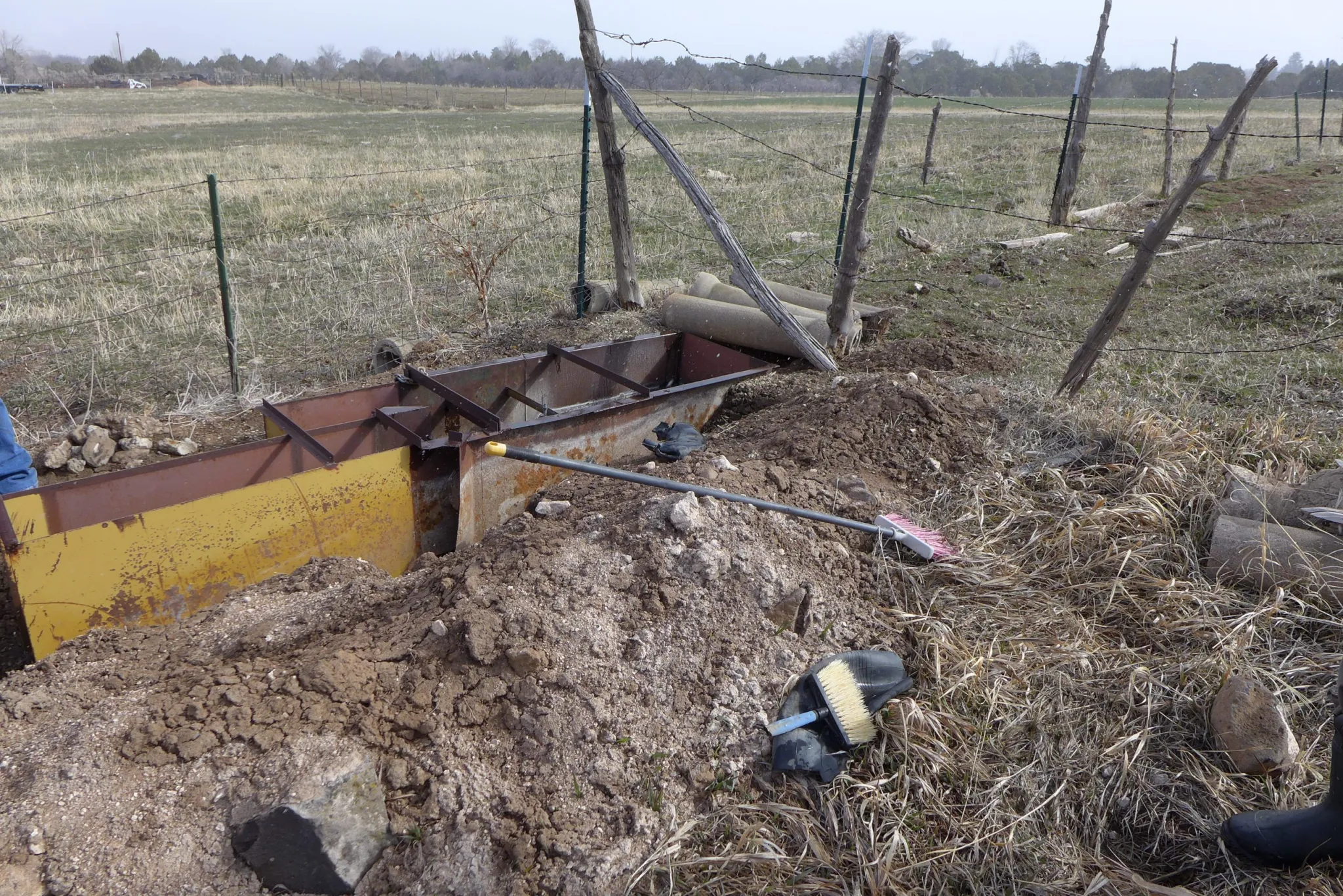
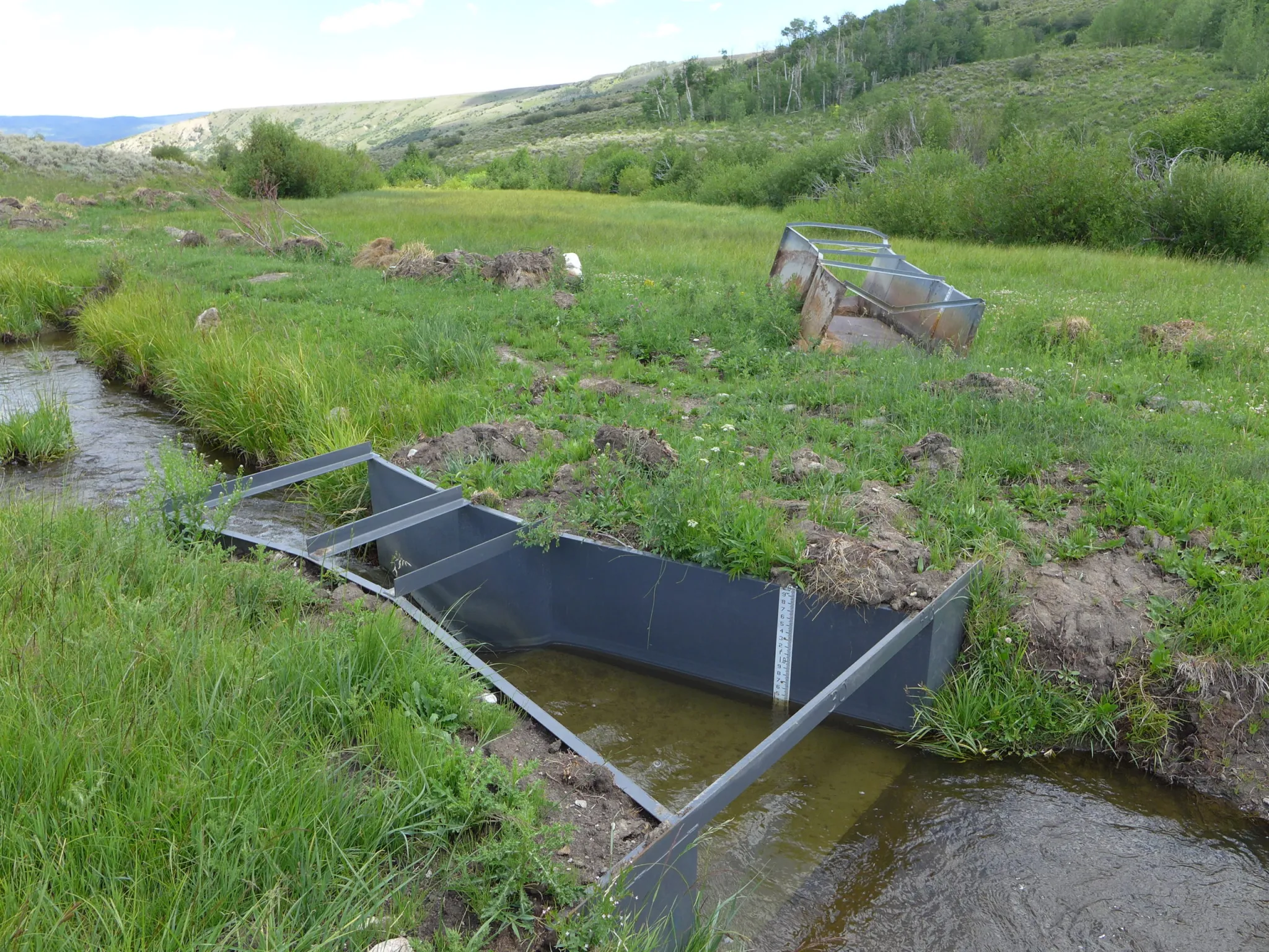

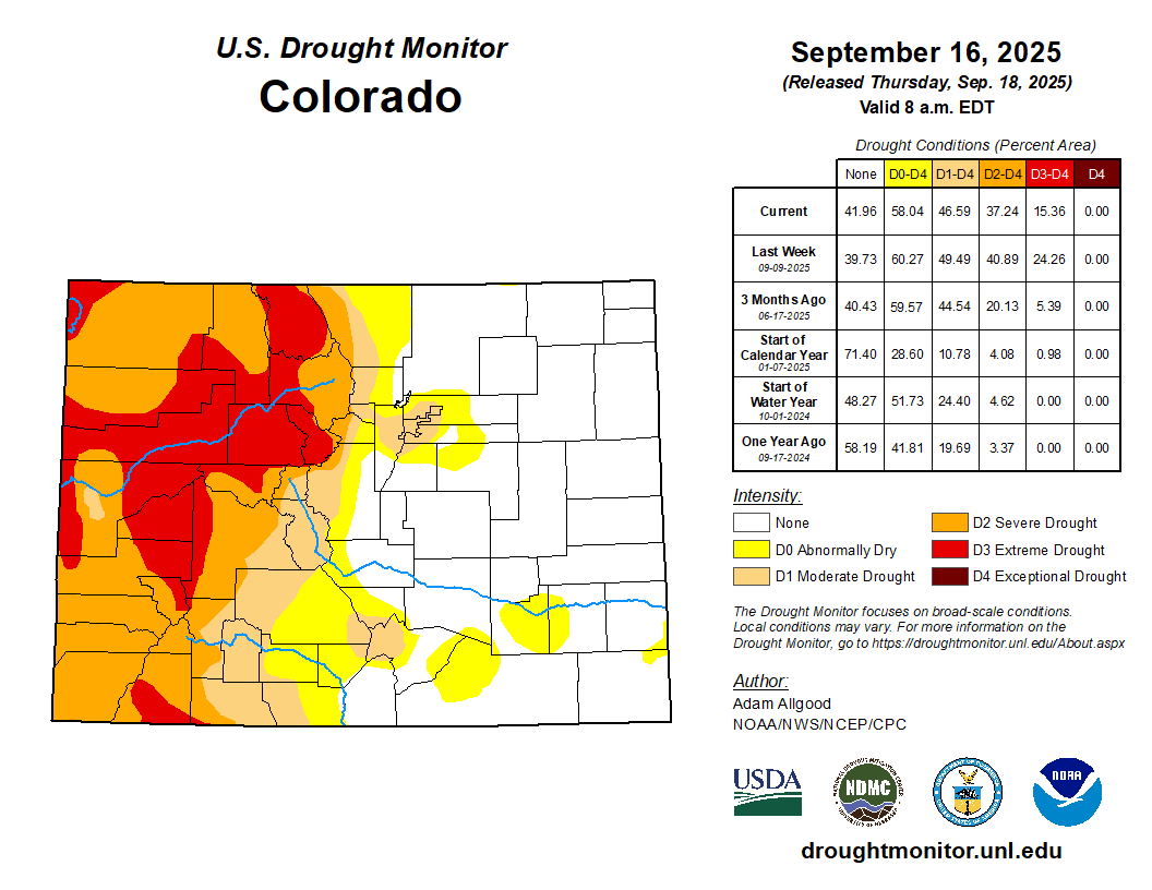

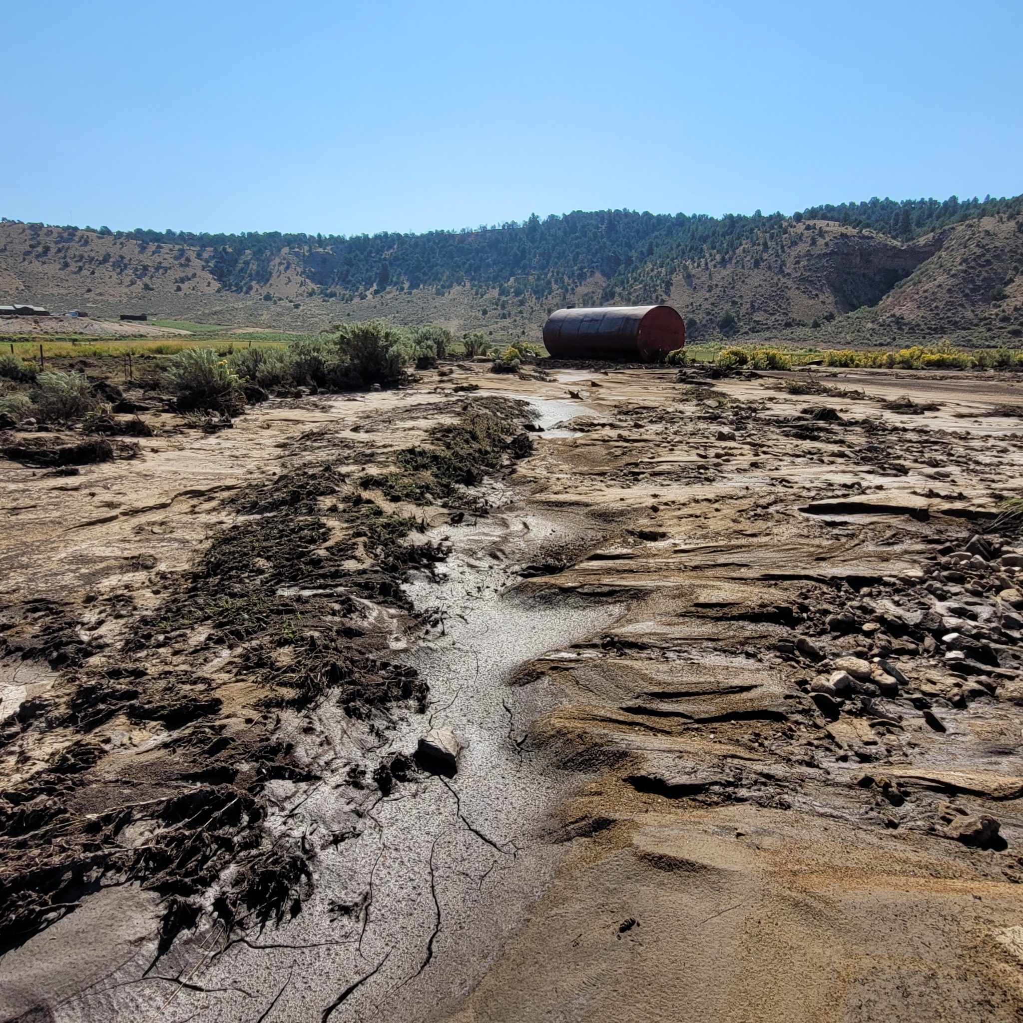
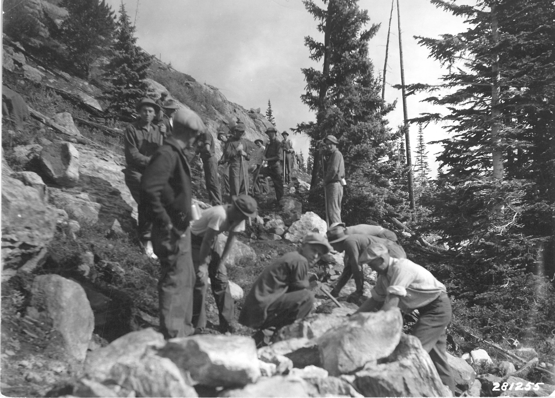
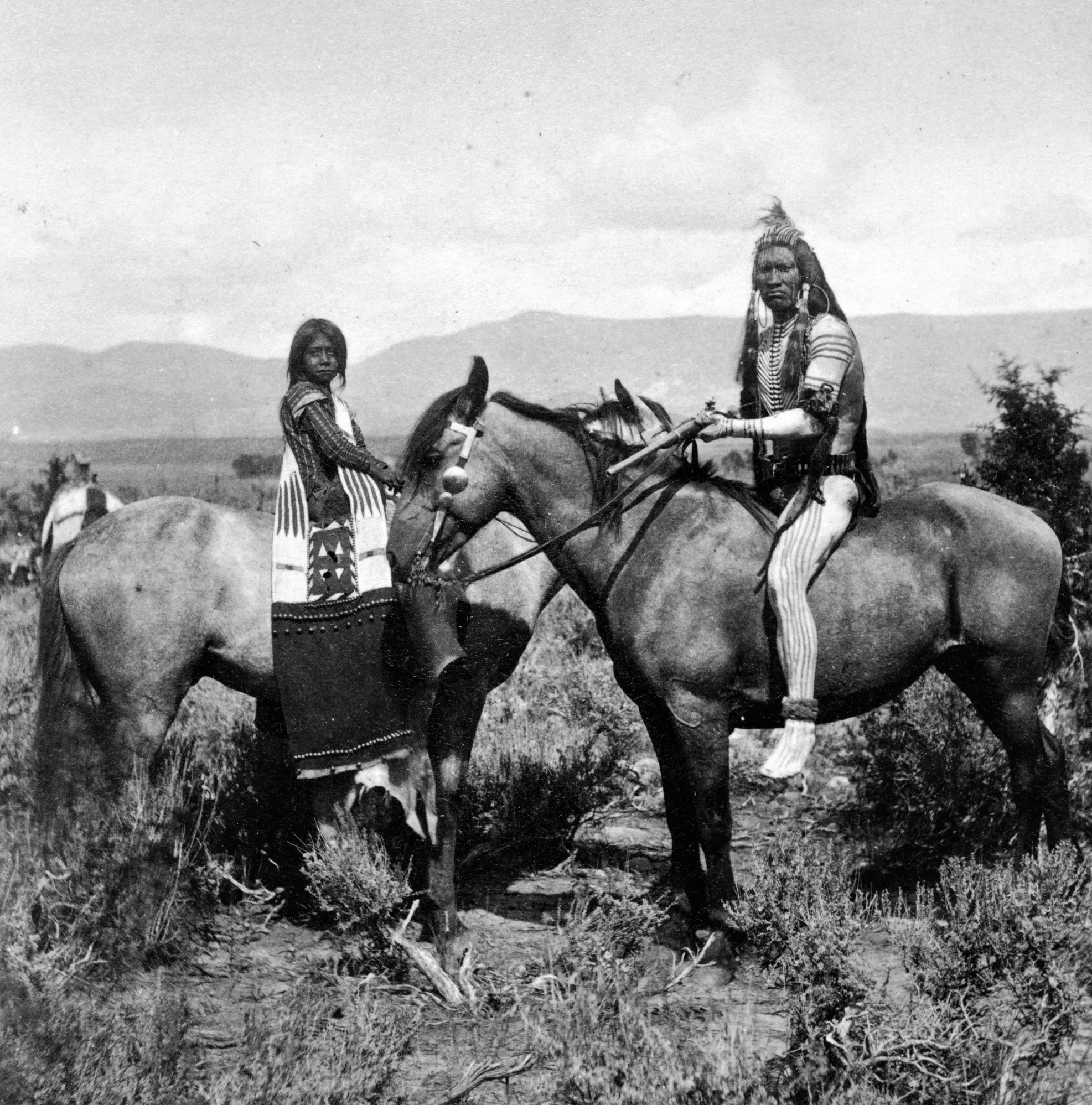
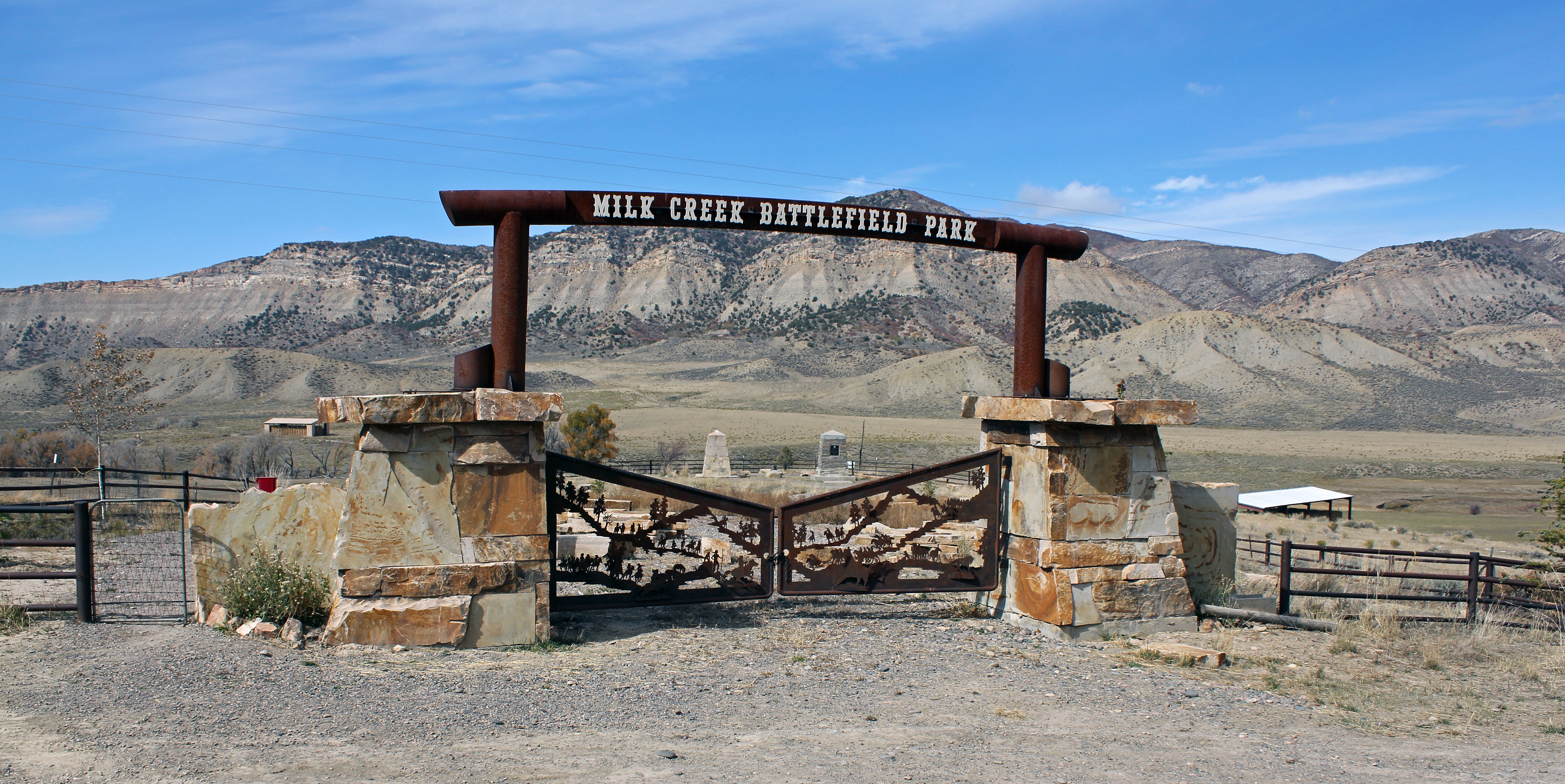


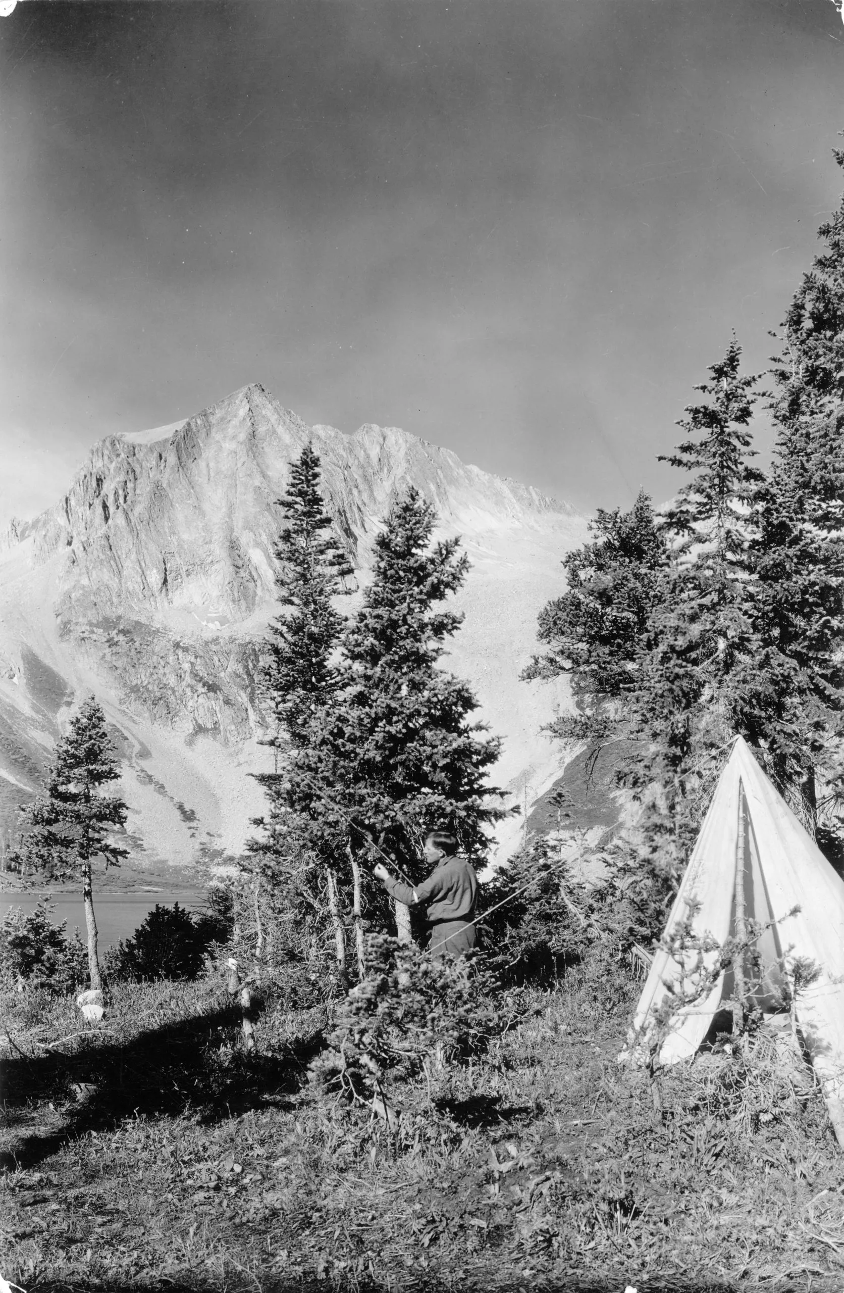
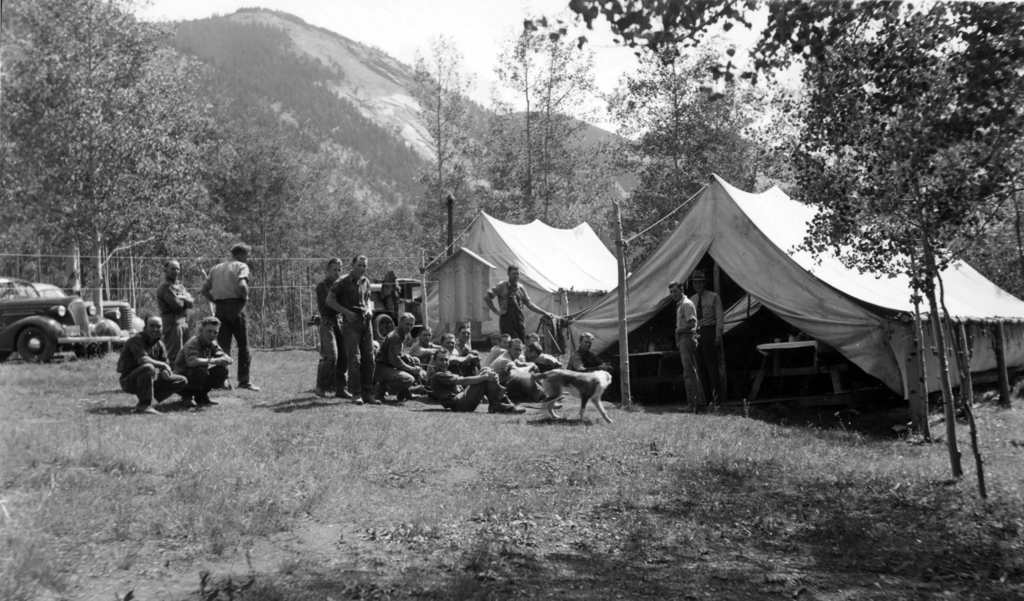
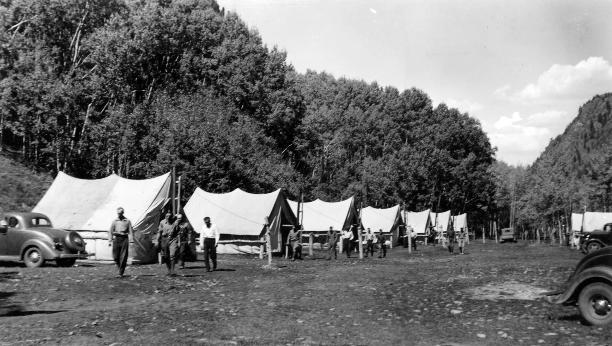


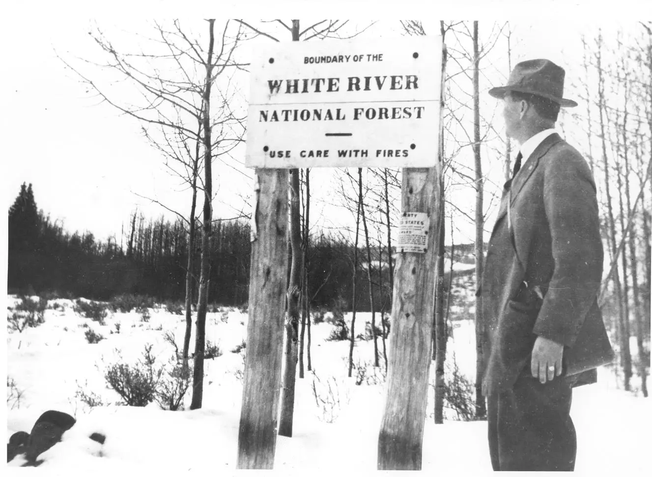
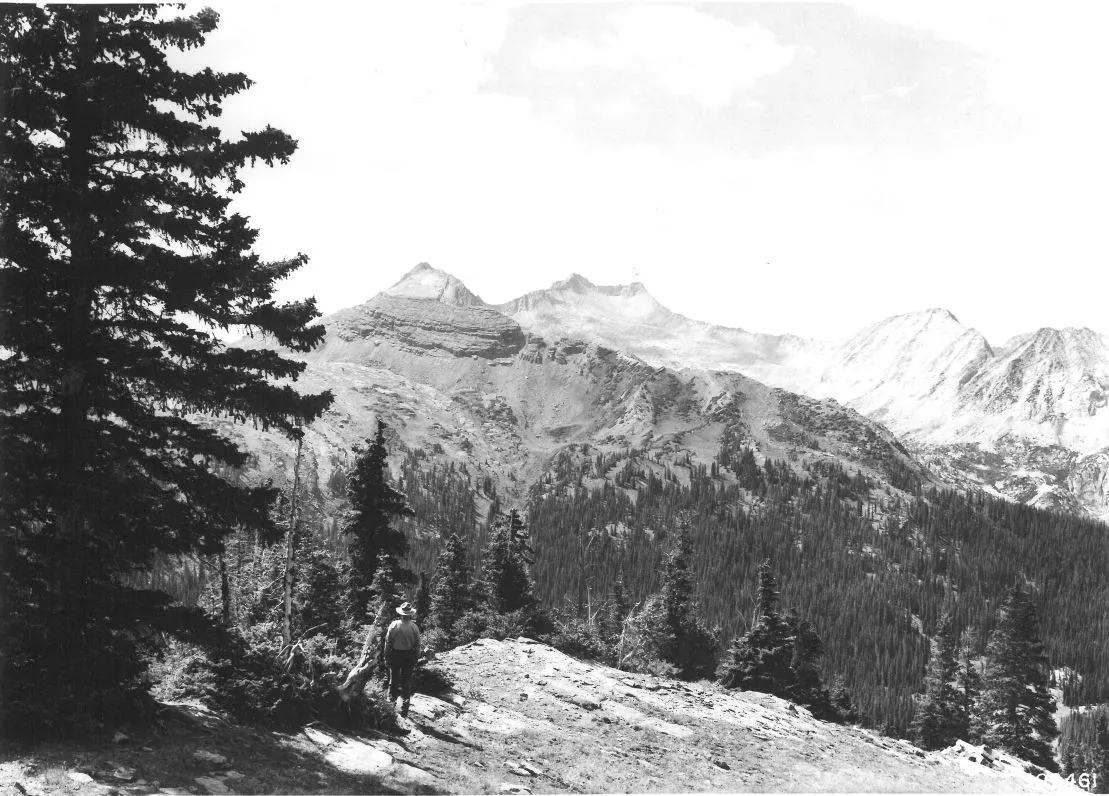

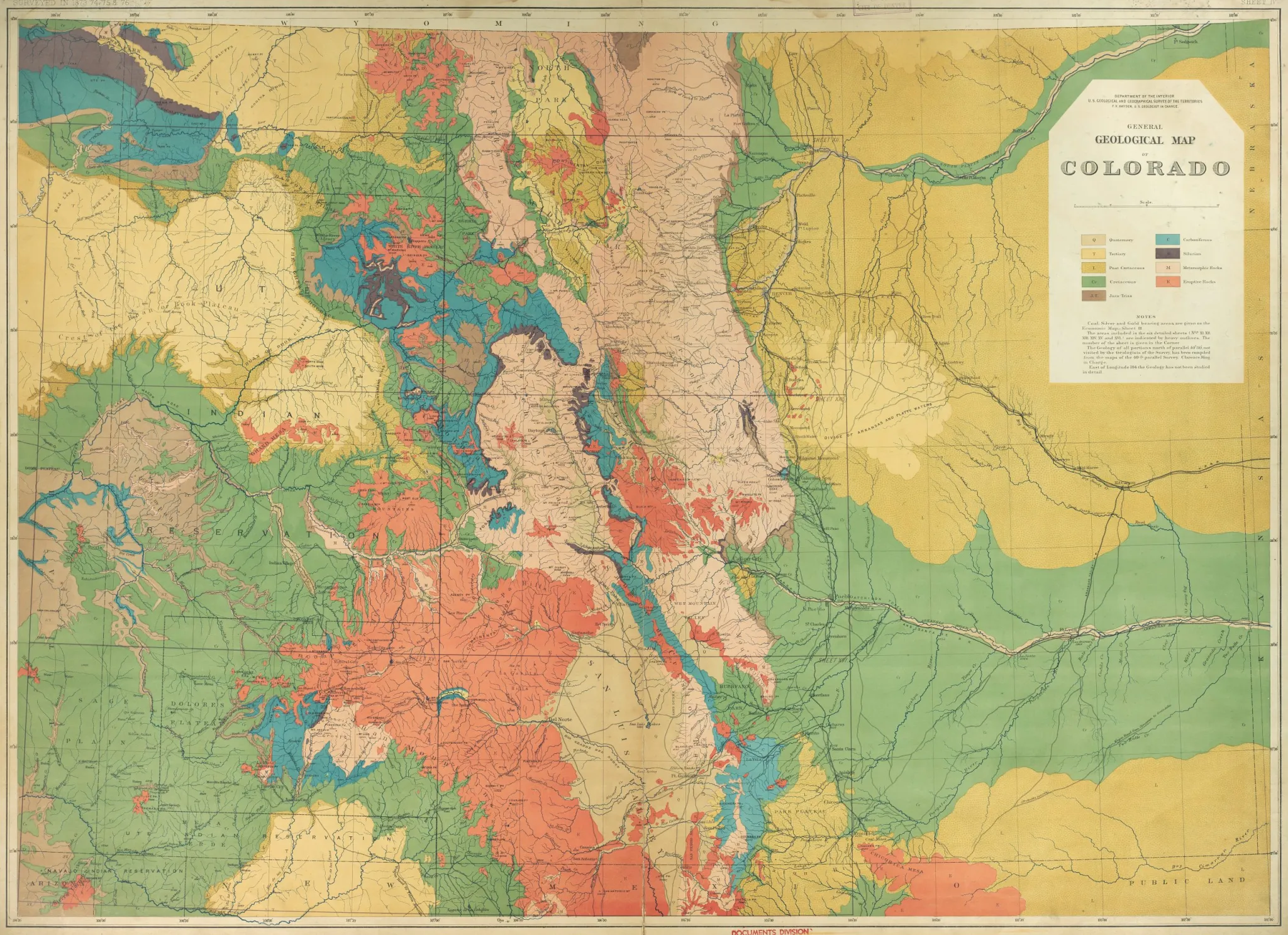

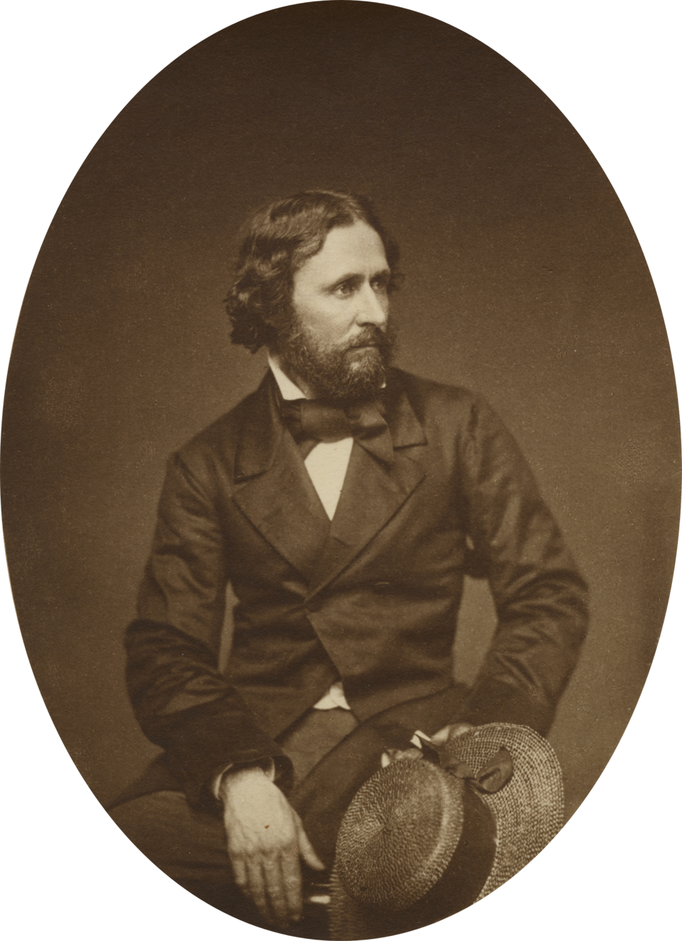
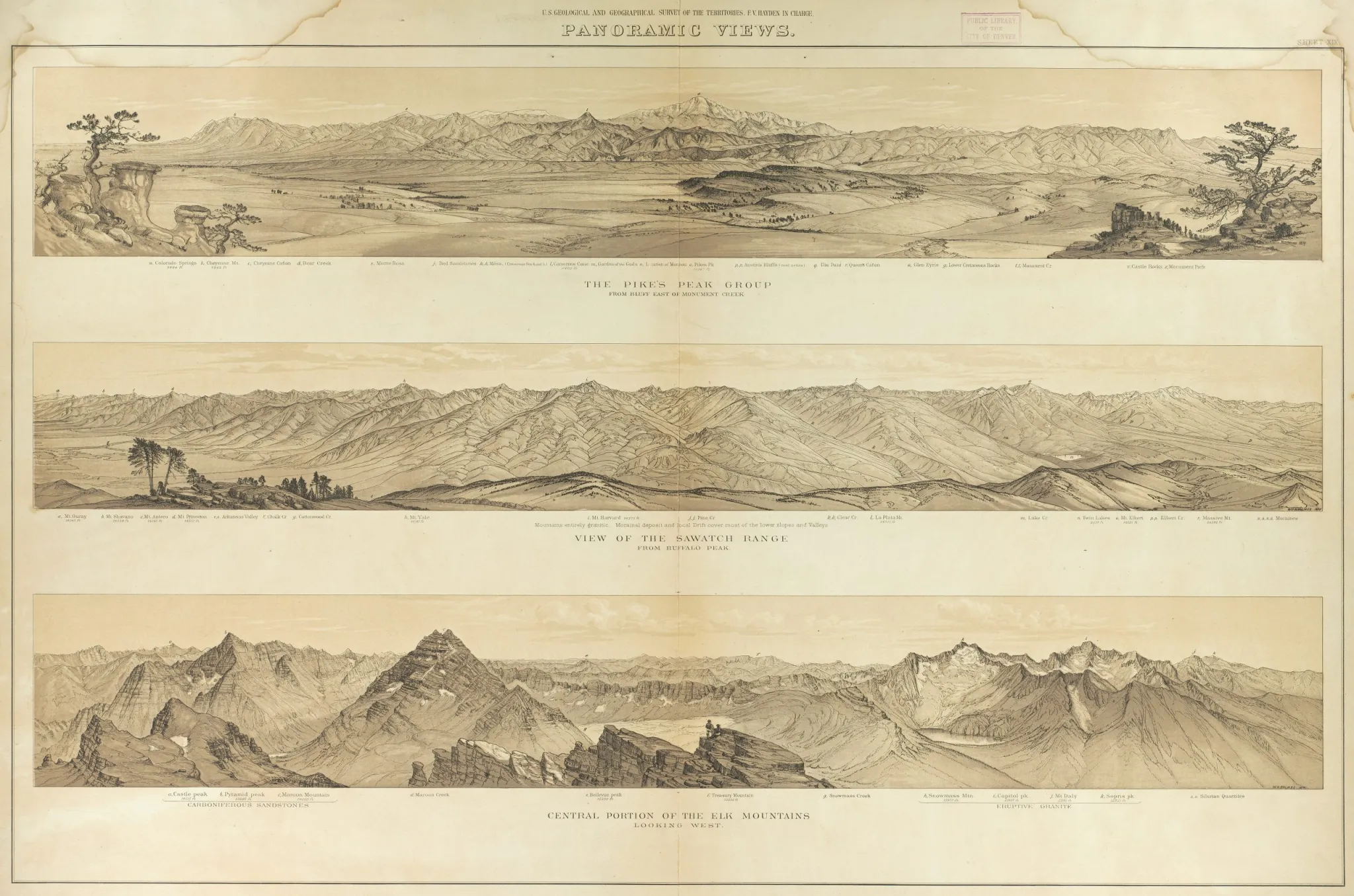


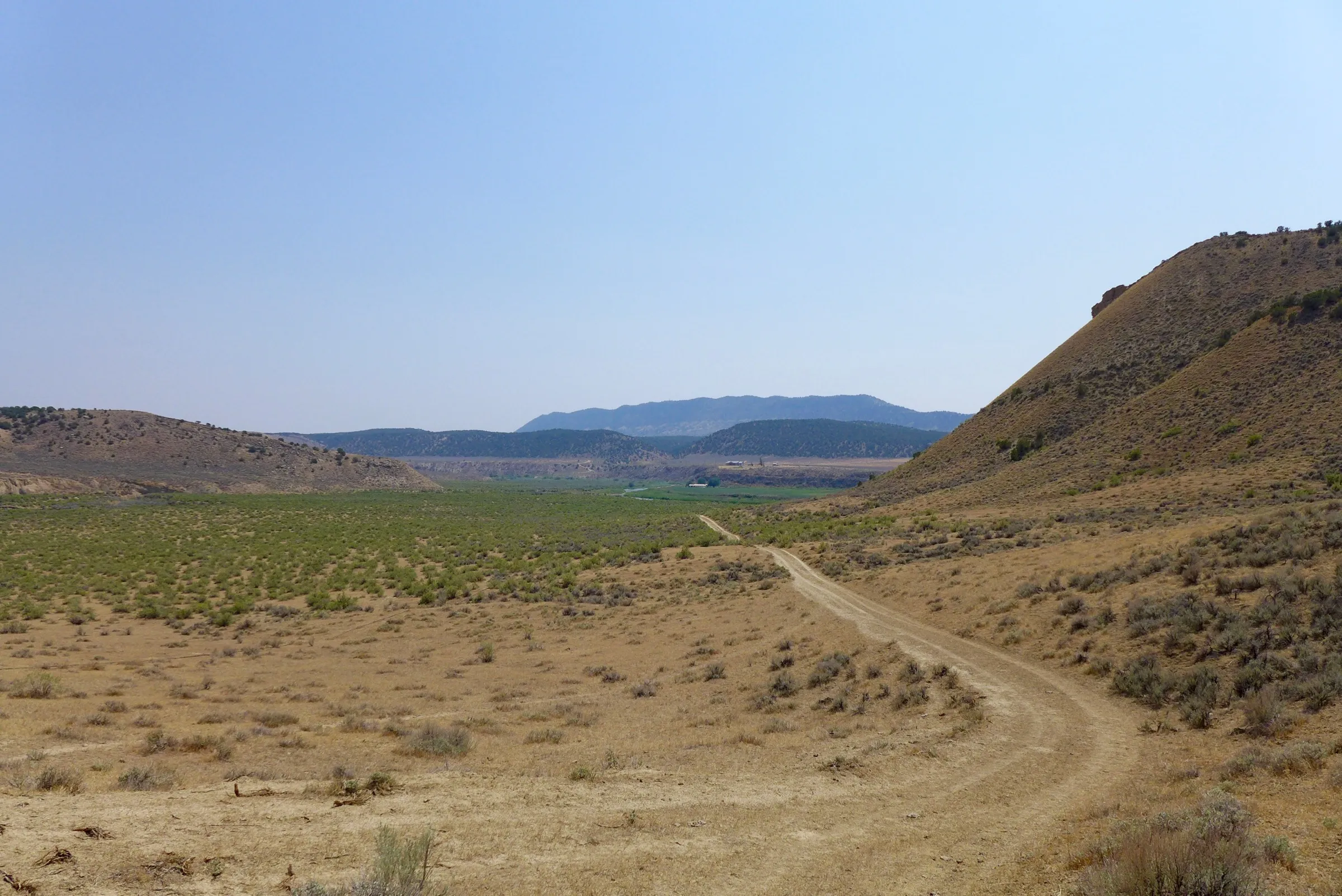
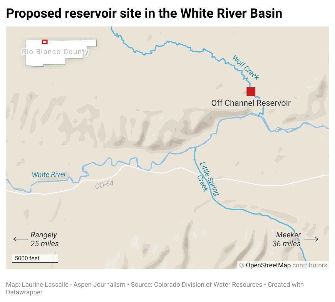


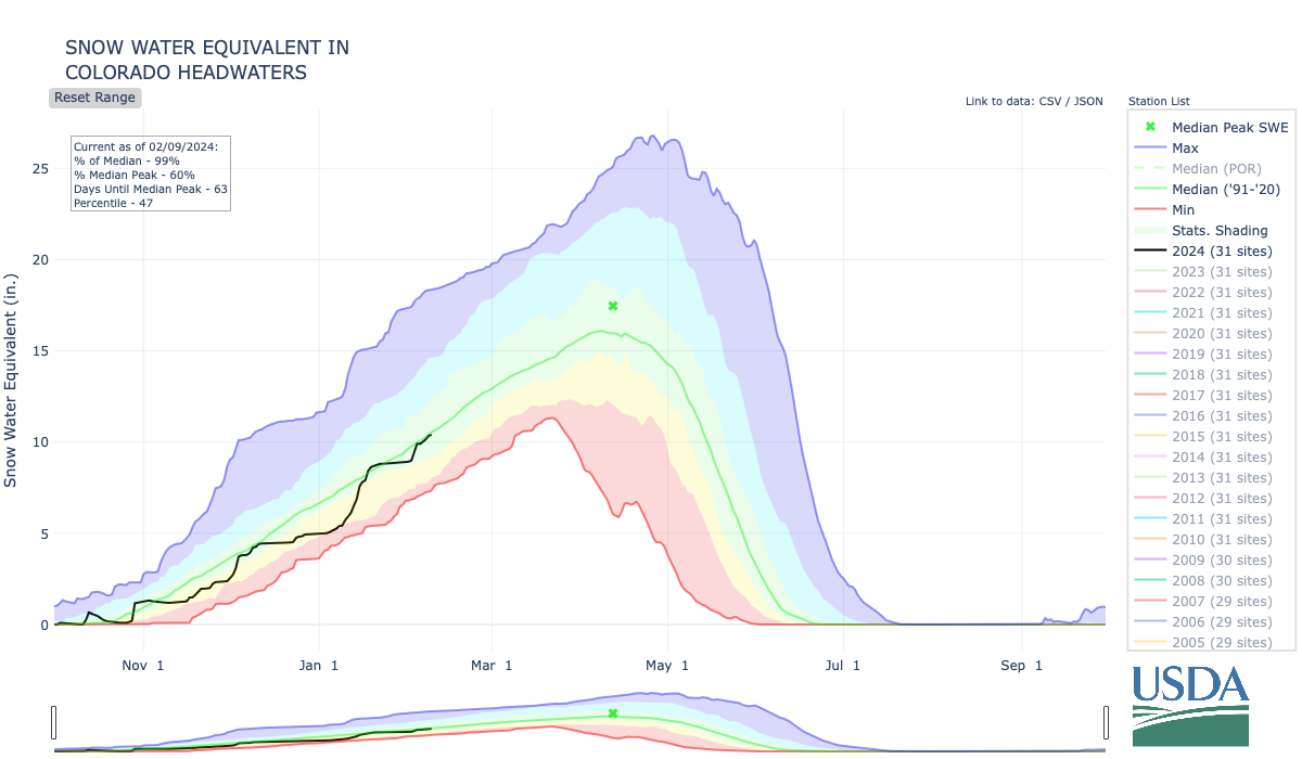
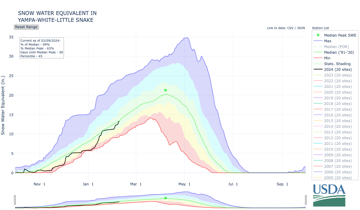
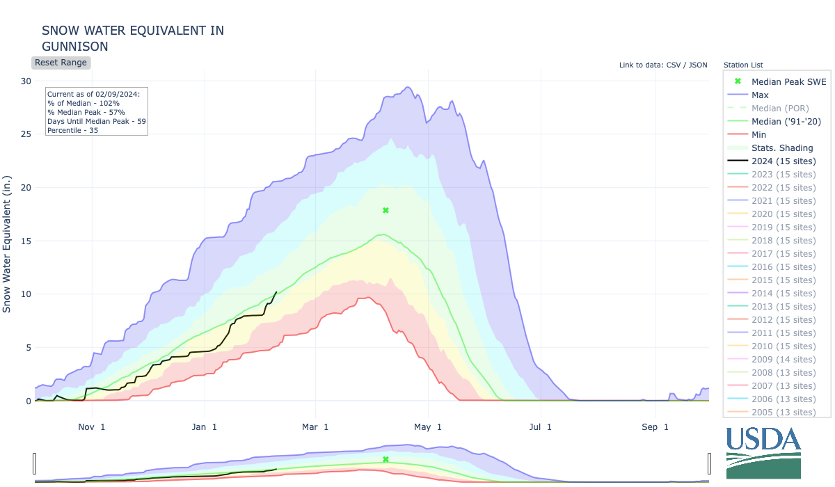
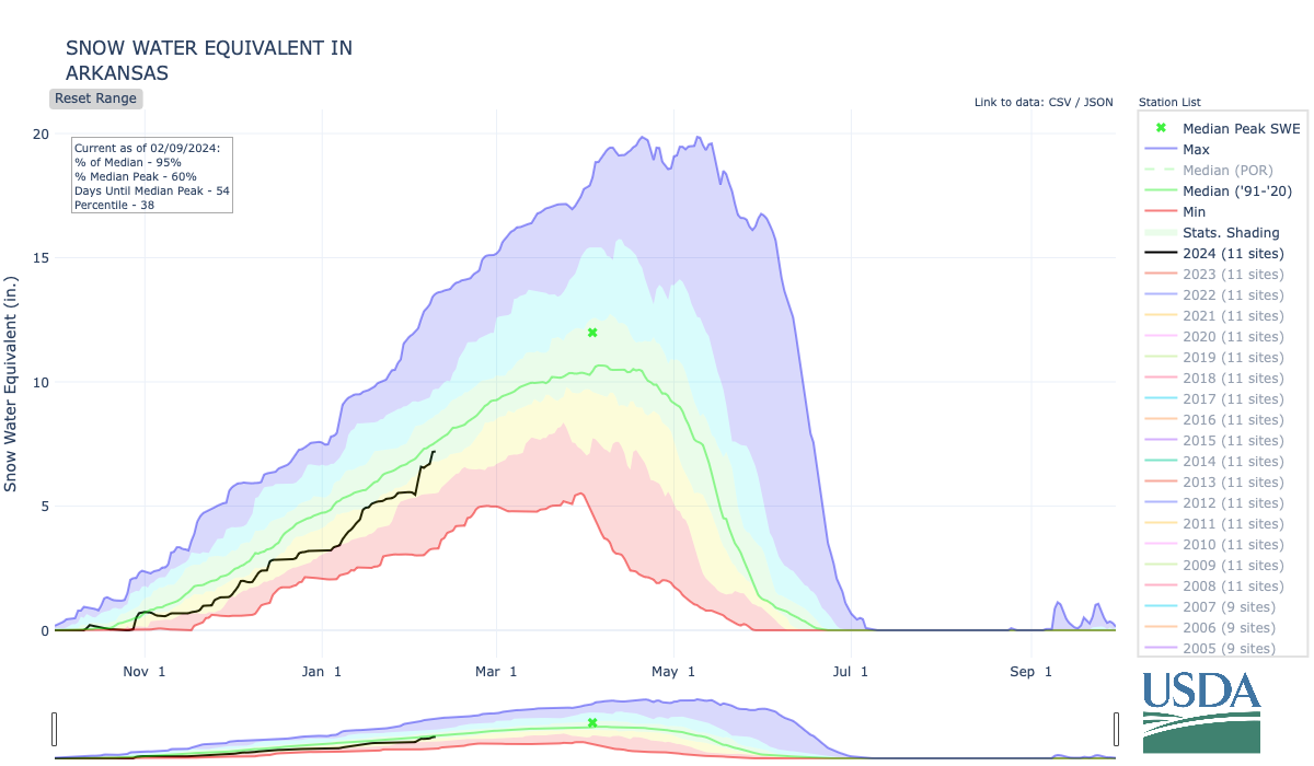

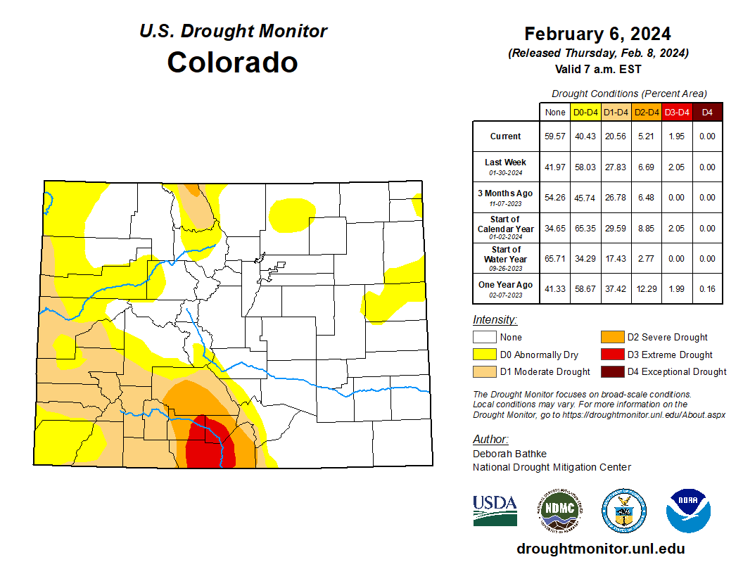


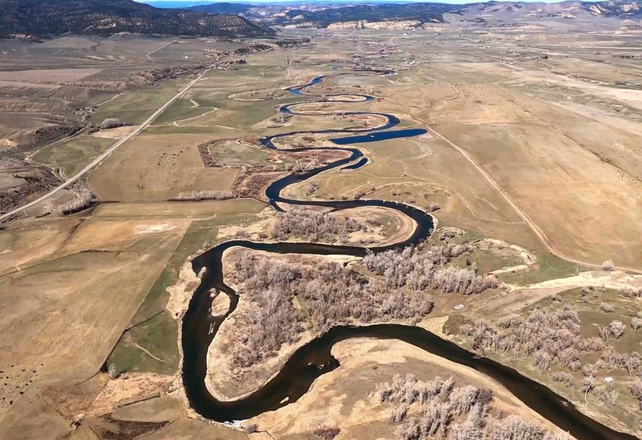
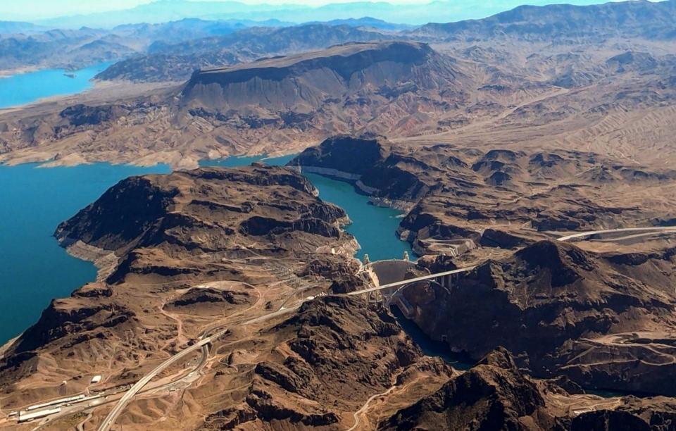


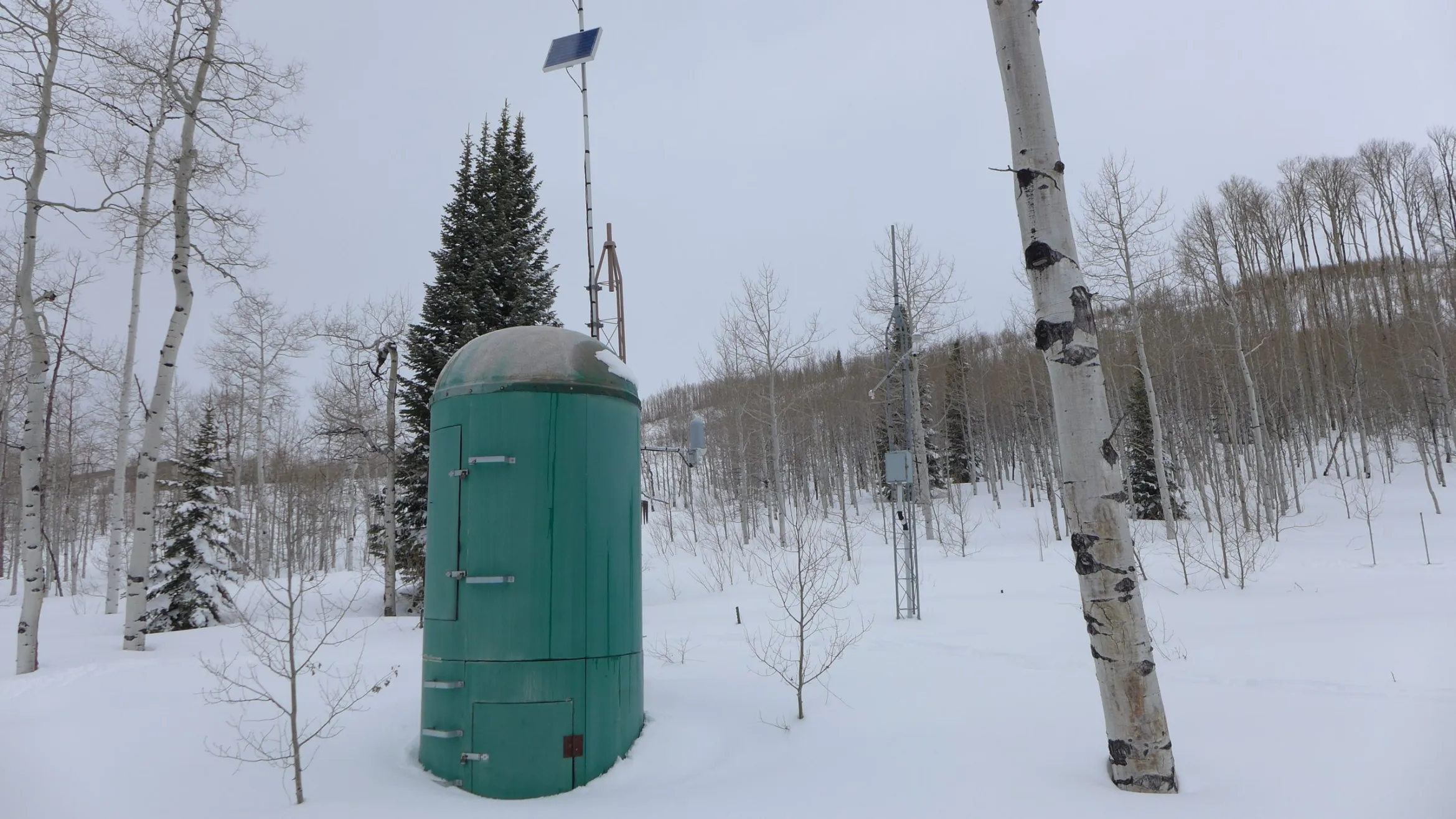

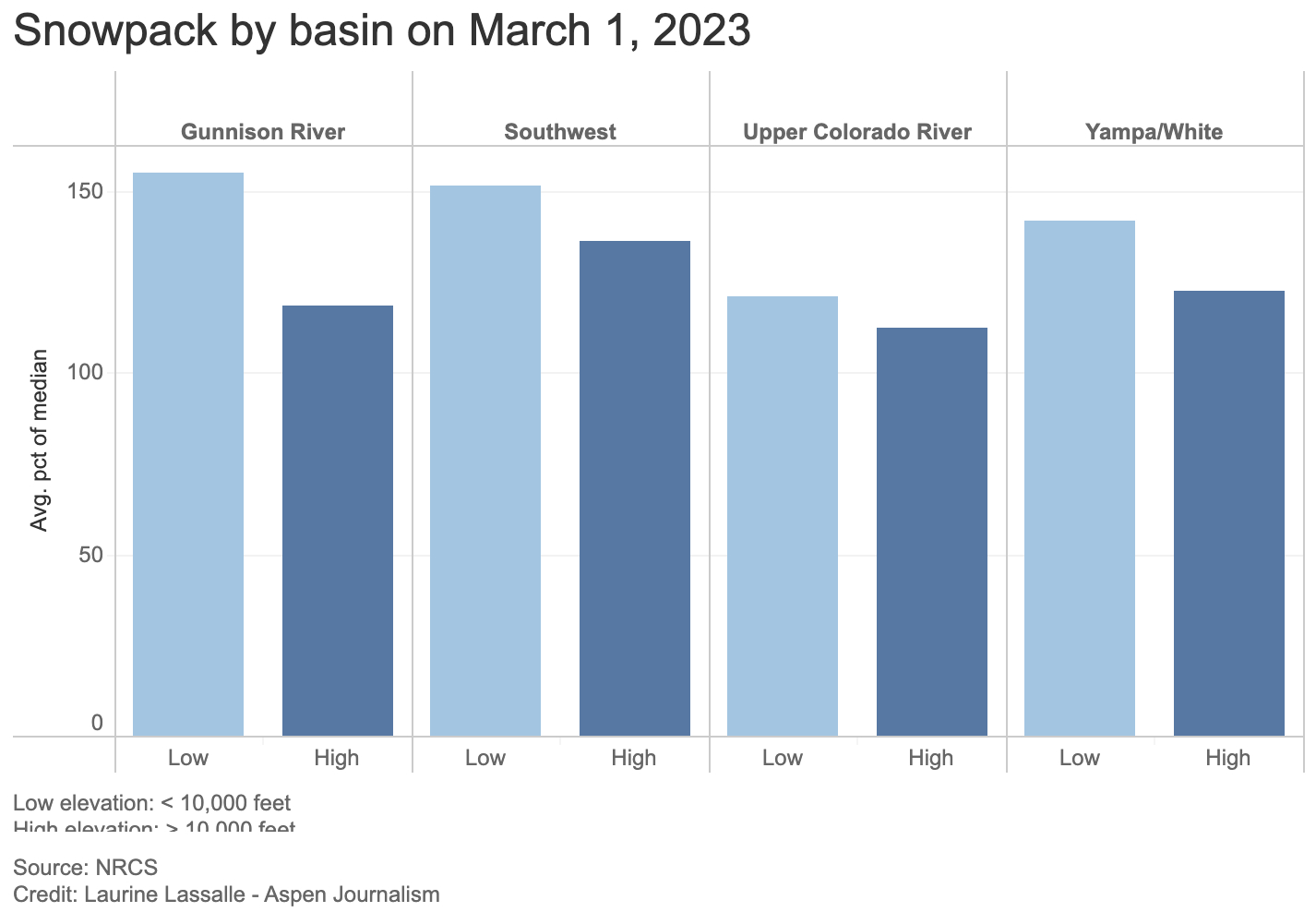
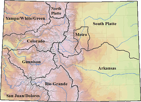


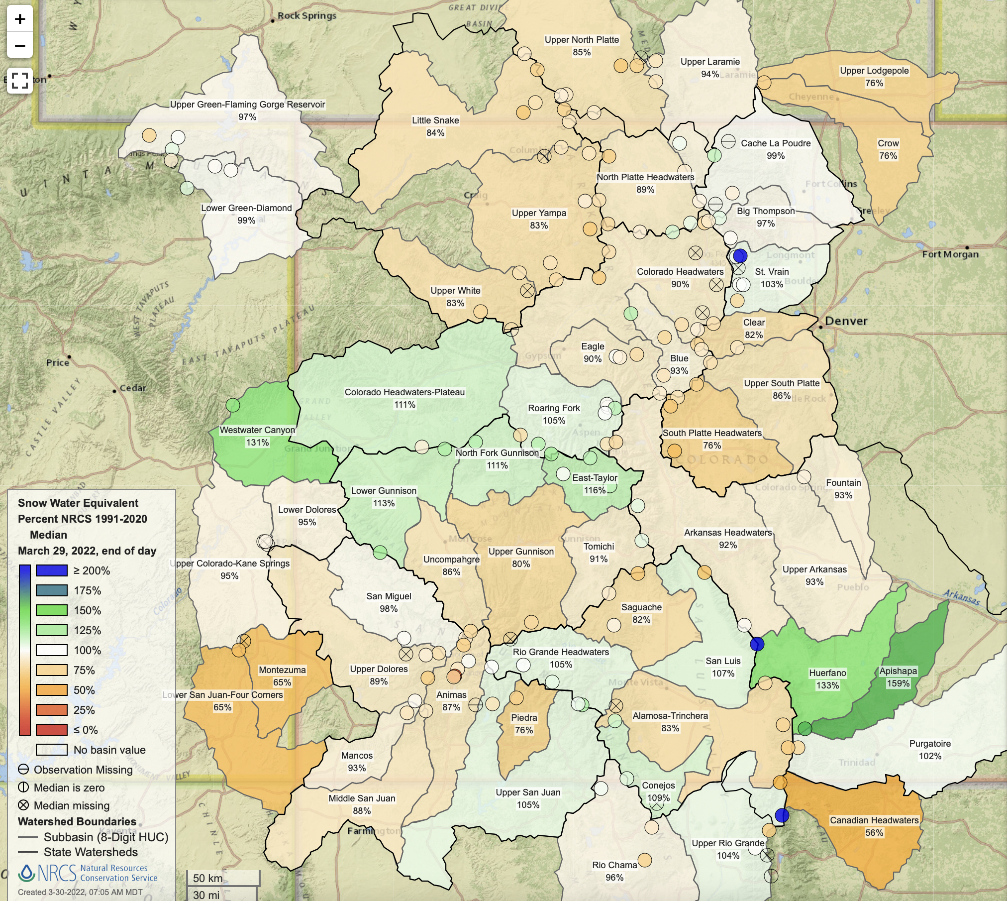
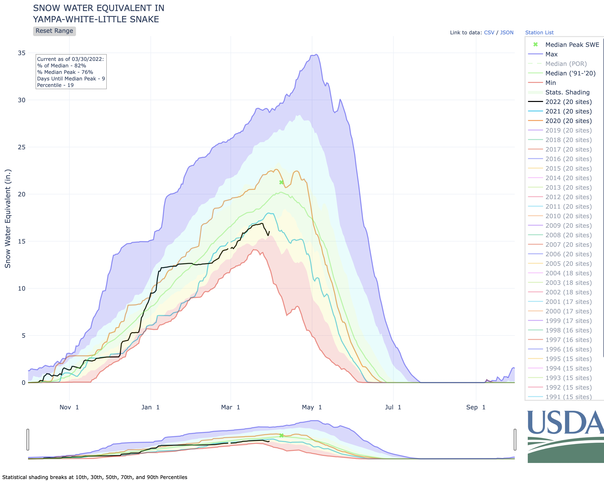
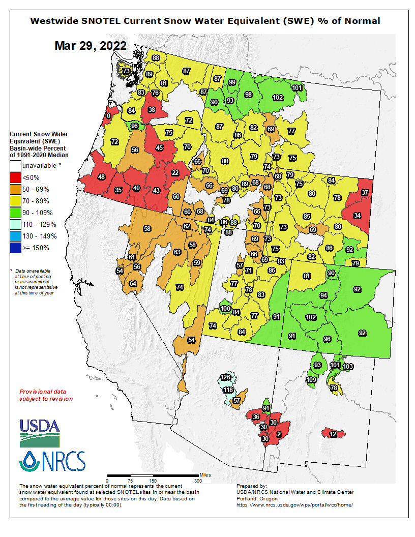


_basin_map")


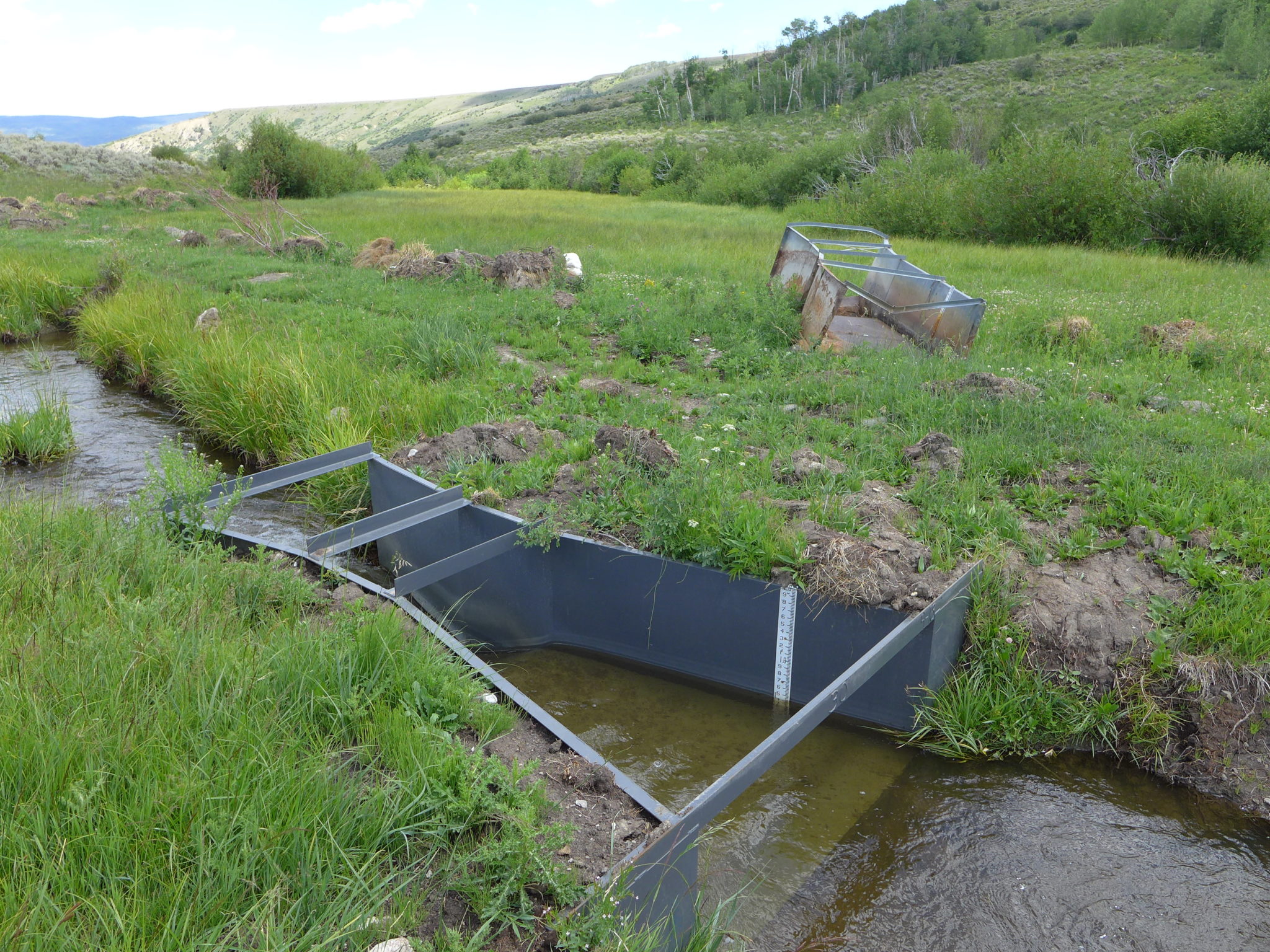
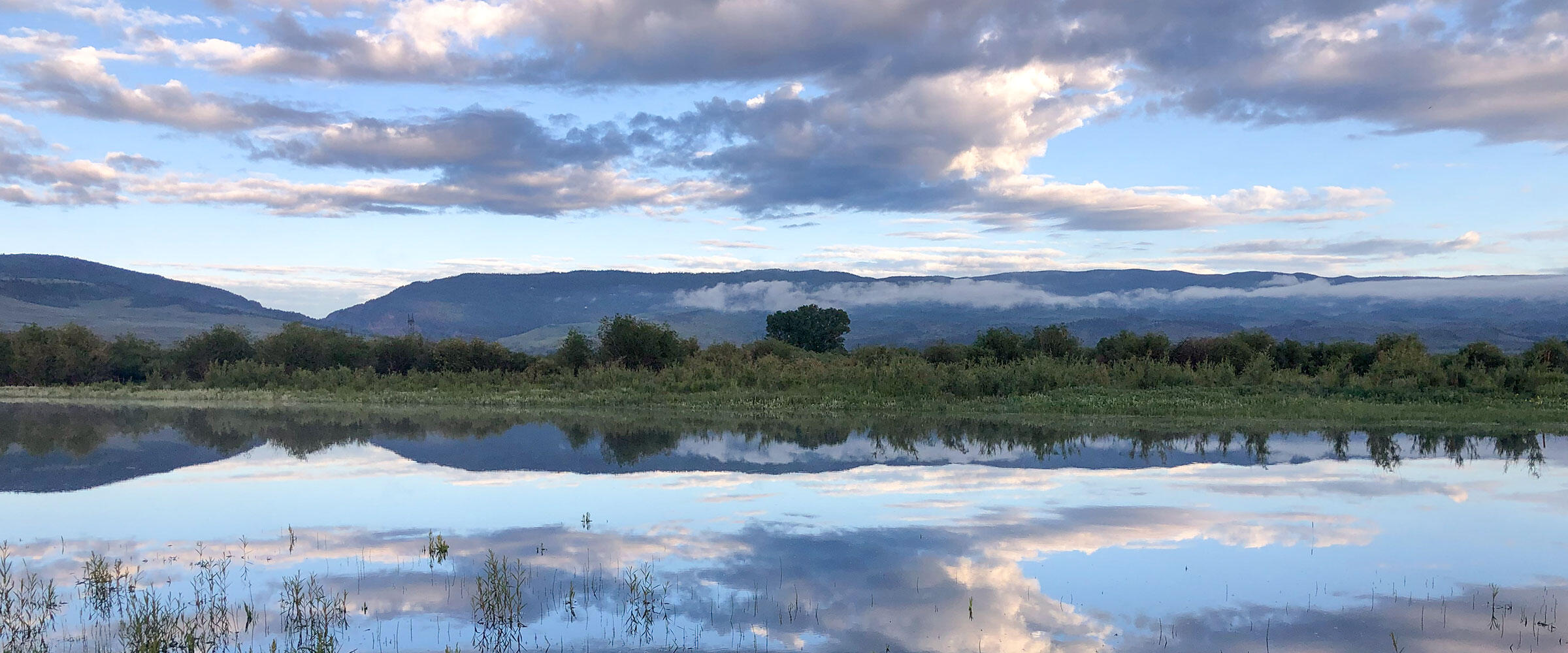
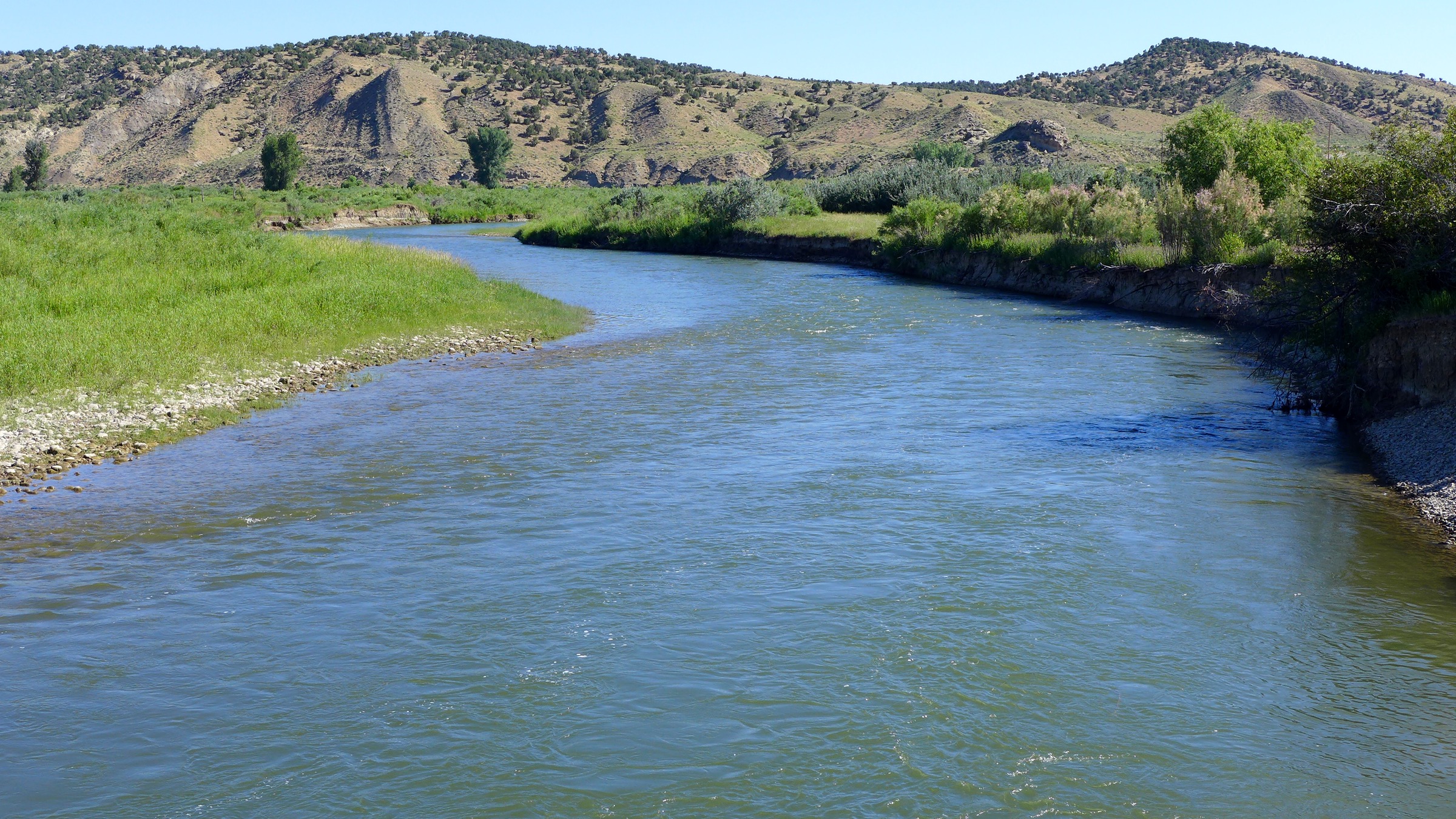
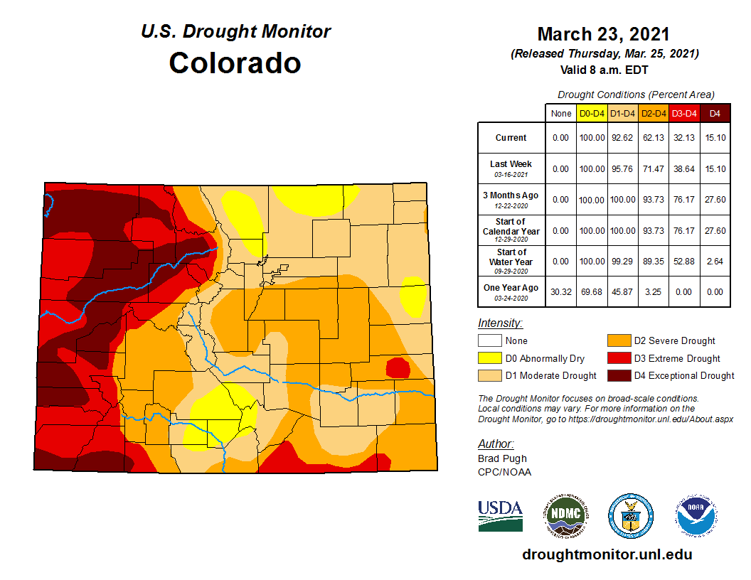
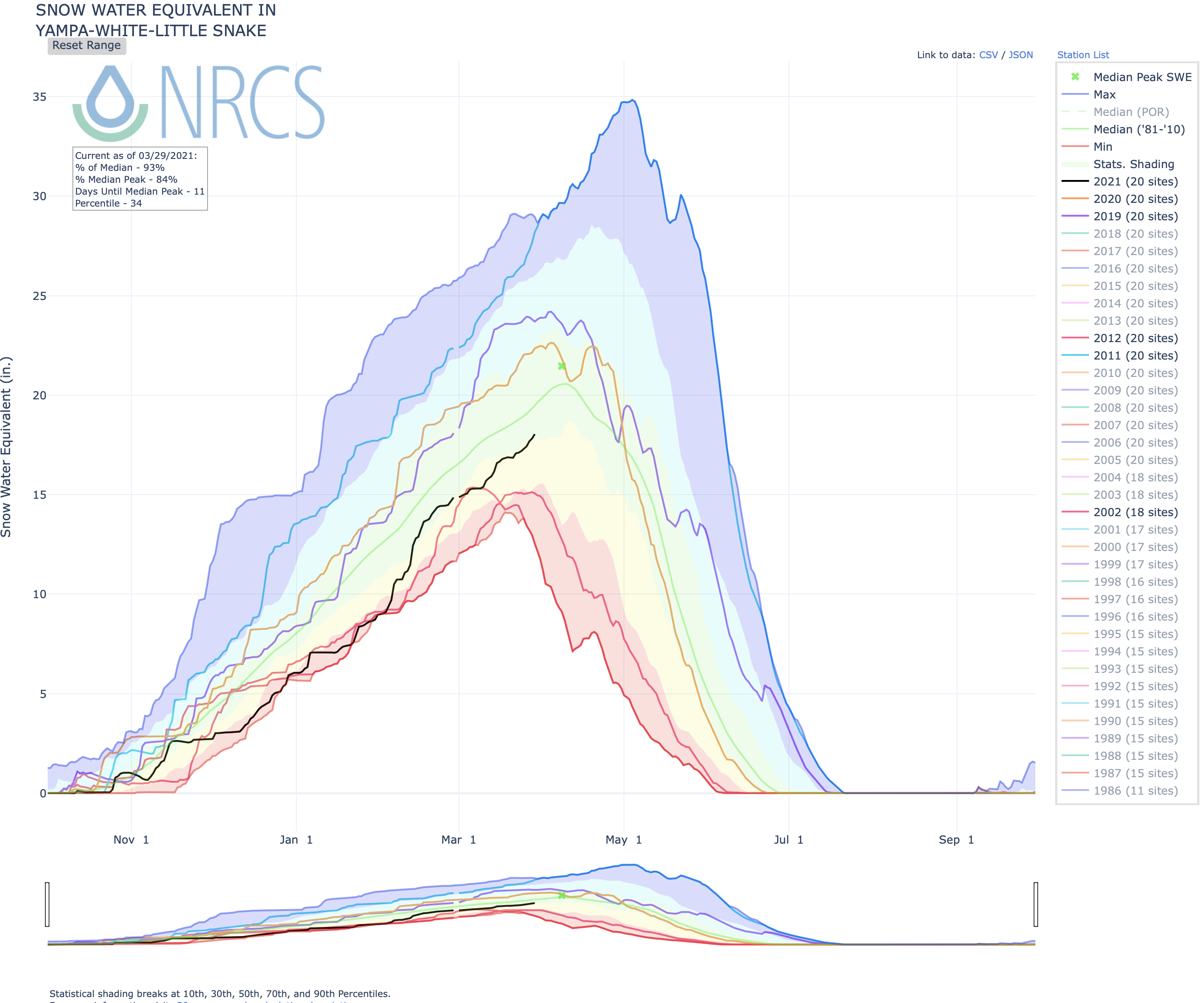
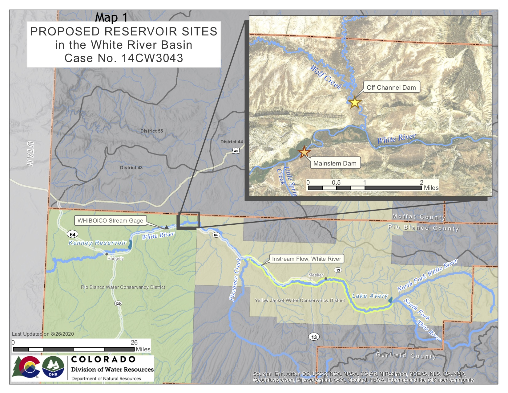
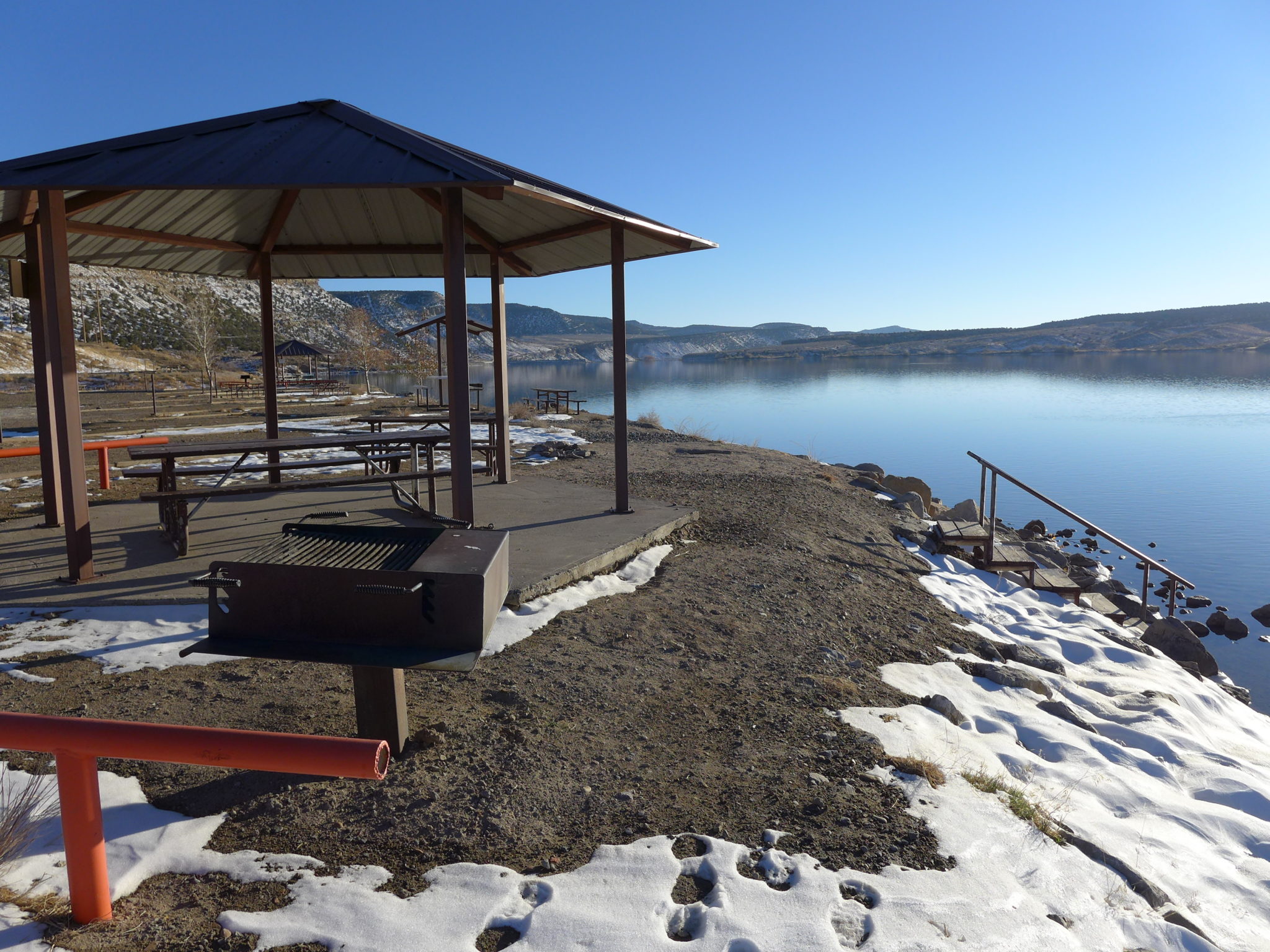
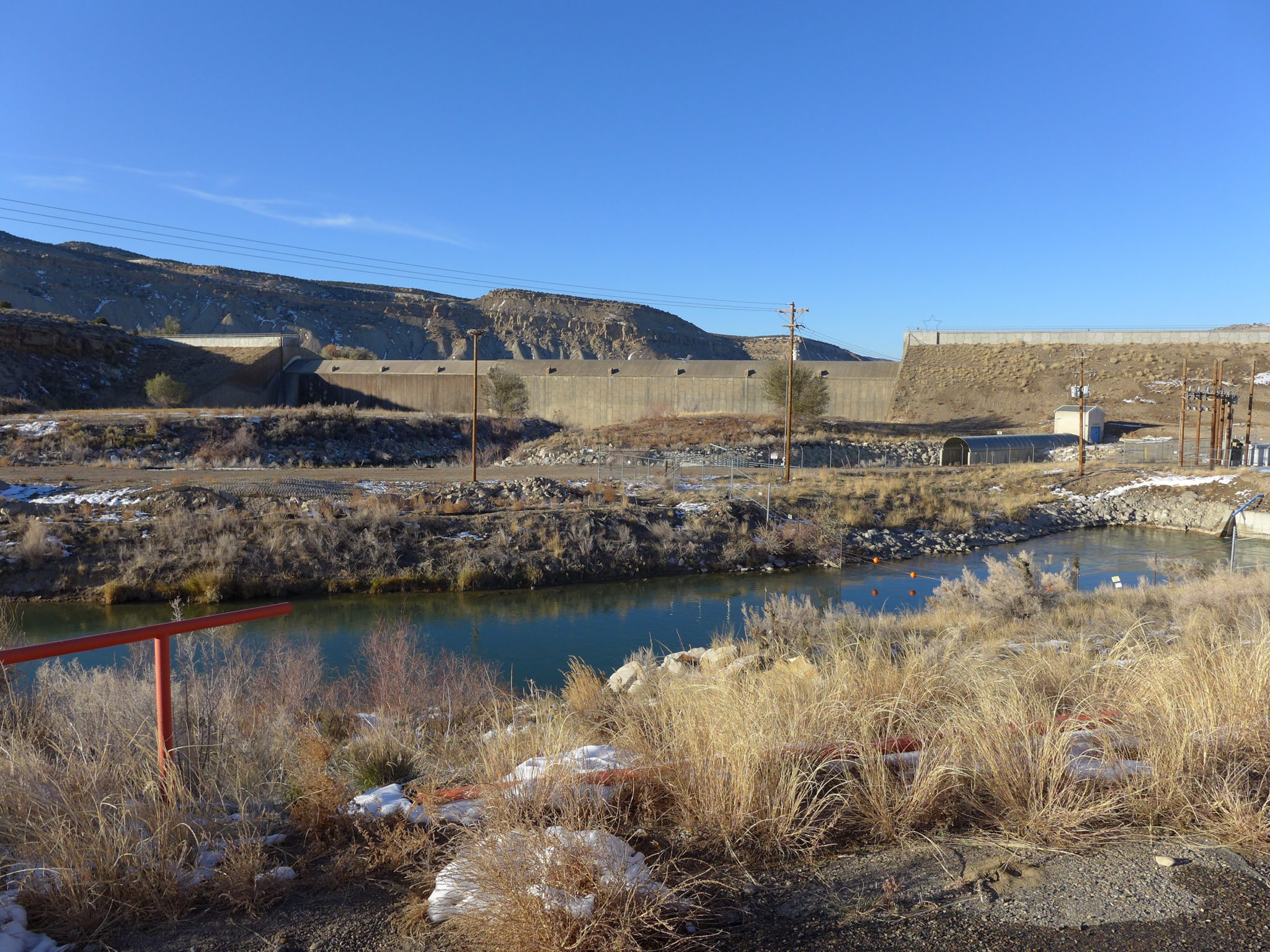
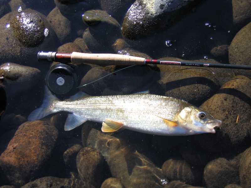
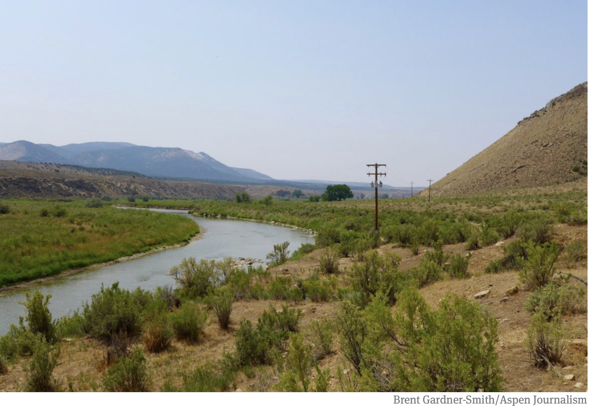
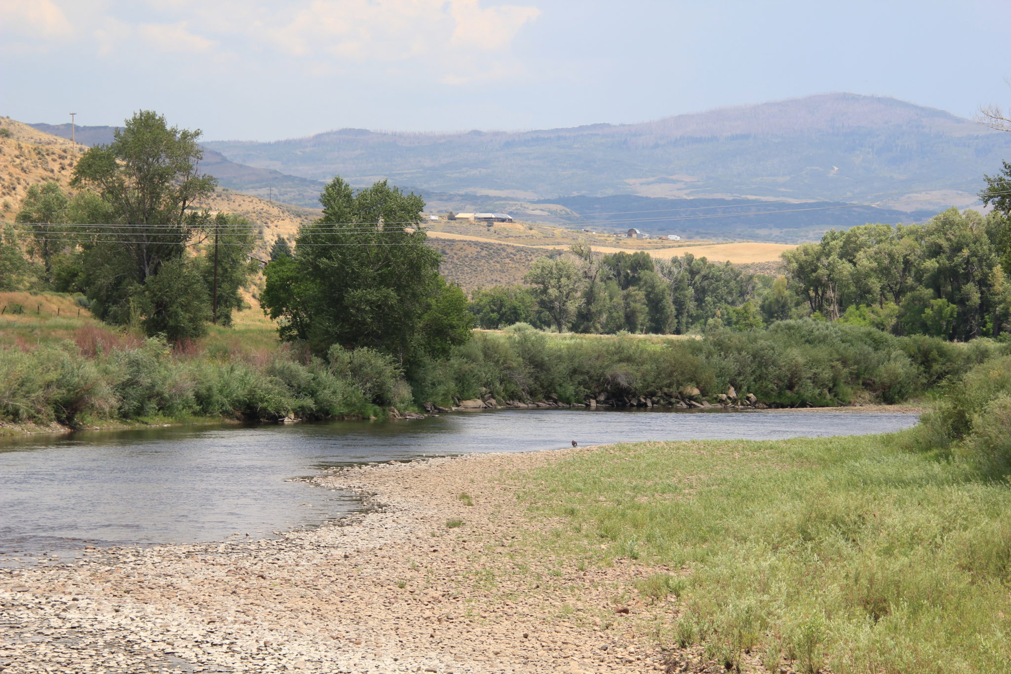
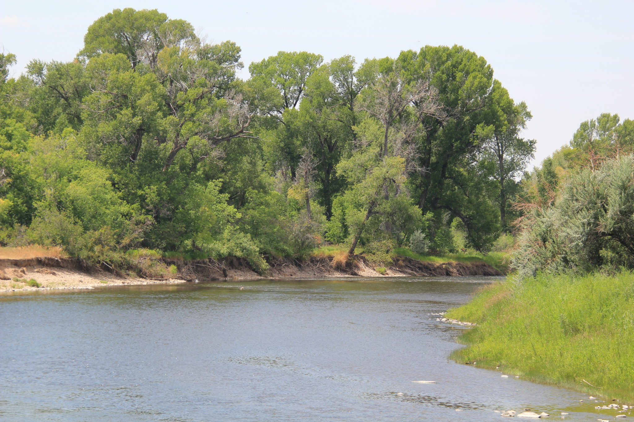
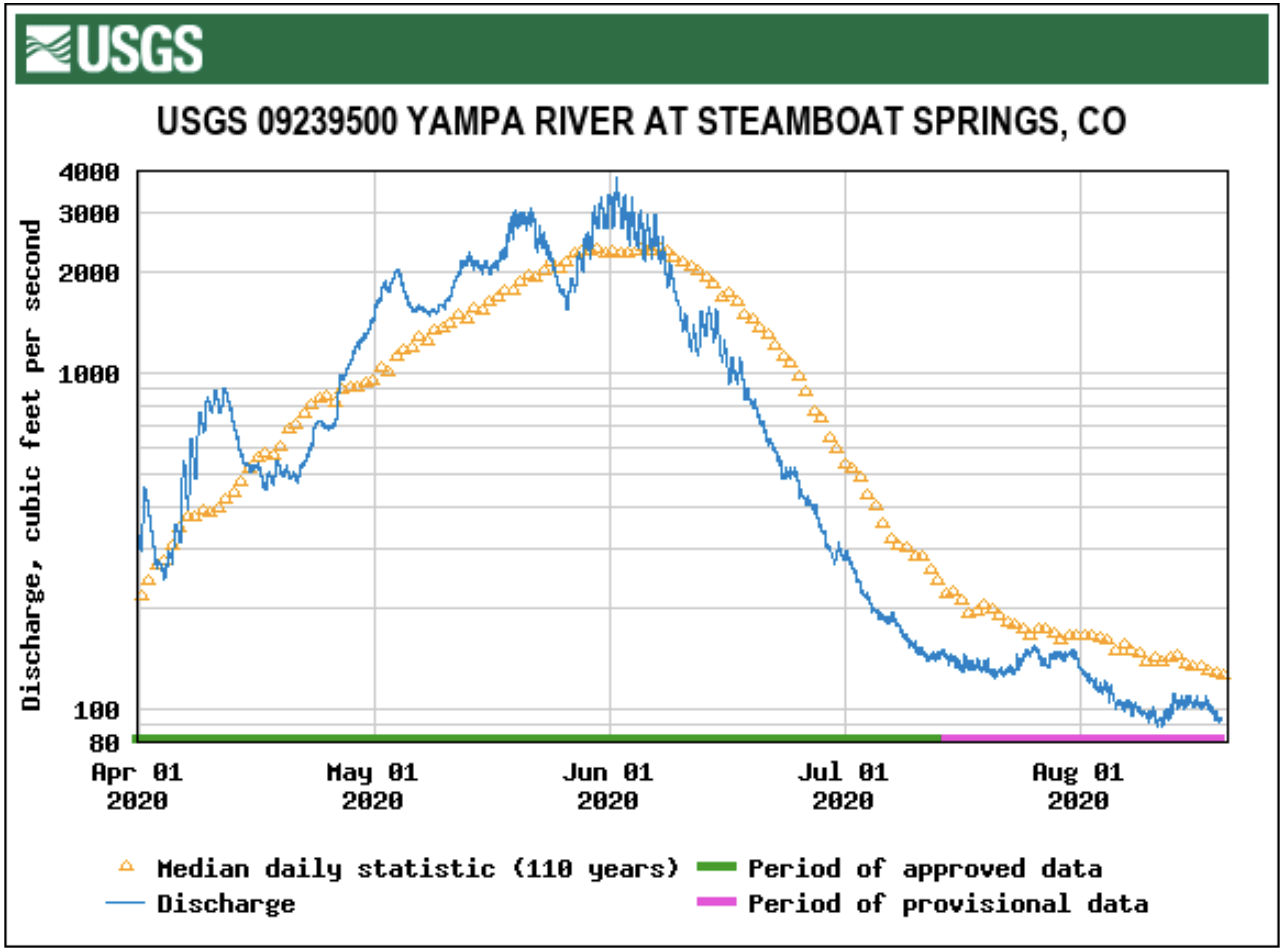
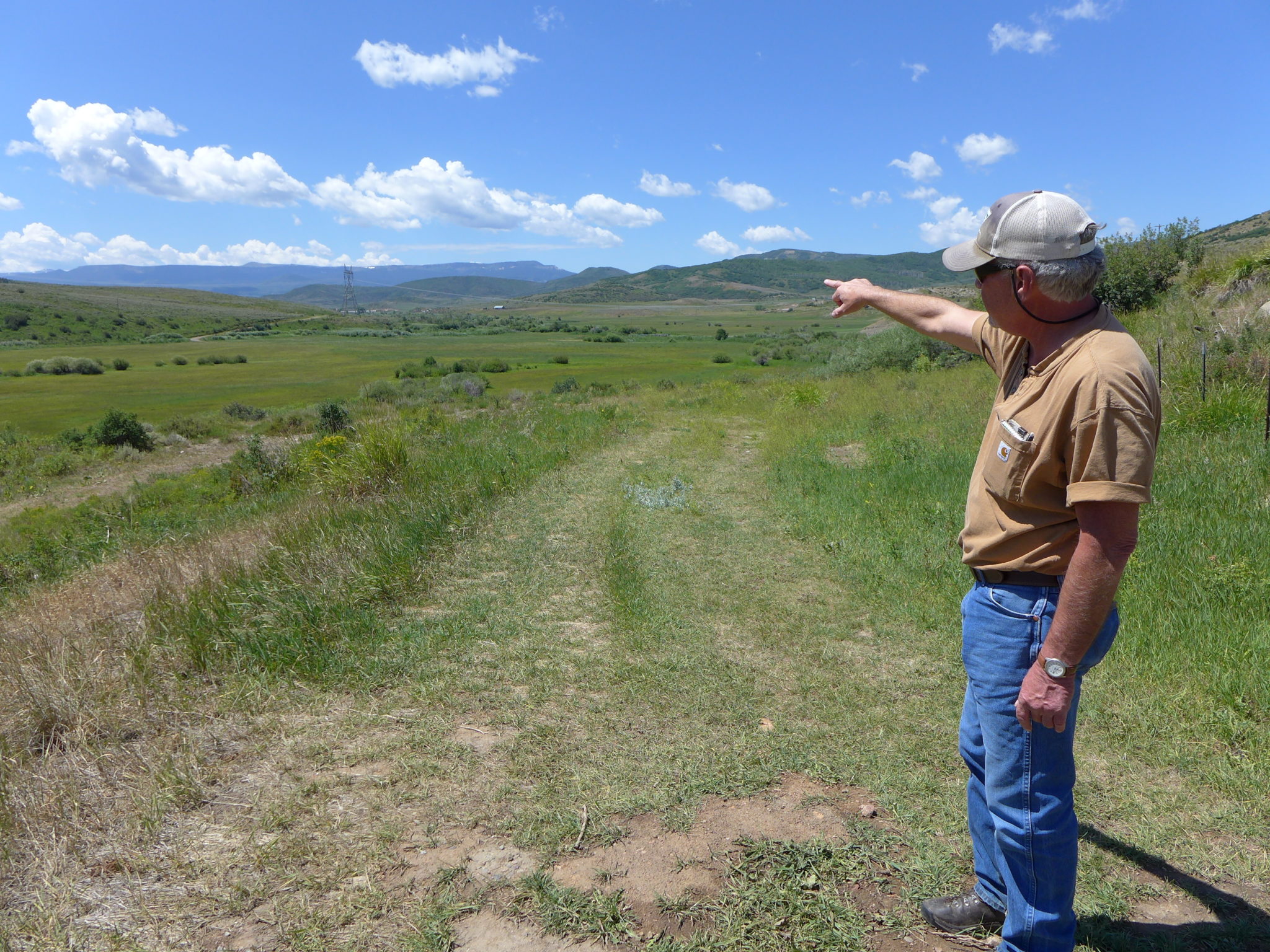


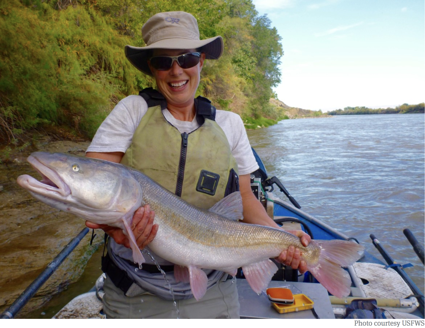
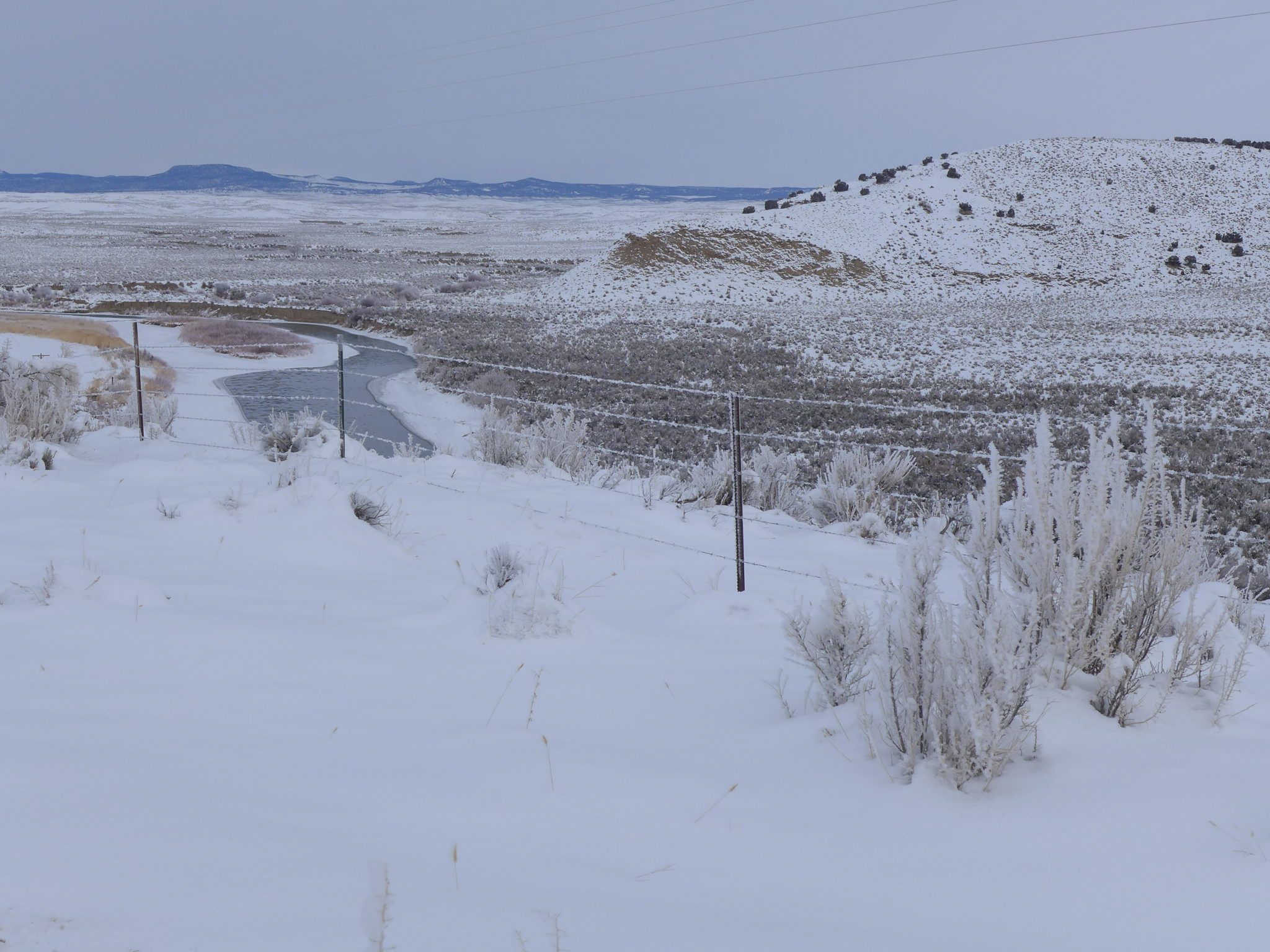


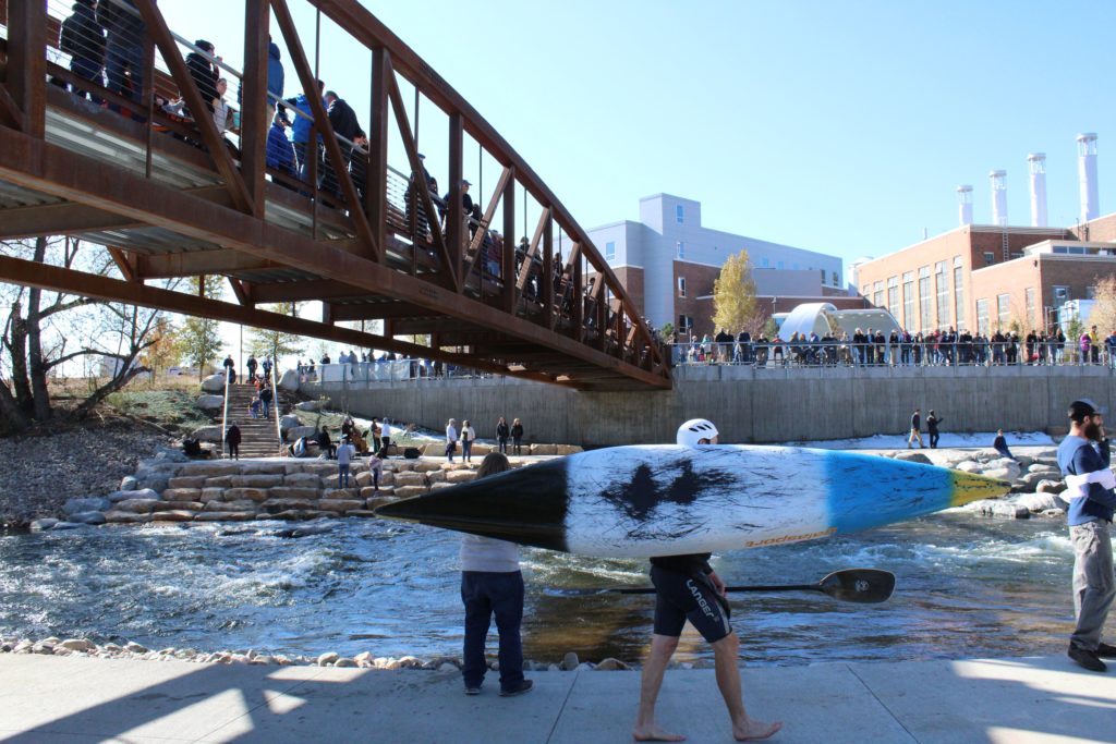


_basin_map")


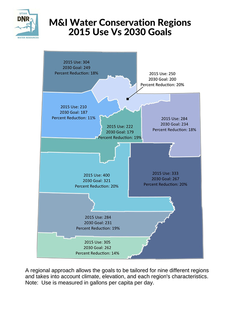