Ed Quillen used to say that oil shale had been the, “Next big thing for 100 years.”
Here’s the release from the Southern Utah Wilderness Alliance (Ray Bloxham) via Earth Justice:
Conservation groups today sued the Trump administration to challenge what would be the nation’s first commercial-scale oil shale mine and processing facility. The lawsuit says officials failed to protect several endangered species when they approved rights-of-way across public lands to provide utilities to the proposed oil shale development.
The massive Enefit project in northeast Utah’s Uintah Basin would also drain billions of gallons of water from the Green River, generate enormous amounts of greenhouse gas pollution and exacerbate the Uintah Basin’s often-dismal air quality.
Today’s lawsuit, filed in U.S. District Court in Utah, argues that the U.S. Fish and Wildlife Service violated the law by ignoring the potential harm to endangered fish. In its biological opinion, the agency considered only the harm from water depletions necessary to build the pipeline, not the billions of gallons of Green River water that will be sent through the pipeline to Enefit’s oil shale development.
“The responsible federal agencies have worn blinders in approving this project, leaving themselves and the public in the dark about the immense ecological harm it would cause,” said Alex Hardee, attorney at Earthjustice. “We’re going to court to uphold the nation’s environmental laws and save the Upper Colorado River Basin from the devastating effects of oil shale.”
The Bureau of Land Management also violated the law by failing to adequately analyze the significant environmental impacts of the proposed oil shale development, which likely would not occur but for the agency’s approval of the rights-of-way.
“This is a prescription for disaster for our climate, wildlife, and the Colorado River Basin,” said Ted Zukoski, a senior attorney at the Center for Biological Diversity. “Draining the Green River to mine one of the most carbon-intensive fuels on the planet sends us in exactly the wrong direction. It’s putting us on a collision course with climate catastrophe so a foreign fossil-fuel company can make big bucks.”
The Trump administration paved the way for the project last year by approving rights-of-way for electricity, oil, gas, and water lines across public lands. At full buildout, the Estonian-owned Enefit American Oil facility would produce 50,000 barrels of oil every day for the next 30 years or more from the Green River Formation.
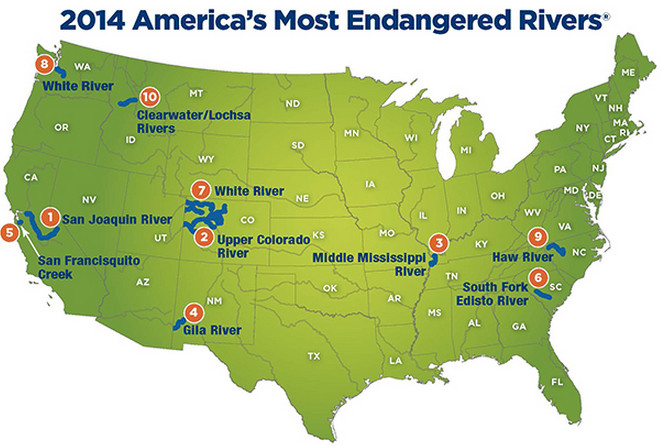
Map of oil shale and tar sands in Colorado, Utah and Wyoming — via the BLM
“The environmental destruction, air pollution and water pollution inherent in this proposed oil shale mining project is something that every citizen of Utah should be alarmed about,” said Dr. Brian Moench, president and founder of Utah Physicians for a Healthy Environment. “That it would become a long-term public health disaster is being callously dismissed by a BLM that is being run as a subsidiary of the dirty energy industry.”
Huge amounts of water are required in the oil shale production process. The water pipeline will allow Enefit to drain more than 10,000 acre feet annually from the Green River, harming critical habitat for endangered fish, including the Colorado pikeminnow and the razorback sucker. The project comes as Western states struggle with record droughts and climate-driven declines in river flows in the Colorado River Basin.
“Our region is already feeling the effects of pollution and climate change. To destroy our public lands in order to drill for more polluting fossil fuels would be a disaster for our communities and our planet,” said Dan Mayhew, conservation chair of the Utah Chapter of the Sierra Club. “We should be accelerating the transition to clean energy, not sacrificing our water, air quality, and climate for an investment in one of the dirtiest fossil fuels in the world. Today we continue the fight to ensure that federal agencies can’t continue to approve dangerous, dirty energy projects without fully considering the totality of environmental damage that would result.”
Enefit intends to strip-mine about 28 million tons of rock a year over thousands of acres of high-desert habitat, generating hundreds of millions of tons of waste rock. It will also construct a half-square-mile processing plant, about 45 miles south of Dinosaur National Monument, to bake the rock at extremely high temperatures to turn pre-petroleum oil shale rock into refinery-ready synthetic crude oil. That will require vast amounts of energy and emit huge amounts of ozone precursors in an area recently listed by the U.S. Environmental Protection Agency as not in attainment with healthy ozone standards.
Oil shale is one of world’s most carbon-polluting fuels, with lifecycle carbon emissions up to 75 percent higher than those of conventional fuels.
“BLM’s approach here is to ignore the elephant in the room, which never ends well,” said Ann Alexander, senior attorney with Natural Resources Defense Council. “They’ve focused exclusively on the relatively small impact of building some power lines and pipes, hoping no one will notice that this infrastructure will facilitate large-scale environmental destruction. Well, we noticed.”
The project would produce 547 million barrels of oil over three decades, spewing more than 200 million tons of greenhouse gas — as much as 50 coal-fired power plants produce in a year. Those emissions would contribute to global warming and regional drought already afflicting the rivers and their endangered fish.
“Enefit’s proposed oil shale operation could deplete more than 100 billion gallons over three decades,” said Sarah Stock, program director at Living Rivers. “That’s water taken away from other current water users and the downstream river ecosystem. The BLM needs to stop side-stepping their responsibilities by ignoring the devastating impacts that oil shale development will have on the climate and downstream water availability in the Colorado River Basin.”
“As a result of mismanagement, drought, and accelerating climate change, the Colorado River system is on the verge of collapse,” said Daniel E. Estrin, advocacy director at Waterkeeper Alliance. “Yet despite this crisis, BLM and FWS have approved rights-of-way across public lands for a project that could remove 100 billion gallons of water from the basin, push several endangered species closer to extinction, and rapidly degrade the water supply of almost 40 million people. These approvals, that will allow an Estonian hard rock oil shale company to exploit US public lands and resources, must be reversed.”
“The BLM approved the rights-of-way to service Enefit’s proposed oil shale mine and processing facility based on an utterly inadequate analysis of potentially devastating air, water, climate and species impacts,” said Michael Toll, a staff attorney at Grand Canyon Trust. “Considering the rights-of-way are a public subsidy of an otherwise economically unfeasible oil shale development, the public has a right to know exactly how Enefit’s project will impact their health and environment.”
The groups filing today’s lawsuit are Living Rivers/Colorado RiverKeeper, Center for Biological Diversity, Grand Canyon Trust, Natural Resources Defense Council, Sierra Club, Utah Physicians for a Healthy Environment and Waterkeeper. The groups are represented by attorneys from Earthjustice, Grand Canyon Trust and the Center for Biological Diversity.
From the Rio Blanco Water Conservancy District via The Rio Blanco Herald-Times:
The Rio Blanco Water Conservancy District (RBWCD) is as busy as ever with many projects in the works that affect residents on both ends of Rio Blanco County. District Manager Alden Vanden Brink explained that the board is in the pre-permitting process for the White River Storage Project.
“They are getting organized enough so that they can go into permitting. Their goal is to be in the permitting process at this time next year in 2020,” Vanden Brink said.
According to the Rio Blanco Water Conservancy’s website, the Northwest Colorado Water and Storage Project, also known as “Wolf Creek” has been in water resource planners’ sights since the 1940s when it was first proposed. Since then it seems every 10 years or so interest in the project is renewed and a feasibility study is completed. After reviewing all the pieces involved in reservoir construction the Wolf Creek project appears to make perfect sense for a White River reservoir. This is due, in part, to the potential for a significant portion of water to be stored off of the main channel, even with the main-stem White River dam. The geology of Wolf Creek and the surrounding area allows the inundation areas for the main-stem versus off-channel dam to be very similar. The Wolf Creek area also has the advantage of having all necessary raw materials available on site for the construction of the dam.
Estimates of the reservoir’s potential capacity are still in the development stages, but all indications point to a minimum reservoir capacity of 20,000–30,0000 acre-feet (AF) to 90,000 AF of storage with a maximum build capacity of stored water up to 1.2 million AF.
This is the only basin or main tributary to the Colorado River in the state that does not currently have drought resiliency. This project is a response to a developing water crisis for the lower White River including the Town of Rangely. No private lands will be inundated by this project as the location sits on federal, state and private land. That private land belongs to the Rio Blanco Water Conservancy District.
Not only will this project help the water storage crisis on the White River, Vanden Brink asserts “the local and regional economy will be enormously impacted and stimulated by the construction of this project.” The public can look forward to updates on the project as they develop.
The popular annual Rio Blanco Water Conservancy District Fishing Derby is set for June 1-2 this year. This event coincides with Colorado Parks and Wildlife’s free fishing weekend. The conservancy district offers free camping at Kenney Reservoir that begins Friday, May 31 and is honored on a first-come, first-serve basis. The weekend is also a free boating weekend a the reservoir.
“The Rangely Area Chamber of Commerce will be executing a Visit Rangely promotion during this time as well,” Vanden Brink said.
The White River Management Plan is a plan being developed for the endangered species within the White River. The lower White River system, which includes Kenney Reservoir, is a unique Colorado fishery. The Colorado Pike Minnow and the Razorback Sucker are the two endangered species that this plan is targeting for aid. The White River Management Plan puts the state in compliance with the Endangered Species Act of 1973. The RBWCD is a cooperating agency along with U.S. Fish and Wildlife Service, the State of Colorado, the Colorado Water Users Association, The Upper Colorado River Endangered Fish Recovery Program, and the Nature Conservancy. Vanden Brink said “his board has been very active with this plan” to ensure that it gets completed.”
The investigation into the problematic algae bloom in the White River is ongoing. A group of concerned citizens and agencies have convened to address the excessive amount of algae in the White River from the headwaters to the Utah state line. The Technical Advisory Group includes the Rio Blanco Water Conservancy District, Colorado Parks and Wildlife, Colorado River Water Conservation District, Rio Blanco County, Town of Meeker, Town of Rangely, Meeker Sanitation District, White River Conservation District, Douglas Creek Conservation District, Natural Resource Conservation Service, US Forest Service, Bureau of Land Management, U.S. Geological Survey, and Trout Unlimited.
According to Colorado Parks and Wildlife, in 2016 the visible filamentous alga was identified as Cladophora glomerata. All water users on the White River are impacted by this algae growth. It has especially caused intake problems for water users such as The Town of Rangely as well as private land owners. The RBWCD financially contributes to this investigation which hired the U.S. Geological Survey last year to conduct the water quality and stream morphology investigation. Vanden Brink reports that the RBWCD had success in 2018 flushing water out of the dam into the lower White River which helped to alleviate some of the algae problems in that area. They intend to use that method again in 2019 but likely earlier in the year.
Taylor Draw Dam was constructed in 1983 to create Kenney Reservoir. One hundred percent of the dam was funded by the taxpayers of western Rio Blanco County, including the Town of Rangely. In 1993 a 2-megawatt hydroelectric generator was added. The generator is capable of variable power output matching the flows of the White River. At full power production capacity, the hydroelectric facility provides up to 30 percent of renewable energy for Rangely. The energy created goes immediately onto the energy grid.
The Rio Blanco Water Conservancy District will meet again on Wednesday, March 27 at 6 p.m.
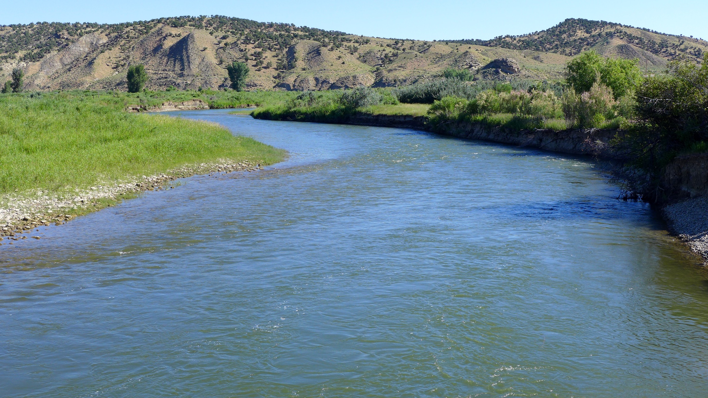
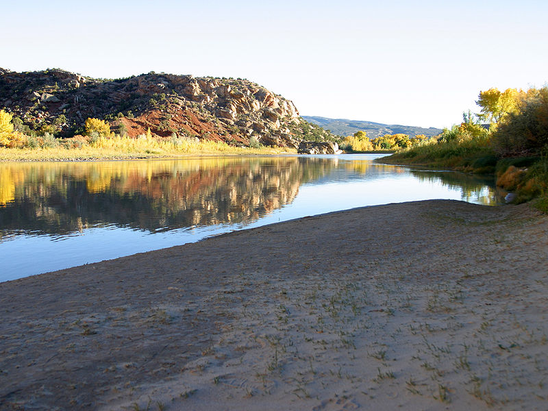
A view looking downstream of the White River in the approximate location of the potential White River dam and reservoir. The right edge of the dam, looking downstream, would be against the brown hillside to the right of the photo. Photo credit: Aspen Journalism/Brent Gardner-Smith
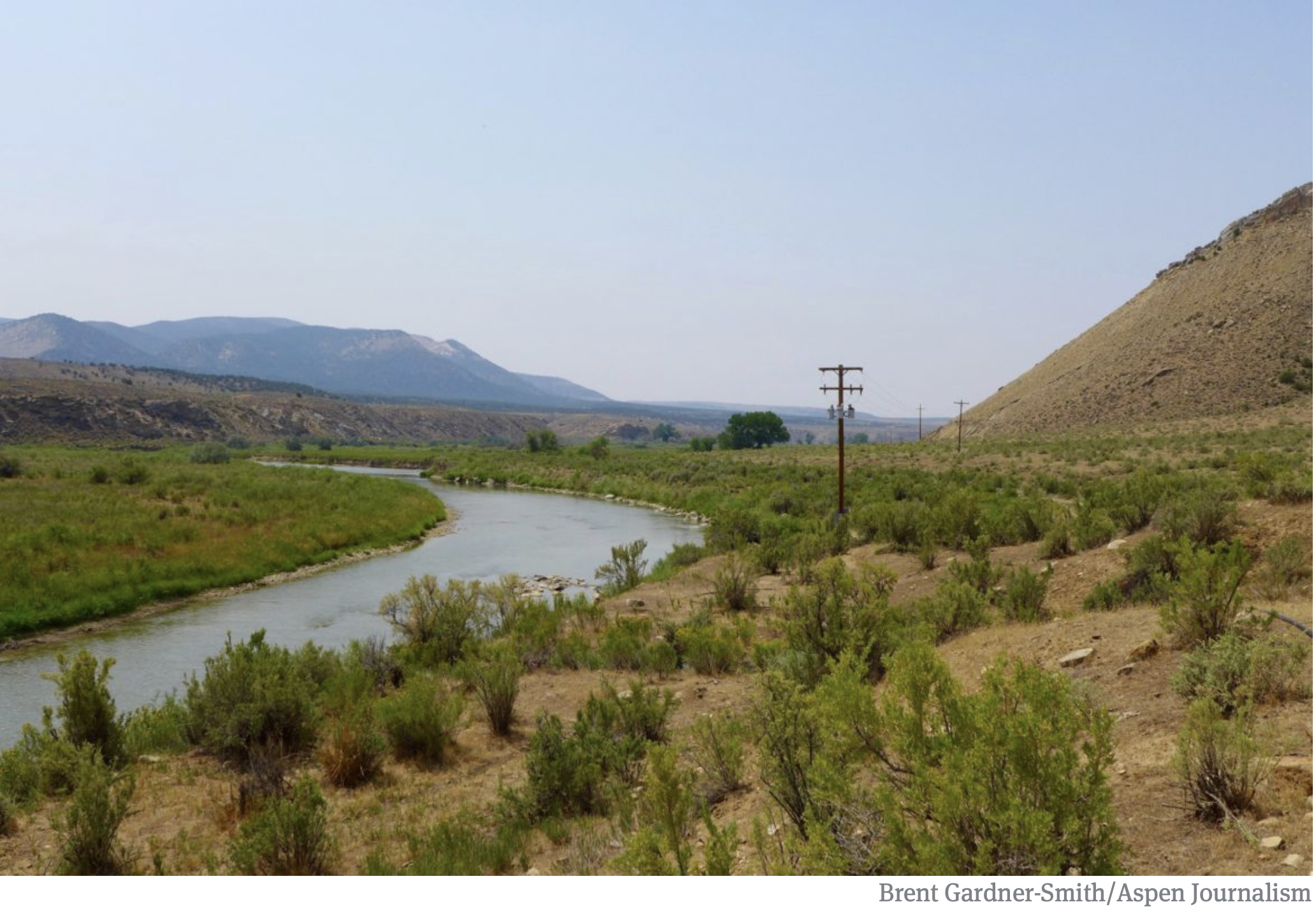
A view of the White River foreground, and the Wolf Creek gulch, across the river. The Rio Blanco Water Conservancy District and the State of Colorado have reached a settlement for a reservoir and dam project at this site. Photo credit: Aspen Journalism/Brent Gardner-Smith
The White River, in the vicinity of the proposed Wolf Creek Reservoir. Photo by Brent Gardner-Smith/Aspen Journalism.
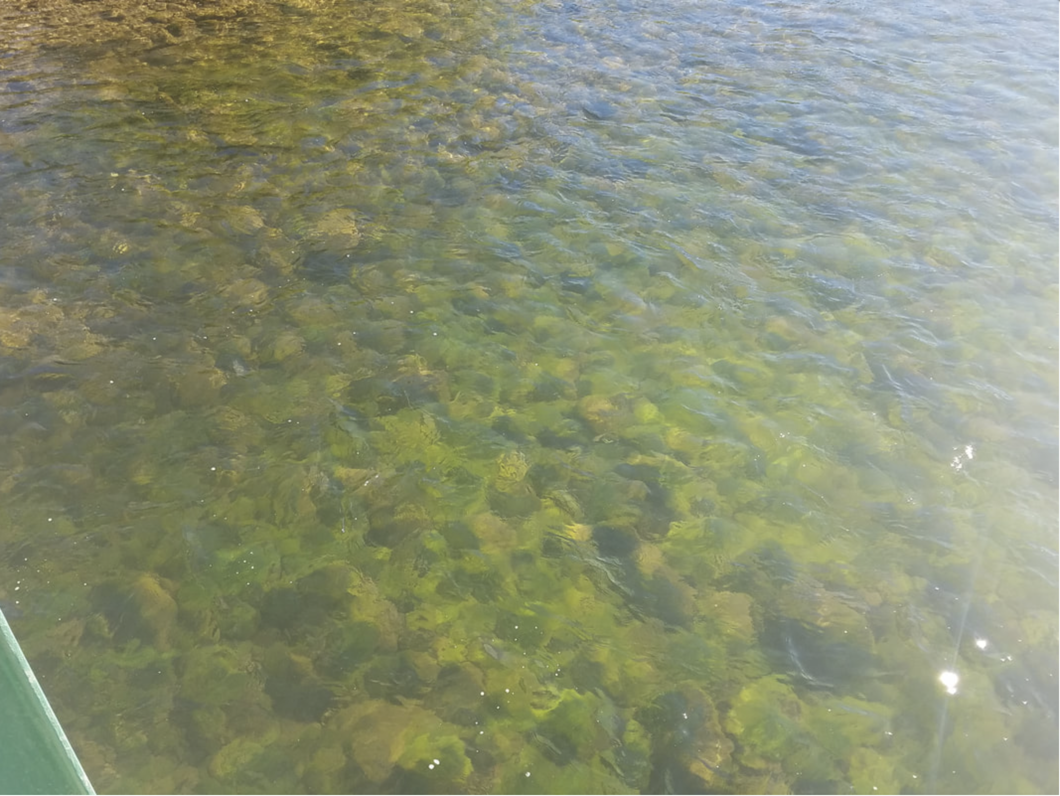
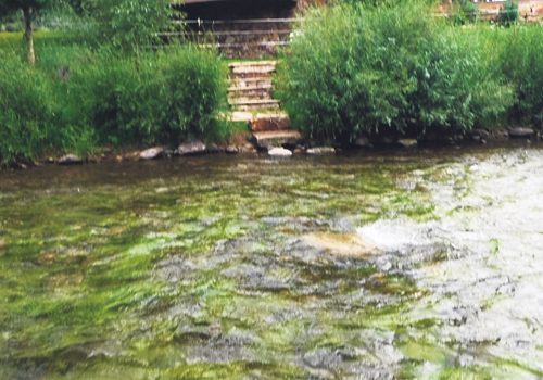
Picture taken 6/25/18 from the Miller Creek bridge. Unfortunately, the algae is coming on early this year. We are looking forward to finding the cause(s) of this algae in the near future. Photo credit: White River Algae Technical Advisory Group
From the White River Algae Technical Advisory Group via The Rio Blanco Herald Times:
Members of the White River Algae Technical Advisory Group (TAG), met Feb. 13 to discuss the 2019 plans to ascertain what is driving the algae growth in the White River to improve the overall health of the watershed. Callie Hendrickson, executive director of the White River and Douglas Creek Conservation Districts facilitated the meeting.
USGS provided a review of 2018 studies and planned 2019 activities. Ken Leib, Western Colorado Office Chief, stated their goal is to document and understand benthic algal occurrence, characteristics and controls at multiple locations within the White River (WR) study area and described the study design and approach. Cory Williams, Western Colorado Studies Chief, reviewed the historical analysis, water quality trends, algae sampling and isotope sampling. Key takeaways are as follows. Historical streamflow analysis showed a decreasing trend in flow patterns since 1900 while available high-resolution water temperature data indicates increasing daily mean temperatures during May-September between two more recent time periods (1979-84 and 2007-17). Little to no change has been shown in the mean, annual concentration of kjeldahl nitrogen while total phosphorous showed a substantial increase in concentration and flux between 1999 and 2017. Concentrations in phosphorous increased during snowmelt-runoff (high flow) and decrease during fall and winter months. Several types of algae were present at each study site and Cladophora was found at all 19 USGS study sites. Water samples were collected and analyzed for nitrate concentrations at six locations but, concentrations were too low for isotope analysis. Isotopic analysis is an aspect of the study intended to aid in identification of sources of nitrate in the watershed. Sampling and nitrate analysis are ongoing and USGS is exploring alternative sampling approaches to meet target concentration ranges. Historical analysis and literature review, physical and chemical characterization/data collection, algae sampling and isotope sampling will all be continued in 2019.
Tyler Adams, project manager, and Susan Nall, section supervisor, with the Army Corps of Engineers (ACE) reviewed permitted activity in the recent past. They described their regulatory authorities and explained how to know when a project is regulated and when it may qualify for exemptions. Available permits vary from Nation Wide Permits (NWP) to Regional General Permits (RGP) to Individual Permits (IP). Permitting history in the Upper White River total 53 permits (NWPs=38, RGPs=14, IP=1), about 866,939 acres, from 2008-2018.
Matt Weaver, 5 Rivers Inc. gave a presentation on a local project proposal that is currently in the application process with the ACE. The proposal is to enhance fish habitat in the White River. The plan is to create 18 pools in which Weaver will remove material from the pool area and add it to the bank to leave everything functioning as a pool-bar sequence. Weaver and the landowners are communicating with the Colorado Parks and Wildlife to avoid disrupting crucial times such as spawning season, etc. One USGS study site is encompassed in the project area. The landowners/managers are willing to work with the TAG and USGS to do their best not to affect the ongoing study.
Several discussion items were identified at the last TAG meeting as potential changes to the USGS 2019 Scope of Work (SOW). Items such as monitoring growth of the algae using pictures, isotopic analysis, water temperature monitoring, taxonomy, capturing the impacts of stream structure changes, water clarity (turbidity) and quantitative mapping were reviewed to make decisions on how the TAG would like to move forward.
After this discussion, the TAG reached a consensus that the White River Conservation District should move forward with the original agreement with USGS to continue the 2019 SOW for the White River Algae project. That SOW includes the workplan elements: Scouring flows and analysis and Pre, peak-, post-algae and water quality sampling events.
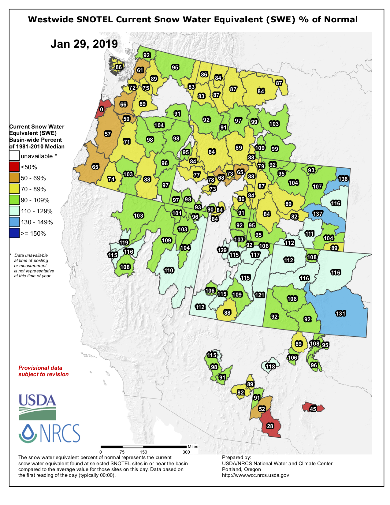
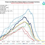
Westwide SNOTEL basin-filled map January 29, 2019 via the NRCS.
FromThe Steamboat Pilot & Today (Eleanor C. Hasenbeck):
Snowpack in the Yampa and White river basins is at 110 percent of its long-term median snow water equivalency, which is a measure of how much water is contained within the snowpack. Snowpack typically peaks in April, so snowfall — or lack of it — could still force that number away from the median.
… the city of Steamboat Springs has enough water to provide for current demands for a decade under 2012 conditions — the third worst drought episode in Colorado’s history — according to city water resources manager Kelly Romero-Heaney. Romero-Heaney said this would be a “doomsday scenario.”
“I don’t know if there are many communities in Colorado that can say that,” she said in an update to the Steamboat Springs City Council on Jan. 15.
One of the ways managers seek to minimize the risk of a compact call is demand management, she said. This is a spot where Steamboat has hit beyond the mark. In 2011, the city’s water conservation plan sought to reduce water consumption by 5 percent, said Michelle Carr, city water and sewer distribution and collection manager. The city exceeded this goal, and as Steamboat’s population has grown, it’s demand for water has fallen, she explained.
The White River, in the vicinity of the proposed Wolf Creek Reservoir. Photo by Brent Gardner-Smith/Aspen Journalism.
Click here to go to the website to RSVP and read the agenda.
From the White River Water Conservation District via The Craig Daily Press:
The public is invited to attend the Water Expo and White River Conservation District Annual Meeting to hear and engage in discussions with speakers about the Colorado River Water Compact, Prior Appropriations Doctrine, Demand Management, Protecting your Water Rights, and Integrated Water Management Plans.
The Expo is set for Thursday, Jan. 17, in Meeker and is hosted by the White River Conservation District, Colorado Ag Water Alliance, and Rio Blanco Water Conservancy District
Speakers include Colorado River District General Manager Andy Mueller, Colorado Water Conservation Board’s Interstate, Federal, and Water Information Section Chief Brent Newman, Division 5 Water Referee Susan Ryan, and several water rights attorneys, who will discuss these topics with Rio Blanco citizens.
See the full agenda at the White River and Douglas Creek Conservation Districts’ website, http://whiterivercd.com. Registration is at 9:30 a.m., and the expo is expected to wrap up by 4 p.m. Lunch will be provided by the Colorado Ag Water Alliance with an RSVP.
To RSVP or for more information, contact the Conservation District Office at 970-878-9838 or whiterivercd@gmail.com.
A view of the White River foreground, and the Wolf Creek gulch, across the river. The Rio Blanco Water Conservancy District has been using state funds, and their own, to study two dam options for this area between Meeker and Rangely on the White River. Photo credit: Aspen Journalism/Brent Gardner-Smith
The Colorado Water Conservation Board has given $843,338 to the Rio Blanco Water Conservancy District since 2013 to study a potential dam on the White River, yet officials at the Colorado Division of Water Resources say the project appears “speculative” and Rio Blanco lacks evidence for its claims for municipal, irrigation, energy and environmental uses.
On Nov. 14, the CWCB directors approved the most recent grant application from Rio Blanco for $350,000 to keep studying the proposed White River dam and reservoir project near Rangely.
But while the CWCB is spending more state money to help prepare the White River project for federal approval, another state agency, the Division of Water Resources, is asking hard questions about the project in water court.
“There are concerns whether the district can show that it can and will put the requested water rights to beneficial use within a reasonable period of time and that the requested water rights are not speculative,” wrote Erin Light, the division engineer in Division 6, who oversees the White and Yampa river basins, and Tracy Kosloff, the assistant state engineer in Denver, in a report filed in water court Oct. 4.
In addition to pursuing a series of grants from CWCB, Rio Blanco applied in water court in 2014 for a new water right to store 90,000 acre-feet of water from the White River.
The two engineers in the Division of Water Resources filed their report after consulting with the state attorney general’s office. Review of water rights applications by division engineers is routine, but the report filed by the division engineer and assistant state engineer raised a higher level of concerns than normal.
Also known as the Wolf Creek project, it could store anywhere from 44,000 to 2.92 million acre-feet of water, according to the array of proposals, presentations and applications that have been made public over the project’s ongoing evolution. (Please see: Timeline: tracking the proposed White River dam and reservoir).
The water would be stored either in a reservoir formed by a dam across the main stem of the White River, or in an off-channel reservoir at the bottom of the Wolf Creek gulch.
The latest grant from the CWCB to Rio Blanco was to “finalize the preferred reservoir size and firm-up financial commitments of key project partners so that applications for federal permits can be filed,” according to a CWCB staff memo on the grant.
Asked about the apparent conflict between CWCB and DWR on the White River project, CWCB Director Becky Mitchell said she was aware of the concerns voiced by the division and state engineers and was confident that the next phase of study supported by CWCB would help answer some of the questions raised.
“All of the grants given to Rio Blanco thus far have been all about feasibility, so we are not necessarily in disagreement with DWR, but it needs to trued up,” Mitchell said Tuesday. “There may be concerns with what DWR is stating and the grant will help us evaluate those concerns.”
In another sign of CWCB’s support for the potential project, the agency’s finance section has added a potential $100 million loan to Rio Blanco on a list of potential loans it compiles and publishes as part of the CWCB director’s reports to the agency’s directors.
Brad McCloud of EIS Solutions in Grand Junction is serving as Rio Blanco’s project manager for the White River project.
When asked Tuesday about the contradictory messages sent by the two state agencies, McCloud said, “I think one side is working on one end and the other is doing the other and it’s a good check and balance and the way the system is supposed to work. And there are probably things that will get worked out along the way.”
A view looking downstream of the White River in the approximate location of the potential White River dam and reservoir. The right edge of the dam, looking downstream, would be against the brown hillside to the right of the photo. Photo credit: Aspen Journalism/Brent Gardner-Smith
State questions
In their report filed in water court, the state’s water engineers challenge Rio Blanco oft-stated claim it is seeking the new storage facility at Wolf Creek in order to meet the future water needs of the Town of Rangely, which today takes its water directly from the White River.
“While every case is different and may require evidence tailored to the particular facts of the case, the engineers have not received sufficient evidence to support the district’s claimed water demands for Rangely nor evidence that Rangely intends to rely on water storage in one of the Wolf Creek Reservoirs to meet its demand,” the report from Kosloff and Light says.
The engineers’ report also questions the demand for water in the potential new reservoir from the energy sector.
They said Rio Blanco should, at a minimum, show how much of the 45,800 acre-feet of industrial demand it is claiming is located within the district’s boundaries.
They also say Rio Blanco should make public how much of the demand from the energy sector within the district’s boundaries can be satisfied by the existing water rights of the district.
In addition to challenging Rio Blanco’s claims for municipal and industrial use of water in their 2018 report, Light and Kosloff also question Rio Blanco’s claims for irrigation and environmental uses.
They said a storage report prepared for the project “notes that irrigated acreage and irrigation water demand is projected to decrease in the future” in the area downstream of the reservoir.
And the engineers said they “do not believe that a water right for irrigation use should be awarded in this case.”
And the engineers question Rio Blanco claim that it will release up to 42,000 acre-feet of water from its proposed reservoir to the benefit of endangered fish downstream on the White and Green rivers.
They say an ongoing study has yet to make clear how much water is needed for the endangered fish.
“Long story short, it is still unclear what flows should be used when determining if or how much water needs to be stored to assist with meeting the recommended flows,” the report says. “Until these numbers are known, claiming any quantity of water for these uses is speculative.”
Consultants for the Rio Blanco Water Conservancy presenting a slide earlier this year showing how a dam could be built across the main stem of the White River between Rangely and Meeker. A report from engineers at the Division of Water Resources is questioning the claims made in a water court case in which Rio Blanco is seeking new water rights for the project.
Size in flux
The White River project has a wide range of potential uses, according to Rio Blanco, and it also has a wide range of potential sizes, as various presentations and applications have included potential sizes from 44,000 acre-feet to 90,000 acre-feet to 400,000 acre-feet to 2.92 million acre-feet.
Alden Vanden Brink, the manager of the Rio Blanco district, told the CWCB directors Nov. 14 that his district is not seeking to build a 400,000 acre-foot reservoir, despite the reference in Rio Blanco’s grant application to study a reservoir between 44,000 acre-feet and 400,000 acre-feet.
“The 400,000 is maximum size,” Vanden Brink said. “That is not what the Rio Blanco Water Conservancy District is looking to build. It’s going to take somebody from a way outside source to come to the table for that.”
Vanden Brink said the district was seeking to store “anywhere from 44,000 to about 130,000” acre-feet of water.
However, the grant application from Rio Blanco notes that a 400,000 acre-foot reservoir might have some benefit to the state.
“If the higher end of the storage is implemented, the project has tremendous potential to help the majority of the state of Colorado address Colorado River Compact administration issues,” the grant said.
An earlier study on the dam by W.W. Wheeler and Associates for the Rio Blanco district found it was possible to build a dam on the White River at Wolf Creek that would hold 2.92 million acre-feet of water.
The latest grant application to CWCB from the Rio Blanco district says “the preferred reservoir size will be developed based on the amount of water needed and committed to by key project stakeholders.”
Wade Cox, the president of the Rio Blanco Water Conservancy District, discussed the project in October with the board of the Colorado River District, and referenced the varying potential sizes of the reservoir.
“There is never going to be enough water,” Cox said. “I don’t care how big you build it. Whatever you do, it’s never going to be enough. Somebody somewhere is going to utilize it.”
Editor’s note: Aspen Journalism covers water and rivers in collaboration with The Aspen Times and other Swift Communications newspapers. The Times published the story on Thursday, Nov. 29, 2018.
Map of oil shale and tar sands in Colorado, Utah and Wyoming — via the BLM
FromThe Grand Junction Daily Sentinel (Dennis Webb):
Petroteq Energy, formerly MCW Energy Group, has built a facility at Asphalt Ridge outside Vernal and is using what it says are benign solvents to produce oil from oil sand deposits. The company says its approach uses no water, produces no waste or greenhouse gas and doesn’t require high temperatures.
It is working to ramp up production to the plant’s capacity of 1,000 barrels a day.
The company said this month it received a small-source exemption from the Utah Division of Air Quality for its facility, allowing it to begin sales. It said in a news release that it got the exemption because the plant’s estimated emissions are less than the level for which a permit is needed, “further confirmation that Petroteq’s process is an environmentally conscious method of oil extraction.”
Oil sands are also known as tar sands or bituminous sands, and contain a heavy oil also described as asphalt or bitumen.
Petroteq says its leases have 93 million barrels of estimated oil resource. Eastern Utah is home to the largest oil sands resources in the country, with resource estimates running as high as 32 billion barrels…
Petroteq’s project is at Asphalt Ridge, which the federal Bureau of Land Management has reported has been the target of oil/tar sand exploration and development efforts as early as the 1920s, when Vernal paved its streets from Asphalt Ridge deposits.
Work there included a plant that used hot water to extract oil in the 1930s. Hot water also is used in Canadian tar sands development that also incorporates tailing ponds. “Our ‘Asphalt Ridge’ asset has (from time to time) caught the attention of major oil companies going back 70 years. But nobody has been able to unlock its resources in a financially sound and environmentally friendly manner until the Petroteq team and its proprietary technology came along,” David Sealock, Petroteq’s chief executive officer, said in a recent news release announcing the company’s start of commercial production.
The company says its focus is on development and implementation of proprietary technologies for environmentally safe production of heavy oil from oil sands, oil shale and shallow oil deposits. Northwest Colorado and northeastern Utah are home to world-class deposits of oil shale, rock containing kerogen-like hydrocarbon deposits.
The efforts of companies like Petroteq continue to be criticized by groups including Utah Tar Sands Resistance, which says on its website, “The production of tar sands in Utah is a story of false claims and impossible promises with a long history of failed companies, bankruptcies and name changes.”
The site of the potential off-channel Wolf Creek Reservoir on the White River. Photo: Brent Gardner-Smith/Aspen Journalism
FromThe Grand Junction Daily Sentinel (Dennis Webb):
The Rio Blanco Water Conservancy District wants to build the reservoir northeast of Rangely on Wolf Creek, a tributary of the White River on the Moffat County border, and pump water from the White River to fill it.
The district is looking at two options, one with a working pool of 20,000 acre-feet, the second with a working pool of 90,000 acre-feet, at estimated costs of $119 million and $191 million respectively.
The district envisions the reservoir meeting a variety of uses, including providing water to the town of Rangely, supporting oil and gas and oil shale development, providing water for endangered fish, and serving as a recreational attraction. In terms of total size, it is considering a reservoir holding 41,000 or 130,000 acre-feet of water. That would account for an additional nonworking pool that would continue to serve recreation needs at times of low water, provide an insurance water supply in circumstances such as during work on the pumping system, and make room for accumulation of silt.
The problem of sedimentation has beset Kenney Reservoir, which sits upstream of Rangely on the White River. That is threatening its viability as a continued source of water for Rangely and as a recreational amenity.
Dredging the reservoir would cost an estimated $700 million. Siltation is expected to be less of a problem in the case of a Wolf Creek reservoir because it’s off the main White River channel and the water would be pumped into it.
Rio Blanco Water Conservancy District officials discussed their proposal in Glenwood Springs last week with the board of the Colorado River District, a taxpayer-funded entity consisting of 15 counties. The Rio Blanco district is hoping the river district will contribute $50,000 toward the cost of seeking permits for the project, which would be built largely on federal Bureau of Land Management land. It’s also seeking technical and other support from the river district.
The district board plans to consider the request and act on it at a future board meeting. But Tom Gray, the Moffat County representative on the river district board, voiced general support for the reservoir proposal…
Representatives of the Rio Blanco district pointed to dry years such as this one, and concerns about longer-term drought, in arguing on behalf of building new storage in the White River basin…
The district plans to pursue funding from potential users and other sources such as the federal and state governments to pay for the project.
According to the U.S. Drought Monitor all of Rio Blanco County is still currently classified as D3, or Extreme Drought, as precipitation around the county continues to fall well under normal rates. However, there is some hope to be found in the winter forecast.
Drought Levels in Rangely
The National Oceanic and Atmospheric Administration, or NOAA, has been tracking weather and climate related data in Rangely since 1894. The station currently sits near the Rangely Water Treatment Plant. According to NOAA data, by the end of August Rangely was 1.37 inches below normal precipitation, receiving only 6.22 inches from January through August.
In 2017 Rangely received total precipitation of 8.66 inches for the entire year while the historic average total annual precipitation sits at 10.03 inches.
NOAA predicts that the below normal precipitation will continue through the rest of September.
The fact that precipitation has been well below normal for multiple years has certainly exacerbated the drought conditions.
Dry conditions in Meeker
NOAA tracks Meeker’s climate and weather at a station located at the Bureau of Land Management Office. Meeker is currently below normal for precipitation by 0.81 of an inch, receiving 9.16 inches through the end of August.
In 2017, Meeker received a total of 15.73 inches of precipitation for the year and the historical data, which dates back to 1893 for the community, places an average annual precipitation of 16.54 inches. Jim Pringle with NOAA doesn’t anticipate much change in the standings through the month of September, saying, “Although we still have to wait just under two weeks from now to obtain the September 2018 precipitation for Meeker, it is doubtful based on the latest computer-generated atmospheric model guidance that Meeker will receive normal precipitation for September.”
Winter Forecast
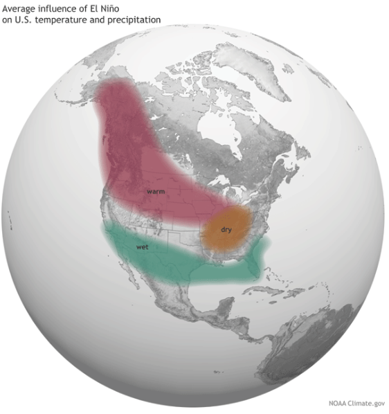
The good news is that the National Weather Services’ Climate Prediction Center (CPC) is anticipating an El Niño episode for the upcoming 2018-2019 winter season, with odds favoring at least near normal precipitation in northwest Colorado during the late fall, winter and spring months.
An El Niño event is characterized as bringing unusually warm waters in the Pacific Ocean. This typically produces warmer-than-average temperatures over the western and northern United States. Wetter-than-average conditions are likely over portions of the western U.S and Gulf Coast regions, while drier-than-average conditions are usually expected in the Ohio Valley and the Pacific Northwest.
Average influence of El Niño on US temperature and precipitation
Due to the low flows, dry conditions and extreme heat, higher water temperatures in the White River are nearing danger levels for cold-water fish. CPW officials have been encouraging anglers to fish in the early morning, when water temperatures are cooler and less stressful to fish. Last Friday, CPW, out of Grand Junction, asked for voluntary fishing closures on western Colorado rivers due to the high water temperatures and low flows.
CPW Area Wildlife Manager Bill de Vergie said before the meeting, “It’s important that ranchers, landowners, ditch users, fishing guides and fishing ranch managers, anglers, and other members of the public work together to protect our fishery and our river.”
CPW and the Colorado Water Conservation Board (CWCB) entered into a water lease agreement in 2012. The agreement allows the partial release of CPW’s water stored in Lake Avery to help meet minimum instream flow needs of 200 cubic feet per second (cfs) at the County Road 4 (Wakara) bridge. Users at Lake Avery would see declining water levels in the lake whenever any releases are initiated. deVergie said CPW would give at least 48 hours notice prior to any releases.
In 2012, the lake level at Avery dropped about six feet as 1300 acre-feet out of the 7600 acre-foot storage capacity reservoir was used. Water released comes from the bottom of the reservoir, is relatively cold, and able to be quickly oxygenated. Releases this year could use twice as many acre-feet from the reservoir and drop the lake level up to 14 feet.
“If we do make releases from Avery (a.k.a. Big Beaver Reservoir), we will ask water diverters to avoid taking the additional water and instead leave it in the river to give the fish and river habitat a chance,” said de Vergie. “We all know how important this river is to our economy, and we expect that people will comply to ensure the river continues to be a destination fishery.”
The meeting was attended by local water users including ditch operators and users Don Hilkey, Tad Edwards, Wayne Johnson, Jerry Belland, Tel Gates, Joe Conrado, Chris Collins, Rob Raley, Forrest Nelson and Ben Rogers. CPW employees at the meeting included water resource specialist David Graf of Grand Junction, instream flow coordinator Jay Skinner, Katie Birch from Denver, aquatic specialist Melynda May, wildlife managers Bailey Franklin and Ross McGee, fisheries specialist Tory Eyre and Lori Martin, senior Northwest Region aquatic biologist. Erin Light, the Division 6 water engineer with the Division of Water Resources in Steamboat Springs, was also in attendance…
River advocates attending included Shawn Welder, Bob Dorsett of Colorado River Watch, Roy Wedding and Bob Regulski. Upriver fishing ranch interests were noticeably absent from the meeting. One such individual told the Herald Times after the meeting that neither he nor his manager had heard anything about the meeting beforehand.
Graf told the meeting that his agency is evaluating how their water rights statewide might be better used to improve difficult situations like the White River now faces which might differ, to varying degrees, from the related water right decrees.
Dorsett cautioned the group not to think of this as an unusual circumstance, that current data trends are for these low flows to be more the norm. This concern evoked some discussion about needing more water storage in the valley, which could possibly include enlarging Lake Avery.
Local diverters are anxious to avoid any call on the river. Light reinforced concern that any flows cannot really be legally protected unless the whole river is under a call for administration by the Division of Water Resources. Cooperation between irrigators and other users in times of low water is critical and, in the past, has prevented a call. Several irrigators indicated how well retired water commissioner Bill Dunham had facilitated cooperation between water users. Light said she was confident that the current commissioner, Shanna Lewis, would work as well with diverters and that she had her blessings to do so…
Johnson, a Miller Ditch irrigator, wondered why we were trying to save fish and habitat in the White River when there is so little public access to the river for fishing, to which de Vergie responded that the duty of CPW was to provide a viable fishery and to serve all members of the public, including those that avail themselves of fishing on the private ranches.
Lake Avery releases of 10 to 15 cfs in 2012 didn’t occur until Aug. 30 and continued until Oct. 3. That year, de Vergie said, we experienced some good rain in July that postponed the need to release Avery water until late August.
The threshold factors CPW said are critical for the fish are a flow of less than 200 cfs at the Wakara bridge, water temperatures above 70 degree Fahrenheit there, and dissolved oxygen levels of less than 5 ppm. These are the factors that will trigger releases.
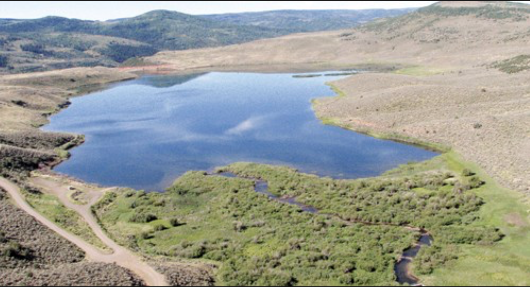
Lake Avery. Photo credit: Colorado Parks and Wildlife
From Colorado Parks and Wildlife via The Rio Blanco Herald Times:
Due to low flows, dry conditions and extreme heat, water temperatures in the White River are nearing dangerous levels for cold-water fish. Colorado Parks and Wildlife officials are encouraging anglers to fish in the early morning, when water temperatures are cooler and less stressful to fish.
To help mitigate current conditions, Colorado Parks and Wildlife is considering releasing water from Lake Avery to increase flow in the White River, and potentially lower river water temperature.
To answer questions and address concerns about the possible release, CPW invites the public to a roundtable session, 7 p.m., July 9 at Kilowatt Korner (White River Electric Association—WREA), 233 Sixth St., in Meeker, Colo.
“We’ve been here before, and we know what we need to do, “ said Bill de Vergie, Area Wildlife Manager from Meeker. “It’s important that ranchers, landowners, ditch users, fishing guides, anglers, and other members of the public attend our meeting so that we can work together to protect this important fishery.”
Colorado Parks and Wildlife officials and the Colorado Water Conservation Board entered into a water lease agreement in 2012. The agreement allows the release of CPW’s water stored in Lake Avery to help meet the minimum instream flow on the White River of 200 cubic feet per second.
Anglers at Lake Avery will see declining water levels in the lake beginning when the release is initiated.
“When the flow from Lake Avery begins, we will ask users to avoid taking the additional water and instead leave it in the river to give fish a chance of surviving,” said de Vergie. “Everyone around here knows how important this river is to our economy, and we expect that people will comply to ensure the river continues to be a destination fishery.”
CRAIG — Three variations of a potential dam that could someday sit astride the main stem of the White River between Meeker and Rangely have been examined by the Rio Blanco Water Conservancy District in Rangely.
Last week in Craig, Steve Jamieson, a principal engineer and president at W.W. Wheeler and Associates, told the members of the Yampa, Green and White river basin roundtable that an 80-foot-tall dam built across the main stem of the White River at Wolf Creek could store 68,000 acre-feet of water.
He said a 104-foot-tall dam across the river could store 138,000 acre-feet.
And a 290-foot-tall dam across the valley floor could store 2.9 million acre-feet of water.
“The maximum you can get here is 2.9 million acre-feet in this bucket,” Jamieson said. “It’s a big bucket, and you can do that with a dam that it’s about 290 feet high. It would be a very efficient dam site, but you need to have the water to fill it.”
A slide being presented by Steve Jamieson of Wheeler a showing the range of dam and reservoir sizes that have been studied for the potential White River Dam on the main stem of the White River 23 miles east of Rangely. The dams range in size from 80-feet-tall to 290-feet-tall and could store between 68,000 AF to 2.9 MAF. The dam sizes were studied as part of Phase 2A of the White River storage project, and the state has provided $500,000 in funding so far to study the project.Steve Jamieson, left, of Wheeler and Associates, and Brad McCloud, right, showing an illustration of where the axis of a 290-foot-tall dam across the White River would be. The big dam would require a 500-foot-wide spillway, which would mean relocating a section of Hwy 64.
Water enough
About 500,000 acre-feet of water a year runs down the lower White River each year, flowing through Meeker and Rangely and into Utah and the Green River.
And between 1923 and 2014, the annual flow in the White River at the Utah line ranged from 200,000 to 1.2 million acre-feet, according to Wheeler and Associates.
The potential White River Dam would be located 23 miles east of Rangely, along Highway 64.
The existing Taylor Draw Dam, which forms Kenney Reservoir on the main stem of the White River, is six miles east of Rangely.
That reservoir was built in 1984 to hold 13,800 acre-feet of water, but it’s gradually silting in, as was expected in a 1982 EIS done for the project. The surface area still “available for recreation,” or boating, is now less than 335 acres, down from 650 acres when the reservoir opened.
The dam’s hydro plant, however, is still generating about $500,000 a year in electricity revenue for the Rio Blanco district in a run-of-river setup.
A slide being presented by Steve Jamieson of Wheeler and Associates and Brad McCloud of EIS Solutions showing the range of dam and reservoir sizes that have been studied with state funding for the Wolf Creek drainage. The dams range in size from 80-feet-tall to 260-feet-tall and could store 41,000 AF to 1.6 MAF. The dam sizes were studied as part of Phase 2A of the White River storage project, and the state has provided $500,000 in funding so far to study the project.
Off-channel too
Jamieson also has been studying an off-channel dam in the Wolf Creek drainage, which is a broad, dry valley on the north side the river, just upstream of the proposed White River Dam site.
The Wolf Creek Dam would be located 3,000 feet back from the river and 170 feet above it.
An 80-foot-tall version of that dam could store 41,000 acre-feet of water, a 119-foot-tall dam could store 130,000 acre-feet, and a 260-foot-tall dam could store 1.6 million-acre feet, Jamieson said.
“This is really good dam site here, I like this,” Jamieson said. “It’s very flexible.”
However, the off-channel Wolf Creek Dam would require that water be pumped up from the river, at a high cost, or delivered via a 40-mile long canal or pipeline starting near Rio Blanco Lake — closer to Meeker than Rangely.
“It’s going to be a very long and expensive canal,” Jamieson said.
The pumping facility for a 90,000 acre-foot reservoir, which was studied in 2014, was estimated to cost $18.2 million build and up to $1.1 million a year to operate.
Jamieson said Highway 64 would need to be moved to accommodate the biggest White River Dam option, which requires a 500-foot-wide spillway on one side of the river valley.
The river itself would also have to be moved during construction.
“You’d be constructing two to three years at least,” Jamieson said. “So what we looked at is actually building a tunnel around into this abutment that we would divert the White River through during construction.”
A slide presented by Steve Jamieson of Wheeler and Associates on May 9, 2018, showing the maximum inundation area of a 290-foot-tall dam on the main stem of the White River. Jamieson presented the slide at the May 9, 2018 meeting in Craig of the Yampa/White/Green basin roundtable.
Gardner-sized
Jamieson said the district started studying the maximum size of the potential reservoirs after Sen. Cory Gardner asked during a site visit, “How big can you make this reservoir?”
During his presentation Jamieson repeatedly referred to Sen. Gardner, using phrases such as “this is the maximum Cory Gardner reservoir.”
A roundtable member asked, “Did the senator promise the money for this?”
The basin roundtables operate under the auspices of the Colorado Water Conservation Board and review grants for water projects.
“No, he did not, unfortunately,” said Brad McCloud of EIS Solutions, a public affairs consulting firm retained by the district. “We asked.”
The Colorado Water Conservation Board also wants to know what the maximum reservoir size is.
“Based on recent comments from some stakeholders, it may be beneficial to build the largest possible reservoir at Wolf Creek,” the scope of work for a 2017 grant from the board to the district states.
It also says “a much larger reservoir … could have additional benefits to the state.”
One of those benefits could be helping the state avoid a compact call on the Colorado River.
“Part of the Phase 2A study is to determine if the project may have the potential to provide Colorado compact curtailment insurance during periods of drought,” the 2017 grant application from the district said.
Since 2013, the district has received three grants totaling $500,000 from the Colorado Water Conservation Board for its White River project, and the potential benefit of compact compliance has been mentioned in all three grants.
The White River near the vicinity of the Wolf Creek drainage. The river sends about 500,000 acre-feet of water a year across the state line into Utah, with flows ranging from 200,000 AF to 1.2 MAF a year. The White drains the western side of the Flat Top Mountains and flows through Meeker and Rangely.
20,000 or 90,000
On Wednesday in Craig, Jamieson downplayed compact curtailment and focused on the district’s goal of creating a 20,000 or 90,000 acre-foot “working pool” of water inside larger potential reservoirs.
For example, it would require a 138,000 acre-foot on-channel reservoir to establish a 90,000 acre-foot working pool for the district, after allowances for a recreation pool and a 24,000 acre-foot sedimentation pool — which would fill in over 50 years.
To establish a need of the stored water, Jamieson cited a 2014 study showing demand in the basin at 91,000 acre-feet in 2065.
That’s on the high end, though.
The low-end need in 2065 was 16,600 acre-feet.
The district filed in water court in 2014 for a 90,000-acre-foot storage right at both the on-channel and off-channel locations.
But Erin Light, the division engineer in Div. 6, told the district in July 2017 “this application continues to contain aspects that are speculative and this is concerning to me.”
She questioned the district’s use of the highest estimates for such potential uses as oil shale production and flows for endangered fish.
The water attorney for the district, Ed Olszewski, responded to Light in August.
He said the district “disputes that any portion of the application is speculative” and the application is intended to be “as flexible as possible.”
As Jamieson wrapped up his presentation, he said the Rio Blanco district plans to “initiate project permitting” in 2019.
“I know we’re very aggressive,” Jamieson said. “We’re making progress.”
Aspen Journalism is covering water and rivers in collaboration with The Aspen Times and the Glenwood Springs Post Independent. The Times and the Post Independent published this story on Monday, May 14, 2018.
From the Rio Blanco Water Conservation District via the Rio Blanco Herald Times:
Earlier this month the Colorado River District released a statement protesting the application for water rights filed by Water Horse Resources LLC, owned by Aaron Million.
The application for Utah water rights requests 55,000 acre feet of water from the Green River with two pump stations located five miles from the Colorado state line in Dagget County, Utah, on Bureau of Land Management land. The water would then run through a hydroelectric facility before being piped nearly 500 miles northeast into Wyoming and then south down the Colorado Front Range.
The river district’s letter of opposition cites a variety of reasons why the application should be denied, including the speculative nature of the application saying, “A fundamental precept of water use in Colorado (and, we believe, in Utah as well) is a strict prohibition on speculative claims of water. No specific beneficial use or need has been identified for the project other than a general reference to future water demands in Colorado.”
The district also raises concerns about the legal and practical nature of enforcing and accounting for a water right issued by the State of Utah but with great impact on Colorado water users. The letter states, “The proposed water right would exacerbate the supply problems currently faced in the Colorado River Basin, and would increase the need and cost of any Upper Basin demand management program.”
Another concern raised by both the river district and numerous environmental groups including the Center for Biological Diversity who have spoken against the application is the lack of environmental analysis.
In years prior Million has unsuccessfully attempted to obtain water rights that would allow him to pipe water from Flaming Gorge Reservoir to the Front Range. The Colorado River District opposed that application as well.
“This new application suffers from many of the same problems as his previous proposals but presents a number of new problems and interstate legal issues as well,” said Peter Fleming, General Counsel for the Colorado River District.
In a statement released last week Colorado River District General Manager Andy Mueller said, “Development of this resource in this manner would not only harm existing Western Slope water users but would impact the ability of the River District and the State of Colorado to plan for and develop future water resources as well.”
Thirty-two letters of protest have been filed against the project including letters from the Utah Board of Water Resources and Division of Water Resources who raise similar concerns to those mentioned by the Colorado River District.
In a press release issued last week Million stated, “Utah is initiating an identical project…The Lake Powell pipeline. Point of diversion in Arizona, water and hydroelectric power into Utah. We are watching that closely as they are still sorting out federal permitting responsibilities. The Upper Colorado River Compact is clear and allows the use of water from Utah or Wyoming into Colorado. Or vice versa. For the last 96 years the Upper Basin, which includes Colorado, Utah, Wyoming and New Mexico has over-delivered its’ Compact share. The issues on the Colorado are almost strictly a Lower Basin over-use issue, which includes California, Arizona and Nevada. Had the Lower Basin not drained the Lower Colorado River and over-utilized their water allocation, Lake Powell and Mead would be full by five times plus.”
The project, nicknamed Grasshopper by Water Horse, is estimated to cost $890 million. Tom Wood, Project Management team member stated, “The Green has numerous advantages. A huge river system, excellent water quality, and Flaming Gorge Reservoir that will double the State of Colorado’s storage availability. Additionally, all the global warming models are indicating the Green River will be wetter than average in the future, coupled with a later snowmelt than the Colorado River main stem. The Green River headwaters is located several hundred miles north of the Colorado River headwaters. This year is a classic reason that two hydrologically diverse basins, meaning the Colorado River and Green River, and their respective water supplies, should be managed collectively. The Upper Green is currently running 140 percent of average snowpack, the Colorado River main-stem is half that or less, at maybe 60 to 65 percent. It diversifies water supply management risk, which ties directly to alleviating ecosystem and environmental impacts.”
Rio Blanco Water Conservation District Manager Alden Vanden Brink is concerned about the project. “Focusing on the water resource needs in Northwest Colorado I intimately understand how water projects that are speculative in nature, as Mr. Million’s project is, include, intrastate concerns and potentially put water resour ces in Western Colorado at risk to Compact curtailment are certainly something that we need to pay close attention to,” he said.
At least seven major new reservoirs and water diversion projects are being planned in Colorado, which had a population of 5.6 million in 2017. Many would continue the controversial practice of diverting water across the Rocky Mountains from the state’s Western Slope, where the majority of Colorado’s precipitation falls, to its more arid Front Range, where people are flocking to Denver, Boulder, Fort Collins, Longmont and increasingly sprawling suburbs.
The water projects have been inspired partly by the Colorado Water Plan, an effort by Governor John Hickenlooper to solve a projected water deficit of 560,000 acre-feet by 2050, or enough to serve more than 1 million households. The plan calls for 400,000 acre-feet of new water storage and an equal amount of water conservation.
The plan is only two years old. But critics say it has prioritized gray infrastructure – new dams, pipelines and pumps – over green projects like water conservation and sustainable land use…
The state water plan does not recommend any specific water development projects. But Hickenlooper has personally endorsed several of them. He also appointed all the voting members of the Colorado Water Conservation Board, the entity that oversees the Water Plan and awards grants for water projects.
Greg Johnson, chief of water supply planning at the Water Conservation Board, said the state’s plan emphasizes conservation just as much as new water supply projects. But he said the latter may be more more pressing in some cases.
“Some of the bigger projects that are in permitting right now are helping meet really critical supply needs that a lot of those faster-growing northern Front Range suburbs have, where they’ve got new developments going up all over the place,” Johnson said. “They have maybe a 10- or 15-year horizon to get some of those things done.”
One of the water developments endorsed by the governor won a $90 million loan in 2017 from the Water Conservation Board – the largest loan in the board’s history. Known as the Windy Gap Firming Project, it proposes a new reservoir called the Chimney Hollow Reservoir near Longmont to store Colorado River water diverted through an existing tunnel under the Continental Divide.
The loan covers nearly one-fourth of total costs for the project, which is proposed by the Northern Colorado Water Conservancy District.
As its name implies, the project is intended to “firm up” existing Colorado River water rights held by a dozen Front Range cities. The cities already draw on these water rights, but can’t fully tap them in some years because of storage limitations. The new 90,000 acre-foot reservoir will solve this problem and allow them to divert the river almost every year.
The project would result in diverting 30,000 acre-feet more water out of the Colorado River every year than is currently diverted…
Other major projects in the works include the Moffat Collection System, a plan by Denver Water to expand Gross Reservoir to hold 77,000 acre-feet of additional diversions from Colorado River headwaters streams; and the White River Storage Project, a proposal for a new reservoir of up to 90,000 acre-feet in the northwest corner of the state, near the town of Rangely…
Greg Silkensen, a spokesman for the Northern Colorado Water Conservancy District, said the Windy Gap project is vital to many fast-growing Front Range communities that have lower-priority water rights.
“The Colorado economy is just crazy. Everybody and their brother is moving here,” Silkensen said. “There is a great deal of environmental mitigation that will go forward if the project is built. There’s going to be a lot of benefit to the Upper Colorado River if it does go through.”
Those projects include stream habitat restoration in the Colorado River and water quality improvements in Grand Lake, part of the existing Western Slope diversion system.
Bloom on the White River. Photo courtesy of Colorado Parks and Wildlife via the Rio Blanco Herald Times.
From the White River Conservation District (Callie Hendrickson) via The Rio Blanco Times:
Thank you to all the interested public and stakeholders for your commitment to finding the drivers of the algae in the White River. We also want to thank you all for your patience with our Technical Committee (TC) as they have put a great amount of time, effort, and energy into identifying the most critical elements to the Scope of Work (SOW) that will help identify the causes of the algae. This is a very complex problem that has evolved over time and it will require some time to identify the cause. It is anticipated that there is no one single cause or source of this problem. There are multiple rivers across the western United States that are experiencing the excess algae issue, much like the White River.
A quick review of what the Technical Committee has done reminds us that USGS had originally recommended we do a one-year study primarily up-river from Meeker. The TC asked USGS to provide a proposal that would also include studying the river all the way down to Rangely and to make it a multi-year study over concerns that one year’s worth of data would not be statistically significant. USGS came back to the group with that proposal which gave many of the committee members “sticker shock.”
Realizing that it would be a huge challenge to get down to the detail necessary, a five-member workgroup was appointed in January to work out those details and bring a recommendation back to the TC. The final recommendation from the workgroup is the culmination of many hours (days), conversations, meetings, emails, etc. I’m confident that the workgroup has done exactly what the TC asked.
In reviewing the USGS draft SOW, the workgroup literally dissected it into a chart where they evaluated it line by line based on prioritized questions. Then they developed and analyzed a more elaborate spreadsheet for more discussion so that they could sort based on priorities and the “core” tasks required to ensure scientific analysis and credibility to the study. There were a number of tasks that each individual would like to include but the group finalized the SOW based on the highest priorities ensuring scientific integrity in determining the cause of excess algae. The workgroup’s final step in the two-month processes is to present the final SOW to the technical committee on March 21.
The workgroup recognizes that there is a sense of urgency in finding the cause of the algae and has balanced that sense of urgency with a solid scientific-based study that will give us the best of both worlds. To identify different sources of nutrients in the White River as quickly as possible, the proposed SOW will analyze isotopic-signatures of oxygen and nitrogen from nitrate in various source materials and in the river during 2018. Please remember, there is no guarantee that the “signatures” will be different enough to help determine the potential source. While analyzing samples for isotopic signatures, the proposed SOW will simultaneously include efforts to help develop a better understanding of the physical and chemical properties controlling the algal growth.
The draft proposal includes annual progress reports from USGS to evaluate the next year’s proposed work based on findings of the current year. We will be using adaptive project management based on annual findings.
While the anticipated cost is more than any of us would like to see, the workgroup has done a great deal of individual research and determined that we do need all the components of this SOW. Discussion was had about the USGS preliminary costs being a little higher than potentially other researchers. The consensus of the workgroup was that with USGS providing 35 percent of the funding and their reputation of being nonbiased, they are the best entity to have do this research and analysis.
So, how are we going to pay for the study? We currently have commitments for a total of $60,000 for 2018. That leaves us approximately $30,000 to raise for 2018 work. The conservation district and others will be meeting with individuals and agencies during the remainder of March to solicit this $30,000 because it is too short of a time frame to get grant funding and it seems like it is a “doable” amount to raise for such an important issue to the community.
In ensuing years, we will be seeking support again from the stakeholders and applying for grants through the Basin Roundtable, the Colorado Water Conservation Board and others to be determined.
The White River Conservation District anticipates that we will have annual agreements with USGS for the study dependent upon funding availability and on adaptive research based on each year’s outcome.
The technical committee meeting will be March 21 at the Fairfield Center beginning at 11 a.m. At that time the workgroup will give a brief overview of their recommendations followed by a more detailed presentation of the SOW by USGS. We will break for lunch and reconvene at 1:30 p.m. for further discussion and public comment specifically on the proposal in anticipation of finalizing the SOW by end of the day.
Landowners and interested parties are welcome to attend the technical committee meeting and will have an opportunity to provide comment and input on the proposal during the public comment period. We strongly encourage that anyone interested in providing comment in the afternoon attend the morning session, where they receive a copy of the proposal and hear the presentations.
Visit the White River and Douglas Creek Conservation Districts’ website (www.whiterivercd.com) to find copies of the workgroup’s recommendations, previous meetings’ minutes, research and meeting information. Contact the conservation district office at 878-9838 with any questions.
District Executive Director Callie Hendrickson, of Grand Junction, reviewed subjects including rangeland health and monitoring; excess horses on public range; range improvement programs and opportunities; greater sage grouse management; and water issues. The latter includes facilitation, on behalf of the county, of the deliberations and research of the county’s White River Algae Task Force. The mission of the task force, Hendrickson stated, is “to ascertain what is driving the algae growth in the White River (in order) to improve the overall health of the watershed.”
The 2018 Plan of Work presented covers the development and implementation of the rangeland monitoring and weed control project with the federal Bureau of Land Management on the Piceance-East Douglas (Wild Horse) Herd Management Area; ongoing facilitation of the White River Algae Task Force; continuing utilization of the Land and Natural Resource Plan and Policies developed by the districts and approved by the board of county commissioners as a guide to public lands use; continuing equipment rental, tire tank and polyacrylamide (PAM) sales for sites where quick fixes are needed on dam areas where there are known leaks and for setting up the surface for new ponds as well as flooded field irrigation and ditch projects; continuing excess wild horse education; continuing work with partners to support the wise use of natural resources; and working to secure long-term sustainable funding to replace losses in mill levy funding.
Enterprise Products, Williams gas company, and XTO Energy were the primary sponsors of the district dinner this year. Steve Cochran, Enterprise manager, and Darren Baker, representing Williams, were presented “thank you” awards for the sponsorships. Past district manager Chris Colflesh and his bride, Kim O’Donnell, both now of Silt, were also honored.
The Natural Resources Conservation Service district conservationist, Kendall Smith from Craig, whose jurisdiction covers Moffat and Rio Blanco Counties; Kent Walter, field manager for the White River Field Office of BLM; and U.S. Forest Service Rio Blanco District Ranger, Curtis Keetch, each gave updates on the activities of their agencies.
The evening’s program closed out with presentations by Colorado Parks and Wildlife water quality guru Mindi May, Denver, and Elk Creek Ranch fishing manager Colton Brown sharing their perspectives on the White River algae situation.
Replacing aging and failing infrastructure was the primary topic of discussion for Meeker Sanitation District board members at its Dec. 6 meeting. Cooper Best and Josh McGibbon, from JVA Consulting Engineers, presented their assessment of the town’s sewer system.
JVA had Action Services “clean and jet” the lines and record their findings, resulting in 180 hours of sewer line video…
JVA uncovered three instances of fiber optic cable punched through sewer lines. The county is paying for and finishing repairs for those now.
One of the main problems in the system involve “service laterals.” While the district is responsible for the main system, homeowners are responsible for the connection between their homes and the district line…
The assessment identified “quite a few areas” where the service laterals have become separated from the main line, allowing water and roots to get into the system.
The district is facing about $10 million worth of repairs and replacements during the next nine years, starting with the highest priority projects. Some areas will require “full line replacements.”
Funding options include capital reserves, increasing tap and user fees, but none of those options are enough to cover the costs…
McGibbon and Best outlined necessary steps for the district to qualify as a “disadvantaged community” for grant purposes.
The “disadvantaged” label is limited to the Colorado State Revolving Fund and only applies to water and sewer projects…
The board, with JVA’s help, will begin pursuing grant monies to fund the suggested repairs and replacements…
The board also approved the 2018 budget, which includes a “tax holiday” for taxpayers, temporarily reducing the mill levy from 9.47 mills to 6.47 mills. The district anticipates $769,281 in revenue in 2018. According to the budget, “For the operation of the district, the estimated expenditures for 2018 have increased by $17,379.57 from the 2017 appropriated expenditures. The district has seen an increase in the property and liability insurance, employee health insurance program, an increase in the water sampling program, an increase in sewer main maintenance, and the employees will realize a 3 percent wage increase based on the average of salaries.” The district employs five people, two in the office and three at the wastewater treatment plant.
In an unprecedented move, the board voted against the bid award recommendations for the Meeker Water Supply Improvements Project from contracted civil engineer Olsson Associates. Olsson recommended awarding RNA Enterprises of Glenwood Springs for $340,948 and Ridge Electric of Grand Junction for $150,603 as the lowest bidders. Several trustees expressed concerns over the recommendation, as there was more than $100,000 difference between the low bid and the next highest bid, and the bid was not itemized.
Wyatt Popp of Olsson cautioned the board that the Department of Local Affairs (DOLA) grant funding received from the town would be at risk if the board chose to go with a higher bid. State statutes for DOLA funds require awarding the lowest bid as long as the bidders are responsive and qualified.
“Deviating from the process at this point in time is not recommended,” Popp said. Refusing to accept the recommendation risks losing approximately $300,000 in DOLA grant funds…
Town Attorney Melody Massih asked if there is a way to re-bid the project. Popp said that would require additional discussion with DOLA.
More than three dozen people gathered at the sheriff’s office conference room in Meeker last Friday morning to continue addressing why we’re experiencing such bothersome summer algae blooms in the ecological heart of our community—the White River. Led by Rio Blanco Commissioner Si Woodruff, with Commissioner Jeff Rector at his side, the past meetings were acknowledged and the county laid out their proposal for moving forward. The proposal was that an action oriented advisory group, smaller than the whole group gathered Friday, be established which could better focus on needed actions.
In addition, the county proposed that the White River and Douglas Creek Conservation Districts (CDs) take the lead in coordinating and facilitating meetings and electronic communications and serve as the fiscal agent to pursue and manage finances including grant applications and management for addressing the algae and overall health of the river.
Callie Hendrickson, executive director of the CDs, explained the discussions the CDs had held with the county and presented a possible scope of work to be carried out…
The advisory group proposed by the county initially includes representatives from the U.S. Geological Service (USGS), the county, the Colorado River Water Conservation District, the Towns of Meeker and Rangely, Meeker Sanitation District, Rio Blanco Water Conservancy District, Colorado Parks and Wildlife, and the CDs. Interested vested stakeholders, non-governmental organizations and members of the general public are expected to be included at some point as well.
The assembled group Friday accepted the county proposal without objection. The advisory group itself met Friday afternoon.
The county’s concept was also to turn to the USGS to do much of the needed further research. USGS scientist Ken Leib of Grand Junction, who has been attending the county river algae meetings, gave a presentation to the whole group on what such a research effort should look like. Leib reviewed much of the information on the river conditions that have already been collected, and the further research and data gaps USGS would try to complete.
Hendrickson facilitated a round-robin collection of important pieces individuals at the meeting would like to see included in further study and action. Several group members urged that the advisory group not delay pursuing actual remedial actions regarding the algae that make sense in the short term while conducting longer term research.
The Yampa-White-Green Rivers Basin Round Table is a group of 32 stakeholders from Routt, Moffat and Rio Blanco counties who work on local water issues. Established in 2005 when the Colorado General Assembly passed the Colorado Water Act for the 21st Century and officially beginning 2010 by order of the governor, the Round Table often uses studies, system modeling and projects with the goal of preserving the quantity and quality of water. Their goals include protecting the Y-W-G Basin from the Colorado River Compact curtailment of existing decreed water uses and some increment of future uses, protect and encourage agricultural uses of water in the Y-W-G Basin within the context of private property rights, improve agricultural water supplies to increase irrigated land and reduce shortages, identify and address municipal and industrial water shortages, quantify and protect non-consumptive water uses, maintain and consider the existing natural range of water quality that is necessary for current and anticipated water uses. They also seek to restore, maintain, and modernize water storage and distribution infrastructure while developing an integrated system of water use, storage, administration and delivery to reduce water shortages and meet environmental and recreational needs.
In November the Round Table will need to fill 10 vacancies on their board. Areas that will be open for re-election or new appointments include representatives for recreation, domestic water provider and industrial water user, as well as four at-large representatives plus three individuals or entities who reside outside the basin but own water rights within the basin. Eligibility requirements vary between the positions. Those interested in serving or seeking more information should contact April McIntyre, Round Table Administrative Assistant at 970-985-9924 or mcintyreapril6@gmail.com.
Those who are interested in protecting and directing the future of the Yampa, White and Green River Basins are encouraged to get involved. Changing population distributions and water demands across the west will only serve to raise the level of importance these rivers play making groups like the Round Table ever more vital.
FromThe Grand Junction Daily Sentinel (Dennis Webb):
Cleanup is continuing and Chevron and authorities are looking into the cause of a pipeline leak outside the Rangely area in which more than 4,800 gallons of oil spilled into a dry drainage.
The leak was discovered March 5 by Chevron personnel in a drainage leading to Stinking Water Creek, and the line was shut off following the discovery.
Two ducks, two other birds and three mice died as a result of the spill.
The incident occurred on Bureau of Land Management land. BLM spokesman David Boyd said the spill initially was estimated at 1,200 barrels, or more than 50,000 gallons. But Erika Conner, spokeperson for Chevron Pipe Line Co., says early reports included recovered barrels of oil combined with snowmelt.
Boyd said the spill involved a 6-inch-diameter oil gathering pipeline.
Todd Hartman, a spokesman for the Colorado Department of Natural Resources, said the oil traveled about 30 feet to an unnamed drainage, then flowed to another drainage, covering about two miles altogether in heavily vegetated terrain.
It stopped at a stormwater siphon about 1.5 miles west of Stinking Water Creek, he said.
He said the failed section of pipe has been sent off for analysis.
Richard Mylott, a spokesman for the Environmental Protection Agency, said that Chevron “had previously installed berms and siphon dams in the unnamed draw as a prevention/preparedness measure for any spills.”
“… Cleanup is ongoing. Crews have vacuumed oil from behind the siphon dam and are currently removing contaminated soils, flushing oil from pockets and steep ditches,” he said.
Both Mylott and Conner said no water was impacted by the spill.
Conner also said there were no public health concerns.</blockquote
2016 saw the finalization and implementation of the Rio Blanco Land Use Plan. The plan, which had a four-year creation process, was accomplished in partnership with the former board of county commissioners. It endeavors to influence federal decisions by providing local input regarding federal lands. Because federal law requires that federal agencies, such as the BLM, give “meaningful consideration” to plans developed by local governments and conservation districts, the district has been able to gain a bigger seat at the table during the decision making process. The plan has already been put into use in addressing sage grouse issues and has allowed a conservation district representative to attend the BLM’s weekly NEPA meetings where they can officially comment on current issues, such as the BLM’s travel management plan.
The other major event impacting the conservation districts was the news that their mill levy had been incorrectly assessed causing an 83 percent budget reduction for 2017. The mill levy, which began collection in 1989, is only eligible to receive monies from real property. However, since its inception, it was collecting on both real and personal property. According to Hendrickson the oil and gas industry were hit the hardest. The impacted companies were given the opportunity to request abatement for the past two years’ collection. Hendrickson expressed extreme gratitude that none of the companies had, and instead expressed support for the work undertaken by the districts. The companies left substantial money in the coffers of the districts, with Enterprise being eligible for $135,000, Williams $65,000 and XTO $30,000. To help ease the budget transition the former board of county commissioners helped fund the districts for the 2017 year.
Meeker resident Gary Moyer, who sits on the National Association of Conservation Districts, provided a short update. The NACD is currently pushing for Congress to oppose any EPA authority over water quantity and the recently released BLM Planning 2.0. According to Moyer, Planning 2.0 does not allow for enough local input, despite the claim by the BLM that local input is the very purpose of the new plan. Moyer also cited concerns that it gives environmental groups who are not locally based a much bigger seat at the decision making table. He is hopeful that the plan will be killed by the Senate.
Senator Cory Gardner’s office sent a representative to address the group. Betsy Bair, who manages Gardner’s Grand Junction office, confirmed that Senator Gardner does not support BLM Planning 2.0 and is opposing the BLM’s vent and flare regulations, which impact the oil and gas industry.
The second half of the evening was filled with talk of water issues, many of which have significant impact to those living on the White River.
Marsha Daughenbaugh of the Community Agriculture Alliance informed the group of an upcoming Yampa/White River Basin water workshop. The workshop will take place on March 22 in Steamboat. Agriculture producers will be provided with the opportunity to learn about The Colorado Water Plan and how it may impact them. More information can be found at coagwater. colostate.edu.
Jim Pokrandt of the Colorado River Conservation District discussed the importance of Colorado snow pack. “We are all snow farmers,” he said. Pokrandt talked about the increasing incidence of water being pulled from production agriculture to the front range and the need to keep water moving from the East to the West. The Colorado River Conservation District will be piloting a program this year to conserve water in the Grand Valley, paying farmers to leave fields fallow. Pokrandt expects more than $750,000 to be paid to participating farmers this year.
The final speaker of the evening was Alden Vanden Brink from the Rio Blanco Water Conservancy. Vanden Brink updated the audience on the White River storage project, which is currently seeking to begin Phase II which includes modeling, preliminary studies and stakeholder outreach. Following Phase II the district will seek permitting, which Vanden Brink says can be a very long process.
The Douglas Creek Conservation District meets monthly, on the first Wednesday at 6 p.m. in Rangely. In coming meetings they will be discussing the future of the district.
The Rio Blanco Water Conservancy is preparing to begin Phase II of the White River storage project with the ultimate goal of obtaining a new reservoir on the White River.
The project began in 2014 with a water storage study. The study was determined necessary after the Conservancy determined that Rio Blanco was facing a water crisis. Approximately half of Kenney Reservoir’s original size has been silted in and it’s estimated that it loses 300 acre feet of water storage per year. The loss of Kenney significantly impacts recreation, endangered fish and potentially the Town of Rangely’s ability to store water. The district initially investigated improvements to Kenney but found that dredging would cost more than half a billion dollars and enlarging Taylor Draw had significant permitting issues. Because of these concerns the Conservancy District decided to move forward with the study of a new multipurpose reservoir. The functions of a new reservoir would include municipal and domestic water supply, environmental improvements, recreation, energy development and potentially irrigation and Colorado River Compact Storage.
Phase I of the project, which was completed in 2015, saw 23 initial reservoir sites identified at various locations along the White River. Estimating water demand in 2065, the District was able to narrow it down to two possible sizes, a 20,000 or 90,000-acre foot reservoir. After comparing construction, implementation and storage costs the location was also narrowed down to the Wolf Creek Drainage, which is located 17 miles East of Rangely, near Yellow Creek. The total project cost of the 20,000-acre foot option is estimated at $71.1 million and the 90,000-acre foot option at $127.7 million. However, when a storage cost per acre foot comparison is made the larger reservoir appears economical, with the 20,000-acre foot costing $3,560 and the 90,000-acre foot costing $1,420 per acre foot.
In addition to size options Wolf Creek comes with two potential locations, a traditional dam built directly on the White River or an off channel diversion project which would require the water to be piped and pumped to a nearby location. The on river dam option offers a smaller dam footprint, hydroelectric options and the possibility of extending the life of Kenney Reservoir by preventing more sedimentation. This option will require greater infrastructure relocations as well as have a larger impact on private and agricultural lands.
While the off channel diversion would certainly have higher construction costs than building on river, there are benefits to be considered. The off channel diversion would receive less sedimentation, leaving it more protected from the problems Kenney has experienced. It would also require little to no need for infrastructure relocations such as power lines or pipelines along with a minimal impact to private lands and personal property. Additionally, there are significant enlargement capabilities. However, the off channel option also provides limited opportunities for hydroelectric power. The conservancy has already filed for water rights on both options.
Phase I also looked at the potential tax revenue provided by a new reservoir, with recreation playing a large role. It is estimated that the Wolf Creek site could create a total annual tax revenue of $1.1- $1.4 million.
Phase II, which will begin when all funding mechanism are firmly in place, will include more stakeholder and public outreach, preferred alternative refinement, preliminary sedimentation studies and hydraulic modeling. In addition, this phase will include development of minimum stream flows for the endangered fisheries program and research into the possibility of another hydroelectric plant. Phase II is estimated to cost $350,000. The funding comes from a variety of stakeholders including $85,000 from the Yampa/White Green Roundtable, $75,000 form the Rio Blanco Water Conservancy District, $50,000 from the Town of Rangely, $10,000 from the Town of Meeker and $25,000 from Rio Blanco County. There is also a $82,888 grant request in to the Colorado Water Conservation Board.
In their most recent meeting the Rio Blanco Board of County Commissioners agreed to additional funding to help fill the $22,000 gap with the understanding that the Conservation District would request the Towns of Meeker and Rangely to share the burden.
The $75,000 contribution from the Rio Blanco Water Conservancy District is a sizeable amount of money for the district, as it equates to 45 percent of their tax revenue.
The goal is to have Phase II completed by 2018 so that the lengthy permitting process can begin.
The entire project boasts an aggressive schedule with the goal of final completion in 2024. This timeline is considered rapid because the last completed dam project in Colorado took 18 years. It is also not unusual for the permitting process to last decades.
Oil and gas development on the Roan via Airphotona
Here’s guest column from David Nickum writing in the Grand Junction Daily Sentinel:
For more than a decade, the battle over Colorado’s Roan Plateau — a beautiful green oasis surrounded by oil and gas development — raged in meetings and in courtrooms. At issue: Would the “drill, baby, drill” approach to public lands carry the day and the path of unrestrained energy development run over one of Colorado’s most valuable wildlife areas? Or would “lock it up” advocates preclude all development of the Roan’s major natural gas reserves?
Luckily, this story has a happy ending — and a lesson for Colorado and other states in the West struggling with how to balance the need for energy development with conservation of public lands and irreplaceable natural resources.
The Bureau of Land Management recently issued its final plan for the Roan Plateau, closing the most valuable habitat on top of the plateau to oil and gas leases. The plan, which will guide management of the area for the next 20 years, also acknowledges the importance of wildlife habitat corridors connecting to winter range at the base of the plateau.
At the same time, the BLM management plan allows responsible development to proceed in less-sensitive areas of the plateau that harbor promising natural gas reserves and can help meet our domestic energy needs.
What happened? After years of acrimony and lawsuits, stakeholders on all side of the issue sat down and hammered out a balanced solution. Everyone won. It’s too bad it took lawsuits and years of impasse to get all sides to do what they could have done early on: Listen to each other. We all could have saved a lot of time, money and tears.
The Roan example is a lesson to remember, as the incoming administration looks at how to tackle the issue of energy development on public lands. There’s a better way, and it’s working in Colorado.
The BLM also this month, incorporating stakeholder input, closed oil and gas leasing in several critical habitat areas in the Thompson Divide — another Colorado last best place — while permitting leasing to go ahead in adjacent areas.
That plan also represents an acknowledgment that some places are too special to drill, while others can be an important part of meeting our energy needs.
And in the South Park area — a vast recreational playground for the Front Range and an important source of drinking water for Denver and the Front Range — the BLM is moving ahead with a Master Leasing Plan (MLP) for the area that would identify, from the outset, both those places and natural resources that need to be protected and the best places for energy leasing to proceed.
We have said that we want federal agencies in charge of public lands to involve local and state stakeholders more closely in land management planning — that perceived disconnect has been the source of criticism and conflict in the West regarding federal oversight of public lands.
The MLP process is a new tool that promises to address some of that top-down, fragmented approach to public land management. To their credit, the BLM is listening and incorporating suggestions from local ranchers, conservation groups and elected officials into their leasing plan for South Park.
This landscape level, “smart from the start” approach is one way for stakeholders to find consensus on commonsense, balanced solutions that allow careful, responsible energy development to occur while protecting our most valuable natural resources.
The lesson I take from the Roan? We can find solutions through respectful dialogue—and we shouldn’t wait for litigation to do so. [ed. emphasis mine] Coloradoans can meet our needs for energy development and for preserving healthy rivers and lands by talking earlier to each other and looking for common ground.
David Nickum is executive director of Colorado Trout Unlimited.
Solar-powered water systems let livestock drink more easily and take pressure off ponds and streams
[Vance Fulton], an engineering technician with the Natural Resources Conservation Service, described the way solar energy provides an effective way for landowners to transport water to their livestock.
“Especially around here, (landowners) have found that solar is a much more efficient way to pump water than the old windmills,” Fulton said.
And now, with the birth of the Sage Grouse Initiative, the solar-powered systems are receiving increasing amounts of federal support. Fulton said the systems have received funding through the Farm Bill for decades — but for the last several years, SGI has targeted more money for the solar-powered projects in places where the sage grouse is affected, such as Moffat County.
Surprising as it may seem at first glance, the creation of multiple water sources for cattle helps sage grouse too.
The system often works this way: A solar panel powers a pump that drives water through an underground pipeline, and the pipeline delivers the water to troughs at various points in the land so that animals can drink. The pump often fills up a storage tank for a backup water supply, as well.
The system, as Fulton explained it, creates an efficient means of supplying water to animals on the land. By creating several water sources, the system also eases stress on the ponds, puddles and streams where animals may gather to drink. That benefits a host of creatures — including the sage grouse.
Chris Yarbrough, formerly a biologist with the Rocky Mountain Elk Foundation, who is now regional habitat biologist for Idaho Fish and Game, explained how a water system such as this can help sage grouse. If there’s only one pond on a ranch, he said, that’s where the cows will congregate.
“That area will probably get overgrazed, and you’ll probably get a lot of weeds — things that aren’t good for wildlife,” he said.
But water troughs scattered throughout the land can attract animals to different spots, easing the pressure on a pond or a stream.
“The grasses and (other plants) then have a chance to grow,” he said — something that’s good for sage grouse and lots of other species, as well.
Yarbrough said much of the funding to install solar pumping systems in Moffat County is generated by the SGI, launched by the Natural Resources Conservation Service in 2010.
Fulton said the NRCS works with about 20 landowners in Moffat County on solar watering systems, and he noted there may be others using solar power, as well. It’s a number that’s far larger, he said, than it was about a decade ago, before the SGI.
One of the Moffat County landowners who uses solar-powered system is Doug Davis, who has a ranch called Davis Family Farm LLC that lies in the eastern part of the county.
“We discovered a very good water source up high, and because it’s up high you can use gravity flow,” Davis said.
Davis explained that the solar panel on this ranch pumps water from the well into a storage tank — and from that storage tank, gravity allows the water to flow through pipes to troughs throughout the property. Davis said that, on another property, he uses the solar-powered pump to push water directly to the troughs.
Either way, Davis said he’s glad to be using solar energy. He used to use windmills, which could be tough to maintain and less reliable.
“Windmills are much higher maintenance, and the wind does not blow as consistently as the sun shines,” he said. “Solar, which has turned out to be a low-maintenance, relatively low-cost proposition for us, is a winner.”
As Fulton walked through Davis’s land on that sunny July day, he pointed to some small nuances in the equipment, including strategically placed fencing to protect the plumbing from the animals drinking from the troughs, and a “small animal escape ramp” to let otherwise trapped animals climb to safety.
Fulton said the solar-powered system works without batteries, which means that energy is transferred directly to the pumps. It also means that the amount of energy may vary from day to day, depending on the supply of sunlight at a given time. That’s where the agility of the pumps comes into play.
“These pumps are able to work on variable voltage,” he said. “They’ll even continue to pump on a slightly cloudy day.”
Storing water during the sunny days, Fulton said, creates a water supply to use on the cloudy ones.
“You store water instead of storing electricity,” he said.
Fulton said, too, that advances in technology — in the pumps and the solar panels — have made the system even better than it used to be.
“It got more dependable, more efficient through the years,” he said — a sign that the sun soaking ranches throughout the county will be put to good use for many more years to come.
FromThe Craig Daily Press (Randy Baumgardner and Bob Rankin):
Our main takeaway from the meeting and subsequent tour was that the proposed Wolf Creek Reservoir project is a gem in the making for Colorado. In light of the governor’s water plan for the state, and his recent announcement that he wants to ensure that the we improve efficiencies and streamline the regulatory process for completing water projects in Colorado, it was highly encouraging to us to see a plan and a project like this in the works. Following our visit, we are confident that the Wolf Creek Reservoir can be an example and set the standard for how such projects can work, and we also both feel strongly that, for this reason, the Wolf Creek Reservoir should be made a priority within the state’s water plan.
More specifically, this project will bring a number of important regional benefits: it will provide the Town of Rangely with the quality and quantity of water necessary to serve their needs and address the growing water crisis that they are facing; it will assist in conservation efforts, providing possible opportunities for enhancing endangered fish species recovery; and, crucially, it will provide diversification to the local and regional economy through the tremendous recreational options it affords — offering growth and economic opportunity to an area that has been hit hard due to the drop in oil and gas prices, and other external and political factors that have ravaged the local energy industry. We will, of course, continue to work together at the state Capitol to address some of the political issues facing our energy sector; but in the meantime, seeing a project of this magnitude and importance begin to spring to life in this part of our state is extremely encouraging to us, as we are sure it is to the residents of Rangely and the whole area.
This project has great potential to offer incredible returns to both Rio Blanco and Moffat counties. The recreational opportunities alone will certainly enhance the quality of life for the region as well as diversify the local economy, as it will draw people not only from around the region and the rest of the state, but from neighboring states as well.
We both believe that it is time for the state and the various stakeholders involved to get behind making this project a reality. This is a perfect example of how the state can prioritize helping western Colorado. In particular, we would ask the governor to put his support behind it, and to use this as an opportunity to prove his commitment to speeding up the permitting process…
Sen. Randy Baumgardner and Rep. Bob Rankin composed this Op-Ed.
Here’s the release from The Center for Biological Diversity (Taylor McKinnon):
Lawsuit Launched Over Fracking, Water, Climate Change in Colorado River Basin
The Center for Biological Diversity and Living Rivers today filed a 60-day notice of intent to sue the Bureau of Land Management and U.S. Fish and Wildlife Service to compel them to update invalid, outdated Endangered Species Act consultations on the impacts of climate change and expanded fracking in western Colorado on the Colorado River system and its four endangered fish. The challenge seeks to halt all new oil and gas leasing and development on federal public lands in the Upper Colorado River Basin of Colorado — including the White River and Grand Junction field offices — pending updated consultations.
Fracking near the White River in Utah, located immediately downstream of the Bureau of Land Management’s White River Field Office that is subject to today’s notice. Photo by Taylor McKinnon / EcoFlight.
“The Colorado River system’s endangered fish can’t handle more water depletions. The river system is already overtaxed, and declining flows because of climate change are making a bad situation worse,” said Taylor McKinnon with the Center. “It’s hard to imagine a more self-destructive policy for the Colorado River Basin than using scarce water to fuel more climate-warming fossil fuel extraction — but that’s exactly what the Obama administration is allowing.”
The notice asserts that a programmatic “biological opinion” study authorizing water withdrawals for oil and gas development on public lands in the Upper Colorado River Basin is outdated and invalid. The study fails to consider impacts to endangered fish from the drawing-down of large amounts of water that would be used for horizontal drilling, as well as the impacts of developing expanded estimates of Mancos shale gas deposits, existing and projected future climate-driven Colorado River declines, oil and other toxic spills, mercury and selenium pollution, and the failure of the federal recovery program to provide minimum river flows in critical habitat for the fish.
The notice challenges both agencies’ reliance on the study when they approved new land-use plans for the Grand Junction and White River field offices last year and other oil and gas development plans this year. Together the new land-use plans would allow nearly 19,000 new oil and gas wells in western Colorado. Yet the Fish and Wildlife Service has already conceded that any further water depletions from the Colorado River or its tributaries would jeopardize the four endangered fish — the Colorado pikeminnow, razorback sucker, humpback chub and bonytail.
“Fracking in the Colorado River Basin comes at the peril of public lands, our climate, the river, its endangered fish, and tens of millions of downstream water users,” said McKinnon. “It’s backward public policy in face of a worsening climate crisis. Now’s the time for the Obama administration to align our country’s energy policies with its climate goals by ending new fossil fuel leasing on America’s public lands.”
Center for Biological Diversity attorneys Wendy Park and Michael Saul are staffing the case.
Background
On behalf of the American people, the U.S. federal government manages nearly 650 million acres of public land and more than 1.7 billion acres of the Outer Continental Shelf — and the fossil fuels beneath them. This includes federal public land, which makes up about a third of the U.S. land area, and oceans like Alaska’s Chukchi Sea, the Gulf of Mexico and the Eastern Seaboard. These places and the fossil fuels beneath them are held in trust for the public by the federal government; federal fossil fuel leasing is administered by the Department of the Interior.
Over the past decade, the combustion of federal fossil fuels has resulted in nearly a quarter of all U.S. energy-related emissions. A 2015 report by EcoShift Consulting, commissioned by the Center for Biological Diversity and Friends of the Earth, found that remaining federal oil, gas, coal, oil shale and tar sands that have not been leased to industry contain up to 450 billion tons of potential greenhouse gas pollution. As of earlier this year, 67 million acres of federal fossil fuel were already leased to industry, an area more than 55 times larger than Grand Canyon National Park containing up to 43 billion tons of potential greenhouse gas pollution.
Last year Sens. Merkley (D-Ore.), Sanders (I-Vt.) and others introduced the Keep It In the Ground Act (S. 2238) legislation to end new federal fossil fuel leases and cancel non-producing federal fossil fuel leases. Days later President Obama canceled the Keystone XL tar sands pipeline, saying, “Because ultimately, if we’re going to prevent large parts of this Earth from becoming not only inhospitable but uninhabitable in our lifetimes, we’re going to have to keep some fossil fuels in the ground rather than burn them and release more dangerous pollution into the sky.”
Download Public Lands, Private Profits about the corporations profiting from climate-destroying fossil fuel extraction on public lands.
Download the Center for Biological Diversity’s legal petition calling on the Obama administration to halt all new offshore fossil fuel leasing.
Download the Center for Biological Diversity’s legal petition with 264 other groups calling on the Obama administration to halt all new onshore fossil fuel leasing.
The Center for Biological Diversity is a national, nonprofit conservation organization with more than 1.1 million members and online activists dedicated to the protection of endangered species and wild places.
FromThe Grand Junction Daily Sentinel (Dennis Webb):
Two conservation groups say oil and gas leasing and development need to be halted on federal lands in the Upper Colorado River Basin until agencies can take the steps needed to protect endangered fish.
The Center for Biological Diversity and Living Rivers have notified the Bureau of Land Management and U.S. Fish and Wildlife Service that they plan to sue the agencies for failing to take into account new information in order to properly protect the Colorado pikeminnow, razorback sucker, humpback chub and bonytail. This information includes the growing use of water-intensive horizontal drilling and hydraulic fracturing to produce oil and gas from the Mancos shale formation, which holds a much larger developable resource than previously thought. The U.S. Geological Survey recently estimated that the Piceance Basin’s Mancos shale formation contains 40 times more recoverable gas than it previously had estimated.
The groups say the BLM and Fish and Wildlife Service relied on an invalid and outdated study authorizing water depletions for oil and gas development in the Upper Colorado Basin as the BLM approved land-use plans in the region, most notably plans involving the Grand Junction and White River field offices that combined allow for nearly 19,000 oil and gas wells…
The study, known as a programmatic biological opinion, was adopted in 2008, before the BLM recognized the potential for horizontal drilling and the associated water impacts, the groups say in their notice of intent to sue. The notice said while the BLM estimated that local wells drilled out directionally and then vertically into producing formations require an average of 2.62 acre-feet of water, nine local horizontal wells ended up consuming an average of nearly 69 acre-feet each. That largely was responsible for water consumption of nearly twice the projected annual total for oil and gas development for a sub-basin portion of the Colorado River, in violation of a depletion limit intended to protect the fish, the groups say.
The groups’ notice said difficulty meeting minimum recommended flows for the fish in a critical 15-mile stretch of the Colorado River in Mesa County strongly suggests the habitat there will be unsuitable for the Colorado pikeminnow and razorback sucker in dry years, “and that flow depletions from oil and gas development will only exacerbate these unsuitable conditions and reduce these species’ chances of recovery.”
BLM and Fish and Wildlife Service spokesmen said Monday their agencies don’t comment on pending litigation.
Kathleen Sgamma of the Western Energy Alliance industry group said the legal action is another attempt by conservation groups to grasp at straws in their opposition to the industry. She noted a state estimate that fracking consumes less than a tenth of a percent of Colorado water.
“It’s a very small amount of water that is used for fracking and for oil and gas development in general,” she said.
She added that one horizontal well replaces several vertical wells, so the overall water use is actually lower. And she questioned how much impact energy development can be having on fish at a time of minimal drilling activity on the Western Slope.
The conservation groups single out in their notice water consumption by Black Hills Exploration & Production, but that company since has suspended local drilling.
Upper Colorado River Endangered Fish Recovery Program
Erin Light, center, and Shanna Lewis in a pasture with a mule while checking on the Meeker Ditch on July 11. Light has curtailed diversions into the ditch, which she determined was wasting water.
MEEKER – The mule in a pasture east of Meeker along the White River seemed happy to see Erin Light, a state division engineer, and Shanna Lewis, a water commissioner, when they went to take a look at the amount of water flowing through the Meeker Ditch on July 11.
Lewis, who grew up on a Colorado ranch, praised the mule’s beautiful, deer-like coloring and said they’d become friends on her frequent visits to check the ditch.
But the warm equine reception the two enforcers of Colorado water law received differed from the response they sometimes get from ranchers in Division 6, which encompasses the Yampa, White and North Platte river basins, especially when they are visiting a ditch because they think its operator is diverting more water than they need through their head gate.
“I would say I’m more telling than I am curtailing,” said Light, who has been the division engineer based in Steamboat Springs since 2006. “There have only been a few situations where I’ve actually said, ‘That’s it. We’re curtailing you.’ And they’re very obvious situations where they’ve got a lot of water going down the tail end of their ditch, where you can’t argue that this isn’t waste.
“Where the problem becomes in determining waste is that I can go out to a piece of land and say, ‘Oh my gosh, you’ve got 6 inches of water on this land. There’s ducks swimming around. This is wasteful,’” she continued. “You can go to the landowner or the irrigator and say, ‘This is waste,’ and they’ll stare you right in the face and say, ‘The hell it is.’”
Division and state engineers working for Colorado’s Division of Water Resources, as Light does, are the only officials who have the authority to determine if waste is occurring on an irrigation system. And their primary response is to curtail wasteful flows at the head gate.
But determining if there is waste in a ditch is a case-by-case exercise. It’s site specific and time sensitive, and it can take time to understand how someone manages their ditch.
There’s no state definition of waste or written guidelines, but in the end it’s a fact-based analysis focused on how much water is needed to irrigate so many acres.
An allowance is also made for customary inefficiencies on a ditch system. Water leaking out of an old ditch, for example, is not considered waste. But beyond inefficiency, which is often a physical issue, there is waste, which is usually a water-management issue.
And waste is a much bigger issue on the Western Slope than on the state’s drier eastern plains, where irrigators have long watched for anyone wasting water.
A field flooded with water from the Yampa RIver this year. Erin Light, the division engineer for Division 6, said this is an example of diverting more water than is necessary.
Free river, or not
In 2014, Light served the Meeker Ditch with a written curtailment order, and she also told the big Maybell Canal on the Yampa River that they had to stop wasting water.
And she did so even though neither river was “under administration,” the term for the body of water being called out by senior downstream diverters, so both were considered in a “free river” condition.
Nor was there another water right that was being injured by either ditch’s diversions.
Just in the past 10 days, Light’s office has informed rancher Doug Monger that water is being wasted in the irrigation system he manages on his Yampa River Ranch three miles east of Hayden.
Monger is a Routt County commissioner, a member of the Yampa-White Roundtable, and a director on the Colorado River Water Conservation District’s board.
When asked Tuesday, during a break in a daylong strategic retreat at the River District, about Light’s belief that he was wasting water, he responded in a way that she has heard before.
“I don’t know what the hell difference it makes if I’m wasting water or not, it’s going back in the river,” Monger said. “Who the hell cares, if it’s a free river.”
“I know he is wasting water,” Light said Monday of Monger. “And he should be the poster child of what should be done, not what shouldn’t be done.
“About 10 days or so ago, our water commissioner approached a bunch of water users in the ditch system,” she explained. “There are several ditches that combine and co-mingle there.
“They were immediately going, ‘That’s Doug Monger’s responsibility, Doug’s the one controlling that,’ which I take as Doug is the one controlling the head gates,” Light said. “One of our water commissioners, Brian Romig, went to Doug and said, ‘We’ve got a problem here. You’re diverting too much water.’ From what Brian told me, Doug somewhat recognized it. He concurred that he needed to reduce his diversions.”
But Tuesday, Monger was not willing to go that far, saying he understood from the water commissioner only that he was still figuring out how Monger’s ditch works.
“I won’t acknowledge it,” Monger said of the allegation that he was diverting more water than he needs. “And if they start coming up with some scenario on it, we can always get our attorney. “
That was the same initial response that David Smith, the primary shareholder on the Meeker Ditch, had when Light curtailed his ditch in 2014.
But since then, and after spending $40,000 in legal and engineering fees, Smith has come around to see Light’s point.
“I would tell you that Erin and I started out on opposite ends on this thing, but both of us have kind of tried to work our way towards middle ground that we can both agree on,” he said.
Smith was busy this week bringing in hay on his well-tended fields along the White River just west of Meeker — the same fields his grandfather irrigated.
“I’ve had some disagreements with her, but Erin is an intelligent gal,” he said of Light, who has a master’s degree in civil engineering from Colorado State University with an emphasis in hydraulics and hydrology. “We’ve worked with her, and we’ve worked with the people that she has here, and at the end of the day it’s helped all of us, and I think we’re all better educated because of it.”
Well-tended fields along the White River west of Meeker irrigated by the Meeker Ditch. The ditch has been directed to divert less water at its head gate than it used to.Shanna Lewis, a water commissioner in Division 6, inspecting the Meeker Ditch’s measuring flume. Lewis suggested it’s easy for outsiders to critique how ranchers manage their water, but that there are a lot of factors, and experience, involved that are not always readily apparent.
Laying down the law
The Meeker Ditch has a water right dating back to 1883 to divert 20 cubic feet per second (cfs) of water and two other later and smaller rights that allow it to divert 25.95 cfs in all.
The ditch diverts water from the White River just east of Meeker, runs it through Meeker proper, and then to fields west of town. (See map).
In her August 2014 curtailment order, Light said the historic water rights held by the Meeker Ditch represent enough water to irrigate about 1,000 acres, but today only 153 acres are actively being irrigated. And engineers at Resource Engineering Inc. calculated that the Meeker Ditch only needed 6 cfs to irrigate the fields still served by the ditch.
Attorney Kevin Patrick of Patrick, Miller and Noto, a water law firm with offices in Aspen and Basalt, had hired Resource Engineering to analyze the irrigation ditch on behalf of a client who owned commercial property under the ditch.
Since 2004, the property had been intermittently subject to flooding by water leaking from the ditch.
Patrick sent the engineering report and a letter to Light. “The ditch is diverting unnecessary water which is merely being spilled” and “the excessive running of water, over that reasonably required for the reasonable application of water to beneficial use for the decreed purposes and lands, is forbidden” under state law, the letter says.
After investigating the matter, Light found the ditch had been consistently diverting about 20 cfs at its head gate, but was then sending much of the water out of the ditch and down Curtis Creek, Sulphur Creek or Fairfield Gulch, back toward the White River.
Light then curtailed diversions at the Meeker Ditch head gate, which she has the authority to do. And when asked to do so by Smith, she put the curtailment order in writing.
“Colorado statute clearly prohibits the running of water not needed for beneficial use,” Light wrote in her order, dated Aug. 15, 2014.
Light cited a Colorado statute that reads “it shall not be lawful for any person to run through an irrigating ditch any greater quantity of water than is absolutely necessary for irrigating his land, it being the intent and meaning of this section to prevent the wasting and useless discharge and running away of water.”
And she addressed the issue of water being released from the ditch and back to the river.
“Generally when water is being wasted off the end of the irrigated acreage, through waste gates, or at the tail end of the ditch, the head gate should be turned down to eliminate that waste of water,” Light wrote. “In this case it appears that water is being diverted at too great a rate for the lands that are being irrigated, and the rate of diversion is not being reduced to eliminate waste.”
Light’s stance on enforcing waste has the backing of her boss, State Engineer Dick Wolfe.
A photo from the Resource Engineering report documenting waste on the Meeker Ditch in 2014. Water from the ditch is being turned out into Sulphur Creek, while the main flow in the ditch continues through the pipe above the outfall.
Use it or lose it?
Both Wolfe and Light served recently on a committee, convened by the Colorado Water Institute at Colorado State University, that issued a report in February on the widely brandished piece of advice to irrigators to “use it or lose it.”
The report is called “How diversion and beneficial use of water affect the value and measure of a water right” and is subtitled “Is ‘use it or lose it’ an absolute?”
The 11-page report ends with several declarative statements about waste that give further backing to Light’s approach, and that she might well wish to see chained to every head gate on the Western Slope.
“Water that is diverted above the amount necessary for application to a beneficial use (including necessary for transit loss) is considered waste,” states the report.
“Increased diversions for the sole purpose of maintaining a record of a larger diversion are considered waste,” it says, referring to the practice of diverting toward the full amount of a decree in order to bolster the future potential value of a water right.
And, “Wasteful diversions will either be curtailed, or will not be considered as part of the water right’s beneficial use.”
Wolfe, who recently gave a presentation to the Colorado Ag Water Alliance on the “use it or lose it” report, said that Light is not being overzealous in her enforcement of waste.
“She is not going out and as a division engineer purposely looking and being more assertive or aggressive about trying to find where waste is going on,” Wolfe said. “These are ones that just came to our attention.”
Alan Martellaro, the division engineer for Division 5, has not taken the same approach as Light when it comes to curtailing waste.
“To actually actively go look for waste is not something that’s historically been done unless there’s a call on the stream,” said Martellaro, who is based in Glenwood Springs and whose jurisdiction includes the Colorado, the Roaring Fork, and the Crystal river basins. “It just hasn’t been the mode we’ve ever been in.”
Kevin Rein, the deputy state engineer who also served on the “use it or lose it” committee, said issues vary from division to division.
“In Division 6, in the Yampa-White, we’ve had periods of free river without administration for a long time, because it hasn’t been over-appropriated,” Rein said. “That means not being water short. So very often people were just diverting whatever they wanted because, why not? But she’s really directing herself to getting people to measure their diversions and pay attention to duty of water. I think you choose what’s important in your division. That’s important in her division.”
“Duty of water” is essentially how much water someone needs to grow crops on a certain amount of land, without waste. In the Yampa and White river basins, the duty of water is generally held to be that it takes 1 cfs to adequately irrigate 40 acres of land.
After giving a presentation at a water workshop in Gunnison in June about the “use it or lose it” report, Rein was asked why the state doesn’t go around and curtail people who are over-diverting.
“We do, as resources allow,” Rein said. “It’s simply a matter of looking at our water districts where we, maybe, have one water commissioner and maybe a deputy. Maybe if they each had two or three more deputies, then we could do that.”
Light sounds like she could use some help.
“When it comes down to obvious waste,” she said, “I would say we have a tremendous problem with it. I had a long-standing water commissioner — he was with us for 40 years and grew up a rancher — tell me one day, ‘The problem with irrigators today is they don’t go out and move their sets. They just open the head gate wider.’”
“Sets” refers to how irrigators have set various control points, such as check dams and internal head gates, along their ditches.
“That just blew me away,” Light said. “Here’s a longtime rancher living in the community of Meeker his entire life who is more or less telling me that his co-irrigators … just open up their head gate and don’t move sets anymore. To me, that’s where the inefficiency is. Go out, divert less water, and move your damn sets.”
Erin Light, after being asked to pose for a photo at the head gate of the Meeker Ditch. Light has curtailed diversions into the ditch to reduce the amount of water being wasted in the ditch system.
Defending Light
After receiving Light’s written curtailment order in August 2014 on the Meeker Ditch, Smith appealed it to an administrative hearing officer, which was a rare move.
Wolfe said the appeal, which was addressed to him, “is the only curtailment order that I am aware of that has been appealed since I have been state engineer.” He’s been state engineer since since 2007 and has been with the Division of Water Resources since 1993.
An attorney for the Meeker Townsite Ditch Co., which owns the Meeker Ditch, told the state that Light was “attempting to restrict the diversion of water down the Meeker Ditch at a time when the White River is not under an administrative call and at a time when no other water rights owner is affected by the diversion.”
At that point, the state stepped in to defend Light’s curtailment order, and Philip Lopez, an assistant attorney general, prepared an answer to Smith’s appeal.
In his answer, Lopez cited a relatively straightforward statute that reads: “During the summer season it shall not be lawful for any person to run through his irrigating ditch any greater quantity of water than is absolutely necessary for irrigating his land, and for domestic and stock purposes, it being the intent and meaning of this section to prevent the wasting and useless discharge and running away of water.”
And he quoted the Colorado Supreme Court in Fellhauer v. People, where it said, “The right to water does not give the right to waste it.”
As to the matter of Light, or any other division engineer, not being able to curtail waste if there is not a call on the river, Lopez wrote “the division engineer has the authority to curtail [the Meeker Ditch’s] wasteful diversions at any time pursuant to [state law], regardless of whether or not the White River is under administration.”
Lopez did concede, though, that the water rights held by the Meeker Ditch still allowed it to divert water, as long as they did so “without waste.”
That’s an important distinction for Smith, who insists that he wasn’t technically curtailed, only that he can’t waste water when diverting.
“She hasn’t curtailed me to the amount of water that I can use,” Smith said. “All that Erin tells me is that whatever amount of water I have in the ditch, that she doesn’t want us wasting any water.”
Light has a different take.
“We curtailed them,” Light said. “We issued an order to stop wasting. They hired an attorney. They hired an engineer. It went to the hearing officer. They don’t waste anymore.”
The hearing officer in the case denied the ditch’s appeal, indicating it was a matter for water court. But Smith declined to go there.
“We kind of came to a working agreement that we were going to try to work with it, but as far as the laws, there was never a test case,” Smith said.
That may be, but on July 11, when Light and Lewis measured the flow in the Meeker Ditch, it was running at 6 cfs, not 20 cfs as it often used to.
The diversion structure for the Maybell Canal on the Yampa River east of Maybell. The ditch has been working to reduce diversions after the division engineer found it was diverting more water than it needed.
The Maybell Canal
Light has also curtailed another irrigation ditch in Division 6, the Maybell Canal on the Yampa River near Maybell, which she found was similarly diverting more water than it needed.
The canal diverts water from the Yampa into a head gate located in a canyon on the edge of Little Juniper Mountain, about 30 miles west of Craig. (See map).
The Maybell Canal has a senior water right for 42.2 cfs that was adjudicated in 1923 and appropriated in 1899. It also has a junior right for 86.8 cfs that was adjudicated in 1972 and was appropriated in 1946.
The waste on the Maybell Canal was brought to Light’s attention by one of her water commissioners who’d visited the ditch. Light then verbally instructed the canal’s manager to stop wasting water. Mike Camblin, manager of the Maybell Irrigation District, wasn’t happy when he got the curtailment order from Light, but he’s now working to secure funding to make $197,000 worth of improvements to the irrigation system.
On July 13, the Yampa-White-Green basin roundtable approved a $108,000 grant of state funds to help fix several issues on the ditch system. One of those improvements is a modern, automated “waste gate” a mile below the head gate.
Camblin said such a remote-controlled system won’t work at the head gate, which is higher up in the canyon without cell phone service and prone to being washed out by high water.
But he is willing to use the automated gate to reduce sending more water than necessary out the bottom of the ditch, where the water returns to the Yampa River.
The arrangement for the new gate does not entirely please Light, however. She insisted that Camblin agree to send someone up to the head gate within three days after receiving information from the new automated gate that they are over-diverting.
An agreement to that end has been worked out and is poised for adoption, both Light and Camblin said.
“The whole goal is to not only help Erin out but to make us better at what we do,” Camblin told his fellow roundtable members on July 13.
In an interview this week, Camblin said, “At times we were probably taking more water than we need, but that’s what this whole process is about, to cut that down.” He said he is forging a productive working relationship with Light.
“I think it all comes down to communication, especially with Erin and the water commissioners,” he said. “If they get to know us and how our ditch can run better, and we allow them to do that, and we communicate, we can solve a lot of problems.”
Water diverted into the Maybell Canal enters a flume a mile below the head gate and crosses the Yampa River. A remote-operated outlet is to be installed just above the flume in an effort to reduce diversions into the ditch.The Maybell Canal, toward its end, below the town of Maybell, on July 13, 2016. The ditch is working to waste less water by reducing diversions from the Yampa River.
Watch that stick
Dan Birch, the deputy general manager at the Colorado River Conservation District and a member of the Yampa-White basin roundtable, is supportive of the improvements that Camblin is trying make on the Maybell Canal.
“I think Mike’s really trying to do the right thing, and I think he wants to take a look at ways he can manage his diversions better,” Birch said. “I certainly don’t think he’s diverting just for the sake of diverting.”
Birch also cautioned against using a stick to beat back waste.
“You can’t go into a situation and say, ‘Hey, you guys are wasting water, I want you to reduce your diversions,’” Birch said. “You really have to be prepared to go into that situation and say, ‘Hey, look, here’s something that we’re seeing here. Let’s have a conversation. I’m interested in exploring what we might do to improve flow in the river.’”
But Light feels the Maybell Canal needed to be prodded into action.
“What has partially pushed the Maybell Canal to go the direction they have is us really putting our foot down that we’re not going to allow this waste to continue,” she said. “Again, the waste is so blatant. They were diverting about 54 cfs at the head gate, and we estimated about 18 cfs going out the tail end. It’s like, ‘No, you can’t do that.’”
Birch was asked directly if he thought the Maybell Canal would be making its proposed improvements without Light’s enforcement actions.
“That’s a fair question, and my immediate response is probably not,” he said.
While Light has been able to work with both Smith and Camblin, she knows she’s raising the hackles of ranchers in the Yampa and White river basins.
“I don’t think the irrigation community wants to be told they’re wasting,” she said. “I’d love to do more as far as waste, but I do have to tread lightly.”
Editor’s note: Aspen Journalism, the Aspen Daily News and Coyote Gulch are collaborating on coverage of rivers and water. The Daily News published this story on Sunday, July 24, 2016
As my friend Ed Quillen once said, “Oil shale has been the ‘Next big thing’ in Colorado for over a hundred years.”
FromThe Grand Junction Daily Sentinel (Gary Harmon):
The White River meanders through Utah on its way to joining the Green River, flowing slowly through land on which an energy company hopes to develop its oil shale holdings.
Opponents and supporters of the proposal by Enefit American Oil have drawn familiar lines in the sandstone of the Colorado Plateau.
Opponents contend that the project threatens the local environment and that development could unbalance the global climate.
Supporters say the project would prop up local economies in two states still reeling from the fall in oil prices that slowed production and put a virtual halt to exploration.
Enefit is seeking a right of way across federal land administered by the Bureau of Land Management, which listed the route as a preferred alternative in its environmental study of the request.
Oil shale development is a greater threat to the atmosphere than other fossil-fuel development, said John Weisheit of Living Rivers.
“It’s not a contribution to society,” Weisheit said. “It’s a detriment to society.”
More like a lifeline to struggling northwest Colorado and northeast Utah, said Lannie Massey, natural resource specialist for Rio Blanco County.
“This Enefit deal is a good deal for everybody involved,” Massey said. “It would lessen our dependence on foreign sources” of energy and pump new life into the moribund energy industry.
Enefit’s project has attracted an array of opposition, including the Grand Canyon Trust, Earthjustice, Western Resource Advocates, the Center for Biological Diversity, Natural Resources Defense Council, Sierra Club, Utah Physicians for a Healthy Environment, as well as Living Rivers.
The northwest Colorado town of Rangely stands to benefit from Enefit’s project because of the town’s proximity. Rangely is about 30 miles from the area via Rio Blanco County Road 23, which could connect to Dragon Road in Utah, and then into the project site.
The project is expected to require about 2,000 jobs, which would be “a huge boost for this area and for this region, eastern Utah and western Colorado,” said Tim Webber, executive director of the Western Rio Blanco County Metro Recreation and Park District.
Bonanza, Utah, and Rangely are the nearest towns and they sit 20 miles apart as the crow flies, 28 miles apart by road. The rough-and-tumble territory in between is pockmarked with drillpads and Gilsonite mines that cut deep, straight-edge swaths into the earth.
Enefit’s oil shale project sits on private land as well as state land set aside for development to benefit Utah schools and other institutions.
Enefit is planning to mine oil shale under 27,243 acres, most it privately held.
The project under consideration by the BLM is a utility corridor over federal land that Enefit would use to extend utilities to serve the project, which projects production of 50,000 barrels of oil per day for as many as 30 years.
Enefit is planning to build three pipelines, expand an existing road and run a 138-kilovolt power line to the project area 12 miles southeast of Bonanza.
“I fly over that area a lot,” said Bruce Gordon of Aspen-based EcoFlight. The corridor land is “relatively pristine” with good habitat for animals, Gordon said.
The area is “pretty industrialized and disturbed already,” said Enefit Chief Executive Officer Rikki Hrenko-Browning.
Enefit could develop its private holdings without crossing federal land, but that would require a constant stream of heavy trucks and other heavy equipment, resulting in reduced air quality, the BLM said in its draft environmental impact statement.
The BLM needs to better understand the oil that would be produced by Enefit, as well as take into account the potential effects on water quality and of spent shale, said Anne Mariah Tapp of the Grand Canyon Trust.
The possible effects of a spill of oil into the White River or Evacuation Creek — and how to clean it up — have gone unstudied, Tapp said.
“Water quality is as important as water quantity,” Tapp said.
The BLM also should have a better idea of what will happen with 23 million tons of spent shale produced every year, Tapp said.
Spent shale — as the rock left over after the process is referred to — contains poisons, such as arsenic, as well as minerals, such as lithium.
Enefit is planning a “zero-liquid discharge” process in which all water to be used will be captured, treated and reused, said Hrenko-Browning. [ed. emphasis mine]
Plans also call for Enefit to have ongoing reclamation in areas of surface mining, Hrenko-Browning said.
Once the BLM completes its process, Enefit will seek permits from the state, including the state mining permit.
Rangely and western Rio Blanco County are working hard to diversify the regional economy, said Massey.
There is more at stake than that, however, Massey said.
Colorado, Utah and Wyoming contain the largest oil shale resources in the world.
“If we can get somebody to commit money and improve the retort process,” Massey said, “it would be a benefit to all of us in the oil shale region.”
FromThe Grand Junction Daily Sentinel (Gary Harmon):
The Roan Plateau is high on Interior Secretary Sally Jewell’s list of issues to be resolved in the remaining months of the Obama administration.
Jewell recently discussed the next 100 years of conservation and a “course correction” before the National Geographic Society.
The Interior Department has “some work left to re-examine whether decisions made in prior administrations properly considered where it makes sense to develop and where it doesn’t,” Jewell said. “Or where science is helping us better understand the value of the land and water and potential impacts of development. Places like Badger Two-Medicine in Montana, or the Boundary Waters in Minnesota, or the Roan Plateau in Colorado.”
Jewell’s comments, however, left some Colorado officials questioning whether they signaled a change in the direction of the management of the Roan.
The Bureau of Land Management is completing an environmental study of the area. BLM, industry and environmental groups and local governments in late 2014 reached an agreement to cancel 17 of the 19 leases issued on the plateau in 2008. The remaining two leases on top and 12 leases at the base of the plateau were to remain in place.
Jewell was referring to the plan now under study by the BLM, the Interior Department said…
The Roan Plateau was managed by the U.S. Department of Energy as an oil shale reserve until 1997, when President Bill Clinton signed legislation transferring the area to the BLM.
The act required the BLM to manage the area for multiple use and instructed the agency to begin leasing it for oil and gas development.
“We hope the secretary’s mention of the Roan Plateau bodes well for the future of the area,” said Luke Schafer, West Slope Advocacy director for Conservation Colorado, urging the BLM to complete the management plan “to protect the pristine lands, rare species, and remarkable habitat on the Roan.”
The directive to lease the area, however, remains, said David Ludlam, executive director of the West Slope Colorado Oil and Gas Association.
Jewell’s “policies may contribute to compliance with that law taking decades rather than years,” Ludlam said, “but for the benefit of future generations we will never stop advocating for the responsible development that must and someday will occur on the Roan Plateau.”
Roan Cliffs Aerial via Rocky Mountain Wild
Roan Plateau settlement map via The Grand Junction Daily Sentinel
Roan Plateau
East Fork Parachute Creek
Drilling rig above waterfall Roan Plateau via The Grand Junction Daily Sentinel
Drilling sites in a valley on the Roan Plateau via The Grand Junction Daily Sentinel
Oil and gas well sites near the Roan Plateau
Oil and gas development on the Roan via Airphotona
FromThe Rio Blanco County Herald-Times (Reed Kelley):
While there are as yet no approvals, project advocates are looking at a site on Wolf Creek, approximately 20 miles east of Rangely just north of Highway 64 and the White River, an area that extends into Moffat County.
With a footprint of at least 1,500 surface acres and a holding capacity of up to 90,000 acre-feet of water, the reservoir would be the largest in the region. Costs are projected to be from $71 million to $128 million.
The reservoir would be expected to meet municipal and energy development needs with use to include all types of water recreation, including motorized activities that Better City claims are increasingly restricted in other places across the state. In addition, the facility would provide water management that would benefit endangered fish recovery in the White River and beyond.
Better City further states that the proposal has already received support from multiple interests, including water conservation agencies, environmental groups and recreation enthusiasts.
Better City suggests interested citizens look at the “White River Storage Feasibility Study” done for the Rio Blanco Water Conservancy District in 2014. Further information can be obtained from the Conservancy District office at 2252 E. Main St., Rangely, or 970-675-5055…
Based on visitation data from other reservoirs in the region, the Wolf Creek impoundment is anticipated to attract 125,000 to 160,000 visitor days annually, generating direct expenditures in Rio Blanco County of $6.1 million to $7.8 million.
Such economic activity would be very beneficial to existing small businesses in the county and job creation—complementing development activities being recommended by Better City for Meeker and Rangely.
Alden VandenBrink, the new Conservancy District manager, said the project has the endorsement of the Yampa/White/Green River Roundtable and the Colorado Water Conservation Board. It is included in the recently released State Water Plan.
VandenBrink confirms that at least $400,000, including $25,000 from Rio Blanco County, have been invested by the Conservancy District in exploring the possibilities for the reservoir.
Yampa/White/Green/North Platte river basins via the Colorado Geological Survey
As the new chair of the Yampa-White-Green Rivers Basin Round Table, I’m writing today to give an update on some of the water issues being addressed both in Northwest Colorado and throughout the state…
Members are elected and/or appointed to their positions per the requirements of the statute, and the roster is filled with people who have a passion for preserving the water in our region. Officers are elected annually and must represent the Yampa and White river basins.
Jackie Brown and Alden Vanden Brink, from Routt and Moffat counties respectively, now serve as the vice-chairs. Jon Hill from Rio Blanco is the immediate past-chair. We have met consistently since our formation to identify, quantify and address challenges of water quantity and quality for the Yampa, White and Green rivers.
The Yampa-White-Green Rivers Basin Round Table one of nine basin round tables in Colorado. During 2014 and 2015 our Round Table was engaged fully with the development of our basin implementation plan. We have authorized studies that help us understand the agricultural, industrial and municipal, environmental and recreation needs of Northwest Colorado.
Many of our members serve on state and regional committees, task forces and modeling crews. All have attended countless meetings and volunteered incalculable hours to produce the basin implementation plan, which was used in the development of the Colorado Water Plan.
The District was recognized by Colorado State Conservation Board in 2015 as “District of the Year,” and Executive Director Callie Hendrickson received the Conservation Excellence Award by Colorado Agriculture Commissioner Don Brown, “for giving a strong voice to locally led conservation at home, in Colorado and nationally.”
Hendrickson highlighted the district’s’ natural resource priorities including rangeland health, wildlife, water and natural resource information and education…
Attendees were updated on the progress of the Land and Natural Resource Use Plan. Hendrickson asked all Rio Blanco County citizens to be prepared to review and comment on the plan in March. The district will publicize the exact dates of public comment meetings. The plan will then be applied to influence federal regulatory frameworks that govern the management of public lands.
The district recognized Rocky and Sparky Pappas and Travis Flaharty as Conservationists of the Year. President Neil Brennan highlighted the Pappas’ conservation accomplishments, including water development, grazing practices, weed control and community involvement. The Pappases and Flaherty manage first for wildlife and second for livestock.
The property they manage is leased to several local producers to graze sheep and cattle during the summer. The livestock are removed before fall to allow for rejuvenation for wildlife habitat. With the ongoing partnership with Colorado Parks and Wildlife, the Pappas’ and Flaherty reclaimed some farm ground in the Josephine Basin to provide critical winter range for mule deer and to improve the migration corridor for deer and elk.
They battle weeds through aerial applications and are experimenting with biological control such as beetles and pathogens for leafy spurge and thistles. They have improved water quality and quantity by converting manual pumps to solar, adding water tanks and installing pipelines to spread the water across the properties. In addition to their conservation efforts, the three volunteer on local boards such as the Historical Society, and the Flat Tops chapter of the Rocky Mountain Elk Foundation. They also sponsor youth hunts and help approximately 200 Colorado hunters with the Ranching for Wildlife program…
Keynote speaker David Ludlum, West Slope Colorado Oil and Gas Association’s executive director, addressed the audience regarding the various ways industries convey their purpose and message to the public. While industries think they are doing a good job by providing great detail about “how they do their work,” they miss the important message about “why they do their work.”
Ludlum showcased how individuals that “bash” industry and the general public need to hear “industry develops these resources simply to provide the tires for your bicycles, the concrete you walk on, the fiberglass on your surfboards, the polyester and nylon in your clothes, the polycarbonate in your sunglasses, the ethane used to make your artificial hips, the heat you enjoy on a cold night, the gas in your car, the fertilizer used to grow your food, etc.”
Ludlum expressed how important it is that our industries help people understand what they provide for your standard of living. Most people, he said, don’t care “how” you do it until they understand “why” you do it.
The nightmare scenario for West Slope water nerds is a “call” on the Colorado River, meaning that Colorado, Wyoming, and Northwest New Mexico are not delivering a legally required amount of water to California, Nevada, Arizona, and Utah.
If or when that happens, some water users in the three Upper Basin states will have their water use curtailed so that the Lower Basin states get their share. Water banking as a concept being proposed on the West Slope to minimize curtailment and huge water fights between holders of pre-1922 water rights, which would not be curtailed, and holders of post-1922 rights that would be curtailed.
Durango water engineer Steve Harris spoke to this at the Sept. 25 Water 101 seminar in Bayfield.
The idea started in 2008 with the Southwest Colorado Water Conservation District and the Colorado River Conservation District. Those two entities cover the entire West Slope, Harris said. The idea of water banking is “to provide water for critical uses in cases of compact curtailment.”
West Slope agricultural water users would voluntarily and temporarily reduce their water use and be compensated for it. The water would go to Lake Powell to satisfy the legal requirement for the three Upper Basin states to deliver 7.5 million acre feet of water each year (averaged over 10 years for a total 75 million AF) to the four Lower Basin states and avert curtailment…
All this is dictated by a water compact signed in 1922. It committed 15 million AF per year divvied up between the Upper and Lower Basin states. “Average flow now is around 13 million AF in the Colorado,” Harris said. The result has been continued draw-down of Lake Powell and Lake Mead.
“Right now we are at around 90 million AF versus the 75 million AF over 10 years,” Harris said. If the amount delivered goes below the 10 year requirement, perfected water rights before 1922 would not be curtailed. Most of that is West Slope ag water.
About half of Bayfield’s and Durango’s municipal water is pre-1922 rights, he said. More than 90 percent of the 1-plus million AF of pre-1922 West Slope water is used to grow grass or alfalfa hay.
Post-1922 rights include area reservoir storage, water for coal-fired power plants, a lot of municipal and industrial water, and 98 percent of West Slope water diversions to Front Range urban areas. “So they would be curtailed. But that’s not going to happen,” Harris said, because Front Range residents aren’t going to have their water supply cut to grow hay.
“We want to set up a water bank so the pre-1922 users would set aside water for the post-1922 users. Otherwise, pre-1922 rights could be targeted for acquisition by post-1922 users,” he said.
Water banking is still an idea at this point. “We don’t know if the water bank will work,” Harris said. Two studies have been done, one is under way, and a fourth will be conducted by Colorado State University to look at the impacts on eight small farms of full irrigation, reduced irrigation, and no irrigation.
Harris said 50,000 to 200,000 AF of West Slope pre-1922 water might be able to go into a water bank, based on land that could be fallowed. But there is concern that some other senior water right holder could take the water before it gets to Lake Powell. Also, he said, “It’s very hard to measure water saved through fallowing. Every year is different.”
In contrast, there is an estimated 55,000 AF of critical post-1922 municipal and industrial use on the West Slope and 295,000 AF of critical diversions to the East Slope. “The amount of pre-compact water that might be available is much smaller than the demand,” Harris said. He cited another local issue: “If you don’t irrigate on Florida Mesa, people don’t have water wells.”
An assortment of water entities in the Colorado River Basin have contributed $11 million to do demand management pilot projects to get more water to Lake Powell. Durango applied to change their water billing to “social norming,” meaning how much water you use compared to your neighboors. Harris quipped that he’d pull the norm down because he made a show of removing his lawn back in the spring.
State Sen. Ellen Roberts also spoke at the seminar. “Even though we are a headwaters state, there’s a limited amount of water, and if the population is going to double by 2040 or 2050, where will the water come from? … Every direction from Colorado, there’s a neighboring state that has a legal right to some of our water.”
Eighty-seven percent of the state population lives between Fort Collins and Pueblo, and they like their Kentucky blue grass, she said, adding, “Kentucky is a much better place for it. … On the Front Range, all they care about is does the water come out when they turn on the tap.”
She noted the heated reaction to the bill she introduced in 2014 to limit the size of lawns in new residential developments that use water converted from ag, leaving the ag land dry. Harris initiated that idea. Roberts commented, “To feed their lawns, they need our water.”
As with population, 87 of 100 state legislators also live betwween Fort Collins and Pueblo, she said. “If they don’t come out here to know our world, they don’t appreciate why water is so important. … Water is our future.”
Roberts gave an update on the Colorado Water Plan, which is intended to address the projected gap between water demand and supply. Community meetings on the plan were held around the state last year and earlier this year. “The number one thing we heard was the need for storage,” Roberts said. “If we can’t capture and hold the water we have, we are hurting ourselves.” The next question is how to pay for storage projects. “That’s where the fighting begins,” she said.
The water plan needs more specifics on recommended actions, Roberts said. And after the Gold King spill of toxic mine waste, it needs something about water quality threats from abandoned mines.
The 470-plus page plan is being done by the Colorado Water Conservation Board and is supposed to be presented to the governor by Dec. 10. It’s available on-line at http://www.coloradowaterplan.com.
Colorado River Basin including Mexico, USBR May 2015
FromThe Grand Junction Daily Sentinel (Dennis Webb):
Protecting Western Slope agriculture appears to be one area of agreement as the region looks for ways of speaking with one voice on Colorado water issues. That was one takeaway from what was effectively a Western Slope water summit held [December 18] in Grand Junction with the goal of presenting some consolidated messages on the state’s newly drafted water plan.
Members of four roundtable groups — representing the Gunnison and Colorado river basins, southwest Colorado and the Yampa, White and Green river basins — already have developed their own plans that were incorporated into the newly completed draft plan. Representatives from all those roundtables gathered Thursday to talk about common themes that have emerged that they can be jointly voicing to the rest of the state as a final plan is developed.
In the case of agriculture, Colorado roundtable basin chair Jim Pokrandt said it’s important that the state not engage in poor water planning that forces farmers and ranchers out of business.
Said state Rep. J. Paul Brown, R-Ignacio, who works in agriculture himself, “Our agriculture water is the low-hanging fruit. It’s the easy water to buy and that’s exactly what’s happened.”
He talked about a need for more Front Range storage of its own water and alternatives like bringing in water from the Missouri River “so you’re not buying that agricultural water.”
Jim Spehar, a former Mesa County commissioner and Grand Junction mayor, agreed about the importance of considering agriculture in state water planning.
“If this discussion isn’t done by and for agriculture I think it will be done to agriculture,” he said.
Thursday’s discussion also turned to other areas including municipal and agriculture conservation. Gunnison County rancher Ken Spann said one thing those in agriculture need to know is where any water they might free up from conservation would go. He’d like to see it help fill Lake Powell to help states in the Upper Colorado River basin meet interstate compact water obligations.
But he worries that instead it could just end up supplying another new subdivision, or perhaps simply being offset by new water use being sought in the Yampa basin, which would mean no net increase in Colorado River water reaching Powell.
“The trade-offs (from conservation efforts) have to be identified and we are now at the point where we have to do that or people won’t play,” he said.
Western Slope water interests plan to continue talking about seeking a unified voice on water, including by addressing issues such as a somewhat controversial proposed framework for discussing any possible new diversions of western Colorado water to the Front Range.
“This is just the start of the West Slope conversation,” said Moffat County rancher T. Wright Dickinson, who also sits on Colorado’s Interbasin Compact Committee, a statewide forum for discussing water issues.
First water over Cheesman back in the day via Denver Water
Denver Water’s collection system via the USACE EIS
9News.com reporter Maya Rodriguez has embarked on a series about the Colorado Water Plan and water issues in Colorado. The first installment deals with Cheesman Dam and Reservoir.
Correction: The original post attributed the article to *Mary* Rodriguez. Coyote Gulch blames autocorrect rather than the author and his propensity to post at the wee hours of the morning.
Here’s an excerpt from Ms. Rodriguez’s article:
It is something most of us take for granted: running water. Colorado is now beginning to grapple with how to keep the tap flowing, both now and in the future. As the state develops a water plan, set to be released in December, we are beginning a series of stories revolving around that precious resource…
Cheesman Reservoir and Dam
Nearly 7,000 feet above sea level, it’s a place of stillness and a quiet refuge. Yet, it’s also a place capable of wielding immense power.
Cheesman Reservoir is a major source of water for communities up and down the Front Range. It holds 25 billion gallons of water. That’s enough water to cover Sports Authority Field with a foot of water more than 79,000 times. All of it is held in place by the Cheesman Dam, which was built nearly 110 years ago.
“It was tremendous foresight that this reservoir has been pretty much unchanged in all that time,” documentary filmmaker Jim Havey of Havey Productions said.
The reservoir is just one of the places Havey is beginning to capture as part of an upcoming documentary called “The Great Divide.” The subject? Water.
“We looked at water, initially, as a great way to tell the story of Colorado,” he said.
Colorado’s water system is a complex combination of reservoirs, rivers and dams. As the state’s population has grown, though, there has been a greater need to come up with a water plan that can evolve with time.
“Really, it is all connected,” said Travis Thompson, spokesperson for Denver Water, which bought the Cheesman Reservoir nearly 100 years ago.
Denver Water– along with water municipalities and agencies across Colorado– is now working on a long-term plan for Colorado’s water. It includes, among other things, figuring out the best way to manage the state’s water as it flows between different river basins and whether or not to create more reservoirs.
“We’re not planning just for today, we’re planning for tomorrow– 25 years, 50 years down the road,” Thompson said. “And we have many challenges that we’re looking into, just like our forefathers had.”
Those challenges include how to provide enough water for people and industries in Colorado, as well as people in 18 other states– and even two states in Mexico– which also get their water from rivers that begin in Colorado.
“What the water plan is going to mean, I don’t think anybody knows yet,” Havey said.
Yet, it’s a plan that has a lot riding on it below the surface. The first draft of the state’s water plan is due in December and is expected to be presented to the state legislature next year. For more information about the water documentary, “The Great Divide,” go to http://bit.ly/1qDftUO.
More Denver Water coverage here. More South Platte River Basin coverage here. More Colorado Water Plan coverage here.
FromThe Grand Junction Daily Sentinel (Dennis Webb):
Fifty years after the Wilderness Act became law, wilderness areas can be found in 44 states and Puerto Rico. But only one state, Colorado, can lay claim to what’s called the Cradle of Wilderness. It’s right here on the Western Slope, in the Flat Tops Wilderness Area east of Meeker, at a place called Trappers Lake.
The place has taken on its wilderness moniker thanks to the efforts of one Arthur Carhart, a native Iowan who had a degree in landscape architecture. In 1919, at the age of 27, he was sent by the Forest Service to the lake with instructions to survey it for 100 summer homes and a road circling the lake.
According to information on the White River National Forest website, Carhart did his work but “closed his report with a strongly worded recommendation that the area remain roadless and undeveloped.”
He wrote, “There are a number of places with scenic values of such great worth that they are rightfully the property of all people. They should be preserved for all time for the people of the nation and the world. Trappers Lake is unquestionably a candidate for that classification.”
“This was sort of the beginning of the idea that some places are too beautiful to be developed,” said Sloan Shoemaker, executive director of the Wilderness Workshop nonprofit group, based in Carbondale. “He came back with this idea of wilderness for wilderness’ sake.”
“The whole wilderness ideal started right there,” said Scott Fitzwilliams, supervisor of the White River National Forest, of which Trappers Lake is a part. “Here’s this 20-some-year-old … telling the agency, you’re on the wrong path.”
Carhart’s boss ended up agreeing with him.
Trappers Lake
“In 1920 Trappers Lake was designated as an area to be kept roadless and undeveloped. It remains so to this day. That designation marked the first application of the wilderness preservation concept in Forest Service history.”
That’s according to a biography on Carhart on the website of the Arthur Carhart National Wilderness Training Center, a federal interagency organization based in Missoula, Montana.
Although no one person can be called Father of the Wilderness Concept, Carhart has been referred to as “the chief cook in the kitchen during the critical first years,” the biography says.
He eventually became acquainted with another Forest Service employee, Aldo Leopold. The two put into a memorandum their shared vision for what at the time was still a nascent wilderness concept that they and others turned into a movement. Carhart left the Forest Service in 1923, but not before visiting and recommending preservation of what now is known as the Boundary Waters Canoe Area Wilderness in Minnesota.
He saw his dreams come to fruition with the passage of the Wilderness Act and designation of the Boundary Waters as wilderness in 1964.
“During his long life, Carhart continued to write about and work for the ideal of wilderness,” his training center biography reads. “On March 3, 1973, at the age of 81 Carhart said of himself: ‘I sometimes wonder how I had the nerve as a young punk to get my superiors turned around on some of these things. I feel real good about how it all turned out.’”
Carhart died in 1978. That was long enough to see the Flat Tops Wilderness Area, including Trappers Lake, designated three years earlier.
Steamboat Springs — Residents of the Yampa Valley, where the meadows are lush and snow still lingers on the peaks, easily could conclude that this is a year of water abundance. But in terms of the water produced by the entire Colorado River Basin, the summer of 2014 won’t be outstanding.
Eric Kuhn, of the Colorado River Water Conservation District, told an audience of about 50 state legislators, water managers and educators at the Sheraton Steamboat Thursday the abundance of snowmelt in the upper Colorado, Yampa and Green rivers early this summer isn’t indicative of the entire Colorado Basin.
“We have wet years, we have dry years but the bottom line for Lake Powell this year is that it’s going to be right about average,” Kuhn said…
“Currently, Lake Mead (below the Grand Canyon) and Lake Powell (just above the Grand Canyon) are 42 percent full,” Kuhn said. “Does that make us nervous? Yeah that makes us very nervous.”[…]
Water storage in Flaming Gorge Reservoir on the Green River just upstream from its Colorado stretch is expected to be 140 percent of average, and Blue Mesa Reservoir on the Gunnison River is expected to be 126 percent of average, Kuhn told his audience. But 25-mile-long Navajo Reservoir, straddling the Colorado and New Mexico state line and capturing flows from the San Juan River, will be just about 67 percent of average. It’s the southernmost reaches of the upper basin that are below par.
Kuhn and his audience had gathered in Steamboat Springs Thursday to begin a tour of the Yampa River Basin sponsored by the nonprofit Colorado Foundation for Water Education. CFWE program manager Kristin Maharg told the gathering that the purpose of the tour is to explore the compatibility of consumptive water uses (agriculture and power plants) and non-consumptive uses (recreation and habitat conservation) along the length of the Yampa in Routt and Moffat counties.
“The Yampa is no longer a valley too far, and we want to look at some of the demands this basin is facing,” Maharg said. “This is a very cooperative basin in terms of resource management and conservation.”
Thursday’s audience included more than a half dozen state legislators, members of their technical support staff, including an economist and an attorney who work on water bills, a Pitkin County commissioner and an Eagle County water district official, as well as college educators from Colorado State University, the University of Colorado Denver and Colorado Mesa University.
If there is some good news for the Colorado Basin and the people who depend on Lake Powell this summer, it’s that the abundance in the Green River basin will give the reservoir a boost this summer. Flaming Gorge Reservoir, about 30 miles upstream from the point where the Green makes a dog leg into Colorado on the way to its confluence with the Yampa, is currently releasing large amounts of water. That’s being done to mimic the spring floods that occurred before the dam was built in order to support the ecosystem that evolved around those floods. When the river is restored to its baseline sumer flow, it will be at double the flows seen in the last few years, or about 1,600 cubic feet per second. The net result of those additional flows should boost Lake Powell to 50 percent full by the end of July, Kuhn confirmed.
The Natural Resources Conservation Service in Denver predicted Monday that the total volume of flows in the Yampa in Steamboat Springs in June and July will be 118 percent of average, and maybe more if precipitation is abundant. And flows in the Elk, one of the Yampa’s biggest tributaries, could be at 145 percent of average during the heart of the summer.
The streamflow projections issued by the NRCS shouldn’t be interpreted as meaning the flows in the Yampa consistently will be at 118 percent of average, Mage Hultstrand cautioned. She is the assistant snow survey supervisor with the NRCS in Denver. Hultstrand explained that the streamflow projection anticipates the total volume of water that will flow under the Fifth Street Bridge from June through July.
“It’s based on current (snowpack) conditions and weather patterns in the area the past few months,” Hultstrand said.
The weather in terms of temperature and precipitation will have much to say about streamflow from week to week.
The Yampa at Steamboat peaked for the season May 30 at 4,850 cubic feet per second, Brenda Alcorn, senior hydrologist with the Colorado Basin River Forecast Center in Salt Lake City, Utah, said Wednesday. The Elk peaked at 6,300 cfs also on May 30. The Yampa came close to going higher June 2, but fell just short, Alcorn said. Flows in the Yampa were in decline this week, but the snowpack still has a kick in it; the Forecast Center expects the Yampa to rally Thursday and Friday, jumping from Wednesday morning’s flow of 2,300 cfs to perhaps 3,400 cfs by Friday. The median flow for June 11 is 2010 cfs. Temperatures are expected to reach the mid-70s under clear skies Thursday and Friday.
The streamflow projection issued by the NRCS really is intended to inform reservoir managers and help them understand how full their reservoirs will be and how much water they can release.
It’s safe to say the upper Yampa will be carrying more water than average for much of the next seven or eight weeks, but the streamflow forecast doesn’t guarantee there will be above average water in the river for irrigating hay fields or providing thrills for tubers during the last week in July, for example, Hultstrand said.
Click here to go to the American Rivers website to view the list:
1. San Joaquin River
Outdated water management and excessive diversions leave the river dry in stretches, threatening water quality, fish and wildlife, agriculture, and leaving communities vulnerable in the face of drought.
2. Upper Colorado River
The river’s health, fish and wildlife, agriculture, and recreation are threatened by new proposed diversions and increasing water demands.
3. Middle Mississippi River
A proposed new levee would cut off the river from the floodplains that protects downstream communities from floodwaters and provide habitat for fish and wildlife.
4. Gila River
An unnecessary water diversion and pipeline would harm fish and wildlife, river health, and local economics dependent on outdoor recreation and tourism.
5. San Francisquito Creek
The 65-foot Searsville Dam blocks threatened steelhead from reaching habitat upstream, impairs water quality, and poses flooding risks for local communities.
6. South Fork Edisto River
Excessive agriculture withdrawals threaten the river’s health and downstream water users, including other farmers.
7. White River (Colorado)
15,000 proposed new oil and gas wells in the region threaten to ruin clean drinking water and fish and wildlife habitat.
8. White River (Washington)
Salmon, steelhead, and bull trout populations are often killed at the unsafe and outdated Buckley Dam.
9. Haw River
Drinking water and recreation areas for more than one million people are threated by polluted runoff and wastewater.
10. Clearwater/Lochsa Rivers
The Wild and Scenic rivers’ cold-water fisheries, scenery, and whitewater are threatened by industrialization that would bring huge mega-loads bound for Canadian tar sands onto narrow roads beside the rivers.
The San Joaquin River in central California — one of the sources of San Francisco’s drinking water and an agricultural resource for the fertile San Joaquin Valley — is the nation’s “most endangered river,” according to a report from American Rivers…
Other rivers on this year’s list include the Upper Colorado River system in Colorado; a stretch of the Mississippi River in Missouri, Illinois and Kentucky; the Gila River in New Mexico and the San Francisquito Creek in California.
Rounding out the Top 10 are the South Fork Edisto River in South Carolina; the White River in Colorado; the White River in Washington; the Haw River in North Carolina; and the Clearwater/Lochsa Rivers in Idaho.
The list is not a series of the “worst” or most polluted rivers.
Three factors govern the rivers’ selections, according to Irvin: “One is the significance of the river for human and natural communities,” he says. “The second is the magnitude of the threat for a particular river, while the third is a major decision that the public can help influence in the coming year.”
The Upper Colorado’s primary threat is new transmountain diversions as the state’s metro population continues to grow.
“Having tapped the headwaters of the Colorado mainstem, some Front Range water interests are currently considering diversions from rivers farther away, like the Yampa and Gunnison rivers — rivers not yet impaired by transmountain diversions,” the American Rivers report said…
“The ‘America’s Most Endangered Rivers’ report is a call to action to save rivers that are at a critical tipping point,” said Ken Neubeck of American Rivers in a press release. “We cannot afford more outdated, expensive and harmful water development schemes that drain and divert rivers and streams across the Upper Colorado Basin.”
A new list names the Upper Colorado River basin the second most endangered stretch of water in the country. The conservation group American Rivers released its annual “top-10” list Wednesday and local rivers like the Roaring Fork and Frying Pan are part of basin that’s threatened…
Neubecker says Front Range communities are desperately looking for new water supplies and that could come from the upper Colorado and its tributaries. He says the listing raises public awareness.
“There are an awful lot of people, especially on the Front Range, who have no idea where their water comes from. It’s getting better than it used to be. But, there are still a lot of people who don’t understand that every time they run their faucet, they’re draining the Colorado River system.”
One other river in the state made the list: the White River in northwestern Colorado. According to the list, it’s main threat is oil and gas drilling.
The Aaron Million water project continues on in the form of a request to the Bureau of the Interior. Million’s request, as published in the Federal Register Feb. 12, calls for a standby contract for the annual reservation of 165,000 care-feet of municipal and industrial water from the Flaming Gorge Reservoir for a transbasin diversion project…
Mayor Hank Castillon, who is a member of Communities Protecting the Green, said he isn’t sure what Million’s plans are with this latest move. Citing his previous denials from the Army Corp of Engineers and FERC, Castillon said the amount Million wants to use has dropped from the initial 250,000 acre feet of water his project would require. Castillon said he expects a battle to occur between the eastern and western sides of the continental divide. Castillon is aware Cheyenne and other cities in eastern Wyoming need water, along with locations in northern Colorado. The problem they need to address, according to Castillon, is the fact that the water isn’t available…
The Sweetwater County Commissioners commented on Million’s proposal Tuesday, voicing their opposition to the idea. Commissioner Wally Johnson said the transfer of water to Colorado isn’t in Sweetwater County’s best interest, saying “it doesn’t matter if it’s Mr. Million or Mr. Disney” making the proposal. Commissioner John Kolb also voiced his opposition, saying opposition to the idea is unanimous between Gov. Matt Mead, the Wyoming County Commissioners Association and the commissioners themselves.
“I’d like to see us not wasting our time on crazy, hare-brained schemes,” Kolb said. “(Transbasin water diversion) doesn’t work.”
More Flaming Gorge Pipeline coverage here and here.
Yampa/White/Green river basins via the Colorado Geological Survey FromSteamboat Today (Brody Farquhar):
…we know the worth of water when it is gone, in short supply, polluted or tied up in a state or federal water court. Otherwise, we don’t give much thought to the water that shows up in our faucets, irrigation ditches, streams and rivers. We often take it for granted.
Yet we have learned through the work of the Colorado Statewide Water Supply Initiative, the Interbasin Compact Committee and the basin roundtables that our current statewide water trajectory is neither desirable nor sustainable. We know that the state must take a hard look at Colorado’s future water needs as a whole and plan for how they will be addressed…
The Yampa-White-Green Rivers Basin Roundtable is hosting four meetings, inviting the residents of Northwest Colorado to participate in the one nearest them. Each meeting is aimed at gathering public input toward the creation of a Colorado Water Plan. Routt County residents are encouraged to attend either one of the following:
• Feb. 13 in Steamboat Springs at the Steamboat Springs Community Center, 1605 Lincoln Ave.
• Feb. 19 in Craig, at the American Legion Hall, 1055 Moffat County Road 7.
Following this series of meetings, public input also will be welcome at the basin roundtable meetings held at the American Legion Hall in Craig on March 12, May 14 and June 18. All meetings begin at 6 p.m.
The goal is to have a comprehensive implementation plan submitted by the Yampa-White-Green Roundtable to Colorado Water Conservation Board by July…
Interested parties are basically anyone who drinks, uses or recreates in water. More specifically, that includes homeowners and small business owners, ranchers and farmers, recreationists, energy workers (miners, drillers and power generators), town and county officials, etc.
As noted by Tom Gray, former chairperson of Yampa-White-Green Roundtable and former Moffat County commissioner, “The influence always goes to those who make the effort to get informed and participate. This (Basin Implementation Plan) process is the chance for everyone in the basin to do just that.”
New supply development concepts via the Front Range roundtables
Here’s the text from the recently approved draft of the white paper:
Introduction
The Colorado River Basin is the “heart” of Colorado. The basin holds the headwaters of the Colorado River that form the mainstem of the river, some of the state’s most significant agriculture, the largest West Slope city and a large, expanding energy industry. The Colorado Basin is home to the most-visited national forest and much of Colorado’s recreation-based economy, including significant river-based recreation.
Colorado’s population is projected by the State Demographer’s Office to nearly double by 2050, from the five million people we have today to nearly ten million. Most of the growth is expected to be along the Front Range urban corridor; however the fastest growth is expected to occur along the I-70 corridor within the Colorado Basin.
Colorado transmountain diversions via the State Engineer’s office
Here’s an article about the white paper approved last week by the Colorado Basin Roundtable, from Brent Gardner-Smith writing for Aspen Journalism. Click through and read the whole article. Here’s an excerpt:
“Don’t goddamn come here any more,” was the way Lurline Curran, county manager of Grand County, summed up the roundtable’s position just before the group voted to approve a white paper it has been working on for months.
“We’re trying to tell you, Front Range: Don’t count on us,” Curran said. “Don’t be counting on us to make up all the shortages.”
The actual paper crafted by the Colorado roundtable states its case in a more diplomatic fashion, but it is still blunt.
“The notion that increasing demands on the Front Range can always be met with a new supply from the Colorado River, or any other river, (is) no longer valid,” the position paper states…
“There is going to have to be a discussion and plan for developing a new West Slope water supply,” the South Platte roundtable stated in a June memo directed to Committee.
Together, the South Platte, Metro and Arkansas roundtables are pushing that discussion. They’re asking the state to preserve the option to build “several” 100,000 to 250,000 acre-foot projects on the Green River at Flaming Gorge Reservoir, the lower Yampa River, and/or the Gunnison River at Blue Mesa Reservoir…
On Nov. 25, the members of the Colorado River roundtable clearly wanted to inform the Committee that they don’t support the idea of new Western Slope projects.
Jim Pokrandt, a communications executive at the Colorado River District who chairs the Colorado roundtable, said the group’s paper, directed to the Committee, was “an answer to position statements put out by other basin roundtables.”
The Committee’s eventual analysis is expected to shape a draft statewide Colorado Water Plan, which is supposed to be on the governor’s desk via the Committee and the Colorado Water Conservation Board in 12 months.
And while there has been a decades-long discussion in Colorado about the merits of moving water from the Western Slope to the Front Range, the language in the position papers, and the roundtable meetings, is getting sharper as the state water plan now takes shape.
“It’s not ‘don’t take one more drop,’ but it is as close as we can get,” said Ken Neubecker, the environmental representative on the Colorado roundtable, about the group’s current position.
The paper itself advises, “the scenic nature and recreational uses of our rivers are as important to the West Slope as suburban development and service industry businesses are to the Front Range. They are not and should not be seen as second-class water rights, which Colorado can preserve the option of removing at the behest of Front Range indulgences.”
That’s certainly in contrast to the vision of the South Platte, Metro and Arkansas basin roundtables, which in a draft joint statement in July said that the way to meet the “east slope municipal supply gap” is to develop “state water projects using Colorado River water for municipal uses on the East and West slopes.”[…]
The white paper from the Colorado roundtable states that “new supply” is a euphemism for “a new transmountain diversion from the Colorado River system.”
“This option must be the last option,” the paper notes.
Instead of new expensive Western Slope water projects, the paper calls for more water conservation and “intelligent land use” on the Front Range.
It goes on to note that Front Range interests are actively pursuing the expansion of existing transmountain diversions — many of which are likely to be blessed by the Committee because they are already in the works.
It says the Western Slope has its own water gap, as the growing demands of agriculture, energy development, population growth and river ecosystems are coming together in the face of climate change.
It calls for reform to the state’s water laws, so it is easier to leave water in Western Slope rivers for environmental reasons, and it rejects the Front Range’s call to streamline the review process for new water projects.
“Streamlining as a means of forcing West Slope acquiescence to any new supply project ‘for the good of the state’ is unacceptable,” the paper states.
Finally, the document advises the state not to endorse or get behind a Western Slope water project unless it “has been agreed to by the impacted counties, conservancy districts and conservation districts from which water would be diverted.”
More IBCC — basin roundtables coverage here. More Colorado Water Plan coverage here.
Yampa River Basin via the Colorado Geological Survey
Here’s a post arguing to keep the Yampa River riparian system as a baseline for a healthy river from Susan Bruce writing for the Earth Island Journal. Here’s an excerpt:
Governor John Hickenlooper’s directive to the Colorado Water Conservation Board earlier this year to create a Colorado Water Plan by 2015 has put the Yampa, which has the second largest watershed in the state, under the spotlight.
Efforts to dam the Yampa go back to the proposed construction of Echo Park Dam, which Congress vetoed in 1952, bowing to a groundswell of public outcry led by David Brower, then with the Sierra Club. But in a compromise he later regretted, Brower supported the construction of two other dams: Glen Canyon on the Colorado River and Flaming Gorge on the Green River. The Green and Yampa rivers used to have similar flows and ecosystems. The construction of the Flaming Gorge Dam in 1962 modified the Green’s hydrograph, reducing sediment flow by half and tapering its seasonal fluctuations to a slower, more consistent flow, opening the way for invasive species like the tamarisk tree to crowd out native ones.
More recently, in 2006, there was a proposal to build a reservoir near Maybell, CO, and pump water from the Yampa to a reservoir about 230 miles away for municipal and agricultural use on the Front Range. But the plan was scrapped due to environmental and cost concerns; the reservoir would have cost between $3 billion and $5 billion.
The oil and gas industry is also eyeing the Yampa. Shell Oil had plans to pump about 8 percent of the Yampa’s high-water flow to fill a 1,000-acre reservoir, but it shelved the proposal in 2010, citing a slowdown of its oil-shale development program. Still, oil production in Colorado is at its highest level since 1957 and gas production at an all-time high. While industrial and municipal water needs are projected to increase with population growth, the largest water user, agriculture, will continue to divert the lion’s share of Colorado’s water, around 80 percent. All of which mean the pressure to suck up Yampa’s water is only going to grow.
The most unique characteristic of the Yampa is its wild and unimpeded flow, in particular the extensive spring flooding that washes away sediment, giving the river its brownish hue. This “river dance” helps establish new streamside forests, wetlands, and sandy beaches, as well as shallows that support species like the endangered Colorado pikeminnow and razorback sucker. By late fall, the water barely covers the riverbed in some stretches…
The rafting industry, which contributes more than $150 million to Colorado’s economy, has a strong voice when it comes to the Yampa’s future. Although damming the Yampa would provide a more consistent flow over a longer season, George Wendt – founder of OARS, the largest rafting company in the world – speaks for most outfitters when he says he would rather see the Yampa retain its natural state.
Conservationists also argue that the Yampa’s full flow helps meet Colorado’s legal obligation to provide water to the seven states within the Colorado Basin and Mexico. Measures being considered to protect the Yampa include an instream flow appropriation by the Colorado Water Conservation Board that would reserve Yampa’s water for the natural function of rivers, and a Wild and Scenic River designation by Congress.
Many proponents of keeping the Yampa wild point to its value as a baseline – an ecosystem naturally in balance. “If things go awry on dammed rivers, which they do, we have a control river, so to speak,” says Kent Vertrees of The Friends of the Yampa. “Keeping the last wild river in the Colorado Basin intact is important to a healthy environment and so future generations can experience in situ millions of years of history little changed by man.”
Map of oil shale and tar sands in Colorado, Utah and Wyoming — via the BLM
FromThe Grand Junction Daily Sentinel (Gary Harmon):
It could require less than half a barrel of water to buoy up a barrel of oil from the high desert of the west, Shell Oil Co. said. One barrel of oil could be produced from oil shale for as little as a third of a barrel of water, Tom Fowler, commercial lead for the Shell project, said at the 33rd Oil Shale symposium at Colorado School of Mines.
Water use has long been a point of contention in the running battle over the development of oil shale.
Shell’s announcement comes on the heels of its decision to shift assets away from oil shale in northwest Colorado to other assets, among them a $12.5 billion shale-to-gas plant in Louisiana.
“We were laser-focused on water,” and the techniques refined in Colorado “translate very well to other places, I’m specifically thinking of Jordan, where they also are very concerned about their water, Fowler said.
Shell’s new estimates are based on a project producing 50,000 barrels of oil per day.
One major factor in Shell’s reduction in anticipated water use was to switch from water cooling to air cooling, especially in the power-generation part of the process. Power is needed to heat the rock to about 700 degrees Fahrenheit to free kerogen from the rock. Vaporized kerogen condenses into crude oil that can be recovered.
Shell also reduced its estimates of water use by targeting the deepest, though not richest, layers of oil shale, Fowler said. By recovering oil from the deepest layers, which lie beneath groundwater, the company eliminated any need to steam-strip the area from which it removed kerogen. That, combined with other efforts to reduce and better manage water, could reduce the ratio of water to oil to 0.3 barrels of water to 1 barrel of oil. It also would leave the richest layers of shale still available for development with more refined techniques in the future, Fowler said. Shell’s estimates include domestic water and usage for reclamation and other purposes.
The most kerogen-rich oil shale in the world sits in northwest Colorado, under thousands of feet of overburden and Shell’s departure leaves one company pursuing development of shale in place, with little surface disturbance.
Two companies, Enefit American Oil and Red leaf Resources, are mining more shallow resources in Utah and heating them to recover oil.
Shell’s estimates don’t apply to those techniques, but Enefit American Oil says its methods will require between one and three barrels of water per barrel of oil, with the likely outcome closer to the lower end.
Opponents of oil shale development frequently cite a Government Accountability Office report, widely panned by industry officials, citing water needs at seven barrels per barrel of oil produced.
More oil shale coverage here via Gary Harmon writing for The Grand Junction Daily Sentinel:
While oil shale development in the United States suffered a blow when Shell Oil announced it was pulling out of its much-touted Mahogany project, other nations are encouraging industry development. Genie Energy, which is still moving ahead on its project in northwest Colorado, has a new project in Mongolia. Irati Energy, based in Canada, is moving ahead on a pilot oil shale project in Brazil. Enefit American Oil, a subsidiary of Eesti Energia, the world’s largest oil shale company, also has a concession, or lease, in Jordan, to produce electricity and oil from shale deposits there.
And while Shell pulled out of Colorado, it didn’t pull out of oil shale. The international energy giant still is working on an oil shale project in Jordan, despite abandoning its plans to produce oil from shale in the Colorado portion of the Green River formation.
China, Morocco and other countries are seeing development of their oil shale deposits, as well.
Northwest Colorado, the focal point of the richest, thickest deposits of oil shale in the world, however, is seeing no new interest in its deposit even as Enefit American Oil is working to produce oil from shale in neighboring Utah.
David Argyle organized Irati Energy to begin work on the Brazil project and he’s on the lookout for new resources. He’s not looking immediately at the U.S., however.
“We don’t have the time or patience” to work through the regulatory issues facing oil shale development in the United States, Argyle said, noting that he doesn’t reject development in the United States out of hand.
The industry, however, has to overcome emotional opposition, despite having a good environmental record, Argyle said.
“In Brazil, we’re getting quietly on with it. In Israel, they’re getting quietly on with it,” Argyle said of oil shale development.
Boom-bust cycles aren’t a major issue because the Brazil project anticipates a 200-year lifespan, Argyle said.
Another project in Brazil has a 300-year lifespan, he said.
The development around the world demonstrates that “oil shale has a global footprint” that is growing, Argyle said. That footprint expanded into Mongolia by accident, said Claude Pupkin, Genie Energy CEO. Genie Energy sent a geologist to Mongolia on an unrelated mission and he stumbled on a “world class,” previously unrecognized oil shale deposit, Pupkin said.
“We’ll do a pilot project that is smaller than AMSO,” Pupkin said, referring to the American Shale Oil project in Colorado.
In both cases, the projects will be in-situ, meaning that there will be little surface disturbance. Genie obtained commercial production rights and is working with the government in Mongolia to establish a regulatory system for development, Pupkin said.
Colorado’s deep oil shale deposits don’t fit with the retorting technology developed in Estonia, Enefit American Oil CEO Rikki Hrenko said.
Update:FromThe Grand Junction Daily Sentinel (Gary Harmon):
With the shadow of Nazi occupation looming over the country, Sweden turned to oil shale in 1940.
“Oil shale got the Swedish economy through World War II,” Dr. Harold Vinegar said.
Vinegar outlined for the Oil Shale Symposium at Colorado School of Mines last week how Sweden exploited a low-grade oil shale deposit near the town of Kvantorp, using an in-situ process that bore a striking resemblance to the in-situ process Shell Oil Co. was pursuing in northwest Colorado. Vinegar is an oil and energy scientist who spent more than 30 years with Shell.
The Swedes already were mining the same oil shale deposit when they became frustrated by the cost and difficulty of digging to reach the shale they retorted to produce oil, Vinegar said.
Fredrick Ljungstrom came up with the idea of heating the shale in place and leaving the soil above it undisturbed. Ljungstrom drove heating elements in a closely spaced hexagonal pattern down into the shale and sunk a collection well in the center.
The heaters and wells were shallow, in the tens of feet instead of the thousands of feet below the surface in the Piceance Basin.
Making the project more difficult was the lack of electricity. Ljunsgstrom could only get electricity to heat the shale four months of the year, during the spring runoff, when hydroelectric power was available, Vinegar said.
During those months, Ljungstrom used a mobile transformer to direct power into the cells he was using at any given time to heat the rock to 400 degrees Fahrenheit.
“It really was a brilliant idea,” Vinegar said.
And it worked.
The Ljungstrom process produced 90,000 barrels of oil from 1942 to 1945 and 1.5 million barrels during its production life that ended in 1959. The oil produced from Ljungstrom’s in-situ process was lighter and cleaner than the oil produced from the retort process on the same deposit, Vinegar said. Groundwater beneath the deposit was protected by an impermeable clay layer that prevented contamination, Vinegar said.
In addition to inventing what is known as the Ljungstrom process for oil shale, Ljungstrom was also a co-inventor, with his brother, of high-pressure steam boilers, steam turbines and steam locomotives.
He also was a sailing innovator and the Ljungstrom rig — an arrangement of sails — is named for him.
The land he used to produce oil from shale over the years has changed.
“The area revegetated naturally,” Vinegar said. “It’s now a park where the in-situ process was run.”
Geothermic fuel cell well field — via Independent Energy Partners
FromThe Grand Junction Daily Sentinel (Dennis Webb):
A Colorado company is working with the Colorado School of Mines on the next stage of testing for a novel approach to developing oil shale. Parker-based Independent Energy Partners is pursuing the concept of using what it calls a geothermic fuel cell to employ heat to produce oil from shale in-situ, or in place, underground. Strings of fuel cells would be stacked in wells drilled into the shale.
The idea was first conceived by Marshall Savage, whose family has extensive land holdings in western Colorado’s Piceance Basin and who serves as IEP’s vice president of technology development.
A fuel cell can convert a fuel like natural gas into electricity through a chemical process. The patented, downhole heater being developed by IEP will use the waste heat to warm up the oil shale rock in what’s called a geothermic process, versus the geothermal one of tapping heat from the ground.
The company plans to use locally produced natural gas to get the fuel cells going, but under the concept the cells then will operate on gas generated along with oil in the heating process. Electricity production will be a side benefit of the process, and IEP President and Chief Executive Officer Alan Forbes said the process would be water neutral because water produced by the fuel cell would offset consumption. Carbon emissions would be minimal because there’s no combustion, he said.
The company had Pacific Northwest National Laboratory do work to confirm the concept’s technical viability, and had Delphi, a solid oxide fuel cell maker, make a downhole prototype. Now, IEP is paying about $900,000 for the School of Mines to do prototype testing at its Colorado Fuel Cell Center. The school received a small unit earlier this year and a stacked one more recently.
Initial testing will be followed next year by in-ground tests on campus, and then field tests in oil shale formations, with a goal of producing oil in 2015. IEP holds several leases on private property in Rio Blanco County.
“It’s kind of an exciting research project,” said Jeremy Boak, director of the Center for Oil Shale Technology and Research at the School of Mines.
Said Forbes, “We’re pretty confident it’s going to work fine, it will work as advertised.”
Boak said one challenge the company might face is rock shifting when heated and damaging heaters. He said he thinks Shell faced such problems but was able to solve them. [ed. emphasis mine]
The company is pressing forward even as Shell has announced the end of its Colorado oil shale research and development project, citing a desire to focus on other global opportunities.“I know that they haven’t been doing really well at a corporate level and I think they’re just readjusting their priorities,” Forbes said.
He said IEP’s work is “moving right along.”
“We’re quite pleased with the progress and the parties we’re working with right now.”
Those parties include the energy giant Total, which also is a partner with American Shale Oil in an in-situ project in Rio Blanco County and is invested in Red Leaf Resources’ project to mine and process oil shale in Utah.
“I think Total is very energized by this (IEP) approach and other approaches and is eager to see something proceed here,” Boak said.
According to Don Hartley, a member of [Communities Protecting the Green], an organization known as the Colorado Wyoming Coalition is finishing a feasibility study involving the transfer of water from the Flaming Gorge. The coalition was originally known as the Parker Group, after the community in Colorado initially proposing the project, before it rebranded itself. According to a 2011 document titled “Flaming Gorge Investigation Status Report,” the municipal governments in Cheyenne and Torrington, along with the Laramie County government, are involved the coalition’s study to move water from the gorge to eastern Wyoming and northern Colorado.
The document states more than half a million people living in both states would be served by the project.
“It’s kind of slow right now, but things could get interesting once that study is completed,” Hartley said.
Hartley believes the study could be completed within a matter of weeks and said they need to be vigilant with the group because they pose the biggest threat to the river.
Hartley said the second issue on the horizon involves a state water plan under construction within the Colorado state government. One of the key issues Hartley and others at Communities Protecting the Green are watching involves the augmentation of the river to provide water to communities in Colorado.
More Flaming Gorge Pipeline coverage here and here.
The health effects of hydraulic fracturing will be discussed in Greeley on June 25. Speaking will be Rep. Joann Ginal, D-Fort Collins, who serves on the House Health Environment Committee; Wes Wilson, a former geological engineer and water resources manager; and Phil Doe, an expert on agricultural water issues.
The experts were invited to speak because members of several grassroots groups — Weld Air and Water, Weld 350, Frack Files and Plains Alliance — want to educate the public about a process they think is moving too fast, said spokeswoman Hollis Berendt. She said some people in the community are concerned about the recent increase in fracking operations, noting that more than 100 people came to a Greeley City Council meeting when fracking was discussed — though most only listened. “We’re going at this too fast; we’re not using good judgment,” Berendt said.
She said the lure of fast money has distracted people from how little is known about the health and environmental risks posed by fracking. But many professors and experts have studied oil and gas development without choosing sides when it comes to fracking, countered Doug Flanders, director of policy and external affairs for the Colorado Oil & Gas Association, in a statement to The Tribune.
Green energy development has slowed, Berendt said, and increasing the use of fracking could cause “catastrophic climate change.” However, she said the focus of the Greeley forum will be the health risk of fracking — not the environmental impact.
Berendt accused the oil and gas industry of trying to make information about fracking vague and unavailable, and said even oil and gas workers don’t know all of the chemicals and risks associated with fracking.
Flanders said COGA is listening to the concerns of the public when it comes to fracking. “COGA acknowledges the concerns, risks and benefits associated with all forms of energy development. We value the conversations we have with concerned communities every day,” Flanders said. Flanders added that he thinks most Coloradans want to work with the oil and gas industry, and that the talk among most citizens is a calm and rational dialogue.
Health ailments can’t yet be proven to be linked to oil and gas because the list of chemicals used in hydraulic fracturing was only recently released, Berendt said, but she thinks it’s more than coincidence when people who work at and live around fracking sites are afflicted with ailments such as worsening asthma and other breathing issues.
Because other Colorado cities have passed fracking bans, Berendt said, “People in Greeley are going to be guinea pigs, because we are continuing to do it.”
Flanders said fracking in the state is a complex matter, and that practical concerns shouldn’t be ignored when enacting bans. “… Banning a product we all use every minute of our lives is both short sighted and damaging to the Colorado way of life,” Flanders said.
State officials said regulations are constantly evolving to make oil and gas operations safer. The oil and gas industry is highly regulated to make sure it is safe, said Todd Hartman, communications director for the Colorado Department of Natural Resources. He said the department is always alert for new information that could shape regulations, and that the oil and gas industry has operated safely and successfully in Colorado for more than a hundred years. “All the while, industry technology and regulatory requirements designed to reduce environmental and health impacts continue to advance,” Hartman said.
Ginal, a biologist with a doctorate in endocrinology, will recap the bill she presented last session, HB 1275. The bill, which died in committee, asked for a study to identify health aspects of oil and gas activity.
Wilson has a bachelor’s of science degree in geological engineering and a master’s of science degree in water resources administration. He was in the U.S. Army Corps of Engineers and worked for the Environmental Protection Agency in Denver until his retirement in 2010.
Doe is environmental issues director for Be the Change, a progressive grassroots political organization. He was formerly head of the policy office overseeing federal water subsidies to irrigated agriculture with the U.S. Department of the Interior. He was also a whistleblower against attempts by the agriculture industry to thwart congressional controls on agricultural water subsidies who appeared on “60 Minutes.” He has published a number of articles on water issues, including a recent EcoWatch article discussing fracking in Colorado.
Hannah Holm recaps the Gunnison Roundtable discussion of the proposed Flaming Gorge Pipeline in this column running in the Glenwood Springs Post Independent. Here’s an excerpt:
One reliable way to rile up a room full of western Coloradans is to start talking about moving water from the Colorado River basin (“our water”) east across the Continental Divide for use by Front Range cities. You’ll hear lots of muttering, and someone will probably say something to the effect that not one more drop should go over while a blade of bluegrass remains in the Denver metro area.
It doesn’t even have to be water that resides in Colorado to get people’s backs up, as was demonstrated by the reaction to a proposal floated by entrepreneur Aaron Million to pump water from the Flaming Gorge reservoir in southwestern Wyoming east along the I-80 corridor and then south to a reservoir near Pueblo. In September 2011, billboards sprouted up along I-70 protesting providing funding to even study the idea. The billboards were funded by environmental organizations, but a host of resolutions approved by the City of Grand Junction, Mesa County and others roundly condemned the proposed project as well.
However, if Front Range cities can’t take water from our side of the hill, they have to look elsewhere — and that usually means “buying and drying” agricultural land. Since western Coloradans tend to like farms, even if they are east of the Divide, this creates a bit of a quandary. While some claim that ramped up conservation could preclude the need for more water transfers, it’s not easy to see how to push conservation far enough to close the 500,000-acre-foot gap between supply and demand that is forecast to afflict the state by 2050 if measures aren’t taken. Besides, if the Front Range has to dry up lawns, we might have to do the same — and that becomes a more complicated conversation.
Despite the billboards and resolutions, the state did fund a committee to study the potential benefits and impacts of the Flaming Gorge proposal. It included representatives from each of Colorado’s major river basins, including many highly skeptical of the proposal as well as potential beneficiaries, and it met once a month for a year. In short order, the committee broadened its mission and ended up developing a series of questions to be addressed for any proposed major movement of water across the Divide, as well as criteria for what would be a “good” project. This report was presented to the Gunnison Basin Roundtable and Gunnison “State of the River” meeting in Montrose June 3.
More Flaming Gorge Pipeline coverage here and here.


_basin_map")