The latest briefing (October 8, 2024) is hot off the presses from Western Water Assessment

Click the link to view the latest briefing on the Western Water Assessment website:

October 8, 2024 – CO, UT, WY

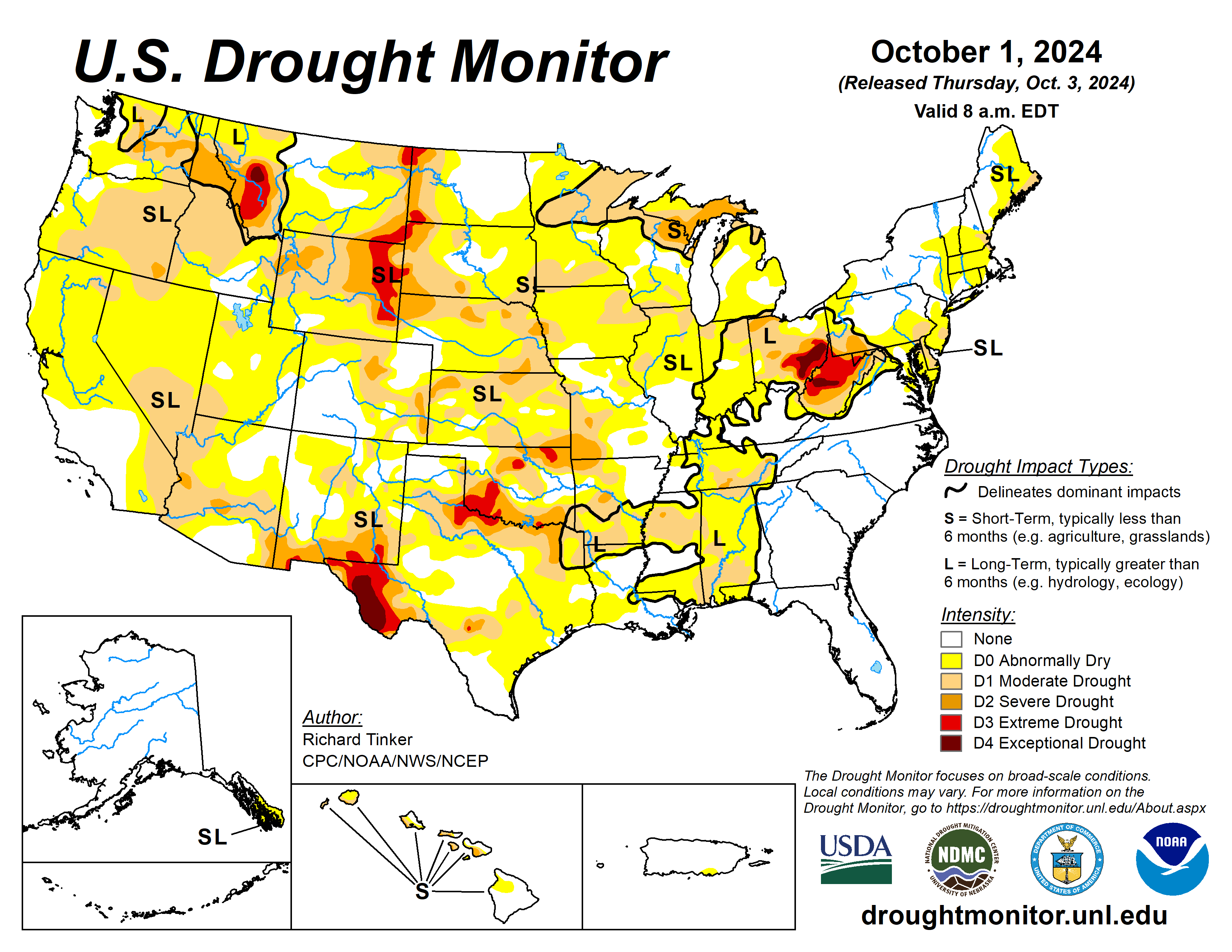
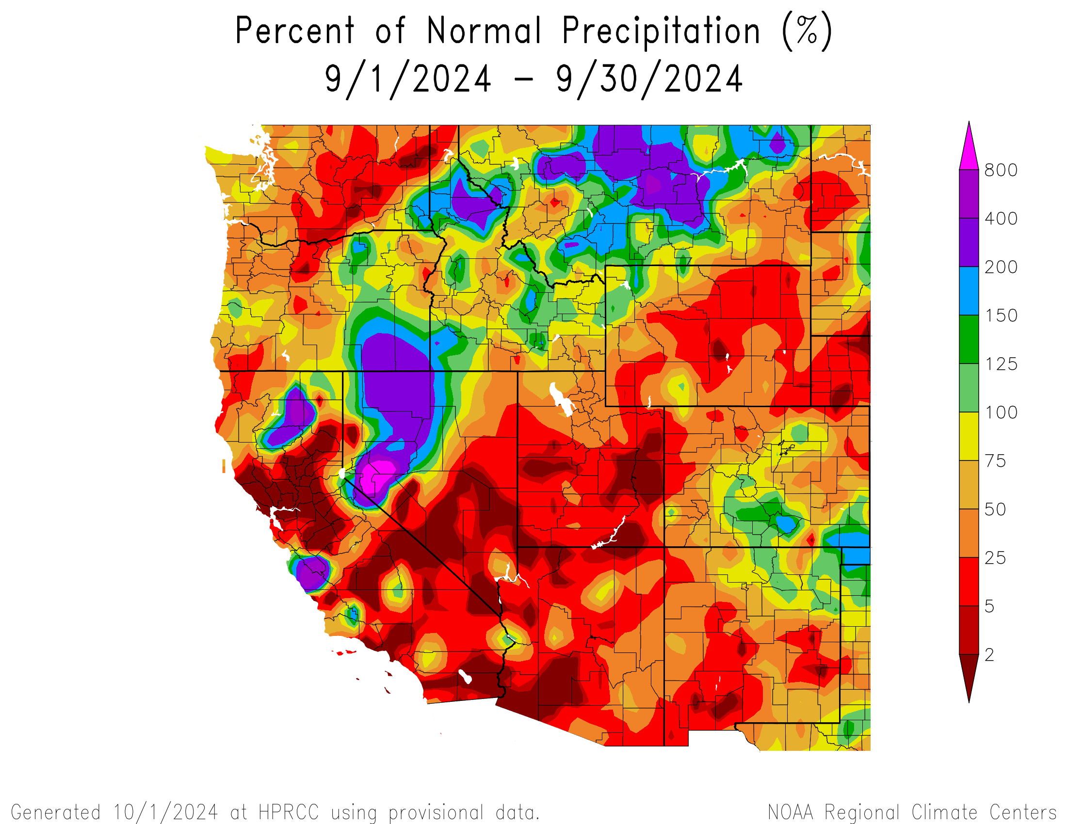
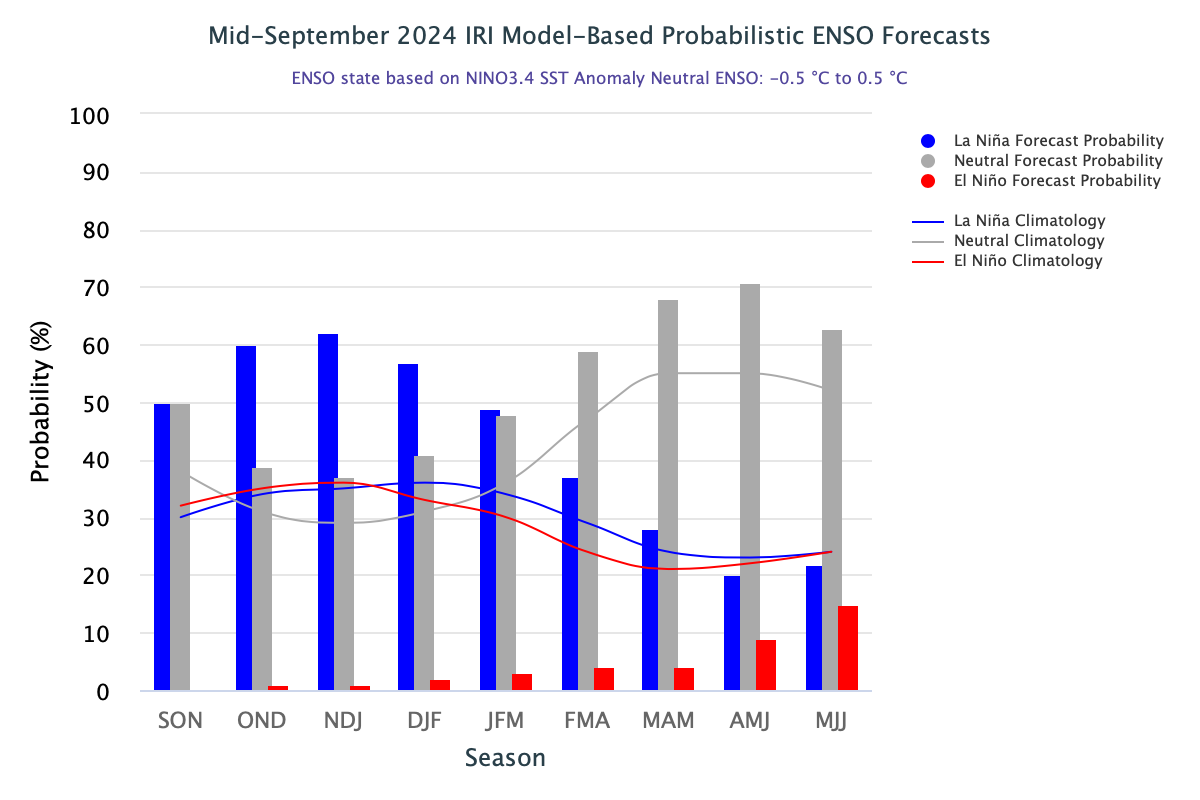
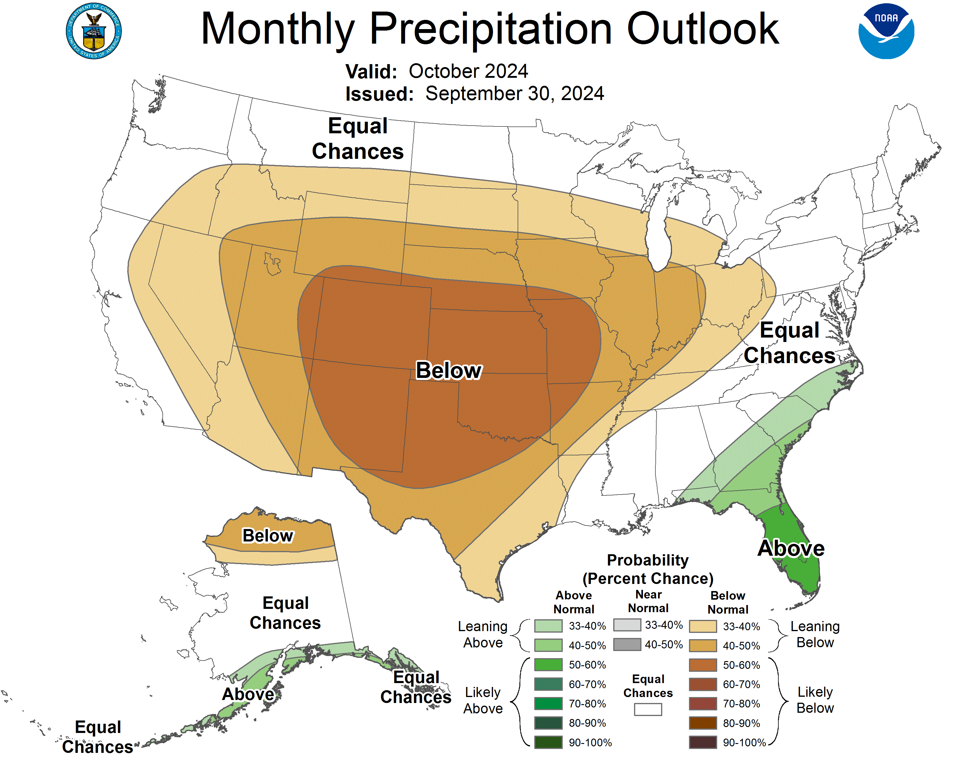
September precipitation was below to much below normal, particularly in Utah and Wyoming where record-dry conditions occurred. Temperatures were above to much above normal, breaking many record-warm temperatures in the region, particularly in Wyoming. Due to below normal precipitation and above normal temperatures in September, regional drought expanded by 7%, now covering 31% of the region. Neutral-ENSO conditions are transitioning into La Niรฑa conditions with a 62% probability forecast that La Niรฑa will develop by early winter. NOAA seasonal forecasts for October-December suggest an increased probability of below average precipitation and above average temperatures for the region. 

Regional precipitation during September was below to much below normal, with pockets of above normal precipitation in south-central and southeastern Colorado and northwestern Wyoming. Much below normal precipitation occurred throughout the majority of Utah and Wyoming, with exceptionally below normal (<2%) conditions in southern, western, and eastern Utah, and central Wyoming. Record-dry conditions were scattered throughout Utah and Wyoming with particularly large pockets in Tooele, Kane, and San Juan Counties in Utah. 
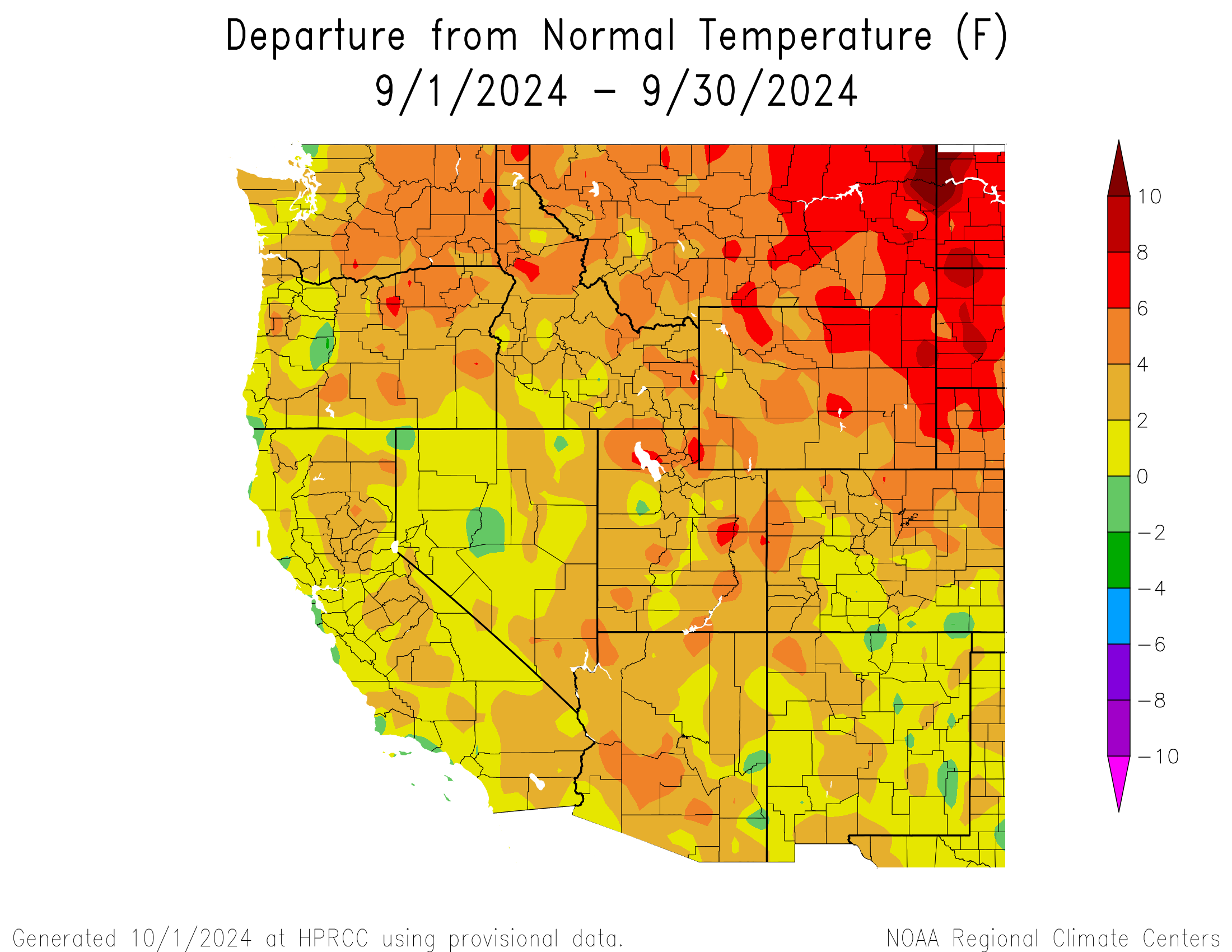
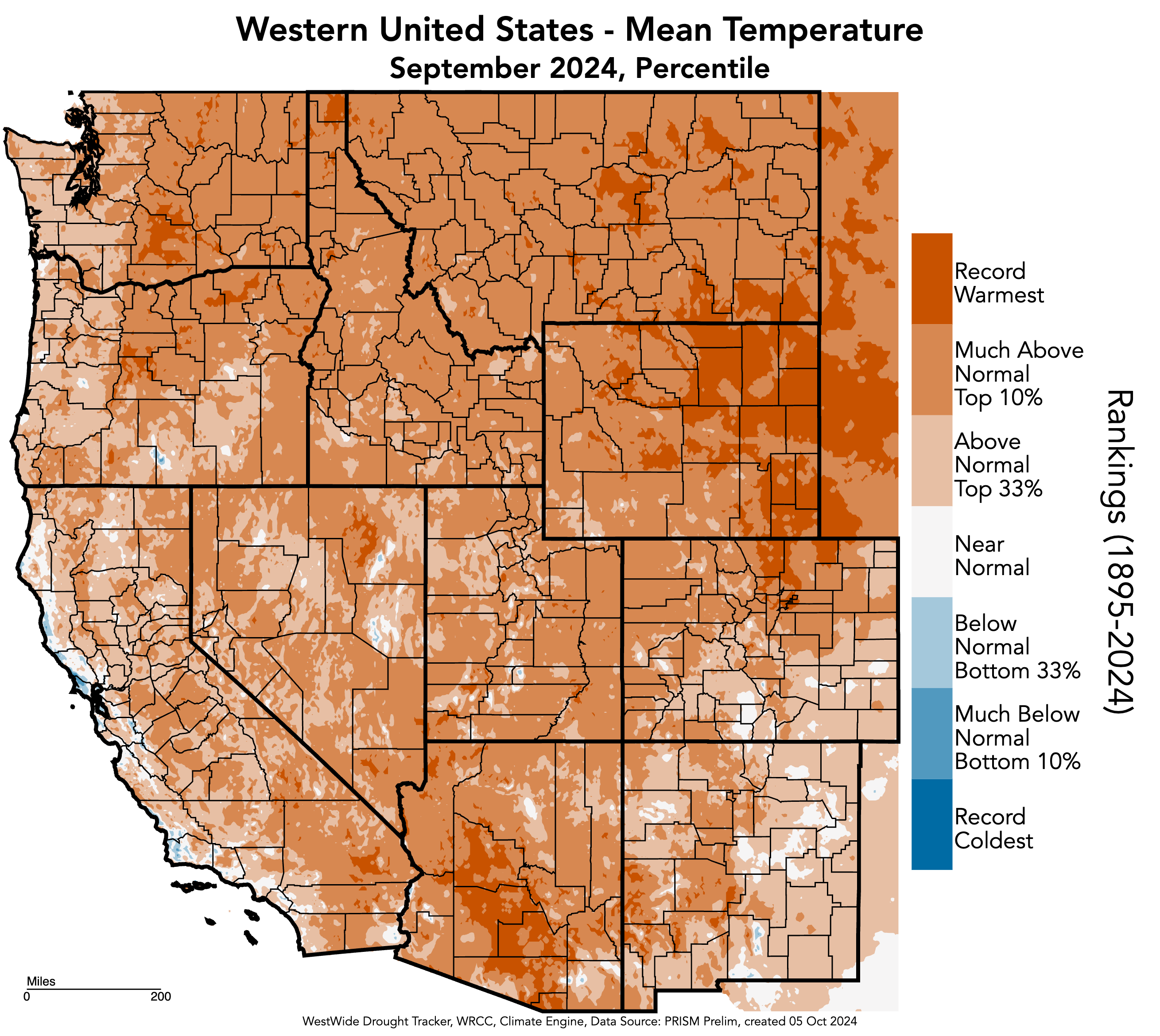
The region experienced at least 2-4ยฐF above normal temperatures throughout the majority of the region in September, with large areas of 4-6ยฐF above normal temperatures in each state. Pockets of 6-8ยฐF above normal conditions were observed in Utah and Wyoming, with a large swath of these conditions in northeastern Wyoming. The greatest departure from normal temperatures was observed in a pocket of 8-10ยฐF above normal conditions in Weston County, Wyoming. Record-warm temperatures occurred in a staggering amount of Wyoming, particularly in the eastern half of the state, as well as a large pocket from Denver up to Larimer and Weld Counties in Colorado.

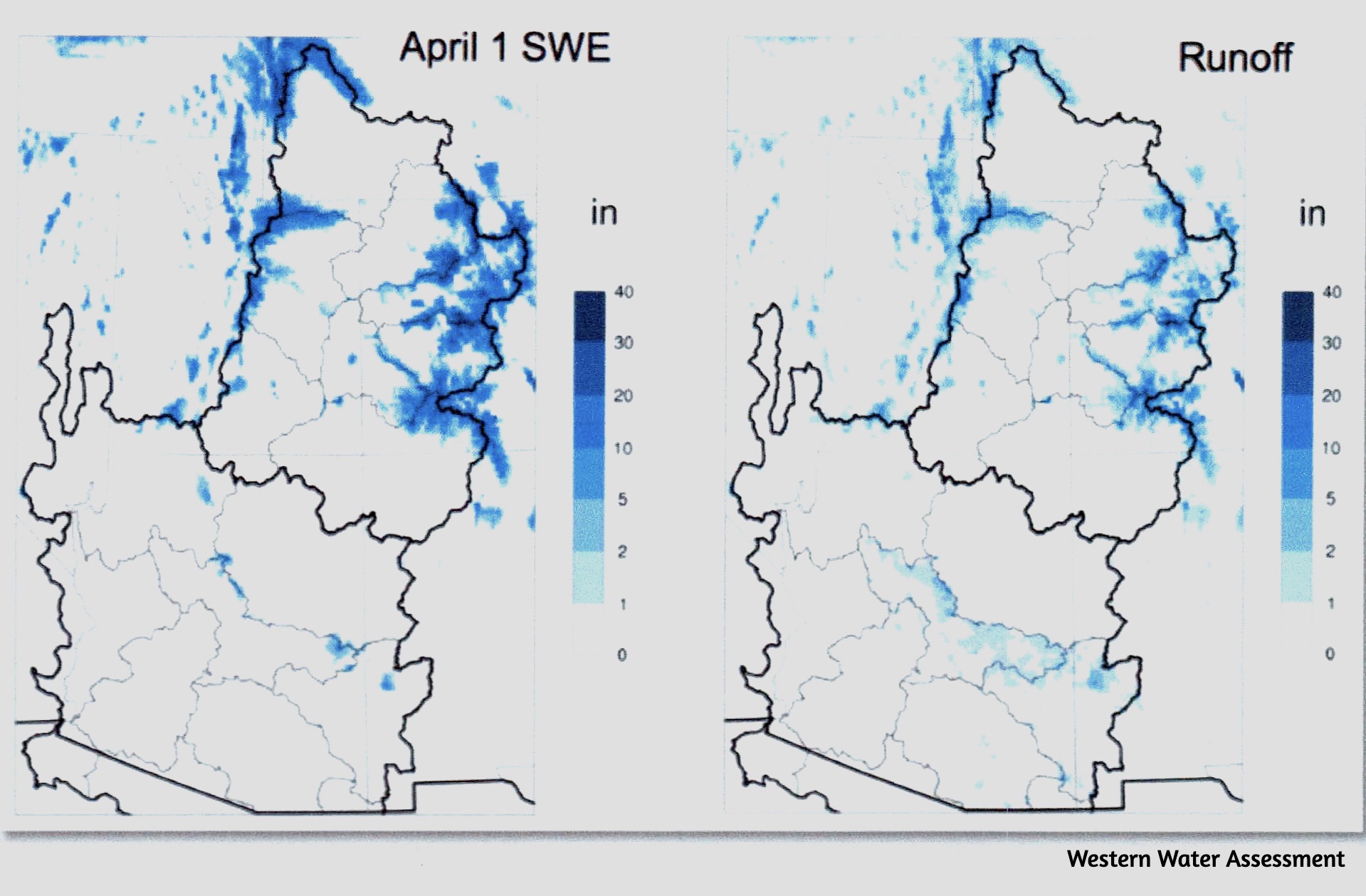
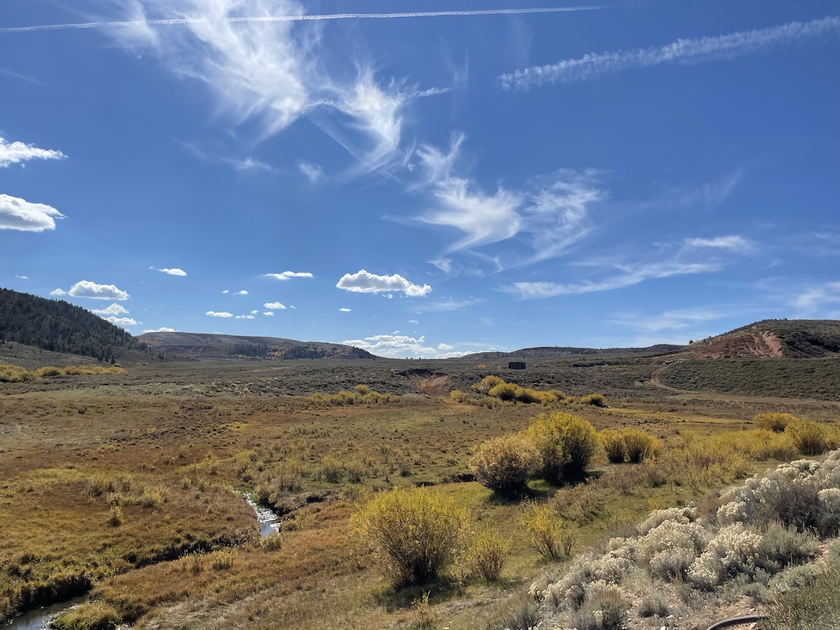
The first accumulating snow fell across many mountain locations above 11,000 feet in Colorado on September 4. As of October 1, the highest amount of SWE is at Berthoud Summit in Colorado at 0.3 inches of SWE. Almost all other mountains in the region remain at 0 inches of SWE.

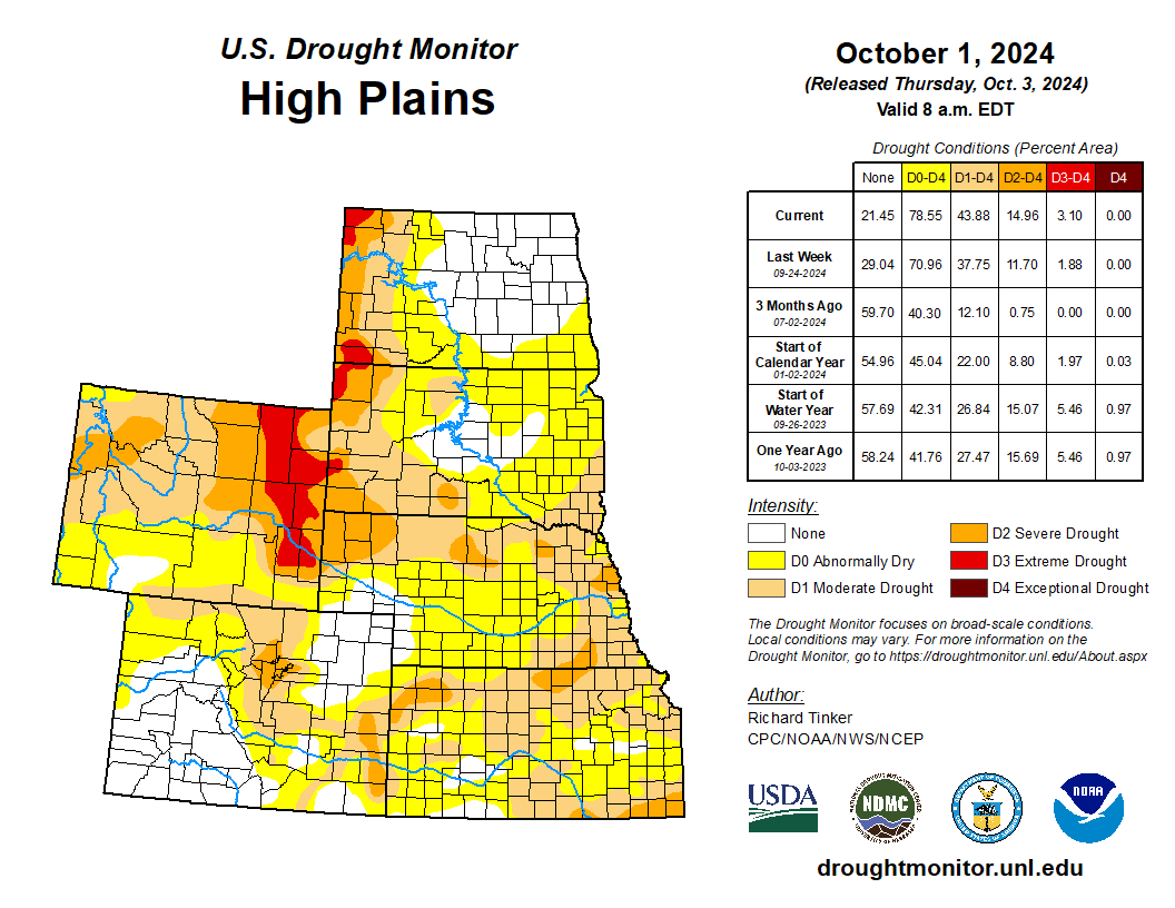
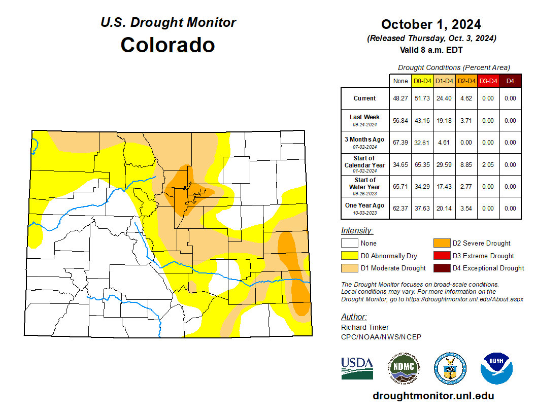
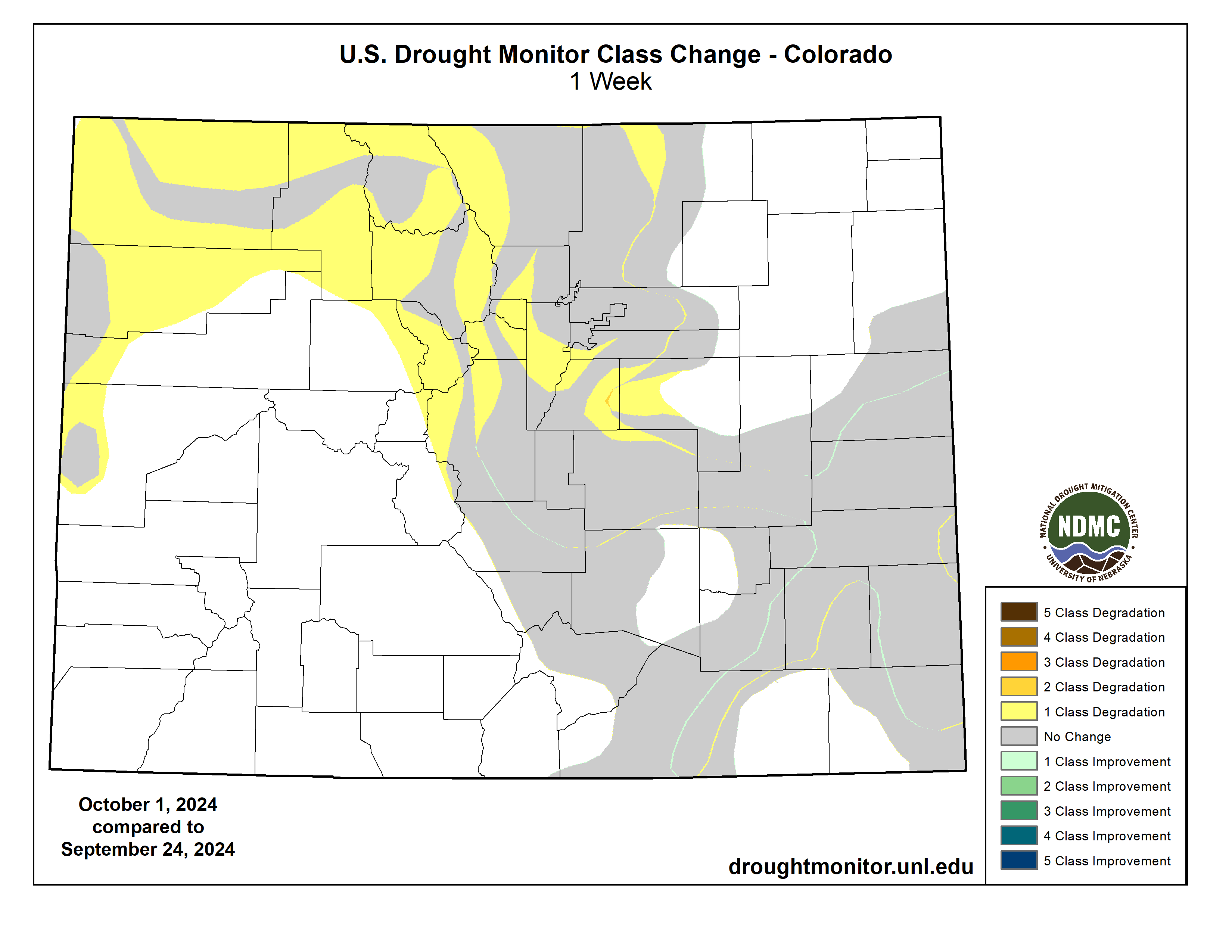
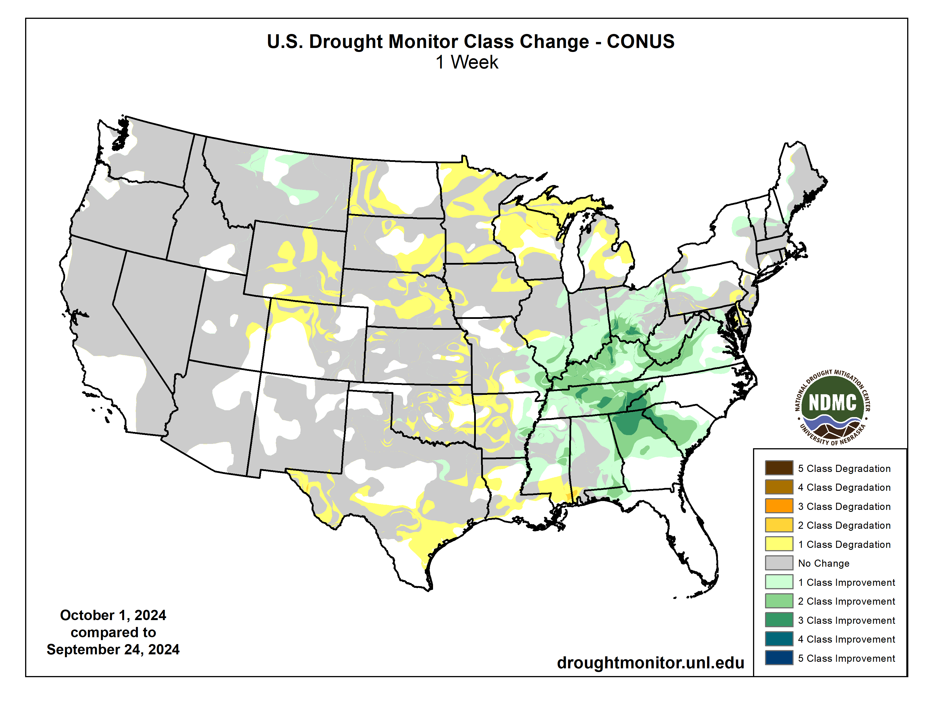
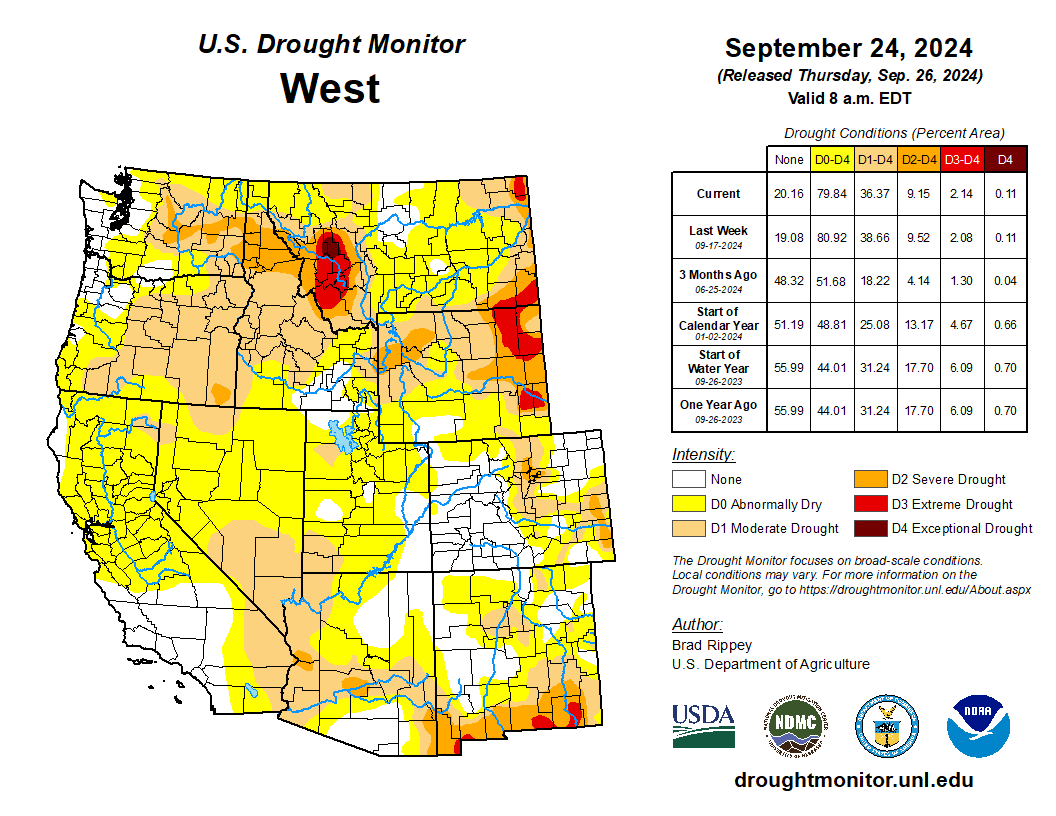
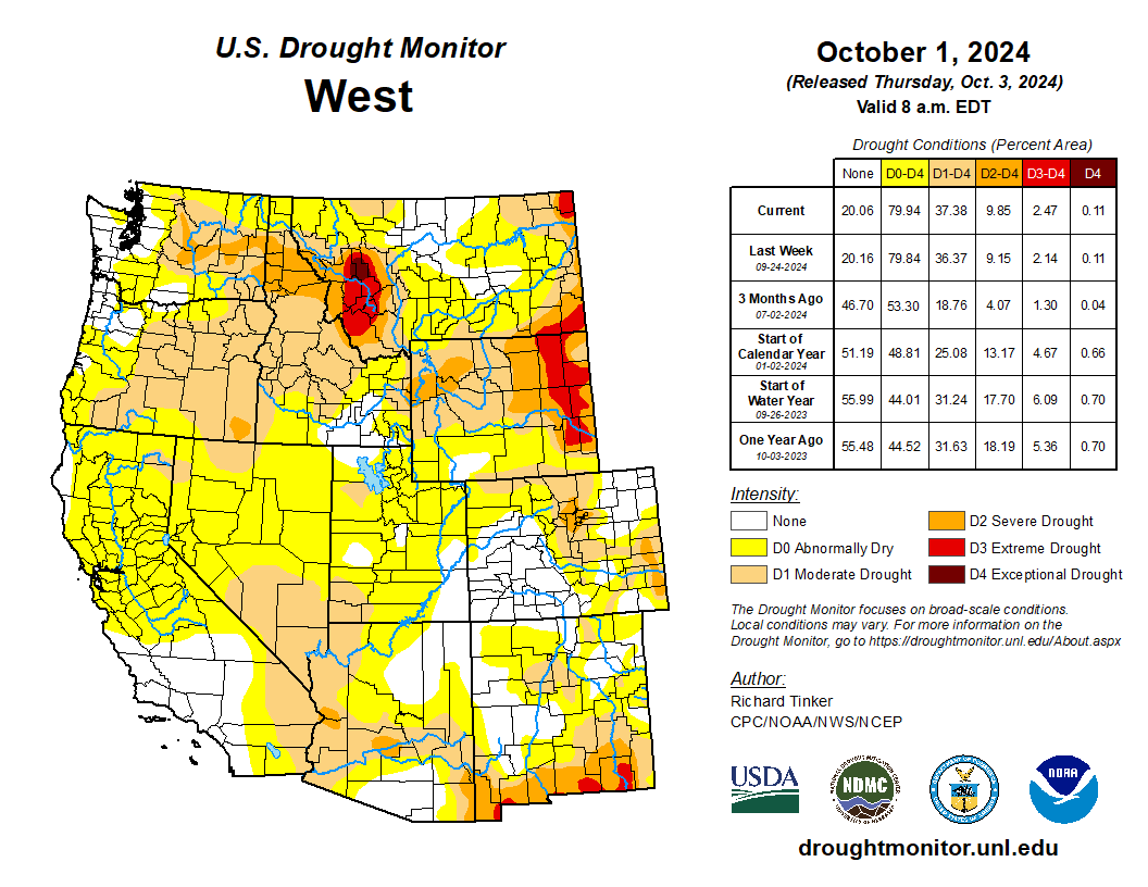
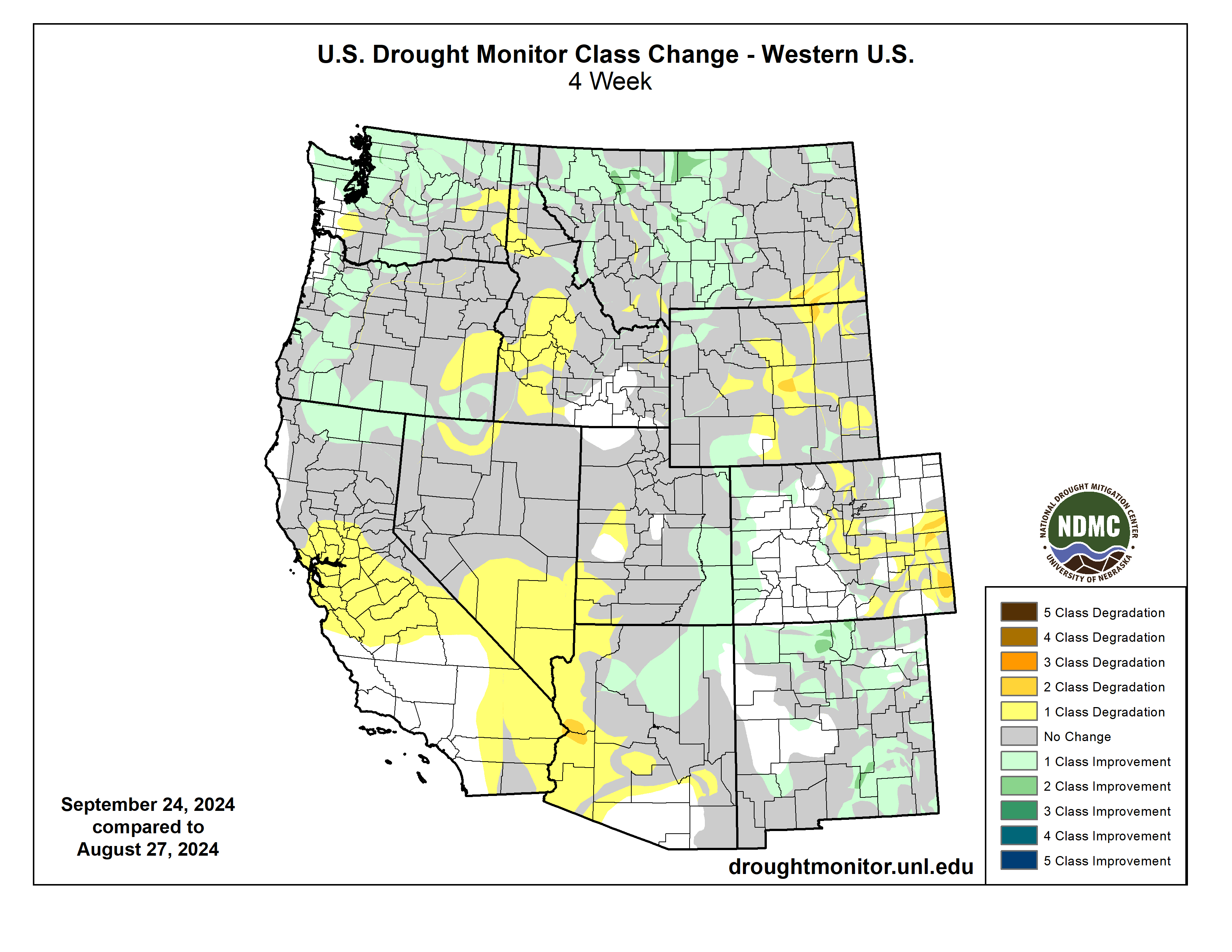
At the end of September, 31% of the region was covered by drought, a 7% expansion since the end of August. Wyoming experienced the most severe drought conditions, with D1 (moderate) drought expanding to 62% and D3 (extreme) drought conditions more than doubling in coverage up to 9% of the stateโ€™s area. D1 and D2 (severe) drought conditions both doubled in coverage in Colorado during September. Despite hot and dry conditions, drought coverage in Utah changed little during September.

West Drought Monitor map October 1, 2024.

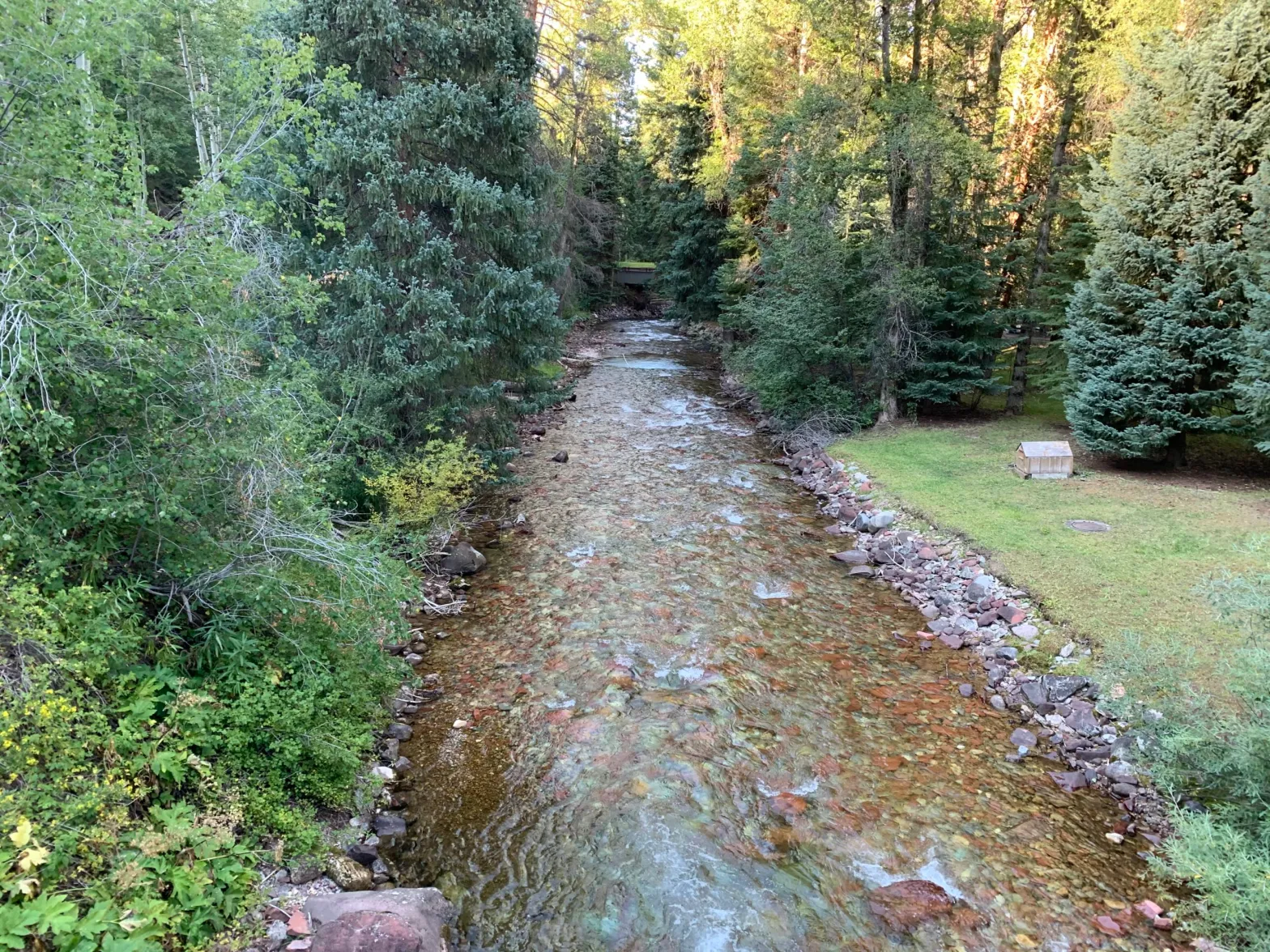
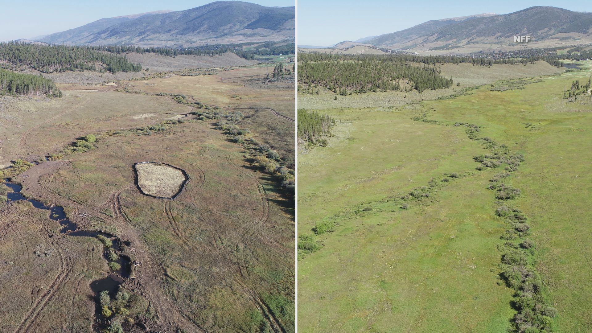
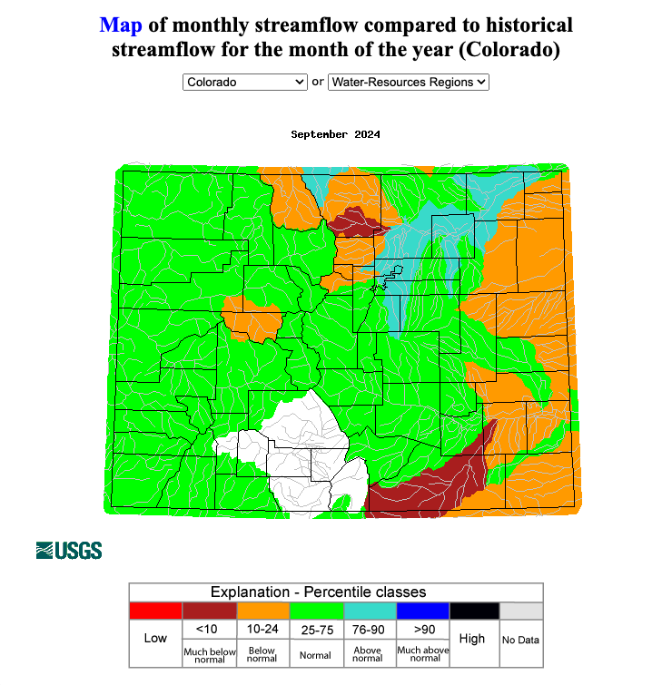
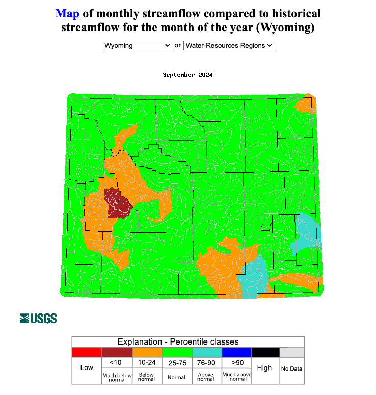
Streamflow in regional rivers was near to below normal during September. Much below normal streamflow occurred in the New Fork River basin in Wyoming, Big Thompson and Purgatoire River basins in Colorado, and the northern end of the Chinle River basin in Utah. Above normal streamflow occurred in the Wyoming portion of the North Platte River basin, the Upper Laramie River basin in Wyoming, the Colorado portion of the South Platte River basin, and the East Fork Sevier River basin in Utah. Lastly, much above normal streamflow occurred in the Spanish Fork River basin in Utah.

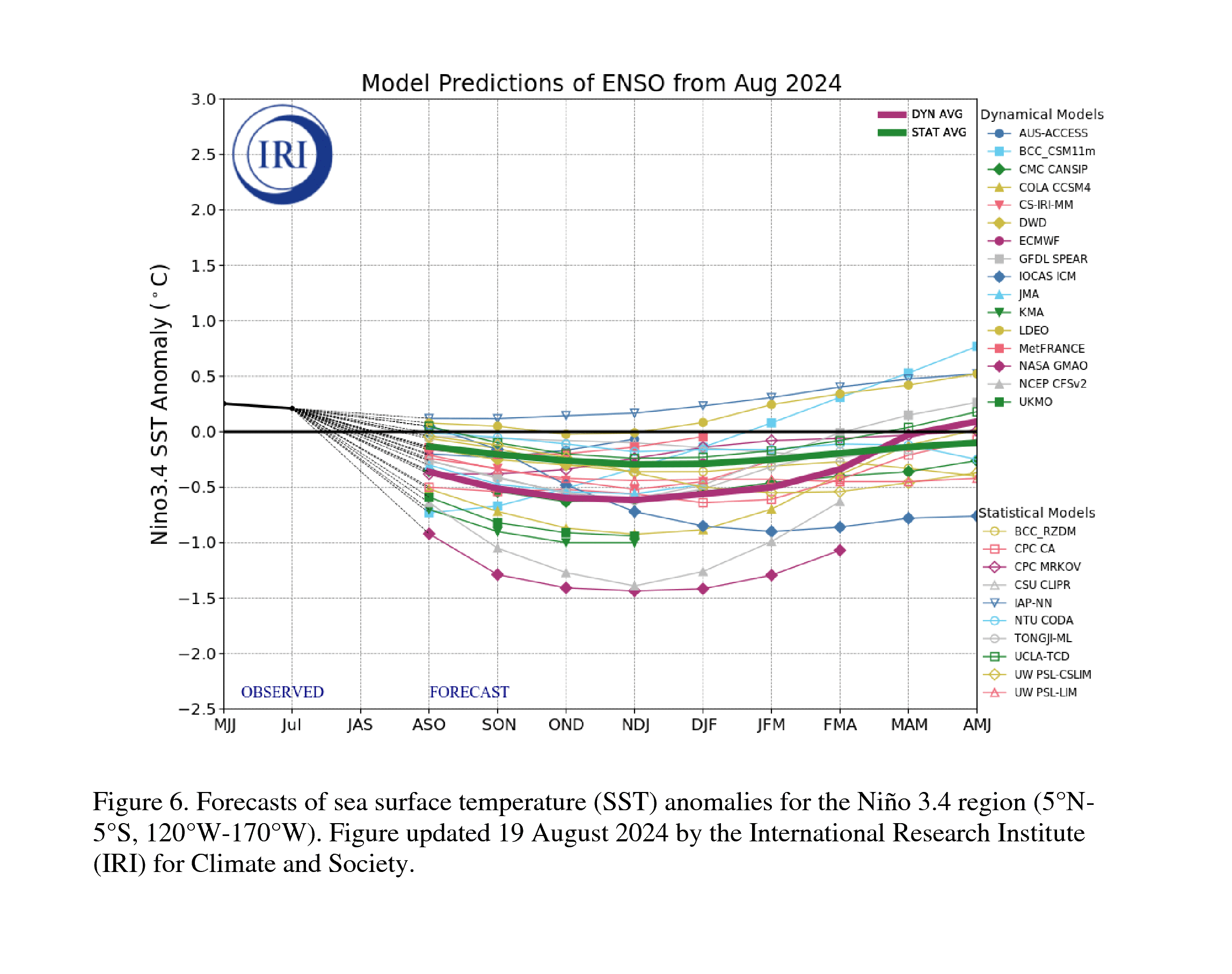
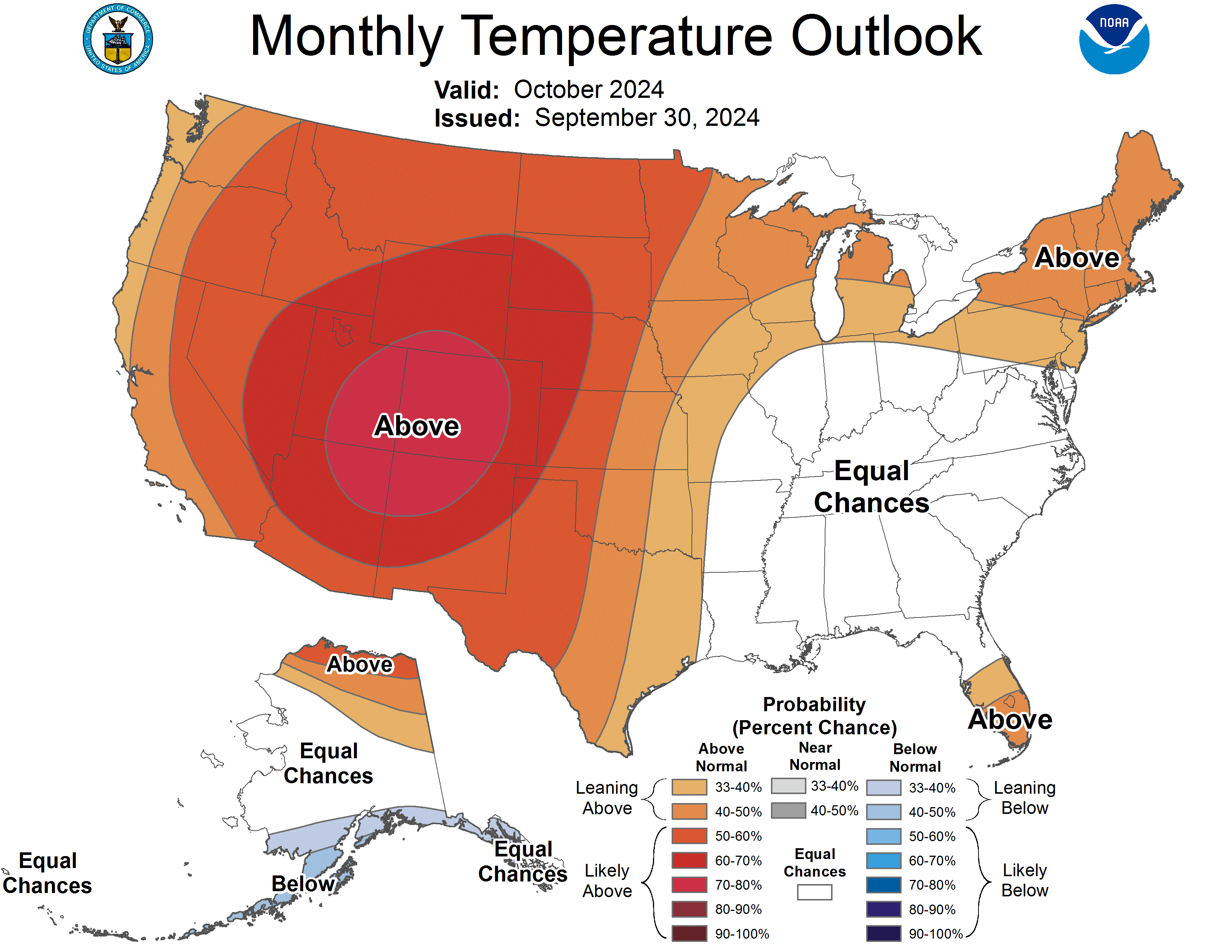
Near-to-below average sea surface temperatures were observed in the eastern Pacific Ocean, consistent with neutral-ENSO conditions. Current forecasts indicate a 62% probability of La Niรฑa developing by December and a 59% probability of neutral-ENSO conditions returning by March. The NOAA monthly precipitation outlook for October suggests an increased probability of below average precipitation for the entire region, with below (50-60%) average conditions for all of Colorado. The monthly temperature outlook suggests an increased probability of above (60-80%) average conditions for the entire region. The NOAA seasonal outlook for October-December suggests an increased probability of below average precipitation for southern Utah and most of Colorado, and above average temperatures for the entire region, particularly in Colorado and Utah, with likely above (60-70%) average conditions in the Four Corners region.

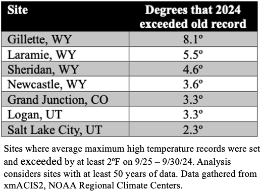
Significant climate event: Late September heat wave.ย After cooler conditions during mid-September, a significant heat wave settled over the Intermountain West from September 25-30. The six-day period was the hottest on record for many weather monitoring sites with at least 50 years of data. All-time average high temperature records for September 25-30 were set at 28% of long-term weather monitoring sites in Colorado (29 of 105), 38% of sites in Utah (36 of 94), and 43% of sites in Wyoming (34 of 80). The September 25-30 heat was also significant because of the magnitude of heat across the region. The maximum temperatures reached during the heat wave included 104ยบF in St. George, UT, 102ยบF in Sheridan, WY, and 97ยบF in Pueblo, CO, all of which were daily maximum temperature records. Several sites shattered the old all-time average maximum temperature record for September 25-30 including Gillette and Laramie, WY where the previous records were broken by 8.1ยบF and 5.5ยบF, respectively. During the heat wave, many sites set daily temperature records on multiple days. Across Colorado, Utah, and Wyoming, 17 sites set daily high temperature records on three days, 18 sites set daily temperature records on four days, and 4 sites set daily temperature records on four days. Two sites, Neola, UT, and Grand Junction, CO set daily high temperature records on all six days. Looking back to August predictions of temperature, the NOAA forecast for September correctly forecasted a 70-80% chance of above average temperatures during September. Across North America, a series of late September extreme weather events were interrelated, beginning with an anomalous atmospheric river event in northern British Columbia and southern Alaska which set up a ridging pattern that led to favorable conditions for the late September heat wave and then created conditions that interacted with Hurricane Helene in the southeastern United States.

Happy New Water Year, #NewMexico! — John Fleck (InkStain.net)

Bouncing along the bottom. Credit: John Fleck/InkStain

Click the link to read the article on the InkStain website (John Fleck):

October 4, 2024

Sept. 30 marks the end of the โ€œwater year,โ€ an accounting milestone that gives us an opportunity to take stock.

The change in total water storage year-over-year is one way to do this, to help understand if we took more water out of the reservoirs than the climate put in. The graph above is actually based on Sept. 20 year-over-year (the Reclamation data updates lag a bit), but itโ€™s enough to give us a feel for two things.

First, weโ€™ve seen no real reversal of the long term pattern โ€“ a huge reduction in storage in the early 21st century, and then basically dragged the bottom of the reservoirs ever since.

Second, on a shorter one- or two-year time scale, total storage is down ~350,000 acre feet at the end of water year 2024 compared to the end of 2023. Over a two-year time scale, we basically burned through the bonus water from a wet 2023 and are back where we were at the end of 2022.

Rio Grande flow this year at Otowi in north-central New Mexico has been 63 percent of the period of record mean, going back to the late 1800s.

New Mexico Lakes, Rivers and Water Resources via Geology.com.

#Coloradoโ€™s water users are told โ€˜use it or lose it.โ€™ But is the threat real? — Heather Sackett (@AspenJournalism)

The Rockford Ditch has the oldest water rights on the Crystal River. It irrigates some agricultural land as well as the lawns and gardens of the Colorado Rocky Mountain School and the Satank neighborhood of Carbondale. CREDIT: HEATHER SACKETT/ASPEN JOURNALISM

Click the link to read the article on the Aspen Journalism website (Heather Sackett):

October 2, 2024

The old water law adage doesnโ€™t capture just how difficult it is to lose a water right. And state policy limits the pool of possibly abandoned water even further.

In December 2020, the Summit County Open Space and Trails Department bought a 15-acre property with a small pond, three ditches and a well. 

Known as the Shane Gulch property, it was the only remaining private property north of Heeney Road between Green Mountain Reservoir and the Williams Fork Range. The land, just east of Colorado 9 and the Blue River, has stunning views of the snow-capped peaks that form the Continental Divide. Summit County purchased the property, which consists of three parcels of rolling hills and meadows, to preserve the unique scenic, wildlife and agricultural heritage values of the area.

The water on the property had historically been used for irrigation. But according to the state Division of Water Resources, the former owners of the property had not used the water rights on one of those ditches, the Culbreath Ditch, in the previous 10 years. The water rights were placed on the initial 2020 abandonment list, leaving them at risk of being lost. 

Abandonment is the official term for one of Coloradoโ€™s best-known water adages: Use it or lose it. As the saying goes, a user must do something of value with their water (use it) or the state could take it away (lose it). Once abandoned, the right to use the water is canceled and goes back to the stream where someone else can claim it and put it to use. 

Every 10 years, officials from the Colorado Division of Water Resources review every water right โ€” through diversion records submitted by water users and site visits โ€” to see whether it has been used at some point in the previous decade. If it has been dormant, itโ€™s added to the preliminary abandonment list. But thereโ€™s a safety net. Not using the water is just one part of abandonment; a water user must also intend to abandon it.

The goal of abandonment is to preserve the water law system that the West relies upon. That legal framework, known as prior appropriation, is the bedrock of Colorado water law in which the oldest rights get first use of the river. If an upstream user with a senior water right resumes using it again after decades of letting it sit dormant, thatโ€™s not fair to downstream junior water users because it leaves less water for them. The abandonment process prevents people from locking up a resource they arenโ€™t using.

The view from the Shane Gulch property, owned by Summit County, where the Blue River begins forming Green Mountain Reservoir. The county bought the property and water rights from the Culbreath Ditch in 2020. Credit: Courtesy of Summit County Open Space and Trails

Abandonment-process protections

Although the concept of abandonment may loom large in the minds of water users, only a tiny percentage of water rights ends up on the abandonment list every 10 years, and itโ€™s rare for the state to formally abandon a water right. 

In the last round of cancellations, in 2021, 3,439 water rights ended up on the final abandonment list out of 171,578 total water rights in the state, or 2%. On the Western Slope, 658 water rights out of about 75,000, or less than 1%, ended up on the final revised abandonment list.

Water users have two opportunities to fight an abandonment listing, and state policies have given an extra layer of protection from abandonment to the oldest water rights for the past 20 years. In most, if not all, cases, the water rights that were abandoned truly were not used in the previous decade. 

In an example near Glenwood Springs, a ditch had been filled in and turned into a trail, and the land it had once irrigated was now home to a hotel and recreation center. And those who arenโ€™t using their water because they are participating in state-approved conservation programs, such as the System Conservation Program currently happening in the Colorado Riverโ€™s Upper Basin (Colorado, New Mexico, Utah, and Wyoming), are protected from abandonment.

โ€œItโ€™s a lot harder than people think to actually abandon water rights,โ€ said Jason Ullmann, the top water engineer at the Colorado Division of Water Resources. โ€œI think people feel like thereโ€™s this constant potential for their water right to be abandoned, but because itโ€™s a personal property right to use the publicโ€™s resource, you donโ€™t want it to be easy to come in and abandon that right.โ€

Why donโ€™t we just fix the #ColoradoRiver crisis by piping in water from the East? — Alex Hager (KUNC) #COriver #aridification

A complex system of pipes, tunnels and canals carries water around the Western U.S., like this one in Colorado’s Fraser Valley. However, policy experts say a cross-country pipeline wouldn’t make sense for political, financial and engineering reasons. Ted Wood/The Water Desk

Click the link to read the article on the KUNC website (Alex Hager):

September 30, 2024

This story is part of a series on water myths and misconceptions in the West, produced by KUNC, The Colorado Sun, Aspen Journalism, Fresh Water News and The Water Desk at the University of Colorado Boulder. KUNCโ€™s coverage of the Colorado River is supported by the Walton Family Foundation.

The Colorado River is a lifeline for about 40 million people across the Southwest. It supplies major cities like Los Angeles, Phoenix, and Denver and a multibillion-dollar agriculture industry that puts food on tables across the nation. But it doesnโ€™t have enough water to meet current demands.

Policymakers are struggling to rein in demand on the river, which has been shrinking at the hands of climate change. The region needs to fix that gap between supply and demand, and thereโ€™s no obvious way to do it quickly.

But one tantalizingly simple solution keeps coming up. The West doesnโ€™t have enough water, but the East has it in abundance. So, why donโ€™t we just fix the Colorado River crisis by piping in water from the East?

This proposed pipeline divert water from the Atchafalaya River in Louisiana through Louisiana, Texas, New Mexico, Arizona and up to the Glen Canyon Dam. Credit: Don Siefkes

The answer is complicated, but experts say it boils down to this: It doesnโ€™t make sense to build a giant East-to-West water pipeline anytime soon for three reasons โ€” politics, engineering, and money.

Political headwinds

If the Westโ€™s leaders wanted to take some water from the East, who would they even ask? Right now, thereโ€™s no national water agency that could oversee that kind of deal.

โ€œI would argue that there aren’t many entities with the authority across the country to do this,โ€ said Beaux Jones, president and CEO of The Water Institute in New Orleans. โ€œI don’t know that the regulatory framework currently exists.โ€

Water is often managed using a messy patchwork of different government agencies and laws. The Colorado River is managed through a fragile web of agreements between cities, states, farm districts, native tribes and the federal government. Even though theyโ€™re all pulling from the same water supply, thereโ€™s no central Colorado River government agency.

A similarly complex system applies to many watersheds in the East. Even if a single city or state in the Western U.S. seriously wanted to build a pipeline from the East, itโ€™s not even clear who theyโ€™d meet with to ask for water from a different area. And thereโ€™s no single federal agency that could sign off on such a deal and make sure it doesnโ€™t harm people or the environment.

Colorado Water Conservation Board Executive Director and commissioner to the Upper Colorado River Commission Becky Mitchell, center, speaks on a panel with representatives of each of the seven basin states at the annual Colorado River Water Users Association conference in Las Vegas Thursday, December 15, 2022. The UCRC released additional details of a water conservation program this week. CREDIT: HEATHER SACKETT/ASPEN JOURNALISM

Any serious effort to pull new water in from the East to the Southwest would likely touch some part of the Mississippi River basin. Itโ€™s a sprawling network of smaller rivers that covers 31 different states, from Montana to Pennsylvania.

Itโ€™s a busy river with a lot of uses. And while its shortages arenโ€™t as severe as dry times in the West, the Mississippi River basin goes through its own droughts. So even if, someday, the governments of the East and West set up a formal way to negotiate a water transfer, the cities, farms, boaters and wildlife advocates to the east might not be willing to share.

โ€œThe very nature of there being sufficient availability of water in the Mississippi River Basin to, in a large scale way, export that water,โ€ Jones said. โ€œI think there are many people on the ground within the Mississippi River basin that would fundamentally disagree with that.โ€

Engineering limits

There are countless examples of large pipelines and canals moving liquids around the U.S. at this very moment. The longest existing today is the Colonial Pipeline, which carries gasoline from Houston to northern New Jersey through 5,500 miles of pipe.

So if we have the engineering capacity to do that, could we build similar infrastructure for water? In theory, yes. But it would have to be much larger than existing pipes for oil and gas.

โ€œIt takes so much more water to supply a city than it takes gasoline,โ€ said John Fleck, a water policy professor at the University of New Mexico. โ€œSo the size of the pipe or the canal has to be a lot bigger, has to be much wider, has to cover a lot more ground.โ€

Because that pipeline or canal would be so big, it is more likely to ruffle some feathers along the way. Fleck suggested that landowners in its path, including local governments, could push back on a giant new piece of infrastructure running through their properties and mire any pipeline project in regulatory red tape.

Phoenix, Los Angeles, Denver and Salt Lake City wouldn’t look like they do today without giant water-moving systems, like this pipe that is part of the Central Arizona Project. Experts say all of the feasible water pipelines have already been built, and a system to carry water in from the East is too difficult to be worth building. Photo credit: Central Arizona Project

All that said, a pipeline is still physically possible. There is perhaps no better argument for an East-West water transfer than the fact that the Western U.S. is already crisscrossed by multiple huge pipes and canals that carry water across long distances.

The West as we know it today wouldnโ€™t exist without that kind of infrastructure. Much of Coloradoโ€™s population only has water due to a series of underground tunnels that bring water across the Rocky Mountains. Phoenix and Tucson have been able to welcome new residents in the middle of the desert with the help of a 336-mile canal that carries water from the Colorado River. Los Angeles, Albuquerque and Salt Lake City would not be the cities they are today without similarly ambitious water delivery systems built decades ago.

The existence of those water-moving projects isnโ€™t proof that we should build a new, even bigger water pipeline from the East, Fleck said. In fact, he pointed to those systems as proof that we shouldnโ€™t.

โ€œAll the feasible ones have largely been done, and the ones that are left are the ones that weren’t done because they just turned out not to be feasible,โ€ he said.

Money problems

Even in a world where the Westโ€™s leaders could find a willing water seller, get the right permits and put shovels in dirt, experts say an East-to-West water pipeline would simply be too expensive.

Any solution to the Colorado River crisis will require massive amounts of public spending. The federal government alone has thrown billions of dollars at the problem in just the past few years. But water economists and other policy experts say a cross-country pipeline isnโ€™t the most efficient use of taxpayer dollars.

Stacks of hay bales sit beside an irrigation canal in California’s Imperial Valley on June 20, 2023. Experts say there are more cost-effective ways to fix the Colorado River crisis than building a cross-country canal, like paying farmers to pause growing thirsty crops such as alfalfa. Alex Hager/KUNC

Kathleen Ferris, former director of the Arizona Department of Water resources, pointed to two ongoing efforts that might be a more cost-effective way to help correct the regionโ€™s supply-demand imbalance. One involves paying farmers to pause growing on their fields, freeing up water to bolster the regionโ€™s beleaguered reservoirs. Another uses expensive, high-tech filtration systems to turn wastewater directly back into drinking water.

โ€œSometimes I feel like people don’t want to do the heavy lifting,โ€ said Ferris, who is now a water policy researcher at Arizona State University. โ€œInstead, they want to just find the next water supply and be done with it and have somebody else pay for it.โ€

Ultimately, she said, those kinds of programs already have momentum and cost less money than an East-to-West water pipeline.

โ€œWhy don’t we do the things that we know are possible and that are within our jurisdiction first,โ€ Ferris said, โ€œBefore we go looking for some kind of a grand proposal that we don’t have any reason to believe at the moment could succeed.โ€

Pipe dreams becoming reality

Piping in water from outside of the Colorado River basin, for all of its challenges, is a tempting enough idea that the federal government has given it a serious look.

In 2012, a Bureau of Reclamation report analyzed ways to bring new water into the Colorado River Basin, including importing piped water from adjacent states.

The study concluded that strategy was not worth the money and effort.

โ€œIt just isn’t the time yet,โ€ said Terry Fulp, a retired Reclamation official who helped write the study. โ€œWe felt that there were other things we could be doing in the basin, particularly in the Lower Basin, that would relieve the pressure.โ€

This map from the Bureau of Reclamation’s 2012 “Colorado River Basin Water Supply and Demand Study” shows places where water could theoretically be imported. One of the report’s authors said now “isn’t the time” to pipe water in from the East. Credit: U.S. Bureau of Reclamation

Fulp said the study was a worthwhile endeavor, and that the idea of importing water from the East might make sense down the road. The scale of the challenge posed by the Colorado River crisis, he said, will take some big thinking, โ€œon the order of the thinking when we built the Hoover Dam.โ€

โ€œIt’s one of those possible solutions that should always stay, if not forefront on the table, somewhere on the table, so that you don’t lose sight of it,โ€ Fulp said.

Despite the fact that many Colorado River experts have cast doubt on the feasibility of a cross-country water pipeline, even some sitting state officials say it deserves more research. Chuck Podolak, director of the Water Infrastructure Finance Authority of Arizona said the idea deserves โ€œserious attention.โ€

โ€œWe understand that every option is hard, every option is expensive, every option has political hurdles, every option is a daunting engineering task,โ€ he said. โ€œRight now, weโ€™re in a let’s-look-at-everything mode with eyes wide open.โ€

Arizona and other states around the region, with their eyes on continued growth, are already looking at ways to stretch out the water they already have using technology. Terry Fulp said those efforts may need to expend past the spendy and ambitious engineering projects that are already helping facilitate that growth.

โ€œIt’ll be the time someday, if we want the Southwest to continue to grow the way it’s been growing,โ€ he said. โ€œThere’s only so much water in the basin.โ€

Map credit: AGU

Al Gore thought stopping #ClimateChange would be hard. But not this hard — Grist #ActOnClimate

Al Gore at a Climate Reality Leadership Corps training.

Click the link to read the article on the Grist website (Kate Yoder):

October 7, 2024

Gore has been talking about carbon emissions for more than 40 years. Now he includes a “hope budget.”

At a congressional hearing on the greenhouse effect in 1981, Al Gore, then a member of the House of Representatives from Tennessee, remarked that it was hard to come to terms with the fact that rising carbon dioxide emissions could radically alter our world. โ€œQuite frankly, my first reaction to it several years ago was one of disbelief,โ€ he said. โ€œSince then, I have been waiting patiently for it to go away, but it has not gone away.โ€

Goreโ€™s hearings didnโ€™t spark the epiphany heโ€™d hoped among his fellow members of Congress. More than four decades later, the problem still hasnโ€™t resonated with many of them, even as the devastating weather changes scientists warned about have become reality. Wildfires have turned towns to ash, and the rains unleashed by storms like Hurricane Helene have left even so-called climate havens like Asheville, North Carolina, in a post-apocalyptic state, with power lines tossed around like spaghetti

โ€œIโ€™ll have to admit to you that Iโ€™ve been surprised at how difficult itโ€™s been to implement the kinds of policies that will solve the climate crisis,โ€ Gore said in an interview with Grist.

So he isnโ€™t exactly surprised that the issue is on the back burner this election season. When asked about their plans to fight climate change in the presidential debate last month, Vice President Kamala Harris assured voters she wasnโ€™t against fracking for natural gas, while former President Donald Trump went on a tangent about domestic vehicle manufacturing. The subject took on a more prominent role in the vice presidential debate last Tuesday, when the Republican, Senator J.D. Vance of Ohio, hedged by calling global warming โ€œweird scienceโ€ while not actually dismissing it, and the Democrat, Governor Tim Walz of Minnesota, envisioned America โ€œbecoming an energy superpower for the future.โ€ And that was about it.

โ€œSince the struggle for votes is almost always focused on undecided voters, most of them in the center of the political spectrum, itโ€™s not at all unusual to see immediate, visceral issues like jobs and the economy take the foreground,โ€ Gore said.

As told in the documentary An Inconvenient Truth, Goreโ€™s interest in climate change was first sparked at Harvard University, where Gore took a population studies class taught by the Roger Revelle, a climate scientist who had played a pivotal role in setting up experiments to measure rising levels of carbon dioxide in the atmosphere. It was the 1960s, a decade in which the American public first started learning about the dangers of burning fossil fuels. Gore was stunned by the evidence Revelle presented, but โ€œnever imagined for a second that it would take over my life.โ€

Heโ€™s spent the decades since advocating for climate action. As vice president under President Bill Clinton in the 1990s, he unsuccessfully pushed to pass the Kyoto Protocol, the first international attempt to push countries to limit their greenhouse gas emissions. Six years after he lost the presidential election to George W. Bush in 2000,ย An Inconvenient Truth, the documentary that turned his traveling climate change slideshow into a hit, launched the issue into the national conversation. Today, he leads the educational nonprofit The Climate Reality Project, whichย trains people how to mobilizeย their neighbors to elect climate champions, counter greenwashing, and advance green solutions.ย 

Coyote Gulch graduation March 4, 2017. @ClimateReality #ActOnClimate

As a prominent Democrat, Goreโ€™s impassioned advocacy has beenย blamed for making climate change seem like a liberal thing to care about. To Gore, thatโ€™s an example of attacking the messenger without looking at the deeper reasons why climate change is politically contentious in the first place. โ€œEven when Pope Francis, for goodnessโ€™ sake, speaks out on it, they attack him and say that heโ€™s meddling in partisanship.โ€ If thereโ€™s anyone to blame for polarization, he said, itโ€™s the fossil fuel industry, which hasย tried to take control of the conversation about climate change.ย 

โ€œThis is the most powerful and wealthiest business lobby in the history of the world, and they spare no effort and no expense to try to block any progress,โ€ Gore said. โ€œWhoever sticks his or her head up above the parapet draws fire from fossil fuel polluters, and they use their legacy networks of economic and political power to try to block any solutions of any sort that might reduce the consumption of fossil fuels.โ€

In his decades of talking to the public about climate change, he says heโ€™s learned a few things. You have to keep in mind a โ€œtime budgetโ€ that people will give you to speak with them, as well as a โ€œcomplexity budgetโ€ so that you avoid dumping facts and numbers onto people. Finally, he says, you need to allot a โ€œhope budgetโ€ so they donโ€™t get too overwhelmed and depressed.

Electricity generation in 2022 (dark blue) from key fuel sources and countries, terawatt-hours (TWh). Red bars indicate estimated electricity generation from the renewables built in 2019-2023 and set to be built in 2024-2028, according to the IEAโ€™s โ€œmain caseโ€ forecast. Source: Carbon Brief analysis by Simon Evans of figures from the IEA Renewables 2023 and Renewables 2022 reports, the IEA world energy outlook 2023 and the Ember data explorer.

Even while progress has been slower than heโ€™d hoped, Gore sees signs that things are moving in the right direction. Last year, 86 percent of new electricity generation installed worldwide came from renewables, for example. Not to mention that Congress, where climate legislation had long gone to die, finally managed to pass a landmark climate law in 2022, the Inflation Reduction Act, which aims to drastically trim U.S. emissions through green incentives and rebates. 

โ€œItโ€™s the kind of challenge that is so compelling โ€” once you pick it up, you canโ€™t put it back down again โ€” because it really requires any person of conscience, I think, to keep working on it until we get the kind of progress thatโ€™s needed.โ€

Urban Agriculture Takes Root: USDA and Partners Connect in #Colorado — NRCS

Photo credit: NRCS

Click the link to read the article on the Natural Resources Conservation Service website:

October 2, 2024

Over 40 attendees gathered for the first Urban Agriculture Connector’s Meeting at the CSU Spur campus in the heart of Denver on September 26th. This groundbreaking event brought together a diverse group of stakeholders, including representatives from federal, state, and local governments, non-profit organizations, and urban agriculture producers. The meeting served as a nexus for networking and learning about the myriad resources available for urban agriculture.

The meeting marks a milestone in the USDA’s continuing commitment to urban agriculture. In 2018, the USDA established the Office of Urban Agriculture and Innovative Production, showcasing its dedication to including urban, small-scale, and innovative producers in its support of agriculture in all its forms. This office plays a crucial role in coordinating across USDA agencies to ensure that the needs of urban producers are met and adapted to as the landscape of agriculture evolves.

Cindy Einspahr, NRCS Outreach & Beginning Farmer/Rancher Coordinator, emphasized the importance of the event, stating, “The Urban Conservation Connectors meeting will be an excellent opportunity to connect with the urban agriculture community and establish new relationships. This is only the beginning of numerous meetings to follow.”

The event kicked off with a warm welcome from Petra Popiel, NRCS State Public Affairs Specialist. Setting a collaborative tone for the day, attendees had the opportunity to introduce themselves and share their background and interest in urban agriculture.

Elizabeth Thomas, FSA Outreach & Administrative Specialist, provided an overview of USDA conservation assistance available in urban settings and discussed strategies for providing resources to historically underserved farmers. The focus on urban conservation underscores the USDA’s recognition of the unique challenges and opportunities presented by city-based agriculture.

The meeting featured presentations from a diverse array of urban agriculture partners, each bringing their unique perspective and expertise to the table. Presenters included:

  • Consumption Literacy Project
  • Colorado Department of Education-School Nutrition Unit
  • Denver Department of Public Health & Environment
  • Denver Urban Gardens (DUG)
  • Farm Service Agency (FSA)
  • Natural Resources Conservation Service (NRCS)
  • Rural Development (RD)
  • Shannon Dobbs/Food System Hackers
  • US Department of Health and Human Services

This wide-ranging group of presenters highlighted the interdisciplinary nature of urban agriculture, touching on aspects from education and public health to innovative farming techniques and community development.

As the meeting drew to a close, discussions turned to the future of urban agriculture in Colorado. The NRCS is committed to continuing its work with urban agriculture and keeping the conversation going by asking the crucial question: “What is Urban Ag in Colorado?”

As urban populations continue to grow and the demand for locally-sourced, sustainable food increases, the importance of urban agriculture cannot be overlooked. The Urban Agriculture Connector’s Meeting represents a significant step forward in fostering the relationships, knowledge-sharing, and resource allocation necessary to support producers and communities.

By bringing together a diverse group of stakeholders and focusing on the unique needs of urban producers, the USDA and its partners are laying the groundwork for a more inclusive and sustainable agricultural future. The connections made and ideas shared at this event will undoubtedly sprout into innovative projects and collaborations that will shape the landscape of urban agriculture in Colorado and beyond.

Jen Bousselot and Amanda Salerno plant seedlings at CSU Spur alongside City of Denver employees Colin Bell and Austin Little. Photo credit: Colorado State University

Myth: Cutting agricultural water use in #Colorado could prevent looming water shortages. But is it worth the cost? — Jerd Smith (Fresh Water News)

A powerful sprinkler capable of pumping more than 2,500 gallons of water per minute irrigates a farm field in the San Luis Valley June 6, 2019. Credit: Jerd Smith via Water Education Colorado

Click the link to read the article on the Water Education Colorado website (Jerd Smith):

October 3, 2024

Youโ€™ve heard the news: Farmers and ranchers use roughly 80% of the water in Colorado and much of the American West.

So doesnโ€™t it make sense that if growers and producers could just cut a bit of that, say 10%, we could wipe out all our water shortages? We probably couldnโ€™t water our lawns with wild abandon, but still, wouldnโ€™t that simple move let everyone relax on these high-stress water issues?

Not exactly. To do so would require drying up thousands of acres of productive irrigated lands, causing major disruptions to rural farm economies and the agriculture industry, while wiping out vast swaths of open space and habitat that rely on the industryโ€™s sprawling, intricate irrigation ditches, experts said.

This story is the second offering in a five-part series on myths and misconceptions about Colorado water. It is part of a collaboration between Fresh Water News, the Colorado Sun, Aspen Journalism, KUNC, and the CU Water Desk. Other stories in the series include a look at whether cities are using too much water; how real is the fear around the โ€œuse it or lose threatโ€ in Colorado Water lawCanโ€™t we just pipe water in from the East; and still to come, whether Colorado needs a desalination plan.

Take a look at the numbers in Colorado. The state produces more than 13.5 million acre-feet of water every year, but only about 40% of that stays here, according to the Colorado Water Plan. The rest flows downhill to satisfy the needs of other states across the country.

Of the 5.34 million acre-feet that is used here at home, 4.84 million is used by ranchers and farmers to grow cows, lamb, pigs, corn, peaches, onions, alfalfa and a rich list of other items that produce the food we eat here in Colorado, the U.S. and internationally.

All told, the agriculture industry is one of the largest in the state, and includes 36,000 farms employing 195,000 people, according to the Colorado Department of Agriculture, and generates $47 billion annually in economic activity.

But here is the hard part. Thanks to crumbling infrastructurechronic drought and climate-driven reductions in streamflows, the industry is already facing annual water shortages of hundreds of thousands of acre-feet. That number could soar as stream flows continue to shrink and populations continue to grow, according to the water plan.

An acre-foot equals enough water to serve two to four urban households, or a half acre of corn.

โ€œAlready, statewide there are irrigated crop producers who donโ€™t receive water in some years,โ€ said Daniel Mooney, a Colorado State University agricultural economist.

โ€œIf we had to cut another 10%, those people who are already at the margins would be impacted. I would say we canโ€™t afford to do that.โ€

Out in the fields, just as cities are trying to cut water use inside and out, ranchers and growers are trying to cut back as well because they donโ€™t have as much as they once did.

That too is challenging, according to Greg Peterson, executive director of the Colorado Agricultural Water Alliance.

Peterson spends most of his days working with farmers and ranchers, helping them findย money to experiment with new cropsย and new tilling techniques thatย help keep water in the soil.

These hay bales stand ready to be collected on a ranch outside of Carbondale. Upper Colorado River Basin officials are working on a memorandum of understanding with the U.S. Bureau of Reclamation so water saved as part of conservation programs can be tracked and stored in Lake Powell. Credit: Heather Sackett/Aspen Journalism

Despite years of work, the transition from farming and ranching in water-rich Colorado, to water-short Colorado is still evolving.

Peterson cites one crop experiment, where a new type of grass, or forage, was grown to replace alfalfa, a water guzzler.

Twenty farmers in the pilot program switched crops, saving an acre-foot of water per acre of land. Initially, they got $200 a ton for the new grass crop. Today, that same crop is selling for $90 a ton.

โ€œWe flooded the market,โ€ Peterson said. โ€œSo now we need to look at hiring a marketer to find new markets. Changing what they grow might be the easiest thing to do.โ€

Finding funding to create new lines of production and new markets is also needed, Peterson said.

In the quest to help farmers stretch existing water supplies, the state and the federal government have spent millions of dollars helping pay for lining irrigation ditches and piping water underground, among other things. But that doesnโ€™t create new water.

Delta County farmer Paul Kehmeier stands atop a diversion structure that was built as part of a project to improve irrigation infrastructure completed between 2014 and 2019. Kehmeier served as manager for the ditch-improvement project, which was 90% funded by the Bureau of Reclamation and serves 10 Delta County farms with water diverted from Surface Creek, a tributary of the Gunnison River. Lining and piping ditches, the primary methods used to prevent salt and selenium from leaching into the water supply, are critical to the protection of endangered fish in the Gunnison and Colorado river basins. Photo credit: Natalie Keltner-McNeil/Aspen Journalism

The only way to do that, really, agriculture experts say, is to dry up farm and ranch lands, a practice that has caused deep pain and economic suffering in rural communities across the state, particularly on the Front Range where cities continue to buy up large parcels of irrigated land in order to take the water for their own uses.

Colorado has lost roughly 32% of irrigated lands since 1997, according to the National Agricultural Statistics Service. New state policies designed to make it easier and more lucrative to share water between agricultural producers and cities through long-term, temporary leases, rather than having the water permanently removed, have done little to slow the loss of irrigated agriculture, according to Jim Yahn, manager of the North Sterling Irrigation Company in the northeastern corner of the state.

Such deals often require a trip to Coloradoโ€™s special water courts, where the legal right to use the water must be changed from agricultural to industrial or municipal use.

โ€œWe can recoup money from leasing,โ€ Yahn said. โ€œBut itโ€™s whether you want to take the step. Itโ€™s scary because when you go into water court, you never know how a judge might rule.โ€

Yahn was referring to the amount of water associated with water rights. If growers havenโ€™t tracked their water use annually and lack adequate records, a judge could determine that there is less water associated with that water right than originally believed.

Perry Cabot, a Grand Junction-based agricultural research scientist, has been studying farm water use for decades, testing new ways to help growers stretch water supplies and examining leasing programs that pay growers well and slake the thirst of city dwellers and industry.

Leasing water almost always means drying up land, even if only on a temporary basis. Alfalfa, Cabot said, is one of the few crops that tolerates fallowing well, but it has to be done carefully.

โ€œIt is not unrealistic to expect a 10% reduction in use (in a growing season). But that means less hay,โ€ he said.

Milkweed, sweet peas, and a plethora of other flora billow from Farmerโ€™s Ditch in the North Fork Valley of western Colorado. Jonathan P. Thompson photo.

But then what do cows eat in the winter, Cabot asked. โ€œThey are not going to go to Florida. So then do you sell them and buy them back next year (when you have the water to grow hay again). No.โ€

Agriculture experts say the simplest and most destructive way to cut agricultural water use enough to make up for looming shortages would be to continue drying up large swaths of farm and ranch lands that are already struggling.

โ€œIs it possible? Yes.โ€ irrigator Jim Yahn said. โ€œBut is that more important than growing food and supporting local economies? And itโ€™s not just food. What about the open spaces and habitat that our irrigation systems create?โ€

Sept. 20, at a Grand Junction water conference sponsored by the Colorado River District, Bob Sakata was handing out T-shirts that say โ€œWithout the farmer you would be hungry, naked and sober.โ€ Sakata is agricultural water policy adviser to the Colorado Department of Agriculture. 

Heโ€™s been thinking about ways to keep farmers whole even as water supplies shrink, including paying farmers for the benefits their open spaces and lush habitats provide all Coloradans.

And he warned against taking the cost of agricultural water cuts lightly. โ€œWeโ€™ve lost 1 million irrigated acres in this state,โ€ he said. โ€œThat is scary.โ€ 

More by Jerd Smith. Jerd Smith is editor of Fresh Water News. She can be reached at 720-398-6474, via email at jerd@wateredco.org or @jerd_smith.

The downballot issues driving the Westโ€™s 2024 elections: From #climate and public lands to shifting political allegiances, the region faces critical choices at the ballot box — Jonathan P. Thompson (@HighCountryNews)

Click the link to read the article on the High Country News website (Jonathan P. Thompson):

October 1, 2024

This November, most of the nation will be transfixed by the presidential contest between Vice President Kamala Harris and former President Donald Trump. But thereโ€™s also plenty to see downballot in the West.

SHIFTING AFFILIATIONS

Arizona has long been home to old-fashioned Barry Goldwater-style conservatives. But MAGA hijacked the state Republican Party, alienating its more moderate members. Republican John Giles, for example, the mayor of Mesa, endorsed Kamala Harris. The shift gives Rep. Ruben Gallego, a progressive-turned-moderate Democrat, an edge over election-denying Trump acolyte Kari Lake, R, in the race to replace Sen. Kyrsten Sinema, who veered from left to right politically before finally dropping her โ€œDโ€ in 2022. Democrats might even win control of the state Legislature for the first time in decades. 

โ€ข Itโ€™s a long shot, but Utah could get its first Democratic governor since 1985, largely because of GOP infighting. Incumbent Gov. Spencer Cox, a Republican who purports to champion civility, won his partyโ€™s primary by nearly 40,000 votes. But his MAGA opponent, Utah state Rep. Phil Lyman, challenged the results in court, and, when that failed, launched a write-in candidacy. Lyman โ€” who has blasted Cox for being insufficiently right-wing โ€” could draw enough Republican votes to give Utah House Minority Leader Brian King, a Mormon bishop, a fighting chance. And Coxโ€™s flip-flopping on Trump might damage him: He refused to vote for him in 2016 and 2020 but recanted after the attempt on Trumpโ€™s life, saying that the former president was saved to unify the nation.

โ€ข In-migration and demographic shifts are nudging some red Western states toward purple and blue. But Wyomingโ€™s incomers are turning that GOP stronghold an even deeper shade of MAGA-red. In the August Republican primaries, the โ€œFreedom Caucusโ€ continued to infiltrate the state Legislature. These new right-wing lawmakers gained notoriety for outright climate-change denial and for slamming Republican Gov. Mark Gordon for championing carbon capture to help preserve the stateโ€™s still-dominant but ailing coal industry, despite Gordonโ€™s numerous lawsuits against the Biden administration over fossil fuel and public-land regulations. 

Outside cash is pouring into Montana, not only to buy real estate, but to purchase candidates and influence the race for a U.S. Senate seat, in which Democrat incumbent Sen. Jon Tester seeks to hold off Republican Tim Sheehy. Sheehyโ€™s main benefactors are PACs bankrolled by Wall Street high rollers and the Koch brothers. Testerโ€™s dough comes from Democratic Party-affiliated PACs, but he got a louder boost in August, when members of Pearl Jam played at his fundraiser in Missoula. Credit: High Country News

ENERGY AND CLIMATE AT THE POLLS

โ€ข Incumbent Democratic Rep. Mary Peltola is taking on Republicans Nick Begich and Trump-endorsed Lt. Gov. Nancy Dahlstrom to represent Alaska. But Big Oil is poised to win no matter what. Since becoming the first Alaska Native in Congress in 2022, Peltola has taken a pro-drilling stance at odds with President Joe Bidenโ€™s energy policies. She successfully pushed the administration to approve ConocoPhillipsโ€™ massive Willow drilling project, and the oil corporation and its employees gratefully donated $16,400 to her campaign and another $300,000 to the Center Forward Committee PAC, which in turn contributed the same amount. 

โ€ข Montanaโ€™s first congressional district will see a rematch between incumbent Rep. Ryan Zinke, a MAGA Republican and Trumpโ€™s former Interior secretary, and Democrat Monica Tranel, an attorney who has worked in the energy and utility sectors. The candidates diverge on almost every issue, but one of the biggest involves climate change and energy: Itโ€™s Zinkeโ€™s drill your way to โ€œenergy dominanceโ€ versus Tranelโ€™s all-in on the renewable energy transition.

โ€ข In New Mexico, the nationโ€™s second-largest oil-producing state, the race for the U.S. Senate pits the Democratic incumbent, clean energy booster Sen. Martin Heinrich, against Republican Nella Domenici, daughter of the late Sen. Pete Domenici, a decidedly old-school fossil fuel enthusiast. Heinrich supported tighter regulations on public-lands drilling and methane emissions, but he alienated some of his base with a bipartisan bill to streamline permitting for renewable energy and transmission projects while expediting oil and gas drilling and liquefied natural gas exports.

โ€ข In Utah, two climate champions โ€” of different degrees โ€” are vying to replace retiring Republican Sen. Mitt Romney. Republican Rep. John Curtis launched the Conservative Climate Caucus, acknowledges human-caused climate change, supports clean energy and was endorsed by environmental group EDF Action โ€” yet received only a 6% score from the League of Conservation Voters (LCV), perhaps because heโ€™s reluctant to regulate fossil fuels. Heโ€™s heavily favored to defeat Democrat Caroline Gleich, an environmental advocate and ski mountaineer, whoโ€™s been endorsed by the LCV and Protect Our Winters Action Fund.

โ€ข The clean energy transition goes head-to-head with the fossil-fuel status quo in Montana and Arizona in the battle for several seats on those statesโ€™ obscure but influential utility regulatory commissions.

โ€ข In Washington, fossil fuel fans sparked two initiatives aimed at stifling the energy transition. One would repeal the 2021 climate law and carbon auctions that have so far raised more than $2 billion to fund climate-related projects, while another bans local and state governments from restricting natural gas hookups or appliance sales. California is asking voters to approve a $10-billion bond to fund parks, environmental protection and water and energy projects, while two southern Oregon coastal counties will inquire whether voters support or oppose offshore wind development. 

A REFERENDUM ON WESTERN LANDS

โ€ข If you thought nuclear weapons testing and uranium mining ended when the Cold War did, think again: A slew of long-idled mines on the Colorado Plateau are slated to reopen. And now, Project 2025, the right wingโ€™s โ€œplaybookโ€ for a second Trump administration, looks to return nuclear weapons testing to Nevada โ€” perhaps creating a whole new generation of โ€œdownwindersโ€ sickened by exposure to nuclear fallout, even as U.S. House Republicans terminate RECA, the program that compensates them. 

โ€ข All this could play an indirect role in elections in downwinder states like Nevada, Utah, Idaho and Arizona. And itโ€™s a major issue in Utahโ€™s House District 69, home to dozens of mines and Energy Fuelsโ€™ White Mesa Mill, the nationโ€™s only active uranium processing center, which processes ore from the corporationโ€™s Pinyon Plain Mine near the Grand Canyon. Davina Smith โ€” who favors tougher environmental and public lands protections โ€” hopes to become the first Dinรฉ woman to serve in the Utah Legislature. Her opponent, Blanding Mayor Logan Monson, supports the industry. 

โ€ข Arizonaโ€™s 2nd Congressional District, home to 12 tribal nations and the Pinyon Plain Mine, may also feel some fallout from the nuclear renaissance. Former Navajo Nation President Jonathan Nez, a Democrat who has condemned the uranium industryโ€™s lethal legacy, is challenging incumbent Republican Rep. Eli Crane to represent the district. 

โ€ขย When incumbent Rep. Lauren Boebert, the gun-slinging MAGA Republican, abandoned the race for Coloradoโ€™s 3rd Congressional District late last year to run in a redder district,ย it turned one of the nationโ€™s most closely watched races into a run-of-the-mill contest where itโ€™s hard to distinguish between Democrat Adam Frisch and Republican Jeff Hurd, two moderates. Frisch, who narrowly lost to Boebert in 2022, is a self-proclaimed pragmatist who has taken progressive stances on abortion, social issues and labor but veers to the right on public lands. Like Hurd, he opposes national monument designation for the Lower Dolores River and claims Biden administration policies are hampering oil and gas drilling. And Frisch echoed Utah Republicans when he slammed the new public-lands rule, which puts conservation on a par with other uses, saying it would โ€œseriously harm western Coloradoโ€™s economy and way of life.โ€

OTHER BALLOT INITIATIVES 

โ€ข Nevada, Montana, Colorado and Arizona all have ballot initiatives that would make abortion a constitutional right. Coloradoโ€™s would also repeal a constitutional provision banning the use of public funds for abortion.

โ€ข Coloradans will vote on whether to ban trophy hunting of mountain lions, bobcats and lynx. A separate initiative would levy an excise tax on firearm and ammunition sales to fund crime victim, education and mental health programs. 

โ€ข A ballot measure would give Oregon residents a โ€œrebate,โ€ or basic income, of $1,600 per year, and an Arizona initiative tackles homelessness by allowing property owners to apply for property tax refunds if local government doesnโ€™t crack down on unhoused people via camping and panhandling rules. 

โ€ข A Wyoming ballot initiative creates a specific residential property tax category that opens the way toย lowering property taxes for owner-occupied primary residences โ€” and charging higher ones for unoccupied second or third homes.

SOURCES: OpenSecrets, Federal Election Commission, Ballotpedia, Grand Junction Daily Sentinel, Colorado Newsline, Arizona Agenda, Utah News Dispatch, KJZZ, Politico. Data for the charts was collected by Colorado College State of the Rockies Project 2024 from Arizona, Colorado, Idaho, Montana, Nevada, New Mexico, Utah and Wyoming.

Data visualization by Cindy Wehling/High Country News

This article appeared in the October 2024 print edition of the magazine with the headline โ€œDownballot.โ€

World Meteorolgical Organization report highlights growing shortfalls and stress in global water resources #ActOnClimate

Click the link to read the release on the World Meterorological Organization website (Clare Nullis):

October 7, 2024

The year 2023 marked the driest year for global rivers in over three decades, according to a new report coordinated by the World Meteorological Organization (WMO), which signaled critical changes in water availability in an era of growing demand. 

Key messages

  • 2023 was driest year for global rivers in 33 years
  • Glaciers suffer largest mass loss in 50 years
  • Climate change makes hydrological cycle becomes more erratic
  • Early Warnings for All must tackle water-related hazards
  • WMO calls for better monitoring and data sharing
State of Global Water Resources report. Photo credit: WMO

The last five consecutive years have recorded widespread below-normal conditions for river flows, with reservoir inflows following a similar pattern. This reduces the amount of water available for communities, agriculture and ecosystems, further stressing global water supplies, according to the State of Global Water Resources report.

Glaciers suffered the largest mass loss ever registered in the last five decades. 2023 is the second consecutive year in which all regions in the world with glaciers reported iceloss.

With 2023 being the hottest year on record, elevated temperatures and widespread dry conditions contributed to prolonged droughts. But there were also a significant number of floods around the world. The extreme hydrological events were influenced by naturally occurring climate conditions โ€“ the transition from La Niรฑa to El Niรฑo in mid-2023 โ€“ as well as human induced climate change.

โ€œWater is the canary in the coalmine of climate change. We receive distress signals in the form of increasingly extreme rainfall, floods and droughts which wreak a heavy toll on lives, ecosystems and economies. Melting ice and glaciers threaten long-term water security for many millions of people. And yet we are not taking the necessary urgent action,โ€ said WMO Secretary-General Celeste Saulo. [ed. emphasis mine]

โ€œAs a result of rising temperatures, the hydrological cycle has accelerated. It has also become more erratic and unpredictable, and we are facing growing problems of either too much or too little water. A warmer atmosphere holds more moisture which is conducive to heavy rainfall. More rapid evaporation and drying of soils worsen drought conditions,โ€ she said.

โ€œAnd yet, far too little is known about the true state of the worldโ€™s freshwater resources. We cannot manage what we do not measure. This report seeks to contribute to improved monitoring, data-sharing, cross-border collaboration and assessments,โ€ said Celeste Saulo. โ€œThis is urgently needed.โ€

The State of Global Water Resources report series offers a comprehensive and consistent overview of water resources worldwide. It is based on input from dozens of National Meteorological and Hydrological Services and other organizations and experts. It seeks to inform decision makers in water-sensitive sectors and disaster risk reduction professionals. It complements WMOโ€™s flagship State of the Global Climate series.

The State of the Global Water Resources report is now in its third year and is the most comprehensive to date, with new information on lake and reservoir volumes, soil moisture data, and more details on glaciers and snow water equivalent.

The report seeks to create an extensive global dataset of hydrological variables, which includes observed and modelled data from a wide array of sources. It aligns with the focus of the global Early Warnings for All initiative on improving data quality and access for water-related hazard monitoring and forecasting,and providing early warning systems for all by 2027.

Currently, 3.6 billion people face inadequate access to water at least a month per year and this is expected to increase to more than 5 billion by 2050, according to UN Water, and the world is far of track Sustainable Development Goal 6 on water and sanitation.

Highlights

Hydrological extremes

The year 2023 was the hottest year on record. The transition from La Niรฑa to El Niรฑo conditions in mid-2023, as well as the positive phase of the Indian Ocean Dipole (IOD) influenced extreme weather.

Africa was the most impacted in terms of human casualties. In Libya, two dams collapsed due to a major flood in September 2023, claiming more than 11,000 lives and affecting 22% of the population. Floods also affected the Greater Horn of Africa, Democratic Republic of Congo and Rwanda, Mozambique and Malawi.

Southern USA, Central America, Argentina, Uruguay, Peru and Brazil were affected by widespread drought conditions, which led to 3% gross domestic product loss in Argentina and lowest water levels ever observed in Amazon and in Lake Titicaca.

River discharge

The year 2023 was marked by mostly drier-than-normal to normal river discharge conditions compared to the historical period. Similar to 2022 and 2021, over 50% of global catchment areas showed abnormal conditions, with most of them being in deficit. Fewer basins showed above normal conditions.

Large territories of Northern, Central and South America suffered severe drought and reduced river discharge conditions in 2023. The Mississippi and Amazon basins saw record low water levels. In Asia and Oceania, the large Ganges, Brahmaputra and Mekongriver basins experienced lower-than-normal conditions almost over the entire basin territories.

The East coast of Africa had above and much above-normal discharge and flooding. North Island of New Zealand and the Philippines exhibited much above normal annual discharge conditions. In Northern Europe, the entire territory of the UK and Ireland saw above-normal discharge, also Finland and South Sweden.

2023: Half of the globe had dry river flow conditions. Credit: WMO

Reservoirs and lakes

The inflows into reservoirs showed a similar pattern to the global river discharge trends: India, North, South and Central America, parts of Australia experiencing below-normal inflow conditions. The basin-wide reservoir storage varied significantly, reflecting the influence of water management, with much above-normal levels in basins like the Amazon and Parana, where river discharge was much-below-normal in 2023.

Lake Coari in the Amazon faced below-normal levels, leading to extreme water temperature. Lake Turkana, shared between Kenya and Ethiopia, had above-normal water volumes, following much above-normal river discharge conditions.

Groundwater Levels

In South Africa, most wells showed above-normal groundwater levels, following above-average precipitation, as did India, Ireland, Australia, and Israel. Notable depletion in groundwater availability was observed in parts of North America and Europe due to prolonged drought. In Chile and Jordan groundwater levels were below normal, with the long-term declines due to over-abstraction rather than climatic factors.

Soil moisture and evapotranspiration

Levels of soil moisture were predominantly below or much below normal across large territories globally, with North America, South America, North Africa, and the Middle East particularly dry during June-August.  Central and South America, especially Brazil and Argentina, faced much below-normal actual evapotranspiration in September-October-November. For Mexico, this lasted almost the entire year because of drought conditions.

In contrast, certain regions, including Alaska, northeast Canada, India, parts of Russia, parts of Australia and New Zealand experienced much above-normal soil moisture levels. 

Snow water equivalent

Most catchments in the Northern Hemisphere had below to much-below normal snow water equivalent  in March. Seasonal peak snow mass for 2023 was much above normal in parts of North America and much-below normal in Eurasian continent.

Glaciers

Glaciers lost more than 600 Gigatonnes of water, the worst in 50 years of observations, according to preliminary data for September 2022 – August 2023. This severe loss is mainly due to extreme melting in western North America and the European Alps, where Switzerland’s glaciers have lost about 10% of their remaining volume over the past two years. Snow cover in the northern hemisphere has been decreasing in late spring and summer: in May 2023, the snow cover extent was the eighth lowest on record (1967โ€“2023). For North America the May snow cover was the lowest in the same period

Summer ice mass loss over the past years indicated that glaciers in Europe, Scandinavia, Caucasus, Western Canada North, South Asia West, and New Zealand have passed peak water (maximum melt rate of a retreating glacier; leading to reduced water storage and availability afterwards), while Southern Andes (dominated by the Patagonian region), Russian Arctic, and Svalbard seem to still present increasing melt rates.

Retreating Glaciers: Glaciers suffer largest mass loss in 50 years. Credit: WMO

Notes to Editors

The State of Global Water Resources report contains input from a wide network of hydrological experts, including National Meteorological and Hydrological Services, Global Data Centres, global hydrological modelling community members and supporting organizations such as NASA and the German Research Centre for Geosciences (GFZ).

The number of river discharge measurement stations increased from 273 in 14 countries to 713 in 33 countries, and the groundwater data collection expanded to 35459 wells in 40 countries, compared to 8,246 wells in 10 countries in the previous year (Figure 1). However, despite improvements in observational data sharing, still Africa, South America, and Asia remain underrepresented in hydrological data collection, highlighting the need for improved monitoring and data sharing, particularly in the Global South.

The report seeks to enhance the accessibility and availability of observational data (both through better monitoring and improved data sharing), further integrate relevant variables into the report, and encourage country participation to better understand and report water cycle dynamics.

Future reports are anticipated to include even more observational data, supported by initiatives like the WMOโ€™s Global Hydrological Status and Outlook System (HydroSOS), the WMO Hydrological Observing System (WHOS), and collaboration with global data centers.

The World Meteorological Organization (WMO) is a specialized agency of the United Nations responsible for promoting international cooperation in atmospheric science and meteorology.

WMO monitors weather, climate, and water resources and provides support to its Members in forecasting and disaster mitigation. The organization is committed to advancing scientific knowledge and improving public safety and well-being through its work.

For further information, please contact:

  • Clare Nullis WMO media officer cnullis@wmo.int +41 79 709 13 97
  • WMO Strategic Communication Office Media Contactmedia@wmo.int

Feds rule that next round of #drought relief funding wonโ€™t cover tribesโ€™ unused water: Tribal and state officials say Reclamation walked back support for forbearance payments — Heather Sackett (@AspenJournalism) #ColoradoRiver #COriver #aridification

Lake Nighthorse, near Durango, Colorado on May 26, 2023. Both of Colorado’s tribes, the Southern Ute Indian Tribe and the Ute Mountain Utes have water in Lake Nighthorse they haven’t been able to access. CREDIT: MITCH TOBIN/THE WATER DESK

Click the link to read the article on the Aspen Journalism website (Heather Sackett):

October 4, 2024

Tribes in the upper Colorado River basin are still struggling to get compensated for water to which they are entitled but arenโ€™t using.

Tribes had hoped to be included in a new round of federal funding through the U.S. Bureau of Reclamation aimed at conservation programs in the Upper Basin and possibly get paid for their water that they arenโ€™t using. But it appears that will not be the case, Lorelei Cloud, vice chair of the Southern Ute Indian Tribe, said on Sept. 20. 

โ€œReclamation agreed to include tribal forbearance programs under the B2W program where we were looking forward to announcing and working on a proposal,โ€ Cloud said. โ€œOn Sept. 18, the state of Colorado informed the Southern Ute Indian Tribe that Reclamation has reconsidered its position and will no longer include tribal programs in the B2W program. This decision needs to be reversed.โ€

The comments came during a panel discussion at the Colorado River Water Conservation Districtโ€™s annual seminar in Grand Junction. Cloud put out a call to action for attendees to help them plead their case to federal officials. She noted that the title of the panel was โ€œDoes History Repeat Itself?โ€

โ€œWe havenโ€™t changed anything,โ€ she said. โ€œNo matter how tribes are trying, we havenโ€™t changed anything.โ€

Becky Mitchell, Coloradoโ€™s representative to the Upper Colorado River Commission and the stateโ€™s lead negotiator on Colorado River issues, has advocated for more tribal inclusion. She said Colorado officials were notified by phone that Reclamation would not fund forbearance with B2W money. 

โ€œBoth the tribes and the states thought that this was an option for the use of that funding,โ€ Mitchell said. โ€œThere are commitments that have been made, not just in this last year, but in the last 200 years, and itโ€™s time to make good. โ€ฆ Weโ€™re going to continue to work with the tribes to pursue federal funding in an effort to correct these historic injustices.โ€

Native America in the Colorado River Basin. Credit: USBR

Lower #ArkansasRiver water districts, #Aurora prepare for talks over cityโ€™s controversial $80M farm water purchase — Jerd Smith (Fresh Water News)

Straight line diagram of the Lower Arkansas Valley ditches via Headwaters Magazine

Click the link to read the article on the Water Education Colorado website (Jerd Smith):

October 3, 2024

Arkansas Valley water districts and Aurora plan to open talks as soon as December aimed at providing aid to the region to offset the impact of a controversial, large-scale water purchase by Aurora that will periodically dry up thousands of acres of farmland.

The talks are likely to include renegotiating a hard-fought, 21-year-old agreement among water providers, Aurora, Pueblo, Colorado Springs and the U.S. Bureau of Reclamation, and others.

A map filed as part of Southeasternโ€™s diligence application that shows the extent of the Fry-Ark Project. On its southern end, it diverts water from creeks near Aspen. The conditional rights within the Holy Cross Wilderness are on its northern end.

The agreement is not set to expire until 2047, but Bill Long, president of the Southeastern Water Conservancy District, which manages the Fryingpan-Arkansas Project for the Bureau of Reclamation, said the districts and Aurora have agreed to reopen the pact early to find ways to compensate the valley for the new loss of farm water.

โ€œWe hope that this issue can be resolved in a way thatโ€™s beneficial to both parties,โ€ Long said. โ€œWhat that looks like at this point I am not sure. We strongly believe the agreement has been violated and appropriate mitigation, or them not taking the water out of the valley, needs to occur. In our minds, there is no gray area.โ€

Aurora declined an interview request, but spokesman Gregory Baker acknowledged via email that Aurora has agreed to the talks, though a firm date has not been set.

Baker also confirmed that the water rights have been placed in a special account and wonโ€™t be used for two years while negotiations are underway.

The original 2003 agreement helped settle a number of lawsuits and disputes with Aurora after it asked to use the federally owned Fryingpan-Arkansas Project and Pueblo Reservoir. The deal gave Aurora the right to use the federal system for moving farm water it owned at the time in exchange for $25 million in cash payments over the 40-year life of the deal, among other provisions. The contract with the federal government was finalized in 2007.

Catlin Ditch water serving the Arkansas Valley an Otero County Farm to be purchased by Aurora Water. The purchase allows for periodic water draws from the Arkansas River basin for Aurora, a unique water transfer proposal in Colorado, officials say. PHOTO COURTESY OF AURORA WATER

The latest battle erupted this spring shortly afterย Aurora announced its $80 million purchase of more than 5,000 acres of farmlandย and the irrigation water used to farm the land in Otero County.

Southeasternโ€™s board quickly voted unanimously in April to oppose the purchase, and others, such as Colorado Springs and the Lower Arkansas Valley Water Conservancy District in Rocky Ford, followed suit.

Jack Goble, general manager of the Lower Arkansas Valley district, said the planned talks should pave the way for ensuring the valleyโ€™s farmers and ranchers are better protected against urban water harvesting.

โ€œThis is a big deal,โ€ Goble said.

Aurora facing growth pressures

While Lower Arkansas officials argue that the 2003 agreement prohibits future water exports by Aurora, city officials have said previously that the purchase does not violate the pact, in part, because it involves leasing the water temporarily, rather than permanently removing it from the valley.

Fast-growing Aurora, Coloradoโ€™s third largest city, has had a controversial role in the history of agricultural water in the Arkansas Valley. In the 1970s and 1980s, it purchased water in several counties, drying up the farms the water once irrigated, and moving it up to delivery and storage systems in the metro area.

The Fryingpan-Arkansas project was built in the 1950s to gather water from the Western Slope and the headwaters of the Arkansas River and deliver it to the cities and farms of the Arkansas Valley. Local residents, via property taxes, have repaid the federal government for most of the construction costs and continue to pay the maintenance and operation costs of the massive project, according to Southeasternโ€™s Long.

Aurora isnโ€™t the only city that has moved to tie up agricultural water in the Lower Arkansas Valley. Recently, Colorado Springs inked a deal with Bent County and Pueblo Water has purchased water in the historic Bessemer Ditch just east of Pueblo.

At the same time, irrigated farm and ranch lands, the backbone of the stateโ€™s $47 billion agricultural economy, have been disappearing across the state. A new analysis by Fresh Water News and The Colorado Sun shows that 32% of irrigated ag lands have been lost to drought and urban development, and to other states to satisfy legal obligations to deliver water.

Long said the pending talks are โ€œa recognition by Aurora that when making deals to acquire ag water, they need to be responsible and make sure there are benefits for all the parties. When we get to the table they may play hard ball, but I truly do think they want to fix this issue. That is in the best interest of all of the parties.โ€

More by Jerd Smith. Jerd Smith is editor of Fresh Water News. She can be reached at 720-398-6474, via email at jerd@wateredco.org or @jerd_smith.

Map of the Arkansas River drainage basin. Created using USGS National Map and NASA SRTM data. By Shannon1 – Own work, CC BY-SA 4.0, https://commons.wikimedia.org/w/index.php?curid=79039596

The climate fight thatโ€™s holding up the farm bill: 11 percent of the countryโ€™s emissions come from agriculture. Will Congress do anything about it? — Grist

Aerial view of irrigated and non-irrigated fields in eastern Colorado. Photo by Bill Cotton, Colorado State University

Click the link to read the article on the Grist website (Jake Bittleย &ย Gautama Mehta):

September 30, 2024

Every five years, farmers and agricultural lobbyists descend on Capitol Hill to debate the farm bill, a massive food and agriculture funding bill that helps families afford groceries, pays out farmers whoโ€™ve lost their crops to bad weather, and props up less-than-profitable commodity markets, among dozens of other things. The last farm bill was passed in 2018, and in 2023, Congress extended the previous farm bill for an additional year after its negotiations led to a stalemate. That extension expires today, and Congress seems poised to settle for another one.

House Republicans and Democratsโ€™ primary dispute is over how much funding will go to food programs like SNAP and the Thrifty Food Plan. Another reason for this unusual standoff โ€” in past cycles, the bill passed easily with bipartisan support โ€” is a grant authority called the Environmental Quality Incentives Program, which has become a flashpoint for a fight over the relationship between agriculture and climate change. At first glance, the program might not sound all that controversial: It โ€œhelps farmers, ranchers and forest landowners integrate conservation into working lands,โ€ according to the U.S. Department of Agriculture, funding a wide variety of conservation practices from crop rotation to ditch lining. In contrast to other huge programs in the farm bill, such as crop insurance, EQIP costs only around $2 billion per year, which is measly by federal spending standards. So why is it such a sticking point?

The Biden administrationโ€™s landmark Inflation Reduction Act expanded EQIP and three other USDA programs with billions of new dollars for on-farm improvements, but the bill specified that the money had to go to โ€œclimate-smartโ€ conservation practices. This was stricter than the original EQIP, which allows farmers to use money for thousands of different environment-adjacent projects. 

Democrats and climate advocates view EQIP as a potential tool to fight climate change, not just a way to fund the building of fences and repairing of farm roofs. Agriculture accounts for 11 percent of American greenhouse gas emissions, a share thatโ€™s projected to rise dramatically as other sectors of the nationโ€™s economy such as transportation continue to decarbonize. To help the farming sector keep pace with the nationโ€™s emissions targets, 2022โ€™s Inflation Reduction Act (IRA) included $20 billion in subsidies for farmers who engaged in agricultural practices designed as โ€œclimate-smartโ€ โ€” a category defined by the USDA, which administers the subsidies. These practices include installing vegetation breaks to reduce fire risk, electrifying tractors, and planting โ€œno-tillโ€ crops, which reduce greenhouse gas emissions by cutting down on soil disturbance.

Farmers and politicians of both parties have embraced the additional EQIP money from the IRA, but the boost was a one-time infusion, slated to run out in 2026. Now, as lawmakers debate making the expanded environmental program permanent in the looming new farm bill, Republicans and Democrats are clashing over what โ€œclimate-smartโ€ means, and whether the money should be โ€œclimate-smartโ€ at all. 

Earlier this year, the agriculture committee chairs in the Senate and House, which are controlled respectively by Democrats and Republicans, released competing farm bill proposals. In May, the House committee passed its version, but that has still not gone to the floor for a full vote. Nevertheless, the two proposals differ significantly on the fate of the IRAโ€™s $20 billion conservation boost.  

But with each passing year that a new farm bill isnโ€™t passed, the amount of IRA money thatโ€™s available to permanently reallocate into its conservation title will diminish, as more of the infrastructure funding is spent. With Congress now out of session until after Novemberโ€™s election, the two chambers will have a short window to pass their versions of the bill and then reconcile them together by the end of the year. If they fail to do so by January, Congressโ€™s next two-year cycle will begin, and the bill dockets reset โ€” so lawmakers will have to start from scratch and renegotiate the bill drafts in committee. Even with yet another short-term extension, the fight for next year will pretty much be the same: If Republicans get their way, they will negate perhaps the most significant attempt in recent history to control the environmental and climate impacts of the nationโ€™s massive agriculture industry. If Democrats succeed, they will safeguard the IRAโ€™s climate ag money from a potential repeal if Donald Trump wins the election, and the money will also be incorporated into the billโ€™s โ€œbaseline,โ€ making it likely to stick around in future farm bills.

Grand Valley Power plans to use a federal grant to reduce wildfire-related dangers and boost system reliability in the Mesa Lakes area — The #GrandJunction Daily Sentinel

Grand Junction back in the day with the Grand Mesa in background

Click the link to read the article on The Grand Junction Daily Sentinel website (Dennis Webb). Here’s an excerpt:

October 4, 2024

Grand Valley Power plans to use a federal grant of nearly $2 million to bury 4.1 miles of existing power line serving the Mesa Lakes area to reduce wildfire-related dangers and boost system reliability. The local not-for-profit rural electric cooperative has received $1,947,204 from the U.S. Department of Energy through the Wildfire Assessment and Resilience for Networks project, or WARN. WARN funding comes from the departmentโ€™s Grid Resilience and Innovation Partnerships program created by the 2021 Infrastructure Investment and Jobs Act, also known as the Bipartisan Infrastructure Bill. Grand Valley Power is a member of a consortium of 38 electric co-ops and other rural utilities selected to receive federal funding through WARN, it said in a news release. It will provide matching funds for the Mesa Lakes project. It expects the work to begin in late spring after the winter snow has melted.

Gila River Indian Community and Biden-Harris Administration Celebrate ‘First Power’ on Historic #Solar-Over-Canal Project, Marking a New Era in Renewable Energy and Water Conservation

Greg Stanton and Stephen Roe Lewis at the solar-on-canal project October 3, 2024. Photo credit: AZ-4 U.S. Representative Greg Stanton

Brad Udall receives David Getches Flowing Waters Award — #Colorado State University

Brad Udall is pictured at Boulder Reservoir, which helps deliver water from the Upper Colorado River to the Front Range. Photo: Vance Jacobs

Click the link to read the article on the Colorado State University website (Benjamin Randall):

September 2024

Brad Udall, a senior water and climate researcher at the Colorado Water Center at Colorado State University, has been honored with the prestigious 2024 David Getches Flowing Waters Award. The award recognizes Udallโ€™s substantial contributions to water science and policy.  

Named after the renowned water law scholar David Getches, the award celebrates individuals who have made significant contributions to water policy and law. Getches, best known for his influential textbook Water Law in a Nutshell and his extensive work on the Colorado River, left a lasting legacy in the field.  

The award was presented to Udall by the Colorado Water Trust on Sept. 24 at a ceremony at the Denver Botanic Gardens. 

Kate Ryan, executive director of the Colorado Water Trust, said that presenting Udall with the award celebrates โ€œthe innovative and collaborative spirit exemplified by both David and Brad over their careers.โ€ She continued, โ€œBy researching and communicating to broad audiences and key policymakers how climate change impacts hydrology in the Colorado River Basin, Brad has given water users including the Colorado Water Trust tools that are essential for protecting healthy flows in our rivers.โ€ 

Udall said that receiving the David Getches Flowing Waters Award is a deeply meaningful honor and acknowledged the critical role Getches played in shaping modern water law and policy. 

โ€œDavid was beloved by students, by faculty, by his family โ€“ by anybody who knew him,โ€ Udall said. โ€œBeing a part of this legacy is a gift that is hard to come up with words for, frankly.โ€ 

Early influences and career path

Udallโ€™s journey into the world of water science and policy was shaped by a long-standing family tradition of public service. Coming from a family with strong political roots โ€“ his father, uncle, brother and grandfather all held significant public offices โ€“ Udall initially seemed destined to follow in their footsteps.  

โ€œIn some ways, my story starts with my political family, which deeply influenced who I am,โ€ Udall said. โ€œThereโ€™s a deep commitment to public service in my family. It extends back to my grandfather, who was a Supreme Court justice in Arizona.โ€ 

However, he carved out his own path, pursuing a career in engineering and earning degrees from Stanford University and Colorado State University.  

Udall began his career as a consulting engineer but soon found his calling in the intersection of climate science and policy. His work with the University of Coloradoโ€™s Western Water Assessment, a National Oceanic and Atmospheric Administration-funded Regional Integrated Sciences Assessment program focused on integrating climate science with regional water management decisions, was instrumental in shaping his career.  

โ€œThe goal at the Western Water Assessment was to connect climate science with decision-makers in a meaningful way,โ€ Udall explained. 

In 2014, Udall transitioned to the Colorado Water Center at CSU, where he continues to focus on making climate science accessible to both policymakers and the public. His mission to translate complex scientific concepts into actionable insights to guide better decision-making around water management in the U.S. West aligns with the Colorado Water Centerโ€™s mission. Since 1965, the center has served as a hub for water-related research, education and outreach to address complex water management issues in Colorado and the West. 

Bridging science communication and decision-making

Udall sees science communication as a critical tool in making research meaningful and applicable to real-world decisions. โ€œItโ€™s not enough for scientists to understand the data,โ€ he emphasized. โ€œWe need to be able to explain it in a way that decision-makers and the public can understand, and then that understanding can fuel action.โ€ 

Udallโ€™s experience working with CUโ€™s RISA program helped sharpen his communication skills. However, he acknowledges the challenges of conveying the intricacies of climate science, particularly when it comes to long-term projections and uncertainty.  

โ€œToo many scientists want to caveat their findings to the point where theyโ€™re truly worthless for decision-making,โ€ Udall said. โ€œThatโ€™s where communication and journalism come in โ€“ many scientists donโ€™t know that thereโ€™s a real art in being able to condense science down into stuff that decision-makers and the public can hear and understand.โ€ 

In his role at the Colorado Water Center, Udall strives to communicate the urgency of water issues in the U.S. West while providing clear, actionable recommendations for policymakers. 

Looking ahead: Ongoing research and future challenges

While Udall is now working part time, his research and outreach efforts remain a top priority. He recently submitted a paper focused on groundwater issues in Arizona, highlighting the complexities of maintaining water balance in a state that is heavily dependent on groundwater resources.   

Udall is also leading a review paper on the future of the Colorado River, a waterway that is central to the regionโ€™s economy and ecosystem. The paper aims to provide a comprehensive summary of the current state of knowledge on the river and offer guidance on future management strategies.  

โ€œUnderstanding the political and social context of water law is essential to producing better science,โ€ Udall said. 

In a statement by the Colorado Water Trust, Udall is described as a humble person with a passion for the environment that โ€œleads him to share what he knows about climate change and the coming impacts on rivers with audiences nationwide.โ€   

โ€œBrad was one of the original voices speaking out on climate change impacts on water in the West long before many of us even had climate change in our vocabulary,โ€ said Karen Schlatter, interim director of the Colorado Water Center. โ€œHis unwavering quest to educate and inform decision-makers and the public on water and climate change issues has shifted the dialogue from the abstract to reality, heightening awareness that climate change is now, it affects everyone and we must adapt to an altered water future. Brad is highly deserving of this award, and we are excited to celebrate his impactful career to date.โ€ย ย 

Reflections on a changing climate

Udall reflected on the broader challenges facing water management in the West. โ€œWater is everything out here,โ€ he said, โ€œand climate change is altering the water cycle in ways weโ€™re only beginning to understand.โ€  

He emphasized the need for adaptive management strategies that can respond to the unpredictable nature of climate change. โ€œThe only constant is change,โ€ he remarked, โ€œand we have to be ready for it.โ€ 

Delayed farm bill punted until after election with Congress stuck on how to pay for it — Source #NewMexico

A farmer stores grain near Eldridge, Iowa, on Sept. 28, 2024. (Photo by Kathie Obradovich / Iowa Capital Dispatch)

Click the link to read the article on the Source New Mexico website (Allison Winter):

October 3, 2024

Sweeping legislation that would set food and farm policy for the next five years is in limbo, waiting for lawmakers to decide its fate after the election.

The latest deadline for the farm bill passed unceremoniously at midnight on Sept. 30, without a push from lawmakers to pass a new farm bill or an extension.

Congress will have to scramble in the lame-duck session set to begin Nov. 12 to come up with some agreement on the farm bill before benefits run out at the end of the year โ€” which if allowed to happen eventually would have major consequences.

The law began 90 years ago with various payments to support farmers but now has an impact far beyond the farm, with programs to create wildlife habitat, address climate change and provide the nationโ€™s largest federal nutrition program.

Ag coalition in disarray

The omnibus farm bill is more than a year behind schedule, as the bipartisan congressional coalition that has advanced farm bills for the last half century has been teetering on the edge of collapse.

Congress must approve a new federal farm bill every five years. The previous farm bill from 2018 expired a year ago. With no agreement in sight at the time, lawmakers extended the law to Sept. 30, 2024.

The delay creates further uncertainty for farmers, who are facing declining prices for many crops and rising costs for fertilizer and other inputs.

Lawmakers have some buffer before Americans feel the consequences of the expiration.

Most of the key programs have funding through the end of the calendar year, but once a new crop year comes into place in January, they would revert to โ€œpermanent law,โ€ sending crop supports back to policy from the 1938 and 1949 farm bills.

Those policies are inconsistent with modern farming practices and international trade agreements and could cost the federal government billions, according to a recent analysis from the non-partisan Congressional Research Service.

โ€˜Groundhog Dayโ€™ cited by Vilsack

The stalemate between Democrats and Republicans over the farm bill has centered on how to pay for it and whether to place limits on nutrition and climate programs.

Agriculture Secretary Tom Vilsack told reporters in a press call on Saturday that the process โ€œfeels like Groundhog Dayโ€ โ€” because he keeps having the same conversations about it. Vilsack said Republicans โ€œjust donโ€™t have the votesโ€ on the floor for legislation passed in the House Agriculture Committee, which is why it has sat dormant in the House for four months.

โ€œIf they want to pass the farm bill theyโ€™ve got to get practical, and they either have to lower their expectations or raise resources. And if theyโ€™re going to raise resources, they have to do it in a way where they donโ€™t lose votes, where they actually gain votes,โ€ Vilsack, a former Iowa governor, said.

The Republican-led committee approved its farm bill proposal largely on party lines at the end of May, amidst complaints from Democrats that the process had not been as bipartisan as in years past.

Partisan division is not uncommon in todayโ€™s Congress but is notable on the farm bill, which historically brought together lawmakers from both sides of the aisle. Bipartisan support can be necessary for final passage because the size of the $1.5 trillion farm bill means it inevitably loses some votes from fiscal conservatives and others.

Shutdown threat

Lawmakers are on borrowed time with both the farm bill and the appropriations bills that fund the federal government.

The House and Senate both approved stopgap spending bills at the end of September to avoid a partial government shutdown. The short-term funding bill, sometimes referred to as a continuing resolution, or CR, will keep the federal government running through Dec. 20.

Some agriculture leaders had asked for the continuing resolution to not extend the farm bill, to help push the deadline for them to work on it when they return.

The day after they approved the CR and left the Capitol, 140 Republican House members sent a letter to congressional leadership asking to make the farm bill a priority in the waning weeks of 2024.

โ€œFarmers and ranchers do not have the luxury of waiting until next Congress for the enactment of an effective farm bill,โ€ the letter states, noting rising production costs and falling commodity prices that have put farmers in a tight spot.

House Democrats also say they want to pass a new farm bill this year.

House Minority Leader Hakeem Jeffries, a New York Democrat, listed the farm bill as one of his top three priorities for the lame duck. Also on his list were appropriations and the National Defense Authorization Act, which sets policy for the Pentagon.

โ€œIt will be important to see if we can find a path forward and reauthorize the farm bill in order to make sure that we can meet the needs of farmers, meet the needs from a nutritional standpoint of everyday Americans and also continue the progress we have been able to make in terms of combating climate crisis,โ€ Jeffries said in remarks to reporters Sept. 25.

Nearly 300 members of the National Farmers Union visited lawmakers in September to ask for passage of a new five-year farm bill before the end of 2024.

โ€œFamily farmers and ranchers canโ€™t wait โ€“ they need the certainty of a new farm bill this year,โ€ National Farmers Union President Rob Larew said in a statement after the meetings. โ€œWith net farm income projected at historic lows, growing concentration in the agriculture sector, high input costs and interest rates, and more frequent and devastating natural disasters, Congress canโ€™t miss this opportunity to pass a five-year farm bill.โ€

Disagreements over SNAP formula

The key dispute for Democrats this year is a funding calculation that would place limits on the โ€œThrifty Food Planโ€ formula that calculates benefits for the Supplemental Nutrition Assistance Program, SNAP.

It would keep SNAP payments at current levels but place a permanent freeze on the ability of future presidents to raise levels of food support. Democrats have characterized it as a sneaky cut to vital support for hungry Americans that makes the bill dead on arrival.

Republicans are using the limits as part of a funding calculation to offset other spending in the bill. The bill would raise price supports for some crops like cotton, peanuts and rice.

โ€œThey have to do one of two things,โ€ Vilsack said of lawmakers. โ€œThey either have to recognize that they canโ€™t afford all the things that they would like to be able to afford, if they want to stay within the resources that are in fact available โ€ฆ Or another alternative would be to find more money.โ€

Vilsack recommended finding other sources of funding outside the farm bill, like changes to the tax code.

โ€œYou close a loophole here or there in terms of the taxes or whatever, and you generate more revenue, and you have that revenue directly offset the increase in the farm bill. โ€ฆ Thatโ€™s the correct way to do it. And thatโ€™s, frankly, the way Senator Stabenow is approaching the farm bill,โ€ Vilsack said, referring to Senate Agriculture Committee Chairwoman Debbie Stabenow, D-Mich.

The Senate Agriculture Committee has had no public markup or formal introduction of a bill. But leaders say committee staff have been meeting weekly to discuss a path forward. Stabenow has not publicly disclosed the offsets for the money she says is available to be moved into the bill.

A powerful sprinkler capable of pumping more than 2,500 gallons of water per minute irrigates a farm field in the San Luis Valley June 6, 2019. Credit: Jerd Smith via Water Education Colorado

When it comes to probabilities, donโ€™t trust your intuition. Use a decision support system instead! — NOAA

Click the link to read the article on the NOAA website (Brian Zimmerman):

October 3, 2024

This is a guest post by Brian Zimmerman, a climate scientist atย Salient Predictions. Salient is a startup that utilizes advances in machine learning and artificial intelligence to develop and provide accurate, reliable forecasts on the subseasonal-to-seasonal timescales. Additionally, Brian serves as a decision support specialist, helping clients to navigate uncertainty in the most effective manner possible.

The nature of uncertainty

There are not too many things more frustrating in this world than unmet expectations. Your favorite basketball team has an estimated 79% chance of beating the upcoming opposition; yet, they lose, and youโ€™re out $10 to your work betting pool. There was only a 15% chance of rain in the forecast one day before your friend’s wedding, and it starts raining precisely 10 minutes before the outdoor ceremony is supposed to start. Or perhaps youโ€™re in the ENSO betting market.

Regular readers of the blog recognize that climate predictions are uncertain, including for the El Niรฑo-Southern Oscillation (ENSO), which are expressed as probabilities (70% chance of El Niรฑo coming) instead of forecasting a single black-and-white outcome (El Niรฑo is coming). To make decisions in the face of uncertainty, we sometimes consciously, often automatically, use our best guess at how likely the various outcomes are and what our tolerance for risk in the given situation is. For all but a few of us (nerd alert!), this is done in a qualitative, intuitive fashion. 

The trouble is, humans arenโ€™t very good at it. Most of us find it difficult to intuitively understand probabilities except 0, 50, and 100%. In order to make sense of an uncertain world, we often craft narratives that enable us to make decisions and move forward. Unfortunately, these narratives tend to be compromised by two traits: our penchant for overconfidence and our aversion to risk (see footnote #1). This generally leads us to sorely misestimate the likelihood of almost all events facing us as we move through our lives. An even more frustrating truth to face is that even if we correctly act on probabilistic information (know the true odds of a given event and make the best decision possible) the outcome may be opposite of what we favored.

So, what to do? This blog post aims to offer some tips and tricks that are likely to lead to greater fulfillment of all your most accurately estimated dreams! Letโ€™s learn from a simple example. Iโ€™ll use a sports betting analogy to highlight the benefits of using calibrated probabilistic forecast models (like the CPC ENSO forecast!) for real-world decisions.

Betting on the Bulls: building a decision support system

Say you’re a Bulls fan, and thereโ€™s a betting pool at work. Given no information about them or their competition, you would assume that the odds that they win any given game is 50-50. In reality, not all teams are equally matched, so the true chances the Bulls will win a given game will vary. To maximize your odds of large profits over the season, you need a system for guiding how much to bet based on a range of probabilities. Good probabilistic decision making requires two key items (see footnote #2 for additional commentary): 

1) A clearly defined event with a yes-no outcome:

The Bulls will win their game tomorrow night.

2) A set of actions youโ€™ll take at specific thresholds:

This table shows what you will gamble based on what you think the probability is of the Bulls winning against whatever team they are playing. The maximum you can put into the pool is $50. 

Your decision support system (DSS) for determining how much to bet based on your estimate of the percent chances of the Bulls beating their opponent. Credit: NOAA

If the odds are less than 50%, you donโ€™t risk your money. The higher the odds above 50%, the more you bet. (Note: this table above is your decision support system or DSS.)

Now that we have our DSS, we can mock up how this system would work out in 3 situations: 

  1. a scenario where you know absolutely nothing about basketball, and donโ€™t try to learn. You just bet randomly based on what you had for lunch that day. This is akin to using the Farmerโ€™s Almanac to forecast ENSO.ย 
  2. a scenario where you are an experienced basketball enthusiast with a discerning eye. Your estimation of the true probabilities of the Bulls winning against any team they play is perfect. This would be equivalent to climate scientists having a model that perfectly predicts the chances of El Niรฑo in a given season: for instance, when the model predicts there is a 70% chance of El Niรฑo coming, El Niรฑo actually happens 70% of the time.
  3. a scenario where youโ€™re enthusiastic and like sports, and your estimation of the true probabilities of the Bulls winning against any team they play is good, but not perfect. This would be equivalent to climate scientists having a model that does not perfectly predict the chances of El Niรฑo, but is pretty good! For instance, when the model predicts an 80% chance of El Niรฑo coming, El Niรฑo actually happens 60% of the time.ย 

How would you wind up in each of these situations? I worked up some code (see footnote #3) so we can explore the outcomes!

Outcomes!

Each experiment simulates 1,000 seasons of 82 games each. The tables below show excerpts from one season of the second (perfect estimates of the chances of winning) and third experiments (estimates of the odds of a Bullโ€™s victory are good, but not perfect.)

(top) A simulated season in Experiment 2, where if you predict the Bulls have a 90 percent chance of winning a game against the 76ers, they do, in fact, win against them 90% of the time (line 2). (bottom) A season from Experiment 3, where your estimates of the chances are good, but not perfect. You estimate the Bulls have a 60% percent chance of beating the Wizards over time, but they only beat them 50 % of the time (Line 81). NOAA Climate.gov graphic, based on data from Brian Zimmerman.

Each bar chart shows the cumulative profit or loss from betting after 1,000 simulated basketball seasons. The amount of profit or loss is shown across the bottom of the chart, and the height of the bar indicates how many seasons had that total. When you bet randomly (top), you lose as often as you win, and your average profit is close to zero. When you bet following a decision support system that risks more when you think the Bulls’ odds of winning are higher, you make more than $500 on average even if you can’t predict their odds of winning perfectly (bottom). NOAA Climate.gov image, based on data from Brian Zimmerman.

The first thing to notice is that by simply utilizing a tailored decision support system (DSS), you can come out ahead over time even if all you know is the probability of your team winning a game. The figure above makes this obvious; randomly betting performs much worse overall! Yes, sometimes the Bulls lose when the chance of winning is high, but if you stick to the program (your DSS), you will end up ahead at the end of the season (in this simulation, see footnote #4).

Now, you might be saying to yourself, โ€œOkay, sure, you can come out ahead if you know the probabilities perfectly, but no one actually knows the true odds of their team winning any game.โ€ Not to fear! The bottom row of the graphic shows that, over the long haul, the consistent implementation of decisions derived from your DSS is almost always lucrative even when your forecasts are not perfectly reliable! Itโ€™s the DSS that is critical here.

Comparing the three experiments, we see something weโ€™d expectโ€”that using a decision support system based on perfect knowledge of the probabilities is the MOST lucrative. But we can also see something that is perhaps not intuitive: the figure below shows that over shorter periods of time, our imperfect estimates (or even random bets!) will sometimes put us further ahead than using perfect estimates of the odds.

Out of a thousand seasons, there will be some where random betting (top) or imperfect estimates of the chances of winning (middle) will make as much money as betting with perfect knowledge of the probabilities (bottom). Inevitable negative outcomes can be one of the hardest things for people to accept about forecasts that use probabilities. NOAA Climate.gov image, based on data provided by Brian Zimmerman.

That is because there is still some randomness in the actual outcomes of the game (see footnote #3 on โ€œnoiseโ€). A 60% chance of victory means that you will lose your bets on occasion (60% does not equal 100%). It’s inevitable that there will be a single game, or even 5- or 10-game stretches (possibly even an entire season!), where you actually end up with higher profits using a DSS with imperfectly estimated probabilities or even just random bets.

This is shown in a different way in the line graph below. I cherryโ€“picked a season that shows both Experiment 1(random guesses) and Experiment 3 (good, but not perfect estimates of the true probability) performing worse than Experiment 2 (perfect prediction of the probability)โ€”but only for the 1st half of the season! In the end, if you follow your DSS, you end up much better off than randomly betting, even with imperfect estimation of the probabilities.

Game by game cumulative profits for season 796 from each of the three experiments. In this season of the experiments, the bettor scenario using a decision support system with true probabilities (blue) did worse than the other two strategies until the very end of the 82-game season! NOAA Climate.gov image, adapted from original by Brain Zimmerman.

Bringing it all together

This simple example shows how we can benefit from uncertain, probabilistic estimates of the chances a team will win a game. As frustrating as it may be, a single bad game or even one bad season doesn’t mean our strategy is flawed. Making decisions based on weather, climate, and ENSO forecasts is similar! In fact, any probabilistic forecast is similar.

In ENSO forecasting, a premium is put on using so-called โ€œcalibratedโ€ forecast models, which are constructed using long hindcasts to create more reliable outlooks. In calibrating the model output, the goal is to make the forecast estimates closer to the true probabilities – which pushes us closer to the case outlined by Experiment #2This allows for the highest chance of the best outcomes over the long haul, but also by no means guarantees them.

Having a solid DSS means we also have considered our tolerance for risk and how to act upon the estimated forecast probabilities. This should help us avoid disappointment and stay true to the course when we donโ€™t get an outcome we hoped for. In an inherently uncertain world, itโ€™s the best we can do.

Lead editors: Rebecca Lindsey and Michelle L’Heureux. 

Footnotes

  1. Some additional reading:ย 
    Kahneman, Daniel.ย (2011).ย Thinking, Fast and Slow. London:ย Penguin Books.ย 
    Here’s a relatedย Guardian article/interviewย with Kahneman where he states that if he could wave a magic wand and eliminate one thing, it would be “overconfidence.”ย 
    Kahneman and Tversky (1979).ย Prospect Theory: An Analysis of Decision under Risk.ย Econometrica, 47 (2), 263-292.ย 
  2. Event Definition:
    An event can literally be anything! However, whatever you choose, itโ€™s critical to be specific. It could be something like โ€œthe Bulls will win tomorrow’s game against the 76ersโ€, or โ€œEl Niรฑo will develop between now and March 1stโ€ – essentially, anything that can have a definitive outcome of either โ€œyes it did happenโ€ or โ€œno it didnโ€™t happenโ€.ย Thresholds of Actionability: Here is where it gets tricky. The goal for defining โ€œthresholds of actionabilityโ€ is to determine a set of actions you would take given the various probabilities of the defined event occurring. This can be complicated because it starts to incorporate all kinds of other concepts – and is highly prone to the influence of Narrative. Itโ€™s also highly personal because different people or organizations have different risk tolerances! Ideally, these thresholds of actionability would be defined and analyzed over some historical period in order to optimize the thresholds, but let’s leave that alone for now and just make up some that seem reasonable. We can go back to our sports example for some simple fun.
  3. I created a Betting Simulator to generate these experiments. You can run it yourself because I put the python code here:ย https://github.com/bgzimmerman/enso_blog. The results in this blog are generated from the output of 1000 synthetic seasons of betting in the pool. There are 82 games in a season – the true probability of the Bulls winning is created using a stochastic generator – your estimated probability (on which you cast a bet) is generated conditioned on the true probability. For simplicity, the profit on a win is equivalent to the bet placed. We explore two scenarios – one in which you are perfectly prescient (i.e. your estimated probability equals the true probability) and another in which we incorporate estimation error (a tunable parameter – it adds noise to the true probability to create your estimated probability). The addition of noise here is meant to emulate both the impact of having an imperfect model and how human Narrative can lead you astray from the true probabilities (i.e. โ€œOh they lost the last two games so theyโ€™re due for a win this time!โ€).ย Additional Notes: In this simple example, weโ€™re not getting into issues of who pays out the bet, what are the house odds, etc. In real betting, a gambler allocates bets based on having an edge. Finally, reliable probabilities will give you a higher payout but only if the scoring is โ€œproperโ€ (seeย Brocker and Smith, 2007ย andย Gneiting et al., 2007).
  4. ย Astute readers may note that in this simulation with the true probabilities there is not a single season of 82 games in Experiment 2 where you lose money. Even in Experiment 3 (estimated probabilities) you donโ€™t often lose money over a full season. However, do not jump to the conclusion that as long as you know a little bit about the sport, betting for a full season will return some money! This outcome is a result of the assumptions in the Betting Simulator. The simulator could be easily adjusted so there are more opportunities to lose money. Download it and experiment yourself if interested!

Reclamation announces $9.2 million for Tribal water projects and emergency drought relief supported by the Investing in America agenda: Reclamationโ€™s Native American Affairs Program is providing funding for technical assistance and drought mitigation for Tribes

Rio Grande. Photo credit: USBR

Click the link to read the article on the Reclamation website:

October 1, 2024

The Bureau of Reclamation today announced a $9.2 million investment supported by President Bidenโ€™s Investing in America agenda to support Tribal efforts to develop, manage and protect water and related resources, and mitigate drought impacts and the loss of Tribal trust resources.  The 25 projects selected through the Native American Affairs Technical Assistance Program, with funding from the Inflation Reduction Act and annual appropriations will benefit 18 federally recognized Tribes across 11 western states.

โ€œReclamation is committed to working with Tribal nations to prepare for and respond to the impacts of climate change across all western basins,โ€ said Bureau of Reclamation Commissioner Camille Calimlim Touton. โ€œThe projects weโ€™re funding today will improve water use efficiency and increase Tribal water supplies by upgrading infrastructure and programs and modernizing existing facilities. Reclamation is providing the resources necessary to ensure these sovereign nations have the modern water infrastructure crucial to the health and economic vitality of their communities.โ€ 

Projects will assess and repair a water treatment plant and drinking water system, replace failing irrigation system equipment and lower pump elevations for river access, establish an on-site training and testing center for Tribal water system operators, and map a reservation water utility system to aid future improvement, expansion, and enhancements.

Examples of the projects selected for federal funding include: 

  • Hopi Tribeย (Arizona) โ€“ $397,476 to establish an on-site training and testing center to provide specialized training, operator exams, and attainment of Tribal Utility Management certifications. This will alleviate the need for water system operators to travel for training.ย 
  • Chickasaw Nationย (Oklahoma) – $400,000 to develop a project to protect and manage diminishing groundwater supplies, accomplish community water assessments, and devise a regional water management plan to safeguard critical community water supplies. The project is in partnership with the Southern Oklahoma Water Corporation, Arbuckle Master Conservancy District and the city of Ardmore, Oklahoma.ย 
  • Ute Mountain Uteย (Colorado) โ€“ $278,434 to design the 1,000 acre-feet Red Arrow Regulating Reservoir to help stabilize irrigation water supply. The reservoir design will allow for banking water during wet years and capturing the operational spill at the end of the 39.9-mile Towaoc- Highline Canal.ย 
  • Fort Mojave Indian Tribeย (California) โ€“ $400,000 to replace irrigation intake pumps and related equipment on the Tribeโ€™s land along the Colorado River. The declining river level is impacting the Tribeโ€™s ability to irrigate agricultural fields which members depend on for income. Declining water level due to extended drought conditions necessitates the revamping of pumping stations. Replacing the 1980s-era pumps and lowering their elevation will improve the supply of irrigation water.ย ย 
  • Ute Indian Tribeย (Utah) โ€“ $400,000 to complete an assessment and repairs to its water system treatment plant to benefit the Tribesโ€™ drinking water system.ย 

View a full list of projects on Bureau of Reclamationโ€™s website

Section 80004 of the Inflation Reduction Act appropriates $12.5 million for Reclamation to provide near-term drought relief to Tribes that are impacted by the operation of a bureau water project. 

Reclamationโ€™s Native American Affairs Program provides funding opportunities and technical assistance through cooperative working relationships and partnerships with Tribes. To learn more about these and other funding opportunities, visit www.usbr.gov/native

Native American Affairs Program

CPW introduces Trojan Male brook trout in a historic effort to protect native cutthroat trout in #Colorado

Aquatic Biologist Jon Ewert stocks Trojan Maleย brook trout into Bobtail Creek during a historic stocking event in the headwaters of the Colorado River basin. Photo credit: Colorado Parks & Wildlife

Click the link to read the release on the Colorado Parks & Wildlife website (Rachael Gonzales):

September 27, 2024

 On Tuesday, Sept. 17, in an effort to restore native cutthroat populations in the headwaters of the Williams Fork River, Colorado Parks and Wildlife stocked 480 Trojan male or YY brook trout into Bobtail and Steelman creeks.

โ€œThis is a pretty historic moment for Colorado and native cutthroat trout restoration across the state,โ€ said CPW Aquatic Biologist Jon Ewert. โ€œThis is a combination of both the hard work and dedication of CPW biologists current and retired.โ€ 

โ€œThis is yet another example of the groundbreaking work done by CPW biologists and researchers to preserve native species,โ€ said George Schisler, CPW Aquatics Research Section Chief. โ€œWhile Bobtail and Steelman creeks are the first to be stocked with YY brook trout, they will not be the last. This is just the first of many for Colorado.โ€

In 2010, an alarming number of non-native brook trout were discovered after completing a fish survey in the headwaters of the Williams Fork River. While it is unknown when brook trout invaded these creeks, it was evident the thriving brook trout had nearly decimated the native cutthroat population over time.

Cutthroat trout found within these two creeks are some of the highest-valued native cutthroat populations in the headwaters of the Colorado River basin. Considered a species of special concern in Colorado, this subspecies of trout is genetically pure and naturally reproducing. 

โ€œIn 2011 we found 123 cutthroat trout combined in both creeks. Today, after 13 years of hard work by dedicated biologists we are seeing a little more than 1,400 cutthroats in these creeks,โ€ said Ewert. 

Trojan male brook trout are often called YY because they have two Y chromosomes, unlike wild males with an X and Y chromosome. These trout are stocked into wild brook trout populations and reproduce with the wild fish, producing only male offspring. Without a reproducing population (male and female fish), the brook trout will eventually die out, allowing for native cutthroat trout to be restored.

Colorado Parks and Wildlife will continue to stock both streams with YY brook trout over the next several years to sustain the number of Trojan males in the population, eliminating the production of female brook trout in the creeks. 

To learn more about Trojan male brook trout and cutthroat trout restoration project in the Upper Williams Fork drainage, read our latest Colorado Outdoors Online Magazine article. 

Cutthroat trout historic range via Western Trout

At last, juice from Taylor Park Dam: It took awhile to make this happen but it immediately is cheaper energy for Gunnison County Electric Assocation — Allen Best (@BigPivots)

Taylor Park Dam. Photo credit: Allen Best/Big Pivots

Click the link to read the article on the Big Pivots website (Allen Best):

September 25, 2024

When work was completed on Coloradoโ€™s Taylor Park Dam in 1937, at least some thought existed that it would eventually be modified to produce electricity.

In 2024, it is finally happening. The first commercial power production has or will very soon happen in the first days of autumn.

The new 500-kilowatt hydroelectric turbine and generator installed in the dam will operate at or near full capacity 24/7/365. It is projected to produce an average 3.8 million kilowatt-hours annually. That compares to a  2.5-megawatt fixed-til solar array.

The electricity will get used by Gunnison County Electric Association. Mike McBride, the manager, says the electricity delivered will immediately save the cooperative money compared to the power delivered by Tri-State Generation and Transmission.

Under its contract with Tri-State, Gunnison County Electric can generate up to 5% of its own power. This hydroelectric facility will get it to 3%. The association is working to gain the other 2% from local solar array developments, one near Crested Butte and the other near Gunnison.

Map of the Gunnison River drainage basin in Colorado, USA. Made using public domain USGS data. By Shannon1 – Own work, CC BY-SA 4.0, https://commons.wikimedia.org/w/index.php?curid=69257550

The Taylor River originates on the west side of Cottonwood Pass in the Sawatch Range. The road across the pass connects Buena Vista and Crested Butte and Gunnison. After being impounded by the dam that creates Taylor Park Reservoir, the river descends to meet the East River, which originates near Crested Butte. Together they become the Gunnison River.

Grand opening of the Gunnison Tunnel in Colorado 1909. Photo credit USBR.

The 206-foot-high earthen dam is owned by the U.S. Bureau of Reclamation but operated by the Uncompahgre Valley Water Users Association, which delivers water to the Montrose and Delta area via [the Gunnison Tunnel].

In 2020, that water association joined with the Gunnison County Electric Association to form a legal entity to finance the $3.6 million project.

George Sibley, a historian of all things water in the Gunnison Basin (and beyond), said the dam was originally intended for storing water for July through September.

In the 1970s that changed in a collaboration of the Bureau, the Uncompahgre water district, and Upper Gunnison Regional Water Conservation District. That collaboration allowed them to store water from Taylor in Blue Mesa Reservoir. This allowed water to be released continuously through the year.

โ€œThat year-round flow potential made it more possible to think of the Taylor Dam as a possible year-round power source,โ€ he says.

But the coal-burning units at Craig were delivering plenty of cheap power. Only in the last couple of decades have the electrical cooperative started getting pressure from some members and โ€œother cultural entitiesโ€ to reduce emissions associated with their electricity, he says.

A study was commissioned in 2009 and wrapped up in March 2010. Beyond were more complications โ€” but now success.

#Drought news October 3, 2024: #Wyoming and most of #Colorado saw temperatures average near or over 10 F above normal. As a result, dryness and drought in the region was unchanged or worsened

Click on a thumbnail graphic to view a gallery of drought data from the US Drought Monitor website.

Click the link to go to the US Drought Monitor website. Here’s an excerpt:

This Week’s Drought Summary

Hurricane Helene dropped heavy to excessive amounts of rain on a large area from the Ohio Valley, central Appalachians, and mid-Atlantic Piedmont southward to the eastern Gulf Coast region. The storm moved inland across the Florida Panhandle and northward into the South Atlantic States, then slowed down and drifted westward as it interacted with an upper-level low pressure system, becoming quasi-stationary as it slowly dissipated. The heaviest rains fell where precipitation was orographically enhanced on the east side of the Appalachians. Part of the central North Carolina mountains received 20 to almost 30 inches of rain, with totals topping 10 inches over the rest of the North Carolina mountains as well as the central Blue Ridge in Virginia, part of central and western South Carolina, some patches in central Georgia, and near the landfall site. More than 4 inches soaked a broad area from the middle and lower Ohio Valley southward through eastern Alabama and eastward through the central and southern Appalachians and Piedmont, including most of the Carolinas and Georgia. Widespread flooding resulted, with devastating floods impacting the wetter areas, along with prolonged power outages. Helene is the deadliest tropical system to affect the Nation since Hurricane Katrina in 2005, with a death total was approaching 200 as of this writing. At the same time, the intense rains dramatically improved or ended the various degrees of dryness and drought that had been affecting many of the areas impacted by Helene, especially from the Appalachians westward through the Ohio and Tennessee Valleys and southward to the central Gulf Coast, in addition to much of South Carolina and northern Georgia. Outside the broad area impacted by Helene, subnormal precipitation prevailed across most of the contiguous states. Precipitation was almost non-existent over a large area from the western Great Lakes and most of the Mississippi Valley westward to the Pacific Coast, with only scattered sites in the northern Intermountain West and areas from the northern Cascades to the Pacific Coast receiving over one-tenth of an inch. Above-normal temperatures accompanied the low precipitation totals, resulting in dryness and drought persisting or intensifying across this area covering a majority of the contiguous states. Farther east, the Northeast, mid-Atlantic region, and eastern Great Lakes recorded generally 0.5 to 2.0 inches of rain, with a little more reported in parts of western Michigan, southern and western Pennsylvania, and the higher elevations from upstate New York eastward across Vermont, New Hampshire, and western Maine…

High Plains

It was very warm and almost bone dry throughout the region, with only a few highly isolated spots of measurable rainfall. Unusually high temperatures worsened the situation, with weekly mean anomalies ranging from +1 to +2 deg. F in eastern Kansas to +15 to +18 deg. F in most of the Dakotas. Wyoming and most of Colorado saw temperatures average near or over 10 deg. F above normal. As a result, dryness and drought in the region was unchanged or worsened. Moderate to severe drought expanded in coverage across the central Great Plains and northern High Plains, with increased areas of extreme drought D3) noted in eastern Wyoming, plus a few spots in the western Dakotas. Over the past 30 days, only a few tenths of an inch of rain at most has fallen on much of Wyoming and Nebraska, northern Kansas, and the southeastern Dakotas…

Colorado Drought Monitor one week change map ending April 1, 2024.

West

Some of the higher elevations in Washington recorded 1.0 to locally 2.5 inches of rain while a few tenths of an inch were measured in other parts of the Northwest from the Cascades to the Pacific Coast, and in portions of northern Idaho and northwestern Montana. However, most of the West was very warm and free from any measurable precipitation. A few areas in Utah saw conditions noticeably deteriorate this past week, but no other degradations took place. Some D0 and D1 areas were actually scaled back in central and northwestern Montana despite the warm and dry week due to a few rounds of heavy precipitation in late August and September, which has continued to have a positive impact on soil moisture, vegetative health, and 1- to 4-month precipitation anomalies. Elsewhere, conditions are unchanged from last week. Low relative humidity, high temperatures, and gusty winds continue to produce periods of extreme fire danger, and supplemental feeding and watering of livestock has been common in eastern Montana. With the Southwest monsoon season ending and the wet season in the West not yet underway, drought tends to progress slowly in the region this time of year…

South

Intense rains spawned by Helene dropped 2 to locally 6 inches of rain on Tennessee and northeastern Arkansas, but lesser amounts fell elsewhere. A few tenths of an inch of rain (with isolated higher amounts) fell on parts of eastern Texas and Oklahoma and scattered portions of Louisiana, Mississippi, and the remainder of Arkansas. Other locations recorded little or no rain. Predictably, the heavy rains across Tennessee led to broad-scale reductions in the areal coverage dryness and drought, leaving only south-central parts of the state in drought (D1 and isolated spots of D2). Improvements were also indicated in northern Mississippi and eastern Arkansas, where a re-assessment of conditions demonstrated that early September rainfall from Hurricane Francine was more beneficial than initially thought. Meanwhile, D0 was expanded across southern Louisiana, and areas of deterioration were identified in Texas and Oklahoma, including an expansion of exceptional drought (D4) in the Texas Big Bend, and increased coverage of severe to extreme drought (D2 to D3) in portions of Oklahoma. Rainfall during the past 60 days was less than half of normal in portions of northeastern Oklahoma, the Red River Valley, eastern Texas, and the Texas Big Bend. According to the U.S. Department of Agriculture (USDA), half of the Texas cotton crop was in poor or very poor condition, along with 31 percent of Texas corn and 24 percent of Oklahoma cotton…

Looking Ahead

During the next five days (October 3 – 7), warm and dry weather will dominate the contiguous United States. Very little if any precipitation is expected across a vast majority of the Nation. The Florida Peninsula the immediate rim of the Gulf Coast are significant exceptions, where abundant tropical moisture is expected to feed heavy rainfall. There is some potential for tropical cyclone development over the Gulf later in the period. Over an inch is forecast across the Florida Peninsula and along parts of the immediate Gulf Coast from the Florida Panhandle through coastal southern Texas. Generally 1.5 to 3.0 inches are expected in a swath across the central Florida Peninsula and near the central Gulf Coast, with heavy amounts of 3 to 5 inches forecast on the Florida West Coast from the Tampa area southward through Ft. Myers, and across the Louisiana Bayou. Moderate amounts (0.5 to 1.5 inches) are forecast from the Cascades of Washington and northern Oregon westward to the Pacific Coast, and over parts of northern Idaho and adjacent Montana. Meanwhile, several tenths of an inch are expected across most of the Great Lakes region and the Northeast. Several tenths of an inch are also expected over most of Hawaii, with the largest totals forecast in central Lanai, eastern Maui, and part of the western Big Island. Between 2 and 3 inches are expected to fall on southeasternmost Alaska, where normals are relatively high. Near normal temperatures are expected in most areas east of the Mississippi River while well above-normal temperatures should prevail farther west. Daily maximum temperatures 10 โ€“ 15 deg. F above normal are anticipated from the central and northern Plains through most of the Rockies and Intermountain West to near the California Coast. Temperatures are expected to average closer to normal across Hawaii and southeastern Alaska.

The Climate Prediction Centerโ€™s 6-10 day outlook (valid October 8 – 12) continues to favor warmer and drier than normal weather for most of the Nation. Above-normal rainfall is expected to continue across the Florida Peninsula, possibly spreading into southern Georgia. Meanwhile, marginally-enhanced chances for wetter than normal weather cover much of Maine, portions of the Far West from the Cascades westward, and west-central California. A much larger area with increased chances for drier-than normal weather stretch across the northern Rockies and from the High Plains eastward through the southern and middle Atlantic Coast. The best odds for subnormal rainfall extend from the Great Lakes southward through the lower Ohio and middle Mississippi Valleys. Surplus precipitation is expected in southeasternmost Alaska while totals over Hawaii are expected to be near normal. Meanwhile, warmer than normal weather is expected from the Great Lakes and the Mississippi Valley westward to the Pacific Coast, with odds for unusual warmth exceeding 80 percent over northern and central sections of the Rockies and Plains. Warmer than normal weather is also favored over the Florida Peninsula. In contrast, there are enhanced chances for subnormal temperatures along the Eastern Seaboard from Georgia through Maine, over most of the Appalachians, across the middle and upper Ohio Valley, and in the Tennessee Valley and adjacent areas. Outside the contiguous U.S., near normal temperatures are forecast for southeast Alaska, with nominally elevated chances for warmer than normal conditions across most of Hawaii.

US Drought Monitor one week change map ending April 1, 2024.

Romancing the River: The Headwaters Challenge 2 — George Sibley (SibleysRivers.com) #ColoradoRiver #COriver #aridification

East River. Photo credit: Sibley’s Rivers

Click the link to read the article on the Sibley’s Rivers website (George Sibley):

October 2, 2024

In the last two posts here (one of which you got twice, my apology), Iโ€™ve been trying to โ€˜revisionโ€™ the Colorado River as the classic desert river that it is. All rivers are composed of runoff โ€“ water from precipitation that did not soak into the ground, collecting in streams that โ€˜run offโ€™ to the next lower watershed. Humid-region rivers receive new water from unused precipitation all the way along their course to the sea, but a river in the arid lands obtains nearly all of its water as runoff from a highland area high enough to force water vapor to condense into precipitation. The resulting runoff from that precipitation then flows down into the arid lands where it receives very little additional moisture and thus starts to diminish through natural processes on its way to the sea โ€“ evaporation under the desert sun, riparian vegetation use, absorption into low desert water tables. When the deserts are large enough, and the riversโ€™ highland water supplies erratic enough, some desert rivers disappear entirely, seasonally if not year round, before they get to the ocean.

As a desert river, the Colorado River divides naturally into a water-producing region in mountains mostly above ~8,000 feet elevation (only about 15 percent of the basin area, mostly in the Southern Rockies), and a much larger water-consuming region of arid lands, both orographic โ€˜rain-shadowโ€™ deserts and hot subtropical deserts. Because the majority of its surface water comes from snowmelt, the pre-20th-century Colorado River regularly sent an early summer flood of water down into the Gulf of California, but later in the water year, snowpack gone, it probably did not always make it all the way through its jungly delta to the sea. Today, with 35-40 million water users in the Colorado Riverโ€™s water-consuming region as well as those natural processes, the highly controlled river only makes it (almost) to the ocean in an occasional planned release.

In the last post we began exploring the riverโ€™s Headwaters โ€“ its water-producing region. To refresh your memory, hereโ€™s is the set of maps that, in effect, show the riverโ€™s water producing region โ€“ the blue areas on the map on the left, which show the average quantities of water (snow water equivalent) held in the peak snowpack, usually late March or early April:

Itโ€™s important to note that the water-producing and water-consuming regions of the Colorado River region are not congruent with the Colorado River Compactโ€™s Upper and Lower Basins (above and below the line dividing the area outlined in black). The water-consuming region consists of nearly all of the Lower Basin and most of the Upper Basin โ€“ and includes all the trans-basin consumptions via long canals and tunnels).

The riverโ€™s actual water-producing region (blue areas inside the black line) is barely a fourth of the Upper Basin and some Lower Basin uplands that produce water for the Gila, Virgin and Little Colorado Rivers. That region is our focus today.

I will begin by suggesting that the 35-40 million of us in the water-consuming region of the Colorado River Basin (plus extensions) should have an investment of at least interest and concern, if not (yet) a fiscal investment, in our riverโ€™s water-producing region.

Whoa! Whatโ€™s that? In addition to doing everything we can to conserve and extend the water we use in our deserts โ€“ we arid-land river users have to be involved โ€“ maybe eventually financially โ€“ with the riverโ€™s water-producing Headwaters as well? Why shouldnโ€™t the people that live there take care of that?

One obvious reason is the fact that comparatively very few people live in the Headwaters above 8,000 feet. Nearly all of it is public land, National Forests managed for the โ€˜multiple usesโ€™ of all the people. But the larger reason for water users in the consumption region to be investing at least attention and political interest in the Headwaters is the fact that we โ€“ the 40 million of us consumptive users โ€“ are the people with the greatest direct interest in what happens in the mountains. We depend on those Headwaters for 90 percent of our water supply, and our concern ought to be apparent: we want as much water as possible making its way out of water-producing region into the region of consumption, especially as our riverโ€™s flow diminishes by the decade.

Because the border between the water-producing region and the water-consuming region is a natural rather than political boundary, it is not really a line at all (like the 8,000-foot contour),ย ย but more of a blurry edge zone, anย ecotoneย with varying levels of both water production and consumption in it. In Gunnison where I live, for example, at 7,700 feet elevation, we receive on average just a little over 10 inches of precipitation annually โ€“ the upper edge of an arid region that continues down through the Colorado River Basin to the riverโ€™s end in the subtropical deserts. But 30 miles up the valley from Gunnison, the town of Crested Butte at 9,000 feet gets around 24 inches a year on average, a water-consuming community up in the water-producing region โ€“ and all of the valley floodplains between the two towns that are not yet subdivisions are in irrigated hay fields. This is the ecotone, the edge zone in which the net balance between water production and water consumption gradually shifts, over a mere 30 miles, from mostly production to mostly consumption, as precipitation diminishes to desert levels.

Mining and resort towns above 8,000 feet are, however, pretty minor consumers of precipitation-produced water, compared to consumption by natural forces at work in the area. In the last post we explored some of those natural forces in addressing a mystery posed by the Western Water Assessmentโ€™s report on the โ€˜State of Colorado River Scienceโ€™: ~170 million acre-feet of precipitation fall on the Colorado River Basin every year on average, but only ~10 percent of that becomes the riverโ€™s water supply. What happens to the other 90 percent?

The perpetrators of this loss turn out to be the sun that originally โ€˜distillsโ€™ the freshwater from the salty ocean and the prevailing winds that carry it across a thousand miles of mountain and desert to condense it into a snowpack in the high Rockies. The sun and wind give, and the sun and wind take away โ€“ starting immediately after the giving.

The precipitation forced from water vapor in the air by our mountains is barely on the ground before the sun and wind are trying to return it again to vapor. Throughout the main water accumulation period, the winter, sublimation โ€“ the conversion of โ€˜solid waterโ€™ directly to water vapor by sun and wind โ€“ is eating away at the exposed snowpack every sunny or windy day, even at temperatures well below freezing.

Then once the mountains warm up enough for the snow to melt, the sun and wind evaporate what they can of the water that runs off on the surface, especially where it is pooled up or spread out on the streamsโ€™ floodplains. The snowmelt water that sinks into the ground goes into the root zone of all the vegetation on the land โ€“ grasses, shrubs, brush and trees โ€“ where it is sucked up by the thirsty plants, with most of that being transpired back into the atmosphere as water vapor to cool and humidify the working environment of the plants.

Sublimation, evaporation, transpiration โ€“ exactly how much water each of these activities of sun and wind convert back to water vapor is difficult to measure, but the end result is that less than a quarter of the water that falls on the mountains stays in the liquid state as runoff creating the streams that become the river flowing into the desert regions where 35-40 million of us depend on it, and less than five percent of what falls on the water-consuming desert regions augments the river there. The sun and wind give, and take away.

The question arises: are there not some ways in which we might retain or recover some of that lost water? That question may begin to sound like another charge for planet engineering โ€“ crystals in the stratosphere to reflect heat away from the planet, et cetera. I am not so ambitious as that.

But we know that the Colorado River has lost as much as 20 percent of its water over the past several decades from a combination of climate warming and drought, and even if the drought ends, we will lose morein the decades to come from the warming of the climate already made inevitable from our ongoing reluctance to do much about it. Scientists estimate that for every Fahrenheit degree of average temperature increase, we will lose 5-7 percent of our surface waters from heat- sublimation, evaporation and transpiration. So is there anything we can do โ€“ affordably, and undestructively โ€“ down here where the water is, to mitigate that loss, if only partially?

Obviously, the sun and wind rule unchallenged in the highest Headwaters, the treeless alpine tundra. But as one moves down into the treeline โ€“ another ecotone with the subalpine spruce-fir forest gradually becoming the dominant ecology over the miniature plants and windbeaten krumholz trees of the tundra. The forest shades the snow that makes it down to the snowpack from the sun, and shelters it from the wind. But the forest also catches a lot of snow on its branches, and that snow is prey to the sublimating sun and wind.

The shading trees also slow how fast the ground snowpack melts; in the deep forest, patches of dirty snow can last into the early fall. A slower melt means a higher ratio of water sinking into the ground over water running off to the 35-40 million of us waiting for it downriver. But the trees of the forest exact a high price for their protective efforts; the water sinking in is sipped up by the roots of all the forest vegetation, and the trees are heavy drinkers, transpiring most of what they drink.

Nearly all of the forests that run a wide belt through the Colorado River Headwaters region โ€“ the subalpine spruce-fir forests and the montane pine forests โ€“ are, as mentioned earlier, public lands designated National Forests, set aside to protect them.from the Early Anthropocene Age of Plunder. A huge number of them were designated by President Theodore Roosevelt, considered the Father of American Conservation, with forester Gifford Pinchot riding shotgun. Pinchot probably had a hand in crafting the 1897 Organic Act that created the National Forest concept out of scattered federal โ€˜Forest Reservesโ€™ set aside under earlier legislation, but with no management or legally impowered managers explicit.

The Organic Act was fairly explicit in defining the purpose for creating National Forests:

Recognizing that just setting the land aside with no process for โ€˜improving and protecting the forestโ€™ was, in the still pretty wild West, equivalent to hanging a sign on the reserve saying โ€˜Get it while you can, boys, because someday you might be banned,โ€™ the Organic Act also provided for โ€˜such service as will insure the objects of such reservationsโ€™ โ€“ which โ€˜serviceโ€™ became, under Roosevelt and Pinchot, the U.S. Forest Service.

Note that there are two fairly specific charges in the quotation from the Organic Act: โ€˜securing favorable conditions of water flows,โ€™ and โ€˜furnishing a continuous supply of timber.โ€™ Given the circumstances of a nation continually growing and building, with the American dream being a home of oneโ€™s own, it goes without saying which of those two tasks the evolving Forest Service has been mandated to prioritize. For much of their history, the Forest Service has been expected to fund themselves with a surplus to the U.S. Treasury through timber sales โ€“ always harvesting of course in ways that โ€˜improve and protect the forestโ€™ (possible, but increasingly improbable when demand grows extreme and supply trudges along at natureโ€™s unhurriable rate).

The charge to secure favorable conditions of water flows, however, has been given much less attention. Pinchot said that โ€˜the relationship between the forests and the rivers is like the relationship between fathers and sons: no forests, no rivers.โ€™ That is clearly not the case; the forests are not the creators of rivers, they are instead just the first major user of the riversโ€™ waters; they protect the snowpack and slow the melt for their own needs. Pinchot was right in perceiving a relationship between forests and rivers, but had it backward: โ€˜No water, no forestsโ€™ is more accurate.

One might think, then, that in the Headwaters of the most stressed and overused river in the West, if not the world, the managers of the Headwaters forests might be expending serious effort to make sure that they are securing the most favorable flows possible from their forests.

What I am having trouble discerning is whether the Forest Service is paying any attention at all to any responsibility for a water supply that 35-40 million people are depending on. In my โ€˜home forest,โ€™ for example, the Gunnison National Forest โ€“ now bundled together for management efficiency with two other National Forests as the โ€˜Grand Mesa Uncompahgre Gunnison National Forests (GMUG): the first draft of a GMUG Forest Management Plan being drafted over the past 2-3 years did not even mention the Colorado River Basin by name as a larger system they are part of, and hugely important to. Response letters from ecofreaks like me (I assume others also wrote them about this) got a paragraph about that larger picture into the final draft โ€“ but nowhere in the plan itself did I find explicit discussion of the larger mission that implied and of specific management strategies for making sure that the plan was fulfilling that organic charge of securing favorable โ€“ one might say โ€˜optimalโ€™ โ€“ conditions of water flows.

Well โ€“ that launches into an exploration of National Forest management policies and activities that I am still trying to muddle through, but that can wait till next month. Iโ€™ve gone on long enough here for now, in this effort to peer over the edge of the box weโ€™re all supposed to be trying to think outside of โ€“ the โ€˜Compact Boxโ€™ that all the water buffalo are still stalemated over, as we all try to envision river management after the expiration of the Interim Guidelines from 2007. Stay tuned.

National forests and grasslands

New SNOTEL to help #Aspenโ€™s water planning: Castle Peak site collects weather, snowpack data — Heather Sackett (@AspenJournalism )

This new SNOTEL site near the headwaters of Castle Creek measures snowpack, temperature, soil moisture and other weather data. The city of Aspen will use the data to better understand its water supply. Credit: Heather Sackett/Aspen Journalism

Click the link to read the article on the Aspen Journalism website (Heather Sackett):

September 26, 2024

Water managers at the city of Aspen have a new tool to help them better understand and plan for the cityโ€™s water supply.

Last week, after four years of planning and permitting, crews from the National Resources Conservation Service installed a new snow telemetry (SNOTEL) site in the headwaters of Castle Creek. Named Castle Peak, the new SNOTEL site is one of the highest in the state at 11,500 feet.

The SNOTEL network is a collection of over 900 automated remote sensing sites in high-elevation, mountainous watersheds across the West. The stations collect data about snowpack depth and water content, air temperature, wind, solar radiation, humidity, precipitation and soil moisture.

This publicly available data provides a real-time snapshot of conditions in Coloradoโ€™s high country. It can help avalanche forecast centers know how much new snow is in the backcountry after a storm; soil moisture data can help wildland firefighters know when forests are dangerously dry.

Perhaps most importantly, SNOTEL data helps scientists understand climate change impacts to water supply and predict how much water will be available come spring.

โ€œIn the western United States, about 80% of the annual water used in many basins comes from mountain snow,โ€ said Brian Domonkos, NRCS Colorado snow survey supervisor. โ€œThat means itโ€™s a resource we can monitor and get an idea of how much water we have in the snowpack and anticipate how much will be melting in the spring for use throughout the summer.โ€

The city of Aspen staff requested the site just below treeline off of Pearl Pass Road because the city gets the majority of its water from Castle Creek. NRCS agreed it would be a good spot to enhance their network of SNOTEL sites. Aspen paid the $45,000 cost of setting up the site, while NRCS will be responsible for maintaining it going forward. 

โ€œMost folks are pretty psyched that we have another piece of data and something that will be more representative of the basin than what weโ€™ve had in the past,โ€ said Steve Hunter, utilities resource manager with the city of Aspen. 

Castle Creek flows downstream from the bridge on Midnight Mine Road, just above the city of Aspenโ€™s diversion. Aspen is hoping to get a stream gauge on this stretch of river to better understand its water supply. Credit: Heather Sackett/Aspen Journalism

Site fills a data gap

Aspen water managers previously have used SNOTEL sites on Independence Pass, Schofield Pass, North Lost Trail, Upper Taylor in the Gunnison River basin and sites in the Fryingpan River basin to estimate how much water was in the Castle Creek drainage.

โ€œThere was really this big hole, a missing gap in this area,โ€ Hunter said. 

In many cases, SNOTEL data can help officials manage their reservoirs, releasing more water to make room for a big spring runoff or holding more back in years with a sparse snowpack. Aspen does not have a big storage bucket; the Leonard Thomas Reservoir it uses to store municipal water only holds about 10 acre-feet. Hunter said Aspen will use the SNOTEL data to make decisions about water conservation and when to enact outdoor watering restrictions.

โ€œIt gives us a way to quickly adapt, depending on what weโ€™re seeing up there as far as snowpack,โ€ he said. โ€œI think thatโ€™s going to be super helpful.โ€

Aspen received several letters of support for the project when it was applying for a grant from the U.S. Bureau of Reclamation in 2020, including from Pitkin County, Colorado Water Conservation Board, Roaring Fork Conservancy and Aspen Global Change Institute. While the grant wasnโ€™t funded, it demonstrated strong support for the new SNOTEL site.

โ€œSince all data from these proposed stations will be public, these monitoring sites would benefit both the city of Aspen and other mountain towns and municipalities seeking to better understand potential climate change impacts on water supplies,โ€ reads the letter from AGCI.

The Castle Peak SNOTEL is just one piece of Aspenโ€™s effort to better understand its water supply availability. Itโ€™s 2020 Municipal Drought Mitigation and Response Plan says the city would benefit from a stream gauge on Castle Creek above its diversion point to improve monitoring and make drought declaration decisions. The city is still working on the Castle Creek stream gauge.

Along with other governments across the state, Aspen has also funded Airborne Snow Observatories, a company that measures snowpack from the air using LiDAR, a laser technology that can sense snowpack depth across a wide area. Aspen contributed $50,000 to ASO flights in the Roaring Fork watershed this year. 

Real-time data from the new SNOTEL site can be found on the NRCS website. The site does not yet have โ€œpercent of normalโ€ values since this is its first year of operation.

This story ran in the Sept. 27 edition of The Aspen Times and the Vail Daily.

Rubber Soul, the path to elevation 1,040, and the game of chicken on the #ColoradoRiver — John Fleck (InkStain.net) #COriver #aridification

Cracked mud โ€“ memories of Lake Meadโ€™s low stand. Art and photo by L. Heineman.

Click the link to read the article on the InkStain website (John Fleck):

September 29, 2024

Two years ago, when the level of Lake Mead was hovering near elevation 1,040, my artist wife Lissa Heineman and I drove out over UNMโ€™s fall break to see it for ourselves.

Out beyond the old Boulder Harbor, we walked a half mile across mud flats to get to the water. I could look out across the water to see the elbow of the old Southern Nevada Water Authority intake, above the water line. I was gut-punched by the visceral reality.

Lake Mead in the 1,040s, October 2022. Photo credit: John Fleck/InkStain

On the walk back to the car, Lissa carefully picked up some pieces of cracked mud. Her art has always been wrapped up in the conceptual properties of her materials. So she carefully packed up the cracked mud in a box and took it home. Itโ€™s been sitting in her studio ever since, and last month she tried firing some of it atop some small ceramic plates in her kiln.

It worked, and she gave me the results to give to my Lower Basin/Lake Mead friends. The texture of the mud, with ripples across the sandy and muddy reservoir bottom, captures a moment in history I hope we never repeat.

So last week, with the Colorado River brain trust in Santa Fe for the Water Education Foundationโ€™s always-fascinating Colorado River symposium, I drove up to see folks and stuck a couple of Lissaโ€™s pieces in my backpack.

I shared them with a message: That was scary. Letโ€™s not go back there again. Please donโ€™t fuck this up.

Iโ€™ve got a lot going on โ€“ revisions to the new book, teaching my fall semester graduate-level water resources class, nervously eyeing the levels in Lake Powell and Lake Mead, and the gridlock in Colorado River negotiations. So when my brain suggested listening to Rubber Soul Friday night, I was resistant. But weโ€™ve been together for a long time, and I trust my brainโ€™s judgment. So Rubber Soul it was.

What a great album.

This post is lengthy and rambly, so for those who are annoyed by my discursive side trips and just here for the Colorado River stuff, Iโ€™ve added anchors to the key material:

Eugene Clyde LaRue measuring the flow in Nankoweap Creek, 1923. Photo credit: USGS

Rubber Soul and my fascination with innovation

When Eric Kuhn and I set out to write Science Be Dammed, the project arose in part out of a mutual fascination with E.C. LaRue, the early 20th century hydrologist who first tried to map out the supply of water, and possible uses of it, across the entire Colorado River Basin. The thing that first drew me to LaRue, long before I knew Eric, was the fundamental innovation of what LaRue and the others working at the time on similar projects were doing. No one had ever tried to envision managing a continental-sized river at the full basin scale.

Rubber Soul

In an entirely different context and framework, itโ€™s a theme Bob Berrens and I take up in our new book Ribbons of Green, about the making of a city.

The first time I remember thinking hard about this was when Lissa, my sister Lisa, and I saw the Hermitage exhibition at the Los Angeles County Museum of Art in 1986. It was a magnificent sweep of early modern painting that had been collected by rich Russians before the revolution. I remember rounding a corner and being gobsmacked by a big Picasso canvas, Three Women, one of the first few cubist paintings that he and George Braque had been making in Paris in 1907-08. Lissa, who understood the history, took me back through the rest of the exhibit to see the roots โ€“ the impressionists breaking one way, Matisse another, and Cezanne sweeping them all away with the beginnings of the deconstruction of the picture plane that led to Braque and Picasso.

My own father had been deeply influence by the reverberations of that work, and I had always seen it in Dadโ€™s work, but it wasnโ€™t until Lissa held my hand and walked me through the history that I began thinking about pathways. How does this happen? Once I saw, read, and learned about it once, I became hungry for examples. My intellectual life is now littered with them. I have long since soured on Picasso himself (what an asshole!), but the genre of intellectual journey continues to fascinate.

The most interesting books Iโ€™ve read in recent years all document this โ€“ Patti Smithโ€™s Just Kids, about the birth of punk and her invention of Patti Smith; Amartya Senโ€™s memoir Home in the World; Henry Threadgillโ€™s Easily Slip Into Another World (I still canโ€™t grasp the music, but his story of innovation is a joy); Stanley Crouchโ€™s biography of early Charlie Parker, Kansas City Lightning. In each case (three memoirs, one not), the innovation is rooted in a deep understanding of the past and foundations, and then the ability to see, out of that, something entirely new. And all four books are ripping good reads.

I love playing this game with the Beatles, because thanks to streaming services it is possible to dive in and listen to them learning on the fly, to watch the way the bar band Beatles learned how audiences responded to the old things and began envisioning something new.

This is metaphor.

The path to elevation 1,040

As we near the Sept. 30 end of the water year, Lake Mead is at elevation 1,064 feet above sea level, twenty feet above where it was when Lissa picked up the cracked mud two years ago.

In 2021-22, it took one year to drop from the 1,060s to the 1,040s. Could this happen again?

The short answer is probably not in a single year, because of a couple of things that have changed since then. But in two years? Yup. Lissa and I could have a chance to collect more 1,040s cracked mud.

The first thing that has changed since 2022 is the release from Lake Powell. In 2022 the Basin was in the midst of its hair-on-fire crisis management because of fears of Powell dropping dangerously low, so the Powell release that year was just 7 million acre feet. This year, itโ€™s 7.48 million acre feet. So more water coming into Mead.

Things are also better on the outflow side. In 2022, the three Lower Basin States used 6.66 million acre feet. This year, the latest forecast number is 6.09 million acre feet.

Between the higher inflows and lower use, the latest midpoint forecast has Mead ending next year at 1,059 feet above sea level, with Reclamationโ€™s most pessimistic model runs (the โ€œminimum probableโ€) at ~1,054. But the min probable clearly shows risk out at the edge of what our headlights can illuminate right now, of dropping back into the 1,040s again by the summer of 2026.

The game of chicken on the Colorado River

The โ€œgame of chickenโ€ is a game theory classic. It involves a conflict which, in the classic storytelling version, involves two drivers headed toward one another on a collision course. Weโ€™ll call them โ€œUโ€ and โ€œLโ€. Each has the option to swerve or stay on course. The best outcome for each driver is for the other to swerve and lose face (water), while the driver who stays the course demonstrates dominance (keeps its water). But if neither swerves, we end up with a catastrophic collision. In the game theory matrix, it looks like this, with the payoffs for each:

Driver U SwervesDriver U Stays
Driver L Swerves(0,0)(-1,1)
Driver L Stays(1,-1)(-10,-10)

Iโ€™m obviously talking about the Upper Basin and the Lower Basin here, which are at impasse over the Lower Basinโ€™s proposal to cut deeply up to a point (1.5-ish million acre feet total) and, if any deeper cuts are needed, to share them among the two basins.

The Upper Basinโ€™s counter is basically โ€œno.โ€ If deeper cuts are needed, the Lower Basin should make them.

The payoff matrix, though, is a lot more complicated than my toy example above. First, both sides can gamble on good hydrology, which could avert the crash. So even if the impasse remains, the collision is not a sure thing. (In this regard, itโ€™ll be interesting to see how the playersโ€™ strategies shift if we have a really bad winter.)

The second is the nature of the collision itself. No one knows quite what it will look like.

In the classic chicken game, both drivers know about the crash that happens if neither swerves. But part of the risk calculation we all have to live with right now is the uncertainty about what happens if the Upper and Lower Basin states canโ€™t come to an agreement. We also have a situation where the nature of the game is changing over time.

Walking down a Santa Fe sidewalk Wednesday evening after dinner, one of my Colorado River friends observed that both sides seem to think that, if the collision comes, they have a winning legal argument.

If you think that, your understanding of what happens in the bottom right quadrant of the matrix, the crash scenario, is very different.

The Upper Basin seems to have convinced itself, at least based on public pronouncements, that it has a winning legal argument in terms of its obligation, or lack thereof, to send water downstream past Lee Ferry. This seems dangerous to me given my understanding of the history and the law, but it doesnโ€™t matter what I think. The Upper Basin seems happy to keep hammering down the road.

Once deliveries past Lee Ferry drop below one of the โ€œtripwireโ€ triggers (82.5maf / ten years or 75/10), the Lower Basin states have nothing to lose by suing. And when that happens, my communityโ€™s water supply is at risk if my basinโ€™s lawyers arenโ€™t right.

Crash!

A few years back Kaveh Madhani and Bora Ristic wrote a paper working out the details of a game theory example that seems to fit what weโ€™re currently seeing in the Lower Basinโ€™s proposal to โ€œownโ€ the 1.5 million acre feet of structure deficit, and to try to negotiate some sort of sharing arrangement if the cuts need to go deeper. This would appear to be what Ristic and Madhani describe as โ€œstrategic loss.โ€

Which seems to model what the Lower Basin has done.

I would prefer to live in the upper left quadrant of the chicken game matrix, where both sides compromise. My values: mindful shared reductions across the basin can leave us all with healthy, thriving communities. I wrote a whole book about this path. But one of my smart friends pointed out something that is a reasonable hypothesis: The model I laid out in that book, written a decade ago, was sufficient on a river that shrinks some, but seems to be failing on a river that has shrunk a lot.

Risti? and Madhani seem to be suggesting a game theoretic path that could get us back on track.

Buy me a coffee

Thanks so much to Inkstainโ€™s supporters. You can join them here.

“New plot using the nClimGrid data, which is a better source than PRISM for long-term trends. Of course, the combined reservoir contents increase from last year, but the increase is less than 2011 and looks puny compared to the โ€˜holeโ€™ in the reservoirs. The blue Loess lines subtly change. Last year those lines ended pointing downwards. This year they end flat-ish. 2023 temps were still above the 20th century average, although close. Another interesting aspect is that the 20C Mean and 21C Mean lines on the individual plots really donโ€™t change much. Finally, the 2023 Natural Flows are almost exactly equal to 2019. (17.678 maf vs 17.672 maf). For all the hoopla about how this was record-setting year, the fact is that this year was significantly less than 2011 (20.159 maf) and no different than 2019” — Brad Udall

The #Colorado West Land Trust looks to step up role addressing water issues — The #GrandJunction Daily Sentinel #conservation

Milkweed, sweet peas, and a plethora of other flora billow from Farmerโ€™s Ditch in the North Fork Valley of western Colorado. Jonathan P. Thompson photo.

Click the link to read the article on the Grand Junction Daily Sentinel website (Dennis Webb). Here’s an excerpt:

September 28, 2024

The Colorado West Land Trust is looking to play a larger, more focused role in helping address the water challenges that face western Colorado. The nonprofit has developed a water protection plan that aims to help strengthen agricultural water supplies, preserve important wildlife habitat and enhance watershed health. Rob Bleiberg, the land trustโ€™s executive director, said water is such a significant issue facing western Colorado that the organization needs to think creatively and try new things to help respond.

โ€œThis plan represents our goal of viewing water in a more systematic, comprehensive way, and increasing action that we are taking on the ground to benefit our community now and into the future,โ€ he said.

The land trust, which operates in Mesa County and several other area counties, has worked for decades in cooperation with landowners to protect land from development through conservation easements. Bleiberg said that with ongoing drought, water scarcity problems and impacts on agricultural production and wildlife habitat in the region, the land trust felt an urgency to take a fresh look at water and not just think about what the land trust does on individual farms and ranches, but look at entire systems. He said one aspect of the plan involves looking at what opportunities exist for protecting some of the most important irrigated farmland locally in terms of the seniority of water rights, quality of soils, and economic production that is occurring and its importance to local communities. The land trust is looking at tools beyond conservation easements that it might employ. One that Bleiberg said it is already pursuing on a pilot basis and ideally wants to scale up involves buying irrigated farmland and then selling it with restrictions in place to ensure that it isnโ€™t subdivided and developed and the water isnโ€™t permanently separated from the land. Bleiberg said retiring farmers in western Colorado who donโ€™t have heirs wanting to farm but want to see their land remain available for agriculture donโ€™t have a lot of options. The land trust wants to work with such farmers, pay them a fair price for their land, implement conservation measures on the farms and then sell them, ideally to young farmers, he said.

Cities in the West are booming in population. Will they need a lot more water?: Most major metro areas have shown they can grow without straining their supplies. But there could be limits to that success. — Luke Runyon (WaterDesk.org) #conservation

Homes line the foothills outside Colorado Springs on Sept. 11, 2024. The city has doubled down on water conservation to make its recent spike in population growth possible. (Luke Runyon/The Water Desk)

Click the link to read the article on The Water Desk website (Luke Runyon):

September 30, 2024

When researcher Brian Richter set out to take a close look at how big cities in the Western U.S. were adapting to water scarcity, he already knew the storyโ€™s basic contours. 

Previous studies showed the trend clearly for some large utilities. As a megadrought has baked the Southwest since 2000, the regionโ€™s biggest cities have reined in their use to keep pace with the declining supply. 

But it had been years since someone took a more region-wide look at who was conserving and how much. Richter, a lecturer at the University of Virginia, and president of his own independent research firm, Sustainable Waters, was up to the task.

After gathering data for 28 large and medium-size water utilities dependent on the Colorado River, Richter and his team were able to see the more modern trend lines in sharp detail. The results surprised him. It wasnโ€™t just that cities like Denver, Los Angeles, Tucson and Las Vegas were using less. They were doing it while growing rapidly. 

His 2023 study found that collectively the regionโ€™s cities had grown by 25% from 2000 to 2020, while their water use dropped by 18%. Per person use rates declined even more sharply, falling by 30%. 

โ€œWe thought that was nothing short of miraculous, to be honest,โ€ Richter said. โ€œItโ€™s quite a water conservation success story.โ€

Richter had heard the regionโ€™s growth anxieties before. As homes spring up, highways widen and new schools open, conversations about rising populations in the arid West eventually find their way to water. Those new residents mean more green lawns and household faucets, forcing cities to scramble to meet the new demand, or so the thinking goes.

Itโ€™s easy to understand why the notion that more people beget more water use jumps to peopleโ€™s minds, Richter said. All of the on-the-ground impacts of growth are highly visible.

โ€œWhat you canโ€™t see so easily are the numbers, the water numbers behind that growth,โ€ Richter said. โ€œWe felt it was really important to start getting those numbers out there, and to start revealing the fact that itโ€™s not necessarily true any longer, that as a cityโ€™s population grows its water use has to increase at the same time.โ€

Now, as pressure from climate change mounts, the region faces a critical question: Can urban areas keep pace with their past successes in water conservation, or is there a floor to just how much water savings can be wrung from Southwestern cities?

The Colorado Springs skyline rises above Fountain Creek on Sept. 11, 2024. For the past couple decades the city has experienced rapid population growth while ratcheting down its demand for water. (Luke Runyon/The Water Desk)

Using less in Colorado Springs

Until 2002, Colorado Springs was using water like thereโ€™s no tomorrow. As the city grew, so did its water demand, hand-in-hand. 

โ€œThere was a lot of inefficiency out there, a lot of inefficient fixtures, a lot of landscape irrigation, primarily of turf grass,โ€ said Scott Winter, Colorado Springs Utilities water conservation project manager. โ€œA lot of it was, frankly, egregious.โ€ 

A punishing drought in 2002 provided a shock to the system. While reservoirs declined, the people in charge of Colorado Springs started to realize that unchecked water use would eventually lead to serious shortages. Mandatory restrictions on use at the city level ran from 2002 to 2005.

โ€œI donโ€™t think people thought of the water system, the water supply, as being constrained in any way until we hit 2002 and then our perspective changed on the scarcity of water and how reliable our supply was,โ€ Winter said.

Conservation is now seen as a reliable way to live within their means, he said. 

Scott Winter, Colorado Springs Utilities water conservation project manager, points out a turf grass conversion project on Sept. 11, 2024. The utility offers incentives to encourage homeowners and commercial businesses to swap lawns for native grasses. (Luke Runyon/The Water Desk)

Colorado Springs has taken a gradual approach. First came the rate changes. Residents who irrigated more paid more per gallon. Then came the incentives to swap out indoor plumbing fixtures, such as replacing a toilet that uses 5 gallons per flush with a new model that uses less than 1. 

The city has also begun to embrace the loss of its lawns. It ramped up its lawn replacement program, in which thirsty yards are replaced with native grasses, like blue grama or buffalo grass, which use 60%-80% less water. The utility offers 50 cents per square foot of lawn converted. 

Since Colorado Springs started those conversions in 2013, the city has swapped in native grass on about 3.1 million square feet, or about 72 acres, mostly on commercial properties like shopping centers, churches and business parks. In 2020 a permanent shift to only allow for three days per week of outside watering on existing grass went into effect as well.

Blue grama grows alongside a Colorado Springs parkway on Sept. 11, 2024. Concerns over dwindling water supplies have sped up the cityโ€™s conversions of turf grass to blue grama and other native species. (Luke Runyon/The Water Desk)

All of the focus on conservation is paying off, Winter said. From 2000 to 2023, Colorado Springs has grown by about 40%, while also recording a 39% reduction in average per capita water use and about a 25% drop in total water deliveries. The cityโ€™s water use is now about equal to what it was in the late 1980s, despite the rapid growth, he said.

Mandatory conservation measures have started taking hold in some parts of the Colorado River Basin, like a nonfunctional turf ban in Las Vegas, for example. But Winter said the cultural and political contours of Colorado Springs mean water managers have to get creative, relying more on voluntary incentives than strict mandates that could rile its conservative voter base.

When the city decided to overhaul its building code a few years ago, the process brought up the usual tensions over growth. One code change ruffled feathers. A restriction on new developments limited turf to 25% of the total landscape. 

โ€œIndividual freedom is a core value here,โ€ said Nancy Henjum, a Colorado Springs city council member. Henjum summarized the early complaints of some fellow council members: โ€œWhat do you mean I wouldnโ€™t be able to have Kentucky bluegrass in my whole yard?โ€ 

But after lengthy discussions, plus field trips to the infrastructure that brings Colorado River basin water over the mountains to Colorado Springs, lightbulbs went off for the city council members about the scarce nature of their supply, she said. As of June 2023, the turf restriction is now officially part of the cityโ€™s landscape code.

โ€œIt was ultimately fascinating to watch people who are policymakers kind of push back initially, and then little by little over time recognize this is the right thing to do,โ€ Henjum said. 

A sign indicates where to find low water use plants in Colorado Springs Utilities demonstration garden on Sept. 11, 2024. A punishing drought in 2002 reframed the way the community saw its reliance on the shrinking Colorado River. (Luke Runyon/The Water Desk)

Conserving the way out

While city leaders are proud of the water conservation success theyโ€™ve had over the past two decades, they say that was the easy part. In Colorado Springs, another 40% reduction in use over the next few decades will be tough, if not impossible, Winter said. 

โ€œUsed to be that we could put a conservation program out there and anyone could participate. Almost everyone was inefficient, and so you could just broadcast a program out there and it worked,โ€ he said. โ€œItโ€™s getting harder, itโ€™s getting more expensive. Weโ€™re having to get a lot more strategic and targeted in our approach.โ€

The same is true just to the north, in Aurora. The city grew by 40% from 2000 to 2020, while lowering both its total water use and per-person use, according to Richterโ€™s study. 

โ€œWe are the first city (in Colorado) to pass a turf ban,โ€ said Alex Davis, assistant general manager for Aurora Water. โ€œFifty percent of our use is outdoor water use in the summer, and weโ€™re trying to ratchet that down.โ€

A path winds through the Colorado Springs Utilities demonstration garden on Sept. 11, 2024. Because of gradual water conservation measures the city has been able to add thousands of new residents while using less water from the Colorado River basin. (Luke Runyon/The Water Desk)

But Davis isnโ€™t convinced a city like Aurora, with its steep population curve, can rely solely on conservation to make its way toward a stable water future. 

โ€œWhen we look at our demand projections going forward, we have a gap that we need to fill, right?โ€ she said. โ€œWe have a projected need that we canโ€™t meet today for what we expect the population to be in 2060, and so we have to acquire more water resources and do more supply projects in order to meet that gap.โ€

A big portion of that gap is being driven by climate change, Davis said. Longer, hotter dry spells mean the uncertainty about future water supplies is greater than it was 20 years ago. Her team uses models to game out what kinds of policies the city might need to make it through extreme droughts. 

Under those severe scenarios, Auroraโ€™s plans indicate it would first cut down on outdoor watering, then eliminate it all together. That would leave just indoor, household use, but Davis said, โ€œthere are projections where we donโ€™t have enough water to meet household use only in these very severe projected scenarios.โ€

John Fleck, a University of New Mexico water policy professor, said this is the challenging future facing many of the Westโ€™s municipal water leaders. Even so, he cautioned against too much hand-wringing over population growth and urban water use. Thereโ€™s still a lot of slack in the system and a lot more savings to be had, he said.

Because so much water is used outdoors, Western cities face a fundamental question: As the region warms and dries, how much green space are they willing to part with to close the gap between supply and demand? Itโ€™ll be a tough call, but not an impossible one, Fleck said.

โ€œWhen you think deeply about it, it would be weird for people, for communities, not to take the necessary steps to ensure their future existence, right?โ€ he said. 

โ€œIf youโ€™re facing the choice of getting rid of some swimming pools and lawns, or abandoning your city, itโ€™s a no-brainer. People are going to use less water. And thatโ€™s what we see happen over and over again.โ€

This story is part of a series on water myths and misconceptions, produced by KUNC, The Colorado Sun, Aspen Journalism, Fresh Water News and The Water Desk at the University of Colorado Boulder. 

Mrs. Gulch’s landscape September 12, 2024. Blue Gramma in the far left corner of the photo.

Trump and Harris have clashing records on clean energy, but the clean power shift is too broad for any president toย control

Intersect Powerโ€™s Oberon Solar + Storage Facility in Riverside, Calif. Michael Slider, U.S. Department of Energy/Flickr, CC BY-ND

Daniel Cohan, Rice University

Although Vice President Kamala Harris touts clean energy and Donald Trump makes misleading assertions and false claims about it, neither candidate has set forth a comprehensive energy plan. Even if they do, a gridlocked Congress would be unlikely to pass it.

Instead, the next presidentโ€™s greatest influence on clean energy will come through their handling of legislation and regulations put in place since 2021 under the Biden-Harris administration. As an environmental engineer who studies energy and climate change, I expect that Harris, who has strongly supported these policies, would follow through on them, while Trumpโ€™s record as president suggests that he would try to roll them back. Trade policies toward China, the leading producer of clean energy technologies, will also be key. https://www.youtube.com/embed/hoycdE1G0C0?wmode=transparent&start=0 Donald Trump and Kamala Harris discuss clean energy policy during their presidential campaign debate on Sept. 10, 2024.

Legislation and regulations

Three bills passed by Congress under Biden and Harris โ€“ the Infrastructure Investment and Jobs Act, the Inflation Reduction Act and the CHIPS and Science Act โ€“ have transformed U.S. energy policy. The three bills allocated hundreds of billions of dollars for building infrastructure, providing incentives for clean energy manufacturing and purchases, and funding clean energy research.

None of these measures is likely to be completely overturned, since each funds numerous projects in red states. But implementation by the next administration will determine how effectively they stimulate clean energy growth.

Glen Canyon Dam faces deadpool — Zak Podmore (WritersOnTheRange.org) #ColoradoRiver #COriver #aridification

Click the link to read the article on the Writers on the Range website (Zak Podmore):

September 30, 2024

In 1998, when I was in fourth grade, I joined a class field trip to Mesa Verde National Park in Colorado. But when we got to Cortez, the road was barricaded. Hours earlier, three men had stolen a water-tanker truck and killed a police officer before fleeing into the desert.

In his book Dead Run, writer Dan Schultz makes the case that the criminals were inspired by Edward Abbeyโ€™s 1975 novel, The Monkey Wrench Gang. The men were survivalists planning to turn the water truck into a mobile bomb, Schultz says. Their probable goal: To pack the tanker truck with explosives and blowup Glen Canyon Dam.

Back then, the idea of draining Lake Powell was a fringe idea, attractive to anti-government extremists and radical environmentalists. Those who advocated a legal decommissioning of the Glen Canyon Dam, including supporters of the Glen Canyon Institute in Salt Lake City, were often laughed out of the room.

In those years, the dam was working as intended. Lake Powell was nearly full in the late โ€˜90s. Hydropower production was going full tilt, and millions of people were visiting the reservoir annually to fish, houseboat, and water ski.

But since the year 2000, Lake Powell has been in decline. Climate change has reduced runoff throughout the Colorado River Basin by around 20% compared to the previous century. In 2022, the reservoirโ€”the second-largest in the country after Lake Meadโ€”was less than a quarter full.

The back of Glen Canyon Dam circa 1964, not long after the reservoir had begun filling up. Here the water level is above dead pool, meaning water can be released via the river outlets, but it is below minimum power pool, so water cannot yet enter the penstocks to generate electricity. Bureau of Reclamation photo. Annotations: Jonathan P. Thompson

Nearly every boat ramp on Lake Powell was unusable last spring, and there was barely enough water to sustain hydroelectric generation. One more bad snow year would have pushed the Colorado River system to the brink of collapse, dropping the reservoirโ€™s surface toward the lowest outlets on the Glen Canyon Damโ€”a point known as โ€œdead pool.โ€

At dead pool, the 27 million people who rely on Colorado River water downstream from the dam would likely be forced to reduce water use quickly and involuntarily.

But Lake Powell would still stretch 100 miles into Glen Canyon at dead pool.

Thatโ€™s because there is a significant design flaw in the dam: There is no drain at the bottom. Billions of gallons of water would be trapped in the dead-pool reservoir with no easy way to release them into the Grand Canyon.

Luckily, that catastrophic scenario didnโ€™t play out in 2023 thanks to a near-record snow year that brought Lake Powell to around 40% full. After another decent runoff this spring, the reservoir level held steady.

Twenty-four years of low levels in Lake Powell havenโ€™t been all bad, either. Over 100,000 acres of land that were once flooded had been exposed by early 2023, including countless cultural sites sacred to Indigenous people. Along Glen Canyonโ€™s tributaries, whole ecosystems have sprung back to life, biologically diverse and dominated by native species. Ecologists have been surprised by just how healthy the reemerging landscape is, despite spending decades underwater.

This 2023 diagram shows the tubes through which Lake Powell’s fish can pass through to the section of the Colorado River that flows through the Grand Canyon. Credit: USGS and Reclamation 2023

The Bureau of Reclamation has been studying potential modifications to the Glen Canyon Dam, including the drilling of tunnels at or near river level that would allow Lake Powell to be emptied if necessary. Until those modifications are made, however, the potential for a crisisโ€”caused in part by the current dam designโ€”remains as real as ever. Two back-to-back years of severe drought, such as weโ€™ve seen several times since 2000, would halt hydropower production at the dam and bring us dangerously close to dead pool.

Allowing the Colorado River to flow freely through Glen Canyon was a radical idea in the 1990s, but the opposite is true today. Climate change and steady water demand in the Southwest have shown us that the Glen Canyon Dam, instead of being a boon to water users, is part of the problem. Modifying the dam would give water managers greater flexibility in dry years, and it would allow Glen Canyon to continue its ecological rebirth. Since dam modifications would likely take several years to complete, there is no time to waste.

Zak Podmore. Photo credit: Writers on the Range

The extremists today are those who deny climate change, assuming that Lake Powell will refill again soon. In a rapidly warming world, business as usual should be treated as the fringe position. [ed. emphasis mine]

Zak Podmore is a contributor to Writers on the Range, writersontherange.org, an independent nonprofit dedicated to spurring lively debate about Western issues. He is a Utah-based journalist and the author of Life After Dead Pool: Lake Powellโ€™s Last Days and the Rebirth of the Colorado River, published by Torrey House Press in August.

Imperial Irrigation Districtโ€™s water use on track for a record low, as is US Lower Basin use — John Fleck (InkStain.net) #ColoradoRiver #COriver #aridification

The Salton Sea (pictured above ) straddles the Imperial and Coachella valleys and has long been a sticking point in Colorado River deals. But the federal government recently committed up to $250 million for restoration efforts at the sea. (Source: Water Education Foundation)

Click the link to read the article on the InkStain website (John Fleck):

September 3, 2024

Taming the Lower Basin Structural Deficit

The federally funded water use reductions approved last month by the Imperial Irrigation District and the federal government have made their way into the Bureau of Reclamationโ€™s annual forecast model (updated Sept. 6 as Iโ€™m writing this), and the numbers are remarkable.

Imperialโ€™s projected 2.2 million acre foot take on the Colorado River in 2024 is on track to be the lowest on record, with data going back to 1941.

Californiaโ€™s total projected main stem withdrawals are again under 4 million acre feet, the lowest theyโ€™ve been since the 1950s. Arizonaโ€™s main stem withdrawals remain under 2 million of their nominal 2.8 maf allocation for the second year in a row, basically the lowest theyโ€™ve been since the Central Arizona Project was built. Nevada is once again hovering around 200,000 acre feet of its 300,000 acre foot allocation.

Taken together, water use by the three lower basin states is currently on track to be the lowest since detailed record keeping began in 1964.

A note on the data

The Bureau of Reclamation hasย complete reported data back to 1964, when the modern accounting system was established as a result of the Supreme Courtโ€™s Arizona v. California decree. I have stitched that data together with a separate dataset that pushes California records back into the 1940s, assembled some years ago by the Metropolitan Water District of Southern California and kindly shared with me. For my current version of the dataset, I extend a huge thanks to Sami Guetz, who spent time QAโ€™ing it as part of her masters project at UC San Diego.

“New plot using the nClimGrid data, which is a better source than PRISM for long-term trends. Of course, the combined reservoir contents increase from last year, but the increase is less than 2011 and looks puny compared to the โ€˜holeโ€™ in the reservoirs. The blue Loess lines subtly change. Last year those lines ended pointing downwards. This year they end flat-ish. 2023 temps were still above the 20th century average, although close. Another interesting aspect is that the 20C Mean and 21C Mean lines on the individual plots really donโ€™t change much. Finally, the 2023 Natural Flows are almost exactly equal to 2019. (17.678 maf vs 17.672 maf). For all the hoopla about how this was record-setting year, the fact is that this year was significantly less than 2011 (20.159 maf) and no different than 2019” — Brad Udall

Trump’s giant faucet: And the tragic Myth of More — Jonathan P. Thompson (www.landdesk.org) #ColoradoRiver #COriver #aridification

Credit: The Land Desk

Click the link to read the article on The Land Desk website (Jonathan P. Thompson):

September 20, 2024

๐Ÿคฏ Annals of Inanity ๐Ÿคก

Silly me. Silly, silly me. And that goes for all of those federal and state officials who have been wringing their hands and gnashing their teeth over the Westโ€™s water situation, trying to find some way to keep the region from drying up as the Colorado River shrinks. When all along, the answer was staring us all right in the face: We just had to turn on the big faucet. You know, the big one up there somewhere that collects all the water from the snowcaps that climate change is melting. I think?  

Former President Donald Trump unveiled this solution in an address in California. Seriously. You can watch it yourself on thisย YouTube clipย Jeff Tiedrich put up on hisย newsletter:

And just in case the link doesn’t work or something, hereโ€™s the transcript (with punctuation added by me where it seemed to fit):ย 

I had to watch the clip several times, and search around for the context, to make sure I wasnโ€™t missing a lead-in or punchline to the joke. I wasnโ€™t. He was serious. 

As much as my snarky side would like to draw this whole thing out for humorโ€™s sake, none of us have time for that. So Iโ€™m going to end the suspense: There is no faucet. There is no pipeline, canal, or other infrastructure in place that could move that water southward. And all that gibberish about the Department of Commerce, Gov. Newsom, and 30 gallons per day is nonsense. Maybe Trump believes in the Giant Faucet. Or maybe he just thinks the people listening to him are dumb enough to believe it and vote for him so that he can get someone to go up there and turn the big-as-a-wall faucet and turn Californiaโ€™s brittle forests into lush oases. 

There are those who will get mad because Iโ€™m being too partisan by beating up on Trump. Believe me, if a Democrat said something this silly Iโ€™d be even more scathing in my response. Others will say I should just laugh it off; you canโ€™t take anything the guy says seriously. Which is true. And yet, if Trump is elected, he or someone he appoints will be in charge of big water-related decisions. What are they going to tell him when he orders them to turn on the Giant Faucet? 

As I Googled around on this one, it was interesting to see the lengths to which various water experts โ€” especially those friendly ones from Canada โ€” went to explain what Trump might have been talking about. Sure, thereโ€™s no faucet, but there have been proposals to ship water from the Columbia River southward โ€” proposals that will never come to pass, because they would cost trillions of dollars and would involve a war with Canada. Thatโ€™s probably what he was talking about. (It was called the North American Water and Power Alliance. Michelle Nijhuis wrote a fascinating history of the scheme in now-defunct Buzzfeed, which is preserved on the Wayback Machine). 

I doubt it. More likely, he was just pulling a random assemblage of concepts out of his a&%. Maybe itโ€™s best to just laugh it off as the ravings of a lunatic in cognitive decline, like all the talk of sharks and batteries and Hannibal Lecter. Thing is, even if it is crazy, it does come from โ€” and reinforce โ€” a common misconception that we can build our way out of the water crisis. It is the tragic Myth of More: If we just add a few more dams, diversions, and canals; if we just shoot some more silver iodide into the clouds; if we could just find some great big person to turn that Giant Faucet, everything will be fine. 

Western water: Where values, math, and the “Law of the River” collide, Part I Jonathan P. Thompson Sep 12, 2024

***

Desalination is one of those infrastructure ideas that has long-been held up as an easy solution to the Westโ€™s water problems, but which has never caught on because of the crazy expense, energy-intensity, and the environmental impact of sucking water out of the ocean and disposing of the leftover brine. But Hannah Ritchie, at her Sustainability by the Numbers Substack, gives the technology another look. She finds that the technology has evolved, bringing energy use and operating costs down. A U.S. household would use less energy to desalinate all of its water than it does to heat the same water or to heat or cool the home. And it would end up costing the average American household about $154 per year. Not nothing, but not terrible, either. 

If all irrigation of alfalfa and hay was stopped, it would put more than 6 million acre-feet of water back into the Colorado River system. But it would also wreak havoc โ€” and conflict with the law and values. Credit: Jonathan P. Thompson/The Land Desk

So can we solve the Colorado River shortage by desalinating seawater? Probably not. In theory, municipalities near the coasts could get most of their water from desalination. They could even pump and pipe that water further inland (which requires energy, and therefore increases cost). But relying on desalination for agricultural irrigation would be prohibitively expensive due to the huge volumes of water needed for crops. And, as youโ€™ve read here before, agriculture takes up the lionโ€™s share of the Colorado River.

***

๐Ÿ“ˆ Data Dump ๐Ÿ“Š

Iโ€™ve had a lot of charts on here showing how many drilling permits the Biden administration has issued vs. other administrations.ย Itโ€™s more than some, less than some. But perhaps more important over the long-term is how much new land is leased to oil and gas companies. And by that measure, Biden is way ahead โ€” or behind โ€” of everyone else, depending on your point of view. Heโ€™s leased out a record-low amount of land. The totals arenโ€™t yet in for fiscal year 2024 (which ends at the end of this month), but Iโ€™m fairly sure theyโ€™ll look more or less the same as 2022 and 2023.

๐Ÿ“ธ Parting Shot ๐ŸŽž๏ธ

Always a good sign โ€ฆ

Photo credit: Jonathan P. Thompson/The Land Desk

Upper San Juan Watershed Enhancement Partnership announces Pagosa Gateway River Project presentation — The #PagosaSprings Sun #SanJuanRiver

San Juan River Basin. Graphic credit Wikipedia.

Click the link to read the article on the Pagosa Springs Sun website (Danyelle Leentjes). Here’s an excerpt:

September 30, 2024

The Upper San Juan Watershed Enhancement Partnership (WEP) is inviting the public to attend a presen- tation and Q-and-A of the 60 percent designs of the Pagosa Gateway River Project on Oct. 10 from 5:30 to 7 p.m. at the Ross Aragon Community Center.

The public can also view and make comments on the designs on mypa- gosa.org.

The Pagosa Gateway Project is a vital restoration endeavor targeting approximately 2 miles of the San Juan River upstream of the Town of Pagosa Springs. A recent environmental and rec- reational water supply needs assess- ment, commissioned by the WEP, identified potentially significant changes in hydrology and limiting conditions for aquatic life in this sec- tion of the San Juan River. Assessment results suggest late summer and fall flows may restrict the availability and quality of aquatic habitat for fish and other aquatic species, as well as the number of days in a year when recreational craft can successfully navigate this segment of the San Juan mainstem.

R.I.P. Kris Kristofferson, “‘Cause there’s somethin’ in a Sunday that makes a body feel alone” — The New York Times

Kris Kristofferson with Rita Coolidge at the 1972 Dripping Springs Reunion. By Bozotexino at English Wikipedia, CC BY 3.0, https://commons.wikimedia.org/w/index.php?curid=19963094

Click the link to read the obit on The New York Times website (Bill Friskics-Warren). Here’s an excerpt:

September 29, 2024

He wrote songs for hundreds of other artists, including โ€œMe and Bobby McGeeโ€ for Janis Joplin and โ€œSunday Morning Coming Downโ€ for Johnny Cash, before a second act in film.

Kris Kristofferson, the singer and songwriter whose literary yet plain-spoken compositions infused country music with rarely heard candor and depth, and who later had a successful second career in movies, died at his home on Maui, Hawaii, on Saturday. He was 88. His death was announced by Ebie McFarland, a spokeswoman, who did not give a cause. Hundreds of artists have recorded Mr. Kristoffersonโ€™s songs โ€” among them, Al Green, the Grateful Dead, Michael Bublรฉ and Gladys Knight and the Pips. Mr. Kristoffersonโ€™s breakthrough as a songwriter came with โ€œFor the Good Times,โ€ a bittersweet ballad that topped the country chart and reached the Top 40 on the pop chart for Ray Price in 1970. His โ€œSunday Morning Coming Downโ€ became a No. 1 country hit for his friend and mentor Johnny Cash later that year…

Kris Kristofferson & Johnny Cash – Sunday morning coming down (1978 Johnny Cash Christmas Show)

Mr. Kristofferson and Rita Coolidge, who were married for much of the โ€™70s, won Grammy Awards for best country vocal performance by a duo or group with โ€œFrom the Bottle to the Bottomโ€ (1973) and โ€œLover Pleaseโ€ (1975). They also appeared in movies together, including Sam Peckinpahโ€™s gritty 1973 western, โ€œPat Garrett & Billy the Kid,โ€ in which Mr. Kristofferson played the outlaw Billy the Kid. Peckinpah cast Mr. Kristofferson in the film after seeing him perform at the Troubadour in Los Angeles and in โ€œCisco Pikeโ€ (1972), his big-screen debut.

Martin Scorsese then cast Mr. Kristofferson, whose rugged good looks lent themselves to the big screen, as the laconic male lead, alongside Ellen Burstyn, in the critically acclaimed 1974 drama โ€œAlice Doesnโ€™t Live Here Anymore.โ€ He later starred opposite Barbra Streisand in Frank Piersonโ€™s 1976 remake of โ€œA Star Is Born,โ€ a performance for which he won a Golden Globe Award. Over four decades Mr. Kristofferson acted in more than 50 movies, among them the 1980 box-office failure โ€œHeavenโ€™s Gateโ€ and John Saylesโ€™s Oscar-nominated 1996 neo-western โ€œLone Star.โ€ Singer-songwriters may not be the likeliest of movie stars, but Mr. Kristofferson consistently revealed onscreen a magnetism and command that made him an exception to the rule. In 2006 he was inducted into the Texas Film Hall of Fame, along with Matthew McConaughey, Cybill Shepherd and JoBeth Williams. Mr. Kristoffersonโ€™s last major hit as a recording artist was โ€œThe Highwayman,โ€ a No. 1 country single in 1985 by the Highwaymen, an outlaw-country supergroup that included his longtime friends Waylon Jennings, Mr. Nelson and Mr. Cash.

#Westminster pulls out of Rocky Flats tunnel and bridge access project, citing health concerns: Councilโ€™s 4-3 vote means the city will not contribute nearly $200,000 it owes for the project — The #Denver Post

Rocky Flats circa 2007

Click the link to read the article on The Denver Post website (John Aguilar). Here’s an excerpt:

September 29, 2024

Westminster is making it clear the city doesnโ€™t want to increase access to hikers and cyclists visiting theย Rocky Flats National Wildlife Refugeย โ€” the one-time site of a Cold War nuclear weapons plant that continues to spark health worries 30 years after it closed. The city last week became the second community surrounding the 6,200-acre federal property to withdraw from an intergovernmental agreement supporting construction of a tunnel and bridge into the refuge, home toย more than 200 wildlife species, including prairie falcons, deer, elk, coyotes and songbirds. Broomfield exited the $4.7 million Federal Lands Access Program agreement four years ago, and both cities point to potential threats to public health from residual contamination at the site โ€” most notably the plutonium that was used in nuclear warhead production over four decades โ€” for their withdrawal…

Westminsterโ€™s withdrawal comes less than a month after a federal judge denied several environmental organizations a preliminary injunction that would have stopped the project cold. The plaintiffs had sued federal agencies in January, claiming the refuge is not fit for human use.

As part of the City Councilโ€™s 4-3 vote last week, Westminster will not pay the nearly $200,000 it owes to the project. The city also will no longer complete a 0.4-mile trail segment in its Westminster Hills Open Space property that would bring hikers and cyclists traveling from the east to the bridge to cross into Rocky Flats.

U.S. Forest Service funding will improve preparation for wildfires in San Juan National Forest: Project will focus on wooded areas near homes — The #Durango Herald #wildfire

A prescribed fire along the Colorado Trail near Buffalo Creek in June 2023 is an example of other fuel reduction treatments in the Pike National Forest. Photo credit: Andrew Slack, Colorado Forest Restoration Institute.

Click the link to read the article on The Durango Herald website (Maria Tedesco). Here’s an excerpt:

The San Juan National Forest is receiving $5 million to restore forest health on 3,000 acres of high-risk fireshed near homes outside Durango. The Wildfire Risk Reduction and Restoration Project will mechanically treat 3,000 acres of forest in the San Juan National Forest, enabling an additional 9,000 acres of future prescribed fire treatment. This project is located between Falls Creek and Durango Hills subdivisions, which are northwest and northeast of Durango, respectively. The treatment will be done in areas where the forest meets homes, called โ€œwildland-urban interface,โ€ said District Ranger for the Columbine ranger district of the SJNF Nick Glidden. The treatment ranges from thinning the trees out so fires spread slower to mechanical brush mastication, which is mulching of vegetation using heavy equipment. The funding is a part of a larger investment from the Biden administration to prepare forests for wildfires…

This project is important because healthy forest fires restore the forest by cleaning up dead material in the forest and increasing soil nutrients, Glidden said. In the past, the USFS has focused on fire suppression. Now, the agencyโ€™s wildfire crisis strategy places an emphasis on restoration by reducing the available fuels…On the SJNF, fire managers are striving to work with what they call โ€œgood fire.โ€ Pat Seekins, fuels program manager for the SJNF told The Durango Herald last year that the SJNF needs โ€œ30,000 to 40,000 acres of prescribed fireโ€ annually to restore lands. Glidden said this number would allow the forest to catch up to full restoration, but the USFS is prioritizing areas that are close to homes with this newly funded project. To put the funding in context, the USFS burned 9,528 acres in the SJNF from Oct. 1, 2022, to Sept. 30, 2023.

New rates for geothermal water usage adopted — The #PagosaSprings Sun

The springs for which Pagosa Springs was named, photographed in 1874. By Timothy H. O. Sullivan – U.S. National Archives and Records Administration, Public Domain, https://commons.wikimedia.org/w/index.php?curid=17428006

Click the link to read the article on the Pagosa Springs Sun website (Derek Kutzer). Here’s an excerpt:

September 25, 2024

On Sept. 19, the Pagosa Springs Town Council adopted new rates for the geothermal water that the town sends to The Springs Resort. The new rates are based on what the council deemed as the โ€œfair mar- ketโ€ values of the heat and mineral content of the water. The council decided that a fair market rate for the heat/energy of the water should reflect the same per- centage of rate increases that general customers have experienced. Geothermal utility customers saw a 100 percent rate increase in the 2022-2023 heating season and a 50 percent increase for the 2024-2025 season. The councilโ€™s calculations deem that if The Springs Resort also paid these rate increases for the geother- mal energy, its rate would be $2,084 per month or $25,007 annually, and this rate would be the fair market value for the heat/energy component of the water. On the mineral component, the council decided that the fair mar- ket value would be determined by the daily entry fee that The Springs charges its nonresident visitors. Currently, the resort charges out-of-town purchase the water at these new rates…

The council ultimately decided on $1,675 per month, or $20,100 annually, for the usage of the waterโ€™s mineral component, which was calculated by multiplying The Springsโ€™ daily nonresident price of $67 by the number of its soaking pools (25).

The 2024-2025 Season of Water Consumption: Can We Retain Our Gains? — Jack Schmidt (Center for #ColoradoRiver Studies) #COriver #aridification

Click the link to read the article on the Center for Colorado River studies website (Jack Schmidt):

September 11, 2024

The decrease in reservoir storage following the 2024 inflow season has been thankfully modest, but not as favorable as it was at this time last year. Perseverance reducing consumptive uses and losses is needed for reliability and security in the water supply and to regain reservoir storage.

Between mid-April and early July 2024, reservoir storage in the Colorado River basin increased by 2.45 million acre feet (af). Now we are in the nine-month period of progressive decline as reservoir storage supports consumptive uses and losses throughout the basin until the 2025 spring snowmelt season begins. As of 1 September 2024 basin reservoir storage was 28.9 million af, and the combined storage in Lake Mead and Lake Powell was 18.0 million af. Those amounts are similar to conditions from spring 2021 when media outlets began reporting on the emergence of a water crisis. That crisis continues.

It is useful to monitor changes in basin reservoir storage because it is the โ€œbank accountโ€ from which we can make withdrawals during dry years. Basin water managers have little control over each yearโ€™s watershed runoff, but they have a continuing ability to reduce water consumption.

Basin water managers have a long way to go to replenish reservoir storage to amounts that ensure a secure and reliable water supply. Todayโ€™s water in the basinโ€™s reservoirs is slightly more than a two-year supply, based on the average rate of water consumption and losses[1] in the basin. It remains in a precarious state should a string of very dry years occur, as was the case between 2002 and 2004 and between 2020 and 2022.

Although the ultimate cause of the ongoing crisis in water supply is a declining watershed runoff associated with a warming climate, the proximate cause is the inability to reduce consumptive uses to match the declining supply[2]John Fleck summarized recent progress in reducing Lower Basin water use[3]โ€” that is the kind of progress needed throughout the basin.

Where We Stand Today

Figure 1 is a reminder that present reservoir storage remains low in relation to conditions throughout the 21st century. Today, 62% of total basin storage is in Lake Mead and Lake Powell, 30% of storage is in reservoirs upstream from Lake Powell, and 8% of storage is in Lake Mohave and Lake Havasu. Storage in reservoirs upstream from Lake Powell increases during each yearโ€™s snowmelt season, and subsequently decreases to sustain consumptive uses. Storage in Lake Mohave and Lake Havasu change little. The big changes in the basin are mostly due to changes in storage in Lake Mead and Lake Powell.

Figure 1. Graph showing reservoir storage in the Colorado River basin between 1 January 1999 and 31 August 2024.

The water supply in Lake Mead and Lake Powell, as well as Lake Mohave and Lake Havasu, supports water use in the Lower Basin and in Mexico. Lake Powell is downstream from virtually all Upper Basin water use. Essentially, Lake Powell and Lake Mead are one reservoir, separated into two parts by the Grand Canyon. Nevertheless, Lake Mead and Lake Powell are operated differently, as is evident in Figure 2. In spring and early summer, snowmelt runoff is captured in Lake Powell, and storage increases there even though storage at the same time decreases in Lake Mead in some years. Once the snowmelt season ends, water is transferred to Lake Mead, and Lake Powell storage slowly declines. Figure 2 demonstrates that changes in water storage in Lake Mead occur over longer cycles than do the annual cycles of storage change that occur in Lake Powell. Because of the different operating rules of the two reservoirs, basin water storage conditions are better reflected by the combined storage contents of the two reservoirs rather than conditions in either Lake Mead or Lake Powell.ย 

Figure 2. Graph showing reservoir storage in different parts of the Colorado River basin since 1 January 2021.Note that water storage in Lake Powell increased greatly during the 2023 inflow season, declined thereafter until the beginning of the 2024 inflow season, increased again in spring 2024, and is now declining.

Despite the modest inflow season of 2024 when unregulated inflow to Lake Powell was only 83% of average, reservoir storage increased by 300,000 af, because losses from the basinโ€™s reservoirs between mid-July 2023 and early April 2024 were less than the gains in storage that occurred in spring 2024[4]. The total decrease in storage between mid-July 2023 and early April 2024 was the smallest in the past decade and was primarily due to reduced consumptive uses in the Lower Basin.

One way to keep track of the loss in reservoir storage due to consumptive uses and losses is to monitor changes in storage that occur after the early summer peak occurs, as is depicted in Figure 3. For example, the dark blue line in Figure 3 was computed by subtracting the total basin reservoir storage on each day from the peak value of 30.0 million af that occurred on 6 July 2024. On 31 August 2024, total basin storage of 28.8 million af was 1.12 million af less than the early July peak. This amount of loss is midway in the range of reservoir loss that has occurred during the past decade. Reservoir storage declined little following inflow in 2017 (2017-2018); 2019 (2019-2020); and 2023 (2023-2024). Storage declined by large amounts following inflow in 2018 (2018-2019); 2020 (2020-2021); and 2021 (2021-2022). These data demonstrate that the current rate of decrease in reservoir storage has been โ€œaverageโ€ for the last decade but is much greater than the remarkably small rate of loss last year.

Figure 3. Graph showing the decrease in total basin reservoir storage in 2024 (2024-2025) following the early summer peak, compared with the decrease in some other years of the past decade. Loss in reservoir storage was greatest following the 2020 inflow season (2020-2021) and least following the 2023 inflow season (2023-2024). This yearโ€™s loss is midway between those extremes.

The rate of decrease in the combined contents of Lake Mead and Lake Powell since early July 2024 has been comparable to the loss in other years of small decline, as is evident in Figure 4. It is especially encouraging that storage in Mead and Powell greatly slowed since mid-August.

Figure 4. Graph showing the decrease in the combined contents of Lake Mead and Lake Powell following peak storage of 18.5 million af that occurred on 8 July 2024, compared with the decrease in some other years of the past decade. Loss in reservoir storage was greatest following the 2020 inflow season (2020-2021) and least following the 2023 inflow season (2023-2024). This yearโ€™s loss is similar to years when the loss in combined storage was relatively small.
  • [1]ย Basin consumptive uses and losses averaged 13.0 million af/yr for 2021-2023, based on the latest published reports of the Bureau of Reclamation.
  • [2]ย Schmidt, J. C., Yackulic, C. B., and Kuhn, E. 2023. The Colorado River water crisis: its origin and the future.ย WIREs Water 2023;e1672.
  • [3]ย Fleck, J. 2024. Imperial Irrigation Districtโ€™s water use on track for a record low, as is U.S. Lower Basin use. Inkstain, 9 September 2024,ย https://www.inkstain.net/.
  • [4]ย The gain is reservoir storage during the 2024 inflow season was 2.45 million af, and preceding decreases in storage between mid-July 2023 and mid-April 2024 were only 2.15 million af. Thus, inflows in 2024 added 300,000 af to total basin reservoir storage (Schmidt, 2024. The 2024 runoff season comes to an end- how did we do? Center for Colorado River Studies, 17 July 2024,ย https://qcnr.usu.edu/coloradoriver/).

Emerging Values and Institutional Reform on the #ColoradoRiver — John Fleck (InkStain.net) #COriver #aridification

Colorado River “Beginnings”. Photo: Brent Gardner-Smith/Aspen Journalism

Click the link to read the article on the InkStain.net website (John Fleck):

September 4, 2024

Lorelei Cloud and John Berggren had a really important piece on Colorado River governance in the Colorado Sun last month that has not received sufficient attention.

The challenge, they argue, is the lack of the institutional framework we need to address evolving societal values around the riverโ€™s management in a changing world.

Cloud is Vice-Chairman of the Southern Ute Tribe and has become a major voice in the effort to rethink the role of indigenous people in management of the Colorado River. Berggren, now at Western Resource Advocates, is the author of one of the most insightful analyses of Colorado River governance weโ€™ve had in recent years. (I hope that link works for folks, this might also.)

They catalog the remarkable efforts within the last decade or more to create new frameworks for Tribal involvement in Colorado River governance, notably the Ten Tribes Partnership and the Water and Tribes Initiative. Hereโ€™s Cloud:

The challenge, as Berggren documented in his thesis, is a set of water management institutions โ€“ by โ€œinstitutionsโ€ here I mean the formal rules we wrote to manage water โ€“ which are antecedent to the government agencies and political power centers that emerged to carry them out โ€“ created to allocate water for municipal and agricultural use.

Because those rules were allocative in nature, the government agencies and political power centers that emerged to carry them out focused almost entirely on carving up the water supply and getting it efficiently to farms and cities. Which worked great, until it didnโ€™t. As the twin challenges of climate change and evolving values emerged, those institutional structures have proven maladaptive.

But itโ€™s a path dependence from which it is hard to dislodge ourselves as new, changing values emerge. These new values (โ€œNewโ€ here seems weird, the indigenous communities represent the oldest values! Maybe โ€œnewly recognizedโ€?) donโ€™t have a seat at the table.

I donโ€™t know if their proposed solution, is the right one:

But if not this tool, then what should we do instead?

Native America in the Colorado River Basin. Credit: USBR

U.S. House passes Curtisโ€™ #GreatSaltLake Stewardship act — #Utah News-Dispatch

The shores of the Great Salt Lake near Syracuse are pictured on Tuesday, May 21, 2024. (Photo by Spenser Heaps for Utah News Dispatch)

Click the link to read the article on The Utah News Dispatch website (Kyle Dunphey):

September 25, 2024

The U.S. House of Representatives passed a bill sponsored by Utah Republican Rep. John Curtis on Tuesday that includes the Great Salt Lake in the federal governmentโ€™s Colorado River water conservation plan, possibly freeing up federal funds to help the Beehive Stateโ€™s beleaguered saline lake. 

The Great Salt Lake Stewardship Act tweaks the Central Utah Project Completion Act, which takes water from the Colorado River basin in eastern Utah, and through a system of reservoirs, rivers and pipelines, diverts it to the Wasatch Front where itโ€™s used for municipal and industrial use. The project is described by the Department of Interior as Utahโ€™s โ€œlargest and most comprehensive federal water resource development project.โ€ 

Now, the secretary of the department can use their budget authority to take water conservation measures โ€œwithin the Great Salt Lake basin,โ€ according to the bill text.

Curtis says this will give water managers greater flexibility when making conservation decisions regarding the Great Salt Lake, allowing them to take steps to protect โ€œUtah and the West from the economic and public health risks of an ecological disaster.โ€

โ€œUtahns have worked tirelessly to protect the Great Salt Lake, but persistent drought conditions now threaten its long-term viability. Recognizing the urgency of this issue, the Great Salt Lake Stewardship Act would expand the Colorado River water conservation program to include the lake,โ€ Curtis said in a statement. 

The bill was co-sponsored by members of the Utah Delegation, including Republican Reps. Celeste Maloy, Blake Moore and Burgess Owens. 

Utahโ€™s Great Salt Lake Commissioner Brian Steed said the bill could have โ€œa huge impact on the lake and its future.โ€

โ€œIt is great to have partners in Congress who recognize these issues and are willing to collaborate to create innovative and effective solutions,โ€ Steed said in a statement.

Water levels at the Great Salt Lake have been in steady decline since peaking in May โ€” currently the south arm of the lake sits at about 4,192.5 feet, with the north arm, separated by a railroad causeway, at about 4,191.8 feet. 

Thatโ€™s a far rosier outlook than years prior, when the lake hit a historic low of 4,188.5 feet in November 2022. 

Still, according to the Great Salt Lake Strategic Plan released earlier this year, the lake needs between 471,000 and 1,055,000 acre-feet of additional water delivered each year for it to reach 4,198 feet in elevation, which is considered the โ€œlow endโ€ of the healthy range. An acre-foot is almost 326,000 gallons. 

Curtis, who has represented Utahโ€™s 3rd Congressional District since 2017, is not running for reelection, instead vying to replace outgoing Utah GOP Sen. Mitt Romney.

Lake Mead will rise 10 feet by 2026, officials say. Hereโ€™s why — The Las Vegas Review-Journal #ColoradoRiver #COriver #aridification

Hoover Dam and Lake Mead. Photo credit: USBR

Click the link to read the article on The Las Vegas Review-Journal website (Alan Halaly). Here’s an excerpt:

September 25, 2024

Five U.S. Bureau of Reclamation conservation agreements targeting California farmers were signed on Wednesday with a big intended impact.

โ€œThese โ€˜bucket oneโ€™ agreements celebrated today will collectively add 10 feet to Lake Meadโ€™s elevation by 2026,โ€ Reclamation Commissioner Camille Calimlim Touton said. โ€œOur collaborative efforts are certainly paying off.โ€

The Bureau of Reclamation predicts that the agreements will save 717,000 acre-feet of water in total.

Topsoil Moisture % short/very short: 50% of the Lower 48 is short/very short, 2% less than last week — @NOAADrought

Soils dried out in much of the Northeast/Mid-Atlantic but improved in the Carolinas. 4 states are over 80% short/very short: WY, OH, WV, MD, DE, NJ

For Secretarial #Drought Designations in 2024, there are 802 primary counties and 488 contiguous counties through Sept. 18, 2024 — @DroughtDenise

For more info, please see the Emergency Disaster Designation and Declaration Process fact sheet at https://fsa.usda.gov/Assets/USDA-FSA-Public/usdafiles/FactSheets/emergency_disaster_designation_declaration_process-factsheet.pdfโ€ฆ

Microplastics: Meant to last, just not forever and not in our bodies — #Colorado State University

Photo credit: Colorado State University

Click the link to read the release on the Colorado State University website (Mark Gokavi):

September 2024

Megan Hill is an assistant professor of chemistry and leader of the Hill Lab in Colorado State Universityโ€™s College of Natural Sciences. Her research leverages organic chemistry to design advanced polymeric materials for applications in sustainability, catalysis and soft materials. She recently sat down with SOURCE to answer some common questions.

What are microplastics?

Given their name, they are micro-sized bits of plastic. There are even smaller nanoplastics that are below that (.5 mm in diameter) threshold (about the size of a grain of rice). They are pieces of plastic that have broken down but never fully degraded.

How long has synthetic, mass-produced plastic been around?

Letโ€™s say about 100 years. Chemists spent a lot of time and effort optimizing polymerization techniques, eventually making catalysts that enabled extremely fast, cheap and easy production of plastic materials. Once the industry realized how useful these lightweight, durable and cheap materials were, then it just kind of exploded. Itโ€™s much more complex than that because there was government assistance in making these types of products more affordable. Within the last 10 to 20 years, people started to realize, โ€œWow, this stuff is still around, and it doesnโ€™t seem like itโ€™s going away anytime soon.โ€

Dr. Megan Hill at Colorado State University where she teaches. โ€œThere’s not a future that is without plastic, but there should be a future with much less and better plastic.โ€ Photo credit: Colorado State University

Have we had better living through chemistry, i.e. plastics, in the past century?

You absolutely have to take that into account. Plastics make cars and airplanes lighter, reducing the amount of fuel that is needed. Wind turbines are made from epoxy resins, crosslinked polymer networks. Polyethylene is used in hip replacements, and Kevlar is something that saves peopleโ€™s lives. These are all plastic materials.

What are the unintended consequences?

Weโ€™ve never had to deal with materials that have such a long lifetime. Every material that weโ€™ve worked with in the past has been environmentally degradable over at least long periods of time. People didnโ€™t realize how long it would actually take these materials to degrade. But now we are facing the fact that nearly every piece of plastic that has ever been made still exists, except for a small percentage that has been incinerated. 

Is it bad that microplastics are found in virtually every part of human bodies?

We still have a lot to learn about how microplastics affect our health. Initially, it was thought that it wouldnโ€™t be that big of an issue because particles have to be really small to pass through your esophagus or digestive tract, so we assumed microplastics would not persist in the body. But as these particles have become smaller and smaller, now theyโ€™re accumulating in tissues and throughout our bodies. We are still not sure what this means to our health. Plastics are designed to be inert, so the chemical structures are not likely interacting with anything in our body, but they are foreign objects that your body will likely react to. Thereโ€™s still a lot unknown about the severity or what might actually happen as these particles accumulate more in animals and then humans as it goes up the food chain.

Dr. Megan Hill in the chemistry lab at Colorado State University where she teaches. Photo credit: Colorado State University

Whatโ€™s an example of your labโ€™s research in polymers?

One area of research our lab focuses on is integrating reversible or degradable bonds into polymer networks and backbones. By making some of the bonds reversible, we can improve the ability for the materials to be broken and reformed, without compromising their material properties โ€” a big problem plastic recycling is currently facing. Another CSU group has pioneered polymer materials that can be chemically recycled, a route that enables polymers to be broken down to their starting materials so they can be remade into the high-quality materials that are needed in industry.  

What does it mean for a polymer to be sustainable?

It means finding starting materials that arenโ€™t derived from oil. [ed. emphasis mine] It means using processes that are less energy intensive. It means thinking about the end-of-life of the materials we are making. We still arenโ€™t exactly sure how long itโ€™s OK for something to persist in the environment, and the answer will certainly depend on several different circumstances, but it needs to be addressed. Something I find hopeful and inspiring is how the whole polymer community, and chemistry community, has refocused our attention on these issues. I wouldnโ€™t say that anyoneโ€™s doing research now without thinking about the end fate of the materials they are making, which is something that people just didnโ€™t consider before.

What are some positive developments?

Scientists have teamed up and come up with some really promising solutions. They have developed new recycling methods, they have engineered enzymes that are more efficient at breaking down plastics, they have developed catalysts that can convert plastics into useful chemicals, etc. There is also funding for researchers to develop sustainable materials, figure out creative methods to tackle the abundance of plastic waste, and for people to start companies. So I see a very bright future in this. It would help if the government would make plastic a little more expensive or have some sort of incentives to get companies to stop using it. Itโ€™s incredibly difficult for individual consumers to avoid all the plastic that is cheap and easy.

What can people do to help?

Every little action helps. Support companies that try to steer away from plastics, vote for politicians who support research, and if you can, spend or give a little extra money to show itโ€™s something you care about.

Top 10 sources of plastic pollution in our oceans.

Biden-Harris Administration Marks Major Progress for #ColoradoRiver System Health, Signsย Fiveย New Water #Conservation Agreements: Transformational resources from President Bidenโ€™s Investing in America agenda are helping to safeguard western communities from drought — Department of Interior #COriver #aridification

Photo credit: U.S. Department of Interior

Click the link to read the release on the Department of Interior website:

September 25, 2024

The Department of the Interior today marked major progress for the short and long-term health of the Colorado River System. In Santa Fe, New Mexico, Bureau of Reclamation Commissioner Camille Calimlim Touton joined leaders from the Imperial Irrigation District (California), Bard Water District (California), Metropolitan Water District (California) and Gila River Indian Community (Arizona) to sign five water conservation agreements that will leverage funding from President Bidenโ€™s Investing in America agenda to help advance water conservation across the West.   

Short-term agreements with the Imperial Irrigation District, Bard Water District and Metropolitan Water District are expected to conserve over 717,000 acre-feet of water by 2026. The agreements with the Gila River Indian Community are the first long-term agreements to be signed and have the potential to create system conservation of over 73,000 acre-feet within the next 10 years.  

โ€œThe Biden-Harris administration is committed to making western communities more resilient to the impacts of climate change,โ€ said Secretary Deb Haaland. โ€œWith transformational resources provided through President Bidenโ€™s Investing in America agenda, the Interior Department is collaborating with states, Tribes and partners to make smart investments to strengthen the stability and sustainability of the Colorado River System to support the families, farmers and ecosystems that rely on this vital basin.โ€  

โ€œWe are proud to announce these agreements that will support the long-term health of the Colorado River System by shoring up elevations,โ€ said Reclamation Commissioner Camille Calimlim Touton. โ€œThe agreements with the Imperial Irrigation District and the Bard Water District in partnership with the Metropolitan Water District will contribute a significant amount of system conservation through 2026 and the new agreements with the Gila River Indian Community are the beginning of our long-term investments that will improve the sustainability of our river for generations to come.โ€  

The lifeblood of the American West, the Colorado River Basin provides water for more than 40 million people and fuels hydropower resources in seven U.S. states. It is a crucial resource for 30 Tribal Nations and two states in Mexico and supports 5.5 million acres of agriculture and agricultural communities across the West, in addition to important ecosystems and endangered species. It is currently experiencing the longest and worst drought on record, driven by hotter temperatures under climate change. The Biden-Harris administration is leading a comprehensive effort to make Western communities more resilient to climate change and address the ongoing megadrought across the region, by harnessing the full resources of President Bidenโ€™s historic Investing in America agenda.  

Short Term Conservation Agreements

Conservation agreements signed today with the Imperial Irrigation District and Bard Water District in partnership with the Metropolitan Water District signify the final short-term agreements signed under โ€œBucket 1โ€ of the Lower Basin System Conservation and Efficiency Program with funding from the Inflation Reduction Act. The agreement with the Imperial Irrigation District is the largest from the Bucket 1 effort, expected to provide up to 700,000 acre-feet of system conservation water to Lake Mead between 2024-2026 with a total investment of approximately $589.2 million. The agreement with the Bard Water District in partnership with the Metropolitan Water District conserves up to 17,100 acre-feet of water during the same time period at a cost of about $6.8 million. This water will remain in Lake Mead in an effort to benefit the Colorado River System and its users.  

Reclamation has now executed 25 agreements that are projected to conserve more than 2.28 million acre-feet of water.โ€ฏThe agreements are part of the three million acre-feet of system conservation commitments made by the Lower Basin states.   

Long Term Conservation Agreements   

An initial $700 million investment from the Inflation Reduction Act was announced in June to support long-term conservation in the system. Todayโ€™s agreements with the Gila River Indian Community represent the first agreements signed under this investment. The agreements invest approximately $107 million into three projects with the potential to create system conservation of over 73,000 acre-feet within the next 10 years. Reclamation is also working with Southern Nevada Water Authority, the Metropolitan Water District of Southern California, Coachella Valley Water District, City of Tucson, San Diego County Water Authority, Town of Gilbert, Salt River Valley Water Usersโ€™ Association & Salt River Project Agricultural Improvement and Power District and City of Phoenix in the Lower Colorado Basin to negotiate water conservation contracts for up to 10 additional proposed projects.  

Overall, the funding for long-term water conservation initiatives in the Lower Basin is expected to save more than 1 million-acre-feet of water, putting the Colorado River Basin on a path to a more resilient and sustainable water future.  

Historic Investments to Address the Drought Crisis

President Bidenโ€™s Investing in America agenda represents the largest investment inโ€ฏclimate resilience in the nationโ€™s history and is providing much-needed resources to enhance the resilience of the West to drought and climate change, including to protect the short- and long-term sustainability of the Colorado River System. Through the Bipartisan Infrastructure Law, Reclamation is investing $8.3 billion over five years for water infrastructure projects, including water purification and reuse, water storage and conveyance, desalination and dam safety. The Inflation Reduction Act is investing an additional $4.6 billion to address the historic drought.   

To date, the Department has announced the following investments for Colorado River Basin states, which will yield hundreds of thousands of acre-feet of water savings each year once these projects are complete: 

  • Aging Infrastructure: More than $1.02 billion for infrastructure repairs on water delivery systems in the Colorado River Basin states from the Bipartisan Infrastructure Law, which will preserve ability to deliver water and power benefits to over 40 million people every year in the Colorado River Basin.ย ย 
  • Water Storage and Conveyance: More than $648 million in new water storage and conveyance investments in Colorado River Basin states, which will grow the supply of new water or enhance benefits from existing reservoirs within the Basin states.ย ย 
  • Water Recycling: $505 million for 26 water recycling projects in the Colorado Basin that are expected to increase annual water capacity by hundreds of thousands of acre-feet annuallyย 
  • Water Conservation: More than $416 million in WaterSMART grants in Colorado River Basin States, which will conserve tens of thousands of acre-feet of water and make Basin water supplies more resilient.ย 
Map credit: AGU

#Colorado had a shockingly normal year for precipitation, at 102% of normal, though #drought is creeping back in — Fresh Water News

West Drought Monitor map September 24, 2024.

Click the link to read the article on the Water Education Colorado website (Jerd Smith):

September 26, 2024

Just for a moment, forget about drought and water shortages, because this year, itโ€™s been wet in Colorado, with precipitation hitting 102% of normal.

The wet weather hasnโ€™t pulled the state or the American West out of its naggingly, sometimes desperate, dry existence, but it has delivered some surprises, according to experts reviewing data at the stateโ€™s water monitoring committee meeting Sept. 24.

โ€œMuch of northern Colorado has been drier than normal, but areas of southern Colorado have been wetter than normal,โ€ said Peter Goble, assistant state climatologist at Colorado State Universityโ€™s climate center.

So wet, in fact, that it helped pull the statewide average above 100%.

Weather watchers, researchers and hydrologists track water based on a reporting period known as the โ€œwater year.โ€ It begins Oct. 1 and ends Sept. 30, a time that captures the buildup of winter snowpacks and spring runoff. Most of the stateโ€™s water supplies come from these sources.

As the 2024 water year comes to a close on Monday, Peter Goble, assistant state climatologist, said the numbers were refreshingly normal, with some surprises in parts of the state normally starved for water: The Arkansas and Upper Rio Grande river basins, which routinely fall last in line when it comes to storm systems.

The Arkansas Basin, for instance, saw precipitation that topped 111% of normal, while the Rio Grandeโ€™s numbers hit 107%.

โ€œItโ€™s good news when weโ€™re above average for the basin,โ€ said Jack Goble, general manager of the Lower Arkansas Water Conservancy District in Rocky Ford in the Lower Arkansas Basin. He is not related to Peter Goble. โ€œBut as is typical, it depends on where you are. You can drive 20 or 30 miles in any direction and go from green to brown.โ€

In fact, according to the U.S. Drought Monitor, drought is already beginning to reappear in parts of the Arkansas Basin and other areas on the Front Range.

Colorado Drought Monitor map September 24, 2024.

Another surprise: Even with ultra hot temps in places like Grand Junction, precipitation was heavy.

โ€œWarm and wet is a bit unusual for Colorado for the summer,โ€ Peter Goble said. โ€œUsually itโ€™s warmer going drier and cooler going wetter.โ€

The South Platte River Basin, which includes metro Denver and Fort Collins, saw a slightly different scenario, with precipitation registering slightly below normal and temperatures coming in at record highs.

โ€œIt was a hot summer,โ€ said Nathan Elder, Denver Waterโ€™s manager of water supply. โ€œBut Denver fared all right,โ€ in part because customers stuck to their lawn-watering schedules and the utility, the largest in the state, had a strong spring runoff that allowed its reservoirs to fill.

In fact, reservoirs across the state have healthy supplies, coming in at 93% of normal, according to Nagam Gill, a hydrologist with the Natural Resources Conservation Service in Lakewood.

โ€œOur reservoir storage is in good shape,โ€ Gill said, โ€œand many basins are reporting above-average levels.โ€

Looking ahead, Peter Goble said there is an 80% chance that a La Niรฑa weather pattern will develop early this winter, which could mean a delayed start to the snow season but heavy snowfall eventually for the northern Rockies. La Niรฑa refers to a time period when colder temperatures prevail in certain parts of the Pacific Ocean.

For water utilities, a La Niรฑa doesnโ€™t offer much predictability in terms of next yearโ€™s water supplies, and so the go-to strategy is to keep reservoirs as full as possible.

โ€œWeโ€™ve seen wet years and weโ€™ve seen dry years,โ€ Denver Waterโ€™s Elder said. โ€œTo deal with the uncertainty, we set up our system this time of year so that we have an equal chance of filling all our reservoirs, and we rely  on our customers to use water wisely.โ€

More by Jerd Smith. Jerd Smith is editor of Fresh Water News. She can be reached at 720-398-6474, via email at jerd@wateredco.org or @jerd_smith.

#Coloradoโ€™s Water Resources and Agriculture Review Committee advances bill to clean up legacy mines and improve water quality: Proposed legislation to establish new permit process, potentially speeding up local initiatives — The #Telluride Daily Planet

Prior to mining, snowmelt and rain seep into natural cracks and fractures, eventually emerging as a freshwater spring (usually). Graphic credit: Jonathan Thompson

Click the link to read the article on the Telluride Daily Planet website (Sophie Stuber). Here’s an excerpt:

September 24, 2024

Across the state, Colorado has 23,000 abandoned mines awaiting cleanup. Untreated, these mines spread acid mine drainage into an estimated 1,800 streams. Many of these legacy mines โ€” inoperational areas with historic mining activity โ€” leach heavy metals into watersheds, harming aquatic ecosystems. Cleaning up mines could help improve water quality and contribute to healthier watersheds. Coloradoโ€™s Water Resources and Agriculture Review Committee recently advanced a bill to help remove dangerous mining waste. Bill 4 would establish a new permit process through the Division of Reclamation, Mining, and Safety in the Department of Natural Resources (DNR) to facilitate the removal of mining waste. The permits are intended for projects that would improve water quality by cleaning up mines that are no longer operational. Currently, Colorado laws make some cleanup efforts challenging due to strict regulations that are intended to protect the ecosystem from mining operations โ€” not reclamation of legacy mines. The new permit type would focus on areas that are โ€œsources of discharge,โ€ leaking acid mine drainage or heavy metals into the watershed. Permit applicants would still be required to comply with any applicable surface or groundwater water quality conditions. If approved, the bill would help expedite โ€œreclamation-onlyโ€ permits issued starting in July 2025…

The โ€œBonita Peak Mining Districtโ€ superfund site. Map via the Environmental Protection Agency

Locally, the regionโ€™s history of mining still affects water quality today. Critical headwaters in the San Juans are surrounded by old mining areas. On Red Mountain Pass between Ouray and Silverton, Red Mountain Creek runs orange. Both natural minerals and ceased mining operations contribute to the creekโ€™s hue. Heaps of mine tailings also funnel the river in a straight line into the Uncompahgre River and down into Ridgway. Bill 4 is intended to incentivize clean up of some of these 23,000 abandoned mines across the state, while improving water quality.

#Palisade sewer lagoons could become wetland habitat after remediation — The #GrandJunction Daily Sentinel

Main Street in Palisade. By User: (WT-shared) WineCountryInn at wts wikivoyage, CC BY-SA 3.0, https://commons.wikimedia.org/w/index.php?curid=22986968

Click the link to read the article on the Grand Junction Daily Sentinel website (Dan West). Here’s an excerpt:

September 26, 2024

The Town of Palisade is pursuing a federal grant that would help it fund the remediation and regrading of its sewer lagoons and turn a portion of that property into a constructed wetlands for migrating waterfowl. Town Administrator Janet Hawkinson told the Palisade Board of Trustees at its Tuesday meeting that the grant is through the Bureau of Reclamation and could provide several million dollars without requiring a match.

โ€œWe are working right now with our town engineers on a cost estimate to look at if itโ€™s $2 million, $3 million or $6 million weโ€™ll request for this grant application,โ€ Hawkinson said.

The town has a grant and loan from the Department of Agricultureย to build a pipeline to the Clifton Sanitation Districtโ€™s wastewater facility for its sewage.ย Once that is complete the current lagoons will be remediated. Palisade Community Development Director Devan Aziz said the proposed plan would improve water quality, mitigate health hazards and restore habitat in the area of the sewer lagoons. The lagoons are located along the Colorado River just east of Riverbend Park.

โ€œThe proposal would be to create a constructed wetlands for migratory waterfowl, as well as removing invasives like tamarisk and Russian olive and enhancing plant biodiversity,โ€ Aziz said. โ€œThis project directly addresses drought related habitat loss while fostering environmental regeneration.โ€

Seeking security in scarcity: Officials emphasize need for action as #ColoradoRiver faces dwindling water supply: The Colorado River Districtโ€™s annual water seminar focuses on the past, present and future of water on the Western Slope — The #Aspen Times #COriver #aridification

Andy Mueller, general manager of the Colorado River District, speaks at the district’s annual water seminar on Friday, Sept. 20 at Colorado Mesa University in Grand Junction. Colorado River District/Courtesy photo

Click the link to read the article on The Aspen Times website (Ali Longwell). Here’s an excerpt:

September 25, 2024

Water availability on Coloradoโ€™s Western Slope is under increasing pressure and uncertainty from climate change, population growth, and ongoing negotiations.

โ€œWeโ€™re seeing a shrinking resource, and one trend that is likely to continue to accelerate whether we have more precipitation or not โ€ฆ is the warming temperatures are going to drive less water available for human use,โ€ said Andy Mueller, general manager of the Colorado River District. โ€œThe question is: Can we as a society come together and plan for that? We havenโ€™t done a great job of doing that so far, but perhaps we can.โ€

He posed this question to a room full of water managers, agricultural producers, and elected officials in Grand Junction on Friday, Sept. 20, for the Colorado River Districtโ€™s annual water seminar. This yearโ€™s seminar encouraged attendees to โ€œmeet the momentโ€ and to find clarity, solutions, and opportunities amid water insecurity in the West.ย As the event kicked off, attendees were asked to share the biggest challenge facing water management in their community. Words like โ€œdrought,โ€ โ€œscarcity,โ€ โ€œlack,โ€ โ€œquantity,โ€ โ€œpolitics,โ€ โ€œknowledge,โ€ โ€œclimate change,โ€ and โ€œagreementโ€ dominated the responses from attendees…

With these negotiations underway in the basin, conflict is likely unless stakeholders begin working together, planning, and learning from past mistakes and challenges…This collaboration includes bringing more voices to the table, particularly those left out of historic water negotiations. Lorelai Cloud, vice chairman of the Southern Ute Indian Tribal Council and director for the Colorado Water Conservation Board, said the 30 Native American tribes in the Colorado River Basin are 100 years behind on the conversations after being left out of the initial compact negotiations and many of the subsequent discussions.

“New plot using the nClimGrid data, which is a better source than PRISM for long-term trends. Of course, the combined reservoir contents increase from last year, but the increase is less than 2011 and looks puny compared to the โ€˜holeโ€™ in the reservoirs. The blue Loess lines subtly change. Last year those lines ended pointing downwards. This year they end flat-ish. 2023 temps were still above the 20th century average, although close. Another interesting aspect is that the 20C Mean and 21C Mean lines on the individual plots really donโ€™t change much. Finally, the 2023 Natural Flows are almost exactly equal to 2019. (17.678 maf vs 17.672 maf). For all the hoopla about how this was record-setting year, the fact is that this year was significantly less than 2011 (20.159 maf) and no different than 2019” — Brad Udall

Budget-strapped #Wyoming towns race for federal funds to fix aging water, sewer systems — @WyoFile

Crews scrambled in 2023 to repair multiple breaks in a water pipeline that serves the twin towns of Kemmerer and Diamondville. (courtesy/Kemmerer-Diamondville)

Click the link to read the article on the WyoFile website (Dustin Bleizeffer):

September 25, 2024

Waking up to long-overdue system upgrades, dozens of towns that were awarded federal ARPA dollars may see them โ€˜clawed backโ€™ for lack of resources to complete paperwork.

This story is part of an ongoing series between WyoFile and The Water Desk exploring water issues in Wyoming. โ€”Ed

After a town council shakeup, Micah Foster was suddenly mayor of his tiny eastern Wyoming agricultural town. A wave of resignations last April meant that in addition to getting up at 2 a.m. each day for his regular job โ€” delivering bread to grocery stores for Bimbo Bakeries โ€” Foster found himself running his 400-person town.

In June, as Foster was still adjusting to his new role, he got some good news. Lingle was awarded a $1.4 million American Rescue Plan Act grant to upgrade aging sewage pipelines โ€” a big deal for any small town, sparing it from having to borrow the money because it cannot possibly raise rates high enough to cover such an expense. Lingle even secured the required 10% match from the state, Foster said.

But there was a hitch. To complete the required engineering plan, the town still needed the cooperation of BNSF Railway to cross its tracks on the south side โ€” a slow process and an effort that the townโ€™s small, overworked staff struggled to accomplish.

Wyoming officials, in July, reminded town leaders that the engineering plan must be complete, contracts signed and the project โ€œshovel-readyโ€ by Oct. 1, or the state would be forced to revert, or claw back, the grant to pre-empt the federal government from taking the money back โ€” from Lingle and the state.

โ€œThereโ€™s no way we can get that done,โ€ Foster said, adding, โ€œWeโ€™re not Cheyenne,โ€ referring to the capital cityโ€™s advantage in having a full professional staff. โ€œWe donโ€™t have an engineer on staff to do this and push it. So we were happy [when initially approved for the grant] and then we were sad.

โ€œItโ€™s like dangling a carrot in front of you but it was never really there,โ€ he added.

Many Wyoming towns and entities that have been awarded ARPA grant dollars administered by the state worry they may suffer the same fate. In August, the Office of State Lands and Investments hosted a webinar with municipalities and others, striking a tone of urgency as staff reiterated the Oct. 1 deadline to prove ARPA grant projects are ready for shovels to hit dirt, or lose the money.

โ€œWe want to have this opportunity to make long-term investments with these dollars,โ€ Wyoming Grants Management Office Administrator Christine Emminger told attendees. โ€œSo create the pressure on your contractors to get these dollars obligated, get them contracted at your local government or your entity level. Because if they are not contracted, and you do not provide that evidence to the Office of the State Lands and Investments (OSLI), we will have to go back and recapture those dollars.โ€

The Rawlins water treatment facility, pictured Sept. 16, 2022. (Dustin Bleizeffer/WyoFile)

More than 50 of 159 state-administered ARPA grant recipients for water and sewer projects have yet to file completed compliance documents to avoid recapture, according to state officials.

โ€œOSLI is in regular communication with all the entities that have not yet provided the necessary information, and are making every effort to provide assistance, where possible,โ€ Gov. Mark Gordonโ€™s press secretary Michael Pearlman told WyoFile. 

The state is also facing a tight deadline, and is at risk of losing potentially tens of millions of federal dollars that budget-strapped communities desperately need. Wyomingโ€™s mineral royalty revenues, which used to fund such water infrastructure funds, are drying up due to the declining coal industry.

State officials, under the guidance of the governorโ€™s office, will determine in October which ARPA grants to claw back, then rush to โ€œredeployโ€ those dollars before the federal governmentโ€™s Dec. 31 deadline, they say.  Though Gordon has indicated his priorities for redeploying ARPA dollars, exactly who and what projects the state might choose before the end of the year is yet to be determined.

โ€œAny funds available after the Oct. 1 deadline may be deployed to local governments to reimburse or reduce local matches for previously approved water infrastructure projects,โ€ according to an Aug. 19 press release from the governorโ€™s office.

Meanwhile, thereโ€™s an increasingly urgent need among Wyoming towns to update water and sewer systems.

A stockpile of bottled water was collected to help residents in Rawlins and Sinclair to get through a temporary boil advisory in March 2022. (courtesy/City of Rawlins)

The neighboring oil boom-and-bust towns of Midwest and Edgerton in the middle of the historic Salt Creek oilfield are relying on ARPA dollars to help cover an estimated $5 million cost to replace 7 miles of potable water pipeline at risk of corrosion due to acidic soils in the oilfield.

In the neighboring towns of Kemmerer and Diamondville (with a combined population of about 3,000) in the stateโ€™s southwest corner, town officials have described a chicken-and-egg dilemma to fund long-overdue upgrades necessary to not only meet current demands, but to meet the needs of construction workers arriving for the $4 billion Natrium nuclear energy project already underway. The construction workforce is expected to peak at 1,600 in 2028, although many of the workers will commute from other nearby towns, according to officials. Project developers, backed by both the U.S. Department of Energy and Microsoft billionaire Bill Gates, say itโ€™s up to local government entities in Wyoming or the federal government to make any needed investments.

Human-caused climate change plays a role, too, forcing many towns to consider increasing competition for secure sources of water made more scarce due to warming and drying trends.

Cascading water challenges

Sometimes when you patch a leak, you spring another one down the line. Then another, and another.

That was the challenge for city water crews in Rawlins over Labor Day weekend. They chased and patched six leaks at gushing โ€œweak pointsโ€ in the aging municipal water system that serves both Rawlins and neighboring Sinclair without major interruptions to water deliveries, according to officials.

Rawlins relies on several natural springs in the Sage Creek Basin for its municipal water supply. (courtesy/City of Rawlins)

Itโ€™s a routine that many water crews in Wyoming towns have become well practiced at in recent years: Fixing one leak in a frangible network begets another โ€” a result of depressurizing then re-pressurizing segments of pipe. The problem worsens when youโ€™re dealing with an aging system long overdue for upgrades.

And towns like Rawlins arenโ€™t just patching leaks. Theyโ€™re looking at systemwide water and sewer upgrades vital to simply meet existing demand, not to mention potential population growth and previously unfathomed pressures of climate change.

In March 2022, Rawlins residents were under a boil order for nearly a week due to a โ€œcatastrophicโ€ failure in the 100-plus-year-old wood-stave pipelines that deliver the majority of water to the municipal system from springs 30 miles south of town. 

In addition to the expense and task of gradually upgrading the wooden pipelines โ€” nearly 2 miles have been replaced so far โ€” the town also brought back online a long-derelict pre-water treatment plant so it can supplement its water supply by pumping from the North Platte River, as needed. Flow from the springs that provide Rawlins and Sinclair most of their water varies greatly, depending on seasonal snowpack, according to city officials. And those seasonal flows are only becoming more unpredictable.

All told, it will take nearly $60 million for necessary water system upgrades, according to Rawlinsย officials. Theyโ€™ve already had some success landing grant dollars from state and federal sources, including ARPA dollars. But to secure those grants, and other fundsย in the form of loans, water users have been asked to pony up.

The average residential water utility bill has increased by about $30 per month since 2022, officials say. 

โ€œOur rates were too low to support the maintenance and the work that we have to do on our lines,โ€ Rawlins City Manager Tom Sarvey said. 

โ€œA lot of these grants or loans require that you show community buy-in,โ€ Rawlins spokesperson Mira Miller said. โ€œSo you canโ€™t apply for these things if you canโ€™t show that you are charging your customers a fair rate.โ€

Rawlins โ€” because itโ€™s been in emergency mode for the past two years โ€” is confident about the security of its state-administered ARPA funding so far, according to officials. But many other towns with pressing water system improvement needs arenโ€™t so sure.

Many small towns, even those that clearly qualify for federal grants, struggle to complete engineering and other required planning in the arduous process due to a basic lack of resources and expertise, Wyoming Association of Municipalities Member Services Manager Justin Schilling said.

Kemmerer, population 2,800, was selected as the host community for TerraPowerโ€™s Natrium nuclear reactor power plant. (Dustin Bleizeffer/WyoFile)

โ€œMunicipal government, itโ€™s a constant rotation of people, so they might not have been aware how urgent [completing grant requirements] was,โ€ Schilling said. โ€œSo, we had a bunch of these small communities that got a lifeline tossed to them, but because of engineering delays, the stateโ€™s got to pull it back and slide it to shovel-ready projects so that it doesnโ€™t just go back to the feds.โ€

State officials, in their August webinar with ARPA recipients in the state, fielded about a dozen questions from concerned community leaders.

โ€œI know the process has been cumbersome,โ€ State Loan and Investments Grants and Loans Manager Beth Blackwell told attendees, adding that state officials knew all along that the ARPA requirements were going to be a major challenge for many small, resource-strapped towns to meet. โ€œMy staff is working extremely hard, and itโ€™s just, weโ€™ve got to make sure that at the end of the day, the stateโ€™s not on the hook to paying these funds back.โ€

In Lingle, without the ARPA grant, thereโ€™s no alternative plan in the works to fund the wastewater system upgrades, Mayor Foster said.

Navajo Dam operations update September 27, 2024: Bumping down to 600 cfs #SanJuanRiver

Navajo Lake

From email from Reclamation (Western Colorado Area Office):

With forecast sufficient flows in the critical habitat reach, the Bureau of Reclamation has scheduled a decrease in the release from Navajo Dam from 700 cubic feet per second (cfs) to 600 cfs for Friday, September 27th, at 4:00 AM.  

Next week, on October 1st at 7:30 AM, Reclamation will begin a maintenance project that will necessitate a switch to the 4×4 for the release point. The release may fluctuate slightly during the switch, and the water downstream of the dam may be silty for a day or two following this release point change. The maintenance project will continue throughout October and November.

Releases are made for the authorized purposes of the Navajo Unit, and to attempt to maintain a target base flow through the endangered fish critical habitat reach of the San Juan River (Farmington to Lake Powell).  The San Juan River Basin Recovery Implementation Program recommends a target base flow of between 500 cfs and 1,000 cfs through the critical habitat area.  The target base flow is calculated as the weekly average of gaged flows throughout the critical habitat area from Farmington to Lake Powell.  

This scheduled release change is subject to changes in river flows and weather conditions.  If you have any questions, please reply to this message, call 970-385-6560, or visit Reclamationโ€™s Navajo Dam website at https://www.usbr.gov/uc/water/crsp/cs/nvd.html.

Wetland restoration project underway in Summit County: The project is part of a larger effort to restore 40 acres of wetlands in the #WhiteRiver National Forest — 9News.com

Before and after photos show a drastic change to the landscape. Credit: National Forest Foundation

Click the link to read the article on the 9News.com website (Brianna Clark). Here’s an excerpt:

September 17, 2024

Wetlands play a major role in keeping our water clean. Yet, according to the National Forest Foundation, the U.S. has lost more than half of them in the lower 48 states because of infrastructure development and agricultural practices. The Soda Creek Restoration Project hopes to undo some of that loss in Colorado…The project is part of a larger effort to restore 40 acres of wetlands in the White River National Forest, reestablishing nearly 30 acres while rehabilitating another 12.5 acres. The NFF started the project last month and all the work is being done by hand with the help of volunteers. One of several things they’re doing is creating dams to slow down the water allowing it to spread out over the valley. NFF Colorado River Watershed Program Coordinator Adde Sharp said the historic wetland in Summit County was converted into a cabbage farm more than a hundred years ago, causing the area to dry up and the landscape to change. Sharp said turning the area back into a wetland is a big deal because Soda Creek is upstream of Dillon Reservoir, which provides drinking water to the Denver area.

“Wetlands dramatically improve water quality because they’re like sponges or filters that are filtering out sediment and different contaminants in the water, heavy metals, etc.,โ€ said Sharp. โ€œIf you live downstream of a wetland- and we all do, there are wetlands upstream of all of us- this is really improving your water quality.”

[…]

This portion of the Soda Creek Restoration Project is scheduled to wrap up in November. The overall project is expected to replenish up to 321.7 million liters of water recharge per year. The restoration project is being funded through wetland mitigation credits.