Biden-Harris Administration Announces Over $140 Million for #Water #Conservation and Efficiency Projects in the West

Photo credit: Reclamation

Click the link to read the release on the Department of Interior website:

84 projects in 15 western states expected to conserve over 230,000 acre-feet annually once completedย 

WASHINGTONโ€”The Department of the Interior today announced a $140 million investment for water conservation and efficiency projects as part of the Presidentโ€™s Investing in America agenda to enhance the resilience of the West to drought and climate change. Funding for 84 projects in 15 western states, provided through the Bipartisan Infrastructure Law and annual appropriations, will go to irrigation and water districts, states, Tribes and other entities and are expected to conserve over 230,000 acre-feet of water when completed. This is equivalent to 77 billion gallons of water, enough water for more than 940,000 people.

โ€œAs we work to address record drought and changing climate conditions throughout the West, we are bringing every resource to bear to conserve local water supplies and support the long-term stability and sustainability of the Colorado River System,โ€ said Deputy Secretary Tommy Beaudreau. โ€œThe projects we are funding today are locally led and will support increased water conservation through innovative efficiency measures.โ€

โ€œDelivering water more efficiently is key to helping Western communities become more resilient to drought,โ€ said Bureau of Reclamation Commissioner Camille Calimlim Touton. “For more than 120 years, Reclamation and its partners have developed sustainable water and power solutions for the West. With increased funding from the Bipartisan Infrastructure Law and Inflation Reduction Act, weโ€™re able to expand that work, extending collaboration and expanding conservation.โ€

The leaders returned last week from visits across the West as part of the Administrationโ€™s Investing in America tour to highlight the opportunities that the Bipartisan Infrastructure Law and Inflation Reduction Act are creating.

The Bipartisan Infrastructure Law includes $8.3 billion for Reclamation water infrastructure projects over five years to advance drought resilience and expand access to clean water for families, farmers and wildlife. The investment will revitalize water delivery systems, advance water purification and reuse techniques, expand water storage capacities and complete rural water projects. The Inflation Reduction Act is investing another $4.6 billion to address Western drought. Combined, these laws represent the largest investments inโ€ฏclimate resilience in the nationโ€™s history and provide unprecedented resources to support the Administrationโ€™s comprehensive, government-wide approach to make Western communities more resilient to drought and climate change.

In the Colorado River Basin, 12 projects will receive more than $20 million in federal funding from todayโ€™s announcement, resulting in more than $44.7 million in infrastructure investments. Once completed, the projects will result in a combined annual water savings of more than 29,000 acre-feet in the Colorado River System. Another 32 projects selected in California will receive $46.7 million in federal funding. The projects will result in more than $164.3 million in infrastructure investments in the state and a combined annual savings of more than 65,000 acre-feet once completed.
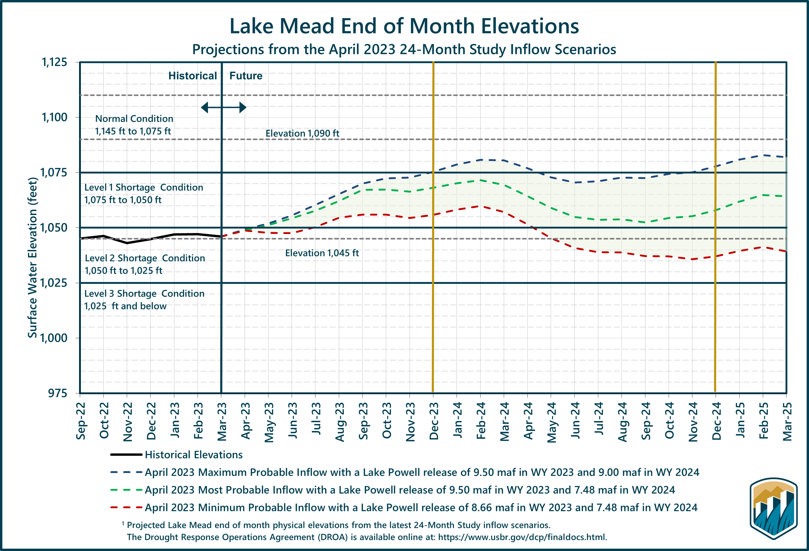
Todayโ€™s announcement is part of the efforts underway by the Administration to increase water conservation, improve water efficiency, and prevent the Colorado River Systemโ€™s reservoirs from falling to critically low elevations that would threaten water deliveries and power production. The ongoing implementation and effectiveness of these essential efforts through new investments, as well as any voluntary system conservation agreements between Basin states, will help determine the degree to which revised operations will be implemented.

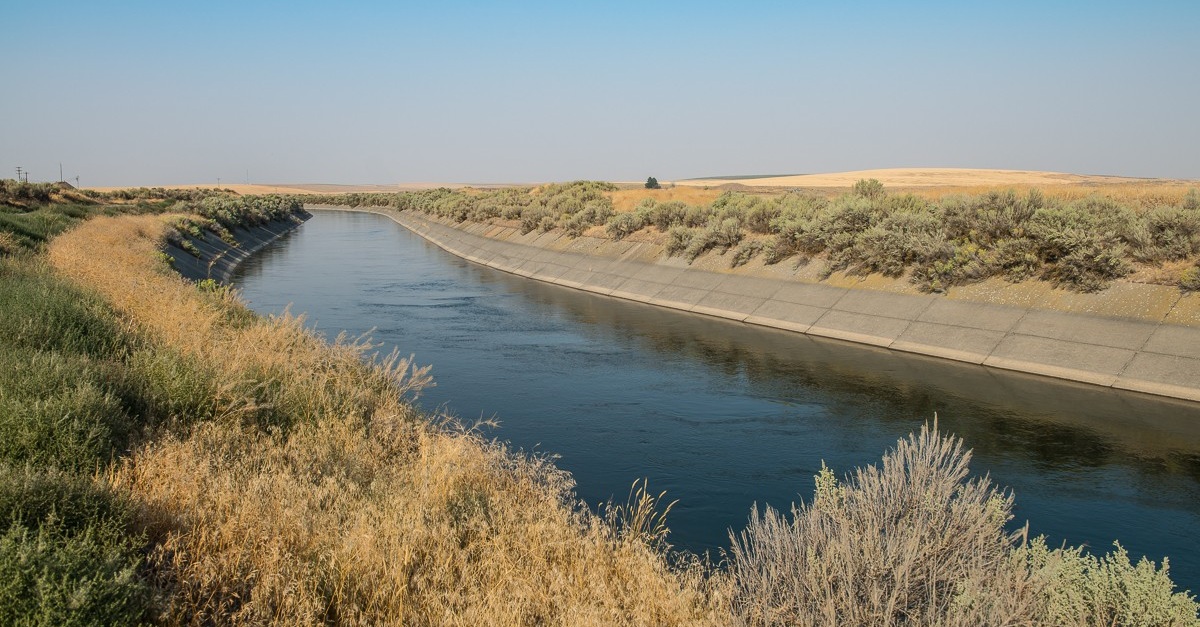
Selected projects include updating canal lining and piping to reduce seepage losses, installing advanced metering, automated gates and control systems, and programs in urban areas to install residential water meters and other water conservation activities.

One-third of the selected projects advance the Administrationโ€™s Justice40 initiative, which aims to deliver 40 percent of the overall benefits of climate, clean energy and related investments to disadvantaged communities that are marginalized, overburdened and underserved.

This funding is part of Reclamationโ€™s WaterSMART Program, which focuses on collaborative efforts to plan and implement actions to increase water supply sustainability, including investments to modernize infrastructure. More information is available onโ€ฏReclamation’sย WaterSMART program webpage.

Map credit: AGU

Running and cycling to raise awareness of global #water issues — The Los Angeles Times #ActOnClimate

Click the link to read the article on The Los Angeles Times website

Dustin Garrick, an associate professor of water and development policy at the University of Waterloo in Ontario, Canada, has started an initiative calledย Water Cycles Expeditionsย and recently led a group on a five-day cycling trip in Southern California and Arizona. The journey took riders from Joshua Tree to the Coachella Valley, and beside the Salton Sea, which is fed by water draining off farmlands. The cyclists also rode next to the U.S.-Mexico border, stopping to see the area where the last of the Colorado Riverย dries up in the desert, becoming a sandy riverbed fringed with vegetation.

โ€œIt was really a profound experience,โ€ Garrick said.

Bicycles allow people โ€œto get on the ground and get close to the issues,โ€ he said. He values that perspective as a water researcher, and believes it also helps those who are interested in learning about water sources and challenges.

โ€œThe bike brings what I call the bikeโ€™s eye view,โ€ he said.

Isabel Jorgensen, a doctoral researcher at the University of Waterloo who grew up in Southern California, said pedaling by the Salton Sea โ€œoffered a slower pace to really examine the landscape, both natural and human.โ€

Jorgensen studies saline lakes, among them the Salton Sea. She said being on a bike helped her notice the shift in desert vegetation as they descended toward the Salton Sea and also gave her a closeup view of Slab City, where people have erected makeshift homes near the lake.

She said cycling provided a different perspective than by car, in part because the group rode into strong winds and dust.

โ€œThe sheer force of the wind on the high wind days was knocking our bikes back and even out from under us,โ€ Jorgensen said. โ€œIt blew dust everywhere.โ€

Arapahoe County Divides on Gas & Oil — The Buzz #ActOnClimate #KeepItInTheGround

Click the link to read the post on The Buzz website (Floyd Ciruli):

A surprising 3 to 2 vote against a moratorium on gas and oil drilling in Arapahoe County highlighted a board of commissioners with many new members and seldom seen in Arapahoe Countyโ€™s history – a Democratic majority. The commissioners voted against the moratorium that would have stopped a potential drilling application for 174 wells east of Aurora and the Aurora Reservoir.

Bill Holen, a moderate Democrat, and Jeff Baker, the only Republican, joined with new commissioner Carrie Warren-Gully to defeat the moratorium. Leslie Summey, who represents the most Democratic district, voted in favor with Jessica Campbell-Swanson, who won Republican Nancy Sharpeโ€™s Greenwood Village seat very handily last fall.

Arapahoe County continues to drift to the political left but has unpredictable variations.

Holen is term limited in 2024 and Baker will likely have a competitive reelection (won by about 200 votes in 2020, had a recount).

Navajo Dam operations update: Bumping releases to 500 cfs April 21, 2023

Navajo Dam spillway via Reclamation.

From email from Reclamation Susan Novak Behery:

The Bureau of Reclamation has scheduled an increase in the release from Navajo Dam from 300 cubic feet per second (cfs) to 500 cfs for Friday, April 21st, at 4:00 AM.

#Snowpack peaks, shifting view toward #runoff — The #Aspen Times

Click the link to read the article on The Aspen Times website (Josie Taris). Here’s an excerpt:

This season, snowpackย peakedย on April 7 with 23.2 inches of snow-water equivalent, about five inches above average, according to the USDA. Consistent snowfall throughout the season contributed to the 35% above-average count โ€“ the highest snowpack for the second week of April since 2019. Experts said it is still too soon to tell exactly what the snowmelt pattern will look like. Factors like temperature, wind, and dust will play into that rate…

If temperatures continue to rise and wind storms blow away top layers of snow or carry in dirt โ€” the most detrimental to snowpack โ€” rivers could swell and lead to strong flow or even flooding. Or if cold weather like Friday continues, the snowmelt could come at a more even pace all the way into July. Normal peak runoff season in the Roaring Fork watershed is mid-May through mid-June.ย  [Erin] Walter said elevation also plays a huge role in the rate of snowmelt. The highest elevations hold out the longest.ย Another factor in extending the runoff season is better soil moisture at the beginning of winter than in seasons past.ย 

โ€œThis winter, weโ€™re heading in with better soil moisture. And so the hope is that then that water finds its way into the river rather than into the ground,โ€ said Roaring Fork Conservancy water quality technician Matthew Anderson.ย 

U.S. senators Bennet and Hickenlooper on potential revisions to #ColoradoRiver operations: Wet year no excuse to ignore a drier future — The #Vail Daily #COriver #aridification

Water levels at Lake Powell have plummeted to lows not seen since the days when the reservoir was filling for the first time. Credit: Alexander Heilner, The Water Desk with aerial support from LightHawk, CC BY-NC-ND 4.0

Click the link to read the article on the Vail Daily website (John LaConte). Here’s an excerpt:

The Bureau of Reclamation on Tuesday [April 11, 2023] issued a set of potential options to revise the current operation of the Colorado River system, catching the attention of many residents and stakeholders within the system…The options were laid out in a draft Supplemental Environmental Impact Statement, which determined that some action would be required to protect the Glen Canyon and Hoover Dam operations, system integrity, and public health and safety in the years to come…

Sen. Michael Bennet, following Tuesdayโ€™s announcement, issued a statement saying as much.

โ€œThis yearโ€™s good snowpack canโ€™t be an excuse to kick the can down the road,โ€ Bennet said. โ€œThis SEIS is a constructive step toward sustaining the Colorado River system for the long term, and I continue to urge all seven Basin states to come to an agreement. We have no time to lose.โ€

The Supplemental Environmental Impact Statement contemplates an โ€œabsence of consensus among all entities affected by changed operations,โ€ saying sound and prudent operation of the reservoirs on the system โ€œwill almost certainly lead to objection by specific entities to the impacts of one or more aspects of water management decisions.โ€

Sen. John Hickenlooper called the statement โ€œan important step in planning for a drier West, saying states โ€œmust work towards a collaborative, seven-state solution for managing water scarcity that honors our communities, the sovereignty of Tribes, and the concerns of agricultural producers.โ€

Hickenlooper also mentioned the lure of the no-action alternative in the shadow of the historic winter of 2022-23.

โ€œNo matter how promising this yearโ€™s snowpack is, we must prepare for less water in the river on which we rely,โ€ he said.

Reclamation releases April 2023 24-month study projections #ColoradoRiver #COriver #aridification

Click the link to read the release on the Reclamation website:

The 24-Month Study projects future Colorado River system conditions using single-trace hydrologic scenarios simulated with the Colorado River Mid-term Modeling System (CRMMS) in 24-Month Study Mode. Three Studies, the Most, Minimum, and Maximum Probable 24-Month Studies, are released monthly, typically by the 15th day of the month.

  • Initial Conditions: The 24-Month Study is initialized with previous end-of-month reservoir elevations.
  • Hydrology: In the Upper Basin, the first year of the Most Probable inflow trace is based on the 50th percentile of Colorado Basin River Forecast Center (CBRFC) forecasts and the second year is based on the 50th percentile of historical flows. To represent dry and wet future conditions, the Minimum Probable and Maximum Probable traces use the 10th and 90th forecast percentiles in the first year and the 25th and 75th percentiles of historical flows in the second year, respectively. The Lower Basin inflows are based only on historical intervening flows that align with the Upper Basin percentiles.
  • Water Demand: Upper Basin demands are estimated and incorporated in the unregulated inflow forecasts provided by the CBRFC; Lower Basin demands are developed in coordination with the Lower Basin States and Mexico.
  • Policy: Reservoir operations are input manually in the 24-Month Study by reservoir operators and align with Colorado River policies.
  • Drought Response Actions:ย CRMMS projections contain actions undertaken with theย 2022 Drought Response Operations Plan,ย 2022 Glen Canyon Dam operational adjustment, and the 2023 operations described in the 24-Month Study.
    • The 2022 Drought Response Operations Plan includes an additional release of 500 kaf from Flaming Gorge from May 2022 through April 2023.
    • The reduction of releases from Lake Powell from 7.48 maf to 7.00 maf in water year 2022 will result in a reduced release volume of 0.480 maf that normally would have been released from Glen Canyon Dam to Lake Mead as part of the 7.48 maf annual release volume, consistent with routine operations under the 2007 Interim Guidelines. The reduction of releases from Glen Canyon Dam in water year 2022 (resulting in increased storage in Lake Powell) will not affect future operating determinations and will be accounted for โ€œas ifโ€ this volume of water had been delivered to Lake Mead. The August 2022 24-Month Study modeled 2023 and 2024 operations at Lakes Powell and Mead as if the 0.480 maf had been delivered to Lake Mead for operating tier/condition determination purposes for the Lower Basin States and for Mexico.
    • Because the 2022 operations were designed to protect critical elevations at Lake Powell, Reclamation will implement Lower Elevation Balancing Tier operations in a way that continues to protect these critical elevations, or preserves the benefits of the 2022 operations to protect Lake Powell, in water year 2023. Specifically, Reclamation modeled operations in WY 2023 as follows in the 24-Month Studies:
      • The Glen Canyon Dam annual release has initially been set to 7.00 maf, and in April 2023 Reclamation will evaluate hydrologic conditions to determine if balancing releases may be appropriate under the conditions established in the 2007 Interim Guidelines;
      • Balancing releases will be limited (with a minimum of 7.00 maf) to protect Lake Powell from declining below elevation 3,525 feet at the end of December 2023;
      • Balancing releases will take into account operational neutrality of the 0.480 maf that was retained in Lake Powell under the May 2022 action. Any Lake Powell balancing release volume will be calculated as if the 0.480 maf had been delivered to Lake Mead in WY 2022; and
      • The modeling approach for WY 2023 will apply to 2024.

Consistent with the provisions of the 2007 Interim Guidelines, and to preserve the benefits to Glen Canyon Dam facilities from 2022 Operations into 2023 and 2024, Reclamation will consult with the Basin States on monthly and annual operations. Reclamation will also ensure all appropriate consultation with Basin Tribes, the Republic of Mexico, other federal agencies, water users and non-governmental organizations with respect to implementation of these monthly and annual operations.

Reclamation will continue to carefully monitor hydrologic and operational conditions and assess the need for additional responsive actions and/or changes to operations. Reclamation will continue to consult with the Basin States, Basin Tribes, the Republic of Mexico and other partners on Colorado River operations to consider and determine whether additional measures should be taken to further enhance the preservation of these benefits, as well as recovery protocols, including those of future protective measures for both Lakes Powell and Mead.

For more detailed information about the approach to the 24-Month Study modeling, see the CRMMS 24-Month Study Mode page. All modeling assumptions and projections are subject to varying degrees of uncertainty. Please refer to this discussion of uncertainty for more information.

Projections

The latest 24-Month Study reports for each study can be found at the links below:

Archived 24-Month Studyย results are also available. Descriptions of the 24-Month Study hydrologic scenarios are also documented inย Monthly Summary Reports.ย Lake Powellย andย Lake Meadย end-of-month elevation charts are shown below.

Projected Lake Powell end-of-month physical elevations from the latest 24-Month Study inflow scenarios.
Projected Lake Mead end-of-month physical elevations from the latest 24-Month Study inflow scenarios.

For additional information or questions, please contact us via email at: ColoradoRiverModeling@usbr.gov.

Last updated: 2022-08-16

Reclamation: Above-average #snowpack and projected #runoff will send more #water from #LakePowell to #LakeMead #ColoradoRiver #COriver #aridification

Colorado River Allocations: Credit: The Congressional Research Service

Click the link to read the release on the Reclamation website:

WASHINGTON โ€“ The Bureau of Reclamation today released its April 24-Month Study, which includes an increase to downstream flows from Lake Powell to Lake Mead of up to 9.5 million acre-feet (maf) this water year (Oct. 1, 2022 through Sept. 30, 2023).

Glen Canyon Damโ€™s annual release volume for water year 2023 was initially set at 7.0 maf, based on the August 2022 24-Month Study, and is now projected to increase to up to 9.5 maf because of high snowpack this winter and projected runoff in the Colorado River Basin this spring. The actual annual release volume from Glen Canyon Dam is adjusted each month throughout the water year and is determined based on the observed inflow to Lake Powell and the storage contents of Lake Powell and Lake Mead.

While this water yearโ€™s projections are above average, the Colorado River Basin is experiencing severe drought conditions and system reservoirs remain at historically low levels. In response to this historic drought, Reclamation recently released a draft Supplemental Environmental Impact Statement to potentially revise the current interim operating guidelines for the near-term operation of Glen Canyon and Hoover Dams.

โ€œThis winterโ€™s snowpack is promising and provides us the opportunity to help replenish Lakes Mead and Powell in the near-term โ€” but the reality is that drought conditions in the Colorado River Basin have been more than two decades in the making,โ€ said Commissioner Camille Calimlim Touton. โ€œDespite this yearโ€™s welcomed snow, the Colorado River system remains at risk from the ongoing impacts of the climate crisis. We will continue to pursue a collaborative, consensus-based approach to conserve water, increase the efficiency of water use, and protect the systemโ€™s reservoirs from falling to critically low elevations that would threaten water deliveries and power production.โ€ 

Lake Powell is currently operating in the Lower Elevation Balancing Tier, and Reclamation is required to โ€œbalance the contentsโ€ of Lake Mead and Lake Powell, as outlined in Section 6.D.1 of the Colorado River Interim Guidelines for Lower Basin Shortages and Coordinated Operations for Lake Powell and Lake Mead (2007 Interim Guidelines).  

Reclamation utilized the Colorado Basin River Forecast Centerโ€™s (CBRFC) April forecasts and other relevant factors such as Colorado River system storage and reservoir elevations to make balancing adjustments to Lake Powell operations.

The CBRFCโ€™s April through July unregulated inflow forecast for Lake Powell is 11.3 maf (177% of average) โ€” an increase of 3.3 maf from March, which was 125% of average. Reclamationโ€™s April 24- Month Study projects Lake Powellโ€™s elevation at 3,576.50 feet at the end of the water year (Sept. 30, 2023). This is approximately 40 feet higher and 2.74 maf of additional storage than projected in the August 2022 Most Probable 24-Month Study, which was used to set the annual operations for Lake Powell and Lake Mead.

For the past several years, Reclamation has had to take drought response operations, including modifying monthly releases from Glen Canyon Dam, to keep water in Lake Powell and help prevent it from dropping to critically low elevations. ย 

The higher annual release volume for the remainder of this water year is inclusive of water previously kept in Lake Powell:

  • 480,000 acre-feet of water kept in Lake Powell by reducing the annual release volume in water year 2022 from 7.48 maf to 7.0 maf
  • 523,000 acre-feet of water held back this winter to increase Lake Powell elevations during the lowest point in the water year until post-runoff months of May through September

Reclamation has already increased the monthly release volume for April from Glen Canyon Dam from 552,000 acre-feet to 910,000 acre-feet to be better positioned to release up to 9.5 maf by the end of the water year (Sept. 30, 2023). Monthly releases for May through September will also be adjusted as needed.

Reclamation will take advantage of Aprilโ€™s higher water releases and will conduct a 72-hour high-flow release from Glen Canyon Dam later this month. This will involve a release of water from Glen Canyon Dam that is more rapid than normal โ€” up to 39,500 cfs during its peak โ€” to move sediment stored in the river channel and redeposit it onto beaches, which will benefit conditions at Grand Canyon National Park and aid in management of invasive species in the Colorado River. The release will not change the annual release volume of up to 9.5 maf from the dam.

“The steps announced by the Bureau of Reclamation today respond adaptively to the unusual conditions this year with an action grounded in the sound science of the Grand Canyon Monitoring and Research Center scientists,โ€ said National Park Serviceโ€™s Grand Canyon National Park Superintendent Ed Keable. โ€œThis release is critical to rebuild the sandbars and protect the archeological resources and restore the camping beaches in the canyon in compliance with the 1992 Grand Canyon Protection Act.โ€

Based on the April 24-Month Study, Lake Meadโ€™s elevation is also projected to improve in calendar year 2023, with a projected end of calendar year elevation of 1,068.05 feet โ€” approximately 33 feet higher than the March 24-Month Study. With this improvement in Lake Meadโ€™s elevation, a mid-year review of Lake Mead operations is not expected in 2023.

While improved hydrology and projected forecasts have provided an opportunity to recover upstream reservoir storage and use the higher runoff to take positive action in the Grand Canyon, the Colorado River system remains at risk, with Lake Powell and Lake Mead at a combined storage capacity of just 26%.

Reclamation is committed to protecting and sustaining the system and is undertaking an expedited, supplemental process to revise the current interim operating guidelines for the Glen Canyon and Hoover Dams. This process will provide the alternatives and tools needed to address the likelihood of continued low-runoff conditions and reduced water availability across the basin over the next two years. This draft SEIS is available for public review and comment until May 30, 2023. The document can be found on the project website, www.usbr.gov/ColoradoRiverBasin/SEIS.html, as well as information on how to submit written comments and when virtual public meetings will be held.

Additional information about the planned high-flow release will be posted and updated online at: https://www.usbr.gov/uc/progact/amp/ltemp.html.

Flooding reaches some #Utah cities, but #water managers welcome huge #snowpack: Managing what water goes where will be key going forward — The Deseret News #runoff (April 21, 2023)

Click the link to read the article on The Deseret News website (Amy Joi Oโ€™Donoghue). Here’s an excerpt:

March, which is typically Utahโ€™s best month for precipitation, outdid itself this year. By the time it was over, precipitation was 250% of normal, more than twice what the month generally delivers.

โ€œI donโ€™t know what we did to deserve March, but it was something. I donโ€™t know what to say about March. I know our forecast staff was extremely tired. It was just phenomenal,โ€ said Glen Merrill, senior hydrologist with the National Weather Service in Salt Lake City, adding not only was the wet weather outstanding, but the cool temperatures as well…

The warmer temperatures last week kick-started the melt from lower and mid-elevations of a snowpack that exceeded that of the early โ€™80s and even, cautiously speaking, the big snow year of 1952, although at that time measurements were not taken as often and measure sites were not as plentiful…That snow coming off the mountains means extraordinarily high stream runoff forecasts in some areas and flooding that is already happening at Emigration Creek, resulting in the closure of some recreational trails near waterways and wary eyes cast on the Weber and Ogden rivers…

All that water needs to go somewhere and reservoirs are already in an operational mode of controlled releases to make room for the coming melt. The precipitation has also delivered enough water to lift the ailing Great Salt Lake by 3.5 feet and forecasters predict Lake Powell will receive 11 million acre-feet of water due to inflows. Neither of those amounts are enough to get the Great Salt Lake or Lake Powell Reservoir out of trouble, but it will help. And as the berm dividing the north arm of the Great Salt Lake from the south arm is expected to be eclipsed by the precipitation, water experts said some of that additional water will make it into the north arm โ€” a good thing.

#Drought drastically reduced in #Utah, much of the West after winter storms: Regional experts say Utah in particular has stellar snowpack, high runoff forecast this spring — The Deseret News

Utah Drought Monitor map April 18, 2023.

Click the link to read the article on The Deseret News website (Amy Joi Oโ€™Donoghue). Here’s an excerpt:

As of Oct. 1 last year, 73% of land in the Southwest was in some sort of drought. Flash forward to April and only 27% of that same region was impacted by drought. That is according to a Tuesday briefing coordinated by the National Integrated Drought Information System and in conjunction with other entities that include the Colorado River Basin Forecast Center and the National Weather Service.

Utah sat at 100% of its land in some sort of drought, while only a few troublesome spots remain according to the U.S. Drought Monitor. Utah now sits at 35% of its land in some sort of drought, but none in the exceptional or extreme categories โ€” the worst of the worst.

Dave Simeral, associate research climatologist with the Western Regional Climate Center/Desert Research Institute based in Reno, Nevada, pointed to the whopping 253% average of precipitation the Great Basin Region received since the new water year began in October. The basin stretches from the Sierras on the West to the Wasatch Range in Utah.

Rural Renewables & Agrivoltaics Get a Leg Up in North Fork Valley — #Colorado Farm & Food Alliance

NREL researcher Jordan Macknick and Michael Lehan discuss solar panel orientation and spacing. The project is seeking to improve the environmental compatibility and mutual benefits of solar development with agriculture and native landscapes. Photo by Dennis Schroeder, NREL

Here’s the release from the Colorado Farm & Food Alliance:

PAONIA, CO. (April 20, 2023) – Today the Colorado Farm & Food Alliance was named by the National Community Solar Partnership (NCSP) as a recipient of a Community Power Accelerator Phase 1 prize to study and advance community-owned farm-based renewable projects in the North Fork Valley.

The Community Power Accelerator Prize is a U.S. Department of Energy led initiative to spur development of community-owned solar and renewable projects. The North Fork award is for a collaboration that involves the CO Farm & Food Alliance and other organizations, community leaders and businesses. In March this group submitted a proposal to help plan a small solar project that will benefit area farms and farm-related businesses and to use that project as a springboard for additional renewable energy to benefit rural communities. Phase 1 prize recipients can compete for additional awards.

โ€œOur goal is to promote rural climate leadership and to show that the clean energy transition can support agriculture, boost local enterprise, and work toward greater energy equity,โ€ said Pete Kolbenschlag, director of the Colorado Farm & Food Alliance. โ€œWe are extremely excited to move our project forward, and we see it as a model for rural climate action that puts land health, people and local community first.โ€

The North Fork team first coalesced around a small agrivoltaic project being scoped near Hotchkiss, and saw this as an opportunity to consider how the area might advance more community-owned renewables that integrate with agriculture and serve local residents. 

โ€œWe see agrivoltaics as part of our effort to pursue sustainability, adding renewable energy to our efforts to improve the health of our land and soil and to better feed our local community,โ€  said Mark Waltermire, owner of Thistle Whistle Farm in Hotchkiss, Colorado. โ€œThis project will give a handful of farms like this one, and a few food-related businesses that use our produce, a way of accessessing cleaner power, while benefiting our farm by giving us more gentle growing conditions under the panels to grow some of our crops. Our whole farm community benefits. And, we can set the stage for similar projects in areas around the valley that can help other producers,โ€ he added.

Agrivoltaics is an emerging field of solar development that is paired with agriculture. In the U.S. Southwest, as we head into a warmer and drier future, interest in agrivoltaics, as a means to adapt farming to a changing climate while co-locating clean energy production, is high. Some studies show that growing certain crops under solar panels can provide shade benefits, help regulate soil-moisture, and can also help to cool the panels, which increases their efficiency.ย 

Rogers Mesa

The projects being considered by the North Fork team will involve working agriculture, grid energy production, and scientific research conducted in partnership with the Colorado State University Western Colorado Research Center at Rogers Mesa, to gather more data on how renewable energy and agriculture can co-exist and can even benefit each other. 

โ€œInnovative solar projects involving agrivoltaics and community ownership models promise significant benefits for rural agricultural communities and there isnโ€™t a better place than the Western Slope to demonstrate that potential and to provide a model that can be replicated,โ€ said team-member Alex Jahp, who works at Paonia-based Solar Energy International. โ€œReceiving the Community Power Accelerator Prize demonstrates that we aren’t alone in our thinking.โ€ 

The North Fork Valley is named after a major stem of the Gunnison River, which is the second largest tributary to the imperiled Colorado River system. The region is at the epicenter of the global climate emergency, as a critical headwaters area and due to its heating at a more rapid rate than many places in the nation. The North Fork Valley is home to both the stateโ€™s largest operating coal-mine and its highest concentration of organic farms. Many in the region still see both agriculture and energy as key parts of a diverse economic future, but also see the critical need to act to address climate change. 

โ€œWith Delta County warming double the national and global average, the impacts of local warming are upon us. Building community resilience–through community-driven projects like the ones being considered here, at the nexus of agriculture, water, and energyโ€“is critical if we are to survive and thriveโ€ said Natasha Lรฉger, Executive Director, Citizens for a Healthy Community. She added that โ€œfarms play a critical role in transitioning away from oil and gas as energy sources for running farm operations, and will be leadership models for new approaches to land use.โ€ 

Citizens for a Healthy Community has recently completed a Climate Action Plan for Delta County, hoping to help local governments act more boldly to address the climate crisis. In its recent report, Gunnison Basin: Ground Zero in the Climate Emergency, the Colorado Farm & Food Alliance also made a pitch for the potency of rural-based climate action โ€“ including the expansion of farm-based renewables. The North Fork Valley agrivoltaic team is not waiting to act.

โ€œThe Community Power Accelerator Prize is a key award that will allow us to take the great work already being done by local community groups and turn it into tangible results,โ€ said Kolbenschlag on behalf of the Colorado Farm & Food Alliance which accepted the prize for the community collaboration. โ€œWe have an exceptional team and an exceptional project. We think this can be a model for rural climate action and community resilience. We thank the Department of Energy and Solar Partnership for this opportunity to prove it.โ€ย 

Gunnison River Basin. By Shannon1 – Own work, CC BY-SA 4.0, https://commons.wikimedia.org/w/index.php?curid=69257550

2023 #COleg: #Colorado lawmakers consider pilot projects that combine #solar energy with #water conservation — @WaterEdCO

Grays and Torreys, Dillon Reservoir May 2017. Photo credit Greg Hobbs.

Click the link to read the article on the Water Education Colorado website (Allen Best):

Colorado lawmakers on Thursday, April 13, will hear why Colorado should study the nexus of solar energy and water. Aquavoltaics, as this still-emerging practice is known, positions solar panels above canals and other water bodies.

The marriage, proponents say, can save water by reducing evaporative losses while boosting the amount of electricity solar panels generate.

The proposal is part of a bill, SB23-092, that will be heard by the Senate Transportation and Energy Committee.

That same bill also proposes to nudge development of agrivoltaics, where solar production occurs simultaneously with agricultural production. A similar agrivoltaics bill was introduced last year, but was not passed. Aquavoltaics is new to this yearโ€™s bill.

State Sen. Chris Hansen, D-Denver, a principle sponsor of both bills, said his study of water conservation efforts around the world found that aquavoltaics was one of the most advantageous ways to reduce evaporation from canals and reservoirs. Doing so with solar panels, he says, produces a โ€œhuge number of compounded value streams.โ€

Covering the water can reduce evaporation by 5% to 10%, he says, while the cooler water can cause solar panels to produce electricity more efficiently, with a gain of 5% to 10%. Electricity can in turn be used to defray costs of pumping water.

Solar panels in cooler climates produce electricity more efficiently, which is why solar developers have looked eagerly at the potential of Coloradoโ€™s San Luis Valley. At more than 7,000 feet in elevation, the valley is high enough to be far cooler than the Arizona deserts but with almost as much sunshine.

Colorado already has limited deployment of aquavoltaics. Walden in 2018 became the stateโ€™s first community to deploy solar panels above a small pond used in conjunction with water treatment. The 208 panels provide roughly half the electricity needed to operate the plant. The town of 600 people, which is located at an elevation of 8,100 feet in North Park, paid for half of the $400,000 cost, with a state grant covering the rest.

Other water and sewage treatment plants, including Fort Collins, Boulder and Steamboat Springs, also employ renewable generation, but not necessarily on top of water, as is done with aquavoltaics.

As introduced, the bill would authorize the Colorado Water Conservation Board to โ€œfinance a project to study the feasibility of using aquavoltaics.โ€

Hansen said he believes Colorado has significant potential for deploying floating solar panels on reservoirs or panels above irrigation canals. โ€œThere is significant opportunity in just the Denver Water reservoirs,โ€ he said. โ€œPlus you add some of the canals in the state, and there are hundreds of megawatts of opportunity here,โ€ he said.

Other Western states are also eying the technology.

Arizonaโ€™s Gila River Indian Community announced last year that it is building a canal-covering pilot project south of Phoenix with the aid of the U.S. Amy Corp of Engineers. โ€œThis project will provide an example of new technology that can help the Southwest address the worst drought in over 1,200 years,โ€ said Stephen Roe Lewis, governor of the tribe.

When completed, the canal-covering solar project will be the first in the United States.

But both the Gila and a $20 million pilot project launched this year by Californiaโ€™s Turlock Irrigation District are preceded by examples in India.

Officials with the Central Arizona Project (CAP), a major user of Colorado River water and the largest consumer of electricity in Arizona, will be closely following the pilot projects in Arizona and California, according to a report in the Arizona Republic. In the past, both CAP and the Salt River Project, two of the largest water providers in Arizona, have cited engineering challenges of aquavoltaics.

The new Colorado bill also would authorize the Colorado Agricultural Drought and Climate Resilience Office to award grants for new or ongoing demonstration or research projects that demonstrate or study the use of agrivoltaics. This is to be overseen by a stakeholder group.

Mike Kruger, chief executive of the Colorado Solar and Storage Association, says his members want to see the most expansive definition of eligible projects possible. โ€œI donโ€™t think it will ever be โ€˜amber waves of grainโ€™ under panels. It will more likely be cattle and sheep grazing,โ€ he says.

That is indeed what will be happening near Delta. There, a solar project was proposed near an electrical substation with the intent of serving the Delta-Montrose Electric Association. Neighbors objected, and the county commissioners rejected it in a 2-to-1 vote. The project developer returned with a revised project, one that calls for sheep grazing to occur amid the solar panels. This revised proposal passed in a 3-to-0 vote.

Hansen says this is exactly the model he expects to see play out in the contest between devoting land for agriculture and for renewable power generation.

โ€œWhat is clear is that county commissions do not want the fight between solar and agriculture if they can help it,โ€ says Hansen. He cites the Delta County case as a prime example.

โ€œIf you combine it with grazing, we are going to say yes, and thatโ€™s exactly what the Delta County commissioners did. That is why I see this as one of the ways to address the fight between solar and agriculture.โ€

Allen Best is a frequent contributor to Fresh Water News. He also publishes Big Pivots, an e-journal that chronicles the energy and water transitions in Colorado and beyond.

Reclamation releases #ClimateChange Adaptation Strategy

Ringside seats to the decline of Lake Mead. Credit: InkStain

Click the link to read the release on the Reclamation website (Peter Soeth):

WASHINGTON โ€“ The Bureau of Reclamation has released its Climate Change Adaptation Strategy that outlines how Reclamation will combat climate change. The strategy also affirms Reclamation will use leading science and engineering to adapt to human-caused climate change.

“Climate change is impacting our communities, economies and the environment throughout the West,” said Reclamation Commissioner Camille Calimlim Touton. “Through this strategy, Reclamation will work collaboratively with our federal and non-federal partners and incorporate climate change into our water and power management decisions to minimize climate change’s impacts on western water into the future.”

The strategy focuses on four goals:

  1. Increase water management flexibility โ€“ including improvements to reservoir operations and hydropower generation efficiency, development of water treatment and water conservation technologies to relieve water scarcity and advancing applications in watershed monitoring and forecasting to provide better decision-support.
  2. Enhance climate adaptation planning โ€“ including engagement with water and power stakeholders to build climate resilience and provide financial assistance through WaterSMART programs, and development of guidance to better account for climate change in planning and related environmental reviews, tailored for situations in long-term resource management, new infrastructure, asset management, operations and maintenance, dam safety, aquatic restoration and more.
  3. Improve infrastructure resilience โ€“ Reclamation will embark on strategic activities in hydropower, dam safety, infrastructure investments and innovation, ensuring its infrastructure continues to provide benefits well into the future.
  4. Expand information sharing โ€“ including working with partners to develop quality-assured climate change information and then making that information publicly available for different resource management situations.  

The strategy supports the implementation of President Biden’s Executive Order on Protecting Public Health and the Environment and Restoring Science to Tackle the Climate Crisis and Executive Order on Tackling the Climate Crisis at Home and Abroad. It also aligns with Secretarial Order on Department-wide Approach to the Climate Crisis and Restoring Transparency and Integrity to the Decision-Making Process. Finally, it is consistent with the Department of the Interior’s Climate Adaptation and Resilience Plan.

Reclamation’s 2021 West-wide Climate and Hydrology Assessment identified the human-induced climate change impacts expected to impact the West through the rest of this century. It identifies changes in temperature, precipitation, snowpack and streamflow across the West.

You can read the entire Climate Change Adaptation Strategy at www.usbr.gov/climate.

Climate Change Website

Local officials prepare for spring runoff (April 19, 2023) — The #Gunnison Country Times #GunnisonRiver #ColoradoRiver #COriver

Click the link to read the article on The Gunnison Country Times website (Bella Biondini). Here’s an excerpt:

On Monday, April 17, Gunnison County Emergency Services hosted a multi-jurisdictional meeting to discuss spring runoff and the possibility of flooding in the Gunnison Valley as temperatures rise. Although the upcoming weather forecast is favorable and no cause for alarm, local officials and law enforcement made sure plans are in place and sandbags are available in the case of rapid snowmelt. Snowpack for the Gunnison Basin sat at approximately 160% of normal on April 9 with more snow on the way. After an exceptionally wet winter, rapid warming has the potential to overfill streams and rivers โ€” putting low-lying areas at risk as the snow finally starts to melt away.ย 

Temperatures above freezing overnight at higher elevations for several days can lead to expedited snowmelt, National Weather Service (NWS) Hydrologist Erin Walter said during a weather briefing at the start of the meeting. But transitioning into the middle of the week, she said the basin will see the influence of a low pressure system carrying snow and cooler temperatures. 

โ€œThis downward turn in temperatures is what we want to see for snowmelt,โ€ Walter said. โ€œIf we saw a ridge of high pressure over us and all of these temperatures climbing for a prolonged period of time, thatโ€™s when we need to be on high alert.โ€

Federal officials lay out options for #ColoradoRiver cuts if no consensus is reached — The #Nevada Independent #COriver #aridification

A boat is shown on the Colorado River near Willow Beach Saturday, April 15, 2023. Willow Beach is located approximately 20 miles south of the Hoover Dam. Photo by Ronda Churchill/The Nevada Independent

Click the link to read the article on Nevada’s only statewide nonprofit newsroom The Nevada Independent website (Daniel Rothberg):

Earlier this week [April 11, 2023], federal water officials released theย draftย of a much-awaited document outlining potential major short-term cuts to stabilize a Colorado River shrinking due to overuse and drought โ€”ย unless the seven states that rely on the watershed come up with an alternative.ย 

The last part is key. 

Officials made it clear that they still wanted the states to reach a consensus on what painful cuts might look like as any action that is taken by the federal government faces a risk of litigation.

Speaking in front of Lake Mead, with its prominent bathtub ring โ€” one of the most apparent illustrations of the Colorado River shortage โ€” Tommy Beaudreau, deputy secretary of the Department of Interior, said the choices federal water officials laid out โ€œprovide room for additional work and solutions.โ€

The document, he said, โ€œis intended to drive those conversations and negotiations forward.โ€

The announcement served as a step in an ongoing environmental impact study, led by the U.S. Bureau of Reclamation, to analyze the cuts needed to stabilize the Colorado Riverโ€™s reservoirs, which serve about 40 million people across the West and have hit record lows in recent years. 

The Colorado River and its tributaries form a watershed that spans a massive geography, which includes seven U.S. states, 30 Native American tribes and Mexico. The river supports millions of acres of agricultural land, countless ecosystems, aquatic species, recreation and many of the Westโ€™s largest cities, including Las Vegas, Los Angeles, Phoenix, Salt Lake City and Denver. 

Southern Nevada receives about 90 percent of its water directly from the Colorado River. All of the states below Lake Mead โ€” Arizona, California and Nevada โ€” comprise the Lower Colorado River Basin and face the possibility of major cuts. In recent years, the Southern Nevada Water Authority has taken proactive steps to offset future cuts with aggressive conservation measures, including the removal of decorative water-guzzling turf and limiting the size of residential pools. 

The water authority is still conducting a detailed analysis of the nearly 500-page draft document, authority spokesman Bronson Mack said. But conversations among the states continue. 

On Friday, John Entsminger, the head of the water authority, met with counterparts in Arizona and California. In a statement, he called the draft โ€œthe next step in the process to find workable solutions to protect water supplies for 40 million Americans and more than a trillion dollars in economic activity.โ€

The document released Tuesday is a draft of what is known as a Supplemental Environmental Impact Statement, or an SEIS. It amends the current set of guidelines that govern shortages on the river.

As the Western U.S. experienced its worst drought in 1,200 years, it became clear that the existing shortage guidelines, finalized in 2007, were not sufficient to keep the riverโ€™s largest reservoir, Lake Mead, from crashing so low it would threaten water deliveries across the West.

Federal water officials launched the SEIS process last year after the seven states tried but failed to reach a consensus over how the painful cuts to the Colorado River should be allocated within a framework of law, known as the Law of the River, that gives California a priority to its Colorado River share over Arizonaโ€™s major diversion, a 336-mile canal called the Central Arizona Project.

Eventually, by January, six of the seven states had reached a consensus framework, but without California, the largest user of the river and a meaningful player in making any sizable cutbacks.

The draft SEIS outlines three approaches that the federal government could take:

  1. The do-nothing approach: Federal operations would implement the existing operating agreements for the Colorado River reservoirs, which would risk the possibility of one or both major reservoirs โ€” Lake Mead and Lake Powell โ€” declining so low they would effectively become inoperable in future years if dry conditions continue.
  2. Rely on the water rights system: Follow what is known as the priority system outlined in the Law of the River, a compilation of the many compacts, settlements, decrees and treaty documents pertaining to the Colorado River. In general, this system often gives  priority to those who have the oldest or โ€œseniorโ€ rights, including agricultural districts and tribal nations. This more closely aligned the proposal that California had advocated for.
  3. Apportion additional cuts evenly: The other action alternative outlined by federal water managers calls for building on existing agreements, which reflect priority, and applying cuts on a proportional basis by assigning an across-the-board cut of up to 15.6 percent. The cuts in this scenario would more closely align to the cuts outlined in the six-state plan and backed by Arizona, putting a larger burden of cuts on California.

But federal officials were clear: This draft document is not the last word. Notably, federal officials did not endorse a preferred option, instead framing the actions as โ€œtoolsโ€ they could implement.

โ€œIt was interesting that they did not do what they said they were going to do and offer a federal [preferred] option,โ€ said John Fleck, a University of New Mexico professor who focuses on the Colorado River and water governance. โ€œThey simply offered a federal-lite version of the six-state proposal and the California proposal, and a positive โ€˜power of collaborationโ€™ argument.โ€

At a press conference Tuesday, negotiators for California and Arizona signaled willingness to reach a consensus deal and avoid either option, both of which come with risks for each state.

People recreate on Colorado River-fed Lake Mojave near Katherine Landing Saturday, April 15, 2023. Katherine Landing is located just north of Laughlin, Nevada. Photo by Ronda Churchill/The Nevada Independent

Between two bookend scenarios, a possible deal?

J.B. Hamby, the chair of the Colorado River Board of California and on the board of the Imperial Irrigation District, which holds the single largest entitlement to the Colorado River, said โ€œit is our hope and our fervent desire that the tools laid out in the [document] never have to be used.โ€ 

The best way to get there, he said, โ€œis through ongoing work with collaborative processes.โ€ He said that the ideal situation would be to develop a seven-state consensus in the coming months, if not weeks. 

During the press conference Tuesday, Tom Buschatzke, who directs the Arizona Department of Water Resources, also echoed the continued need for states to come up with a negotiated deal, noting that officials from Arizona, California and Nevada have been discussing paths forward.

Buschatzke said the goal is to avoid litigation. 

โ€œSo we have to avoid that outcome,โ€ Buschatzke said, arguing that it could take decades to settle any lawsuit, time that negotiators do not have to reach major agreements on cutbacks. โ€œOnce litigation occurs, if it does, it’s going to be very difficult to negotiate something moving forward.โ€

Setting up  bookend alternatives could give the states more boundaries by which to negotiate a path forward that balances the priority system and equity, water experts said.

โ€œWhat they are trying to do is set up the worst-case scenario for Californiaโ€ by showing what could be done if officials deviate from a strict application of priority, said Elizabeth Koebele, a UNR professor who focuses on water policy and has followed the negotiations over the cuts.

Each state has internal dynamics to sort through

Much of the rhetoric around the Colorado River negotiations has focused on the long-held and ongoing tensions between California and Arizonaโ€™s share of water on the river.ย 

While California has priority rights over water that flows through the Central Arizona Project โ€” water that is delivered to cities, tribal nations, agricultural districts and industrial users โ€” each state has internal dynamics that will influence what happens next.

What priority looks like within โ€” and between โ€” the three states is extremely complicated. 

For instance, although California is often seen as the senior user on the river, the Metropolitan Water District โ€” the major municipal water purveyor for Southern California โ€” has rights that have less priority relative to other water users and could be cut off in either of the alternatives. 

In a statement, the water agencyโ€™s general manager said neither alternative is ideal.

โ€œBoth include significant supply cuts that would hurt Metropolitan and our partners across the Basin,โ€ General Manager Adel Hagekhalil said. โ€œThere is a better way to manage the river.โ€

Arizona also faces complicated internal dynamics when it comes to what curtailment by priority would actually look like. Although Arizona supported an equitable approach and is often seen as  junior to California, several Arizona water users have high-priority water rights to the Colorado River. During the Tuesday press conference, Buschatzke said that the several water users in Arizona, including Colorado River Indian Tribes and farmers in the Yuma area, wrote letters urging officials to respect the priority system.

Last week, federal water officials began a 45-day comment period on the SEIS as talks continue. A final version of the document will be released after the comment period ends.

โ€œOptimistically, the next 45 days look like meeting some middle ground between the priority approach and the equity-based approach,โ€ said Rhett Larson, law professor at Arizona State University. “It’s going to require a fair amount of give and take, including intrastate negotiations.โ€

People recreate on Colorado River-fed Lake Mojave at Telephone Cove Saturday, April 15, 2023. The cove is located just north of Laughlin, Nevada. Photo by Ronda Churchill/The Nevada Independent

Still searching for a long-term agreement

The two options weighed by federal officials are part of a larger dialogue over the long-term management of the river. The cuts are meant to stabilize Colorado River reservoirs until 2026. 

The 2007 guidelines for operating the river are set to expire in 2026, and officials must renegotiate a new set of rules in the coming years.

Since last year, drought conditions in the Colorado River Basin have improved with large storms increasing the snowpack โ€” the primary source of the Colorado River โ€” to well-above average. 

As the snow melts this summer, reservoirs could start recovering from record lows. But one year of low runoff after 2023 could quickly put the river back into a dire situation, especially given the existing deficit. In addition, many water experts believe significant cuts are still needed to ensure the basin is able to rebuild storage in the reservoirs, rather than continuing to overuse water.

โ€œThe hydrology this year has been nothing short of amazing and I think itโ€™s up to us to ensure that we donโ€™t squander it,โ€ said Estevan Lรณpez, the Colorado River negotiator for New Mexico. โ€œWe have an opportunity here to rebuild supplies that were kind of loaned to the system, if you will, under the emergency drought actions that were taken over the course of the last year.โ€

Even with one good year of snowpack, the Colorado River faces significant challenges โ€” with more rights to water than there is water to go around. On top of these structural problems and continued overuse, a changing climate and warmer temperatures are making the region more arid, contributing to less runoff in recent decades and more uncertainty about water supply. 

As negotiators focus on long-term river management and renegotiating the 2007 rules, they must also address inequities embedded in the riverโ€™s foundational documents, which excluded tribal governments and gave little consideration to the riverโ€™s ecosystems, which have been damaged by overuse.

At the press conference Tuesday, Rosa Long, vice chair of the Cocopah Indian Tribe and chair of theย Ten Tribes Partnership, urged all states to focus on conservation measures.

โ€œIn closing, let us commit to continuing our collaboration and to work together in the spirit of mutual respect and understanding,โ€ Long said in her remarks Tuesday. โ€œBy doing so we can ensure that the Colorado River remains a vital and thriving resource for generations to come.โ€

The latest seasonal outlooks through July 31, 2023 are hot off the presses from the #Climate Prediction Center

#Drought news April 20, 2022: Some areas of deterioration were also noted across D0 to D2 areas in central and eastern #Colorado, but most of the state was unchanged from last week, as was #Wyoming.

Click on a thumbnail graphic to view a gallery of drought data from the US Drought Monitor website.

Click the link to go to the US Drought Monitor website. Here’s an excerpt:

This Week’s Drought Summary

While most of the country received light precipitation at best last week, large totals fell on a few areas. Over 1.5 inches fell on the south half of Mississippi and the central Gulf Coast Region from Louisiana through the Florida Panhandle, with totals of 4 to 6 inches dousing parts of southeast Mississippi, southern Alabama, and coastal Louisiana. Totals also exceeded 1.5 inches in parts of the central and southern Florida Peninsula, with amounts reaching 6 inches in parts of the southern Peninsula and along the eastern coastline. A few swaths in the Upper Midwest recorded 1.5 to 3.0 inches, specifically from central to northeastern Minnesota, across much of Wisconsin and the western Upper Peninsula of Michigan, and from northeast Kansas and southeast Nebraska into southwest Iowa. Beneficial moderate to heavy precipitation also fell on parts of the Northern Rockies, northern Intermountain West, and Pacific Northwest. Most of the Nation west of the Appalachians, however, saw light precipitation at best. Precipitation was a little more widespread over the Appalachians and along the Eastern Seaboard, but most areas received subnormal amounts with only isolated patches reporting moderate to heavy precipitation.

On the whole, some areas of dryness and drought in the Southeast, the Upper Midwest, the northern Rockies, and the Pacific Northwest felt improvement over the course of the week. In addition, rapid snowmelt quickly recharged soil moisture and boosted streamflows from the Dakotas to the western Great Lakes Region, prompting improvement in some areas. But most locations experiencing abnormal dryness or drought saw conditions persist or intensify, with deterioration to D3 or D4 (Extreme to Exceptional Drought) noted in some areas across the western Florida Peninsula and the southern half of the Great Plains…

High Plains

A majority of Kansas and portions of Nebraska remained entrenched in D3 to D4 (extreme to exceptional drought). Some D3 and D4 expansion took place there, but a few small areas saw limited improvement from localized rainfall. Some areas of deterioration were also noted across D0 to D2 areas in central and eastern Colorado, but most of the state was unchanged from last week, as was Wyoming.

Farther north, precipitation was unremarkable and generally below normal in the Dakotas, but rapid melting of the unusually deep snowpack has been recharging soil moisture and boosting streamflows, with river flooding reported in some areas. As a result, dryness and drought generally eased this past week, reducing D0 and D1 coverage, and removing last weekโ€™s D2 from southeastern South Dakota.

The Weekly Weather and Crop Bulletin reported poor or very poor conditions for 60 percent of Kansas winter wheat, 40 percent of Nebraska winter wheat, and 38 percent of Colorado winter wheat…

Drought Monitor one week change map ending April 18, 2023.

West

Areas of moderate to heavy precipitation brought continued improvement to many of the dryness and drought areas in Washington, Oregon, and Montana. Improvement was also noted across parts of Utah as the unusually deep snowpack continued to slowly melt, recharging soil moisture and boosting streamflows.

From May 5 to August 9, 2022, anywhere from 25 to 39 percent of the West Climate Region was entrenched in D3 or D4 drought. As of April 18, only about 1.5 percent of the region was in D3, restricted to interior northeastern Oregon.

According to the California Department of Water Resources, mid-April statewide reservoir contents were about 19.5 million acre-feet in 2021, and less than 18 million acre-feet in 2022. But after abundant December-March precipitation in most of the state, mid-April reservoir storage has rebounded to around 27.5 million acre-feet this year, slightly above the long-term average of around 26 million acre-feet at this time of year…

South

Heavy rainfall also eased dryness and drought from southern Louisiana eastward into the Florida Panhandle. Moderate drought there is now restricted to southeastern Louisiana, where substantial multi-month precipitation shortfalls remained despite a wet week. Elsewhere, Tennessee and the Lower Mississippi Valley remained free of dryness and drought, as did eastern Texas and southeastern Oklahoma.

A tight gradient exists from near normal conditions in the aforementioned areas to extreme or exceptional drought (D3-D4) over portions of central and western Texas and Oklahoma. Beneficial rains fell on Deep South Texas and southeastern Texas, bringing limited improvement, but a dry week for most of the central and western sections of Texas and Oklahoma meant conditions persisted or deteriorated there. Most locations across central and northern Oklahoma have 3-month SPEI below the 5 percentile threshold, with 90-day precipitation 3 to 5 inches below normal.

As of April 16, the Weekly Weather and Crop Bulletin reports 53 percent of Oklahoma winter wheat and 52 percent of Texas winter wheat crops in poor or very poor condition [ed. empahisis mine]…

Looking Ahead

During the next five days (April 19-24, 2023) moderate to heavy precipitation (over an inch) is expected in the Pacific Northwest, higher elevations in the central and northern Rockies, much of the eastern Great Plains, most of the Mississippi Valley and Great Lakes Region, the Appalachians, the Carolinas, the Middle Atlantic Region, and the Northeast. Totals of 1.5 to 3.0 inches is forecast for a broad area from the Mississippi/Ohio Riversโ€™ Confluence Region southward across the west side of the lower Mississippi Valley and the eastern half of Texas. In contrast, most areas from the west side of the Great Plains to the Pacific Coast (outside the higher elevations and areas west of the Cascades) are expecting light precipitation at best. Light amounts of precipitation (less than one-quarter inch) are also expected in Florida, Georgia, and some adjacent locales.

The Climate Prediction Centerโ€™s 6-10 day outlook (valid April 25-29) shows above-normal precipitation favored over the vast majority of the central and eastern contiguous states and Alaska. Odds are only marginally enhanced in most areas, but odds exceed 50 percent that amounts will be in the wettest one-third of the historical distribution in part of the South Atlantic States and in southeastern Alaska. Subnormal precipitation is more favored in most areas from the Rockies to the Pacific Ocean, with much of the northern Great Basin having at least a 50 percent chance for precipitation totals in the lowest one-third of the historical distribution. Enhanced chances for subnormal temperatures cover a large area from the Plains to the Middle Atlantic Region, especially across the northern Plains, upper Midwest, and upper Mississippi Valley. Colder than normal temperatures are also expected across most of Alaska outside southeastern areas. Warmer than normal weather is forecast for the southern Rockies, the Intermountain West, and West Coast, as well as across northern New England and locations across and near the Florida Peninsula.

US Drought Monitor one week change map ending April 18, 2023.

Fire danger in the high mountains is intensifying: Thatโ€™s bad news for humans, treacherous for theย environment

Fires are increasing in high mountain areas that rarely burned in the past. John McColgan, Bureau of Land Management, Alaska Fire Service

Mohammad Reza Alizadeh, Massachusetts Institute of Technology (MIT) and Mojtaba Sadegh, Boise State University

As wildfire risk rises in the West, wildland firefighters and officials are keeping a closer eye on the high mountains โ€“ regions once considered too wet to burn.

The growing fire risk in these areas became startling clear in 2020, when Coloradoโ€™s East Troublesome Fire burned up and over the Continental Divide to become the stateโ€™s second-largest fire on record. The following year, Californiaโ€™s Dixie Fire became the first on record to burn across the Sierra Nevadaโ€™s crest and start down the other side.

We study wildfire behavior as climate scientists and engineers. In a new study, we show that fire risk has intensified in every region across the West over the past four decades, but the sharpest upward trends are in the high elevations.

Fire burns in the mountains above a building and ranch fence.
In 2020, Coloradoโ€™s East Troublesome fire jumped the Continental Divide. AP Photo/David Zalubowski

High mountain fires can create a cascade of risks for local ecosystems and for millions of people living farther down the mountains.

Since cooler, wetter high mountain landscapes rarely burn, vegetation and dead wood can build up, so highland fires tend to be intense and uncontrollable. They can affect everything from water quality and the timing of meltwater that communities and farmers rely on, to erosion that can bring debris and mud flows. Ultimately, they can change the hydrology, ecology and geomorphology of the highlands, with complex feedback loops that can transform mountain landscapes and endanger human safety.

Four decades of rising fire risk

Historically, higher moisture levels and cooler temperatures created a flammability barrier in the highlands. This enabled fire managers to leave fires that move away from human settlements and up mountains to run their course without interference. Fire would hit the flammability barrier and burn out.

However, our findings show thatโ€™s no longer reliable as the climate warms.

We analyzed fire danger trends in different elevation bands of the Western U.S. mountains from 1979 to 2020. Fire danger describes conditions that reflect the potential for a fire to ignite and spread.

Over that 42-year period, rising temperatures and drying trends increased the number of critical fire danger days in every region in the U.S. West. But in the highlands, certain environmental processes, such as earlier snowmelt that allowed the earth to heat up and become drier, intensified the fire danger faster than anywhere else. It was particularly stark in high-elevation forests from about 8,200 to 9,800 feet (2,500-3,000 meters) in elevation, just above the elevation of Aspen, Colorado.

Chart showing changing wildfire risks in the high mountains
Mohammad Reza Alizadeh, CC BY

We found that the high-elevation band had gained on average 63 critical fire danger days a year by 2020 compared with 1979. That included 22 days outside the traditional warm season of May to September. In previous research, we found that high-elevation fires had been advancing upslope in the West at about 25 feet (7.6 meters) per year.

Cascading risks for humans downstream

Mountains are water towers of the world, providing 70% of the runoff that cities across the West rely on. They support millions of people who live downstream.

High-elevation fires can have a significant impact on snow accumulation and meltwater, even long after they have burned out.

For example, fires remove vegetation cover and tree canopies, which can shorten the amount of time the snowpack stays frozen before melting. Soot from fires also darkens the snow surface, increasing its ability to absorb the Sunโ€™s energy, which facilitates melting. Similarly, darkened land surface increases the absorption of solar radiation and heightens soil temperature after fires.

The result of these changes can be spring flooding, and less water later in the summer when communities downstream are counting on it.

Fire-driven tree loss also removes anchor points for the snowpack, increasing the frequency and severity of avalanches.

A burned area on a mountain ridge with a large reservoir far below.
Wildfire burn scars can have many effects on the water quality and quantity reaching communities below. George Rose/Getty Images

Frequent fires in high-elevation areas can also have a significant impact on the sediment dynamics of mountain streams. The loss of tree canopy means rainfall hits the ground at a higher velocity, increasing the potential for erosion. This can trigger mudslides and increase the amount of sediment sent downstream, which in turn can affect water quality and aquatic habitats.

Erosion linked to runoff after fire damage can also deepen streams to the point that excess water from storms canโ€™t spread in high-elevation meadows and recharge the groundwater; instead, they route the water quickly downstream and cause flooding.

Hazards for climate-stressed species and ecosystems

The highlands generally have long fire return intervals, burning once every several decades if not centuries. Since they donโ€™t burn often, their ecosystems arenโ€™t as fire-adapted as lower-elevation forests, so they may not recover as efficiently or survive repeated fires.

Studies show that more frequent fires could change the type of trees that grow in the highlands or even convert them to shrubs or grasses.

A team of pack mules carries supplies up a high mountain in Glacier National Park. Some of the trees have burned, even at this high elevation.
High-elevation tree species like whitebark pines face an increasing risk of blister rust infections and mountain pine beetle infestations that can kill trees, creating more fuel for fires. Chip Somodevilla/Getty Images

Wet mountain areas, with their cooler temperatures and higher precipitation, are often peppered with hot spots of biodiversity and provide refuges to various species from the warming climate. If these areas lose their tree canopies, species with small ranges that depend on cold-water mountain streams can face existential risks as more energy from the Sun heats up stream water in the absence of tree shading.

While the risk is rising fastest in the high mountains, most of the West is now at increasing risk of fires. With continuing greenhouse gas emissions fueling global warming, this trend of worsening fire danger is expected to intensify further, straining firefighting resources as crews battle more blazes.

Mohammad Reza Alizadeh, Postdoctoral Researcher in Environmental Engineering, Massachusetts Institute of Technology (MIT) and Mojtaba Sadegh, Assistant Professor of Civil Engineering, Boise State University

This article is republished from The Conversation under a Creative Commons license. Read the original article.

The St. Vrain and Left Hand Water Conservancy District taps millions in new cash to transform mountain watersheds, farms, streams — @WaterEdCO #SouthPlatteRiver

A colorful signpost welcomes visitors to Jamestown. Jamestown residents have joined forces with multiple agencies in a project funded in part by the St. Vrain and Left Hand Water Conservancy District to restore the forest and the James Creek watershed. Credit: Jerd Smith

Click the link to read the article on the Water Education Colorado website (Jerd Smith):

On the hillsides that rise above James Creek in Jamestown, Colorado, west of Boulder, the yards of mountain homes and the forests that surround them are dotted with trees decorated with pink and blue ribbons.

Itโ€™s festive, but not in the usual sense.

Jamestown lies in the headwaters of Left Hand Creek, a tributary of the St. Vrain River. The pink trees will be kept, while those flagged in blue will be cut down in a careful thinning project designed to protect a watershed farther downstream that serves farmers and thousands of people in communities such as Lyons and Longmont.

The watershed is a critical part of the St. Vrain and Left Hand Water Conservancy District, an agency charged with overseeing and managing the St. Vrain River, a major system in the larger South Platte River Basin on Coloradoโ€™s Front Range.

The people of Jamestown have been working for years to find funding to protect their community from wildfire and to protect James Creek. Tree cutting is expensive, sometimes costing $1,000 just to remove one tree.

Trees marked for forest health initiative above James Creek in Jamestown, Colorado. Credit: Jerd Smith

But thanks to a property tax increase the districtโ€™s voters approved in 2020, as well as an influx of COVID relief money to the state, and new federal funds for infrastructure and jobs, the people of Jamestown and the St. Vrain district now have access to the money they need to reshape and improve their water systems in ways that benefit supply, recreation, the environment and agriculture.

If state and federal funding proposals come through, and some already have, the district will have more than $240 million to work with. For perspective, that is 60 to 80 times the size of the districtโ€™s annual $3 million to $4 million operating budget.

Similar big federal funding opportunities exist for other water districts, and policy makers across the state are looking to the St. Vrain district to lead by example.

Alex Funk, senior counsel and director of water resources at the Theodore Roosevelt Conservation partnership is tracking the streams of new cash. He says the opportunities to modernize water systems and improve the stateโ€™s farms and rivers now are huge.

โ€œItโ€™s unprecedented in its scope and scale,โ€ Funk said. โ€œThere has never been this amount of federal money available all at once. In that sense, we are in uncharted territory.โ€

Thatโ€™s not lost on Sean Cronin, executive director of the St. Vrain and Left Hand Water Conservancy District.

Plume of subtropical moisture streaming into Colorado September 2013 via Weather5280

After the floods of 2013, the district saw its streams and water systems devastated. Desperate to rebuild, small communities, ditch companies and watershed groups, as well as the St. Vrain district, began banding together to apply for federal and state emergency assistance.

โ€œThe flood introduced us to new friends,โ€ Cronin said.

From that grew a ballot initiative in 2020 that has raised millions of dollars in property taxes.

Though statewide water tax proposals have had little success among Colorado voters, St. Vrainโ€™s was one of two local districts that year that succeeded. The Glenwood Springs-based Colorado River Water Conservation District also won approval to raise taxes to protect and improve the regions water sources.

โ€œThe fact that we had a plan that looked at all things regarding water and wasnโ€™t specifically for a single water outcome is part of why we succeeded,โ€ Cronin said. โ€œPeople embrace looking at things holistically.โ€

Credit: St. Vrain and Left Hand Water Conservancy District

Energized by the win, the district launched into planning and design on a range of modest projects.

And then the federal funding deluge began. Now the district is in the running for $240 million to improve infrastructure and restore streams, and improve agricultural irrigation systems, among other projects.

Todd Boldt oversees the federal  Emergency Watershed Protection program in Colorado at the Natural Resources Conservation Service as well as other major grant-making programs that are now flush with cash.

He said one of his agencyโ€™s priorities is to get the word out about federal funding opportunities and to ensure even small water districts have the resources to do the planning, engineering and design work needed to begin the grant process.

He credits the St. Vrain district with being well-planned and well-organized at the starting line.

โ€œThis is complicated stuff,โ€ Boldt said. โ€œWeโ€™re at a critical juncture in time.โ€

If the St. Vrain and Left Hand team succeeds, its ditches, streams, wetlands, reservoirs and farm fields could look significantly different in seven to 10 years.

High in the mountains, for instance, a historic diversion system will be brought into the 21st century. More than 130 years old, the structure is difficult to access and maintain. Soon it will be rehabilitated so that it can be monitored and operated remotely to make sure water is accurately counted and properly diverted.

โ€œWeโ€™re trying to squeeze every last drop out of our system,โ€ Cronin said.

In fact, there are dozens of diversion structures in this sprawling district that includes prized recreational streams, thousands of acres of farms, rich wetlands, and cities.

Sean Cronin and John McClow at the 2014 CFWE President’s Award Reception

Cronin and his team are reaching out to everyone, funneling the cash theyโ€™ve raised into matching grants and offering assistance to partners.

Another part of the districtโ€™s strategy is to grow water supplies where possible, and to do so in a way that doesnโ€™t require the purchase of farm-tied water rights and the subsequent dry up of farm fields.

This year, for instance, the district began its own cloud-seeding program, which is forecast to increase water derived from annual snow storms by 5% to 10%.

Funk said the work in the St. Vrain and Left Hand district is encouraging.

โ€œWe need to see more of that. We want people to think creatively about these [federal] funds,โ€ he said.

Back up in Jamestown, St. Vrainโ€™s Jenny McCarty, a water resources specialist, has been monitoring the forest restoration work. She believes the initiative could serve as a template for other community-based, multi-property-owner watershed health projects.

In the mountains, while itโ€™s helpful for one property owner to thin trees and remove slash, the impact is limited, McCarty said.

โ€œThese property owners like their privacy. Their contribution to the project has been to allow all those trees to be cut down,โ€ she said. โ€œItโ€™s the collective effort that makes a difference.โ€

Jerd Smith is editor of Fresh Water News. She can be reached at 720-398-6474, via email at jerd@wateredco.org or @jerd_smith.

Healthy #snowpack provides water for long-delayed Grand Canyon environmental flood — AZCentral.com

Glen Canyon High Flow Experiment November 2013 via Jonathan Thompson

Click the link to read the article on the AZCentral.com website (Brandon Loomis). Here’s an excerpt:

Grand Canyon advocates are celebrating a decision by federal water managers to unleash a three-day pulse of high water from Glen Canyon Dam to rebuild beaches and improve environmental conditions on the Colorado River. The high-flow experience is scheduled to start Monday. Environmentalists, river runners and others had sought such a flood release, outlined under the damโ€™s adaptive management program, for years. Healthy monsoon rains had pushed tons of sand into the river, but had also gouged the beaches and sandbars that create natural backwaters and campsites for river trips. Opening the damโ€™s floodgates before the fresh sediment gradually washed downstream could push the sand up to form new beaches. Their efforts previously ran into the reality of declining water behind the dam in Lake Powell, where the U.S. Bureau of Reclamation was trying to hold back enough water to keep generating hydropower. In response under the Grand Canyon Protection Act of 1992, the agency can release floodwaters when the Paria River dumps sufficient sand below the dam, butย had not done so since 2018.ย This winter, the Rocky Mountains piled up more snow than at any time since 2011, with enough water content to raise the reservoir by dozens of feet.

Before and after photos of results of the high flow experiment in 2008 via USGS

Reclamation’s Upper Colorado Region confirmed the plan on Tuesday. On Friday, the agency sent interested parties a memo explaining its decision to go ahead with a 72-hour release of extra water beginning Monday. Dam operators will open bypass tubes to roughly quadruple the riverโ€™s flow to 39,500 cubic feet per second.

The government has conducted several such high-flow experiments in the past, but this will be the first to occur in spring, the natural time for flooding before Glen Canyon Damโ€™s completion in 1963.

โ€œA springtime (flood) is an opportunity to see all the natural processes that are kicked in by a high flow and see how they respond,โ€ said Kelly Burke, who directs Wild Arizonaโ€™s Grand Canyon Wildlands Council.

Carbon โ€˜bankโ€™ at risk of failure: Scientists trying to determine what will happen to massive carbon stores as rainforests dry out — #Colorado State University #ActOnClimate

View of one of the rainforests studied by CSU researcher Daniela Cusack, as seen from a motorboat on the Panama Canal. Researchers had to access the forests in the study by boat.

Click the link to read the article on the Colorado State University website (Jayme DeLoss):

Tropical rainforests store 25%-40% of global soil carbon, though they occupy only 7% of Earthโ€™s land area. By functioning as a carbon sink, tropical forests prevent more severe effects from climate change.

A research team led by a Colorado State University scientist found that climate change will impact tropical forestsโ€™ ability to store carbon. Their study reveals that persistent drying in tropical forests, an anticipated result of climate change, leads to carbon loss from the most fertile soils โ€“ and that soil nutrients play an important role in how much carbon is released and when. 

โ€œTropical forests can be really sensitive to reductions in rainfall,โ€ said Daniela Cusack, lead author and an associate professor in the Department of Ecosystem Science and Sustainability, โ€œand they have some of the largest stores of carbon on Earth. As climate is drying, that carbon is vulnerable.โ€ 

Climate change is reducing rainfall in some places and causing more year-to-year variation. Some tropical forests already have been documented as drying.  

โ€œAll of that carbon thatโ€™s stored in rainforests right now is like a bank,โ€ Cusack said. โ€œWeโ€™re banking all that carbon and anything that releases that carbon is going to exacerbate climate change and impact everybody.โ€ย 

Unexpected results

Daniela Cusack, an associate professor in Ecosystem Science and Sustainability, led the PARCHED study, which revealed surprising results about how tropical forests will react to climate change.

Cusack and her team assessed the effects of natural seasonal drying and chronic reduced rainfall on carbon fluxes in tropical forests. They found that natural seasonal drying suppressed the release of carbon dioxide. 

โ€œThere was some resilience at first, which makes sense because these are seasonal forests, so theyโ€™re used to a dry season,โ€ Cusack said. โ€œBut it seems like after that initial resilience, weโ€™re hitting a threshold where things are shifting more rapidly in some tropical forests.โ€ 

The ecosystem model they used in the study predicted that persistent drying would increase the release of carbon dioxide from more fertile and wetter tropical forests but decrease CO2 fluxes from drier tropical forests. 

โ€œWe had predicted that the wettest site would be most sensitive to drying,โ€ Cusack said. โ€œItโ€™s the least adapted to drier conditions.โ€ 

The expectation was that as the wetter sites dried down a little, they would become more favorable for microbes, which decompose carbon in soil, turning it back into carbon dioxide. 

โ€œWhat we saw was the opposite of whatโ€™s been hypothesized for these tropical forests,โ€ Cusack said. The site they expected to have the biggest carbon loss actually lost the least carbon. 

Perhaps the microbes canโ€™t thrive in infertile soil, Cusack said, or maybe microbial activity is just slower to ramp up in the wettest soils because they take longer to dry out. Cusack said more research is needed to determine why the results disagreed with the model. 

Carbon loss via respiration did increase significantly with persistent drying in the more fertile soils, suggesting nutrients play an important role in CO2 fluxes.  

Withholding rain from the rainforest

The study, called PARCHED for PAnama Rainforest CHanges with Experimental Drying, measured the effects of natural seasonal drying and experimental chronic drying on soil carbon storage in four distinct tropical forests in Panama.ย ย 

The forests encompassed a broad range in natural rainfall and soil fertility. This allowed the researchers to compare how different kinds of tropical forests would respond to drying. 

With initial investment from the National Science Foundation, they took two years of baseline measurements, starting in 2015. Then the team started monitoring carbon fluxes under conditions imposed by experimental drying over plots of rainforest in 2018, thanks to funding from the Department of Energy. 

To induce artificial drying, the team built partial greenhouse roofing over plots measuring 10 meters by 10 meters in each of the four forests. The roofing, which was below the forest canopy, diverted about half of the rainfall from the soil at each site. Trenches lined with plastic kept moisture from seeping into the study plots.ย ย 

PARCHED study field team, from left: Amanda Cordeiro (CSU grad student), Jackie Reu (intern), Edwin Garcia (Panama technician), Daniela Cusack and Lee Dietterich (CSU postdoc and co-author).

The study, published in Global Biogeochemical Cycles, showed that different tropical forests will respond to climate change differently and on different time frames, and that fertile soils may be the first to react with big carbon losses across the tropics. 

Researchers were surprised that soil nutrients seem to have as big an effect as soil moisture, which necessitates updates to predictive models. 

โ€œIf there arenโ€™t enough nutrients, the microbes donโ€™t seem to respond as much to changes in moisture,โ€ Cusack said. 

Scientists have not observed changes in plant growth or conversion of CO2 to oxygen via photosynthesis yet, which makes sense, Cusack said, because plants are bigger organisms that take longer to grow. 

โ€œMicrobes are small creatures, and they tend to respond much more quickly to climate change and other kinds of disturbance,โ€ she said. 

With continued experimental drying, the other plots also are trending toward carbon loss, Cusack said โ€“ one more reason to address emissions problems and increase carbon sequestration initiatives. 

โ€œEveryone thinks about temperature change, but I think precipitation change can be more confusing,โ€ Cusack said. โ€œItโ€™s more variable, and itโ€™s changing differently in different places. But drying in the tropics is a real concern as far as these carbon stores.โ€ย 

The PARCHED study team built infrastructure to divert about 50% of rainfall from plots measuring 10 meters by 10 meters in four forests in Panama. The forests varied greatly in mean annual precipitation and soil properties.

Improved prediction

Cusack and her teamโ€™s results have contributed to improved modeling of rainforest carbon cycling.  

Ecosystem-scale soil carbon models were developed for temperate forests, which is why they donโ€™t simulate saturated, infertile tropical soils very well. The researchers updated the carbon model they worked with to better match their observations. 

Soil fertility is not fully represented in many ecosystem carbon models, especially for the nutrients scarcest in tropical forests, like phosphorus. In many existing soil carbon models, carbon loss predictions are based primarily on soil moisture. Cusack said representing nutrients better in ecological models is an important next step in this research.ย 

Authors of the study, โ€œSoil Respiration Responses to Throughfall Exclusion are Decoupled from Changes in Soil Moisture for Four Tropical Forests, Suggesting Processes for Ecosystem Models,โ€ are Cusack, Lee H. Dietterich, with CSUโ€™s Department of Ecosystem Science and Sustainability, and Benjamin N. Sulman, with Oak Ridge National Laboratory. The Department of Ecosystem Science and Sustainability is part of the Warner College of Natural Resources.ย 

Navajo Dam operations update April 19, 2023 #SanJuanRiver #ColoradoRiver #COriver

The San Juan Riverโ€™s Navajo Dam and reservoir. Photo credit: U.S. Bureau of Reclamation

From email from Reclamation (Susan Novak Behery):

At 9:00 AM on April 20thย (Thursday), the release at Navajo Dam will be transferred to the 4×4 Auxiliaryย outlet for a period of 2 hours to allow for SCADA testing.ย ย During this time, the release volume will not change.ย The release will be transferred back to the power plant after the 2-hour test has concluded. You may expect some silt and discoloration downstream in the river during this time due to the location of the 4×4.

Taming the forest fires of the future โ€• today: @DenverWater and partners are making landscape-scale changes that may ease the threat of wildfires and protect precious #water supplies

Click the link to read the article on the Denver Water website (Todd Hartman):

In the race to protect homes and communities โ€• and water supplies โ€• from the intensifying threat of wildfire, Front Range organizations spent urgent years hustling to thin dense and overgrown forests in scattered patches.

Cutting trees and clearing brush ideally would ease the risk of catastrophic fire by reducing what could burn and slowing a fireโ€™s spread in a less crowded forest.

In September 2019, firefighters quickly contained the Payne Gulch fire in Pike National Forest. Work done in 2017 to reduce the density of the trees in the area, from 256 to 44 trees per acre, helped make it more difficult for the 2019 fire to spread rapidly. Photo credit: U.S. Forest Service.

And that was true. But the approach, while well-meaning and understandable, also was disorganized and scattershot.

โ€œOrganizations were frantically out there working on their own,โ€ explained Madelene McDonald, a watershed scientist at Denver Water focused on protecting water supplies from wildfire. โ€œThese were shotgun treatments, or what is sometimes called โ€˜random acts of restoration.โ€™ It was 500 acres here, then 300 acres there.โ€

Things are changing โ€• for the better. And Denver Water is at the forefront.


Denver Water scientist earns rare slot on Congressional wildfire commission.


With greater coordination, more resources and a more strategic approach, agencies and communities are beginning to create larger, more connected swaths of thinned-out forests. 

Experts believe these larger swaths can better prevent the kind of massive damage to waterways, reservoirs โ€” and the forests themselves โ€” that have marked the last quarter-century of epic wildfire in Colorado.

โ€œWe are recognizing that we canโ€™t be working independently. We need to be collaborating and doing strategic cross-boundary planning. We can get far more done together,โ€ McDonald said. โ€œThe risk is still there, but we are moving the needle.โ€

Focus on the Pike National Forest

One of the clearest examples of this strategic shift can be found in the South Platte Ranger District, in a region near Bailey located south and west of Denver.

Here, partnerships involving the U.S. Forest Service, Denver Water, the Colorado State Forest Service and other state and local organizations are driving landscape-scale work that will provide greater protection for forests and for Denver Waterโ€™s supplies in an era of a warming climate and hotter, larger, more damaging forest fires.

A view of the trees, now stacked as logs, that were thinned as part of the Jerome Miller/Miller Gulch Project to reduce wildfire risk and protect the North Fork of the South Platte River, a key supply for Denver Water. Photo credit: Denver Water.

Much of the work is occurring under the banner of the Jerome Miller/Miller Gulch Project, an effort focused on an area of the Pike National Forest that lies between the North Fork and the South Platte rivers and upstream from where the two waterways merge near Strontia Springs Reservoir, a temporary pool for 80% of Denver Waterโ€™s supply.

The project is expanding a series of forest treatments in the region that collectively are designed to limit future fires ability to spread quickly and grow in intensity. That, in turn, should lessen wildfire impacts to the North Fork of the South Platte, a stretch that conveys critical supplies of water flowing from Dillon Reservoir to the metro area.

Parts of this general region in the South Platte River watershed were the epicenter of two major fires in 1996 and 2002 that together burned more than 150,000 acres, devastated landscapes and left reservoirs clogged with thousands of tons of sediment that poured from the scorched, treeless landscape left by the fires. 

Those two fires, named the Buffalo Creek and Hayman, set Denver Water and other land management agencies on the course they are on today โ€• to collaborate on the ground to ease the risk of future catastrophic fires.

Examples of success 

Already, the partnershipโ€™s work has resulted in tangible success stories.

In 2019, a fire broke out in an area called Payne Gulch in the Pike National Forest. As part of a series of forest management projects in the region, this area had been thinned in 2017.

โ€œThe fire could have blown up to be a pretty catastrophic fire, but wildland firefighters were able to access and suppress the fire effectively because of the thinning,โ€ McDonald said. โ€œThatโ€™s a shining example of where weโ€™ve seen this work pay off. The connectivity between treated areas is increasing and attracting more and more work in that area.โ€

This photo shows the result of work to reduce forest density in the Jerome Miller/Miller Gulch Project on U.S. Forest Service land. Photo credit: Denver Water.

In perhaps the highest profile example, the partnershipโ€™s work to develop fuel breaks protected about 1,400 homes and as much as $1 billion in value in Silverthorne during the Buffalo Fire in Summit County in 2018. The work has also protected Denver Waterโ€™s Dillon Reservoir, Denver Waterโ€™s largest water storage facility.

Success has many fathers (as the saying goes), but thereโ€™s little question that Denver Waterโ€™s From Forests to Faucets partnership with the U.S. Forest Service, Natural Resources Conservation Service, Colorado State Forest Service and Colorado Forest Restoration Institute is a key part of the story driving greater investment and partnerships to get ahead of big fires in Colorado.


In 2020, the Williams Fork fire hit one source of Denver Water supply.


All told, partners have committed more than $96 million to the From Forests to Faucets partnership, from its inception in 2010 through work planned into 2027.

In total, Denver Water and partners have treated more than 120,000 acres of forested land since 2010, with nearly two-thirds of that within the South Platte Basin. Local organizations involved in the South Platte Basin work include Jefferson County Open Space, Jefferson Conservation District, Aurora Water and the Coalition for the Upper South Platte. 

Feds point to Colorado

Federal officials gathered Feb. 9 for a news conference in Broomfield to highlight new congressional funding for forest work and called such partnerships in Colorado โ€œa template for the nation.โ€

At that event, Homer Wilkes, the U.S. Department of Agriculture Undersecretary of Natural Resources and Environment, announced $37 million in federal money for priority landscapes along the Front Range in 2023, including areas in the South Platte watershed.

Last year, the region attracted $18 million in federal dollars. All of that money comes on top of recent funding at the state level of more than $80 million.ย 

โ€œInvesting proactively in protecting forests and watersheds is a smart business decision. You can see our partners increasingly understand that as state and federal resources pour in to help reduce the impacts of, and potential for, big fires,โ€ said Christina Burri, who has for years developed and strengthened Denver Waterโ€™s interagency collaboration.

Burri noted that with the new flow of state and federal money, Denver Water is seeing up to a tenfold return on the utilityโ€™s investment into From Forests to Faucets.

โ€œIt is amazing to see,โ€ she said.

Outgoing Denver Water CEO/Manager Jim Lochhead said the big rise in funding to protect water supplies and communities is a tribute to Denver Waterโ€™s years of focus on the issue.

โ€œIt is just one more example of how a utility can achieve results by leaning into collaboration and partnerships, and by leading in innovation,โ€ Lochhead said.ย 

In August of 2022, Denver Water commissioners joined the utilityโ€™s watershed scientists to visit the area being treated as part of the Jerome Miller/Miller Gulch Project. Left to right: Alison Witheridge, Christina Burri, Commissioner Craig Jones, Commissioner Dominique Gรณmez, Madelene McDonald, Commissioner Tyrone Gant. Photo credit: Denver Water.

This Week’s Topsoil Moisture % Short/Very Short (S/VS) by @usda_oce

The Lower 48 saw a 3% rise in S/VS, w/ big jumps in the Mid-Atlantic and Northeast. The Central/Southern Plains continue to have high levels of S/VS. Most of the West and Southeast (except FL) have low levels.

Colorado Water Trust Launches Rebrand @COWaterTrust

Helms Ditch Headgate. Photo credit: Colorado Water Trust

Here’s the release from the Colorado Water Trust (Dana Hatlelid):

April 17, 2023: Since 2001, Colorado Water Trust has restored over 20 billion gallons of water to 600 miles of Coloradoโ€™s rivers and streams. Upon our founding, water transactions for environmental benefit were controversial and there were many skeptics of their viability. It took over a decade of tireless outreach and negotiations to prove it was possible and start implementing projects that restored water to rivers.

We stand at the beginning of a new era. Coloradans see clearly the impact climate change and population growth has had on our rivers. We read and hear about compact compliance and federal regulations and know we are in a time of grave concern for the westโ€™s water future. In Colorado, water transactions for environmental benefit are gaining quickly in importance and regularity. Five years ago, an offer of water at Colorado Water Trust was rare. Today, our staff are fielding inquiries with increasing frequency. Colorado is changing, and Colorado Water Trust aims to help turn the tide.

We are scaling up our impact, implementing visionary solutions for low-flowing rivers, instituting new programs, bringing more people together, and spreading out our team across the state. As we enter this new stage of growth, our Board and Staff decided it was time to modernize our brand. We revamped our mission statement, created a new vision and values statements, designed a bright and colorful logo and brand, and constructed a brand-new website. After nearly a year of effort and thoughtful consideration, we present to you a renewed Colorado Water Trust.

We invite you to join us in celebrating our hard work which we couldnโ€™t have done without the support of our community.

Consider doing your part for Coloradoโ€™s rivers and returning the amount of water you use in your household annually to Coloradoโ€™s rivers and streams with myRiver Balance: ColoradoWaterTrust.org/myRiverBalance.

Greenhouse gases continued to increase rapidly in 2022: Carbon dioxide, methane and nitrous oxide rise further into uncharted levels — NOAA #ActOnClimate #KeepItInTheGround

Click the link to read the article on the NOAA website (Theo Stein):

Levels of carbon dioxide (CO2), methane and nitrous oxide, the three greenhouse gases emitted by human activity that are the most significant contributors to climate change, continued their historically high rates of growth in the atmosphere during 2022, according to NOAA scientists. 

The global surface average for CO2ย rose by 2.13 parts per million (ppm) to 417.06 ppm, roughly the same rate observed during the last decade. Atmospheric CO2ย is now 50% higher than pre-industrial levels. 2022 was the 11th consecutive year CO2ย increased by more than 2 ppm, the highest sustained rate of CO2ย increases in the 65 years since monitoring began. Prior to 2013, three consecutive years of CO2ย ย growth of 2 ppm or more had never been recorded.ย 

The Global Monitoring Division of NOAA/Earth System Research Laboratory has measured carbon dioxide and other greenhouse gases for several decades at a globally distributed network of air sampling sites. Credit: NOAA Global Monitoring Laboratory

Atmospheric methane, which is far less abundant but much more potent than CO2ย at trapping heat in the atmosphere, increased to an average of 1,911.9 parts per billion (ppb). The 2022 methane increase was 14.0 ppb, the fourth-largest annual increase recorded since NOAAโ€™s systematic measurements began in 1983, and follows record growth in 2020 and 2021. Methane levels in the atmosphere are now more than two and a half times their pre-industrial level.

This graph shows the globally-averaged, monthly mean atmospheric methane abundance determined from marine surface sites since the inception of NOAA measurements starting in 1983. (Image credit: NOAA Global Monitoring Laboratory)

In 2022, levels of the third-most significant anthropogenic greenhouse gas, nitrous oxide, rose by ย 1.24 ppb to 335.7 ppb, which is tied with 2014 as the third-largest jump since 2000 and a 24% increase over its pre-industrial level of 270 ppb. The two years of highest growth occurred in 2020 and 2021. Increases in atmospheric nitrous oxide during recent decades are mainly from use of nitrogen fertilizer and manure from the expansion and intensification of agriculture.

This graph shows the globally-averaged, monthly mean atmospheric nitrous oxide abundance determined from marine surface sites since 2001. (Image credit: NOAA Global Monitoring Laboratory)

โ€œThe observations collected by NOAA scientists in 2022 show that greenhouse gas emissions continue to rise at an alarming pace and will persist in the atmosphere for thousands of years,โ€ said Rick Spinrad, Ph.D., NOAA administrator. โ€œThe time is now to address greenhouse gas pollution and to lower human-caused emissions as we continue to build toward a Climate-Ready Nation.โ€

NOAAโ€™s measurements vital for understanding emissions trends

NOAAโ€™s Global Monitoring Laboratory collected more than 14,000 air samples from monitoring stations around the world in 2022 and analyzed them in its state-of-the-art laboratory in Boulder, Colorado. Every spring, NOAA calculates and releases the preliminary global average levels of the three primary long-lived greenhouse gases โ€” CO2, methane and nitrous oxide โ€” observed during the previous year. 

Measurements are obtained from air samples collected from sites in NOAAโ€™s Global Greenhouse Gas Reference Network, which includes more than 50 cooperative sampling sites around the world. 

“Our latest measurements confirm that the most important greenhouse gases continue to increase rapidly in the atmosphere,โ€ said Stephen Montzka, NOAAโ€™s Global Monitoring Laboratory senior scientist. โ€œIt’s a clear sign that much more effort will be required if we hope to stabilize levels of these gases in the next few decades.”

Carbon dioxide emissions remain the biggest problemย 

CO2 is by far the most important contributor to climate change. The main driver of increasing atmospheric CO2 is the burning of fossil fuels, with emissions increasing from 10.9 billion tons per year in the 1960s โ€” which is when the measurements at the Mauna Loa Observatory in Hawaii began โ€” to about 36.6 billion tons per year in 2022, according to the Global Carbon Projectoffsite link, which uses NOAAโ€™s greenhouse gas measurements in its estimates. 

The amount of CO2 in the atmosphere today is comparable to where it was around 4.3 million years ago during the mid-Pliocene epoch, when sea level was about 75 feet higher than today, the average temperature was 7 degrees Fahrenheit higher than in pre-industrial times and studies indicate offsite linklarge forests occupied areas of the Arctic that are now tundra. 

About a quarter of the CO2 emissions from fossil fuels to date have been absorbed by the world ocean, contributing to ocean acidification, which may threaten some fisheries and aquaculture around the world.

Cause of methane increases not fully known 

NOAA’s long-term measurements show that atmospheric methane increased rapidly during the 1980s, nearly stabilized in the mid-1990s and early 2000s, then resumed a rapid rise in 2007. 

A 2022 study by NOAA and NASA scientistsoffsite linkย suggests that as much as 85% of the increase from 2006 to 2016 was due to increased microbial emissions generated by livestock, agriculture, human and agricultural waste, wetlands and other aquatic sources. The rest of the increase was attributed to increased fossil fuel emissions.ย 

The exact causes of the recent increase in methane are not yet fully known, said GML carbon cycle scientist Lindsay Lan, aย CIRESoffsite linkย scientist working at the Global Monitoring Laboratory. One possibility, she said, is the influence of a persistent three-year La Nina, which, on average, results in enhanced precipitation over tropical wetland regions, which may increase the activity of microbes that generate methane emissions as a result. NOAA scientists are investigating the possibility that climate change is causing wetlands to give off increasing methane emissions in a feedback loop.ย 

Opinion: My Continent Is Not Your Giant #Climate Laboratory — Chukwumerije Okereke in the New York Times

Graphic via the skeptics at What’s Up With That

Click the link to read the guest column on the New York Times website (Chukwumerije Okereke). Here’s an excerpt:

Several environmentalists last year presented Africaโ€™s leading climate negotiators with a bold idea: A technology called solar geoengineering could protect their countries from the worst effects of climate change, they said. While insisting they were impartial, representatives from the Carnegie Climate Governance Initiative said that these technologies, which claim to be able to re-engineer the climate itself, either by dimming the sunโ€™s rays or reflecting sunlight away from the earth, could quickly and cheaply turn the tide of dangerously rising temperatures โ€” and that poor countries might have the most to gain.

It wasnโ€™t the first time Westerners have tried to persuade Africans that solar engineering projects may be in our best interest. And it wonโ€™t be the last. In May, another international nonprofit, the Climate Overshoot Commission, headquartered in Paris, is hosting an event in Nairobi to help drum up support for research on solar geoengineering and other related technologies it says could be helpful in reducing risks when the world exceeds its global warming targets.

As a climate expert, I consider these environmental manipulation techniques extremely risky. And as an African climate expert, I strongly object to the idea that Africa should be turned into a testing ground for their use. Even if solar geoengineering can help deflect heat and improve weather conditions on the ground โ€” a prospect that is unproven on any relevant scale โ€” itโ€™s not a long-term solution to climate change. It sends a message to the world that we can carry on over-consuming and polluting because we will be able to engineer our way out of the problem.

The solar engineering technology attracting the most attention would use balloons or aircraft to spray large quantities of aerosols โ€” tiny particles of, for example, sulfur dioxide or engineered nanoparticles โ€” into the stratosphere to dim the sunlight. Itโ€™s calledย solar radiation managementย and itโ€™s highly speculative.Without using the whole earth as a laboratory, itโ€™s impossible to know whether it would dim anything, let alone how it would affect ecosystems, people and the global climate.

These technologies would also theoretically need to be deployed essentially forever to keep warming at bay. Stopping would unleash the suppressed warming of the carbon dioxide still accumulating in the atmosphere in a temperature spike known as โ€œtermination shock.โ€ One study found that the temperature change after ending solar radiation management could be up to four times as large as whatโ€™s being caused by climate change itself.

The other risk is that geoengineering will divert attention and investments from building renewable energy and other climate solutions in Africa. The continent has received only 2 percent of global investments in renewable energy in the last two decades, and the lack of access to capital is perhaps the biggest obstacle for countries that would like to cut down on fossil fuels.

America’s Most Endangered Rivers of 2023 — @AmericanRivers

Click the link to read the article on the American Rivers website:

A workgroup, of sorts, on the Colorado River in the Grand Canyon. Photo credit: Brent Gardner-Smith/Aspen Journalism

#1 COLORADO RIVER IN THE GRAND CANYON

THREAT: CLIMATE CHANGE AND OUTDATED WATER MANAGEMENT

The Colorado Riverโ€™s Grand Canyon is one of our nationโ€™s, and the worldโ€™s, greatest natural treasures. A sacred place of deep cultural significance, it is also a beloved recreation and travel destination, and home to endangered plants and animals. But rising temperatures and severe drought driven by climate change, combined with outdated river management and overallocation of limited water supplies, put this iconic river at serious risk. As it makes critical decisions about water management along the Colorado River, the Bureau of Reclamation must consider the environment a key component of public health and safety and prioritize the ecological health of the Grand Canyon.

The confluence of the Mississippi and Ohio rivers is at Cairo, Illinois. By ISS Crew Earth Observations experiment and the Image Science & Analysis Group, Johnson Space Center, NASA – http://earthobservatory.nasa.gov/Newsroom/NewImages/images.php3?img_id=17177, Public Domain, https://commons.wikimedia.org/w/index.php?curid=735327

#2 OHIO RIVER

THREAT: POLLUTION & CLIMATE CHANGE

The Ohio River unifies 30 million people across 15 states, from New York to Mississippi. Protecting this precious resource is essential to ensuring the endurance of cultural identity, historical significance, biodiversity, vibrant river communities, and safe drinking water. But the upper river is threatened by industrialization and pollution, recently exemplified by the East Palestine train derailment. This ongoing chemical disaster underscores the vulnerability of the Ohio River and need for increased safeguards and durable funding for additional and continuous monitoring. To protect the Ohio River, Congress must designate the river as a federally protected water system and commit to significantly fund both the Ohio River Restoration Plan and Ohio River Valley Water Sanitation Commissionโ€™s technical upgrades.

#3 PEARL RIVER

THREAT: DREDGING & DAM CONSTRUCTION

The Pearl River is one of the most biodiverse rivers in the U.S. and the primary drinking water source for Jackson, Mississippi. But this natural treasure is threatened by a devastating private real estate development scheme masquerading as a flood control project. This โ€œOne Lakeโ€ project would dredge and dam the Pearl River to create new waterfront property, destroying vital fish and wildlife habitat, worsening Jacksonโ€™s flooding and drinking water crisis, increasing toxic contamination, and reducing freshwater flows critical to the regionโ€™s important seafood and tourism economies. The Biden administration must stop this project and invest in environmentally-sustainable flood relief for the predominantly Black community of Jackson while protecting the Pearl River and all the communities and economies that rely on it. 

Ansel Adams The Tetons and the Snake River (1942) Grand Teton National Park, Wyoming. National Archives and Records Administration, Records of the National Park Service. (79-AAG-1). By Ansel Adams – This tag does not indicate the copyright status of the attached work. A normal copyright tag is still required. See Commons:Licensing., Public Domain, https://commons.wikimedia.org/w/index.php?curid=118192

#4 SNAKE RIVER

THREAT: FOUR FEDERAL DAMS

Salmon in the Columbia-Snake River basin are on the brink of extinction in large part due to four dams on the lower Snake in eastern Washington. Restoring salmon runs and honoring treaties and responsibilities with Tribal Nations across the region requires removal of these four dams. Momentum and support for this river restoration effort is growing, but it is critical that the hydropower, transportation, and irrigation services of the dams are replaced before dam removal can begin. The regionโ€™s congressional delegation and the Biden administration must act with urgency to invest in infrastructure so that the dams can be removed, setting the Northwest on a course to climate resilience, economic strength, abundant salmon, and cultural revitalization.

Clark Fork River, Missoula, Montana, USA. By The original uploader was Sooter at English Wikipedia. – Transferred from en.wikipedia to Commons., CC BY-SA 3.0, https://commons.wikimedia.org/w/index.php?curid=6067994

#5 CLARK FORK RIVER

THREAT: PULP MILL POLLUTION

The Clark Fork is a regional boating and angling destination and supplies some of the richest habitat in the lower 48. Throughout European settlement and industrial development, the Clark Fork was the backbone of large-scale enterprises that left a legacy of pollution and ecological damage. Community members, advocates, Tribes, and government officials are among many who have been helping to heal the river, however, the shuttered Smurfit-Stone pulp mill threatens to reverse the gains made. Sitting along four miles of the Clark Fork downstream of Missoula, Montana, Smurfit-Stone is poisoning the groundwater and river with dioxins and heavy metals. These pollutants threaten fish and wildlife and put the health of Tribal subsistence fishers at risk. Through federal Superfund law, the polluters are responsible for cleaning up the site.

#6 EEL RIVER

THREAT: DAMS

The Eel River once teemed with abundant native fish and other wildlife, supporting the Wiyot, Sinkyone, Lassik, Nongatl, Yuki and Wailaki peoples, who have lived along the river since time immemorial. Today the riverโ€™s Chinook salmon, steelhead, and Pacific lamprey are all headed toward extinction in large part because of two obsolete dams that make up Pacific Gas and Electricโ€™s Potter Valley Hydroelectric Project. Together the dams completely block salmon migration and harm river habitat. The license for the dams recently expired and PG&E no longer wants to operate the facilities. Itโ€™s up to federal regulators to require PG&E to remove the dams as part of the decommissioning plan, expected during the fall of 2023.

The Lehigh River near Jim Thorpe, Pennsylvania, 24 June 2002. By The original uploader was Malepheasant at English Wikipedia. – Transferred from en.wikipedia to Commons by Matthiasb using CommonsHelper., CC BY-SA 2.0, https://commons.wikimedia.org/w/index.php?curid=4495692

#7 LEHIGH RIVER

THREAT: POORLY PLANNED DEVELOPMENT

The Lehigh River, flowing out of the Appalachian Mountains and through the densely populated Lehigh Valley region, is the โ€œbackyard riverโ€ for half a million people, and the keystone to Northeastern Pennsylvaniaโ€™s outdoor recreation industry. The areas that surround the river offer outdoor gathering spaces and accessible recreation opportunities for folks throughout the watershed, but especially in the cities of Allentown, Easton, and Bethlehem. But as the region becomes the logistics hub of the eastern seaboard, with over four square miles of warehouses and distribution centers built to date, the riverโ€™s health is at risk. Unless federal, state and local decision makers act to improve protections for local waterways, the areaโ€™s clean water and wildlife habitat could suffer irreversible harm. 

Uppermost cataract of Klehini Falls. By Mbochart – Own work, CC BY-SA 4.0, https://commons.wikimedia.org/w/index.php?curid=46448893

#8 CHILKAT AND KLEHINI RIVERS

THREAT: MINING

But the Palmer Project, a proposed copper and zinc mine, is about to move to the next stage of development, which could release hundreds of thousands of gallons of toxic wastewater per day into nearby creeks that feed directly into the Klehini and Chilkat rivers, potentially crippling the entire ecosystem of the Chilkat Valley. This is in addition to the already concerning impacts of climate change, such as rapid glacier melting and a historic increase in rainfall. Congress and the Environmental Protection Agency (EPA) must act now to ensure the fundamental protections guaranteed by the federal Clean Water Act are not abandoned and a grave environmental injustice is not allowed.

Fishing on the Gallinas River near Las Vegas, New Mexico, Date: 1886 – 1888? J.R. Riddle Collection, Palace of the Governors Photo Archives, New Mexico History Museum, Santa Fe, New Mexico.

#9 RIO GALLINAS

THREAT: CLIMATE CHANGE AND OUTDATED FOREST AND WATERSHED MANAGEMENT

New Mexicoโ€™s waterways are among the most vulnerable in the United States. The Rio Gallinas is the poster child for the adverse impactsโ€”both ecological and cultural โ€” of climate change on Southwestern watersheds. The river provides water for Las Vegas, New Mexico, and for the traditional acequia irrigation system. Drinking water, farming, and overall watershed functionality are all threatened by climate change and outdated forest management practices. Furthermore, without a good connection to its floodplain and a loss of wetlands, the Rio Gallinas is less able to naturally store the water needed to maintain flows during periods of drought. 

#10 OKEFENOKEE SWAMP

THREAT: MINING

The Okefenokee Swamp โ€” a unique wetland nearly half a million acres in size โ€” is threatened by a proposed titanium mine, which government agencies predict would result in permanent and unacceptable damage to this special place. In 2022, the U.S. Army Corps of Engineers abdicated its responsibility for oversight of the proposed mine. The Corpsโ€™ decision leaves permitting to the Georgia Environmental Protection Division, which must deny the permit applications for this ill-advised project. The Corps should make it clear that a federal Clean Water Act permit is required for the proposed mine. Perhaps no clearer case exists for why meaningful wetland protections at the federal level under the Clean Water Act are so important. 

#Snowpack news April 17, 2023: Snowmelt is on #runoff

West snowpack basin-filled map April 16, 2023 via the NRCS.
Colorado snowpack basin-filled map April 16, 2023 via the NRCS.

Record March snow fueling above-average spring #runoff forecasts: Ruedi Reservoir awaits best chance at filling since 2019 — @AspenJournalism (April 17, 2023)

The Colorado River flowing just above its confluence with the Roaring Fork River in Glenwood Springs on Friday. Spring runoff season has begun. Heather Sackett/Aspen Journalism

Click the link to read the article on the Aspen Journalism website (Heather Sackett):

Fueled by a deep snowpack that hit record highs in some areas, spring streamflow is forecasted to be well above average across the Western Slope.

According to theย April Water Supply Outlook Reportย from the National Resources Conservation Service, streamflows are forecast to be 184% of median in the Yampa/White/Little Snake River basin; 173% of normal in the Gunnison River basin; 171% of median in the San Miguel/Dolores/Animas/San Juan basin. The mainstem of the Colorado River headwaters lagged behind other areas of the West Slope with a predicted 118% of normal streamflow.

Map: Laurine Lassalle – Aspen Journalism Source: National Resources Conservation Service Created with Datawrapper

The Roaring Fork River basin is forecast to hit 136% of median streamflow; the Eagle River basin is at 105% of average and the Blue River is at 94% of median. At the confluence of the Roaring Fork and Colorado rivers in Glenwood Springs, streamflow is forecast to be about 140% of normal.

โ€œI think the biggest takeaway is that really substantial March precipitation across the state, particularly in western Colorado, really boosted the streamflow forecast,โ€ said Karl Wetlaufer, a hydrologist and assistant supervisor with the NRCS Colorado Snow Survey. โ€œA pretty substantial proportion of western Colorado SNOTEL sites had record-high or second-highest snowpack accumulations for the month of March and that was going on top of a snowpack that was already quite substantial.โ€

SNOTEL, or snow telemetry, sites are remote sensing stations throughout the Westโ€™s mountainous watersheds that collect weather and snowpack data. Most sites have been collecting data for about the last 30 or 40 years. According to the report, up to 30% of the SNOTEL sites in the state reached a record or near-record snow depth and snow-water equivalent. Snow-water equivalent (SWE) is a measure of how much water is contained in the snowpack.

The southwest corner of the state was the big winner for March precipitation, with the combined San Miguel/Dolores/Animas/San Juan river basins receiving 326% of median snowfall. The Sharkstooth SNOTEL site in the Dolores basin ended March with a whopping 532% of median precipitation.

With warmer temperatures this week, itโ€™s likely that much of the Western Slope has already turned the corner, hitting peak snowpack and beginning to melt out. In the Roaring Fork basin, most SNOTEL sites started seeing a decrease in snowpack around April 9 or 10.

โ€œItโ€™s definitely looking like this may have been peak snowpack statewide in the last week or so,โ€ Wetlaufer said. โ€œYou can always get another pulse that can top it, but I think it would take a significant input of snow to achieve a new peak beyond what we have seen.โ€

As that snow turns to water it will begin to fill Coloradoโ€™s depleted reservoirs. For many of the reservoirs, Wetlaufer said, inflow is forecast to be more than the reservoirโ€™s total capacity.

โ€œItโ€™s encouraging that this year will most certainly help to fill most if not all reservoirs,โ€ he said.

After two years of drought, in March 2022, Ruedi Reservoir on the Fryingpan River above Basaltย hit its lowest level in two decades. This year, Ruedi is on track to fill, with a forecasted 107% of average inflow. The reservoir is currently at about 61% full.

โ€œWe should have the best opportunity to reach a full fill since 2019,โ€ said Tim Miller, a hydrologist with the U.S. Bureau of Reclamation, which operates Ruedi Reservoir.

As spring progresses, water managers will get a clearer picture of what this year will bring. Scientists are gaining a better understanding that what happens in the weeks following peak snowpack can have an outsize influence on the yearโ€™s water supply and that the April numbers may no longer be a reliable benchmark.

In particular, timing of the melt out can be hard to predict. High temperatures, lots of sun and dust on snow, which increases the melt rate, could all combine to cause flooding in some areas.

โ€œI think the timing of this runoff is something I would advise people to watch closely, both for reservoir management and for the flood potential,โ€ Wetlaufer said. โ€œWith this much water stored in the snowpack across western Colorado, if it does come down all at once, the rivers are most certainly going to be flowing fast and furious.โ€

Dave Kanzer, director of science and interstate matters with the Colorado River Water Conservation District, said the good news is that there should be enough water for nearly all users in western Colorado this season and that most reservoirs, including Paonia, Ridgway, Granby and others, should fill and spill. But regionally, even this winterโ€™s record-breaking snowstorms wonโ€™t be enough to replenish the nationโ€™s two largest reservoirs Lake Powell and Lake Mead, which are 23% and 28% full, respectively.

The March forecasts from the Bureau of Reclamation, which manages Powell and Mead, predicted that the most probable estimate of inflow into Lake Powell this year would be 10.9 million acre-feet, which is 113% of average. According to Reclamationโ€™s estimates from March, 10.9 million acre-feet of inflow would result in raising Lake Powellโ€™s elevation to 3,552 feet, or about 33% full, as of Dec. 31, 2023.

โ€œOne year does not bust a drought,โ€ Kanzer said.

Map credit: AGU

2022-23 officially second snowiest season on record at Steamboat Resort: #Snowpack in Northwest Colorado might have peaked earlier this month — Steamboat Pilot & Today #runoff (April 17, 2023) #YampaRiver #GreenRiver #ColoradoRiver #COriver #aridification

Click the link to read the article on the Steamboat Pilot & Today website (Shelby Reardon). Here’s an excerpt:

Five inches of snow falling ahead of closing day made 2023 the second snowiest season ever recorded at Steamboat Resort.ย  Flakes fell throughout Friday, April 14, and continued into early Saturday, April 15, bringing the mid-mountain snow total on Steamboatโ€™s snow report to 448 inches. There are some discrepancies on the resortโ€™s snow report atย Steamboat.com/the-mountain/mountain-report, as the sum of monthly totals is 459 inches. Nevertheless, 448 was all that was needed to become the second snowiest season at the resort, according to data collected by the resort since 1980.ย  In order to become the second snowiest season on record, this yearโ€™s snowfall had to surpass the 447.75 inches that collected at mid-mountain in the 1996-97 season.ย  The record of 489 inches set in 2007-08 will continue to stand at least for another year, as the resort will close on Sunday, April 16, and stop documenting snowfall…

While the melt was slowed by Fridayโ€™s snow and cold temperatures, the fluffy stuff is diminishing quickly. The snowpack or snow water equivalent in the Yampa, White, Little Snake Basin seems to have peaked on April 7, according to data from the United States Department of Agriculture…The presumed peak, which came 24 hours before the median peak based on 30-year averages, was 30.1 inches.ย The past two years peaked at 18 inches, or just below. The last year to have a similar peak was 1997.ย  Between April 1 and 8, the area had record snow water equivalent as the measurement surpassed 29 inches and reached 30. With the melt, the 2023 snowpack is back below the record trajectory, which was set in 2011.

Yampa River flow hit 817 cubic feet per second on Thursday evening, April 13, which is four times greater than the flow of 204 cfs on the same day the year before, according to U.S. Geological Survey data.ย  The Elk River hit a high flow of 1,700 cfs on Friday, April 14, more than six times the flow on the same day in 2022.ย 

Nature is in crisis. Here are 10 easy ways you can make aย difference

Australiaโ€™s rarest butterfly, the Australian fritillary. Garry Sankowsky, Author provided

Matthew Selinske, RMIT University; Georgia Garrard, The University of Melbourne; Jaana Dielenberg, Charles Darwin University, and Sarah Bekessy, RMIT University

Last month, Sir David Attenborough called on United Kingdom residents to โ€œgo wild once per weekโ€. By this, he meant taking actions which help rather than harm the natural world, such as planting wildflowers for bees and eating more plant-based foods.

Australia should follow suit. We love our natural environment. But we have almost 10 times more species threatened with extinction than the UK. How we act can accelerate these declines โ€“ or help stop them.

We worked with 22 conservation experts to identify 10 actions which actually do help nature.

Why do we need to act for nature?

If you go for a bushwalk, you might wonder what the problem is. Gums, wattles, cockatoos, honeyeaters, possums โ€“ everything is normal, right? Alas, we donโ€™t notice whatโ€™s no longer there. Many areas have only a few of the native species once present in large numbers.

We are losing nature, nation-wide. Our threatened birds are declining very rapidly. On average, there are now less than half (48%) as many of each threatened bird species than in 1985. Threatened plants have fared even worse, with average declines of over three quarters (77%).

Biodiversity loss will have far-reaching consequences and is one of the greatest risks to human societies, according to the OECD.

The small choices we all make accumulate to either help or harm nature.

rainbow lorikeets
Seeing common birds like rainbow lorikeets can make us think everything is fine in the natural world. John Morton/Flickr, CC BY

Our top ten actions to help biodiversity

1. Choose ASC and MSC certified seafood products

Two labels from the Marine Stewardship Council that tell consumers the seafood is a sustainable choice.
These labels tell you the seafood is a sustainable choice. Image: MSC/ASC, Author provided

Why? Why? Overfishing is devastating for fish species. By-catch means even non-food species can die in the process. Good wild fishery and aquaculture practices minimise impacts to biodiversity.

Where to start: Look for certification labels from the Marine Stewardship Council (MSC) or the Aquaculture Stewardship Council (ASC) on seafood products where you shop. Certified products are caught or farmed sustainably.

2. Keep your dog on a leash in natural areas โ€“ including beaches

Why? Off-leash dogs scare and can attack native wildlife. When animals and birds have to spend time and energy fleeing, they miss out on time to eat, rest and feed their young.

Where to start: Look for local off-leash areas and keep your dog leashed everywhere else.

Walk your dog on a leash in natural areas so it canโ€™t chase and scare native wildlife. Jaana Dielenberg

3. Cut back on beef and lamb

Why? Producing beef and lamb often involves destroying or overgrazing natural habitat, as well as culling native predators like dingoes.

Where to start: Eat red meat less often and eat smaller portions when you do. Switch to poultry, sustainable seafood and more plant-based foods like beans and nuts. Suggest a meatless Monday campaign in your friend and family group chat to help wildlife โ€“ and your own health.

What a delicious looking veggie burger! Reducing beef and lamb consumption is a relatively easy way to reduce your impact on nature, given the wide range of vegetable, poultry and sustainable fish alternatives. Theo Crazzolara/Flickr

4. Donate to land protection organisations.

Why? These organisations protect land in perpetuity. Donations help them expand and do important on-ground biodiversity management.

Where to start: Check out organisations such as the Australian Wildlife Conservancy, Bush Heritage Australia, Trust for Nature, and Tasmanian Land Conservancy.

You can help threatened species like this critically endangered mala by donating to private land conservations organisations that do on-ground biodiversity management. Wayne Lawler/Australian Wildlife Conservancy.

5. Make your investments biodiversity-friendly

Why? Many funds include companies whose business model relies on exploiting the natural environment. Your money could be contributing. Looking for biodiversity-positive investments can nudge funds and companies to do better.

Where to start: Look at the approach your superannuation fund takes to sustainability and consider switching if you arenโ€™t impressed. You could also explore the growing range of biodiversity-friendly investment funds.

6. Donate to threatened species and ecosystem advocacy organisations

Why? These groups rely on donations to fund biodiversity advocacy, helping to create better planning and policy outcomes for our species.

Where to start: Look into advocacy groups like WWF Australia, Birdlife Australia, Biodiversity Council, Environment Centre NT, and the Environmental Defenders Office.

7. Plant and maintain a wildlife garden wherever you have space

Why? Our cities arenโ€™t just concrete jungles โ€“ theyโ€™re important habitat for many threatened species. Gardening with wildlife in mind increases habitat and connections between green space in suburbs.

Where to start: Your council or native nursery is often a great source of resources and advice. Find out if you have a threatened local species such as a butterfly or possum you could help by growing plants, but remember that non-threatened species also need help.

Gardens can provide valuable habitat for native animals in urban areas and help them to move between larger habitat patches. Jaana Dielenberg

8. Vote for political candidates with strong environmental policies

Why? Electing pro-environment candidates changes the game. Once inside the tent, environmental candidates can shape public investment, planning, policy and programs.

Where to start: Look into local candidate and party policies at every election. Consider talking to your current MP about environmental issues.

9. Desex your cat and keep it inside or in a cat run

Why? Research shows every pet cat kept inside saves the lives of 110 native animals every year, on average. Desexing cats avoids unexpected litters and helps to keep the feral cat population down.

Where to start: Keep your cat inside, or set up a secure cat run to protect wildlife from your cute but lethal pet. Itโ€™s entirely possible to have happy and healthy indoor cats. Indoor cats also live longer and healthier lives.

cat hunting night
Cats are excellent pets โ€“ and excellent killers of wildlife if let loose. Shutterstock

10. Push for better control of pest animals

Why? Pest species like feral horses, pigs, cats, foxes and rabbits are hugely destructive. Even native species can become destructive, such as when wallaby populations balloon when dingoes are killed off.

Where to start: Look into the damage these species do and tell your friends. Public support for better control is essential, as these issues often fly under the radar.

Making a difference

Conservation efforts may seem far away. In fact, our daily choices and actions have a considerable effect.

Talking openly about issues and actions can help these behaviours and habits spread. If we all do a small part of the work and support others to do the same, we will see an enormous effect.

Matthew Selinske, Senior Research Fellow, RMIT University; Georgia Garrard, Senior Lecturer, School of Ecosystem and Forest Sciences, The University of Melbourne; Jaana Dielenberg, University Fellow, Charles Darwin University, and Sarah Bekessy, Professor in Sustainability and Urban Planning, Leader, Interdisciplinary Conservation Science Research Group (ICON Science), RMIT University

This article is republished from The Conversation under a Creative Commons license. Read the original article.

Airborne #snowpack measurement hits the #RoaringForkRiver Watershed — #Aspen Daily News #ColoradoRiver #COriver #aridification

An aerial view from the Airborne Snow Observatories’ survey aircraft during mapping of the Roaring Fork Watershed last week. The extensive dust-on-snow coverage is strikingly evident. Photo by Dan Berisford/Airborne Snow Observatories

Click the link to read the article on the Aspen Daily News website (Austin Corona). Here’s an excerpt:

Last week, geospatial technology company Airborne Snow Observatories completed its first survey of the Roaring Fork River Basin. Flying at 25,000 feet, a Beechcraft King Air B200 roved over the headwaters of the Roaring Fork River and its tributaries like a high-altitude lawn mower for a total of six hours. Meanwhile, an onboard LiDar system scanned the mountains below, capturing a three-dimensional image of the landscape, and spectrometers measured light reflecting off the snowโ€™s surface. The data from this survey will provide western Colorado water managers with unprecedented information about spring snowmelt and runoff in the watershed.ย ASO operated these flights through contracts with eight public entities, including the Colorado River District, the city of Aspen and Pitkin County.ย  After flying the watershed, ASO compared the data they collected with data takenย last summer, when the mountains were snow-free. The difference in the two scans represents how much snow is lying on the landscape and provides insight into how much runoff will flow into the Roaring Fork River and its tributaries this spring and summer.ย 

In total, ASO found that there are a little less than 600,000 acre feet of water stored in snowpack within their measurement area. For perspective, thatโ€™s three times the amount of Colorado River water used by the state of Nevada last year, according to data from the Bureau of Reclamation. And it doesnโ€™t even include snowpack above the Crystal River, which adds significantly to the Roaring Forkโ€™s total flow. While some of that water will be absorbed into the soil, much of it will ultimately become river water, sustaining riparian habitats and human communities in the valley and beyond.ย Using data on snow โ€œalbedo,โ€ or the light that reflects off the snowโ€™s surface, ASO also examined the impact that dust deposited by high winds have on snowmelt in the basin…

Colorado water managers say ASOโ€™s technology is a major step forward from existing snowpack measurement tools in the Roaring Fork Watershed. First developed as a project under NASA, ASO says the technology is superior to both ground and satellite-based snow measurement methods. Dave Kanzer, Director of Science and Interstate Matters at the Colorado River Water Conservation District, said it wouldnโ€™t be inappropriate to call the tech โ€œrevolutionaryโ€ for Colorado snowpack measurement.

โ€œIt is a game changer,โ€ he said. 

Map of the Roaring Fork River drainage basin in western Colorado, USA. Made using USGS data. By Shannon1 – Own work, CC BY-SA 4.0, https://commons.wikimedia.org/w/index.php?curid=69290878

Game & Fish: West Fork Dam would cause โ€˜substantial negative impactsโ€™ — @WyoFile #LittleSnakeRiver #YampaRiver #GreenRiver

A technician measures flow in the Little Snake River near Dixon in 2018. (USGS)

Click the link to read the article on the WyoFile website (Angus M. Thuermer Jr.):

Wyoming Game and Fish Department comments cast doubt on irrigatorsโ€™ claims that a 264-foot-high dam proposed in Carbon County will benefit fisheries, riparian zones and wetland-wildlife habitats.

The dam proposed for the West Fork of Battle Creek above the Little Snake River on the Medicine Bow National Forest would provide 6,000 acre-feet of late-season irrigation to ranches near Baggs, Dixon and Savery and in Colorado. The 700-foot-long concrete dam and associated 130-acre reservoir would also provide a โ€œminimum bypass flowโ€ to improve fisheries in downstream creeks and rivers, according to the proposal.

The reservoir itself could be a โ€œbrood facilityโ€ and refuge for native Colorado River cutthroat trout, a species of conservation concern, the Wyoming Water Development Commission and others say.

As dam backersโ€™ plans were opened to formal public review and comment earlier this year, however, critics challenged the rosy ecological picture and accounting of public benefits claimed by water developers.

Among these critics is Wyomingโ€™s own Game and Fish Department, which says construction and operation of the dam would cause โ€œsubstantial negative impacts on the aquatic and fisheries resources in the West Fork Battle Creek, Battle Creek and Little Snake River drainages.โ€

Even though mitigation efforts are โ€œlikelyโ€ to offset such impacts and may conserve and enhance fish and wildlife habitat, the wildlife agency expressed reservations about the project. 

โ€œGiven the complexity of ecological systems and inherent uncertainties about project operation and impacts and future climate and hydrology,โ€ Game and Fish wrote in nine pages of comments, โ€œit is not known if the proposed project will benefit fisheries, riparian, and wetland wildlife habitats, as suggested by the proponents.โ€

In-stream flow vs. bypass

Wyomingโ€™s wildlife agency made its comments along with 935 other individuals and organizations as the Natural Resources Conservation Service, a federal agency tasked with aiding agriculture on private lands, analyzes the project through an environmental impact statement. Eight hundred ninety-nine commenters opposed dam construction and an associated land swap with the Medicine Bow National Forest that would enable it.

Game and Fish offered six pages of recommendations for how to potentially alleviate some of the damโ€™s impacts. Those include a program to wipe out non-native trout from a network of creeks that extends about six miles upstream of the dam site. Colorado River cutthroat trout would then be planted in an artificial โ€œbrood facilityโ€ in the reservoir and upstream.

The valley in which the West Fork dam and reservoir would be constructed. (Angus M. Thuermer, Jr./WyoFile)

In launching the plan to dam the West Fork of Battle Creek, dam backers declared benefits would accrue to โ€œfisheries, riparian and wetland wildlife habitats, and water-associated recreation,โ€ according to a legal notice published in the Federal Register.

โ€œEcological objectives โ€ฆ include improvements to aquatic ecosystems and riparian habitats by supplementing stream flows during low-flow periods, and โ€ฆ to terrestrial habitat associated with irrigation-induced wetlands,โ€ the notice posted by the NRCS states. โ€œBenefits are expected to accrue to these attributes [downstream] to the confluence with the Yampa River including improvements to both cold water and warm water sensitive species.โ€

Fisheries below the dam could benefit from 1,500 acre-feet earmarked for bypass flow, a 483-page Wyoming study says. Bypass water that would be released from the dam would maintain a minimum flow for about 4 miles downstream.

Nothing in the plan as currently written, however, would prevent any irrigator from taking water out of the creek below that point and using it for irrigation.

โ€œWithout an in-stream flow water right, once released from the bypass flow account in West Fork Reservoir, the water could be used or diverted for other purposes,โ€ Jason Mead, interim director of the Wyoming Water Development Office wrote in an email. Nevertheless, โ€œ[m]ost of the water released solely for habitat flow purposes, according to hydrologic models, occurs during the non-irrigation season months,โ€ Mead wrote. โ€œ[T]here are no irrigation diversions below the [proposed] West Fork Reservoir on the West Fork of Battle Creek or Battle Creek until it runs on to private land.โ€

โ€˜Habitat unitsโ€™

The 4.8-mile reach of Battle Creek that runs across private land would benefit from approximately 1,414 new fishery โ€œhabitat unitsโ€ if the dam were built, according to Wyomingโ€™s study. A โ€œhabitat unitโ€ supports about one pound of trout per acre. Together, the new aquatic productivity โ€œcould facilitate additional private enterprise investment which could generate direct private fishing benefits of $144,228 annually,โ€ the Wyoming Water Development Office says in the 2017 study.

That money would increase through an economic theory known as an โ€œindirect benefit multiplier,โ€ producing $379,320 in private benefits annually and $8.2 million over 50 years, Wyomingโ€™s plan states.

Little Snake River agricultural lands along the Colorado-Wyoming border. Angus M. Thuermer, Jr./WyoFile)

That, plus other โ€œinstream flow benefits,โ€ are estimated to generate $35 million in public benefits in the damโ€™s half-century life, the WWDO study states. All told, the state forecasts $73 million in public benefits. That sum justifies the state paying for most of the 2017-estimated $80 million project price tag.

โ€œGiven the unique location of the West Fork Reservoir project, its most valuable recreation attribute may be its isolated location which provides a sense of solitude that some recreationalists seek and consider priceless,โ€ the state study reads.

In a comment letter, downstream ranch owners Sharon and Pat Oโ€™Toole said the proposed dam โ€œoffers multiple benefits,โ€ and would offset the city of Cheyenneโ€™s water diversions from the Little Snake River Basin.

โ€œAn environmental benefit would include creating and enhancing wetlands and riparian habitats upstream from the West Fork Reservoir, and improving stream habitat to sequester copper and other metalsโ€ from an abandoned mine, the Oโ€™Tooles wrote. โ€œThe created wetlands and improved stream channel could also provide wetland and stream channel mitigation for the project.

โ€œOur family owns all the private land on Battle Creek,โ€ the couple wrote, adding that โ€œin the lower reaches we have Colorado Cutthroat Trout,โ€ along with other species.

โ€œHaggerty Creek [above the site of the proposed reservoir] used to provide habitat for this species of interest, and could again, with the benefit provided by the dam. The proposed dam would offer value to the recreating public. It would provide a fishery on Haggerty Creek and downstream that does not presently exist.โ€

John Cobb, chairman of the Little Snake River Conservation District, an irrigation group, wrote that there are โ€œmany self-mitigating aspects of this [dam-building] alternative with the potential to drastically offset any potential negative impacts.โ€ Dam construction could โ€œresult in a net benefit to the native ecosystems and human economies that thrive within the proposed service area of this project,โ€ his comment reads.

The project would also contribute to the goals of the Colorado-based Yampa, White, Green Roundtable, a consortium of river users, according Jonathan Bowler, watermaster for the Savery-Little Snake River Water Conservancy District that applied to build the dam. Among those is a goal to develop a system to reduce water shortages and meet environmental and recreation needs, he said in a presentation to the group.

Professional, expert critique

In addition to Game and Fish comments on the plan, reaction includes reviews and criticism from angling and conservation groups.

Wyoming proposes to swap state property for federal land to enable construction, and budgets $594,000 of the estimated $80 million project cost for wetland and stream mitigation, public documents state.

Without endorsing construction, Wyoming Trout Unlimited recommended that any plan include funding for non-native brook trout removal and other conservation measures, Kathy Buchner, Wyoming TU Council chair and two other TU officers wrote. Other groups were more critical.

Little Snake River watershed S. of Rawlins, Wyoming via the Wyoming Water Development Office.

โ€œFive years of construction will destroy the present aquatic habitat for all populations of vertebrate and invertebrate species and terrestrial wildlife habitat,โ€ wrote Brian Smith, a former Wyoming water development technician who operated the nearby High Savery Dam and Reservoir where Game and Fish established a similar Colorado River cutthroat trout reserve. โ€œSpawning migrations that have occurred [in and above Battle Creek] presumebly (sic) since the last ice age by CRCT will be terminated. The Little Snake River Drainage is one of only 3 in the State of Wyoming, where the CRCT exist.โ€

The nonprofit American Rivers also criticized the state plan saying the proposed project could threaten year-round water in the Belvidere Ditch upstream of the proposed reservoir. That ditch is โ€œa WGFD stocking source of cutthroat trout,โ€ and disruption there could harm โ€œthese valuable populations.โ€

Matt Rice, the groupโ€™s Colorado River Basin program director, said threats to the ditch could damage โ€œone of the only remaining healthy populations of cutthroat trout [and] could perhaps push the species sufficiently to the brink to merit a federally endangered listing.โ€ The dam would further reduce flows downstream, including in the Yampa River โ€œwith additional consequences for protection and recovery of pikeminnow and other sensitive species,โ€ Rice wrote.

A promise of ecological benefits downstream is unsubstantiated, wrote Ben Beall, Friends of the Yampa president. He said that was โ€œa questionable claim given the projectโ€™s stated primary purpose is to supply late season irrigation water and the limitation of capacity of the bypass account in the reservoir.โ€

Forest staffer worried

Worries about the damโ€™s impacts and a lack of critical review emerged well before the NRCS opened the issue for comments. When the Medicine Bow began preparing for a potential land swap two years ago, a staff hydrologist became alarmed that the damโ€™s effects wouldnโ€™t be thoroughly analyzed.

The Medicine Bow distributed a briefing paper to its staff that included language โ€œtaken from the water development justifications/benefit promotional material and adopted by FS management/lands staff w/o consultation of fisheries professionals,โ€ Medicine Bow hydrologist Dave Gloss wrote to colleagues.

The Medicine-Bow distributed the briefing paper after dam backers had held several meetings with national forest officials and put the bureaucratic wheels in motion for the land exchange, according to an email chain obtained by WyoFile through a Freedom of Information Act request.

โ€œThere is much more to the aquatics story,โ€ Gloss wrote, โ€œincluding the upstream reaches above the reservoir not supporting fish populations due to metals contamination and dewatering from an irrigation ditch, the in-reservoir and downstream trade-offs from altered flow, etc.

โ€œIf I could achieve one thing related to this project, it would be an honest and critical look at the social and environmental effects โ€ฆโ€ Gloss wrote.

He held out little hope for that โ€œhonest and criticalโ€ look. โ€œThere are a lot of factors in play making that approach very unlikely at the moment โ€ฆโ€ his email read.

A Medicine-Bow spokesman earlier this year wrote that Glossโ€™s worries are now unfounded. In briefing papers like the one Gloss complained about, โ€œexternal opinions are encouraged to be included in the full range of information, as they help give situational awareness,โ€ spokesman Aaron Voos wrote in an email. Information in the briefing paper was appropriately cited to make clear it came from project proponents, he wrote.

Further the Medicine Bow will consider the social and environmental effects of the dam and a wide range of public input and values for the public lands, water and resources involved, Voos wrote. โ€œThat will be accomplished with the EIS. We are a cooperating agency in that process and will be involved.โ€

The Medicine Bow, however, has no plans to peer-review Wyomingโ€™s study of public benefits that justifies state funding of the dam, Voos wrote. The NRCS also said it will not peer-review the 483-page Wyoming Little Snake River final report of 2017.

โ€œAt this time we cannot say whether or not the Little Snake River Supplemental Storage Level II Phase II Study Report will be used in the land exchange feasibility analysis,โ€ Voos wrote. โ€œ[H]owever, it could be used as a reference document during the feasibility analysis or at other points in the land exchange and NEPA processes.โ€

Yampa River Basin via Wikimedia.

Upper #SanJuanRiver #runoff report — The #PagosaSprings Sun #ColoradoRiver #COriver #aridification

Click the link to read the article on the Pagosa Springs Sun website (Randi Pierce). Here’s an excerpt:

The San Juan River peaked at 1,700 cubic feet per second (cfs) at midnight and 12:45 a.m. on April 12 โ€” above the medians for those times that are near 400 cfs.

How can Holy Cross possibly leap this high? — @BigPivots #ActOnClimate #KeepItInTheGround

Mountain of the Holy Cross Creator: Jackson, William Henry, 1843-1942. View of Mount of the Holy Cross in the Sawatch Range, Eagle County, Colorado. Shows snow on a mountain peak, rocky ridges and talus. Date: 1892? Credit: Denver Public Library Digital Collections

Click the link to read the article on the Big Pivots website (Allen Best):

Glenwood Springs-based cooperative says it can leap from 50% emission-free energy to 92% by next yearโ€”despite owning a coal plant. Exactly how do this work? Is it a model for others?

Letโ€™s start with the obvious. The sun doesnโ€™t always shine and, except for springtime in Colorado, the wind doesnโ€™t always blow.

So how can Holy Cross Energy, which serves the Vail, Aspen, and Rifle areas, achieve 92% emission-free energy in 2024? Last year it was 50%.

And if Holy Cross can do it, what is possible for utilities serving Crested Butte and Steamboat Springs, Holyoke and Crestone, Sterling and Pueblo?

By the way, Holy Cross still owns 8% of Coloradoโ€™s newest coal plant, Comanche 3.

Directors of Holy Cross several years ago adopted what seemed like the audacious goal of achieving 100% emissions-free power by 2030. Municipal utilities serving Aspen and Glenwood springs already have 100% renewables, but do not own their own generation.

I expected small steps. Wind and solar have become far less expensive than coal or gas. But what windless, sunless days?

Resource adequacy has become a major question in this energy transition. Coal plants, if sometimes down, are far more reliable than wind and sunshine. Now weโ€™re hurriedly closing those high-priced and polluting plants. Natural gas can respond quickly to demand. However, those plants are costly and pollute, too.

Do we need more natural gas plants?

Coloradoโ€™s two largest electrical providers, Xcel Energy and Tri-State Generation and Transmission, both say they can reduce carbon emissions 80% carbon by 2030 as compared to 2005 levels. But both have refrained from embracing higher, short-term goals.

Tri-State, which delivers power to 17 of the stateโ€™s 22 electrical cooperatives, warns of ambitions outpacing realities. Duane Highley, the chief executive, likens resource adequacy to a โ€œbig bad wolf.โ€ The Western Energy Coordinating Council in December warned that Western states risked having insufficient resources by 2025 to meet electric demand on the grid they share.

Storage will be crucial. Lithium-ion batteries, if increasingly more affordable, can store electricity for just a few hours. We need technologies that can store energy for days if not weeks. Xcel Energy will be testing one such long-term technology, called iron-air, at Pueblo. Colorado wants to be part of the elusive answer to hydrogen, perhaps using existing electricity infrastructure at Brush or Craig. And transmission and other new infrastructure, such that could allow Colorado to exploit the winds of Kansas or the sunshine of Arizona, can helpโ€”but remains unbuilt.

Holy Cross actually has the second lowest electrical rates among Coloradoโ€™s 22 electrical cooperatives. And its rates are 5% less than those of Xcel. This is not Gucci electricity, a Tesla Model X Plaid. The Aspen Skiing Co. and Vail Resorts make snow with some of Coloradoโ€™s lowest electricity rates.

Holy Cross Energy owned 8% of Comanche 3 when the coal-burning unit at Pueblo began operations in 2010, when this photo was taken, and it still does. It has assigned output of the power to Guzman Energy. Photo/Allen Best

Bryan Hannegan, the chief executive and head wizard at Holy Cross, laid out his utilityโ€™s broad strategy in recent presentations to both state legislators and the Avon Town Council. Holy Cross, he explained, will add new wind from eastern Colorado and several new solar-plus-storage projects within its service territory.

The cooperative also intends to integrate new storage in homes and businesses. It incentivizes home batteries that can be tapped as needed to meet demand from neighborhoods. Holy Cross also wants to integrate vehicle batteries, such as from electric school buses, in its efforts to match demands with supplies. Time-of-use rates will be crucial. This market mechanism aims to shift demands to when renewable electricity is most readily available โ€” and cheapest.

Importantly, Holy Cross expects to achieve this high mark without need of new natural gas capacity. Many environmentalists loathe the idea of new and rarely used โ€“ but always expensive โ€“ natural gas plants. Most utilities see even more gas  generation as necessary.

Speaking to the Avon council, Hannegan expressed confidence Holy Cross can meet growing demand from electric vehicles, heat pumps, and other uses. He called it โ€œsmart electrification.โ€

Holy Crossโ€™s journey from 92% to 100%, though, will โ€œbe a bit of a doozie,โ€ he said. He likened it to the climb from Camp 4 on Everest to the peak.

โ€œWe have to think about how we balance (supply and demand) at every location on our grid at every moment of every day,โ€ he said. That โ€œfine-grained balancingโ€ will be โ€œquite an engineering challenge. There is reason we have given ourselves six yearsโ€ to figure this out.

What about that coal plant that Holy Cross still owns? Does that muck up the math? Can Holy Cross truly claim 92% ? And what prevents other utilities from following in its footsteps? These are questions I will ask Holy Cross and others in coming weeks.

Before Western States Suck the #ColoradoRiver Dry, We Have One Last Chance to Act — Bruce Babbit in The New York Times #COriver #aridification

Lake Mead, December 2022. Itโ€™s not about the bike. Photo credit: John Fleck/Inkstain

Click the link to read the article on The New York Times website (Bruce Babbit). Here’s an excerpt:

Instead of taking the lead, [the Interior Deparment] urged the seven states โ€” Arizona, California, Colorado, Nevada, New Mexico, Utah and Wyoming โ€” to figure out how to make the cuts themselves. Since then the states have engaged in futile discussions about how much water each must forgo. Tensions have been most acute among Arizona, California and Nevada, the three states that get their water primarily from large reservoirs instead of stream flow and therefore are the only ones who can be ordered to make reductions. Arizona and California, whose allotments areย much largerย than Nevadaโ€™s, should make the biggest cuts, but they have been sharply divided over how to carry them out.

This week, Interior Secretary Deb Haaland at last entered the negotiations over how the cuts โ€” revised down to two million acre-feet โ€” should be allocated. Her agency released aย draftย with three options, but it clearly favors one in which the water delivered to Arizona, California and Nevada is reduced by the same percentage for each state…

Coming to agreement will not be easy. To date, California has offered insufficient reductions in its water use, claiming thatย a federal law enacted more than 50 years agoย โ€” before climate change reared its head โ€” places much of the burden of cutting back on Arizona. Arizona has responded that Californiaโ€™sย proposalย would effectively shut down water deliveries to Phoenix, Tucson and other cities, devastating Arizonaโ€™s economy…

Interior has some firepower to pressure the parties toward agreement. All water users, cities and farmers alike, that take water from Lake Mead must have a contract with the department detailing the terms and conditions on which water is delivered from the reservoir. Aย regulationย known as Section 417 empowers the department to periodically review those contracts to assure that water is being delivered and used with maximum efficiency; contracts can be adjusted to reduce water use that is not absolutely necessary.

Nature is in crisis. Here are 10 easy ways you can make aย difference

Australiaโ€™s rarest butterfly, the Australian fritillary. Garry Sankowsky, Author provided

Matthew Selinske, RMIT University; Georgia Garrard, The University of Melbourne; Jaana Dielenberg, Charles Darwin University, and Sarah Bekessy, RMIT University

Last month, Sir David Attenborough called on United Kingdom residents to โ€œgo wild once per weekโ€. By this, he meant taking actions which help rather than harm the natural world, such as planting wildflowers for bees and eating more plant-based foods.

Australia should follow suit. We love our natural environment. But we have almost 10 times more species threatened with extinction than the UK. How we act can accelerate these declines โ€“ or help stop them.

We worked with 22 conservation experts to identify 10 actions which actually do help nature.

Why do we need to act for nature?

If you go for a bushwalk, you might wonder what the problem is. Gums, wattles, cockatoos, honeyeaters, possums โ€“ everything is normal, right? Alas, we donโ€™t notice whatโ€™s no longer there. Many areas have only a few of the native species once present in large numbers.

We are losing nature, nation-wide. Our threatened birds are declining very rapidly. On average, there are now less than half (48%) as many of each threatened bird species than in 1985. Threatened plants have fared even worse, with average declines of over three quarters (77%).

Biodiversity loss will have far-reaching consequences and is one of the greatest risks to human societies, according to the OECD.

The small choices we all make accumulate to either help or harm nature.

rainbow lorikeets
Seeing common birds like rainbow lorikeets can make us think everything is fine in the natural world. John Morton/Flickr, CC BY

Our top ten actions to help biodiversity

1. Choose ASC and MSC certified seafood products

Two labels from the Marine Stewardship Council that tell consumers the seafood is a sustainable choice.
These labels tell you the seafood is a sustainable choice. Image: MSC/ASC, Author provided

Why? Why? Overfishing is devastating for fish species. By-catch means even non-food species can die in the process. Good wild fishery and aquaculture practices minimise impacts to biodiversity.

Where to start: Look for certification labels from the Marine Stewardship Council (MSC) or the Aquaculture Stewardship Council (ASC) on seafood products where you shop. Certified products are caught or farmed sustainably.

2. Keep your dog on a leash in natural areas โ€“ including beaches

Why? Off-leash dogs scare and can attack native wildlife. When animals and birds have to spend time and energy fleeing, they miss out on time to eat, rest and feed their young.

Where to start: Look for local off-leash areas and keep your dog leashed everywhere else.

Walk your dog on a leash in natural areas so it canโ€™t chase and scare native wildlife. Jaana Dielenberg

3. Cut back on beef and lamb

Why? Producing beef and lamb often involves destroying or overgrazing natural habitat, as well as culling native predators like dingoes.

Where to start: Eat red meat less often and eat smaller portions when you do. Switch to poultry, sustainable seafood and more plant-based foods like beans and nuts. Suggest a meatless Monday campaign in your friend and family group chat to help wildlife โ€“ and your own health.

What a delicious looking veggie burger! Reducing beef and lamb consumption is a relatively easy way to reduce your impact on nature, given the wide range of vegetable, poultry and sustainable fish alternatives. Theo Crazzolara/Flickr

4. Donate to land protection organisations.

Why? These organisations protect land in perpetuity. Donations help them expand and do important on-ground biodiversity management.

Where to start: Check out organisations such as the Australian Wildlife Conservancy, Bush Heritage Australia, Trust for Nature, and Tasmanian Land Conservancy.

You can help threatened species like this critically endangered mala by donating to private land conservations organisations that do on-ground biodiversity management. Wayne Lawler/Australian Wildlife Conservancy.

5. Make your investments biodiversity-friendly

Why? Many funds include companies whose business model relies on exploiting the natural environment. Your money could be contributing. Looking for biodiversity-positive investments can nudge funds and companies to do better.

Where to start: Look at the approach your superannuation fund takes to sustainability and consider switching if you arenโ€™t impressed. You could also explore the growing range of biodiversity-friendly investment funds.

6. Donate to threatened species and ecosystem advocacy organisations

Why? These groups rely on donations to fund biodiversity advocacy, helping to create better planning and policy outcomes for our species.

Where to start: Look into advocacy groups like WWF Australia, Birdlife Australia, Biodiversity Council, Environment Centre NT, and the Environmental Defenders Office.

7. Plant and maintain a wildlife garden wherever you have space

Why? Our cities arenโ€™t just concrete jungles โ€“ theyโ€™re important habitat for many threatened species. Gardening with wildlife in mind increases habitat and connections between green space in suburbs.

Where to start: Your council or native nursery is often a great source of resources and advice. Find out if you have a threatened local species such as a butterfly or possum you could help by growing plants, but remember that non-threatened species also need help.

Gardens can provide valuable habitat for native animals in urban areas and help them to move between larger habitat patches. Jaana Dielenberg

8. Vote for political candidates with strong environmental policies

Why? Electing pro-environment candidates changes the game. Once inside the tent, environmental candidates can shape public investment, planning, policy and programs.

Where to start: Look into local candidate and party policies at every election. Consider talking to your current MP about environmental issues.

9. Desex your cat and keep it inside or in a cat run

Why? Research shows every pet cat kept inside saves the lives of 110 native animals every year, on average. Desexing cats avoids unexpected litters and helps to keep the feral cat population down.

Where to start: Keep your cat inside, or set up a secure cat run to protect wildlife from your cute but lethal pet. Itโ€™s entirely possible to have happy and healthy indoor cats. Indoor cats also live longer and healthier lives.

cat hunting night
Cats are excellent pets โ€“ and excellent killers of wildlife if let loose. Shutterstock

10. Push for better control of pest animals

Why? Pest species like feral horses, pigs, cats, foxes and rabbits are hugely destructive. Even native species can become destructive, such as when wallaby populations balloon when dingoes are killed off.

Where to start: Look into the damage these species do and tell your friends. Public support for better control is essential, as these issues often fly under the radar.

Making a difference

Conservation efforts may seem far away. In fact, our daily choices and actions have a considerable effect.

Talking openly about issues and actions can help these behaviours and habits spread. If we all do a small part of the work and support others to do the same, we will see an enormous effect.

Matthew Selinske, Senior Research Fellow, RMIT University; Georgia Garrard, Senior Lecturer, School of Ecosystem and Forest Sciences, The University of Melbourne; Jaana Dielenberg, University Fellow, Charles Darwin University, and Sarah Bekessy, Professor in Sustainability and Urban Planning, Leader, Interdisciplinary Conservation Science Research Group (ICON Science), RMIT University

This article is republished from The Conversation under a Creative Commons license. Read the original article.

Climate Change Threatens Insects โ€” And Us: Researchers warn we risk losing a sustainable future if we donโ€™t take action to conserve insects and address #ClimateChange. They also offer solutions — The Revelator

The autumn darter is endangered in Japan. Photo: coniferconifer, (CC BY 2.0

Click the link to read the article on The Revelator website (Tara Lohan):

Maybe youโ€™ve noticed summer night skies dimmed by the loss of fireflies, or a lack of bug splatter on your windshield. Or perhaps youโ€™ve been urged to plant milkweed to help monarch butterflies recover. Those are just small glimpses at the insect declines happening globally.

In the United States research has documented American bumblebees down 90% since 2000. Moth populations have fallen 33% since 1968; the western population of migratory monarch butterflies has plummeted by 90% in the past 50 years. In Germany researchers measured a 76% reduction in the biomass of flying insects, and research in East Asia showed the summertime number of predator insects had fallen by 20%.

A look at the bigger picture isnโ€™t much better: A 2019 study concluded that we could lose 40% of the worldโ€™s insect species to extinction in the next few decades.

This mounting body of scientific evidence prompted a 2018 New York Times story, โ€œThe Insect Apocalypse Is Here,โ€ which caused a storm of media attention.

New research since then only adds to the concern. It also hones in on the additional pressure of climate change, which amplifies other threats already facing many insect species.

โ€œWe have enough data to know we are in a critical moment because many of the insects we know are declining, and Earth is experiencing transformations that will make it even more inhospitable to insects as we know them,โ€ says Mariana Abarca, an assistant professor of biological sciences at Smith College. Sheโ€™s the coauthor of a paper published in November in Ecological Monographs called, โ€œScientistsโ€™ Warning on Climate Change and Insects,โ€ which summarizes the effects of gradual global surface temperature increases on insects, as well as the effects of increased extreme events.

โ€œWe warn that, if no action is taken to better understand and reduce the action of climate change on insects, we will drastically reduce our ability to build a sustainable future based on healthy, functional ecosystems,โ€ the authors of the study concluded.

Thatโ€™s bad news not just for insects but for all wildlife โ€” and for us.

Life as we know it relies on insects doing what they do: pollinating plants, including three-quarters of the crops we eat and 80% of wild plants; controlling pests; breaking down organic matter and recycling the nutrients; and being eaten. Insects make up the base of the aquatic and terrestrial food webs. Salmon, birds, people โ€” and countless other animals โ€” would all go hungry without them.

How Bad Is It?

Are concerns of an โ€œapocalypseโ€ justified? The answer may be somewhere between โ€œnot sureโ€ and โ€œnot yet.โ€

To be certain, weโ€™d need more information.

โ€œIn order to know what proportion of insect populations are declining and how geographically widespread these declines are, we would need long-term monitoring data from multiple locations in the globe,โ€ says Abarca. โ€œOnly a subset of insects in a restricted geographic range have been properly monitored, so of those, we know many are experiencing serious declines and that is concerning.โ€

But signs are strong that weโ€™re headed into dangerous territory.

A butterfly on a butterfly bush. Photo: Michele Dorsey Walfred (CC BY 2.0)

โ€œIf we donโ€™t change what weโ€™re doing, the areas and groups that are declining will spread,โ€ says Carol Boggs, a professor of biological sciences at the University of South Carolina, and another coauthor of the study.

The Threats

Climate change will hurry that process along.

Some of the biggest threats to insects are habitat loss and fragmentation, pollution, invasive species and land-use changes like deforestation, urbanization and industrial agriculture. Climate change adds another compounding layer.

Warming temperatures will force some species to migrate, but thatโ€™s a prospect that gets harder as we convert natural areas โ€” and potential climate refugia โ€” into roads, housing developments and chemical-intensive farms.

Most insects are ectothermic, making them unable to control their own body heat and therefore vulnerable to changing temperatures or moisture levels.

When temperatures get too high insects can suffer a range of injuries, including development failures and negative effects on longevity, dispersal and fecundity. โ€œAll of which can reduce their resilience in the face of climate change and in the worst-case scenarios lead to population crashes,โ€ the researchers wrote.

Many insects also rely on temperature signals to initiate stages of life, including diapause, a necessary period when development is suspended in winter. More summer heatwaves or warmer winter spells could trigger mistimed biological cues, resulting in โ€œtrophic mismatchโ€ where a lack of synchronous resource availability affects organismsโ€™ survival.

โ€œIโ€™ve collaborated with Dr. David Inouye to show that early snowmelt in montane regions can lead to flowering plants starting to grow earlier; those plantsโ€™ flower buds can then get aborted due to late spring freezes,โ€ says Boggs. โ€œA lack of flowers leads to reduced egg laying by the Mormon fritillary butterfly, which leads to decreases in population. This phenomenon likely applies to other butterflies as well.โ€

Extreme Weather

Itโ€™s not just long-term warming trends. More climatic extremes can be dangerous for insects, too.

Climatic extremes pose โ€œa short-term threat to insects, with long-term consequences for ecosystems,โ€ the researchers write.

Heat waves can impair reproduction and fertility. Extreme rainfall and floods can dislodge insects from plants, change soil properties, and force those who live underground to come to the surface, increasing the risk of predation.

Drought also threatens insects and the plants they rely on. For example, the study found โ€œa recent mega-drought in western North America had negative and long-lasting effects on montane butterfly communities that were comparable in magnitude to the combined effects of decades of habitat loss and degradation at lower elevations.โ€

Black-backed woodpeckers eat beetles on fire-burned trees. Photo: budgora, (CC BY-NC-ND 2.0)

One exception may be wildfires, the aftereffects of which are a boon for wood-boring beetles (and the birds who eat them). Emergent vegetation after a fire can boost the understory and bugs attracted to that new growth โ€” though even for these species, researchers warn, big changes to fire regimes can still be problematic.

But smoke from wildfires can also negatively affect some insects, a recent study found, including blocking antennal receptors in bees and decreasing flying abilities of painted lady butterflies.

Winners and Losers

Thatโ€™s an important reminder that climate change wonโ€™t affect all species the same way โ€” insects included.

Tropical insect species have been found to be at a greater risk than those in temperate areas, who are more adapted to a greater range in temperature. But insects in the coldest places, like areas in front of receding glaciers, also face habitat change.

Some insects could benefit โ€” in some cases the ones we least want to see proliferate. Warming winter temperatures are leading to more forest and crop pests that were previously held in check by cold weather.ย In Hawaiโ€˜i native birds like theย โ€˜akikiki, a kind of honeycreeper, are endangered by the avian malaria spread by invasive mosquitoes that are now increasing their range to higher elevations with warming temperatures.

โ€œWinners tended to be generalist/invasive species, good dispersers, generally colonizing from downstream or downslope, such as grasshoppers,โ€ they write. โ€œConversely, the losers are often specialist species, adapted to cold habitats, among which some were restricted to isolated glacier-influenced ecosystems.โ€

Taking Action

Despite a lot of concerning findings, thereโ€™s also some good news if we act quickly. โ€œMost insects have short generations and lay hundreds of eggs, so they have a better chance of bouncing back than other imperiled animals, such as rhinos or tigers,โ€ says Abarca. โ€œIโ€™m optimistic about the success of insect conservation programs โ€” we just have to start them.โ€

Some of that can be small, like โ€œmicroclimatic refugia.โ€ This includes flower strips, hedgerows, woodlots, and diverse agricultural areas and cover cropping.

Wheat fields bordered with flowers to attract pollinating insects. Photo: Paul van de Velde (CC BY 2.0)

Insect needs also vary at different times of the year.

โ€œOverwintering insects need the protection that leaf litter and organic debris provide,โ€ she says. โ€œItโ€™s important to not only provide native flowers for pollen and nectar during the growing season, but also to let caterpillars and other larvae to eat the foliage of trees and to leave the leaves where they fall in autumn, so they host pupae until the following spring.โ€

People can help this process in their own yards by using a diverse mix of native plants, forgoing pesticides, sowing native wildflowers, limiting mowing and leaving plant debris on the ground.

โ€œI would like to change the image of a neat, tidy yard as something desirable and replace it with the image of a rich, messy, biodiverse yard,โ€ says Abarca.

We also need actions on a much larger scale.

โ€œItโ€™s vitally important that factors such as habitat loss and fragmentation, invasive species, intensive agricultural practices, various forms of pollution, and other stresses are fully integrated into conservation management approaches,โ€ the researchers write. โ€œOnly in this way will declines in insects be stabilized or reversed.โ€

Curbing climate change will be needed to help insects, too. The study highlights a range of actions along those lines, including reducing and eliminating the use of fossil fuels, curbing short-lived pollutants like methane, restoring and permanently protecting ecosystems to safeguard biodiversity and store carbon, embracing a circular economy and growth within ecological limits, and stabilizing human population levels.

โ€œScientific progress alone is unlikely to result in desirable outcomes and needs to be paired with enabling policies, broad awareness-raising, and stakeholder education,โ€ it reads. โ€œThe evidence is clear and the onus is on governing bodies to act now. With species and habitats being lost every day, a refusal or delay to act is not a wise choice.โ€

Thereโ€™s also one more way we can all help: Tell stories about insects. โ€œInsects are so different from mammals that we donโ€™t typically connect with them,โ€ says Abarca. โ€œBut once people learn more about their ways of life and their ecological importance, they change their minds.โ€

Biden Administration Considers Unprecedented Solution to #ColoradoRiver Crisis — EOS #COriver #aridification

The Colorado River flows from its headwaters region, near Parshall, Colo. Credit: Mitch Tobin, The Water Desk, CC BY-NC-ND 4.0

Click the link to read the article on the EOS website (Jane Palmer). Here’s an excerpt:

As Colorado River Basin states prove unable to reach a consensus in reducing their water consumption, the U.S. Department of the Interior is investigating an option that defies the Law of the River...

Consequently, as the states have been unable to reach a consensus, on 11 April the Bureau of Reclamation stepped in with a draft analysis weighing options for water use reduction. One option, which is aligned with the current Law of the River, considers making reductions based on the seniority of water rights. This strategy means that some users in Arizona would face drastic reductions, and the water allocations to the cities of Tucson and Phoenix could be slashed. California, however, would not have to make cuts.

โ€œThis business-as-usual approach means the lowest-priority users take the biggest cut, and that is surely not going to work,โ€ saidย Jack Schmidt, director of the Center for Colorado River Studies at Utah State University.

An alternative, unprecedented approach outlined in the analysis would be to divvy the cuts up evenly among the lower basin states, reducing the water allocated to California, Arizona, and Nevada. Everybody taking the same proportional cuts might be okay in the near term, but sustainability in the long term requires more targeted and thoughtful analysis, Schmidt said. โ€œBut if itโ€™s an incremental step towards people saying that we have to move beyond the limits of the Law of the River, then itโ€™s a first step,โ€ Schmidt said. โ€œAnd we have to start somewhere.โ€

Schmidt pointed out that the Law of the River has always progressively changed in increments, and the current situation, exacerbated by a warming climate, would call for further changes. โ€œThat said, it is important for the federal government to exert its leadership because the states have recently not been able to reach an agreement,โ€ Schmidt said…

โ€œIt is time for a fundamental restructuring of how we think about water allocation in the Colorado River system,โ€ Schmidt said.

Water levels at Lake Powell have plummeted to lows not seen since the days when the reservoir was filling for the first time. Credit: Alexander Heilner, The Water Desk with aerial support from LightHawk, CC BY-NC-ND 4.0

Melting snows make rushing rivers — The #Montrose Daily Press #runoff #snowpack (April 15, 2023)

Click the link to read the article on The Montrose Daily Press website (John T. Unger). Here’s an excerpt:

The graphs this week from the U.S. Department of Agriculture show that the Gunnison Basin is at 161% of its normal snow-water-equivalent (S.W.E.). Interestingly, the Upper Colorado Headwaters zone is at 132% of its normal S.W.E. These โ€œnormalsโ€ are based on just the previous thirty years, twenty of which have been drought years here in the western U.S. But there is some elation in seeing the moisture now residing in the soils within our valleys, though it is said to be too wet to plant onions just yet. Of course, the soils in the backyards of towns such as Crested Butte are still hidden from sight, beneath five feet of settled snow still on the level…

How much of this melting snowpack can we capture and store this year? As reported by Katharhynn Heidelberg in Tuesday’s Montrose Press, the U.S. Bureau of Reclamation states that Blue Mesa Reservoir’s actual live storage capacity is projected to be at just 71% by the end of the water year in September. That beats last year, anyway.

Closed Basin issues rise at #RioGrande Water Conservation District board meeting — @AlamosaCitizen #SanLuisValley

Sunrise March 10, 2023 Alamosa Colorado with the Rio Grande in the foreground. Photo credit: Chris Lopez/Alamosa Citizen

Click the link to read the article on the Alamosa Citizen website (Chris Lopez):

THE federal governmentโ€™s Closed Basin Project reared its head at Thursdayโ€™s special meeting of the Rio Grande Water Conservation District board.

In question was whether Closed Basin water could be included in annual replacement plans as a potential resource for subdistricts to help offset winter depletions to the Rio Grande and Conejos River basins.

The majority of the board answered in the affirmative, with some dissent, and approved resolutions to that effect and then separately approved the respective annual replacement plans of the six subdistricts. Those now get filed with the state Division of Water Resources for review and sign-off and are key plans to show the state how Valley irrigators are replacing the water they pump out in efforts to bring sustainability to the Upper Rio Grande aquifers.

The meeting drew a crowd of water users along the Rio Grande and Conejos River basins, who had heard the subdistrict annual replacement plans were in jeopardy of not being approved because the plans included potential use of Closed Basin water. Without a board-approved annual replacement plan in place, irrigators wouldnโ€™t be able to begin groundwater pumping, hence the turnout and pleas to the board to vote for the plans.

No annual replacement plan, no groundwater pumping, no Valley ag economy was the message the Rio Grande Water Conservation District board members heard.

The U.S. Bureau of Reclamation-managed Closed Basin Project, positioned in the northern end of the Valley, pools surface water and groundwater and pumps the water into a canal to meet Rio Grande Compact and Treaty of Mexico requirements. 

In rulings from the Colorado Supreme Court, the water also can be prioritized for private use if thereโ€™s water left after meeting annual downstream obligations to New Mexico, Texas and Mexico, and delivering water to the Valleyโ€™s wetlands and wildlife refuges.ย 

But rarely is that the case.

With the persistent drought conditions, the Closed Basin Project has reduced its pumping to about 12,500 acre-feet of water a year, said Amber Pacheco, acting general manager of the Rio Grande Water Conservation District. Of that, about 4,000 acre-feet is used to protect the wetlands areas and the rest of the water, or around 8,000 acre-feet, heads downstream.

The Closed Basin has an absolute water right of 42,000 acre-feet annually if conditions allow for it, and pumping is constantly monitored because under federal statute the Closed Basin Project cannot withdraw water to a level two feet below the area being pumped.

โ€œThey canโ€™t pump it dry,โ€ Pacheco said. โ€œThe Closed Basin Project canโ€™t operate that way.โ€

Pacheco said the Rio Grande Water Conservation District cannot use Closed Basin water for anything other than wintertime depletions. โ€œWe pay all our irrigation-season depletions by other means. We donโ€™t use the Closed Basin for that.โ€

And despite there being plenty of water users who would like to see the Closed Basin Project shut down and the water kept in the San Luis Valley, including some members of Rio Grande Water Conservation District board, a vote to shut it down isnโ€™t within the boards power.

โ€œThis board canโ€™t shut down the Closed Basin. Itโ€™s a federal project. They can ask and make comments, but they canโ€™t vote to shut it down.โ€

But the Rio Grande Water Conservation District can approve an annual replacement plan for a subdistrict that includes the option of using Closed Basin water to offset winter depletions. The meeting at least made that clear.

SLV WATER

Find more coverage of the RWR plan and other Valley water issues HERE

The headwaters of the Rio Grande River in Colorado. Photo: Brent Gardner-Smith/Aspen Journalism

June 22 is the 2023 Watershed Summit. Mark your calendars for a fun filled day of water education and community. Registration will open May 1st — @OWOW_MSUDenver @DenverBotanic @msudenver

Big flows on #NewMexicoโ€™s #RioJemez — John Fleck (InkStain) #RioGrande #runoff

The Jemez River โ€” downstream from Jemez Pueblo, in Sandoval County, central New Mexico. By Sharon Phelan Evans – Own work, CC BY-SA 3.0, https://commons.wikimedia.org/w/index.php?curid=18260044

Click the link to read the article on the InkStain websire (John Fleck):

Ryan Boetel at the Albuquerque Journal has the latest in the morning paper on the big flows on the Rio Jemez, a Rio Grande tributary north of Albuquerque.

  • For non-Albuquerque readers, the Jemez flows through the Jemez Mountains northwest of Albuquerque. Its confluence with the Rio Grande is ~25 miles (~40km) river miles upstream from Albuquerque.
  • Measurements here are in cubic feet per second (cfs).
  • Flood stage measurements in feet are important for assessing flood impact, while cfs measurements are useful for water volume analysis, which is what Iโ€™m most interested in.
  • The highest flow since a specific date depends on the measurement used โ€“ flood stage in feet versus cfs โ€“ as the channel changes. So flood stage โ€œhighest sinceโ€ will differ from cfs flow โ€œhighest sinceโ€
  • The red line on the chart represents daily flow in cfs. Yesterdayโ€™s the highest April 13 volume of water since the gage was installed in the 1930s.
  • Huge caveat: There are significant gaps in the dataset from spring 1941 to spring 1953. 1942? Weโ€™ll never know. So really the best way to characterize this is โ€œa dataset that goes back to the 1950sโ€.
  • Yesterdayโ€™s average daily flow was 1,130 cfs, the highest daily flow since 1987, when the flow peaked at 1,440 cfs on April 19 and 20.
  • The all-time peak flow on record occurred on April 21, 1958, at 3,160 cfs. Yowza.

April 2023 #ENSO update: #ElNiรฑo Watch — NOAA

Click the link to read the article on the NOAA website (Emily Becker):

Well, that was quick! Just two months ago I was writing about La Niรฑa for what seemed like the 97th month in a row, and then by March La Niรฑa had departed. Today weโ€™re hoisting an El Niรฑo Watch, meaning that conditions are favorable for the development of El Niรฑo conditions within the next 6 months. In fact, thereโ€™s a 62% chance of El Niรฑo conditions for the Mayโ€“July period. Read on for the reasoning behind the outlook, thoughts about the potential strength of El Niรฑo, and implications for global weather and climate.

Letโ€™s run some numbers

The March average sea surface temperature in the Niรฑo-3.4 region, our primary monitoring region for ENSO (El Niรฑo/Southern Oscillation, the whole El Niรฑo-La Niรฑa system), was 0.2ยฐ Celsius (~0.4หšFahrenheit) below the long-term average, according to ERSSTv5. This is solidly in the ENSO-neutral range, that is, between -0.5 and 0.5 ยฐC difference from average.

Three-year history of sea surface temperatures in the Niรฑo-3.4 region of the tropical Pacific for the 8 existing multi-year La Niรฑa events (gray lines) and the current event (purple line). Of all the previous 7 events, 2 went on to La Niรฑa in their third year (below the blue dashed line), 2 went on to be at or near El Niรฑo levels (above the red dashed line) and three were neutral. Graph by Emily Becker based on monthly Niรฑo-3.4 index data from CPC using ERSSTv5.

The atmosphere is also looking quite neutral, overall. In March, both the Southern Oscillation Index and the Equatorial Southern Oscillation Index were close to zero. Both of these indexes measure the strength of the atmospheric component of ENSO, via the relative surface pressures in the western and central-eastern Pacific. Negative index values indicate the Walker circulation is weaker than average, an El Niรฑo response, while positive values tells us the west-east pressure difference is greater than average, indicating a strengthened Walker circulationโ€”a La Niรฑa response. Near-zero, like the current values, tells us that the atmospheric patterns are near average over the tropical Pacific Ocean.

Onward!

Thatโ€™s where we areโ€ฆ but where are we going?? Thereโ€™s a 62% chance that El Niรฑo will develop during the Mayโ€“July period, and more than 80% chance of El Niรฑo by the fall.

NOAA Climate Prediction Center forecast for each of the three possible ENSO categories for the next 8 overlapping 3-month seasons. Blue bars show the chances of La Niรฑa, gray bars the chances for neutral, and red bars the chances for El Niรฑo. Graph by Michelle L’Heureux.

We spend a lot of time and effort monitoring and predicting ENSO because it can give us an idea about upcoming potential weather and climate conditions (and because it is a fascinating natural system!). When El Niรฑo or La Niรฑa are holding court in the tropical Pacific, they can affect global temperature and rain/snow patterns in specific ways, with the strongest impacts during the winter. Since ENSO can be predicted months in advance, we can start playing the odds on what sort of climate patterns can be expected. There is a lot of variety, and no prediction is ever perfect! But itโ€™s currently the best tool we have to anticipate upcoming seasonal conditions.

Iโ€™ll get back to the potential impacts of El Niรฑo in a minuteโ€”first, letโ€™s discuss this confident forecast. Forecasts made during the spring are often less accurate than those made other times of the year. ENSO tends to change phase during the spring, and the tropical Pacific ocean-atmosphere system can be more susceptible to smaller pushes like short-term weather variations, contributing to the โ€œspring predictability barrier.โ€ So it seems the forecasters are really feeling their oats this month, to be giving El Niรฑo such relatively high odds. Whatโ€™s behind this?

First, the latest runs from our computer climate models are providing very high probabilities that El Niรฑo will develop this year. When there is a lot of agreement among the models, we tend to give more credence to their predictions. For some examples, hereโ€™re Niรฑo-3.4 forecasts from the European multi-model ensembleAustraliaโ€™s ACCESS-S2, and the North American Multi-Model Ensemble.

But itโ€™s not just model advice supporting the forecast. We always keep an eye on the temperature of the water under the surface of the tropical Pacific. After many months cooler than average, the amount of warmer subsurface water hasย increased over the past monthย as aย downwelling Kelvin waveโ€”an area of warmer water that sloshes from the west to the east beneath the surfaceโ€”traverses the tropical Pacific.

Water temperatures in the top 300 meters (1,000 feet) of the tropical Pacific Ocean compared to the 1991โ€“2020 average in Februaryโ€“April 2023. NOAA Climate.gov animation, based on data from NOAA’s Climate Prediction Center.

This warm subsurface will provide a source of warmer water to the surface over the next couple of months and helps provide confidence in the forecast.

Further bolstering the chance for El Niรฑo is a short-term forecast for the Madden-Julian Oscillation (MJO). The MJO is an area of storminess that travels west-to-east along the equator. Itโ€™s flanked by wind anomalies, as surface level winds rush toward the area of storminess. The MJO is predicted to be in a phase that will weaken the trade winds (the consistent east-to-west winds near the equator) over the next couple of weeks. Weaker trade winds allow the surface to warm and can contribute to the growth or propagation of downwelling Kelvin waves.

One more observation supporting the potential development of El Niรฑo is the currently very warm far-eastern Pacific. The Niรฑo-1+2 index, which measures the sea surface temperature off the coast of Peru, was near-record warm in March. A coastal El Niรฑo like this can precede a larger El Niรฑo event, although not always.

To summarize, there are several signs pointing to the development of El Niรฑo, including model predictions and the current state of the ocean and atmosphere. Itโ€™s still possible that a developing El Niรฑo will sputter out, and the forecast includes around a 1-in-8 chance of neutral conditions in the late fall. However, from our current vantage point, there is enough evidence to support a confident forecast for El Niรฑo.

How strong of an El Niรฑo are we talking?

Thatโ€™s a lot of support for El Niรฑo developing, but how strong it will get if it forms is a different question. Some of the models are predicting pretty extraordinary Niรฑo-3.4 values, but we put a lot less trust in those predictionsโ€”models tend to overestimate, especially in the spring. The ENSO team has a method of predicting the strength of an El Niรฑo or La Niรฑa event that combines human forecasts and model predictions. This method has shown promise so far, although weโ€™ve only been using it for a couple of years. (Lots more detail inย Tomโ€™s postย on the topic.) By that method, theย current chanceย for a strong El Niรฑo (Niรฑo-3.4 greater than 1.5 ยฐC) is about 4 in 10; a clearer picture of the potential strength of El Niรฑo will develop as we emerge from the spring barrier.

What would an El Niรฑo mean for global climate?

Right, I promised to get back to impacts! El Niรฑo influences the Atlantic and Pacific hurricane seasons, usually leading to fewer tropical storms and hurricanes in the Atlantic and more than average in the Pacific. In the case of the Atlantic, El Niรฑo increases vertical wind shearโ€”the change in wind direction and strength from the surface to higher in the atmosphereโ€”which can impede a hurricaneโ€™s growth. NOAAโ€™s hurricane outlook comes out next month, so keep your eyes peeled for that.

You can check out some of the El Niรฑo-related expected temperature and precipitation patterns during Juneโ€“August and Decemberโ€“February here. Weโ€™ll get into more detail about these potential patterns in coming months.

One last comment!ย ENSO has a strong relationship with the global average temperature: in general, the warmest year of any decade will be an El Niรฑo year, and the coolest a La Niรฑa one. Global warming means that we canโ€™t just say โ€œEl Niรฑo years are warmer than La Niรฑa,โ€ since recent La Niรฑa years (weโ€™re looking at you, past 3 years!) have featured much higher global averages than El Niรฑo years from the 1990s and earlier.ย 2022 was the 6thย warmest year since records began in 1880, and that was with a non-stop La Niรฑa. If El Niรฑo develops this year, it increases the odds of record-warm global temperature.

Map showing the March 2023 sea surface temperature difference from the long-term average. Figure by climate.gov from NOAA Coral Reef Watch data.

@Northern_Water increases #Colorado-Big Thompson quota to 70 percent #SouthPlatteRiver #ColoradoRiver #COriver

Water from the Colorado-Big Thompson Project is delivered to water users north of Horsetooth Reservoir in this photo from summer 2018. Photo credit: Northern Water

Here’s the release from Northern Water (Jeff Stahla):

The Northern Water Board of Directors voted Thursday to increase its 2023 quota allocation for the Colorado-Big Thompson Project to 70 percent. Members voted 8-4 to increase the allocation from the 40 percent initial quota set in October.

Board members discussed the combination of this yearโ€™s above-average snowpack and streamflow projections contrasted against the lowest East Slope non-C-BT reservoir levels since 2013 and below-average soil moisture readings throughout much of the district.

Luke Shawcross, manager of the Water Resources Department at Northern Water, outlined water modeling showing the predicted storage levels in the project through the end of 2023 and into 2024, and he also discussed the available water supplies in regional reservoirs. Water Resources Specialist Emily Carbone and Water Scheduling Department Assistant Manager Sarah Smith also provided Board members with current water supply and availability data.

Public input was also considered in the Boardโ€™s decision.

While current soil moisture conditions on Northeastern Colorado farmland prompted several Board members to ask for consideration of a higher quota, others cited the uncertainty of future hydrology to support their approach this year.

The Board has been setting C-BT quota since 1957 and 70 percent is the most common quota declared. It was also the quota set for the 2021 water delivery season. In 2022, the final quota was 80 percent. Quotas are expressed as a percentage of 310,000 acre-feet, the amount of water the C-BT Project was initially envisioned to deliver to project allottees each year. A 70 percent quota means that the Board is making 0.70 acre-feet of water available for each C-BT Project unit, or collectively, 217,000 acre-feet.

The quota increases available C-BT Project water supplies by 93,000 acre-feet from the initial 40 percent quota made available in November 2022. Water from the C-BT Project supplements other sources for 33 cities and towns, 120 agricultural irrigation companies, various industries and other water users within Northern Waterโ€™s 1.6 million-acre service area. According to recent census figures, more than 1 million residents now live inside Northern Waterโ€™s boundary. To learn more about Northern Water and the C-BT quota, visit www.northernwater.org.

Screenshot of the Colorado-Big Thompson Project boundaries via Northern Water’s interactive mapping tool , June 5, 2019.

#Hayden sees worst flash flooding in many residentsโ€™ memory, and it likely isnโ€™t over yet — Steamboat Pilot & Today #DryCreek #YampaRiver #GreenRiver #ColoradoRiver #COriver

Click the link to read the article on the Steamboat Pilot & Today website (Dylan Anderson, Tom Skulski and John F. Russell). Here’s an excerpt:

Haydenโ€™s Dry Creek certainly didnโ€™t live up to its name Thursday, as flash flooding from melting snow crested its banks around midnight. The floodwaters closed streets, Hayden Valley Schools, the townโ€™s parks and a 38-mile stretch of U.S. Highway 40 to start the day…Many Hayden residents โ€” whether they are new to town or have spent decades in the Yampa Valley โ€” said they had never seen flooding like this before. While for part of the morning there was a true sense of panic in town, many residents were quick to pump water out of their houses, and their neighbors were ready to help…

While Thursdayโ€™s flooding was significant, officials expect flooding to continue as snow keeps melting. Water in Dry Creek was starting to rise again Thursday evening…Hayden officials closed several streets on Thursday as well, with Third, Fourth and Poplar streets all seeing significant flooding. The water submerged roads, flooded garages and made its way into some peopleโ€™s homes…U.S. 40 was closed to through traffic between Steamboat and Craig until after 1 p.m. Thursday, though the road was largely free of the flooding. Rather, CDOT officials were concerned about a key bridge just west of Hayden, and waited for an engineer to inspect it before reopening the highway. The bridge may eventually close the highway again if floodwaters rise overnight after a day of melting, DeMorat wrote in his update.

Fast-melting snow in #Colorado mountains sends #water to downriver reservoirs โ€” with flooding along the way — The #Denver Post #runoff #snowpack #MancosRiver #YampaRiver #GreenRiver #ColoradoRiver #COriver #aridification

Click the link to read the article on The Denver Post website (Bruce Finley). Here’s an excerpt:

Mountain snow-melting intensified this week with an unusually abrupt โ€œflick of the switchโ€ from cold to hot, leading to flooding that on Thursday cut off northwestern Coloradoโ€™s main transportation route and forced a shutdown of schools. The statewide heat that broughtย Denver temperatures to 85 degrees,ย breaking two records, combined withย mountain snowpack more than a third above the norm, also has boosted the potential for early replenishment of water supply reservoirs, including those along theย Colorado River

But rapid melting here and around the Southwest this week has brought higher-than-expected flows in rivers, such as the Mancos River in southwestern Colorado, along U.S. 160, and inย the Yampa River in northwestern Colorado, along U.S. 40…Water in the Yampa and tributaries on Thursday gushed over banks and submerged a bridge near Hayden, forcing state transportation officials to close U.S. 40, the main transportation route in northwestern Colorado, between Steamboat Springs and Craig…

As the Mancos River swelled near Cortez, Montezuma County officials who had anticipated possible flooding in May or June suddenly faced those perils a month early.

The latest El Niรฑo/Southern Oscillation (#ENSO) Diagnostic Discussion is hot off the presses from the #Climate Prediction Center

Click the link to read the discussion on the Climate Prediction Center website:

ENSO Alert System Status: El Niรฑo Watch

Synopsis: ENSO-neutral conditions are expected to continue through the Northern Hemisphere spring, followed by a 62% chance of El Niรฑo developing during May-July 2023.

During the last month, above-average sea surface temperatures (SSTs) became more prominent in the western and far eastern equatorial Pacific Ocean. The latest weekly Niรฑo-3.4 index value was 0.0ยบC, but the Niรฑo1+2 index value was +2.7ยบC, indicating significant warming along the South American coast. Area-averaged subsurface temperatures also increased over the past month, reflecting the dominance of above-average subsurface temperatures across the equatorial Pacific Ocean. For the monthly average, upper-level and low-level winds were near normal across most of the equatorial Pacific Ocean. However, low-level westerly wind anomalies were evident in the first half of March associated with subseasonal activity. Suppressed convection was evident over the central tropical Pacific and over parts of Indonesia. While the warming near coastal South America was striking, the basin-wide coupled ocean-atmosphere system was consistent with ENSO-neutral.

The most recent IRI plume favors a transition to El Niรฑo, beginning June-August 2023 and persisting into the winter. While the lower accuracy of forecasts during the spring can result in surprises, the recent oceanic Kelvin wave plus recurring westerly wind anomalies are anticipated to further warm the tropical Pacific Ocean. The coastal warming in the eastern Pacific may foreshadow changes across the Pacific basin. Therefore, an El Niรฑo Watch has been issued, and the range of possibilities toward the end of the year includes a strong El Niรฑo (4 in 10 chance of Niรฑo-3.4 1.5C) to no El Niรฑo (1 in 10 chance). In summary, ENSO-neutral conditions are expected to continue through the Northern Hemisphere spring, followed by a 62% chance of El Niรฑo developing during May-July 2023.

#Drought news April 13, 2023: Record-breaking #snowpack conditions were observed in the Sierra Nevada, Great Basin, ranges of the #Colorado Plateau in #Utah and northern #Arizona, and in the central and southern Rockies of western Colorado, northern Utah, and southeastern #Idaho

Click on a thumbnail graphic to view a gallery of drought data from the US Drought Monitor website.

Click the link to go to the US Drought Monitor website. Here’s an excerpt:

This Week’s Drought Summary

This U.S. Drought Monitor (USDM) week saw continued improvements on the map across areas of the West including California, Nevada, Idaho, Montana, and Utah. In the Plains states, drought-related conditions degraded in the southern Plains in Kansas and Oklahoma. In Kansas, the past 9-month period (July 2022-March 2023) has been the 4th driest on record, according to the NOAA National Centers for Environmental Information (NCEI). In the northern Plains, the conditions on the map improved in response to recent significant winter storm events that helped to boost snowpack conditions in North Dakota where numerous weather stations broke all-time snow depth records for April, according to the North Dakota State Climate Office. In the South, a mix of improvements and degradation characterized the regionโ€™s drought status this week. Significant improvements were observed in South Texas, parts of the Hill Country, and the Gulf Coast regions where locally heavy rainfall accumulations (2 to 8+ inches) were logged. Conversely, areas of western Texas and the Panhandle saw continued degradations in response to short and longer-term precipitation shortfalls. In the Southeast, above-normal temperatures (4 to 8 deg. F) and generally dry conditions persisted across drought-affected areas of Florida. Further to the north in the Carolinas and areas of southern Virginia, improvements were made related to widespread shower activity, including some locally heavy accumulations (2 to 5+ inches), observed this past week. In the Mid-Atlantic and Northeast, short-term dry conditions and widespread low streamflow activity led to areas of degradation in Virginia, Maryland, New Jersey, New York, Connecticut, and Rhode Island. Looking at the latest climatological data released by NOAA NCEI, March precipitation across the contiguous U.S. ranked in the wettest third of the historical record (129 years) with well above-normal precipitation (falling in the top 10th percentile) observed regionally across much of the western U.S. including in California (7th wettest), Nevada (6th wettest), and Utah (3rd wettest). Meanwhile, drier-than-normal conditions for March were observed across much of the Eastern Seaboard including in Virginia, which saw its 8th driest on record. In terms of average temperatures, temperatures were above normal for March across all of the Eastern Seaboard as well as across the southern Gulf Coast states where Florida observed its 8th warmest on record. In the northern Plains and across the West, cooler-than-normal temperatures prevailed with notable anomalies observed in California (5th coldest), Nevada (5th coldest), Oregon (3rd coldest), and Utah (7th coldest). Looking at snowpack conditions across the West, record-breaking snowpack conditions were observed in the Sierra Nevada, Great Basin, ranges of the Colorado Plateau in Utah and northern Arizona, and in the central and southern Rockies of western Colorado, northern Utah, and southeastern Idaho…

West Drought Monitor basin-filled map April 12, 2023 via the NRCS.

High Plains

On this weekโ€™s map, deterioration occurred in the southern extent of the region in Kansas where both short and long-term precipitation deficits exist (ranging from 4 to 16 inches during the past 12-month period). Moreover, other drought-related indicators, such as surface and root zone soil moisture, are showing very low moisture levels (ranging from the 2nd to the 20th percentile) across Kansas as well as much of Nebraska, according to NASA Short-term Prediction Research and Transition Center (NASA SPoRT). In the Dakotas, deep snowpack conditions were observed this month as well as recent rapid melting which has boosted soil moisture levels significantly (leading to improvement on the map) as well as concerns over major flooding. Flood warnings have been issued for numerous rivers across the Dakotas as temperatures are expected to soar into the low 90s today (April 12) in southeastern South Dakota. According to NOAA NCEI, North Dakota logged its 32nd wettest March on record while Nebraska observed its 28th driest and Kansas its 14th driest. In terms of average temperatures, North Dakota observed its 5th coldest March and South Dakota its 16th coldest on record, For the 12-month period (April 2022-March 2023), Nebraska experienced its 11th driest on record while Kansas its 17th driest…

Colorado Drought Monitor one week change map ending April 11, 2023.

West

On the map, another round of improvements was made in drought-affected areas of California, Nevada, Idaho, Montana, and Utah this week. Looking at the October through March period, NOAA NCEIโ€™s latest climatological rankings are showing above-normal precipitation in the West Climate Region (California, Nevada) as well as in the Southwest Climate Region (Four Corners states) coming in at 9th wettest (+6.31-inch anomaly) and 18th wettest (+1.83-inch anomaly), respectively. At a statewide level for the contemporaneous period, California ranked 10th wettest (+8.6 inch-anomaly), Nevada 5th wettest (+3.03-inch anomaly), and Utah 4th wettest (+3.71-inch anomaly). Looking at the latest region-level (2-digit HUC) snowpack data across the West, the NRCS SNOTEL network (April 11) was reporting the following median snow water equivalent (SWE) levels: Pacific Northwest 126%, Missouri 114%, Souris-Red-Rainy 84%, California 258%, Great Basin 246%, Upper Colorado 157%, Arkansas-White-Red 98%, Lower Colorado 417%, and Rio Grande 143%. In the Colorado River Basin, Lake Powell was at 23% of capacity and Lake Mead at 28% of capacity on April 11, according to the U.S. Bureau of Reclamation. In Arizona, the Salt and Verde River system reservoirs were 98% full as compared to 72% full a year ago, according to the Salt River Project. In California, the stateโ€™s two largest reservoirs, Shasta Lake and Lake Oroville, are 110% and 117% of their historic averages for the date, respectively. Overall, drought coverage (D1-D4 categories) in California on the map dropped to 8.79% this week as compared to 99.77% at the beginning of the Water Year (October 1, 2022). Likewise, drought coverage on the map in Utah went from 100% (October 1) to 35% this week, and in Nevada from 100% (October 1) to 23%…

South

In the South, drought-related conditions improved in areas of southern Texas in association with some locally heavy rainfall accumulations (up to 8 inches) during the past week. In other areas of the region, drought-related conditions deteriorated in isolated areas of western Oklahoma and Texas in response to precipitation shortfalls at various time scales, low streamflows (<10th percentile), poor groundwater conditions, and impacts within the agricultural sector. For the week, average temperatures across the region were below normal across Louisiana, Oklahoma, and Texas (2 to 10+ degrees F) while Arkansas, Mississippi, and Tennessee were 1 to 5 degrees F above normal. According to NOAA NCEI, the past 12-month period (April 2022-March 2023) was the 5th warmest and 33rd driest on record in the South Climate Region. For March 2023, the region saw its 35th warmest on record with a +3.0-degree F anomaly and its 51st driest on record…

Looking Ahead

The NWS WPC 7-Day Quantitative Precipitation Forecast (QPF) calls for moderate-to-heavy liquid (liquid = rain + SWE) precipitation accumulations ranging from 2 to 5+ inches across western portions of Oregon and Washington while lighter accumulations (< 1 inch) are forecasted for areas of the northern and central Rockies. The remainder of the West is expected to be generally dry during the next 7-day period. In areas of the Upper Midwest and Northeast, light accumulations (< 1 inch) are expected, while light to moderate accumulations (1 to 4+ inches) are forecasted for areas of the Gulf Coast states with the heaviest accumulations expected in southern portions of Louisiana and Mississippi. The CPC 6-10-day Outlooks calls for a moderate-to-high probability of above-normal temperatures across the southern and central Plains, South, Southeast, and the Northeast, while below-normal temperatures are expected across areas west of the Rockies and across areas of the northern Plains and Upper Midwest. In terms of precipitation, below-normal precipitation is expected across the far eastern extent of the Midwest and the southwestern portion of the Northeast region, while above-normal precipitation is forecasted for Plains states, Texas, and the northern two-thirds of the western U.S.

US Drought Monitor one week change map ending April 11, 2023.