

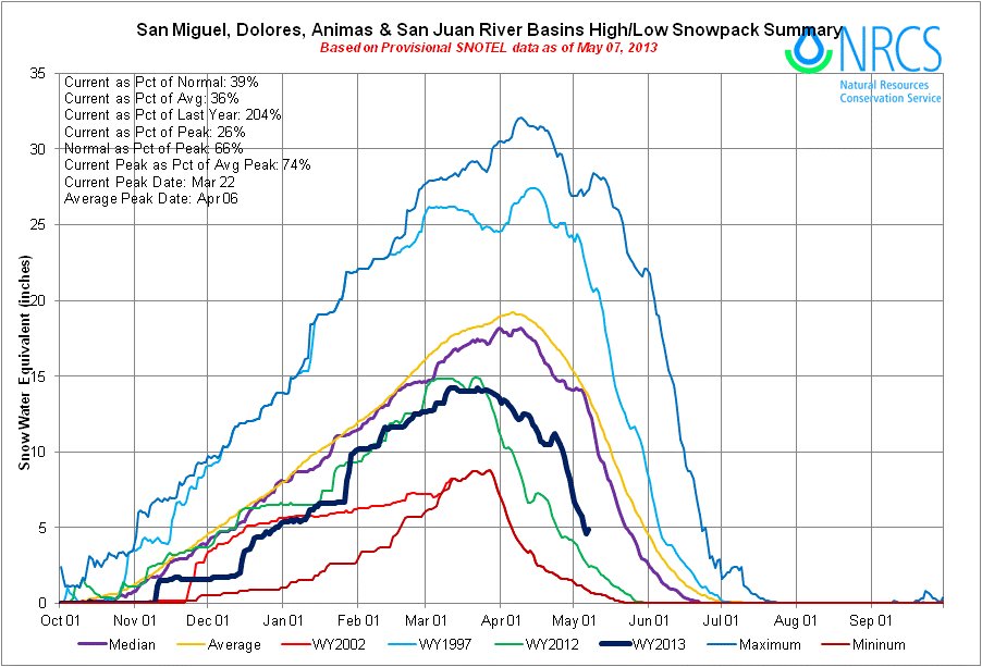
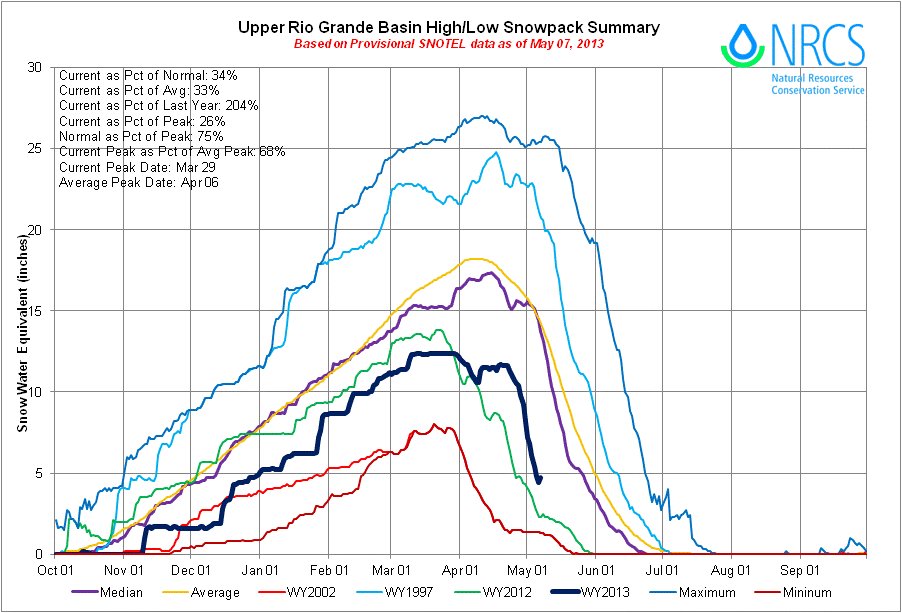
Click on the thumbnail graphics for the current statewide snowpack map along with the basin high/low graphs for the Upper Rio Grande and the San Miguel,Dolores, Animas and San Juan basins.
From The Pueblo Chieftain (Matt Hildner):
While the northern part of the state and parts of the Arkansas River basin were given reprieves by a string of April snowstorms, Mother Nature has been nothing but miserly to the Rio Grande basin. The snowpack report from the Natural Resources Conservation Service lists the basin’s snowpack at 40 percent of its normal peak at the end of April. “It’s not a good year at all,” Division Engineer Craig Cotten said Tuesday.
The federal agency also is forecasting a flow of only 225,000 acre-feet on the Rio Grande River from April to September. Should those forecasts hold, Cotten said this year would mark the fourth lowest flows on record for the Rio Grande since the state began recording them in 1889.
Forecasts are just as bad on the Conejos River in the southwestern corner of the San Luis Valley, where only 113,000 acre-feet are predicted through September.
The dreary numbers are mitigated slightly by the fact that this year’s runoff did not come as early as last year, giving irrigators a better chance to take advantage of them, Cotten said.
The dry forecast also means the state will not have to send much water downstream to satisfy the Rio Grande Compact, which governs how Colorado, New Mexico and Texas share the river. Cotten’s office projects that only 4 percent of the flows on the Rio Grande will need to be sent downstream, and the Conejos, which also has obligations under the compact, will have no delivery requirement.
Craig Cotten division engineer Dry weather is likely to remain, according to the National Weather Service’s Climate Prediction Center, which predicts a likelihood of below-normal precipitation from May through July in South-Central Colorado. The rest of May may hold a brief respite as the center is predicting a likelihood of above-normal precipitation.