

Click here to view the briefing. Spoiler: 47.7% of the U.S. is experiencing drought conditions
From the Summit County Citizens Voice (Bob Berwyn):
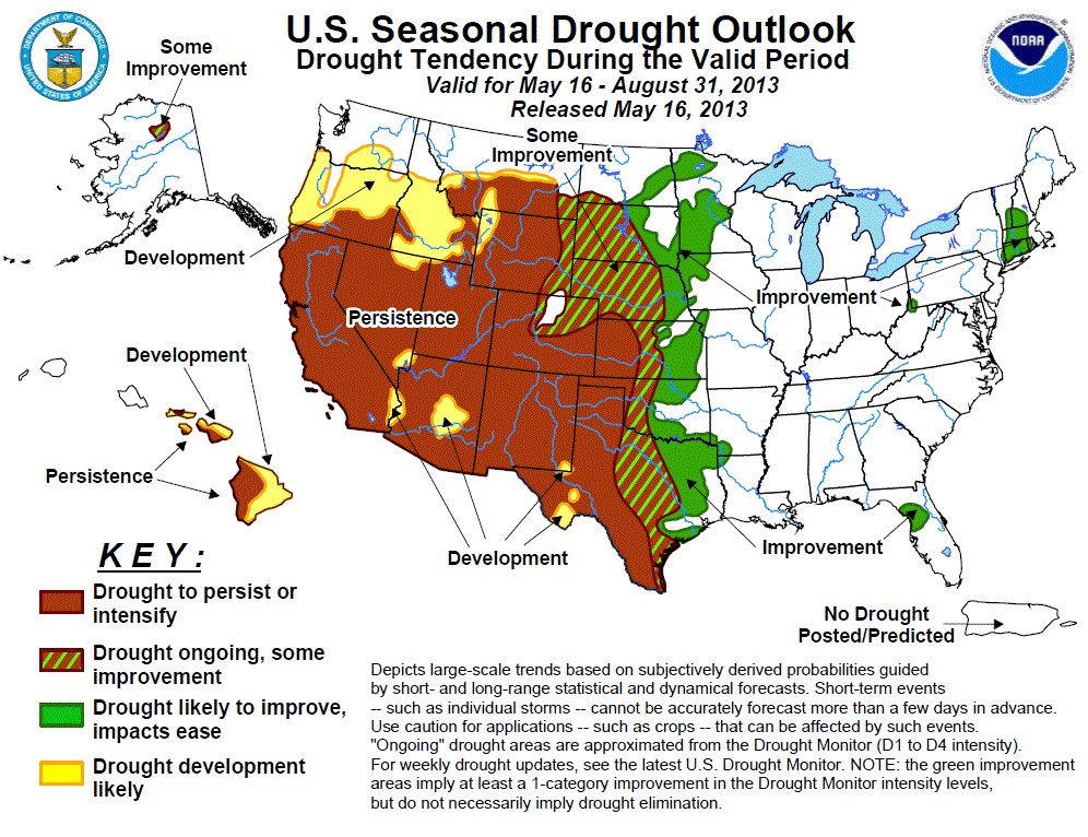
California has reported its driest year to-date on record, with only 27 percent of normal precipitation for January through April. That doesn’t bode well for the state’s water supplies, although at least reservoir storage is close to normal in California. New Mexico and Nevada are in bad shape when it comes to reservoir storage and there’s little relief in sight at the end of the snow season. Forecasters with the National Oceanic and Atmospheric Administration said dry soil conditions in the southwest could contribute to higher than average temperatures this summer. During the monthly climate briefing from the National Climatic Data Center, the experts said they expect drought conditions to persist and perhaps worsen stretching westward from West Texas through New Mexico, Arizona, Nevada and California. Drought persistence is also expected in southeastern Colorado, Oklahoma, Kansas and Nebraska. More moderate drought conditions prevail across South Dakota westward through Wyoming, southern Idaho and parts of Oregon.
From The Pueblo Chieftain (Chris Woodka):
The good news: Snow has begun to melt.
The bad news: The snow has begun to melt.
The spring runoff is not bringing much relief to the parched Arkansas Valley, as reservoir levels continue to drop and streamflow projections show little improvement. “More junior water rights will come into priority next week,” Water Division 2 Engineer Steve Witte told the Southeastern Colorado Water Conservancy District board Thursday.
That said, there was little good news for farmers. He could not say how long the rights would hold up, even though snowpacks have built up from mountain storms during the past month. The Bessemer, Oxford and High Line canals are running the last of their winter water stored over a record-low winter. Holbrook, Fort Lyon and Catlin have used all of theirs.
Running stored water has been problematic as well. The Buffalo Ditch, near the Kansas border, lost 56 percent of the water released from John Martin Dam, while Fort Lyon’s transit loss for water from Pueblo Dam was 35 percent.
The vast majority of wells in the valley remain curtailed, while ditches aren’t expecting much water.
“At this rate, we’ll be done by July 1,” said Dan Henrichs, superintendent of the High Line Canal. “There will be some water, but not enough to farm with.” Even with statewide snowpack near normal, and 83 percent in the Arkansas River basin, streamflow is expected to be just two-thirds of normal throughout the summer. Reservoir storage is half of normal in the basin, compared with 74 percent statewide.
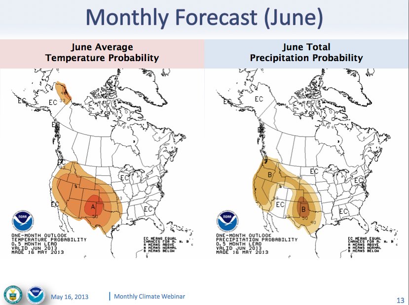
David Mau, head of the local U.S. Geological Survey office, said the outlook for the next three months is for higher than normal temperatures and lower precipitation. “Fire conditions have eased, but the next 30 days will determine if that holds,” Mau said. “Soil moisture has shown a slight improvement, but it’s very bad right now.”
From The Pueblo Chieftain (Chris Woodka):
Every drop counts.
Mountain snowstorms in April doubled the expected yield of the Fryingpan-Arkansas Project and have turned a bleak year for imports into a merely sub-par one. “I think that we’re very fortunate that we wound up with some extra water,” said Bill Long, president of the Southeastern Colorado Water Conservancy District.
The Bureau of Reclamation estimated on May 1 that 47,000 acre-feet of water will be brought over, meaning more than 37,000 acre-feet will be available for allocations. About 20,000 acre-feet will go to cities, and 17,000 to farms, a 54-46 split that has been shaped by years of complicated decisions.
But the Southeastern district will hold back 20 percent of that amount until mid-July just in case the yield falls short. And that’s a big concern in what has so far been a roller-coaster water year largely headed downhill. “I am concerned about a number of things,” said Jim Broderick, executive director of the district. “If the runoff comes too quickly, can we capture it? What are the limits to the Boustead Tunnel? Will we have the return flows for augmentation? . . . But, 37,000 is better than 12,000 acrefeet.”
Last year was the second-worst allocation in history, and this year was shaping up to be equally dismal. However, storms in April brought snowpack back to normal in the central and northern parts of the state — including the Fryingpan-Hunter watershed that the Southeastern district draws water from in the Upper Colorado River basin. The physical limitations of the Boustead Tunnel, coupled with legal obligations to leave water on the Western Slope, could reduce the yield of the Fry-Ark Project if runoff occurs rapidly. All indications are that it will melt fast as the weather is expected to be hotter and drier than usual through the end of July.
That’s not all of the story, said Roy Vaughan, manager of the Fry-Ark Project for the Bureau of Reclamation. “I’ve seen a good monsoon keep the tunnel full for three days,” he said, adding that much of the snowpack is at higher elevations not recorded by official measurements.
From the Sky-Hi Daily News (Reid Tulley):
The ice melt is a week or so behind when ice normally melts off of the area’s reservoirs due to colder temperatures during the beginning of May and late April, according to Noble Underbrink, Northern’s collection systems manager at the Farr Pump Plant on Lake Granby. The historical average date that ice is off of the area’s lakes and reservoirs is April 30, according to Underbrink. Willow Creek Reservoir and Lake Granby currently have no ice on them and the ice on Grand Lake and Shadow Mountain Reservoir is quickly depleting. In 2012, the lakes and reservoirs in the area were free of ice by April 9, and in 2011, ice was gone by May 8.