Snow water equivalent as a % of median November 22, 2013 via the NRCS
Upper Colorado River Basin High/Low Snowpack Summary, November 21, 2013 via the NRCS
South Platte River Basin High/Low Snowpack Summary, November 20, 2013 via the NRCS
Click on the thumbnail graphics above for the statewide map, Upper Colorado River Basin and South Platte Basin High/Low graphs. Click here for Mage Hultstrand’s (NRCS) presentation slides from Thursday’s Water Availability Task Force meeting (CWCB). She includes snowpack, precipitation and reservoir storage across the state. Kudos to Mage for her hard work!
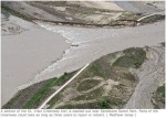
Glen Canyon High Flow Experiment November 2013 via Jonathan Thompson
Here’s a report about Reclamation’s High Flow experiment to fix river ecology through the Grand Canyon from Jonathan Thompson writing for the High Country News. Click through and read the whole thing. Here’s an excerpt:
I can stand for hours on the vertigo-inducing bridge that spans the cold, green Colorado just downstream – a 1,000-foot long steel spiderweb suspended gracefully over a 700-foot deep void – simply trying to comprehend Glen Canyon Dam’s concrete enormity: 300 feet thick at its base, 1,500 feet long at the crest. More than that, though, is what it represents: Our effort to control what was once a muddy, wild, tumultuous river, to rein it in with a colossal concrete plug, holding back billions of gallons of water and flooding hundreds of miles of once-sublime canyons.
Glen Canyon Dam’s power to bewilder – on both sensory and conceptual levels – was enhanced this past week as massive amounts of water were released from the dam to mimic natural floods and hopefully bolster the Grand Canyon ecology and beaches that were forever altered by the dam. Call it a simulated Niagara Falls or, better yet, a several-day-long opening of one of the biggest faucets in the world – gargantuan plumbing, if you will.
I happened to be driving through Page as the big water was being released, so I parked in the dam’s visitor center parking lot, and as soon as I opened the car door I could not only hear, but could also feel the roar emanating from 800 feet below, down at the bottom of the dam, where four giant nozzles sprayed streams of white into the green water of the river, churning it all up into a violent froth. A few days earlier, about 7,000 cubic feet of water was being released from the dam each second, through the hydroelectric turbines. During the flood, that increased to 35,000 cfs, or some 13 million gallons per minute, blasting into the river via the turbines and the nozzles. It was a good time to be rafting the Grand Canyon…
If the dam’s enormity is a symbol of our ability to control nature, then the bathtub ring is an equally potent symbol of how slippery our grasp really is. It shows us how fickle our climate can be, and how our hugest efforts can merely temporarily mitigate the impacts of that fickleness. And it shows us how our very efforts to dominate the planet have gone awry, causing our already unpredictable environment to get even more wild and uncontrollable. Even the massive dam, just one piece of the huge plumbing system that we have constructed up and down the Colorado River drainage, can’t completely fix the arid truth any more than water managers’ prayers for more rain and snow next year.
From the Cañon City Daily Record (Christy Steadman):
Jennifer Opila, Radioactive Materials Unit Leader for the CDPHE, explained how the 1988 pumpback system at Cotter functions. Opila said the cause of the Nov. 5 spill was that a joint in the pipeline of the pumpback system broke. She described it as a “catastrophic break,” meaning it was not a “slow and seeping” spill.
Opila said employees found “water coming out of the ground” just north of well No. 333 and “that’s how they knew the pipe had ruptured.”
According to Cotter’s Environmental Coordinator/Radiation Safety Officer Jim Cain, the spill was measured within a 12-hour window and based on inspection times and flow, an estimated 4,000 to 9,000 gallons of water was spilled. A water sample was collected and the analysis reported that .03 pounds of uranium and .15 pounds of molybdenum was found, according to Cain.
Cotter made the required oral report of the spill and provided a requested written report, Opila said, and the pipe was repaired and operable by the next day.
The pipeline is three feet underground and consists of 3,856 linear feet of six-inch schedule 90 PVC pipe and 3,053 linear feet of four-inch schedule 90 PVC pipe.
Vice President of Cotter Mill Operations John Hamrick said there have been three leaks “in three different years, all for different reasons.”
More Lincoln Park/Cotter Mill superfund site coverage here and here.
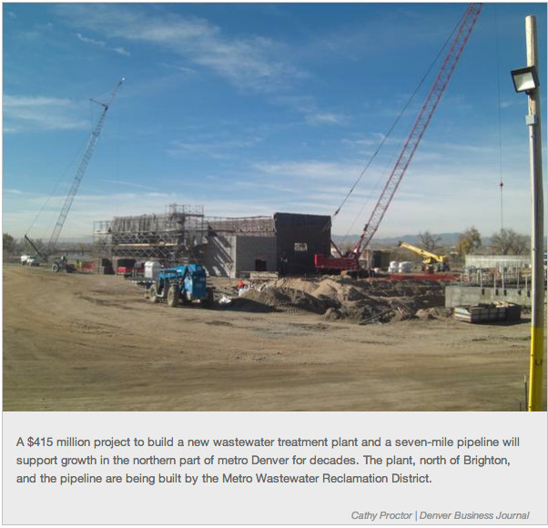
Today, members of the United States House of Representatives introduced the Water Protection and Reinvestment Trust Fund Act of 2013.
The bipartisan bill would provide a small, deficit-neutral, protected source of revenue to help states replace, repair and rehabilitate critical wastewater treatment facilities by creating a voluntary labeling and contributory system to which businesses that rely on a clean water source could opt-in.
Representative Earl Blumenauer (OR-03) along with Representatives Tim Bishop (NY-01), John Duncan (TN-02), Donna F. Edwards (MD-04) Richard Hanna (NY-22), Jim Moran (VA-08), Tom Petri (WI-06), and Ed Whitfield (KY-01) introduced the bill.
While it would take over $9.3 billion a year to maintain a clean-water infrastructure, funding has averaged just over $1.25 billion a year since 2000. The American Society of Civil Engineers (ASCE) has given U.S. wastewater infrastructure a grade of “D” in their most recent report card. Last year alone, American communities suffered more than 310,000 water main breaks and saw overflowing combined sewer systems, causing contamination, property damage, disruptions in the water supply, and massive traffic jams.
Here’s the release from US Senator Michael Bennet’s office:
Colorado U.S. Senator Michael Bennet today announced that the Silverton-based San Juan County Historical Society’s small hydro project would be allowed to move forward without undergoing the burdensome and expensive federal permitting process thanks to the Hydropower Regulator Efficiency Act. The bill, which Bennet cosponsored, cuts red tape for noncontroversial hydro projects that are less than 5 megawatts.
The Federal Energy Regulatory Commission officially announced last night that the project would not be subject to the federal permitting process, thanks to the bill, which passed Congress unanimously in August. As a result, the 11-kilowatt Silverton project will be the first small hydro project in the state, and one of the first in the nation to take advantage of this streamlined system.
“The Hydropower industry has tremendous potential to stimulate economic growth and job creation in Colorado,” Bennet said. “This common-sense bipartisan bill removes unnecessary regulations to help small projects like this one get up and running in communities across the state. We should continue to look for ways to cut through red tape and promote these types of clean, cost-effective energy sources.”
“The Feds had previously said that our project needed to apply for a hydropower license, but requiring a federal license for a tiny, non-controversial hydro project on an existing pipeline didn’t make sense,” Beverly Rich, Chair of the San Juan County Historical Society, said. The Historical Society operates the Mayflower Mill site where the new hydropower project is being built. “We’re grateful to Senator Bennet for helping us cut through this red tape.”
In addition to Silverton, projects in Telluride and Orchard City are working to take advantage of this reform under the new law.
The Hydropower Improvement Act was a companion bill to H.R. 267, the Hydropower Regulatory Efficiency Act of 2013, sponsored by Reps. Diana DeGette (D-CO) and Cathy McMorris-Rogers (R-WA).
Background Info on the Hydropower Regulatory Efficiency Act:
Prior to the new law, the costly federal permitting requirements had been a barrier to entry for small hydropower developments. In many cases, the cost of federal permitting exceeded the cost of the hydro equipment.
The Hydropower Regulatory Efficiency Act solves this problem by creating a “regulatory off-ramp” from permitting requirements for small, non-controversial hydro projects on existing conduits, such as pipelines and canals. It doesn’t change any underlying federal or state environmental statute, it simply streamlines the federal approval process.
The Colorado Small Hydro Association estimates that 100 MW of new hydro development in the state could mean 500 new jobs in various fields including developers, engineers, plumbers, carpenters, and others.
For more details on the Silverton hydro project, feel free to call Beverly Rich, Chair of the San Juan County Historical Society, at 970-387-5488.
More San Juan Historical Society coverage here. More H.R. 267 coverage here. More hydroelectric coverage here.
Bicycling the Colorado National Monument, Grand Valley in the distance via Colorado.com
Here’s the release from the Ute Water Conservancy District (Joseph R. Burtard):
Ute Water Conservancy District’s 14 Member Board of Directors voted unanimously to raise the District’s water rates and tap fees for 2014. Ute Water provides domestic water to over 80,000 people in Mesa County, making it the largest domestic water provider between Denver, Colorado and Salt Lake City, Utah.
The District completed a Raw Water Study in 2011 which identified future water needs based on the estimated population growth and multi-year drought protection in the Grand Valley. This study projected that by 2045, Ute Water will be serving a population of 197,000 consumers. In order to meet the projected demands of 80 gallons per capita per day, the District will need 21,400 acre-feet of additional water supply. The District’s Board has taken a proactive approach, based on the outcome of the study, to insure that appropriate infrastructure, technology and raw water supply will be in place to meet future domestic water demands in the Grand Valley.
The District entered into a Financial Agreement, earlier this year, with the United States Department of the Interior Bureau of Reclamation to purchase water stored in Ruedi Reservoir. This agreement initiated the largest single water purchase the District has made in its 57-year history. This Financial Agreement allowed Ute Water to purchase 12,000 acre-foot of water from Ruedi Reservoir for $1,297.90 an acre-foot. “The District will utilize this water as a reliable insurance policy for the Grand Valley. An investment that will allow the District to meet the future water needs of the Grand Valley while giving us a dependable source of water during drought conditions.” stated Joseph Burtard, spokesperson for Ute Water. Ruedi Reservoir is a 102,000 acre-feet reservoir which sits 15 miles above the town of Basalt, Colorado. Ruedi was constructed in 1968 as part of the Federal Reclamation’s “Fryingpan-Arkansas Project”.
Ute Water utilizes a full-cost pricing approach when evaluating water rates each year. The District’s primary source of revenue is water sales. The revenue from water sales are expected to cover all operations, maintenance and the replacement cost of the existing infrastructure while preparing for the future demands and upgrades to the system. “Purchasing Ruedi water was a major capital investment for the District. As a result, our water rates and tap fees had to be evaluated and aligned with our operational costs and targeted reserves.” stated Burtard. The new water rate increases the $17.00 minimum, for the first 3,000 gallons of water, to a $19.00 minimum. The minimum water rate for all other tap sizes will also increase proportionally. Customers using over 3,000 gallons in a billing cycle will see a $.10 increase in each of the tiers. The new water rates will be for water delivered in December 2013 and billed after January 1, 2014. Effective January 1, 2014, the District’s tap fees will increase from $6,500 to $6,700.
For additional information on Ute Water’s rate increase, please contact Joseph Burtard at Ute Water Conservancy District at (970) 242-7491 or visit the District’s website at http://www.utewater.og.
FromThe Grand Junction Daily Sentinel (Duffy Hayes):
For the second year in a row, Ute Water users will see an uptick in the amount they pay for the service. Ute Water’s board unanimously adopted an increase in the district’s water rates at a recent meeting, similar to a rise in rates last year. Both increases are being attributed to a recent $15.5 million purchase of more than 12,000 acre-feet of water from Ruedi Reservoir near Aspen.
“We were trying to build up our reserves to purchase Ruedi (last year), and now that we have purchased it, we kind of need to replenish those reserves for capital projects,” said Joe Burtard, external affairs manager for the Ute Water Conservancy District. He further called the Ruedi purchase a “hidden gem” in terms of the cost of the purchase as compared with others in the industry.
In practical terms, Ute Water customers who use less than 3,000 gallons a month will see their bill go from $17 to $19. For larger-scale users, $.10 will be added to the cost per tier of usage, officials said.
Ute’s tiered system of billing for higher-use customers is in place for a reason, Burtard said.
“That’s our way of enforcing conservation. We do have a fairly aggressive rate structure, but that’s because we live in a desert, and we don’t want people using treated water for outdoor use,” he said.
The rate increase will happen for water delivered in December, appearing on users’ January billing statements. Also after the first of the year, tap fees will go up $200 to $6,700.
In announcing the rate hike, Ute said that a 2011 study pegged the district’s future customer base at 197,000 customers by 2045, up significantly from the 80,000 people it serves today.
The Ruedi water sale represented the largest single purchase made by the district over its entire 57-year history, according to a press release.
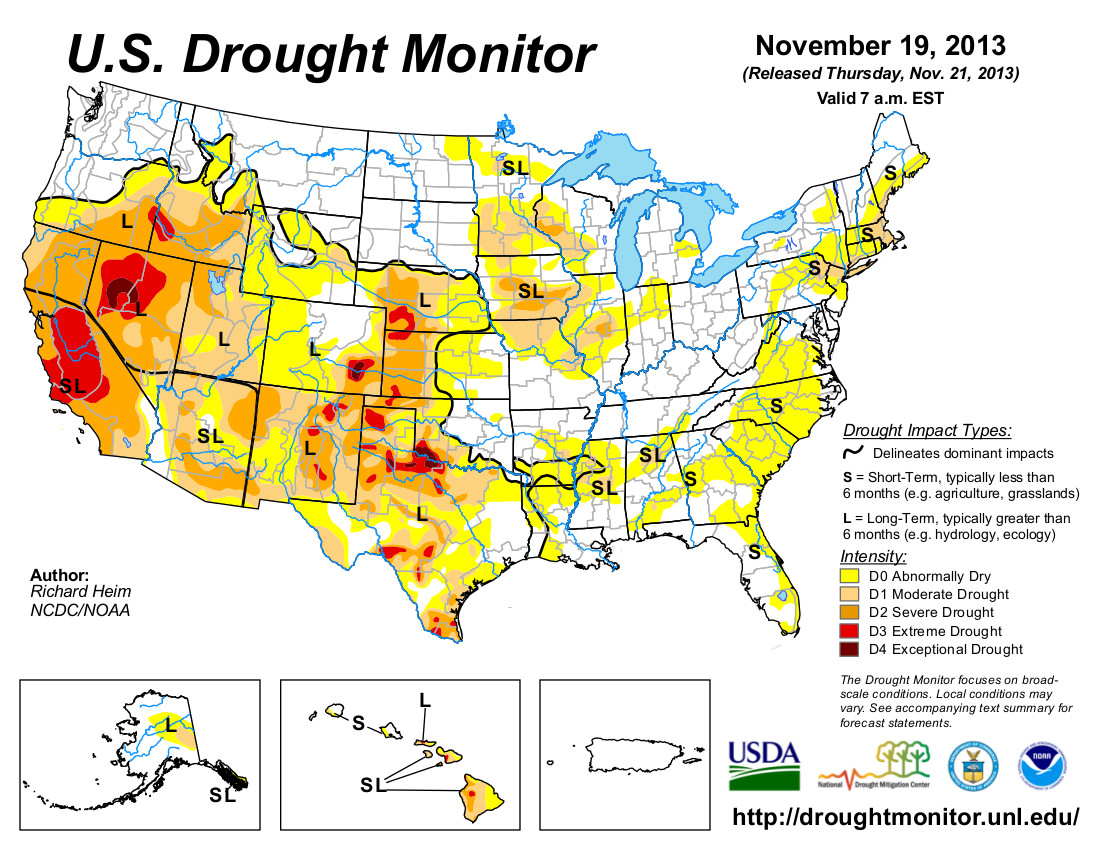
Click here to go to the US Drought Monitor website. Here’s an excerpt:
The Plains
The frontal system dropped half an inch of moisture across parts of the northern Plains this week, but the southern parts were dry. D0 expanded across central to eastern Kansas to reflect the meteorological dryness of the last 3 weeks (low humidity, high winds and limited precipitation) to 90 days (below-normal precipitation) and developing hydrological/agricultural impacts (stock ponds are losing ground and winter wheat is beginning to be negatively affected). In Oklahoma, D1 expanded in the northwest and D2-D4 in the southwest to reflect continued dryness and low soil moisture.
The West
According to November 19 SNOTEL station observations, snow water content in the Washington Cascades to northern and central Rockies was above normal, but this is the start of the wet season when normals are low. In spite of this week’s precipitation in the Pacific Northwest and northern Rockies, water year-to-date (October 1 to present) precipitation remained below normal for much of the West, except for parts of northwestern Montana to Colorado where it was near to above normal. The Southwest (and California) has been especially dry since the summer monsoon ended. In California’s San Joaquin Valley, the city of Bakersfield has moved completely to ground water supplies due to the dry conditions and lack of surface water. Reservoirs are approaching 70% of average capacity. According to local National Weather Service experts, this level has historically been one of the measures of statewide drought, especially with precipitation being historically low for the calendar year. Some of those reservoirs should be near operational thresholds for low water. Consequently, D3 expanded into the San Joaquin Valley to reflect these impacts. In New Mexico, D0-D1 expanded in the south to reflect recent dryness, and D3 expanded in the northeast to reflect persistent dryness from the year to date. In Arizona, D0 and D1 expanded to reflect recent dryness, and the SL impacts boundary was shifted east to cover much of California and Arizona.
Looking Ahead
The NWS HPC 7-Day Quantitative Precipitation Forecast (QPF) calls for a frontal system to bring an inch or more of precipitation across much of the Southwest, and from the southern Plains (east Texas and southeast Oklahoma), across the Southeast, and to the Mid-Atlantic through November 27. Little to no precipitation is forecast for the Pacific Northwest to northern Plains. Temperatures will be below normal as the front moves across the country. The 6-10 day and 8-14 day outlooks project above-normal temperatures across much of the West and Alaska, and below-normal temperatures in the Southwest and most of the country east of the Rockies, as a circulation pattern sets up consisting of a warm ridge in the west and cold trough in the east. Drier-than-normal conditions are expected for much of the West to the Ohio Valley, west-central Alaska, and the western Aleutians, with wetter-than-normal conditions across the Gulf of Mexico coast, Atlantic seaboard, and the rest of Alaska.
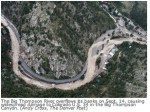
Johnny Olsen oversaw much of the repairs for the Colorado Department of Transportation.
“When you think about it and you drive it, you won’t see it because they did such an amazing job. But about 60 percent of our roadway was lost,” he said.
In some ways the repaired road looks better than it did before—both lanes completely accessible and fully paved. But alongside the road you can see just how destructive the floodwaters were. Homes like this one are still severely damaged…
In Estes Park, Mayor Bill Pinkham says business has been slow at his end of the canyon, too. That’s despite the state paying to keep Rocky Mountain National Park open during the government shut down. For now, Pinkham is focusing on the positive—and the future.
“The restaurants are open, the stores are open, and we’re ready to celebrate the holidays,” he said.
During this morning’s ceremony Hickenlooper and other local leaders painted part of a yellow stripe on the road. The highway reopening is especially welcome news for Estes Park, which is hoping to boost visitations during the Thanksgiving holiday weekend.
About a dozen town administrators and a few volunteers packed up the maps that covered the library bookshelves and moved them back to [Lyons] Town Hall, which underwent extensive cleanup and repairs following flooding in September.
“It feels like a little normalcy to us, or at least a baby step toward that,” said Arianne Powell, who is in charge of accounts payable and customer service for the town of Lyons.
During the past two months, the original Town Hall building, 432 Fifth Ave., got new carpet and tile, Sheetrock and paint. Construction was being completed when employees arrived with boxes at 8 a.m. Thursday.
In a symbolic gesture during a day full of symbolism, the mayors of Loveland and Estes Park hugged at Thursday’s ceremony celebrating the opening of the vital U.S. 34 link between the cities.
Despite the bitter cold and falling snow, the mood was upbeat for the event outside the Big Thompson Canyon Volunteer Fire Department station in Drake.
With “Love Don’t Die” by Colorado band The Fray providing the soundtrack, scores of highway workers celebrated, officials gave speeches and Gov. John Hickenlooper helped paint the final stripes down the middle of the highway that was rebuilt after September’s flood…
With U.S. 34 running through Loveland up to Estes Park, Loveland mayor Gutierrez said his city considers itself the gateway to Rocky Mountain National Park. He thanked everyone responsible for reopening that gateway.
“When people start driving this road, they are not going to be impressed,” he said, “because they will not have seen what you started with.”
What the Colorado Department of Transportation, contractor Kiewit Infrastructure and many local subcontractors started with was an 18-mile stretch of canyon roadway that needed repair or rebuilding on 70 percent of its length.
To drivers getting their first look at the rebuilt road, the new temporary U.S. 34 looks much like the old highway – paved the entire way, with passing lanes and shoulders in places.
“To get this done in 10 weeks is amazing,” said [Governor Hickenlooper], who pledged in the first days after the flood that the state would build temporary roads on every destroyed highway route.
Big Thompson Canyon Fire Department Chief Bill Lundquist, one of the last canyon residents to be evacuated by helicopter, said those who braved the snow to drive on U.S. 34 Thursday will never really know what it looked like. To him, that’s a testament to the swift and high-quality work performed by road construction crews.
We flew out up over Drake and through the canyon, and we really thought it was going to be a year before we got back here,” said Lundquist, 54. “But they put this highway back together in two months. It’s so important to have it back. What it really means to most people in this community is that they can go home. That’s big.”
Lundquist added that, before the highway reopened, his department had trouble responding to even the smallest of incidents.
“We’ve got to cover our district, and this highway is essential to that. Even if we had a house fire, the only way we could fight it would be with buckets from a helicopter,” he said.
The highway’s reopening is equally vital to local businesses. Many of the ones lucky enough to have survived the flood have still been on life support for the last two months.
Here’s a guest column blasting the bill from Matt Rice writing for Steamboat Today:
Last month, Representatives Scott Tipton, R-Colo., and Jared Polis, D-Colo., introduced H.R. 3189, the so called “Water Rights Protection Act.” While the bill was disguised as a minor “fix” for a narrow water rights conflict between Colorado’s ski industry and the U.S. Forest Service, it is in fact a sweeping attempt to stop federal agencies from protecting fish, wildlife and recreation on our public lands.
If passed, the bill would allow private water users across the country to dry up rivers on public lands with impunity. It would prevent federal agencies within the Department of Agriculture and the Department of Interior from protecting fish, wildlife and river recreation.
For instance, in Colorado, this could prohibit the Forest Service from requiring water diverters to leave some water in streams on National Forests to keep native cutthroat trout alive. It could also stop the Fish and Wildlife Service from requiring flows that help salmon find fish ladders so that they can safely pass over dams. It would potentially destroy broadly supported multi-year and multi-million dollar settlement agreements to restore American shad, salmon and steelhead fisheries at hydropower facilities. It even undermines fundamental principles of states’ rights by creating a new federal definition of a water right. At the very least, it would create mountains and mountains of litigation.
The House Natural Resources Committee held the only hearing on this bill during the government shutdown, preventing agencies from providing input on how it would affect public lands. When the Departments of Interior and Agriculture did weigh in, they strongly opposed the bill. They were joined by leading Democrats on the House Natural Resource Committee and more than 60 conservation and recreation groups, including American Rivers, American Whitewater, Trout Unlimited, Defenders of Wildlife, the Sierra Club and National Parks Conservation Association.
We understand that the ski industry has a legitimate need for certainty about their water rights for snowmaking. But they don’t need this bill to provide that certainty. Last week, thanks to the leadership of Senator Mark Udall, the U.S. Forest Service pledged to quickly resolve the dispute over water rights on national forest land in Colorado, protecting rivers on public lands and upholding important principles of water law. This bill is not necessary, and the ski industry has conceded as much. Yet this supposedly “green” industry has inexplicably doubled down and reaffirmed their support for an agenda of preventing federal agencies from protecting our rivers and public lands.
As the list of the bill’s supporters makes clear, this effort is being driven primarily by the farm lobby. We are puzzled why the ski industry — which goes to such great lengths to tout its environmental sustainability bona fides — would continue to give cover to big ag by supporting a bill that would do so much damage to our nation’s rivers, particularly when the problem the bill purports to address has already been solved.
We encourage your readers to call Steamboat Ski Area and ask them why they support this attack on fish, wildlife and river recreation.
More water law coverage here. More NSAA vs USFS coverage here.
A plan by a private water developer to build a reservoir east of Pueblo has been put on hold.
“We’re not building a reservoir at this time,” said John McKowen, CEO of the Two Rivers Water & Farming Co. “Our immediate need right now is augmentation water. It’s primary to the support of our farms.”
Two Rivers has a lease for water from the Pueblo Board of Water Works. McKowen did not specify which other sources of water he would pursue.
“We plan to work with all of the partners we can,” he said.
The Colorado Water Conservation Board this week deauthorized a $10 million loan it granted to Two Rivers on May 14. Two Rivers requested the action Oct. 2.
“We are writing to inform you that due to timing issues outside of our control, it is in Two Rivers’ best interest to deauthorize this loan,” Two Rivers CFO Wayne Harding wrote in a letter to the CWCB.
Two Rivers has not completely given up on a plan to build the reservoir on Southwest Farms property, but will put off the plan for several years. The reservoir site is on the Excelsior Ditch. In August, Two Rivers broke off negotiations with the Arkansas Groundwater Users Association to purchase its majority interest in the ditch. Earlier this year, Two Rivers partnered with AGUA by making some of its leased water available for well augmentation plans.
Colorado Parks and Wildlife is pursuing plans to develop a reservoir on a site just east of Southwest Farms, also on the Excelsior Ditch.
Stonewall Springs LLC owns the other reservoir site, and is the only other shareholder on the Excelsior Ditch. Reservoirs on the Excelsior Ditch would be useful to Colorado Springs, Aurora and Pueblo to recapture water bypassed to support the Pueblo flow program. The location is ideal because there are existing headgates and a system could be operated with gravity flow.
FromThe Grand Junction Daily Sentinel (Dennis Webb):
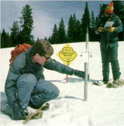
The Natural Resources Conservation Service says it has dropped consideration of reducing the number of Colorado snow survey sites this winter, an idea that had been driven by budget cuts. The idea had drawn criticism from water managers and from U.S. Sens. Mark Udall and Michael Bennet, D-Colo., and U.S. Rep. Scott Tipton, R-Cortez.
Phyllis Ann Philipps, state conservationist in Colorado for the NRCS, told water interests in an Oct. 22 letter that it might be necessary to reduce the number of manual “snow course” measurement sites in the state, following a 15 percent reduction to the agency’s Snow Survey Program for the 2013 fiscal year and anticipated further budget restrictions due to sequestration. Automated sites using telemetry “will be maintained,” she said in the letter, which invited interested parties to an Oct. 28 public meeting on the issue.
“We’re going to continue the manual snow course measurements as recommended by the public forum,” William Shoup, acting snow survey supervisor in Colorado for the NRCS, said Tuesday.
He said the agency would detail its decision in another meeting Thursday.
Chris Treese, external affairs director for the Colorado River District, said that through congressional offices and other voices, “the message has been communicated and the NRCS and the (U.S. Department of Agriculture) are convinced that this isn’t the place that they need to cut.”
Udall spokesman Mike Saccone said Tuesday his office hadn’t been able to confirm the agency’s decision to back off the idea, but if it’s the case it’s welcome news. “Water is critically important to our water providers and certainly those managers on the Western Slope. … If true, this is a big victory for the Western Slope and the people of Colorado,” he said.
Udall, Bennet and Tipton jointly signed a letter to the Department of Agriculture Friday calling on the department and NRCS to make the manual sites a budget priority.
“In the face of prolonged drought, significant population growth and climate change, NRCS’ snow program data provides vital information on precipitation and future water supplies essential for Colorado and the entire American West,” their letter said.
They said snowpack can vary widely from basin to basin, and accurate measurements in each basin using both automated and manual data are “essential for water districts and municipalities to meet the demands of competing users.”
They also said the automated sites “can often face mechanical failure mid-winter, leaving the manual snow courses as the only sources of reliable data to meet local demands and interstate compact deliveries.”
The program has 104 manual snow survey sites in Colorado. Treese said some sit alongside automated sites and are used to double-check the automated operations and adjust or maintain them as needed. Some manual sites have been used for many decades.
“We wouldn’t want to lose that longevity, that time series of information,” he said.
Treese said the snowpack data help water managers plan for spring runoff and have reservoirs release or hold on to water depending on anticipated inflow. It aids in fulfilling water rights obligations and in managing river levels for purposes such as flood avoidance and helping endangered fish.
Shoup said the reduction in manual sites never reached the point of being a proposal by the NRCS. It simply was brought forward for discussion given the budget situation and the fact that data from some of the manual sites isn’t being used in water supply forecasting by the agency’s National Water and Climate Center in Portland, Ore., he said.
But he agreed about the importance of the long-term, historical data being generated by sites that in some cases date back to the 1800s. Those sites provide important information pertaining long-term climate change and the runoff impacts of dust on snow, he said. “There’s just a lot of different historical records that we find are very important,” he said.
He said he’s found ways to continue data collection from all the sites for less money through changes in how the operation is managed. For example, staff working in data collection at the agency’s Denver office also will be deployed into the field for measurements at Front Range sites, rather than paying NRCS field staff for that work.
Shoup said that while all the manual measurements will continue this year, he can’t speak to future years because it all depends on how much funding NRCS gets from Congress.
We’re hearing a lot about the Colorado Water Plan these days. What does it mean for our state, and especially for our headwaters counties? Because approximately 80 percent of the state’s water comes from the Western Slope, and about that same percentage of the population lives east of the Continental Divide, we have a vested interest in the plan’s process and outcomes.
Why a water plan? Based on predictions for population doubling by 2030 and growing demands for water throughout the arid West, Gov. John Hickenlooper assumes there is a coming gap between the demand for water and available supply, and has directed his staff to develop a plan for the future.
Five factors that must inform the Colorado Water Plan are: advances in “smart” land use planning and development; unrealistic estimates of water availability (and there really isn’t any “new” water); the interdependence of water in the stream and our lives and livelihoods in the headwaters and Western Slope; the importance of conservation and re-use of water to meeting demand; and the imperative of working together rather than independently throughout our river basins to develop a workable plan.
We’ve learned a lot from the recent decades of growth: Local governments know the cost of sprawl and are increasingly instituting advanced land use planning that reflects our dry climate and water-short conditions. Colorado’s Water Plan should take into account these advances when estimating future demand for water. We don’t have to assume that new development and population distributions will or should mimic the patterns of the past 30 years.
Past estimates of the water available for future growth may be overstated, especially water from the Colorado River Basin. For example, the Bureau of Reclamation announced this year that it will reduce the amount of water released from Lake Powell in 2014 to the lowest annual release since filling Lake Powell in 1968. Estimates of available water must be revisited in the water plan.
The Colorado Water Plan must not require some areas of the state to sacrifice their economy, environment, and quality of life to become the water supply for other parts of the state. Impacts of transmountain water diversion projects can be devastating. In Eagle County, we are hyper-vigilant in protecting our water quality and quantity, agriculture, open space, and water/snow-dependent recreation. We also understand that the Front Range needs water for future growth, and have initiated historic agreements with major Front Range water providers.
The Colorado Water Plan should encourage Front Range local governments to narrow the gap between predicted supply and demand through smart growth practices, conservation, and reuse before looking to other areas for additional supply.
Finally, the current planning process charges water leaders in each river basin with independently defining their basin’s future need for water through a roundtable process. As each roundtable works alone, we run the risk of Front Range roundtables planning on water supply that either doesn’t exist, or that other roundtables have planned for their own local needs.
Perhaps most important, the people of Colorado have a seat at the table if their local elected officials are brought into the water plan process. It is critical that local government land use plans and authority throughout the state be respected. Sessions of the Interbasin Compact Committee should allow for public comment and discussion, and roundtables should encourage dialogue among diverse perspectives. We need an opportunity to understand each other’s views and seek common ground. Only then will Colorado be able to join together in a water plan that addresses our water supply needs.
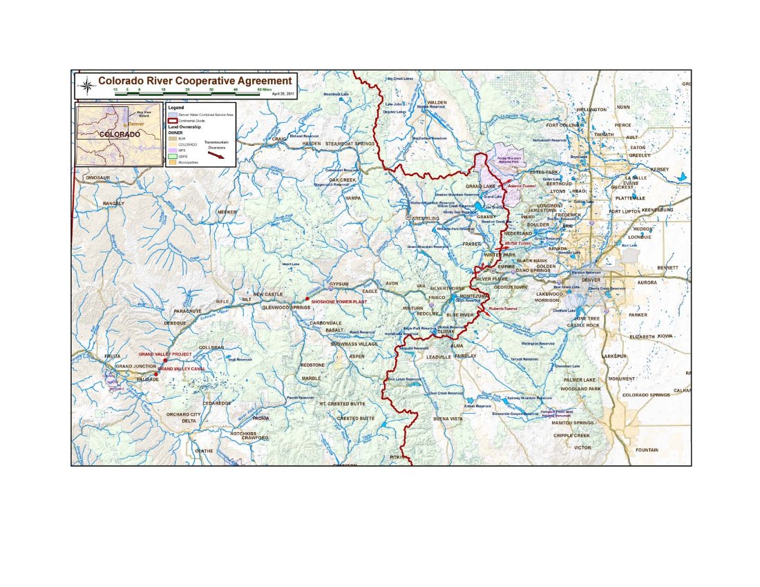
The Colorado River Cooperative Agreement (CRCA) is now fully executed with final approval coming from irrigators and water suppliers in the Grand Valley, General Counsel Peter Fleming reported to the Colorado River District Board of Directors.
The CRCA creates a long-term partnership between Denver Water and 42 entities on the West Slope. The agreement is a framework for numerous actions by the parties to benefit water supply, water quality, recreation and the environment on both sides of the Continental Divide.
It is the direct result of Denver Water’s desire to expand its Moffat Tunnel transmountain water supply from the Fraser River in Grand County and to enlarge Gross Reservoir in Boulder County. While that project is still being permitted, the CRCA represents an enhancement of beneficial actions beyond mitigation yet to be spelled out in the record of decision.
Negotiations on the CRCA concluded in early 2011 and the engaged parties began their approvals. The Grand Valley entities, however, waited until they were satisfied that federal and state reviews of Green Mountain Reservoir and Shoshone Hydro Plant aspects in the agreement were finished and the agreement could be implemented as envisioned.
The CRCA also means the West Slope will not oppose permitting of the Moffat Project. [ed. emphasis mine]
The Colorado River Cooperative Agreement (CRCA) begins a long-term partnership between Denver Water and the West Slope. The agreement is a framework for numerous actions by the parties to benefit water supply, water quality, recreation, and the environment on both sides of the Continental Divide.
More Colorado River Cooperative Agreement coverage here.
A district committed to keeping water in the Lower Arkansas Valley has joined a network that provides real-time water quality data on the Arkansas River from Leadville to the Kansas state line. The Lower Arkansas Valley Water Conservancy District board Wednesday approved spending $34,000 in the next year to help operate stream gauges and gather information from wells below John Martin Reservoir. The information is widely available on the Internet. The district’s contribution will be matched by $17,000 in federal funds from the U.S. Geological Survey.
“The focus is on the reach from Pueblo to the state line,” said David Mau, head of the Pueblo USGS office.
The Southeastern Colorado Water Conservancy District, Pueblo Board of Water Works and St. Charles Mesa Water District also participate in the program.
Measurements track salinity and temperature of water in the river, as well as groundwater levels. The information provides a baseline that allows water users to track changing water conditions from either natural causes or new uses along the river, Mau said.
Past measurements show salinity increases when water levels are low and as water moves downstream. Crowley County board member Jim Valiant asked if selenium also will be studied. Mau replied that selenium is studied, but not as a part of this project.
Water temperature varies most by the time of year, but can increase when levels are low. Mau said the information is valuable to track fish habitat and to establish the relationship between surface flows and groundwater. Water levels are tracked in 130 wells along the river, some with more than 50 years of data to provide historic comparison.
The board enthusiastically supported the study, and encouraged Mau to provide more frequent updates.
“We need to keep up with the information,” said Leroy Mauch, a board member from Prowers County.
Ponds that feed irrigation systems in the Lower Arkansas Valley are leaking twice as much as farmers are given credit for, a study is showing. But farmers will have to wait another year for the study to be completed before they can even begin to hope for a change in the state’s formula. In the meantime, those who measure the water coming into and leaving the ponds will be able to apply that to state calculations for replacement of water under surface consumption rules.
The Lower Arkansas Valley Water Conservancy District is sponsoring a two-year study of pond leakage for farmers who use the ponds to collect water for use in sprinkler systems. There are 26 ponds in the study, but there have been problems with the timing of measurements and malfunctioning meters on some of the ponds. The amount of leakage is complicated to measure, depending on the size of ponds, soil conditions, how often the ponds are filled and lag time for water to return to the river, said consultant Brian Lauritsen.
This year, the state’s model showed leakage of about 8 percent on the ponds, while measurements averaged about 18 percent, said Bill Tyner, assistant division engineer for the Colorado Division of Water Resources. Individual ponds ranged from 2-40 percent leakage. “We’re giving credit for any pond with a meter,” Tyner said.
Farmers have joined Rule 10 group plans set up by the Lower Ark district that allow them to account for sprinkler systems fed by surface water supplies. The Lower Ark provides replacement water, but farmers must pay to join and use the plan.
They’re not happy.
“It’s ironic that we go through all these numbers and nitpick them,” said Lamar farmer Dale Mauch. “But no one ever looks at flood ground, and the HI model isn’t even close.”
The Hydrologic-Institutional model was adopted as part of the U.S. Supreme Court case Kansas v. Colorado over the Arkansas River Compact.
A conservation easement on the Bessemer Ditch will preserve 105 acres in farmland. The Lower Arkansas Valley Water Conservancy District accepted the easement Wednesday. The board uses such easements as part of its mission to keep water in the Lower Ark Valley. It is the custodian for more than 50 easements. Typically, property owners pay for the easement, which undergoes periodic inspections, and are eligible for state and federal tax benefits.
The Bessemer Ditch farm is owned by the Wild Rose Ranch Inc., which is a company formed by the Wally Stealey family. It is located on 43rd Lane and has about 35 shares of Bessemer Ditch water, explained Bill Hancock, who manages conservation programs for the Lower Ark district.
Each share of the Bessemer Ditch provides enough water to irrigate an acre in an average year.
Most of the land is a reclaimed gravel pit or used for pasture land and has not fared well during the drought. An area beneficial to wildlife, Six Mile Creek, crosses the property, Hancock said.
Stealey has donated other easements on the Wild Rose Ranch in Fremont County to the Lower Ark District in the past.
The board voted unanimously to accept the conservation easement.
More Lower Arkansas Valley Water Conservancy District coverage here.
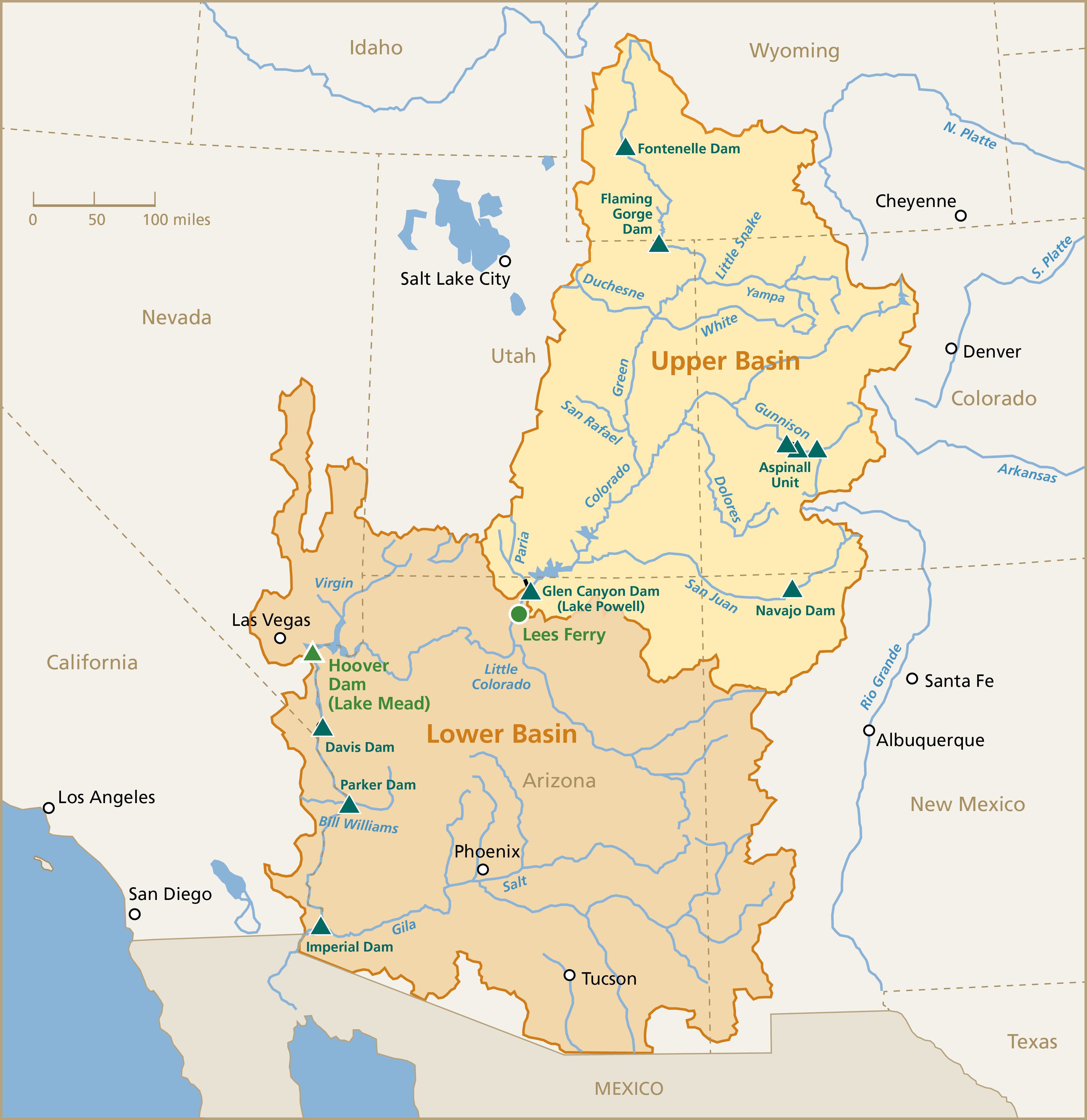
For over 10 years, water use out of the Colorado River and its tributaries for farms and cities has exceeded inflows from rain and snow. One wind storm in 2013 left 419 pounds/acre of snow on the San Juan Mountains, part of a trend of increasing dust falling on snow, which speeds melting. Mountain snowpacks are melting out up to six weeks earlier than they did historically. On the human side, subdivisions are encroaching on farms, and river-based recreation now economically dwarfs agriculture in some areas. Many of the growing cities that rely on the river lie outside the river basin, using pipes and canals to transport water across mountain ranges.
The weather influencing our environment, and the people who inhabit and rely on it, just aren’t behaving the way they did 50-100 years ago, or even 20-30 years ago. While conditions are changing, the legal apparatus and much of the infrastructure we use to manage water are old. The “first in time, first in line” prior appropriation doctrine was established during the early days of mining in Colorado, and many of the ditches that still convey water to hayfields and orchards aren’t much newer. The Colorado River Compact, the cornerstone of the “Law of the River” that apportions the water resources of the Colorado River and its tributaries between the headwaters and down-river states, dates back to 1922.
A central issue of debate among scholars and water managers is whether this legal apparatus, and the physical apparatus that grew up alongside it, is adequate to address our changing natural and social conditions. Both were designed to help communities withstand the variability of our region’s climate, with reservoirs to capture runoff from wet years to meter out during dry years, and rules to handle scarcity in an orderly way, as well as transfer water rights as demands changed.
As a result, the security of access to water for millions of people and millions of rows of lettuce, alfalfa, cotton and peaches has greatly increased. But in helping our communities survive and thrive, despite the variability our climate has dished out over the past 100 years, it has left us even more vulnerable to the larger swings that both ancient tree ring studies and climate change models tell us could be in our future.
On a large scale, proponents of our existing systems point to their flexibility. The states involved in the Colorado River Compact meet regularly and have refined the agreement in numerous ways. These include allowing the lower basin states and even Mexico to bank saved water in Lake Mead for future uses, and to help support a project to reconnect the Colorado River to the sea. The parties also cooperated on the Bureau of Reclamation’s massive Colorado River Basin Water Supply and Demand Study, released in December 2012, which raised the alarm about an intensifying supply-demand imbalance. Stakeholders from each state are now working together to study solutions in the areas of curbing urban demands, enhancing agricultural efficiency, and protecting flows to serve environmental and recreational purposes.
On a smaller scale, farmers and conservation advocates across the basin are increasingly working together to fix leaky canals and headgates in order to improve water management options for farmers while improving streamflows for fish and recreation. Habitat restoration projects are also underway, from small streams and wetlands in the headwaters to industrial contamination sites on the Colorado main stem. On the urban demand side, water providers are helping thousands of homeowners be more efficient with their water use through individual water audits.
Will these efforts be enough to enable our region to smoothly adapt to future conditions? This is an open question, to be answered in part by what the climate dishes out, and in part by the perseverance and creativity of scientists, water managers and stakeholders across the region.
The construction at Santa Rita Park near Durango’s wastewater-treatment plant will result in a temporary diversion of the river trail while a crew restructures the riverbed, which will allow for more control over the intensity of the rapid.
The in-stream work is slated to be completed by March, just in time for the spring runoff.
Scott McClain, landscape architect for the city of Durango, said the riverbed will be grouted and rocks will be moved to maintain river-flow consistency. During major water runoffs, the rocks can move, changing the rapids, he said, and every so often, the rocks have to be rearranged. This structure is intended to be more permanent, he said…
After a long process of applying for a recreational in-channel diversion right through the water courts, a conditional water right was given in 2007. The water right will not be permanent until the boating park is complete, she said.
Protecting the public’s recreational access to the river was a long process, Metz said. The Animas River Task Force, a group of residents who wanted to obtain the water rights for recreation, were the initial spark commencing the project in 2005, she said…
The initial estimate for Whitewater Park was about $1.3 million, but Metz said that might be high. She said the project is contracted for about $850,000, with additional money available as a safety net in case of any unforeseen financial hiccups…
Scott Shipley, the engineer and mastermind behind the current project, is looking forward to bringing Durango back on the map as a major river-running location. This type of project is not a first for Shipley, whose company developed the hydraulic features in the whitewater course for the London Olympics. An avid competitive kayaker, Shipley is thrilled to be working on the project even though he’s far away from his home in Lyons…
Phase 1 of the project will be completed in the spring, and the river then will be open to the public. The entirety of the fully developed park with amenities will not be completed until the end of 2014, Metz said.
SNOTEL Site via the Natural Resources Conservation Service
From the Northern Colorado Business Report (Steve Lynn):
Farmers, water managers, ditch-irrigation company representatives and local government officials rely on the USDA’s Natural Resources Conservation Service program to forecast water supplies. The agriculture department, however, has proposed eliminating some sites where scientists manually measure snowpack in Colorado and throughout the West.
Because of looming budget cuts, the agriculture department is uncertain about how it can maintain the traditional, manual measurements that began in the late 1930s. The agency also has automated snow stations scattered throughout the West, including in the Larimer County high country.
“As a climatologist, our strengths reside in the quality of our long-term data for tracking variations and changes,” Colorado State University climatologist Nolan Doesken said. “We don’t want to see any of those long-term records interrupted.”
The manual measurements done by scientists cover more territory than the automated snowpack sites, giving scientists a better grasp of snowpack depth and water availability than if they relied only on the automated sites, he said.
“That really allows improving on the forecast of what the future water supply is going to be,” he said.
Democratic U.S. Sens. Mark Udall and Michael Bennet, as well as Republican U.S. Rep. Scott Tipton entered the fray this week, urging the agriculture department to maintain the snowpack monitoring measurements.
State water providers, lawmakers and others have long pushed for more detailed snowpack and river-flow data in anticipation of population growth, increased demands and climate change. But now they’re fighting just to keep in place the data system they have. Because of budget cuts, the state’s Natural Resources Conservation Service has fewer dollars this year to devote to its Snow Survey and Water Supply Forecasting Program.
However, Colorado State Conservationist Phyllis Ann Philipps said she’s “actually optimistic” for the program this year, after a number of representatives from water providers, conservation districts and other operations across the state have stressed that they’ll provide whatever resources are needed — technical assistance, dollars, staff, all of the above — to make sure the data-collection system is fully functional this year.
“There’s no doubt we need more data than we have now,” said Brian Werner, a spokesman for the Northern Colorado Water Conservancy District in Berthoud, which oversees operations of the region’s largest water-supply project, the Colorado-Big Thompson Project that provides water to about 640,000 acres of irrigated farmground and about 860,000 people in portions of eight counties. “To take a step in the other direction certainly isn’t the way we want to go.”
The snowpack program consists of automated “Snotel” measurement devices in the mountains, and also of manual snow readings done by NRCS staff. With the data collected, water officials each year estimate what river flows will be when snow melts in the spring, and also how much of that water will run off into the region’s reservoirs.
Based on those forecasts, farmers — who use about 85 percent of the state’s water — decide what crops they’ll plant and how much. Cities, too, decide whether they’ll have enough water, not only to meet their own needs, but also whether they’ll have enough water left over to lease to local farmers during the growing season.
In addition to providing water projections, some of the data-collection system dates back to the early 1900s, and continuing that historic data is critical, water officials say.
While important, the snowpack-measuring program’s future has been uncertain recently. Philipps explained that, with its budget this year, the NRCS’s automated Snotel system would still be up and running as normal, but 47 of the 104 sites where manual measurements are taken wouldn’t be operational. She added, though, that state water officials, experts, providers and others are doing what they can to prevent that from happening.
“If we can get all of the support we think is out there, we’re optimistic our data-collection system will be fully functional this year,” Phillips said Tuesday night.
She noted that a meeting will take place Thursday between NRCS staff and water officials from across Colorado. At that time, discussions will be had about what’s needed to keep the snowpack-data system fully functional this year.
She said further discussions will have to take place down the road about how the data-collection system will function beyond 2014.
This week, Colorado Democratic Sens. Mark Udall and Michael Bennet, and Rep. Scott Tipton, R-Colo., joined the cause, writing a letter to U.S. officials, urging the U.S. Department of Agriculture — which oversees NRCS functions — to prioritize funding for snow forecasts.
Local farmers, too, are stressing the future of the program is critical for the future of farming.
“We make basically all of our decisions based on those numbers and those forecasts,” said Robert Sakata with Sakata Farms, which grows produce and other crops in Weld and surrounding counties. Sakata also sits on the board of directors for two irrigation ditches that provide water to farmers.
The difference in just a few hundred acre feet of water coming down the river can make a big difference in how farmers operate, Sakata and other farmers stressed. The accuracy of the forecasts needs to be precise, he continued, so opportunities aren’t wasted for farmers still in production, who already face future uncertainty when it comes to water supplies.
At the current rate, Colorado cities buying water from the state’s farmers to meet their needs is expected to dry up an estimated 500,000 to 700,000 acres of irrigated farmground by 2050, according to a statewide water supply study, released in 2010.
“We have to make the most of everything,” Sakata said. “We need the data to do that.”
On the U.S. House of Representatives floor Tuesday, Rep. Jared Polis ripped Colorado’s state regulations involving hydraulic fracturing, saying the growth of fracking in the state “without common-sense federal guidelines, without common-sense state guidelines” has caused friction for his constituents.
Polis, a Boulder Democrat, represents three municipalities — Boulder, Lafayette and Fort Collins — whose voters earlier this month approved moratoriums on the deep horizontal drilling technique. A fourth town, Broomfield, also had a moratorium proposal on the ballot, but officials are recounting that measure because the vote was so close.
Polis never took a position on the fracking bans, but Tuesday he said fracking “is occurring very close to where people live and work and where they raise families.”
“Yet our state doesn’t have any meaningful regulation to protect homeowners,” Polis said in a floor debate on a series of energy measures. “Unfortunately, the fracking rules are overseen by an oil and gas commission that is heavily influenced by the oil and gas industry. They don’t have at their disposal the independence or the ability to enact real penalties for violations of our laws and their charge is not first and foremost to protect homeowners and families and health.”
Democratic Gov. John Hickenlooper’s office disagreed, saying ” the Colorado Constitution protects the rights of people to access their property above and below ground.”
Mission accomplished. The Pueblo Board of Water Works increased its storage levels by 10,000 acre-feet after cutting off spot-market water leases this year.
“It was a good year for recovery of our storage reserves,” Water Resources Manager Alan Ward told the board Tuesday.
At the end of the October, the water board had 37,500 acre-feet of water stored in four reservoirs, up from 27,500 acre-feet the previous year at the same time. Pueblo has long-term storage in Lake Pueblo, Clear Creek Reservoir, Twin Lakes and Turquoise Lake.
“Our spot market leases typically total about 10,000 acre-feet,” Ward said.
There were other factors to the quick recovery, but they played a smaller role, he said. After drenching rains in August and September, water customers cut back use by about 1 billion gallons — roughly 3,000 acre-feet. But most of the water supplied to the city’s potable system comes from direct-flow water rights on the Arkansas River, rather than storage, Ward explained. Part of the reduction also came from reduced use in city parks, water that is provided at no charge. Water use was down at the Xcel Energy’s Comanche power plant, and good snows late in the season aided natural storage levels, he added.
The new water year is looking more promising than the past two, with 93 percent snowpack in the Arkansas River basin and 123 percent in the Colorado River basin.
“It’s still early in the season, and you can’t draw conclusions,” Ward said. “But it’s encouraging that we are near average and the Colorado is above average.”
Click here for this morning’s snowpack report from the Natural Resources Conservation Service.
More coverage of the board meeting from Chris Woodka writing for The Pueblo Chieftain:
Tastes great, less money. That was Tuesday’s mantra at the Pueblo Board of Water Works monthly meeting as the board approved its 2014 budget. The board was slightly distracted because it was basking in the glory of capturing second place in an American Water Works Association regional water quality taste test earlier this year. But it was also proud of maintaining the lowest water rate among Front Range cities. Only Louisville has a lower base rate, but charges more as use increases.
“Our rates are reasonable compared to surrounding communities, and it’s a heck of a buy,” said board member Nick Gradisar. “The average household will spend about $400 per year on water, and that is among the lowest on the Front Range,” said Seth Clayton, director of administrative services. “With all this, we’re still able to produce a product that is among the best in the state.”
Pueblo rates will increase 3 percent next year, funding about 70 percent of the $34 million budget. Metered sales are expected to total $23 million, and will be supplemented by $8.2 million in leases of raw water. The remainder of the revenue will be generated by various fees and a transfer of $1 million from reserves. The bottom line for water users will be an average $1.02 increase per month for strictly indoor use, and $2.63 per month more during lawn irrigation periods, Clayton said.
On the expenditure side of the ledger, 41 percent will go toward personnel services, 30 percent to operation and maintenance, 17 percent to capital projects and 12 percent to debt service. Major expenses include $3.37 million for utilities, mostly electricity; $1.03 million for the next round of automated meters; $2.4 million for main improvement and expansion; and nearly $1 million for water tank improvements.
In other business, the board re-elected Mike Cafasso as president and Nick Gradisar as secretarytreasurer for the coming year.
More Pueblo Board of Water Works coverage here and here.
Bob Crifasi, a consultant with the Left Hand Ditch Co., says workers are trying to reconnect the creek to its original course.
The raging floodwaters forced Left Hand Creek away from the company’s diversion structures and canals, which supplied irrigation water for farmers who were miles away. Crifasi says those structures are now clogged with mud, debris and stagnant water.
All this rechanneling work comes with a cost. For Left Hand Ditch Co. alone, it could cost more than $3 million. Crifasi says there’s little financial assistance from the Federal Emergency Management Agency or the U.S. Army Corps of Engineers.
“They’re not stepping up, or they do not have the authority to provide resources for moving the creek,” he says…
Kevin Houck, the chief of flood protection for the Colorado Water Conservation Board, which oversees water use and management issues across the state, says the Army Corps of Engineers doesn’t necessarily have funds to help out in this case.
And it certainly doesn’t have “the authority to just come in and make wholesale changes without private property approval,” he says.
“I think that is a misconception that is out there in a lot of places, which is [that] the state or the federal government are going to come in and fix everything here,” he says. “And for the most part, that’s not really going to be the case.”
Colorado lawmakers are urging the Department of Agriculture to prioritize funding for snow forecasts. U.S. Sens. Mark Udall and Michael Bennet, both Democrats, and U.S. Rep. Scott Tipton, a Republican, say Snotel reports and manual snow course measurements are necessary to determine Colorado water supply.
Snotel measurements are based on the weight of snow on “pillows” at more than 140 sites in Colorado. Data is relayed by bouncing VHF radio signals off ionized meteors 50-75 miles above Earth from solar-powered collector stations. Manual snow course readings provide on-the-ground observations to corroborate the automated system.
Many water users rely on data from more than one basin in order to account for imported water. The data is collected by the Natural Resources Conservation Service, a branch of the Department of Agriculture, and widely distributed via the Internet. Cities, water districts and other agencies use the information for planning purposes by comparing it to past years.
“In the face of prolonged drought, significant population growth and climate change, NRCS’ snow program data provides vital information on precipitation and future water supplies essential for Colorado and the entire American West,” the lawmakers wrote in a letter to Undersecretary Robert Bonnie.
Colorado has nine major watersheds, each with different weather patterns. Last year, for instance, snowpack ranged from 40-100 percent of average.
The lawmakers wrote the letter to head off a proposal to reduce the number of stations collecting data as a way to meet budgetary restraints.
In recent years, Colorado water users have pushed for more sampling sites in order to improve the accuracy of forecasts.
Current water supplies across Colorado range from 40 percent to 100 percent of normal, the letter continued. The ability to accurately measure snowpack in each basin, using both SNOTEL and manual snow course data, is essential for water districts and municipalities to meet the demands of competing users, the lawmakers contended.
Governor Hickenlooper announcing new methane rules — Associated Press via the Washington Post
Here’s the release from Governor Hickenlooper’s office:
Proposed rules for air pollution released today would make Colorado the first state to directly regulate detection and reduction of methane emissions associated with oil and gas drilling and further Colorado’s efforts as a national leader in environmental-friendly energy production.
The rules, which cover the lifecycle of oil and gas development (from drilling to production to maintenance), reflect a collaborative effort by the Environmental Defense Fund and Noble Energy, Encana and Anadarko oil and gas companies as part of the Air Quality Control Division’s stakeholder process.
The plan, with Gov. John Hickenlooper’s support and active engagement, constitutes the division’s official proposed rules and will now go before the state Air Quality Control Commission, which will meet Thursday, Nov. 21, and will be asked to set a February 2014 public hearing on the rules.
“These proposed rules provide common sense measures to help ensure Colorado has the cleanest and safest oil and gas industry in the country,” Hickenlooper said. “The rules will help Colorado prepare for anticipated growth in energy development, while protecting public health and the environment. They represent a significant step forward in addressing a wider range of emissions that before now have not been directly regulated. We welcome the proposed rules and are grateful all of the interested parties worked together.”
The comprehensive set of rules were crafted after an extensive process in which the Colorado Department of Public Health and Environment (CDPHE) sought input from diverse stakeholders across Colorado. The rules will now be subject to further input as the Air Quality Control Commission considers them under CDPHE’s formal rulemaking process.
“Tackling smog and climate pollution from the oil and gas sector is a critical part of making sure communities are protected and that the lower carbon advantage of natural gas doesn’t simply leak away,” said Fred Krupp, president of the Environmental Defense Fund. “If this package is adopted, Coloradans will breathe easier, knowing they have the best rules in the country for controlling air pollution from oil and gas activities.”
Anadarko, Encana and Noble jointly stated: “As citizens of Colorado, we all want clean air, and we support this joint proposal initiated by Gov. Hickenlooper. This collaboration is a good model for developing effective regulations and activities to monitor, control and reduce methane leaks and VOCs. The process and increased accountability established by the proposal will provide transparency and build public trust. We remain committed to continuously improving industry practices and protecting our communities through responsible energy development.”
The rules will benefit Colorado’s public health, environment and economy by increasing the capture and use of clean burning natural gas. Highlights of the rules include:
A first-in-the-nation requirement for leak detection from tanks, pipelines, and other drilling and production processes, using instruments such as infrared cameras that can detect leaks that otherwise may not be discovered using other more conventional means.
Instrument-based monthly inspections on large sources of emissions.
An aggressive timeline for repair of leaks found using either these instrument-based methods or leaks found through sight, smell or sound.
Leak detection and repair of storage tanks, at well-site production facilities and at compressor stations.
Requirements for detection and repair of leaks of a wide variety of hydrocarbons, including VOCs and methane, another first in the country.
Expanding provisions statewide for reducing emissions of pollutants that today apply only in nonattainment areas, so anyone living near a well site would benefit.
New, more stringent limits on emissions from dehydrator units located near where people live and play.
“Colorado is fortunate to have a governor who is invested in protecting the state’s environment and who brought parties together to advance the draft regulations,” said Dr. Larry Wolk, executive director and chief medical officer at CDPHE.
CDPHE estimates the package will reduce volatile organic compounds (VOC) emissions in Colorado by approximately 92,000 tons per year. That’s more VOC emissions than the VOCs emitted by all cars in Colorado in a year, and it would be a 34 percent reduction based on a 2011 inventory by CDPHE that showed oil and gas VOC emissions were approximately 275,000 tons. [ed. emphasis mine]
The draft rules also include elements that have the unique and additional benefit of significantly reducing methane emissions.
These kinds of significant reductions in VOC emissions will improve public health by decreasing asthma and other respiratory ailments.
Colorado’s unique state rules would complete the state’s adoption of EPA rules that further reduce air pollution associated with oil and gas operations. Interested individuals and parties can submit comments on the proposed rules to the Air Quality Control Commission at cdphe.aqcc-comments@state.co.us. The proposal and related information may be found online here.
State health officials rolled out groundbreaking rules for the oil and gas industry Monday to address worsening air pollution, including a requirement that companies control emissions of the greenhouse gas methane, linked to climate change. The rules would force companies to capture 95 percent of all toxic pollutants and volatile organic compounds they emit.
This would cut overall air pollution by 92,000 tons a year — roughly equivalent to taking every car in the state off the road for a year, state health chief Larry Wolk said. Such reductions could help bring Colorado’s heavily populated Front Range, where smog and ozone are on the rise, back into compliance with federal air quality standards.
No state has adopted rules directly limiting methane emitted by oil and gas operations. Federal government and United Nations authorities are developing rules to try to reduce such emissions because they are a large factor in global warming.
“These are going to amount to the very best air quality regulations in the country,” Gov. John Hickenlooper said.
He credited executives from Anadarko, Encana and Noble Energy — the state’s largest producers — for compromising and helping minimize environmental harm from drilling before the cost implications are fully known.
“They understand it is a shared responsibility,” he said, “and they have really stepped up.”
Under the rules, companies would have to:
• Detect leaks from tanks, pipelines, wells and other facilities using devices such as infrared cameras.
• Inspect for leaks at least once a month at large facilities and plug leaks.
• Adhere to more stringent limits on emissions from equipment near where people live and play.
• Use flare devices to burn off emissions from facilities not connected to pipelines.
Noble Vice President Ted Brown said the prescribed practices are “the right thing to do” but added that “it’s a tough rule.”
He and counterparts from Anadarko and Encana said they support the proposed rules as a way to operate more safely and build public trust.
“Regulatory certainty is important to the company, and doing the right thing also is important to the company,” Encana’s Lem Smith said. Reducing industry air pollution will bring a “quantifiable environmental benefit.”
Colorado Petroleum Association president Stan Dempsey questioned the state’s authority and the need for new rules. Regulation of industry air pollution might better be done through the state’s overall air pollution control program or by the Colorado Oil and Gas Conservation Commission, he said.
The COGCC, part of the state Department of Natural Resources, has a dual mandate of promoting and regulating the industry and has been the primary overseer after contentious rule-makings over where wells can be drilled and protection of groundwater.
But state air pollution control division director Will Allison said statutes give the state’s Department of Public Health and Environment the authority to regulate hydrocarbons. “Volatile organic compounds are one type of hydrocarbon. Methane is another type of hydrocarbon.”
An industry study estimated the costs related to the new rules, assuming monthly inspections for leaks, could reach $80 million a year. A CDPHE study estimated costs at $30 million.
“I am very concerned that the costs — especially for small and midsize operations — will be quite significant,” said John Jacus, an attorney who represented five companies in CDPHE stakeholder sessions.
Environment groups, led by the Environmental Defense Fund, helped craft the proposed rules.
“First in the nation, direct regulation of methane from oil and gas production facilities is a big, exciting step forward,” Conservation Colorado director Pete Maysmith said.
Around the nation, state regulators have not dealt comprehensively with increasing air pollution from the oil and gas industry — a challenge as companies ramp up domestic energy production. And, when it comes to emissions of methane, the industry is largely unregulated, even though state data show oil and gas operations are a major source.
Colorado’s political landscape for oil and gas development has been toughening, however, with voters in four cities passing moratoriums and a ban on operations inside city limits.
The new air rules, to be hashed out at formal hearings in February, do not include a proposal to raise the threshold of air pollution above which companies would have to obtain permits from the state — 4,000 this year. State health officials had proposed reducing their administrative workload by raising the reporting threshold to 25 tons of air pollution per year from 2 tons to 5 tons. But state officials dropped the effort because the “messaging” to residents would be difficult, Allison said.
“It was going to distract from the overall process,” he said. “We want the focus in this rule-making to be on emissions reduction.”
Unveiled Monday, the proposed rule will be formally sent on Thursday to the Air Quality Control Commission, a division of the Colorado Department of Public Health and Environment (CDPHE). Public hearings are expected to be held in February. The proposed regulation aims to reduce the amount of natural gas and methane leaking into the air at all stages of industry operations, such as the well itself as well as storage tanks, pipelines and other steps along the path to market.
At a press conference at the Capitol on Monday afternoon, Hickenlooper joined with representatives from EDF, Anadarko Petroleum Corp. (NYSE: APC), Noble Energy Inc. (NYSE: NBL) and Encana Corp. (NYSE: ECA) to praise the effort that went into the proposed rules…
If adopted as proposed, Colorado will be the first state in the nation to regulate methane — an element of natural gas that’s a powerful greenhouse gas…
Cutting those emissions, which contribute to asthma and other respiratory ailments, is expected to improve public health, according to the health department.
Hickenlooper said the proposed rules were a group effort, requiring compromise on all sides.
“We recognize, and the people should recognize, that the rules, while they will be enforced, they weren’t imposed,” he said, referring to the stakeholder group that worked with state officials to craft the proposal.
Industry and environmental representatives in turn credited the governor for pushing the group to make the rules tough…
Ted Brown, Noble’s senior vice president for the Rocky Mountain region, said his company also supports the proposal “because it’s the right thing to do.”
“It’s a tough rule, it’s an additional layer of regulations,” Brown said.
“But we wanted to develop a sound solution based on science. [ed. emphasis mine] We believe this proposal sends a clear message — we can have a health environment, clean air, and responsible energy development here in Colorado,” Brown said.
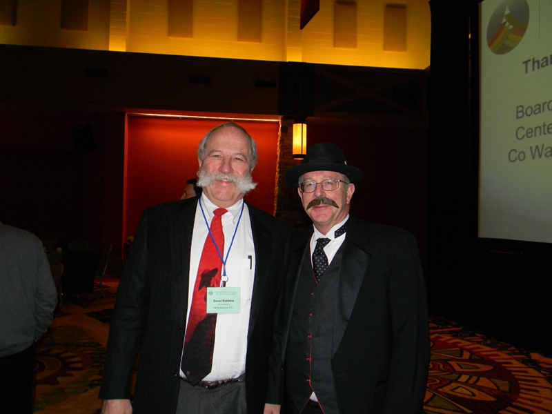
David Robbins and J.C. Ulrich (Greg Hobbs) at the 2013 Colorado Water Congress Annual Convention
Click here to read the newsletter. Here’s an excerpt:
Join us for the 2014 Annual Convention, Jan. 29-31 at the Hyatt Regency DTC in Denver, Colorado. The annual convention is the premier water industry event in the state, attracting 500+ attendees that convene for networking and collaboration on the important water issues in Colorado.
Early registration is now open and offers members a discounted rate for registering before Dec. 31. There are many sponsorship opportunities available and many exhibit spaces to choose from.
As an added bonus to this year’s Convention, CSU will host its annual Water Tables event the evening of January 30.
Here’s an in-depth look at Special Master Simon Rifkind’s decision about Colorado River streamflow back in the early 1960s from John Fleck posted on instain. Click through and read the whole post for all the gory detail. Here’s an excerpt:
In 1960, U.S. Supreme Court Special Master Simon Rifkind made a fundamental mistake in calculating how much water was then available in the Colorado River Basin, and how much might be available in the future. The court, in its ruling in the case of Arizona v. California, accepted Rifkind’s math. The consequence is a shortage on the Colorado River relative to the expectations of the nine states (seven in the U.S., two in Mexico) that share it.
But it also was a fundamental mistake for the water users in the Lower Colorado River Basin to not recognize the flaw in Rifkind’s math and act accordingly. That second mistake, more than Rifkind’s, is the cause of our current troubles…
So right off the bat, according to [Lawrence MacDonnell’s] analysis, you’ve got what a “losing reach” between Lee Ferry and the users of Nevada, Arizona and California. That whole 7.5 million acre feet will not be available for the downstream users. But it gets worse. You’ve also got to add in water needed to meet the 1.5 million acre foot U.S. obligation to Mexico. Once all the puts and takes are added in (I encourage you to read MacDonnell’s paper (pdf), pp 395-396 for the full details).
The Pueblo Board of Water Works will have a public hearing on its 2014 budget at 2 p.m. Tuesday at the Alan C. Hamel Administration Building, 319 W. Fourth St. The board is expected to approve a $34 million budget that will mean a 3 percent rate increase for Pueblo water users. The average monthly residential bill will increase about $1 per month, or $3 per month during summer months if yard watering is factored.
The budget includes $100,000 for the CARES program, administered by Catholic Charities, that provides emergency funding for families. Last year, the program helped about 900 families.
About $23 million in revenue, or 70 percent, comes from metered accounts, while water leases contribute $8.22 million, or 25 percent.
Personnel services account for 41 percent of expenditures, while operation and maintenance costs make up 30 percent. Capital expenses amount to 17 percent, and fund transfers 12 percent.
Among the largest expenditures are $4.8 million for debt service, largely for the 2009 purchase of Bessemer Ditch shares, and $3.37 million for utilities, mainly electricity purchases from Black Hills Energy.
Directional drilling from one well site via the National Forest Service
From email from Governor Hickenlooper’s office:
Gov. John Hickenlooper will be joined Monday by environmental groups and energy companies to announce proposed rules that would make Colorado the first state to directly regulate detection and reduction of methane emissions associated with oil and gas drilling. The rules would also further Colorado’s efforts as a national leader in environmental-friendly energy production.
WHEN: 1 p.m., Monday, Nov. 18, 2013
WHERE: West Foyer, state Capitol, Denver
The comprehensive set of rules were crafted after an extensive process in which the Colorado Department of Public Health and Environment sought input from diverse stakeholders across Colorado.
St. Vrain River floodplain November 2013 via the Longmont Times-Call
From the Boulder Daily Camera (Amy Bounds) via the Longmont Times-Call:
“The house was fine, but everything around it was washed away,” [Kevin Grady] said as he looked over a creek bed that once was Geer Canyon Road — the road used to access the trailhead. “It was insane.”
Geer Creek, he added, is typically “dry as a bone” by this time in November, but it’s still running thanks to the over saturated ground. One of the road’s two culverts also now is in the middle of the creek, while the other was washed far downstream. Multiple areas were either scoured out by the raging water or filled up with rocks swept downstream.
Grady spoke to open space advisory board members and area residents who took a tour today of some of the county properties damaged by September’s floods that haven’t been reopened to the public. The tour, led by county Parks and Open Space Department director Ron Stewart, included Heil Valley Ranch, county open space areas east of Lyons along the St. Vrain River and Pella Crossing…
Stewart said the flooding caused an estimated $2.5 million in damage to Boulder County open space trails, restrooms, kiosks and parking lot. But, he said, the overall estimate to repair damage on Boulder County open space land is $50 million, with the most extensive damage at lakes and ponds — particularly reservoirs along or near the St. Vrain River corridor. On county open space along the St. Vrain River, one side of the river near the Cemex plant is largely untouched with a thicket of bushes and trees that form a riparian area. The other side looks like a beach, with a layer of sand and only a single bush and some stumps left. A dry bed of rocks shows the river’s former path, with a new path nearby that’s about six feet lower and going in a new direction. The roof and upper section of a house, an upended RV, a grill, a ladder and a vacuum cleaner are scattered through the area. The flooding also caused breeches in lakes and ponds in more than dozen areas on county open space, creating big lakes out of individual ponds and wreaking havoc with irrigation ditches…
Stewart said decisions are expected soon on a timeline for repairs and reopening areas to the public. One issue, he said, is funding. The county doesn’t have the money to start all the projects while waiting for federal and state reimbursements for flood-recovery work. Another is the finding the manpower to make repairs, given the extent of the damage.
Philosophically, the proposed water storage expansion of Chatfield Reservoir makes some sense. In reality, it makes some headaches.
Participants of the Chatfield Reservoir Reallocation Project took their turn before the Colorado Parks and Wildlife Commission in Lamar on Friday, formally presenting the “Fish, Wildlife and Recreation Mitigation Plan” essential for approval of the proposal to double the water storage in the south Denver reservoir. The presentation started the 60-day review clock for commission approval required by state statute and offered a closer look at the likely impacts to one of Colorado’s most popular state parks.
“No water project is without environmental impacts and the statute doesn’t require that the impacts be eliminated, it requires that we mitigate them,” said Mike King, executive director of Colorado’s Department of Natural Resources. “(The participants and stakeholders) are to be commended for being creative in getting us to this point. I’m hopeful that we can get this across the finish line in the next couple of months.”
The hurdles to be overcome at Chatfield range far beyond the environmental, however. The 1,423-acre reservoir and surrounding topography serve as a cornerstone of the state park system, annually attracting more than 1.5 million visitors and generating some $2.2 million in revenue. Impacts to the park during and after inundation of 587 additional acres are expected to be significant.
Wide fluctuations in water levels are anticipated as additional municipal and agricultural water storage join the reservoir’s current primary uses of flood control and recreation. An additional 12 vertical feet of potential water fluctuations is likely to have considerable impact on park operations and will require the relocation of multiple facilities when the reservoir fills to its new level.
The law does not require that a mitigation plan for recreation impacts be approved by the commission, however project participants have proposed plans to alleviate unavoidable impacts to recreation facilities and amenities.
“Areas that were recognized as being potentially impacted included the park, fish and wildlife, recreation and financial,” said Randy Knutson, board member of the Central Colorado Water Conservancy District. “Mitigation plans for all these impacts either have been developed or are in the development phases.”
“We feel that we’ve gone above and beyond the state law requirement,” added Randy Ray, water resources manager for the Centennial Water & Sanitation District. “This plan addresses all the concerns.”
While the 11 project participants have pledged up to $116 million to finance the potential impacts identified in studies by the U.S. Army Corps of Engineers and Colorado Parks and Wildlife, concerns remain. Foremost among them is the reservoir’s dramatically fluctuating water level.
Under the state park’s current operating agreement with Denver Water, Chatfield typically fluctuates no more than five feet between Memorial Day and Labor Day, offering recreational users reliable water levels for boating, fishing and other summer activities. The “Fish, Wildlife and Recreation Mitigation Plan” notes that the new “fluctuation zone” could be up to 21 feet, citing a comparison study of six other Front Range reservoirs showing that impacts (mud, weeds, mosquitoes, etc.) would be negligible.
Project participants insist that the reallocation proposal will have a positive impact on the South Platte River downstream from Chatfield, including an improved fishery as water is conveyed to downstream users from mid to late summer and through fall and winter. The “new reservoir” effect of added nutrients also has potential to improve fishing within Chatfield in the short term, although fluctuating water levels have been associated with elevated mercury levels in walleye at other reservoirs.
Reallocation participants have agreed to maintain water levels in the reservoir during critical walleye and smallmouth bass spawn periods. They also announced a new plan to preserve a gravel pond popular among recreational users that was initially subject to inundation.
“It’s an ongoing process. I feel better about some of the changes that they’ve made but we’ve got 60 days still to work through some of the details,” said Ken Kehmeier, a CPW aquatic biologist working on the project. “Bottom line is that it won’t be the Chatfield that everybody knows right now.”
What do wastewater treatment and economic development have in common? You can’t have growth without the capacity to treat the wastewater that comes with it, according to the Metro Wastewater Reclamation District, which treats and cleans what 1.7 million people in the Denver area flush down the drain every day.
And it’s the continuing growth of the metro area — particularly north of Denver in Adams County, Thornton and Brighton — that the district had in mind when it launched a $415 million project to build a new wastewater treatment plant and a seven-mile pipeline to funnel waste to the plant, says Barbara Biggs, the district’s governmental affairs officer.
The project has been in the works for years. Biggs attended her first meeting on it in 1999. The plant, located at U.S. 85 and 168th Avenue north of Brighton, broke ground in January. It’s about 25 percent complete, and is expected to be finished in 2016. It will serve about 300,000 people in parts of Aurora, Thornton, Brighton, and Denver and Commerce City…
When the switch is flipped, the plant will be able to handle up to 24 million gallons of waste per day — enough to handle population growth in its serve area through 2055, said Biggs, who’s been working on the project since 1999. The plant, located on a 90-acre site, is designed to be expanded as needed up to 60 million gallons per day. That’s big enough to handle the needs of 750,000 people, [John Kuosman] said…
The plant is designed to meet new state regulations that require the district to remove phosphorus and nitrogen from the wastewater, in addition to other requirements, before it’s sent into the South Platte River, Biggs said. Removing those two elements from the wastewater stream will reduce algae growth in the river — improving the water quality for fish in the river, people who use it for recreation and also making it easier to treat to drinking water standards, she said.
If Greeley residents had not voted in last week’s election, the 51st state initiative still would have been shot down by Weld County voters, according to a breakdown of ballots provided by the Weld County Clerk and Recorder’s Office. Without Greeley voters included, 52 percent of Weld County voters would have chosen not to move forward with seceding from the state of Colorado, versus 48 percent who voted for the measure.
The final count on the 51st state question was 56 percent of Weld County voters against secession, compared to 44 percent in support. In Greeley, voters strongly rejected the measure 67 percent to 33 percent.
Some say the disparity between the way Greeley and the rest of the county voted points to a difference in values. Weld County commissioners last week said they feel the rural-urban divide also exists within the county. Others say the fact that Greeley voters rejected the 51st state by a wider margin has nothing to do with a disconnect. They point to the fact that the rest of Weld County also voted against the measure as reason to argue the rural-urban divide issue is overblown. Critics say Weld County commissioners may have a disconnect with the rest of their electorate.
None of Weld County’s five commissioners responded to repeated requests from The Tribune seeking comment regarding how the county voted on the 51st state initiative. But commissioners said after Election Day that they put the question to a vote specifically to see what their electorate thought of secession.
Commissioners said they would honor the vote of the people and would not move forward with seceding from the state, but they vowed to continue to fight for rural interests at the state level. They said the vote was still a success in the sense that a message was sent to state legislators and the governor that a substantial portion of people in rural Colorado feel they have lost their voices.
“I think we have to be careful in saying that because they rejected the vote, there isn’t a problem,” Weld County Commissioner Sean Conway said last week.
Commissioners also sent a letter to Gov. John Hickenlooper’s office saying they would like to find a time for him to meet with Ault, Fort Lupton, Tri-Town and Evans residents before the 2014 legislative session.
“We received the Weld County commissioners’ letter and are reviewing the governor’s upcoming schedule to find more opportunities for the governor to visit Weld and other rural counties,” said Eric Brown, spokesman for the governor’s office, in a statement.
He said Hickenlooper was in Weld County on Sept. 16, 22, and 23 and on Oct. 23, and has made an effort to visit with all Coloradans.
Greeley Mayor Tom Norton, who has served as a state lawmaker, said he doubts the state Legislature is any more divided today than it was when he was a representative.
“I don’t think it means anything,” Norton said of the 51st state vote. “It just means that people don’t want it.”
Jeffrey Hare, a founder of the 51st state initiative and its spokesman, said he feels there is a disconnect between Greeley and the rest of the county.
“I would say that it is a little unfortunate that the city of Greeley has forgotten its agricultural roots,” Hare said.
He said he feels the fact 43 percent of Weld voters supported the initiative makes it a “resounding success.” Secession is still a new idea to many people, he said, but 43 percent is a strong plurality on which to build for a renewed secession effort in 2014.
Hare said the five counties that did vote for the initiative — Kit Carson, Washington, Phillips, Yuma and Cheyenne counties — will meet Monday to discuss their next steps in the movement.
While it was possible to track how the city of Greeley voted versus the rest of the county, other communities were not as easily identified. Ballots were not separated by precinct, but by blocks for different districts that held an election this year, said Rudy Santos, elections manager for the Weld County Clerk and Recorder’s Office.
Hare’s suggestion that Greeley has lost touch with its agricultural roots was refuted by local officials.
Sarah MacQuiddy, president of the Greeley Chamber of Commerce, said the city is anchored on the east and west by symbols of Weld County’s agricultural prosperity, with a JBS USA office to the west and Leprino Foods to the east.
“I still believe people in Greeley very much so understand our agrarian roots and appreciate the fact that we are an agricultural county, and appreciate that economic impact,” MacQuiddy said.
Steve Mazurana, professor emeritus of political science at the University of Northern Colorado who opposed the 51st state initiative, said he sees the differences between Greeley and rural areas of the county as a simple disparity in needs and behaviors. But he said that doesn’t stretch into a difference in ideas and values. For example, Greeley and Windsor residents probably lock the doors to their homes during the day. But that doesn’t necessarily point to a difference in values compared to rural areas, where the practice may be to leave them unlocked. That’s a difference in how residents are dealing with their surroundings, which is a fact of life in any state or county, he said. Mazurana said he feels there are just as many rural residents who are unwilling to accept incoming urban ideas and values as there are urban dwellers who rural residents say are attacking their way of life.
Critics say commissioners are elected by all who live in Weld, including municipalities, and a dedication to only rural needs is a disconnect between commissioners and their electorate.
But most of Weld County commissioners’ control is over unincorporated parts of the county, meaning they are rightly more sensitive to the needs of rural areas, Mazurana said.
Colorado Water Plan website screen shot November 1, 2013
Here’s a guest column about the Colorado Water Plan, written by State Senator Gail Schwartz that is running in the Aspen Daily News:
On May 14, Governor Hickenlooper signed an executive order directing the development of the first long-term State Water Plan by and for Coloradans. The “gap” between our water supply and demand is of critical concern today and in the future. This planning process will be the foundation of a larger discussion about water needs and allocation. I recommend that all Coloradans engage in this important effort.
The state water plan will pave the way for water decisions that responsibly and predictably address future challenges. The Governor’s executive order detailed that the plan must promote a productive economy that supports vibrant and sustainable cities, viable and productive agriculture, and a robust skiing, recreation and tourism industry. It must also incorporate efficient and effective water infrastructure planning while promoting smart land use and strong environmental protections that include healthy watersheds, rivers and streams, and wildlife.
The Colorado Water Conservation Board (CWCB) has been tasked with creating the Colorado Water Plan. The board must submit a draft of the plan to the Governor’s office by Dec. 10, 2014, and a final plan by Dec. 10, 2015. The CWCB will incorporate the state’s Interbasin Compact Committee (IBCC) and nine basin round tables’ recommendations to address regional long-term water needs.
As chair of the Interim Water Resources Review Committee (WRRC), I will help ensure that the diverse voices of Colorado’s water community are heard during the development of this plan. The 10-member WRRC is comprised of legislators representing districts in each of the state’s major river basins. The committee has a full agenda as we are charged to review water issues and propose legislation. The WRRC will also remain actively engaged with the CWCB in development of the State Water Plan.
A recent public opinion survey on water issues in Colorado indicated that only 30 percent of Coloradans believe the state has enough water to meet its current needs. Furthermore, nearly 70 percent of Coloradans indicated they believe there is insufficient supply for the next 40 years. Colorado’s perennial drought has diminished our reservoir levels, which not only impacts our state, but has immense implications for neighboring states. In fact, the U.S. Bureau of Reclamation may constrain water releases for the first time in modern history from Lake Powell to the minimum required by the 1922 Colorado River Compact for the next two years unless precipitation significantly increases in the Colorado River Basin.
As charged, the water plan has a broad scope and will inevitably need to address difficult and contentious issues. I believe that we should first focus on conservation and efficiency both at the municipal/industrial level and in agriculture. Water conservation is an area with broad consensus. A recent public opinion study of Coloradans identified conservation as the most important water related issue. Other studies have strikingly demonstrated that 80 percent of Coloradans favored conservation over new construction projects. In 2013 I sponsored SB13-19, which gives landowners a new tool to conserve water without injuring their water rights. New conservation and efficiency tools are needed in the State Water Plan as they stress wise use of our precious water resource.
Conservation may be just one piece of this larger puzzle, and I want to hear what pieces are important to you. The dialogue around the state water plan is a critical discourse to ensure the protection of Western Slope water, reduce the “buy and dry” cycle on our agricultural lands and demand responsible urban and industrial use. In order to make your voice heard, contact me at gail.schwartz.senate@gmail.com, your regional round table, and IBCC members to help identify water issues and solutions that you feel are critical to this process. Thank you for caring about Colorado’s future.
To follow WRRC interim meetings, find materials, and read potential state water legislation as it becomes available please go to http://www.colorado.gov/lcs/WRRC.
Last week, while speaking at lunch during the Upper Colorado Basin Water Conference in Grand Junction, the director of the Colorado Water Conservation Board could have put his audience to sleep in their cannoli. He was talking about the narcolepsy-inducing topic of water planning, after all. Instead, James Eklund captured the room’s attention by quoting “the great water philosopher, Mike Tyson” who said, “Everyone has a plan until they’ve been punched in the face.” And there’s no doubt that Colorado’s been punched in the face.
Those blows have come from the combination of a 14-year drought, population growth, wild fires and floods. Now the state is figuring out how it will “pick itself off the canvas,” as Eklund described it, and move forward. But Colorado is one of the few Western states without a water plan.
In Colorado’s case, Eklund said, there are already enough glossy reports that sit on shelves. The state wants a document that analyzes the state’s water challenges and leads to meaningful action. So Colorado’s been working on one since this past summer, based on input from grassroots water planning groups called basin roundtables, which have been meeting for the last eight years. The first draft is due to Gov. Hickenlooper in December. Hopefully, having a road map will help soften the blows of further hydrologic bludgeoning…
One solution to stave off buy-and-dry would be creating a marketing system to let farmers lease water to cities in select years, or for a series of years, instead of permanently selling water rights. Leasing already happens on a small scale, but the state has been providing grants so water districts or nonprofits can work out the legal, technical and financial hurdles to large-scale leasing.
For example, in the Arkansas Basin, land of famous Rocky Ford cantaloupes, irrigators have formed the Super Ditch Company. It’s an amalgamation of regional ditch companies that will bargain for irrigators who want to lease part of their water to cities like Denver and Pueblo. There’s now legislation in the works to make the pilot project permanent. (For more on buy-and-dry and the Arkansas Basin check out this 2012 HCN feature from Matt Jenkins).
Even in the recent past, Eklund said, there’s been resistance to state water planning because of fear that it will impinge on private property rights, or overthrow the legal doctrine that guarantees water to senior rights holders. But those days of foot-dragging may be coming to an end, and the state’s water managers have recognized that water management needs to change to address new climate norms. “I’m here to tell you why I think the landscape has shifted,” Eklund said, “and why (with) the variable hydrology these days coupled with the scarcity of the resource…we can no longer have enough water for every need, and we’ve got to start looking at what we’re going to do with these new pressures.”
Water leaders on Tuesday unanimously approved $100,000 for an acequia rehabilitation project near San Luis.
Rio Grande Interbasin Roundtable Chairman Mike Gibson explained that Acequia del Cerro’s application originally included a $400,000 request for funding administered statewide through the Colorado Water Conservation Board. Each river basin receives an allotment to distribute, as well, and that is where the $100,000 will come from. Gibson said the criteria for the state-administered funds have changed so this project no longer fit the criteria. Statewide funds can only be distributed to projects with statewide benefit now, he explained.
The local water leaders comprising the roundtable board have discretion over how they spend money allocated from the state to the basin account, however, so the group voted to provide $100,000 locally for the acequia project.
Natural Resources Conservation Service (NRCS) is funding the $400,000 shortfall the state declined to provide for the project, Gibson explained. This will be funded through the NRCS’ Targeted Conservation Funds. NRCS is also providing $200,000 for the acequia project through EQUIP (Environmental Quality Incentives Program) funding.
Consultant Diana Cortez described the acequia project to the roundtable on Tuesday. Acequia del Cerro is a 10-mile long system constructed in 1880, she explained. It is comprised of two systems, the north and south channels serving 82 water users and irrigating 1,880 acres of hay, grass, row crops and vegetable gardens between ¦ See ACEQUIA pg 3 Chama and La Vega Commons in San Luis. Acequia del Cerro consists of about five miles of earthen ditch and five miles of concrete ditch. It is the longest and most complex irrigation system in southern Costilla County.
The part of the project for which El Cerro Ditch Company requested funding is located at the bottom part of the system and will replace 1,900 linear feet of concrete starting about 20 feet from the main head gate. Cortez said the $100,000 funding from the roundtable is a portion of the entire project, which is divided into phases. This funding will be used in Phase I, which is $138,510 including the roundtable grant, $33,000 of the funding from NRCS and the remainder from in-kind and cash matches. The entire project will exceed $1 million and will encompass 15,000 linear feet of pipeline to rehabilitate the northern ditch “to assure proper water control, eliminate water loss and provide irrigation water to all landowners,” as stated in the funding application.
“Costilla County is experiencing drought and in many cases, significant crop loss due to insufficient water from the Culebra Watershed. In addition to the drought, the landowners along the Acequia del Cerro are operating with a malfunctioning irrigation water system. With the implementation of this rehabilitation project, the Acequia del Cerro landowners will have a fully functioning irrigation system that will greatly reduce high sediment loads, promote cost effectiveness by minimizing maintenance , and provide increased operational flexibility. With the installation of the HPDE pipeline, the landowners will experience high flow capacity, elimination of bank erosion and sediment loading in the irrigation water and optimizing existing and future water supply needs for all landowners on the Culebra watershed.”
Cortez explained to the roundtable that the old concrete ditch in use now will continue to exist, and the new project will be constructed alongside it. The new ditch will include a pipeline. Cortez said irrigators will still be able to use the old ditch while the new one is constructed so irrigation will not be disrupted during construction, which is projected to begin next spring.
She added that once the new project is complete, the old ditch would be maintained to catch sediment and rock that comes down off the hill.
“We feel it’s a valuable project,” Cortez told the roundtable members. In the ditch company’s application , the value of this project was described: “The sustainability of the Rio Culebra Agricultural Co-op and local farming methods that include heirloom seed products and organic grass and hay for cattle feed, may serve as a model for other parts of the state where irrigation water is either insufficient due to the drought conditions or to low efficiency of water use. With the rehabilitation of the Acequia del Cerro, which will provide a managed distribution, timed controlled and monitored water and irrigation system, the landowners feel that crop production will increase even in years of drought. The area associated with the project will essentially remain as it is now, providing wildlife habitat and a scenic landscape for visitors to this historic area of Colorado that demonstrates how the early Hispanic settlers of the area farmed and irrigated their lands.”
It could take two years before the Greenway can once again be traveled from end to end, according to Kim Shugar, the city’s natural resources manager. And it’ll likely take another year on top of that before it looks like it once did, with its landscaping once again in place.
“It took 20 years to build,” Shugar said. “Even though the river destroyed it in a couple of hours, we are going to get it back open as soon as possible.”
Parts of it won’t have to wait that long; the first re-opened stretches are expected to be done by mid-January. But a lot depends on how much has to be done. The city’s plans show three phases of work:
Phase 1: Repair the trail, areas where the concrete needs to be fixed, but the underlying base is in decent shape. This is the “low-hanging fruit” that has the mid-January date.
Phase 2: Rebuild the trail. These are the harder parts, where the base itself was destroyed in the flood. That work will be bid in December and may be done by March or April.
Phase 3: Redesign the trail. These are the places where the river cut a completely new course, so that either the river or the trail must be moved. This is where the two-year timeframe comes into play, and even that’s a guess, since it depends on what the Army Corps of Engineers decides.
“Until we get direction from the Army Corps of Engineers, we can’t begin design,” Shugar said…
Those wanting to stay posted can check an interactive map on the city’s website, ci.longmont.co.us. A link can be found after clicking on the link for flood information. The map includes “thumbtacks” that can be clicked to show a photo of the area, its current condition and the work that needs to be done.
From the Northern Colorado Business Report (Steve Lynn):
The Colorado Farm Bureau said a U.S. Forest Service decision to no longer pursue forcing ski areas to surrender their water rights to renew their operating permits bodes well for farmers.
The Forest Service’s decision represents a “huge win” for private property owners, including farmers with grazing permits, the Farm Bureau said in a statement.
“We were concerned that if the Forest Service could demand this from ski areas, it was only a matter of time until they went after ranchers who also use Forest Service lands to do the same to renew their grazing permits,” Farm Bureau President Don Shawcroft, said in a statement.
FromThe Grand Junction Daily Sentinel (Gary Harmon):
A measure that would bar federal agencies from demanding state water rights in exchange for permits to use federal lands will get a vote in the U.S. House. The House Resources Committee on Thursday passed H.R. 3189, the Water Rights Protection Act by U.S. Reps. Scott Tipton, a Republican, and Jared Polis, a Democrat.
The U.S. Forest Service said this week that it would not require ski areas to surrender water rights in exchange for permits to operate on forest lands. The imposition of that requirement prompted the legislation, but Tipton said legislation is needed.
“Water users need certainty that all federal land management agencies, not just the Forest Service, are prohibited from future attempts to take privately held water rights,” Tipton said in a statement.
The National Ski Areas Association said the measure is necessary to give stability to its members.
“The policy change announced by the agency is the fourth change in Forest Service water policy for ski areas in 10 years,” the association said.
“These changes are disruptive, create uncertainty and adversely impact our operations, planning and future growth.”
Only federal legislation can provide long-term protection against the taking of water rights by the federal government, the association said.
A floor vote has not been scheduled.
A companion measure sponsored by Sen. John Barasso, R-Wyo., has been introduced in the Senate.
More water law coverage here. More NSAA vs. USFS coverage here.
Looking over Hunter Mesa along Mamm Creek above Rifle via Aspen Journalism
FromThe Grand Junction Daily Sentinel (Dennis Webb):
A woman living south of Silt urged Garfield County commissioners Tuesday to continue groundwater sampling there despite new tests finding no clear evidence of a link between methane and benzene in test wells and natural gas development. Lisa Bracken made her plea after representatives of the firm Tetra Tech presented the county with results from the third phase of a nine-year groundwater study in the area. It was conducted after the 2004 discovery of natural gas and benzene in West Divide Creek. The state blamed a faulty Encana well.
The latest tests involved three pairs of groundwater monitoring wells installed by the county, with each pair drilled to depths of about 400 and 600 feet deep in the Wasatch geological formation. The study found that methane in the shallower wells was biogenic, meaning from microbial sources, whereas methane in the deeper wells was thermogenic, resulting from geological heat and pressure. Thermogenic gas is what energy companies target for drilling.
The Tetra Tech consultants believe all the gas in the test wells is likely naturally occurring rather than a result of oil and gas development. Geoffrey Thyne, a longtime consulting geologist for the county, agrees that the research demonstrates that there is naturally occurring Wasatch formation methane that helps explain at least some of the methane being found in a number of domestic water wells.
But Bracken, who lives near the seep area, believes 600 feet is a suspiciously shallow level to be finding thermogenic gas. She said she also found “astonishing” the widespread detection of benzene, a carcinogen, in test well samples. Those detections were within safe drinking water standards in all but one case, and Tetra Tech theorizes the benzene also is naturally occurring.
County commissioners plan to seek a meeting with Thyne, and state oil and gas and health officials, before determining whether the county should undertake any more research.
Resident Marion Wells of Rulison said after Tuesday’s meeting that the latest research relies on several assumptions, including that carbon dioxide is present to allow for the kind of biogenic process believed to account for methane in the shallower test wells.
The state is working on repairing a projected $2 billion damage to infrastructure caused by flooding in September. While roads, homes and other buildings were lost to raging waters, mainly in the northern part of the state, there was also severe damage to water structures.
“A lot of the focus is on the recovery of water structures,” Alan Hamel, chairman of the Colorado Water Conservation Board, told the Arkansas Basin Roundtable Wednesday. “The CWCB is spending a lot of time there.”
Structures were damaged both in the South Platte and Arkansas River basins and low-interest loans are available from the CWCB in both areas, said Rebecca Mitchell, of the CWCB staff. The storms lasted for several days and damaged at least 27 dams, 25 stream gauges and 220 diversion structures, Hamel said.
“Many of those diversion structures are owned by private ditch companies and are not covered by any federal funding,” Hamel said.
In some cases, stream courses changed, making diversion structures useless, he added.
From the Estes Park Trail-Gazette (David Persons):
If you see a group of people in blue shirts or vests walking through your neighborhood from time to time, don’t be alarmed. These people – part of the Colorado Spirit Mountain Outreach Team – are just checking up on you and your neighbors to see if you’re OK or having any difficulty related to September’s flood. Their task is to offer flood survivors whatever counseling or guidance they might require. Their effort isn’t going to be short-lived either. They plan to keep on checking on you and your neighbors for up to a year…
Gaarder and his four-person counseling team have been assigned to the mountain region which includes Estes Park, Drake, Glen Haven, Allenspark, Pinewood Springs, Big Elk Meadows and other area communities. Currently, the team headquarters in the Disaster Recovery Center in the Rocky Mountain Park Inn, 101 S. St. Vrain Ave., in the same room with FEMA representatives. Gaarder said the team is averaging about 110 contacts a week…
The emotional side of the flood event is another area where the outreach team can help survivors.
“Some people just need to talk about the experience,” said team member George Desjardins. “Some had no damage but just the magnitude of what happened can be emotionally overwhelming.”[…]
If you would like to contact the outreach team, you can call 970-494-4245 or e-mail the team at COFloodRecovery13@gmail.com.
Farmers and ranchers are tallying just how expensive September’s flooding will be for Colorado’s agriculture economy. Estimates are quickly adding up to tens of millions of dollars. It’ll be a drop in the bucket for the state’s overall farm economy. But for the individual farmers pushed out of their homes and kept out of their fields, the flood’s effects are still very real and costly…
This year was a challenge even before the flood. Hail in August stripped ears of corn and pummeled vegetable farms. Crippling summer heat didn’t help either. Then debris carried by the high water littered fields throughout the South Platte River Basin. In two months time, [Glenn Werning], along with his family and friends, have managed to tear out the floors from inside their decades-old homestead. Soaked insulation is piled up outside and his chimney is sinking into the ground…
On their farm situated at the confluence of the South Platte and Big Thompson Rivers, Werning and his sons lost about 25 acres of corn, a relatively small amount. A recent report from Colorado State University estimates 7,500 acres lost in the South Platte River basin, including corn, hay and sugar beets. That could cost Colorado farmers upwards of $5.5 million. That figure doesn’t count the cost to fix miles of fencing, track down missing livestock and to clear sand bars that materialized in fields…
Expensive irrigation systems were also damaged in the flooding. Without reliable water, many farmers can’t grow profitable crops. Closer to the foothills, streams like the St. Vrain River and Left Hand Creek rerouted themselves leaving some irrigation systems without a connection to the flowing water…
The price tag to fix just the irrigation lines along the St. Vrain and Left Hand Creek alone will approach $16 million…
Glenn Werning and his neighbors received a grant to fix up their tattered water delivery system. Those fixes will need to be finished before next spring’s planting.
he rainfall that led to September’s floods in Colorado has been described as “biblical.” State Climatologist Nolan Doesken is trying to quantify that description. Flooded watersheds were dotted with rain gauges. Now that the preliminary deadline has passed for the Colorado Climate Center’s efforts to gather rainfall totals, scientists have precise estimates of rainfall totals…
Inside places the like Four Mile Canyon and the High Park Fire burn zones, Doesken says it was a happy accident that researchers had installed instruments and stream gauges.
Right now one key question is how the storm could have been better predicted. At the National Weather Service in Boulder, forecasters like Chad Gimmestad knew large amounts of rain were coming, but pinpointing exact locations was challenging.
“We didn’t really know until a few hours in advance when the thunderstorms were starting to develop,” he Gimmestad said.
Two months after September’s historic flooding, scientists are evaluating computer forecast models against what happened to see why some of their models failed.
The U.S. Geological Survey is also crunching data that could be used to regulate development and design of future infrastructure in flood plains. The USGS Colorado Water Science Center expects to release this data in the next few weeks.
A project that will take longer is replacing about 24 stream gauges that were damaged in the flooding…
Perhaps the most difficult question will be determining what role climate change played in the September floods. Doesken says he can’t finish a presentation on Colorado’s flooding without an audience member asking about it.
“Mostly it’s not related to climate change,” he said. “[It’s] possibly an incremental enhancement, but a small increment.”
Meanwhile, Reclamation’s operation of Olympus Dam on the Big Thompson was a damned if you do, damned if you don’t situation for the dam which was not designed for flood control. Here’s a report from Patrick Malone writing for the Fort Collins Coloradoan Here’s an excerpt:
Man stood by, mostly powerless, while nature imposed its will by flooding the Big Thompson Canyon for two days in September. The Olympus Dam at Estes Park was the lone exception. The U.S. Bureau of Reclamation controlled its flows into the rising waters of the Big Thompson River. At its peak, the release rate from the dam was 66 times greater than normal for mid-September. Residents of the flood-ravaged canyon wonder how releases from the dam affected the magnitude of the flood…
In hindsight, people whose business is water say the dam releases were a negligible factor in the river’s rise, although emergency communications during peak flooding told a different story.
“I don’t really think the releases had a huge impact on the flows,” said David Nettles, an engineer with the Colorado Department of Natural Resources’ water division. “I think it may have had a small, positive impact. But overall, I think its impact one way or the other was probably pretty minimal.”
The Bureau of Reclamation released water from Olympus Dam at about the same rate that Lake Estes was filling with rain, according to spokeswoman Kara Lamb…
Essentially, Nettles said, that strategy resulted in a neutral relationship between dam releases and downstream flows in the Big Thompson River.
“Once the reservoir is full and you’re passing inflows, it’s pretty much like the reservoir is not there,” Nettles said. “If you’re passing the inflows, the reservoir has no impact.”[…]
Now that the floodwaters have subsided, Brunner said she and others who own property or live in the Big Thompson Canyon want a formal, scientific assessment of the dam’s role in the magnitude of the flood…
The Bureau of Reclamation has questions of its own, and plans to assess how the disaster was managed at the Olympus Dam.