Click here to read the newsletter. Here’s an excerpt:
IS DROUGHT ON ITS WAY BACK?
A wet fall brought most of CO out of drought, and current soil moisture and snowpack numbers look great, but the latest US Drought Monitor seasonal forecast map indicates “drought development likely” for most of Western CO. The same map shows either “persisting” or “developing” drought conditions UT, NM, and AZ.
From email from the Colorado Department of Natural Resources (Todd Hartman):
Colorado this week completed successful negotiations with Kansas and Nebraska to allow for operation of the Compact Compliance Pipeline to deliver water to the North Fork of the Republican River in 2014. The agreement marks an important step toward resolving long-standing disputes under the Republican River Compact and providing more certainty to the agricultural economy across the region.
The agreement allows Colorado to operate the pipeline in 2014 and demonstrate its benefits to agricultural operators in Kansas and Nebraska. The 12-mile pipeline will deliver irrigation water directly to the North Fork of the Republican River near the Nebraska state line, providing the water necessary for Colorado to meet its Compact obligations with Kansas and Nebraska.
“This is a great step forward,” said Colorado’s State Engineer Dick Wolfe. “This has been a hard-fought matter, and hopefully this demonstrates that we can work together as three States to address these challenging issues and come to a permanent resolution on the Republican River.”
Colorado sought arbitration of this matter in May after Kansas denied Colorado’s request to operate the pipeline indefinitely to comply with the Compact. This fall, Kansas proposed a path forward that would allow Colorado to operate the pipeline for Compact compliance in 2014 so all parties could gain experience with its operations.
On Thursday, the three states voted to approve a resolution to use the pipeline in 2014. The Colorado Department of Natural Resources and its Division of Water Resources, along with the State Engineer, express their appreciation to the Attorney General’s Office in its efforts to negotiate with Kansas, and also thank the Republican River Water Conservation District and the Sandhills Ground Water Management District for their efforts to assist in reaching a resolution.
Colorado, Nebraska and Kansas have agreed to use a 12-mile pipeline to transfer water from wells in northeastern Colorado to the Republican River for agriculture in Kansas and Nebraska in 2014.
The deal made this week may help resolve a decades-old dispute over rights to water in the river, which flows from eastern Colorado into Kansas and Nebraska. Colorado hasn’t been meeting its obligations under the 1942 Republican River Compact that governs use of the river.
In May, Colorado officials sought arbitration after Kansas rejected a request to use the pipeline to meet its obligations under the compact.
Kansas also has argued that Nebraska farmers took more than their share of river water and tried to stop Nebraskans from irrigating 500,000 acres in the 5.8 million-acre Republican River Basin.
The pipeline would carry irrigation water pumped out of the ground into wells north of Wray and deliver that water to the North Fork of the Republican River near the Nebraska state line. Colorado natural resources officials said Friday the pipeline potentially could deliver 13,000 acre-feet of water a year to Nebraska.
State engineer Dick Wolfe called the deal to use the pipeline “a great step forward” in a hard-fought matter. “Hopefully this demonstrates that we can work together as three states to address these challenging issues and come to a permanent resolution on the Republican River.”
Colorado Attorney General John Suthers in recent years has convened state legal officials to encourage collaboration. Past agreements have aimed at state monitoring and control over water use to comply with the compact, which allotted 300,000 acre-feet a year for Nebraska, 240,000 acre-feet a year for Kansas and 40,000 acre-feet a year for Colorado.
More Republican River Basin coverage here and here.
Directional drilling and hydraulic fracturing graphic via Al Granberg
From the Northern Colorado Business Report (Steve Lynn):
Doug Flanders, COGA’s director of policy and external affairs, issued a statement this week calling the study’s link between drilling and chemicals known as endocrine disruptors “short sighted.”
“The Colorado River is a drainage basin for almost half of western Colorado,” reads the statement. “To correlate the (endocrine disrupting chemical) levels in the river to oil and gas drilling is extreme cherry-picking from a number of sources that are known to contain (endocrine disrupting chemicals).”
The study from researchers with the University of Missouri at Columbia and the U.S. Geological Survey who collected water samples from the Colorado River and water wells near oil and gas development in Garfield County found chemical activity linked to cell destruction. The study is published in the journal Endocrinology…
She noted that though the study found higher levels of the endocrine disruptors in waters near fracking sites, more research is required to determine whether fracking is causing more of the chemicals to appear in the water supply. Nagel is conducting additional testing on the Western Slope as part of a new, more comprehensive study, she said.
The researchers collected control water samples in Boone County, Missouri, an area with no natural-gas drilling, and found lower levels of endocrine disrupting chemical activity.
The Colorado Oil & Gas Association argues that the region in Missouri has a different geology, topography and environment.
“Additionally, authors of the study are unsure of the exact source of the (endocrine disrupting chemicals) and even acknowledge that the chemicals could come from a host of other sources besides fracking,” the industry group’s statement reads.
Naturally occurring and synthetic chemicals could contribute to the activity observed in water samples collected by scientists, according to the study. Researchers noted, however, that they collected samples in areas without recent agricultural activity and wastewater contamination that could have led to additional endocrine disrupting chemical activity.
The researchers also contend that water samples taken in the more urban Boone County lend further support for a link between fracking and chemical activity in water.
“The more urban samples were found to exhibit the lowest levels of hormonal activity in the current study,” the study states.
Meanwhile, the State of Colorado has toughened regulations for oil and gas spills. Here’s the release from the COGCC (Todd Hartman):
The nine-member Colorado Oil and Gas Conservation Commission today unanimously approved new spill reporting regulations that significantly tighten the volume thresholds and timeframe for operators to report spills of oil as well as exploration and production waste.
Under the new rules, any spill of five barrels or more must be reported within 24 hours. In addition, any spill of one barrel or more that occurs outside secondary containment, such as metal or earthen berms, must also be reported within 24 hours. The previous threshold for such reporting in both instances was 20 barrels, and spills between five and 20 barrels could be reported within 10 days.
The rules continue to require reporting within 24 hours of any spill that impacts or threatens to impact waters of the state, any occupied structure, livestock, a public byway or surface water supply area.
The rules approved Tuesday build upon House Bill 13-1278, which was approved by lawmakers earlier this year and took effect August 7.
“These are important improvements to our spill reporting requirements and improve our ability to track and respond to spills and releases across Colorado,” said COGCC director Matt Lepore.
“These regulations will improve the public’s confidence in our ability to protect public health, safety and our environment.”
I took a few days off last week to attend the Colorado River Water Users Association’s annual meeting. Yes, this is my idea of a vacation…
The upper Colorado Basin, where all that liquid life starts as snow and mountain springs, is suffering a long-term drought similar to, and in ways exceeding, what we’ve experienced in California. Lake Powell and Lake Mead, the two primary water storage reservoirs on the river, look like half-empty bathtubs. They have been slowly drained over the last two decades as users tried to keep land and cities from drying up.
Things are getting critical now, 15 years into a long-term drought. The powers that be are spending hundreds of millions on a three-mile-long tunnel under Lake Mead to get to a spot where water can still be taken out of the reservoir when it’s less than half full.
The Law of The River, called the Colorado River Compact, calls for limiting the amount of water released from Powell and Mead when they get below certain levels. Those levels likely will be reached in 2016.
Moreover, Mead will continue to drop even if “normal” amounts of water are released from Lake Powell. Users are taking out almost 10% more than is coming in, year in and year out.
Except for cloud seeding or rain dances (about equally effective), there is no way to increase the amount of water in the Colorado River. The only solution is to use less — conservation, in other words.
The folks who rely solely on the Colorado have accepted that reality. Farmers talk more about new irrigation techniques than the price of hay. In Nevada and Arizona, desert metropolises have permanent water restrictions, from landscape use to water served at restaurants, and recycling water is an art form. You didn’t think all those Las Vegas fountains really just used water once, did you?
As I mentioned, California and Long Beach are blessed with multiple sources of water. But the concept — and the reality — is the same. We have a finite amount of water, and an ever-increasing population looking for its share. The only long-term solution to limited supply is reducing demand — increasing conservation. We need to learn how to live with less water than we use today.
Long Beach Water is committed to providing an adequate supply of safe water to all of our residents, now and in the future. But be prepared — the definition of adequate supply is changing.
That’s the lesson of the Colorado, and one we need to embrace sooner rather than later.
The Bureau of Reclamation will extend the repayment contract for Trinidad Lake to 75 years because prolonged drought has reduced the anticipated use of storage in the reservoir. The reservoir, formed by the completion of Trinidad Dam in 1977, was built by the Corps of Engineers for flood control, but the project also includes recreation and wildlife values, as well as an irrigation contract between Reclamation and the Purgatoire River Water Conservancy District. The contract dates back to 1967 and the original debt was $6.46 million.
The construction of Trinidad Dam was a matter of dispute when Kansas sued Colorado over violations of the Arkansas River Compact in 1985. The compact commission reviews operating principles at the lake every 10 years.
“The contract repayment is tied to water supply, and we determined the contract could not be repaid over 70 years, so we extended it to 75 years,” Andrew Gilmore, Reclamation engineer, told the compact commission this week.
He explained that several years of drought, including just a 17 percent of average snowpack in the Purgatoire River basin last year, have reduced payments by the district to a minimal level.
Meanwhile there is a request by the city of Trinidad to store water from outside the Purgatoire River district boundaries in the lake. Jeris Danielson, manager of the district, supported using more capacity in Trinidad Lake, which has a capacity of 125,967 acre-feet, with 20,000 acre feet set aside for irrigation, municipal and industrial storage contracts. Flood control is 50,000, while a joint use pool is 39,000 acre-feet. However, the reservoir often does not contain much more than the permanent pool of about 16,000 acre-feet set aside for fish and wildlife. The current level is about 14,400 acre-feet.
Danielson told the commission flooding has rarely occurred and more conservation storage could be used.
“In the joint use pool there is 35,000 acre-feet of storage that goes unused each year,” Danielson said. “It’s an incredible resource that just sits there.”
Las Vegas’ water supply comes primarily from stored Colorado River water in Lake Mead. With all the demand on the river nowadays the metroplex is looking to mine groundwater north and east of the Las Vegas Valley to shore up supplies. They lost a round in court last week. Here’s a report from Hannah Holm writing for the Glenwood Springs Post Independent. Here’s an excerpt:
In September, SNWA senior deputy general manager John Entsminger told the crowd at the Colorado River District’s annual seminar that the long-term plan was to prepare for reduced availability of Colorado River water in part by developing new sources of water from outside the river basin. A centerpiece of this plan was to develop a pipeline to bring 84,000-acre-feet per year of groundwater from the Spring, Cave, Delamar and Dry Lake valleys in Northern Nevada down to the Las Vegas metro area. These valleys lie within the Great Basin, which swallows its runoff underground and evaporates it from vast salt pans rather than sending it towards the Pacific via rivers.
The Nevada State Engineer granted the SNWA rights to the groundwater in the northern valleys in 2012, but on Dec. 12, the Salt Lake Tribune reported that a Nevada state judge had invalidated the state engineer’s decision to grant the rights. The ruling claimed that in deciding to grant the rights, the state engineer failed to adequately investigate the potential impact to existing water rights and the environment. Lawyers for the ranchers and environmentalists in the “donor” valleys who had fought the pipeline project, as well as residents Utah’s neighboring Snake Valley, cheered the ruling.
I doubt that we’ve heard the end of the story on this controversy, and it bears watching. Despite the fact that Las Vegas exerts a relatively small demand on the Colorado River, its predicament could still have repercussions here in Colorado. A number of analysts have noted that no matter what the “law of the river” says, it is unlikely that a city of 2 million people will have its tap turned off. Keeping the tap on could require increased releases from Lake Powell, with domino effects upstream for water use in Colorado. Also, the way competing demands for water between urban users, agriculture and the environment are dealt with in Nevada could foreshadow how similar tensions are dealt with here.
Upper Colorado River Basin High/Low Graph December 19, 2013 via NRCS
South Platte River Basin High/Low graph December 19, 2013 via NRCS
Arkansas River Basin High/Low graph December 19, 2013 via NRCS
Yampa/White Basin High/Low graph December 19, 2013 via NRCS
Gunnison Basin High/Low graph December 19, 2013 via NRCS
San Miguel/Dolores/Animas/San Juan Basin High Low graph December 19, 2013 via NRCS
Upper Rio Grande Basin High/Low graph December 19, 2013 via NRCS
Laramie/North Platte Basin High/Low graph December 19, 2013 via NRCS
Mage at the NRCS has been busy this week updating snowpack graphics. Click on the thumbnail graphics to scope out your favorite areas for winter fun. Click here to go to their FTP site for more informative graphics.
The region’s snowpack, critical for meeting water demands each year, will enter 2014 in much better shape than it did the past two years.
On Thursday, the South Platte Basin’s snowpack was right at normal — 100 percent of historic average, according to the Natural Resources Conservation Service’s SNOTEL data system.
Snowpack for the basin sat at only 70 percent of average at the start of this year, leaving many water providers and users concerned about supplies for the upcoming year — although late spring storms increased snowpack up to 153 percent of average by the end of May, helping the situation. At the start of 2012, South Platte snowpack was 85 percent of average — then drought set in, and snowpack plummeted to only 2 percent of average by the end of spring.
Typically, heavy snowstorms in March and April play the biggest role in determining water supplies each year, eventually providing runoff that fills reservoirs and irrigation ditches.
Still, the good early snowpack start has many water providers and users more optimistic than they were the past two years. In addition to normal snowpack, heavy rains in September that caused flooding also put more water in reservoirs, which was much needed after reservoir water was heavily used to get through the drought of 2012 and water levels dwindled.
Many — particularly the agriculture industry, which uses about 85 percent of the state’s water, according to the Colorado Division of Water Resources — would prefer a repeat of the record-high snowpack levels of 2010 and 2011. But they’ll take the average snowpack they have heading into 2014, after the rollercoaster ride of 2012 and 2013. Even though snowpack rebounded by May 2013, much of that snowmelt was only used to fill reservoirs that had been depleted by 2012’s drought, and some users didn’t get as much water as they had hoped.
Like the South Platte Basin, the Colorado River Basin, from which the northern Front Range also diverts some of its water through trans-mountain tunnels, also is well ahead of where it was during the past two years. The Colorado Basin’s snowpack was 105 percent of average Thursday, after sitting at 68 percent at the start of 2013, and at 63 percent at the start of 2012.
All eight of Colorado’s river basins were above average as of Thursday.
The Gunnison River Basin was in the best shape at 122 percent of average.
The South Platte Basin was the lowest at 100 percent of average.
Colorado’s credit for water deliveries at the Kansas state line stands at more than 58,700 acre-feet under a rolling 10-year average. The annual accounting of deliveries, related to a 24-year U.S. Supreme Court case over the Arkansas River Compact, was given to the compact administration Wednesday.
In 2012, marked by statewide drought, there was a net depletion of 5,500 acre-feet to the Arkansas River. That was combined with other flows since 2003 to calculate the 10-year average.
While the final decision in the court case was issued in 2009, Colorado and Kansas continue to work through issues related to water deliveries.
Bill Tyner, assistant engineer for Colorado Division 2, reported that 1,160 acre-feet of replacement water was made available by the Lower Arkansas Valley Water Conservancy District to compensate for on-farm sprinkler improvements on more than 14,500 acres covering 100 farms.
Tyner reported a pond study is showing about 18 percent seepage, which is nearly twice the assumed rate in a “conservative” computer model. The pond study will be complete next year, but results from individual measurements already are being applied as credits for about 20 individual farmers.
“We’ll report next year on any changes we make in the model,” Tyner said.
Kansas accepted Colorado’s evaluation of the presumptive depletion for well pumping at 36.5 percent next year, said Kelly Thompson of the Colorado Division of Water Resources.
Kansas still has issues with a Colorado water court decree for the Lower Arkansas Water Management Association, said Eve McDonald, of the Colorado attorney general’s office.
For the second consecutive year, Kansas took no water from its account in John Martin Reservoir because of the low volume of water, dry conditions and the timing of flows, which arrived past the point when they could be used in Kansas.
“We lose less through evaporation than by running it down the river,” said Kevin Salter of the Kansas Division of Water Resources.
The enormity and severity of devastation caused by September’s flood bewildered us. Buildings were reduced to barely recognizable heaps of mud-caked rubble. Others, their foundations ripped from under them by the raging waters, dangled precariously from washed out banks 20 to 30 feet above the river bed, itself scoured down to raw cobble and bedrock. Bridges were collapsed or swept away; massive cottonwood trees lay uprooted and strewn about like splintered matchsticks. It was heartbreaking.
Yet, in the midst of this overwhelming ruin and gloom, the beginnings of recovery and restoration were already evident. After all, the highway had been miraculously rebuilt in less than three months. And though it will take considerable time, the river corridor itself, its wild and scenic riparian habitat and superb fishery will ultimately be restored to its former world-class status.
While much of the actual reconstruction work will be directed by the Army Corps of Engineers, other government agencies and their contractors, the cooperation of all the folks who own properties abutting the river is essential to the process of reclaiming the aesthetic and dynamic health of the river and its wildlife, restoring the fishery, and mitigating future possible flood damage.
It is an expensive, complicated, bureaucratic process and not the sort of thing the average person is prepared to undertake on his or her own, so it’s in the best interest all riverfront landowners to become involved while the required agency permits governing recovery and restoration projects have been authorized and the heavy equipment is in place rather than initiate them on their own after the fact. In other words — landowners need to act now.
But not to worry. A group of concerned community members, citizens, nonprofits, state and local agencies is standing by to assist landowners enhance the river corridor next to their properties, help them develop long range plans to restore the infrastructure, fishery, and natural areas along the river and make their properties more resilient to future flooding events. Known as the Big Thompson River Restoration Coalition, they have assembled a Rapid Assessment Team of technical advisers to analyze the condition of river corridor properties in order to raise funds for restoration work.
The coalition is urging all 579 riverfront landowners affected by the flood to take advantage of this service by allowing their advisers permission to access and analyze their properties for them. The service is free, but it is imperative that landowners sign on as soon as possible so that recommendations for any projects can be coordinated with government and fundraising agencies while the permits are still active and work crews are in place.
If you own property in the Big T corridor you’re encouraged to go to http://www.bigthompsonriver.org and click on “Information for Landowners” in the banner at the top of the page, download the Best Management Practices document and complete the permissions form on page 6. Please pass this along to any out of state Big T landowners you might know.
You can also find the Big Thompson River Restoration Coalition online at facebook.com/BigThompsonRiverRestoration
“It’s little bites at a time; that’s all you can do,” said Clifton DeWitt, a captain with the Glen Haven Area Volunteer Fire Department. “You’ve got to realize you can’t do it all at once.”
While giving a tour Thursday on roads still accessible only by four-wheel-drive or all-terrain vehicle, he pointed out some of those little bites, such as a propane truck making deliveries for the first time since the flood and excavators repairing private roads…
“The real need of Glen Haven is these private back roads,” said Dwayne Ballard, who lives just east of town on County Road 43.
“The biggest challenge is still access,” agreed Fire Chief Jason Gdovicak. “Where’s the money going to come from, and who’s going to fix the roads?”
Right now, who’s fixing the roads is Kitchen & Co. Excavators of Estes Park. Glen Haven residents Tim Sterkel and his son, Travis, have been working on the roads since the first days after the flood, using company equipment that happened to be in the community.
At first, Estes Park Light and Power contracted with the company to scratch out roads so crews could get in and restore electricity.
On Thursday, the Sterkels were being paid by a homeowner to repair the road past his house and reclaim his driveway and front yard, which had been scoured away by the North Fork of the Big Thompson River and replaced with piles of debris…
In another step forward, the Glen Haven Fire Department on Thursday accepted the gift of a new four-wheel-drive Chevy pickup with snowplow for use in the community.
Gdovicak’s aunt, who lives in Ohio, got the attention of Chevrolet executives in Detroit, and they connected with the 18 dealerships in Denver and Northern Colorado to arrange for the donation, according to Mark Heinz, Chevrolet’s district sales manager…
The brand-new fire station wasn’t quite completed when the flooding hit, but it was quickly pressed into service. In the absence of the town hall, which was one of many buildings destroyed by floodwaters, the fire station has become a community gathering place and communications hub.
Gov. John Hickenlooper today recognized the ongoing flood recovery and progress to help communities rebuild from the September floods. The devastation impacted 24 counties, more than 28,000 individuals and more than 2,000 square miles. This Friday, Dec. 20., marks 100 days since the flooding started.
“Colorado united to help communities large and small deal with the floods,” Hickenlooper said. “When the water first started rising we witnessed people helping one another to safety. Now, they are helping one another rebuild the homes, roads, schools and businesses that make up their communities. The cooperation among our federal partners, the National Guard, state agencies and local communities has been critical to the success of all the phases of the recovery efforts. We are thankful to be 100 days past this historic disaster, and we remain committed to ongoing efforts toward permanent recovery.”
The governor and his extended family will spend Christmas in Estes Park to help support local businesses in the area impacted by the flooding.
“Estes Park is a Colorado treasure and was deeply affected by the floods,” Hickenlooper said. “We hope everyone this holiday season supports small businesses in our state’s tourist destinations and Colorado communities hit by the disaster.”
Here is an update of completed and ongoing recovery efforts 100 days since the flooding began:
The Colorado Department of Transportation (CDOT) opened all 27 flood-impacted state roadways before the Dec. 1 deadline. Most roads are in a temporary condition and require permanent repairs in the future. CDOT crews will continually monitor and assess the condition of the highways, especially prior to, during, and after storms. Additional temporary repairs may be necessary to help maintain the safety of the roads through the spring thaw. Motorists are strongly advised to obey posted speed limits, and to drive with extra care, as the temporary roadways can be narrow, are prone to rockfall, and may feature temporary alignments. CDOT has $450 million allocated in funding with $53 million used to date.
The federal government continues to be a critical partner in on-going flood-recovery efforts. The Federal Emergency Management Agency (FEMA) has obligated $27.2 million in Public Assistance funding to 233 projects from 20 flood-impacted counties. FEMA has approved $58.3 million in funding for Individual Assistance approved for 16,437 individuals in 11 flood-impacted communities. 28, 342 people have applied for individual assistance; and 91 percent of these homes have been inspected. The U.S. Small Business Administration has loaned $89.9 million to date to 1,930 homeowners and 278 businesses. The National Flood Insurance has made payments of $55.7 million to more than 1,863 claims.
The U.S. Housing and Urban Development Secretary Shaun Donovan announced $62.8 million in Community Development Block Grant Disaster Recovery (CDBG-DR) funds to assist in long-term recovery efforts. We are currently completing our overall state-wide damage assessment across housing, economic development and infrastructure which will then help us better understand where we must allocate these dollars to those areas most in need. A process to distribute the funds will be communicated in early 2014.
Mile High United Way of Denver was approached by the State of Colorado to accept funds raised by United Ways of Colorado and distribute them to local United Way agencies. So far, $7.3 million has been raised and approximately $2.8 million from both the United Ways of Colorado Flood Recovery Fund and other locally-raised funds has been distributed to the counties hit the hardest by the Colorado floods and their United Way agencies. Those agencies include United Way of Larimer County, Foothills United Way (Boulder County), United Way of Weld County and Catholic Charities of the Diocese of Pueblo. United Way agencies are run independently of each other with a Board of Directors providing oversight. United Way distributes funds to disaster survivors based on national best practices of providing financial support to individuals with the most needs in partnership with what survivors received from FEMA programs and insurance agencies. Immediate needs of families and individuals are being met on an as-needed, ongoing bases through an application process at their local United Way. Families and individuals can meet with a case worker to discuss what support they have already received through FEMA or insurance, and how United Way can assist. At the same time, an overall assessment of community needs is also being addressed by committees comprised of local business, neighborhood groups, individuals and other stakeholders to ensure long-term community needs are also identified.
Less than 60 days ago, there were 479 families receiving Transitional Sheltering Assistance. As of Dec. 15, the final five families have moved into FEMA Manufactured Housing Units or a rental situation.
Long-term ongoing recovery efforts continue in flood-impacted communities. There are 834 personnel from FEMA, CDOT and the Office of Emergency Management working closely together to address the ongoing needs of flood-impacted Coloradans. A total of $822 million has been allocated, with $312 million used to date including. There are 17 long-term recovery committees formed for local planning and rebuilding efforts and specific task forces for issues such as repairing ditches and streams. Also, 100 percent of the 207 flood-impacted dams have been inspected.
Local water providers say repairs to flood-damaged infrastructure — needed to be complete by this spring to deliver water to farmers for the growing season — are on schedule so far. Following September’s historic flood, a number of representatives from irrigation ditches, reservoir companies and other water providers were reporting damage along their systems — ditches, dykes, gravel pits, canals, head gates and other diversion structures that need repairs, or even to be rebuilt.
For the Central Colorado Water Conservancy District — based in Greeley, providing augmentation water for more than 1,100 irrigation wells in Weld, Morgan and Adams Counties, covering 56,900 acres — the damages occurred at four sites and added up to about $1.8 million. But already the district is about half done, with work at two sites complete, according to Randy Randy, executive director of Central Water. He added that he believes the rest of the work could be done by Feb. 1.
“Overall things are looking pretty good, and we feel pretty fortunate,” he said.
Similar optimism was expressed by Frank Eckhardt — chairman of the board for the Western Mutual and Farmers Independent irrigation companies, which, combined, deliver water to about 15,000 acres of farm ground in the LaSalle/Gilcrest areas. Eckhardt said Western Mutual Ditch had about $100,000 in damage — about 400 feet of ditch bank that had been washed out. Already it’s been repaired, he added, although some more minor touching up will be needed in the future.
Other local ditch board representatives were confident their work would be done in time.
Across the board, Weld County seems to be in better shape than its neighbors to the west, according to Sean Cronin, executive director of the St. Vrain and Left Hand Water Conservancy District in Longmont. Cronin — who also serves as chairman for the South Platte Roundtable, a group of water experts from the region who meet throughout the year to address to region’s water issues — said water providers in Weld and farther upstream had more time to take precautionary measures before the floodwaters arrived, helping minimize some of the damage. He added that the floodwaters had more room to spread out once they made it to the plains, meaning they weren’t carrying the same intense pressure in Weld as they did in Boulder County, where the velocity wiped out much more infrastructure.
Cronin said the St. Vrain and Left Hand Water Conservancy District — which encompasses about 80,000 acres, mostly in Boulder County, but stretches a little into western Weld — so far is looking at about $20 million in damages, and the assessment process still isn’t complete, he added.
While there’s much more work to be done in his neck of the woods, he said work is coming along, and it’s too early for anyone to be worrying about the work not getting done in time.
While the work is coming along, Cronin, Eckhardt, Ray and others expressed uncertainty about how much of the cost of their repairs would be coming out of shareholders’ pockets. Each expressed uncertainty about whether they’d be reimbursed by Federal Emergency Management Agency dollars, or in some cases whether certain repairs would be covered by insurance.
“That’s been the toughest part. We’re still not sure how much we’re going to be paying out-of-pocket for it,” said Eckhardt, who farms corn, sugar beets, onions, beans and wheat near LaSalle, and noted that Western Mutual has so far paid for its repairs with money it had saved up and also by increasing its assessment fees for shareholders by about $50 per water unit, although he and others are hoping FEMA will eventually pitch in. “But at least we know we can get water on our fields. That’s the main thing.”
On Wednesday, the town leaders officially kicked off the town’s long-term recovery process, which aims to have a restoration plan together by early March.
Mayor Julie Van Domelen and town administrator Victoria Simonsen acknowledged that it was a short timeline for something so big. But there wasn’t a lot of choice. The town needs to have its priorities set soon, Van Domelen said, so that it can take advantage of funding options while they’re still around…
More than 300 people showed up to the kickoff, with most staying to become part of one of the seven recovery groups, tasked with building a piece of the overall picture. The groups for housing, stream planning, and parks and recreation drew the heaviest participation — in some cases, more than 50 volunteers — but business, infrastructure, human services, and the arts, culture and historic preservation groups were far from ignored…
The groups will start to meet in January and must create their draft actions by the end of the month. By the end of February, all the groups have to integrate their actions into a single united plan, to go before the planning commission and town Board of Trustees by March…
…while the town had plenty of successes to cheer Wednesday night — water restored to the Apple Valley lines and soon to be chlorinated, the possibility of reopening US 36 through town by Christmas, and the return of most of the residents — the picture remains sobering. The flood wiped out 178 houses and 43 mobile homes, about 20 percent of Lyons’ housing stock. Two months of sales tax revenue was lost while the entire town was evacuated and next year’s budget expects to see that revenue down by 40 percent. The parks, once one of Lyons’ biggest draws, are now in rubble; one person said Bohn Park had become a “moonscape.”
Colorado instream flow program map via the Colorado Water Conservation Board
From the Colorado Trout Unlimited website:
Celebrating 40 Years of Success and Challenges for Colorado’s Instream Flow Program
Join the Colorado Water Conservation Board for a special workshop and happy hour celebrating the 40th anniversary of Colorado’s Instream Flow Program. The event features a keynote presentation from Supreme Court Justice Gregory Hobbs, panel presentations on the program’s history and on its future, and a happy hour featuring light refreshments. Among the confirmed panelists who will be speaking are:
James Eklund, Director, Colorado Water Conservation Board
Eric Kuhn, General Manager, Colorado River Water Conservation District
Amy Beatie, Executive Director, Colorado Water Trust
The event is free and open to the public; RSVPs are requested. The program begins at 2 pm, with the happy hour reception starting at 430 pm – at the Ralph Carr Colorado Judicial Center.
Sponsored by American Rivers, Colorado Trout Unlimited, the Colorado Water Conservation Board, Colorado Water Trust, Conservation Colorado, Kaplan Kirsch & Rockwell, The Nature Conservancy, Petros & White, Public Counsel of the Rockies, Rocky Mountain Land Use Institute, University of Denver Water Law Review, Waterjamin Legal & Policy Consulting, and Western Resource Advocates.
More instream flow coverage here. More CWCB coverage here.
Click here to go to the US Drought Monitor website. Here’s an excerpt:
The Central and Northern Plains and Midwest
After some modest improvements last week, most locales in these regions saw little in the way of precipitation over the past week, leading to few or no changes in the depiction on this week’s map. The one area that did see some minor expansion of drought this week was in central Kansas, where the recent warm, windy and dry weather has led to a slight push eastward of D1 conditions…
The South and Southern Plains
Last week was rather cool and dry for most parts of these regions as the drought keeps its grip and begins to swell again across parts of southern Texas and western Oklahoma and the panhandles of both states. Scattered pockets of increases and/or introductions of D1/D3 are noted in both states given the continued dryness of late on top of long-term (12- to 36-months) dryness, which has left behind dry stock ponds and slowed winter wheat and pasture growth/recovery…
The West
Drought and dryness continued its march northward to the Canadian border through coastal and central Oregon and Washington this week as dismal water year numbers continue to roll in. Widespread expansion of D0 is noted in both central Oregon and Washington while D1 has now spread across the southwestern corner of Oregon up to the Umpqua Divide. In fact, many locations in southern/southwestern Oregon (around the Medford and Klamath Falls areas) are approaching record dry calendar years. Groundwater levels for wells are of increasing concern in these areas of the state, and the ski resorts (many not even open yet) are feeling the brunt of it as well given the lack of snow to date. According to the National Weather Service in Medford, OR, Mount Shasta City may epitomize the impacts: current 2013 calendar year precipitation stood at 9.99 inches as of earlier this week, and the 1981-2010 normal stands at 43.21 inches. In fact, December of 2012 was wetter (10.43 inches) than all of 2013 to date.
Region wide, early USDA-NRCS SNOTEL readings are abysmal for both Water-Year-to-Date precipitation and snow water equivalent with values as of December 17 falling in the 30-50% of normal range. There is plenty of time to make it up in January-March, but this certainly isn’t the start to the season many were hoping for.
Although there are no changes to the map in California this week with D2/D3 firmly entrenched across 83% of the state, impacts are beginning to really ramp up, with the Big Sur fire and water supply issues a continual concern and making plenty of news heading into 2014. Indeed, fire has become more than just a seasonal concern for those folks in California of late. The NWS office in Los Angeles/Oxnard reported on December 16 that Los Angeles is on track for its driest calendar year on record with data going back to 1877. Through December 15, LA had recorded only 3.49 inches (26% of normal). The current record dry calendar years of 1947 and 1953 both came in at 4.08 inches. Many other locations around the region are approaching similar dubious record or near-record dry calendar years…
Looking Ahead
During the December 19-23, 2013, time period, a system is expected to bring some much-needed moisture to the Pacific Northwest. Additionally, heavy rains are expected across portions of the eastern southern Plains and into the middle Mississippi Valley and Ohio Valley. Others along the eastern Seaboard and up into New England can also expect to share in some of the moisture, although at more modest levels. Above-normal to well-above-normal temperatures are expected across northern California, Texas and the Gulf Coast region and from Florida northward into New England. Cold air looks to remain entrenched across the central and northern Plains along with the western Great Lakes region.
For the ensuing 5 days (December 24-28, 2013), warmer temperatures are anticipated across all of Alaska, California and the southern Atlantic Coast region from Florida up to the coastal Carolinas. Cooler temperatures are expected in the Pacific Northwest, Intermountain West, Mississippi Valley and Midwest, including the Great Lakes. Dryness seems to be in the cards for most, with below-normal precipitation likely across most of the West, central and southern Plains, Mississippi Valley and western Gulf Coast states. Alaska and the southern Atlantic Coast states can expect above-normal amounts of the wet stuff, though.
During the monthly meeting of the Upper Arkansas Water Conservancy District board of directors, consultant Ken Baker discussed preliminary efforts to develop a bill that would create a “flexible water market,” saying he believes some form of bill will be enacted during the next legislative session.
Baker said the bill would allow the amount of water attributed to historical consumptive use on irrigated land to be put to other uses during temporary fallowing of that land and allow the water to be put to any beneficial use without designating the specific use, as is currently required. Through a flex market, Baker said, agricultural water rights holders could implement rotational fallowing of their farmland and lease a portion of their water for other beneficial uses, while retaining sufficient water to sustain agricultural activities and keep the land in production. A key element of this approach, Baker said, is that the bill would grant the state water engineer the authority to approve flex market filings and agreements, removing Water Court from the process except for appeals.
Baker also noted that nothing proposed in the bill to date addresses storing or transferring water leased through the proposed flex market system. Baker said one concern with the legislation is basin-of-origin protections for water in the Arkansas River Basin because similar bills passed in 2013, HB-1248 and HB-1033, do not protect the Arkansas Basin from transbasin diversions.
In other business, directors:
Learned that a final decree was issued granting absolute storage rights for all district water in O’Haver Reservoir and all but 100 acre-feet of district water in North Fork Reservoir.
Learned that the Colorado Water Conservation Board approved a grant to fund phase 2 of the Helena Ditch project, which will include construction of concrete components to ensure sufficient capacity in the ditch and a bypass to return excess diverted water back to the river.
Learned from hydrologist Jord Gertson that Arkansas River Basin snowpack has reached 139 percent of average and that the district is gaining native and transbasin winter water in Twin Lakes Reservoir.
Heard comments from attorney Kendall Burgemeister indicating U.S. Sen. Mark Udall’s proposed Browns Canyon National Monument legislation “seems favorable to the district.”
Heard from Director Tim Canterbury that preliminary discussions have begun in an effort to craft legislation concerning livestock ponds that have no water rights, some of which the Colorado Division of Water Resources officials have ordered drained.
Discussed the exemption from the priority system of livestock that drink from a free-flowing stream or ditch.
Received a list of projects from the Personnel and Finance Special Committee and were asked to prioritize projects and submit those priorities to the committee prior to the January meeting.
Heard from Cañon City Water Superintendent Bob Hartzman about ongoing efforts to protect the watershed through erosion prevention and revegetation in areas burned by the Royal Gorge Fire.
Heard from Director Frank McMurry that the U.S. Forest Service will no longer pursue its plan of forcing ski resorts to surrender their water rights, a plan that agricultural water rights holders had opposed.
Approved, by an 8-4 vote, dropping opposition to the Lower Arkansas Water Conservancy District’s Super Ditch case if the Lower Ark district agrees to drop its opposition to the Upper Ark district’s 04CW96 case. McMurry, Canterbury, Tom French and Bill Jackson voted against the measure.
Renewed the U.S. Geological Survey contract for the Groundwater Network Study.
Approved stipulations negotiated with St. Charles Mesa in case 04CW96 relating to basin-wide exchanges.
Learned from Burgemeister that the deadline for filing oppositions in the district’s Cottonwood Creek exchange case had been extended into February because the Aspen newspaper failed to post notice of the filing.
FromThe Grand Junction Daily Sentinel (Dennis Webb):
A recently hydraulically fractured horizontal oil and gas well was drilled within about 400 feet underground, and possibly within 260 feet, of a nonproducing well discovered to be leaking Saturday. The inactive, 32-year-old vertical well showed no leaking or structural problems during a routine Bureau of Land Management inspection July 9.
Authorities are continuing to investigate the cause of the newly discovered leak at the Maralex Resources well on BLM-managed land on Jaw Ridge in Mesa County about seven miles southwest of De Beque. One possibility is that hydraulic fracturing of a horizontal well owned by another company, Black Hills Exploration & Production, may be responsible.
The BLM and Colorado Oil and Gas Conservation Commission are investigating the incident with the assistance of both companies. BLM spokesman Chris Joyner said the COGCC took soil and water samples Tuesday.
“We’re being told within a week we’ll know what the analysis shows,” he said.
“If it’s fracking fluids, then obviously that will give us an indication that it was related to the other site that was recently fracked,” Joyner said.
Joyner said the BLM is being told a citizen, possibly a hunter, discovered the leak Saturday. The leak was bubbling up from around the well, but Maralex opened the well to divert the leak to a holding pit, which caused the water and gas to come up only through the well and suggested the action relieved the pressure, he said.
Todd Hartman, spokesman for the Colorado Department of Natural Resources, said late Tuesday afternoon that it appeared the flow of fluids and gas had stopped altogether. An unknown amount of fluids initially migrated off the pad but didn’t reach surface water, Joyner said.
Maralex “acted quickly Saturday and got it going into a containment pit. That helped a lot,” he said.
A containment berm around the pad was built Tuesday.
Fracked recently
Joyner said Maralex removed 160 barrels of fluids from the pit, which had been dry during this summer’s inspection. He said precipitation likely accounts for part of that amount.
The leaking well is 7,300 feet deep and about a mile southeast of a 6,000-foot-deep Black Hills well that Joyner was told was fracked within the last 10 days. He said the leak appears fairly fresh, or the volume would likely be much larger.
Maralex couldn’t be reached for comment. Black Hills spokesman Wes Ashton said his company’s horizontal well went underground within about 400 feet of the Maralex well. Joyner said that’s possible, but it could have come within 260 feet. Joyner didn’t know how close to the well it was allowed to be, and Ashton didn’t know how far the fractures from the Black Hills well were expected to extend.
Ashton said Black Hills has drilled four wells, all horizontal, in the De Beque area in the last three years.
“We’ve got a pretty good track record and history in the local area. … We’re just doing anything we can at this point to assist what’s going on and as far as the review.”
Horizontal drilling, which involves drilling down and then out 90 degrees sometimes for long distances, is becoming increasingly popular, in Colorado’s case mostly in northeastern Colorado where companies are pursuing oil development.
Path to surface
Bruce Baizel, energy program director with the Earthworks conservation group, said such drilling poses a challenge as the wells “wiggle and waggle” between pre-existing vertical wells, at closer and closer distances with less margin for error. Especially if the wells are older, perhaps with corroded pipe or with cement sealing around them that has weakened over time, there’s the potential for leaks when high-pressure fracking occurs, he said.
“You put pressure on it and boom, there goes your crumbling cement and you’ve got a path right to the surface,” he said.
Ashton said Black Hills does collision-avoidance studies, including resurveying of existing wells and planning of a well path to avoid existing well bores.
“This is an issue of concern to the industry and operators in the industry are presently working with regulatory agencies to address the issue and we’re actively participating in that process,” he said.
A moratorium on fees to establish water service for companies that bring jobs to Pueblo was approved Tuesday. The Pueblo Board of Water Works has approved the exemption on a year-to-year basis for the last 30 years as a way to support local economic development. The resolution exempts fees for main extensions, tap, meter and plant water investment fees that otherwise would be required by the water board. The goal is to encourage industry that creates primary jobs to locate in Pueblo.
Since 1984, the moratorium has resulted in the contribution of $5.7 million toward infrastructure that allowed companies to locate or expand in Pueblo.
The most recent efforts have been to create water service to the St. Charles Industrial Park south of Pueblo. Vestas, Rocla and pewag have located in the park since improvements began in 2009. Prior to that, the improvements were concentrated at the airport industrial park east of Pueblo.
Town residents are concerned over a number of water violations that the town of Antonito has incurred within the past few months. The topic was put forth to the Antonito town board at their monthly meeting on Thursday, Dec. 12. The state is imposing penalties on the town for using Town Administrator Rossi Duran to operate their water systems without a license. Duran has been operating without a license since August , and the town’s waste and distribution licenses expired in 2012. The town has failed to comply with having a certified operator responsible in charge requirement to operate the Antonito water distribution facility. According to state law, every facility, domestic or industrial, that manages wastewater, water collection systems and distribution systems must be supervised by a certified operator. The town was required to submit proof of having a licensed operator by October 30.
Duran had received a letter from the State Department of Public Health and Environment Water Quality Control Division stating the town is in violation of Colorado Primary Drinking Water regulations and could receive a $1,000 if the town fails to complete compliance requirements. The town has been notified that it is in violation of several other policies and has been for several years, going back to 2008.
The town received several notices from the state ordering them to halt their water testing practices, which are not in accordance with state regulations. Antonito Mayor Michael Trujillo was sent a letter calling for a cease and desist on water regulatory practices in the town. The letter requires the town to submit an answer to the water quality division that either admits or denies the findings on the violations. Trujillo said that a response was sent and that the town is doing the best it can to comply with the state. Several residents voiced their opinions regarding the violations and how the town is planning to address these charges. Resident Ronald Hope asked Trujillo if he was aware of the violations and if the board had received letters from the state informing the town of the nature of the violations and the potential repercussions of continuing to operate out of policy.
“I just want to know if the board is aware of the violations in question. We have an unlicensed water tester working for the city and we need a new one that is qualified. The board needs to do something about this,” said Hope. Trujillo said that the town was aware of the violations and of the length of time that these violations have been occurring.
“We are working on trying to solve this problem. We have to look at this and work on it as a community because this affects all of us,” said Trujillo.
The board did not make any decision regarding the violations, and suggested that a workshop be conducted to discuss, and come to a solution , for complying with state water regulations.
Antonito water has been scrutinized since the Guadalupe water test came back positive for E. coli in November . Only one test came back positive, but it raised some concern amongst residents and brought the town’s past violations into question.
From the Associated Press via The Pueblo Chieftain:
Residents of Antonito are worried about their water quality after the town was notified it failed to comply with state water regulations for months. The Colorado Department of Public Health and Environment sent a letter threatening to penalize the town for allowing town administrator Rossi Duran to operate the town’s water systems without a license.
At a meeting last week, resident Ronald Hope asked Antonito Mayor Michael Trujillo if he was aware of the violations. City officials acknowledged that Duran has been operating without a license since August, and the town’s waste and distribution licenses expired in 2012.
November 2013 Selected Climate Anomalies and Events Map via NOAA
Click here to read the analysis. Here’s an excerpt:
Global Highlights
The combined average temperature over global land and ocean surfaces for November 2013 was record highest for the 134-year period of record, at 0.78°C (1.40°F) above the 20th century average of 12.9°C (55.2°F).
The global land surface temperature was 1.43°C (2.57°F) above the 20th century average of 5.9°C (42.6°F), the second highest for November on record, behind 2010. For the global oceans, the November average sea surface temperature was 0.54°C (0.97°F) above the 20th century average of 15.8°C (60.4°F), tying with 2009 as the third highest for November.
The combined global land and ocean average surface temperature for the September–November period was 0.68°C (1.22°F) above the 20th century average of 14.0°C (57.1°F), the second warmest such period on record, behind only 2005.
The September–November worldwide land surface temperature was 1.08°C (1.94°F) above the 20th century average, the third warmest such period on record. The global ocean surface temperature for the same period was 0.52°C (0.94°F) above the 20th century average, tying with 2009 and 2012 as the fourth warmest September–November on record.
The combined global land and ocean average surface temperature for the year-to-date (January–November) was 0.62°C (1.12°F) above the 20th century average of 14.0°C (57.2°F), tying with 2002 as the fourth warmest such period on record.
Dear Johnnie: I was just wondering, since the flood destroyed Longmont’s Greenway and knowing how rapid it ran, does anyone know if the depth of the St. Vrain River has gone deeper?
I know it jumped out of its banks. However, for this time of the year the river seems much higher than the normal. It’s usually only a stream…
Dear Angela: I spoke with Bob Kimbrough, the associate director of the USGS Colorado Water Science Center in Lakewood. He said that there have been no measurements of the riverbed, but “we’ve had dramatic changes in the channel.”
But that doesn’t mean the river is necessarily deeper overall.
It’s a mix of some reaches filled in and some reaches scoured,” he said.
Parts of the river — not necessarily in Longmont — have been scoured down to the rock. But, Kimbrough said, “that sediment has to be deposited somewhere.” Those parts of the river become more shallow.
My observation is that the river channel has become wider, an observation that Kimbrough said makes sense.
“Anywhere the river has scoured the banks … that’s not going to fill back in.”
Angela, you are not the first person to ask about changes in the river since the September flood. Some have asked about how long the river would run high. Kimbrough said that the latest measurement of Boulder Creek at 75th Street shows that it is running below the median of the past 26 years. He said that the rivers and streams — the St. Vrain included — ran high through November, but he could not let me know about the St. Vrain as it is now. Those river gauges that were not destroyed in the flood were frozen by this month’s deep freeze.
Fort Morgan’s stake in NISP is 9 percent, with the city having invested around $1 million so far. And much more would need to flow from city coffers toward the project before it is all built, according to Nation.
The city has budgeted $90,000 for that purpose for 2014, and planned water rate increases are likely this year and in 2015 to start preparing for needing to contribute even larger amounts toward the project in coming years, he said.
“That’s just kind of where we’re at,” Nation said. “We need to be prepared for when we’re ready for construction.”
Right now, the plan calls for preliminary construction activities to start in 2018 and 2019, he said.
And while the costs to the city may seem astronomical, Nation quickly puts the numbers in perspective:
• Each unit of C-BT water that the city buys right now costs $18,500, a number that keeps rising.
• One C-BT unit is 7/10 of an acre foot of water, and each acre foot is going for $26,000 currently.
• But because of the city’s participation in NISP, the city will have water for about $12,500 per acre foot.
“We’re investing in something that will give us water at $12,500 an acre foot versus $26,000 an acre foot,” Nation said…
Getting the project built is a complicated process, and the Northern Colorado Water Conservancy District, aka Northern Water, is working its way through that process, according to Nation.
During the environmental review process, the engineers for Northern Water have been gathering up data for technical reports, which they soon will pass on to the Army Corps of Engineers for the project’s updated draft environmental impact statement.
The Corps is the lead federal agency for the Northern Integrated Supply Project’s compliance with the National Environmental Policy Act, which aims “to help public officials make decisions based on understanding of environmental consequences, and take actions that protect, restore, and enhance the environment,” according to a press release from Northern Water.
The process of putting together the environmental impact statement helps the Corps make a final decision ultimately on whether to issue a permit to build NISP.
The environmental impact statement process for NISP started in August 2004, which led to an initial draft being released for public comment in April 2008, according to Northern Water.
In February 2009, the Corps had announced they would move forward with a supplemental draft environmental impact statement “to include additional studies primarily centered around hydrologic and flow modeling,” the press release stated.
Also helping with the environmental impact statement process are the U. S. Bureau of Reclamation, Colorado Parks and Wildlife, the Colorado Department of Transportation, the Colorado Department of Public Health and Environment, the U.S. Environmental Protection Agency, the U.S. Fish and Wildlife Service and Larimer County, according to Northern Water…
With all of the technical reports due to the Corps by Dec. 23, Nation said work on the supplemental draft environmental impact statement could begin “right after the first of the year.”
Once the Corps has all the updated technical data, both from the project’s supporters and objectors, a draft report is put together and then made public. Then there would be public hearings and comment periods.
“We should be getting the draft environmental impact statement taken care of yet this coming calendar year, possibly by summer 2014,” Nation said.
The final environmental impact statement would then be completed in spring 2015 with a final permit decision “due in fall 2016,” according to Northern Water.
But just getting further into the environmental impact statement process shows progress, Nation said.
More Northern Integrated Supply Project coverage here and here.
John Stulp, former Prowers County Commissioner and current Director of the Interbasin Compact (IBCC), and Special Policy Advisor to the Governor for Water, met with the Prowers County Commissioners on December 12 to provide an update on the water plan. Stulp was accompanied by another former commissioner, Leroy Mauch, who also represents the region on water issues.
Representatives from nine different water basins throughout the state have been meeting for the past several years, providing updates on each basin’s water needs, best use policies and how those future needs will interact with each other. Stulp said that some trends have been evident for years such as gaps between water supplies and water demands, agricultural water has been undergoing a buy and dry policy to meet municipal demands along the Western Slope and Front Range and water supplies are uncertain in light of the continued drought which has impacted much of the state for the past decade. He added that the various Basins in the Compact will have their own areas of focus, “The Rio Grande will look at wells and the Arkansas is concerned about wells and surface water. The North Platte is nearly all surface and some wells,” he explained.
Stulp said, “We could see our state population double in the next 40 to 60 years and we need to know where we can find the water to supply those needs.” Reports have shown that with a widening gap between supply and needs, the state could face a shortfall that exceeds 500,000 acre feet annually. “We don’t want to see a buy and dry situation that hit Crowley County,” Stulp explained. That county had over 92% of its water go away and supplies were also used by two prison systems that located there. The end result was dry land and brush fires, one that was fatal to responders several years ago.
“Water conditions became critical on the Western Slope due to the drought that’s lasted about 12 years now and our interests along the Front Range and the eastern portion of the state takes about half the water from the Slope,” Stulp explained to the commissioners. “We drilled from 20 to 30 tunnels through the Continental Divide over the years to bring in about 550,000 acre feet a year from parts of the Western Slope to the Front Range. Half of that is junior to the Colorado River Compact. There could be concern over various obligations and a potential for a water call on the Colorado River. The junior diverters will have to reduce their diversions.” He added that Denver is getting half its water from the East and the Western Slope.
Conservation measures could help reduce the demand in metro areas, Stulp stated. He said Front Range communities along with Denver have done well, cutting back demand per capita by 20% the same time the population has increased by about 10%. There may be more restrictions pertaining to lawn watering and there’s grey water legislation being considered which will reuse shower and similar used water to flush toilets, all within municipal water use decrees. The system that recycles water in that fashion won’t be mandated for household use, but will be an option. Other legislation will require water-“sense” fixtures for additional efficiency such as lavatories, shower heads, aeration toilets and urinals and other flush systems. “The big box retail outlets will be the first point of sale for such items, and will be the only type available for sale in the future if this legislation is approved,” he explained. “We’re not going to be seeing toilet cops running around, but according to Denver water, we could save from 20 to 40,000 acre feet a year with these changes,” Stulp added. He thinks the legislature will see these measures introduced next year…
Stulp also touched upon the status of the Ark Valley Conduit, first proposed in the 1960s to bring water by pipeline from Pueblo to Lamar. Funding for environmental studies has become available from Congress over the past several years, but the 120 mile long project is still years away. Over 30 entities along the route would be served by the water stored in Pueblo. STulp said because of water quality concerns for the Arkansas River, there have been several groups from western Kansas that have expressed interest in having the pipeline extended across the border.
From the Associated Press (Matthew Perrone) via Loveland Reporter-Herald:
The Food and Drug Administration says there is no evidence that antibacterial chemicals used in liquid soaps and washes help prevent the spread of germs, and there is some evidence they may pose health risks.
The agency said it is revisiting the safety of chemicals like triclosan in light of recent studies suggesting they can interfere with hormone levels and spur the growth of drug-resistant bacteria.
The government’s preliminary ruling lends new credence to longstanding warnings from researchers who say the chemicals are, at best, ineffective and at worst, a threat to public health.
Under its proposed rule released Monday, the agency will require manufacturers to prove that their antibacterial soaps and body washes are safe and more effective than plain soap and water. If companies cannot demonstrate the safety and effectiveness of their products, they would have to be reformulated, relabeled or possibly removed from the market. The agency will take comments on its proposal before finalizing it in coming months.
FromThe Grand Junction Daily Sentinel (Dennis Webb):
State oil and gas personnel are trying to determine whether hydraulic fracturing of a horizontal well outside De Beque is responsible for water and gas flowing from a non-producing vertical well a half-mile away. Todd Hartman, spokesman for the state Department of Natural Resources, said fluid at the surface has been captured in a trench and contained in a pit on site.
“No surface waters have been impacted and the nearest known water well is roughly six miles away. (Colorado Oil and Gas Conservation Commission) personnel will be working to determine any potential impact on groundwater,” he said.
“COGCC is investigating the possibility the hydraulic stimulation of the horizontal wellbore communicated with the vertical wellbore.”
He said Black Hills Exploration & Production was doing the horizontal drilling and fracturing operation on Bureau of Land Management property. Its well reached about 6,000 feet deep and the fracking was done within the last few weeks. The vertical well, owned by Maralex Resources Inc., is 7,300 feet and was drilled in 1981. It hasn’t produced for many years, Hartman said.
He said COGCC field inspection personnel were on the site Monday and more, including environmental specialists and engineers, would be arriving Tuesday to determine what happened and assess and remediate any impacts. The agency is collecting water samples as part of its investigation. Representatives with both companies also are involved in the investigation.
Horizontal drilling involves drilling down and then out horizontally to follow geological formations. The practice has taken off as companies have combined it with hydraulic fracturing to successfully produce significant quantities of oil and gas.
The practice also has led to some concerns about the possibility of impacting pre-existing vertical wells that may not be designed to withstand the kind of pressure associated with the fracking, which involves pumping fluids into a formation to create cracks and foster oil and gas flow. In October, Encana said its fracking of a horizontal well in New Mexico may have been responsible for releases of fluid from a nearby vertical well, according to a report by KRQE in Albuquerque.
Meanwhile, a group of 9-15-year-olds have delivered a petition asking the state to stop issuing permits for oil and gas exploration and production. Here’s a report from Cathy Proctor writing for the Denver Business Journal. Here’s an excerpt:
A group of eight 9-15-year-olds from Boulder, Lafayette and Englewood have asked state regulators to stop issuing permits for drilling oil and gas wells, or for fracking them, “until it can be done without adversely impacting human health,” safety, or Colorado’s climate, water, earth and wildlife.
The petition was filed Nov. 15 by the Boulder-based Earth Guardians with the Department of Natural Resources and the Colorado Oil and Gas Conservation Commission (COGCC), the state agency that regulates the state’s multibillion-dollar oil and gas industry. It’s available here, on the COGCC website.
“The COGCC will consider initiating this rulemaking at the January 27-28, 2014 Hearings,” the agency said in a note posted on its website.
COGCC Executive Director Matt Lepore said the petition was posted to the COGCC website Monday, after the commissioners decided to hear the children’s request for a new rule. The petition was filed under a state law that allows individuals to ask the state to make rules, change them or repeal them.
Finally, here’s a look at finding common ground in the oil and gas debate from Allen Best writing for the Mountain Town News. Here’s an excerpt:
In a lecture on Dec. 10 sponsored by the Center of the American West, oil-and-gas attorney Howard Boigon called this “the latest reel in a long-running movie.”
This latest reel can be distilled into one word: fracking. Short for hydraulic fracturing, it’s a technical process, just one component in the broader activity of drilling. But the word is now fraught with additional meanings, depending upon who is using it.
The rift has become so deep that, like gang colors, sides can be differentiated by how they spell the word. To drillers, the abbreviated word is spelled “frac.” To most everybody else, including those more neutral about the practice, it is “frack.”
If we can’t agree how to spell the word, there’s even deeper division as to what it refers. Until a few years ago, it was clinically called a “downhole completion procedure,” one done only after a drilling rig had been laid down. So far, as Boigon noted, there are no confirmed cases of fracking fluids sullying potable drinking water — this after a million fracks during the last 60 years.
In the language of some, thought, fracking involves much more—and is much more sinister.
“In its most pointed form,” he said, “it is used to describe in a pejorative way the injection of known carcinogens underground which can percolate into groundwater, with the resulting production of large quantities of toxic fluids which are often spilled on the surface before having to be disposed of in underground wells that cause earthquakes.”[…]
Boigon was at his best in dissecting the oil and gas industry. It is, he said, “an industry that in many ways is bolted to the past…A stubborn reliance on property rights as the sacred foundation of the industry underlies attitudes and actions. Oil and gas is found where it is found, therefore we must go and get it wherever it is, and our right to do is inalienable and must be protected…. Independence and self-reliance, the willingness to take risk, an aversion to interference by government or neighbor—these are the attributes of the oilman…Oilmen are competitive and notoriously self-confident, sometimes to the point of arrogance and dismissiveness, believing they know best how to do their business and that there is nothing they can’t do. “
His acknowledgement of the technological prowess of drillers also bears citation:
“The fact is that the oil and gas industry is one of the most innovative on the planet, and our civilization has benefited greatly from this. Think about the basic technology of the business, drilling a hole several inches in diameter miles below the surface to targets imperfectly identified, through virtually impenetrable rock under conditions of high heat and pressure, under surface conditions ranging from extreme cold to thousands of feet of water to dense jungle to challenging topography to fragile environments to urban surroundings, in political and regulatory contexts all over the world ranging from highly developed to primitive. The imperatives of meeting these challenges have generated extraordinary creativity and innovation, from deepwater platforms to multi-well pads to horizontal drilling to multi-stage hydraulic fracturing to pitless drilling, to water recycling, to fracking without fresh water, to name just a few. Technology is constantly evolving. You give them a challenge, and they figure out a way to meet it.”[…]
I have made the argument that it wouldn’t hurt to have a few more drilling rigs in our midst, to retain an element of reality in our lives. Those drilling rigs are our rigs, after all. Our giant houses, 12 mph pickups, weekend flights to Las Vegas – we’re all part of this story. It’s not them vs. us. It’s us.
Does this drilling give us the illusion of sustainability? The late Randy Udall probed this in a presentation at the Colorado Renewable Energy Society in March. We’ve chained ourselves to the drilling rig, he said, and thrown away the key.
From the Imperial Republican (Russ Pankonin) via The Yuma Pioneer:
Based on the lack of surface water available for delivery in the Republican River Basin in 2014, the Department of Natural Resources has declared 2014 as a compact call year. DNR is forecasting that 2014 will be a “dry year.” That forecast leading to the compact-call-year declaration creates implications for both surface water and groundwater irrigators in the basin.
For surface water irrigators, it will mean that any water that comes into their storage reservoirs after Jan. 1, 2014, must be passed on through. It also means the water available to the surface water irrigators will likely be reduced again in 2014. In 2013, DNR made the same declaration.
Since the mid-1960s, the Arctic has warmed about 3.6°F (2.0°C)—more than double the amount of warming in lower latitudes, and the past decade has brought a series of new temperature records. In 2012 (the last complete calendar year available at the time scientists began working on the 2013 Arctic Report Card), the annual average temperature was the sixth warmest on record.
If some parts of the Arctic were getting cooler while others warmed, scientists might suspect that the long-term trends they have been documenting were simply part of the Earth’s natural climate variability. But Arctic-wide analysis shows that temperatures have risen everywhere, which means that global warming is a more likely explanation for why the Arctic is changing.
Even with global warming, however, the Arctic will still have relatively cool years or seasons. Temperatures will still vary from place to place. In spring 2013, for example, the Arctic was divided almost evenly in two, with chillier-than-average temperatures across Greenland, Canada, and Alaska, and warmer-than-average temperatures across all of Russia and Northern Europe.
Relatively cool temperatures lingered across Greenland, northernmost Canada, and the central Arctic into summer. Compared to the extreme warmth of the past seven summers, Greenland and the islands of the Canadian Arctic, in particular, got a reprieve this summer, with average temperatures for June-August several degrees cooler than the 2007-2012 average—the years that saw the six lowest Arctic ice extents on record.
The spring and summer temperature patterns influenced sea ice and snow extents as well as surface melting on the Greenland ice sheet. The annual summer minimum ice extent in September of 2013 was below the long-term average, but larger than the previous year’s record low. The spring warmth across the Eurasia likely played a role in the record low May snow extents in the region, while the surface melt across the Greenland Ice Sheet was roughly half as extensive as it was in summer 2012 thanks to cooler summer temperatures.
More information can be found in the Air Temperature chapter of the Arctic Report Card: Update for 2013.
Williams Energy hydraulic fracturing operation near Rulison via The Denver Post
Here’s the release from the University of Missouri:
University of Missouri researchers have found greater hormone-disrupting properties in water located near hydraulic fracturing drilling sites than in areas without drilling. The researchers also found that 11 chemicals commonly used in the controversial “fracking” method of drilling for oil and natural gas are endocrine disruptors.
Endocrine disruptors interfere with the body’s endocrine system, which controls numerous body functions with hormones such as the female hormone estrogen and the male hormone androgen. Exposure to endocrine-disrupting chemicals, such as those studied in the MU research, has been linked by other research to cancer, birth defects and infertility.
“More than 700 chemicals are used in the fracking process, and many of them disturb hormone function,” said Susan Nagel, PhD, associate professor of obstetrics, gynecology and women’s health at the MU School of Medicine. “With fracking on the rise, populations may face greater health risks from increased endocrine-disrupting chemical exposure.”
The study involved two parts. The research team performed laboratory tests of 12 suspected or known endocrine-disrupting chemicals used in hydraulic fracturing, and measured the chemicals’ ability to mimic or block the effects of the reproductive sex hormones estrogen and androgen. They found that 11 chemicals blocked estrogen hormones, 10 blocked androgen hormones and one mimicked estrogen.
The researchers also collected samples of ground and surface water from several sites, including:
Accident sites in Garfield County, Colo., where hydraulic fracturing fluids had been spilled
Nearby portions of the Colorado River, the major drainage source for the region
Other parts of Garfield County, Colo., where there had been little drilling
Parts of Boone County, Mo., which had experienced no natural gas drilling
The water samples from drilling sites demonstrated higher endocrine-disrupting activity that could interfere with the body’s response to androgen and estrogen hormones. Drilling site water samples had moderate-to-high levels of endocrine-disrupting activity, and samples from the Colorado River showed moderate levels. In comparison, the researchers measured low levels of endocrine-disrupting activity in the Garfield County, Colo., sites that experienced little drilling and the Boone County, Mo., sites with no drilling.
“Fracking is exempt from federal regulations to protect water quality, but spills associated with natural gas drilling can contaminate surface, ground and drinking water,” Nagel said. “We found more endocrine-disrupting activity in the water close to drilling locations that had experienced spills than at control sites. This could raise the risk of reproductive, metabolic, neurological and other diseases, especially in children who are exposed to endocrine-disrupting chemicals.”
The study, “Estrogen and Androgen Receptor Activities of Hydraulic Fracturing Chemicals and Surface and Ground Water in a Drilling-Dense Region,” was published in the journal Endocrinology.
The chemicals “could raise the risk of reproductive, metabolic, neurological and other diseases, especially in children who are exposed to EDCs [endocrine-disrupting chemicals],” said one of the study’s authors, Susan Nagel, of the University of Missouri School of Medicine.
Researchers took surface and ground water samples from sites with drilling spills or accidents in Garfield County, Colo. The area has more than 10,000 natural gas wells. Researchers also looked at control samples from sites without spills in Garfield County, as well samples from Boone County, Missouri.
The water samples from drilling sites had higher levels of EDC activity that could interfere with the body’s response to the reproductive hormone estrogen, and androgens, a class of hormones that includes testosterone.
Drilling site water samples had moderate to high levels of the hormone-disrupting chemical. Water samples from the Colorado River, which is the drainage basin for the natural gas drilling sites, had moderate levels.
Researchers found little EDC activity in the water samples from the sites with little drilling…
Researchers looked at 12 suspected endocrine-disrupting chemicals used in fracking. They measured the chemicals’ ability to mimic, or block, the effect of the body’s male and female reproductive hormones…
The study, “Estrogen and Androgen Receptor Activities of Hydraulic Fracturing Chemicals and Surface and Ground Water in a Drilling-Dense Region,” was published online on Dec. 16.
The local snowpack got a boost from the early snows this season. The watershed that feeds the Mancos, Dolores, Animas other area rivers was 150 percent of the expected level of snow Dec. 9, based on historical measurements, according to data collected by the Natural Resources Conservation Service. Last year at this time the area was at 35 percent of the expected level.
The NRCS district conservationist Joel Lee said the data is based on an average of snow weights collected at stations located throughout the mountains. Lee said that while this data is positive, many different weather patterns could change the current outlook…
…he said it is encouraging because last year was one of the driest years on record, and it can take several wet winters to make up for a dry one…
Wally Patcheck the water commissioner for the Mancos River Basin said high winds can dry out the snow and warm weather can melt the snow before the spring. He also said particularly low temperatures can lower the water content in the snow before it reaches the ground.
Here’s a report about Rio Grande River administration from Julián Aguilar writing for The New York Times. Click through and read the whole article. Here’s an excerpt:
Researchers say the Rio Grande is one of the most studied and controversial bodies of water in North America. But with various levels of government in two countries making decisions that influence it, the Rio Grande has become the subject of interstate and international legal battles that have intensified during the continuing drought.
“It’s obvious there isn’t anything like” the Rio Grande, said Gabriel Eckstein, a professor at the Texas A&M University School of Law and the director of the International Water Law Project. “It’s a border river amongst U.S. states and internationally. You just have so many stakeholders with different jurisdictions and laws that apply.”[…]
It is at the New Mexico border where water needs and individual interpretations of laws create one controversy. New Mexico and Texas are embroiled in a lawsuit over groundwater extraction. Texas argues its neighbor is allowing excessive pumping, reducing the flow of the Rio Grande into Texas.
A 1938 compact between Colorado, New Mexico and Texas governs how much of the river’s water the states are allotted. Mr. Eckstein says that the compact does not consider different state practices.
“Are they allowed to do it? That’s a different question,” he said. “New Mexico has a different law for groundwater versus surface water, and it’s unclear whether the compact relates to that.”
As the Rio Grande continues southeast, intrastate needs create more domestic discord. Tom Miller, the director of the Lamar Bruni Vergara Environmental Science Center in Laredo, said people there are monitoring a proposal by the city of San Antonio that would pipe in water from the San Felipe Springs in Val Verde County. The springs feed the river, and Mr. Miller said the action would harm one of the few hundred springs left in a state that once had thousands.
“We’re very concerned about this intrabasin transfer of water,” said Mr. Miller, whose Webb County office is just feet from the Rio Grande’s banks. “How will it affect the general water table of the river, and will it lower so that the water will have a harder time being delivered to the intended recipients? How will it affect ours?” San Antonio officials say considering the option is necessary to help satisfy its growth needs, which have been magnified by the drought.
The clearest example of how international politics affects the Rio Grande is a 1944 water treaty between the United States and Mexico. The treaty states that Mexico must provide the United States surface water from Mexican tributaries that feed into the river. In turn, the United States is to deliver water from the Colorado River. Mexico is supposed to provide 1.75 million acre-feet of water every five years. American officials contend that Mexico should supply 350,000 acre-feet annually, unless prevented by extreme environmental circumstances. Others say Mexico can make good on its delivery at any point during the cycle.
Sally Spener, a foreign affairs specialist with the El Paso-based International Boundary and Water Commission, said that as of Nov. 23, the supply deficit was 275,000 acre-feet, down from 484,000 in June.
The deficit prompted Senators John Cornyn and Ted Cruz, Republicans of Texas, to file legislation urging Mexico to comply and Gov. Rick Perry to write the Obama administration with a similar demand.
But Mexico has not technically violated the treaty. And in certain areas along the Rio Grande, its tributaries are the main supplier of water. Mexico also cites the drought as one reason it continues to hold on to its supply.
At Falcon Lake, a massive reservoir that straddles Mexico at Tamaulipas State and Webb and Zapata Counties in Texas, more than 80 percent of the water that is distributed comes from Mexico, Mr. Miller said…
Mr. Eckstein said that bureaucratic hurdles also affect what stakeholders know about the river and how it is fed. Transnational aquifers, he said, are a mystery because data is not shared across the border. Knowing how many aquifers span the border would inform public use practices and legislation, he said, citing the basics of the hydrological model.
VALLEY Pumping in the Valley’s first sub-district is down 95,000 acre-feet from 2011, and 30,000 acre-feet from last year. Rio Grande Water Conservation District (RGWCD) Program General Manager Steve Vandiver said during the Rio Grande Roundtable meeting on Tuesday afternoon the fees for the 2013 irrigation year were tallied up last month, totaling $7.1 million, down a touch from last year. About 168,000 irrigated acres were charged for 230,000 acre-feet of water pumped.
Sub-district No. 1 affects 175,000 irrigated acres and 500 or more individual property owners, and lies north of the Rio Grande in what is known as the Closed Basin area within Alamosa, Rio Grande and Saguache Counties . Its purpose includes repairing the damage from well users to surface water rights, helping the state meet its Rio Grande Compact obligations to downstream states and replenishing the Valley’s underground aquifers.
“It’s not like the well owners in that area aren’t doing something,” Vandiver said. “It is working well.” One problem unveiled this year, he said, was found in some well metering systems, but alternative methods were used to obtain pumping data.
One problem solved this year, he added, was figuring out how some government entities like the Center Conservation District existing within the sub-district pay their dues since they are tax-exempt. The Colorado State University San Luis Valley Research Center, however, has not reached an agreement with the sub-district .
The pumping decline complements the snowfall of late, which Division 3 Water Engineer Craig Cotton said is between 130 and 140 percent of the annual average.
“We are looking better than we have in a number of years,” Cotton said. “We still have a lot of winter to go… hopefully we will get more snow.”
While the Valley waits to see what will happen this season, preparations for water challenges in the future are being addressed. Vandiver said the RGWCD is moving forward with meetings regarding the creation of more Valley sub-districts and groundwater rules and regulations, which are scheduled for adoption next spring. “We are pushing really hard to get started (with the new sub-districts ),” Vandiver said. “Those participating in a sub-district or participating in an augmentation plan need to pay attention (to the groundwater rules and regulations). It is a pretty important time.”
He added, “There is power in the sub-district . We can do it as a group instead of one-on-one , and it makes a lot of sense.”
The Division of Water Resources (DWR) will conduct meetings today regarding several proposed Valley sub- districts. The meetings will discuss the modeling results and the replacement and sustainability requirements of the sub-districts , and are as follows:
Saguache and San Luis Creek Sub-districts , 9:30 a.m., Saguache County Road and Bridge Department
Alamosa La Jara Subdistrict , 1:30 p.m., Monte Vista Coop
Rio Grande Alluvial Sub-district , 7 p.m., Monte Vista Coop The San Luis Valley Advisory Committee to the state engineer concerning rules and regulations for ground water use in the Rio Grande Basin meets tomorrow from 10 a.m. to 4 p.m. at the Inn of the Rio Grande in Alamosa, and, Vandiver said, all water users are encouraged to attend.
In addition, the RGWCD purchased a property within the sub-district boundaries with two irrigation wells and Rio Grande Canal water rights, he said. The parcel will be placed in a permanent forbearance plan.
“This is certainly very helpful to Sub-district No. 1,” Vandiver said. outdoor recreation opportunities . A complete list of grant awards is available at goco.org.
GOCO invests a portion of Colorado Lottery proceeds to help preserve and enhance the state’s parks, trails, wildlife , rivers and open spaces. GOCO’s independent board awards competitive grants to local governments and land trusts, and makes investments through Colorado Parks and Wildlife. Created by voters in 1992, GOCO has funded more than 3,500 projects in all 64 counties without any tax dollar support . The grants are funded by GOCO’s share of Colorado Lottery revenues, which are divided between GOCO, Colorado Parks and Wildlife, the Conservation Trust Fund and school construction. Projects in Saguache County have received more than $13.1 million in GOCO funds over the years.
Jonathan Waterman paddling the ooze in the Colorado River Delta
Here’s a report from Sandra Postel writing for the National Geographic. Click through and read the whole thing. Here’s an excerpt:
The Colorado Delta was once one of the planet’s great desert aquatic ecosystems, boasting 2 million acres of lush wetland habitat. For millions of years, it received a huge spring flood as the winter snows melted in the Rocky Mountains and the resulting flows coursed south. The flood waters spread across the delta before emptying into the upper Gulf of California.
That yearly flood cleansed the river channel and floodplain, recharged groundwater, aided the reproduction of native cottonwoods and willows, and sustained the overall delta ecosystem and its extraordinary bird and wildlife habitat. It also connected the Colorado River to the sea, where fisheries depend on the mixing of saltwater with fresh water for their spawning and rearing grounds…
The last time the delta enjoyed a significant influx of fresh water was in the late 1990s, a period of unusually high precipitation in the Colorado watershed that resulted in “surplus” water passing through the basin’s dams, across the international border, and on to the thirsty delta in northwestern Mexico…
Minute 319 calls for a flood pulse of 105,392 acre-feet (130 million cubic meters). The water will be released from Lake Mead at Hoover Dam, and then, mimicking the historic natural flood, will flow south to the delta.
Compared with the pre-dam spring flood of some 15 million acre-feet, this pulse appears paltry. But the delta scientists expect it to be sufficient to flood low terraces and backwaters, move channel sediments, recharge groundwater, and promote the germination of native cottonwoods and willows, which create prime habitat for birds…
To learn more, click here to see our National Geographic videos, blog posts and photo galleries of the Colorado Delta..
Snow that feel this week in northwest Nebraska alleviated some Severe Drought (D2) there. Nearby in southern South Dakota, the snow alleviated some Abnormal Dryness (D0). Large amounts of snow fell in select areas around the Midwest. This led to removal of Moderate Drought (D1) in northern Minnesota and improvements in Abnormal Dryness (D0) in the same areas and carrying over into North Dakota. Lingering drought impacts in northern Minnesota have been changed to “L” to represent their longer timescale impact given the short-term precipitation abundance…
The West
Abnormal Dryness (D0) expanded again this week in the northern Cascade Mountains in Oregon and Washington as well as on the Oregon Coast. These areas continue to miss most of the recent precipitation that has fallen around the Northwest and have significant deficits for the year. Beneficial precipitation has continued to accumulate in Utah. Severe (D2) and Moderate Drought (D1) improved in the central, southern, and eastern part of the state. Further improvements may be necessary in coming weeks through this area and in northern Arizona should precipitation continue. Southeast Montana also saw a decrease in
Looking Ahead
During the December 12-16, 2013 time period, the probability of precipitation is above-normal for nearly the entire eastern U.S. and in the Northwest early in the period. A below-normal chance of precipitation is expected in the rest of the West and spreads to the entire country by the end of this time period. Below-normal temperatures are expected across most of the eastern U.S. with the exception of Florida. Above-normal temperatures are expected for from the Southern Plains extending into New England. An above normal chance of precipitation is also present across areas of the West, particularly in the Southwest.
Due to a variety of factors, Colorado wheat growers might have planted their largest crop this fall since 1997. That’s according to estimates this week from Darrell Hanavan, the president of the Colorado Wheat Growers Association for 32 years, who said he’s expecting the state to collectively plant about 3 million acres this year — although a U.S. Department of Agriculture report with official numbers will be released in January, he added.
Hanavan also said this week he believes Colorado’s large crop remains in great condition, despite the recent streak of days with temperatures below zero. A year ago, cold spells not nearly as severe caused widespread winterkill — but last year’s crop didn’t go into its winter dormancy in nearly as good of shape as this year’s.
Production fluids leak into surface water September 2013 — Photo/The Denver Post
FromThe Grand Junction Daily Sentinel (Dennis Webb):
The head of the Colorado Oil and Gas Conservation Commission said Thursday that no firm decisions have been made about how to deal with the question of riparian setbacks following contamination problems in Parachute and on the Front Range. But in response to a question from Rifle citizen activist Leslie Robinson at the quarterly Northwest Colorado Oil & Gas Forum, commission director Matt Lepore promised some kind of action soon.
“We will sit down in the not-too-distant future in a little more formal way and look certainly at the flooding in September and certainly Parachute Creek as well, as sort of a lessons-learned — what in light of those incidents seems appropriate to change or require or what have you,” he said.
Lepore was speaking in reference to massive floods that caused damage including the leaking of tens of thousands of gallons of oil and produced water from production facilities, and to last winter’s leak of natural gas liquids from a pipeline leaving Williams’ gas processing plant near Parachute Creek.
During a major rules rewrite in 2008, the COGCC set aside action on the question of riparian setbacks, except for requirements it imposed to protect municipal water supplies. Some activists consider it to be unfinished business that recent events have shown needs revisiting.
In an interview, Robinson, president of the Grand Valley Citizens Alliance, said she hopes the COGCC isn’t going to consider lessons learned just on its own. “I hope that they ask for input from environmental and conservation groups like the GVCA,” she said. She said while the Front Range probably has been more impacted by problems related to oil and gas infrastructure near rivers, she’s worried about the proximity of wells to the Colorado River in the Parachute area and potential vulnerability to flooding.
The leak up Parachute Creek resulted in an estimated 10,000 gallons of natural gas liquids getting into groundwater, with benzene ultimately reaching the creek. Williams spokeswoman Donna Gray said Thursday no benzene has been detected in the creek since August.
Results are pending on a quarterly round of water testing in November that involved hundreds of sampling points.”
Farmers are still not happy with the state’s accounting of the impact of surface irrigation improvements on return flows to the Arkansas River.
“We’ve got to change the formula,” Lamar farmer Dale Mauch told officials Friday after learning of preliminary results from a two-year pond study at a meeting hosted by the Prowers County Soil Conservation District. “We’re getting screwed here. Does Kansas owe me water?”
The pond study is being conducted under a state grant through the Lower Arkansas Valley Water Conservancy District and won’t be finished until next year. But results from 2013 show that ponds leak about twice as much as assumed under a state formula adopted in 2010 surface irrigation rules.
The rules are meant to assure that Colorado does not take more of its share than it is entitled to under the Arkansas River Compact with Kansas, said Assistant Division Engineer Bill Tyner.
The Lower Ark district provided 1,160 acre-feet of replacement water to make up for calculated deficits caused by sprinklers on 107 farms under Rule 10 plans this year. Most of the sprinklers are located on the Fort Lyon Canal. Those included 81 ponds, which were presumed to leak at a rate of about 10 percent under the state formula.
But a study of 20 ponds by engineers Jerry Knudsen and Brian Lauritsen shows they leaked anywhere from 3-45 percent, averaging about 18 percent. Those numbers were used in the state calculations, but only for ponds that were measured.
Ponds with higher leakage tend to crack as they dry up between irrigation runs, Knudsen said. Because of the drought, irrigation runs were less frequent this year, and most of the 50 farmers who attended the meeting expressed doubts that a water-short ditch like the Fort Lyon Canal owed any water to the river under those conditions.
Cutting back the amount of augmentation water needed for the Rule 10 plans is critical to making irrigation affordable. The price of augmentation water is expected to increase, especially in years such as this one when it is not readily available. Water used for this year’s Rule 10 plans ranged in cost from Fry-Ark water, which costs $7.50 per acre-foot, to water leased from the Pueblo Board of Water Works, at a cost of $250 per acre-foot (including storage). Other sources included the Larkspur Ditch and Twin Lakes water owned by the Lower Ark district.
While the cost is going up, water leasing also competes with well groups, said Jay Winner, manager of the Lower Ark district.
“Buying water on the spot market in the future is not promising,” Winner said.
The Big Thompson River September 14, 2013 via The Denver Post
Here’s the release from Governor Hickenlooper’s office:
The Colorado flood recovery team continues to make progress in helping communities rebuild from the September floods. Here is an update of recovery efforts:
U.S. Housing and Urban Development Secretary Shaun Donovan announced $62.8 million in Community Development Block Grant (CDBG) Disaster Recovery funds to assist in long-term recovery efforts. The CDBG funds will be used for housing, economic development, infrastructure and prevention of further damage to affected areas.
The total amount of federal and state funds allocated to date are more than $815 million with $296 million used to date.
There are 760 people working daily on flood recovery from the Federal Emergency Management Agency, the Colorado Office of Emergency Management, the Colorado Department of Transportation (CDOT) and other state agencies.
CDOT is helping residents in the Big Thompson Canyon with debris removal and flood cleanup efforts this week and during the week of Dec. 23. For more information, residents can contact the CDOT flood information hotline at (720) 263-1589.
Ken Salazar, a former U.S. senator from Colorado and U.S. Interior secretary, and hedge fund billionaire Louis Bacon are forming a political action committee to back pro-conservation congressional candidates.
America’s Conservation PAC is “dedicated to strengthening our nation’s long-standing, bipartisan tradition of conserving lands and cultural resources for future generations to enjoy,” Thursday’s announcement said.
The PAC will be led by Will Shafroth as executive director. Shafroth, founding director of Colorado Conservation Trust and the Great Outdoors Colorado Trust Fund, was Salazar’s deputy assistant secretary for fish, wildlife and parks at the U.S. Department of the Interior.
Congressional candidates willing to work on land conservation efforts could benefit from a new political action committee announced Thursday. The bipartisan America’s Conservation PAC is spearheaded by former U.S. Interior Secretary Ken Salazar and billionaire philanthropist Louis Bacon. At a moment when partisanship and polarization run rampant in Washington, work that focuses on land conservation and the preservation of cultural resources has not received ample attention, said Salazar.
“Voices for conservation need to be lifted,” said Salazar, who left the Obama administration earlier this year. “This will be an opportunity to help engage lawmakers in dialogue around conservation and preservation as the country continues to grow.”
For example, candidates committed to fighting to replenish the federal Land and Water Conservation Fund could benefit from the PAC.
Will Shafroth, founder of Colorado Conservation Trust and the Great Outdoors Colorado Trust Fund, will serve as the PAC’s executive director.
“Conserving land and cultural resources for our children and our children’s children is neither a liberal nor a conservative value. It’s not Republican or Democratic, neither an urban nor a rural idea,” Bacon said in a statement. “It is so important to protect and preserve those physical places that truly define a region — however tough the fight — that we are coming together to help elected officials who support the future over the immediate.”
Salazar and Bacon worked in the past to create the Sangre de Cristo Conservation Area in Colorado’s San Luis Valley, where Bacon owns the sprawling Trinchera Ranch.
In coming months, Salazar said the PAC will begin to pinpoint candidates to support in 2014.
“As the country grows, we need to be smarter and focused on conservation,” Salazar said.
Significant portions of the Ogallala Aquifer, one of the largest bodies of water in the United States, are at risk of drying up if it continues to be drained at its current rate. Courtesy of MSU
Significant portions of the Ogallala Aquifer, one of the largest bodies of water in the United States, are at risk of drying up if it continues to be drained at its current rate.
In the current issue of Earth’s Future, a journal of the American Geophysical Union, Michigan State University scientists are proposing alternatives that will halt and hopefully reverse the unsustainable use of water drawdown in the aquifer. The body of water, also known as the High Plains Aquifer, spans from Texas to South Dakota and drives much of the region’s economy.
“Already, there are regions in Texas and Kansas where farmers can’t pump enough water to meet the demands of their crops,” said Bruno Basso, co-author and MSU ecosystem scientist. “If current withdrawal rates continue, such depletion will expand across extensive portions of the central and southern areas served by the aquifer during the next few decades.”
Despite the widespread, rapid decline of the water table, the number of irrigated acres across the region continues to increase. The situation isn’t completely dire, though, as the National Science Foundation-funded research revealed. Basso, David Hyndman and Anthony Kendall, MSU colleagues and co-authors, offered some policy solutions to avert some aspects of this water crisis.
Federal crop insurance could be changed to allow substantial water reductions, especially crops categorized as fully irrigated. An example of such a sustainable model was recently proposed by the governor of Kansas. It could save significant amounts of water, and it could be adopted regionally.
Another sustainable approach would be to adopt wholesale precision agriculture strategies. These would allow farmers to identify which areas in fields need more water and fertilizer. New precision agriculture strategies combine GPS technologies with site-specific management to apply optimal amounts of water and nutrients, which will increase farmer’s profitability and reduce environmental impact.
“When you have a cut in your hand and need disinfectant, you don’t dive into a pool of medicine, you apply it only where you need it and in the quantity that is strictly necessary; we can do the same in agricultural now,” said Basso, part of MSU’s Global Water Initiative.
Lastly, policies should address the issue in terms of crop yield – more crop per drop of water. Selecting crops with higher density can increase yield and decrease groundwater evaporation. Upgrades in irrigation systems can reduce water loss from 30 percent to almost zero. And careful water management can stop excess water from flooding fields and leaching valuable nutrients from the soil.
Simply put, the current water management strategies of the High Plains Aquifer are unsustainable. For the region to maintain this water source, there has to be a complete paradigm shift, Basso added.
“We emphasize the critical role of science as a foundation for policies that can help mitigate the disaster that is occurring across this region,” Basso said. “Policies solidly grounded in science are critical to ensure long-term sustainability and environmental integrity for future generations.”
Greeley Irrigation Ditch No. 3 construction via Greeley Water
Click here to go to the website for the pitch. Here’s an excerpt:
Become a Water Leader! Discover your potential and expand your network in Colorado. This program offers mid-level water professionals the opportunity to develop their leadership potential with a focus on water resources issues. Since 2006, the program has provided training in conflict resolution, communication and management to participants across Colorado. Water Leaders benefit from extensive self-assessment, executive coaching, networking opportunities and the chance to learn about water resources across the state.
We are NOW ACCEPTING APPLICATIONS for the next cohort of water leaders. Applications are due January 17, 2014 along with two letters of recommendation. Apply here, preview the application here (but don’t fill out the PDF), or contact Kristin Maharg at kristin@yourwatercolorado.org with questions.
More Colorado Foundation for Water Education coverage here.
Mark Udall, who serves on the U.S. Senate Energy and Natural Resources Committee, and the U.S. Department of Agriculture’s Natural Resources Conservation Service announced today that they have found a way forward to maintain funding for the Snow Survey and Water Supply Forecasting Program. Continue reading “Snowpack news (percent of normal): Snow surveys get funding”→
The U.S. Interior Secretary told water agency chiefs in Las Vegas how happy she is to see them getting along…
New Interior Secretary Sally Jewell spoke to the Colorado River Water Users Association at Caesars Palace Friday morning. The group is made of water agencies from most western states. She told the group she is happy to see that politics is not getting in the way of state governments talking about sharing dwindling water resources.
Secretary Jewell says it’s because the talk about climate change reached a new level.
“The debate about whether it is going on is over. The president’s climate action plan, which he released in June, was very helpful to all of us. He put a stake in the ground and he said, ‘this is how we’re going to go forward.’ He charged people like me with being part of the solution and prepare our landscapes. That is where we’re going. We’re moving on from the debate and into the solution,” Secretary Jewell said.
The secretary said that even with an average year of rain and snow along the Colorado River, reservoir levels will keep going down. Lake Mead’s level is expected to go down between eight and 30 feet within months. That would trigger a state of emergency forcing all agencies to cut water use by 4 percent…
A majority of the people managing major water facilities are nearing or even past retirement age. There is a fear of a talent drain, if the Interior Department doesn’t find qualified employees soon.
Here’s a statement from McCrystie Adams and Earth Justice about Secretary Jewell’s speech at the conference:
McCrystie Adams, staff attorney for the Rocky Mountain Office of Earthjustice, issued the following statement today regarding the future of the Colorado River:
“A business-as-usual response to the current crisis, while potentially resolving disputes between those who take water out of the river, does nothing to ensure a better future and a living river.
“A more sustainable future for the Colorado River will require a fundamentally different approach to river management and water supply. Smart water planning means more than carefully dividing up flows—it means valuing living, flowing rivers and the natural systems that depend upon them as much as municipal and agricultural water. It means embracing water conservation, recycling, and re-use. We urge the Secretary and all of those who depend on the Colorado River to ensure that the river is a keystone of our future and not a relic of our past.”
The Colorado River is the foundation of natural systems—fish, wildlife and entire ecosystems—across a wide swath of the west. For a century, these important resources and the human communities that depend on them have taken a back seat to the drive to capture water for our growing cities. Now, with flows dropping and its natural rhythm disrupted, the river itself is endangered. This is painfully apparent through the struggle for survival of the river’s few remaining native fish.
The Colorado River Water Users Association met in Las Vegas this week to discuss how to deal with some of the lowest water levels on record. Interior Secretary Sally Jewell spoke to the group Friday.
The theme of the Interior Secretary’s speech was constrained resources — a tight budget and the resource on everyone’s mind, water. Despite financial constraints, Jewell said her agency is committed to providing scientific research for innovative conservation and incentive grants.
“Climate models and droughts of this magnitude and worse are going to be more common in the Southwest for decades to come,” Jewell said. “And yet I don’t think we’re ready to pack up, shut down Las Vegas, shut down our farms and start to import what we eat. We’ve got to work together.”
While Jewell did not lay out specific conservation examples to deal with the impending water shortage, environmentalists are quick to point to water recycling and water banking.
Jewell discussed another critical issue — a massive turnover of Bureau of Reclamation staff. More than 50 percent of department employees are eligible to retire in the next five years.
US combined water storage levels April 2008 via NASA JPL (click on graphic to launch animation)
From the animation:
This animation illustrates the highs and lows of combined land water storage (Snow, soil moisture and surface water) over the continental U.S. from 2003 to early 2013 as measured by NASA’s Gravity Recovery and Climate Experiment (GRACE) satellites. The changes are depicted in millimeters of equivalent water height, with increased land water storage shown in blues and decreased storage in reds. Annual seasonal variations are prominent, as are periods of flooding and drought.
Here’s a report from Brett Walton writing for Circle of Blue. Click through and read the whole article. Here’s an excerpt:
Stephanie Castle…presented [UCI’s Center for Hydrologic Modeling] most recent findings on Wednesday, December 11, in San Francisco at the annual fall meeting of the American Geophysical Union, the world’s largest Earth sciences conference. Like earlier studies of California’s Central Valley and the Tigris-Euphrates Basin in the Middle East, the UCI research team assessed fluctuations in water storage using data from NASA’s GRACE mission, a pair of satellites that translate changes in gravity into changes in water volume…
From March 2005 to June 2013, the Colorado River Basin lost 5.7 cubic kilometers (4.6 million acre-feet) of water per year, or more than 47 cubic kilometers (38 million acre-feet) over the 100-month study period. The cumulative losses are equal to 1.3 times the storage capacity of Lake Mead, the nation’s largest reservoir. Most of the water losses are attributed to groundwater pumping, mainly for irrigated agriculture.
The GRACE satellites measure total water storage – the water in mountain snowpack, reservoirs and rivers, soils, and aquifers. By subtracting the known quantities from other data sets, the value for each component can be reckoned. The research team is still analyzing those data, but preliminary results strongly suggest that groundwater is the prime culprit for the losses.
Castle told Circle of Blue that she compared the GRACE data to groundwater monitoring wells that are operated by state and federal agencies in the Upper and Lower Colorado River Basins. The water levels in the monitoring wells were consistent with what the satellites were detecting.
Though Castle acknowledged that water agencies in Arizona and Nevada – which, along with California, make up the three Lower Basin states – are storing water underground in a process called “water banking,” those savings accounts are relatively small when compared with the broader picture of water use in the region.


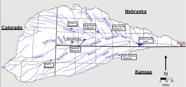


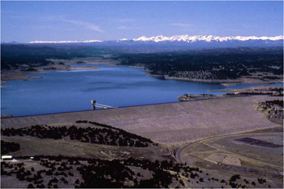

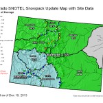
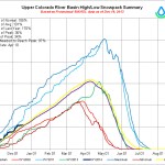
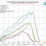
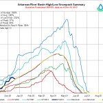
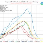
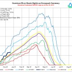
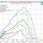


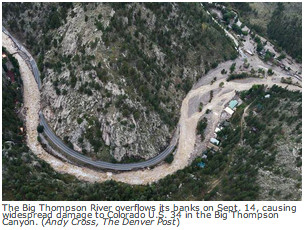
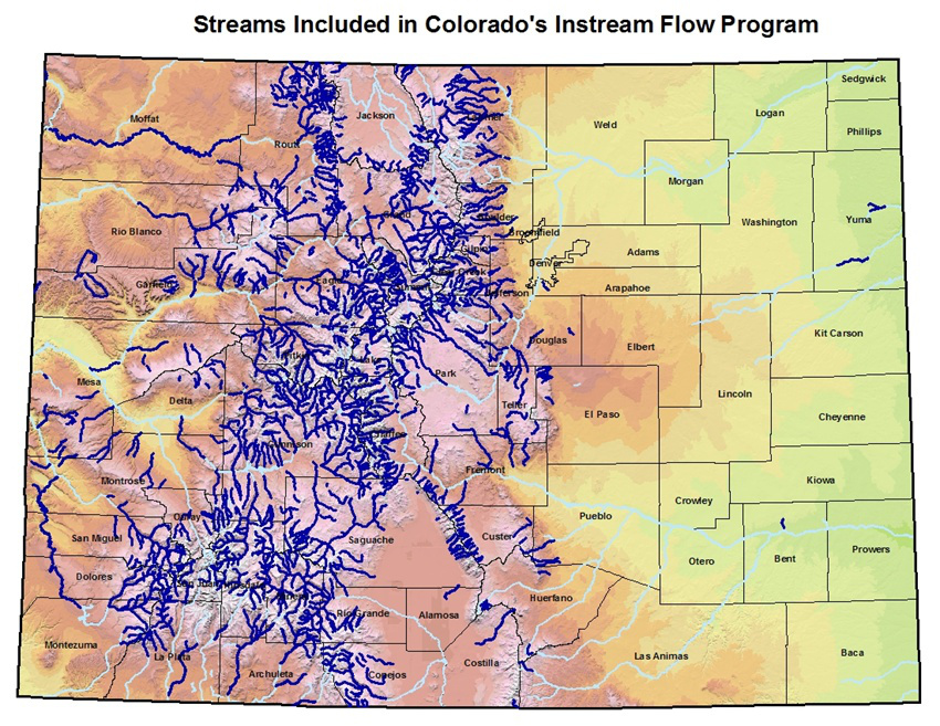


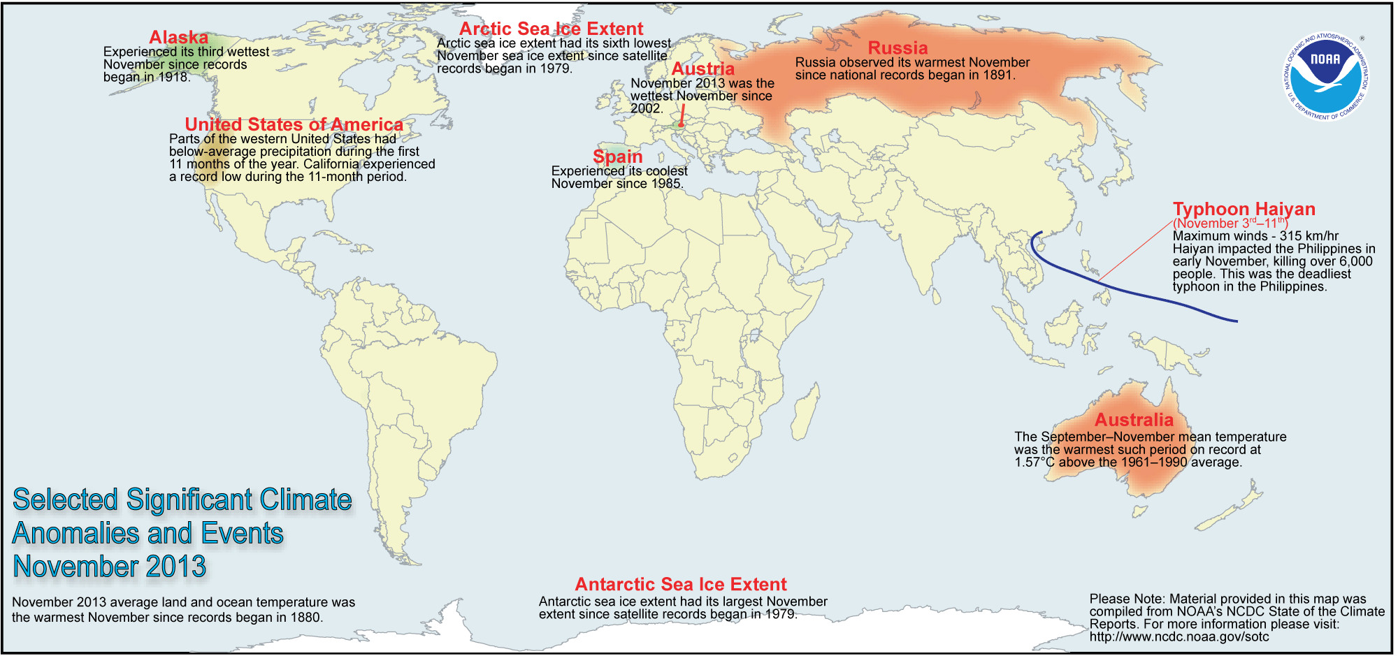


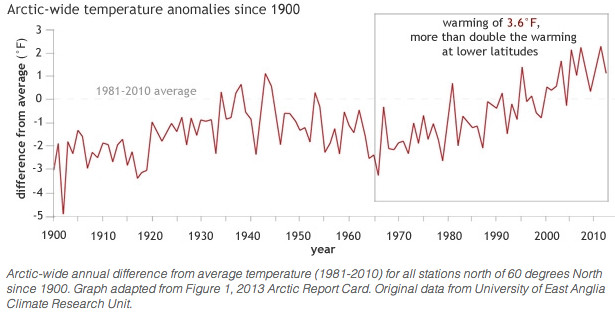

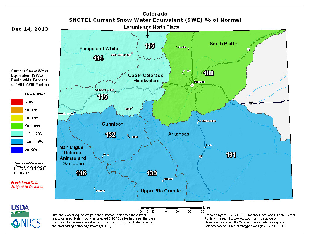


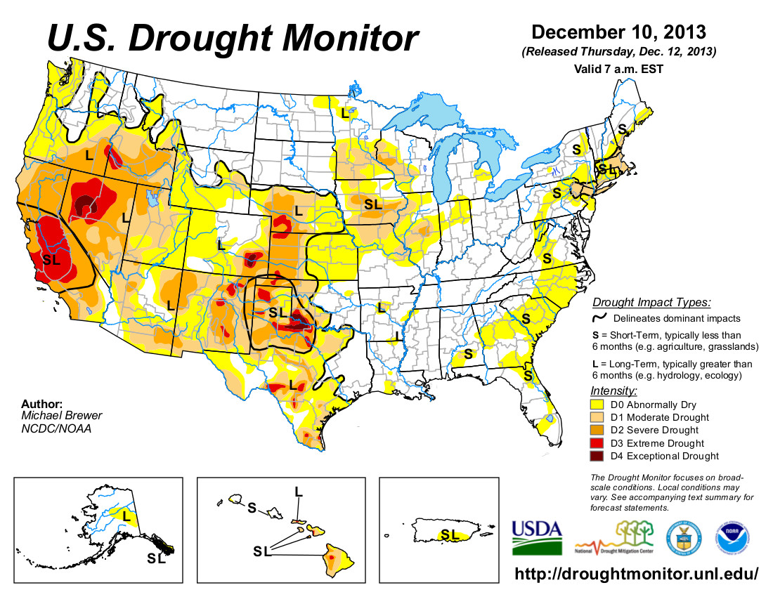


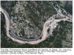


