
Month: December 2013
Scarce and vital: History Colorado showcases water in the West
Meterologist Brian Bledsoe goes out on a limb and predicts normal weather for northern Colorado

From The Greeley Tribune (Whitney Phillips):
For the first time in years, a weatherman had good news for local farmers and ranchers, telling them on Thursday that they’ll likely see normal amounts of moisture over the next year. Brian Bledsoe, chief meteorologist with KKTV in Colorado Springs, told attendees of the 2013 Colorado Ag Classic in Loveland that weather patterns show no signs of drought in the coming year. He said without the presence of El Niño or La Niña patterns that mess with normal weather, most of Colorado will likely see reasonable amounts of moisture — something Bledsoe said he hasn’t predicted in years.
“It’s gonna snow,” he said. “(We’re) much, much more optimistic about the weather patterns than we were a year ago.”
Snow, not rain, will be most crucial in getting moisture levels back up, he said. Bledsoe said most of the state, with the exception of portions of the state south of Interstate 70, has come out of devastating droughts that have plagued Colorado. Bledsoe said wet weather has helped immensely in getting farmers and ranchers back on track.
“To say that we’ve erased a large part of the drought I think is an understatement,” he said.
A full recovery, though, may take a decade, he said.
Bledsoe cautioned those in the agricultural community, especially those in the southern part of Colorado, to go forward with plans in mind to combat a lack of water.
“Most farmers and ranchers, especially the younger ones, do not even have a drought plan,” he said. “This drought problem is not going to go way just because it rains for a few months.”
Bledsoe said he predicts colder-than-normal weather to stick around for the next month and a half, bringing little precipitation. But there are indicators that helpful spring moisture will arrive right on time.
“I’m actually a little more optimistic as far as moisture in the spring time,” he said.
He added that monsoon season, which normally arrives in July, should bring normal to slightly above-normal precipitation.
“I think most people would settle for normal, whatever that is anymore,” Bledsoe said.
Overall, Bledsoe said the weather systems he monitors across the globe are all indicating there will be good news here in Colorado.
“The trend there is no monster drought signals are reappearing over our state,” he said.
Bledsoe said, though, his confidence level in his prediction is “a little bit lower than normal.
“I would caution you to say my standards (for predicting weather) are pretty high,” he said. “I’m feeling OK about seeing some moisture this year.”
Colorado Springs: Stormwater, the need is there, opposing ideas about financing models

From The Colorado Springs Gazette (Monica Mendoza):
Colorado Springs City Council says Mayor Steve Bach may have jumped the gun calling his stormwater plan “the most sensible.”
Hold on, Council says in a letter sent to the mayor. The task force has not solidified its proposal and likely won’t do so until after the New Year. It’s too early to say which solution is the most sensible, said Val Snider, council member and task force member.
“It’s important to note that the Regional Stormwater Task Force has not made a recommendation about the best structure for governance or funding of the program, and does not anticipate making that decision for at least a couple of months,” the task force said in a Dec. 10 letter to Bach.
The Pikes Peak Regional Stormwater Task Force still is doing research on the laws and finances of various scenarios, Snider said.
Bach issued a press release Dec. 9 outlining his proposal on how to pay for the millions in backlogged drainage and flood control projects. He was reacting to a community survey the task force had done to gauge public interest in stormwater issues and funding. Respondents of the survey said they favored a regional approach, a dedicated funding source and they wanted some say in the list of projects to be built.
The task force may not have settled on a proposal, but it has narrowed down its discussion to two options: one models the Pike Peak Rural Transportation Authority, created by voters in Colorado Springs, El Paso County, Manitou Springs and Green Mountain Falls and collects 1 percent sales tax for transportation and transit improvements.
The other option is modeled after the Southeast Metro Stormwater Authority, which includes Centennial, Arapahoe County, and three water districts. The authority sets and collects fees, has a staff and oversees the projects for the region.
More stormwater coverage here.
Pueblo plans $1.08 million addition to wastewater plant to meet stricter discharge standards

From The Pueblo Chieftain (Chris Woodka):
The city plans to build a $1.08 million addition at the wastewater treatment plant next year to meet long-term changes in water quality rules. The new enclosed concrete plant is being completely funded by a state grant through a $15 million appropriation designed to help small municipalities meet new state requirements which were adopted to comply with federal regulations.
“We’re not cutting any corners with this plant,” said Gene Michael, Pueblo wastewater director.
He said $80,000 will go toward design and engineering, and the plant will have to meet all criteria for new construction. The plant is expected to be complete next summer in order to comply with state requirements to use the grant money prior to 2016.
The regulations concern the concentration of nitrogen and phosphorus — both of which are found in human waste — that are in water released from the city’s treatment plant. Standards adopted this year require less than 15 parts per million nitrogen and 1 ppm phosphorus. The city completed ammonia removal facilities this year that meet those standards, Michael said. By 2022, the standards tighten to 1 ppm nitrogen and 0.17 ppm phosphorus.
Biological processes are at odds in reaching those levels, Michael explained, calling it the “zen of wastewater treatment.”
To meet the nitrogen standard, a fermentation process will be used. Further chemical treatment and filtration, similar to a drinking water plant, will be needed to bring phosphorus to the lower level, he said. The state grant is sufficient to provide fermentation and chemical treatment, but the estimated cost of filtration, about $9.3 million, will have to be dealt with later.
More wastewater coverage here.
Upper Rio Grande Impact Assessment Reveals Potential Growing Gap in Water Supply and Demand

Here’s the release from the Bureau of Reclamation (Peter Soeth):
Increasing temperatures and changes in the timing of snowmelt runoff could impact the amount of water available on the upper Rio Grande in the future. These are some of the results of the Upper Rio Grande Impact Assessment released by Department of the Interior Assistant Secretary for Water and Science Anne Castle.
“This report uses the most current information and state of the art scientific methodology to project a range of future supply scenarios in the upper Rio Grande basin,” Castle said. “It is a great first step and a call to action for water managers and users in the basin and the partner federal agencies to move forward and develop adaptation to the challenges this study brings to light.”
The study was conducted by the Bureau of Reclamation in partnership with Sandia National Laboratories and the U.S. Army Corps of Engineers. It includes a detailed evaluation of the climate, hydrology and water operations of the upper Rio Grande basin of Colorado and New Mexico. Also included is an evaluation of the potential impacts associated with climate change on streamflow, water demand and water operations in the basin.
Temperatures will increase four to six degrees Fahrenheit by the end of the 21st century, according to the climate modeling used in the study. Although the modeling projects that total annual average precipitation in the basin will not change considerably, we are likely to see a decreasing snowpack, an earlier and smaller spring snowmelt runoff and an increase in the frequency, intensity and duration of both droughts and floods.
The models used for the study consistently project an overall decrease in water availability in the basin. Rio Grande supplies are projected to decrease by an average of one-third from current supplies. The water supply from the San Juan-Chama Project, which is imported to the Rio Grande, is projected to decrease by an average of one-quarter.
All of these impacts would contribute to a larger gap between water supply and demand and lead to future water management challenges for the Bureau of Reclamation and other water managers within the upper Rio Grande basin.
The URGIA is the first impact assessment to be completed by Reclamation as part of the Westwide Climate Risk Assessments through the Department of the Interior’s WaterSMART Program. Impact assessments are reconnaissance-level investigations of the potential hydrologic impacts of climate change in the major river basins of the Western United States. Through WaterSMART, Reclamation is also able to conduct a more in-depth basin study in conjunction with state and local partners that would develop options and strategies to address supply and demand imbalances.
The WaterSMART Program focuses on improving water conservation, sustainability and helping water resource managers make sound decisions about water use. It identifies strategies to ensure that this and future generations will have sufficient supplies of clean water for drinking, economic activities, recreation and ecosystem health. The program also identifies adaptive measures to address climate change and its impact on future water supply and demand.
To read the report or learn more about WaterSMART please visit http://www.usbr.gov/watersmart/.
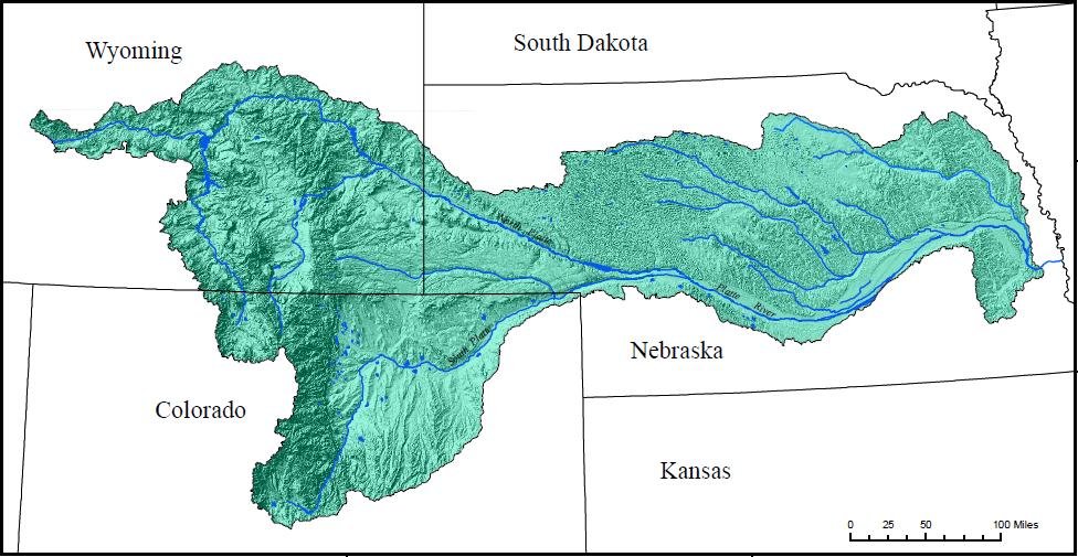
WRA Filling the Gap Report Series: Meeting Future Urban Water Needs in the Platte Basin, Wyoming
Click here to read the report. From email from Western Resource Advocates (Courtney Morrissey):
As advocates for the protection of Wyoming’s rivers and natural heritage, Western Resource Advocates and Trout Unlimited believe it is imperative for water planning to ensure healthy rivers and to minimize the adverse environmental impacts of water supply strategies.
Sustaining Wyoming’s rivers and streams is critical to Wyoming’s economy and exceptional quality of life. The report Filling the Gap: Meeting Future Urban Water Needs in the Platte Basin, Wyoming (Western Resource Advocates and Trout Unlimited, 2013) documents how Wyoming can more than meet the future water needs of the urban subbasins in the Platte Basin while minimizing impacts to the state’s rivers and streams. Specifically, the smart structural projects, conservation, reuse, and agriculture-urban sharing strategies analyzed in the report would produce 25,000 acre-feet of water per year by 2035, which is 19,600 acre-feet (6.4 billion gallons) of water in excess of the urban subbasin’s 2035 demands.
Our integrated portfolio approach more than fills the projected needs of the urban communities of the Platte Basin, Wyo. while protecting the state’s rivers, economy, and quality of life. Importantly, this water portfolio meets future needs more cheaply and without the need for the types of new, large, environmentally -damaging transbasin diversions that have been a hallmark of traditional water supply planning.
More North Platte River Basin coverage here.
Report card: Rapid changes continue in Arctic
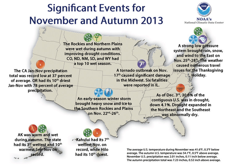
Climate: U.S. cooler than average in November
NOAA: National Overview – November 2013
Click here to go to the website.
John Wesley Powell at his desk—same desk used by the USGS Director today
#TBT John Wesley Powell at his desk—same desk used by the #USGS Director today. http://t.co/dlzFx1sJxh #science pic.twitter.com/8oG5ghSRbq
— USGS (@USGS) December 12, 2013
Cortez: Some sewer rates skyrocket
From the Cortez Journal (Tobie Baker):
Cortez City Manager Shane Hale said municipal leaders have been meeting with CSD officials to fully understand the impacts new rates would have on city facilities.
“Preliminarily, it looks as though the majority of city buildings will be assessed with exorbitant increases, ranging from four to eight times what the city currently pays for this service,” Hale said.
The most dramatic increases will be felt at the recreation center, where the sewer rates would increase from an average of $93 per month to $762 per month. City Hall, Cortez Police Department, municipal pool and city service center are all projected to see rates increase four-fold.
“From our standpoint, these increases are excessive,” Hale said.
Current sewer rates for the city and other businesses are based on actual metered water usage. City Hall currently uses 3,000 to 4,000 gallons per month of water, approximately half what a single family home is presumed to use.
“The bill for City Hall will go from $29 a month to a proposed $116 per month, or four times what a single family home pays,” Hale said.
Taxpayers would be responsible for picking up the city sewer tab, with total annual municipal sewer collections increasing from $27,600 in 2013 to $52,500 in 2014, according to CSD budget forecasts.
CSD’s new proposed sewer fees would be billed starting Jan. 1. Commercial and municipal rates would be determined based on six different classifications, with a majority of the new rates based on square footage. Hotel charges, however, are linked to the number of units, the hospital is related to the number of beds, and schools and day cares are subject to student capacity. And new rates for the Cortez Journal will be determined based on the number of employees.
CSD officials have indicated that each business type is awarded a Single Family Equivalency (SFE) ratio based on American Water Works Association guidelines. The SFE ratio is then multiplied by the square footage, number of employees or number of beds, for example, which is then multiplied by $30 to determine the business’s monthly sewer rate.
According to CSD budget figures, annual sewer collections from area schools are also expected to nearly double starting next year. CSD officials project the school district’s annual rates will increase from $19,200 in 2013 to $37,920 in 2014…
New residential sewer rates, including single-family residences, duplexes, apartments and mobile homes, contain a flat $30 monthly sewer fee without regard to the number of occupants.
Under the new rate structure, a 10,000-square-foot warehouse would pay $12 per month for sewer; a 1,000-square-foot beauty salon, $51 per month; a 200-seat movie theater, $18 per month; a 5,000-square-foot nursing home, $216 per month; a five-bay self-serve car wash and a 25-space RV park with full hookups, $300 per month; a 5,000-square-foot restaurant or bar, $364.50 per month; a 50-unit hotel with restaurant, $1,035 per month; a 50-unit hotel without a restaurant, $720 per month; and a 1,000-square-foot laundry mat, $357 per month.
Arkansas Basin Roundtable recap: Identifying critical watersheds should be part of the #COWaterPlan

From The Pueblo Chieftain (Chris Woodka):
Fires and floods have emphasized the need to protect watersheds in Colorado and should be incorporated into state water planning. The Arkansas Basin Roundtable, which is drafting its piece of the state water plan, discussed how to evaluate which watersheds are most critical and how to prevent damage from drought, insects and fire at its meeting Wednesday.
“The question we’re trying to answer is how do you expedite permitting and how do you come up with a common technical platform,” said Gary Barber, chairman of the roundtable.
Forest fires in the last two years have damaged critical watersheds in the Colorado Springs, Canon City and Walsenburg areas. Grassland fires have created other problems in the Lower Arkansas Valley as well. Fires increase the severity of flooding and increase levels of contaminants in the water.
Some watersheds may deserve higher priority because cities and farms rely on them for water supply, he said. Barber suggested the roundtable use the same sort of method it employed for recreation and environmental uses by breaking the watershed into small units and analyzing each. By having priorities in place, it will be easier to “invite” federal and state agencies to participate in programs to improve watershed health, Barber said. Using watershed models also would help in protecting from threats that arise in other basins, such as fires that top a ridge or spruce beetles that are blown by winds from one area to another.
“All of these ecological processes don’t care about which basin they’re in,” said SeEtta Moss, of the Arkansas Valley Audubon Society.
More coverage from Chris Woodka writing for The Pueblo Chieftain:
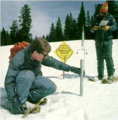
State water interests are chipping in to keep federal snow surveys in operation, but say the measurements should remain a federal responsibility. The Arkansas Basin Roundtable Wednesday agreed to ask the state to fund this year’s snow course measurements by the Natural Resources Conservation Service in the Arkansas River watershed, about $8,500. Funds come through the portion of the Water Supply Reserve Account dedicated to the Arkansas River basin. Other roundtables and water agencies such as Denver Water are providing similar funding, about $80,000 statewide.
The snow course measurements have been made since the 1930s in some places and pre-date more technological methods such as Snotel. They rely on physical measurement of snow depth to provide ground truth to automated methods. Because they are labor-intensive, the federal government has indicated they would be phased out.
“Basically, they hike in and measure the snow,” said Terry Scanga, general manager of the Upper Arkansas Water Conservancy District. “I think these snow courses are important to our basin.”
Other roundtable members supported funding the snow course readings this year, but said they should remain a federal responsibility. They agreed to back efforts to restore funding to the program.
“This is a statewide problem caused by Congress,” said Reed Dils, of Buena Vista and a former member of the Colorado Water Conservation Board. “The value of Snotel readings far exceeds the cost…These long-term programs where the federal government is a partner are important.”
U.S. Rep. Scott Tipton, R-Colo., and U.S. Sens. Mark Udall, D-Colo., and Michael Bennet, D-Colo., last month wrote a letter to the Agriculture Department urging continuation of snow measurement programs. Such programs help water suppliers plan for spring runoff.
More IBCC — Basin Roundtables coverage here and here. More Colorado Water Plan coverage here.
Weekly Climate, Water and Drought Assessment of the Upper #ColoradoRiver Basin
Click here to read the December 10 assessment from NIDIS via the Colorado Climate Center website.
Water demands grow on both sides of the Continental Divide — Aspen Journalism #ColoradoRiver #COWaterPlan
This is the kind of water story @CoyoteGulch readers lap up: http://t.co/L56Nrf0zhu
— Aspen Journalism (@AspenJournalism) December 12, 2013
Here’s a recap of the December 4 IBCC meeting in Golden, from Aspen Journalism (Allen Best). Click through and read the whole thing. Here’s an excerpt:
Many of the members of Colorado’s Interbasin Compact Committee, or IBCC, risked icy roads and snowy weather to get to their state-level water meeting in Golden on December 4. And when they got there – to talk about water for the state’s growing population – they didn’t find the going any easier…
The IBCC includes representatives from the state’s nine river basin roundtables. And as it convened, it did so knowing the Colorado River Basin Roundtable had just drawn a line on the Continental Divide in a position paper, telling the IBCC that “new transmountain diversions projects, if any, should be the very last ‘tool’ out of the box.’”
“Everybody knows the new supply will come from the Colorado River basin, except those of us in the Colorado River basin,” Stan Cazier of Grand County, who represents the Colorado River Basin Roundtable, told the other members of the IBCC.
Today, nearly three-quarters of the water in the upper Colorado River is sent east before the river reaches the Grand County seat in Hot Sulphur Springs. In all, 450,000 acre-feet to 600,000 acre-feet of water is moved each year from the Western Slope to cities along the Front Range and farms on the eastern plains.
But faced with a growing population, representatives of water interests on the Front Range want to plan for additional diversions, or “new supply,” from the Western Slope. Still in doubt is whether that water is available…
Taylor Hawes, Colorado River Program director for The Nature Conservancy…wants conservation and efficiency fully explored before additional water projects are considered.
“It’s premature to talk about a big project on the Western Slope, because we don’t know what problem we’re solving,” said Hawes, who is one of the governor’s appointees on the IBCC to represent environmental viewpoints. “Depending upon the problem, the solution may look different.”
More IBCC — basin roundtables coverage here and here. More Colorado Water Plan coverage here
Secretary Jewell to speak at the #ColoradoRiver Water Users Association 2013 Annual Conference on Friday

From the Public News Service (Troy Wilde):
U.S. Interior Secretary Sally Jewell will address the future of the Colorado River at a meeting in Las Vegas Friday. Jewell is scheduled to speak at the Colorado River Water Users Association 2013 Annual Conference at Caesars Palace.
Scott Huntley, public information manager with Southern Nevada Water Authority, says those at the conference are working together to address an ongoing water shortage. “Unless the states on the river cooperate there is really no chance of being able to weather droughts or shortages such as we have been facing – or potentially could face in the future, near future,” he explains.
From Inland News Today:
Water watchers say the drought is beginning its 14th year. And, the consequences for Southern California are looming.
Those attending a conference of Colorado River water users in Las Vegas were warned Wednesday that shortages could appear as soon as 2017.
Much of Southern California relies on Colorado River water. Spokesman Bob Muir of the Metropolitan Water District says supplies were impacted in 2003.
“Our Colorado River water supplies were almost cut in half. Since then, we’ve been investing money to refill the aqueduct that was left half-empty. The reason supplies were cut off was because it was the beginning of the drought,” Muir said.
Experts say that changes in water management will be stepped up unless there’s a sustained improvement in rain and snowfall.
Say hello to the Open Water Foundation — Open Data. Open Software. Open Decisions.

Click here to go to the Open Water Foundation website. Here’s the overview from the website:
The Open Water Foundation (OWF) is a nonprofit social enterprise that is working to provide an open source software platform to help organizations make better decisions about water. With increasing population, demand for water is increasing, resulting in negative impacts. In particular, water issues in the Western United States and other arid regions increasingly will influence decisions about the economy, environment, and society. There has been increased communication and collaboration among water interests and there is an opportunity to extend this spirit of collaboration to software development.
OWF was formed to apply an open source software business model to water resource software, so that organizations have well maintained tools to address important water problems. Every organization wants to base decisions on data and science yet it is cost prohibitive for any one organization to develop the needed software tools. Government funding and research has produced useful software, but with budget and staffing issues, we cannot rely on government agencies or short-term investment to develop and maintain software tools.
Instead, OWF is leading the effort to collaboratively develop, enhance, and maintain open source water resource software tools, to the benefit of government, universities, consultants, nonprofits, and the public. Our vision is of:
* Collaboration – OWF will work with anyone to solve water/technology issues and make those solutions available
* Transparency – as a nonprofit using an open source business model, we are demonstrating that open access to data and technology ultimately lead to a greater understanding of problems and sound decisions
* Neutrality – OWF provides a neutral space for collaboration, focusing on shared interests rather than competition
* Efficiency – with ongoing focus on water resource software solutions, OWF understands technology issues and can efficiently direct resources to projects
* Agility – by establishing relationships with a diverse network of organizations, we seek to respond as quickly as possible, and we use agile software development approaches
* Cost-effectiveness – by pooling the financial resources of our customers as applied to open source tools, we leverage solutions and benefit everyone
* Sustainability – OWF acts as a steward for open source water resources software for the long term. It is our mission.
* Innovation – OWF leads in open innovation for all of the above reasons and because it is our culture
The OWF was incorporated in April 2013 with the support of the nonprofit Rocky Mountain Innosphere (Innosphere) incubator. We also are a member of the nonprofit Colorado Water Innovation Cluster (CWIC).
We are early in our journey, are very busy, and will continue to tell our story over the next few months as we enhance this website and continue to grow.
New online database charts water quality regulations related to oil and gas development

Here’s the release from the University of Colorado at Boulder:
A searchable, comparative law database outlining water quality regulations for Colorado and other states experiencing shale oil and gas development is now available on LawAtlas.org.
The Oil & Gas – Water Quality database project is led by the University of Colorado Boulder’s Intermountain Oil and Gas Best Management Practices (BMP) Project in partnership with Temple University’s Public Health Law Research program and its LawAtlas.org website.
The newly launched Oil & Gas – Water Quality dataset (http://www.lawatlas.org/oilandgas) was created as a comparative tool for examining water quality laws and regulations related to oil and gas activities in Colorado, Montana, New Mexico, New York, North Dakota, Ohio, Pennsylvania, Texas, Utah, West Virginia and Wyoming.
The database allows policymakers, local governments, industry officials and citizens to study the scope of water quality law in their state or to make comparisons with other states. An interactive map allows for easy navigation across different jurisdictions, and downloadable PDFs are available that document each state’s water quality regulations.
“Across the nation, local and state government jurisdictions are experiencing new or increased oil and gas development,” said Matt Samelson, dataset creator, attorney and consultant for the CU-Boulder Intermountain Oil and Gas BMP Project. “When development occurs in these jurisdictions, there is tremendous value in examining regulatory regimes already in effect in order to guide conversations about best regulatory practices.”
Oil and gas production has increased nationwide as technological developments improved directional drilling and hydraulic fracturing practices, which involve pumping pressurized water, sand and chemicals deep down well bores to create fissures in the shale in order to free oil and natural gas.
In October, the U.S. Energy Information Administration predicted that the United States would surpass Russia and Saudi Arabia as the world’s largest producer of oil and natural gas by the end of 2013.
“The development of oil and gas wells, particularly in urban and suburban areas, coupled with the practice of hydraulic fracturing has stimulated interest in laws designed to protect water quality,” said Kathryn Mutz, director of CU-Boulder’s Intermountain Oil and Gas BMP Project.
Because water quality regulations depend on the stage of development, the Oil & Gas – Water Quality database has been divided into five stages of oil and gas activities: Permitting, Design and Construction; Well Drilling; Well Completion; Production and Operation; and Reclamation.
Web users can select multiple queries and search by statute categories or by state. The water quality dataset contains nearly 100 distinct questions and corresponding regulations addressing oft-cited oil and gas development issues, such as public disclosure of chemicals used in hydraulic fracturing fluid; baseline water source testing; disposal of water in hydraulically fractured wells; and spill and accident reporting.
The Oil & Gas – Water Quality database is curated by CU-Boulder’s Intermountain Oil and Gas BMP Project, part of the CU-Boulder Law School’s Getches-Wilkinson Center for Natural Resources, Energy and the Environment.
The Oil & Gas – Water Quality database is supported by the Environmentally Friendly Drilling Program and a Sustainability Research Network grant from the National Science Foundation. The dataset is part of Public Health Law Research’s LawAtlas, an online portal exploring variations in laws relating to current public health issues nationwide. In the coming year, datasets for water quantity and air quality pertaining to oil and gas development will be added to the website.
To learn more visit http://www.lawatlas.org/oilandgas.
Snowpack news: Statewide = 131% of average
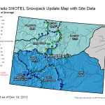

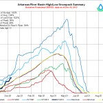
Mage at the NRCS was really busy yesterday. Click on the thumbnails to see the current snowpack graphs and statewide map.
NOAA: How do snowflakes form?

From NOAA:
Q: How are snowflakes formed?
A: A snowflake begins to form when an extremely cold water droplet freezes onto a pollen or dust particle in the sky. This creates an ice crystal. As the ice crystal falls to the ground, water vapor freezes onto the primary crystal, building new crystals – the six arms of the snowflake.
That’s the short answer.
The more complex explanation is this:
These ice crystals that make up snowflakes are symmetrical (or patterned) because they reflect the internal order of the crystal’s water molecules as they arrange themselves in predetermined spaces (known as “crystallization”) to form a six-sided snowflake.
Ultimately, it is the temperature at which a crystal forms — and to a lesser extent the humidity of the air — that determines the basic shape of the ice crystal. Thus, we see long needle-like crystals at 23 degrees F and very flat plate-like crystals at 5 degrees F.
The intricate shape of a single arm of the snowflake is determined by the atmospheric conditions experienced by entire ice crystal as it falls. A crystal might begin to grow arms in one manner, and then minutes or even seconds later, slight changes in the surrounding temperature or humidity causes the crystal to grow in another way. Although the six-sided shape is always maintained, the ice crystal (and its six arms) may branch off in new directions. Because each arm experiences the same atmospheric conditions, the arms look identical.
Q: So, why are no two snowflakes exactly alike?
A: Well, that’s because individual snowflakes all follow slightly different paths from the sky to the ground —and thus encounter slightly different atmospheric conditions along the way. Therefore, they all tend to look unique, resembling everything from prisms and needles to the familiar lacy pattern.
The latest climate briefing from the Western Water Assessment is hot off the presses
Click here to go to the WWA dashboard. Scroll down for the array of graphics and the current assessment. Here’s an excerpt:
Highlights
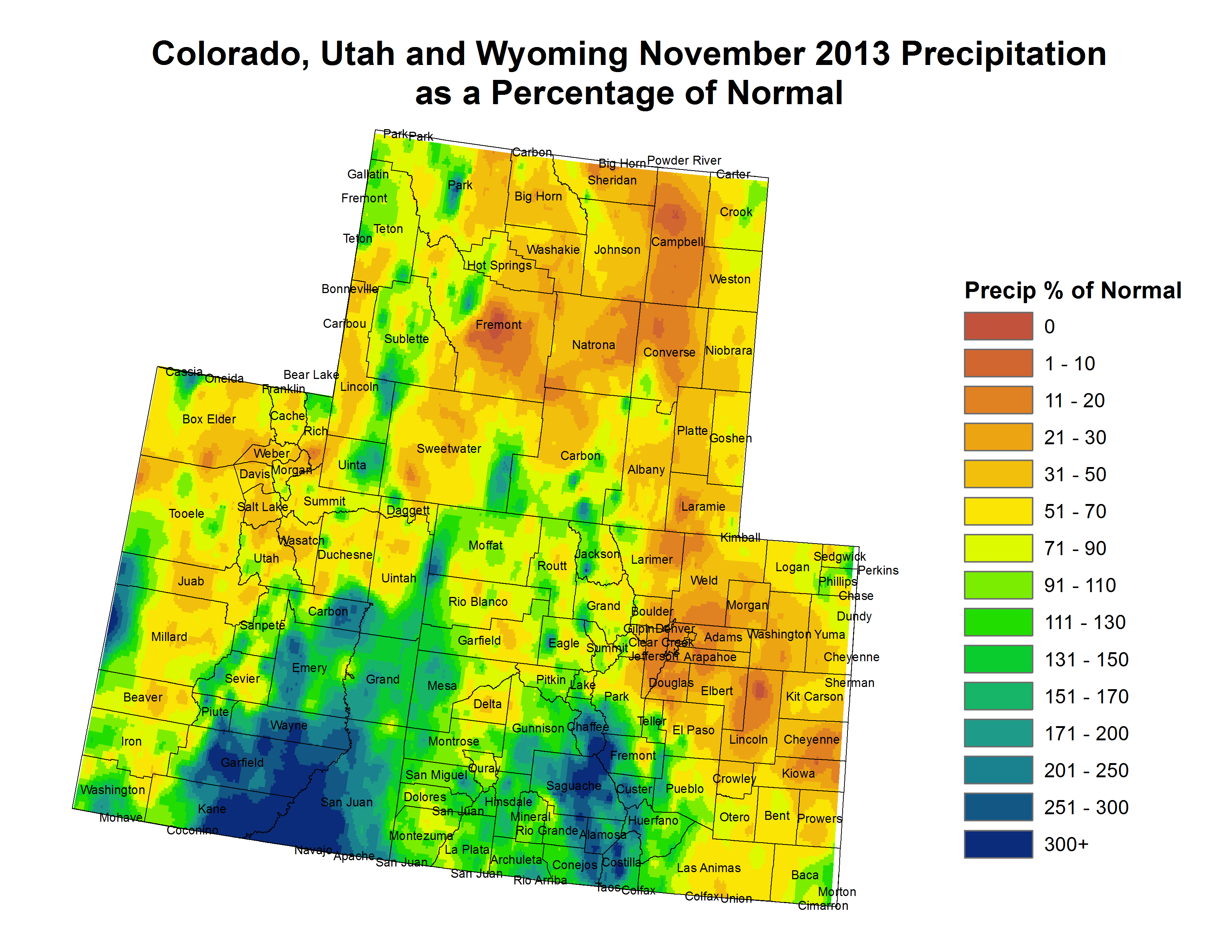
A major storm on a southerly track in late November led to much-above-average monthly precipitation for southeastern and west-central Utah and western and south-central Colorado.
Snowpacks are above normal across nearly all of the three-state region, with the wettest basins (>140% of median) in northern Wyoming, southern Utah, and the southern half of Colorado, and the driest basins (80–100% of median) in northern and central Utah and far southwestern Wyoming.
The NOAA CPC climate outlooks show a wet tilt for Wyoming over the next three months, with a slight dry tilt for southern Colorado and Utah for late winter (January–March). The NOAA PSD ‘SWcast’ is more pessimistic, showing a dry tilt for most of Colorado and Utah for late winter.
NOAA: #ColoradoRiver Basin Forecast Discussion
Colorado Basin Forecast Discussion: http://t.co/8tnEOS4WwD
— NRCS Water Supply (@ColoradoBasin) December 10, 2013
Today is Colorado Gives Day
Click here to give until you hurt. From the website:
Today is Colorado Gives Day! Last year, Coloradans made an astonishing show of support for local nonprofits by donating $15.4 million in just 24 hours. A total of $15.7 million was distributed to the nonprofits, thanks to additional contributions from the FirstBank Incentive Fund and 36 cash prizes. Let’s see what we can do on Colorado Gives Day 2013!
When: 24 hours starting at 12 a.m. on Tuesday, December 10, 2013
How: Donate online through this website
Why: To support the nonprofits that protect and nurture quality of life in Colorado
Republican River Basin: Special Master William Kayatta, Jr. reduces Nebraska’s damages to $5.5 million
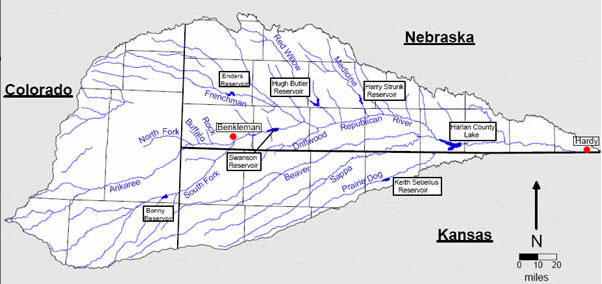
Here’s a report the Imperial Republican (Russ Pankonin) via The Yuma Pioneer. Click through and read the whole article. Here’s an excerpt:
Last Friday’s report by Special Master William Kayatta, Jr. gave Nebraska the upper hand in a dispute between Kansas and Nebraska that dates back to 2010.
“The decision could have only been $5.5 million better,” said Upper Republican Manager Jasper Fanning. Kayatta said Kansas was entitled to damages of $5.5 million versus the $80 million they had sought.
Fanning said the only way the report could have been more favorable for Nebraska was if Kansas hadn’t gotten any damages at all, he noted. Fanning said the reduction in damages was important. But even bigger was a change in the accounting process that ultimately determines how much water is available to Nebraska, he added. That will be worth many times more over the years than the $5.5 million Nebraska will have to pay Kansas, Fanning said.
In addition to the accounting change, Kayatta said Nebraska should not be charged for evaporation that occurred from Harlan County reservoir in 2006.
These two rulings will gain the basin from 16,000 to 18,000 acre feet towards water use calculations for 2007.
In addition, the accounting change will result in additional water supply annually, Fanning said. That additional water will be a boost in helping Nebraska stay in compliance with the 2002 settlement agreement reached with Kansas over basin water supplies, he added.
A 1000 Year Rain – Commemorative Edition will be available at the Estes Park Trail Gazette today
A 1000 Year Rain – Commemorative Edition will be available here at the Trail for sale this coming Tuesday…. http://t.co/Bg2FCaVxxy
— Trail Gazette (@EPTrailGazette) December 6, 2013
Pikes Peak Regional Stormwater Task Force releases poll results

From KRDO (Emily Allen):
The task force conducted it’s first ever official poll to help brainstorm solutions for the region’s stormwater problems.
“We wanted to have some good, solid data on what citizens are thinking,” said Rachel Beck with the Pikes Peak Regional Stormwater Task Force. “We wanted to have some good solid data and not just be guessing.”
It worked with an independent group to survey 400 people in the Pikes Peak region.
Ninety-five percent say flood control is important. Ninety-five percent say stormwater has had a serious impact on the community. Some 59 percent say the current stormwater system is in poor or not so good condition. “This is much stronger support than we would have expected,” said Beck…
Beck said the poll is insightful, but there is still disagreement about how to solve the problem.
“As you drill down to who manages the program and how we pay for it and the real specific things, there is less agreement on that and that’s where we are going to have to have a lot more conversation,” said Beck.
Al Brody said he sat on a stormwater task force between 2005 and 2006. He is no longer on the task force, but he still wants the community’s stormwater issues resolved. He said tackling new projects is not the solution.
“Emergency management becomes the key factor and not building and building and building bigger infrastructure to get the water out because 99.9 percent of the time you don’t need it, you need it for that one flash flood and it’s devastating but it will be devastating to people and property no matter what,” said Brody.
The task force will use results from the poll to come up with solutions. Beck said any solution will be approved by voters before moving forward.
The Fountain Creek Watershed Flood Control and Greenway District scores $175,000 from the CWCB

From The Colorado Springs Gazette (Matt Steiner):
Larry Small of the Fountain Creek Watershed Flood Control and Greenway District announced plans Monday to sponsor a study to identify potential projects stemming from storms and floods that hit the Pikes Peak region in July, August and September. Much of the damage along Fountain Creek came during flash floods in early July and Aug. 9, while that near Cheyenne Creek happened during torrential rains that occurred in El Paso County north to the Wyoming border.
El Paso County’s John Chavez called the assessment a “fill in the gaps project” that will further point out post-Waldo Canyon fire weaknesses in the watersheds. The project is expected to run through the end of 2014, Small said at Monday’s monthly Waldo Canyon Fire Regional Recovery Group meeting. The fire ravaged the mountains west of Colorado Springs in June 2012, killing two people, burning more than 18,000 acres and destroying 347 homes.
The Upper Fountain Creek and Cheyenne Creek Flood Restoration Master Plan comes more than six months after two studies in the Waldo Canyon burn scar and area watersheds were completed.
Small said his organization was approved Friday for a $175,000 grant from Colorado Water Conservation Board. The entire assessment will cost $437,500, with the remainder of the money coming from the City of Colorado Springs, El Paso County, Colorado Springs Utilities and other area municipalities and organizations.
Officials with CDOT, who also were at Monday’s meeting, highlighted two more projects along Highway 24 that they hope will keep debris flow off the roadway and alert responders before large floods strand motorists.
CDOT plans video cameras, flow gauges, online monitoring and road closure gates.
One set of monitoring equipment was installed the week of Nov. 12 about 1.5 miles up Waldo Canyon. That project cost $100,000, and CDOT said Monday that it has $200,000 more to spend on two more sites. Dave Watt of CDOT said they are looking at Williams Canyon and areas above Cascade as potential candidates. The United States Geologic Survey is working with CDOT on the project.
Summit County snowfall near average in November
Flood Recovery Resource Fair for farmers, ranchers & landowners on Monday, 12/16 #COFlood
Flood Recovery Resource Fair for farmers, ranchers & landowners on Monday, 12/16 from 1-4:30pm in Loveland. Details: http://t.co/1unRtbSj2X
— Rep. Cory Gardner (@repcorygardner) December 9, 2013
Colorado Basin Roundtable advises the Front Range to look elsewhere for new supplies #ColoradoRiver #COWaterPlan

From The Grand Junction Daily Sentinel (Gary Harmon):
Colorado can’t have less water running west down the Colorado River, a coalition of water agencies and organizations said in a missive that urged state officials contemplating a state water plan to look elsewhere.
“The West Slope of Colorado, indeed no part of Colorado, can be sacrificed for Front Range growth,” the Colorado River Basin Roundtable said.
It would be “unrealistic to look for significant new supplies of water for the East Slope from the Colorado River as a primary source,” the roundtable said, noting that any new depletions of water from the Colorado River boost the risk that downstream states will demand water under the 1922 Colorado River Compact.
The roundtable’s position paper was presented to the Interbasin Compact Committee last week in Golden. The committee will play a role in the drafting of a state water plan. There, said Eric Kuhn, general manager of the Colorado River Water Conservation District, the Colorado River Basin position was largely understood.
Most of the state’s transmountain diversions siphon water away from the Colorado and into Front Range waterworks.
“Somebody has already given at the office,” Kuhn said. “They’ve given and given.”
Kuhn is a governor’s appointee to the Interbasin Compact Committee.
Gov. John Hickenlooper charged the Colorado River Water Conservation Board with delivering a draft plan by December 2014 and a final plan by December 2015. One element of the plan is finding a new supply of water and the roundtable said the term “new supply” amounts to a euphemism for another transmountain diversion from the Colorado River system. Any new transmountain diversion must be a last option “after all means of significant conservation, reuse, land use and agricultural transfers based on substantial improvements in efficient water use are exhausted,” the roundtable said.
Several Colorado River water agencies and Denver Water have signed onto a cooperative agreement that includes additional development of Colorado River water for the Front Range.
Those projects should be completed before any new diversions are contemplated, Kuhn said.
The Colorado River basin already supplies between 450,000 and 600,000 acre feet of water to the East Slope for growing cities, farms and industries. Under the compact, the Upper Colorado River Basin is required to deliver 7.5 million acre feet of water to the lower basin. That amount is figured on a 10-year rolling average.
State officials, including Colorado Water Conservation Board director James Eklund, have urged statewide participation in drafting the plan. A plan emanating from Denver would be “anathema” to the rest of the state, Eklund said at the Upper Colorado River Basin Water Conference at Colorado Mesa University last month.
Whatever comes out of the state plan, it should “protect and not threaten the economic, environmental and social well-being of the West Slope,” the roundtable said.
More Colorado Water Plan coverage here.
Hydraulic Fracturing and Water Quality: Selected USGS Publications, August 2012 to present

Click here to go to the USGS website with links to their publications about hydraulic fracturing since 2012.
Funding Opportunity Available to Increase Water Conservation or Improve Water Supply Sustainability

Here’s the release from the Bureau of Reclamation (Peter Soeth):
The Bureau of Reclamation is making funding available through its WaterSMART program to support new Water and Energy Efficiency Grant projects. Proposals are being sought from states, Indian tribes, irrigation districts, water districts and other organizations with water or power delivery authority to partner with Reclamation on projects that increase water conservation or result in other improvements that address water supply sustainability in the West.
The funding opportunity announcement is available at http://www.grants.gov using funding opportunity number R14AS00001.
Applications may be submitted to one of two funding groups:
Funding Group I: Up to $300,000 will be available for smaller projects that may take up to two years to complete. It is expected that a majority of awards will be made in this funding group. Funding Group II: Up to $1,000,000 will be available for larger, phased projects that will take up to three years to complete. No more than $500,000 in federal funds will be provided within a given fiscal year to complete each phase. This will provide an opportunity for larger, multiple-year projects to receive some funding in the first year without having to compete for funding in the second and third years. Proposals must seek to conserve and use water more efficiently, increase the use of renewable energy, improve energy efficiency, benefit endangered and threatened species, facilitate water markets, carry out activities to address climate-related impacts on water or prevent any water-related crisis or conflict. To view examples of previous successful applications, including projects with a wide-range of eligible activities, please visit http://www.usbr.gov/watersmart/weeg.
In 2013, Reclamation awarded more than $20 million for 44 Water and Energy Efficiency Grants. These projects were estimated to save about 100,000 acre-feet of water per year — enough water to serve a population of about 400,000 people.
The WaterSMART Program focuses on improving water conservation, sustainability and helping water resource managers make sound decisions about water use. It identifies strategies to ensure that this and future generations will have sufficient supplies of clean water for drinking, economic activities, recreation and ecosystem health. The program also identifies adaptive measures to address climate change and its impact on future water demands.
Proposals must be submitted as indicated on http://www.grants.gov by 4 p.m., Mountain Standard Time, Jan. 23, 2014. It is anticipated that awards will be made this spring.
To learn more about WaterSMART please visit http://www.usbr.gov/WaterSMART.
More Bureau of Reclamation coverage here.
‘I firmly believe we will some day see oil shale become a reality’ — Glenn Vawter

Here’s a recap of a presentation about the future of oil shale at Rifle Community College on November 19, written by Mike McKibbin for the Rifle Citizen-Telegram. Here’s an excerpt:
The long sought-after petroleum product is infamous for its long-held promise of economic benefits, high-paying jobs and what sounds like an almost non-ending supply to meet America’s growing energy needs.
But while that reality has proved elusive for centuries, some, such as Glenn Vawter, executive director of the National Oil Shale Association, are ever optimistic. The nonprofit group promotes factual information about oil shale…
“I firmly believe we will some day see oil shale become a reality, and 75 percent of the world’s oil shale is in the U.S.,” Vawter said. “It’s already been produced commercially for decades in Brazil, Estonia and China.”[…]
The underground mining processes used by companies such as Unocal, which produced 10,000 barrels of shale oil a day during its limited operation, totaled five-million barrels and was proven feasible, Vawter said.
The in-situ process that companies are now developing has the advantage of no mining, Vawter said.
Currently, research, design and development projects on Bureau of Land Management leases are underway by American Shale Oil, ExxonMobil and Natural Soda in western Garfield and Rio Blanco counties, along with Red Leaf Resources and Enefit American Oil in Utah.
“It was discouraging that Shell recently announced they were pulling out,” Vawter said. “But Red Leaf plans to start commercial production of up to 10,000 barrels a day in Utah next year. There’s a lot going on over there in Utah. They have policies that are more welcoming to energy and oil shale industries.”
Enefit has operated shale oil projects in Estonia for decades, Vawter pointed out, with a proven technology.
And Vawter pointed to a recent U.S. Geological Survey estimate of 4.3 trillion barrels of shale oil in Colorado, Wyoming and Utah. Of that, Vawter said up to 1.14 billion barrels are now considered recoverable. That is up to six times more than the total oil reserves in Saudi Arabia and significantly more than known U.S. conventional oil resources.
“There are places in the Piceance Basin that are estimated to have one million barrels in just one acre,” Vawter said. “The Piceance Basin could have up to 152 trillion barrels.”
Water used in the oil shale process has often been cited by opponents as a large hurdle, Vawter said, but current processes for a 1.5 million barrel per day project would require just 2 to 3 percent of an estimated 8 million acre feet per year of water in the Colorado River.
“That’s not an insignificant amount, but it’s far less than some still believe,” he said…
The Pagosa Springs Sanitation and General Improvement District board is moving ahead with wastewater pipeline

From the Pagosa Sun (Ed Fincher):
The Pagosa Springs Sanitation and General Improvement District board voted last week [week of November 25] to accept a bid from Hammerlund Construction Company for work on a pipeline and pumping stations needed to deliver wastewater from the town’s current lagoon site to the Pagosa Area Water and Sanitation District’s Vista treatment plant.
Art Dilione, special projects manager for Bartlett & West, the company tasked with handling the bidding process for the town, sent a letter to both town manager David Mitchem and Gregg Mayo, special projects director for PAWSD.
The letter, dated Nov. 19, explained how the project was originally bid on Oct. 2, but all of those bids came in well above the engineer’s estimate as well as the project’s budget, so those original bids were rejected and the project was rebid on Nov. 12.
More wastewater coverage here.
Weld County: Replacing homes lost in the September flooding? #COflood

From The Greeley Tribune (Analisa Romano):
Leticia Rivera’s son has a birthday coming up this month and, this year, his birthday wish is simple. He wants a home to live in, Rivera said, as she stood in a semi-circle among her neighbors at Greeley West High School on Thursday, all of them past residents of Eastwood Village mobile home park, which was wiped out in the flood. “Pobrecito,” Rivera said. “Poor thing.” For the past two months, Rivera, her 8-year-old son and her husband have been living out of a suitcase, traveling from one friend’s home to the next each week so that they can stay in the Greeley area and keep their son in the same school, she said.
Rivera said after a community meeting at the high school that the family plans to move into a mobile home provided by FEMA as soon as the agency places them. That should be soon, but like the rest of those who lost their homes in the flood, FEMA has had a hard time finding any vacancies. It’s one of an array of challenges in Greeley and Evans, where apartment vacancies have hit an 18-year low, and in Milliken, where few affordable housing options exist. Continue reading “Weld County: Replacing homes lost in the September flooding? #COflood”
Allen Best: The risk is that water may not be there some years. Or a lot of years. #ColoradoRiver #COWaterPlan

Here’s a guest column about the possible effects of low flow into Lake Powell, written by Allen Best that is running in The Denver Post:
Skimpy-clothed people splashing amid the red sandstone canyons of Utah define our images of Lake Powell. But six months ago, engineers and water officials from the seven states of the Colorado River Basin quietly met in Santa Fe to consider a more serious possibility: Continued drought could leave too little water in the reservoir for the eight giant turbines in Glen Canyon Dam to produce electricity.
The turbines can produce great amounts of electricity, 1,320 megawatts at full throttle, or roughly twice as much as the Cherokee power plants north of downtown Denver. In practice, the volume runs half that. Most rural electrical cooperatives in the Rocky Mountains states buy power from Glen Canyon through their wholesale supplier, Tri-State Generation and Transmission, as does Xcel Energy.
The average $150 million in revenues from this power generation are a federal cash cow. The money paid for construction of Glen Canyon and other dams authorized by Congress in 1958, but also funds salinity control such as in the Paradox Valley west of Telluride and the endangered fish recovery program, including the 15-mile segment of the Colorado River from Palisade into Grand Junction.
What if the Colorado River Basin has another bum year for snow? Inflows into Lake Powell during the last two years were 25 percent and then 47 percent as compared to the rolling 30-year average. If the years 2001-2003 were about as bad, here’s the difference: in 1999, Lake Powell was full. In recent years, despite a few big snow years, the reservoir has often displayed big “bathtub rings.” Right now, it’s 43 percent of capacity. Drought has been our more steady companion of the 21st century. This extended drought, in duration and depth, surpasses any since gauges were installed in the Colorado River Basin in 1906. However, extensive study of tree rings in the basin suggest worse and even longer drought sequences have occurred in the Southwest, especially 900 years ago. Whether this drought will also continue is anybody’s guess, but Colorado and other states decided it best to plan in case it does. On Thursday, at a meeting in Golden, officials for the first time shared some of their pending strategies.
John McClow of Gunnison, who is Colorado’s representative on the Upper Basin Compact Commission, said if snow lags again this winter, reservoirs on two tributary rivers — Flaming Gorge Reservoir on the Green and Navajo on the San Juan — can be tapped to allow the Glen Canyon generators to produce electricity. The trio of reservoirs near Gunnison — Blue Mesa, Curecanti and Morrow Point — are already too low to be of much value, he said. Other federal reservoirs — Ruedi near Basalt, Green Mountain near Kremmling, and Granby — are not part of the same system.
If the drought deepens, other small-gain strategies can be deployed: stepped-up cloud seeding and more aggressive efforts to remove water-gobbling salt cedar, i.e., tamarisk, an invasive species, from river banks. Still other strategies being weighed include idling of agriculture land —even crimping of some transmountain diversions, which normally divert 450,000 to 600,000 acre-feet of water each year in Colorado from the Colorado River Basin to the Front Range and eastern plains. But whatever strategies are adopted, McClow stressed, Colorado alone wouldn’t bear the burden.
Why not just forego the electricity? That remains an option, but it would invite the federal government to become a decision-maker in water matters. Almost fiercely, the states prefer to chart their own course.
This newest twist at Lake Powell is different from a curtailment under the 1922 Colorado River Water Compact. Colorado and other upper-basin states are in no imminent danger of failing to deliver the water specified for delivery at Lee’s Ferry, at the head of the Grand Canyon, as required by the compact, said McClow, nor is that likely to occur at any time soon. For that matter, the prospect of a Lake Powell “dead pool”- too little water to generate power – isn’t high probability next summer. Computer modeling suggets a 5 to 7 percent chance.
Yet this sharpening razor’s edge at between water supply and demand may be instructive. At one level it represents the intersection of water and energy. In California, one-fifth of all energy is devoted to moving around water. In Colorado, it’s lower. But everywhere, particularly the West, water is dependent on energy, and producing energy is dependent on water.
More immediately, this reminds us of risk. Some people think that Colorado’s growing urban areas need to develop the state’s remaining raw water supplies from the Colorado River Basin. The risk is that water may not be there some years. Or a lot of years. We just don’t know.
Allen Best of Arvada publishes Mountain Town News (http://http://mountaintownnews.net/).
September’s flooding leaves the question, ‘What if it comes at the wrong time?’: Chris Woodka #COflood

From The Pueblo Chieftain (Chris Woodka):
What can the Arkansas River basin learn from flooding in Northern Colorado in September?
Some impacts of the historic floods on ditches will take years to sort out, said Sean Cronin, executive director of the St. Vrain and Left Hand Water Conservancy District in Longmont. He spoke at an American Ground Water Trust conference last week. More than half of the 95 ditches and reservoirs within the district reported damage from the flood.
Damage totals are still unknown, but could easily absorb the $2.3 million in grants and $40 million in loans made available by the Colorado Water Conservation Board. Many ditches already have made quick repairs, but some reservoirs and diversions could take years to repair. In some cases streams shifted from their historic channels.
“We got the message out early that nobody’s riding in on a white horse,” Cronin said. “We told our ditch companies ‘you need to do this.’ ”
The district is helping ditch companies navigate through processes to obtain permits or relief through state and federal agencies.
While Cronin described the impacts on areas in Boulder County, implications for the Arkansas River basin could be gleaned from his presentation.
Before the flood
Numerous small gravel-pit reservoirs are in the St. Vrain River watershed between Lyons and Longmont.
“They’re attractive because no permits are required, but they became unzipped from Lyons to Longmont,” Cronin said.
In the Arkansas River basin, a series of small retention ponds has been suggested as a way to reduce peak flows from a large,100-year flood on Fountain Creek, the Arkansas River’s largest tributary. The last 100-year flood on Fountain Creek occurred in 1965, but would be much heavier now because of growth in Colorado Springs. A demonstration pond in Pueblo, similar to the type proposed, suffered some damage to its outer wall from a much smaller flood during September. A U.S. Geological Survey study shows that 10 ponds between Colorado Springs and Pueblo would reduce the peak flow by 47.7 percent, but would have little impact on huge loads of sediment that would be expected in a 100-year flood.
During the flood
There was some capacity in ditches in the St. Vrain watershed to redirect some of the flows as flooding occurred, until reservoirs in the system were completely overwhelmed during five days of rain.
During the same period, in the Arkansas Basin, ditches in the La Junta area cooperatively moved water from a “wave” from El Paso County that migrated down Fountain Creek and into the Arkansas River. Coupled with tamarisk removal from the river channel through La Junta, the peak was reduced to avoid the type of damage North La Junta incurred during 1999 floods.
The historic 1965 Fountain Creek flood in the Arkansas River basin caused $37.5 million in damage, much of it to cities and farms east of Pueblo, as well as Pueblo’s East Side.
Diverting some of the water on Fountain Creek, either to Chico Creek or to an off-channel reservoir, has been suggested and modeled in the USGS study. The alternative would not be as effective as either a large dam or a series of smaller ponds.
After the flood
Protection of junior water rights often is mentioned during discussion of detention of water on Fountain Creek.
After the September flooding in the South Platte basin, the Colorado Division of Water Resources measured the impact of groundwater interception of increased flows during the flood. While groundwater levels rose rapidly during flooding, they decreased quickly as the river level dropped. The net gain to the system after the majority of water rushed past was about 7.8 percent.
“The question comes up, ‘does that erase the depletions from past well pumping?’ ” said Kevin Rein, deputy state engineer.
The state’s answer was “no.” The additional water was not allocated to junior water rights, but divvied up through the same priority system that satisfies senior rights first.
Of course the most devastating impact of a flood is damage to infrastructure. The state has reconstructed the roads destroyed by the September flooding on a temporary basis, and it will be years before they are completely rebuilt. For ditch companies, the questions of rebuilding become more complicated and problematic.
While any ditch would welcome more water, September’s flooding leaves the question, “What if it comes at the wrong time?”
Pearl Harbor Day
THIS IS NOT DRILL pic.twitter.com/WkaTX29rRR
— NewMexiKen (@NewMexiKen) December 7, 2013
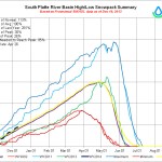
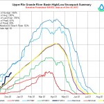
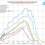
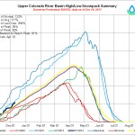
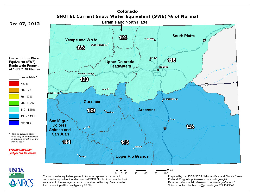
Snowpack news (% of normal): Upper Colorado = 120; South Platte = 116; Arkansas = 143; Upper Rio Grande = 145; Gunnison = 139; Yampa & White = 123; San Miguel/Dolores/Animas/San Juan = 141
From the Fort Collins Coloradoan (Ryan Maye Handy):
…for meteorologists, climatologists and water district officials, it’s too early to celebrate an already above-average snowpack, or to anticipate reaping the benefits when spring runoff hits.
“Early snow is better than no snow,” said Brian Werner, spokesman for the Northern Colorado Water Conservancy District. “We don’t put a lot of emphasis on the early numbers before you get us into February and March.”
Still, the early snowpack numbers for the hills west of Fort Collins look good; levels at two crucial Fort Collins reservoirs, Joe Wright and Deadman Lake, are above average. Averages are measured by snow water equivalents — essentially, a sample of snow that is then melted and measured. At Joe Wright Reservoir, snowpack is 13 percent above average for this time of year, and the snow water equivalent is at 4.5 inches. Deadman Lake snowpack levels are 39 percent above average, with a snow water equivalent of 7.1 inches, according to the National Weather Service…
Until September, when catastrophic floods hit the Front Range, most of Colorado was in some stage of moderate to extreme drought. Even with the heavy snows, it took up to a foot of rain in most places to banish the drought completely in northern and central Colorado.
“September has given us such a shot in the arm that we will end up, in the 2013 calendar year, at least a couple of inches above the long-term (precipitation levels),” said Nolan Doesken, director of the Colorado Climate Center at Colorado State University.
Much of the glut of September rain is still in the ground, and has not yet been depleted by streams, Doesken said. The Cache la Poudre River Basin, the watershed that feeds Fort Collins, has likely retained a lot of moisture after the September floods.
“Our basin has a lot of water in the soils as well as a good start to the snowpack,” Doesken said.
From Transworld.net (Gerhard Gross):
A powerful and well-timed winter storm swept across the western U.S. Tuesday and Wednesday, touching each one of Vail Resorts’ mountains and leaving up to 14 inches of new snow in its wake.
From The Aspen Times (Andre Salvail):
Despite some decent helpings of early snowfall this autumn, what locals and visitors had been hoping for finally came — an estimated 14-inch dumping of powder atop Aspen Mountain and 12 inches on Snowmass ski area late Tuesday and much of Wednesday.
In fact, Mother Nature was generous throughout the Roaring Fork Valley, dropping about 11 inches in the city of Aspen, 9 or 10 inches in the Basalt area and a similar amount in Glenwood Springs. The estimates from each area vary, depending on the source and the precise location…
The next significant snowfall event is not expected until Saturday, Boudreau said. It’s not predicted to have quite the same impact as the Tuesday-Wednesday storm, but could bring 3 to 5 inches on Saturday and maybe more on Sunday, according to Cory Gates, also of http://aspenweather.net.
From The Grand Junction Daily Sentinel:
Weather-watchers reported .54 inches of precipitation on Wednesday — in the form of 5.9 inches of snowfall recorded. That bested precipitation and snowfall totals for the day — .35 in precipitation in 1944 and 3.7 inches of snow recorded in 1972.
Storm snowfall totals from across the region revealed the real impact the storm had in multiple spots.
In Garfield County, 30 inches of snow were measured at Douglas Pass over the course of the storm, and 17 inches of snow were recorded in New Castle.
In Delta County, 8 inches fell in Paonia and 5 inches were recorded in Hotchkiss.
The measurements were similarly mixed across Mesa County.
A measuring site at the Skyway on Grand Mesa tallied 10.5 inches of snow, while 9 inches were recorded on the Redlands and 7 inches on Glade Park, according to weather service data.
Larimer County: All major road corridors now open #COflood
News Release: Larimer Flood 2013 – All Major Road Corridors Now Open!!!!! http://t.co/hitA7UyhUy
— Larimer County (@LarimerCounty) December 6, 2013
Reclamation Selects Jacklynn Gould as Eastern-Colorado Area Manager

Here’s the release from the Bureau of Reclamation (Kara Lamb):
The Bureau of Reclamation’s Great Plains Region has selected Jacklynn Gould, a Colorado native, as the Eastern Colorado Area Manager in Loveland, Colo. Gould will assume her responsibilities as Area Manager on Dec. 15. She replaces Mike Collins, who is retiring after more than 42 years of federal service.
“Gould is the right candidate for the job,” said Great Plains Regional Director Mike Ryan. “Her prior experience working at ECAO, along with her extensive background in management and water operations qualifies her to help mitigate water challenges of the future.”
Gould is the first female Area Manager Colorado has hired. Prior to accepting the Area Manager position, she served as the Deputy Area Manager for the Eastern Colorado Area Office in Loveland. Gould’s career with Reclamation began in 1992 as a water resource planner in Reclamation’s Denver Office. She has also worked in the Albuquerque Area Office, and most recently in the Eastern Colorado Area Office.
“I’m honored to be selected as the Eastern-Colorado Area Manager,” said Gould. “I look forward to the opportunities and challenges Colorado faces in managing and developing the water resources of tomorrow.”
Eastern Colorado is home to two major Reclamation projects: the Colorado Big-Thompson and Fryingpan-Arkansas. Together, the projects provide water to over 1.5 million people.
More Bureau of Reclamation coverage here.
Eagle River Watershed Council: Hydraulic Fracturing & Water an informational panel, Wednesday December 11th

Click here to read the announcement.
Water Court cancels @fortcollinsgov 2007 Halligan Reservoir expansion conditional water right — no diligence filing
Big deal on the Poudre River. #gamechanger pic.twitter.com/ti7KFDTVou
— Don Frick (@donfrick07) December 7, 2013
The Tweet above has been deleted from Twitter.
Update (January 10, 2014): The right is actually a 1985 right. I got that wrong and the source document is now unavailable. Also, the right is not directly associated with the Halligan expansion. Fort Collins has other rights that will fill the expanded vessel.
Here’s the story from Kevin Dugan writing for the Fort Collins Coloradoan. Here’s an excerpt:
Failure to file required paperwork has cost Fort Collins a water right on the Poudre River it has held for 28 years.
The right was intended to help fill Halligan Reservoir, which sits on the North Fork of the Poudre River, if a project to enlarge the reservoir is ever approved and built.
The city has been working on the enlargement proposal for many years. It secured a conditional right to receive up to 33,462 acre-feet of water in 1985 in hopes of storing part of it in Halligan to meet future water needs and protect the city’s water supply during times of drought.
More Halligan/Seaman expansion coverage here.
Many eyes are on the 1,250 cfs Shoshone right #ColoradoRiver
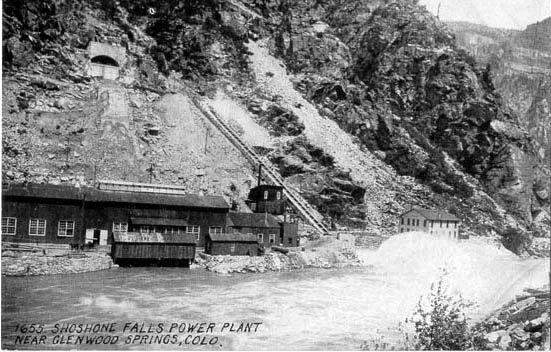
From KUNC (Maeve Conran):
There’s popular launch site for rafters a few miles east of Glenwood Springs. It’s right beneath Interstate 70, and is in front of an old tan brick building, set back into the canyon wall. Chances are, highway drivers might not even see this place. But it’s the reason the rafting is so good here all the time.
The Shoshone Hydro Plant, built to harness Colorado River water and turn it into 15 megawatts of electricity has two nine-foot tall turbines, which were manufactured and installed in 1906 and are still humming along today. It’s the linchpin of the river, according to Jim Pokrandt, Education and Outreach Specialist with the Colorado River District.
“Not because of producing electricity,” said Pokrandt. “But because it takes water to produce that electricity, and that water is supplied via a 1902 water right for 1250 CFS. That’s the biggest, oldest water right on the river.”
1250 CFS, or cubic feet per second, is a lot of water. It’s labeled “non-consumptive use,” which means the water is not taken out of the river to grow food or flush toilets. It flows onto the turbines and right back out—sustaining an important part of the local economy: rafting, kayaking and fishing.
Maintaining that primary water right is critical to keeping flow levels adequate for the turbines, and to help create rapids.
Pokrandt says Shoshone also helps towns that draw water from the river, because the high flows the plant requires helps keep the water cleaner.
“Silt, Rifle, Parachute and Clifton are all taking drinking water out of the Colorado River,” said Pokrandt. “The greater the flow, the less intensive you have to treat the water.”
Agriculture in the Grand Valley also benefits from Shoshone’s water right.
Mel Rettig is a vegetable and fruit farmer in Palisade, about 80 miles southwest of the Shoshone plant. Rettig says the higher flows due to Shoshone help keep salinity levels low…
Some West Slope water irrigators who depend on Shoshone would love to buy the plant and its water right to protect the interests of the Grand Valley. A 15-megawatt output is small by today’s standards — modern power plants produce hundreds of megawatts. But Xcel continues to invest millions in maintenance at the plant and the utility says they have no plans to sell Shoshone or its water rights…
“This little, old, two turbine, 15-megawatt 1905 vintage power plant in Glenwood Canyon,” said Pokrandt. “It doesn’t look like much but it’s a big dog on the river.”
The latest ENSO discussion is hot off the presses from the Climate Prediction Center

Click here to read the discussion. Here’s an excerpt:
Synopsis: ENSO-neutral is expected to continue into the Northern Hemisphere summer 2014.
During November, ENSO-neutral persisted, as reflected by near-average sea surface temperatures (SST) across much of the equatorial Pacific Ocean. SST anomalies in all of the Niño regions were small, but showed increases in the Niño-3.4 and Niño-4 regions. The oceanic heat content (average temperature in the upper 300m of the ocean) increased due to the eastward propagation of a downwelling oceanic Kelvin wave. This increased heat content reflects above-average subsurface temperatures across the Pacific. The wind anomalies remained small at lower and upper levels during the month. Equatorial convection was suppressed in the central equatorial Pacific and enhanced over Indonesia. Collectively, these atmospheric and oceanic conditions reflect ENSO-neutral. The majority of model forecasts indicate that ENSO-neutral (Niño-3.4 index between -0.5°C and 0.5°C) will persist into the Northern Hemisphere summer 2014. While current forecast probabilities are still greatest for ENSO-neutral by mid-summer, there is an increasing chance for the development of El Niño. The consensus forecast is for ENSO-neutral to continue into the Northern Hemisphere summer 2014 (see CPC/IRI consensus forecast).
Colorado flood recovery updates #COflood

Here’s the release from Governor Hickenlooper’s office:
The Colorado flood recovery team continues to make progress in helping communities rebuild from the September floods. Here is an update of recovery efforts:
The Colorado Department of Transportation (CDOT) contracted with a debris removal company to help residents in the Big Thompson Canyon dispose of certain materials removed from homes during flood cleanup efforts. The contractor is scheduled to remove debris during the weeks of Dec. 9 and Dec. 23. Residents in the area will be asked to place debris alongside the U.S. 34 right-of-way. For more information, residents can contact the CDOT flood information hotline at (720) 263-1589. CDOT implemented flood mitigation measures for the Waldo Canyon fire burn scar along U.S. Highway 24 — including stabilizing slopes and creating sediment ponds. Boulder completed the “Left Hand Creek Flood Control Project” that included upgrading bridges and channel capacity to keep storm water in the channel and away from neighborhood homes. The Boulder Creek Path, a heavily used commuting pathway will reopen this week, with only a small section from Pearl Parkway to Goose Creek Path, east of Foothills Parkway still closed. With completion of major sewer line repairs, remaining areas in Estes Park have been removed from the “No-Flush Zone.” Lyons elementary, middle school and senior high students are back in their schools this week. Some 700 students attended classes at the Main Street School in Longmont since the September flood.
Meanwhile, Reclamation has started moving water through the Adams Tunnel again. The pumps had been off since the flooding in September. Here’s a report from Leia Larsen writing for the Sky-Hi Daily News. Here’s an excerpt:
The Bureau of Reclamation stopped pumping in mid-September after heavy rains in Estes Park and the Front Range. Crews were working to repair damage and dredge sediment loads from reservoirs caused by the ensuing floods in the Estes Park area. As of Wednesday, Nov. 27, the Bureau began running around 60 cubic feet per second through the tunnel. Most years, it runs around 550 cfs by mid-December to refill Horsetooth and Carter reservoirs. According to public information officer Kara Lamb, the Bureau of Reclamation is still hoping to meet that schedule this season.
Currently, Lake Granby is at about 72 percent full.
“We’re probably going to see that tick down a little bit as we starting running more (water) through the tunnel,” Lamb said. “But right now, Lake Granby is staying pretty even since we’re not taking that much.”
Drought news: Improvement over southwest and south-central Colorado #COdrought
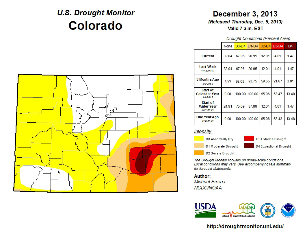
From the National Weather Service Pueblo office:
…IMPROVEMENT IN DROUGHT CONDITIONS CONTINUES ACROSS SOUTHWEST
AND SOUTH CENTRAL COLORADO…SYNOPSIS…
NOVEMBER OF 2013 STARTED ON A WARM AND DRY NOTE ACROSS MOST OF SOUTH CENTRAL AND SOUTHEAST COLORADO. A CHANGING WEATHER PATTERN THEN BROUGHT COOL AND WET WEATHER THROUGH THE MIDDLE OF THE MONTH…ESPECIALLY ACROSS THE SOUTHWEST MOUNTAINS AND THE SAN LUIS VALLEY. UNFORTUNATELY…MUCH OF THIS BENEFICIAL PRECIPITATION MISSED THE SOUTHEAST PLAINS…PERPETUATING THE DROUGHT…ESPECIALLY ACROSS PORTIONS OF THE LOWER ARKANSAS RIVER VALLEY.
WITH THIS IN MIND…THE LATEST US DROUGHT MONITOR NOW INDICATES DROUGHT FREE CONDITIONS ACROSS MOST OF MINERAL COUNTY…AS WELL AS EXTREME SOUTHWESTERN RIO GRANDE COUNTY AND EXTREME NORTHWESTERN CONEJOS COUNTY. DROUGHT FREE CONDITIONS CONTINUE TO BE DEPICTED ACROSS LAKE COUNTY…EASTERN TELLER COUNTY…SOUTHWESTERN THROUGH EXTREME NORTHEASTERN EL PASO COUNTY…EASTERN FREMONT COUNTY AND EXTREME NORTHWESTERN PUEBLO COUNTY.
ABNORMALLY DRY (D0) CONDITIONS CONTINUE TO BE INDICATED ACROSS WESTERN FREMONT COUNTY…WESTERN TELLER COUNTY…SOUTH CENTRAL THROUGH NORTHEASTERN EL PASO COUNTY…NORTHWESTERN PUEBLO COUNTY…CUSTER COUNTY…WESTERN HUERFANO COUNTY AND WESTERN LAS ANIMAS COUNTY. ABNORMALLY DRY (D0) CONDITIONS ALSO REMAIN DEPICTED ACROSS CHAFFEE COUNTY…SAGUACHE COUNTY…NORTHERN MINERAL COUNTY…THE REST OF RIO GRANDE AND CONEJOS COUNTIES…AS WELL AS ALAMOSA COUNTY AND COSTILLA COUNTY.
MODERATE DROUGHT (D1) CONDITIONS REMAIN DEPICTED ACROSS MOST OF THE REST OF EL PASO AND PUEBLO COUNTIES…THE REST OF HUERFANO COUNTY…CENTRAL LAS ANIMAS COUNTY AND MOST OF BACA COUNTY.
SEVERE DROUGHT (D2) CONDITIONS CONTINUE TO BE INDICATED ACROSS EXTREME SOUTHEASTERN EL PASO COUNTY AND EXTREME EASTERN PUEBLO COUNTY…MOST OF THE REST OF LAS ANIMAS COUNTY…NORTHWESTERN BACA
COUNTY…EASTERN BENT COUNTY…PROWERS COUNTY AND EASTERN KIOWA COUNTY.EXTREME DROUGHT (D3) CONDITIONS REMAIN DEPICTED ACROSS MOST OF CROWLEY COUNTY…WESTERN OTERO COUNTY…WESTERN BENT COUNTY…EXTREME NORTH CENTRAL LAS ANIMAS COUNTY…AND WESTERN AND CENTRAL KIOWA
COUNTY.EXCEPTIONAL (D4) DROUGHT CONDITIONS CONTINUE ACROSS SOUTHEASTERN CROWLEY COUNTY…EASTERN OTERO COUNTY…SOUTHWESTERN KIOWA COUNTY AND EXTREME WESTERN BENT COUNTY.
CSU, Noble Energy and DNR partner on groundwater monitoring project in the Wattenberg field

From The Greeley Tribune (Sharon Dunn):
Like the crime scene investigators on television, researchers in northern Colorado will be taking an intense look at water wells throughout the oil patch in a demonstration study in the coming months to determine changes in the water over time. Conducted through Colorado State University in partnership with Noble Energy, the Colorado Water Watch demonstration project will soon begin water table monitoring in test wells at roughly 10 Noble production sites in a real-time look at how the water changes.
“It was conceived not so much as a research project but as a tool to provide information to the public,” said project lead researcher Ken Carlson, an associate professor Civil and Environmental Engineering at CSU. “The oil and gas industry is taking the initiative here to provide some visibility.” Continue reading “CSU, Noble Energy and DNR partner on groundwater monitoring project in the Wattenberg field”
NOAA: Warming and extreme dust could advance spring thaw in Upper #ColoradoRiver basin by 6 weeks
Here’s the article from NOAA:
Models project that extreme dust events combined with global warming could advance the spring thaw in the mountains of the Upper Colorado River Basin by as many as 6 weeks by 2050. The earlier disappearance of snow could amplify water disputes, extend the fire season, and stress aquatic ecosystems.
The maps at right suggest one strategy that water managers in the West could use to lessen the impacts of climate change: reduce blowing dust. Each image shows model projections of how much earlier in the spring the “snow-all-gone” day would arrive by 2050 compared to today based on the same amount of warming but different levels of dust. Positive days (brown) mean the snow disappears earlier in the spring.
The mountain snowpack in the Upper Colorado River Basin is a natural, frozen reservoir that melts its way into streams and rivers throughout late spring and early summer. Some years, huge amounts of dust blow in from the Southwest, dirtying the snow. The darker snow absorbs more sunlight and melts faster than normal. In those years, the spring thaw—marked by the arrival of the “snow-all-gone” date—can arrive more than a month earlier than normal.
If better soil conservation brought dust down to low levels (left-most map), models project that the average snow-all-gone date would increase by fewer than 20 days (lighter browns) for most of the area (this is for a relatively high greenhouse gas emissions scenario). In a few areas, snow might even linger a bit longer (green areas) than it currently does because models also project some localized increases in snowfall in high, cold terrain.
But regular occurrence of extreme dust levels (right-most map)—which researchers modeled after unprecedented dust conditions witnessed in 2009 and 2010—could lead to winter snows disappearing 40 or more days (darkest browns) earlier in the spring than they currently do. Given that the snow-all-gone date already arrives about three weeks earlier than it once did, the change would amount to a roughly nine-week advance in the snow-all-gone date.
The early disappearance of snow could further add to water supply problems in the already over-allocated river, especially in the Upper Colorado River Basin, which lacks the big reservoirs of the Lower Colorado. Earlier arrival of snow-all-gone dates also means a longer dry season, which would increase fire risk and stress aquatic ecosystems.
The Colorado River supplies water to an estimated 40 million people in the United States and Mexico, and it is already the focal point of heated water disputes among cities, farmers, ranchers, and agencies that protect wildlife. Presently, dust has a bigger impact on spring melt than warming. Climate change alone is likely to advance the snow-all-gone date in the Upper Colorado River Basin, but high levels of dust will only make the problem worse.
The new research identifies a risk to water supplies, but suggests an opportunity for adaptation. The high levels of dust blowing out of the Southwest are due to more than a century of inadequate soil conservation in the area’s dry, fragile soils. Restoring landscapes that have been damaged—by grazing, mining, energy exploration and development, farming, and off-road travel—to reduce blowing dust could keep a potentially manageable problem from turning into a major one.
HUD will provide $63 million to help our communities recover from floods #COflood
w/ @ShaunHUD @SenBennetCO @MarkUdall announcing @HUDgov will provide $63 million to help our communities recover from floods #COunited
— John Hickenlooper (@hickforco) December 5, 2013
Meanwhile the Fort Collins Coloradoan (Sarah Jane Kyle) reports that there are snags in the distribution of recovery dough:
Throughout the fall, concerts, T-shirts and feel-good fundraisers championed the hundreds of flood survivors who were put out of their homes and away from their livelihoods. Donors were assured their dollars would make a difference in their lives.
Relief organizations say they’ll soon start using those dollars to get survivors…
The American Red Cross raised $6.3 million designated flood relief funds to put toward the organization’s anticipated $6.7 million cost of flood relief. The Long-Term Recovery Group, a collection of agencies with the United Way as a fiscal agent, has raised $921,750.41 as of Nov. 30. Catholic Charities expects to raise around $50,000 to help with flood-related needs.
Other agencies, such as Habitat for Humanity, have a small fund set aside in case a need arises. Loveland Habitat has about $500 in a fund so far but has not been actively fundraising, according to Executive Director Gwen Stephenson.
The dollars are allocated to various needs, including housing, item replacement and filling “unmet needs.” But most haven’t begun doling out dollars, and others are just beginning that process.