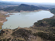
Lake Nighthorse via the USBR
Here’s the release from Reclamation (Justyn Hock)
Reclamation will hold a public meeting on Wednesday, June 18, 2014 from 5 pm to 7 pm on recreation at Lake Nighthorse, part of the Animas-La Plata Project. The meeting will be at the Durango Community Recreation Center, 2700 Main Avenue, in the Eolus and Sunlight Meeting Rooms. Reclamation will provide a brief presentation, and the public will be able to ask questions and look at maps and plans about recreation at Lake Nighthorse.
Currently, Reclamation is working with all Animas-La Plata Project partners and stakeholders to reach consensus regarding development and management of recreation at Lake Nighthorse. We believe we are nearing an agreement to integrate recreation into the project, while ensuring compatibility with the primary purposes of the project for municipal and industrial water supply.
We are conducting regular meetings with partners and stakeholders to discuss and resolve a broad range of issues concerning water quality, environmental protection, and tribal trust responsibilities of the United States government. Many issues have been resolved and Reclamation continues to work on remaining issues, including working closely with Association members to ensure protection of cultural resources and annexation of project lands by the city of Durango for administration of recreation and law enforcement purposes.
Click here to go to the Western Water Assessment climate dashboard. Here’s an excerpt:
Highlights
May was wetter than average across most of Colorado, adding to the above-average snowpacks in many basins. Drier than average conditions were experienced in most of Wyoming and northern Utah.
The spring runoff, in line with previous forecasts, has been above average to much above average in nearly all of Wyoming, and in northern, central, and southeastern Colorado. Below to much-below-average runoff has been observed in southwestern and south-central Colorado, southwestern Utah, and most of the eastern Great Basin.
Many gages in Colorado and Wyoming have seen record-high or near-record-high daily flows in the past three weeks, with minor to moderate flooding in some areas.
With the above-average spring runoff in the northern two-thirds of the region, reservoirs are regaining storage depleted by the last two years of dry conditions.
Atmospheric and oceanic conditions are still pointing to the very likely emergence of an El Niño event by fall. Sea-surface temperatures have continued to warm in the equatorial Pacific…
May Precipitation and Temperatures, and Current Drought
May was wetter than average across Colorado (except the southeastern quarter), southern Utah, and far southeastern Wyoming Western US Seasonal Precipitation. The month was drier than average in northern Utah and nearly all of Wyoming, though only relatively small areas saw less than 50% of average precipitation.
May temperatures Western US Seasonal Precipitation were up 3°F to cooler than average in most of Colorado, eastern Utah, and eastern Wyoming, and up to 4°F warmer than the monthly average, in the remainder of Wyoming and Utah.
The latest US Drought Monitor US Drought Monitor, representing conditions as of June 10, shows slightly less drought for the region compared to early May. Drought conditions improved in eastern and southwestern Colorado, while worsening in a smaller area of south-central Colorado. The proportion of the region in D2 or worse drought: Utah unchanged at 22%, Colorado at 17%, down from 19%, and Wyoming unchanged at zero.
Current Snowpack
Early June is typically well past the peak accumulation at even the highest-elevation SNOTEL sites, and many sites have normally melted out by this date. Thus, the numerical percent-of-median-SWE values on the Current Basin Snowpack Map Western US Seasonal Precipitation should be treated with caution. That said, the prevalence of dark blue colors (>150% of median) on the map in Colorado, Wyoming, and far northern Utah does indicate an unusually large and persistent late-season snowpack in those basins. The basins in southwestern Colorado and southern Utah that were lagging behind seasonal normals throughout the spring have completely melted out and are not shown on the map.
According to the Colorado Dust-on-Snow Program (CODOS), no more dust events have occurred since May 13, leaving the seasonal total at eight events. The latest CODOS update noted that consolidated dust layers from events D3–D8 were exposed at the snow surface during field surveys done from June 2–4 at CODOS sites at Grand Mesa, Hoosier Pass, Loveland Pass (Grizzly Peak), Berthoud Pass, Willow Creek Pass, Rabbit Ears Pass, and McClure Pass, as well as Independence Pass. With the exposed dust, snow-surface albedo (reflectivity) is unusually low, and melt rates will be above-average through the remainder of the season, leading to a steeper-than-average declining limb of the annual hydrograph.
Here’s an in-depth look at Climate Change and the current affects on water supply in the Colorado River Basin, from The Las Vegas Desert Sun (Story by Ian James / Photos by Richard Lui). Here’s an excerpt:
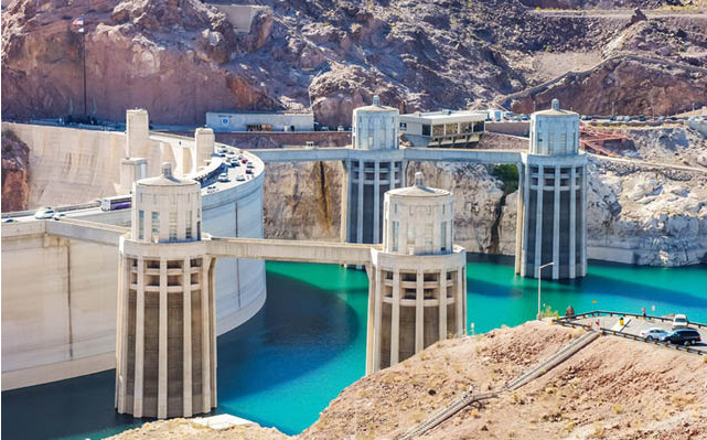
The biggest reservoir in the United States is dropping 1 foot each week. Lake Mead’s rapidly sinking water level is set to reach an all-time low in July, driven down by a 14-year drought that scientists say is one of the most severe to hit the Colorado River in more than 1,200 years.
The water behind Hoover Dam supplies vast areas of farmland and about 25 million people in three states, and this critical reservoir stands just 40 percent full.
Droughts and even decades-long mega-droughts have long been part of the natural cycle of the Colorado River, but that ebb and flow is now occurring alongside global warming, which scientists say is influencing the weather and putting new pressures on water supplies that are already over-tapped and declining.
In many ways, climate change is starting to compound the problems of a water system in the Southwest that is fundamentally out of balance:
• The Colorado River would naturally flow through its delta to the Sea of Cortez. But so much water is taken from the river that it seldom reaches the sea, and federal officials say water use has begun to surpass the available supply, drawing down the river’s reservoirs.
• Beneath desert cities and towns, in places from Palm Desert to Borrego Springs, groundwater levels have been dropping as more water is pumped from wells than flows back into aquifers.
• Scientists aren’t sure to what degree climate change is influencing the natural cycle of droughts in the West, but they say it’s clear that hotter temperatures worsen droughts, meaning that future dry spells will become more intense, more frequent and longer-lasting. And the current drought is taking an economic toll on agriculture in California’s Central Valley, with UC Davis researchers estimating losses this year at $1.7 billion.
• Already, scientists say hotter temperatures across the West have led to less mountain snowpack and earlier melting of snow in the spring. More of the snow and rain that does fall is evaporating due to warmer temperatures, and that diminishes the flows of water into the Colorado River that sustain cities and farms across the Southwest.
A celebration of the return of water to the Delta [Click on the image to view Peter McBride’s slideshow]
Here’s great photo roundup of the Minute 319 pulse flow that re-connected the Colorado River with the Sea of Cortez, from Peter McBride, that is running in Outside Magazine. Click through to view the photos.
Thompson Creek via the Summit County Citizens Voice
From the Colorado Water Quality Control Commission via the Glenwood Springs Post Independent:
The state Water Quality Control Commission this week approved a special “Outstanding Waters” designation for several branches of Thompson Creek and its tributaries in the upper Thompson Creek watershed, west of Carbondale.
Trout Unlimited and the Roaring Fork Conservancy said in a news release that the designation will ensure that the watershed’s water quality is protected in perpetuity.
The Water Quality Control Commission’s decision means that anyone seeking approval for development or discharge permits in the watershed must demonstrate that the proposed activity does not degrade the creeks’ baseline water quality.
“This is a huge conservation win that ensures there will be no degradation of these pristine waters,” said Aaron Kindle, Colorado Field Coordinator for Trout Unlimited. “The designation will safeguard the streams, wetlands and tributaries of a nationally significant watershed, and the genetically pure populations of cutthroat trout found there.”
To qualify for the designation, a stream must exhibit high standards on 12 different water quality parameters, including ammonia, dissolved oxygen, e. coli, nitrate, pH and various metals.
The protections will be applied to North Thompson, Middle Thompson and the South Branch of Middle Thompson Creek, as well as several tributaries, including Park Creek, a stronghold for a rare subspecies of cutthroat trout. The vast majority of the designated creeks are on Forest Service lands.
FromThe Grand Junction Daily Sentinel (Dennis Webb):
A state commission has provided new watershed protections in the Thompson Divide area, where numerous entities are trying to stop oil and gas development.
However, such development apparently will be compatible with the “Outstanding Waters” designation by the state Water Quality Control Commission Tuesday.
Trout Unlimited and the Roaring Fork Conservancy had sought the designation. It applies to the north, middle and south branches of Middle Thompson Creek, and tributaries including Park Creek, home to a rare subspecies of cutthroat trout. The protections cover some 130 miles of waterways.
Stream segments qualifying for the designation must exhibit high standards based on water quality parameters such as ammonia, dissolved oxygen, nitrate, pH and various metals. Any entity discharging into a designated segment must show it won’t degrade existing water quality.
Interests including the Thompson Divide Coalition have been trying to prevent drilling on more than 200,000 acres west of Carbondale. Much of that acreage is leased, but certain leases are currently in suspension pending a Bureau of Land Management review.
Trisha Oeth, administrator for the Water Quality Control Commission, said Trout Unlimited testified that it reached out to energy companies holding leases in the areas and none opposed the designation.
“Trout Unlimited indicated the companies felt the designation would not impact their activities and that the designation would be compatible with their operations and plans,” she said.
The commission decided the sensitivity of cutthroat trout and diminishing extent of their habitat made the additional protection necessary.
David Ludlam, executive director of the West Slope Colorado Oil and Gas Association, called the designation “a clever maneuver that doesn’t concern us too much.”
“As modest drilling begins in the Thompson Divide, this important designation is in alignment with what our member companies already do to protect water and wildlife resources. We have shown a tremendous ability to safely produce natural gas in other sensitive western Colorado watersheds and will do so in the Thompson Divide, too.”
In a news release, Aaron Kindle, Colorado field coordinator for Trout Unlimited, called the designation “a huge conservation win that ensures there will be no degradation of these pristine waters.
“The designation will safeguard the streams, wetlands and tributaries of a nationally significant watershed, and the genetically pure populations of cutthroat trout found there,” Kindle was quoted as saying.
To win approval the stream has to meet several high quality standards and, the designation prohibits certain pollutants from being discharged into the water. Aaron Kindle is with Colorado Trout Unlimited, which fought for the designation. He says it protects fish.
“Cutthroat trout have been dwindled down to about 10 percent of their native range, so the populations that do exist are pretty critical and those creeks up there are really critical for cutthroat trout.”
The protected creek runs through an area where energy companies would like to drill for natural gas. The gas leases are currently at a stand-still while the Bureau of Land Management does a review. Kindle says Trout Unlimited had discussions with the oil and gas companies and he says they neither supported nor disapproved of the new designation.

![A celebration of the return of water to the Delta [Click on the image to view Peter McBride's slideshow]](http://coyotegulch.blog/wp-content/uploads/2014/06/folksatsanluisriominute319fiestaapril2014.jpg?w=450)

