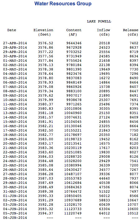
Click on the thumbnail graphic to view a table of data for Lake Powell via the US Bureau of Reclamation.
Here’s a report from (Amy Joi O’Donoghue) writing for the Deseret News. Here’s an excerpt:
Brian McInerney, a hydrologist with the National Weather Service in Salt Lake City, said snowpack numbers can look crazy this time of year because the melt is well underway, but the snow that remains in northern Colorado and Wyoming is a big boost for the Colorado River and its tributaries.
“Basically the high pressure that was parked over the western United States (over much of the winter) ended at the Utah/Colorado border,” he said, adding that Colorado was pounded with storms while Utah was left wanting. “That is the benefit of this whole thing, what is going on with the upper Colorado River and the Green River now.”
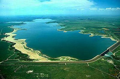
Runoff into Lake Powell that began in mid-May reached 60,000 cubic feet per second. The U.S. Bureau of Reclamation reports that lake levels will continue to climb a foot a day into late June, hitting a peak elevation of 3,616 feet.
The rising water opened the Castle Rock Cut near Wahweap Marina and three concrete launch ramps — Wahweap, State Line and Antelope Point — are now open.
“The above average snowpack is helping,” said bureau spokeswoman Lisa Iams. “We are kind of at the mercy of Mother Nature. Who knows what we will see in the future, but we are glad that we have it.”
The bureau projects that by Oct. 1, the start of the next water year, Lake Powell will likely be at an elevation of 3,610 feet, 26 feet below its 50-year average for the date.
“Lake Powell is still half full, but that speaks to the value it has provided. Without that bank account of water storage, the implications of consecutive years of drought would be far more catastrophic. It is operating exactly as it was designed to do.” Iams said…
A monthly climate and water supply report put out by the Natural Resources Conservation Service said Utah continued its dry pattern into May, which saw precipitation across the state at just 73 percent of average.
Reservoir storage in general is down 4 percent from where it was last year and most streams and rivers have already reached their peak runoff.
From The Greeley Tribune (Eric Brown):
A new report shows that snowpack in the South Platte on June 1 was at 311 percent of its historic average for that date, narrowly putting it behind the mark set in 2011, which is widely referred to as one of the best-ever snowpack years for the area.
On June 1, 2011, snowpack was at 313 percent of historic average — farther ahead of normal than any other date on record in the South Platte basin.
The Natural Resources Conservation Service’s snowpack data — consisting of reports that collect data for the first day of winter and spring months — date back to 1968, although its Jan. 1 reports for the South Platte Basin only go back to 1985, and its June 1 reports only date back to 1986.
While data is somewhat limited, there’s no doubting there’s a lot of snow in the mountains right now.
Because of that large snowpack, along with recent heavy rains, there’s been some flooding in the area, particularly along the Poudre River.
As far as the potential for more flooding, water experts say river flows in the area are trending down, doing so earlier than normal, and if there is any more flooding, it will be caused by rains — not necessarily by how much melting snow is coming down from the mountains.
Dave Nettles, the Colorado Division of Water Resources Division 1 engineer, based in Greeley, explained that, in general, this year’s apparent peak runoff for snowmelt up in the mountains came about May 31 — roughly 10 days earlier than normal.
Flows in the Poudre River peaked on May 31, flowing at about 6,000 cubic feet per second (the historic average is about 1,600 cfs for that date), and had fallen to about 4,300 cfs by Thursday afternoon (the historic average for June 5 is about 1,800 cfs).
Similar to the Poudre, the Big Thompson River above Lake Estes peaked on May 31 as well, flowing at about 1,350 cfs (the historic average for that date is about 440 cfs), and had fallen to 815 cfs by Thursday afternoon (the historic average for June 5 is about 520 cfs).
“Depending on what the weather does, we may have seen the rivers get as high as they’re going to get,” Nettles said. “But as full as the rivers already are … and as saturated as the ground is … it won’t take much rain to make them rise again.”
In addition to large snowpack, reservoirs in the South Platte Basin remain full.
Reservoir levels in the South Platte basin on June 1 were collectively at 113 percent of the historic average for that date, up slightly from the May 1 report this year, when they were 110 percent of historic average.
Minus the flooding in some areas, it’s continued good news for water users in the region.
Snowpack and reservoir measures have been at normal levels, or better, all year.
A healthy water supply is vital for Colorado’s agriculture industry which, according to the Colorado Division of Water Resources, uses about 85 percent of the state’s water.
And it’s especially critical for Weld County, where the ag industry makes about a $1.86 billion economic impact annually and ranks ninth nationally.
In addition to being good for northeast Colorado, the NRCS report showed that water supplies are in good shape across much of the state.
The Colorado River Basin — which flows in the opposite direction of Greeley and Weld County but still supplies a large chunk of the region’s water needs through transmountain tunnels that cross the Continental Divide — had similar numbers to those of the South Platte basin.
Snowpack for the Colorado basin stood at 223 percent of average on May 1, while reservoir levels were at 95 percent of average.
Statewide, snowpack is at 197 percent of normal, and reservoirs are filled at 95 percent of normal.